Maps (804)

1647 Olivarius Vredius Antique Map of Roman Europe Flanders, Germany, France
- Title : Francorum Primae Sedes...Incisum Bruges a Joe F Jois...Olivario Vredio...1647
- Ref #: 60040
- Size: 16 1/2in x 14in (420mm x 355mm)
- Date : 1647
- Condition: (A+) Fine Condition
Description:
This fine scarce beautifully engraved original antique map of central & western Roman Europe centering on what is today Belgium, the Southern Netherlands, Northern France and Western Germany - was engraved in 1647 - dated - and published by Olivarius Vredius (Olivier de Wree)in the 1652 edition of Historiae Comitum Flandriae
Historiae Comitum Flandriae was an important historical work on the origin and early history of Flanders by the well-known historian Olivarius Vredius - Olivier de Wree - (1596-1652) from Bruges. Vredius belongs to the most prominent representatives of late-Belgian humanism and his historical works are still considered to be of high value. (Ref: M&B; Tooley)
General Description:
Paper thickness and quality: - Heavy & stable
Paper color: - White
Age of map color: -
Colors used: -
General color appearance: -
Paper size: - 16 1/2in x 14in (420mm x 355mm)
Plate size: - 12 1/2in x 11in (320mm x 280mm)
Margins: - Min 1in (25mm)
Imperfections:
Margins: - None
Plate area: - Light blue underlining some names, light creasing
Verso: - None
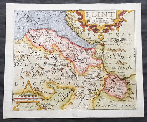
1610 Johannes Kip Antique Map of the County of Flintshire, Wales, Great Britain
- Title : Flint Comitatus quem Ordovices olim Incolucrunt
- Ref #: 01-3604
- Size: 15in x 13in (380mm x 330mm)
- Date : 1610
- Condition: (A+) Fine Condition
Description:
A very attractive early original hand coloured antique map of Flintshire (Welsh: Sir y Fflint) Wales, based on the first survey of the county by Christopher Saxton, was engraved by William Kip for William Camden's Britannia* (London: 1607-1637).
As well as still being the earliest printed map of Flintshire at an 'affordable' price it is also the first detailed one dedicted solely to the county.
General Definitions:
Paper thickness and quality: - Heavy and stable
Paper color : - off white
Age of map color: - Early
Colors used: - Blue, yellow, green, brown
General color appearance: - Authentic
Paper size: - 15in x 13in (380mm x 330mm)
Plate size: - 13in x 11in (330mm x 280mm)
Margins: - Min 1in (25mm)
Imperfections:
Margins: - Light soiling to margin edges
Plate area: - None
Verso: - None
Background:
Britannia', was one of the most popular and influential books of the period. The work of the Elizabethan antiquarian, William Camden (1551-1623), it was a detailed historical and topographical description of Great Britain. Its patriotic sentiments, in particular, both appealed to and generated the growing sense of nationalism that was coursing through late Tudor / early Stuart society. Between 1607 and 1637, county maps engraved by William Kip and William Hole, and based largely on Saxton's surveys, were added. These maps have the distinction of being the first set to show each county individually as opposed to several being grouped together on one page. Camden's Britannia continued to be published well into the 19th century; from 1695 to 1772, county maps by Robert Morden were used, and from 1789 to c.1815, those by the renowned John Cary.
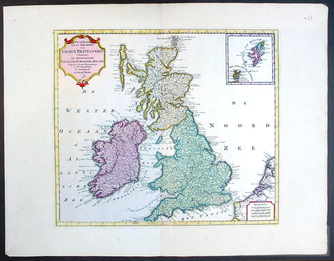
1750 Isaac Tirion Large Antique Map of Great Britain & Ireland
- Title : Nieuwe Kaaart van de Eilanden Groot Britannie behelsende Het Koningryk Engeland
- Ref #: 70087
- Size: 21 1/2in x 17in (545mm x 435mm)
- Date : 1750
- Condition: (A+) Fine Condition
Description:
This beautifully hand coloured original antique map of Great Britain & Ireland was published by Isaac Tirion in 1750.
Isaac Tirion was a successful publisher in Amsterdam during the 18th century who produced extensive volumes of Dutch town plans as well as a number of atlases with maps usually based on those of G. Delisle. His world atlases were finely engraved and beautifully colored as with this map for auction. (Ref: Tooley; M&B)
General Description:
Paper thickness and quality: - Heavy and stable
Paper color: - off white
Age of map color: - Original
Colors used: - Green, pink, yellow
General color appearance: - Authentic
Paper size: - 21 1/2in x 17in (545mm x 435mm)
Plate size: - 14 1/2in x 13in (370mm x 330mm)
Margins: - Min 1in (25mm)
Imperfections:
Margins: - None
Plate area: - None
Verso: - None
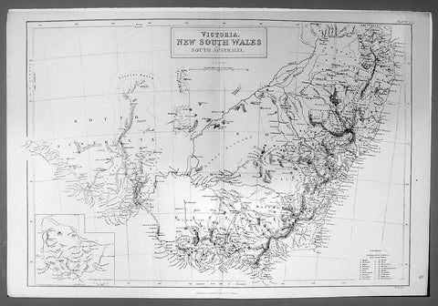
1844 Hughes Antique Australian Map of the States of Victoria & NSW
- Title : Victoria New South Wales and South Australia
- Ref #: 91204
- Size: 17in x 11 1/4in (430mm x 285mm)
- Date : 1844
- Condition: (A+) Fine Condition
Description:
This finely engraved original antique map of the Australian States of NSW, Vic & part of SA was engraved by William Hughes and published by A&C Black in 1844. (Ref: Tooley; M&B)
General Description:
Paper thickness and quality: - Light and stable
Paper color: - off white
Age of map color: -
Colors used: -
General color appearance: -
Paper size: - 17in x 11 1/4in (430mm x 285mm)
Plate size: - 17in x 11 1/4in (430mm x 285mm)
Margins: - Min 1/2in (12mm)
Imperfections:
Margins: - None
Plate area: - None
Verso: - None
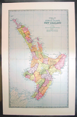
1888 Pic Atlas Large Antique Map of the North Island of New Zealand
- Title : General Map of The North Island of New Zealand
- Ref #: 50321
- Size: 28in x 18in (710mm x 460mm)
- Date : 1888
- Condition: (A+) Fine Condition
Description:
This large original antique map of the North Island of New Zealand was engraved in 1888 - the date is engraved at the foot of the map - by Alex J Scally and was published in the extremely significant Australian & New Zealand publicationThe Picturesque Atlas of Australasia between 1886-88. Also includes an index to the map on the verso giving names and locations of places on the map.
These maps were some of the best maps published at the time in the "Modern" look. The colour is bright, the engraving extremely fine and the paper heavy and stable.
The Picturesque Atlas of Australasia was published in Sydney between 1886-88. Many of its over 700 wood-engraved illustrations were specially commissioned works by leading Australian artists.
It was released in 42 separate editions usually bound into three large volumes and sold a remarkable 50,000 copies.
Its publication was one of the most significant cultural projects in nineteenth-century Australia. Writers, artists, academics and politicians came together to prepare a book of unprecedented grandeur and ambition, and a publishing company was established to produce and publish it. The seven hundred engravings on steel and wood contained in the Picturesque Atlas were among the finest engravings to be found anywhere in the world at this time.
The Atlas was a collegial project, staffed by a large number of artists and garnering an unusual number of contributors for one work. Lightly supervised by the former Sydney Morning Herald editor Andrew Garran it was lavishly produced at the Wynyard Square headquarters of the Atlas company. It had the services of the Melburnian journalist and public figure James Smith who wrote much of the Victorian and Tasmanian material, and W.H. Traill wrote extensively about Queensland. It was not, of course, an Atlas is the usual sense of the word, maps playing a comparatively minor role. But use of Atlas in the title, Hughes-d'Aeth notes, gave a sense of the scale of the publication both in terms of comprehensiveness and format. As the author points out, calling it an Atlas carries a promise of the exactitude of the relationship between the subject and its representation, and also bears a sense of the acquisitiveness that shadows the imperial phase of cartography.
There were only thirty maps in the Atlas's 800 pages, but there were hundreds of pictures. This is where much of the ideological work of the Atlas was completed and this is where Paper Nation concentrates its analysis. Its first task is to unravel the linguistic ball of string that is the word 'picturesque'. Though Humphrey Repton and Uvedale Price had their opinions, Hughes-d'Aeth is quite right to pick William Gilpin out of the line-up of suspicious aesthetes, for it was he who really popularised the idea of travelling in search of picturesque views. Paper Nation's dissection of the term picturesque is particularly aware of the term's adaptation to colonial usage, and its mutations through time. The picturesque took on an increasingly acquisitive edge, as admiration of the beauty of the land was joined by a concern to exploit it. A 'deep reverence for production' can be seen in the Picturesque Atlas's many illustrations of mines, factories and agricultural processes. The slag heaps of a mine were now as 'picturesque' as a fern-filled valley, but this does mean that the term was evacuated of all meaning. Rather the aesthetic appropriation of the land and its material exploitation were part of a continuum of colonial attitudes, and it was the duty of the Picturesque Atlas to affirm and re-affirm the rightness of European habitation and progress. (Ref: M&B; Tooley)
General Description:
Paper thickness and quality: - Light & stable
Paper color: - White
Age of map color: - Original
Colors used: - Pink, yellow, green, blue
General color appearance: - Authentic
Paper size: - 28in x 18in (710mm x 460mm)
Plate size: - 28in x 18in (710mm x 460mm)
Margins: - Min 1in (25mm)
Imperfections:
Margins: - None
Plate area: - None
Verso: - None
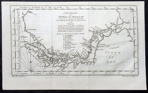
1753 Bellin Original Antique Map of Magellan Straits, Argentine Tierra Del Fuego
- Title : Carte Reduite du Detroit De Magellan...1753
- Ref #: 60961
- Size: 15in x 9 1/2in (380m x 240mm)
- Date : 1753
- Condition: (A+) Fine Condition
Description:
This fine, original copper-plate engraved antique map of the Magellan Straits between the South American mainland and Tierra Del Fuego map - with major points of discovery and remarks in a 9 legend points by Jacques Nicolas Bellin was engraved in 1753 - dated - and was published in Antoine-François Prevosts L Histoire Generale des VoyagesPierre de Hondt, The Hague.
General Definitions:
Paper thickness and quality: - Heavy and stable
Paper color : - off white
Age of map color: -
Colors used: -
General color appearance: -
Paper size: - 15in x 9 1/2in (380m x 240mm)
Plate size: - 14 1/2in x 8in (370mm x 205mm)
Margins: - Min 1/2in (12mm)
Imperfections:
Margins: - None
Plate area: - Folds as issued
Verso: - None
Background:
Antoine François Prevost d Exiles 1697 – 1763, usually known simply as the Abbé Prévost, was a French author and novelist.He was born at Hesdin, Artois, and first appears with the full name of Prevost d Exiles, in a letter to the booksellers of Amsterdam in 1731. His father, Lievin Prévost, was a lawyer, and several members of the family had embraced the ecclesiastical estate. Prevost was educated at the Jesuit school of Hesdin, and in 1713 became a novice of the order in Paris, pursuing his studies at the same time at the college in La Flèche.
At the end of 1716 he left the Jesuits to join the army, but soon tired of military life, and returned to Paris in 1719, apparently with the idea of resuming his novitiate. He is said to have travelled in the Netherlands about this time; in any case he returned to the army, this time with a commission. Some biographers have assumed that he suffered some of the misfortunes assigned to his hero Des Grieux. Whatever the truth, he joined the learned community of the Benedictines of St Maur, with whom he found refuge, he himself says, after the unlucky termination of a love affair. He took his vows at Jumièges in 1721 after a year\'s novitiate, and in 1726 took priests orders at St Germer de Flaix. He spent seven years in various houses of the order, teaching, preaching and studying. In 1728 he was sent to the Abbey of Saint-Germain-des-Pres, Paris, where he contributed to the Gallia Christiana, a work of historiographic documentation undertaken communally by the monks in continuation of the works of Denys de Sainte-Marthe, who had been a member of their order. His restless spirit made him seek from the Pope a transfer to the easier rule of Cluny; but he left the abbey without leave (1728), and, learning that his superiors had obtained a lettre de cachet against him, fled to England.
In London he acquired a wide knowledge of English history and literature, as can be seen in his writings. Before leaving the Benedictines Prévost had begun perhaps his most famous novel, Mémoires et aventures d’un homme de qualité qui s’est retiré du monde, the first four volumes of which were published in Paris in 1728, and two years later at Amsterdam. In 1729 he left England for the Netherlands, where he began to publish (Utrecht, 1731) a novel, the material of which, at least, had been gathered in London Le Philosophe anglais, ou Histoire de Monsieur Cleveland, fils naturel de Cromwell, ecrite par lui-même, et traduite de l anglais (Paris 1731-1739, 8 vols., but most of the existing sets are partly Paris and partly Utrecht). A spurious fifth volume (Utrecht, 1734) contained attacks on the Jesuits, and an English translation of the whole appeared in 1734.
Meanwhile, during his residence at the Hague, he engaged on a translation of De Thou\'s Historia, and, relying on the popularity of his first book, published at Amsterdam a Suite in three volumes, forming volumes v, vi, and vii of the original Mémoires et aventures d’un homme de qualite. The seventh volume contained the famous Manon Lescaut, separately published in Paris in 1731 as Histoire du Chevalier des Grieux et de Manon Lescaut. The book was eagerly read, chiefly in pirated copies, being forbidden in France. In 1733 he left the Hague for London in company of a lady whose character, according to Prevosts enemies, was doubtful. In London he edited a weekly gazette on the model of Joseph Addisons Spectator, Le Pour et contre, which he continued to produce in collaboration with the playwright Charles-Hugues Le Febvre de Saint-Marc, with short intervals, until 1740.
In the autumn of 1734 Prevost was reconciled with the Benedictines, and, returning to France, was received in the Benedictine monastery of La Croix-Saint-Leufroy in the diocese of Evreux to pass through a new, though brief, novitiate. In 1735 he was dispensed from residence in a monastery by becoming almoner to the Prince de Conti, and in 1754 obtained the priory of St Georges de Gesnes. He continued to produce novels and translations from the English, and, with the exception of a brief exile (1741–1742) spent in Brussels and Frankfurt, he resided for the most part at Chantilly until his death, which took place suddenly while he was walking in the neighbouring woods. The cause of his death, the rupture of an aneurysm, is all that is definitely known. Stories of crime and disaster were related of Prevost by his enemies, and diligently repeated, but appear to be apocryphal.
Prevosts other works include:
- Le Doyen de Killerine, Killerine, histoire morale composee sur les memoires d une illustre famille d Irlande (Paris, 1735; 2nd part, the Hague, 1739, 3rd, 4th and 5th parts, 1740)
- Tout pour l\'amour (1735), a translation of Drydens tragedy
- Histoire d une Grecque moderne (Amsterdam [Paris] 2 vols., 1740)
- l Histoire de Marguerite d Anjou (Amsterdam [Paris] 2 vols., 1740)
Memoires pour servir a l histoire de Malte (Amsterdam, 1741)
- Campagnes philosophiques, ou memoires ... contenant l histoire de la guerre d Irlande (Amsterdam, 1741)
- Histoire de Guillaume le Conquerant (Paris, 1742)
- Histoire generale des voyages (15 vols., Paris, 1746-1759), continued by other writers
- Manuel Lexique (Paris, 1750), continued by other writers
- Translations from Samuel Richardson:
Lettres anglaises ou Histoire de Miss Clarisse Harlovie (1751), from Richardson\'s Clarissa, and Nouvelles lettres anglaises, ou Histoire du chevalier Grandisson (Sir Charles Grandison, 1755).
- Mémoires pour servir a l\'histoire de la vertu (1762), from Mrs Sheridan\'s
Memoires of Miss Sidney Bidulph
- Histoire de la maison de Stuart (3 vols., 1740) from Hume\'s History of England to 1688
- Le Monde moral, ou Mémoires pour servir a l\'histoire du coeur humain (2 vols., Geneva, 1760)
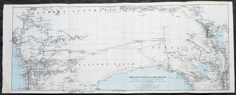
1876 Petermann Antique Map Expedition Ernest Giles Western & South Australia, 1875
- Title : Thomas Elders Expedition durch Inner-Australien vom Beltana im Osten bis Perth im Westen, Ausgefuhrt Durch E. Giles Mai - Nov 1875
- Size: 27in x 11in (285mm x 280mm)
- Condition: (A+) Fine Condition
- Date : 1876
- Ref #: 82054
Description:
This early folding original antique lithograph map of Western & South Australia - from Perth to Lake Torrens South Australia covering the 3rd & 4th expedition of the explorer Ernest Giles in 1875 by Augustus Heinrich Petermann was engraved in 1877 - dated - and was published by Justus Perthes, Gotha Germany.
General Definitions:
Paper thickness and quality: - Heavy and stable
Paper color : - off white
Age of map color: - Original
Colors used: - Blue, red, yellow
General color appearance: - Authentic
Paper size: - 27in x 11in (285mm x 280mm)
Plate size: - 27in x 11in (285mm x 280mm)
Margins: - Min 1/2in (12mm)
Imperfections:
Margins: - None
Plate area: - Folds as issued
Verso: - None
Background:
William Ernest Powell Giles 1835 – 1897 best known as Ernest Giles, was an Australian explorer who led five major expeditions in central Australia.
Giles did not attempt an organised expedition until 1872, when with two other men he left Chambers Pillar, South Australia (now in the Northern Territory), on 22 August and traversed much previously untrodden country to the north-west and west. Finding their way barred by Lake Amadeus and that their horses were getting very weak, a return was made to the Finke River and then to Charlotte Waters and Adelaide, where Giles arrived in January 1873. Giles looked upon his expedition as a failure, but he had done well considering the size and equipment of his party.
Giles friend Baron von Mueller raised a subscription so that a new expedition could be made. The services of William Tietkens as first assistant were obtained, and with two other men a start was made on 4 August 1873. The journey began considerably south from the previous expedition and from the Alberga River a generally western course was traversed. A month later in the Musgrave Ranges a fine running river was found and named the Ferdinand and by 3 October 1873 the party was approaching longitude 128 East. The country was extremely dry and though tested in various directions it was a constant struggle to get enough water to keep the horses going. Early in November, having passed longitude 126, a partial return was made and on 20 December 1873 the neighbourhood of Mount Scott was reached. A turn to the north and then west was made and the farthest westerly point was reached on 23 April 1874. Giles and one of the men, Alfred Gibson, had been scouting ahead when the latter\'s horse died. Giles gave him his own horse with instructions to follow their tracks back and obtain assistance. Giles made his way back to their depot on foot in eight days, almost completely exhausted, to find that Gibson had not reached the camp. A search was made for him for several days without success. The stores were almost finished, nothing further could be done, and on 21 May 1874 the return journey began. Giles named the desert Gibson Desert after his companion. On 24 June 1874 they were on a good track to the Finke River and on 13 July 1874 Charlotte Waters was reached. Giles had again failed to cross the continent, but in the circumstances all had been done that was possible.
Giles was the first European to see the rock formations of The Olgas, now known by their Aboriginal name of Kata Tjuta, and Lake Amadeus. He had wanted to name these Mt Mueller and Lake Ferdinand respectively, to honour his benefactor Baron Ferdinand von Mueller, however Mueller prevailed on him to instead honour the King Amadeus of Spain and Queen Olga of Württemberg. Giles supposedly discovered Uluru (formerly Ayers Rock), but was beaten to the claim by a competing explorer, William Gosse.
Early in 1875 Giles prepared his diaries for publication under the title Geographic Travels in Central Australia, and on 13 March 1875, with the generous help of Sir Thomas Elder, he began his third expedition. Proceeding considerably to the north from Fowler\'s Bay the country was found to be very dry. Retracing his steps Giles turned east, and eventually going round the north side of Lake Torrens reached Elder\'s station at Beltana. There the preparations for his fourth journey were made, and with Tietkens again his lieutenant, and with what Giles had always wanted, a caravan of camels, a start was made on 6 May. Port Augusta was reached on 23 May and, after taking a northerly course to clear the lakes, a generally westerly course was followed. Some water was carried, and the party was saved the continual excursions in search of water for horses that had caused so much difficulty during previous expeditions. Towards the end of September over 323 miles (520 km) had been covered in 17 days without finding water, when on 25 September the native Tommy found an abundant supply in a small hollow between sand dunes at Queen Victoria Spring, and the party was saved. After a rest of nine days the journey was resumed on 6 October the course being still west. Ten days later the expedition was attacked by a large body of aborigines and Giles was compelled to fire on them. On 4 November they met a white stockman at Tootra out-camp, east of Bindi Bindi. Their course was west to Walebing Station, then south-west and on 11 November they arrived at New Norcia where they were welcomed by Bishop Salvado. On 17 November 1875 the party arrived at Guildford and Perth the next day, where they received an enthusiastic reception.
Giles stayed for two months at Perth. Tietkens and Jess Young, another member of the expedition, went back to Adelaide by sea, and on 13 January 1876 Giles began the return journey taking a course generally about 400 miles north of the last journey. He arrived at Adelaide in September 1876 after a good journey during which the camels were found to be invaluable.
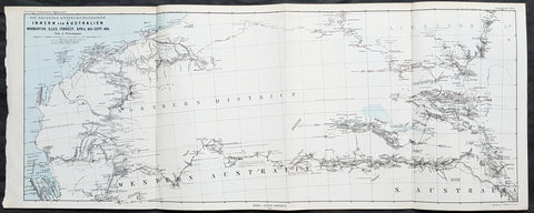
1876 Petermann Antique Map Western & South Australia - Warburton, Giles, Forrest
- Title : Die Neuesten Entdeckungsreisen im Inner-Australien von Warburton, Giles, Forrest, April 1873 - Sept 1874
- Size: 27in x 11in (285mm x 280mm)
- Condition: (A+) Fine Condition
- Date : 1876
- Ref #: 82055
Description:
This early folding original antique lithograph map of Western & South Australia and Alexandria land (Northern Territory) with the tracks of 3 explorers - in 1873 & 1874 - Peter Egerton-Warburton, Ernest Giles & Alexander Forrest by Augustus Heinrich Petermann was engraved in 1876 - dated - and was published by Justus Perthes, Gotha Germany.
General Definitions:
Paper thickness and quality: - Heavy and stable
Paper color : - off white
Age of map color: - Original
Colors used: - Blue, red, yellow
General color appearance: - Authentic
Paper size: - 27in x 11in (285mm x 280mm)
Plate size: - 27in x 11in (285mm x 280mm)
Margins: - Min 1/2in (12mm)
Imperfections:
Margins: - None
Plate area: - Folds as issued
Verso: - None
Background:
Colonel Peter Egerton-Warburton CMG (1813–1889), was a British military officer, Commissioner of Police for South Australia, and an Australian explorer. In 1872 he sealed his legacy through a particularly epic expedition from Adelaide crossing the arid centre of Australia to the coast of Western Australia via Alice Springs.
William Ernest Powell Giles (1835 – 1897) best known as Ernest Giles, was an Australian explorer who led five major expeditions in central Australia.
Alexander Forrest CMG (1849 – 1901) was an explorer and surveyor of Western Australia, and later also a member of parliament.
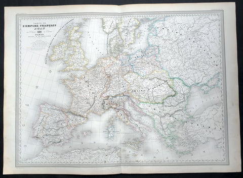
1856 A H Dufour Very Large Antique Map of The Different Empires of Europe
- Title : Carte De L Empire Francais par A H Dufour Gravee CH Dyonnet..1856
- Ref #: 61027
- Size: 33in x 24in (840mm x 610mm)
- Date : 1856
- Condition: (A+) Fine Condition
Description:
This very large, magnificent hand coloured original copper plate antique map of the political borders of Europe and the various Empires that ruled the continent at the time French, Austrian, Rhine Conference, Italian States, Russian, Ottoman etc by Adolphe Hippolyte Dufour was engraved by Charles Dyonnet in 1856 - dated in the title - for Dufours 1860 edition of his monumental elephant folio Atlas Physique, Historique et Politique Geographie Moderne published by Pauline Et La Chevalier, Paris.
The 19th century French cartographer Auguste-Henri Dufour began publishing the dramatic elephant folio Atlas Universel, also occasionally titled Grand Atlas Universal, around 1855. Several editions appeared between its initial publication in the 1850s and a final run c. 1870. The 1863 and 1864 editions in particular are highly desirable among collectors because the United States and North America maps illustrate the proposed, but unrealized, state of Corona (roughly modern day Utah). The atlas contained roughly 40 maps, most of which were engraved by Louis Antoine (the maps) and Deletre (typography) under the supervision of Charles Dyonnet, official engraver of the Depot de la Marine. The Atlas Universal was published in Paris and edited by the firm of Paulin et le Chevalier, 60 Rue Richelieu.
General Definitions:
Paper thickness and quality: - Heavy and stable
Paper color : - off white
Age of map color: - Original
Colors used: - Yellow, green, blue, pink
General color appearance: - Authentic
Paper size: - 33in x 24in (840mm x 610mm)
Plate size: - 33in x 24in (840mm x 610mm)
Margins: - Min 1in (25mm)
Imperfections:
Margins: - Light age toning in margins
Plate area: - None
Verso: - None
Background:
Charles Dyonnet 1822 - 1880 was an extremely active Paris based engraver working in the mid to late 19th century. From his offices at 220 Rue St. Jacques, Paris, Dyonnet engraved numerous maps for many of the most prominent 19th French cartographic publishers including Vuillemin, Dufour, Fremin and Duvotenay. From 1850-1861, he held the coveted position of Graveur du Dépot de la Marine, and in this position engraved numerous French naval and military maps. Dyonnet had a detail oriented and aesthetically minded hand and is responsible from some of the most beautiful French maps to emerge during the 19th century. (Ref: M&B; Tooley)
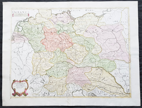
1689 Nicolas Sanson Large Antique Map of Germania & Central Europe
- Title : Germania Antiqua Aut N Sanson.....1689
- Ref #: 26191
- Size: 24in x 18 1/2in (610mm x 470mm)
- Date : 1689
- Condition: (A+) Fine Condition
Description:
This fine original hand coloured copper-plate engraved antique map of Germania & central Europe stretching from Poland to Italy to Denmark, by Nicolas Sanson, was engraved in 1689 - dated in the cartouche - and was published by Pierre Mariette in Cartes Generales de Toutes les Parties du Monde
General Definitions:
Paper thickness and quality: - Heavy and stable
Paper color : - off white
Age of map color: - Original & later
Colors used: - Yellow, green, blue, pink
General color appearance: - Authentic
Paper size: - 24in x 18 1/2in (610mm x 470mm)
Plate size: - 21 1/2in x 16in (545mm x 405mm)
Margins: - Min 1in (25mm)
Imperfections:
Margins: - None
Plate area: - None
Verso: - None
Background:
Germania was the Roman term for the geographical region in north-central Europe inhabited mainly by Germanic peoples.
It extended from the Danube in the south to the Baltic Sea, and from the Rhine in the west to the Vistula. The Roman portions formed two provinces of the Empire, Germania Inferior to the north (present-day southern Netherlands, Belgium, and western Germany), and Germania Superior to the south (Switzerland, southwestern Germany, and eastern France).
Germania was inhabited mostly by Germanic tribes, but also Celts, Balts, Scythians and later on Early Slavs. The population mix changed over time by assimilation, and especially by migration. The ancient Greeks were the first to mention the tribes in the area. Later, Julius Caesar wrote about warlike Germanic tribesmen and their threat to Roman Gaul, and there were military clashes between the Romans and the indigenous tribes. Tacitus wrote the most complete account of Germania that still survives.
The origin of the term Germania is uncertain, but was known by Caesars time, and may be Gaulish in origin.
Germania was inhabited by different tribes, most of them Germanic but also some Celtic, proto-Slavic, Baltic and Scythian peoples. The tribal and ethnic makeup changed over the centuries as a result of assimilation and, most importantly, migrations. The Germanic people spoke several different dialects.
Classical records show little about the people who inhabited the north of Europe before the 2nd century BC. In the 5th century BC, the Greeks were aware of a group they called Celts (Keltoi). Herodotus also mentioned the Scythians but no other tribes. At around 320 BC, Pytheas of Massalia sailed around Britain and along the northern coast of Europe, and what he found on his journeys was so strange that later writers refused to believe him. He may have been the first Mediterranean to distinguish the Germanic people from the Celts. Contact between German tribes and the Roman Empire did take place and was not always hostile. Recent excavations of the Waldgirmes Forum show signs that a civilian Roman town was established there, which has been interpreted to mean that Romans and Germanic tribesmen were living in peace, at least for a while.
Caesar described the cultural differences between the Germanic tribesmen, the Romans, and the Gauls in his book Commentarii de Bello Gallico, where he recalls his defeat of the Suebi tribes at the Battle of Vosges. He describes them at length at the beginning of Book IV and the middle of Book VI. He states that the Gauls, although warlike, had a functional society and could be civilized, but that the Germanic tribesmen were far more savage and were a threat to Roman Gaul and Rome itself. Caesar said the Germanic tribes were nomadic, with no notable settlements and a primitive culture. He used this as one of his justifications for why they had to be conquered. His accounts of barbaric northern tribes could be described as an expression of the superiority of Rome, including Roman Gaul.
Caesars accounts portray the Roman fear of the Germanic tribes and the threat they posed. The perceived menace of the Germanic tribesmen proved accurate. The most complete account of Germania that has been preserved from Roman times is Tacitus Germania.
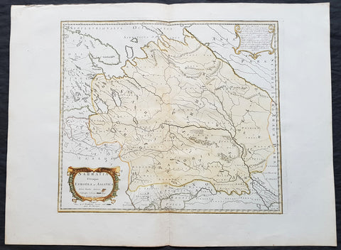
1741 Nicolas Sanson Large Antique Map of Sarmatia, Modern Day Russia & Ukraine
- Title : Sarmatia Utraque Europaea et Asiatica Autore Nicolas Sanson...1741
- Ref #: 50602
- Size: 27in x 20 1/4in (690mm x 515mm)
- Date : 1741
- Condition: (A+) Fine Condition
Description:
This fine original hand coloured copper-plate engraved antique map of the land of the Sarmatians - today stretching encompassing modern day European Russia and Ukraine and central Asia by Nicolas Sanson, was engraved in 1741 - dated in the cartouche - and was published by Robert De Vaugondy in a re-issue of Sansons atlas Cartes Generales de Toutes les Parties du Monde
General Definitions:
Paper thickness and quality: - Heavy and stable
Paper color : - off white
Age of map color: - Original & later
Colors used: - Yellow, green, blue, pink
General color appearance: - Authentic
Paper size: - 27in x 20 1/4in (690mm x 515mm)
Plate size: - 19in x 16 1/2in (485mm x 420mm)
Margins: - Min 2in (50mm)
Imperfections:
Margins: - None
Plate area: - None
Verso: - None
Background:
The Sarmatians were a large Iranian confederation that existed in classical antiquity, flourishing from about the 5th century BC to the 4th century AD.
Originating in the central parts of the Eurasian Steppe, the Sarmatians started migrating westward around the 4th and 3rd centuries BC, coming to dominate the closely related Scythians by 200 BC. At their greatest reported extent, around 1st century AD, these tribes ranged from the Vistula River to the mouth of the Danube and eastward to the Volga, bordering the shores of the Black and Caspian seas as well as the Caucasus to the south. Their territory, which was known as Sarmatia to Greco-Roman ethnographers, corresponded to the western part of greater Scythia (it included todays Central Ukraine, South-Eastern Ukraine, Southern Russia, Russian Volga and South-Ural regions, also to a smaller extent north-eastern Balkans and around Moldova). In the 1st century AD, the Sarmatians began encroaching upon the Roman Empire in alliance with Germanic tribes. In the 3rd century AD, their dominance of the Pontic Steppe was broken by the Germanic Goths. With the Hunnic invasions of the 4th century, many Sarmatians joined the Goths and other Germanic tribes (Vandals) in the settlement of the Western Roman Empire. Since large parts of todays Russia, actually the land between the Ural Mountains and the Don River, were controlled in the 5th century BC by the Sarmatians, Volga–Don and Ural steppes sometimes are also called Sarmatian Motherland.
The Sarmatians were eventually decisively assimilated (e.g. Slavicisation) and absorbed by the Proto-Slavic population of Eastern Europe.
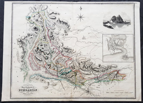
1841 Johnston Large Antique Map The County of Dumbarton, Dunbartonshire Scotland
- Title : 1841 Johnston Large Antique Map The County of Dumbarton, Dunbartonshire Scotland
- Size: 29in x 21in (740mm x 535mm)
- Condition: (A) Very Good Condition
- Date : 1841
- Ref #: 70481
Description:
This large original hand coloured steel-plate engraved antique map of the Scottish region of Dumbarton in the county of Dunbartonshire centering on Glasgow and the river Clyde - with an inset image of Dumbarton Castle and another of Dumbarton Town - was published by W & A.K. Johnston in 1841.
The map centers on Loch Lomond, the River Clyde and the city of Glasgow.
General Definitions:
Paper thickness and quality: - Heavy and stable
Paper color : - off white
Age of map color: - Original
Colors used: - Yellow, green, blue, pink
General color appearance: - Authentic
Paper size: - 29in x 21in (740mm x 535mm)
Plate size: - 27in x 21in (685mm x 535mm)
Margins: - Min 1/2in (12mm)
Imperfections:
Margins: - Soiling, several small repairs to margins into border, no loss
Plate area: - Light soiling, centerfold re-joined
Verso: - Soiling, repairs as noted
Background:
Dunbartonshire or the County of Dumbarton is a historic county, lieutenancy area and registration county in the west central Lowlands of Scotland lying to the north of the River Clyde.
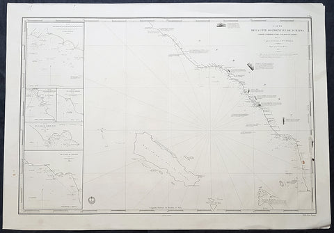
1837 Depot De Marine Large Antique Map Sea Chart of Aceh, Sumatra, Indonesia
- Title : Carte de la Cote Occidentale De Sumatra..1837
- Size: 38in x 26 1/2in (330mm x 255mm)
- Condition: (A+) Fine Condition
- Date : 1837
- Ref #: 30142
Description:
This very large highly detailed original antique map, Sea Chart of the South west coast of Aceh on the North-West tip of the Island of Sumatra, Indonesia was engraved in 1837 - the date is engraved in the title - and was published by The French Admiralty - Depot General de la Marine.
At the time of publication Baron Duperre was head of the French Admiralty. This sea chart would have been one of the actual charts used by the French navy during the many voyages of discovery launched by the French in the 18th & 19th centuries.
The map stretches from the town of Singkil on the south coast to the town of Meulaboh in the north. Off the coast is the Island of Simeulue. Inset are 5 inset maps of ports and harbours along the SW Aceh coastline.
1. Qualh-Battoo et De Soosoo (Susu)
2. Baie De Muckie
3. De Labon et Hadje (Labuan)
4. Baie Tampat Tuan (Tapak Tuan)
5. Baie De Troumon (Trumon)
General Definitions:
Paper thickness and quality: - Heavy and stable
Paper color : - off white
Age of map color: -
Colors used: -
General color appearance: -
Paper size: - 38in x 26 1/2in (330mm x 255mm)
Plate size: - 38in x 26 1/2in (330mm x 255mm)
Margins: - Min 1/2in (12mm)
Imperfections:
Margins: - None
Plate area: - None
Verso: - None
Background:
Aceh is a province of Indonesia. The territory is located at the northern end of Sumatra. Its capital is Banda Aceh. It is close to the Andaman and Nicobar Islands of India and separated from them by the Andaman Sea. Its population has the highest percentage of Muslims in Indonesia, who mostly live according to Sharia customs and laws.
The Sultanate of Aceh was established by Sultan Ali Mughayat Syah in 1511.
In 1584–88 the Bishop of Malacca, D. João Ribeiro Gaio, based on information provided by a former captive called Diogo Gil, wrote the Roteiro das Cousas do Achem (Lisboa 1997) – a description of the Sultanate.
Later, during its golden era, in the 17th century, its territory and political influence expanded as far as Satun in southern Thailand, Johor in Malay Peninsula, and Siak in what is today the province of Riau. As was the case with most non-Javan pre-colonial states, Acehnese power expanded outward by sea rather than inland. As it expanded down the Sumatran coast, its main competitors were Johor and Portuguese Malacca on the other side of the Straits of Malacca. It was this seaborne trade focus that saw Aceh rely on rice imports from north Java rather than develop self sufficiency in rice production.
After the Portuguese occupation of Malacca in 1511, many Islamic traders passing the Malacca Straits shifted their trade to Banda Aceh and increased the Acehnese rulers\' wealth. During the reign of Sultan Iskandar Muda in the 17th century, Aceh\'s influence extended to most of Sumatra and the Malay Peninsula. Aceh allied itself with the Ottoman Empire and the Dutch East India Company in their struggle against the Portuguese and the Johor Sultanate. Acehnese military power waned gradually thereafter, and Aceh ceded its territory of Pariaman in Sumatra to the Dutch in the 18th century.
By the early nineteenth century, however, Aceh had become an increasingly influential power due to its strategic location for controlling regional trade. In the 1820s it was the producer of over half the world\'s supply of black pepper. The pepper trade produced new wealth for the Sultanate and for the rulers of many smaller nearby ports that had been under Aceh\'s control, but were now able to assert more independence. These changes initially threatened Acehs integrity, but a new sultan Tuanku Ibrahim, who controlled the kingdom from 1838 to 1870, reasserted power over nearby ports.
Under the Anglo-Dutch Treaty of 1824 the British ceded their colonial possessions on Sumatra to the Dutch. In the treaty, the British described Aceh as one of their possessions, although they had no actual control over the Sultanate. Initially, under the agreement the Dutch agreed to respect Aceh\'s independence. In 1871, however, the British dropped previous opposition to a Dutch invasion of Aceh, possibly to prevent France or the United States from gaining a foothold in the region. Although neither the Dutch nor the British knew the specifics, there had been rumors since the 1850s that Aceh had been in communication with the rulers of France and of the Ottoman Empire
Depot des cartes et plans de la Marine
The Naval Hydrographic and Oceanographic Service is a French public establishment of an administrative nature, administered by the Ministry of Defence. It is the successor to the Dépôt des cartes et plans de la Marine, founded in 1720 which became the Naval Hydrographic Service in 1886 and the Naval and Oceanographic Service in 1971.
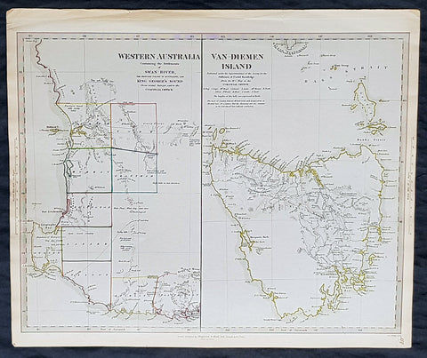
1833 SDUK Antique Map of Western Australia & Van Diemens Island, Tasmania
- Title : Western Australia containing the settlment of Swan River and King Georges Sound; Van-Diemens Land
- Size: 16 1/4in x 13 1/2in (410mm x 350mm)
- Condition: (A+) Fine Condition
- Date : 1833
- Ref #: 11-1074
Description:
This fine hand coloured original steel plate engraved antique maps of Western Australia - only 4 years after the first British settlement on the Swan river & Van Diemens Land or Tasmania was engraved by J & C Walker, in 1833 - the date is engraved at the foot of the map - and was published in the Baldwin & Craddock edition of the Society For the Diffusion of Useful Knowledge (SDUK) Atlas.
General Definitions:
Paper thickness and quality: - Heavy and stable
Paper color : - off white
Age of map color: - Original
Colors used: - Yellow, Green, pink
General color appearance: - Authentic
Paper size: - 16 1/4in x 13 1/2in (410mm x 350mm)
Plate size: - 16 1/4in x 13 1/2in (410mm x 350mm)
Margins: - Min 1/2in (12mm)
Imperfections:
Margins: - None
Plate area: - None
Verso: - None
Background:
The SDUK produced two landmark volumes of cartography in the first half of the 19th century. The first volume concentrated on areas of the old world, Europe, Africa, Great Britain etc. The second volume contained maps of the new world, Alvin Jewett JohnsonAmerica, South Asia, including US state maps, colonies of Australia, South Africa, South America etc. Also included were some of the finest engraved town and city plans published at that time.
The SDUK was published in its entirety or in part by many publishers including Baldwin and Cradock 1829-32, Chapman & Hall in 1844, Charles Knight & co. 1846 – 1852. G. Cox published the SDUK between 1852-3, Stanford 1857-70 and later revised edition were also published after Stanford. (Ref: Tooley, M&B)
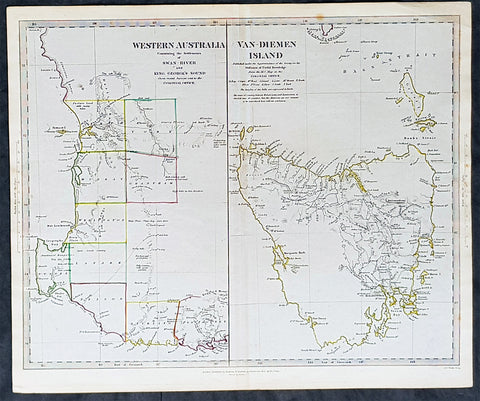
1833 SDUK Antique Map of Western Australia & Van Diemens Island, Tasmania
- Title : Western Australia containing the settlment of Swan River and King Georges Sound; Van-Diemens Land
- Size: 16 1/4in x 13 1/2in (410mm x 350mm)
- Condition: (A+) Fine Condition
- Date : 1833
- Ref #: 11-1084
Description:
This fine hand coloured original steel plate engraved antique maps of Western Australia - only 4 years after the first British settlement on the Swan river & Van Diemens Land or Tasmania was engraved by J & C Walker, in 1833 and was published in the Charles Knight edition of the Society For the Diffusion of Useful Knowledge (SDUK) Atlas.
General Definitions:
Paper thickness and quality: - Heavy and stable
Paper color : - off white
Age of map color: - Original
Colors used: - Yellow, Green, pink
General color appearance: - Authentic
Paper size: - 16 1/4in x 13 1/2in (410mm x 350mm)
Plate size: - 16 1/4in x 13 1/2in (410mm x 350mm)
Margins: - Min 1/2in (12mm)
Imperfections:
Margins: - None
Plate area: - None
Verso: - None
Background:
The SDUK produced two landmark volumes of cartography in the first half of the 19th century. The first volume concentrated on areas of the old world, Europe, Africa, Great Britain etc. The second volume contained maps of the new world, Alvin Jewett JohnsonAmerica, South Asia, including US state maps, colonies of Australia, South Africa, South America etc. Also included were some of the finest engraved town and city plans published at that time.
The SDUK was published in its entirety or in part by many publishers including Baldwin and Cradock 1829-32, Chapman & Hall in 1844, Charles Knight & co. 1846 – 1852. G. Cox published the SDUK between 1852-3, Stanford 1857-70 and later revised edition were also published after Stanford. (Ref: Tooley, M&B)
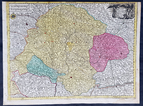
1744 Georg Mattaus Seutter Antique Map Hungarian Empire, Transylvania, Sclavonia
Antique Map
- Title : Regni Hungariae........a Matth. Seutteri...T C Lotter, Geogr.
- Ref #: 93399
- Size: 11in x 8 1/2in (280mm x 215mm)
- Date : 1744
- Condition: (A) Very Good Condition
Description:
This beautifully hand coloured original copper-plate engraved antique map of the Hungarian Empire was engraved by Tobias Lotter and was published in the 1744 edition of GM Seutters Atlas Minor Prae cipua Orbis Terrarum Imperia Regna et Provincias...., Augsburg, Germany.
General Definitions:
Paper thickness and quality: - Heavy and stable
Paper color : - off white
Age of map color: - Original
Colors used: - Yellow, green, blue, pink
General color appearance: - Authentic
Paper size: - 11in x 8 1/2in (280mm x 215mm)
Plate size: - 10 1/2in x 8in (265mm x 205mm)
Margins: - Min 1/4in (5mm)
Imperfections:
Margins: - Top margin cropped into border
Plate area: - None
Verso: - None
Background:
Atlas Minor was a series of beautiful maps of all parts of the world. Georg Matthäus Seutter was one of the most and important of the German cartographers of the 18th century, being appointed as the Geographer to the Imperial Court. His son, Albrecht Carl, joined Matthäus and eventually inherited the business. The maps from Atlas Minor were drawn by the two Seutters and engraved by Tobias Conrad Lotte. These maps are highly detailed and engraved with a bold hand with equally strong original hand color in the body of the map as was the 18th century German style. The cartouches were left uncolored in order to emphasize the elaborately detailed illustrations for which German maps are especially prized. These are some of the most decorative and interesting maps of the eighteenth century.
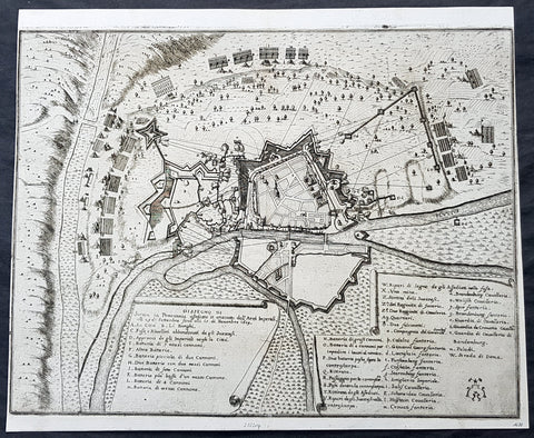
1675 Merian Antique Map Birds Eye View Siege of Szczecin, Stettin Poland in 1659
Antique Map
- Title : Abzeichnung der Belägerung der Statt Stettin in Pommeren wie dieselbe von denen Kayserlichen vom 29.Sept. biß auf den 15. Novemb. Anno 1659 angegriffen und bestritten worden
- Ref #: 93491
- Size: 15 1/2in x 13in (395mm x 340mm)
- Date : 1675
- Condition: (A+) Fine Condition
Description:
This original copper-plate engraved antique map a birds-eye view of the siege of Szczecin or Stettin, Poland in 1659 - with illustrations of military positions surrounding the city - by Matthaus Merian was published in the 1675 edition of Theatrum Europaeum
During the Thirty Years War, Stettin refused to accept German imperial armies, instead the Pomeranian dukes allied with Sweden. After the Treaty of Stettin (1630) manifested Swedish occupation, Stettin was fortified by the Swedish Empire. After the death of the last Pomeranian duke, Boguslaw XIV, Stettin was awarded to Sweden with the western part of the duchy in the Peace of Westphalia (1648), but remained part of the Holy Roman Empire. The Swedish-Brandenburgian border was settled in the Treaty of Stettin (1653). The King of Sweden became Duke of Pomerania and as such held a seat in the Imperial Diet of the Holy Roman Empire. The city was cut off from its main trading area, and was besieged in several wars with Brandenburg which shattered the citys economy, which fell in prolonged economic decline.
In 1654 the last Pomeranian duke Boguslaw XIV was buried in the Ducal Castle.
General Definitions:
Paper thickness and quality: - Heavy and stable
Paper color : - off white
Age of map color: -
Colors used: -
General color appearance: -
Paper size: - 15 1/2in x 13in (395mm x 340mm)
Plate size: - 15 1/2in x 13in (395mm x 340mm)
Margins: - Min 1/8in (2mm)
Imperfections:
Margins: - Left margin cropped close to border
Plate area: - None
Verso: - None
Background:
Szczecin/Stettin is the capital and largest city of the West Pomeranian Voivodeship in northwestern Poland. Located near the Baltic Sea and the German border, it is a major seaport and Polands seventh-largest city.
Szczecin is located on the river Oder, south of the Szczecin Lagoon and the Bay of Pomerania. The city is situated along the southwestern shore of Dąbie Lake, on both sides of the Oder and on several large islands between the western and eastern branches of the river. Szczecin is adjacent to the town of Police and is the urban centre of the Szczecin agglomeration, an extended metropolitan area that includes communities in the German states of Brandenburg and Mecklenburg-Vorpommern.
The cities recorded history began in the 8th century as a Lechitic Pomeranian stronghold, built at the site of the Ducal castle. In the 12th century, when Szczecin had become one of Pomeranias main urban centres, it lost its independence to Piast Poland, the Duchy of Saxony, the Holy Roman Empire and Denmark. At the same time, the House of Griffins established themselves as local rulers and the population was Christianized. After the Treaty of Stettin in 1630, the town came under the control of the Swedish Empire and became in 1648 the Capital of Swedish Pomerania until 1720, when it was acquired by the Kingdom of Prussia and then the German Empire. Following World War II Stettin became part of Poland in accordance with the Potsdam Agreement, resulting in the almost complete expulsion of the pre-war German population.

1825 Philippe Vandermaelen Large Antique Map of The Solomon Islands
Antique Map
- Title : Oceanique. Partie Des Iles Salomon
- Ref #: 17003
- Size: 28 1/2in x 21in (725mm x 550mm)
- Date : 1825
- Condition: (A+) Fine Condition
Description:
This very large original hand coloured antique lithograph map of the Solomon Islands in the South Pacific was published by Philippe Vandermaelen in his revolutionary 1825 Atlas universel de geographie physique, politique, statistique et mineralogique.
Until the publication of this atlas, large detailed maps of this region of Australia & the Pacific were uncommon.
General Definitions:
Paper thickness and quality: - Heavy and stable
Paper color : - off white
Age of map color: - Original
Colors used: - Yellow, green, blue, pink
General color appearance: - Authentic
Paper size: - 28 1/2in x 21in (725mm x 550mm)
Plate size: - 28 1/2in x 21in (725mm x 550mm)
Margins: - Min 1/2in (12mm)
Imperfections:
Margins: - None
Plate area: - None
Verso: - None
Background:
The first European to visit the islands was the Spanish navigator Álvaro de Mendaña de Neira, sailing from Peru in 1568. Landing on Santa Isabel on 7 February, Mendaña explored several of the other islands including Makira, Guadalcanal and Malaita. Relations with the native Solomon Islanders were initially cordial, though often soured as time went by. As a result, Mendaña returned to Peru in August 1568. He returned to the Solomons with a larger crew on a second voyage in 1595, aiming to colonise the islands. They landed on Nendö in the Santa Cruz Islands and established a small settlement at Gracioso Bay. However the settlement failed due to poor relations with the native peoples and epidemics of disease amongst the Spanish which caused numerous deaths, with Mendaña himself dying in October. The new commander Pedro Fernandes de Queirós thus decided to abandon the settlement and they sailed north to the Spanish territory of the Philippines. Queirós later returned to the area in 1606, where he sighted Tikopia and Taumako, though this voyage was primarily to Vanuatu in the search of Terra Australis.
Save for Abel Tasmans sighting of the remote Ontong Java Atoll in 1648, no European sailed to the Solomons again until 1767, when the British explorer Philip Carteret sailed by the Santa Cruz Islands, Malaita and, continuing further north, Bougainville and the Bismarck Islands. French explorers also reached the Solomons, with Louis Antoine de Bougainville naming Choiseul in 1768 and Jean-François-Marie de Surville exploring the islands in 1769. In 1788 John Shortland, captaining a supply ship for Britains new Australian colony at Botany Bay, sighted the Treasury and Shortland Islands. That same year the French explorer Jean-François de La Pérouse was wrecked on Vanikoro; a rescue expedition led by Bruni dEntrecasteaux sailed to Vanikoro but found no trace of La Pérouse. The fate of La Pérouse was not confirmed until 1826, when the English merchant Peter Dillon visited Tikopia and discovered items belonging to La Pérouse in the possession of the local people, confirmed by the subsequent voyage of Jules Dumont dUrville in 1828.
Some of the earliest regular foreign visitors to the islands were whaling vessels from Britain, the United States and Australia. They came for food, wood and water from late in the 18th century, establishing a trading relationship with the Solomon Islanders and later taking aboard islanders to serve as crewmen on their ships. Relations between the islanders and visiting seamen was not always good and sometimes there was bloodshed. A knock-on effect of the greater European contact was the spread of diseases to which local peoples had no immunity, as well a shift in the balance of power between coastal groups, who had access to European weapons and technology, and inland groups who did not. In the second half of the 1800s more traders arrived seeking turtleshells, sea cucumbers, copra and sandalwood, occasionally establishing semi-permanent trading stations. However initial attempts at more long-term settlement, such as Benjamin Boyds colony on Guadalcanal in 1851, were unsuccessful.
Vandermaelen, Philippe M G 1795-1869
Vandermaelen was the son of the wealthy soap manufacturer; he abandoned the soap trade and devoted his life to cartography. Entirely self-taught in geometry, astronomy and the geosciences, he began drafting the first sheets of an Atlas universel in 1824. This atlas was published between 1825 and 1827; it was sold in forty instalments of ten maps each and became a great success. The revenue enabled him to set up his own Etablissement géographique de Bruxelles in 1830, which not only produced maps, atlases and globes in large quantities but also housed a natural science museum, botanical gardens, a library, and an impressive collection of maps.
Shortly after the closing of Vandermaelens Institute, the Royal Library of Belgium (KBR) in 1880 acquired a large part of its cartographic collection and production.
Vandermaelens atlas was remarkable: 387 maps on a uniform scale of ca. 1:1.6 million. There was one edition of this very rare atlas, published in 1825-27; the subscription list shows that only 810 copies were sold. The six volumes, of which Africa was in Volume III (60 maps), were issued in instalments during the period 1825-1827.
This folio-size atlas is remarkable for several reasons. It is the first atlas produced by the then new printing process of lithography. It is also the first atlas to show the whole world in 380 maps using a large uniform scale—about 10km to the cm. on a modified conical projection described by Sanson-Flamsteed. Based on a prime meridian through Paris, each map has a drawn-out graticule giving it a trapezoidal form, the underlying intention being construction of a globe with a diameter of 7.755m Eugene Gilbert de Cauwer , his biographer, suggested that Vandernaelen was a worthy follower of Mercator and Ortelius.
Vandermaelen enlisted the assistance of lithographer-printer Hippolyte Ode in this ambitious project which introduced lithography into Belgium and created an upsurge in Belgian publishing. A number of maps were lithographed by Philippe Vandermaelen himself. For many of the areas depicted, these maps are the largest scale maps made at the time, and the most detailed. The lithographs are very well drawn and printed and should be appreciated in the context of lithography, which was a developing art at the time. The maps are handsome and detailed, although some of the place names are somewhat curious and the cartography sometimes imaginary. Nevertheless, the Vandermaelen maps are of great significance in the history of cartography and lithography. Visually, they are arresting and unusual. Vandermaelens maps best are appreciated in the context of its neighbouring maps - they were all meant to be joined .
Please note all items auctioned are genuine, we do not sell reproductions. A Certificate of Authenticity (COA) can be issued on request.
1695 Robert Morden Antique Map of the Islands of Great Britain & Ireland
Antique Map
-
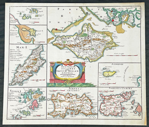
Title : The Smaller Islands in the British Ocean by Rob Morden sold by Mel Swale Awnsham and John Churchill
- Ref #: 17012
-
Condition: (A) Very Good Condition
- Size: 17 1/2in x 15 1/2in (445mm x 395mm)
- Date : 1695
Description:
This fine original copper-plate engraved hand coloured antique map of the many Islands off the coast of Great Britain & Ireland by Robert Morden was published in the 1695 edition of Camdens Britannia.
General Definitions:
Paper thickness and quality: - Heavy and stable
Paper color : - off white
Age of map color: - Early
Colors used: - Red, yellow, green, blue
General color appearance: - Authentic
Paper size: - 17 1/2in x 15 1/2in (445mm x 395mm)
Plate size: - 17in x 141/2in (430mm x 370mm)
Margins: - Min 1/2in (12mm)
Imperfections:
Margins: - None
Plate area: - None
Verso: - Mounted to original board
Background:
These maps are the first county maps to show roads (based on Ogilby’s road maps) and show three scales representing great, middle and small miles as different scales were used in different parts of the country. Morden was employed to replace the outdated maps by Saxton, engraved by Kip and Hole. He based his maps on manuscript sources plus the surveys of Ogilby and Morgan, Seller, Palmer and the coastal charts of Captain Grenville Collins. One innovation was the showing of longitudes measured from the meridian of St. Paul's Cathedral given in the form of time in minutes at the top of the map in Roman numerals and at the bottom in degrees. This was done to clarify local times that were taken from the sun as there was no national standard time. Gibson said:' Where actual Surveys could be had, they were purchased at any rate; and for the rest, one of the best Copies extanct was sent to some of the most knowing Gentlemen in each County; with a request to supply the defects, rectified the positions, and correct the false spellings. And that nothing might be wanting to render them as complete and accurate as might be, this whole business was commited to Mr Robert Morden, a person of know abilities in these matters'..from the Preface of the Britannia.
Morden, Robert 1650 - 1703
Morden was an English bookseller, publisher, and maker of maps and globes. He was among the first successful commercial map makers.
Between about 1675 and his death in 1703, he was based under the sign of the Atlas at premises in Cornhill and New Cheapside, London. His cartographical output was large and varied. His best-known maps are those of South Wales, North Wales and the English Counties first published in a new edition of Camdens Britannia in 1695, and subsequently reissued in 1722, 1753 and 1772. These maps were based on new information from gentlemen of each county, and were newly engraved. Each had a decorated cartouche, and showed numerous place names. Morden also produced in 1701 a series of smaller county maps often known as Miniature Mordens.
In 1695 he published a map of Scotland. It is in parts (e.g. Skye and the Western Isles) essentially a copy of the 1654 map done by Robert Gordon of Straloch, published by Joan Blaeu; other parts show evidence of more accurate cartography.
His (fourth edition) of Geography Rectified: or a Description of the World from 1700 dedicated to a Thomas Goddard, is a comprehensive work from many aspects. Its more than 700 pages, including a long pedagogic preface, no less than 78 maps from Europe including the British Isles, Asia, Africa, America and a two circular maps of the world, representing planet Earth seen from exactly opposite sides - the known world as of its time. (Australia and Antarctica were not yet known in Europe by then.) It further contains explanations of many general geographical concepts such as Latitude and Longitude and more. It also contains several comparisons of commodities, customs, history, governments, coins and weights (etc) with those in London. Its index is extensive. A copy has been stored at British Museum for more than a century.
He published a new map of the Tamil homeland, Coylot Wanees Country, in 17th-century Ceylon island.
He is also known for several very rare early maps of the British colonies in North America, which are now among the earliest and most sought after maps for collectors of old American maps. He also produced a series of miniature maps of the world, which appeared in both playing card format and in a series of atlases, including his Atlas Terrestris and Geography Anatomizd, beginning in 1687.
Please note all items auctioned are genuine, we do not sell reproductions. A Certificate of Authenticity (COA) can be issued on request.

1825 Philippe Vandermaelen Large Antique Map of Austral Islands French Polynesia
Antique Map
-
Title : Partie De L Archipel Des Iles Basses
- Ref #: 17006
-
Condition: (A+) Fine Condition
- Size: 28 1/2in x 21in (725mm x 550mm)
- Date : 1825
Description:
This very large original hand coloured antique lithograph map of the Austral Islands in the French Polynesia group of islands in the in the South Pacific was published by Philippe Vandermaelen in his revolutionary 1825 Atlas universel de geographie physique, politique, statistique et mineralogique.
Until the publication of this atlas, large detailed maps of this region of Australia & the Pacific were uncommon.
General Definitions:
Paper thickness and quality: - Heavy and stable
Paper color : - off white
Age of map color: - Early
Colors used: - Red, yellow, green, blue
General color appearance: - Authentic
Paper size: - 28 1/2in x 21in (725mm x 550mm)
Plate size: - 28 1/2in x 21in (725mm x 550mm)
Margins: - Min 1/2in (12mm)
Imperfections:
Margins: - None
Plate area: - None
Verso: - None
Background:
New Hebrides, officially the New Hebrides Condominium (French: Condominium des Nouvelles-Hébrides, lit. Condominium of the New Hebrides) and named for the Hebrides Scottish archipelago, was the colonial name for the island group in the South Pacific Ocean that is now Vanuatu. Native people had inhabited the islands for three thousand years before the first Europeans arrived in 1606 from a Spanish expedition led by Portuguese navigator Pedro Fernandes de Queirós. The islands were colonised by both the British and French in the 18th century, shortly after Captain James Cook visited.
The two countries eventually signed an agreement making the islands an Anglo-French condominium that divided New Hebrides into two separate communities: one Anglophone and one Francophone. That divide continued even after independence, with schools teaching in either one language or the other, and with different political parties. The condominium lasted from 1906 until 1980, when New Hebrides gained its independence as the Republic of Vanuatu.
Vandermaelen, Philippe M G 1795-1869
Vandermaelen was the son of the wealthy soap manufacturer; he abandoned the soap trade and devoted his life to cartography. Entirely self-taught in geometry, astronomy and the geosciences, he began drafting the first sheets of an Atlas universel in 1824. This atlas was published between 1825 and 1827; it was sold in forty instalments of ten maps each and became a great success. The revenue enabled him to set up his own Etablissement géographique de Bruxelles in 1830, which not only produced maps, atlases and globes in large quantities but also housed a natural science museum, botanical gardens, a library, and an impressive collection of maps.
Shortly after the closing of Vandermaelens Institute, the Royal Library of Belgium (KBR) in 1880 acquired a large part of its cartographic collection and production.
Vandermaelens atlas was remarkable: 387 maps on a uniform scale of ca. 1:1.6 million. There was one edition of this very rare atlas, published in 1825-27; the subscription list shows that only 810 copies were sold. The six volumes, of which Africa was in Volume III (60 maps), were issued in instalments during the period 1825-1827.
This folio-size atlas is remarkable for several reasons. It is the first atlas produced by the then new printing process of lithography. It is also the first atlas to show the whole world in 380 maps using a large uniform scale—about 10km to the cm. on a modified conical projection described by Sanson-Flamsteed. Based on a prime meridian through Paris, each map has a drawn-out graticule giving it a trapezoidal form, the underlying intention being construction of a globe with a diameter of 7.755m Eugene Gilbert de Cauwer , his biographer, suggested that Vandernaelen was a worthy follower of Mercator and Ortelius.
Vandermaelen enlisted the assistance of lithographer-printer Hippolyte Ode in this ambitious project which introduced lithography into Belgium and created an upsurge in Belgian publishing. A number of maps were lithographed by Philippe Vandermaelen himself. For many of the areas depicted, these maps are the largest scale maps made at the time, and the most detailed. The lithographs are very well drawn and printed and should be appreciated in the context of lithography, which was a developing art at the time. The maps are handsome and detailed, although some of the place names are somewhat curious and the cartography sometimes imaginary. Nevertheless, the Vandermaelen maps are of great significance in the history of cartography and lithography. Visually, they are arresting and unusual. Vandermaelens maps best are appreciated in the context of its neighbouring maps - they were all meant to be joined .
Please note all items auctioned are genuine, we do not sell reproductions. A Certificate of Authenticity (COA) can be issued on request.

1825 Philippe Vandermaelen Large Antique Map Admiralty or Manus Islands Pacific
Antique Map
-
Title : Iles De L Amiraute
- Ref #: 17005
-
Condition: (A+) Fine Condition
- Size: 28 1/2in x 21in (725mm x 550mm)
- Date : 1825
Description:
This very large original hand coloured antique lithograph map of the Admiralty or Manus Islands, north of New Guinea, in the South Pacific was published by Philippe Vandermaelen in his revolutionary 1825 Atlas universel de geographie physique, politique, statistique et mineralogique.
Until the publication of this atlas, large detailed maps of this region of Australia & the Pacific were uncommon.
General Definitions:
Paper thickness and quality: - Heavy and stable
Paper color : - off white
Age of map color: - Early
Colors used: - Red, yellow, green, blue
General color appearance: - Authentic
Paper size: - 28 1/2in x 21in (725mm x 550mm)
Plate size: - 28 1/2in x 21in (725mm x 550mm)
Margins: - Min 1/2in (12mm)
Imperfections:
Margins: - None
Plate area: - None
Verso: - None
Background:
The first European to visit the islands was the Spanish navigator Álvaro de Saavedra when trying to return from Tidore to New Spain in the summer of 1528. Saavedra charted Manus as Urays la Grande. Its visit was also reported in 1616 by the Dutch navigator Willem Schouten. The name Admiralty Islands was devised by Captain Philip Carteret of the British Royal Navy in 1767.
Between 1884 and 1914 the area was administered as a German colony. In November 1914, the islands were occupied by troops of the Australian Naval and Military Expeditionary Force landed from the SS Siar. A few shots fired from a machine gun on Siar over the heads of the tiny German garrison at Lorengau were the last shots fired in the battle. After the war, the islands were governed by the Commonwealth of Australia under a League of Nations mandate.
Japanese troops landed on Manus Island on 7 April 1942. In 1944, Japanese forces occupying the islands were attacked and defeated by Allied forces in Operation Brewer. Subsequently, a large American airbase was built at Lombrum near Lorengau.
Vandermaelen, Philippe M G 1795-1869
Vandermaelen was the son of the wealthy soap manufacturer; he abandoned the soap trade and devoted his life to cartography. Entirely self-taught in geometry, astronomy and the geosciences, he began drafting the first sheets of an Atlas universel in 1824. This atlas was published between 1825 and 1827; it was sold in forty instalments of ten maps each and became a great success. The revenue enabled him to set up his own Etablissement géographique de Bruxelles in 1830, which not only produced maps, atlases and globes in large quantities but also housed a natural science museum, botanical gardens, a library, and an impressive collection of maps.
Shortly after the closing of Vandermaelens Institute, the Royal Library of Belgium (KBR) in 1880 acquired a large part of its cartographic collection and production.
Vandermaelens atlas was remarkable: 387 maps on a uniform scale of ca. 1:1.6 million. There was one edition of this very rare atlas, published in 1825-27; the subscription list shows that only 810 copies were sold. The six volumes, of which Africa was in Volume III (60 maps), were issued in instalments during the period 1825-1827.
This folio-size atlas is remarkable for several reasons. It is the first atlas produced by the then new printing process of lithography. It is also the first atlas to show the whole world in 380 maps using a large uniform scale—about 10km to the cm. on a modified conical projection described by Sanson-Flamsteed. Based on a prime meridian through Paris, each map has a drawn-out graticule giving it a trapezoidal form, the underlying intention being construction of a globe with a diameter of 7.755m Eugene Gilbert de Cauwer , his biographer, suggested that Vandernaelen was a worthy follower of Mercator and Ortelius.
Vandermaelen enlisted the assistance of lithographer-printer Hippolyte Ode in this ambitious project which introduced lithography into Belgium and created an upsurge in Belgian publishing. A number of maps were lithographed by Philippe Vandermaelen himself. For many of the areas depicted, these maps are the largest scale maps made at the time, and the most detailed. The lithographs are very well drawn and printed and should be appreciated in the context of lithography, which was a developing art at the time. The maps are handsome and detailed, although some of the place names are somewhat curious and the cartography sometimes imaginary. Nevertheless, the Vandermaelen maps are of great significance in the history of cartography and lithography. Visually, they are arresting and unusual. Vandermaelens maps best are appreciated in the context of its neighbouring maps - they were all meant to be joined .
Please note all items auctioned are genuine, we do not sell reproductions. A Certificate of Authenticity (COA) can be issued on request.

1673 Blome Antique Map Islands of Great Britain - Shetlands, Man, Wight, Channel
Antique Map
-
Title : A Mapp of the Isles of Wight, Jarsey, Garnsey, Sarke, Man, Orcadies and Shetland by Ric Blome by his Matys. Command
- Ref #: 17013
-
Condition: (A+) Fine Condition
- Size: 15in x 12 1/2in (380mm x 320mm)
- Date : 1673
Description:
This original hand coloured, copper plate engraved antique map of the Islands of Great Britain - Shetlands, Man, Wight, Orkenys, Jersey, Guernsey & Sark (Channel Islands) - was published by Richard Blome in the 1673 edition of Britannia: or, A Geographical Description of the Kingdoms of England, Scotland, and Ireland, with the Isles and Terrotories thereto belonging.
General Definitions:
Paper thickness and quality: - Heavy and stable
Paper color : - off white
Age of map color: - Early
Colors used: - Yellow, green, blue, pink
General color appearance: - Authentic
Paper size: - 15in x 12 1/2in (380mm x 320mm)
Plate size: - 14 1/2in x 11in (370mm x 280mm)
Margins: - Min 1/8in (5mm)
Imperfections:
Margins: - Light age toning in margins
Plate area: - None
Verso: - None
Please note all items auctioned are genuine, we do not sell reproductions. A Certificate of Authenticity (COA) can be issued on request.
1639 Henricus Hondius Original Antique Map of the German State of Thuringia
Antique Map
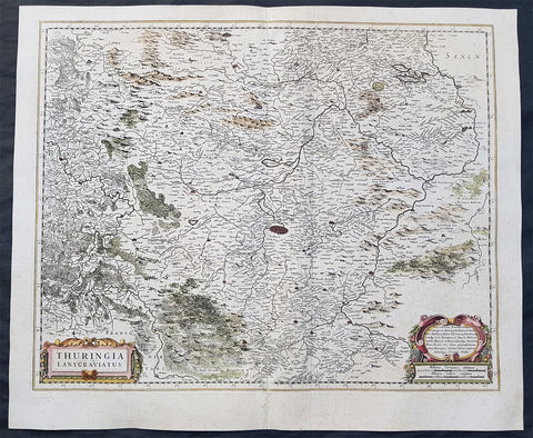
- Title : Thuringia Lantgraviatus
- Date : 1639
- Size: 22 1/2in x 19in (570mm x 485mm)
- Ref #: 23434
- Condition: (A) Very Good Condition
Description:
This fine original antique map of the German State of Thuringia or Thüringen in central Germany was published by Henricus Hondius in the 1639 edition of Mercators Atlas.
The map centers on the city of Erfurt and alos includes major cities of Gotha, Weimar, Schwartzburg, Halle, Jena, Mulhausen and others
General Definitions:
Paper thickness and quality: - Heavy and stable
Paper color : - off white
Age of map color: - Original
Colors used: - Yellow, green, blue, pink
General color appearance: - Authentic
Paper size: - 22 1/2in x 19in (570mm x 485mm)
Plate size: - 20 1/2in x 16 1/2in (520mm x 420mm)
Margins: - Min 1in (25mm)
Imperfections:
Margins: - None
Plate area: - Light creasing along centerfold,
Verso: - Small repair to bottom left margin
Background:
Named after the Thuringii tribe who occupied it around AD 300, Thuringia came under Frankish domination in the 6th century.
Thuringia became a landgraviate in 1130 AD. After the extinction of the reigning Ludowingian line of counts and landgraves in 1247 and the War of the Thuringian Succession (1247–1264), the western half became independent under the name of \"Hesse\", never to become a part of Thuringia again. Most of the remaining Thuringia came under the rule of the Wettin dynasty of the nearby Margraviate of Meissen, the nucleus of the later Electorate and Kingdom of Saxony. With the division of the house of Wettin in 1485, Thuringia went to the senior Ernestine branch of the family, which subsequently subdivided the area into a number of smaller states, according to the Saxon tradition of dividing inheritance amongst male heirs. These were the \"Saxon duchies\", consisting, among others, of the states of Saxe-Weimar, Saxe-Eisenach, Saxe-Jena, Saxe-Meiningen, Saxe-Altenburg, Saxe-Coburg, and Saxe-Gotha; Thuringia became merely a geographical concept.
Thuringia generally accepted the Protestant Reformation, and Roman Catholicism was suppressed as early as 1520; priests who remained loyal to it were driven away and churches and monasteries were largely destroyed, especially during the German Peasants\' War of 1525. In Mühlhausen and elsewhere, the Anabaptists found many adherents. Thomas Müntzer, a leader of some non-peaceful groups of this sect, was active in this city. Within the borders of modern Thuringia the Roman Catholic faith only survived in the Eichsfeld district, which was ruled by the Archbishop of Mainz, and to a small degree in Erfurt and its immediate vicinity.
1816 John Thompson Large Antique Map Grenada, Tobago, Curacao Trinidad Caribbean
Antique Map
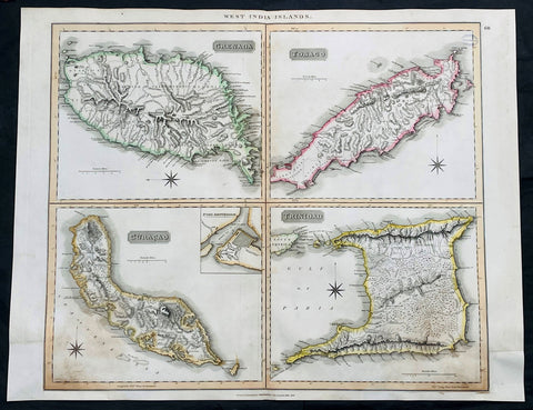
- Title : West India Islands: Grenada; Tobago; Curacao; Trinadad.
- Date : 1816
- Size: 27in x 21in (685mm x 535mm)
- Condition: (A) Very Good Condition
- Ref: 35612
Description:
This large original, beautifully hand coloured copper plate engraved antique map of the Caribbean Islands Grenada, Tobago, Curacao & Trinidad was published by John Thomson in his large elephant folio 1817 edition of A New General Atlas of the World. (Ref Tooley M&B)
General Definitions:
Paper thickness and quality: - Heavy and stable
Paper color : - off white
Age of map color: - Original
Colors used: - Yellow, green, blue, pink
General color appearance: - Authentic
Paper size: - 27in x 21in (685mm x 535mm)
Plate size: - 27in x 21in (685mm x 535mm)
Margins: - Min 1/2in (12mm)
Imperfections:
Margins: - Bottom L&R margins extended from borders, not affecting the image
Plate area: - Light age toning, small library stamp to right
Verso: - Age toning
1817 John Thompson Large Antique Map Caribbean Islands of St Vincent & Barbados
Antique Map
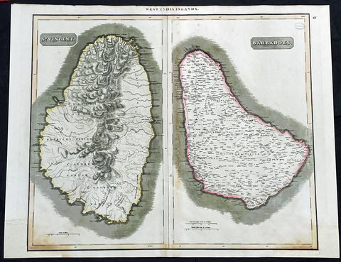
- Title : West India Islands: St Vincent; Barbados
- Date : 1817
- Size: 27in x 21in (685mm x 535mm)
- Condition: (A) Very Good Condition
- Ref: 35610
Description:
This large original, beautifully hand coloured copper plate engraved antique map of the Caribbean Islands was published by John Thomson in his large elephant folio 1817 edition of A New General Atlas of the World. (Ref Tooley M&B)
General Definitions:
Paper thickness and quality: - Heavy and stable
Paper color : - off white
Age of map color: - Original
Colors used: - Yellow, green, blue, pink
General color appearance: - Authentic
Paper size: - 27in x 21in (685mm x 535mm)
Plate size: - 27in x 21in (685mm x 535mm)
Margins: - Min 1/2in (12mm)
Imperfections:
Margins: - Bottom L&R margins extended from borders, not affecting the image
Plate area: - Light age toning, small library stamp to right
Verso: - Age toning
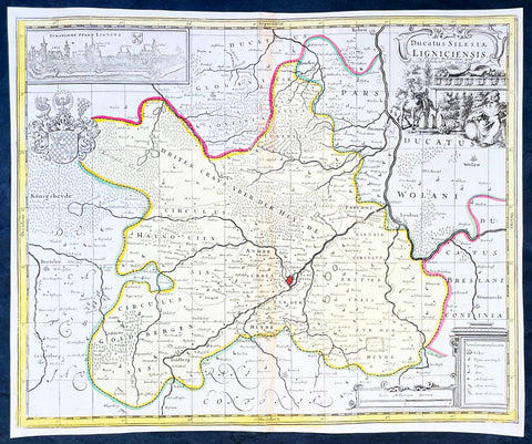
1700 Jan Jansson & Schenk Antique Map of Duchy of Legnica, Silesia South Poland
Antique Map
- Title : Ducatus Silesiae Ligniciensis Pet. Schenk et G Valk
- Ref #: 35636
-
Condition: (A+) Fine Condition
- Size: 19in x 14 3/4in (480mm x 375mm)
- Date : 1700
- Price: $225US
Description:
This original hand coloured large copper plate engraved antique map of the City and Regions of The Duchy of Legnica (Ligniciensis) in Lower Silesia, southern Poland, after Jan Jansson, was published by Peter Schenk Gerard Valck in 1700.
General Definitions:
Paper thickness and quality: - Heavy and stable
Paper color : - off white
Age of map color: - Original
Colors used: - Yellow, green, blue, pink
General color appearance: - Authentic
Paper size: - 19in x 14 3/4in (480mm x 375mm)
Plate size: - 18 1/2in x 14in (465mm x 355mm)
Margins: - Min 1/4in (5mm)
Imperfections:
Margins: - None
Plate area: - Age toning along centerfold
Verso: - None
Background:
The Duchy of Legnica or Duchy of Liegnitz was one of the Duchies of Silesia. Its capital was Legnica (Liegnitz) in Lower Silesia.
Legnica Castle had become a residence of the Silesian dukes in 1163 and from 1248 was the seat of a principality in its own right, ruled by the Silesian branch of the Piast dynasty until the extinction of the line in 1675. Formed by Bolesław II the Bald, Duke of Lower Silesia at Wrocław, Legnica shared the fate of most of the others Silesian duchies, falling into Bohemian, Austrian and eventually—after the First Silesian War—Prussian spheres of influence.
The town of Legnica became famous for the Battle of Legnica that took place at the nearby village of Legnickie Pole on 9 April 1241, during the Mongol invasion of Poland. A Christian army led by the Polish High Duke Henry II the Pious, supported by the feudal nobility including Poles, Bavarian miners and military orders, was decisively defeated by the Mongols. Although Henry was killed and his forces defeated, their advance into Europe was halted when they turned back to attend to the election of a new Khagan (Grand Khan) following the death of Ögedei Khan in the same year. Minor celebrations are held annually in Legnica to commemorate the battle.
After Henry's death his eldest son Bolesław II the Bald followed him as ruler of Lower Silesia until in 1248 his younger brother Henry III the White came of age and claimed his rights of succession. Backed by the nobility of Wrocław, Henry III forced the duke to cede central parts of Lower Silesia to him, while Bolesław himself retired to Legnica. Furthermore, he came into conflict with his younger brother Konrad, who, originally predestined for an ecclesiastical career as Bishop of Passau, also demanded his distributive share and had to be paid off by Bolesław with the newly created Duchy of Głogów in 1251.
Nevertheless, Bolesław's son Henry V the Fat, who succeeded his father in 1278, was able to enlarge the duchy's territories by defeating his cousin Henry Probus, Duke of Wrocław, and, with support of King Wenceslaus II of Bohemia succeeded him as duke in 1290. Thus, the Lower Silesian duchies of Legnica and Wrocław were re-reunited until 1311.
As after the death of Henry V in 1296 his eldest son Bolesław III the Generous was still a minor, King Wenceslaus took over his guardianship, strengthening the Bohemian influence in Silesia. In 1303 Bolesław III was betrothed to Wenceslaus' daughter Margaret and to no avail tried to follow the extinct Přemyslid dynasty on the Bohemian throne in 1306. He was not able to retain the united duchy and in 1311 Lower Silesia was split again, with Wrocław going to his younger brother Henry VI the Good. Even Bolesław's rule over Legnica was contested by his brother Władysław and in 1329 he had to pay homage to the Bohemian King John of Luxembourg to secure his reign.
As the duchy's capital at the beginning of the 14th century, Legnica was an important city of Central Europe, with a population of approximately 16,000 residents. The city began to expand quickly after the discovery of gold in the Kaczawa.
Piast state from 1329 onwards became a Czech vassal, the political weakness of the duchy continued, caused by domestic conflicts between Bolesław's the Wastefull sons Wenceslaus and Louis the Fair strengthening the influences of the Bohemian monarchs. When in 1419 the Legnica branch of the Silesian Piasts became extinct with the death of Duke Wenceslaus II, the duchy was inherited by Duke Louis II of Brzeg. As Louis himself had no male heirs, Legnica was annexed as a ceased fief by the Bohemian king Sigismund in 1436. A long-standing dispute arose, as the late Duke Louis II had bequeathed his estates to the sons of his step-brother Duke Henry IX of Lubin –though without the consent of the Bohemian overlord. Eventually, in 1455 the duchy was inherited by Frederick I, the son of Louis' daughter Hedwig, who was officially enfeoffed by King Matthias Corvinus in 1469.
Frederick's son Frederick II, Duke from 1499, again inherited the Duchy of Brzeg in 1520. The Protestant Reformation was introduced in the duchy as early as 1522, decisively promoted by the theologians Caspar Schwenckfeld and Valentin Krautwald, and the population quickly turned Lutheran. This led to conflict when, after the death of the Bohemian King Louis II at the Battle of Mohács in 1526, the Lands of the Bohemian Crown including the Legnica fief were incorporated into the Habsburg monarchy of the Catholic king Ferdinand. In turn, Duke Frederick II signed an inheritance pact with the Hohenzollern elector Joachim II Hector of Brandenburg, a cousin of his second wife Sophia. However, King Ferdinand I, rejecting any Hohenzollern influence within the Habsburg lands, declared the agreement null and void.
The struggles continued, though the duchy was officially guaranteed freedom of religion by the 1648 Peace of Westphalia. After the death of the last Piast duke, George William, in 1675, Legnica passed to the direct rule of the Habsburg emperor Leopold I, despite claims raised by Elector Frederick William of Brandenburg referring to the inheritance pact in 1537. For the Prussian king Frederick the Great, the old dispute was a pretext to justify his campaign during the First Silesian War: in 1742 most of Silesia including Legnica was occupied by the Prussian Army after Empress Maria Theresa's defeat in the War of the Austrian Succession. Finally in 1763 the duchy lost most of its privileges after being incorporated into Prussia according to the Peace of Hubertusburg.
Please note all items auctioned are genuine, we do not sell reproductions. A Certificate of Authenticity (COA) can be issued on request.
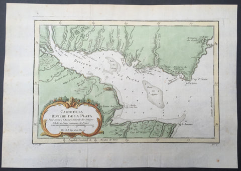
1757 Bellin Antique Map of Rio de la Plata, River Plate, Buenos Aires, Argentina
- Title : Carte de la Riviere de la Plata...
- Ref #: 61103
- Size: 10in x 7 1/2in (255mm x 190mm)
- Date : 1757
- Condition: (A+) Fine Condition
Description:
This fine, original copper-plate engraved antique map of the Río de la Plata of Argentina, by Jacques Nicolas Bellin in 1757 was published in Antoine François Prevosts 15 volumes of Histoire Generale des Voyageswritten by Prevost & other authors between 1746-1790.
The Río de la Plata River Plate in British English and La Plata River (occasionally Plata River) in other English-speaking countries — is the estuary formed by the confluence of the Uruguay and the Paraná rivers. It empties into the Atlantic Ocean, forming a funnel-shaped indentation on the southeastern coastline of South America. Depending on the geographer, the Río de la Plata may be considered a river, an estuary, a gulf or a marginal sea. For those who consider it a river—as is the case mostly in Argentina—it would be the widest river in the world, with a maximum width of about 220 kilometres.
The Río de la Plata was first explored by the Portuguese in 1512–13. The Spanish first explored it in 1516, when the navigator Juan Díaz de Solís traversed it during his search for a passage between the Atlantic and the Pacific Oceans, calling it the Mar Dulce, or \"freshwater sea.\" The Portuguese navigator Ferdinand Magellan briefly explored the estuary in 1520 before his expedition continued its circumnavigation, and in 1521 Cristóvão Jacques also explored the Plate River estuary and ascended the Parana River for the first time, entering it for about 23 leagues (around 140 km) to near the present city of Rosario.[12] The area was also visited by Francis Drake\'s fleet in early 1578, in the early stages of his circumnavigation.
Explorer Sebastian Cabot made a detailed study of the river and its tributaries and gave it its modern name. He explored the Paraná and Uruguay rivers between 1526 and 1529, ascending the Paraná as far as the present-day city of Asunción, and also explored up the Paraguay River. Cabot acquired silver trinkets trading with the Guaraní near today\'s Asunción, and these objects (together with legends of a \"Sierra de la Plata\" in the South American interior brought back by earlier explorers) inspired him to rename the river \"Río de la Plata\" (\"River of Silver\").
The first European colony was the city of Buenos Aires, founded by Pedro de Mendoza on 2 February 1536. This settlement, however, was quickly abandoned; the failure to establish a settlement on the estuary led to explorations upriver and the founding of Asunción in 1537. Buenos Aires was subsequently refounded by Juan de Garay on 11 June 1580.
The city of Buenos Aires sits along the southern coast of the Río de la Plata.
During the colonial era the Río de la Plata was made the center of the Governorate of the Río de la Plata, but the region\'s development was largely neglected by the Spanish Empire until the 1760s, when Portugal and Britain threatened to expand into the estuary. The governorate was elevated to form the Viceroyalty of the Río de la Plata in 1776. In 1806 and 1807 the river was the scene of an important British invasion that aimed to occupy the area.
General Definitions:
Paper thickness and quality: - Heavy and stable
Paper color : - off white
Age of map color: - Early
Colors used: - Green, yellow, orange
General color appearance: - Authentic
Paper size: - 14in x 10in (355mm x 255mm)
Plate size: - 12in x 8in (305mm x 205mm)
Margins: - Min 1/2in (12mm)
Imperfections:
Margins: - Light age toning in margins
Plate area: - Folds as issued
Verso: - None
Background:
One of Antoine Francois Prevosts monumental undertakings was his history of exploration & discovery in 15 volumes titledHistoire Générale des Voyages written between 1746-1759 and was extended to 20 volumes after his death by various authors.
The 20 volumes cover the early explorations & discoveries on 3 continents: Africa (v. 1-5), Asia (v. 5-11), and America (v. 12-15) with material on the finding of the French, English, Dutch, and Portugese.
A number of notable cartographers and engravers contributed to the copper plate maps and views to the 20 volumes including Nicolas Bellin, Jan Schley, Chedel, Franc Aveline, Fessard, and many others.
The African volumes cover primarily coastal countries of West, Southern, and Eastern Africa, plus the Congo, Madagascar, Arabia and the Persian Gulf areas.
The Asian volumes cover China, Korea, Tibet, Japan, Philippines, and countries bordering the Indian Ocean.
Volume 11 includes Australia and Antarctica.
Volumes 12-15 cover voyages and discoveries in America, including the East Indies, South, Central and North America.
Volumes 16-20 include supplement volumes & tables along with continuation of voyages and discoveries in Russia, Northern Europe, America, Asia & Australia.
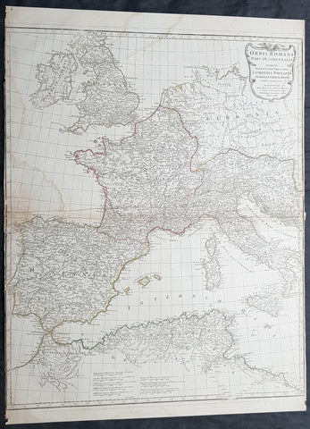
1764 D Anville Large Antique Map of the Western Roman Empire Dalmatia to Britain
- Title : Orbis Romani Pars Occidentalis...Auctor D Anville...MDCCLXIV (1763)
- Size: 29in x 22in (740mm x 560mm)
- Condition: (A) Very Good Condition
- Date : 1763
- Ref #: 92294
Description:
This large hand coloured original copper-plate engraved antique map of the Western part of the post Roman Empire, from Eastern Europe to Britain by Jean Baptiste Bourguignon D Anville was engraved in 1764 - dated in the tile cartouche - and was published in Jean-Baptiste Bourguinon D Anvilles large elephant folio atlas Atlas Generale. (Ref: Tooley, M&B)
General Definitions:
Paper thickness and quality: - Heavy and stable
Paper color : - off white
Age of map color: - Original
Colors used: - Yellow, Green, pink
General color appearance: - Authentic
Paper size: - 29in x 22in (740mm x 560mm)
Plate size: - 28in x 22in (730mm x 560mm)
Margins: - Min 1/4in (3mm)
Imperfections:
Margins: - Soiling in margins, L&R margins cropped close to border
Plate area: - Soiling bottom & top left
Verso: - Soiling
Background:
The Roman Empire was the post-Roman Republic period of the ancient Roman civilization, with a government headed by emperors and large territorial holdings around the Mediterranean Sea in Europe, Africa and Asia. The city of Rome was the largest city in the world c. 100 BC – c. AD 400, with Constantinople (New Rome) becoming the largest around AD 500, and the Empire\\\'s population grew to an estimated 50 to 90 million inhabitants (roughly 20% of the world\\\'s population at the time) The 500-year-old republic which preceded it had been severely destabilized in a series of civil wars and political conflict, during which Julius Caesar was appointed as perpetual dictator and then assassinated in 44 BC. Civil wars and executions continued, culminating in the victory of Octavian, Caesar\\\'s adopted son, over Mark Antony and Cleopatra at the Battle of Actium in 31 BC and the annexation of Egypt. Octavian\\\'s power was then unassailable and in 27 BC the Roman Senate formally granted him overarching power and the new title Augustus, effectively marking the end of the Roman Republic.
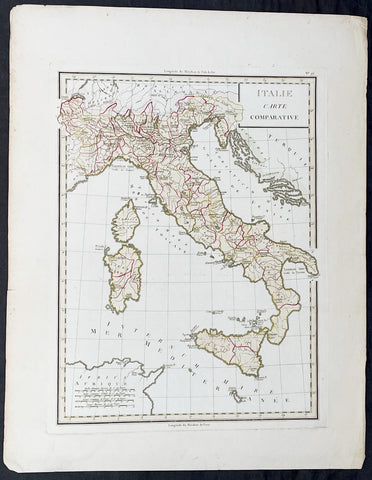
1765 Tardieu Large Antique Map of Italy
- Title : Italie Carte Comparative
- Date : 1765
- Condition: (A+) Fine Condition
- Ref: 92789
- Size: 23in x 17 1/2in (585mm x 445mm)
Description:
This large beautifully hand coloured original antique map of Italy was published by the famous French publisher Pierre Francois Tardieu (famous for publishing Diderots Encyclopedie in 1779) in 1765. (Ref: M&B; Tooley)
General Description:
Paper thickness and quality: - Heavy & stable
Paper color: - White
Age of map color: - Original
Colors used: - Pink, green, yellow
General color appearance: - Authentic
Paper size: - 23in x 17 1/2in (585mm x 445mm)
Paper size: - 18in x 13 1/2in (460mm x 340mm)
Margins: - Min 1in (25mm)
Imperfections:
Margins: - None
Plate area: - None
Verso: - None
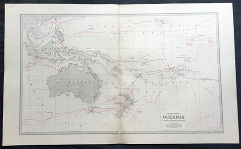
1888 Large Pic Atlas Large Antique Map Oceania Australia, New Zealand
- Title : Oceania, showing the route of the earlier discoverers
- Ref : 50342
- Size: 26in x 18in (660mm x 446mm)
- Date : 1886
- Condition: (A+) Fine Condition
Description:
This large fine lithograph layered coloured original map was published in the extremely significant Australian & New Zealand Australian & New Zealand publication The Picturesque Atlas of Australasia between 1886-88.
The Picturesque Atlas of Australasia was published in Sydney between 1886-88. Many of its over 700 wood-engraved illustrations were specially commissioned works by leading Australian artists. It was released in 42 separate editions usually bound into three large volumes and sold a remarkable 50,000 copies. (Ref: M&B; Tooley)
General Description:
Paper thickness and quality: - Light & stable
Paper color: - White
Age of map color: - Original
Colors used: - Blue, yellow, pink, green
General color appearance: - Authentic
Paper size: - 26in x 18in (660mm x 446mm)
Margins: - Min 1in (25mm)
Imperfections:
Margins: - None
Plate area: - Small repair to bottom centerfold
Verso: - None
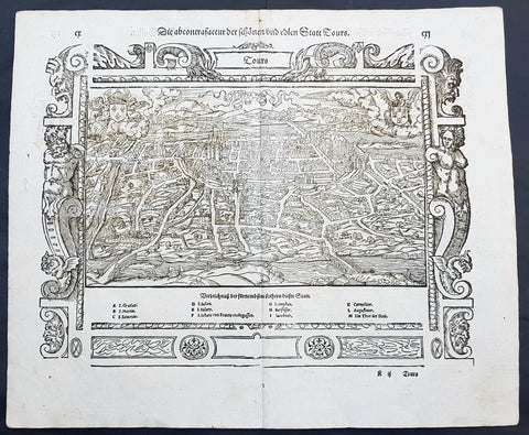
1574 Munster Large Antique Print View of The French City of Tours
- Title : Die Statt Tours
- Ref #: 22614
- Size: 16in x 13in (410mm x 330mm)
- Date : 1574
- Condition: (A+) Fine Condition
Description:
This large finely engraved original antique print a view of the French city of Tours was published by Sebastian Munster in the 1574 edition of Cosmographia.
Tours is a city located in the centre-west of France. It is the administrative centre of the Indre-et-Loire department and the largest city in the Centre-Val de Loire region of France (although it is not the capital, which is the region's second-largest city, Orléans). Tours stands on the lower reaches of the River Loire, between Orléans and the Atlantic coast. The surrounding district, the traditional province of Touraine, is known for its wines, for the alleged perfection (as perceived by some speakers) of its local spoken French, and for the Battle of Tours (732).
Background: For a variety of reasons town plans were comparatively latecomers in the long history of cartography. Few cities in Europe in the middle ages had more than 20,00 inhabitants and even London in the late Elizabethan period had only 100-150,000 people which in itself was probably 10 times that of any other English city. The Nuremberg Chronicle in 1493 included one of the first town views of Jerusalem, thereafter, for most of the sixteenth century, German cartographers led the way in producing town plans in a modern sense. In 1544 Sebastian Munster issued in Basle hisCosmographia containing roughly sixty-six plans and views, some in the plan form, but many in the old panorama or birds eye view.
Sebastian Münster (1488-1552) was a German cartographer, cosmographer, and Hebrew scholar whose work Cosmographia (1544; "Cosmography") was the earliest German description of the world and a major work in the revival of geographic thought in 16th-century Europe. It had numerous editions in different languages including Latin, French, Italian, English, and even Czech. Altogether, about 40 editions of the Cosmographiaappeared between 1544 and 1628 and was one of the most successful and popular books of the 16th century. Münster was a major influence in popular thinking in Europe for the next 200 years.
This success was due not only to the level of descriptive detail but also to the fascinating full page maps & views as well as smaller woodcuts that were included in the text. Many of the woodcuts were executed by famous engravers of the time including Hans Holbein the Younger, Urs Graf, Hans Rudolph Manuel Deutsch, and David Kandel.
Aside from the well-known maps present in the Cosmographia, the text is thickly sprinkled with vigorous views: portraits of kings and princes, costumes and occupations, habits and customs, flora and fauna, monsters, wonders, and horrors about the known -- and unknown -- world, and was undoubtedly one of the most widely read books of its time.
Münster acquired the material for his book in three ways. Firstly he researched all available literary sources across Germany, Switzerland and other parts of Europe. Secondly he obtained original manuscript material from locals all over Europe for description of the countryside, cities, villages, towns, rivers and local history. Finally, he obtained further material first hand on his travels (primarily in south-west Germany, Switzerland, and Alsace).
In 1588 Sebastian Petri re-released Cosomgraphia and re-issued many of Munsters maps and views in the "copperplate style". The maps in this release were more sophisticated than with earlier publications ofCosomgraphia and were based on the 1570 release of Abraham Ortelius monumental work Theatrum Orbis Terrarum.(Ref: Tooley; M&B)
General Description:
Paper thickness and quality: - Light and stable
Paper color: - off white
Age of map color: -
Colors used: -
General color appearance: -
Paper size: - 16in x 13in (410mm x 330mm)
Plate size: - 16in x 13in (410mm x 330mm)
Margins: - 1/2in (12mm)
Imperfections:
Margins: - None
Plate area: -None
Verso: - None
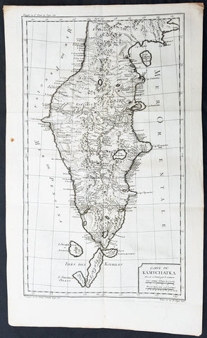
1760 Bellin Large Original Antique Map of Kamchatka Peninsula, in Eastern Russia
- Title : Carte Du Kamtschatka Dressee et Gravee par Laurent.
- Ref #: 60969
- Size: 23in x 14 1/2in (585mm x 370mm)
- Date : 1747
- Condition: (A+) Fine Condition
Description:
This fine, original copper-plate engraved antique map of Kamchatka Peninsula, in Eastern Russia by Jacques Nicolas Bellin in 1760 was published in Antoine François Prevosts 15 volumes of Histoire Generale des Voyages written by Prevost & other authors between 1746-1790.
General Definitions:
Paper thickness and quality: - Heavy and stable
Paper color : - off white
Age of map color: -
Colors used: -
General color appearance: -
Paper size: - 23in x 14 1/2in (585mm x 370mm)
Plate size: - 20 1/2in x 12 1/2in (520mm x 320mm)
Margins: - Min 1/2in (6mm)
Imperfections:
Margins: - None
Plate area: - Folds as issued
Verso: - None
Background:
One of Antoine Francois Prevosts monumental undertakings was his history of exploration & discovery in 15 volumes titledHistoire Générale des Voyages written between 1746-1759 and was extended to 20 volumes after his death by various authors.
The 20 volumes cover the early explorations & discoveries on 3 continents: Africa (v. 1-5), Asia (v. 5-11), and America (v. 12-15) with material on the finding of the French, English, Dutch, and Portugese.
A number of notable cartographers and engravers contributed to the copper plate maps and views to the 20 volumes including Nicolas Bellin, Jan Schley, Chedel, Franc Aveline, Fessard, and many others.
The African volumes cover primarily coastal countries of West, Southern, and Eastern Africa, plus the Congo, Madagascar, Arabia and the Persian Gulf areas.
The Asian volumes cover China, Korea, Tibet, Japan, Philippines, and countries bordering the Indian Ocean.
Volume 11 includes Australia and Antarctica.
Volumes 12-15 cover voyages and discoveries in America, including the East Indies, South, Central and North America.
Volumes 16-20 include supplement volumes & tables along with continuation of voyages and discoveries in Russia, Northern Europe, America, Asia & Australia.
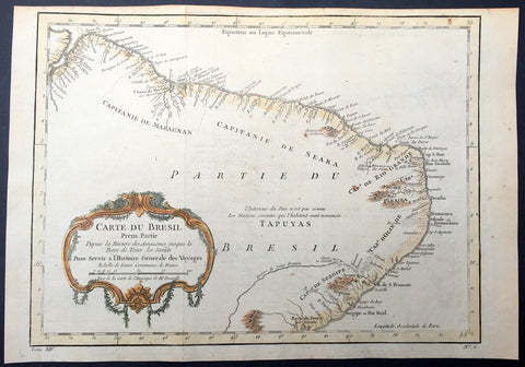
1757 Nicolas Bellin Original Antique Map of Brazil, South America
- Title : Carte Du Bresil.....
- Ref #: 61101
- Size: 15in x 10in (380mm x 255mm)
- Date : 1757
- Condition: (A+) Fine Condition
Description:
This fine, original copper-plate engraved antique map of Brazil, South America by Jacques Nicolas Bellin in 1757 was published in Antoine François Prevosts 15 volumes of Histoire Generale des Voyages written by Prevost & other authors between 1746-1790.
The land now called Brazil was claimed for the Portuguese Empire on 22 April 1500, with the arrival of the Portuguese fleet commanded by Pedro Álvares Cabral. The Portuguese encountered indigenous peoples divided into several tribes, most of whom spoke languages of the Tupi–Guarani family, and fought among themselves. Though the first settlement was founded in 1532, colonization effectively began in 1534, when King Dom João III of Portugal divided the territory into the fifteen private and autonomous Captaincy Colonies of Brazil.
However, the decentralized and unorganized tendencies of the captaincy colonies proved problematic, and in 1549 the Portuguese king restructured them into the Governorate General of Brazil, a single and centralized Portuguese colony in South America. In the first two centuries of colonization, Indigenous and European groups lived in constant war, establishing opportunistic alliances in order to gain advantages against each other. By the mid-16th century, cane sugar had become Brazil\'s most important exportation product, and slaves purchased in Sub-Saharan Africa, in the slave market of Western Africa (not only those from Portuguese allies of their colonies in Angola and Mozambique), had become its largest import, to cope with plantations of sugarcane, due to increasing international demand for Brazilian sugar.
By the end of the 17th century, sugarcane exports began to decline, and the discovery of gold by bandeirantes in the 1690s would become the new backbone of the colony\'s economy, fostering a Brazilian Gold Rush which attracted thousands of new settlers to Brazil from Portugal and all Portuguese colonies around the world. This increased level of immigration in turn caused some conflicts between newcomers and old settlers.
Portuguese expeditions known as Bandeiras gradually advanced the Portugal colonial original frontiers in South America to approximately the current Brazilian borders. In this era other European powers tried to colonize parts of Brazil, in incursions that the Portuguese had to fight, notably the French in Rio during the 1560s, in Maranhão during the 1610s, and the Dutch in Bahia and Pernambuco, during the Dutch–Portuguese War, after the end of Iberian Union.
The Portuguese colonial administration in Brazil had two objectives that would ensure colonial order and the monopoly of Portugal\'s wealthiest and largest colony: to keep under control and eradicate all forms of slave rebellion and resistance, such as the Quilombo of Palmares, and to repress all movements for autonomy or independence, such as the Minas Conspiracy.
General Definitions:
Paper thickness and quality: - Heavy and stable
Paper color : - off white
Age of map color: - Early
Colors used: - Green, yellow, orange
General color appearance: - Authentic
Paper size: - 15in x 10in (380mm x 255mm)
Plate size: - 13in x 9 1/2in (330mm x 245mm)
Margins: - Min 1/2in (12mm)
Imperfections:
Margins: - None
Plate area: - Folds as issued
Verso: - None
ackground:
One of Antoine Francois Prevosts monumental undertakings was his history of exploration & discovery in 15 volumes titledHistoire Générale des Voyages written between 1746-1759 and was extended to 20 volumes after his death by various authors.
The 20 volumes cover the early explorations & discoveries on 3 continents: Africa (v. 1-5), Asia (v. 5-11), and America (v. 12-15) with material on the finding of the French, English, Dutch, and Portugese.
A number of notable cartographers and engravers contributed to the copper plate maps and views to the 20 volumes including Nicolas Bellin, Jan Schley, Chedel, Franc Aveline, Fessard, and many others.
The African volumes cover primarily coastal countries of West, Southern, and Eastern Africa, plus the Congo, Madagascar, Arabia and the Persian Gulf areas.
The Asian volumes cover China, Korea, Tibet, Japan, Philippines, and countries bordering the Indian Ocean.
Volume 11 includes Australia and Antarctica.
Volumes 12-15 cover voyages and discoveries in America, including the East Indies, South, Central and North America.
Volumes 16-20 include supplement volumes & tables along with continuation of voyages and discoveries in Russia, Northern Europe, America, Asia & Australia.
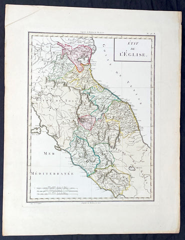
1765 Tardieu Large Antique Map Catholic States of Italy
- Title : Etat de L Eglise
- Ref #: 92787
- Size: 23in x 17 1/2in (585mm x 445mm)
- Date : 1765
- Condition: (A+) Fine Condition
Description:
This large beautifully hand coloured original antique map of the Catholic States of Italy waspublished by the famous French publisher Pierre Francois Tardieu (famous for publishing Diderots Encyclopedie in 1779) in 1765. (Ref: M&B;Tooley)
General Description:
Paper thickness and quality: - Heavy & stable
Paper color: - White
Age of map color: - Original
Colors used: - Pink, green, yellow
General color appearance: - Authentic
Paper size: - 23in x 17 1/2in (585mm x 445mm)
Paper size: - 18in x 13 1/2in (460mm x 340mm)
Margins: - Min 1in (25mm)
Imperfections:
Margins: - None
Plate area: - None
Verso: - None
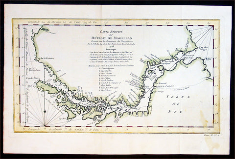
1753 Bellin Antique Map of the Magellan Straits, South America
- Title : Carte Reduite du Detroit De Magellan...1753
- Ref #: 91218
- Size: 15in x 10in (380mm x 255mm)
- Date : 1753
- Condition: (A+) Fine Condition
Description:
This fine hand coloured original antique map of the Magellan Straits between the South American mainland and Tierra Del Fuego - with major points discovered and remarked in a 9 point legend - was engraved by Jacques Nicolas Bellin in 1753 - the date is engraved in the title cartouche - and was published in Antoine-François Prevost's monumental 20 volume edition of L`Histoire Generale des Voyages published by Pierre de Hondt, The Hague between 1747 & 1780. (Ref: Tooley; M&B)
General Description:
Paper thickness and quality: - Heavy and stable
Paper color: - off white
Age of map color: - Later
Colors used: - Yellow, green, red
General color appearance: - Authentic
Paper size: - 15in x 10in (380mm x 255mm)
Plate size: - 14in x 8in (355mm x 205mm)
Margins: - Min 1/2in (12mm)
Imperfections:
Margins: - Light stain bottom right corner
Plate area: - None
Verso: - None
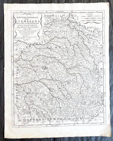
1695 De Rossi Large Old, Antique Map of The Champagne Region of France
- Title : Governo generale della Ciampagna diviso nelle sue Parti Principali; da Giaco. Cantelli da Vignola geografo del Sermo Sigr. Duca di Moda.; e dato in luce da Domenico de Rossi erede di Gio. Giaco. de Rossi dalle sue Stampe in Roma alla Pace, con Privil. del S.P. e licenza de Sup. l'Anno 1695
- Ref #: 50224
- Size: 24in x 18 1/2in (610mm x 470mm)
- Date : 1695
- Condition: (A+) Fine Condition
Description:
This very large, beautifully engraved original antique map of the Champagne Region of France by Giovanni Giacomo de Rossi, (1627-1691) in 1695 - dated in title - and was published by Domenico de Rossi in his monumental Atlas Mercurio Geografico overo Guida Geografica in tutte le parti del Mondo.
Background: A fine example of De Rossi's atlas map, similar to Coronelli's maps of the same period, with engraved decorative title. The atlas included 150 engraved outline hand colored maps with decorative title cartouche, on 181 sheets. Maps are dated between 1669 and 1715, issued by Giov. Giac. de Rossi and Domenico de Rossi, they are mainly derived from Cantelli da Vignola's maps, an important seventeenth-century cartographer who pioneered the Italian style of fine bold engraving that would eventually be embraced and expanded upon by Vincenzo Coronelli, and Nicolas Sanson (1600 – 1667) a French cartographer, termed by some the creator of French geography.
Many of the maps were engraved by Baudrand, Franciscus Donia, G.B. Falda, Jean Lhuilier, Vin Mariotti, Gasparo Pietro Santa, Salomon Rogiers, & Giorgio Widman, Lubin, Titi, Ameti, Magini and Mattei.
Giovanni Giacomo De Rossi (1627 - 1691) was an Italian printer and publisher active in 17th century Rome. Giovanni inherited the important Rome based printing business originally founded by his father, Giuseppe de Rossi (1570-1639). By the mid-17th century the Rossi firm was considered the most active and important press in Rome. (Ref Tooley M&B)
General Description:
Paper thickness and quality: - Heavy and stable
Paper color: - off white
Age of map color: -
Colors used: -
General color appearance: -
Paper size: - 24in x 18 1/2in (610mm x 470mm)
Plate size: - 20 3/4in x 16 3/4in (525mm x 425mm)
Margins: - Min 1in (25mm)
Imperfections:
Margins: - None
Plate area: - None
Verso: - None
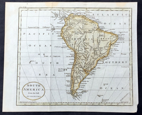
1797 John Russell Old, Antique Map of South America
- Title : South America from the best Authorities
- Ref : 70198
- Size: 10in x 8in (255mm x 205mm)
- Date : 1797
- Condition: (A+) Fine Condition
Description:
This fine hand coloured original antique map of South America was engraved in 1797 by John Russell and published by Charles Dilly & John Robinson. London.(Ref: M&B; Tooley)
General Description:
Paper thickness and quality: - Light & stable
Paper color: - White
Age of map color: - Early
Colors used: - Red, green, orange
General color appearance: - Authentic
Paper size: - 10in x 8in (260mm x 205mm)
Plate size: - 10in x 8in (260mm x 205mm)
Margins: - Min 1/2in (12mm)
Imperfections:
Margins: - None
Plate area: - Folds as issued
Verso: - None
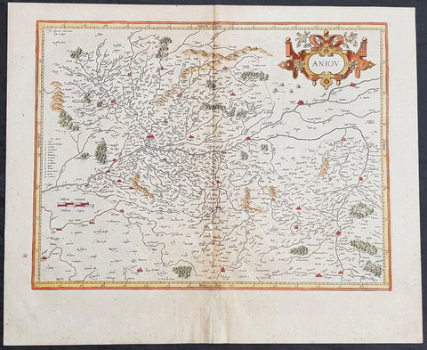
1628 Henricus Hondius Antique Map of the Duchy of Anjou, Maine-et-Loire, France
- Title : Aniov
- Date : 1628
- Size: 21in x 17in (535mm x 430mm)
- Ref #: 26135
- Condition: (A) Very Good Condition
Description:
This beautifully hand coloured original copper-plate engraved antique map of the French region of the historical province of Anjou (today a greater part of the Maine-et-Loire dept.) centering on the city of Angers & the Loire River was published in the 1628 French edition of Mercators Atlas by Henricus Hondius and Jan Jansson.
General Definitions:
Paper thickness and quality: - Heavy and stable
Paper color : - off white
Age of map color: - Original
Colors used: - Yellow, green, blue, pink
General color appearance: - Authentic
Paper size: - 21in x 17in (535mm x 430mm)
Plate size: - 18in x 14in (460mm x 360mm)
Margins: - Min 1/2in (12mm)
Imperfections:
Margins: - None
Plate area: - Age toning along centerfold
Verso: - Age toning along centerfold
Background:
Anjou is a historical province of France straddling the lower Loire River. Its capital was Angers and it was roughly coextensive with the diocese of Angers. It bordered Brittany to the west, Maine to the north, Touraine to the east and Poitou to the south. The adjectival form of Anjou is Angevin and inhabitants of Anjou are known as Angevins. During the Middle Ages, the county of Anjou was a prominent fief of the French crown.
The region takes its name from the Celtic tribe of the Andecavi, who submitted to Roman rule following the Gallic Wars. Under the Romans, the chief fortified settlement of the Andecavi became the city of Juliomagus, the future Angers. The territory of the Andecavi was organized as a civitas (called the civitas Andegavensis or civitas Andegavorum).
Under the Franks, the city of Juliomagus took the name of the ancient tribe and became Angers. Under the Merovingians, the history of Anjou is obscure. It is not recorded as a county (comitatus) until the time of the Carolingians. In the late ninth and early tenth centuries the viscounts (representatives of the counts) usurped comital authority and made Anjou an autonomous hereditary principality. The first dynasty of counts of Anjou, the House of Ingelger, ruled continuously down to 1205. In 1131, Count Fulk V became the King of Jerusalem; then in 1154, his grandson, Henry \'Curtmantle\' became King of England. The territories ruled by Henry and his successors, which stretched from Ireland to the Pyrenees, are often called the Angevin Empire. This empire was broken up by the French king Philip II, who confiscated the dynasty\'s French lands, including Anjou in 1205.
The county of Anjou was united to the royal domain between 1205 and 1246, when it was turned into an apanage for the king\'s brother, Charles I of Anjou. This second Angevin dynasty, a branch of the Capetian dynasty, established itself on the throne of Naples and Hungary. Anjou itself was united to the royal domain again in 1328, but was detached in 1360 as the Duchy of Anjou for the king\'s son, Louis I of Anjou. The third Angevin dynasty, a branch of the House of Valois, also ruled for a time the Kingdom of Naples. The dukes had the same autonomy as the earlier counts, but the duchy was increasingly administered in the same fashion as the royal domain and the royal government often exercised the ducal power while the dukes were away. When the Valois line failed and Anjou was incorporated into the royal domain again in 1480, there was little change on the ground. Anjou remained a province of crown until the French Revolution (1790), when the provinces were reorganized.
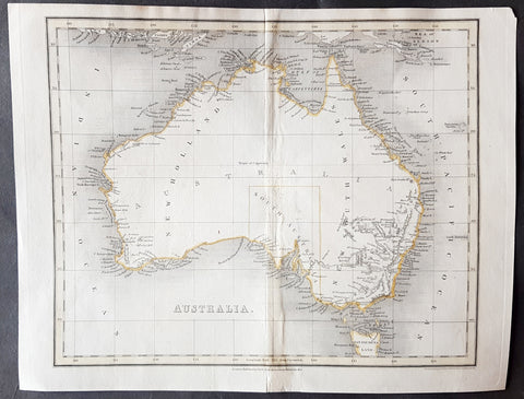
1837 John Dower Original Antique Map of Australia - New Holland
- Title : Australia
- Date : 1837
- Size: 12in x 9 1/2in (305mm x 240mm)
- Ref #: 70704
- Condition: (B) Good Condition
Description:
This fine steel-plate engraved original hand coloured antique map of Australia by John Dower was published by Orr & Smith, London in 1837. (Ref Tooley M&B)
General Definitions:
Paper thickness and quality: - Heavy and stable
Paper color : - off white
Age of map color: - Original
Colors used: - Yellow
General color appearance: - Authentic
Paper size: - 12in x 9 1/2in (305mm x 240mm)
Plate size: - 12in x 9 1/2in (305mm x 240mm)
Margins: - Min 1/2in (12mm)
Imperfections:
Margins: - None
Plate area: - Browning & weak along centerfold
Verso: - Strengthened along centerold
Background:
Interesting early map of Australia with only the state of South Australia delineated. The whole of the east coast is named New South Wales, the city of Melbourne was not noted, few internal details are noted. Western Australia shows significant coastal details but is still named "New Holland"
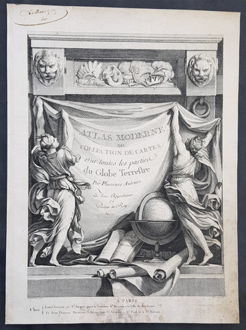
1762 Bonne, Janvier, & Zannoni Original Antique Atlas Title Page to Atlas Modern
- Title : Atlas Moderne ou Collection De Cartes Sur toutes les parties du Globe Terrestre
- Size: 14in x 10in (355mm x 255mm)
- Ref #: 92277
- Date : 1762
- Condition: (A+) Fine Condition
Description:
This original copper-plate engraved antique frontispiece from the atlas Atlas Moderne of a Collection of Maps by Rigobert Bonne, Jean Janvier, & Rizzi Zannoni was published by Jean Lattre in 1762, dated.
General Definitions:
Paper thickness and quality: - Heavy and stable
Paper color : - off white
Age of map color: -
Colors used: -
General color appearance: -
Paper size: - 14in x 10in (355mm x 255mm)
Plate size: - 14in x 10in (355mm x 255mm)
Margins: - Min 1/2in (12mm)
Imperfections:
Margins: - Light soiling in margins
Plate area: - None
Verso: - None
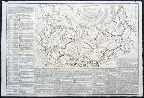
1812 Las Cases Large Original Antique Map of The Russian Empire, English Text
- Title : The Russian Empire with its gradual Acquisitions traced and Explained
- Size: 28in x 19in (710mm x 485mm)
- Ref #: 40259
- Date : 1812
- Condition: (A) Very Good Condition
Description:
This large original copper plate engraved antique map of Russia - within the geographical, political, economic, physical & historical text - was published in the 1812 English edition of Emmanuel Las Cases very large Elephant Folio size The Historical, Geographical & Genealogy Atlas
General Definitions:
Paper thickness and quality: - Heavy and stable
Paper color : - off white
Age of map color: -
Colors used: -
General color appearance: -
Paper size: - 28in x 19in (710mm x 485mm)
Plate size: - 21in x 13in (535mm x 33mm)
Margins: - Min 1/2in (12mm)
Imperfections:
Margins: - Light offsetting
Plate area: - Light offsetting
Verso: - Light age toning
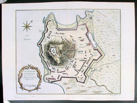
Copy of 1753 Bellin Antique Map Plan of the City of Cayenne French Guyana, South America
- Title: La Ville De Cayenne...1753
- Date: 1753
- Condition : (A+) Fine Condition
- Ref: 25648
- Size: 15in x 11in (390mm x 275mm)
Description:
This beautifully engraved original antique map a plan of the city of Cayenne capital of French Guyana, South America was engraved by Jacques Nicolas Bellin in 1753 - the date is engraved in the title cartouche - and was published by Jacques Nicolas Bellin for Antoine-François Prevosts 20 volume edition of L`Histoire Generale des Voyages published by Pierre de Hondt, The Hague in 1747. (Ref: Tooley; M&B)
General Description:
Paper thickness and quality: - Heavy and stable
Paper color: - white
Age of map color: - Early
Colors used: - Yellow, Green, red
General color appearance: - Authentic
Paper size: - 15in x 11in (390mm x 275mm)
Plate size: - 11 1/2in x 9 1/2in (290mm x 245mm)
Margins: - min. 1in (25mm)
Imperfections:
Margins: - None
Plate area: - Folds as issued
Verso: - None
Condition : (A+) Fine Condition
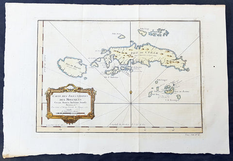
1750 Bellin Original Antique Map The Maluku or Moluccas, Spice Islands Indonesia
- Title : Carte Des Isles Voisines Des Moluques Ceram, Bouro, Amboine, Banda, Neyra....1750
- Ref #: 34099
- Size: 16in x 10 1/2in (390mm x 265mm)
- Date : 1750
- Condition: (A+) Fine Condition
Description:
This fine, original copper-plate engraved antique map of the Maluku or Moluccas Islands (Spice Islands) Indonesia by Jacques Nicolas Bellin in 1750 was published in Antoine François Prevosts 15 volumes of Histoire Generale des Voyages written by Prevost & other authors between 1746-1790.
The Maluku Islands or the Moluccas are an archipelago within Banda Sea, Indonesia. Geographically they are located east of Sulawesi, west of New Guinea, and north and east of Timor.
The islands were known as the Spice Islands due to the nutmeg, mace and cloves that were originally exclusively found there, and the presence of these sparked colonial interest from Europe in the 16th century.
The most significant lasting effects of the Portuguese colonisation was the disruption and reorganization of the Southeast Asian trade, and in eastern Indonesia—including Maluku—the introduction of Christianity. The Portuguese had conquered the city state of Malacca in the early 16th century and their influence was most strongly felt in Maluku and other parts of eastern Indonesia. After the Portuguese annexed Malacca in August 1511, one Portuguese diary noted \'it is thirty years since they became Moors - giving a sense of the competition then taking place between Islamic and European influences in the region.
Afonso de Albuquerque learned of the route to the Banda Islands and other \'Spice Islands\', and sent an exploratory expedition of three vessels under the command of António de Abreu, Simão Afonso Bisigudo and Francisco Serrão. On the return trip, Francisco Serrão was shipwrecked at Hitu island (northern Ambon) in 1512. There he established ties with the local ruler who was impressed with his martial skills. The rulers of the competing island states of Ternate and Tidore also sought Portuguese assistance and the newcomers were welcomed in the area as buyers of supplies and spices during a lull in the regional trade due to the temporary disruption of Javanese and Malay sailings to the area following the 1511 conflict in Malacca. The spice trade soon revived but the Portuguese would not be able to fully monopolize nor disrupt this trade.
Allying himself with Ternate\'s ruler, Serrão constructed a fortress on that tiny island and served as the head of a mercenary band of Portuguese seamen under the service of one of the two local feuding sultans who controlled most of the spice trade. Both Serrão and Ferdinand Magellan, however, perished before they could meet one another.
The Portuguese first landed in Ambon in 1513, but it only became the new centre for their activities in Maluku following the expulsion from Ternate. European power in the region was weak and Ternate became an expanding, fiercely Islamic and anti-European state under the rule of Sultan Baab Ullah (r. 1570–1583) and his son Sultan Said.
Following Portuguese missionary work, there have been large Christian communities in eastern Indonesia through to contemporary times, which has contributed to a sense of shared interest with Europeans, particularly among the Ambonese. By the 1560s there were 10,000 Catholics in the area, mostly on Ambon, and by the 1590s there were 50,000 to 60,000. The central and southern parts of Maluku are populated by a majority of Christians.
The Dutch arrived in 1599 and competed with the Portuguese in the area for trade.
General Definitions:
Paper thickness and quality: - Heavy and stable
Paper color : - off white
Age of map color: - Early
Colors used: - Green, yellow, red
General color appearance: - Authentic
Paper size: - 16in x 10 1/2in (390mm x 265mm)
Plate size: - 12 1/2in x 9in (320mm x 230mm)
Margins: - Min 1/2in (6mm)
Imperfections:
Margins: - Light age toning
Plate area: - Folds as issued
Verso: - None
Background:
One of Antoine Francois Prevosts monumental undertakings was his history of exploration & discovery in 15 volumes titledHistoire Générale des Voyages written between 1746-1759 and was extended to 20 volumes after his death by various authors.
The 20 volumes cover the early explorations & discoveries on 3 continents: Africa (v. 1-5), Asia (v. 5-11), and America (v. 12-15) with material on the finding of the French, English, Dutch, and Portugese.
A number of notable cartographers and engravers contributed to the copper plate maps and views to the 20 volumes including Nicolas Bellin, Jan Schley, Chedel, Franc Aveline, Fessard, and many others.
The African volumes cover primarily coastal countries of West, Southern, and Eastern Africa, plus the Congo, Madagascar, Arabia and the Persian Gulf areas.
The Asian volumes cover China, Korea, Tibet, Japan, Philippines, and countries bordering the Indian Ocean.
Volume 11 includes Australia and Antarctica.
Volumes 12-15 cover voyages and discoveries in America, including the East Indies, South, Central and North America.
Volumes 16-20 include supplement volumes & tables along with continuation of voyages and discoveries in Russia, Northern Europe, America, Asia & Australia.
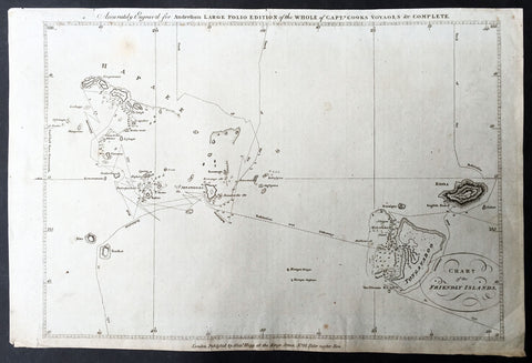
1784 Anderson Antique Map of the Tonga Islands - Capt. Cooks Voyages in 1773 & 1777
- Title : Chart of the Friendly Islands
- Size: 14 1/2in x 9 1/2in (370mm x 245mm)
- Ref #: 32181
- Date : 1784
- Condition: (A) Very Good Condition
This fine original copper-plate engraved antique map of the Tonga Island (Friendly Islands) with the routes taken by Captain James Cook visits to the Islands in his 2nd voyage in 1773 in HMS Resolution & Discovery and his 3rd and last voyage in 1777 in HMS Resolution & Discovery, was published in George Andersons 1784 edition of A Collection of voyages round the world : performed by royal authority : containing a complete historical account of Captain Cooks first, second, third and last voyages, undertaken for making new discoveries, &c. ... published by Alexander Hogg, London 1784.
Exert From Cooks, <i>A Voyage Towards the South Pole, and Round the World, performed in His Majestys Ships the 'Resolution' and 'Adventure', In the Years 1772, 1773, 1774, and 1775.</i>
......<i>after leaving Raiatea (Society Islands) on 18 September 1773, Cook directed his course towards Amsterdam Island (Tongatapu), discovered by Tasman in 1643, intending to verify Tasman's charting against his own charts. The ships stayed for three days, thoroughly enjoying the reception they had received and called the group the Friendly Islands. On his second visit he headed for the Nomuka, the largest island of the south central group of Tonga.</i>
General Definitions:
Paper thickness and quality: - Heavy and stable
Paper color : - off white
Age of map color: -
Colors used: -
General color appearance: -
Paper size: - 14 1/2in x 9 1/2in (370mm x 245mm)
Plate size: - 14 1/2in x 9 1/2in (370mm x 245mm)
Margins: - Min 1/2in (12mm)
Imperfections:
Margins: - None
Plate area: - None
Verso: - None
Background:
Tonga officially the Kingdom of Tonga, is a Polynesian sovereign state and archipelago comprising 169 islands, of which 36 are inhabited. The total surface area is about 750 square kilometres (290 sq mi) scattered over 700,000 square kilometres (270,000 sq mi) of the southern Pacific Ocean. It has a population of 107,122 people, of whom 70% reside on the main island of Tongatapu.
The Tongan people first encountered Europeans in 1616 when the Dutch vessel Eendracht, captained by Willem Schouten, made a short visit to trade. Later came other Dutch explorers, including Jacob Le Maire (who called on the northern island of Niuatoputapu); and in 1643 Abel Tasman (who visited Tongatapu and Haapai).
Later noteworthy European visitors included James Cook (Royal Navy) in 1773, 1774, and 1777; Alessandro Malaspina (Spanish Navy) in 1793; the first London missionaries in 1797; and the Wesleyan Methodist Reverend Walter Lawry in 1822.
Tonga became known in the West as the Friendly Islands because of the congenial reception accorded to Captain James Cook on his first visit in 1773. He arrived at the time of the inasi festival, the yearly donation of the First Fruits to the Tui Tonga (the islands paramount chief) and so received an invitation to the festivities. According to the writer William Mariner, the chiefs wanted to kill Cook during the gathering but could not agree on a plan.
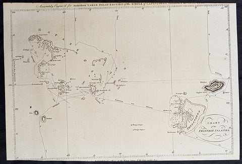
1784 Anderson Antique Map of the Tonga Islands - Capt. Cooks Voyages in 1773 & 1777
- Title : Chart of the Friendly Islands
- Size: 14 1/2in x 9 1/2in (370mm x 245mm)
- Ref #: 21603
- Date : 1784
- Condition: (A) Very Good Condition
This fine original copper-plate engraved antique map of the Tonga Island (Friendly Islands) with the routes taken by Captain James Cook visits to the Islands in his 2nd voyage in 1773 in HMS Resolution & Discovery and his 3rd and last voyage in 1777 in HMS Resolution & Discovery, was published in George Andersons 1784 edition of A Collection of voyages round the world : performed by royal authority : containing a complete historical account of Captain Cooks first, second, third and last voyages, undertaken for making new discoveries, &c. ... published by Alexander Hogg, London 1784.
Exert From Cooks, <i>A Voyage Towards the South Pole, and Round the World, performed in His Majestys Ships the 'Resolution' and 'Adventure', In the Years 1772, 1773, 1774, and 1775.</i>
......<i>after leaving Raiatea (Society Islands) on 18 September 1773, Cook directed his course towards Amsterdam Island (Tongatapu), discovered by Tasman in 1643, intending to verify Tasman's charting against his own charts. The ships stayed for three days, thoroughly enjoying the reception they had received and called the group the Friendly Islands. On his second visit he headed for the Nomuka, the largest island of the south central group of Tonga.</i>
General Definitions:
Paper thickness and quality: - Heavy and stable
Paper color : - off white
Age of map color: -
Colors used: -
General color appearance: -
Paper size: - 14 1/2in x 9 1/2in (370mm x 245mm)
Plate size: - 14 1/2in x 9 1/2in (370mm x 245mm)
Margins: - Min 1/2in (12mm)
Imperfections:
Margins: - Top & bottom margins cropped close to borders
Plate area: - None
Verso: - None
Background:
Tonga officially the Kingdom of Tonga, is a Polynesian sovereign state and archipelago comprising 169 islands, of which 36 are inhabited. The total surface area is about 750 square kilometres (290 sq mi) scattered over 700,000 square kilometres (270,000 sq mi) of the southern Pacific Ocean. It has a population of 107,122 people, of whom 70% reside on the main island of Tongatapu.
The Tongan people first encountered Europeans in 1616 when the Dutch vessel Eendracht, captained by Willem Schouten, made a short visit to trade. Later came other Dutch explorers, including Jacob Le Maire (who called on the northern island of Niuatoputapu); and in 1643 Abel Tasman (who visited Tongatapu and Haapai).
Later noteworthy European visitors included James Cook (Royal Navy) in 1773, 1774, and 1777; Alessandro Malaspina (Spanish Navy) in 1793; the first London missionaries in 1797; and the Wesleyan Methodist Reverend Walter Lawry in 1822.
Tonga became known in the West as the Friendly Islands because of the congenial reception accorded to Captain James Cook on his first visit in 1773. He arrived at the time of the inasi festival, the yearly donation of the First Fruits to the Tui Tonga (the islands paramount chief) and so received an invitation to the festivities. According to the writer William Mariner, the chiefs wanted to kill Cook during the gathering but could not agree on a plan.
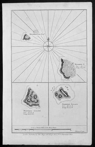
1786 Bowen Antique Map 3 x Cook Islands & 1 x Society Island - Cooks Voyage 1777
- Title : Wanooaette Isl; Wateeoo I; Mangeea Island Toobouai Island
- Size: 13 1/2in x 9 1/2in (345mm x 240mm)
- Ref #: 21697
- Date : 1786
- Condition: (A+) Fine Condition
Description:
This fine original copper-plate engraved antique map of three of the Cook Islands, Takutea (Wanooaette) Atiu (Wateeoo) and Mangaia (Mangeea) and a 4th map of the Island of Tubuai (Toobouai) in French Polynesia near Tahiti, visited by Captain Cook in HMS Resolution & Discovery in September 1777, during his 3rd & last Voyage of Discovery, was published in George Andersons A New, Authentic, and Complete Account of Voyages Round the World, Undertaken and Performed by Royal Authority. Containing a New, Authentic, Entertaining, Instructive, Full and Complete History of Captain Cooks First, Second, Third and Last Voyages.. ... published by Alexander Hogg, London 1786.
These maps of three Cook Islands :
1.Wanooaette, (Takutea)
2. Wateeoo (Atiu)
3. Mangeea ( Mangaia)
4. inset map of Toobouai (Tubuai) in the Society Islands in French Polynesia
All maps were charted by James Cook in 1777 while sailing for the Society Islands (French Polynesia) with livestock he carried aboard the Discovery and the Resolution. As he sailed toward Tahiti he discovered Toobouai (Tubuai) Island on 13 August 1777 where they stayed for 6 weeks. Relief shown by hachures and soundings.
General Definitions:
Paper thickness and quality: - Heavy and stable
Paper color : - off white
Age of map color: -
Colors used: -
General color appearance: -
Paper size: - 13 1/2in x 9 1/2in (345mm x 240mm)
Plate size: - 13 1/2in x 9 1/2in (345mm x 240mm)
Margins: - Min 1/2in (12mm)
Imperfections:
Margins: - None
Plate area: - None
Verso: - None
George William Anderson
A Collection of voyages round the world : performed by royal authority : containing a complete historical account of Captain Cooks first, second, third and last voyages, undertaken for making new discoveries, &c. ... : to which are added genuine narratives of other voyages of discovery round the world, &c. viz. those of Lord Byron, Capt. Wallis, Capt. Carteret, Lord Mulgrave, Lord Anson, Mr. Parkinson, Capt. Lutwidge, Mess. Ives, Middleton, Smith, &c published by Alex. Hogg, 1786.
Spanish ships visited the islands in the 16th century; the first written record of contact with the islands came in 1595 with the sighting of Pukapuka by Spanish sailor Álvaro de Mendaña de Neira, who called it San Bernardo (Saint Bernard). Pedro Fernandes de Queirós, a Portuguese captain working for the Spanish crown, made the first recorded European landing in the islands when he set foot on Rakahanga in 1606, calling it Gente Hermosa.
British navigator Captain James Cook arrived in 1773 and 1777 and named the island of Manuae Hervey Island. Later, the name Hervey Islands came to be applied to the entire southern group; the name Cook Islands, in honour of Cook, first appeared on a Russian naval chart published in the 1820s
Takutea, in the Cook Islands, is a small uninhabited island 21 kilometres northwest of Atiu in the southern Cook Islands.
Takutea is the only island in the Cook Islands that never had a permanent population. When Captain James Cook sighted the island on 4 April 1777, and some crew members went ashore, they found some huts, but no evidence of a permanent settlement.
Atiu, also known as Enuamanu (meaning land of the birds), is an island 187 km northeast of Rarotonga, in the Southern Islands group of the Cook Islands Archipelago.
The first recorded European to arrive at Atiu was Captain Cook. He sighted the island on March 31, 1777 and made tentative contact with some of the people over the next few days.
Mangaia (traditionally known as A ua u Enua, which means terraced) is the most southerly of the Cook Islands and the second largest, after Rarotonga.
The first recorded European to arrive at Mangaia was Captain James Cook on 29 March 1777.
Tubuai part of the Society Islands is located 640 km south of Tahiti. Tubuai was first viewed by Europeans when it was mapped by Captain James Cook in 1777, although his party did not disembark. Cook discovered the islands name, Toobouai, from the natives who surrounded his ship in their canoes (a Tahitian named Omai, who was part of Cooks group, translated)
The next Europeans to arrive were the mutineers of the HMS Bounty in 1789. Mutineer Fletcher Christian, in looking for an island on which to permanently hide, had scoured Blighs maps and nautical charts and decided on Tubuai.
Upon arrival at Tubuai, a conflict arose while the mutineers were still on their ship and several islanders were killed in their canoes. The site of this event in the lagoon on the north side of the island is called Baie Sanglant (Bloody Bay)
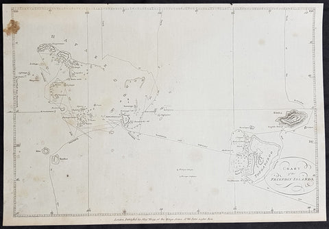
1784 Anderson Antique Map of the Tonga Islands - Capt. Cooks Voyages in 1773 & 1777
- Title : Chart of the Friendly Islands
- Size: 13 1/2in x 9 1/2in (360mm x 245mm)
- Ref #: 32152
- Date : 1784
- Condition: (A) Very Good Condition
This fine original copper-plate engraved antique map of the Tonga Island (Friendly Islands) with the routes taken by Captain James Cook visits to the Islands in his 2nd voyage in 1773 in HMS Resolution & Discovery and his 3rd and last voyage in 1777 in HMS Resolution & Discovery, was published in George Andersons 1784 edition of A Collection of voyages round the world : performed by royal authority : containing a complete historical account of Captain Cooks first, second, third and last voyages, undertaken for making new discoveries, &c. ... published by Alexander Hogg, London 1784.
Exert From Cooks, <i>A Voyage Towards the South Pole, and Round the World, performed in His Majestys Ships the 'Resolution' and 'Adventure', In the Years 1772, 1773, 1774, and 1775.</i>
......<i>after leaving Raiatea (Society Islands) on 18 September 1773, Cook directed his course towards Amsterdam Island (Tongatapu), discovered by Tasman in 1643, intending to verify Tasman's charting against his own charts. The ships stayed for three days, thoroughly enjoying the reception they had received and called the group the Friendly Islands. On his second visit he headed for the Nomuka, the largest island of the south central group of Tonga.</i>
General Definitions:
Paper thickness and quality: - Heavy and stable
Paper color : - off white
Age of map color: -
Colors used: -
General color appearance: -
Paper size: - 13 1/2in x 9 1/2in (360mm x 245mm)
Plate size: - 13 1/2in x 9 1/2in (360mm x 245mm)
Margins: - Min 1/2in (12mm)
Imperfections:
Margins: - Brown stain top left
Plate area: - None
Verso: - None
Background:
Tonga officially the Kingdom of Tonga, is a Polynesian sovereign state and archipelago comprising 169 islands, of which 36 are inhabited. The total surface area is about 750 square kilometres (290 sq mi) scattered over 700,000 square kilometres (270,000 sq mi) of the southern Pacific Ocean. It has a population of 107,122 people, of whom 70% reside on the main island of Tongatapu.
The Tongan people first encountered Europeans in 1616 when the Dutch vessel Eendracht, captained by Willem Schouten, made a short visit to trade. Later came other Dutch explorers, including Jacob Le Maire (who called on the northern island of Niuatoputapu); and in 1643 Abel Tasman (who visited Tongatapu and Haapai).
Later noteworthy European visitors included James Cook (Royal Navy) in 1773, 1774, and 1777; Alessandro Malaspina (Spanish Navy) in 1793; the first London missionaries in 1797; and the Wesleyan Methodist Reverend Walter Lawry in 1822.
Tonga became known in the West as the Friendly Islands because of the congenial reception accorded to Captain James Cook on his first visit in 1773. He arrived at the time of the inasi festival, the yearly donation of the First Fruits to the Tui Tonga (the islands paramount chief) and so received an invitation to the festivities. According to the writer William Mariner, the chiefs wanted to kill Cook during the gathering but could not agree on a plan.
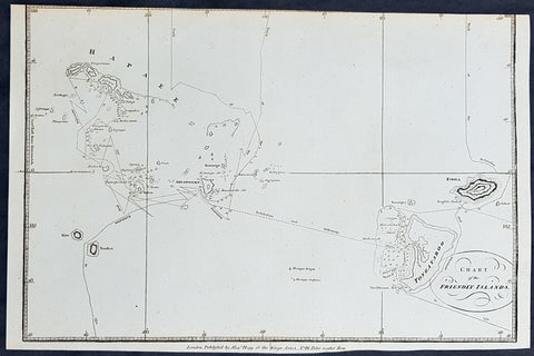
1784 Anderson Antique Map of the Tonga Islands - Capt. Cooks Voyages in 1773 & 1777
- Title : Chart of the Friendly Islands
- Size: 13 1/2in x 9 1/2in (360mm x 245mm)
- Ref #: 21443
- Date : 1784
- Condition: (A) Very Good Condition
This fine original copper-plate engraved antique map of the Tonga Island (Friendly Islands) with the routes taken by Captain James Cook visits to the Islands in his 2nd voyage in 1773 in HMS Resolution & Discovery and his 3rd and last voyage in 1777 in HMS Resolution & Discovery, was published in George Andersons 1784 edition of A Collection of voyages round the world : performed by royal authority : containing a complete historical account of Captain Cooks first, second, third and last voyages, undertaken for making new discoveries, &c. ... published by Alexander Hogg, London 1784.
Exert From Cooks, <i>A Voyage Towards the South Pole, and Round the World, performed in His Majestys Ships the 'Resolution' and 'Adventure', In the Years 1772, 1773, 1774, and 1775.</i>
......<i>after leaving Raiatea (Society Islands) on 18 September 1773, Cook directed his course towards Amsterdam Island (Tongatapu), discovered by Tasman in 1643, intending to verify Tasman's charting against his own charts. The ships stayed for three days, thoroughly enjoying the reception they had received and called the group the Friendly Islands. On his second visit he headed for the Nomuka, the largest island of the south central group of Tonga.</i>
General Definitions:
Paper thickness and quality: - Heavy and stable
Paper color : - off white
Age of map color: -
Colors used: -
General color appearance: -
Paper size: - 13 1/2in x 9 1/2in (360mm x 245mm)
Plate size: - 13 1/2in x 9 1/2in (360mm x 245mm)
Margins: - Min 1/2in (12mm)
Imperfections:
Margins: - Top margin cropped to border
Plate area: - None
Verso: - None
Background:
Tonga officially the Kingdom of Tonga, is a Polynesian sovereign state and archipelago comprising 169 islands, of which 36 are inhabited. The total surface area is about 750 square kilometres (290 sq mi) scattered over 700,000 square kilometres (270,000 sq mi) of the southern Pacific Ocean. It has a population of 107,122 people, of whom 70% reside on the main island of Tongatapu.
The Tongan people first encountered Europeans in 1616 when the Dutch vessel Eendracht, captained by Willem Schouten, made a short visit to trade. Later came other Dutch explorers, including Jacob Le Maire (who called on the northern island of Niuatoputapu); and in 1643 Abel Tasman (who visited Tongatapu and Haapai).
Later noteworthy European visitors included James Cook (Royal Navy) in 1773, 1774, and 1777; Alessandro Malaspina (Spanish Navy) in 1793; the first London missionaries in 1797; and the Wesleyan Methodist Reverend Walter Lawry in 1822.
Tonga became known in the West as the Friendly Islands because of the congenial reception accorded to Captain James Cook on his first visit in 1773. He arrived at the time of the inasi festival, the yearly donation of the First Fruits to the Tui Tonga (the islands paramount chief) and so received an invitation to the festivities. According to the writer William Mariner, the chiefs wanted to kill Cook during the gathering but could not agree on a plan.