City & Views (82)
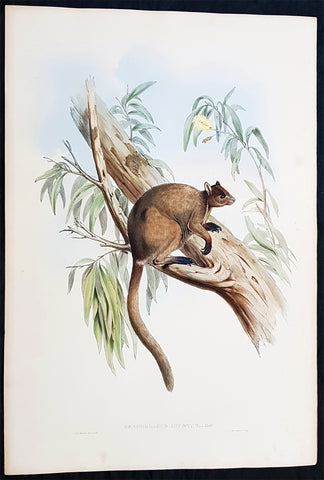
1845-63 John Gould Large Antique Print of Tree Kangaroo The Mammals of Australia
Antique Map
- Title : Dendrolagus Inustus, Mull....H C Richter del et lith....C Hullmandel Imp.
- Ref #: 93442
- Size: 22in x 15in (560mm x 385mm)
- Date : 1845–63
- Condition: (A+) Fine Condition
Description:
This large rare original hand coloured lithograph antique print of The Grizzled Tree Kangaroo, by the artist HC Richter was printed by Charles Joseph Hullmandel 1789 – 1850 in the famous Naturalists John Goulds The Mammals of Australiapublished between 1845–63.
General Definitions:
Paper thickness and quality: - Heavy and stable
Paper color : - off white
Age of map color: - Original
Colors used: - Blue, pink, red, green, yellow
General color appearance: - Authentic
Paper size: - 22in x 15in (560mm x 385mm)
Plate size: - 22in x 15in (560mm x 385mm)
Margins: - Min 1in (25mm)
Imperfections:
Margins: - Light age toning
Plate area: - None
Verso: - None
Background:
The Mammals of Australia is a three-volume work written and published by John Gould between 1845–63. It contains 182 illustrations by the author and its artist H. C. Richter. It was intended to be a complete survey of the novel species of mammals, such as the marsupials, discovered in the colonies of Australia.
The author, John Gould, best known for The Birds of Australia and other major works of ornithology, visited Australia in 1838. In his introduction, Gould says:.....It was not until I arrived in the country, and found myself surrounded by objects as strange as if I had been transported to another planet, that I conceived the idea of devoting a portion of my attention to the mammalian class of its extraordinary fauna......During his short stay he made observations on the natural history and employed his skills as a taxidermist to obtain specimens.
The publication of this major work by Gould followed his A Monograph of the Macropodidae or Family of Kangaroos in 1841. This work was the first comprehensive survey of Australian mammals, and gave an account of their classification and description. Gould also included the indigenous names for the species from the lists he made while in Australia. He used these names to make requests of the local peoples for his specimens, and recorded the regions where the names were used. This conserved a number of common names, such as dibbler (Parantechinus apicalis), which were later recommended by authorities.
The large lithographs reproduced the artwork of Richter, after the drawings and watercolours made in Australia by Gould and his wife, Elizabeth. (The contribution by Elizabeth Gould was uncredited). These were hand-coloured by a group of artists, led by Gabriel Bayfield, that required the completion of 26,572 plates. The illustrations produced during their visit to Australia were supplemented by the preserved specimens returned to England and detailed the characteristics of the species. These illustrations have become iconic images of the mammals of Australia. Among the best known of the illustrations from the work are the two of Thylacinus cynocephalus (Tasmanian tiger), copied since its publication and the most frequently reproduced, made more recognizable by Cascade Brewerys appropriation for its label in 1987. The government of Tasmania published a monochromatic reproduction of the same image in 1934, the author Louisa Anne Meredith also copied it for Tasmanian Friends and Foes (1881).
The Mammals of Australia was published by subscription in the format Imperial Folio; 13 parts in three volumes were issued from 1845 until 1863. To these the author added An Introduction to The Mammals of Australia (1863) in a separate work. This provided corrections and updates, a new preface, introduction, and a list of the mammals of the three volumes. The first two volumes were complete surveys of orders Marsupiata (marsupials), and, with Rodentia in the third, it formed the sum of known mammalian species of Australia. With the addition of those contained in the later Introduction the total of species described reached 166. The same work notes the exclusion of marine mammals such as whales from the volumes, but reprints a manuscript by Charles Coxen on the dugong.
Beyond the scientific value of this comprehensive survey, the document is cited in reference to its subjects conservation. Some of the species included in the work, such as Onychogalea lunata (crescent nailtail wallaby), have since succumbed to changes in land use since European colonisation.
The work was received with acclaim, but the high cost of production, especially of the coloured plates, reduced its accessibility. The original listed price was £41 for the complete set of volumes. The public curiosity for the unique fauna of Australia was met by this handsomely illustrated and comprehensive survey, and it spawned imitations in Australia. The curator of the Australian Museum, Gerard Krefft, produced the more affordable The Mammals of Australia (1871); intended for educational purposes and influenced by Goulds illustrations. Gracius Broinowskis abandoned work, Birds and Mammals of Australia (1884), so closely imitated the plates that an injunction was threatened by its publisher.
Gould, John FRS 1804 – 1881
Gould was an English ornithologist and bird artist. He published a number of monographs on birds, illustrated by plates that he produced with the assistance of his wife, Elizabeth Gould, and several other artists including Edward Lear, Henry Constantine Richter, Joseph Wolf and William Matthew Hart. He has been considered the father of bird study in Australia and the Gould League in Australia is named after him. His identification of the birds now nicknamed Darwins finches played a role in the inception of Darwins theory of evolution by natural selection. Goulds work is referenced in Charles Darwins book, On the Origin of Species.
Gould was born in Lyme Regis the first son of a gardener. He and the boy probably had a scanty education. Shortly afterwards his father obtained a position on an estate near Guildford, Surrey, and then in 1818 Gould became foreman in the Royal Gardens of Windsor. He was for some time under the care of J. T. Aiton, of the Royal Gardens of Windsor. The young Gould started training as a gardener, being employed under his father at Windsor from 1818 to 1824, and he was subsequently a gardener at Ripley Castle in Yorkshire. He became an expert in the art of taxidermy. In 1824 he set himself up in business in London as a taxidermist, and his skill helped him to become the first Curator and Preserver at the museum of the Zoological Society of London in 1827.
Goulds position brought him into contact with the countrys leading naturalists. This meant that he was often the first to see new collections of birds given to the Zoological Society of London. In 1830 a collection of birds arrived from the Himalayas, many not previously described. Gould published these birds in A Century of Birds from the Himalaya Mountains (1830–1832). The text was by Nicholas Aylward Vigors and the illustrations were drawn and lithographed by Goulds wife Elizabeth Coxen Gould. Most of Goulds work were rough sketches on paper from which other artists created the lithographic plates.
This work was followed by four more in the next seven years, including Birds of Europe in five volumes. It was completed in 1837; Gould wrote the text, and his clerk, Edwin Prince, did the editing. The plates were drawn and lithographed by Elizabeth Coxen Gould. A few of the illustrations were made by Edward Lear as part of his Illustrations of the Family of Psittacidae in 1832. Lear, however, was in financial difficulty, and he sold the entire set of lithographs to Gould. The books were published in a very large size, imperial folio, with magnificent coloured plates. Eventually 41 of these volumes were published, with about 3000 plates. They appeared in parts at £3 3s. a number, subscribed for in advance, and in spite of the heavy expense of preparing the plates, Gould succeeded in making his ventures pay, realising a fortune. This was a busy period for Gould who also published Icones Avium in two parts containing 18 leaves of bird studies on 54 cm plates as a supplement to his previous works. No further monographs were published as in 1838 he and his wife moved to Australia to work on the Birds of Australia. Shortly after their return to England, his wife died in 1841. Elizabeth Gould completed 84 plates for Birds of Australia before her death.
When Charles Darwin presented his mammal and bird specimens collected during the second voyage of HMS Beagle to the Zoological Society of London on 4 January 1837, the bird specimens were given to Gould for identification. He set aside his paying work and at the next meeting on 10 January reported that birds from the Galápagos Islands which Darwin had thought were blackbirds, gross-bills and finches were in fact a series of ground Finches which are so peculiar as to form an entirely new group, containing 12 species. This story made the newspapers. In March, Darwin met Gould again, learning that his Galápagos wren was another species of finch and the mockingbirds he had labelled by island were separate species rather than just varieties, with relatives on the South American mainland. Subsequently, Gould advised that the smaller southern Rhea specimen that had been rescued from a Christmas dinner was a separate species which he named Rhea darwinii, whose territory overlapped with the northern rheas. Darwin had not bothered to label his finches by island, but others on the expedition had taken more care. He now sought specimens collected by captain Robert FitzRoy and crewmen. From them he was able to establish that the species were unique to islands, an important step on the inception of his theory of evolution by natural selection. Goulds work on the birds was published between 1838 and 1842 in five numbers as Part 3 of Zoology of the Voyage of H.M.S. Beagle, edited by Charles Darwin. Elizabeth Gould illustrated all the plates for Part 3.
In 1838 the Goulds sailed to Australia, intending to study the birds of that country and be the first to produce a major work on the subject. They took with them the collector John Gilbert. They arrived in Tasmania in September, making the acquaintance of the governor Sir John Franklin and his wife. Gould and Gilbert collected on the island. In February 1839 Gould sailed to Sydney, leaving his pregnant wife with the Franklins. He travelled to his brother-in-laws station at Yarrundi, spending his time searching for bowerbirds in the Liverpool Range. In April he returned to Tasmania for the birth of his son. In May he sailed to Adelaide to meet Charles Sturt, who was preparing to lead an expedition to the Murray River. Gould collected in the Mount Lofty range, the Murray Scrubs and Kangaroo Island, returning again to Hobart in July. He then travelled with his wife to Yarrundi. They returned home to England in May 1840.
The result of the trip was The Birds of Australia (1840–48). It included a total of 600 plates in seven volumes; 328 of the species described were new to science and named by Gould. He also published A Monograph of the Macropodidae, or Family of Kangaroos (1841–1842) and the three volume work The Mammals of Australia (1849–1861).
Elizabeth died in 1841 after the birth of their eighth child, Sarah, and Goulds books subsequently used illustrations by a number of artists, including Henry Constantine Richter, William Matthew Hart and Joseph Wolf.
Throughout his professional life Gould had a strong interest in hummingbirds. He accumulated a collection of 320 species, which he exhibited at the Great Exhibition of 1851. Despite his interest, Gould had never seen a live hummingbird. In May 1857 he travelled to the United States with his second son, Charles. He arrived in New York too early in the season to see hummingbirds in that city, but on 21 May 1857, in Bartrams Gardens in Philadelphia, he finally saw his first live one, a ruby-throated hummingbird. He then continued to Washington D.C. where he saw large numbers in the gardens of the Capitol. Gould attempted to return to England with live specimens, but, as he was not aware of the conditions necessary to keep them, they only lived for two months at most.
Gould published: A Monograph of the Trochilidae or Humming Birds with 360 plates (1849–61); The Mammals of Australia (1845–63), Handbook to the Birds of Australia (1865), The Birds of Asia (1850–83), The Birds of Great Britain (1862–73) and The Birds of New Guinea and the adjacent Papuan Islands (1875–88).
The University of Glasgow, which owns a copy of Birds of Great Britain, describes John Gould as the greatest figure in bird illustration after Audubon, and auctioneers Sotherans describe the work as Goulds pride and joy.
Gould had already published some of the illustrations in Birds of Europe, but Birds of Great Britain represents a development of his aesthetic style in which he adds illustrations of nests and young on a large scale.
Sotherans Co. reports that Gould published the book himself, producing 750 copies, which remain sought after both as complete volumes, and as individual plates, currently varying in price from £450 – £850. The University of Glasgow records that the volumes were issued in London in 25 parts, to make the complete set, between 1863 and 1873, and each set contained 367 coloured lithographs.
Gould undertook an ornithological tour of Scandinavia in 1856, in preparation for the work, taking with him the artist Henry Wolf who drew 57 of the plates from Goulds preparatory sketches. According to The University of Glasgow Goulds skill was in rapidly producing rough sketches from nature (a majority of the sketches were drawn from newly killed specimens) capturing the distinctiveness of each species. Gould then oversaw the process whereby his artists worked his sketches up into the finished drawings, which were made into coloured lithographs by engraver William Hart.
There were problems: the stone engraving of the snowy owl in volume I was dropped and broken at an early stage in the printing. Later issues of this plate show evidence of this damage and consequently the early issue – printed before the accident – are considered more desirable.
The lithographs were hand coloured. In the introduction for the work, Gould states every sky with its varied tints and every feather of each bird were coloured by hand; and when it is considered that nearly two hundred and eighty thousand illustrations in the present work have been so treated, it will most likely cause some astonishment to those who give the subject a thought.
The work has gathered critical acclaim: according to Mullens and Swann, Birds of Great Britain is the most sumptuous and costly of British bird books, whilst Wood describes it as a magnificent work. Isabella Tree writes that it was seen – perhaps partly because its subject was British, as the culmination of [his] ... genius
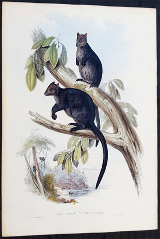
1845-63 John Gould Large Antique Print The Mammals of Australia - Tree Kangaroo
Antique Map
- Title : Dendrolagus Ursinus, Mull....H C Richter del et lith....C Hullmandel Imp.
- Ref #: 93441
- Size: 22in x 15in (560mm x 385mm)
- Date : 1845–63
- Condition: (A+) Fine Condition
Description:
This large rare original hand coloured lithograph antique print of The Ursine Tree Kangaroo, by the artist HC Richter was printed by Charles Joseph Hullmandel 1789 – 1850 in the famous Naturalists John Goulds The Mammals of Australiapublished between 1845–63.
General Definitions:
Paper thickness and quality: - Heavy and stable
Paper color : - off white
Age of map color: - Original
Colors used: - Blue, pink, red, green, yellow
General color appearance: - Authentic
Paper size: - 22in x 15in (560mm x 385mm)
Plate size: - 22in x 15in (560mm x 385mm)
Margins: - Min 1in (25mm)
Imperfections:
Margins: - Light age toning
Plate area: - None
Verso: - None
Background:
The Mammals of Australia is a three-volume work written and published by John Gould between 1845–63. It contains 182 illustrations by the author and its artist H. C. Richter. It was intended to be a complete survey of the novel species of mammals, such as the marsupials, discovered in the colonies of Australia.
The author, John Gould, best known for The Birds of Australia and other major works of ornithology, visited Australia in 1838. In his introduction, Gould says:.....It was not until I arrived in the country, and found myself surrounded by objects as strange as if I had been transported to another planet, that I conceived the idea of devoting a portion of my attention to the mammalian class of its extraordinary fauna......During his short stay he made observations on the natural history and employed his skills as a taxidermist to obtain specimens.
The publication of this major work by Gould followed his A Monograph of the Macropodidae or Family of Kangaroos in 1841. This work was the first comprehensive survey of Australian mammals, and gave an account of their classification and description. Gould also included the indigenous names for the species from the lists he made while in Australia. He used these names to make requests of the local peoples for his specimens, and recorded the regions where the names were used. This conserved a number of common names, such as dibbler (Parantechinus apicalis), which were later recommended by authorities.
The large lithographs reproduced the artwork of Richter, after the drawings and watercolours made in Australia by Gould and his wife, Elizabeth. (The contribution by Elizabeth Gould was uncredited). These were hand-coloured by a group of artists, led by Gabriel Bayfield, that required the completion of 26,572 plates. The illustrations produced during their visit to Australia were supplemented by the preserved specimens returned to England and detailed the characteristics of the species. These illustrations have become iconic images of the mammals of Australia. Among the best known of the illustrations from the work are the two of Thylacinus cynocephalus (Tasmanian tiger), copied since its publication and the most frequently reproduced, made more recognizable by Cascade Brewerys appropriation for its label in 1987. The government of Tasmania published a monochromatic reproduction of the same image in 1934, the author Louisa Anne Meredith also copied it for Tasmanian Friends and Foes (1881).
The Mammals of Australia was published by subscription in the format Imperial Folio; 13 parts in three volumes were issued from 1845 until 1863. To these the author added An Introduction to The Mammals of Australia (1863) in a separate work. This provided corrections and updates, a new preface, introduction, and a list of the mammals of the three volumes. The first two volumes were complete surveys of orders Marsupiata (marsupials), and, with Rodentia in the third, it formed the sum of known mammalian species of Australia. With the addition of those contained in the later Introduction the total of species described reached 166. The same work notes the exclusion of marine mammals such as whales from the volumes, but reprints a manuscript by Charles Coxen on the dugong.
Beyond the scientific value of this comprehensive survey, the document is cited in reference to its subjects conservation. Some of the species included in the work, such as Onychogalea lunata (crescent nailtail wallaby), have since succumbed to changes in land use since European colonisation.
The work was received with acclaim, but the high cost of production, especially of the coloured plates, reduced its accessibility. The original listed price was £41 for the complete set of volumes. The public curiosity for the unique fauna of Australia was met by this handsomely illustrated and comprehensive survey, and it spawned imitations in Australia. The curator of the Australian Museum, Gerard Krefft, produced the more affordable The Mammals of Australia (1871); intended for educational purposes and influenced by Goulds illustrations. Gracius Broinowskis abandoned work, Birds and Mammals of Australia (1884), so closely imitated the plates that an injunction was threatened by its publisher.
Gould, John FRS 1804 – 1881
Gould was an English ornithologist and bird artist. He published a number of monographs on birds, illustrated by plates that he produced with the assistance of his wife, Elizabeth Gould, and several other artists including Edward Lear, Henry Constantine Richter, Joseph Wolf and William Matthew Hart. He has been considered the father of bird study in Australia and the Gould League in Australia is named after him. His identification of the birds now nicknamed Darwins finches played a role in the inception of Darwins theory of evolution by natural selection. Goulds work is referenced in Charles Darwins book, On the Origin of Species.
Gould was born in Lyme Regis the first son of a gardener. He and the boy probably had a scanty education. Shortly afterwards his father obtained a position on an estate near Guildford, Surrey, and then in 1818 Gould became foreman in the Royal Gardens of Windsor. He was for some time under the care of J. T. Aiton, of the Royal Gardens of Windsor. The young Gould started training as a gardener, being employed under his father at Windsor from 1818 to 1824, and he was subsequently a gardener at Ripley Castle in Yorkshire. He became an expert in the art of taxidermy. In 1824 he set himself up in business in London as a taxidermist, and his skill helped him to become the first Curator and Preserver at the museum of the Zoological Society of London in 1827.
Goulds position brought him into contact with the countrys leading naturalists. This meant that he was often the first to see new collections of birds given to the Zoological Society of London. In 1830 a collection of birds arrived from the Himalayas, many not previously described. Gould published these birds in A Century of Birds from the Himalaya Mountains (1830–1832). The text was by Nicholas Aylward Vigors and the illustrations were drawn and lithographed by Goulds wife Elizabeth Coxen Gould. Most of Goulds work were rough sketches on paper from which other artists created the lithographic plates.
This work was followed by four more in the next seven years, including Birds of Europe in five volumes. It was completed in 1837; Gould wrote the text, and his clerk, Edwin Prince, did the editing. The plates were drawn and lithographed by Elizabeth Coxen Gould. A few of the illustrations were made by Edward Lear as part of his Illustrations of the Family of Psittacidae in 1832. Lear, however, was in financial difficulty, and he sold the entire set of lithographs to Gould. The books were published in a very large size, imperial folio, with magnificent coloured plates. Eventually 41 of these volumes were published, with about 3000 plates. They appeared in parts at £3 3s. a number, subscribed for in advance, and in spite of the heavy expense of preparing the plates, Gould succeeded in making his ventures pay, realising a fortune. This was a busy period for Gould who also published Icones Avium in two parts containing 18 leaves of bird studies on 54 cm plates as a supplement to his previous works. No further monographs were published as in 1838 he and his wife moved to Australia to work on the Birds of Australia. Shortly after their return to England, his wife died in 1841. Elizabeth Gould completed 84 plates for Birds of Australia before her death.
When Charles Darwin presented his mammal and bird specimens collected during the second voyage of HMS Beagle to the Zoological Society of London on 4 January 1837, the bird specimens were given to Gould for identification. He set aside his paying work and at the next meeting on 10 January reported that birds from the Galápagos Islands which Darwin had thought were blackbirds, gross-bills and finches were in fact a series of ground Finches which are so peculiar as to form an entirely new group, containing 12 species. This story made the newspapers. In March, Darwin met Gould again, learning that his Galápagos wren was another species of finch and the mockingbirds he had labelled by island were separate species rather than just varieties, with relatives on the South American mainland. Subsequently, Gould advised that the smaller southern Rhea specimen that had been rescued from a Christmas dinner was a separate species which he named Rhea darwinii, whose territory overlapped with the northern rheas. Darwin had not bothered to label his finches by island, but others on the expedition had taken more care. He now sought specimens collected by captain Robert FitzRoy and crewmen. From them he was able to establish that the species were unique to islands, an important step on the inception of his theory of evolution by natural selection. Goulds work on the birds was published between 1838 and 1842 in five numbers as Part 3 of Zoology of the Voyage of H.M.S. Beagle, edited by Charles Darwin. Elizabeth Gould illustrated all the plates for Part 3.
In 1838 the Goulds sailed to Australia, intending to study the birds of that country and be the first to produce a major work on the subject. They took with them the collector John Gilbert. They arrived in Tasmania in September, making the acquaintance of the governor Sir John Franklin and his wife. Gould and Gilbert collected on the island. In February 1839 Gould sailed to Sydney, leaving his pregnant wife with the Franklins. He travelled to his brother-in-laws station at Yarrundi, spending his time searching for bowerbirds in the Liverpool Range. In April he returned to Tasmania for the birth of his son. In May he sailed to Adelaide to meet Charles Sturt, who was preparing to lead an expedition to the Murray River. Gould collected in the Mount Lofty range, the Murray Scrubs and Kangaroo Island, returning again to Hobart in July. He then travelled with his wife to Yarrundi. They returned home to England in May 1840.
The result of the trip was The Birds of Australia (1840–48). It included a total of 600 plates in seven volumes; 328 of the species described were new to science and named by Gould. He also published A Monograph of the Macropodidae, or Family of Kangaroos (1841–1842) and the three volume work The Mammals of Australia (1849–1861).
Elizabeth died in 1841 after the birth of their eighth child, Sarah, and Goulds books subsequently used illustrations by a number of artists, including Henry Constantine Richter, William Matthew Hart and Joseph Wolf.
Throughout his professional life Gould had a strong interest in hummingbirds. He accumulated a collection of 320 species, which he exhibited at the Great Exhibition of 1851. Despite his interest, Gould had never seen a live hummingbird. In May 1857 he travelled to the United States with his second son, Charles. He arrived in New York too early in the season to see hummingbirds in that city, but on 21 May 1857, in Bartrams Gardens in Philadelphia, he finally saw his first live one, a ruby-throated hummingbird. He then continued to Washington D.C. where he saw large numbers in the gardens of the Capitol. Gould attempted to return to England with live specimens, but, as he was not aware of the conditions necessary to keep them, they only lived for two months at most.
Gould published: A Monograph of the Trochilidae or Humming Birds with 360 plates (1849–61); The Mammals of Australia (1845–63), Handbook to the Birds of Australia (1865), The Birds of Asia (1850–83), The Birds of Great Britain (1862–73) and The Birds of New Guinea and the adjacent Papuan Islands (1875–88).
The University of Glasgow, which owns a copy of Birds of Great Britain, describes John Gould as the greatest figure in bird illustration after Audubon, and auctioneers Sotherans describe the work as Goulds pride and joy.
Gould had already published some of the illustrations in Birds of Europe, but Birds of Great Britain represents a development of his aesthetic style in which he adds illustrations of nests and young on a large scale.
Sotherans Co. reports that Gould published the book himself, producing 750 copies, which remain sought after both as complete volumes, and as individual plates, currently varying in price from £450 – £850. The University of Glasgow records that the volumes were issued in London in 25 parts, to make the complete set, between 1863 and 1873, and each set contained 367 coloured lithographs.
Gould undertook an ornithological tour of Scandinavia in 1856, in preparation for the work, taking with him the artist Henry Wolf who drew 57 of the plates from Goulds preparatory sketches. According to The University of Glasgow Goulds skill was in rapidly producing rough sketches from nature (a majority of the sketches were drawn from newly killed specimens) capturing the distinctiveness of each species. Gould then oversaw the process whereby his artists worked his sketches up into the finished drawings, which were made into coloured lithographs by engraver William Hart.
There were problems: the stone engraving of the snowy owl in volume I was dropped and broken at an early stage in the printing. Later issues of this plate show evidence of this damage and consequently the early issue – printed before the accident – are considered more desirable.
The lithographs were hand coloured. In the introduction for the work, Gould states every sky with its varied tints and every feather of each bird were coloured by hand; and when it is considered that nearly two hundred and eighty thousand illustrations in the present work have been so treated, it will most likely cause some astonishment to those who give the subject a thought.
The work has gathered critical acclaim: according to Mullens and Swann, Birds of Great Britain is the most sumptuous and costly of British bird books, whilst Wood describes it as a magnificent work. Isabella Tree writes that it was seen – perhaps partly because its subject was British, as the culmination of [his] ... genius
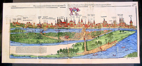
1574 Munster Large Antique Print View of The City of Wormbs, Germany
Antique Map
- Title : Die Statt Wormbs
- Ref #: 22670
- Size: 27in x 13in (685mm x 330mm)
- Date : 1574
- Condition: (A) Very Good Condition
Description:
This large folding original antique print a View of the important German city ofWormbs, south of Hamburg was published in the 1574 release of Sebastian MunstersCosmographia published by Sebastian Petri, Basle.
(This is a reasonably scarce map as the large fold out maps in Cosmographia were easily damaged and lost)
Background: For a variety of reasons town plans were comparatively latecomers in the long history of cartography. Few cities in Europe in the middle ages had more than 20,00 inhabitants and even London in the late Elizabethan period had only 100-150,000 people which in itself was probably 10 times that of any other English city. The Nuremberg Chronicle in 1493 included one of the first town views of Jerusalem, thereafter, for most of the sixteenth century, German cartographers led the way in producing town plans in a modern sense. In 1544 Sebastian Munster issued in Basle his Cosmographia containing roughly sixty-six plans and views, some in the plan form, but many in the old panorama or birds eye view. (Ref: Tooley; M&B)
General Description:
Paper thickness and quality: - Heavy and stable
Paper color: - off white
Age of map color: - Later
Colors used: - Green, blue, yellow, pink
General color appearance: - Authentic
Paper size: - 27in x 13in (685mm x 330mm)
Plate size: - 25in x 10in (635 x 255m)
Margins: - 1/2in (12mm)
Imperfections:
Margins: - Light soiling
Plate area: -Folds re-joined small loss, light soiling, light creasing
Verso: - Light soiling, colour show through, half the map backed in archival material
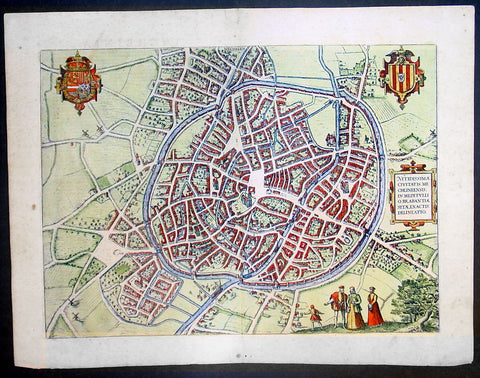
1575 Braun & Hogenberg Large Antique Print a View of Mechelen, Belgium
Antique Map
- Title : Mechelen - Nitidissimae Civitatis Mechlineensis in meditullio Brabantiae sitae, exactis: delineatio
- Ref #: 16247
- Size: 21in x 16in (535mm x 410mm)
- Date : 1575
- Condition: (A+) Fine Condition
Description:
This fine beautifully hand coloured original antique map a birds-eye view of the city of Mechelen in the Antwerp province of Flanders, Belgium was published by Georg Braun & Frans Hogenberg for the 1575 atlas of town plans Civiates Orbis Terrarum Vol II (1572-1612) intended as a companion to Abraham Ortelius's master Atlas Theatrum Orbis Terrarum published in 1570.
Franz Hogenberg's birthplace is illustrated twice. In the view presented in Volume I the cityscape is dominated by the massive tower belonging to the cathedral of Sint-Rombout, which measures almost 100 m in height. Behind the cathedral to the right lies the Onze-Lieve-Vrouwe church built in the Brabantine late Gothic style. In the present plate Mechelen is seen in a bird's-eye view from the northwest. Clearly apparent is the almost circular shape of the inner city, which has already spread beyond the bounds of the canal ringing the old city wall. In the Middle Ages staple rights and the cloth trade brought Mechelen great prosperity. In 1336 the city passed to the Duchy of Brabant, later to Burgundy, and developed into a highly regarded centre of commerce. The collapse of the cloth industry prompted the development of new areas of manufacturing, such as cannon and bell founding. In 1477 Mechelen passed to the Habsburgs and from 1507 to 1530, under the regency of Margaret of Austria, was capital of the Habsburg Netherlands. In 1559 Mechelen became an archbishopric and over the course of the Wars of Religion grew into a centre of the Counter-Reformation. For some time it was also the seat of the highest tribunal of the Habsburg Netherlands. (Taschen)
Background of Civitates Orbis Terrarum
The first volume of the Civitates Orbis Terrarum was published in Cologne in 1572. The sixth and the final volume appeared in 1617.
This great city atlas, edited by Georg Braun and largely engraved by Franz Hogenberg, eventually contained 546 prospects, bird-eye views and map views of cities from all over the world. Braun (1541-1622), a cleric of Cologne, was the principal editor of the work, and was greatly assisted in his project by the close, and continued interest of Abraham Ortelius, whose Theatrum Orbis Terrarum of 1570 was, as a systematic and comprehensive collection of maps of uniform style, the first true atlas.
For a variety of reasons town plans were comparatively latecomers in the long history of cartography. Few cities in Europe in the middle ages had more than 20,00 inhabitants and even London in the late Elizabethan period had only 100-150,000 people which in itself was probably 10 times that of any other English city. The Nuremberg Chronicle in 1493 included one of the first town views of Jerusalem, thereafter, for most of the sixteenth century, German cartographers led the way in producing town plans in a modern sense. In 1544 Sebastian Munster issued in Basle his Cosmographia containing roughly sixty-six plans and views, some in the plan form, but many in the old panorama or birds eye view. (Ref: Tooley; M&B)
Condition Report:
Paper thickness and quality: - Heavy and stable
Paper color: - off white
Age of map color: - Early
Colors used: - Green, blue, red, yellow
General color appearance: - Authentic
Paper size: - 21in x 16in (535mm x 410mm)
Plate size: - 18 1/2in x 13 1/2in (470mm x 345mm)
Margins: - Min 1in (25mm)
Imperfections:
Margins: - Light soiling in margins
Plate area: - None
Verso: - None
1575 Braun & Hogenberg Map of Pozzuoli Bay Naples Italy
Antique Map
- Title : Puteoli et Baiae
- Date : 1575
- Condition: (A+) Fine Condition
- Ref: 92687
- Size: 21in x 16in (535mm x 410mm)
Description:
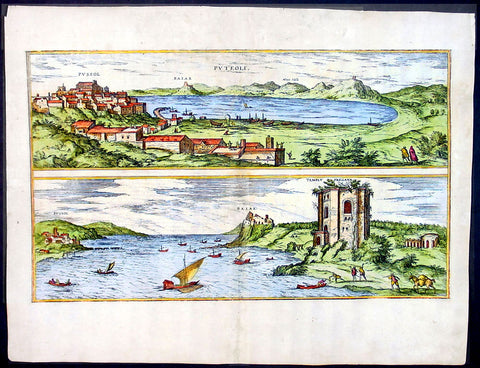
This finely engraved beautifully hand coloured original antique 2 x birds-eye view of the Bay of Pozzuoli -in the Gulf of Naples - with The city of Pozzuoli & the Port Of Baia visible was published by Georg Braun & Frans Hogenberg for the 1575 atlas of town plans Civiates Orbis Terrarum Vol II intended as a companion to Abraham Ortelius's master Atlas Theatrum Orbis Terrarum published in 1570.
The Gulf of Naples is a 10-mile wide gulf located in the south western coast of Italy, (province of Naples, Campania region). It opens to the west into the Mediterranean Sea & is bordered on the north by the cities of Naples and Pozzuoli. To the east is Mount Vesuvius, and on the south by the Sorrentine Peninsula and its main town Sorrento; the Peninsula separates it from the Gulf of Salerno.
Pozzuoli began as the Greek colony of Dicaearchia. The Roman colony was established in 194 BC, and took the Latin name Puteoli 'little wells', referring to the many hot springs in the area, most notably Solfatara. This is because Pozzuoli lies in the center of the Campi Flegrei, a caldera.
Puteoli was the great emporium for the Alexandrian grain ships, and other ships from all over the Roman world. It also was the main hub for goods exported from Campania, including blown glass, mosaics, wrought iron, and marble. The Roman naval base at nearby Misenum housed the largest naval fleet in the ancient world. It was also the site of the Roman Dictator Sulla's country villa and the place where he died in 78 BC.
The local volcanic sand, pozzolana formed the basis for the first effective concrete, as it reacted chemically with water. Instead of just evaporating slowly off, the water would turn this sand/lime mix into a mortar strong enough to bind lumps of aggregate into a load-bearing unit. This made possible the cupola of the Pantheon, the first real dome.
Background of Civitates Orbis Terrarum
The first volume of the Civitates Orbis Terrarum was published in Cologne in 1572. The sixth and the final volume appeared in 1617.
This great city atlas, edited by Georg Braun and largely engraved by Franz Hogenberg, eventually contained 546 prospects, bird-eye views and map views of cities from all over the world. Braun (1541-1622), a cleric of Cologne, was the principal editor of the work, and was greatly assisted in his project by the close, and continued interest of Abraham Ortelius, whose Theatrum Orbis Terrarum of 1570 was, as a systematic and comprehensive collection of maps of uniform style, the first true atlas.
For a variety of reasons town plans were comparatively latecomers in the long history of cartography. Few cities in Europe in the middle ages had more than 20,00 inhabitants and even London in the late Elizabethan period had only 100-150,000 people which in itself was probably 10 times that of any other English city. The Nuremberg Chronicle in 1493 included one of the first town views of Jerusalem, thereafter, for most of the sixteenth century, German cartographers led the way in producing town plans in a modern sense. In 1544 Sebastian Munster issued in Basle his Cosmographia containing roughly sixty-six plans and views, some in the plan form, but many in the old panorama or birds eye view. (Ref: Tooley; M&B)
Condition Report:
Paper thickness and quality: - Light and stable
Paper color: - off white
Age of map color: - Early
Colors used: - Green, blue, red, yellow
General color appearance: - Authentic
Paper size: - 21in x 16in (535mm x 410mm)
Plate size: - 19in x 12in (485mm x 310mm)
Margins: - Min 1in (25mm)
Imperfections:
Margins: - Professional repair to top centre margin
Plate area: - Small professional repairs & light age toning to centrefold
Verso: - None
1575 Braun & Hogenberg Antique Print Sneek Dokkum Ylst Frisia Sloten Netherlands
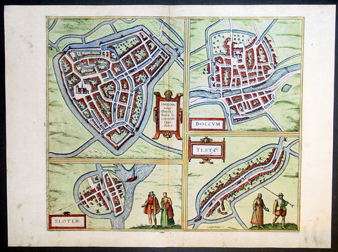
- Title : Sneecha, vulgo Sneeck Frisiae Occidentalis Oppidum. - Doccum - Sloten - Ylsta
- Ref #: 30261
- Size: 21in x 16in (535mm x 410mm)
- Date : 1575
- Condition: (A+) Fine Condition
Description:
This fine beautifully hand coloured original antique map a birds-eye view of the towns of Sneek, Dokkum, Ylst and Sloten in Frisia, the Netherlands was published by Georg Braun & Frans Hogenberg for the 1575 atlas of town plans Civiates Orbis Terrarum Vol II (1572-1612) intended as a companion to Abraham Ortelius's master Atlas Theatrum Orbis Terrarum published in 1570.
Background of Civitates Orbis Terrarum
The first volume of the Civitates Orbis Terrarum was published in Cologne in 1572. The sixth and the final volume appeared in 1617.
This great city atlas, edited by Georg Braun and largely engraved by Franz Hogenberg, eventually contained 546 prospects, bird-eye views and map views of cities from all over the world. Braun (1541-1622), a cleric of Cologne, was the principal editor of the work, and was greatly assisted in his project by the close, and continued interest of Abraham Ortelius, whose Theatrum Orbis Terrarum of 1570 was, as a systematic and comprehensive collection of maps of uniform style, the first true atlas.
For a variety of reasons town plans were comparatively latecomers in the long history of cartography. Few cities in Europe in the middle ages had more than 20,00 inhabitants and even London in the late Elizabethan period had only 100-150,000 people which in itself was probably 10 times that of any other English city. The Nuremberg Chronicle in 1493 included one of the first town views of Jerusalem, thereafter, for most of the sixteenth century, German cartographers led the way in producing town plans in a modern sense. In 1544 Sebastian Munster issued in Basle his Cosmographia containing roughly sixty-six plans and views, some in the plan form, but many in the old panorama or birds eye view. (Ref: Tooley; M&B)
Condition Report:
Paper thickness and quality: - Heavy and stable
Paper color: - off white
Age of map color: - Early
Colors used: - Green, blue, red, yellow
General color appearance: - Authentic
Paper size: - 21in x 16in (535mm x 410mm)
Plate size: - 16 1/2in x 14in (420mm x 355mm)
Margins: - Min 1in (25mm)
Imperfections:
Margins: - Light soiling in margins
Plate area: - None
Verso: - None
1575 Braun & Hogenberg Large Antique Map of the City of Arras, France
Antique Map
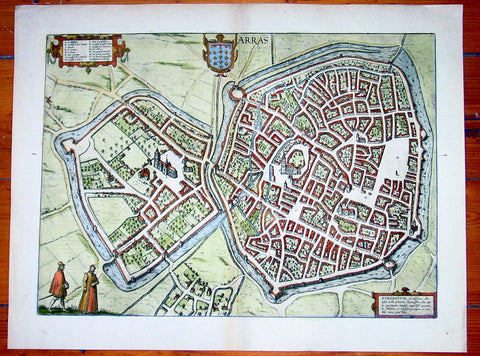
- Title : Arras
- Date : 1575
- Condition: (A+) Fine Condition
- Ref: 92833
- Size: 21in x 16in (535mm x 410mm)
Description:
This fine beautifully hand coloured original antique map a birds-eye view of the French City of Arras - the capital of the Pas de Calais region - was published by Georg Braun & Frans Hogenberg for the 1575 atlas of town plans Civiates Orbis Terrarum Vol II (1572-1612) intended as a companion to Abraham Ortelius's master Atlas Theatrum Orbis Terrarum published in 1570.
Background of Civitates Orbis Terrarum
The first volume of the Civitates Orbis Terrarum was published in Cologne in 1572. The sixth and the final volume appeared in 1617.
This great city atlas, edited by Georg Braun and largely engraved by Franz Hogenberg, eventually contained 546 prospects, bird-eye views and map views of cities from all over the world. Braun (1541-1622), a cleric of Cologne, was the principal editor of the work, and was greatly assisted in his project by the close, and continued interest of Abraham Ortelius, whose Theatrum Orbis Terrarum of 1570 was, as a systematic and comprehensive collection of maps of uniform style, the first true atlas.
For a variety of reasons town plans were comparatively latecomers in the long history of cartography. Few cities in Europe in the middle ages had more than 20,00 inhabitants and even London in the late Elizabethan period had only 100-150,000 people which in itself was probably 10 times that of any other English city. The Nuremberg Chronicle in 1493 included one of the first town views of Jerusalem, thereafter, for most of the sixteenth century, German cartographers led the way in producing town plans in a modern sense. In 1544 Sebastian Munster issued in Basle his Cosmographia containing roughly sixty-six plans and views, some in the plan form, but many in the old panorama or birds eye view. (Ref: Tooley; M&B)
Condition Report:
Paper thickness and quality: - Heavy and stable
Paper color: - off white
Age of map color: - Early
Colors used: - Green, blue, red, yellow
General color appearance: - Authentic
Paper size: - 21in x 16in (535mm x 410mm)
Plate size: - 19in x 14in (485mm x 355mm)
Margins: - Min 1in (25mm)
Imperfections:
Margins: - None
Plate area: - None
Verso: - None
1665 Nieuhof Antique Print Imperial Palace Peking or the Forbidden City, Beijing
Antique Map
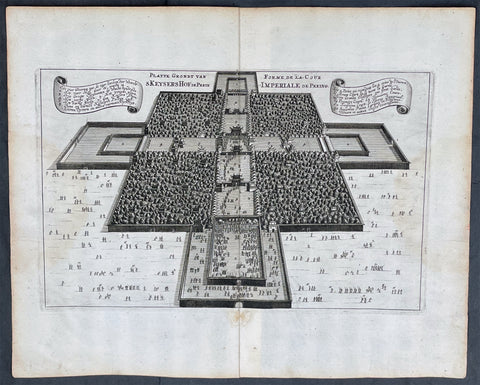
- Title : Platte Grondt van Skeyers Hof in Pekin; Forme de la Cour Imperiale de Peking
- Ref #: 17055
- Size: 15in x 12 1/2in (380mm x 310mm)
- Date : 1665
- Condition: (A+) Fine Condition
Description:
This original copper-plate engraved antique print a birds-eye view of the Imperial Palace & extensive gardens in Peking, now Beijing, or the Forbidden City by Johan Nieuhof was published by Jacob van Meurs in the 1665 edition of L’Ambassade de la Compagnie Orientale des Provinces Unies vers l’Empereur de la Chine, ou Grand Cam de Tartarie, faite par les sieurs Pierre de Goyer et Jacob de Keyser illustrée d’une très-exacte description des villes, bourgs, villages, ports de mer et autres lieux plus considérables de la Chine....1665. Title in English: An embassy from the East-India Company (1669).
General Definitions:
Paper thickness and quality: - Heavy and stable
Paper color : - off white
Age of map color: -
Colors used: -
General color appearance: -
Paper size: - 15in x 12 1/2in (380mm x 310mm)
Plate size: - 12 1/2in x 7 1/2in (310mm x 195mm)
Margins: - Min 1in (25mm)
Imperfections:
Margins: - None
Plate area: - None
Verso: - None
Background:
The Forbidden City is a palace complex in Dongcheng District, Beijing, China, at the center of the Imperial City of Beijing. It is surrounded by numerous opulent imperial gardens and temples including the 22-hectare Zhongshan Park, the sacrificial Imperial Ancestral Temple, the 69-hectare Beihai Park, and the 23-hectare Jingshan Park.
The Forbidden City was constructed from 1406 to 1420, and was the former Chinese imperial palace and winter residence of the Emperor of China from the Ming dynasty (since the Yongle Emperor) to the end of the Qing dynasty, between 1420 and 1924. The Forbidden City served as the home of Chinese emperors and their households and was the ceremonial and political center of the Chinese government for over 500 years. Since 1925, the Forbidden City has been under the charge of the Palace Museum, whose extensive collection of artwork and artifacts were built upon the imperial collections of the Ming and Qing dynasties. The Forbidden City was declared a World Heritage Site in 1987.
The complex consists of 980 buildings, encompassing 8,886 rooms and covering 720,000 square metres (72 hectares)/178 acres. The palace exemplifies the opulence of the residences of the Chinese emperor and the traditional Chinese palatial architecture, and has influenced cultural and architectural developments in East Asia and elsewhere. It is listed by UNESCO as the largest collection of preserved ancient wooden structures in the world. Since 2012, the Forbidden City has seen an average of 14 million visitors annually, and received more than 19 million visitors in 2019. In 2018, The Forbidden Citys market value has been estimated at US$70 billion, making it both the worlds most valuable palace and the most valuable piece of real estate anywhere in the world.
Some sources describe it as the largest palace in the world still in existence, but other Chinese imperial residences far exceed it in size, namely the 6.1 km2 (610 ha) Zhongnanhai which lies just west of the Forbidden City, the 2.9 km2 (290 ha) Summer Palace in Haidian District, Beijing, and the 5.6 km2 (560 ha) Chengde Mountain Resort in Chengde, Hebei Province.
The Forbidden City in Beijing is one of the largest and most well-preserved ancient wooden structures in the world. It is a national AAAAA-level tourist attraction in China. It was listed as the first batch of national key cultural relics in 1961 and listed as a world cultural heritage in 1987.
Nieuhof, Johan (1618 – 1672)
Nieuhof was a Dutch traveler who wrote about his journeys to Brazil, China and India. The most famous of these was a trip of 2,400 kilometers from Canton to Peking in 1655-1657, which enabled him to become an authoritative Western writer on China. He wrote An embassy from the East-India Company containing the written account of this journey.
Johan Nieuhof was born in Uelsen, a town in the county of Bentheim, Lower Saxony, sitting just across the Dutch-German border. His father (originally from Zwolle) was mayor of the town, and was later succeeded by one of Johans brothers and brother-in-law. By the grace of Cornelis Jan Witsen, a leading figure within the Dutch West India Company (or WIC), Nieuhof left for Dutch Brazil in 1640 as a reserve officer-candidate. From then on, barring two short family visits in 1658 and 1671, he spent all the rest of his life abroad.
Nieuhof was employed in Brazil to explore the regions between Maranhão and the São Francisco Rivers, made a particular study of the neighborhood of Pernambuco. He left Brazil in 1649, after the Portuguese victory in the Second Battle of Guararapes. Upon his return, Nieuhof joined the service of the Dutch East India Company (or VOC). In service of the VOC he resided several years in Batavia, and then was appointed in 1654 steward of an embassy to the relatively new Qing emperor China under Peter de Goyer and Jacob de Keyser, which aimed to gain trading rights on Chinas southern coast.
He remained in China until 1657. In 1663 he operated as an ambassador in Quilon, after the occupation of the Malabar Coast by Rijckloff van Goens. During this period he visited several chiefs of indigenous tribes in order to secure trade relations with them. Afterwards, he was offered a post on Ceylon where he was stationed between 1663 and 1667. He was imprisoned for seven months because of illegal trade in pearls. Nieuhof was sent to Batavia by Hendrik van Rheede and fired by the Dutch East India Company.
On returning to the Indies from a trip home in 1672, he stopped on the isle of Madagascar. On October 8 1672, Nieuhof traveled inland along with the first mate, in search of the local tribes in order to trade with them, as well as secure water for his crew. Upon hearing several gunshots, the captain sent a second ship towards the island in order to await Nieuhofs return. After three days of waiting, the captain presumed Nieuhof and his company to be murdered and sailed onwards towards Mauritius. On order of the governing council in Amsterdam, a ship was sent from the Cape of Good Hope to retrieve Nieuhof and his fellows, but no trace of them could be found.
In the first half of the 17th century, the VOC tried to break the Portuguese monopoly position on trade to Macau. When they did not succeed, they sent six embassies to Peking between 1655 and 1685. Their aim was to convince the Qing emperor to open up trade relations on the southern coast, in favor of the VOC, although they ultimately failed. Nieuhof was appointed to the position of steward on one of these embassies by Joan Maetsuycker, which traveled from Canton to Peking between 1655 and 1658. They were the second embassy to try and gain the emperors favor, the first was led by Zacharias Wagenaer. Nieuhofs duties as part of the embassy primarily consisted of ceremonial matters as well as securing lodgings. He was, however, specifically appointed to illustrate any and all of the cities, palaces, temples, rivers and other noteworthy buildings in their true to nature form.
On March 17 1656, after months of negotiations and discussions of tributes to be paid to the Chinese emperor and viceroy, the embassy left Canton by barge, to travel towards Peking. The embassy arrived at the emperors court in Peking on July 18 the same year. The hired the jesuit scholar Johann Adam Schall von Bell to be their translator, who warned them of the possible dangers and required ceremonies to approach the emperor. On September 24, the embassy was received by the Shunzhi Emperor. As dictated by their translator, the party performed the traditional kowtow, as failing to do so would most likely result in immediate refusal by the emperor. As a result, the emperor allowed Dutch embassies to visit the court once every eight years, in parties consisting of no more than 100 men. Any trading rights were not discussed nor granted at this point. On October 16 the embassy was asked to leave the city of Peking within two hours. Their return trip took three months; putting the entire length of the embassy at 20 months and 6 days.
At his homecoming in 1658, he had entrusted his notes and annotations to his brother Hendrik, whom Johan thanked when finally (in 1665) Hendrik produced an ample study of China, with many images, text and explanation of the latest events. The work was published by Jacob van Meurs in 1665, titled Het Gezandtschap der Neêrlandtsche Oost-Indische Compagnie, aan den grooten Tartarischen Cham, den tegenwoordigen Keizer van China: Waarin de gedenkwaerdigste Geschiedenissen, die onder het reizen door de Sineesche landtschappen, Quantung, Kiangsi, Nanking, Xantung en Peking, en aan het Keizerlijke Hof te Peking, sedert den jaren 1655 tot 1657 zijn voorgevallen, op het bondigste verhandelt worden. Beneffens een Naukeurige Beschrijvinge der Sineesche Steden, Dorpen, Regeering, Weetenschappen, Hantwerken, Zeden, Godsdiensten, Gebouwen, Drachten, Schepen, Bergen, Gewassen, Dieren, et cetera en oorlogen tegen de Tartar : verçiert men over de 150 afbeeltsels, nat leven in Sina getekent. Hendrik dedicated the work to Hendrik Spiegel and Cornelis Jan Witsen (Nicolaes Witsens father), administrators of the East and West India Companies respectively. Translations into French (1665), German (1666), Latin (1668) and English (1669) were also published, each going into at least two editions. More of Nieuhoffs material, on Chinese ships, appeared in Nicolaes Witsens Scheepsbouw (1671).
The reports from these embassies and the reports of the Jesuits formed the only reliable source of information on China available in Western Europe. As mentioned, being the purser of the VOC embassy to Peking, Johan Nieuhof in 1655 had special instructions to observe all farms, towns, palaces, rivers, ... [and other] buildings that he might pass by, drawing them in straight form and figure, as well as remains of the historical victory of the Tartars (Manchus) that brought an end to the reign of the Ming dynasty. The inclusion of approximately 150 illustrations in the book marked the first time that literature on China contained images that were true to nature. In previously published works, belonging to the imaginative fantastic tradition where fact and fiction were hardly discernible, the Chinese were depicted as creatures of fantasy. Nieuhofs illustrations, as opposed to these previous works, depicted the Chinese and their culture as they were observed by the illustrator himself, without fanciful additions.
The 150 illustrations of the Nieuhoffs book were one inspiration for chinoiserie, which became especially popular in the 18th century. Many artists and architects based their designs on the pictures in the book. The original drawings were rediscovered in 1984 in the collection of prince Roland Bonaparte, an anthropologist who collected material about Madagascar, Lapland and the Native Americans.
Publications:
- Johannes Nieuhof (1668), Legatio batavica ad magnum Tartariæ chamum Sungteium, modernum Sinæ imperatorem; Historiarum narratione, quæ legatis in provinciis Quantung, Kiangsi, Nanking, Xantung, Peking, & aula imperatoriâ ab anno 1665 ad annum 1657 obtigerunt ..., Amstelodami: Jacobum Meursium, OCLC 2134985, OL 23411529M
- Het gezantschap der Neêrlandtsche Oost-Indische Compagnie, aan den grooten Tartarischen Cham, den tegenwoordigen keizer van China : waar in de gedenkwaerdighste geschiedenissen, die onder het reizen door de Sineesche landtschappen, Quantung, Kiangsi, Nanking, Xantung en Peking, en aan het keizerlijke hof te Peking, sedert den jare 1655 tot 1657 zijn voorgevallen, op het bondigste verhandelt worden : befeffens een naukeurige Beschryving der Sineesche steden, dorpen, regeering, wetenschappen, hantwerken, zeden, godsdiensten, gebouwen, drachten, schepen, bergen, gewassen, dieren, &c. en oorlogen tegen de Tarters : verçiert men over de 150 afbeeltsels, nat leven in Sina getekent. Amsterdam: Jacob van Meurs, 1665. Title in English: An embassy from the East-India Company (1669).
- Zee- en Lant-Reise door verscheide Gewesten van Oostindien, behelzende veele zeldzaame en wonderlijke voorvallen en geschiedenissen. Beneffens een beschrijving van lantschappen, dieren, gewassen, draghten, zeden en godsdienst der inwoonders: En inzonderheit een wijtloopig verhael der Stad Batavia. Amsterdam: de Weduwe van Jacob van Meurs, 1682. Google books
- Gedenkweerdige Brasiliaense Zee- en Lant-Reise und Zee- en Lant-Reize door verscheide Gewesten van Oostindien. Amsterdam: de Weduwe van Jacob van Meurs, 1682.

1574 Sebastian Munster Antique Map Birds Eye View of the City of Tours, France
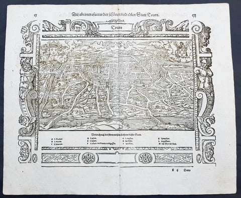
- Title : Die Statt Tours
- Ref #: 22614
- Size: 16in x 13in (410mm x 330mm)
- Date : 1574
- Condition: (A+) Fine Condition
Description:
This fine original wood block engraved antique map a birds eye view of the French city of Tours, France was published in the French Section of Sebastian Munsters 1574 edition of Cosmographia, Das ist: Beschreibung der gantzen Welt, Darinnen Aller Monarchien Keyserthumben, Königreichen, Fürstenthumben, Graff- und Herrschafften, Länderen, Stätten und Gemeinden.Ursprung (Cosmographia, that is: description of the whole world, in it all monarchies Keyser thumben, kingdoms, prince thumben, graff and herrschafften, countries, places and municipalities.)
Tours is a city in the centre-west of France. It is the administrative centre of the Indre-et-Loire department and the largest city in the Centre-Val de Loire region of France
General Definitions:
Paper thickness and quality: - Heavy and stable
Paper color : - off white
Age of map color: -
Colors used: -
General color appearance: -
Paper size: - 16in x 13in (410mm x 330mm)
Plate size: - 16in x 13in (410mm x 330mm)
Margins: - Min 1in (25mm)
Imperfections:
Margins: - None
Plate area: - None
Verso: - None
Background:
Cosmographia, Das ist: Beschreibung der gantzen Welt, Darinnen Aller Monarchien Keyserthumben, Königreichen, Fürstenthumben, Graff- und Herrschafften, Länderen, Stätten und Gemeinden.Ursprung, Regiment, Reichthumb, Gewalt und.Beschaffenheit. Dessgleichen Aller deren, beyder Ständen, Regenten: Keysern, Königen, Bäpsten, Bischoffen.Genealogien und Stammbäumen.zusammen getragen. by Sebastian Münster was first published in 1544 and is the earliest German-language description of the world. It had numerous editions in different languages including Latin, French (translated by François de Belleforest), Italian, English, and Czech. The last German edition was published in 1628, long after Munsters death. The Cosmographia was one of the most successful and popular books of the 16th century. It passed through 24 editions in 100 years. This success was due to the notable woodcuts (some by Hans Holbein the Younger, Urs Graf, Hans Rudolph Manuel Deutsch, and David Kandel). It was most important in reviving geography in 16th-century Europe. Among the notable maps within Cosmographia is the map Tabula novarum insularum, which is credited as the first map to show the American continents as geographically discrete.
Munsters earlier geographic works were Germania descriptio (1530) and Mappa Europae (1536). In 1540, he published a Latin edition of Ptolemys Geographia with illustrations.
1650 Fuller Antique Print a View of Neros Palace Rome
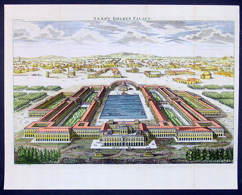
- Title : Neros Golden Palace
- Ref : 24312
- Size: 17in X 13in (435mm x 330mm)
- Date : 1650
- Condition: (A+) Fine Condition
Description:
This finely engraved hand coloured original antique print a view of Neros Golden Palace in Rome was published in 1650 by Thomas Fuller in his unique book of the Holy Land A Pisagh-Sight of Palestine
Fuller, a loyalist during the English Civil War of the mid 17th century, wrote Pisagh-Sightduring a forced exile in Waltham.
The book was an early success and confirmed the genial divines contention the “the booksellers have always done well by me”. His earlier studies in poetry and history and his droll humor contribute to the geographical description in “Pisagh-Sight” while the cartography in the book is derived from that of Adrichom sixty years before.
The book contained 21 wonderfully engraved maps on the Holy Land and displayed unusual charm in their Vignettes and scenes. For all its lively and playful erudition, Pisagh-Sight is one of the great books on the topography of the Holy Land. (Ref: Nebenzahl; Tooley; M&B)
General Description:
Paper thickness and quality: - Heavy and stable
Paper color: - Off white
Age of map color: - Early
Colors used: - Yellow, pink, orange, green
General color appearance: - Authentic
Paper size: - 17in X 13in (435mm x 330mm)
Margins: - Min 1/2in (12mm)
Imperfections:
Margins: - None
Plate area: - Folds as issued
Verso: - None
1574 Munster Large Antique Print View of The French City of Tours
- Title : Die Statt Tours
- Ref #: 22614
- Size: 16in x 13in (410mm x 330mm)
- Date : 1574
- Condition: (A+) Fine Condition
Description:
This large finely engraved original antique print a view of the French city of Tours was published by Sebastian Munster in the 1574 edition of Cosmographia.
Tours is a city located in the centre-west of France. It is the administrative centre of the Indre-et-Loire department and the largest city in the Centre-Val de Loire region of France (although it is not the capital, which is the region's second-largest city, Orléans). Tours stands on the lower reaches of the River Loire, between Orléans and the Atlantic coast. The surrounding district, the traditional province of Touraine, is known for its wines, for the alleged perfection (as perceived by some speakers) of its local spoken French, and for the Battle of Tours (732).
Background: For a variety of reasons town plans were comparatively latecomers in the long history of cartography. Few cities in Europe in the middle ages had more than 20,00 inhabitants and even London in the late Elizabethan period had only 100-150,000 people which in itself was probably 10 times that of any other English city. The Nuremberg Chronicle in 1493 included one of the first town views of Jerusalem, thereafter, for most of the sixteenth century, German cartographers led the way in producing town plans in a modern sense. In 1544 Sebastian Munster issued in Basle hisCosmographia containing roughly sixty-six plans and views, some in the plan form, but many in the old panorama or birds eye view.
Sebastian Münster (1488-1552) was a German cartographer, cosmographer, and Hebrew scholar whose work Cosmographia (1544; "Cosmography") was the earliest German description of the world and a major work in the revival of geographic thought in 16th-century Europe. It had numerous editions in different languages including Latin, French, Italian, English, and even Czech. Altogether, about 40 editions of the Cosmographiaappeared between 1544 and 1628 and was one of the most successful and popular books of the 16th century. Münster was a major influence in popular thinking in Europe for the next 200 years.
This success was due not only to the level of descriptive detail but also to the fascinating full page maps & views as well as smaller woodcuts that were included in the text. Many of the woodcuts were executed by famous engravers of the time including Hans Holbein the Younger, Urs Graf, Hans Rudolph Manuel Deutsch, and David Kandel.
Aside from the well-known maps present in the Cosmographia, the text is thickly sprinkled with vigorous views: portraits of kings and princes, costumes and occupations, habits and customs, flora and fauna, monsters, wonders, and horrors about the known -- and unknown -- world, and was undoubtedly one of the most widely read books of its time.
Münster acquired the material for his book in three ways. Firstly he researched all available literary sources across Germany, Switzerland and other parts of Europe. Secondly he obtained original manuscript material from locals all over Europe for description of the countryside, cities, villages, towns, rivers and local history. Finally, he obtained further material first hand on his travels (primarily in south-west Germany, Switzerland, and Alsace).
In 1588 Sebastian Petri re-released Cosomgraphia and re-issued many of Munsters maps and views in the "copperplate style". The maps in this release were more sophisticated than with earlier publications ofCosomgraphia and were based on the 1570 release of Abraham Ortelius monumental work Theatrum Orbis Terrarum.(Ref: Tooley; M&B)
General Description:
Paper thickness and quality: - Light and stable
Paper color: - off white
Age of map color: -
Colors used: -
General color appearance: -
Paper size: - 16in x 13in (410mm x 330mm)
Plate size: - 16in x 13in (410mm x 330mm)
Margins: - 1/2in (12mm)
Imperfections:
Margins: - None
Plate area: -None
Verso: - None
1693 Slezer Antique Print View of the Town of Alloa on Firth of Forth Scotland
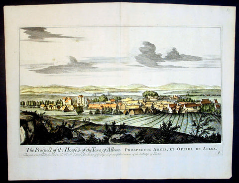
- Title : The Prospect of the House & of the Town of Alloua
- Ref : 24947
- Size: 18 ½in x 14 ½in (470mm x 370mm)
- Date : 1693
- Condition: (A+) Fine Condition
Description:
This finely engraved original important antique print a view of the town of Alloa in Clackmannanshire in eastern Scotland on the Firth of Forth, was published in the first edition of John Slezer's 'Theatrum Scotiae', 1693.
This is an important and rare print as Slezer s Theatrum Scotiae is one of the earliest records of early Scottish towns. (Ref: Tooley; M&B)
General Description:
Paper thickness and quality: - Heavy and stable
Paper color: - off white
Age of map color: -
Colors used: -
General color appearance: -
Paper size: - 18 ½in x 14 ½in (470mm x 370mm)
Plate size: - 16 ½in x 11 in (420mm x 280mm)
Margins: - Min 1in (25mm)
Imperfections:
Margins: - None
Plate area: - None
Verso: - None
1819 Gainsborough & Wells Antique Print of an English Country Farming Scene
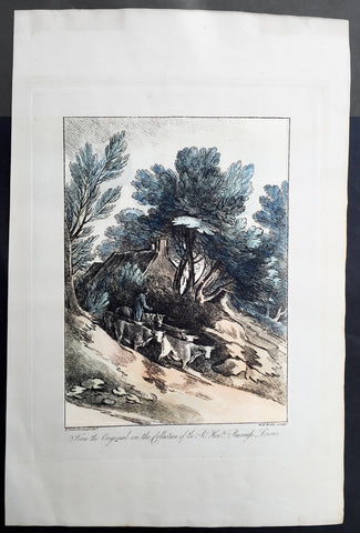
- Title : From the Original in the Collection of the Rt. Hon. ble Baroness Lucas...T Gainsborough del. W.F. Wells sculpt.
- Date : 1801
- Condition: (A+) Fine Condition
- Ref: 91222
- Size: 17 1/4in x 11 1/2in (440mm x 290mm)
Description:
This large beautiful executed original antique soft ground etched print with hand tint colour, of a English country scene after Thomas Gainsborough, was engraved by William Frederick Wells and published in A Collection of Prints Illustrative of English Scenery From the Drawings and Sketches of Thos. Gainsborough, R.A. in the various collections of The Baroness Lucas; Viscount Palmerston; George Herbert, Esq.; Dr. Monro by John and Josiah Boydell, London in 1819.
The English painter Thomas Gainsborough (1727-1788) ranks as one of the principal masters and innovators of the English school of landscape painting. Thomas Gainsborough was baptized in Sudbury, Suffolk, on May 14, 1727. His father, a substantial cloth merchant, recognized Thomas's precocious artistic gifts and sent him at an early age, possibly 12, to London. Gainsborough was connected with the artists Francis Hayman and Hubert François Gravelot, possibly as apprentice to the former and assistant to the latter. Gainsborough is reported to have copied and restored Dutch landscapes for dealers. At the age of 19 he married Margaret Burr, reputedly a natural daughter of the Duke of Beaufort, who is said to have brought him an income of £200 a year.
At the age of 21 Gainsborough was so much admired as a landscape painter that he was invited with the leading artists of the day to present a picture to the Foundling Hospital in London. His painting, The Charterhouse, shows a mature observation of reality and handling of light. From Hayman the scene painter and Gravelot the rococo decorator Gainsborough learned to approach pictorial composition on inventive principles, and the alternation between observation and invention henceforth became the basis of his artistic growth. The two approaches may be illustrated by comparing Mr. and Mrs. Robert Andrews (ca. 1749), with a deliciously observed Suffolk landscape dappled by sunlight and shadow of cloud, and Henéage Lloyd and His Sister (ca. 1750), shown against a limpid background of stage scenery.
Gainsborough's art after his early London studies falls into three main divisions: the Suffolk period, 1748-1759; the Bath period, 1759-1774; and the years of fame in London, 1774-1788. In Suffolk he combined the charms of the modern conversation piece with those of realistic landscape, thus making a strong appeal to the country gentry. Here too he painted the Suffolk countryside as faithfully and freshly as if he were a Dutch painter reborn in the 18th century.
William Frederick Wells (1762 - 10 Nov 1836) was an English watercolour landscape painter and etcher. Wells was born in London in 1762. Wells studied art in London under John James Barralet (1747–1815). On 20 November 1804, Wells initiated the founding of the Society of Painters in Watercolours (now the Royal Watercolour Society), at a meeting held at the Stratford Coffee House, Oxford St, London. He served as President of the fledgling association from 1806 to 1807.
He travelled and painted extensively in England and Europe, particularly in Norway and Sweden. Wells' art was annually exhibited at the Royal Academy from 1795 to 1813. He held the post of Professor of Drawing at Addiscombe Military Seminary for officers of the East India Company Army over twenty years from 1813 until his retirement, immediately before his death, in November 1836.[1] Wells was an intimate friend of Joseph Mallord William Turner. Among his works as an etcher are two fine sets in soft ground; Thomas Gainsborough's English Scenery (1819) and Select Views in Cumberland (1810).
General Description:
Paper thickness and quality: - Heavy and stable
Paper color: - off white
Age of map color: - Original
Colors used: - Blue, orange, green, brown
General color appearance: - Authentic
Paper size: - 17 1/4in x 11 1/2in (440mm x 290mm)
Plate size: - 12 1/2in x 9 1/2in (315mm x 245mm)
Margins: - Min 2in (50mm)
Imperfections:
Margins: - None
Plate area: - None
Verso: - None
1675 Merian Antique Map Birds Eye View Siege of Szczecin, Stettin Poland in 1659
Antique Map
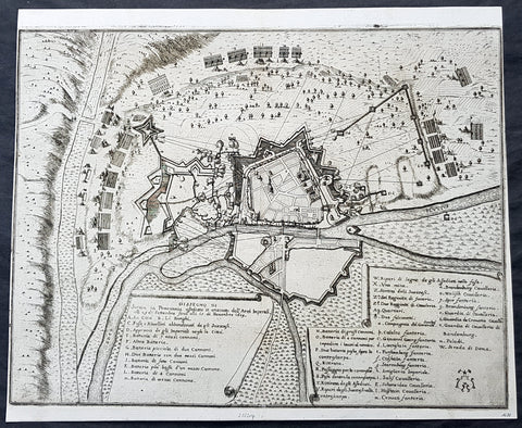
- Title : Abzeichnung der Belägerung der Statt Stettin in Pommeren wie dieselbe von denen Kayserlichen vom 29.Sept. biß auf den 15. Novemb. Anno 1659 angegriffen und bestritten worden
- Ref #: 93491
- Size: 15 1/2in x 13in (395mm x 340mm)
- Date : 1675
- Condition: (A+) Fine Condition
Description:
This original copper-plate engraved antique map a birds-eye view of the siege of Szczecin or Stettin, Poland in 1659 - with illustrations of military positions surrounding the city - by Matthaus Merian was published in the 1675 edition of Theatrum Europaeum
During the Thirty Years War, Stettin refused to accept German imperial armies, instead the Pomeranian dukes allied with Sweden. After the Treaty of Stettin (1630) manifested Swedish occupation, Stettin was fortified by the Swedish Empire. After the death of the last Pomeranian duke, Boguslaw XIV, Stettin was awarded to Sweden with the western part of the duchy in the Peace of Westphalia (1648), but remained part of the Holy Roman Empire. The Swedish-Brandenburgian border was settled in the Treaty of Stettin (1653). The King of Sweden became Duke of Pomerania and as such held a seat in the Imperial Diet of the Holy Roman Empire. The city was cut off from its main trading area, and was besieged in several wars with Brandenburg which shattered the citys economy, which fell in prolonged economic decline.
In 1654 the last Pomeranian duke Boguslaw XIV was buried in the Ducal Castle.
General Definitions:
Paper thickness and quality: - Heavy and stable
Paper color : - off white
Age of map color: -
Colors used: -
General color appearance: -
Paper size: - 15 1/2in x 13in (395mm x 340mm)
Plate size: - 15 1/2in x 13in (395mm x 340mm)
Margins: - Min 1/8in (2mm)
Imperfections:
Margins: - Left margin cropped close to border
Plate area: - None
Verso: - None
Background:
Szczecin/Stettin is the capital and largest city of the West Pomeranian Voivodeship in northwestern Poland. Located near the Baltic Sea and the German border, it is a major seaport and Polands seventh-largest city.
Szczecin is located on the river Oder, south of the Szczecin Lagoon and the Bay of Pomerania. The city is situated along the southwestern shore of Dąbie Lake, on both sides of the Oder and on several large islands between the western and eastern branches of the river. Szczecin is adjacent to the town of Police and is the urban centre of the Szczecin agglomeration, an extended metropolitan area that includes communities in the German states of Brandenburg and Mecklenburg-Vorpommern.
The cities recorded history began in the 8th century as a Lechitic Pomeranian stronghold, built at the site of the Ducal castle. In the 12th century, when Szczecin had become one of Pomeranias main urban centres, it lost its independence to Piast Poland, the Duchy of Saxony, the Holy Roman Empire and Denmark. At the same time, the House of Griffins established themselves as local rulers and the population was Christianized. After the Treaty of Stettin in 1630, the town came under the control of the Swedish Empire and became in 1648 the Capital of Swedish Pomerania until 1720, when it was acquired by the Kingdom of Prussia and then the German Empire. Following World War II Stettin became part of Poland in accordance with the Potsdam Agreement, resulting in the almost complete expulsion of the pre-war German population.
1772 John Boydell Antique Print of Moat Island Eight Views of Windsor Great Park
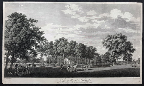
- Title : The Moat Island Published March the 2nd 1772 by John Boydell Engraver in Cheapside London
- Size: 23 1/2in x 13 1/2in (595mm x 340mm)
- Condition: (B) Good Condition
- Date : 1772
- Ref #: 91158-1
Description:
This large original copper-plate engraved antique print of The Moat Island in Great Windsor Park by Thomas Sandby was engraved by François Vivares and published by John Boydell for the 1772 edition of Eight Views of Windsor Great Park
Thomas Sandby RA 1721 – 1798 was an English draughtsman, watercolour artist, architect and teacher. In 1743 he was appointed private secretary to the Duke of Cumberland, who later appointed him Deputy Ranger of Windsor Great Park, where he was responsible for considerable landscaping work.
Along with his younger brother Paul, he was one of the founding members of the Royal Academy in 1768, and was its first professor of architecture. His most notable architectural work was the Freemason\'s Hall in London (now demolished).
Francois Vivares 1709 – 1780 was a French landscape-engraver, active in England.
General Definitions:
Paper thickness and quality: - Heavy and stable
Paper color : - off white
Age of map color: -
Colors used: -
General color appearance: -
Paper size: - 23 1/2in x 13 1/2in (595mm x 340mm)
Plate size: - 23 1/2in x 13 1/2in (595mm x 340mm)
Margins: - Min 1/2in (12mm)
Imperfections:
Margins: - Soiling and creasing
Plate area: - Several small tears and holes repaired
Verso: - Repairs as noted
Background:
The set of eight folio plates published in Eight Views of Windsor Great Park executed by Thomas Sandby and his brother Paul with the assistance of several noted English engravers. The 8 views were considered to be the finest set of topographical country house views after Rigauds 1739 Views of Stowe
Thomas Sandby (1721–1798) was an architect who served as draftsman to the Duke of Cumberland at the Battle of Culloden in 1746. With his younger brother Paul, a landscape painter and watercolourist, they were founding members of the Royal Academy in 1768.
Through these engravings, the Duke of Cumberland sought to commemorate his alteration of the park, which had served English royalty since the eleventh century as a hunting and jousting ground and, beginning in the eighteenth century, as a place of formal gardens and walks. (The Duke is pictured in several of the engravings, arriving by carriage, directing workers by a bridge, and discoursing with the King by the river.) The improvements to Windsor Great Park recorded in these engravings include a dam built in 1749, forming an artificial lake, rockwork, a cascade, and a grotto. In 1752, a fifty-ton ships hull was raised from the Thames and fitted up on the artificial lake as a Mandarin Yacht or Chinese Junk. A triangular Gothic belvedere was erected on Shrubs Hill to the south, and a large wooden footbridge was constructed over the water. Renovations were also undertaken at the so-called Great Lodge, which became the Dukes residence at Windsor. In short, these improvements partook of the fashionable taste for picturesque Gothick – that was most noticeably championed by Horace Walpoles contemporary Strawberry Hill villa.
Much of these improvements, which were actually the work of architect Henry Flitcroft, were destroyed by severe floods, which broke the dam at Virginia Water in 1768 and again in 1782. These views therefore provide evidence for the state of the park at that date.
Original sketches and preparatory drawings by Paul and Thomas Sandby related to these engravings survive in the Royal Collection at Windsor Castle, the Victoria and Albert Museum, and the British Museum.
Boydell, John 1720 - 1804
Boydell 1804 was an 18th-century British publisher noted for his reproductions of engravings. He helped alter the trade imbalance between Britain and France in engravings and initiated a British tradition in the art form. A former engraver himself, Boydell promoted the interests of artists as well as patrons and as a result his business prospered.
The son of a land surveyor, Boydell apprenticed himself to William Henry Toms, an artist he admired, and learned engraving. He established his own business in 1746 and published his first book of engravings around the same time. Boydell did not think much of his own artistic efforts and eventually started buying the works of others, becoming a print dealer as well as an artist. He became a successful importer of French prints during the 1750s but was frustrated by their refusal to trade prints in kind. To spark reciprocal trade, he commissioned William Wolletts spectacular engraving of Richard Wilsons The Destruction of the Children of Niobe, which revolutionised the print trade. Ten years later, largely as a result of Boydells initiative, the trade imbalance had shifted, and he was named a fellow of the Royal Society for his efforts.
In the 1790s, Boydell began a large Shakespeare venture that included the establishment of a Shakespeare Gallery, the publication of an illustrated edition of Shakespeares plays, and the release of a folio of prints depicting scenes from Shakespeares works. Some of the most illustrious painters of the day contributed, such as Benjamin West and Henry Fuseli.
Throughout his life, Boydell dedicated time to civic projects: he donated art to government institutions and ran for public office. In 1790 he became Lord Mayor of London. The French Revolutionary Wars led to a cessation in Continental trade at the end of the 1790s. Without this business, Boydells firm declined and he was almost bankrupt at his death in 1804.
In 1751, with his large volume of prints, Boydell moved to larger premises at 90 Cheapside. By 1755, he had published A Collection of One Hundred and Two Views, &C. in England and Wales. This cheap but successful book gave him capital to invest. He became increasingly immersed in the commercial side of the print business and like most print dealers began importing prints to sell. These included print reproductions of landscapes by artists such as Claude Lorrain and Salvator Rosa. The bulk of the imports came from the undisputed masters of engraving during the 18th century: the French. Boydell made a small fortune in the 1750s from these imported prints. His early success was acknowledged in 1760 when he was named a member of the Royal Society.Winifred Friedman, who has written extensively on Boydell, explains that despite this success, [w]hat rankled Boydell was that the French would not extend credit, or exchange prints; he was required to produce hard cash. Boydell took action, and this was the turning point.
In 1761, Boydell decided that he would attempt to trade with the French in kind—something they had refused in the past because of the poor quality of British engravings. To inaugurate this change, he had to have a truly spectacular print. To this end, he hired William Woollett, the foremost engraver in England, to engrave Richard Wilsons Destruction of the Children of Niobe. Woollett had already successfully engraved Claude Lorrains 1663 painting The Father of Psyche Sacrificing at the Temple of Apollo for Boydell in 1760. Boydell paid him approximately £100 for the Niobe engraving, a staggering amount compared to the usual rates. This single act of patronage raised engravers fees throughout London. The print was wildly successful, but more importantly, the French accepted it as payment in kind. In fact, it was the first British print actively desired on the Continent. By 1770, the British were exporting far more prints than they were importing, largely due to Boydell.
Boydells business flourished and he soon hired his nephew, Josiah Boydell, to assist him. Boydells biographer, Sven Bruntjen, hypothesizes that one of the reasons for Boydells early and phenomenal success was his specialisation. Unlike his competitors [who sold manuals, atlases and other assorted books] ... his [business had an] almost exclusive concentration on the sale of reproductive prints. Bruntjen argues that despite the extensive sales of varied types of reproductive prints, it was the contemporary history print which accounted for the major part of Boydells success as a print dealer. Most notable among these was the Death of General Wolfe a 1770 painting by Benjamin West, engraved by Woollett for Boydell in 1776. As early as 1767, Boydell had stopped engraving prints himself and began exclusively relying on commissions and trades and it was from these that he profited.
Boydell had opened up a new market with Niobe and he quickly followed up this success. With a prospering business and capital in reserve, he embarked on several ambitious projects, often simultaneously. In 1769, he began A Collection of Prints, Engraved after the Most Capital Paintings in England. Its last, and ninth volume, was finished in 1792 to great critical and financial success. In 1773, he began A Set of Prints Engraved after the Most Capital Paintings in the Collection of Her Imperial Majesty the Empress of Russia, Lately in the Possession of the Earl of Orford at Houghton in Norfolk, which was finished in 1788.
In addition to these projects and in the middle of his Shakespeare undertaking Boydell experimented with aquatint in An History of the River Thames, published in 1796. Bruntjen writes, although not the first colored aquatint book, [it] was the first major one, and it was to set an example for the type of illustration that was to enjoy widespread popularity in England for some forty years. Boydell also published The Original Work of William Hogarth in 1790 and The Poetical Works of John Milton and The Life of the Poet (i.e., Milton) in 1794.
The productivity and profitability of Boydells firm spurred the British print industry in general. By 1785, annual exports of British prints reached £200,000 while imports fell to £100. Boydell was acknowledged and praised throughout England as the agent of this stunning economic reversal. In 1773 he was awarded the Royal Academy Gold Medal for his services in advancing the print trade. In 1789, at the Royal Academy dinner, the Prince of Wales toasted an English tradesman who patronizes art better than the Grand Monarque, Alderman Boydell, the Commercial Maecenas
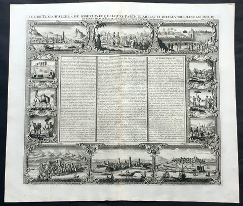
1719 Chatelain Large Antique Print North Africa City Views Algiers, Jijel, Tripoli & Tunis
- Title : Vue de Tunis d'Alger & de Gigeri avec quelques particularitez curieuses touchant les moeurs de leur habitans & de quelques autres peuples de Barbarie
- Ref #: 50646
- Size: 20in x 17 1/2in (510mm x 445mm)
- Date : 1719
- Condition: (A+) Fine Condition
Description:
This large finely engraved original antique print views of cities of The Barbary Coast of North Africa including Algiers and Jijel, both in Algeria, Tripoli in Libya and Tunis in Tunisia - as well as peoples & animals of the Barbary coast - was published by Henri Abraham Chatelain in 1719, in his famous Atlas Historique.
Henri Abraham Chatelain (1684 - 1743)
was a Huguenot pastor of Parisian origins. He lived consecutively in Paris, St. Martins, London (c. 1710), the Hague (c. 1721) and Amsterdam (c. 1728).
Chatelain was a skilled artist and knew combining a wealth of historical and geographical information with delicate engraving and an uncomplicated composition. Groundbreaking for its time, this work included studies of geography, history, ethnology, heraldry, and cosmography. His maps with his elegant engraving are a superb example from the golden age of French mapmaking.The publishing firm of Chatelain, Chatelain Frères and Chatelain & Fils is recorded in Amsterdam, from around 1700-1770, with Zacharias living "op den Dam" in 1730.
Henri Abraham Chatelain, his father Zacharie Chatelain (d.1723) and Zacharie Junior (1690-1754), worked as a partnership publishing the Atlas Historique, Ou Nouvelle Introduction à L'Histoire under several different Chatelain imprints, depending on the Chatelain family partnerships at the time of publication. The atlas was published in seven volumes between 1705 and 1720, with a second edition appearing in 1732. The volumes I-IV with a Third edition and volume I with a final edition in 1739.
Henri Abraham Chatelain, whose "Atlas Historique" was one of the most expansive Dutch encyclopedias of the age. First published in 1705, Chatelain's Atlas Historique was part of an immense seven-volume encyclopedia. Although the main focus of the text was geography, the work also included a wealth of historical, political, and genealogical information. The text was compiled by Nicholas Gueudeville and Garillon with a supplement by H.P. de Limiers and the maps were engraved by Chatelain, primarily after charts by De L'Isle. The atlas was published in Amsterdam between 1705 and 1721 and was later reissued by Zacharie Chatelain between 1732 and 1739.
Atlas Historique: First published in Amsterdam from 1705 to 1720, the various volumes were updated at various times up to 1739 when the fourth edition of vol.I appeared, stated as the "dernière edition, corrigée & augmentée."
The first four volumes seem to have undergone four printings with the later printings being the most desirable as they contain the maximum number of corrections and additions. The remaining three final volumes were first issued between 1719-1720 and revised in 1732.
An ambitious and beautifully-presented work, the Atlas Historique was intended for the general public, fascinated in the early eighteenth century by the recently conquered colonies and the new discoveries. Distant countries, such as the Americas, Africa, the Middle East, Mongolia, China, Japan, Indonesia, etc., take an important place in this work.
In addition to the maps, many of which are based on Guillaume De L'Isle, the plates are after the best travel accounts of the period, such as those of Dapper, Chardin, de Bruyn, Le Hay and other.
Other sections deal with the history of the european countries, and covers a wide range of subjects including genealogy, history, cosmography, topography, heraldry and chronology, costume of the world, all illustrated with numerous engraved maps, plates of local inhabitants and heraldic charts of the lineages of the ruling families of the time. The maps, prints and tables required to make up a complete set are listed in detail in each volume.
The accompanying text is in French and often is printed in two columns on the page with maps and other illustrations interspersed. Each map and table is numbered consecutively within its volume and all maps bear the privileges of the States of Holland and West-Friesland.
The encyclopaedic nature of the work as a whole is reflected in this six frontispiece. The pages are the work of the celerated mr. Romeijn de Hooghe. and are engraved by J.Goeree, T.Schynyoet and P.Sluyter.
New scholarship has suggested the compiler of the atlas, who is identified on the title as "Mr. C***" not to be Henri Abraham Châtelain, but Zacharie Châtelain. (See Van Waning's article in the Journal of the International Map Collectors' Society for persuasive evidence of the latter's authorship.) (Ref: M&B; Tooley)
General Description:
Paper thickness and quality: - Heavy and stable
Paper color: - White
Age of map color: -
Colors used: -
General color appearance: -
Paper size: - 20in x 17 1/2in (510mm x 445mm)
Plate size: - 17 1/2in x 15in (445mm x 380mm)
Margins: - min. 1in (25mm)
Imperfections:
Margins: - None
Plate area: - None
Verso: - None
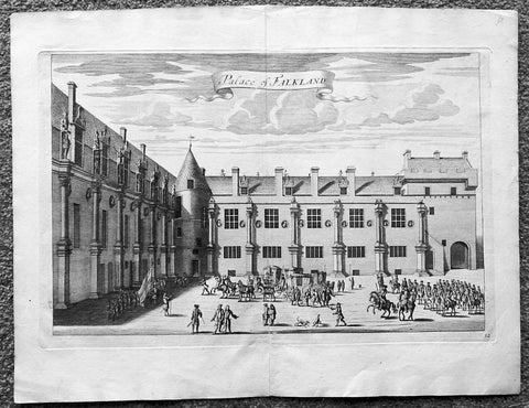
1718 Slezer Antique Print View of Falkland Palace, Fife, Scotland
- Title : Palace of Falkland
- Date : 1718
- Ref # : 24958
- Size : 18 ½in x 14 ½in (470mm x 360mm)
- Condition: (A+) Fine
Description:
This fine beautifully hand coloured original antique print a view of the internal courtyard of Falkland Palace, home of the Scottish Kings - was published in the 1718 edition of John Slezer's 'Theatrum Scotiae'.
Falkland Palace in Falkland, Fife, Scotland, is a former royal palace of the Scottish Kings. The Scottish Crown acquired Falkland Castle from MacDuff of Fife in the 14th century. In 1402 Robert Stewart, 1st Duke of Albany imprisoned his nephew David Stewart, Duke of Rothesay, the eldest son of King Robert III of Scotland, at Falkland. The incarcerated Duke eventually died there from neglect and starvation. Albany was exonerated from blame by Parliament, but suspicions of foul play persisted, suspicions which never left Rothesay's younger brother the future James I of Scotland, and which would eventually lead to the downfall of the Albany Stewarts. John Debrett, writing in 1805, was in no doubt of Duke Robert's motives and guilt. This Robert, Duke of Albany, having obtained the entire government from his brother, King Robert, he caused the Duke of Rothesay to be murdered, thinking to bring the Crown into his own family; but to avoid the like fate, King Robert resolved to send his younger son James, to France, then about nine years old, who being sea-sick, and forced to land on the English coast ... was detained a captive in England eighteen years. At these misfortunes King Robert died of grief in 1406. Between 1501 and 1541 Kings James IV and James V of Scotland transformed the old castle into a beautiful royal palace: with Stirling Castle it was one of only two Renaissance palaces in Scotland. To address the poor state of the garden and park, James V appointed a new Captain and Keeper, William Barclay, Master of Rhynd, in March 1527. Ten years later, James V extended his father's buildings in French renaissance style. He died at Falkland in December 1542 after hearing that his wife had given birth to a daughter—Mary, Queen of Scots. Falkland became a popular retreat with all the Stewart monarchs. They practised falconry there and used the vast surrounding forests for hawking and for hunting deer. Wild boar, imported from France, were kept in the Park, within a fence made by the Laird of Fernie. Nearby Myres Castle is the hereditary home of the Royal Macers and Sergeants at Arms who served Falkland Castle since at least the sixteenth century. John Scrimgeour of Myres supervised building at the Palace from 1532 to 1563. After the Union of the Crowns (1606), James VI and I, Charles I, and Charles II all visited Falkland. A fire partially destroyed the palace during its occupation by Cromwell's troops and it quickly fell into ruin.
This is an important and rare print as Slezer s Theatrum Scotiae is one of the earliest records of early Scottish towns & major buildings. (Ref: Tooley; M&B)
General Description:
Paper thickness and quality: - Heavy and stable
Paper color: - off white
Age of map color: -
Colors used: -
General color appearance: -
Paper size: - 18 ½in x 14 ½in (470mm x 360mm)
Plate size: - 16 ½in x 11in (420mm x 275mm)
Margins: - Min 1in (25mm)
Imperfections: Margins: - None
Plate area: - None
Verso: - None
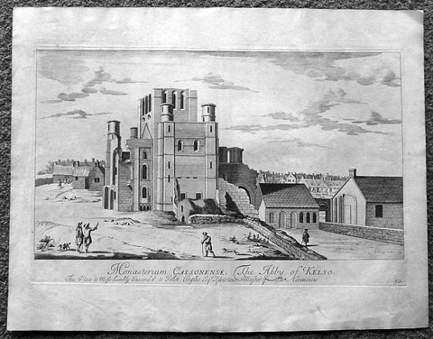
1718 Slezer Antique Print View of Kelso Abby & Township, Scotland
- Title : The Abby of Kelso
- Date : 1718
- Ref # : 24953
- Size : 18 ½in x 14 ½in (470mm x 360mm)
- Condition: (A+) Fine
Description:
This fine beautifully hand coloured original antique print a view of Kelso Abby & Kelso Town, Scotland was published in the 1718 edition of John Slezer's 'Theatrum Scotiae'.
Kelso Abbey is a ruined Scottish abbey in Kelso, Scotland. It was founded in the 12th century by a community of Tironensian monks first brought to Scotland in the reign of Alexander I. It occupies ground overlooking the confluence of the Tweed and Teviot waters, the site of what was once the Royal Burgh of Roxburgh and the intended southern centre for the developing Scottish kingdom at that time. Kelso thus became the seat of a pre-eminently powerful abbacy in the heart of the Scottish Borders.
In the 14th century, Roxburgh became a focus for periodic attack and occupation by English forces and Kelso's monastic community survived a number of fluctuations in control over the area, restoring the abbey infrastructure after episodes of destruction and ultimately retaining Scottish identity. From 1460 onwards, life for the abbey probably grew more settled, but came once again under attack in the early sixteenth century. By the mid-century, through a turbulent combination of events, the abbey effectively ceased to function and the building fell into ruin.
Although the site of Kelso Abbey has not been fully excavated in modern times, evidence suggests that it was a major building with two crossings. The only remains standing today are the west tower crossing and part of the infirmary. The massive design and solid romanesque style of the tower indicate a very large building of formidable, semi-military construction and appearance, evidence of the importance with which Roxburgh was regarded when the abbacy was at the height of its power.
This is an important and rare print as Slezer s Theatrum Scotiae is one of the earliest records of early Scottish towns & major buildings. (Ref: Tooley; M&B)
General Description:
Paper thickness and quality: - Heavy and stable
Paper color: - off white
Age of map color: -
Colors used: -
General color appearance: -
Paper size: - 18 ½in x 14 ½in (470mm x 360mm)
Plate size: - 16 ½in x 11in (420mm x 275mm)
Margins: - Min 1in (25mm)
Imperfections: Margins: - Light age toning
Plate area: - Light age toning
Verso: - Light age toning
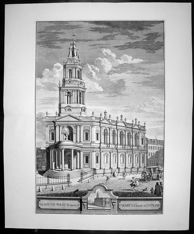
1724 Johannes Kip Large Antique Print of St Marys Church, The Strand, London
- Title : The South West Prospect of St Mary's Church in ye Strand
- Date : 1724
- Condition: (A+) Fine Condition
- Ref: 40400
- Size: 26 1/2in x 22in (670mm x 560mm)
Description: This large original copper-plate engraved antique print by Johannes (Jan) Kip, after Leonard Knyff, was published in the 1724 Joseph Smith edition of Britannia Illustrata or Nouveau Theatre de la Grande Bretagne. This beautifully engraved original antique print is testimony to the fine, detailed work produced by Jan Kip.
Britannia Illustrata was first issued in 1707 by David Mortier as a single volume containing 80 topographical etchings by Johannes Kip, after drawings by Leonard Knyff. Many are birds eye views of country seats, but there are also a number of interesting London views. The series was first reissued and expanded into two volumes in 1708-1713, and provided with a second French title Nouveau Theatre de la Grande Bretagne.
An expanded edition of Britannia Illustrata was re-published by Joseph Smith in 1724 under its French title, Nouveau Theatre..., containing many of the plates from the original edition by Mortier and also containing may new plates of places, churches, cathedrals and architecture of the landed gentry.
Background:
The parish of St Mary le Strand may lay a good claim to being one of the oldest parishes in London. It stands dominating a roadway which since prehistory has been the main artery to the west from the City of London. In early Saxon times the Strand area was the very heart of London, for it seems that the City was effectively abandoned by the newly-arrived settlers. The Saxons predominantly inhabited "Lundenwic", an area stretching from Fleet Street to Whitehall and from the Thames to Covent Garden from the sixth to the ninth centuries. Christianity came to this settlement with St Mellitus and his followers in 604, and, despite their brief expulsion in the 620s, became firmly established. We do not know if any of the existing churches in the area date back that far but some, such as St Clement Danes, are known to have existed in later Saxon times.
There is no record of when St Mary le Strand was founded, but the first church, which was dedicated to the Nativity of the Blessed Virgin Mary, stood just south of the present church on a site now covered by Somerset House. Throughout the Middle Ages, the Bishops of Worcester were the Patrons of the parish and had their London residence on an adjoining site. For throughout the period from the Norman Conquest to the Reformation, the Strand was mainly the home of bishops and princes. Within the parish were the "inns" - large town houses with chapels, stables and accommodation for a large retinue - of the Bishops of Worcester, Llandaff, Coventry and Lichfield. A large part of the parish was absorbed by the building of a great house, the Palace of the Savoy, by Count Peter of Savoy, the uncle of Henry III, in the 1240s. A century later this became the home of John of Gaunt, Earl of Lancaster, and the palace became a centre of culture; among its residents was Geoffrey Chaucer, who was married in the palace chapel. Gaunt's unpopularity, as the king's chief minister, caused the palace to be burned in the Peasant's Revolt. Despite its long absence, the fame of the palace has lasted in the area and was recreated in the nineteenth century by the Savoy Hotel and Theatre.
The site where the present church stands was occupied in medieval times by Strand Cross. The origins of this are unclear. It was not a cross erected in memory of Queen Eleanor - as was Charing Cross - but seems to have dated back at least to Norman times. Perhaps it began as a market cross; by the early fourteenth century it had been rebuilt in a lavish manner, almost certainly following the design of the Eleanor Crosses. Strand Cross was a famous site and it is recorded that in the thirteenth century the local magistrates held their assizes in front of it.
Until the sixteenth century, the Strand was no more than a line of Bishops' palaces on the south side of the roadway stretching all the way to Whitehall. On the north side stood a wall which bounded the Convent - later Covent - Garden, while the churches further away, St Martin's and St Giles, stood "in-the-fields". All this was to change with the Reformation. The bishops' inns around the church were seized by Edward Lord Protector who set about building himself a renaissance palace in what was then the most fashionable part of town. Even with the extensive site that he had now obtained, further space was needed and towards the end of 1548 the Lord Protector's workmen fell upon St Mary's church and demolished it to provide stone for the new palace. Further stone was provided by the demolition of a cloister at St Paul's Cathedral known as Pardon Churchyard and the greater part of the Priory of St John at Clerkenwell. Even by the standards of the time, the demolition of so much sacred property was an outrage. Somerset was never to enjoy living in his new palace; just as it was nearing completion he was overthrown by his political enemies and executed at Tower Hill in 1551.
It is said that Somerset had intended to build a new parish church. If so, all thought of it passed away with his fall. Initially, the parishioners scattered but within a short time we find them gathered in the chapel of St John the Baptist in the Savoy. Here they would remain for the next 175 years. Now known at "St Mary le Savoy", the parishioners chose and paid for their own ministers. The most famous of these was Thomas Fuller, the church historian, who was appointed in 1642, fled during the Civil War and was restored to his living in 1660.
Following the execution of Somerset, his palace had passed to the possession of the Crown. Elizabeth I occasionally lodged there and it was from Somerset House that she set off to give thanks after the defeat of the Armada. Under the Stuarts, extensive improvements were made to the palace, the most impressive being the lavish Roman Catholic chapel built by Charles I's queen, Henrietta Maria.
The roadway in front of Somerset House, where Strand Cross had stood and where the present church was later to stand, was occupied in the early seventeenth century by a windmill used to pump water. In 1634 the first Hackney Carriage stand in England was established here by one Captain Bailey. Here also a maypole was erected which became the most famous maypole in London. Demolished by the Puritans, a new maypole was erected in 1661. Parts of this maypole remained until 1717, when they were removed and presented to Sir Isaac Newton as the base for a telescope.
In 1711, an Act of Parliament was passed for building 50 New Churches in the fast expanding suburbs of London. These were the so-called "Queen Ann Churches"; among them are Hawksmoor's Christ Church Spitalfields, St Anne's Limehouse, and St George's-in-the-East, Archer's St Paul's Depftord and James' St George's, Hanover Square. St Mary le Strand was quick to apply for a church to replace their demolished one and, as the site on the Strand was so prominent, the Commissioners for building the New Churches decided to make the Strand church the most lavish of the churches. Initially, it was intended that there should not be a spire but that a column celebrating the building of the New Churches should stand directly in front of the church.
General Description:
Paper thickness and quality: - Heavy and stable
Paper colour: - off white
Age of map colour: -
Colours used: -
General colour appearance: -
Paper size: - 26 1/2in x 22in (670mm x 560mm)
Plate size: - 23in x 18in (585mm x 460mm)
Margins: - min 1in (25mm)
Imperfections:
Margins: - None
Plate area: - None
Verso: - None
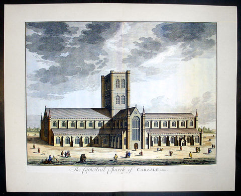
1724 Johannes Kip Large Antique Print a View of Carlisle Church in Cumbria, England
- Title : The Cathedral Church of Carlile
- Date : 1724
- Condition: (A+) Fine Condition
- Ref: 40406
- Size: 26 1/2in x 22in (670mm x 560mm)
Description: This large original copper-plate engraved antique print by Johannes (Jan) Kip, after Leonard Knyff, was published in the 1724 Joseph Smith edition of Britannia Illustrata or Nouveau Theatre de la Grande Bretagne. This beautifully engraved original antique print is testimony to the fine, detailed work produced by Jan Kip.
Britannia Illustrata was first issued in 1707 by David Mortier as a single volume containing 80 topographical etchings by Johannes Kip, after drawings by Leonard Knyff. Many are birds eye views of country seats, but there are also a number of interesting London views. The series was first reissued and expanded into two volumes in 1708-1713, and provided with a second French title Nouveau Theatre de la Grande Bretagne.
An expanded edition of Britannia Illustrata was re-published by Joseph Smith in 1724 under its French title, Nouveau Theatre..., containing many of the plates from the original edition by Mortier and also containing may new plates of places, churches, cathedrals and architecture of the landed gentry.
Background: Carlisle Cathedral bears the scars of 900 years spent in this most tumultuous of regions. The scarred exterior and tower, has the effect of making the cathedral look more like a Border castle than a church! The cathedral suffered badly in the Civil War, when Parliamentary troops under General Leslie almost destroyed the nave, leaving only two bays standing.
The original nave was built by secular canons in 1092 as a collegiate church. That early church was built, but by 1123 the Augustinian order had taken over. The choir aisles are late 13th century, but the body of the choir was not completed until a century later.
The transepts and tower date from the 15th century. The glories of Carlisle are the east window, one of the best examples of decorated tracery anywhere, and the delicately carved capitals in the choir, depicting the seasons. The east window is believed to be the work of Ivo de Ragheton, who was also responsible for the west front of York Minster.
The barrel-vaulted choir ceiling is painted in vivid blue with gold trim. Medieval paintings in the north and south aisles and the choir represent the lives of the Apostles and saints Anthony and Cuthbert. The choir stalls and misericords are decorated with wonderful carvings dating from the early 15th century.
This is a finely engraved print being testimony to the beautiful and detailed work produced by Kip whose eye for detail was one of the most acknowledged of his day.
Condition Report
Paper thickness and quality: - Heavy and stable
Paper colour: - off white
Age of map colour: - Early
Colours used: - Yellow, brown, green, red
General colour appearance: - Authentic
Paper size: - 24 1/2in x 19 1/2in (610mm x 495mm)
Plate size: - 23in x 18in (585mm x 470mm)
Margins: - min 1/4in (6mm)
Imperfections:
Margins: - None
Plate area: - None
Verso: - None
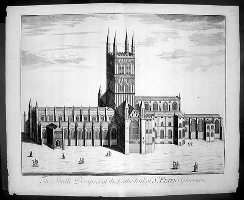
1724 Johannes Kip Large Antique Print of Gloucester Cathedral, England
- Title : The South Prospect of The Cathedral of St Peters Glocester
- Date : 1724
- Condition: (A+) Fine Condition
- Ref: 40415
- Size: 26 1/2in x 22in (670mm x 560mm)
Description: This large original copper-plate engraved antique print by Johannes (Jan) Kip, after Leonard Knyff, was published in the 1724 Joseph Smith edition of Britannia Illustrata or Nouveau Theatre de la Grande Bretagne. This beautifully engraved original antique print is testimony to the fine, detailed work produced by Jan Kip.
Britannia Illustrata was first issued in 1707 by David Mortier as a single volume containing 80 topographical etchings by Johannes Kip, after drawings by Leonard Knyff. Many are birds eye views of country seats, but there are also a number of interesting London views. The series was first reissued and expanded into two volumes in 1708-1713, and provided with a second French title Nouveau Theatre de la Grande Bretagne.
An expanded edition of Britannia Illustrata was re-published by Joseph Smith in 1724 under its French title, Nouveau Theatre..., containing many of the plates from the original edition by Mortier and also containing may new plates of places, churches, cathedrals and architecture of the landed gentry.
General Description:
Paper thickness and quality: - Heavy and stable
Paper colour: - off white
Age of map colour: -
Colours used: -
General colour appearance: -
Paper size: - 26 1/2in x 22in (670mm x 560mm)
Plate size: - 23in x 18in (585mm x 460mm)
Margins: - min 1in (25mm)
Imperfections:
Margins: - None
Plate area: - None
Verso: - None
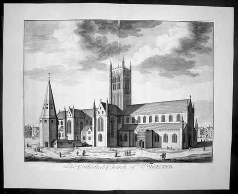
1724 Kip Large Folio Antique Print of Worcester Cathedral, England
- Title : The Cathedral Church of Worcester
- Date : 1724
- Condition: (A+) Fine Condition
- Ref: 40407
- Size: 26 1/2in x 22in (670mm x 560mm)
Description:
This finely engraved original large folio antique Cathedral print by Johannes Jan Kip, was engraved by James Collins was published in the 1724 by Joseph Smith monumental work Nouveau Theatre de la Grande Bretagne. This print also appeared in Britannia Illustrata by D. Mortier (brother of Pierre).
This is a finely engraved print being testimony to the beautiful and detailed work produced by Kip whose eye for detail was one of the most acknowledged of his day.
Background:
The history of Worcester goes back a long way. In 672, a council of the English Church was held, Worcester became the centre of five new dioceses formed. In the ninth century invasions from the Danes brought fighting to England, but Worcester being on the edge of the conflict escaped without much damage. In 983, Oswald founded a monastery at Worcester under the Benedictine rule, dedicated to St. Mary the Virgin. Wulfstan, in 1040 became a monk at Worcester and made such an impression, he became Bishop of Worcester in 1062. Wulfstan was the only Anglo-Saxon bishop to remain at his post after the Norman Conquest of 1066. In 1084, Wulfstan began rebuilding Worcester Cathedral, starting with the crypt, some of which still survives. He was canonised in 1203. Building work continued for some time, including rebuilding the two western bays of the nave in 1170 and around 1202 the central tower collapsed and there was a serious fire. In 1216, King John was buried at Worcester and he seems to have a devotion to St. Wulfstan. In 1224, Bishop William de Blois built the Lady Chapel, where he was buried when he died in 1236. In the fourteenth century the nave was completely rebuilt apart from the western bays. The central tower and the cloisters were completed built by 1374.
General Description:
Paper thickness and quality: - Heavy and stable
Paper colour: - off white
Age of map colour: -
Colours used: -
General colour appearance: -
Paper size: - 26 1/2in x 22in (670mm x 560mm)
Plate size: - 23in x 18in (585mm x 460mm)
Margins: - min 1in (25mm)
Imperfections:
Margins: - None
Plate area: - None
Verso: - None
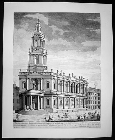
1724 Johannes Kip Large Antique Print of St Marys Church The Strand London England
- Title : Admodum Reverendis Amplissimis...Templi St Maria in Vico dicto The Strand
- Date : 1724
- Condition: (A+) Fine Condition
- Ref: 40399
- Size: 26 1/2in x 22in (670mm x 560mm)
Description: This large original copper-plate engraved antique print by Johannes (Jan) Kip, after Leonard Knyff, was published in the 1724 Joseph Smith edition of Britannia Illustrata or Nouveau Theatre de la Grande Bretagne. This beautifully engraved original antique print is testimony to the fine, detailed work produced by Jan Kip.
Britannia Illustrata was first issued in 1707 by David Mortier as a single volume containing 80 topographical etchings by Johannes Kip, after drawings by Leonard Knyff. Many are birds eye views of country seats, but there are also a number of interesting London views. The series was first reissued and expanded into two volumes in 1708-1713, and provided with a second French title Nouveau Theatre de la Grande Bretagne.
An expanded edition of Britannia Illustrata was re-published by Joseph Smith in 1724 under its French title, Nouveau Theatre..., containing many of the plates from the original edition by Mortier and also containing may new plates of places, churches, cathedrals and architecture of the landed gentry.
Background:
The parish of St Mary le Strand may lay a good claim to being one of the oldest parishes in London. It stands dominating a roadway which since prehistory has been the main artery to the west from the City of London. In early Saxon times the Strand area was the very heart of London, for it seems that the City was effectively abandoned by the newly-arrived settlers. The Saxons predominantly inhabited "Lundenwic", an area stretching from Fleet Street to Whitehall and from the Thames to Covent Garden from the sixth to the ninth centuries. Christianity came to this settlement with St Mellitus and his followers in 604, and, despite their brief expulsion in the 620s, became firmly established. We do not know if any of the existing churches in the area date back that far but some, such as St Clement Danes, are known to have existed in later Saxon times.
There is no record of when St Mary le Strand was founded, but the first church, which was dedicated to the Nativity of the Blessed Virgin Mary, stood just south of the present church on a site now covered by Somerset House. Throughout the Middle Ages, the Bishops of Worcester were the Patrons of the parish and had their London residence on an adjoining site. For throughout the period from the Norman Conquest to the Reformation, the Strand was mainly the home of bishops and princes. Within the parish were the "inns" - large town houses with chapels, stables and accommodation for a large retinue - of the Bishops of Worcester, Llandaff, Coventry and Lichfield. A large part of the parish was absorbed by the building of a great house, the Palace of the Savoy, by Count Peter of Savoy, the uncle of Henry III, in the 1240s. A century later this became the home of John of Gaunt, Earl of Lancaster, and the palace became a centre of culture; among its residents was Geoffrey Chaucer, who was married in the palace chapel. Gaunt's unpopularity, as the king's chief minister, caused the palace to be burned in the Peasant's Revolt. Despite its long absence, the fame of the palace has lasted in the area and was recreated in the nineteenth century by the Savoy Hotel and Theatre.
The site where the present church stands was occupied in medieval times by Strand Cross. The origins of this are unclear. It was not a cross erected in memory of Queen Eleanor - as was Charing Cross - but seems to have dated back at least to Norman times. Perhaps it began as a market cross; by the early fourteenth century it had been rebuilt in a lavish manner, almost certainly following the design of the Eleanor Crosses. Strand Cross was a famous site and it is recorded that in the thirteenth century the local magistrates held their assizes in front of it.
Until the sixteenth century, the Strand was no more than a line of Bishops' palaces on the south side of the roadway stretching all the way to Whitehall. On the north side stood a wall which bounded the Convent - later Covent - Garden, while the churches further away, St Martin's and St Giles, stood "in-the-fields". All this was to change with the Reformation. The bishops' inns around the church were seized by Edward Lord Protector who set about building himself a renaissance palace in what was then the most fashionable part of town. Even with the extensive site that he had now obtained, further space was needed and towards the end of 1548 the Lord Protector's workmen fell upon St Mary's church and demolished it to provide stone for the new palace. Further stone was provided by the demolition of a cloister at St Paul's Cathedral known as Pardon Churchyard and the greater part of the Priory of St John at Clerkenwell. Even by the standards of the time, the demolition of so much sacred property was an outrage. Somerset was never to enjoy living in his new palace; just as it was nearing completion he was overthrown by his political enemies and executed at Tower Hill in 1551.
It is said that Somerset had intended to build a new parish church. If so, all thought of it passed away with his fall. Initially, the parishioners scattered but within a short time we find them gathered in the chapel of St John the Baptist in the Savoy. Here they would remain for the next 175 years. Now known at "St Mary le Savoy", the parishioners chose and paid for their own ministers. The most famous of these was Thomas Fuller, the church historian, who was appointed in 1642, fled during the Civil War and was restored to his living in 1660.
Following the execution of Somerset, his palace had passed to the possession of the Crown. Elizabeth I occasionally lodged there and it was from Somerset House that she set off to give thanks after the defeat of the Armada. Under the Stuarts, extensive improvements were made to the palace, the most impressive being the lavish Roman Catholic chapel built by Charles I's queen, Henrietta Maria.
The roadway in front of Somerset House, where Strand Cross had stood and where the present church was later to stand, was occupied in the early seventeenth century by a windmill used to pump water. In 1634 the first Hackney Carriage stand in England was established here by one Captain Bailey. Here also a maypole was erected which became the most famous maypole in London. Demolished by the Puritans, a new maypole was erected in 1661. Parts of this maypole remained until 1717, when they were removed and presented to Sir Isaac Newton as the base for a telescope.
In 1711, an Act of Parliament was passed for building 50 New Churches in the fast expanding suburbs of London. These were the so-called "Queen Ann Churches"; among them are Hawksmoor's Christ Church Spitalfields, St Anne's Limehouse, and St George's-in-the-East, Archer's St Paul's Depftord and James' St George's, Hanover Square. St Mary le Strand was quick to apply for a church to replace their demolished one and, as the site on the Strand was so prominent, the Commissioners for building the New Churches decided to make the Strand church the most lavish of the churches. Initially, it was intended that there should not be a spire but that a column celebrating the building of the New Churches should stand directly in front of the church.
General Description:
Paper thickness and quality: - Heavy and stable
Paper colour: - off white
Age of map colour: -
Colours used: -
General colour appearance: -
Paper size: - 26 1/2in x 22in (670mm x 560mm)
Plate size: - 23in x 18in (585mm x 460mm)
Margins: - min 1in (25mm)
Imperfections:
Margins: - None
Plate area: - None
Verso: - None
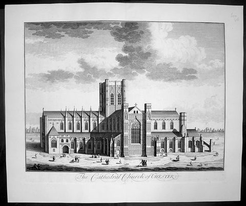
1724 Johannes Kip Large Antique Print of Chester Cathedral Church, Cheshire, England
- Title : The Cathedral Church of Chester
- Date : 1724
- Condition: (A+) Fine Condition
- Ref: 40412
- Size: 26 1/2in x 22in (670mm x 560mm)
Description: This large original copper-plate engraved antique print by Johannes (Jan) Kip, after Leonard Knyff, was published in the 1724 Joseph Smith edition of Britannia Illustrata or Nouveau Theatre de la Grande Bretagne. This beautifully engraved original antique print is testimony to the fine, detailed work produced by Jan Kip.
Britannia Illustrata was first issued in 1707 by David Mortier as a single volume containing 80 topographical etchings by Johannes Kip, after drawings by Leonard Knyff. Many are birds eye views of country seats, but there are also a number of interesting London views. The series was first reissued and expanded into two volumes in 1708-1713, and provided with a second French title Nouveau Theatre de la Grande Bretagne.
An expanded edition of Britannia Illustrata was re-published by Joseph Smith in 1724 under its French title, Nouveau Theatre..., containing many of the plates from the original edition by Mortier and also containing may new plates of places, churches, cathedrals and architecture of the landed gentry.
Background:
Standing on the site of a 10th century Saxon church, the present cathedral at Chester dates from the mid 13th century. Dedicated to St Werburgh, this Christian church was transformed into a Benedictine Abbey in 1092, colonised by a small group of monks from Normandy. Building of the new abbey church began immediately and took the best part of 150 years to complete but little evidence of the first church remains. The traditional sturdy Norman architecture was eventually replaced over the next two centuries by a more elegant Gothic style. Henry VIII dissolved the monastery in 1540 just as the monks of St Werburgh's Abbey were beginning to enjoy their new surroundings. A year later the abbey was given back as a cathedral, the last abbot of St Werburgh's becoming the first Dean of Chester Cathedral.
Over the next two hundred years the cathedral slipped into a bad state of disrepair but was eventually saved from total collapse by the efforts of Sir George Gilbert Scott. His 19th century restoration of Chester Cathedral, both externally and internally, not only put in place essential repairs but also enhanced the appearance of the great church immensely. Most of the stained glass comes from this period and highlights the abbey's dedication to St Werburgh, as well as the long history of the cathedral. On the northern aisle of the nave, at the side of one of the large windows, sits the 'Chester Imp'. A charming little figure in chains, carved by one of the medieval monks, to protect the church from evil spirits.
Most medieval cathedrals have beautifully carved stalls in the quire but the quality of oak carving at Chester Cathedral is quite exceptional. Each stall is topped with an elaborately carved canopy set above a row of small corbels, and below each seat a magnificently carved misericord. This area of the church is so richly carved with such a diverse array of religious artefacts, animals, birds and grotesque figures that it is quite overwhelming.
Apart from the main church many of the monastic buildings from the ancient Benedictine Abbey have been remarkably preserved. The original cloisters, although largely rebuilt during the first half of the 16th century and subsequently restored at the beginning of the 20th century, are a constant reminder of the important part they played in monastic life. All the bays of the undercroft, containing some wonderful vaulting, have been utilised to provide an exhibition centre, gift shop and workshop. The monks' dining room or refectory is still used regularly, as is the superb Chapter House. .
General Description:
Paper thickness and quality: - Heavy and stable
Paper colour: - off white
Age of map colour: -
Colours used: -
General colour appearance: -
Paper size: - 26 1/2in x 22in (670mm x 560mm)
Plate size: - 23in x 18in (585mm x 460mm)
Margins: - min 1in (25mm)
Imperfections:
Margins: - None
Plate area: - None
Verso: - None
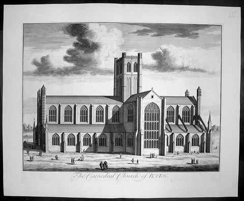
1724 Johannes Kip Large Antique Print of Bath Cathedral, Somerset, England
- Title : The Cathedral Church of Bath
- Date : 1724
- Condition: (A+) Fine Condition
- Ref: 40401
- Size: 26 1/2in x 22in (670mm x 560mm)
Description:
This large original copper-plate engraved antique print by Johannes (Jan) Kip, after Leonard Knyff, was published in the 1724 Joseph Smith edition of Britannia Illustrata or Nouveau Theatre de la Grande Bretagne. This beautifully engraved original antique print is testimony to the fine, detailed work produced by Jan Kip.
Britannia Illustrata was first issued in 1707 by David Mortier as a single volume containing 80 topographical etchings by Johannes Kip, after drawings by Leonard Knyff. Many are birds eye views of country seats, but there are also a number of interesting London views. The series was first reissued and expanded into two volumes in 1708-1713, and provided with a second French title Nouveau Theatre de la Grande Bretagne.
An expanded edition of Britannia Illustrata was re-published by Joseph Smith in 1724 under its French title, Nouveau Theatre..., containing many of the plates from the original edition by Mortier and also containing may new plates of places, churches, cathedrals and architecture of the landed gentry.
Background:
Bath Abbey stands at the heart of the city of Bath; during the past twelve and a half centuries, three different churches have occupied this site:
An Anglo-Saxon Abbey Church dating from 757, pulled down by the Norman conquerors of England soon after 1066.
A massive Norman cathedral begun about 1090. It was larger than the monastery could afford to maintain and by the end of the 15th century was in ruins.
The present Abbey church founded in 1499, ruined after the dissolution of the monasteries in 1539 by order of Henry VIII.
General Description:
Paper thickness and quality: - Heavy and stable
Paper colour: - off white
Age of map colour: -
Colours used: -
General colour appearance: -
Paper size: - 26 1/2in x 22in (670mm x 560mm)
Plate size: - 23in x 18in (585mm x 460mm)
Margins: - min 1in (25mm)
Imperfections:
Margins: - None
Plate area: - None
Verso: - None
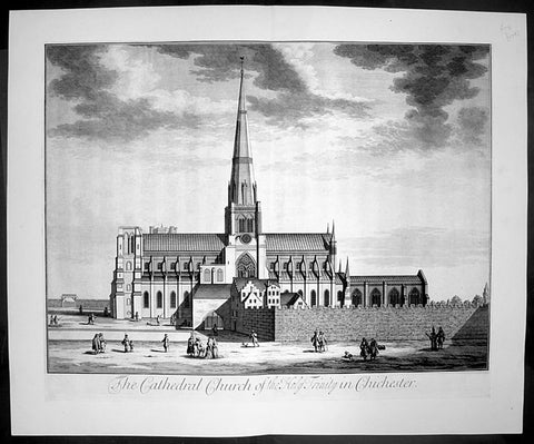
1724 Johannes Kip Large Antique Print The Holy Trinity Cathedral, Chichester, England
- Title : The Cathedral Church of the Holy Trinity in Chichester
- Date : 1724
- Condition: (A+) Fine Condition
- Ref: 40411
- Size: 26 1/2in x 22in (670mm x 560mm)
Description: This large original copper-plate engraved antique print by Johannes (Jan) Kip, after Leonard Knyff, was published in the 1724 Joseph Smith edition of Britannia Illustrata or Nouveau Theatre de la Grande Bretagne. This beautifully engraved original antique print is testimony to the fine, detailed work produced by Jan Kip.
Britannia Illustrata was first issued in 1707 by David Mortier as a single volume containing 80 topographical etchings by Johannes Kip, after drawings by Leonard Knyff. Many are birds eye views of country seats, but there are also a number of interesting London views. The series was first reissued and expanded into two volumes in 1708-1713, and provided with a second French title Nouveau Theatre de la Grande Bretagne.
An expanded edition of Britannia Illustrata was re-published by Joseph Smith in 1724 under its French title, Nouveau Theatre..., containing many of the plates from the original edition by Mortier and also containing may new plates of places, churches, cathedrals and architecture of the landed gentry.
Background:
The cathedral of the Holy Trinity at Chichester was founded in 1075, after the seat of the bishop was transferred to the town from nearby Selsey. It was consecrated in 1108, but a subsequent fire created a need for substantial rebuilding, which was not completed until 1184. The cathedral was reconsecrated in 1199. This was not the last stage in its development, by a long way. Richard de la Wyche, (Saint Richard of Chichester in the Anglican Communion), who was bishop from 1245 to 1253, was buried in the cathedral, where his shrine was a place of pilgrimage, until it was ordered destroyed in 1538, during the first stages of the English Reformation. Further damage to the cathedral had been done by fire after the second consecration, and much rebuilding was carried out in the Early English style. The original wooden ceiling had burnt out, and the sublimely simple present vaulting replaced it. The spire, which was originally built in the 14th century, was of poor-quality local stone, and collapsed suddenly in 1861, miraculously without loss of life. It was immediately rebuilt, by Sir Gilbert Scott, a noted scholarly architect.
The cathedral has many other unique features. Under the floor of the nave are the remains of a Roman mosaic pavement, which can be viewed through a glass window. Also in the interior are the grave of the composer Gustav Holst and the Gothic "Arundel tomb" referred to in a famous poem by Philip Larkin.
Despite its age, the cathedral contains several modern works of art, including tapestries by John Piper and Ursula Benker-Schirmer, a window by Marc Chagall, and a sculpture by Graham Sutherland.
General Description:
Paper thickness and quality: - Heavy and stable
Paper colour: - off white
Age of map colour: -
Colours used: -
General colour appearance: -
Paper size: - 26 1/2in x 22in (670mm x 560mm)
Plate size: - 23in x 18in (585mm x 460mm)
Margins: - min 1in (25mm)
Imperfections:
Margins: - None
Plate area: - None
Verso: - None
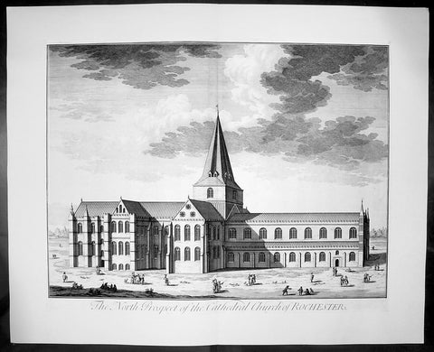
1724 Johannes Kip Large Antique Print of Rochester Cathedral, Kent, England
- Title : The North Prospect of the Cathedral Church of Rochester
- Date : 1724
- Condition: (A+) Fine Condition
- Ref: 40405
- Size: 26 1/2in x 22in (670mm x 560mm)
Description: This large original copper-plate engraved antique print by Johannes (Jan) Kip, after Leonard Knyff, was published in the 1724 Joseph Smith edition of Britannia Illustrata or Nouveau Theatre de la Grande Bretagne. This beautifully engraved original antique print is testimony to the fine, detailed work produced by Jan Kip.
Britannia Illustrata was first issued in 1707 by David Mortier as a single volume containing 80 topographical etchings by Johannes Kip, after drawings by Leonard Knyff. Many are birds eye views of country seats, but there are also a number of interesting London views. The series was first reissued and expanded into two volumes in 1708-1713, and provided with a second French title Nouveau Theatre de la Grande Bretagne.
An expanded edition of Britannia Illustrata was re-published by Joseph Smith in 1724 under its French title, Nouveau Theatre..., containing many of the plates from the original edition by Mortier and also containing may new plates of places, churches, cathedrals and architecture of the landed gentry.
Background:
Being the second oldest cathedral foundation in England, Rochester Cathedrals history goes back to AD604 when Augustine sent Bishop Justus to establish the house founded by King Ethelbert of Kent. Following several invasions by the Danes, the church was in a state of devastation by the time Bishop Gundulf was consecrated in 1077 but immediately he began a major building operation, and introduced a community of Benedictine monks in 1080.
The church suffered misfortune again in the mid 12th century with two serious fires, resulting in a further rebuilding programme. Since that time there has been continuous remodelling, refurbishments and restorations, mainly due to other historical events when the cathedral sustained damage. As a consequence of its very chequered history, Rochester Cathedral displays the varied building styles of each period, from the functional austerity of Gundulf's original structure, through the Romanesque, Gothic and Early English architectural periods, and continuing with renovation and restoration well into the 20th century following war damage.
The sturdy, squat Norman nave contrasts dramatically with the tall, narrow Gothic arches of the crossing. A superbly carved stone archway of the Decorated period (c1345), now enhanced with a solid oak door, leads to the chapter room and is a magnificent feat of craftsmanship. Quite unusually, the Lady Chapel is sited between the nave and the south transept as monastic outbuildings occupied the traditional location at the eastern end of the church when the chapel was added in the late 15th century. Beneath the quire transept is a beautifully preserved and vaulted crypt, with two bays surviving from the original Norman construction. There are also many fragments of medieval ceiling paintings to be found in this lower level sanctuary.
Though one of the smaller Norman cathedrals, Rochester was an important centre for pilgrimage during the 13th century, and even today attracts many visitors who are keen to learn more about its fascinating history. From a photographic perspective, a wonderful view of Rochester cathedral can be seen from the top of Rochester Castle, immediately opposite. We have visited both the Rochester Cathedral and Castle on many occasions, and still manage to uncover more information, or something interesting that we had previously overlooked. Earlier this year, we ventured for the first time into the cloister garth, discovering a substantial section of the ruined Chapter House. On the south side, the entrance arch to the monk's refectory survives and, looking behind it, the 13th century lavatorium and towel recess is still visible.
Johannes Kip was a draughtsman and engraver, who worked first in his native Amsterdam before moving to London at the end of the seventeenth century. He did portraits, views, and book illustrations. (Ref: Tooley; M&B)
General Description:
Paper thickness and quality: - Heavy and stable
Paper colour: - off white
Age of map colour: -
Colours used: -
General colour appearance: -
Paper size: - 26 1/2in x 22in (670mm x 560mm)
Plate size: - 23in x 18in (585mm x 460mm)
Margins: - min 1in (25mm)
Imperfections:
Margins: - None
Plate area: - None
Verso: - None
1760 Vue D Optic Large Antique Print View of Cheapside, London St Mary le Bow
- Title : Prospectus majoris viae, et Ecclesiae Sanctae Mariae in Londino; 25c Vue D Optique Representatnt; Le Grande Rue, et L Englise St Marie de Londres
- Ref : 43197
- Size: 18in x 13in (460mm x 330mm)
- Date : 1756
- Condition: (A) Very Good Condition
Description:
This hand coloured original antique print, a view of Cheapside and St Marys Le Bow, London was published as part of the Vues d’Optique in 1760.
St Mary-le-Bow is an historic church rebuilt after the Great Fire of 1666 by Sir Christopher Wren in the City of London on the main east–west thoroughfare, Cheapside. According to tradition a true Cockney must be born within earshot of the sound of Bow Bells (which refers to this church's bells rather than St Mary and Holy Trinity, Bow Road, in Bow, an outlying village until the 19th century.
Vues d'Optique or Perspective Views: Perspective views, or "vues d'optique," are a special type of popular print published in Europe during the 18th century. These prints provided a form of entertainment when viewed through a device called an "optical machine" or an "optique." The most characteristic feature of the perspective views is their emphasized linear perspective, done to further intensify the enhanced appearance of depth and illusionistic space in the prints when viewed through an optique. When displayed in the optique, the prints might transport the viewer into a far away place---an unknown city, or perhaps into the midst of a dramatic bit of contemporary history. Another attribute of these prints is their bright, often heavy hand coloring, applied boldly so as to show the tints when viewed through the lens.
A number of perspective prints depicted American scenes at the time of the Revolution for a European audience hungry for news of the events in the British colonies. As documents of American history and European printmaking, these are unusual and appealing eighteenth-century prints. (Ref: M&B; Tooley)
General Description:
Paper thickness and quality: - Heavy & stable
Paper color: - White
Age of map color: - Original
Colors used: - Blue, yellow, green, red
General color appearance: - Authentic & bright
Paper size: - 18in x 13in (460mm x 330mm)
Plate size: - 16 1/2in x 10in (420mm x 255mm)
Margins: - Min 1in (25mm)
Imperfections:
Margins: - Repair to top margin, no loss
Plate area: - None
Verso: - None
1886 Pic. Australasia Large Antique Print View of Wellington, New Zealand
- Title : Wellington Harbour
- Ref : 92196
- Size: 17in x 13in (430mm x 330mm)
- Date : 1886
- Condition: (A+) Fine Condition
Description:
This fine large original antique lithograph print was published in the extremely significant Australian & New Zealand publication The Picturesque Atlas of Australasia between 1886-88.
The Picturesque Atlas of Australasia was published in Sydney between 1886-88. Many of its over 700 wood-engraved illustrations were specially commissioned works by leading Australian artists. It was released in 42 separate editions usually bound into three large volumes and sold a remarkable 50,000 copies. (Ref: M&B; Tooley)
General Description:
Paper thickness and quality: - Light & stable
Paper color: - White
Age of map color: - Original
Colors used: - Pink, green, yellow, orange
General color appearance: - Authentic
Paper size: - 17in x 13in (430mm x 330mm)
Margins: - Min 1/2in (10mm)
Imperfections:
Margins: - None
Plate area: - None
Verso: - None
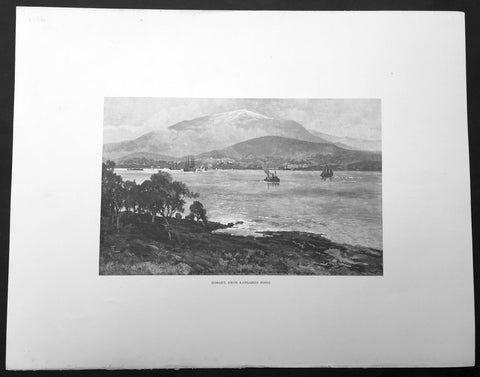
1886 Picturesque Australasia Large Antique Print View of Hobart, Tasmania
- Title : Hobart from Kangaroo Point
- Ref : 92112
- Size: 17in x 13in (430mm x 330mm)
- Date : 1886
- Condition: (A+) Fine Condition
Description:
This fine large original antique lithograph print was published in the extremely significant Australian & New Zealand publication The Picturesque Atlas of Australasia between 1886-88.
The Picturesque Atlas of Australasia was published in Sydney between 1886-88. Many of its over 700 wood-engraved illustrations were specially commissioned works by leading Australian artists. It was released in 42 separate editions usually bound into three large volumes and sold a remarkable 50,000 copies. (Ref: M&B; Tooley)
General Description:
Paper thickness and quality: - Light & stable
Paper color: - White
Age of map color: - Original
Colors used: - Pink, green, yellow, orange
General color appearance: - Authentic
Paper size: - 17in x 13in (430mm x 330mm)
Margins: - Min 1/2in (10mm)
Imperfections:
Margins: - None
Plate area: - None
Verso: - None
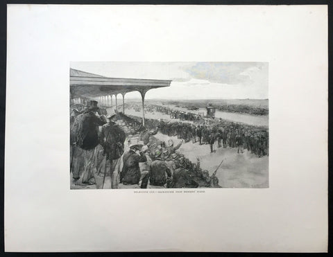
1886 Picturesque Atlas of Australasia Large Antique Print of The Melbourne Cup
- Title : Melbourne Cup - Race Course From Members Stand
- Ref #: 92164
- Size: 17 1/2in x 13 1/2in (440mm x 340mm)
- Date : 1886
- Condition: (A+) Fine Condition
Description:
This fine large original antique lithograph print was published in the extremely significant Australian & New Zealand publication The Picturesque Atlas of Australasia between 1886-88.
The Picturesque Atlas of Australasia was published in Sydney between 1886-88. Many of its over 700 wood-engraved illustrations were specially commissioned works by leading Australian artists. It was released in 42 separate editions usually bound into three large volumes and sold a remarkable 50,000 copies. (Ref: M&B; Tooley)
General Description:
Paper thickness and quality: - Light & stable
Paper color: - White
Age of map color: - Original
Colors used: - Pink, green, yellow, orange
General color appearance: - Authentic
Paper size: - 17 1/2in x 13 1/2in (440mm x 340mm)
Margins: - Min 2in (50mm)
Imperfections:
Margins: - None
Plate area: - None
Verso: - None
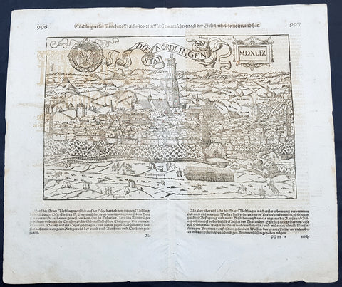
1628 Sebastian Munster & RMD Antique Map View Nordlingen Swabia, Bavaria Germany
- Title : Die Statt Nordlingen
- Ref #: 33587
- Size: 17in x 15in (435mm x 380mm)
- Date : 1628
- Condition: (A+) Fine Condition
Description:
This fine original wood block engraved antique map a birds eye view of the German town of Nördlingen in the Donau-Ries district, in Swabia, Bavaria,, was engraved by Hans Rudolf Manuel Deutsch (RMD) in 1549 - dated - and published in the German Section of Sebastian Munsters 1628 edition of Cosmographia, Das ist: Beschreibung der gantzen Welt, Darinnen Aller Monarchien Keyserthumben, Königreichen, Fürstenthumben, Graff- und Herrschafften, Länderen, Stätten und Gemeinden.Ursprung (Cosmographia, that is: description of the whole world, in it all monarchies Keyser thumben, kingdoms, prince thumben, graff and herrschafften, countries, places and municipalities.)
Hans Rudolf Manuel Deutsch (1525–1571) was a Swiss artist. He made several of the woodcuts for De re metallica (the metals and mining treatise by Georgius Agricola, the father of mineralogy) and for Sebastian Münsters Cosmographia.
Deutschs father, Niklaus Manuel Deutsch (the Elder), and Deutsch\'s brother, Niklaus Manuel Deutsch the Younger, were also artists. The elder Niklaus had taken the last name Manuel, but all three also commonly used Deutsch as part of their names and signed their paintings with initials ending in D.
Nördlingen is a town in the Donau-Ries district, in Swabia, Bavaria, Germany. The town was the location of two battles during the Thirty Years\' War, which took place between 1618–1648. Today it is one of only three towns in Germany that still has a completely established city wall, the other two being Rothenburg ob der Tauber and Dinkelsbühl.
General Definitions:
Paper thickness and quality: - Heavy and stable
Paper color : - off white
Age of map color: -
Colors used: -
General color appearance: -
Paper size: - 17in x 15in (435mm x 380mm)
Plate size: - 17in x 15in (435mm x 380mm)
Margins: - Min 1/2in (10mm)
Imperfections:
Margins: - Light offsetting
Plate area: - Light offsetting
Verso: - Light offsetting
Background:
Cosmographia, Das ist: Beschreibung der gantzen Welt, Darinnen Aller Monarchien Keyserthumben, Königreichen, Fürstenthumben, Graff- und Herrschafften, Länderen, Stätten und Gemeinden.Ursprung, Regiment, Reichthumb, Gewalt und.Beschaffenheit. Dessgleichen Aller deren, beyder Ständen, Regenten: Keysern, Königen, Bäpsten, Bischoffen.Genealogien und Stammbäumen.zusammen getragen. by Sebastian Münster was first published in 1544 and is the earliest German-language description of the world. It had numerous editions in different languages including Latin, French (translated by François de Belleforest), Italian, English, and Czech. The last German edition was published in 1628, long after Munsters death. The Cosmographia was one of the most successful and popular books of the 16th century. It passed through 24 editions in 100 years. This success was due to the notable woodcuts (some by Hans Holbein the Younger, Urs Graf, Hans Rudolph Manuel Deutsch, and David Kandel). It was most important in reviving geography in 16th-century Europe. Among the notable maps within Cosmographia is the map Tabula novarum insularum, which is credited as the first map to show the American continents as geographically discrete.
Munsters earlier geographic works were Germania descriptio (1530) and Mappa Europae (1536). In 1540, he published a Latin edition of Ptolemys Geographia with illustrations.
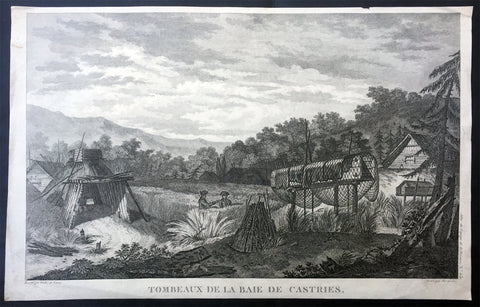
1797 Laperouse Antique Print View De Kastri Bay, Ulchsky Khabarovsk Kai, Russia
- Title : Tombeaux de la Baie de Castries
- Ref : 21436
- Size: 17in x 11in (435mm x 280mm)
- Date : 1797
- Condition: (A+) Fine Condition
Description:
This large original copper plate engraved antique print, a view of the very early settlement at De Kastri Bay, in the Ulchsky District of Khabarovsk Kai, Eastern Russia - opposite the Sakhalin Islands - by Jean-François de Galaup, Comte de la Pérouse was published in the 1st edition of the Atlas du voyage de La Perouse, Paris 1797.
General Definitions:
Paper thickness and quality: - Heavy and stable
Paper color : - off white
Age of map color: -
Colors used: -
General color appearance: -
Paper size: - 17in x 11in (435mm x 280mm)
Plate size: - 17in x 11in (435mm x 280mm)
Margins: - Min 1/2in (12mm)
Imperfections:
Margins: - Small repairs to margins, no loss
Plate area: - None
Verso: - None
Background:
De-Kastri was named for the former name of the bay on which it stands. The bay was discovered by La Pérouse on July 25, 1787 and named after the sponsor of the expedition—the then Secretary of State of the French Navy, the Marquis de Castries. The bay is a convenient natural refuge for vessels, giving it strategic importance from a military viewpoint.
The settlement was officially founded in 1853, although the land where it was situated would not officially be Russian territory until the signing of the Treaty of Aigun five years later.
In 1854, the difficult task of defending Petropavlovsk-Kamchatsky when it came under siege from the British and French forces during the Crimean War brought to attention the difficulties of supply and defense of the Kamchatka Peninsula, where a large section of the Russian Pacific Fleet was based. It was decided to move the port from Kamchatka without waiting for another attack. In the spring of 1855, the Russian navy\'s weapons and sailors under the leadership of Rear Admiral Vasily Zavoyko headed toward the mouth of the Amur River; however, the river mouth was still covered with ice. It was decided to wait for the break-up, hiding in the Bay of de Castries from the superior forces of French and English. Russian ships were discovered there, but managed to escape to the Amur River in the Strait of Tartary before the arrival of enemy reinforcements. The British and French did not know that Sakhalin was an island, and spent the later years of the war waiting in vain for the Russian fleet at its southern coast.
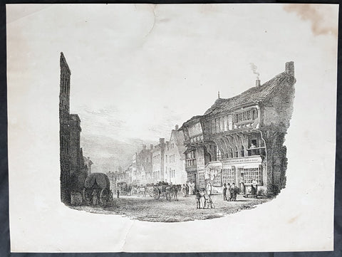
1821 Charles Hullmandel & Francis Nicholson Antique Print of Bridge St, Chester
- Title : Bridge Street, Chester....Printed by C Hullmandel....F. N. 1821
- Size: 16 1/2in x 12 1/2in (420mm x 315mm)
- Condition: (A) Good Condition
- Date : 1821
- Ref #: 26350
Description:
This scarce, fine early lithograph of Bridge St in the city of Chester, England by the British artist Francis Nicholson was print by the Charles Joseph Hullmandel in 1821 - dated at the foot of the print.
General Definitions:
Paper thickness and quality: - Heavy and stable
Paper color : - off white
Age of map color: -
Colors used: -
General color appearance: -
Paper size: - 16 1/2in x 12 1/2in (420mm x 315mm)
Plate size: - 16 1/2in x 12 1/2in (420mm x 315mm)
Margins: - Min 1in (25mm)
Imperfections:
Margins: - Soiling, repair to top & bottom margin, no loss
Plate area: - None
Verso: - Soiling
Background:
Francis Nicholson 1753 – 1844 was a British artist, born in Pickering, North Yorkshire. He worked in watercolour and oil, and is mainly known as a landscape artist.
Nicholson studied with a local artist in Scarborough, before beginning his career in his native Pickering, producing sporting pictures and portraits for a variety of Yorkshire patrons. By the mid-1780s he was also making paintings of country houses, leading him to concentrate on landscapes in watercolour.
From 1789, he contributed views of both Yorkshire and Scotland to exhibitions at the Royal Academy. He also supplied topographical views for the Copper Plate Magazine.
He contributed Views of England in collaboration with the engraver Francis Jukes to The Beauties of England and Wales, Author: Britton, John & Edward Wedlake Brayley - A book published in 18 volumes from 1801 to 1815.
Although his market increasingly became London-based, Nicholson continued to live in Yorkshire - at Whitby, Knaresborough and Ripon. He did not move to London until about 1803. In 1804, he became a founder-member of the Society of Painters in Watercolours, and was a regular and prolific contributor to its exhibitions.
He wrote a handbook, The practice of drawing and painting landscape from nature, in water colours, which was published in 1820. It sold out and a second edition followed in 1823.
His c. 1837 self-portrait is in the National Portrait Gallery. & is known as the Father of water colour painting and also as an early pioneer of lithography, and was much admired by Turner.
Nicholson died in London and is buried there in Brompton Cemetery.
Hullmandel, Charles Joseph 1789 – 1850
Hullmandel was born in London, where he maintained a lithographic establishment on Great Marlborough Street from about 1819 until his death.
He was born in Queen Street, Mayfair. His father was a German-speaking musician and composer, Nicolaus Joseph Hüllmandel (1751–1823), a native of Strasbourg who became a pupil of C. P. E. Bach and from 1780 spent ten years as a fashionable music teacher in Paris. In 1787 he married a Mademoiselle du Cazan, who was of a noble French family, and in 1789 sent his wife to England, following her in 1790, as the French Revolution unfolded.
As a young man, Charles Hullmandel studied art and spent several years living and working in continental Europe. He learned printmaking and printed many of his own works. In 1818, he set up a printing press in London after a visit to Munich with Rudolph Ackermann and went on to study chemistry under Michael Faraday for the purpose of improving his printing.
During the first half of the 19th century Hullmandel became one of the most important figures in the development of British lithography, and his name appears on the imprints of thousands of lithographic prints. He developed a method for reproducing gradations in tones and for creating the effect of soft colour washes which enabled the printed reproduction of Romantic landscape paintings of the type made popular in England by J. M. W. Turner. Hullmandel\\\'s essay The Art of Drawing on Stone (1824) was an important handbook of lithography. In 1843 he went into partnership with Joseph Fowell Walton (born 1812, living 1863), a cousin of the landscape artist and lithographer W. L. Walton, the firm then becoming known as Hullmandel & Walton.
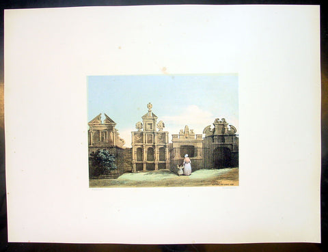
1849 Fairbairn Large Folio Antique Print of Old Tombs High Church Yard, Glasgow
- Title : Old Tombs High Church Yard
- Date : 1849
- Condition: (A+) Fine Condition
- Ref: 40244
- Size: 22in x 16in (560mm x 405mm)
Description:
This beautifully coloured large folio original antique lithograph print, views of old Glasgow now long gone, by the Scottish artist Thomas Fairbairn (1821 - 1885) was published by Miller & Buchanan in the 1849 edition of Relic of Ancient Architecture and other Picturesque Scenes in Glasgow.
Subject Background:
The subjects of this picture are representations of the memorials raised to departed worth by the affection or gratitude of our forefathers. We append a brief notice of each, but the only one of the four deserving of special allusion is that erected to the memory of Dr Peter Low, and now the property of the Faculty of Physicians and Surgeons in Glasgow. Dr. Low, who was some-time chirurgeon-in-ordinary to the French King, and also to King James VI., and his son the Prince, procured from the latter monarch a charter of erection in favour of the Faculty of Glasgow. The original charter is extant A fine old portrait of Dr. Low is preserved in the Faculty Hall, St.Enoch Square.
No. I.- The first on the left of the Plate.
Erected in 1630, by the Rev. John Dickson, who was married to Janet, daughter of the "Lord Bedlay." Afterwards it appears to have become the property of "Roberton of Bedlay," and latterly of Miss Lennox of Woodhead, who in 1818 disponed it to George Brown of Capelrigg, whose representatives are the present proprietors.
No. II.
"Here lyes ane Treu faithfull Brother, William Robertson, Merchand Burges of Glasgow. Decesit ye 24 June, 1617."
"W.R. AB."
This tomb appears afterwards to have belonged to Morehead of Bredisholm, although there is no entry in the Register to that effect. The present proprietor is not known.
No. III.
Monument to Dr PETER Low, Founder of the Faculty of Physicians and Surgeons, Glasgow.
INSCRIPTION.
Stay, Passenger, and view this Stone,
For under it lys such an one,
Who cur'd many while he liv'd,
So gracious he no man griev'd;
Yea, when his Physick's force oft fail'd,
His pleasant Purpose then prevail'd;
For of his God he got the Grace,
To live in Mirth and die in Peace.
Heaven has his soul, his corpse this Stone:
Sigh, passenger, and then be gone.
Ah! me. I gravel am and dust,
And to the grave deshend I must;
O! painted piece of liveing clay,
Man be not proud of thy short day.
This Burial Place was purchased by and is now the property of the Faculty of Physicians and Surgeons.
No. IV.
"Erected by Archd. Mure, Merchant, 1616, and descended to his daughter, Margaret Mure, who was married to James Hamilton. Afterwards it became the property of Provost John Gibson, in right of his wife, Christian Anderson, grand-child of the above James Hamilton and Margaret Mure. It afterwards became the property of William Anderson, merchant, in right of his wife, Christian Gibson, daughter of Provost John Gibson; and their only child, Christian Anderson, was the next successor. She dying unmarried, was succeeded by her cousin, Margaret Mather, relict of Archibald Anderson, brewer in Glasgow, who upon the 13th May, 1797, disponed this property to Thomas Buchanan, merchant in Glasgow; and upon the 13th March, 1806, it was conveyed by Jane Buchanan, his daughter, to James Buchanan,* merchant, Glasgow." - (From Register of Burial Grounds.)
* Late of Dowanhill, whose representatives are the present proprietors.
Relic of Ancient Architecture and other Picturesque Scenes in Glasgow, was published large folio size in 1849, containing 19 large folio coloured lithograph prints and has long since been out of print. A praiseworthy motive induced Mr. James Bogle, at one time Lord Dean of Guild, and a member of an old and highly-respected Glasgow family, to engage Mr. Thomas Fairbairn to reproduce them, before they passed into oblivion, some "Relics of Ancient Architecture and Picturesque Scenes in Glasgow." The immediate cause of Mr. Bogle's resolve was the fall of a sugar-house in Alston Street, by which some six or seven lives were lost, and a resolution on the part of the Dean of Guild Court to make a general survey of the City with a view to the removal of old houses which, from age or other causes, were considered to be unfit for habitation. Mr. Bogle naturally thought that this was the proper time to reproduce in permanent form a fair presentment of many of the noted houses of old Glasgow.
Along with Mr. Fairbairn, the artist, Mr. Bogle made a tour of the City, and selected subjects for the drawings, nearly all of which are now gone, and those few that remain are so altered as to be almost irrecognisable.
A general wish having been expressed for a reproduction of the work, the publishers some time ago engaged Mr. Fairbairn (now alas! gone) to reproduce the original sketches, and also add a number of others of interest before the rapid growth of the City extinguishes or entirely defaces their subjects.
The drawings are now thirty in number, and have been reproduced by Messrs. Annan's new process of photo-engraving, which it will be observed, gives the effect of finely finished mezzo-tints.
The letterpress descriptions of the original edition are from the pen of the late Mr. James Pagan, Editor of the Glasgow Herald, and the descriptions of the new scenes have been supplied by his successor, the present Editor of that journal.
It ought to be stated that the descriptive portions, written by Mr. Pagan more than thirty years ago, have not been touched; so that readers should understand that they refer to the Glasgow of a former generation, and are all indicated in the Contents by an asterisk.
General Description:
Paper thickness and quality: - Heavy & stable
Paper color: - White
Age of map color: - Original
Colors used: - Red, green, blue, brown
General color appearance: - Authentic
Paper size: - 22in x 16in (560mm x 405mm)
Margins: - Min 4in (100mm)
Imperfections:
Margins: - None
Plate area: - None
Verso: - None
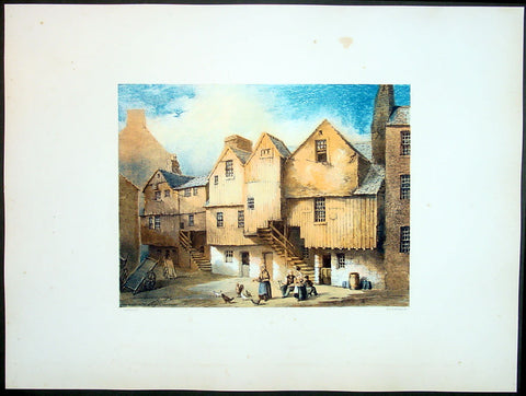
1849 Fairbairn Large Folio Antqiue Print of Houses Saltmarket St Gorbals Glasgow
- Title : Old Wooden Houses in Close Saltmarket
- Date : 1849
- Condition: (A+) Fine Condition
- Ref: 40247
- Size: 22in x 16in (560mm x 405mm)
Description:
This beautifully coloured large folio original antique lithograph print, views of old Glasgow now long gone, by the Scottish artist Thomas Fairbairn (1821 - 1885) was published by Miller & Buchanan in the 1849 edition of Relic of Ancient Architecture and other Picturesque Scenes in Glasgow.
Subject Background:
The artist has here represented a style of dwelling-house architecture which is fast passing away, and will soon altogether cease to exist. Houses of this kind seem to have been originally erected from the cheapness of the materials, and for the purpose of economizing building-ground space. To attain the latter object, beams, as shown in the print, were projected from the first storey, and an out-shot and additional structure raised upon them, thus offering a great obstruction to ventilation, and affording an inconvenient, cold, and comfortless dwelling. When situated in a close, houses of this kind were generally occupied by working people, or by those who rented a small shop or bothy in the front street, and lodged themselves and families in one of these fragile-looking tenements behind. In some rare cases these wooden houses were tenanted by persons of a more substantial character, and we may mention, as the most prominent instance of which we have heard, that so recently as the close of last century the firm of Francis Reid & Sons, watchmakers, occupied a large wooden structure in the close opposite 77, both as their dwelling-house, work-shop, and sale-shop. These gentlemen were the first to give a stimulus to the watchmaking and jewellery business in Glasgow; and however humble their premises may have been, they did a large and lucrative business, and off-shoots from their concern branched into some of the principal establishments at present existing in Glasgow. We have no story to tell regarding the houses represented in the print; in their better days they were occupied by decent native tradesmen, but for a long succession of years they have been in the possession of the Irish, whose annals would furnish nothing attractive. Two hundred years ago wooden houses of this kind formed the majority of the Saltmarket closes ; but a great fire having broken out on 3rd November, 1677, the upper part of the street on both sides was destroyed as far as the Tron Church on the west, and two or three tenements in the Gallowgate on the east. From the rapidity with which these timber structures were mowed down by the flames on that occasion, the wisdom of replacing them with stone erections became apparent, and since then very few timber houses have been put down in the city, excepting in obscure back lanes, and on a very humble scale. As we have said, they will speedily disappear altogether, for the Dean of Guild Court will not permit a renewal of buildings in this style, when the present houses fall or are pulled down from natural decay. A stone inserted in the door-way of a one-storey house at the bottom of this close hears the inscription, "H. Br., J. H., 1727.".
Relic of Ancient Architecture and other Picturesque Scenes in Glasgow, was published large folio size in 1849, containing 19 large folio coloured lithograph prints and has long since been out of print. A praiseworthy motive induced Mr. James Bogle, at one time Lord Dean of Guild, and a member of an old and highly-respected Glasgow family, to engage Mr. Thomas Fairbairn to reproduce them, before they passed into oblivion, some "Relics of Ancient Architecture and Picturesque Scenes in Glasgow." The immediate cause of Mr. Bogle's resolve was the fall of a sugar-house in Alston Street, by which some six or seven lives were lost, and a resolution on the part of the Dean of Guild Court to make a general survey of the City with a view to the removal of old houses which, from age or other causes, were considered to be unfit for habitation. Mr. Bogle naturally thought that this was the proper time to reproduce in permanent form a fair presentment of many of the noted houses of old Glasgow.
Along with Mr. Fairbairn, the artist, Mr. Bogle made a tour of the City, and selected subjects for the drawings, nearly all of which are now gone, and those few that remain are so altered as to be almost irrecognisable.
A general wish having been expressed for a reproduction of the work, the publishers some time ago engaged Mr. Fairbairn (now alas! gone) to reproduce the original sketches, and also add a number of others of interest before the rapid growth of the City extinguishes or entirely defaces their subjects.
The drawings are now thirty in number, and have been reproduced by Messrs. Annan's new process of photo-engraving, which it will be observed, gives the effect of finely finished mezzo-tints.
The letterpress descriptions of the original edition are from the pen of the late Mr. James Pagan, Editor of the Glasgow Herald, and the descriptions of the new scenes have been supplied by his successor, the present Editor of that journal.
It ought to be stated that the descriptive portions, written by Mr. Pagan more than thirty years ago, have not been touched; so that readers should understand that they refer to the Glasgow of a former generation, and are all indicated in the Contents by an asterisk.
General Description:
Paper thickness and quality: - Heavy & stable
Paper color: - White
Age of map color: - Original
Colors used: - Red, green, blue, brown
General color appearance: - Authentic
Paper size: - 22in x 16in (560mm x 405mm)
Margins: - Min 4in (100mm)
Imperfections:
Margins: - None
Plate area: - None
Verso: - None
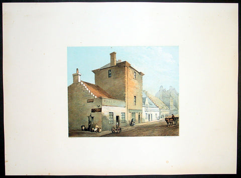
1849 Fairbairn Large Folio Antique Print Baronial Tower ,Main St Gorbals Glasgow
- Title : Old Baronial Hall Front View Main St Gorbals
- Date : 1849
- Condition: (A+) Fine Condition
- Ref: 40245
- Size: 22in x 16in (560mm x 405mm)
Description:
This beautifully coloured large folio original antique lithograph print, views of old Glasgow now long gone, by the Scottish artist Thomas Fairbairn (1821 - 1885) was published by Miller & Buchanan in the 1849 edition of Relic of Ancient Architecture and other Picturesque Scenes in Glasgow.
Subject Background:
This venerable pile, so long identified with the Barony of Gorbals, was erected between the years 1600 and 1608, by Sir George Elphinston, the son of a merchant in Glasgow, who had acquired the lands on the south side of the river known as "St. Ninian's Croft," from Boyd, the Protestant Archbishop of the See. With the view of forming a suitable residence, Sir George enclosed part of the croft for an orchard and garden, and built thereon the erections which so long formed the most prominent objects on the east side of the Main Street of Gorbals. Tradition informs us that he also erected a small Chapel adjoining, part of which still exists at the corner of Main Street and Rutherglen Loan. It was in this baronet's favour that the village of "Gorbels" was erected into a Burgh of Barony and Regality. Although this gentleman enjoyed great distinction in his lifetime, and rose to the rank of Lord Justice Clerk in the reign of Charles I., he afterwards became reduced in circumstances, and died miserably and in poverty about 1634. According to McUre, he was privately interred "in his own chapel, adjoining to his house." The property was then sold by the creditors of the deceased to Robert Douglas, Viscount Belhaven. This nobleman extended the mansion in Gorbals, and built a square Tower or "Fortulice," which is now almost the only part of the venerable buildings existing. Until within a few years ago, the Tower in question exhibited four turrets, which of course gave an imposing appearance to the structure. On the building adjoining the Tower may still be seen the family arms of Viscount Belhaven, pretty well cut in stone, the whole surmounted by the letters S. G. E., which are apparently meant for the initials of Sir George Elphinston. It is not at all improbable that this was not the original position of the arms referred to, but that at some period when alterations were made on the Tower, they had been removed from it, and placed so as to face the Main Street of the Barony. The Viscount, at his death, was succeeded by his nephew, Sir Robert Douglas of Blackerston, who sold the Gorbals Mansion House and lands in cumulo, some time prior to 1661, to the town of Glasgow, the Trades' House, and the Trustees for Hutchesons' Hospital. They were retained as a sort of co-partnery possession till 1790, when a division was made, and the central portion, containing the old buildings, fell to the lot of the city. The most important event connected with the Baronial Hall structure is found in the fact that at one time it formed the residence of Sir James Turner, Commander-in-Chief of the Forces in Scotland in the reign of Charles II., and who is understood to be the personage who supplied Sir Walter Scott with the portrait of Dugald Dalgetty. The terms on which Sir James obtained possession of the house are somewhat singular; for it appears by the minutes that on the 18th July, 1670, the Bailies and Council "ordains ane tack to be wrytten and subscryvit in favors of Sir James Turnor, of the toune's houss and tour in Gorballs, quhilk he presentlie possesses, and that dureing his lifetyme, for payment yearlie of three punds Scots, if the samyne be requyred." Sir James accordingly died in possession of the subjects; and from the records kept in the College, it would appear that at the sale of his effects, a part of his scanty library was purchased by the University of Glasgow. Amongst his books were several works upon the art of war; but the soldier of fortune had not overlooked productions of a more elevating and humanising kind, for Milton's "Paradise Lost" and various kindred tomes are found in his catalogue. Who were the successors of Sir James Turner, in the "toune's houss and tour," we have no way of knowing. At all events, as the locality was never an attractive one for the Glasgow merchants, the occupants must have gradually descended in the scale of quality. Before the close of the last century, and for some time afterwards, the principal room in the Tower, which was of a spacious kind, was used as a place of meeting by the magistrates, heritors and feuars of the parish of Gorbals; and here also the inhabitants mustered previous to performing the dutes of watching and warding, in days when a police force did not exist. Latterly, part of the old building was fitted up as a police-office, with adjoining cells. But it lost all its importance, excepting such as it retained from olden associations, when the official staff was removed to the present extensive police establishment in Portland Street. t was then given over to very humble uses - the ground floors to the street being let as whisky shops, and the upper flats having been split up into dwelling-houses for the lowest class of the people. The greater part of the structure built by Sir George Elphinston was taken down early in 1849 by order of the Dean of Guild Court, from its having exhibited symptoms of insecurity. It was then a fine remnant and wreck of the Scottish urban Manor House style, with its oriel windows, ornamental ceilings, and stout oaken staircases. The Tower, which remains, though sadly dilapidated externally and internally, still exhibits evidences of the aristocratic aspect it wore in the days of other years
Relic of Ancient Architecture and other Picturesque Scenes in Glasgow, was published large folio size in 1849, containing 19 large folio coloured lithograph prints and has long since been out of print. A praiseworthy motive induced Mr. James Bogle, at one time Lord Dean of Guild, and a member of an old and highly-respected Glasgow family, to engage Mr. Thomas Fairbairn to reproduce them, before they passed into oblivion, some "Relics of Ancient Architecture and Picturesque Scenes in Glasgow." The immediate cause of Mr. Bogle's resolve was the fall of a sugar-house in Alston Street, by which some six or seven lives were lost, and a resolution on the part of the Dean of Guild Court to make a general survey of the City with a view to the removal of old houses which, from age or other causes, were considered to be unfit for habitation. Mr. Bogle naturally thought that this was the proper time to reproduce in permanent form a fair presentment of many of the noted houses of old Glasgow.
Along with Mr. Fairbairn, the artist, Mr. Bogle made a tour of the City, and selected subjects for the drawings, nearly all of which are now gone, and those few that remain are so altered as to be almost irrecognisable.
A general wish having been expressed for a reproduction of the work, the publishers some time ago engaged Mr. Fairbairn (now alas! gone) to reproduce the original sketches, and also add a number of others of interest before the rapid growth of the City extinguishes or entirely defaces their subjects.
The drawings are now thirty in number, and have been reproduced by Messrs. Annan's new process of photo-engraving, which it will be observed, gives the effect of finely finished mezzo-tints.
The letterpress descriptions of the original edition are from the pen of the late Mr. James Pagan, Editor of the Glasgow Herald, and the descriptions of the new scenes have been supplied by his successor, the present Editor of that journal.
It ought to be stated that the descriptive portions, written by Mr. Pagan more than thirty years ago, have not been touched; so that readers should understand that they refer to the Glasgow of a former generation, and are all indicated in the Contents by an asterisk.
General Description:
Paper thickness and quality: - Heavy & stable
Paper color: - White
Age of map color: - Original
Colors used: - Red, green, blue, brown
General color appearance: - Authentic
Paper size: - 22in x 16in (560mm x 405mm)
Margins: - Min 4in (100mm)
Imperfections:
Margins: - None
Plate area: - None
Verso: - None
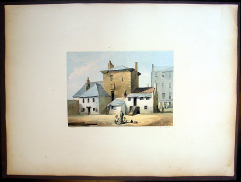
1849 Fairnbiarn Large Antique Print The Old Baronial Hall in the Gorbals Glasgow
- Title : Old Baronial Hall, Gorbals, Back View
- Date : 1849
- Condition: (A+) Fine Condition
- Ref: 40251
- Size: 22in x 16in (560mm x 405mm)
Description:
This beautifully coloured large folio original antique lithograph print, views of old Glasgow now long gone, by the Scottish artist Thomas Fairbairn (1821 - 1885) was published by Miller & Buchanan in the 1849 edition of Relic of Ancient Architecture and other Picturesque Scenes in Glasgow.
Subject Background
The Old Baronial Hall was built by Sir George Elphinstone and his wife Dame Agnes Boyd in 1601. Following his death in 1634 the building passed down through several owners including Robert Douglas, Viscount Belhaven (who added a distinctive square tower), Gorbals Town Council and Sir James Turner. By 1858 a part of The Old Barional Hall (with the neighbouring chapel) had been converted into a public house, the Old Gorbals Wine and Spirit Vaults. However, the ornate ceiling and cornicing and the statuettes on the walls are reminders of the building's former glories, as the home of one of Glasgow's most prominent men of affairs. The initials S G E and D A B on the ceiling were part of the original decoration and stood for Sir George Elphinstone and his wife Dame Agnes Boyd. It was demolished in the early 1870s.
The Gorbals is an area on the south bank of the River Clyde in the city of Glasgow, Scotland. By the late 19th century, it had become over-populated and adversely affected by local industrialisation. Many people lived here because their jobs provided this home and they could not afford their own. It became widely known as a dangerous slum and was subject to efforts at
redevelopment, which contributed to more problems such as homeless people and diseases spreading. In recent decades, some buildings have been demolished for a mixture of market and social housing; others are being refurbished and restored to a higher standard.
Relic of Ancient Architecture and other Picturesque Scenes in Glasgow, was published large folio size in 1849, containing 19 large folio coloured lithograph prints and has long since been out of print. A praiseworthy motive induced Mr. James Bogle, at one time Lord Dean of Guild, and a member of an old and highly-respected Glasgow family, to engage Mr. Thomas Fairbairn to reproduce them, before they passed into oblivion, some "Relics of Ancient Architecture and Picturesque Scenes in Glasgow." The immediate cause of Mr. Bogle's resolve was the fall of a sugar-house in Alston Street, by which some six or seven lives were lost, and a resolution on the part of the Dean of Guild Court to make a general survey of the City with a view to the removal of old houses which, from age or other causes, were considered to be unfit for habitation. Mr. Bogle naturally thought that this was the proper time to reproduce in permanent form a fair presentment of many of the noted houses of old Glasgow
Along with Mr. Fairbairn, the artist, Mr. Bogle made a tour of the City, and selected subjects for the drawings, nearly all of which are now gone, and those few that remain are so altered as to be almost irrecognisable.
A general wish having been expressed for a reproduction of the work, the publishers some time ago engaged Mr. Fairbairn (now alas! gone) to reproduce the original sketches, and also add a number of others of interest before the rapid growth of the City extinguishes or entirely defaces their subjects.
The drawings are now thirty in number, and have been reproduced by Messrs. Annan's new process of photo-engraving, which it will be observed, gives the effect of finely finished mezzo-tints.
The letterpress descriptions of the original edition are from the pen of the late Mr. James Pagan, Editor of the Glasgow Herald, and the descriptions of the new scenes have been supplied by his successor, the present Editor of that journal.
It ought to be stated that the descriptive portions, written by Mr. Pagan more than thirty years ago, have not been touched; so that readers should understand that they refer to the Glasgow of a former generation, and are all indicated in the Contents by an asterisk.
General Description:
Paper thickness and quality: - Heavy & stable
Paper color: - White
Age of map color: - Original
Colors used: - Red, green, blue, brown
General color appearance: - Authentic
Paper size: - 22in x 16in (560mm x 405mm)
Margins: - Min 4in (100mm)
Imperfections:
Margins: - None
Plate area: - None
Verso: - None
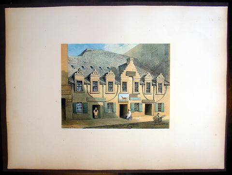
1849 Fairnbiarn Large Antique Print of Mansion Stockwell Street Glasgow Scotland
- Title : Old Mansion, Stockwell Street
- Date : 1849
- Condition: (A+) Fine Condition
- Ref: 40248
- Size: 22in x 16in (560mm x 405mm)
Description:
This beautifully coloured large folio original antique lithograph print of views of old Glasgow now long gone by the Scottish artist Thomas Fairbairn (1821 - 1885) was published by Miller & Buchanan in the 1849 edition of Relic of Ancient Architecture and other Picturesque Scenes in Glasgow.
Subject Background
This is one of the finest specimens extant of the dwelling-houses which the Glasgow citizens of the seventeenth century delighted to rear for the accommodation of themselves and families. No story of any peculiar interest attaches to the fabric in question. It simply illustrates a once favourite style of architecture which has now almost disappeared from amongst us. In a document, dated in 1639, this site is described as having been occupied by three small tenements which were then in rather a ruinous condition. They were surrounded by a "yaird," and considered quite in the suburbs. The subjects must have remained in a dilapidated condition for a long time. They were purchased in 1668 by John Caldwell, merchant in Glasgow, who immediately afterwards built the present tenement or tenements. It had a garden to the back, surrounded with a wall, and adorned with a summer-house. The subjects passed into the hands of Andrew Caldwell, son of the former, who sold them in 1698 to John Gray and William Knox, merchants in Glasgow, but apparently only in security for a debt. This was not paid, however, and a commission was granted to these gentlemen to dispose of the property absolutely, when it was acquired by Daniel Campbell, John Graham of Dugaldston, William Cross, William Wodropp, James Muir, and Matthew Campbell, merchants in Glasgow. This transaction took place on 3rd October, 1700. These gentlemen belonged to the mercantile aristocracy of the time; but the purpose for which they became joint-stock owners of this property is not now apparent. These parties sold their respective shares to Graham of Dugaldston in 1705, who in turn disposed of it, in 1709, to Andrew Cathcart, merchant in Glasgow. In a document, dated 13th January of that year, the subjects are thus described:-
"All and haill, the foresaid northmost of the saids two tenements of land, high and laigh, back and forwd, with the closs yaird at the back thereof, and stone dyke about the same, and summer-house within the same yaird, office-house, and haill pertinents of the samen, with the equal half of the said well Lyand betwixt the said two tenements, with free ish and entree yrto, and haill liberties and privileges yrof. And whilk northmost tenement, closs, yaird, office-houss, and pertinents erected and rebuilded by umqll John Cauldwell, merchant, father to the said Andrew, pertained of old to umqll Peter Johnston Tayloor, and consisted of three small tenements, yaird, and pertinents, and were acquired by the said umqll John Cauldwell from Kathrine Johnstoune and John Montgomerie, her husband, and were then bounded betwixt the lands of Adam Hish, being now the southmost of the saids two tenements. The lands of umqll Patrick Crawford and oyrs, and of the representatives of the said umqll Mitchell on the north. The lands of umqll William Thomson, John Andersone, elder, and Mr Archibald Denniston on the east, and the High Street on the west parts."
The purchaser above-named having held the property during a very lengthened period, including the time of the two great rebellions, it descended in 1754 to his grandson, William Cathcart, then merchant in Kingston, Jamaica. The representatives of this gentleman sold the property in 1771 to James Campbell, saddler in Glasgow, for the sum of £820. Campbell seems to have been unfortunate, for in the same year the Trustees for his creditors sold the subjects to George Anderson, merchant. About this time the house was much damaged by fire, but as it was insured in the Sun Fire Office, the Trustees retained the insurance money, and sold the property as it stood for the reduced price of £535. Anderson held it till his death, and the greater part was disposed of by his Trustees in 1827 to Mr Ritchie, Stockwell Street, whose family still hold the house. The price then paid was £1800. It has long ceased to be a dwelling-house, the lower portions or ground floors having been occupied as spirit vaults for an uninterrupted space of more than 80 years. They are used for this purpose still. A tradition has long prevailed that this house was occupied by some of Cromwell's officers when the Protector was in Glasgow. This, of course, could not have been the case, for the house was not built till eight years after the Restoration. The three small houses, however, which previously occupied the same site may, in all likelihood, have afforded accommodation to some of Cromwell's train.
Relic of Ancient Architecture and other Picturesque Scenes in Glasgow, was published large folio size in 1849, containing 19 large folio coloured lithograph prints and has long since been out of print. A praiseworthy motive induced Mr. James Bogle, at one time Lord Dean of Guild, and a member of an old and highly-respected Glasgow family, to engage Mr. Thomas Fairbairn to reproduce them, before they passed into oblivion, some "Relics of Ancient Architecture and Picturesque Scenes in Glasgow." The immediate cause of Mr. Bogle's resolve was the fall of a sugar-house in Alston Street, by which some six or seven lives were lost, and a resolution on the part of the Dean of Guild Court to make a general survey of the City with a view to the removal of old houses which, from age or other causes, were considered to be unfit for habitation. Mr. Bogle naturally thought that this was the proper time to reproduce in permanent form a fair presentment of many of the noted houses of old Glasgow
Along with Mr. Fairbairn, the artist, Mr. Bogle made a tour of the City, and selected subjects for the drawings, nearly all of which are now gone, and those few that remain are so altered as to be almost irrecognisable.
A general wish having been expressed for a reproduction of the work, the publishers some time ago engaged Mr. Fairbairn (now alas! gone) to reproduce the original sketches, and also add a number of others of interest before the rapid growth of the City extinguishes or entirely defaces their subjects.
The drawings are now thirty in number, and have been reproduced by Messrs. Annan's new process of photo-engraving, which it will be observed, gives the effect of finely finished mezzo-tints.
The letterpress descriptions of the original edition are from the pen of the late Mr. James Pagan, Editor of the Glasgow Herald, and the descriptions of the new scenes have been supplied by his successor, the present Editor of that journal.
It ought to be stated that the descriptive portions, written by Mr. Pagan more than thirty years ago, have not been touched; so that readers should understand that they refer to the Glasgow of a former generation, and are all indicated in the Contents by an asterisk.
General Description:
Paper thickness and quality: - Heavy & stable
Paper color: - White
Age of map color: - Original
Colors used: - Red, green, blue, brown
General color appearance: - Authentic
Paper size: - 22in x 16in (560mm x 405mm)
Margins: - Min 4in (100mm)
Imperfections:
Margins: - None
Plate area: - None
Verso: - None
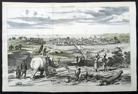
1732 Baldaeus Antique Print a View of Machilipatnam Andhra Pradesh, India
- Title : Masulipatam
- Date : 1732
- Condition: (A+) Fine Condition
- Ref: 25904
- Size: 15in x 10in (380mm x 255mm)
Description:
This fine beautifully hand coloured original antique print a view of the city of Masulipatam (Machilipatnam) on the Malibar Coast in India was published in the 1732 second English edition of Philip Baldaeus "A True and Exact Description of the Most Celebrated East-India Coasts of Malabar and Coromandel; and also of the Isle of Ceylon… London: Awnsham and John Churchill, 1732.
Machilipatnam is a city and the district headquarters of Krishna district, located in Coastal Andhra region of Andhra Pradesh, India. During British rule, the city was their first trading settlement on the Bay of Bengal coast, when it was also known as Masulipatnam or Masula, and as Bandar in folklore, located 72 km to the east of the state capital Vijayawada.
Second edition in English of Baldaeus’ account of his 17th-century travels in south India and Ceylon—one of the first Europeans to publish at length about the region published with 37 copper-engraved views and maps. Father Philippus Baldaeus, Baelde or Philip Balde (October 1632, Delft – 1672, Geervliet) was a Dutch minister. He went to Jaffna, Ceylon with an invading Dutch force during 17th Century. As the first European he documented the life, language and culture of Tamil people, living in the north of the island. It is a great historical record, similar to Mahawamsa, and it was immediately published in Dutch and German (with several beautiful pictures).
Baldaeus had a Flemish origin. His ancestors had left Ypres in 1584. Baldaeus lost both his parents, when he was four years old. His uncle Robertus Junius was a missionary on Dutch Formosa. After studying Oriental languages in Groningen (1649) and theology in Leiden (1650), and discussions with Arnoldus Montanus, he preached from 1655 at Batavia, Dutch East Indies, Jaffanapatnam and Point de Galle, either in Dutch or Portuguese (language). From 1657 he served under Rijklof van Goens, occupying the Coromandel and Negapatnam in 1658. Cornelis Speelman became its first governor. By 1660 the Dutch controlled the whole island except the kingdom of Kandy. When the Dutch occupied the coast of Malabar in 1661, Baldaeus took part. Around 1662 he returned to Ceylon and Baldaeus learned Sanskrit and studied Hinduism.
In 1666 he returned to the Dutch Republic and preached in Geervliet from 1669 until his death at the age of 39 or 40. He left behind a full and faithful account of the civil, religious, and domestic condition of the countries through which he travelled. In this, he introduced also an interesting account of the Hindu mythology, and some specimens of the Tamil language, including the translation of the Lord's Prayer: defective enough it is true, but remarkable as the first treatise, printed in Europe, on any Indian language. The title of the whole work is Description of the East Indian Countries of Malabar, Coromandel, Ceylon, etc. (in Dutch, 1671) The book is dedicated to the bailiff Cornelis de Witt. (Ref: M&B; Tooley)
General Description:
Paper thickness and quality: - Heavy & stable
Paper color: - White
Age of map color: - Early
Colors used: - Blue, green,
General color appearance: - Fresh
Paper size: - 15in x 10in (380mm x 255mm)
Plate size: - 14in x 9 1/2in (360mm x 240mm)
Margins: - Min 1/2in (12mm)
Imperfections:
Margins: - None
Plate area: - Folds as issued
Verso: - None
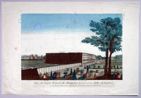
1760 Vue D Optic Antique Print View of Hampton Court Palace, Richmond London
- Title : Vue du Palias Royal de Hampton Court a 15 Milles de Londres
- Date : 1760
- Condition: (A) Very Good Condition
- Ref: 92704
- Size: 19in x 12 3/4in (480mm x 325mm)
Description:
This hand coloured original antique print, a view of Hampton Court Palace was published as part of the Vues d’Optique in 1760.
Hampton Court Palace: is a royal palace in the London Borough of Richmond upon Thames, Greater London, in the historic county of Middlesex, and within the postal town East Molesey, Surrey. It has not been inhabited by the British Royal Family since the 18th century. The palace is 11.7 miles (18.8 kilometres) south west of Charing Cross and upstream of central London on the River Thames. It was originally built in 1514 for Cardinal Thomas Wolsey, a favourite of King Henry VIII. In 1529, as Wolsey fell from favour, the King seized the palace for himself and later enlarged it. Along with St. James's Palace, it is one of only two surviving palaces out of the many owned by King Henry VIII.
In the following century, King William III's massive rebuilding and expansion project was intended to rival Versailles. Work ceased in 1694, leaving the palace in two distinct contrasting architectural styles, domestic Tudor and Baroque. While the palace's styles are an accident of fate, a unity exists due to the use of pink bricks and a symmetrical, if vague, balancing of successive low wings.
Vues d' Optique or Perspective Views: Perspective views, or "vues d'optique," are a special type of popular print published in Europe during the 18th century. These prints provided a form of entertainment when viewed through a device called an "optical machine" or an "optique." The most characteristic feature of the perspective views is their emphasized linear perspective, done to further intensify the enhanced appearance of depth and illusionistic space in the prints when viewed through an optique. When displayed in the optique, the prints might transport the viewer into a far away place---an unknown city, or perhaps into the midst of a dramatic bit of contemporary history. Another attribute of these prints is their bright, often heavy hand coloring, applied boldly so as to show the tints when viewed through the lens.
A number of perspective prints depicted American scenes at the time of the Revolution for a European audience hungry for news of the events in the British colonies. As documents of American history and European printmaking, these are unusual and appealing eighteenth-century prints.
General Description:
Paper thickness and quality: - Heavy & stable
Paper color: - Off white
Age of map color: - Original
Colors used: - Blue, yellow, green, red
General color appearance: - Authentic & bright
Paper size: - 19in x 12 3/4in (480mm x 325mm)
Plate size: - 14 1/2in x 9 1/2in (370mm x 240mm)
Margins: - Min 2in (50mm)
Imperfections:
Margins: - Light soiling
Plate area: - Small smudge & toning to sky
Verso: - Small repair, no loss
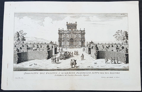
1685 G B Falda & Sandrart Antique Print Villa Gardens Doria Pamphili, Rome Italy
Antique Map
- Title : Prospecto Del Palazzo & Giardino Pamphilio Detto Del Bel Respiro...Architettura del Caualier Alessandro Algardi...Simon Felice delin....Norimburga appresso Gioni. Gac. de Sandart
- Ref #: 93463
- Size: 19in x 12 1/2in (490mm x 335mm)
- Date : 1685
- Condition: (A+) Fine Condition
Description:
This fine original copper plate engraved antique print of the Villa & Gardens of Doria Pamphili, Rome was engraved by Simone Felice for the 1685 edition of Giovanni Battista Faldas Li giardini di Roma, disegnati da Giovanni Battista Falda nuovamente dati alle stampe con direttione di Giov. Giacomo de Sandrart (The gardens of Rome, designed by Giovanni Battista Falda again printed with the direction of Giov. Giacomo de Sandrart) published in Nuremberg by Johann von Sandrart.
The work is based on the original series edited by Gian Giacomo de Rossi a few years earlier (the first edition was certainly published after 1677 but before 1683) which included 19 tables of plants and perspective views of the most famous Roman gardens, 14 of which were engraved by GB Falda and 5 by Simon Felice.
General Definitions:
Paper thickness and quality: - Heavy and stable
Paper color : - off white
Age of map color: -
Colors used: -
General color appearance: -
Paper size: - 19in x 12 1/2in (490mm x 335mm)
Plate size: - 16in x 9 1/2in (400mm x 250mm)
Margins: - Min 1in (25mm)
Imperfections:
Margins: - None
Plate area: - None
Verso: - None
Background:
The Villa Doria Pamphili is a seventeenth-century villa with what is today the largest landscaped public park in Rome, Italy. It is located in the quarter of Monteverde, on the Gianicolo (or the Roman Janiculum), just outside the Porta San Pancrazio in the ancient walls of Rome where the ancient road of the Via Aurelia commences.
It began as a villa for the Pamphili family and when the line died out in the eighteenth century, it passed to Prince Giovanni Andrea IV Doria, and has been known as the Villa Doria Pamphili since.
The nucleus of the villa property, the Villa Vecchia or old villa, already existed before 1630, when it was bought by Pamfilio Pamfili, who had married the heiress Olimpia Maidalchini, to enjoy as a suburban villa. Thereafter he set about buying up neighbouring vineyards to accumulate a much larger holding, which was often known as the Bel Respiro or beautiful breath as it stood on high ground, above the malarial areas of Rome, and offered spectacular views which were a desirable feature of Baroque villa settings.
In 1644 Cardinal Giambattista Pamphili became elected to the papacy and took the name of Innocent X. In accordance with this change in status, the Pamphili aspired to a grander and more expansively sited new villa. Early designs were made, possibly by Virgilio Spada rather than the traditional attribution to Borromini, but these were rejected. Instead the project was placed in the hands of the Bolognese sculptor Alessandro Algardi in 1644, assisted by Giovanni Francesco Grimaldi.
The initial design had a central casino (not the modern usage as a gambling establishment) with wings, but only the central block was built. There is uncertainty as to who the architect was; Algardi was not an architect, and it may be that he had help from Carlo Rainaldi and that the construction was supervised by Grimaldi. The layout has a central circular room around which the other rooms were arranged. Construction began in 1645 and was complete by 1647 although embellishments and the garden layouts were not finished until 1653. The casino, sometimes known as the Casino del Bel Respiro, was designed as a complement to the Pamphili collection of sculptures both ancient and modern, and other Roman antiquities such as vases, sarcophagi and inscriptions; it was only ever intended for display of the collection and the family and guests resided in the older Vecchia Vigna.
As a show case for sculpture, the somewhat crowded Casino facades have rhythmically alternating windows with niches which were elaborately adorned with sculptures, both antique and modern, with busts in hollowed roundels, with panels of bas-reliefs, and reliefs.
The exterior containing statues gives a rich allure that was architecturally somewhat conservative for its date, looking back towards the Villa Medici or the Casina Pio IV, and rather more Mannerist than Baroque. It offered a foretaste of the richly stuccoed and frescoed interiors, where the iconographic program set out to establish the antiquity of the Pamphili, a family then somewhat parvenu in Rome, with origins in Gubbio. Inside, Algardi provided further bas-reliefs and stucco framing for the heroic frescoes drawn from Roman history painted by Grimaldi.
The casino is set into the hill slope such that the main entrance on the north side is at a level above the giardino segreto or secret garden enclosure on its south side, a parterre garden with low clipped hedges. The gardens on the sloping site were laid out from around 1650 by Innocents nephew, Camillo Pamphili, formalizing the slope as a sequence from the parterres that flank the Casino, to a lower level below, framed by the boschi or formalized woodlands that rose above clipped hedges, and eventually arriving at a rusticated grotto in the form of an exedra, from which sculptured figures emerge from the rockwork. The exedra, now grassed, formerly enframed a Fountain of Venus by Algardi, which is preserved in the Villa Vecchia, together with Algardis bas-reliefs of putti representing Love and the Arts that were formerly here. The fountain spilled into a small cascade that let into a short length of formal canal, which was intended to remind the viewer of the similar Canopus at Hadrians Villa— another programmatic connection of the Pamphili with Antiquity.
When Girolamo Pamphili died in 1760 without male heirs, the disputes which broke out among the possible heirs were settled in 1763 when Pope Clement XIII Rezzonico granted to Prince Giovanni Andrea IV Doria the right to take the surname, the arms and the vast properties of the Pamphili; the Princes claim was based on the marriage between Giovanni Andrea III Doria and Anna Pamphili. Since then, the villa has been known as the Villa Doria Pamphili.
Throughout the 18th century, features were regularly added such as fountains and gateways by Gabriele Valvassori and other architects retained by the Pamphili and their heirs. After the Napoleonic era, more sweeping changes were made. The parterres that were formal extensions of the casino were retained but replanted with the patterned planting of colourful carpet bedding supplied from greenhouses by the old villa. (Today the parterres have been replanted in 16th-century style, with panels of scrolling designs in close-clipped greens set in wide gravel walks.) In the sloping outer gardens the changes were more extensive, recasting them in the naturalistic manner of English landscape gardens. The grounds, filled with many surprise features and picturesque incidents, swept down to a small lake at the bottom, which already had an air of atmospheric maturity when it was painted in the 1830s by Alexandre-Gabriel Decamps. In the wooded, natural-appearing landscapes with clumps of characteristic umbrella-like stone pines along horizons stand statues and vases, which evoke a nostalgic antiquity. The 18th-century English landscape gardens such as Stowe and Stourhead that were the inspiration for this style aimed to bring to life the Italian landscapes with Roman ruins painted by Claude and Poussin. A notable difference is that at the Villa Doria Pamphilis giardino inglese the Roman remains are likely to be genuine. The site of the villa contained several Roman tombs that yielded vases, sarcophagi and inscriptions that were added to the Pamphili collection.
Falda, Giovanni Battista 1643 – 1678
Falda was an Italian architect, engraver and artist. He is known for his engravings of both contemporary and antique structures of Rome.
Falda was sent as a boy to Rome, to work in the studio of Bernini, and his draughtsmanship caught the eye of the publisher Giovanni Giacomo de Rossi. He engraved for Le fontane di Roma (Fountains in Rome) and for Palazzi di Roma (Palaces of Rome). The former books was expanded after Faldas death with engravings by Francesco Venturini. The latter was published in 1655 in collaboration with Pietro Ferrerio. He is sometimes known as Falda da Valduggia because of his birthplace.
His works became particularly popular with the first waves of Grand Tour participants during the latter parts of the 17th century and Falda became a commercial success as a result. His works appealed to tourists keen to retain a detailed and accurate representation of those parts of Rome they had visited.
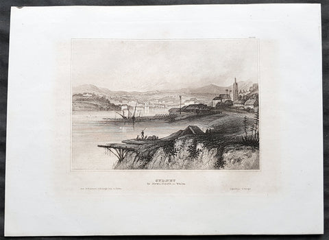
1835 Joseph Meyer Antique Print Early View of The Rocks Sydney, Australia
- Title : Sydney in New South Wales
- Ref #: 50668
- Size: 10in x 7 1/2in (255mm x 190mm)
- Date : 1835
- Condition: (A+) Fine Condition
Description:
This fine steel-plate engraved original antique print an early view of The Rocks in Sydney Australia by Joseph Meyer was published in the 1835 edition of Meyers Universum
These are beautiful steel-plate engraved prints, with a high level of detail along with beautifully executed artistry.
General Definitions:
Paper thickness and quality: - Heavy and stable
Paper color : - off white
Age of map color: -
Colors used: -
General color appearance: -
Paper size: - 10in x 7 1/2in (255mm x 190mm)
Plate size: - 10in x 7 1/2in (255mm x 190mm)
Margins: - Min 1/2in (12mm)
Imperfections:
Margins: - None
Plate area: - None
Verso: - None
Background:
The History of Sydney begins in prehistoric times with the occupation of the district by Australian Aborigines, whose ancestors came to Sydney in the Upper Paleolithic period. The modern history of the city began with the arrival of a First Fleet of British ships in 1788 and the foundation of a penal colony by Great Britain.
From 1788 to 1900 Sydney was the capital of the British colony of New South Wales. An elected city council was established in 1840. In 1900, Sydney became a state capital, when New South Wales voted to join the Australian Federation. Sydney today is Australia\'s largest city and a major international capital of culture and finance. The city has played host to many international events, including the 2000 Summer Olympics.
Meyer, Joseph 1796 - 1856
Meyer was a German industrialist and publisher, most noted for his encyclopedia, Meyers Konversations-Lexikon.
Meyer was born at Gotha, Germany, and was educated as a merchant in Frankfurt am Main. He went to London in 1816, but returned to Germany in 1820 after business adventures and stock speculations fell through. Here he invested in enterprises like textile-trade (1820–24). Soon after the first steam-hauled railway had started in December 1835, Meyer started to make business plans how to start the first railways. He also bought some concessions for iron mining. In 1845, he founded the Deutsche Eisenbahnschienen-Compagnie auf Actien (German Railway Rail joint stock company).
Meyer operated very successfully as a publisher, employing a system of serial subscription to publications, which was new at that time. To this end he founded a company, Bibliographisches Institut, in Gotha in 1826. It published several editions of the Bible, works of classical literature (Miniatur-Bibliothek der deutschen Classiker, Groschen-Bibliothek), atlases, the world in pictures on steel engravings Meyers Universum, 1833–61, 17 volumes in 12 languages with 80,000 subscribers all over Europe), and an encyclopaedia, (das Grosse Conversations-Lexikon für die gebildeten Stände;). His company grew substantially, and in 1828 he moved it from Gotha to Hildburghausen, where he died thirty years later.
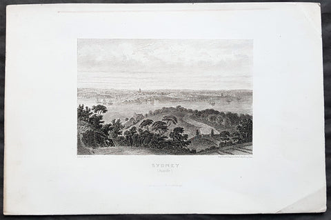
1859 Aubert Antique Print View of Sydney, Australia from the North to The Rocks
- Title : Sydney (Australie)
- Size: 10in x 7in (255mm x 180mm)
- Condition: (A+) Fine Condition
- Date : 1859
- Ref #: 82027
Description:
This original steel-plate engraved antique print an view of Sydney NSW from the north across Circular Quay & The Rocks with a view to St James Church on Kings St - across where the Harbour Bridge is now situated - by Pierre Eugene Aubert was published by Dufour, Mulat and Boulanger, Paris in 1859.
General Definitions:
Paper thickness and quality: - Heavy and stable
Paper color : - off white
Age of map color: -
Colors used: -
General color appearance: -
Paper size: - 10in x 7in (255mm x 180mm)
Plate size: - 10in x 7in (255mm x 180mm)
Margins: - Min 1in (25mm)
Imperfections:
Margins: - Crease in right margin
Plate area: - None
Verso: - None
Background:
The History of Sydney begins in prehistoric times with the occupation of the district by Australian Aborigines, whose ancestors came to Sydney in the Upper Paleolithic period. The modern history of the city began with the arrival of a First Fleet of British ships in 1788 and the foundation of a penal colony by Great Britain.
From 1788 to 1900 Sydney was the capital of the British colony of New South Wales. An elected city council was established in 1840. In 1900, Sydney became a state capital, when New South Wales voted to join the Australian Federation. Sydney today is Australia\'s largest city and a major international capital of culture and finance.
Aubert, Pierre Eugene, 1789-1847
A French artist and engraver of the early 19th century, working with the Paris publishers Dufour, Mulat and Boulanger.
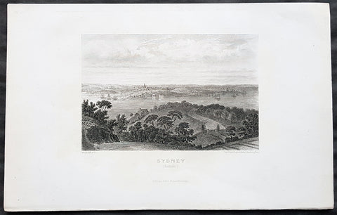
1859 Aubert Antique Print View of Sydney, Australia from the North to The Rocks
- Title : Sydney (Australie)
- Size: 10in x 7in (255mm x 180mm)
- Condition: (A+) Fine Condition
- Date : 1859
- Ref #: 82030
Description:
This original steel-plate engraved antique print an view of Sydney NSW from the north across Circular Quay & The Rocks with a view to St James Church on Kings St - across where the Harbour Bridge is now situated - by Pierre Eugene Aubert was published by Dufour, Mulat and Boulanger, Paris in 1859.
General Definitions:
Paper thickness and quality: - Heavy and stable
Paper color : - off white
Age of map color: -
Colors used: -
General color appearance: -
Paper size: - 10in x 7in (255mm x 180mm)
Plate size: - 10in x 7in (255mm x 180mm)
Margins: - Min 1in (25mm)
Imperfections:
Margins: - Crease in right margin
Plate area: - None
Verso: - None
Background:
The History of Sydney begins in prehistoric times with the occupation of the district by Australian Aborigines, whose ancestors came to Sydney in the Upper Paleolithic period. The modern history of the city began with the arrival of a First Fleet of British ships in 1788 and the foundation of a penal colony by Great Britain.
From 1788 to 1900 Sydney was the capital of the British colony of New South Wales. An elected city council was established in 1840. In 1900, Sydney became a state capital, when New South Wales voted to join the Australian Federation. Sydney today is Australia\'s largest city and a major international capital of culture and finance.
Aubert, Pierre Eugene, 1789-1847
A French artist and engraver of the early 19th century, working with the Paris publishers Dufour, Mulat and Boulanger.
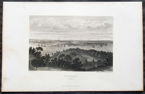
1859 Aubert Antique Print View of Sydney, Australia from the North to The Rocks
- Title : Sydney (Australie)
- Size: 10in x 7in (255mm x 180mm)
- Condition: (A+) Fine Condition
- Date : 1859
- Ref #: 82026
Description:
This original steel-plate engraved antique print an view of Sydney NSW from the north across Circular Quay & The Rocks with a view to St James Church on Kings St - across where the Harbour Bridge is now situated - by Pierre Eugene Aubert was published by Dufour, Mulat and Boulanger, Paris in 1859.
General Definitions:
Paper thickness and quality: - Heavy and stable
Paper color : - off white
Age of map color: -
Colors used: -
General color appearance: -
Paper size: - 10in x 7in (255mm x 180mm)
Plate size: - 10in x 7in (255mm x 180mm)
Margins: - Min 1in (25mm)
Imperfections:
Margins: - Crease in right margin
Plate area: - None
Verso: - None
Background:
The History of Sydney begins in prehistoric times with the occupation of the district by Australian Aborigines, whose ancestors came to Sydney in the Upper Paleolithic period. The modern history of the city began with the arrival of a First Fleet of British ships in 1788 and the foundation of a penal colony by Great Britain.
From 1788 to 1900 Sydney was the capital of the British colony of New South Wales. An elected city council was established in 1840. In 1900, Sydney became a state capital, when New South Wales voted to join the Australian Federation. Sydney today is Australia\'s largest city and a major international capital of culture and finance.
Aubert, Pierre Eugene, 1789-1847
A French artist and engraver of the early 19th century, working with the Paris publishers Dufour, Mulat and Boulanger.
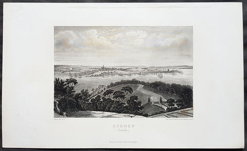
1859 Aubert Antique Print View of Sydney, Australia from the North to The Rocks
- Title : Sydney (Australie)
- Size: 10in x 7in (255mm x 180mm)
- Condition: (A+) Fine Condition
- Date : 1859
- Ref #: 82028
Description:
This original steel-plate engraved antique print an view of Sydney NSW from the north across Circular Quay & The Rocks with a view to St James Church on Kings St - across where the Harbour Bridge is now situated - by Pierre Eugene Aubert was published by Dufour, Mulat and Boulanger, Paris in 1859.
General Definitions:
Paper thickness and quality: - Heavy and stable
Paper color : - off white
Age of map color: -
Colors used: -
General color appearance: -
Paper size: - 10in x 7in (255mm x 180mm)
Plate size: - 10in x 7in (255mm x 180mm)
Margins: - Min 1in (25mm)
Imperfections:
Margins: - Crease in right margin
Plate area: - None
Verso: - None
Background:
The History of Sydney begins in prehistoric times with the occupation of the district by Australian Aborigines, whose ancestors came to Sydney in the Upper Paleolithic period. The modern history of the city began with the arrival of a First Fleet of British ships in 1788 and the foundation of a penal colony by Great Britain.
From 1788 to 1900 Sydney was the capital of the British colony of New South Wales. An elected city council was established in 1840. In 1900, Sydney became a state capital, when New South Wales voted to join the Australian Federation. Sydney today is Australia\'s largest city and a major international capital of culture and finance.
Aubert, Pierre Eugene, 1789-1847
A French artist and engraver of the early 19th century, working with the Paris publishers Dufour, Mulat and Boulanger.
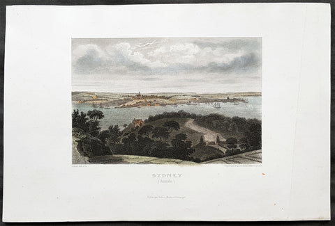
1859 Aubert Antique Print View of Sydney, Australia from the North to The Rocks
- Title : Sydney (Australie)
- Size: 10in x 7in (255mm x 180mm)
- Condition: (A+) Fine Condition
- Date : 1859
- Ref #: 82029
Description:
This original steel-plate engraved antique print an view of Sydney NSW from the north across the Rocks with a view to St James Church on Kings St, across the harbour where the Harbour Bridge now sits, by Pierre Eugene Aubert was published by Dufour, Mulat and Boulanger, Paris in 1859.
General Definitions:
Paper thickness and quality: - Heavy and stable
Paper color : - off white
Age of map color: - Early
Colors used: - Yellow, green, blue
General color appearance: - Authentic
Paper size: - 10in x 7in (255mm x 180mm)
Plate size: - 10in x 7in (255mm x 180mm)
Margins: - Min 1in (25mm)
Imperfections:
Margins: - Crease in right margin
Plate area: - None
Verso: - None
Background:
The History of Sydney begins in prehistoric times with the occupation of the district by Australian Aborigines, whose ancestors came to Sydney in the Upper Paleolithic period. The modern history of the city began with the arrival of a First Fleet of British ships in 1788 and the foundation of a penal colony by Great Britain.
From 1788 to 1900 Sydney was the capital of the British colony of New South Wales. An elected city council was established in 1840. In 1900, Sydney became a state capital, when New South Wales voted to join the Australian Federation. Sydney today is Australia\'s largest city and a major international capital of culture and finance.
Aubert, Pierre Eugene, 1789-1847
A French artist and engraver of the early 19th century, working with the Paris publishers Dufour, Mulat and Boulanger.