Exploration (25)

1774, 1777 & 1785 Capt James Cook 3 Atlas Volumes 1st Editions 204 Maps & Prints
- Title : 1. Figure du Banks 2. Premier Voyage De Cook 3. Troisieme Voyage De Cook
- Ref #: 93498, 93499, 93500
- Size: 4to (Quatro)
- Date : 1774; 1777; 1785
- Condition: (A+) Fine Condition
Description:
A unique and rare opportunity to acquire all three of Captain James Cooks 1st French edition Atlases (4to, Quatro), published to accompany the publication of his 3 voyages of discovery in 1774, 1777 & 1785. The atlases contain a total of 204 large folding, double page and single page maps and prints. It is very rare to find all three atlases complete and available together at the same time.
The contents of all three atlases are in fine condition, with a fresh, heavy impression and clean paper of all maps and prints.
As stated there are 204 maps and prints 51 in the 1st volume, 66 in the second volume and 87 in the second volume. Please view the images above, that include a few images of the 204 maps and prints as well as an itemized list of each volume.
General Definitions:
Paper thickness and quality: - Heavy and stable
Paper color : - off white
Age of map color: -
Colors used: -
General color appearance: -
Paper size: - 4to (Quatro)
Plate size: - 4to (Quatro)
Margins: - 4to (Quatro)
Imperfections:
Margins: - Some scuffing and wear to boards & spines
Plate area: - None
Verso: - None
Background:
Timeline First Voyage 1768 - 1771:
In 1768 Cook was chosen to lead an expedition to the South Seas to observe the Transit of Venus and to secretly search for the unknown Great Southern Continent (terra australis incognita).
Cook and his crew of nearly 100 men left Plymouth (August 1768) in the Endeavour and travelled via Madeira (September), Rio de Janiero (November-December) and Tierra del Fuego (January 1769) to Tahiti.
At Tierra del Fuego (January 1769) Cooks men went ashore and met the local people whom Cook thought perhaps as miserable a set of People as are this day upon Earth. Joseph Bankss party collected botanical specimens but his two servants, Thomas Richmond and George Dorlton, died of exposure in the snow and cold. Leaving Tierra del Fuego Endeavour rounded Cape Horn and sailed into the Pacific Ocean.
Sir Joseph Banks wrote about the homes of the Fuegans
..…huts or wigwams of the most unartificial construction imaginable, indeed no thing bearing the name of a hut could possibly be built with less trouble. They consisted of a few poles set up and meeting together at the top in a conical figure, these were covered on the weather side with a few boughs and a little grass, on the lee side about one eighth part of the circle was left open and against this opening was a fire made.......(Banks, Journal I, 224, 20th January 1769)
Samuel Wallis on the ship Dolphin discovered Tahiti in 1767. He recommended the island for the Transit of Venus observations and Cook arrived here in April 1769. Cook, like Wallis two years before him, anchored his ship in the shelter of Matavai Bay on the western side of the island.
In Matavai Bay Cook established a fortified base, Fort Venus, from which he was to complete his first task – the observation of the Transit of Venus (3rd June 1769). The fort also served as protection for all the important scientific and other equipment which had to be taken ashore as:
.......great and small chiefs and common men are firmly of opinion that if they can once get possession of an thing it immediately becomes their own…the chiefs employd in stealing what they could in the cabbin while their dependents took every thing that was loose about the ship…...(Joseph Banks).
Theft by some native peoples plagued Cooks voyages.
Cook and his crew experienced good relations with the Tahitians and returned to the islands on many occasions, attracted by the friendly people of this earthly paradise. On arrival Cook had set out the rules, including:
.....To endeavour by every fair means to cultivate a friendship with the Natives and to treat them with all imaginable humanity....
Just as Cook was planning to leave Tahiti two members of Endeavours crew decided to desert, having strongly attached themselves to two girls, but Cook recovered them.
Cook sailed around the neighbouring Society Islands and took on board the Tahitian priest, Tupaia, and his servant, Taiata. Endeavour left the Society Island in August 1769.
Tupaia acted as interpreter when they came into contact with other Polynesian peoples and helped Cook to make a map of the Pacific islands. This showed Cook the location of islands arranged according to their distance from Tahiti and indicated Tupaias and Polynesian knowledge of navigation and their skill as great mariners.
Cook sailed in search of the Southern Continent (August-October 1769) before turning west to New Zealand. The first encounters with the native Maori of New Zealand in October were violent, their warriors performing fierce dances, or hakas, in attempts to threaten and challenge the ships crew. Some of their warriors were killed when Cooks men had to defend themselves. Eventually relations improved and Cook was able to trade with the Maori for fresh supplies.
Exploring different bays and rivers along the way Cook circumnavigated New Zealand and was the first to accurately chart the whole of the coastline. He discovered that New Zealand consisted of two main islands, north (Te Ika a Maui) and south (Te Wai Pounamu) islands (October 1769-March 1770).
The artist Sydney Parkinson described three Maori who visited the Endeavour on 12th October 1769:
......Most of them had their hair tied up on the crown of their heads in a knot…Their faces were tataowed, or marked either all over, or on one side, in a very curious manner, some of them in fine spiral directions…
This Maori wears an ornamental comb, feathers in a top-knot, long pendants from his ears and a heitiki, or good luck amulet, around his neck.
At the northern end of the south island Cook anchored the ship in Ship Cove, Queen Charlotte Sound, which became a favourite stopping place on the following voyages. Parkinson noted:
......The manner in which the natives of this bay (Queen Charlotte Sound) catch their fish is as follows: - They have a cylindrical net, extended by several hoops at the bottom, and contracted at the top; within the net they stick some pieces of fish, then let it down from the side of the canoe and the fish, going in to feed, are caught with great ease.....(Parkinson, Journal, 114)
In Queen Charlottes Sound Cook visited one of the many Maori hippah, or fortified towns.
........The town was situated on a small rock divided from the main by a breach in a rock so small that a man might almost Jump over it; the sides were every where so steep as to render fortifications iven in their way almost totally useless, according there was nothing but a slight Palisade…in one part we observed a kind of wooden cross ornamented with feathers made exactly in the form of a crucifix cross…we were told that it was a monument to a dead man.......
Endeavour left New Zealand and sailed along the east coast of New Holland, or Australia, heading north (April-August 1770). Cook started to chart the east coast and on 29th April landed for the first time in what Cook called Stingray, later, Botany Bay.
The ship struck the Great Barrier Reef and was badly damaged (10 June). Repairs had to be carried out in Endeavour River. (June-August 1770). The first kangaroo to be sighted was recorded and shot.
The inhabitants of New Holland were very different from the people Cook had come across in other Pacific lands. They were darker skinned than the Maori and painted their bodies:
......They were all of them clean limnd, active and nimble. Cloaths they had none, not the least rag, those parts which nature willingly conceals being exposed to view compleatly uncovered......(Joseph Banks)
Tupaia could not make himself understood and at first the aborigines were very wary of the visitors and not at all interested in trading.
Joseph Banks recorded the fishing party observed at Botany Bay on 26 April 1770. He wrote:
......Their canoes… a piece of Bark tied together in Pleats at the ends and kept extended in the middle by small bows of wood was the whole embarkation, which carried one or two…people…paddling with paddles about 18 inches long, one of which they held in either hand.....(Banks, Journal II, 134)
Endeavour left Australia and sailed via the Possession Isle and Endeavour Strait for repairs at Batavia, Java (October-December 1770). Although the crew had been quite healthy and almost free from scurvy, the scourge of sailors, many caught dysentery and typhoid and over thirty died at Batavia or on the return journey home via Cape Town, South Africa (March-April 1771). The ship arrived off Kent, England (July 1771).
The voyage successfully recorded the Transit of Venus and largely discredited the belief in a Southern Continent. Cook charted the islands of New Zealand and the east coast of Australia and the scientists and artists made unique records of the peoples, flora and fauna of the different lands visited.
Timeline - Second Voyage 1772 - 1775
In July 1772 Resolution, commanded by Captain Cook, and Discovery, commanded by Lieutenant Furneaux, set sail from Britain, via Madiera (Jul-Aug) and Cape Town, South Africa (Oct-Nov), towards the Antarctic in search of the Great Southern Continent.
During January 1773 the ships took on fresh water, charts of the voyage being marked with:
......Here we watered our Ship with Ice the 1st. Time 26S 44W and Here we compleated our Water/26S 20W but became separated in thick fog: Here we parted company…. and The Resolutions Track after we parted Company on the 8 of February 1773......
The ships became the first known to have crossed the Antarctic Circle (17 January 1773). On 9th January Cook wrote:
.......we hoisted out three Boats and took up as much as yielded about 15 Tons of Fresh Water, the Adventure at the same time got about 8 or 9 and all this was done in 5 or 6 hours time; the pieces we took up and which had broke from the Main Island, were very hard and solid, and some of them too large to be handled so that we were obliged to break them with our Ice Azes before they could be taken into the Boats...... Cook, Journals II, 74.)
The ships met again in New Zealand (February-May 1773) and set off to explore the central Pacific, calling at Tahiti (August), where, from the island of Raiatea, they took aboard Omai who returned with the Adventure to England (7 September).
After visiting Amsterdam and Middelburg, two islands that Cook called the Friendly Islands (Tongan group) (October) the ships became separated and never met again. Both ships returned separately to New Zealand. (November) A boats crew from the Adventure were killed by Maori (17 December) and the ship sailed for Britain, arriving July 1774.
Cook on Resolution attempted another search for the Great Southern Continent (November 1773), crossing the Antarctic Circle on 20th December 1773. However, the ice and cold soon forced him to turn north again and he made another search in the central Pacific for the Great Southern Continent. In January 1774 he turned south again, crossing the Antarctic Circle for the second time. Captain Cooks Journal, 2nd January 1774.
Cook sailed north, arriving at Easter Island in March 1774. Cook was too ill to go ashore but a small party explored the southern part of the island. The artist William Hodges painted a group of the large statues of heads (moia) for which the island has become famous.
Cook then sailed to the Marquesas (March); Tahiti (April) and Raiatea (June); past the Cook Islands and Niue, or Savage Islands as Cook called them; Tonga (June); Vatoa, the only Fijian Island visited by Cook (July); New Hebrides (July-August); New Caledonia (September) and Norfolk Island (October); before returning to New Zealand (October 1774).
Not all the peoples of the islands visited by Cook were friendly and when his ship approached Niue the local people would not let his crew ashore. Cook wrote:
.......The Conduct and aspect of these Islanders occasioned my giving it the Name of Savage Island, it lies in the Latitude of 19 degrees 1 Longitude 169 degrees 37 West, is about 11 Leagues in circuit, of a tolerable height and seemingly covered with wood amongst which were some Cocoa-nutt trees......(Cook, Journals II, 435, 22 June 1774.)
En route for New Zealand, Cook sailed west and explored the islands which he called the New Hebrides, now known as Vanuatu, arriving on 17 July 1774. The people were Melanesian, not Polynesian, and spoke different languages and had different customs. Cook recorded:
........The Men go naked, it can hardly be said they cover their Natural parts, the Testicles are quite exposed, but they wrap a piece of cloth or leafe round the yard (nautical slang for the penis) which they tye up to the belly to a cord or bandage which they wear round the waist just under the Short ribs and over the belly and so tight that it was a wonder to us how they could endure it.......(Cook, Journals II, 464, 23 July 1774)
Cook sailed past or visited nearly all the islands in the group, including landfalls at Malekula, Tanna and Erromango. He later moved on to New Caledonia.
Cooks reception by the New Hebrideans was generally hostile. At Erromango during the landing on 4th August 1774 the marines had to open fire when the natives tried to seize the boat and started to fire missiles. Cook wrote:
....…I was very loath to fire upon such a Multitude and resolved to make the chief a lone fall a Victim to his own treachery…happy for many of these poor people not half our Musquets would go of otherwise many more must have fallen.......(Cook, Journals II, 479, 4th August 1774)
Some of Cooks crew were slightly injured but several natives were wounded and their leader killed. Back on the ship Cook had a gun fired to frighten off the islanders and decided to depart.
Cook left New Zealand to return to Britain via the Southern Ocean in November 1774 and arrived in Tierra del Fuego, South America, in December. Cook took on stores and spent the holiday in what he called Christmas Sound. He described the area:......except those little tufts of shrubbery, the whole country was a barren Tack (or Rock) doomed by Nature to everlasting sterility......(Cook, Ms Journal PRO Adm 55/108)
Cook left South America in early January 1775 and set off across the southern Atlantic for Cape Town, South Africa. On the way he tried to confirm the location of a number of islands charted by Alexander Dalrymple on an earlier voyage. On 17 January 1775 Cook arrived at the cold, bleak, glaciated island he called South Georgia and spent 3 days charting it before sailing on.
Cook headed east and in late January came across the South Sandwich Islands that he again charted and then sailed on to Cape Town, arriving in late March 1775. He then headed across the Atlantic via St. Helena and Ascension Island (May), the Azores (July) and landed at Portsmouth on 30th July 1775.
On his return Cook became a national hero. He was presented to the King, made a member of the Royal Society and received its Copley Medal for achievement. Cook was promoted to post-captain of Greenwich Hospital and wrote up his account of the voyage. This did not mean retirement for Cook who went on his third and final voyage the following year.
The second voyage was one of the greatest journeys of all time. During the three years the ships crews had remained healthy and only four of the Resolutions crew had died. Cook disproved the idea of the Great Southern Continent; had become the first recorded explorer to cross the Antarctic Circle; and had charted many Pacific islands for the first time.
Timeline - Third Voyage 1776 - 1780
In 1776 Cook sailed in a repaired Resolution (July) to search for the North West Passage and to return Omai to his home on Huahine in the Society Islands.
He sailed via the Canary Islands and was joined at Cape Town, South Africa, by the Discovery, commanded by Charles Clerke.
The Discovery was the smallest of Cooks ships and was manned by a crew of sixty-nine. The two ships were repaired and restocked with a large number of livestock and set off together for New Zealand ( December).
Cook sailed across the South Indian Ocean and confirmed the location of Desolation Island, later known as Kerguelen Island. Cook wrote of Christmas Harbour where he first anchored on 25th December 1776:
........I found the shore in a manner covered with Penguins and other birds and Seals…so fearless that we killed as ma(n)y as we chose for the sake of their fat or blubber to make Oil for our lamps and other uses… Here I displayd the British flag and named the harbour Christmas harbour as we entered it on that Festival........(Cook, Journals III, i, 29-32)
Cook sailed east, arriving at Van Diemens Land/Tasmania (January 1777) and Queen Charlottes Sound, New Zealand (February). The Maori were wary at first, expecting Cook to take revenge for the killing of members of the Adventures crew in 1773, but instead Cook befriended the leader of the attack.
The ships stayed for nearly two weeks in New Zealand, restocking with wild celery and scurvy grass and trading with the local Maori who set up a small village in Ship Cove. Cook set off around the islands of the south Pacific (February), visiting the Cook Islands (April); Tongan Islands (July); and Tahiti (August-December 1777)
In 1778 Cook visited the Hawaiian islands, or Sandwich Islands as he named them, for the first time. Cook wrote:
........We no sooner landed, that a trade was set on foot for hogs and potatoes, which the people gave us in exchange for nails and pieces of iron formed into some thing like chisels….At sun set I brought every body on board, having got during the day Nine tons of water….about sixty or eighty Pigs, a few Fowls, a quantity of potatoes and a few plantains and Tara roots.......(Cook, Journals III, i. 269 & 272)
In February 1778 Cook sailed from the Hawaiian Islands across the north Pacific to the Oregan coast of North America. He travelled up the coast in bad weather until he found a safe harbour, Nootka Sound, Vancouver Island, Canada. There he refitted the ships, explored the area and developed relations with the local people.
Cook described a village there, probably Yoquot:
….their houses or dwellings are situated close to the shore…Some of these buildings are raised on the side of a bank, theses have a flooring consisting of logs supported by post fixed in the ground….before these houses they make a platform about four feet broad…..so allows of a passage along the front of the building: They assend to this passage (along the front of the building) by steps, not unlike some at our landing places in the River Thames........(Cook, Journals III, i, 306)
Cook left Nootka Sound in April 1778 and sailed north along the Alaskan coast looking for inlets that might lead to the Northwest passage but was then forced to turn south. By July he had rounded the Alaskan Peninsula and was able to sail north again, visiting the Chukotskiy Peninsula, Russia, before heading out into the Bering Sea.
Cook described the summer huts, or yarangas, of the Chukchi people as:
.........pretty large, and circular and brought to a point at the top; the framing was of slight poles and bone, covered with the skins of Sea animals…About the habitations were erected several stages ten or twelve feet high, such as we had observed on some part of the American coast, they were built wholly of bones and seemed to be intended to dry skins, fish &ca. upon, out of reach of their dogs........(Cook, Journals III, I, 413)
After entering the Bering Sea on 11th August 1778, Cook crossed the Arctic Circle and went as far north as latitude 70 degrees 41 North before being forced back by the pack ice off Icy Cape, Alaska. On the ice all around the ships were large numbers of walruses. About a dozen of these huge animals were killed to replenish the supplies of fresh meat and to provide oil for the lamps.
Cook had to turn west and worked his way down the Russian coast, eventually heading south and east into Norton Sound, Alaska, in September 1778. He wrote of their very brief encounter with the inhabitants of Norton Sound:
....…a family of the Natives came near to the place where we were taking off wood…I saw no more than a Man, his wife and child…...(Cook, Journals III, I, 438)
After a short period spent searching for the Northwest Passage Cook realised that it was too late in the year to make any progress and so sailed for warmer winter quarters in the Hawaiian Islands, arriving there in December 1778.
After circumnavigating the big island of Hawaii for over a month the ships finally anchored in Kealakekua Bay on 16th January 1779. The Hawaiians in over 1000 canoes came out to welcome them, the arrival of the ships coinciding with celebrations to mark the religious festival of Makahiki to the god Lono. The Hawaiians seem to have treated Cook as a personification of the god and at first relations were good on this second visit. However, relationships became strained and Cook left the island on 4th February 1779.
When Cook left Hawaii his ships ran into gales which broke a mast, forcing him to return to Kealakekua Bay for repairs on 11th February. This time the native people were less friendly and stole the cutter of the Discovery. The next day, the 14th February 1779, Cook went ashore to take the Hawaiian king into custody pending the return of the cutter but a fight developed and Cook, four of his marines and a number of natives were killed. Cooks remains were buried at sea in Kealakekua Bay.
Charles Clerke took over command of the stunned expedition and explored the other Hawaiian islands before sailing north to search for the North-West Passage. The ships called at Kamchatka, Russia, (April-June) where they were welcomed by the governor, Behm, at Bolsheretsk. Behm took news of the expedition and Cooks death overland to St. Petersburg from where it reached Europe and Britain.
Having made another voyage into the Arctic in search of the Northwest Passage (June-July) the ships returned to Kamchatka in August. In November they set off sailing south along the east coast of Japan, between Taiwan and the Phillipines and arrived at Macao, China, in December.
In January 1780 the expeditions left for home, crossing the Indian Ocean, calling at Cape Town (April-May) and arriving back in Stromness, Orkney, in August but not returning to London until October 1780.
News of Cooks death reached Britain in January 1780, ahead of the return of Resolution and Discovery in October 1780. The voyage was written up and published and Cooks life gradually commemorated in articles, books, medals and monuments.
The achievements of the voyage were overshadowed by the deaths of both Cook and his second-in-command, Clerke. The main purpose of the voyage, the discovery of the Northwest Passage, was not realised but large tracts of the Pacific and Arctic coasts of America and Russia were charted.
Early attempts to summarise the life of Cook appeared in the popular press soon after news of his death reached Britain. Articles in journals such as the Westminster Magazine, published in January 1780, included Biographical Anecdotes of Capt. Cook, charting his life from his birth in Marton, North Yorkshire. The first published biography of Cook, Life of Captain James Cook, by Andrew Kippis, appeared a few years later in 1788.

1806 John Barrow Antique Atlas Travel Book to Vietnam via Brazil & South Africa
Antique Map
- Title : A Voyage to Cochinchina, in the years 1792 and 1793. to which is annexed an account of a journey, made in the years 1801 and 1802, to the residence of the chief of the Booshuana Nation, being the remotest point in the interior of Southern Africa
- Size: 4to (10 1/2in x 8 1/4in)
- Condition: (A) Very Good Condition
- Date : 1806
- Ref #: 61010
Description:
This rare publication of the first English edition of Sir Johns Barrows voyages to Cochin-China, (Vietnam) via Rio de Janeiro, the South African Cape & Batavia, Java in 1792 & 93, was published by Strahan and Preston for T. Cadell and T. Davies, London in 1806. 447 pages with 19 hand coloured plates & 2 hand coloured maps, as called for.
The book has been beautifully rebound in half calf with gilt text to spine & new end papers. Library stamps to the back of each plate & pages TP, 1, 101, 401 & 447. Staining to title page to page 23 & light browning to several pages after, repair to page 311 with browning.
Plates & maps in VG condition in fresh condition and beautiful hand colouring. 447 pages containing 19 hand colored prints, including one folding view of Rio, by T. Medland after Samuel Daniell and W. Alexander, and two folding hand coloured maps, the first a plan of the harbor and town of Rio de Janeiro, the second a Chart of the Cape & Southern Africa.
General Definitions:
Paper thickness and quality: - Heavy and stable
Paper color : - off white
Age of map color: - Original
Colors used: - Yellow, green, blue, pink
General color appearance: - Authentic
Paper size: - 11in x 7 1/2in (280mm x 190mm) Plates
Plate size: - 14in x 11in (355mm x 280mm) Fold out plates
Margins: - Min 1/2in (12mm)
Imperfections:
Margins: - Age toning
Plate area: - Age toning, repair to page 311
Verso: - Age toning
Background:
A Voyage to Cochinchina, in the years 1792 and 1793 first edition of the first illustrated English work on Vietnam. A description of the outward voyage of Lord Macartneys embassy to China. The voyage visited Madeira, the Canary Islands, and Rio de Janeiro; a description of that city and of Brazil in general is given. Touching at Tristan da Cunha, the ship rounded the Cape and eventually reached Cochin China via the city of Batavia on Java. The volume is also of Cook interest, as it describes finding Captain Cooks Resolution transformed into a smuggling whaler under the French flag. The substance of the sketch of Cochinchina is taken from a manuscript memoir drawn up by Captain Barissy, a French naval officer who, having several years commanded a frigate in the service of the King of Cochinchina and being an able and intelligent man, had the means and the opportunity of collecting accurate information .
The African part of the volume - which might perhaps, with more propriety, have formed an appendix to Barrows South African travels - relates to his two missions into the interior in order to reconcile the Kaffirs and Boers and to obtain more accurate topographical knowledge of the colony. He visited most parts of the Cape Colony, including the countries of the Kaffirs, Hottentots and Bushmen. He conducted the first census of Cape Colony, undertook a few amateur geological surveys, and contrived an interview with Shaka, king of the Zulus (Howgego). The son of a Lancashire journeyman tanner, Barrow was initially educated in the local grammar school, subsequently working as as a clerk in a Liverpool iron foundry, as a landsman on a Greenland whaler, and as a mathematics teacher in a Greenwich academy preparing young men for a naval career (ODNB). At this time he gave private tuition to Thomas Staunton, son of Sir George Staunton, to whom, as he later admitted, he was indebted for all the good fortune of his life, which began with his service as comptroller of household to Lord Macartneys embassy. Today, Barrow is perhaps best known for his Mutiny on the Bounty (1831) but, during his lifetime, his accounts of his travels in eastern Asia and southern Africa, published between 1801 and 1807, were better known and more influential. These established new standards for travel writing His interests ranged widely, but the great bulk of his output had a geographical focus, usually with an underlying imperial theme and a belief in progress and the superiority of British civilization Collectively, these activities established his pre-eminence within British geography. The account is superbly illustrated with aquatints of views, types, and natural history specimens, Abbey commending the aquatinting as of excellent quality. Bookplate of Charles Constant de Rebecque to the front pastedown, together with a modern collectors plate. A Swiss, a cousin of Benjamin Consant, Constant de Rebecque acted as an agent for the HEIC, making three trips to China for them, and publishing an account of his travels, Récits de Trois Voyages à la Chine.
Cochinchina is a historical exonym for part or the whole of Vietnam, depending on the contexts, but it was commonly used to refer to the region south of the Gianh River. In the 17th and 18th centuries, Vietnam was divided between the Trịnh lords to the north and the Nguyễn lords to the south. The two domains bordered each other on the Son–Gianh River. The northern section was called Tonkin by Europeans, and the southern part, Đàng Trong, was called Cochinchina by most Europeans and Quinam by the Dutch
Barrow, Sir John 1764 - 1848
Barrow, 1st Baronet, was an English civil servant, geographer, linguist and writer. Barrows legacy has been met with mixed analysis. Some historians regard Barrow as an instrument of imperialism who portrayed Africa as a resource rich land devoid of any human or civilized elements. Nonetheless, other historians consider Barrow to have promoted humanitarianism and rights for South Africans.
Barrow was born the only child of Roger Barrow, a tanner in the village of Dragley Beck, in the parish of Ulverston, Lancashire. He was schooled at Town Bank grammar school, Ulverston, but left at age 13 to found a Sunday school for the poor.
Barrow was employed as superintending clerk of an iron foundry at Liverpool. At only 16, he went on a whaling expedition to Greenland. By his twenties, he was teaching mathematics, in which he had always excelled, at a private school in Greenwich.
Barrow taught mathematics to the son of Sir George Leonard Staunton; through Stauntons interest, he was attached on the first British embassy to China from 1792 to 1794 as comptroller of the household to Lord Macartney. He soon acquired a good knowledge of the Chinese language, on which he subsequently contributed articles to the Quarterly Review; and the account of the embassy published by Sir George Staunton records many of Barrows valuable contributions to literature and science connected with China.
Barrow ceased to be officially connected with Chinese affairs after the return of the embassy in 1794, but he always took much interest in them, and on critical occasions was frequently consulted by the British government.
Some historians attribute the stagnation thesis to Barrow; that China was an extremely civilized nation that was in a process of decay by the time of European contact.
In 1797, Barrow accompanied Lord Macartney as private secretary in his important and delicate mission to settle the government of the newly acquired colony of the Cape of Good Hope. Barrow was entrusted with the task of reconciling the Boer settlers and the native Black population and of reporting on the country in the interior. In the course of the trip, he visited all parts of the colony; when he returned, he was appointed auditor-general of public accounts. He then decided to settle in South Africa, married, and bought a house in 1800 in Cape Town. However, the surrender of the colony at the peace of Amiens (1802) upset this plan.
During his travels through South Africa, Barrow compiled copious notes and sketches of the countryside that he was traversing. The outcome of his journeys was a map which, despite its numerous errors, was the first published modern map of the southern parts of the Cape Colony. Barrows descriptions of South Africa greatly influenced Europeans understanding of South Africa and its peoples. William John Burchell (1781–1863) was particularly scathing: As to the miserable thing called a map, which has been prefixed to Mr. Barrows quarto, I perfectly agree with Professor Lichtenstein, that it is so defective that it can seldom be found of any use.
Barrow returned to Britain in 1804 and was appointed Second Secretary to the Admiralty by Viscount Melville, a post which he held for forty years – apart from a short period in 1806–1807 when there was a Whig government in power. Lord Grey took office as Prime Minister in 1830, and Barrow was especially requested to remain in his post, starting the principle that senior civil servants stay in office on change of government and serve in a non-partisan manner. Indeed, it was during his occupancy of the post that it was renamed Permanent Secretary. Barrow enjoyed the esteem and confidence of all the eleven chief lords who successively presided at the Admiralty board during that period, and more especially of King William IV while lord high admiral, who honoured him with tokens of his personal regard.
In his position at the Admiralty, Barrow was a great promoter of Arctic voyages of discovery, including those of John Ross, William Edward Parry, James Clark Ross and John Franklin. The Barrow Strait in the Canadian Arctic as well as Point Barrow and the city of Barrow in Alaska are named after him. He is reputed to have been the initial proposer of Saint Helena as the new place of exile for Napoleon Bonaparte following the Battle of Waterloo in 1815. Barrow was a fellow of the Royal Society and received the degree of LL.D from the University of Edinburgh in 1821. A baronetcy was conferred on him by Sir Robert Peel in 1835. He was also a member of the Raleigh Club, a forerunner of the Royal Geographical Society.
Barrow retired from public life in 1845 and devoted himself to writing a history of the modern Arctic voyages of discovery (1846), as well as his autobiography, published in 1847. He died suddenly on 23 November 1848. The Sir John Barrow monument was built in his honour on Hoad Hill overlooking his home town of Ulverston, though locally it is more commonly called Hoad Monument. Mount Barrow and Barrow Island in Australia are believed to have been named for him.
Please note all items auctioned are genuine, we do not sell reproductions. A Certificate of Authenticity (COA) can be issued on request.
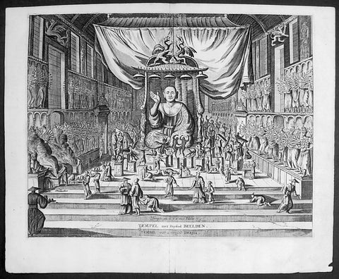
1669 Montanus Antique Print Sanjūsangen-dō 三十三間堂 Buddhist Temple Kyoto, Japan
- Title : Temple ou il y a 1000 Idoles: Temple met Duysend Beelden
- Date : 1669
- Condition: (A+) Fine Condition
- Ref # : 23413
- Size : 14 1/2in x 9in (360mm x 230mm)
Description:
This original copper-plate engraved antique print of Sanjūsangen-dō (三十三間堂) a Buddhist temple in Higashiyama District of Kyoto, Japan (with 1000 Kannon statues) during the Edo period, by Arnoldus Montanus was published in the 1669 edition of Gedenkwaerdige Gesantschappen der Oost-Indische Maetschappy int Vereenigde Nederland, aen de Kaisaren van Japan. Getrokken uit de Geschriften en Reiseaentekeninge der zelver Gesanten (Atlas Japannensis being remarkable addresses by way of Embassy from the East India Company of the United Provinces, to the Emperor of Japan)
General Definitions:
Paper thickness and quality: - Heavy and stable
Paper color : - off white
Age of map color: -
Colors used: -
General color appearance: -
Paper size: - 15in x 12in (380mm x 305mm)
Plate size: - 13in x 10in (330mm x 255mm)
Margins: - Min 1in (20mm)
Imperfections:
Margins: - None
Plate area: - None
Verso: - None
Background:
Sanjūsangen-dō (三十三間堂, lit. thirty-three ken (length) hall) is a Buddhist temple in Higashiyama District of Kyoto, Japan. Officially known as Rengeō-in (蓮華王院), or Hall of the Lotus King, Sanjūsangen-dō belongs to and is run by the Myōhō-in temple, a part of the Tendai school of Buddhism. The temple name literally means Hall with thirty three spaces between columns, describing the architecture of the long main hall of the temple.
Taira no Kiyomori completed the temple under order of Emperor Go-Shirakawa in 1164. The temple complex suffered a fire in 1249 and only the main hall was rebuilt in 1266. In January, the temple has an event known as the Rite of the Willow (柳枝のお加持), where worshippers are touched on the head with a sacred willow branch to cure and prevent headaches. A popular archery tournament known as the Tōshiya (通し矢) has also been held here, beside the West veranda, since the Edo period. The duel between the famous warrior Miyamoto Musashi and Yoshioka Denshichirō, leader of the Yoshioka-ryū, is popularly believed to have been fought just outside Sanjūsangen-dō in 1604.
The main deity of the temple is Sahasrabhuja-arya-avalokiteśvara or the Thousand Armed Kannon. The statue of the main deity was created by the Kamakura sculptor Tankei and is a National Treasure of Japan. The temple also contains one thousand life-size statues of the Thousand Armed Kannon which stand on both the right and left sides of the main statue in 10 rows and 50 columns. Of these, 124 statues are from the original temple, rescued from the fire of 1249, while the remaining 876 statues were constructed in the 13th century. The statues are made of Japanese cypress clad in gold leaf. The temple is 120 - meter long[1]. Around the 1000 Kannon statues stand 28 statues of guardian deities. There are also two famous statues of Fūjin and Raijin.
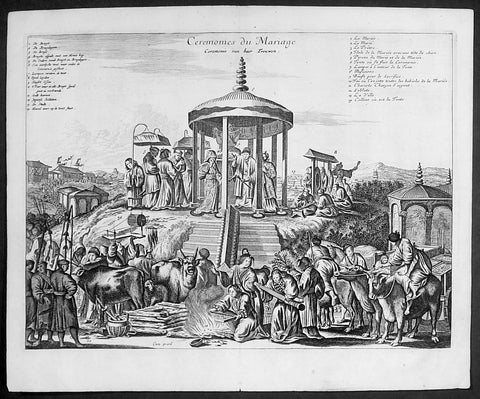
1669 Arnoldus Montanus Large Antique Print of a Japanese Marriage Ceremony 結婚式
- Title : Ceremonies du Mariage
- Date : 1669
- Condition: (A+) Fine Condition
- Ref # : 23411-1
- Size : 14 1/2in x 9in (360mm x 230mm)
Description:
This original copper-plate engraved antique print of a Japanese Marriage Ceremony during the early Edo period of Japanese history, by Arnoldus Montanus was published in the 1669 edition of Gedenkwaerdige Gesantschappen der Oost-Indische Maetschappy int Vereenigde Nederland, aen de Kaisaren van Japan. Getrokken uit de Geschriften en Reiseaentekeninge der zelver Gesanten (Atlas Japannensis being remarkable addresses by way of Embassy from the East India Company of the United Provinces, to the Emperor of Japan)
General Definitions:
Paper thickness and quality: - Heavy and stable
Paper color : - off white
Age of map color: -
Colors used: -
General color appearance: -
Paper size: - 15in x 12in (380mm x 305mm)
Plate size: - 13in x 10in (330mm x 255mm)
Margins: - Min 1in (20mm)
Imperfections:
Margins: - None
Plate area: - None
Verso: - None
Background:
Marriage in the Edo period (1600–1868)
In pre-modern Japan, marriage was inextricable from the ie (家, family or household), the basic unit of society with a collective continuity independent of any individual life. Members of the household were expected to subordinate all their own interests to that of the ie, with respect for an ideal of filial piety and social hierarchy that borrowed much from Confucianism. The choice to remain single was the greatest crime a man could commit, according to Baron Hozumi.
Marriages were duly arranged by the head of the household, who represented it publicly and was legally responsible for its members, and any preference by either principal in a marital arrangement was considered improper. Property was regarded to belong to the ie rather than to individuals, and inheritance was strictly agnatic primogeniture. A woman (女) married the household (家) of her husband, hence the logograms for yome (嫁, wife) and yomeiri (嫁入り, marriage, lit. wife entering).
In the absence of sons, some households would adopt a male heir (養子, or yōshi) to maintain the dynasty, a practice which continues in corporate Japan. Nearly all adoptions are of adult men. Marriage was restricted to households of equal social standing (分限), which made selection a crucial, painstaking process. Although Confucian ethics encouraged people to marry outside their own group, limiting the search to a local community remained the easiest way to ensure an honorable match. Approximately one-in-five marriages in pre-modern Japan occurred between households that were already related.
Outcast communities such as the Burakumin could not marry outside of their caste, and marriage discrimination continued even after an 1871 edict abolished the caste system, well into the twentieth century. Marriage between a Japanese and non-Japanese person was not officially permitted until 14 March 1873, a date now commemorated as White Day. Marriage with a foreigner required the Japanese national to surrender his or her social standing.
The purposes of marriage in the medieval and Edo periods was to form alliances between families, to relieve the family of its female dependents, to perpetuate the family line, and, especially for the lower classes, to add new members to the family\'s workforce. The seventeenth-century treatise Onna Daigaku (Greater Learning for Women) instructed wives honor their parents-in-law before their own parents, and to be courteous, humble, and conciliatory towards their husbands.
Husbands were also encouraged to place the needs of their parents and children before those of their wives. One British observer remarked, If you love your wife you spoil your mother\'s servant. The tension between a housewife and her mother-in-law has been a keynote of Japanese drama ever since.
Romantic love (愛情, aijō) played little part in medieval marriages, as emotional attachment was considered inconsistent with filial piety. A proverb said, Those who come together in passion stay together in tears. For men, sexual gratification was seen as separate from conjugal relations with ones wife, where the purpose was procreation. The genre called Ukiyo-e (浮世絵, lit. floating world pictures) celebrated the luxury and hedonism of the era, typically with depictions of beautiful courtesans and geisha of the pleasure districts. Concubinage and prostitution were common, public, relatively respectable, until the social upheaval of the Meiji Restoration put an end to feudal society in Japan.
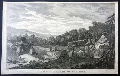
1797 Laperouse Antique Print View De Kastri Bay, Ulchsky Khabarovsk Kai, Russia
- Title : Tombeaux de la Baie de Castries
- Ref : 21436
- Size: 17in x 11in (435mm x 280mm)
- Date : 1797
- Condition: (A+) Fine Condition
Description:
This large original copper plate engraved antique print, a view of the very early settlement at De Kastri Bay, in the Ulchsky District of Khabarovsk Kai, Eastern Russia - opposite the Sakhalin Islands - by Jean-François de Galaup, Comte de la Pérouse was published in the 1st edition of the Atlas du voyage de La Perouse, Paris 1797.
General Definitions:
Paper thickness and quality: - Heavy and stable
Paper color : - off white
Age of map color: -
Colors used: -
General color appearance: -
Paper size: - 17in x 11in (435mm x 280mm)
Plate size: - 17in x 11in (435mm x 280mm)
Margins: - Min 1/2in (12mm)
Imperfections:
Margins: - Small repairs to margins, no loss
Plate area: - None
Verso: - None
Background:
De-Kastri was named for the former name of the bay on which it stands. The bay was discovered by La Pérouse on July 25, 1787 and named after the sponsor of the expedition—the then Secretary of State of the French Navy, the Marquis de Castries. The bay is a convenient natural refuge for vessels, giving it strategic importance from a military viewpoint.
The settlement was officially founded in 1853, although the land where it was situated would not officially be Russian territory until the signing of the Treaty of Aigun five years later.
In 1854, the difficult task of defending Petropavlovsk-Kamchatsky when it came under siege from the British and French forces during the Crimean War brought to attention the difficulties of supply and defense of the Kamchatka Peninsula, where a large section of the Russian Pacific Fleet was based. It was decided to move the port from Kamchatka without waiting for another attack. In the spring of 1855, the Russian navy\'s weapons and sailors under the leadership of Rear Admiral Vasily Zavoyko headed toward the mouth of the Amur River; however, the river mouth was still covered with ice. It was decided to wait for the break-up, hiding in the Bay of de Castries from the superior forces of French and English. Russian ships were discovered there, but managed to escape to the Amur River in the Strait of Tartary before the arrival of enemy reinforcements. The British and French did not know that Sakhalin was an island, and spent the later years of the war waiting in vain for the Russian fleet at its southern coast.
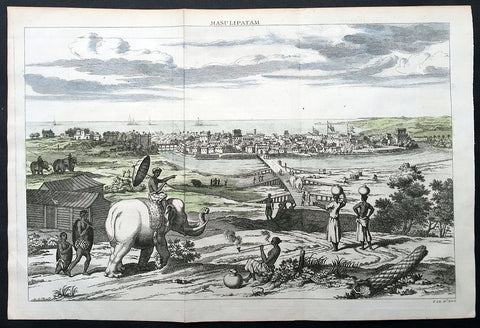
1732 Baldaeus Antique Print a View of Machilipatnam Andhra Pradesh, India
- Title : Masulipatam
- Date : 1732
- Condition: (A+) Fine Condition
- Ref: 25904
- Size: 15in x 10in (380mm x 255mm)
Description:
This fine beautifully hand coloured original antique print a view of the city of Masulipatam (Machilipatnam) on the Malibar Coast in India was published in the 1732 second English edition of Philip Baldaeus "A True and Exact Description of the Most Celebrated East-India Coasts of Malabar and Coromandel; and also of the Isle of Ceylon… London: Awnsham and John Churchill, 1732.
Machilipatnam is a city and the district headquarters of Krishna district, located in Coastal Andhra region of Andhra Pradesh, India. During British rule, the city was their first trading settlement on the Bay of Bengal coast, when it was also known as Masulipatnam or Masula, and as Bandar in folklore, located 72 km to the east of the state capital Vijayawada.
Second edition in English of Baldaeus’ account of his 17th-century travels in south India and Ceylon—one of the first Europeans to publish at length about the region published with 37 copper-engraved views and maps. Father Philippus Baldaeus, Baelde or Philip Balde (October 1632, Delft – 1672, Geervliet) was a Dutch minister. He went to Jaffna, Ceylon with an invading Dutch force during 17th Century. As the first European he documented the life, language and culture of Tamil people, living in the north of the island. It is a great historical record, similar to Mahawamsa, and it was immediately published in Dutch and German (with several beautiful pictures).
Baldaeus had a Flemish origin. His ancestors had left Ypres in 1584. Baldaeus lost both his parents, when he was four years old. His uncle Robertus Junius was a missionary on Dutch Formosa. After studying Oriental languages in Groningen (1649) and theology in Leiden (1650), and discussions with Arnoldus Montanus, he preached from 1655 at Batavia, Dutch East Indies, Jaffanapatnam and Point de Galle, either in Dutch or Portuguese (language). From 1657 he served under Rijklof van Goens, occupying the Coromandel and Negapatnam in 1658. Cornelis Speelman became its first governor. By 1660 the Dutch controlled the whole island except the kingdom of Kandy. When the Dutch occupied the coast of Malabar in 1661, Baldaeus took part. Around 1662 he returned to Ceylon and Baldaeus learned Sanskrit and studied Hinduism.
In 1666 he returned to the Dutch Republic and preached in Geervliet from 1669 until his death at the age of 39 or 40. He left behind a full and faithful account of the civil, religious, and domestic condition of the countries through which he travelled. In this, he introduced also an interesting account of the Hindu mythology, and some specimens of the Tamil language, including the translation of the Lord's Prayer: defective enough it is true, but remarkable as the first treatise, printed in Europe, on any Indian language. The title of the whole work is Description of the East Indian Countries of Malabar, Coromandel, Ceylon, etc. (in Dutch, 1671) The book is dedicated to the bailiff Cornelis de Witt. (Ref: M&B; Tooley)
General Description:
Paper thickness and quality: - Heavy & stable
Paper color: - White
Age of map color: - Early
Colors used: - Blue, green,
General color appearance: - Fresh
Paper size: - 15in x 10in (380mm x 255mm)
Plate size: - 14in x 9 1/2in (360mm x 240mm)
Margins: - Min 1/2in (12mm)
Imperfections:
Margins: - None
Plate area: - Folds as issued
Verso: - None
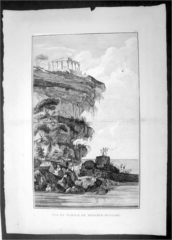
1802 J B Lechevalier Antique Print Temple of Poseidon Cape Sounion Attica Greece
- Title : Vue Du Temple De Minerve-Suniade
- Date : 1802
- Condition: (A+) Fine Condition
- Ref: 70213
- Size: 19 1/4in x 14in (495mm x 355mm)
Description:
This original copper-plate engraved antique print view of the ruins of the Temple of Poseidon, on the cliffs on Cape Sounion, Attica Peninsula, Greece, south of Athens was published in the 1802 edition of Jean-Baptiste Lechevaliers of Voyage de la Troade, fait dans les années 1785 et 1786
General Definitions:
Paper thickness and quality: - Heavy and stable
Paper color : - off white
Age of map color: -
Colors used: -
General color appearance: -
Paper size: - 20in x 14in (510mm x 360mm)
Plate size: - 17 1/2in x 11in (445mm x 280mm)
Margins: - Min 1/2in (12mm)
Imperfections:
Margins: - None
Plate area: - None
Verso: - None
Background:
Cape Sounion is the promontory at the southernmost tip of the Attic peninsula, 8 kilometres south of the town of Lavrio (ancient Thoricus), and 70 kilometres southeast of Athens. It is part of Lavreotiki municipality, East Attica, Greece.
Cape Sounion is noted for its Temple of Poseidon, one of the major monuments of the Golden Age of Athens. Its remains are perched on the headland, surrounded on three sides by the sea.
The original, Archaic-period temple of Poseidon on the site was built of tufa. The Sounion Kouros, discovered in 1906 in a pit east of the temple alongside fragments of other statues, was probably one of a number of votive statues dedicated to Poseidon which probably stood in front of the gods sanctuary. The archaic temple was probably destroyed in 480 BC by Persian troops during Xerxes I\'s invasion of Greece. After they defeated Xerxes in the naval Battle of Salamis, the Athenians placed an entire captured enemy trireme (warship with three banks of oars) at Sounion as a trophy dedicated to Poseidon.
The temple of Poseidon at Sounion was constructed in 444–440 BC. This was during the ascendancy of the Athenian statesman Pericles, who also rebuilt the Parthenon in Athens. It was built on the ruins of a temple dating from the Archaic period. It is perched above the sea at a height of almost 60 metres. The design of the temple is a typical hexastyle, i.e., it had a front portico with six columns. Only some columns of the Sounion temple stand today, but when intact it would have closely resembled the contemporary and well-preserved Temple of Hephaestus beneath the Acropolis, which may have been designed by the same architect.
As with all Greek temples, the Poseidon building was rectangular, with a colonnade on all four sides. The total number of original columns was 36: 15 columns still stand today. The columns are of the Doric Order. They were made of locally quarried white marble. They were 6.10 m high, with a diameter of 1 m (3.1 ft) at the base and 79 cm at the top. At the center of the temple, colonnade would have been the hall of worship (naos), a windowless rectangular room, similar to the partly intact hall at the Temple of Hephaestus. It would have contained, at one end facing the entrance, the cult image, a colossal, ceiling-height (6 metres (20 ft)) bronze statue of Poseidon.
Jean-Baptiste Lechevalier was the secretary of the Ambassador of France in Constantinople. In the year 1788 he visited the plain of Troy, and was enthusiastically in favour of the theory that the site of Homers Troy was to be found at the village of Bunarbashi. His publication about Troy Voyage de la Troade.....was first published in 1799.
The Troad, also known as Troas, is the historical name of the Biga peninsula (Biga Yarımadası, Τρωάς) in the northwestern part of Anatolia, Turkey. This region now is part of the Çanakkale province of Turkey. Bounded by the Dardanelles to the northwest, by the Aegean Sea to the west and separated from the rest of Anatolia by the massif that forms Mount Ida, the Troad is drained by two main rivers, the Scamander (Karamenderes) and the Simois, which join at the area containing the ruins of Troy. Grenikos, Kebren, Simoeis, Rhesos, Rhodios, Heptaporos and Aisepos were seven rivers of the Troad and the names of the river gods that inhabited each river.
Troy (Ancient Greek: Τροία, Troia or Τροίας, Troias, Truva or Troya) was a city in the far northwest of the region known in late Classical antiquity as Asia Minor, now known as Anatolia in modern Turkey, just south of the southwest mouth of the Dardanelles strait and northwest of Mount Ida. The present-day location is known as Hisarlik. It was the setting of the Trojan War described in the Greek Epic Cycle, in particular in the Iliad, one of the two epic poems attributed to Homer. Metrical evidence from the Iliad and the Odyssey suggests that the name λιον (Ilion) formerly began with a digamma: Ϝίλιον (Wilion); this is also supported by the Hittite name for what is thought to be the same city, Wilusa.
A new capital called Ilium (from Greek: λιον, Ilion) was founded on the site in the reign of the Roman Emperor Augustus. It flourished until the establishment of Constantinople, became a bishopric and declined gradually in the Byzantine era, but is now a Latin Catholic titular see.
In 1865, English archaeologist Frank Calvert excavated trial trenches in a field he had bought from a local farmer at Hisarlik, and in 1868, Heinrich Schliemann, a wealthy German businessman and archaeologist, also began excavating in the area after a chance meeting with Calvert in Çanakkale. These excavations revealed several cities built in succession. Schliemann was at first skeptical about the identification of Hisarlik with Troy, but was persuaded by Calvert and took over Calverts excavations on the eastern half of the Hisarlik site, which was on Calvert\'s property. Troy VII has been identified with the city called Wilusa by the Hittites (the probable origin of the Greek λιον) and is generally (but not conclusively) identified with Homeric Troy.
Today, the hill at Hisarlik has given its name to a small village near the ruins, which supports the tourist trade visiting the Troia archaeological site. It lies within the province of Çanakkale, some 30 km south-west of the provincial capital, also called Çanakkale. The nearest village is Tevfikiye. The map here shows the adapted Scamander estuary with Ilium a little way inland across the Homeric plain. Due to Troys location near the Aegean Sea, the Sea of Marmara, and the Black Sea, it was a central hub for the military and trade(Ref: M&B; Tooley)
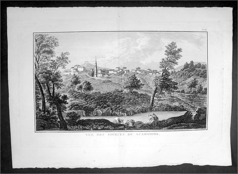
1802 Lechevalier Large Antique Print View of Xanthos or Kinik, Antalya Turkey
- Title : Vue Des Sources Du Scamandre
- Date : 1802
- Condition: (A+) Fine Condition
- Ref: 70225
- Size: 19 1/4in x 14in (495mm x 355mm)
Description:
This original copper-plate engraved antique print view of the source of the Karamenderes (Scamander) River that flowed beneath the ancient Greek city of Troy located in the Troad region of Çanakkale in NW Turkey, was published in the 1802 edition of Jean-Baptiste Lechevaliers of Voyage de la Troade, fait dans les années 1785 et 1786
General Definitions:
Paper thickness and quality: - Heavy and stable
Paper color : - off white
Age of map color: -
Colors used: -
General color appearance: -
Paper size: - 20in x 14in (510mm x 360mm)
Plate size: - 17 1/2in x 11in (445mm x 280mm)
Margins: - Min 1/2in (12mm)
Imperfections:
Margins: - None
Plate area: - None
Verso: - None
Background:
Karamenderes is the modern name of the river Scamander, along the lower course of which, according to the Iliad, the battles of the Trojan War were fought. It flows entirely within the Turkish province of Çanakkale.
Scamander was the name of a river god in Greek mythology.
Scamander fought on the side of the Trojans during the Trojan War (Iliad XX, 73/74; XXI), after the Greek hero Achilles insulted him. Scamander was also said to have attempted to kill Achilles three times, and the hero was only saved due to the intervention of Hera, Athena and Hephaestus. In this context, he is the personification of the Scamander River that flowed from Mount Ida across the plain beneath the city of Troy, joining the Hellespont north of the city. The Achaeans, according to Homer, had set up their camp near its mouth, and their battles with the Trojans were fought on the plain of Scamander. In Iliad XXII (149ff), Homer states that the river had two springs: one produced warm water; the other yielded cold water, regardless of the season.
According to Homer, he was called Xanthos by gods and Scamander by men, which might indicate that the former name refers to the god and the latter one to the river itself
Jean-Baptiste Lechevalier was the secretary of the Ambassador of France in Constantinople. In the year 1788 he visited the plain of Troy, and was enthusiastically in favour of the theory that the site of Homers Troy was to be found at the village of Bunarbashi. His publication about Troy Voyage de la Troade..... was first published in 1799.
The Troad, also known as Troas, is the historical name of the Biga peninsula (Biga Yarımadası, Τρωάς) in the northwestern part of Anatolia, Turkey. This region now is part of the Çanakkale province of Turkey. Bounded by the Dardanelles to the northwest, by the Aegean Sea to the west and separated from the rest of Anatolia by the massif that forms Mount Ida, the Troad is drained by two main rivers, the Scamander (Karamenderes) and the Simois, which join at the area containing the ruins of Troy. Grenikos, Kebren, Simoeis, Rhesos, Rhodios, Heptaporos and Aisepos were seven rivers of the Troad and the names of the river gods that inhabited each river.
Troy (Ancient Greek: Τροία, Troia or Τροίας, Troias, Truva or Troya) was a city in the far northwest of the region known in late Classical antiquity as Asia Minor, now known as Anatolia in modern Turkey, just south of the southwest mouth of the Dardanelles strait and northwest of Mount Ida. The present-day location is known as Hisarlik. It was the setting of the Trojan War described in the Greek Epic Cycle, in particular in the Iliad, one of the two epic poems attributed to Homer. Metrical evidence from the Iliad and the Odyssey suggests that the name λιον (Ilion) formerly began with a digamma: Ϝίλιον (Wilion); this is also supported by the Hittite name for what is thought to be the same city, Wilusa.
A new capital called Ilium (from Greek: λιον, Ilion) was founded on the site in the reign of the Roman Emperor Augustus. It flourished until the establishment of Constantinople, became a bishopric and declined gradually in the Byzantine era, but is now a Latin Catholic titular see.
In 1865, English archaeologist Frank Calvert excavated trial trenches in a field he had bought from a local farmer at Hisarlik, and in 1868, Heinrich Schliemann, a wealthy German businessman and archaeologist, also began excavating in the area after a chance meeting with Calvert in Çanakkale. These excavations revealed several cities built in succession. Schliemann was at first skeptical about the identification of Hisarlik with Troy, but was persuaded by Calvert and took over Calverts excavations on the eastern half of the Hisarlik site, which was on Calvert\'s property. Troy VII has been identified with the city called Wilusa by the Hittites (the probable origin of the Greek λιον) and is generally (but not conclusively) identified with Homeric Troy.
Today, the hill at Hisarlik has given its name to a small village near the ruins, which supports the tourist trade visiting the Troia archaeological site. It lies within the province of Çanakkale, some 30 km south-west of the provincial capital, also called Çanakkale. The nearest village is Tevfikiye. The map here shows the adapted Scamander estuary with Ilium a little way inland across the Homeric plain. Due to Troys location near the Aegean Sea, the Sea of Marmara, and the Black Sea, it was a central hub for the military and trade(Ref: M&B; Tooley)
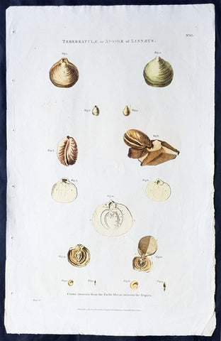
1798 Laperouse Large Antique Print of Shells, Molluscus, Shellfish of Pacific
- Title : Terebratulae, or Anomle of Linnaeus; Cornu Ammonis from the Pacific Ocean between the Tropics.....Published as the act directs Nov 1st 1798 by GG & J Robinson Parnastor Row
- Size: 18in x 11 1/2in (460mm x 295mm)
- Condition: (A+) Fine Condition
- Date : 1798
- Ref #: 31729
Description:
This large original copper plate engraved antique print of various shells, molluscus and shell fish in the Pacific, collected during the voyages of Jean-François de Galaup, Comte de la Pérouse between 1785 to 1788 was engraved in 1798 - dated - and was published in the 1st English edition of the Atlas du voyage de La Perouse G.G & J. Robinson, London in 1799.
La Perouse set sail from France in 1785 to continue the discoveries of Captain Cook. He was shipwrecked in 1788 but his narrative, maps, and views survived and were first published in 1797.
General Definitions:
Paper thickness and quality: - Heavy and stable
Paper color : - off white
Age of map color: -
Colors used: -
General color appearance: -
Paper size: - 18in x 11 1/2in (460mm x 295mm)
Plate size: - 17in x 10 1/2in (430mm x 270mm)
Margins: - Min 1/2in (12mm)
Imperfections:
Margins: - Light age toning in margins
Plate area: - None
Verso: - None
Background:
In 1783 the French government resolved to send an expedition to the Pacific to complete Captain James Cook\'s unfinished work, and in particular to explore the passages in the Bering Sea, which had been a mystery to Europeans since the sixteenth century. King Louis XVI himself took a hand in drafting the plan and itinerary, a copy of which is in the Municipal Library at Rouen, France, and when La Pérouse was selected to lead the fleet gave him an audience before he sailed. In command of two ships, La Boussole and L Astrolabe (Commandant de Langle), he left Brest on 1 August 1785 making for Brazil. Doubling Cape Horn he refitted in Chile, then sailed to the Sandwich Islands and thence to Alaska, where he turned south exploring and surveying the coast as far as California. After a short refit at Monterey, he sailed across the Pacific, discovered uncharted islands, and visited Macao and Manila. After six weeks reprovisioning and refreshing he left on 10 April 1787 to survey the coasts and territories north of Korea, which had been described and commented on by Christian missionaries. He sailed up the Gulf of Tartary, naming several points on both its shores and learned that Sakhalin was an island. In September he put in to Kamchatka to replenish his supplies. From there he dispatched an officer, Lesseps, overland to Paris with accounts of his discoveries, while he turned south making for New Holland. In December, at Tutuila, Samoa, which Bougainville had called the Navigator Islands when he explored them in 1768, natives suddenly attacked a party from L\'Astrolabe seeking water and killed de Langle and eleven others. La Pérouse left without taking reprisals and sailed through the Pacific Islands to Norfolk Island and to Botany Bay. He was sighted off the coast there on 24 January 1788 but bad weather prevented his entering the bay for two days. By then Governor Arthur Phillip had sailed to Port Jackson, but John Hunter had remained with the Sirius and the transports, and assisted La Pérouse to anchor. He established a camp on the northern shore, now called after him, and maintained good relations with the English during his six-week stay. He sailed on 10 March and was not heard of again. His disappearance led the French government in 1791 to equip another expedition under Bruny d Entrecasteaux to look for him, but the search was fruitless.
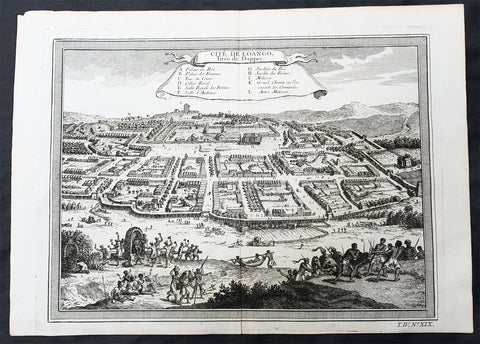
1755 Prevost & Schley Antique Print City View of Mbanza Loango West Congo Africa
- Title:Cite De Loango Tiree de Dapper
- Date: 1755
- Condition : (A+) Fine Condition
- Ref: 25755
- Size: 14in x 10in (355mm x 255mm)
Description:
This fine, original copper-plate engraved antique print, view of the city of Mbanza Loango in the pre-colonial African Kingdom of Loango - now part of the of western part of the Republic of the Congo - by Jakob van Schley in 1755 - after Olfert Dapper - was published in Antoine François Prevosts 15 volumes of Histoire Generale des Voyages written by Prevost & other authors between 1746-1789.
General Definitions:
Paper thickness and quality: - Heavy and stable
Paper color : - off white
Age of map color: -
Colors used: -
General color appearance: -
Paper size: - 14in x 10in (355mm x 255mm)
Plate size: - 12 1/2in x 9 1/2in (320mm x 240mm)
Margins: - Min 1/2in (5mm)
Imperfections:
Margins: - None
Plate area: - None
Verso: - None
Background:
The Kingdom of Loango was a pre-colonial African state, during approximately the 16th to 19th centuries in what is now the western part of the Republic of the Congo. Situated to the north of the more powerful Kingdom of Kongo, at its height in the 17th century Loango influence extended from Cape St Catherine in the north to almost the mouth of the Congo River.
Loango exported copper to the European market, and was a major producer and exporter of cloth.
The English traveller Andrew Battel, when he was there in about 1610, recorded that the predecessor of the unnamed king ruling at that time was named \"Gembe\" or Gymbe (modernized as Njimbe), possibly the founder of the kingdom. With the death of King Buatu in 1787, the succession of leadership is uncertain.
The kingdom is certain to have come to an end with the Conference of Berlin (1884–1885) at the latest, when European colonial powers divided most of Central Africa between them.
The origins of the kingdom are obscure. The most ancient complex society in the region was at Madingo Kayes, which was already a multi-site settlement in the first century CE. At present archaeological evidence is too scarce to say much more about developments until the late fifteenth or early sixteenth centuries.
Loango is not mentioned in early travelers\' accounts of the region, nor is it mentioned in the titles of King Afonso I of Kongo in 1535, though Kakongo, Vungu, and Ngoyo, its southern neighbors. It is therefore unlikely that there was a major power on the coast of Central Africa north of the Congo River.
The earliest reference to Loango in a documentary source is a mention around 1561 by Sebastião de Souto, a priest in Kongo, that King Diogo I (1545–61) sent missionaries to convert Loango to Christianity. Duarte Lopes, ambassador from Kongo to the Holy See in Rome in 1585, related that \"Loango is a friend of the King of Congo and it is said that he was a vassal in past times\" which is consistent with Loango\'s origins from Kakongo, a vassal of Kongo.
Dutch visitors recorded the first traditional account of the kingdom\'s origin in the 1630s or \'40s. In their account as reported by the geographer Olfert Dapper, the region where Loango would be constructed was populated by a number of small polities including Mayumba, Kilongo, Piri and Wansi, \"each with their own leader\" who \"made war on each other.\" He recorded that the founder of Loango, who boasted hailing from the district in Nzari in the small coastal kingdom of Kakongo, itself a vassal of Kongo, triumphed over all his rivals through the skillful use of alliances to defeat those who opposed him, particularly Wansa, Kilongo and Piri, the latter two of which required two wars to subdue. Once this had been effected, however, a range of more northern regions, including Docke and Sette submitted voluntarily. Having succeeded in the conquest, the new king moved northward and after having founded settlements in a variety of places, eventually built his capital in Buali in the province of Piri (from which the ethnic name \"Muvili\" eventually derived).
The English traveller Andrew Battel wrote when he was there in about 1610, that the predecessor of the unnamed king ruling at that time was named \"Gembe\" or \"Gymbe\" (modernized as \"Njimbe\"). A Dutch description published in 1625 said that a ruler who had died sometime before that date had ruled for 60 years and thus had taken the throne around 1565. The documentary chronology thus makes it very likely that Njimbe was the founder and first ruler mentioned in the traditions, and this supposition is supported by traditions recorded around 1890 by R. E. Dennett which also named Njimbe as the first ruler.
On the basis of later traditions from the nineteenth and twentieth centuries that linked the founding of Loango to that of Kongo, Phyllis Martin posited a much earlier foundation, the late fourteenth or early fifteenth centuries. She then argues that the absence of Loango from early titles of the king of Kongo is evidence that Loango was already independent at that time.
Njimbe had created a rule of succession which was in place around 1600, in which the king gave command over four provinces to members of his family, called the provinces of Kaye, Boke, Selage, and Kabango, and the king was to be chosen from a rotation between them. When the king died the ruler of Kaye took over, as he did indeed in the pre-1624 succession, and if the rule was followed then the ruler of Boke took his place; the other two provincial rulers advanced as well, and the king appointed a new ruler for Kabango.
In 1663, the king ruling then was baptized as Afonso by the Italian Capuchin priest Bernardo Ungaro, but there was considerable opposition to this from within the country, and indeed when he died, a non-Christian took over, but this one was himself overthrown by one of the Christian party in 1665. This civil war was still ongoing in the 1670s. In the aftermath of this civil war, a number of the Christian party fled to neighboring territories, one of whom, known to history as Miguel da Silva, was elected ruler of Ngoyo and was ruling there in 1682.
When Nathaniel Uring, an English merchant came to Loango to trade in 1701, he reported that the king had died and the power of the administration was in the hands of the \"Queen or Chief Governess of that Country,\" named \"Mucundy\" and with whom he had to deal as if with the ruler.[20] This title referred to a woman with a regular role in the administration as overseer of women\'s affairs.
Many years elapsed before we have another snapshot of Loango\'s government; during this time the rules of succession, whether formal or informal seem to have changed. When the French missionaries directed by Abbé Liévin-Bonaventure Proyart came to Loango in 1766, they noted that there was no clear succession to the throne, that anyone born of a person regarded as a princess (only female succession mattered) could aspire to the throne. Moreover, the death of a king was cause for a frequently long interregnum; the king ruling in 1766 had come to power only after an interregnum of seven years, during which time the affairs of the country were managed by a regent called Mani Boman. The Mani Boman was appointed by the king during his lifetime. Usually two were appointed to cover the eventuality of the death of one of the two. They, in turn received the petitions of a number of eligible candidates for the throne.
Eventually, the electors of the kingdom, who were those who held offices appointed by the late king, met to decide on the next king. In theory, as the old constitution maintained, the king named his successor as well and placed him as ruler of Kaye, to succeed him at his death, but as there was so much contention as to who should hold the position, the late king died without naming a Ma-Kaye.
Historian Phyllis Martin contends that the external trade of the country had enriched some members of the nobility ahead of others and had thus put pressure on the older constitution as wealthier upstart princes pressed their case forward. She argues that important members of the council were people who had obtained their positions through contact with external trade, particularly the slave trade, and they had come to share power with the king. She posits that this alteration in relative power allowed the council to dominate the king by forcing longer and longer interregna. In fact, after the death of King Buatu in 1787, no king was elected for over 100 years.However, to some extent royal authority remained in the hands of a person entitled the Nganga Mvumbi (priest of the corpse) who oversaw the body of the dead king awaiting burial. Several of these Nganga Mvumbi succeeded each other in the late eighteenth and through the nineteenth centuries.
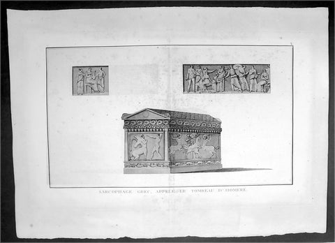
1802 J B Lechevalier Antique Print The Sarcophagus of the Greek Author, Homer
- Title : Sarcophage Grec, Appele Le Tombeau D Homere
- Date : 1802
- Condition: (A) Very Good Condition
- Ref: 70216
- Size: 19 1/4in x 14in (495mm x 355mm)
Description:
This original copper-plate engraved antique print of a Greek Sarcophagus, believe to be that of the ancient Greek Philosopher Homer, was published in the 1802 edition of Jean-Baptiste Lechevaliers of Voyage de la Troade, fait dans les années 1785 et 1786
General Definitions:
Paper thickness and quality: - Heavy and stable
Paper color : - off white
Age of map color: -
Colors used: -
General color appearance: -
Paper size: - 20in x 14in (510mm x 360mm)
Plate size: - 17 1/2in x 10 3/4in (445mm x 275mm)
Margins: - Min 1/2in (12mm)
Imperfections:
Margins: - Light soiling
Plate area: - Light toning along centerfold
Verso: - Light soiling
Background:
Homer is the legendary author of the Iliad and the Odyssey, two epic poems that are the central works of ancient Greek literature. The Iliad is set during the Trojan War, the ten-year siege of the city of Troy by a coalition of Greek kingdoms. It focuses on a quarrel between King Agamemnon and the warrior Achilles lasting a few weeks during the last year of the war. The Odyssey focuses on the journey home of Odysseus, king of Ithaca, around 20 years after the fall of Troy. Many accounts of Homer\'s life circulated in classical antiquity, the most widespread being that he was a blind bard from Ionia, a region of central coastal Anatolia in present-day Turkey. Modern scholars consider them legends.
The Homeric Question—concerning by whom, when, where and under what circumstances the Iliad and Odyssey were composed—continues to be debated. Broadly speaking, modern scholarly opinion falls into two groups. One holds that most of the Iliad and (according to some) the Odyssey are the works of a single poet of genius. The other considers the Homeric poems to be the result of a process of working and reworking by many contributors, and that Homer is best seen as a label for an entire tradition. It is generally accepted that the poems were composed at some point around the late eighth or early seventh century BC.
The poems are in Homeric Greek, also known as Epic Greek, a literary language which shows a mixture of features of the Ionic and Aeolic dialects from different centuries; the predominant influence is Eastern Ionic. Most researchers believe that the poems were originally transmitted orally. From antiquity until the present day, the influence of the Homeric epics on Western civilization has been great, inspiring many of its most famous works of literature, music, art and film. The Homeric epics were the greatest influence on ancient Greek culture and education; to Plato, Homer was simply the one who has taught Greece – ten Hellada pepaideuken
Jean-Baptiste Lechevalier was the secretary of the Ambassador of France in Constantinople. In the year 1788 he visited the plain of Troy, and was enthusiastically in favour of the theory that the site of Homers Troy was to be found at the village of Bunarbashi. His publication about Troy Voyage de la Troade.....was first published in 1799.
The Troad, also known as Troas, is the historical name of the Biga peninsula (Biga Yarımadası, Τρωάς) in the northwestern part of Anatolia, Turkey. This region now is part of the Çanakkale province of Turkey. Bounded by the Dardanelles to the northwest, by the Aegean Sea to the west and separated from the rest of Anatolia by the massif that forms Mount Ida, the Troad is drained by two main rivers, the Scamander (Karamenderes) and the Simois, which join at the area containing the ruins of Troy. Grenikos, Kebren, Simoeis, Rhesos, Rhodios, Heptaporos and Aisepos were seven rivers of the Troad and the names of the river gods that inhabited each river.
Troy (Ancient Greek: Τροία, Troia or Τροίας, Troias, Truva or Troya) was a city in the far northwest of the region known in late Classical antiquity as Asia Minor, now known as Anatolia in modern Turkey, just south of the southwest mouth of the Dardanelles strait and northwest of Mount Ida. The present-day location is known as Hisarlik. It was the setting of the Trojan War described in the Greek Epic Cycle, in particular in the Iliad, one of the two epic poems attributed to Homer. Metrical evidence from the Iliad and the Odyssey suggests that the name λιον (Ilion) formerly began with a digamma: Ϝίλιον (Wilion); this is also supported by the Hittite name for what is thought to be the same city, Wilusa.
A new capital called Ilium (from Greek: λιον, Ilion) was founded on the site in the reign of the Roman Emperor Augustus. It flourished until the establishment of Constantinople, became a bishopric and declined gradually in the Byzantine era, but is now a Latin Catholic titular see.
In 1865, English archaeologist Frank Calvert excavated trial trenches in a field he had bought from a local farmer at Hisarlik, and in 1868, Heinrich Schliemann, a wealthy German businessman and archaeologist, also began excavating in the area after a chance meeting with Calvert in Çanakkale. These excavations revealed several cities built in succession. Schliemann was at first skeptical about the identification of Hisarlik with Troy, but was persuaded by Calvert and took over Calverts excavations on the eastern half of the Hisarlik site, which was on Calvert\'s property. Troy VII has been identified with the city called Wilusa by the Hittites (the probable origin of the Greek λιον) and is generally (but not conclusively) identified with Homeric Troy.
Today, the hill at Hisarlik has given its name to a small village near the ruins, which supports the tourist trade visiting the Troia archaeological site. It lies within the province of Çanakkale, some 30 km south-west of the provincial capital, also called Çanakkale. The nearest village is Tevfikiye. The map here shows the adapted Scamander estuary with Ilium a little way inland across the Homeric plain. Due to Troys location near the Aegean Sea, the Sea of Marmara, and the Black Sea, it was a central hub for the military and trade(Ref: M&B; Tooley)
1798 Laperouse Large Antique Print of Sea Urchins of NW America, California
- Title : Echini Marini, or Sea Urchins, of the North West Coast of America. Published as the (act) directs Novr. 1st 1798, by G.G. & J. Robinson
- Size: 16 1/2in x 10 1/2in (420mm x 265mm)
- Condition: (A+) Fine Condition
- Date : 1798
- Ref #: 31738
Description:
This large original copper plate engraved antique print of various Sea Urchins found off the NW coast of America, collected during the voyages of Jean-François de Galaup, Comte de la Pérouse between 1785 to 1788 was engraved in 1798 - dated - and was published in the 1st English edition of the Atlas du voyage de La Perouse G.G & J. Robinson, London in 1799.
La Perouse set sail from France in 1785 to continue the discoveries of Captain Cook. He was shipwrecked in 1788 but his narrative, maps, and views survived and were first published in 1797.
General Definitions:
Paper thickness and quality: - Heavy and stable
Paper color : - off white
Age of map color: -
Colors used: -
General color appearance: -
Paper size: - 16 1/2in x 10 1/2in (420mm x 265mm)
Plate size: - 16 1/2in x 10 1/2in (420mm x 265mm)
Margins: - Min 1/2in (12mm)
Imperfections:
Margins: - Light age toning in margins
Plate area: - None
Verso: - None
Background:
In 1783 the French government resolved to send an expedition to the Pacific to complete Captain James Cook\'s unfinished work, and in particular to explore the passages in the Bering Sea, which had been a mystery to Europeans since the sixteenth century. King Louis XVI himself took a hand in drafting the plan and itinerary, a copy of which is in the Municipal Library at Rouen, France, and when La Pérouse was selected to lead the fleet gave him an audience before he sailed. In command of two ships, La Boussole and L Astrolabe (Commandant de Langle), he left Brest on 1 August 1785 making for Brazil. Doubling Cape Horn he refitted in Chile, then sailed to the Sandwich Islands and thence to Alaska, where he turned south exploring and surveying the coast as far as California. After a short refit at Monterey, he sailed across the Pacific, discovered uncharted islands, and visited Macao and Manila. After six weeks reprovisioning and refreshing he left on 10 April 1787 to survey the coasts and territories north of Korea, which had been described and commented on by Christian missionaries. He sailed up the Gulf of Tartary, naming several points on both its shores and learned that Sakhalin was an island. In September he put in to Kamchatka to replenish his supplies. From there he dispatched an officer, Lesseps, overland to Paris with accounts of his discoveries, while he turned south making for New Holland. In December, at Tutuila, Samoa, which Bougainville had called the Navigator Islands when he explored them in 1768, natives suddenly attacked a party from L\'Astrolabe seeking water and killed de Langle and eleven others. La Pérouse left without taking reprisals and sailed through the Pacific Islands to Norfolk Island and to Botany Bay. He was sighted off the coast there on 24 January 1788 but bad weather prevented his entering the bay for two days. By then Governor Arthur Phillip had sailed to Port Jackson, but John Hunter had remained with the Sirius and the transports, and assisted La Pérouse to anchor. He established a camp on the northern shore, now called after him, and maintained good relations with the English during his six-week stay. He sailed on 10 March and was not heard of again. His disappearance led the French government in 1791 to equip another expedition under Bruny d Entrecasteaux to look for him, but the search was fruitless.
1755 Prevost & Schley Antique Print of Artifacts Recovered from Inca Burial Tomb
- Title: Puvrages qui se trouvent dans les Tombeaux des anciens Peruviens
- Date: 1755
- Condition : (A+) Fine Condition
- Ref: 34132
- Size: 15in x 10in (385mm x 255mm)
Description:
This fine, original copper-plate engraved antique print of artifacts found in an Inca Tomb in Peru by Jakob van Schley in 1755 - after De Bry - was published in Antoine François Prevosts 15 volumes of Histoire Generale des Voyages written by Prevost & other authors between 1746-1790.
The Inca Empire also known as the Incan Empire and the Inka Empire, was the largest empire in pre-Columbian America, and possibly the largest empire in the world in the early 16th century. Its political and administrative structure \"was the most sophisticated found among native peoples\" in the Americas.The administrative, political and military center of the empire was located in Cusco in modern-day Peru. The Inca civilization arose from the highlands of Peru sometime in the early 13th century. Its last stronghold was conquered by the Spanish in 1572.
From 1438 to 1533, the Incas incorporated a large portion of western South America, centered on the Andean Mountains, using conquest and peaceful assimilation, among other methods. At its largest, the empire joined Peru, large parts of modern Ecuador, western and south central Bolivia, northwest Argentina, north and central Chile and a small part of southwest Colombia into a state comparable to the historical empires of Eurasia. Its official language was Quechua.Many local forms of worship persisted in the empire, most of them concerning local sacred Huacas, but the Inca leadership encouraged the worship of Inti – their sun god – and imposed its sovereignty above other cults such as that of Pachamama. The Incas considered their king, the Sapa Inca, to be the \"son of the sun.\"
The Inca Empire was unique in that it lacked many features associated with civilization in the Old World. In the words of one scholar, \"The Incas lacked the use of wheeled vehicles. They lacked animals to ride and draft animals that could pull wagons and plows... [They] lacked the knowledge of iron and steel... Above all, they lacked a system of writing... Despite these supposed handicaps, the Incas were still able to construct one of the greatest imperial states in human history\". Notable features of the Inca Empire include its monumental architecture, especially stonework, extensive road network reaching all corners of the empire, finely-woven textiles, use of knotted strings (quipu) for record keeping and communication, agricultural innovations in a difficult environment, and the organization and management fostered or imposed on its people and their labor.
The Incan economy has been described in contradictory ways by scholars: as \"feudal, slave, socialist (here one may choose between socialist paradise or socialist tyranny)\". The Inca empire functioned largely without money and without markets. Instead, exchange of goods and services was based on reciprocity between individuals and among individuals, groups, and Inca rulers. \"Taxes\" consisted of a labor obligation of a person to the Empire. The Inca rulers (who theoretically owned all the means of production) reciprocated by granting access to land and goods and providing food and drink in celebratory feasts for their subjects.
General Definitions:
Paper thickness and quality: - Heavy and stable
Paper color : - off white
Age of map color: - Early
Colors used: - Yellow, green, red
General color appearance: - Authentic
Paper size: - 15in x 10in (385mm x 255mm)
Plate size: - 14in x 8 1/2in (355mm x 220mm)
Margins: - Min 1in (25mm)
Imperfections:
Margins: - None
Plate area: - Folds as issued
Verso: - None
Background:
One of Antoine Francois Prevosts monumental undertakings was his history of exploration & discovery in 15 volumes titledHistoire Générale des Voyages written between 1746-1759 and was extended to 20 volumes after his death by various authors.
The 20 volumes cover the early explorations & discoveries on 3 continents: Africa (v. 1-5), Asia (v. 5-11), and America (v. 12-15) with material on the finding of the French, English, Dutch, and Portugese.
A number of notable cartographers and engravers contributed to the copper plate maps and views to the 20 volumes including Nicolas Bellin, Jan Schley, Chedel, Franc Aveline, Fessard, and many others.
The African volumes cover primarily coastal countries of West, Southern, and Eastern Africa, plus the Congo, Madagascar, Arabia and the Persian Gulf areas.
The Asian volumes cover China, Korea, Tibet, Japan, Philippines, and countries bordering the Indian Ocean.
Volume 11 includes Australia and Antarctica.
Volumes 12-15 cover voyages and discoveries in America, including the East Indies, South, Central and North America.
Volumes 16-20 include supplement volumes & tables along with continuation of voyages and discoveries in Russia, Northern Europe, America, Asia & Australia.
Jakob van der Schley aka Jakob van Schley (1715 - 1779) was a Dutch draughtsman and engraver. He studied under Bernard Picart (1673-1733) whose style he subsequently copied. His main interests were engraving portraits and producing illustrations for \\\"La Vie de Marianne\\\" by Pierre Carlet de Chamblain de Marivaux (1688-1763) published in The Hague between 1735 and 1747.
He also engraved the frontispieces for a 15-volume edition of the complete works of Pierre de Brantôme (1540-1614), \\\"Oeuvres du seigneur de Brantôme\\\", published in The Hague in 1740.
He is also responsible for most of the plates in the Hague edition of Prévosts Histoire générale des voyages. (Ref: Tooley; M&B)
1802 J B Lechevalier Antique Print Temple Apollo Ruins Gülpınar Çanakkale Turkey
- Title : Ruines Du Temple D Apollon Thymbreen; Inscription Trouvee dans les Ruines du Temple d Apollon
- Date : 1802
- Condition: (A+) Fine Condition
- Ref: 70222
- Size: 19 1/4in x 14in (495mm x 355mm)
Description:
This original copper-plate engraved antique print view of the ruins of the Temple of Apollo in the ancient city of Hamaxitus in the Troad region of NW Turkey - with Greek inscription from the temple - was published in the 1802 edition of Jean-Baptiste Lechevaliers of Voyage de la Troade, fait dans les années 1785 et 1786
General Definitions:
Paper thickness and quality: - Heavy and stable
Paper color : - off white
Age of map color: -
Colors used: -
General color appearance: -
Paper size: - 20in x 14in (510mm x 360mm)
Plate size: - 15in x 9 1/2in (380mm x 240mm)
Margins: - Min 1/2in (12mm)
Imperfections:
Margins: - Light soiling
Plate area: - Light toning along centerfold
Verso: - Light soiling
Background:
Hamaxitus was an ancient Greek city in the south-west of the Troad region of Anatolia which was considered to mark the boundary between the Troad and Aeolis. Its surrounding territory was known in Greek as Ἁμαξιτία (Hamaxitia) and included the temple of Apollo Smintheus, the salt pans at Tragasai, and the Satnioeis river (modern Tuzla Çay). It has been located on a rise called Beşiktepe near the village of Gülpınar (previously Külahlı) in the Ayvacık district of Çanakkale Province, Turkey
Jean-Baptiste Lechevalier was the secretary of the Ambassador of France in Constantinople. In the year 1788 he visited the plain of Troy, and was enthusiastically in favour of the theory that the site of Homers Troy was to be found at the village of Bunarbashi. His publication about Troy Voyage de la Troade.....was first published in 1799.
The Troad, also known as Troas, is the historical name of the Biga peninsula (Biga Yarımadası, Τρωάς) in the northwestern part of Anatolia, Turkey. This region now is part of the Çanakkale province of Turkey. Bounded by the Dardanelles to the northwest, by the Aegean Sea to the west and separated from the rest of Anatolia by the massif that forms Mount Ida, the Troad is drained by two main rivers, the Scamander (Karamenderes) and the Simois, which join at the area containing the ruins of Troy. Grenikos, Kebren, Simoeis, Rhesos, Rhodios, Heptaporos and Aisepos were seven rivers of the Troad and the names of the river gods that inhabited each river.
Troy (Ancient Greek: Τροία, Troia or Τροίας, Troias, Truva or Troya) was a city in the far northwest of the region known in late Classical antiquity as Asia Minor, now known as Anatolia in modern Turkey, just south of the southwest mouth of the Dardanelles strait and northwest of Mount Ida. The present-day location is known as Hisarlik. It was the setting of the Trojan War described in the Greek Epic Cycle, in particular in the Iliad, one of the two epic poems attributed to Homer. Metrical evidence from the Iliad and the Odyssey suggests that the name λιον (Ilion) formerly began with a digamma: Ϝίλιον (Wilion); this is also supported by the Hittite name for what is thought to be the same city, Wilusa.
A new capital called Ilium (from Greek: λιον, Ilion) was founded on the site in the reign of the Roman Emperor Augustus. It flourished until the establishment of Constantinople, became a bishopric and declined gradually in the Byzantine era, but is now a Latin Catholic titular see.
In 1865, English archaeologist Frank Calvert excavated trial trenches in a field he had bought from a local farmer at Hisarlik, and in 1868, Heinrich Schliemann, a wealthy German businessman and archaeologist, also began excavating in the area after a chance meeting with Calvert in Çanakkale. These excavations revealed several cities built in succession. Schliemann was at first skeptical about the identification of Hisarlik with Troy, but was persuaded by Calvert and took over Calverts excavations on the eastern half of the Hisarlik site, which was on Calvert\'s property. Troy VII has been identified with the city called Wilusa by the Hittites (the probable origin of the Greek λιον) and is generally (but not conclusively) identified with Homeric Troy.
Today, the hill at Hisarlik has given its name to a small village near the ruins, which supports the tourist trade visiting the Troia archaeological site. It lies within the province of Çanakkale, some 30 km south-west of the provincial capital, also called Çanakkale. The nearest village is Tevfikiye. The map here shows the adapted Scamander estuary with Ilium a little way inland across the Homeric plain. Due to Troys location near the Aegean Sea, the Sea of Marmara, and the Black Sea, it was a central hub for the military and trade(Ref: M&B; Tooley)
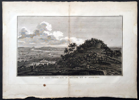
1802 J B Lechevalier Antique Print Tomb of Hector, Ophryneion in Troad, Turkey
- Title : Vue Des Tombeaux D Hector et D Aisyetes
- Date : 1802
- Size: 19 1/2in x 13 1/2in (495mm x 345mm)
- Ref: 70226
- Condition: (A+) Fine Condition
Description:
This original copper-plate engraved antique print a view of the Tombs of Hector & Aesyetes located in the ancient Greek city of Ophryneion in the Troad region of Çanakkale, now in NW modern Turkey, was published in the 1802 edition of Jean-Baptiste Lechevaliers of Voyage de la Troade, fait dans les années 1785 et 1786
General Definitions:
Paper thickness and quality: - Heavy and stable
Paper color : - off white
Age of map color: -
Colors used: -
General color appearance: -
Paper size: - 19 1/2in x 13 1/2in (495mm x 345mm)
Plate size: - 17 1/2in x 10 3/4in (445mm x 275mm)
Margins: - Min 1/2in (12mm)
Imperfections:
Margins: - Light soiling
Plate area: - Light toning along centerfold
Verso: - Light soiling
Background:
Ophryneion was an ancient Greek city in the northern Troad region of Anatolia. Its territory was bounded to the west by Rhoiteion and to the east by Dardanos. It was located about 1.5 km north-east of the village of İntepe (previously known as Erenköy) in Çanakkale Province, Turkey. The city was situated on the steep brow of a hill overlooking the Dardanelles, hence the origin of its Ancient Greek name ὀφρῦς (ophrus), meaning \'brow of a hill\', crag
In Greek mythology, Aesyetes was a Trojan hero and father of Alcathous. His tomb was the vantage point which Polites, son of Priam, used to scout the Greek camp during the Trojan War.
Aesyetes was also given as the father of Antenor by Cleomestra.
In Greek mythology and Roman mythology, Hector was a Trojan prince and the greatest fighter for Troy in the Trojan War. As the first-born son of King Priam and Queen Hecuba, who was a descendant of Dardanus and Tros, the founder of Troy, he was a prince of the royal house and the heir apparent to his fathers throne. He was married to Andromache, with whom he had an infant son, Scamandrius (whom the people of Troy called Astyanax). He acted as leader of the Trojans and their allies in the defence of Troy, killing 31,000 Greek fighters, offers Hyginus. During the European Middle Ages, Hector figures as one of the Nine Worthies noted by Jacques de Longuyon, known not only for his courage but also for his noble and courtly nature. Indeed, Homer places Hector as peace-loving, thoughtful as well as bold, a good son, husband and father, and without darker motives. James Redfield describes Hector as a martyr to loyalties, a witness to the things of this world, a hero ready to die for the precious imperfections of ordinary life.
The most valuable historical evidence for the Battle of Troy are treaties and letters mentioned in Hittite cuneiform texts of the same approximate era, which mention an unruly Western Anatolian warlord named Piyama-Radu (possibly Priam) and his successor Alaksandu (possibly Alexander, the nickname of Paris) both based in Wilusa (possibly Ilion/Ilios), as well as the god Apaliunas (possibly Apollo).
Other such pieces of evidence are names of Trojan heroes in Linear B tablets. Twenty out of fifty-eight men\'s names also known from Homer, including E-ko-to (Hector) are Trojan warriors and some, including Hector, are in a servile capacity. No such conclusion that they are the offspring of Trojan captive women is warranted. Generally the public has to be content with the knowledge that these names existed in Greek in Mycenaean times, although Page hypothesizes that Hector may very well be ... a familiar Greek form impressed on a similar-sounding foreign name.
When Pausanias visited Thebes in Boeotia, in the second century AD, he was shown Hector\'s tomb and was told that the bones had been transported to Thebes according to a Delphic oracle. Moses I. Finley observes this typical bit of fiction must mean that there was an old Theban hero Hector, a Greek, whose myths antedated the Homeric poems. Even after Homer had located Hector in Troy for all time, the Thebans held on to their hero, and the Delphic oracle provided the necessary sanction.
The pseudepigraphical writer Dares Phrygius states that Hector \"spoke with a slight lisp. His complexion was fair, his hair curly. His eyes would blink attractively. His movements were swift. His face, with its beard, was noble. He was handsome, fierce, and high-spirited, merciful to the citizens, and deserving of love
Jean-Baptiste Lechevalier was the secretary of the Ambassador of France in Constantinople. In the year 1788 he visited the plain of Troy, and was enthusiastically in favour of the theory that the site of Homers Troy was to be found at the village of Bunarbashi. His publication about Troy Voyage de la Troade.....was first published in 1799.
The Troad, also known as Troas, is the historical name of the Biga peninsula (Biga Yarımadası, Τρωάς) in the northwestern part of Anatolia, Turkey. This region now is part of the Çanakkale province of Turkey. Bounded by the Dardanelles to the northwest, by the Aegean Sea to the west and separated from the rest of Anatolia by the massif that forms Mount Ida, the Troad is drained by two main rivers, the Scamander (Karamenderes) and the Simois, which join at the area containing the ruins of Troy. Grenikos, Kebren, Simoeis, Rhesos, Rhodios, Heptaporos and Aisepos were seven rivers of the Troad and the names of the river gods that inhabited each river.
Troy (Ancient Greek: Τροία, Troia or Τροίας, Troias, Truva or Troya) was a city in the far northwest of the region known in late Classical antiquity as Asia Minor, now known as Anatolia in modern Turkey, just south of the southwest mouth of the Dardanelles strait and northwest of Mount Ida. The present-day location is known as Hisarlik. It was the setting of the Trojan War described in the Greek Epic Cycle, in particular in the Iliad, one of the two epic poems attributed to Homer. Metrical evidence from the Iliad and the Odyssey suggests that the name λιον (Ilion) formerly began with a digamma: Ϝίλιον (Wilion); this is also supported by the Hittite name for what is thought to be the same city, Wilusa.
A new capital called Ilium (from Greek: λιον, Ilion) was founded on the site in the reign of the Roman Emperor Augustus. It flourished until the establishment of Constantinople, became a bishopric and declined gradually in the Byzantine era, but is now a Latin Catholic titular see.
In 1865, English archaeologist Frank Calvert excavated trial trenches in a field he had bought from a local farmer at Hisarlik, and in 1868, Heinrich Schliemann, a wealthy German businessman and archaeologist, also began excavating in the area after a chance meeting with Calvert in Çanakkale. These excavations revealed several cities built in succession. Schliemann was at first skeptical about the identification of Hisarlik with Troy, but was persuaded by Calvert and took over Calverts excavations on the eastern half of the Hisarlik site, which was on Calvert\'s property. Troy VII has been identified with the city called Wilusa by the Hittites (the probable origin of the Greek λιον) and is generally (but not conclusively) identified with Homeric Troy.
Today, the hill at Hisarlik has given its name to a small village near the ruins, which supports the tourist trade visiting the Troia archaeological site. It lies within the province of Çanakkale, some 30 km south-west of the provincial capital, also called Çanakkale. The nearest village is Tevfikiye. The map here shows the adapted Scamander estuary with Ilium a little way inland across the Homeric plain. Due to Troys location near the Aegean Sea, the Sea of Marmara, and the Black Sea, it was a central hub for the military and trade(Ref: M&B; Tooley)
1802 J B Lechevalier Antique Print Bronze Figure, Vases in Achilles Tomb Turkey
- Title : Figure de bronze et vases cineraires, trouves dans le tombeau d Achille
- Date : 1802
- Condition: (A+) Fine Condition
- Ref: 70228
- Size: 14in x 10in (355mm x 255mm)
Description:
This original copper-plate engraved antique print of a Bronze Figure and a pair of Vases found in the Tomb of Achilles located in the ancient Greek city of Achilleion in the Troad region of Çanakkale, now in NW modern Turkey, was published in the 1802 edition of Jean-Baptiste Lechevaliers of Voyage de la Troade, fait dans les années 1785 et 1786
General Definitions:
Paper thickness and quality: - Heavy and stable
Paper color : - off white
Age of map color: -
Colors used: -
General color appearance: -
Paper size: - 14in x 10in (355mm x 255mm)
Plate size: - 7in x 5in (180mm x 130mm) each plate
Margins: - Min 1/2in (12mm)
Imperfections:
Margins: - Light soiling
Plate area: - None
Verso: - None
Background:
Achilleion was an ancient Greek city in the south-west of the Troad region of Anatolia. It has been located on a promontory known as Beşika Burnu (cradle promontory) about 8 km south of Sigeion. Beşika Burnu is 2 km south of the modern village of Yeniköy in the Ezine district of Çanakkale Province, Turkey. The site considered in classical antiquity to be the tomb of Achilles is a short distance inland at a tumulus known as Beşiktepe. Achilleion in the Troad is not to be confused with Achilleion near Smyrna and Achilleion in the territory of Tanagra.
The otherwise obscure polis of Achilleion was most famous in classical antiquity for its association with Achilles, after whom it was named (the place of Achilles). According to some sources, while passing by Ilion in 334 BC Alexander the Great sacrificed at the Tomb of Achilles. This story became famous, and in the mid-1st century BC it is mentioned by the politician and writer Cicero in his Pro Archia Poeta. In AD 216 the Emperor Caracalla emulated Alexander when, on passing Ilion on his way to a war against Parthia, he held funeral games around the tumulus. Following the abandonment of the settlement at Achilleion in the late Hellenistic period, writers began to associate the tomb with nearby Sigeion to the north.
The first mention of Achilleion is as a fortified settlement from which Mytilene conducted its attacks on Athenian controlled Sigeion to the north in the early 6th century BCE. It is not clear whether Achilleion had been settled earlier, but the ceramic record also begins at this point, suggesting that it had not. Recent excavations have established that the walls of the settlement also date to the first half of the 6th century BCE, further corroborating the literary accounts of Herodotus and Strabo regarding its origins. Achilleion remained under Mytilenaean control until Athens brought an end to the Mytilenaean revolt in 427 BCE and took over all the so-called Actaean cities in the Troad. Achilleion appears in the Athenian tribute lists for 425/4 and 422/1 BCE, indicating that it had joined the Delian League. The legend AX (ACH) which some bronze coins found in this region bear is thought to refer to Ach (illeion) and suggest that c. 350 - 300 BCE the city minted its own coins. King Lysimachus synoecized Ilion with many surrounding communities including Achilleion during his reign (306 - 281 BCE), effectively ending Achilleions political independence. The testimony of Demetrius of Scepsis, who hailed from a nearby town in the Troad, indicates that there was still a hamlet known as Achilleion on the site in the mid-2nd century BCE. It is to around this time that the latest ceramic finds from Achilleion date, suggesting that the site became uninhabited soon afterwards.
Jean-Baptiste Lechevalier was the secretary of the Ambassador of France in Constantinople. In the year 1788 he visited the plain of Troy, and was enthusiastically in favour of the theory that the site of Homers Troy was to be found at the village of Bunarbashi. His publication about Troy Voyage de la Troade.....was first published in 1799.
The Troad, also known as Troas, is the historical name of the Biga peninsula (Biga Yarımadası, Τρωάς) in the northwestern part of Anatolia, Turkey. This region now is part of the Çanakkale province of Turkey. Bounded by the Dardanelles to the northwest, by the Aegean Sea to the west and separated from the rest of Anatolia by the massif that forms Mount Ida, the Troad is drained by two main rivers, the Scamander (Karamenderes) and the Simois, which join at the area containing the ruins of Troy. Grenikos, Kebren, Simoeis, Rhesos, Rhodios, Heptaporos and Aisepos were seven rivers of the Troad and the names of the river gods that inhabited each river.
Troy (Ancient Greek: Τροία, Troia or Τροίας, Troias, Truva or Troya) was a city in the far northwest of the region known in late Classical antiquity as Asia Minor, now known as Anatolia in modern Turkey, just south of the southwest mouth of the Dardanelles strait and northwest of Mount Ida. The present-day location is known as Hisarlik. It was the setting of the Trojan War described in the Greek Epic Cycle, in particular in the Iliad, one of the two epic poems attributed to Homer. Metrical evidence from the Iliad and the Odyssey suggests that the name λιον (Ilion) formerly began with a digamma: Ϝίλιον (Wilion); this is also supported by the Hittite name for what is thought to be the same city, Wilusa.
A new capital called Ilium (from Greek: λιον, Ilion) was founded on the site in the reign of the Roman Emperor Augustus. It flourished until the establishment of Constantinople, became a bishopric and declined gradually in the Byzantine era, but is now a Latin Catholic titular see.
In 1865, English archaeologist Frank Calvert excavated trial trenches in a field he had bought from a local farmer at Hisarlik, and in 1868, Heinrich Schliemann, a wealthy German businessman and archaeologist, also began excavating in the area after a chance meeting with Calvert in Çanakkale. These excavations revealed several cities built in succession. Schliemann was at first skeptical about the identification of Hisarlik with Troy, but was persuaded by Calvert and took over Calverts excavations on the eastern half of the Hisarlik site, which was on Calvert\'s property. Troy VII has been identified with the city called Wilusa by the Hittites (the probable origin of the Greek λιον) and is generally (but not conclusively) identified with Homeric Troy.
Today, the hill at Hisarlik has given its name to a small village near the ruins, which supports the tourist trade visiting the Troia archaeological site. It lies within the province of Çanakkale, some 30 km south-west of the provincial capital, also called Çanakkale. The nearest village is Tevfikiye. The map here shows the adapted Scamander estuary with Ilium a little way inland across the Homeric plain. Due to Troys location near the Aegean Sea, the Sea of Marmara, and the Black Sea, it was a central hub for the military and trade(Ref: M&B; Tooley)
1802 Lechevalier Antique Print of Ancient Greek & Troy Coins - Apollo, Ganymede.
- Title : Plates XXXIV & XXXV
- Date : 1802
- Condition: (A+) Fine Condition
- Ref: 70231
- Size: 14in x 10in (355mm x 255mm)
Description:
This original copper-plate engraved antique prints of ancient Greek, Roman & Troy coins (details below) found in the ancient Greek province of Çanakkale, now in the NW of modern Turkey, was published in the 1802 edition of Jean-Baptiste Lechevaliers of Voyage de la Troade, fait dans les années 1785 et 1786
Each plate contains 3 coins;
Plate XXXIV
31. Tete d Julia Domna (The head of Julia Domna)
32. Un guerrier a cheval (A horse warrior)
33. Tete de Geta (Head of Geta)
Plate XXXV
34. Tete de femme voilee (Head of a woman)
35. Tete de Meduse, de face (Head & face of Medusa)
36. Tete de lauree d apollon (Head of Apollo)
General Definitions:
Paper thickness and quality: - Heavy and stable
Paper color : - off white
Age of map color: -
Colors used: -
General color appearance: -
Paper size: - 14in x 10in (355mm x 255mm)
Plate size: - 7in x 5in (180mm x 130mm) each plate
Margins: - Min 1/2in (12mm)
Imperfections:
Margins: - Light soiling
Plate area: - None
Verso: - None
Background:
Jean-Baptiste Lechevalier was the secretary of the Ambassador of France in Constantinople. In the year 1788 he visited the plain of Troy, and was enthusiastically in favour of the theory that the site of Homers Troy was to be found at the village of Bunarbashi. His publication about Troy Voyage de la Troade..... was first published in 1799.
The Troad, also known as Troas, is the historical name of the Biga peninsula (Biga Yarımadası, Τρωάς) in the northwestern part of Anatolia, Turkey. This region now is part of the Çanakkale province of Turkey. Bounded by the Dardanelles to the northwest, by the Aegean Sea to the west and separated from the rest of Anatolia by the massif that forms Mount Ida, the Troad is drained by two main rivers, the Scamander (Karamenderes) and the Simois, which join at the area containing the ruins of Troy. Grenikos, Kebren, Simoeis, Rhesos, Rhodios, Heptaporos and Aisepos were seven rivers of the Troad and the names of the river gods that inhabited each river.
Troy (Ancient Greek: Τροία, Troia or Τροίας, Troias, Truva or Troya) was a city in the far northwest of the region known in late Classical antiquity as Asia Minor, now known as Anatolia in modern Turkey, just south of the southwest mouth of the Dardanelles strait and northwest of Mount Ida. The present-day location is known as Hisarlik. It was the setting of the Trojan War described in the Greek Epic Cycle, in particular in the Iliad, one of the two epic poems attributed to Homer. Metrical evidence from the Iliad and the Odyssey suggests that the name λιον (Ilion) formerly began with a digamma: Ϝίλιον (Wilion); this is also supported by the Hittite name for what is thought to be the same city, Wilusa.
A new capital called Ilium (from Greek: λιον, Ilion) was founded on the site in the reign of the Roman Emperor Augustus. It flourished until the establishment of Constantinople, became a bishopric and declined gradually in the Byzantine era, but is now a Latin Catholic titular see.
In 1865, English archaeologist Frank Calvert excavated trial trenches in a field he had bought from a local farmer at Hisarlik, and in 1868, Heinrich Schliemann, a wealthy German businessman and archaeologist, also began excavating in the area after a chance meeting with Calvert in Çanakkale. These excavations revealed several cities built in succession. Schliemann was at first skeptical about the identification of Hisarlik with Troy, but was persuaded by Calvert and took over Calverts excavations on the eastern half of the Hisarlik site, which was on Calvert\'s property. Troy VII has been identified with the city called Wilusa by the Hittites (the probable origin of the Greek λιον) and is generally (but not conclusively) identified with Homeric Troy.
Today, the hill at Hisarlik has given its name to a small village near the ruins, which supports the tourist trade visiting the Troia archaeological site. It lies within the province of Çanakkale, some 30 km south-west of the provincial capital, also called Çanakkale. The nearest village is Tevfikiye. The map here shows the adapted Scamander estuary with Ilium a little way inland across the Homeric plain. Due to Troys location near the Aegean Sea, the Sea of Marmara, and the Black Sea, it was a central hub for the military and trade(Ref: M&B; Tooley)
1802 J B Lechevalier Antique Print of Ancient Greek Coins Jupiter, Diane, Apollo
- Title : Plates XXIV & XXV
- Date : 1802
- Condition: (A+) Fine Condition
- Ref: 70229
- Size: 14in x 10in (355mm x 255mm)
Description:
This original copper-plate engraved antique prints of ancient Greek coins (details below) found in the ancient Greek province of Çanakkale in the NW of modern Turkey, was published in the 1802 edition of Jean-Baptiste Lechevaliers of Voyage de la Troade, fait dans les années 1785 et 1786
Each plate contains 3 coins;
Plate XXIV
1. Apdeyc - Jupiter debout dans un Temple Distyle (Jupiter standing in a Distinct Temple)
2. Graecinus, Qvin Tert. - Une figure assise, dont on ne voit que la partie inserieure (A seated figure, whose only part is visible)
3. Tete d Ulysse - Barbue et couverte du Pileus (Head of Ulysses - Bearded and Covered Pileus)
Plate XXV
1. Tete d Appolon lauree (Head of Appolo laurel)
2. Tete de Diane ( Head of Diane)
3. Tete de femme (Head of a woman)
General Definitions:
Paper thickness and quality: - Heavy and stable
Paper color : - off white
Age of map color: -
Colors used: -
General color appearance: -
Paper size: - 14in x 10in (355mm x 255mm)
Plate size: - 7in x 5in (180mm x 130mm) each plate
Margins: - Min 1/2in (12mm)
Imperfections:
Margins: - Light soiling
Plate area: - None
Verso: - None
Background:
Jean-Baptiste Lechevalier was the secretary of the Ambassador of France in Constantinople. In the year 1788 he visited the plain of Troy, and was enthusiastically in favour of the theory that the site of Homers Troy was to be found at the village of Bunarbashi. His publication about Troy Voyage de la Troade.....was first published in 1799.
The Troad, also known as Troas, is the historical name of the Biga peninsula (Biga Yarımadası, Τρωάς) in the northwestern part of Anatolia, Turkey. This region now is part of the Çanakkale province of Turkey. Bounded by the Dardanelles to the northwest, by the Aegean Sea to the west and separated from the rest of Anatolia by the massif that forms Mount Ida, the Troad is drained by two main rivers, the Scamander (Karamenderes) and the Simois, which join at the area containing the ruins of Troy. Grenikos, Kebren, Simoeis, Rhesos, Rhodios, Heptaporos and Aisepos were seven rivers of the Troad and the names of the river gods that inhabited each river.
Troy (Ancient Greek: Τροία, Troia or Τροίας, Troias, Truva or Troya) was a city in the far northwest of the region known in late Classical antiquity as Asia Minor, now known as Anatolia in modern Turkey, just south of the southwest mouth of the Dardanelles strait and northwest of Mount Ida. The present-day location is known as Hisarlik. It was the setting of the Trojan War described in the Greek Epic Cycle, in particular in the Iliad, one of the two epic poems attributed to Homer. Metrical evidence from the Iliad and the Odyssey suggests that the name λιον (Ilion) formerly began with a digamma: Ϝίλιον (Wilion); this is also supported by the Hittite name for what is thought to be the same city, Wilusa.
A new capital called Ilium (from Greek: λιον, Ilion) was founded on the site in the reign of the Roman Emperor Augustus. It flourished until the establishment of Constantinople, became a bishopric and declined gradually in the Byzantine era, but is now a Latin Catholic titular see.
In 1865, English archaeologist Frank Calvert excavated trial trenches in a field he had bought from a local farmer at Hisarlik, and in 1868, Heinrich Schliemann, a wealthy German businessman and archaeologist, also began excavating in the area after a chance meeting with Calvert in Çanakkale. These excavations revealed several cities built in succession. Schliemann was at first skeptical about the identification of Hisarlik with Troy, but was persuaded by Calvert and took over Calverts excavations on the eastern half of the Hisarlik site, which was on Calvert\'s property. Troy VII has been identified with the city called Wilusa by the Hittites (the probable origin of the Greek λιον) and is generally (but not conclusively) identified with Homeric Troy.
Today, the hill at Hisarlik has given its name to a small village near the ruins, which supports the tourist trade visiting the Troia archaeological site. It lies within the province of Çanakkale, some 30 km south-west of the provincial capital, also called Çanakkale. The nearest village is Tevfikiye. The map here shows the adapted Scamander estuary with Ilium a little way inland across the Homeric plain. Due to Troys location near the Aegean Sea, the Sea of Marmara, and the Black Sea, it was a central hub for the military and trade(Ref: M&B; Tooley)
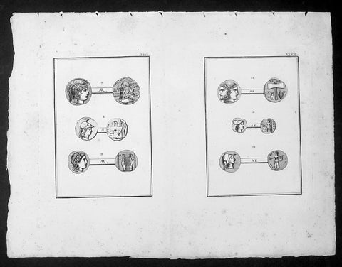
1802 J B Lechevalier Antique Print Ancient Greek Coins - Minerva Mytilene Pallas
- Title : Plates XXVI & XXVII
- Date : 1802
- Condition: (A+) Fine Condition
- Ref: 70235
- Size: 14in x 10in (355mm x 255mm)
Description:
This original copper-plate engraved antique prints of ancient Greek coins (details below) found in the ancient Greek province of Çanakkale in the NW of modern Turkey, was published in the 1802 edition of Jean-Baptiste Lechevaliers of Voyage de la Troade, fait dans les années 1785 et 1786
Each plate contains 3 coins;
Plate XXVI
7. Le Tete de Minerve (The head of Minerva)
8. Tete Casquee de Minerve, fondatrice d Athenes (Head Helmet of Minerva, founder of Athens)
9. Mytilene dans l ile de Lesbos, patrie de Pattacus (Mytilene in the island of Lesbos, homeland of Pattacus)
Plate XXVII
10. Tete a deux faces, l une barbue et couronnee de laurier (Head with two faces, l bearded and laurel wreath)
11. Tete de Palas ( Head of Pallas)
12. Tete de Pallas (Head of a Pallas)
General Definitions:
Paper thickness and quality: - Heavy and stable
Paper color : - off white
Age of map color: -
Colors used: -
General color appearance: -
Paper size: - 14in x 10in (355mm x 255mm)
Plate size: - 7in x 5in (180mm x 130mm) each plate
Margins: - Min 1/2in (12mm)
Imperfections:
Margins: - Light soiling
Plate area: - None
Verso: - None
Background:
Jean-Baptiste Lechevalier was the secretary of the Ambassador of France in Constantinople. In the year 1788 he visited the plain of Troy, and was enthusiastically in favour of the theory that the site of Homers Troy was to be found at the village of Bunarbashi. His publication about Troy Voyage de la Troade.....was first published in 1799.
The Troad, also known as Troas, is the historical name of the Biga peninsula (Biga Yarımadası, Τρωάς) in the northwestern part of Anatolia, Turkey. This region now is part of the Çanakkale province of Turkey. Bounded by the Dardanelles to the northwest, by the Aegean Sea to the west and separated from the rest of Anatolia by the massif that forms Mount Ida, the Troad is drained by two main rivers, the Scamander (Karamenderes) and the Simois, which join at the area containing the ruins of Troy. Grenikos, Kebren, Simoeis, Rhesos, Rhodios, Heptaporos and Aisepos were seven rivers of the Troad and the names of the river gods that inhabited each river.
Troy (Ancient Greek: Τροία, Troia or Τροίας, Troias, Truva or Troya) was a city in the far northwest of the region known in late Classical antiquity as Asia Minor, now known as Anatolia in modern Turkey, just south of the southwest mouth of the Dardanelles strait and northwest of Mount Ida. The present-day location is known as Hisarlik. It was the setting of the Trojan War described in the Greek Epic Cycle, in particular in the Iliad, one of the two epic poems attributed to Homer. Metrical evidence from the Iliad and the Odyssey suggests that the name λιον (Ilion) formerly began with a digamma: Ϝίλιον (Wilion); this is also supported by the Hittite name for what is thought to be the same city, Wilusa.
A new capital called Ilium (from Greek: λιον, Ilion) was founded on the site in the reign of the Roman Emperor Augustus. It flourished until the establishment of Constantinople, became a bishopric and declined gradually in the Byzantine era, but is now a Latin Catholic titular see.
In 1865, English archaeologist Frank Calvert excavated trial trenches in a field he had bought from a local farmer at Hisarlik, and in 1868, Heinrich Schliemann, a wealthy German businessman and archaeologist, also began excavating in the area after a chance meeting with Calvert in Çanakkale. These excavations revealed several cities built in succession. Schliemann was at first skeptical about the identification of Hisarlik with Troy, but was persuaded by Calvert and took over Calverts excavations on the eastern half of the Hisarlik site, which was on Calvert\'s property. Troy VII has been identified with the city called Wilusa by the Hittites (the probable origin of the Greek λιον) and is generally (but not conclusively) identified with Homeric Troy.
Today, the hill at Hisarlik has given its name to a small village near the ruins, which supports the tourist trade visiting the Troia archaeological site. It lies within the province of Çanakkale, some 30 km south-west of the provincial capital, also called Çanakkale. The nearest village is Tevfikiye. The map here shows the adapted Scamander estuary with Ilium a little way inland across the Homeric plain. Due to Troys location near the Aegean Sea, the Sea of Marmara, and the Black Sea, it was a central hub for the military and trade(Ref: M&B; Tooley)
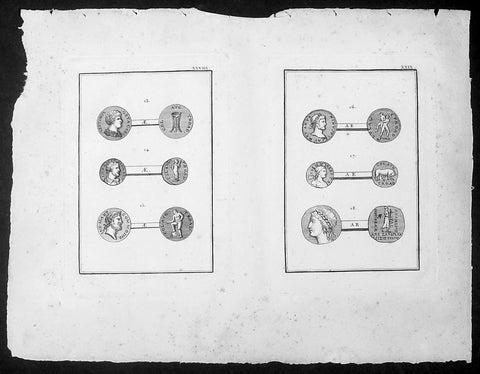
1802 J B Lechevalier Antique Print Ancient Greek Coins - Geta Gallien Apollo
- Title : Plates XXVIII & XXIX
- Date : 1802
- Condition: (A+) Fine Condition
- Ref: 70234
- Size: 14in x 10in (355mm x 255mm)
Description:
This original copper-plate engraved antique prints of ancient Greek coins (details below) found in the ancient Greek province of Çanakkale in the NW of modern Turkey, was published in the 1802 edition of Jean-Baptiste Lechevaliers of Voyage de la Troade, fait dans les années 1785 et 1786
Each plate contains 3 coins;
Plate XXVIII
13. Septimus Geta Caes - Tete de Geta (The head of Geta)
14. Tete de Gallien (Head of Gallien)
15. Tete de Commode (Head of Commode)
Plate XXIX
16. Tete de Antonin le Pieux (Head of Antoninus Pius)
17. Tete de femme, tourrelee ( Head of a woman)
18. Tete d Apollon (Head of Apollo)
General Definitions:
Paper thickness and quality: - Heavy and stable
Paper color : - off white
Age of map color: -
Colors used: -
General color appearance: -
Paper size: - 14in x 10in (355mm x 255mm)
Plate size: - 7in x 5in (180mm x 130mm) each plate
Margins: - Min 1/2in (12mm)
Imperfections:
Margins: - Light soiling
Plate area: - None
Verso: - None
Background:
Jean-Baptiste Lechevalier was the secretary of the Ambassador of France in Constantinople. In the year 1788 he visited the plain of Troy, and was enthusiastically in favour of the theory that the site of Homers Troy was to be found at the village of Bunarbashi. His publication about Troy Voyage de la Troade.....was first published in 1799.
The Troad, also known as Troas, is the historical name of the Biga peninsula (Biga Yarımadası, Τρωάς) in the northwestern part of Anatolia, Turkey. This region now is part of the Çanakkale province of Turkey. Bounded by the Dardanelles to the northwest, by the Aegean Sea to the west and separated from the rest of Anatolia by the massif that forms Mount Ida, the Troad is drained by two main rivers, the Scamander (Karamenderes) and the Simois, which join at the area containing the ruins of Troy. Grenikos, Kebren, Simoeis, Rhesos, Rhodios, Heptaporos and Aisepos were seven rivers of the Troad and the names of the river gods that inhabited each river.
Troy (Ancient Greek: Τροία, Troia or Τροίας, Troias, Truva or Troya) was a city in the far northwest of the region known in late Classical antiquity as Asia Minor, now known as Anatolia in modern Turkey, just south of the southwest mouth of the Dardanelles strait and northwest of Mount Ida. The present-day location is known as Hisarlik. It was the setting of the Trojan War described in the Greek Epic Cycle, in particular in the Iliad, one of the two epic poems attributed to Homer. Metrical evidence from the Iliad and the Odyssey suggests that the name λιον (Ilion) formerly began with a digamma: Ϝίλιον (Wilion); this is also supported by the Hittite name for what is thought to be the same city, Wilusa.
A new capital called Ilium (from Greek: λιον, Ilion) was founded on the site in the reign of the Roman Emperor Augustus. It flourished until the establishment of Constantinople, became a bishopric and declined gradually in the Byzantine era, but is now a Latin Catholic titular see.
In 1865, English archaeologist Frank Calvert excavated trial trenches in a field he had bought from a local farmer at Hisarlik, and in 1868, Heinrich Schliemann, a wealthy German businessman and archaeologist, also began excavating in the area after a chance meeting with Calvert in Çanakkale. These excavations revealed several cities built in succession. Schliemann was at first skeptical about the identification of Hisarlik with Troy, but was persuaded by Calvert and took over Calverts excavations on the eastern half of the Hisarlik site, which was on Calvert\'s property. Troy VII has been identified with the city called Wilusa by the Hittites (the probable origin of the Greek λιον) and is generally (but not conclusively) identified with Homeric Troy.
Today, the hill at Hisarlik has given its name to a small village near the ruins, which supports the tourist trade visiting the Troia archaeological site. It lies within the province of Çanakkale, some 30 km south-west of the provincial capital, also called Çanakkale. The nearest village is Tevfikiye. The map here shows the adapted Scamander estuary with Ilium a little way inland across the Homeric plain. Due to Troys location near the Aegean Sea, the Sea of Marmara, and the Black Sea, it was a central hub for the military and trade(Ref: M&B; Tooley)
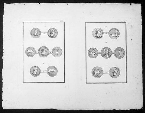
1802 J B Lechevalier Antique Print Ancient Greek Coins - Hadrian, Maxime, Troy
- Title : Plates XXX & XXXI
- Date : 1802
- Condition: (A+) Fine Condition
- Ref: 70233
- Size: 14in x 10in (355mm x 255mm)
Description:
This original copper-plate engraved antique prints of ancient Greek, Roman & Troy coins (details below) found in the ancient Greek province of Çanakkale, now in the NW of modern Turkey, was published in the 1802 edition of Jean-Baptiste Lechevaliers of Voyage de la Troade, fait dans les années 1785 et 1786
Each plate contains 3 coins;
Plate XXX
19. Tete d Hadrian (The head of Hadrian)
20. Tete de Maximin (Head of Maximin)
21. Tete de Maxime (Head of Maxime)
Plate XXXI
22. Tete de Marc Aurele (Head of Marcus Arelius)
23. Col. Avg Troad (Coin of Troy)
24. Tete d Antonin (Head of Antonin)
General Definitions:
Paper thickness and quality: - Heavy and stable
Paper color : - off white
Age of map color: -
Colors used: -
General color appearance: -
Paper size: - 14in x 10in (355mm x 255mm)
Plate size: - 7in x 5in (180mm x 130mm) each plate
Margins: - Min 1/2in (12mm)
Imperfections:
Margins: - Light soiling
Plate area: - None
Verso: - None
Background:
Jean-Baptiste Lechevalier was the secretary of the Ambassador of France in Constantinople. In the year 1788 he visited the plain of Troy, and was enthusiastically in favour of the theory that the site of Homers Troy was to be found at the village of Bunarbashi. His publication about Troy Voyage de la Troade.....was first published in 1799.
The Troad, also known as Troas, is the historical name of the Biga peninsula (Biga Yarımadası, Τρωάς) in the northwestern part of Anatolia, Turkey. This region now is part of the Çanakkale province of Turkey. Bounded by the Dardanelles to the northwest, by the Aegean Sea to the west and separated from the rest of Anatolia by the massif that forms Mount Ida, the Troad is drained by two main rivers, the Scamander (Karamenderes) and the Simois, which join at the area containing the ruins of Troy. Grenikos, Kebren, Simoeis, Rhesos, Rhodios, Heptaporos and Aisepos were seven rivers of the Troad and the names of the river gods that inhabited each river.
Troy (Ancient Greek: Τροία, Troia or Τροίας, Troias, Truva or Troya) was a city in the far northwest of the region known in late Classical antiquity as Asia Minor, now known as Anatolia in modern Turkey, just south of the southwest mouth of the Dardanelles strait and northwest of Mount Ida. The present-day location is known as Hisarlik. It was the setting of the Trojan War described in the Greek Epic Cycle, in particular in the Iliad, one of the two epic poems attributed to Homer. Metrical evidence from the Iliad and the Odyssey suggests that the name λιον (Ilion) formerly began with a digamma: Ϝίλιον (Wilion); this is also supported by the Hittite name for what is thought to be the same city, Wilusa.
A new capital called Ilium (from Greek: λιον, Ilion) was founded on the site in the reign of the Roman Emperor Augustus. It flourished until the establishment of Constantinople, became a bishopric and declined gradually in the Byzantine era, but is now a Latin Catholic titular see.
In 1865, English archaeologist Frank Calvert excavated trial trenches in a field he had bought from a local farmer at Hisarlik, and in 1868, Heinrich Schliemann, a wealthy German businessman and archaeologist, also began excavating in the area after a chance meeting with Calvert in Çanakkale. These excavations revealed several cities built in succession. Schliemann was at first skeptical about the identification of Hisarlik with Troy, but was persuaded by Calvert and took over Calverts excavations on the eastern half of the Hisarlik site, which was on Calvert\'s property. Troy VII has been identified with the city called Wilusa by the Hittites (the probable origin of the Greek λιον) and is generally (but not conclusively) identified with Homeric Troy.
Today, the hill at Hisarlik has given its name to a small village near the ruins, which supports the tourist trade visiting the Troia archaeological site. It lies within the province of Çanakkale, some 30 km south-west of the provincial capital, also called Çanakkale. The nearest village is Tevfikiye. The map here shows the adapted Scamander estuary with Ilium a little way inland across the Homeric plain. Due to Troys location near the Aegean Sea, the Sea of Marmara, and the Black Sea, it was a central hub for the military and trade(Ref: M&B; Tooley)
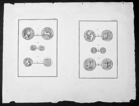
1802 J B Lechevalier Antique Print Ancient Greek Coins, Alexander Severe Minerva
- Title : Plates XXXII & XXXIII
- Date : 1802
- Condition: (A+) Fine Condition
- Ref: 70232
- Size: 14in x 10in (355mm x 255mm)
Description:
This original copper-plate engraved antique prints of ancient Greek, Roman & Troy coins (details below) found in the ancient Greek province of Çanakkale, now in the NW of modern Turkey, was published in the 1802 edition of Jean-Baptiste Lechevaliers of Voyage de la Troade, fait dans les années 1785 et 1786
Each plate contains 3 coins;
Plate XXXII
25. Tete d Alexandre Severe (The head of Alexander Severe)
26. Un cheval marin aile (A sailor wing horse)
27. Tete de Marc-Aurele (Head of Marcus Arelius)
Plate XXXIII
28. Minerve - Iliade tenant de la droite une lance sur l epaule (Minerva - Iliad holding on the right a spear on the shoulder)
29. Tete de Minerve (Head of Minerva)
30. Tete de Minerve casquee (Head of Minerva helmet)
General Definitions:
Paper thickness and quality: - Heavy and stable
Paper color : - off white
Age of map color: -
Colors used: -
General color appearance: -
Paper size: - 14in x 10in (355mm x 255mm)
Plate size: - 7in x 5in (180mm x 130mm) each plate
Margins: - Min 1/2in (12mm)
Imperfections:
Margins: - Light soiling
Plate area: - None
Verso: - None
Background:
Jean-Baptiste Lechevalier was the secretary of the Ambassador of France in Constantinople. In the year 1788 he visited the plain of Troy, and was enthusiastically in favour of the theory that the site of Homers Troy was to be found at the village of Bunarbashi. His publication about Troy Voyage de la Troade.....was first published in 1799.
The Troad, also known as Troas, is the historical name of the Biga peninsula (Biga Yarımadası, Τρωάς) in the northwestern part of Anatolia, Turkey. This region now is part of the Çanakkale province of Turkey. Bounded by the Dardanelles to the northwest, by the Aegean Sea to the west and separated from the rest of Anatolia by the massif that forms Mount Ida, the Troad is drained by two main rivers, the Scamander (Karamenderes) and the Simois, which join at the area containing the ruins of Troy. Grenikos, Kebren, Simoeis, Rhesos, Rhodios, Heptaporos and Aisepos were seven rivers of the Troad and the names of the river gods that inhabited each river.
Troy (Ancient Greek: Τροία, Troia or Τροίας, Troias, Truva or Troya) was a city in the far northwest of the region known in late Classical antiquity as Asia Minor, now known as Anatolia in modern Turkey, just south of the southwest mouth of the Dardanelles strait and northwest of Mount Ida. The present-day location is known as Hisarlik. It was the setting of the Trojan War described in the Greek Epic Cycle, in particular in the Iliad, one of the two epic poems attributed to Homer. Metrical evidence from the Iliad and the Odyssey suggests that the name λιον (Ilion) formerly began with a digamma: Ϝίλιον (Wilion); this is also supported by the Hittite name for what is thought to be the same city, Wilusa.
A new capital called Ilium (from Greek: λιον, Ilion) was founded on the site in the reign of the Roman Emperor Augustus. It flourished until the establishment of Constantinople, became a bishopric and declined gradually in the Byzantine era, but is now a Latin Catholic titular see.
In 1865, English archaeologist Frank Calvert excavated trial trenches in a field he had bought from a local farmer at Hisarlik, and in 1868, Heinrich Schliemann, a wealthy German businessman and archaeologist, also began excavating in the area after a chance meeting with Calvert in Çanakkale. These excavations revealed several cities built in succession. Schliemann was at first skeptical about the identification of Hisarlik with Troy, but was persuaded by Calvert and took over Calverts excavations on the eastern half of the Hisarlik site, which was on Calvert\'s property. Troy VII has been identified with the city called Wilusa by the Hittites (the probable origin of the Greek λιον) and is generally (but not conclusively) identified with Homeric Troy.
Today, the hill at Hisarlik has given its name to a small village near the ruins, which supports the tourist trade visiting the Troia archaeological site. It lies within the province of Çanakkale, some 30 km south-west of the provincial capital, also called Çanakkale. The nearest village is Tevfikiye. The map here shows the adapted Scamander estuary with Ilium a little way inland across the Homeric plain. Due to Troys location near the Aegean Sea, the Sea of Marmara, and the Black Sea, it was a central hub for the military and trade(Ref: M&B; Tooley)
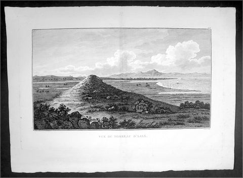
1802 J B Lechevalier Antique Print View of Tomb of Ajax Troy in Troad, NW Turkey
- Title : Vue Du Tombeau D'Ajax
- Date : 1802
- Condition: (A+) Fine Condition
- Ref: 70224
- Size: 19 1/4in x 14in (495mm x 355mm)
Description:
This original copper-plate engraved antique print view of the Tomb of Ajax the Great near in the ancient Greek city of Troy in the Troad region of NW Turkey was published in the 1802 edition of Jean-Baptiste Lechevaliers of Voyage de la Troade, fait dans les années 1785 et 1786
General Definitions:
Paper thickness and quality: - Heavy and stable
Paper color : - off white
Age of map color: -
Colors used: -
General color appearance: -
Paper size: - 20in x 14in (510mm x 360mm)
Plate size: - 17 1/2in x 11in (445mm x 280mm)
Margins: - Min 1/2in (12mm)
Imperfections:
Margins: - None
Plate area: - Light toning along centerfold
Verso: - None
Background:
Ajax or Aiasis a Greek hero, the son of King Telamon and Periboea, and the half-brother of Teucer. He plays an important role, and is portrayed as a towering figure and a warrior of great courage in Homers Iliad and in the Epic Cycle, a series of epic poems about the Trojan War. He is also referred to as Telamonian Ajax (Αἴας ὁ Τελαμώνιος, in Etruscan recorded as Aivas Tlamunus), Greater Ajax, or Ajax the Great, which distinguishes him from Ajax, son of Oileus (Ajax the Lesser).
Jean-Baptiste Lechevalier was the secretary of the Ambassador of France in Constantinople. In the year 1788 he visited the plain of Troy, and was enthusiastically in favour of the theory that the site of Homers Troy was to be found at the village of Bunarbashi. His publication about Troy Voyage de la Troade.....was first published in 1799.
The Troad, also known as Troas, is the historical name of the Biga peninsula (Biga Yarımadası, Τρωάς) in the northwestern part of Anatolia, Turkey. This region now is part of the Çanakkale province of Turkey. Bounded by the Dardanelles to the northwest, by the Aegean Sea to the west and separated from the rest of Anatolia by the massif that forms Mount Ida, the Troad is drained by two main rivers, the Scamander (Karamenderes) and the Simois, which join at the area containing the ruins of Troy. Grenikos, Kebren, Simoeis, Rhesos, Rhodios, Heptaporos and Aisepos were seven rivers of the Troad and the names of the river gods that inhabited each river.
Troy (Ancient Greek: Τροία, Troia or Τροίας, Troias, Truva or Troya) was a city in the far northwest of the region known in late Classical antiquity as Asia Minor, now known as Anatolia in modern Turkey, just south of the southwest mouth of the Dardanelles strait and northwest of Mount Ida. The present-day location is known as Hisarlik. It was the setting of the Trojan War described in the Greek Epic Cycle, in particular in the Iliad, one of the two epic poems attributed to Homer. Metrical evidence from the Iliad and the Odyssey suggests that the name λιον (Ilion) formerly began with a digamma: Ϝίλιον (Wilion); this is also supported by the Hittite name for what is thought to be the same city, Wilusa.
A new capital called Ilium (from Greek: λιον, Ilion) was founded on the site in the reign of the Roman Emperor Augustus. It flourished until the establishment of Constantinople, became a bishopric and declined gradually in the Byzantine era, but is now a Latin Catholic titular see.
In 1865, English archaeologist Frank Calvert excavated trial trenches in a field he had bought from a local farmer at Hisarlik, and in 1868, Heinrich Schliemann, a wealthy German businessman and archaeologist, also began excavating in the area after a chance meeting with Calvert in Çanakkale. These excavations revealed several cities built in succession. Schliemann was at first skeptical about the identification of Hisarlik with Troy, but was persuaded by Calvert and took over Calverts excavations on the eastern half of the Hisarlik site, which was on Calvert\'s property. Troy VII has been identified with the city called Wilusa by the Hittites (the probable origin of the Greek λιον) and is generally (but not conclusively) identified with Homeric Troy.
Today, the hill at Hisarlik has given its name to a small village near the ruins, which supports the tourist trade visiting the Troia archaeological site. It lies within the province of Çanakkale, some 30 km south-west of the provincial capital, also called Çanakkale. The nearest village is Tevfikiye. The map here shows the adapted Scamander estuary with Ilium a little way inland across the Homeric plain. Due to Troys location near the Aegean Sea, the Sea of Marmara, and the Black Sea, it was a central hub for the military and trade(Ref: M&B; Tooley)
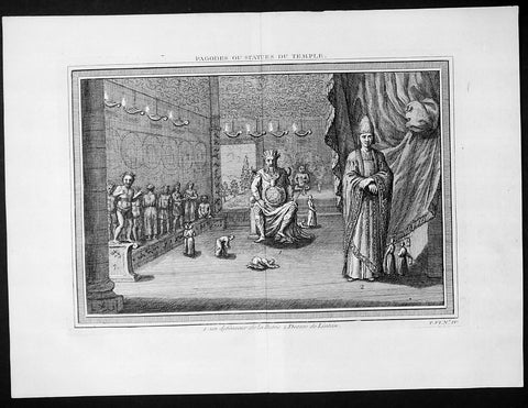
1755 Prevost & Schley Antique Print Dharmapala the Defender Buddhist Gods Pagoda
- Title: Pagodes ou Statues Du Temple
- Date: 1755
- Condition : (A+) Fine Condition
- Ref: 25935
- Size: 15in x 10in (385mm x 255mm)
Description:
This fine, original copper-plate engraved antique print of Dharmapala the defender Buddhist God & Goddess in a Pagoda Temple by Jakob van Schley in 1755 was published in Antoine François Prevosts 15 volumes of Histoire Generale des Voyages written by Prevost & other authors between 1746-1790.
A protector of Buddhist dharma is called a Dharmapala in Buddhism. They are typically divinities, usually depicted with wrathful iconography in the Mahayana and tantric traditions of Buddhism. The wrath depicts their believed willingness to defend and guard Buddhist followers from dangers and enemies. The Astasena, or eight nonhuman super beings, for example are one of the list of dharmapalas. The Astasena dharmapala include, state Buswell and Lopez, Garuda, Deva, Naga, Yaksa, Gandharva, Asura, Kimnara and Mahoraga.
In Vajrayana iconography and thangka depictions, dharmapālas are fearsome beings, often with many heads, many hands, or many feet. Dharmapālas often have blue, black or red skin, and a fierce expression with protruding fangs. Though dharmapālas have a terrifying appearance and countenance, they are all bodhisattvas or buddhas, meaning that they are embodiments of compassion that act in a wrathful way for the benefit of sentient beings.
The devotional worship of dharmapalas in the Tibetan tradition is traceable to early 8th-century
General Definitions:
Paper thickness and quality: - Heavy and stable
Paper color : - off white
Age of map color: -
Colors used: -
General color appearance: -
Paper size: - 15in x 10in (385mm x 255mm)
Plate size: - 14in x 8 1/2in (355mm x 220mm)
Margins: - Min 1in (25mm)
Imperfections:
Margins: - None
Plate area: - None
Verso: - None
Background:
One of Antoine Francois Prevosts monumental undertakings was his history of exploration & discovery in 15 volumes titledHistoire Générale des Voyages written between 1746-1759 and was extended to 20 volumes after his death by various authors.
The 20 volumes cover the early explorations & discoveries on 3 continents: Africa (v. 1-5), Asia (v. 5-11), and America (v. 12-15) with material on the finding of the French, English, Dutch, and Portugese.
A number of notable cartographers and engravers contributed to the copper plate maps and views to the 20 volumes including Nicolas Bellin, Jan Schley, Chedel, Franc Aveline, Fessard, and many others.
The African volumes cover primarily coastal countries of West, Southern, and Eastern Africa, plus the Congo, Madagascar, Arabia and the Persian Gulf areas.
The Asian volumes cover China, Korea, Tibet, Japan, Philippines, and countries bordering the Indian Ocean.
Volume 11 includes Australia and Antarctica.
Volumes 12-15 cover voyages and discoveries in America, including the East Indies, South, Central and North America.
Volumes 16-20 include supplement volumes & tables along with continuation of voyages and discoveries in Russia, Northern Europe, America, Asia & Australia.
Jakob van der Schley aka Jakob van Schley (1715 - 1779) was a Dutch draughtsman and engraver. He studied under Bernard Picart (1673-1733) whose style he subsequently copied. His main interests were engraving portraits and producing illustrations for \\\"La Vie de Marianne\\\" by Pierre Carlet de Chamblain de Marivaux (1688-1763) published in The Hague between 1735 and 1747.
He also engraved the frontispieces for a 15-volume edition of the complete works of Pierre de Brantôme (1540-1614), \\\"Oeuvres du seigneur de Brantôme\\\", published in The Hague in 1740.
He is also responsible for most of the plates in the Hague edition of Prévosts Histoire générale des voyages. (Ref: Tooley; M&B)
1802 J B Lechevalier Antique Print Ancient Greek Coins - Diana, Algos, Apollo
- Title : Plates: XXXVI (Abydos); XXXVII (Cardia)
- Date : 1802
- Condition: (A+) Fine Condition
- Ref: 70230
- Size: 14in x 10in (355mm x 255mm)
Description:
This original copper-plate engraved antique prints of ancient Greek, Roman & Troy coins (details below) found in the ancient Greek province of Çanakkale, now in the NW of modern Turkey, was published in the 1802 edition of Jean-Baptiste Lechevaliers of Voyage de la Troade, fait dans les années 1785 et 1786
Each plate contains 3 coins;
Plate XXXVI
37. Tete de Diane (The head of Diana)
38. Le nom de cette ville est compose de Aigos (The name of this city is composed of Aigos)
39. Une tete barbue, dans un carre (A bearded head, in a square)
Plate XXXVII
40. Sur les medailles de la meme ville (On the medals of the same city)
41. Le type sait allusion au nom de la ville (The guy knows allusion to the name of the city)
42. Tete de d apollon (Head of Apollo)
General Definitions:
Paper thickness and quality: - Heavy and stable
Paper color : - off white
Age of map color: -
Colors used: -
General color appearance: -
Paper size: - 14in x 10in (355mm x 255mm)
Plate size: - 7in x 5in (180mm x 130mm) each plate
Margins: - Min 1/2in (12mm)
Imperfections:
Margins: - Light soiling
Plate area: - None
Verso: - None
Background:
Jean-Baptiste Lechevalier was the secretary of the Ambassador of France in Constantinople. In the year 1788 he visited the plain of Troy, and was enthusiastically in favour of the theory that the site of Homers Troy was to be found at the village of Bunarbashi. His publication about Troy Voyage de la Troade.....was first published in 1799.
The Troad, also known as Troas, is the historical name of the Biga peninsula (Biga Yarımadası, Τρωάς) in the northwestern part of Anatolia, Turkey. This region now is part of the Çanakkale province of Turkey. Bounded by the Dardanelles to the northwest, by the Aegean Sea to the west and separated from the rest of Anatolia by the massif that forms Mount Ida, the Troad is drained by two main rivers, the Scamander (Karamenderes) and the Simois, which join at the area containing the ruins of Troy. Grenikos, Kebren, Simoeis, Rhesos, Rhodios, Heptaporos and Aisepos were seven rivers of the Troad and the names of the river gods that inhabited each river.
Troy (Ancient Greek: Τροία, Troia or Τροίας, Troias, Truva or Troya) was a city in the far northwest of the region known in late Classical antiquity as Asia Minor, now known as Anatolia in modern Turkey, just south of the southwest mouth of the Dardanelles strait and northwest of Mount Ida. The present-day location is known as Hisarlik. It was the setting of the Trojan War described in the Greek Epic Cycle, in particular in the Iliad, one of the two epic poems attributed to Homer. Metrical evidence from the Iliad and the Odyssey suggests that the name λιον (Ilion) formerly began with a digamma: Ϝίλιον (Wilion); this is also supported by the Hittite name for what is thought to be the same city, Wilusa.
A new capital called Ilium (from Greek: λιον, Ilion) was founded on the site in the reign of the Roman Emperor Augustus. It flourished until the establishment of Constantinople, became a bishopric and declined gradually in the Byzantine era, but is now a Latin Catholic titular see.
In 1865, English archaeologist Frank Calvert excavated trial trenches in a field he had bought from a local farmer at Hisarlik, and in 1868, Heinrich Schliemann, a wealthy German businessman and archaeologist, also began excavating in the area after a chance meeting with Calvert in Çanakkale. These excavations revealed several cities built in succession. Schliemann was at first skeptical about the identification of Hisarlik with Troy, but was persuaded by Calvert and took over Calverts excavations on the eastern half of the Hisarlik site, which was on Calvert\'s property. Troy VII has been identified with the city called Wilusa by the Hittites (the probable origin of the Greek λιον) and is generally (but not conclusively) identified with Homeric Troy.
Today, the hill at Hisarlik has given its name to a small village near the ruins, which supports the tourist trade visiting the Troia archaeological site. It lies within the province of Çanakkale, some 30 km south-west of the provincial capital, also called Çanakkale. The nearest village is Tevfikiye. The map here shows the adapted Scamander estuary with Ilium a little way inland across the Homeric plain. Due to Troys location near the Aegean Sea, the Sea of Marmara, and the Black Sea, it was a central hub for the military and trade(Ref: M&B; Tooley)