Title Pages (9)
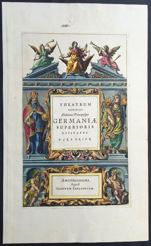
1640 Jansson Old, Antique German Atlas Title Page
- Title : Theatrum Exhibens Illustriores Principesque Germaniae
- Date : 1640
- Condition: (A+) Fine Condition
- Ref: 80014
- Size: 19 1/2in x 12in (495mm x 305mm)
Description:
This finely engraved beautifully hand coloured original antique Atlas Title Page was published by Jan Jansson for the in the 1640 edition of Jansson's German Atlas. (Ref Tooley M&B)
General Description:
Paper thickness and quality: - Heavy and stable
Paper color: - off white
Age of map color: - Original
Colors used: - Green, red, orange, yellow, blue
General color appearance: - Authentic
Paper size: - 19 1/2in x 12in (495mm x 305mm)
Plate size: - 14 1/2in x 9in (370mm x 230mm)
Margins: - Min 1in (25mm)
Imperfections:
Margins: - Blind stamp and old ink notation in top margin
Plate area: - None
Verso: - None
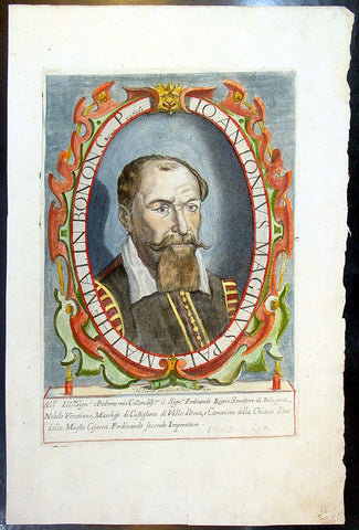
1632 Henricus David Large Antique Portrait of Cartographer Giovanni A Magini
Antique Map
- Title : Io. Antonius Maginus Pat. Mathemat. In Bonon. Gymn. Profess
- Date : 1632
- Condition: (A+) Fine Condition
- Ref: 80766
- Size: 17 1/2in x 11in (445mm x 280mm)
Description:
This fine beautifully hand coloured original antique portrait of the Italian Cartographer Giovanni Antonio Magini was engraved by Henricus David in 1632 - date is engraved below portrait.
Giovanni Antonio Magini (1555-1617) was an Italian mathematician, cartographer and Professor of Astronomy in Bologna. He is responsible for publishing an edition ofPtolemy's Geographia in 1596 that contained 27 maps of the ancient world drawn from the text of Claude Ptolemy, along with 27 contemporary or modern maps. His maps were used by Blaeu in 1640. (Ref: Tooley; M&B)
General Description:
Paper thickness and quality: - Heavy and stable
Paper color: - off white
Age of map color: - Original
Colors used: - Yellow, green, red, brown.
General color appearance: - Fresh
Paper size: - 17 1/2in x 11in (445mm x 280mm)
Plate size: - 12n x 8 1/2in (305mm x 215mm)
Margins: - Min 1in (25mm)
Imperfections:
Margins: - Light dis-colouration in top margin
Plate area: - None
Verso: - None
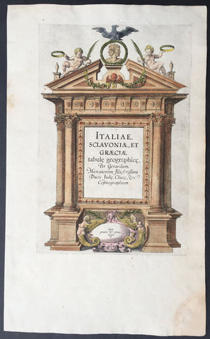
1589 Mercator Antique Atlas Title Page from Italy, Yugoslavia & Greece
-
Title : Italiae Sclavoniae, et Graeciae tabule geographice, per Gerardum Mercatorem....
- Date : 1589
- Condition: (A+) Fine Condition
- Ref: 16281
- Size: 16in x 10in (405mm x 255mm)
Description:
This beautifully engraved hand coloured original antique Title page from Gerard Mercator's Italy & SW Europe section was published in the 1589 edition of the Geographiaatlas.
After the sale of Mercator's plates to in 1605, Hondius continued to publish the original plates with little alteration until 1630 when along with Jansson many of the original plates were altered or re-engraved either decoratively or topographically or both. This map is from one of the last unaltered editions of Mercator's atlas. (Ref: Koeman, Tooley)
Condition Report
Paper thickness and quality: - Heavy and stable
Paper color: - off white
Age of map color: - Original
Colors used: - Red, yellow, green, blue
General color appearance: - Authentic
Paper size: - 16in x 10in (405mm x 255mm)
Plate size: - 11 1/2in x 7 1/2in (290mm x 190mm)
Margins: - Min 1in (25mm)
Imperfections:
Margins: - Repair to bottom right corner
Plate area: - None
Verso: - Age toning
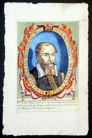
1632 Henricus David Large Antique Portrait of Cartographer Giovanni A Magini
- Title : Io. Antonius Maginus Pat. Mathemat. In Bonon. Gymn. Profess
- Date : 1632
- Condition: (A+) Fine Condition
- Ref: 92835
- Size: 17 1/2in x 11in (445mm x 280mm)
Description:
This fine beautifully hand coloured original antique portrait of the Italian Cartographer Giovanni Antonio Magini was engraved by Henricus David in 1632 - date is engraved below portrait.
Giovanni Antonio Magini (1555-1617) was an Italian mathematician, cartographer and Professor of Astronomy in Bologna. He is responsible for publishing an edition ofPtolemy's Geographia in 1596 that contained 27 maps of the ancient world drawn from the text of Claude Ptolemy, along with 27 contemporary or modern maps. His maps were used by Blaeu in 1640. (Ref: Tooley; M&B)
General Description:
Paper thickness and quality: - Heavy and stable
Paper color: - off white
Age of map color: - Original
Colors used: - Yellow, green, red, brown.
General color appearance: - Fresh
Paper size: - 17 1/2in x 11in (445mm x 280mm)
Plate size: - 12n x 8 1/2in (305mm x 215mm)
Margins: - Min 1in (25mm)
Imperfections:
Margins: - Light dis-colouration in top margin
Plate area: - None
Verso: - None
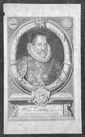
1695 Richard White Original Antique Portrait of William Camden - Britannia
- Title : William Camden Clarenceux Obijt A.D 1623
- Size: 13 1/2in x 8 1/2in (350mm x 215mm)
- Condition: (A+) Fine Condition
- Date : 1695
- Ref #: 70358
Description:
This fine copper-plate engraved original antique portrait of the famous English 16th century historian William Camden (1551 - 1623) - famous for his historical publication of Britannia first published in 1586 - by Richard White was published in the Edmund Gibson 1695 edition of Britannia
General Definitions:
Paper thickness and quality: - Heavy and stable
Paper color : - off white
Age of map color: -
Colors used: -
General color appearance: -
Paper size: - 13 1/2in x 8 1/2in (350mm x 215mm)
Plate size: - 13 1/2in x 8 1/2in (350mm x 215mm)
Margins: - Min 1/2in (12mm)
Imperfections:
Margins: - Light soiling
Plate area: - Light soiling
Verso: - Light soiling
Camden, William 1551 – 1623
Camden was an English antiquarian, historian, topographer, and herald, best known as author of Britannia, the first chorographical survey of the islands of Great Britain and Ireland, and the Annales, the first detailed historical account of the reign of Elizabeth I of England.
In 1577, with the encouragement of Abraham Ortelius, Camden began his great work Britannia, a topographical and historical survey of all of Great Britain and Ireland. His stated intention was to "restore antiquity to Britaine, and Britain to his antiquity". The first edition, written in Latin, was published in 1586. It proved very popular, and ran through five further editions, of 1587, 1590, 1594, 1600 and 1607, each greatly enlarged from its predecessor in both textual content and illustrations. The 1607 edition included for the first time a full set of English county maps, based on the surveys of Christopher Saxton and John Norden, and engraved by William Kip and William Hole (who also engraved the fine title page). The first English language edition, translated by Philemon Holland, appeared in 1610, again with some additional content supplied by Camden.
Britannia is a county-by-county description of Great Britain and Ireland. It is a work of chorography: a study that relates landscape, geography, antiquarianism, and history. Rather than write a history, Camden wanted to describe in detail the Great Britain of the present, and to show how the traces of the past could be discerned in the existing landscape. By this method, he produced the first coherent picture of Roman Britain.
He continued to collect materials and to revise and expand Britannia throughout his life. He drew on the published and unpublished work of John Leland and William Lambarde, among others, and received the assistance of a large network of correspondents with similar interests. He also travelled throughout Great Britain to view documents, sites, and artefacts for himself: he is known to have visited East Anglia in 1578, Yorkshire and Lancashire in 1582, Devon in 1589, Wales in 1590, Salisbury, Wells and Oxford in 1596, and Carlisle and Hadrian's Wall in 1599. His fieldwork and firsthand research set new standards for the time. He even learned Welsh and Old English for the task: his tutor in Old English was Laurence Nowell.
In 1593 Camden became headmaster of Westminster School. He held the post for four years, but left when he was appointed Clarenceux King of Arms. By this time, largely because of the Britannia's reputation, he was a well-known and revered figure, and the appointment was meant to free him from the labour of teaching and to facilitate his research. The College of Arms at that time was not only a centre of genealogical and heraldic study, but also a centre of antiquarian study. The appointment, however, roused the jealousy of Ralph Brooke, York Herald, who, in retaliation, published an attack on Britannia, charging Camden with inaccuracy and plagiarism. Camden successfully defended himself against the charges in subsequent editions of the work.
Britannia was recognised as an important work of Renaissance scholarship, not only in England, but across the European "Republic of Letters". Camden considered having the 1586 Britannia printed in the Low Countries, and although that did not happen, the third edition of 1590, in addition to its London printing, was also published the same year in Frankfurt, and reprinted there in 1616. In 1612 parts were condemned by the Spanish Inquisition. An abridgement was published in Amsterdam in 1617 and reprinted in 1639; and versions of the text were also included in Joan Blaeu's Theatrum Orbis Terrarum (published in Amsterdam in 1645) and in Jan Janssonius's Novus Atlas (again published in Amsterdam, in 1646)
Camden's Britannia remained a standard and highly regarded authority for many years after his death. A lightly revised edition of Holland's 1610 translation was published in 1637. A new and greatly expanded translation, edited by Edmund Gibson, was published in 1695, and was reissued in revised editions in 1722, 1753 and 1772. Yet another new and expanded translation by Richard Gough was published in 1789, followed by a second edition in 1806. In an address given in 1986, marking the original publication's 400th anniversary, George Boon commented that the work "still fundamentally colours the way in which we, as antiquaries, look at our country"
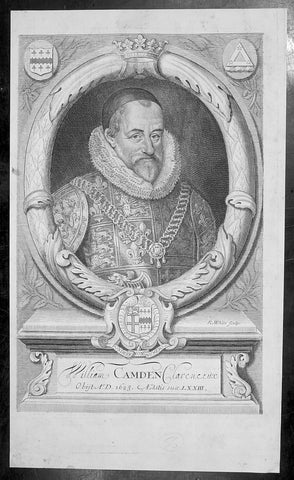
1695 Richard White Original Antique Portrait of William Camden - Britannia
- Title : William Camden Clarenceux Obijt A.D 1623
- Size: 13 1/2in x 8 1/2in (350mm x 215mm)
- Condition: (A+) Fine Condition
- Date : 1695
- Ref #: 40960
Description:
This fine copper-plate engraved original antique portrait of the famous English 16th century historian William Camden (1551 - 1623) - famous for his historical publication of Britannia first published in 1586 - by Richard White was published in the Edmund Gibson 1695 edition of Britannia
General Definitions:
Paper thickness and quality: - Heavy and stable
Paper color : - off white
Age of map color: -
Colors used: -
General color appearance: -
Paper size: - 13 1/2in x 8 1/2in (350mm x 215mm)
Plate size: - 13 1/2in x 8 1/2in (350mm x 215mm)
Margins: - Min 1/2in (12mm)
Imperfections:
Margins: - Light soiling
Plate area: - Light soiling
Verso: - Light soiling
Camden, William 1551 – 1623
Camden was an English antiquarian, historian, topographer, and herald, best known as author of Britannia, the first chorographical survey of the islands of Great Britain and Ireland, and the Annales, the first detailed historical account of the reign of Elizabeth I of England.
In 1577, with the encouragement of Abraham Ortelius, Camden began his great work Britannia, a topographical and historical survey of all of Great Britain and Ireland. His stated intention was to "restore antiquity to Britaine, and Britain to his antiquity". The first edition, written in Latin, was published in 1586. It proved very popular, and ran through five further editions, of 1587, 1590, 1594, 1600 and 1607, each greatly enlarged from its predecessor in both textual content and illustrations. The 1607 edition included for the first time a full set of English county maps, based on the surveys of Christopher Saxton and John Norden, and engraved by William Kip and William Hole (who also engraved the fine title page). The first English language edition, translated by Philemon Holland, appeared in 1610, again with some additional content supplied by Camden.
Britannia is a county-by-county description of Great Britain and Ireland. It is a work of chorography: a study that relates landscape, geography, antiquarianism, and history. Rather than write a history, Camden wanted to describe in detail the Great Britain of the present, and to show how the traces of the past could be discerned in the existing landscape. By this method, he produced the first coherent picture of Roman Britain.
He continued to collect materials and to revise and expand Britannia throughout his life. He drew on the published and unpublished work of John Leland and William Lambarde, among others, and received the assistance of a large network of correspondents with similar interests. He also travelled throughout Great Britain to view documents, sites, and artefacts for himself: he is known to have visited East Anglia in 1578, Yorkshire and Lancashire in 1582, Devon in 1589, Wales in 1590, Salisbury, Wells and Oxford in 1596, and Carlisle and Hadrian's Wall in 1599. His fieldwork and firsthand research set new standards for the time. He even learned Welsh and Old English for the task: his tutor in Old English was Laurence Nowell.
In 1593 Camden became headmaster of Westminster School. He held the post for four years, but left when he was appointed Clarenceux King of Arms. By this time, largely because of the Britannia's reputation, he was a well-known and revered figure, and the appointment was meant to free him from the labour of teaching and to facilitate his research. The College of Arms at that time was not only a centre of genealogical and heraldic study, but also a centre of antiquarian study. The appointment, however, roused the jealousy of Ralph Brooke, York Herald, who, in retaliation, published an attack on Britannia, charging Camden with inaccuracy and plagiarism. Camden successfully defended himself against the charges in subsequent editions of the work.
Britannia was recognised as an important work of Renaissance scholarship, not only in England, but across the European "Republic of Letters". Camden considered having the 1586 Britannia printed in the Low Countries, and although that did not happen, the third edition of 1590, in addition to its London printing, was also published the same year in Frankfurt, and reprinted there in 1616. In 1612 parts were condemned by the Spanish Inquisition. An abridgement was published in Amsterdam in 1617 and reprinted in 1639; and versions of the text were also included in Joan Blaeu's Theatrum Orbis Terrarum (published in Amsterdam in 1645) and in Jan Janssonius's Novus Atlas (again published in Amsterdam, in 1646)
Camden's Britannia remained a standard and highly regarded authority for many years after his death. A lightly revised edition of Holland's 1610 translation was published in 1637. A new and greatly expanded translation, edited by Edmund Gibson, was published in 1695, and was reissued in revised editions in 1722, 1753 and 1772. Yet another new and expanded translation by Richard Gough was published in 1789, followed by a second edition in 1806. In an address given in 1986, marking the original publication's 400th anniversary, George Boon commented that the work "still fundamentally colours the way in which we, as antiquaries, look at our country"
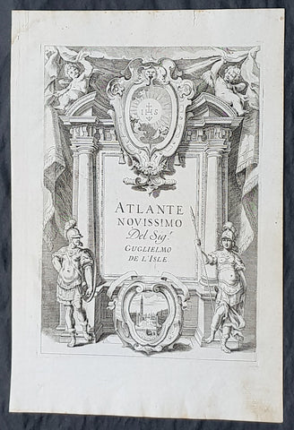
1740 Guillaume Delisle Original Antique Atlas Title Page for Atlante Novissimo
- Title : Atlante Novissimo De Sig Guglielmo De L Isles
- Size: 15in x 10in (380mm x 255mm)
- Condition: (A+) Fine Condition
- Date : 1740
- Ref #: 70343
Description:
This fine original copper-plate engraved antique frontispiece from the Italian version of Guillaume Delisle atlas Atlante Novissimo, was published by Girolamo Albrizzi in 1740.
The architectural columns are flanked by both male & female Roman soldier. At the top of the structure, a pair of putti hold aloft the covering drapes. Within the structure are two internal cartouche, one a vignette view of the city of Venice, where the atlas was published, and above, the symbol for the Society of Jesus.George PhilipDelisle
General Definitions:
Paper thickness and quality: - Heavy and stable
Paper color : - off white
Age of map color: -
Colors used: -
General color appearance: -
Paper size: - 15in x 10in (380mm x 255mm)
Plate size: - 12in x 8 1/2in (305mm x 215mm)
Margins: - Min 1in (25mm)
Imperfections:
Margins: - None
Plate area: - None
Verso: - None
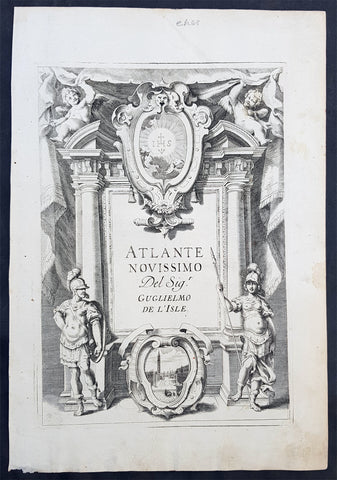
1740 Guillaume Delisle Original Antique Atlas Title Page of Atlante Novissimo
- Title : Atlante Novissimo Del Sig. r Guglielmo De L Isle
- Size: 15in x 10in (380mm x 255mm)
- Ref #: 70345
- Date : 1750
- Condition: (A+) Fine Condition
Description:
This fine original copper-plate engraved antique frontispiece from the Italian version of Guillaume Delisle atlas Atlante Novissimo, was published by Girolamo Albrizzi in 1740.
The architectural columns are flanked by both male & female Roman soldier. At the top of the structure, a pair of putti hold aloft the covering drapes. Within the structure are two internal cartouche, one a vignette view of the city of Venice, where the atlas was published, and above, the symbol for the Society of Jesus.
General Definitions:
Paper thickness and quality: - Heavy and stable
Paper color : - off white
Age of map color: -
Colors used: -
General color appearance: -
Paper size: - 15in x 10in (380mm x 255mm)
Plate size: - 12in x 8 1/2in (305mm x 215mm)
Margins: - Min 1/2in (12mm)
Imperfections:
Margins: - None
Plate area: - None
Verso: - None
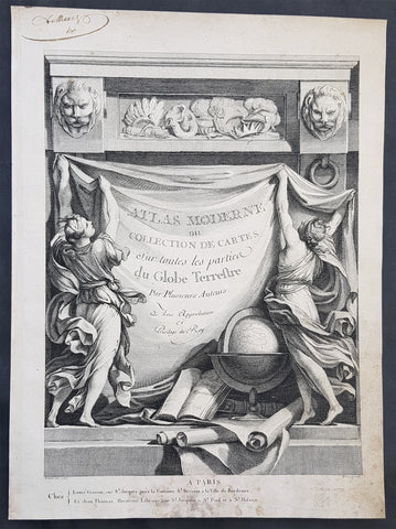
1762 Bonne, Janvier, & Zannoni Original Antique Atlas Title Page to Atlas Modern
- Title : Atlas Moderne ou Collection De Cartes Sur toutes les parties du Globe Terrestre
- Size: 14in x 10in (355mm x 255mm)
- Ref #: 92277
- Date : 1762
- Condition: (A+) Fine Condition
Description:
This original copper-plate engraved antique frontispiece from the atlas Atlas Moderne of a Collection of Maps by Rigobert Bonne, Jean Janvier, & Rizzi Zannoni was published by Jean Lattre in 1762, dated.
General Definitions:
Paper thickness and quality: - Heavy and stable
Paper color : - off white
Age of map color: -
Colors used: -
General color appearance: -
Paper size: - 14in x 10in (355mm x 255mm)
Plate size: - 14in x 10in (355mm x 255mm)
Margins: - Min 1/2in (12mm)
Imperfections:
Margins: - Light soiling in margins
Plate area: - None
Verso: - None