Sold (48)
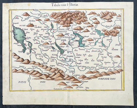
1541 Laurent Fries Very Early, Rare Antique Map of Switzerland
- Title : Tabula noua Helvetiae
- Ref #: 17008
- Size: 18 1/2in x 15in (475mm x 380mm)
- Date : 1541
- Condition: (A+) Fine Condition
Description:
This rare, very early original hand coloured wood-block engraved antique Ptolemaic map of Switzerland by Laurent Fries was published by Trechsel, Gaspar; Vienne, Dauphine in the 1541 Lyon edition of Ptolemys Geographia, Claudii Ptolemaei Alexandrini Geographicae Enarrationis, Libri Octo
General Definitions:
Paper thickness and quality: - Heavy and stable
Paper color : - off white
Age of map color: - Early
Colors used: - Yellow, orange
General color appearance: - Authentic
Paper size: - 18 1/2in x 15in (475mm x 380mm)
Plate size: - 18 1/2in x 15in (475mm x 380mm)
Margins: - Min 1in (25mm)
Imperfections:
Margins: - Small repair to top margin in title
Plate area: - None
Verso: - None
Background:
The first printed map of Switzerland was published in Martin Waldseemuller's edition of Ptolemy in Strasbourg in 1513, but the manuscript map by Konrad Turst (1497) drawn to scale was a splendid first achievement for its time. Also the research of Vadianus at St Gallen University produced notable work, and along with the Germanic influence in Basle, which became part of the Swiss Confederation in 1501, and the highly developed wood engraving skills there, were important factors in European map publishing.
The almost endless editions of Sebastian Munster's Cosmographia were published in Basle from 1540 for nearly a century and Zurich can claim to have published the first national atlas produced anywhere -that of Johann Stumpf in 1548-52.
By comparison with her larger neighbours, Germany and Italy, Switzerland is considered not to have made a major contribution to Cartographic history. But over the years this has been contradicted, especially starting in the sixteenth century. In the second half of the sixteenth century many maps of the Swiss Cantons, in manuscript or woodcuts appeared, but the mountainous nature of the country produced its own mapping problems and imposed a need for large-scale surveys as well as practical and effective methods of showing land surfaces in relief. Early in the seventeenth century Hans Gyger perfected new ways of doing this but although he published a wide range of very large-scale maps of the cantons and of Switzerland as a whole his techniques did not receive the credit they deserved. On the other hand, his countrymen followed his example of compiling large-scale maps for which they have always been noted for up until the present day. (Ref: Koeman; M&B)
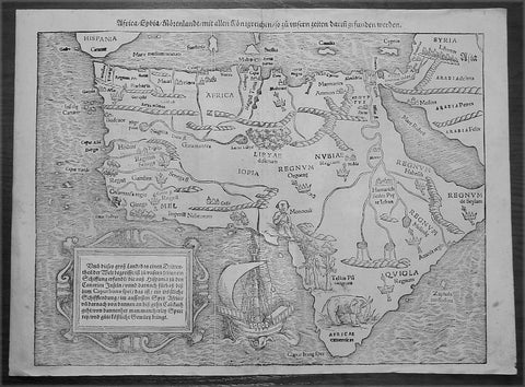
1560 Sebastian Munster Antique Map of Africa
- Title : Africa Lybia Morenlandt mit Allen Konigreichen so zu Unsern Zeiten darin Gefunden Werden
- Date : 1560
- Condition: (A+) Fine Condition
- Ref: 50660
- Size: 15in x 11 1/2in (385mm x 290mm)
Description:
A great example of the first map of the whole continent of Africa published in the 1560 edition of Sebastian Munster'sCosmographia.
This woodblock map is instantly recognisable, first published in 1540, by its illustrations of the 'Monoculi' (a one-eyed man), an impressive sailing ship, and a large elephant in southern Africa.
In The Mapping Of Africa Richard Betz identifies 15 variant states of this map. With German text and the image of a Phoenix rising from the sun to the verso, this example most closely resembles Betz's variant 15. However, our example has only "IOPIA" present in the word Aethiopia in the centre of the continent, not corresponding to any listed in Betz, and appears therefore to be a previously unrecorded variant of this early and important map.
Sales data: There have been 9 recorded sales of this map since 1985 cumulating in a top price of $1897US achieved in 2010 for this scarce edition. (Ref AMPR)
Background:
The first separately printed map of Africa (as with the other known continents) appeared in Munster's Geographia from 1540 onwards and the first atlas devoted to Africa only was published in 1588 in Venice by Livio Sanuto, but the finest individual map of the century was that engraved on 8 sheets by Gastaldi, published in Venice in 1564. Apart from maps in sixteenth-century atlases generally there were also magnificent marine maps of 1596 by Jan van Linschoten (engraved by van Langrens) of the southern half of the continent with highly imaginative and decorative detail in the interior. In the next century there were many attractive maps including those of Mercator/Hondius (1606), Speed (1627), Blaeu (1 630), Visscher (1636), de Wit (c. 1670), all embellished with vignettes of harbours and principal towns and bordered with elaborate and colourful figures of their inhabitants, but the interior remained uncharted with the exception of that part of the continent known as Ethiopia, the name which was applied to a wide area including present-day Abyssinia. Here the legends of Prester John lingered on and, as so often happened in other remote parts of the world, the only certain knowledge of the region was provided by Jesuit missionaries. Among these was Father Geronimo Lobo (1595-1678), whose work A Voyage to Abyssinia was used as the basis for a remarkably accurate map published by a German scholar, Hiob Ludolf in 1683. Despite the formidable problems which faced them, the French cartographers G. Delisle(c. 1700-22), J. B. B. d'Anville (1727-49) and N. Bellin (1754) greatly improved the standards of mapping of the continent, improvements which were usually, although not always, maintained by Homann, Seutter, de Ia Rochette, Bowen, Faden and many others in the later years of the century.
Sebastian Petri re-release of Cosomgraphia in 1588 produced some fine woodcut maps in the "copperplate style". The maps in this release were more sophisticated than with earlier publications of Cosomgraphia and were based on the 1570 release of Abraham Ortelius monumental work Theatrum Orbis Terrarum. (Ref: M&B;Tooley)
General Description:
Paper thickness and quality: - Light and stable
Paper color: - off white
Age of map color: -
Colors used: -
General color appearance: -
Paper size: - 15in x 11 1/2in (385mm x 290mm)
Plate size: - 15in x 11 1/2in (385mm x 290mm)
Margins: - 1/2in (12mm)
Imperfections:
Margins: - None
Plate area: - 4 small worm holes repaired adjacent to centerfold
Verso: - None
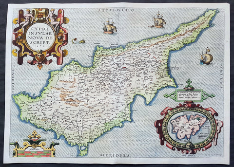
1573 Abraham Ortelius Original Antique 1st Edition Map of The Island of Cyprus
- Title : Cypri Insulae Nova Descript 1573
- Date : 1573
- Size: 20 3/4in x 15in (525mm x 382mm)
- Ref #: 70794
- Condition: (A+) Fine Condition
Description:
This extremely handsome and much sort after original antique map of the Island of Cyprus was published by Abraham Ortelius in 1573. There were a total of 6275 of these maps published between 1573 and 1641, with approx. 10% surviving to this day.
This actual map is a true first edition or state (1573IG39A), of 3 states, with German text & page number 39A on the verso.
General Definitions:
Paper thickness and quality: - Heavy and stable
Paper color : - off white
Age of map color: - Original
Colors used: - Yellow, green, blue, pink
General color appearance: - Authentic
Paper size: - 20 3/4in x 15in (525mm x 382mm)
Plate size: - 19 3/4in x 14in (500mm x 355mm)
Margins: - Min 1/2in (12mm)
Imperfections:
Margins: - None
Plate area: - None
Verso: - None
Background:
A milestone in the history of the cartography of Cyprus, based on a 1570 map by Giacomo Franco. The map is embellished by sailing ships and a sea monster, bearing a map of the Greek Island of Lemnos in an inset mp at bottom right, based on the written account by Pierre Belon in 1555. Signed in the plate by the Dutch engraver Joannes van Doetecum
Cyprus is an island country in the Eastern Mediterranean and the third largest and third most populous island in the Mediterranean. It is located south of Turkey, west of Syria and Lebanon, northwest of Israel, north of Egypt, and southeast of Greece.
The earliest known human activity on the island dates to around the 10th millennium BC. Archaeological remains from this period include the well-preserved Neolithic village of Khirokitia, and Cyprus is home to some of the oldest water wells in the world. Cyprus was settled by Mycenaean Greeksin two waves in the 2nd millennium BC. As a strategic location in the Middle East, it was subsequently occupied by several major powers, including the empires of the Assyrians, Egyptians and Persians, from whom the island was seized in 333 BC by Alexander the Great. Subsequent rule by Ptolemaic Egypt, the Classical and Eastern Roman Empire, Arabcaliphates for a short period, the French Lusignan dynasty and the Venetians, was followed by over three centuries of Ottoman rule between 1571 and 1878.
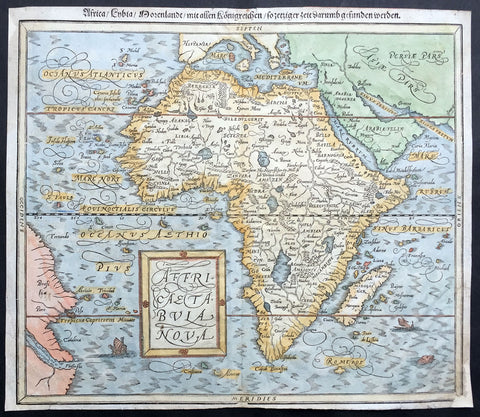
1588 Munster Antique Map of Africa
- Title : Africae Tabula Nova
- Ref #: 43175
- Size: 15in x 13in (380mm x 330mm)
- Date : 1588
- Condition: (B) Good Condition
Description:
This beautifully hand coloured original antique map of Africa was published in the 1588 edition of Sebastian MunstersCosmographia published by Sebastian Petri, Basle.
The first separately printed map of Africa (as with the other known continents) appeared in Munster's Geographia from 1540 onwards and the first atlas devoted to Africa only was published in 1588 in Venice by Livio Sanuto, but the finest individual map of the century was that engraved on 8 sheets by Gastaldi, published in Venice in 1564. Apart from maps in sixteenth-century atlases generally there were also magnificent marine maps of 1596 by Jan van Linschoten (engraved by van Langrens) of the southern half of the continent with highly imaginative and decorative detail in the interior. In the next century there were many attractive maps including those of Mercator/Hondius (1606), Speed (1627), Blaeu (1 630), Visscher (1636), de Wit (c. 1670), all embellished with vignettes of harbours and principal towns and bordered with elaborate and colourful figures of their inhabitants, but the interior remained uncharted with the exception of that part of the continent known as Ethiopia, the name which was applied to a wide area including present-day Abyssinia. Here the legends of Prester John lingered on and, as so often happened in other remote parts of the world, the only certain knowledge of the region was provided by Jesuit missionaries. Among these was Father Geronimo Lobo (1595-1678), whose work A Voyage to Abyssinia was used as the basis for a remarkably accurate map published by a German scholar, Hiob Ludolf in 1683. Despite the formidable problems which faced them, the French cartographers G. Delisle (c. 1700-22), J. B. B. d'Anville (1727-49) and N. Bellin (1754) greatly improved the standards of mapping of the continent, improvements which were usually, although not always, maintained by Homann, Seutter, de Ia Rochette, Bowen, Faden and many others in the later years of the century.
Sebastian Petri re-release of Cosomgraphia in 1588 produced some fine woodcut maps in the "copperplate style". The maps in this release were more sophisticated than with earlier publications of Cosomgraphia and were based on the 1570 release of Abraham Ortelius monumental work Theatrum Orbis Terrarum.
For a variety of reasons town plans were comparatively latecomers in the long history of cartography. Few cities in Europe in the middle ages had more than 20,00 inhabitants and even London in the late Elizabethan period had only 100-150,000 people which in itself was probably 10 times that of any other English city. The Nuremberg Chronicle in 1493 included one of the first town views of Jerusalem, thereafter, for most of the sixteenth century, German cartographers led the way in producing town plans in a modern sense. In 1544 Sebastian Munster issued in Basle his Cosmographia containing roughly sixty-six plans and views, some in the plan form, but many in the old panorama or birds eye view. (Ref: M&B;Tooley)
General Description:
Paper thickness and quality: - Light and stable
Paper color: - off white
Age of map color: - Later
Colors used: - Blue, yellow, green, pink
General color appearance: - Authentic
Paper size: - 15in x 13in (380mm x 330mm)
Margins: - 1/2in (12mm)
Imperfections:
Margins: - Small repair to bottom right & top left corner margin
Plate area: - None
Verso: - Re-enforced along centerfold
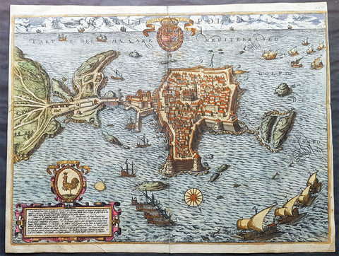
1598 Braun & Hogenberg Antique Map View Old Town of Gallipoli Apulia South Italy
- Title : Gallipolis
- Ref #: 82085
- Size: 20 3/4in x 16in (520mm x 405mm)
- Date : 1598
- Condition: (A+) Fine Condition
Description:
This beautiful original hand coloured copper plate engraved antique map a birds eye view of the Old Town of Gallipoli located on the Salentine Peninsula, in Apulia, Southern Italy & the Angevine-Aragonese Castle, was engraved by the Italian Natale Bonifacio di Girolamo, was published in the 1598 edition of Braun & Hogenbergs atlas on Civitates Orbis Terrarum
General Definitions:
Paper thickness and quality: - Heavy and stable
Paper color : - off white
Age of map color: - Original
Colors used: - Yellow, green, blue, pink
General color appearance: - Authentic
Paper size: - 20 3/4in x 16in (520mm x 405mm)
Plate size: - 20in x 16in (520mm x 405mm)
Margins: - Min 1/8in (3mm)
Imperfections:
Margins: - Top of right margin cropped to border
Plate area: - None
Verso: - Light soiling
Background:
Gallipoli is a southern Italian town and comune in the province of Lecce, in Apulia.
The town is located by the Ionian Sea, on the west coast of the Salentina Peninsula. The town of Gallipoli is divided into two parts, the modern and the old city. The new town includes all the newest buildings including a skyscraper. The old town is located on a limestone island, linked to the mainland by a bridge built in the 16th century.
According to a legend, the city was founded in ancient times by Idomeneus of Crete. Pliny the Elder attributes the foundation to the Senones Gauls, while more likely it was a Messapic settlement. Historically, what is known is that Gallipoli was a city of the Greater Greece, ruling over a large territory including today\'s Porto Cesareo. In 265 BC it sided with Pyrrhus and Taranto against ancient Rome, suffering a defeat which relegated it to a Roman colony (later a municipium).
In the early Middle Ages, it was most likely sacked by the Vandals and the Goths. Rebuilt by the Byzantines, Gallipoli lived an economically and socially flourishing period due to its geographical position. Later it was owned by the Roman Popes, and was a centre of fighting against the Greek monastic orders.
In the 11th century Gallipoli was conquered by the Normans and, in 1268, it was besieged by Charles I of Anjou, causing numerous inhabitants to flee to the nearby Alezio. The city was repopulated around 1300, under the feudal rule of the principality of Taranto. In 1484 the Venetians tried to occupy it, but without results. King Ferdinand I of the Two Sicilies started the construction of the port, which in the 18th century became the largest olive oil market in the Mediterranean.
After the unification of Italy (1861), Gallipoli was capital of a circondario, together with Lecce and Taranto.
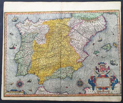
1607 Mercator Antique Map of Spain & Portugal
- Title : Hispania Nova Descriptio de Integro...Petrus Kaerius
- Date : 1607
- Condition: (A) Very Good Condition
- Ref: 42002
- Size: 20in x 18in (510mm x 430mm)
Description:
This fine beautifully hand coloured original antique map of Spain & Portugal by Gerard Mercator was published by Rumold Mercator &Jodocus Hondius in the very early 1607 Latin edition of Mercators Atlas.
This map is magnificent with beautiful original hand colouring. Original colouring such as this is scarce and hard to find.
These maps, published in the early editions of Mercators atlas, are the original maps drawn and engraved by Gerald Mercator in the mid to late 16th century, published by his son Rumold as an atlas, after his death, in 1595. After two editions the plates were purchased by Jodocus Hondius in 1604 and continued to be published until the mid 1630's when the plates were re-engraved and updated by Jan Jansson and Henricus Hondius.
Background:
Many of the original charts and maps drawn by the first Portuguese and Spanish navigators have survived for the very good reason that, on completion of their voyages, pilots were obliged to hand over their manuscript notes to the Casa da India (founded 1504) in Lisbon or to the equivalent Casa de Contrataci6n de las Indias (founded 1504) in Seville. The clear intention was to maintain secrecy over new discoveries and control over the distribution of cartographic material, not always successfully, as it happened; pilots and navigators seem to have changed allegiance with impunity and, in consequence, many of the earliest and most informative charts were compiled as far away as Genoa, Venice, Florence and Ancona, presumably from sources outside the Portuguese and Spanish 'Casas'.It is apparent that few manuscripts reached the printing stage and, indeed, are so rare that any study of them must be regarded as a specialist subject. (Ref Tooley M&B)(Ref: Koeman; Tooley)
Condition Report:
Paper thickness and quality: - Heavy and stable
Paper color: - off white
Age of map color: - Original
Colors used: - Yellow, red, green, purple, blue
General color appearance: - Authentic
Paper size: - 20in x 18in (510mm x 430mm)
Plate size: - 20in x 16in (420mm x 380mm)
Margins: - Min 0in (0mm)
Imperfections:
Margins: - Left margin cropped into border
Plate area: - Light creasing along centerfold
Verso: - Light re-enforcing along centerfold
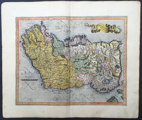
1607 Mercator Hondius Original Antique Map of Ireland - Rare and beautiful
- Title : Irlandiae regnum
- Date : 1607
- Condition: (A) Very Good Condition
- Ref: 42003
- Size: 20in x 18in (560mm x 430mm)
Description:
This fine beautifully hand coloured original antique map of Ireland by Gerald Mercator was published by Rumold Mercator & Jodocus Hondius in the very early 1607 Latin edition of Mercators Atlas.
This map is magnificent with beautiful original hand colouring. Original colouring such as this is scarce and hard to find.
These maps, published in the early editions of Mercators atlas, are the original maps drawn and engraved by Gerald Mercator in the mid to late 16th century, published by his sons Rumold & Henricus as an atlas, after his death, in 1595. After two editions the plates were purchased by Jodocus Hondius in 1604 and continued to be published until the mid 1630's when the plates were re-engraved and updated by Jan Jansson and Henricus Hondius.
The earliest maps of Ireland up to the year 1500 or so share the shortcomings of those of the rest of the British Isles especially as represented on world maps. It was not to be expected that lands literally on the very edge of the known world could be depicted with any accuracy; very often one feels that the cartographers or engravers placed the islands in the nearest available space consistent with their imagined position. Even in the first printed Ptolemaic map there is still much distortion in Ireland's shape and geographical position but, on the other hand, a quite surprising number of place names and other details are shown, as many, in fact, as in the rest of Britain put together. This detailed knowledge is not as puzzling as it might appear, for the Ptolemy maps, at least the later editions from 1513 onwards, were based on Italian portulan charts and these, in turn, reflected knowledge gained during the long commercial relationship which had existed between Italy and Ireland ever since the thirteenth century. The distortions on land-surveyed maps remained uncorrected until late in the seventeenth century but a quite accurate coastal outline was given in the marine atlases of Waghenaer, Dudley, Blaeu and later Dutch chart makers.
Apart from a few manuscript maps and very rare maps printed in Rome and Venice (George Lily, 1546, and others in the period 1560-66) Ireland is shown on Mercator's large map of the British Isles (1564), and in his Atlas (1595) and as a separate sheet in the Ortelius atlases (from 1 573). The most important map, however, was compiled by an Italian, Baptista Boazio, probably in the 1 5 8os. This has survived in manuscript form and may have been used by Pieter van der Keere for a map published by Jodocus Hondius in 1591. Boazio's map was subsequently published by John Sudbury, who later sold Speed's maps, and this version was included in editions of the Ortelius atlases from 6oz onwards. The Boazio map is a quite splendid map, very decorative, some copies even showing an Eskimo complete with kayak and hunting spear. Thereafter the trend is familiar: Camden, Speed, Blaeu, Jansson, Sanson and others of the Dutch and French schools all included a general map or maps of the Irish provinces in their atlases. Speed's map of the whole of Ireland was based at least partly on surveys by Robert Lythe (c.1570) and Francis Jobson(c.1590) and included figures in national costume; it was for long regarded as the best map available and was much copied by publishers in other countries.
In 1685 the first atlas of Ireland to match Saxton's At/as of Eng/andand Wales was published by Sir William Petty as Hiberniae Detineaho, the result of a highly organized and detailed survey (the 'Down' survey) carried out in the years following 1655. Re-issued in miniature form soon afterwards by Francis Lamb, Petty's Atlas was widely used as the basis for practically all maps of Ireland produced by English, French, Dutch and German publishers in the following century. Apart from re-issues of Petty's Atlas and its many copyists there were maps by George Grierson, a Dublin publisher, John Rocque, the Huguenot surveyor and engraver who spent some years in Dublin, and Bernard Scale, Rocque's brother-in-law.
Towards the end of the century many large-scale maps were published but, as in England, private mapping was gradually overtaken and eventually replaced by the Ordnance Survey maps produced between the years 1824 and 1846.(Ref: Koeman, Tooley)
Condition Report:
Paper thickness and quality: - Heavy and stable
Paper color: - off white
Age of map color: - Original
Colors used: - Yellow, red, green, purple, blue
General color appearance: - Authentic
Paper size: - 20in x 18in (560mm x 430mm)
Plate size: - 17 1/2in x 14in (420mm x 330mm)
Margins: - Min 1in (25mm)
Imperfections:
Margins: - Light age toning to margins
Plate area: - Old professional repair to 45mm sq to left side
Verso: - Old professional repair to text "H"
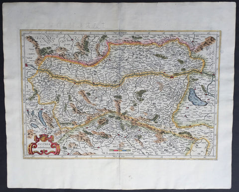
1609 Mercator & Hondius Large Antique Map of Austria
- Title : Austria Archiducatus
- Ref #: 60052
- Size: 22in x 18in (560mm x 460mm)
- Date : 1609
- Condition: (A+) Fine Condition
Description:
This beautifully engraved hand coloured original antique map of Austria was published in the 1609 French edition of Mercators Atlas published by Henricus Hondius and Jan Jansson.
These maps, published in the later editions of Mercators atlas, are derived from the original maps drawn and engraved by Gerald Mercator in the mid to late 16th century, published by his son Rumold as an atlas, after his death, in 1595. After two editions the plates were purchased by Jodocus Hondius in 1604 and continued to be published until the mid 1630's when the plates were re-engraved and updated by Jan Jansson and Henricus Hondius.
Condition Report
Paper thickness and quality: - Heavy and stable
Paper color: - off white
Age of map color: - Early
Colors used: - Red, yellow, green
General color appearance: - Authentic
Paper size: - 22in x 18in (560mm x 460mm)
Plate size: - 19 1/2in x 13in (485mm x 330mm)
Margins: - Min 1in (25mm)
Imperfections:
Margins: - None
Plate area: - None
Verso: - None
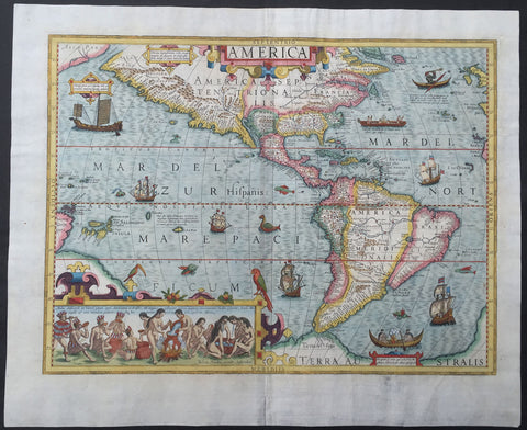
1630 Jodocus Hondius Antique Map of America
- Title : America
- Ref #: 61032
- Size: 22 1/4in x 18 1/4in (565mm x 465mm)
- Date : 1630
- Condition: (A+) Fine Condition
Description:
This magnificent and extremely important, hand coloured original antique map of America was drawn and engraved by Jodocus Hondius for inclusion in his editions of Gerard Mercator's Atlas sive Cosmographicae between 1606 and 1630. This actual map is from the last 1630 Latin edition, identified by the text line Mmmmmmmm on the verso of the map.
This map like many of the time was published on a stereographic projection and is an amalgam of various sources. It incorporates a more correct west coast of South America and narrows still further the longitudinal width of New Spain at the Tropic of Cancer, making it just 10°, much closer in reality. However, like all cartography before, it still retains an enlarged North American continent.
A Plancius type depiction of Newfoundland occurs alongside a typical representation of the east coast, with a more protruding Virginia than usual. Various scenes taken from earlier volumes of de Bry's Grand Voyages adorn the whole. Particularly notable is the native Brazilian scene illustrating the method used to make the local beverage, derived from Hans Stadens voyage as recorded by de Bry.
There are various galleons, kayaks and Indian canoes along with a pair of birds perched on the inset.
Background: This map was engraved by Jodocus Hondius for his first edition of Gerard Mercator's atlas. Intended to be a grand comprehensive work, with the first part originally appearing in 1585, by Mercator's death in 1594 only two parts had been published. Continued by his family, it was still incomplete for the 1602 edition, lacking most importantly a section on the Iberian peninsula. During this time it was also competing with the remarkably successful atlas of Abraham Ortelius which averaged almost one edition per year. By 1604 Jodocus Hondius was flourishing, and in that year acquired all of the plates from Mercator's descendant. He immediately set about engraving many new maps to augment and complete the work, amongst which was a set of the four continents. He also had the original text expanded by Petrus Montanus. In the following year he brought out Mercator's Ptolemy, and in 1606 his first edition of the general atlas which proved instantly popular, selling out within a year.
Right up until 1630 this attractive map was issued alongside the AMERICA sive INDIA NOVA by Michael Mercator, 1595. Since the text describing America was always used by the Mercator, this one is always lacking one. Produced on a stereographic projection like more and more maps of the time, it is an amalgam of various sources. (Ref: Burden; Koeman; M&B; Tooley)
Condition Report
Paper thickness and quality: - Heavy and stable
Paper color: - White
Age of map color: - Original & later
Colors used: - Red, yellow, green
General color appearance: - Authentic
Paper size: - 22 1/4in x 18 1/4in (565mm x 465mm)
Plate size: - 19 3/4in x 14 3/4in (500mm x 375mm)
Margins: - Min 1in (25mm)
Imperfections:
Margins: - Professional repair to bottom center-fold and bottom left margin 1 1/2in into image, no loss
Plate area: - None
Verso: - Light age toning
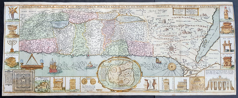
1630 Jacob Tirinus Large Early Antique 1st Edition Map of The Holy Land, Palestine, Israel
- Title : Chorographia Terrae Sanctae in angustiorem Formam Redacta, et ex variis auctoribus a multis errorbus expurgata
- Ref #: 82082
- Size: 33 3/4in x 13 3/4in (855mm x 350mm)
- Date : 1632
- Condition: (A) Very Good Condition
Description:
This large magnificent, hand coloured original copper plate engraved antique 1st edition map of the Holy Land by Johann Belling & Augustus Vindel was published in the 1632 edition of Commentarius in Sacram Scripturam (Commentary on the New and Old Testament) by the Belgian Jesuit monk Jacobus Tirinus.
This is without doubt one of the most visually stunning maps of the Holy land ever published and there have been many elaborated & beautiful maps of this important region published since the dark ages, when the Holy Land was considered the geographical center of the world.
This map was originally prepared in 1632 for Tirinuss study of the Holy Land and was originally engraved by Cornelius Galle and printed in Antwerp by Martinus Nutius. Tirinuss work went through many editions and printings
Background: Oriented to the East the map is surrounded with panels of vignettes displaying sacred objects including a menorah, the arc of the covenant, the altar of sacrifices, the Tabernacle, and a plan and elevations of the Temple. At center is an inset bird's-eye plan of ancient Jerusalem based on the Spanish biblical geographer, Juan Bautista Vilalpando. Oriented with east at top, the map includes the territories of the twelve tribes on both sides of the Jordan River and the route of the Exodus and Wandering. The map depicts from Syria and Tyre southward as far as the Sinai, Egypt and Thebes. At the southern most point, in Egypt, is located the city of Thebes and, slightly to the north, near Memphis, the wildly misshapen Pyramids of Egypt. Slightly further north is the city of Tanis, possible resting place for the Ark of the Covenant. In this spirit, slightly to the south of Tanis, the city of Ramesse is indicated as the starting point of the Biblical Exodus and the wandering of the Hebrews. Following their path into the desert and across the Red Sea – where Pharaoh is shown being inundated by the returning waters following Moses’ parting of the Red Sea. Now in the Sinai, we can follow the footsteps of the Hebrews to Mount Sinai (Sinai Mons), where Moses is drawn throwing down the tablets of God. Slightly to the northwest of this location a cleft in the mountains reveals the location of the ancient Nabatean city of Petra. With regard to Petra, the location and gorge detail is surprisingly accurate considering that it was only “discovered” by the Swiss adventurer Johannes L. Burckhardt, in 1812, 200 years after this map was drawn. Heading northward the lands claimed by the various tribes of Israel are beautifully detailed along with major cities, camps, roads, and trade routes. The Mediterranean is decorated with sailing ships and, in the lower left quadrant, a surveying tool between two censors. Surrounding the map proper on the left, right, and bottom margins, there are 19 maps and images of Biblical objects. The largest and most central of these is a stunning inset of Jerusalem, which notes the various temples and important buildings located there. Other images include the Arc of the Covenant, Israelite coins, Roman antiquities, views of a Menorah, various angels, and a plan of the Temple. All in all an extraordinary piece, one of the most attractive maps of the Holy Land ever made.
Jacobus Tirinus (1580 - 1636) or Jacobi Tirini was a Jesuit monk, theologian, historian, and Biblical scholar. His major work is the Commentarius in Sacram Scripturam a two volume Bible commentary. Tirini was born in Antwerp, Belgium in 1580. Following his admission into the Jesuit Order, Tirini became a respected Biblical scholar and a prominent member of the Order. He was assigned First Superior to the Antwerp Jesuit House as well as "Directior of the Holland Mission". Tirini's Biblial commentaries are still referenced today.(Ref: Laor; M&B; Tooley)
General Description:
Paper thickness and quality: - Heavy & stable
Paper color: - White
Age of map color: - Early
Colors used: - Green, blue, yellow, red, orange
General color appearance: - Authentic
Paper size: - 33 3/4in x 13 3/4in (855mm x 350mm)
Plate size: - 33in x 13in (840mm x 330mm)
Margins: - Min 1/2in (15mm)
Imperfections:
Margins: - Top margin extended from plate-mark
Plate area: - Very light creasing in folds.
Verso: - Light soiling
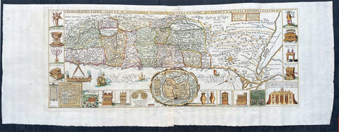
1632 Jacobus Tirinus Large Antique Map of The Holy Land, Palestine, XII Tribes
- Title : Chorographia Terrae Sanctae in angustiorem Formam Redacta, et ex variis auctoribus a multis errorbus expurgata
- Ref #: 17009
- Size: 40in x 19in (1060m x 395mm)
- Date : 1632
- Condition: (A+) Fine Condition
Description:
This large magnificent, hand coloured original copper plate engraved antique map of the Holy Land by Johann Belling & Augustus Vindel was published in Commentarius in Sacram Scripturam (Commentary on the New and Old Testament) by the Belgian Jesuit monk Jacobus Tirinus.
This is without doubt one of the most visually stunning maps of the Holy land ever published and there have been many elaborated & beautiful maps of this important region published since the dark ages, when the Holy Land was considered the geographical center of the world.
This map was originally prepared in 1632 for Tirinus study of the Holy Land and was originally engraved by Cornelius Galle and printed in Antwerp by Martinus Nutius. Tirinuss work went through many editions and printings up until the mid 18th century.
General Definitions:
Paper thickness and quality: - Heavy and stable
Paper color : - off white
Age of map color: - Early
Colors used: - Blue, pink, red, green, yellow
General color appearance: - Authentic
Paper size: - 40in x 19in (1060m x 395mm)
Plate size: - 32 1/2in x 13in (825mm x 330mm)
Margins: - Min 1in (25mm)
Imperfections:
Margins: - None
Plate area: - Folds as issued
Verso: - None
Background:
Oriented to the East the map is surrounded with panels of vignettes displaying sacred objects including a menorah, the arc of the covenant, the altar of sacrifices, the Tabernacle, and a plan and elevations of the Temple. At center is an inset bird\\\'s-eye plan of ancient Jerusalem based on the Spanish biblical geographer, Juan Bautista Vilalpando. Oriented with east at top, the map includes the territories of the twelve tribes on both sides of the Jordan River and the route of the Exodus and Wandering. The map depicts from Syria and Tyre southward as far as the Sinai, Egypt and Thebes. At the southern most point, in Egypt, is located the city of Thebes and, slightly to the north, near Memphis, the wildly misshapen Pyramids of Egypt. Slightly further north is the city of Tanis, possible resting place for the Ark of the Covenant. In this spirit, slightly to the south of Tanis, the city of Ramesse is indicated as the starting point of the Biblical Exodus and the wandering of the Hebrews. Following their path into the desert and across the Red Sea – where Pharaoh is shown being inundated by the returning waters following Moses’ parting of the Red Sea. Now in the Sinai, we can follow the footsteps of the Hebrews to Mount Sinai (Sinai Mons), where Moses is drawn throwing down the tablets of God. Slightly to the northwest of this location a cleft in the mountains reveals the location of the ancient Nabatean city of Petra. With regard to Petra, the location and gorge detail is surprisingly accurate considering that it was only “discovered” by the Swiss adventurer Johannes L. Burckhardt, in 1812, 200 years after this map was drawn. Heading northward the lands claimed by the various tribes of Israel are beautifully detailed along with major cities, camps, roads, and trade routes. The Mediterranean is decorated with sailing ships and, in the lower left quadrant, a surveying tool between two censors. Surrounding the map proper on the left, right, and bottom margins, there are 19 maps and images of Biblical objects. The largest and most central of these is a stunning inset of Jerusalem, which notes the various temples and important buildings located there. Other images include the Arc of the Covenant, Israelite coins, Roman antiquities, views of a Menorah, various angels, and a plan of the Temple. All in all an extraordinary piece, one of the most attractive maps of the Holy Land ever made.
Tirinus, Jacobus 1580 - 1636
Or Jacobi Tirini was a Jesuit monk, theologian, historian, and Biblical scholar. His major work is the Commentarius in Sacram Scripturam a two volume Bible commentary. Tirini was born in Antwerp, Belgium in 1580. Following his admission into the Jesuit Order, Tirini became a respected Biblical scholar and a prominent member of the Order. He was assigned First Superior to the Antwerp Jesuit House as well as Directior of the Holland Mission. Tirinis Biblial commentaries are still referenced today.(Ref: Laor; M&B; Tooley)
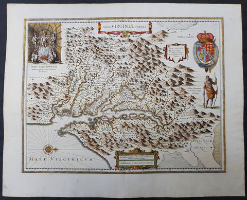
1633 John Smith & Hondius Original Antique Map of Virginia, Chesapeake Bay - Pocahontas
- Title : Nova Virginiae Tabula
- Date : 1633
- Size: 23in x 18 3/4in (585mm x 475mm)
- Ref #: 70818
- Condition: (A+) Fine Condition
Description:
This superb original antique hand coloured map of Chesapeake Bay, Virginia was published in the 1633 edition of Mercators Atlas.
Although this map bears the name of Henricus Hondius, the plate originated from his brother Joducus II in 1618, after Captain John Smith\'s famous map of 1612, and was published in many editions of Mercators Atlas after 1630. Willem Blaeu also purchased this copper-plate from the Hondius plate stock in 1629 and was published in many future Blaeu atlases.
General Definitions:
Paper thickness and quality: - Heavy and stable
Paper color : - off white
Age of map color: - Original
Colors used: - Yellow, green, blue, pink
General color appearance: - Authentic
Paper size: - 23in x 18 3/4in (585mm x 475mm)
Plate size: - 19 3/4in x 15 1/2in (500mm x 395mm)
Margins: - Min 1in (25mm)
Imperfections:
Margins: - None
Plate area: - 4 very small worm holes
Verso: - None
Background:
This is one of the most important seventeenth century maps of the Chesapeake Bay region. The early settlement of Jamestown Iamestowne is noted along with a number of other place names, both in English and Native American. The map was derived from Capt. John Smith's map of 1612 and was the first to depict the bay and its tributaries with any accuracy.
Capt John Smith's fine survey work, as well as reports from indigenous American Indian tribes, and fanciful wishful thinking, combine to make this one of the most interesting maps of America to emerge in the 17th century. Philip D. Burden, the author of The Mapping of America, considers this map, Nova Virginiae Tabula, to be 'one of the most important maps of America ever produced and certainly one of the greatest influence.' Oriented to the west, this map covers from Cape Henry to the Susquehanna River and inland as far as the Appellation Mountains. The Chesapeake Bay is shown in full as are many of its river estuaries, though topographically this map places a number of mountain ranges where there are in fact none.
To fully understand this map one must first realize that most Europeans believed the Pacific, or at least some great bay that led to the Pacific, lay just a few days travel inland. In the minds of most Europeans of the period, the trade potential for the Virginia colony was entirely dependent upon it being a practical access point to the riches of Asia. Thus the significance of large and mysterious body of water appearing in the land of the Massawomecks, in the upper right quadrant, becomes apparent. Of course, much of this land was entirely unexplored by the European settlers in Jamestown, shown here on the Powhatan River (James River), who relied heavily upon American Indian reports for much of their cartographic knowledge of the Virginia hinterlands. The Massawomecks themselves were a rival of the Powhatan and made their home near the headwaters of the Potomac. These, like many other indigenous groups of the region made only a brief and frequently violent appearance during the 17th century before entirely disappearing, mostly from disease and war, in the early 18th century.
In the upper left quadrant there is an image of the American Indian chief of the Powhatan sitting enthroned before a great fire in his long house. One of the more popular legends regarding John Smith was his capture and trial before the chief of the Powahatan. Smith was convinced that his liberation had something to do with the youthful daughter of Chief Powahatan, Pocahontas, taking a liking to him. Although this grew into a fictitious legend of its own, the truth is more likely that Powhatan saw Smith and his Englishmen as potential allies against the rival American Indian groups, such as the Massawomecks, that were pressing hard against his borders.
There are a number of different editions of this map and its publication by various map houses in various states made it the first widely distributed map of the Virginia colony and of John Smith's important map. There was, however, a scandal relating to its publication. The map was originally drawn and engraved in 1618 by Jodocus Hondius based upon the first edition of John Smith's 1612 map. When Jodocus died in 1629, he and his brother, Henricus Hondius, while collaborating on the Hondius Atlas Major, had established and maintained separate business for some 10 years. Jodocus' death enabled the competing cartographer, Willem Blaeu to acquire a large number of Jodocus' map plates, which he promptly published in 1630 as the Atlantis Appendix. Henricus, in the meantime, had been counting on Jodocus' new plates to enhance his own, by then outdated, Hondius Atlas Major. A surviving contract dated March 2, 1630 reveals that Henricus Hondius and his partner Joannes Janssonius hired engravers to produce a number of new map plates copying the work of Jodocus – now in the hands of the Blaeu firm. This map was among the most important of that group and accounts for variants of this map being issued by competing Blaeu and Hondius firms.
The History of Virginia begins with documentation by the first Spanish explorers to reach the area in the 1500s, when it was occupied chiefly by Algonquian, Iroquoian, and Siouan peoples. After a failed English attempt to settle Virginia in the 1580s by Walter Raleigh permanent English settlement began in Virginia with Jamestown, Virginia, in 1607. The Virginia Company colony was looking for gold but failed and the colonists could barely feed themselves. The famine during the harsh winter of 1609 forced the colonists to eat leather from their clothes and boots and resort to cannibalism.[1] The colony nearly failed until tobacco emerged as a profitable export. It was grown on plantations, using primarily indentured servants for the intensive hand labor involved. After 1662, the colony turned black slavery into a hereditary racial caste. By 1750, the primary cultivators of the cash crop were West African slaves. While the plantations thrived because of the high demand for tobacco, most white settlers raised their families on subsistence farms. Warfare with the Virginia Indian nations had been a factor in the 17th century; after 1700 there was continued conflict with natives east of the Alleghenies, especially in the French and Indian War (1754-1763), when the tribes were allied with the French. The westernmost counties including Wise and Washington only became safe with the death of Bob Benge in 1794.
The Virginia Colony became the wealthiest and most populated British colony in North America, with an elected General Assembly. The colony was dominated by rich planters who were also in control of the established Anglican Church. Baptistand Methodist preachers brought the Great Awakening, welcoming black members and leading to many evangelical and racially integrated churches. Virginia planters had a major role in gaining independence and in the development of democratic-republican ideals of the United States. They were important in the Declaration of Independence, writing the Constitutional Convention (and preserving protection for the slave trade), and establishing the Bill of Rights. The state of Kentuckyseparated from Virginia in 1792. Four of the first five presidents were Virginians: George Washington, the "Father of his country"; and after 1800, "The Virginia Dynasty" of presidents for 24 years: Thomas Jefferson, James Madison, and James Monroe.
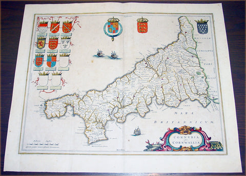
1637 Joan Blaeu Antique Map The English County of Cornwall
- Title : Cornubia sive Cornwallia
- Date : 1637
- Condition: (A) Very Good Condition
- Ref: 50606
- Size: 22in x 18 1/2in (560mm x 470mm)
Description:
This beautifully hand coloured original antique map of English county of Cornwall was published in the 1637 German edition of Joan Blaeu's Atlas Novus.
Background: Blaeu is one of the most revered map makers of all time and it is easy to see why in this beautiful original map.
The high level of the topographical detail, the quality of the paper, the artistic professionalism of the engraving and the beauty of the original hand colouring combine to produce a work of art that is both functional and of exceptional beauty. (Ref: Koeman; M&B)
Condition Report:
Paper thickness and quality: - Heavy and stable
Paper color: - off white
Age of map color: - Original
Colors used: - Yellow, pink, red, blue, green
General color appearance: - Authentic
Paper size: - 22in x 18 1/2in (560mm x 470mm)
Plate size: - 19 3/4in x 15 3/4in (500mm x 400mm)
Margins: - Min 1in (25mm)
Imperfections:
Margins: - Light spotting
Plate area: - Light spotting & browning
Verso: - Light spotting & browning
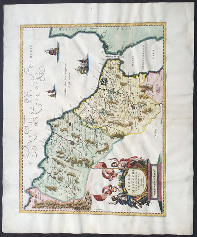
1638 Jan Jansson Large, Old Antique Map of Africa Morocco, Gibraltar & NW Africa
- Title : Fezzae et Marocchi Regna Africae Celeberrima
- Date : 1638
- Condition: (A+) Fine Condition
- Ref: 92950
- Size: 23 1/2in x 19 1/2in (600mm x 495mm)
Description:
This fine large beautifully hand coloured original antique map of Morocco & the Straits of Gibraltar into the Mediterranean was published by Jan Jansson in the 1638 Latin edition of Atlas Novus.
Background: Being part of the Mediterranean world, the northern coasts of the African continent as far as the Straits of Gibraltar and even round to the area of the Fortunate Isles (the Canaries) were reasonably well known and quite accurately mapped from ancient times. In particular, Egypt and the Nile Valley were well defined and the Nile itself was, of course, one of the rivers separating the continents in medieval T-O maps. Through Arab traders the shape of the east coast, down the Red Sea as far as the equator, was also known but detail shown in the interior faded into deserts with occasional mountain ranges and mythical rivers. The southern part of the continent, in the Ptolemaic tradition, was assumed to curve to the east to form a land-locked Indian Ocean. The voyages of the Portuguese, organized by Henry the Navigator in the fifteenth century, completely changed the picture and by the end of the century Vasco da Gama had rounded the Cape enabling cartographers to draw a quite presentable coastal outline of the whole continent, even if the interior was to remain largely unknown for the next two or three centuries.
The first separately printed map of Africa (as with the other known continents) appeared in Munster's Geographia from 1540 onwards and the first atlas devoted to Africa only was published in 1588 in Venice by Livio Sanuto, but the finest individual map of the century was that engraved on 8 sheets by Gastaldi, published in Venice in 1564. Apart from maps in sixteenth-century atlases generally there were also magnificent marine maps of 1596 by Jan van Linschoten (engraved by van Langrens) of the southern half of the continent with highly imaginative and decorative detail in the interior. In the next century there were many attractive maps including those of Mercator/Hondius (1606), Speed (1627), Blaeu (1 630), Visscher (1636), de Wit (c. 1670), all embellished with vignettes of harbours and principal towns and bordered with elaborate and colourful figures of their inhabitants, but the interior remained uncharted with the exception of that part of the continent known as Ethiopia, the name which was applied to a wide area including present-day Abyssinia. Here the legends of Prester John lingered on and, as so often happened in other remote parts of the world, the only certain knowledge of the region was provided by Jesuit missionaries. Among these was Father Geronimo Lobo (1595-1678), whose work A Voyage to Abyssinia was used as the basis for a remarkably accurate map published by a German scholar, Hiob Ludolf in 1683. Despite the formidable problems which faced them, the French cartographers G. Delisle (c. 1700-22), J. B. B. d'Anville (1727-49) and N. Bellin (1754) greatly improved the standards of mapping of the continent, improvements which were usually, although not always, maintained by Homann, Seutter, de Ia Rochette, Bowen, Faden and many others in the later years of the century. (Ref: Tooley; M&B)
General Description:
Paper thickness and quality: - Heavy and stable
Paper color: - off white
Age of map color: - Original & later
Colors used: - Green, red, orange, yellow, blue
General color appearance: - Authentic
Paper size: - 23 1/2in x 19 1/2in (600mm x 495mm)
Plate size: - 20in x 15 1/2in (510mm x 395mm)
Margins: - Min 1in (25mm)
Imperfections:
Margins: - Light soiling in left margin, reapir to top and bottom margin not affecting the image
Plate area: - None
Verso: - None
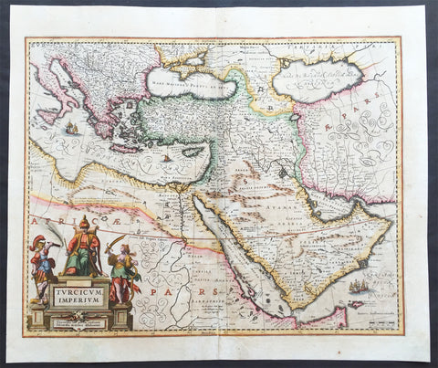
1638 Jansson Old, Antique Map of the Turkish Empire, Saudi Arabia, Middle East
- Title : Turcicum Imperium
- Ref #: 61009
- Size: 22 1/2in x 19in (570mm x 485mm)
- Date : 1638
- Condition: (A) Very Good Condition
Description:
This beautiful, old original antique map* of The Turkish Empire in Europe, Africa & Asia centering on Saudi Arabia by Jan Jansson was published in the 1638 Latin edition for Mercator's Atlas by both Henricus Hondius and Jan Jansson.
Background: This is the standard 17th century view of the Turkish Empire, including the Balkans in south-eastern Europe, the North African littoral, the Levant and the Arabian Peninsula in addition to the area of Modern Turkey & Persia.
Much of the place name information on this map is derived from the maps published in 1561 by the Italian mapmaker, Giacomo Gastaldi, whose maps exercised great influence over later European mapmakers, throughout the 17th century.
Formidable though the barrier presented by the Turkish Empire in the Near East was, by the early years of the 17th century it was beginning to show signs of decadence and weakness, especially after the defeat of the Turkish navy at the hands of the combined Christian forces of Western Europe at the battle of Lepanto in 1571, from which Turkish naval power never fully recovered.
Centered on the palace of the Sultans at Constantinople, the administration of the empire was passed down through local rulers, the Beys, Deys and Pashas, who never lost an opportunity to enrich themselves and to develop often considerable powers of their own.
Further defeats of the Turks occurred in 1669 when Candia (Crete) was taken by the Venetians, and in 1683 when they suffered a humiliating defeat outside Wien (Vienna) at the north-western extremity of European Turkey. (Ref: Suraz; Koeman; M&B; Tooley)
Condition Report:
Paper thickness and quality: - Heavy and stable
Paper color: - off white
Age of map color: - Early & Later
Colors used: - Yellow, pink, green
General color appearance: - Authentic
Paper size: - 22 1/2in x 19in (570mm x 485mm)
Plate size: - 21in x 16 1/2in (530mm x 420mm)
Margins: - Min 1/2in (12mm)
Imperfections:
Margins: - Several small repairs to margins, no loss
Plate area: - Centerfold re-joined light uplift along centerfold, light age toning
Verso: - Repairs as noted
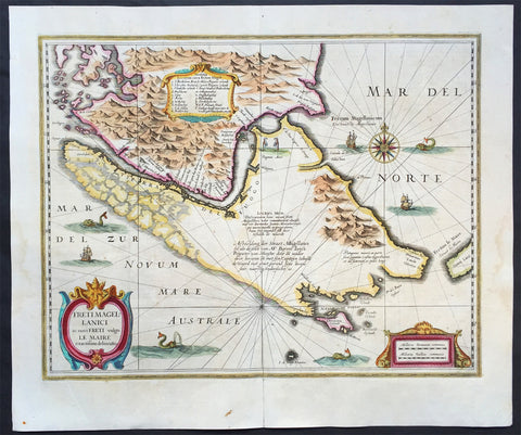
1639 Hondius Antique Map of Magellan Straits, South America
- Title : Freti Magellanici ac novi Freti vulgo Le Maire exactissima delinatio..
- Date : 1639
- Condition: (A+) Fine Condition
- Ref: 43137
- Size: 22in x 18in (560mm x 470mm)
Description:
This finely engraved beautifully hand coloured original antique map of Straits of Magellan, Le Maire Strait, Fire Lands and the southern tip of Patagonia was published in the 1639 French edition of Mercators Atlas by Jan Jansson and Henricus Hondius.
These maps, published in the later editions of Mercators atlas, are derived from the original maps drawn and engraved by Gerald Mercator in the mid to late 16th century, published by his son Rumold as an atlas, after his death, in 1595. After two editions the plates were purchased by Jodocus Hondius in 1604 andcontinued to be published until the mid 1630's when the plates were re-engraved and updated by Jan Jansson and Henricus Hondius.
Early impression of this fine map of Tierra del Fuego. With a Dutch translation of the explanatory text of the passage by Barent Jansz. Potgieter who accompanied captain Sebald de Weert to the Straits in 1599/1600, being the first Dutch vessels to sail through the Strait of Magellan.
After various English voyages, the Dutch appeared in the Strait of Magellan in 1599. One of the Dutch pioneering voyages to the Southwest was the one by Jacques Mahu and Simon de Cordes, who were sent out by Rotterdam merchants.
The five ships of this fleet were the first Dutch vessels to sail through the Strait of Magellan. One of them, the De Liefde, completed the crossing of the Pacific, reached Japan and laid the foundations for Dutch trade. (Ref: Tooley, Koeman)
General Description:
Paper thickness and quality: - Heavy and stable
Paper color: - off white
Age of map color: - Original
Colors used: - Green, pink, yellow, blue
General color appearance: - Authentic
Paper size: - 22in x 18in (560mm x 470mm)
Plate size: - 19 1/2in x 15 1/2in (490mm x 390mm)
Margins: - Min 1in (25mm)
Imperfections:
Margins: - None
Plate area: - Light creasing
Verso: - Bottom centerfold re-joined, no loss
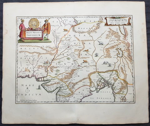
1639 Jansson Original Antique Map The Mughal or Mogul Empire India, Tibet, Nepal
- Title : Magni Mogolis Imperium
- Date : 1639
- Size: 24in x 20in (610mm x 510mm)
- Ref #: 70711
- Condition: (A+) Fine Condition
Description:
This fine, beautifully hand coloured original antique and very important map of Mughal Empire of Northern India, Tibet, Nepal and central Asia by Jan Jansson was published in the 1639 French edition of Gerard Mercators Atlantis Novi Atlas.
General Definitions:
Paper thickness and quality: - Heavy and stable
Paper color : - off white
Age of map color: - Original
Colors used: - Yellow, green, blue, pink
General color appearance: - Authentic
Paper size: - 24in x 20in (610mm x 510mm)
Plate size: - 19 1/2in x 14 1/2in (495mm x 370mm)
Margins: - Min 2in (50mm)
Imperfections:
Margins: - Light age toning
Plate area: - None
Verso: - None
Background:
This map centers on the Mughal capital of Agra, with the map covering, roughly, from Kabul to Orissa and Deccan, and from Persia to Bengal. It depicts the empire prior to the conquest of Orissa and Deccan, most likely during the reign of Shah Jahan, of Taj Mahal fame. Relief is shown pictorially. An elaborate title cartouche appears in the upper left quadrant. The map is embellished with images of tigers, elephants, caravans, and galleons.
There is much of interest. In particular, is the map detailed breakdown of the caravan network between Gujarat and Agra, between Agra and the desert outpost of Jaisalmer, and between Agra and the Silk Road center of Kabul. While the map does not show roads, for surely none as such existed at the time, it does show the network of towns, waystations and caravanserai built to support the bustling trade system.
The apocryphal Lake of Chiamay appears just north of the Bay of Bengal as the source of four important Southeast Asian river systems including the Irrawaddy, the Dharla, the Chao Phraya, and the Brahmaputra. The curious Lake of Chiamay (also called Chiam-may or Chian-may), roughly located in the area of Assam but sometimes as far north as Tibet and China, began to appear in maps of this region as early as the 16th century and persisted well into the mid 18th century. Its origins are unknown but may originate in a lost 16th century geography prepared by the Portuguese scholar Jao de Barros. It was speculated to be the source of five important Southeast Asian River systems and was mentioned in the journals of Sven Hedin. There are even records that the King of Siam led an invasionary force to take control of the lake in the 16th century. Nonetheless, the theory of Lake Chiamay was ultimately disproved and it disappeared from maps entirely by the 1760s.
There are two states of this map, the present example being the first state, first issued in 1638 by Henricus Hondius, and the second state a few years later in 1641 by Jan Jannson. With the exception of the signature imprint, the plates are identical. (Ref: Koeman; M&B)
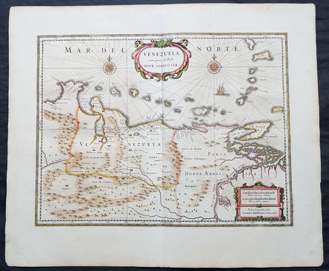
1639 Jansson Scarce Original Antique Map of Venezuela, A. de Berrio & W Raleigh
- Title : Venezuela, cum Parte Australi Novae Andalusiae
- Date : 1639
- Size: 24in x 20in (610mm x 510mm)
- Ref #: 70710
- Condition: (A+) Fine Condition
Description:
This beautifully hand coloured original antique map of what is today modern Venezuela, northern South America was published in the 1639 French Edition of Mercator's Atlas by Mercators successors Jan Jansson & Henricus Hondius.
This map is in stunning condition on bright heavy stable paper. with original margins and beautiful original colour.
General Definitions:
Paper thickness and quality: - Heavy and stable
Paper color : - off white
Age of map color: - Original
Colors used: - Yellow, green, blue, pink
General color appearance: - Authentic
Paper size: - 24in x 20in (610mm x 510mm)
Plate size: - 19 1/2in x 15in (495mm x 385mm)
Margins: - Min 2in (50mm)
Imperfections:
Margins: - None
Plate area: - None
Verso: - None
Background:
This map, showing the area of modern Venezuela to the north of the Orinoco valley is another of the early group of maps added to Mercators atlas by Jansson and Hondius, after Joan Blaeus map of the 1630's. It extends from Lago de Maracaibo in the west to the Island of Trinidad in the east and also shows the Dutch held is lands of Curacao, Aruba and Bonaire which served as the base of the Geotroyeerde West Indische Compahnie or Netherlands West Indian Company, since 1634.
Of the three great rivers of South America, the Orinoco was, and remains, the most difficult to navigate. It was the last to yield any of its secrets even though, on his third voyage in 1498, Columbus had noted the strong currents of fresh water from the Orinoco and believed himself to be at the mouth of one of the four rivers of Paradise>
Throughout the sixteenth century, attempts were made to search for the legendary kingdom of El Dorado, but it was not until the three Orinoco voyages of Antonio de Berrio between 1584 and 1591, all starting out from bases in Nueva Granada, that any useful knowledge of the interior was gathered. Berrio never found El Dorado, but he made several discoveries of the river valleys of the interior. By a curious twist of fate, Berrio, whilst waiting in Trinidad for further orders from Spain, was captured by Sir Walter Raleigh, to whom he divulged his knowledge of the region, as well as a great deal of intended misinformation
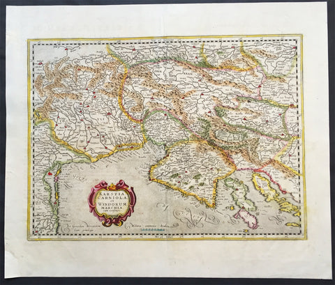
1639 Mercator Hondius Antique Map of Gulf of Venice, Istra, Italy, Slovenia
- Title : Karstia, Carniola, Histria et Windorum Marchia
- Ref #: 43152
- Size: 21 1/2in x 18 1/2in (550mm x 470mm)
- Date : 1639
- Condition: (A+) Fine Condition
Description:
This beautifully hand coloured original antique map of northern Adriatic Sea and the Gulf of Venice centered on Istria, showing present-day north-eastern Italy, a large part of Slovenia and northern Croatia - extending from Venice to the Island of Arbe and from Doblach to Pettau on the Dravus River - engraved by Gerard Mercator, was published by 1639 French edition of Mercators Atlas by Jan Jansson and Henricus Hondius.
These maps, published in the later editions of Mercators atlas, are derived from the original maps drawn and engraved by Gerald Mercator in the mid to late 16th century, published by his son Rumold as an atlas, after his death, in 1595. After two editions the plates were purchased by Jodocus Hondius in 1604 and continued to be published until the mid 1630's when the plates were re-engraved and updated by Jan Jansson and Henricus Hondius.
Condition Report:
Paper thickness and quality: - Heavy & stable
Paper color: - off white
Age of map color: - Original
Colors used: - Yellow, pink, green
General color appearance: - Authentic
Paper size: - 21 1/2in x 18 1/2in (550mm x 470mm)
Plate size: - 18 1/2in x 14 1/2in (470mm x 350mm)
Margins: - Min 1in (25mm)
Imperfections:
Margins: - Bottom left margin corner repaired, no affect on image
Plate area: - Creasing along centerfold
Verso: - None
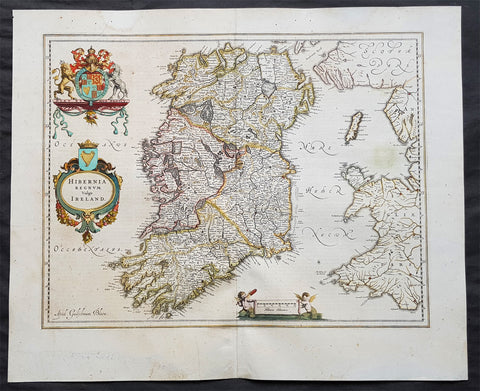
1642 Blaeu Large Old, Antique Map of Ireland - Hibernia Regnum
- Title: Hibernia Regnum Vulgo Ireland
- Size: 23 1/2in x 20in (600mm x 510mm)
- Ref # : 61159
- Date: 1642
- Condition: (A) Very Good Condition
Description:
This superbly hand coloured original antique map of Ireland - Hibernia - was published in the 1642 Dutch edition of Joan Blaeu's Atlas Novus.
Background:
This is Willem Blaeu's highly decorative general map of Ireland and is coloured to show in outline the ancient provinces of Connaught, Leinster, Munster and Ulster each of which together with the map of Carlow, was given a separate map in a section at the end of the atlas volume devoted to Scotland.
The map, which Blaeu first issued in 1635 (twenty years prior to the publication of the Scotland and Ireland volume) was based on that published by John Speed in 1611 in his Theatre of the Empire of Great Briatine. In its turn Speed's map was copied Hondius and Blaeu's great rival Jan Jansson. It was the latter version that Willem Blaeu used. His beautifully balanced design is complemented by the Royal arms and the relatively simple title cartouche at the left hand side. (Ref: Koeman; Tooley; M&B)
General Description:
Paper thickness and quality: - Heavy
Paper color: - White
Age of map color: - Original
Colors used: - Yellow, pink, red, blue, green
General color appearance: - Authentic
Paper size: - 23 1/2in x 19in (600mm x 485mm)
Plate size: - 19 3/4in x 15 1/4in (505mm x 385mm)
Margins: - Min 1in (25mm)
Imperfections:
Margins: - Light age toning
Plate area: - Light age toning
Verso: - Bottom section of centerfold re-joined, no loss
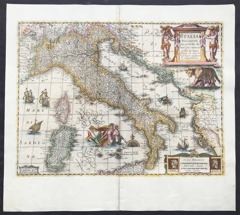
1644 Jan Jansson & Henricus Hondius Antique Map of Italy, Sardinia, Corsica
- Title : Italia Nuouamente piu perfetta chemai per inanzi posta
- Ref #: 61008
- Size: 21 1/2in x 19in (545mm x 490mm)
- Date : 1644
- Condition: (A) Very Good Condition
Description:
This fine beautifully hand coloured original antique map of Italy, Sicily, Sardinia & the Adriatic Coast by Jan Jansson was published in the 1644 German edition of Mercator's atlas by Jansson and Hondius.
This map is richly embellished with cartouches, sailing vessels, sea monsters and a wonderful rendering of Neptune and his mate. The image of the two mer-people embracing with bare chests is a hold over from the controversial images present in the first edition of Ortelius' modern map of Italy. Includes portraits of Romulus and Remus in the lower right corner. In subsequent years, Jansson would replace Hondius's name with his own in the bottom left corner.
General Description:
Paper thickness and quality: - Heavy and stable
Paper color: - off white
Age of map color: - Original
Colors used: - Green, red, orange, yellow, blue
General color appearance: - Authentic
Paper size: - 21 1/2in x 19in (545mm x 490mm)
Plate size: - 19 1/2in x 14 1/2in (500mm x 360mm)
Margins: - Min 1in (25mm)
Imperfections:
Margins: - Centrefold re-joined
Plate area: - Centrefold re-joined
Verso: - Centrefold re-joined
Background: Since classical times the countries bordering the enclosed waters of the Mediterranean had been well versed in the use of maps and sea charts and in Italy, more than anywhere else, the traditional knowledge was kept alive during the many hundreds of years following the collapse of the Roman Empire. By the thirteenth and fourteenth centuries the seamen of Venice, Genoa and Amalfi traded to far countries, from the Black Sea ports and the coasts of Palestine and Egypt in the East to Flanders and the southern coasts of England and Ireland in the West, their voyages guided by portulan charts and the use of the newly invented compass. For a time Italian supremacy in cartography passed to Aragon and the Catalan map makers based on Majorca, but by the year 1400 the power and wealth of the city states of Venice, Genoa, Florence and Milan surpassed any in Europe. Florence, especially, under the rule of the Medici family, became not only a great trading and financial centre but also the focal point of the rediscovery of the arts and learning of the ancient world. In this milieu a number of manuscript world maps were produced, of which one by Fra Mauro (c. 1459) is the most notable, but the event of the greatest importance in the history of cartography occurred in the year 1400 when a Florentine, Palla Strozzi, brought from Constantinople a Greek manuscript copy of Claudius Ptolemy'sGeographia, which, 1,250 years after its compilation, came as a revelation to scholars in Western Europe. In the following fifty years or so manuscript copies, translated into Latin and other languages, became available in limited numbers but the invention of movable-type printing transformed the scene: the first copy without maps being printed in 1475 followed by many with copper-engraved maps, at Bologna in 1477, Rome 1478, 1490, 1507 and 1508, and Florence 1482.
About the year 1485 the first book of sea charts, compiled by Bartolommeo dalli Sonetti, was printed in Venice and in the first part of the sixteenth century a number of world maps were published, among them one compiled in 1506 by Giovanni Contarini, engraved by Francesco Rosselli, which was the first printed map to show the discoveries in the New World. In the following years there were many attractive and unusual maps of Islands (Isolano) by Bordone, Camocio and Porcacchi, but more important was the work of Giacomo (Jacopo) Gastaldi, a native of Piedmont who started life as an engineer in the service of the Venetian Republic before turning to cartography as a profession. His maps, produced in great variety and quantity, were beautifully drawn copperplate engravings and his style and techniques were widely copied by his contemporaries. From about 1550 to 1580 many of Gastaldi's maps appeared in the collections of maps known as Lafreri 'atlases', a term applied to groups of maps by different cartographers brought together in one binding. As the contents of such collections varied considerably they were no doubt assembled at the special request of wealthy patrons and are now very rare indeed.
About this time, for a variety of historical and commercial reasons, Italy's position as the leading trading and financial nation rapidly declined and with it her superiority in cartography was lost to the vigorous new states in the Low Countries. That is not to say, of course, that Italian skills as map makers were lost entirely for it was not until 1620 that the first printed maps of Italy by an Italian, Giovanni Magini, appeared, and much later in the century there were fine maps by Giacomo de Rossi and Vincenzo Coronelli, the latter leading a revival of interest in cartography at the end of the century. Coronelli was also famous for the construction of magnificent large-size globes and for the foundation in Venice in 1680 of the first geographical society.
In the eighteenth century the best-known names are Antonio Zatta, Rizzi-Zannoni and Giovanni Cassini.
We ought to mention the work of Baptista Boazio who drew a series of maps in A Summarie and True Discourse of Sir Francis Drake's West Indian Voyage, published in 1588-89, and who is especially noted for a very fine map of Ireland printed in 1599 which was incorporated in the later editions of the Ortelius atlases. It is perhaps appropriate also to refer to two English map makers who spent many years in exile in Italy: the first, George Lily, famous for the splendid map of the British Isles issued in Rome in 1546, and the second, Robert Dudley, who exactly one hundred years later was responsible for the finest sea atlas of the day, Dell' Arcano del Mare,published in Florence. Both of these are described in greater detail elsewhere in this handbook. (Ref: Tooley, Koeman)
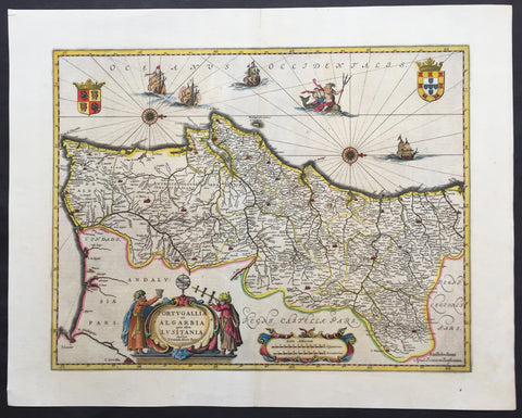
1646 Jan Jansson Large, Old Antique Map of Portugal - Portugallia et Algarbia
- Title : Portugallia et Algarbia quae olim Lusitania
- Date : 1646
- Condition: (A+) Fine Condition
- Ref: 81055
- Size: 24in x 19in (610mm x 480mm)
Description:
This finely engraved beautifully hand coloured original antique map of Portugal was published by Jan Jansson in the 1646 Latin edition of Atlas Novus. (Ref Tooley M&B)
General Description:
Paper thickness and quality: - Heavy and stable
Paper color: - off white
Age of map color: - Original
Colors used: - Green, red, orange, yellow, blue
General color appearance: - Authentic
Paper size: - 24in x 19in (610mm x 480mm)
Plate size: - 20in x 15in (535mm x 385mm)
Margins: - Min 1in (25mm)
Imperfections:
Margins: - None
Plate area: - None
Verso: - None
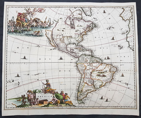
1671 Jacob Van Meurs Rare Original Antique Map of America - Island of California
- Title : Novissima et Accuratissima Totius Americae Descriptio per Jacobum Meursium
- Date : 1671
- Size: 22in x 19in (560mm x 485mm)
- Ref #: 61157
- Condition: (A) Very Good Condition
Description: This uncommon and rare original antique map of America and the Pacific, including parts of New Zealand, was published in Amsterdam by Jacob Van Meurs in 1671 for the German edition of Arnold Montanus' ground breaking publication "America". (Ref: Burden, Tooley, Koeman)
General Description:
Paper thickness and quality: - Heavy and stable
Paper color: - off white
Age of map color: - Early
Colors used: - Green, red, orange, yellow, blue
General color appearance: - Authentic
Paper size: - 22in x 19in (560mm x 485mm)
Plate size: - 21 3/4in x 17 1/2in (550mm x 445mm)
Margins: - Min 1/2in (12mm)
Imperfections:
Margins: - Light soiling
Plate area: - Folds as issued, light separation along folds, no loss
Verso: - Professionally backed onto Japanese archival rice paper
Background: Unlike the Dutch edition of this map (by Van Schaegen) and English edition (by John Ogilby), which copied the De Wit / Visscher America map, Van Meurs creates a highly decorative new plate for the German edition of Montanus' America. The plate was later acquired by Pierre Vander Aa and re-issued bearing Vander Aa's name circa 1714.
The map shows California as an Island on the first Sanson Projection, showing a single large Great Lake (open at the west), a curious north-easterly coastline north of the Island of California and a geographically misaligned South America, with tribal vignettes in Brazil and wild life in North America. The map predates La Salle's information on the interior of North America, but includes excellent detail on Canada and the East Coast of North America, noting the Dutch Possessions, the Iroquois regions, N. Anglia, New Amsterdam, the Cheaspeak, Plymouth, and many Indian Place names.
Meurs's map is based upon Nicholas Visscher's map of 1658, in that it includes the coastline New Zealand and the early Sanson model for California, and only shows one of the Great Lakes, updated from Visscher's edition. Visscher in turn drew his information from Joan Blaeu's wall map of the World, published in 1648.
The map is most notable for its elaborate allegorical cartouches. One of the most outstanding features of this map are the beautifully engraved decorative cartouches that include numerous vignettes of wildlife, American Indians, sailing ships and battles. The title is surrounded by Native Americans trading with Europeans and in the North Pacific is a lavish scene of Neptune and his consort in a chariot surrounded by his entourage and putti. The map was to be included in Montanus book of America and so has folds as issued. (Ref: Burden, Tooley, Koeman)
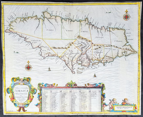
1671 John Ogilby 1st Antique English map of The Island of Jamaica, Caribbean
- Title : Novissima et Acccuratissima Jamaicae Descriptio per Johannem Ogiluium Cosmographum Regnum 1671
- Size: 21 1/4in x 17 1/4in (515mm x 440mm)
- Condition: (B) Good Condition
- Date : 1671
- Ref #: 82081
Description:
This beautifully hand coloured original copper-plate engraved antique map of the Caribbean Island of Jamaica - the first English map of the Island - by John Ogilby was engraved by Francis Lamb (active 1665 - 1700) in 1671 - dated - and published in the atlas America: Being The latest, And Most Accurate Description Of The New World; Containing The Original of the Inhabitants, and the Remarkable Voyages thither. The Conquest Of The Vast Empires Of Mexico and Peru, and Other Large Provinces and Territories, With The Several European Plantations In Those Parts. Also Their Cities, Fortresses, Towns, Temples, Mountains, and Rivers
This map has undergone some restoration, as with most of the folded maps from Ogilbys America, mainly to the borders and is reflected in the price. Please see further details below.
This is the earliest detailed English maps of Jamaica. It had a significant influence on subsequent maps and is based on surveys by John Man, Jamaicas surveyor general. Ogilbys map divides the island into named precincts and notes major cities and plantations. A large inset below lists the plantations and indicates whether they produce cocoa, indigo, sugar and/or cotton. On either side is a decorative title cartouche and a mileage cartouche adorned with putti. This is one of the few original maps from Ogilbys America.
General Definitions:
Paper thickness and quality: - Heavy and stable
Paper color : - off white
Age of map color: - Original
Colors used: - Yellow, green, blue, pink
General color appearance: - Authentic
Paper size: - 21 1/4in x 17 1/4in (515mm x 440mm)
Plate size: - 21 1/4in x 17 1/4in (515mm x 440mm)
Margins: - Min 0in (0mm)
Imperfections:
Margins: - All margins cropped to plate-marks. Right border restored, part of the bottom left & bottom center border restored.
Plate area: - Light creasing, re-enforced along original folds
Verso: - Re-enforced along original folds, soiling
Background:
Jamaica is an island country situated in the Caribbean Sea. Previously inhabited by the indigenous Arawak and Taíno peoples, the island came under Spanish rule following the arrival of Christopher Columbus in 1494. Many of the indigenous people died of disease, and the Spanish transplanted African slaves to Jamaica as labourers. The island remained a possession of Spain until 1655, when England conquered it and renamed it Jamaica. Under British colonial rule Jamaica became a leading sugar exporter, with its plantation economy highly dependent on African slaves. The British fully emancipated all slaves in 1838, and many freedmen chose to have subsistence farms rather than to work on plantations. Beginning in the 1840s, the British utilized Chinese and Indian indentured labour to work on plantations.
Spanish Town has the oldest cathedral of the British colonies in the Caribbean. The Spanish were forcibly evicted by the English at Ocho Rios in St. Ann. In the 1655 Invasion of Jamaica, the English, led by Sir William Penn and General Robert Venables, took over the last Spanish fort on the island. The name of Montego Bay, the capital of the parish of St. James, was derived from the Spanish name manteca bahía (or Bay of Lard), alluding to the lard-making industry based on processing the numerous boars in the area.
In 1660, the population of Jamaica was about 4,500 white and 1,500 black. By the early 1670s, as the English developed sugar cane plantations and imported more slaves, black people formed a majority of the population. The colony was shaken and almost destroyed by the 1692 Jamaica earthquake.
The Irish in Jamaica also formed a large part of the islands early population, making up two-thirds of the white population on the island in the late 17th century, twice that of the English population. They were brought in as indentured labourers and soldiers after the conquest of Jamaica by Cromwells forces in 1655. The majority of Irish were transported by force as political prisoners of war from Ireland as a result of the ongoing Wars of the Three Kingdoms at the time. Migration of large numbers of Irish to the island continued into the 18th century.
Jews were expelled from Spain in 1492 and then forcibly converted to Christianity in Portugal, during a period of persecution by the Inquisition. Some Spanish and Portuguese Jewish refugees went to the Netherlands and England, and from there to Jamaica. Others were part of the Iberian colonisation of the New World, after overtly converting to Catholicism, as only Catholics were allowed in the Spanish colonies. By 1660, Jamaica had become a refuge for Jews in the New World, also attracting those who had been expelled from Spain and Portugal.
An early group of Jews arrived in 1510, soon after the son of Christopher Columbus settled on the island. Primarily working as merchants and traders, the Jewish community was forced to live a clandestine life, calling themselves Portugals. After the British took over rule of Jamaica, the Jews decided the best defense against Spains regaining control was to encourage making the colony a base for Caribbean pirates. With the pirates installed in Port Royal, which became the largest city in the Caribbean, the Spanish would be deterred from attacking. The British leaders agreed with the viability of this strategy to forestall outside aggression.
When the English captured Jamaica in 1655, the Spanish colonists fled after freeing their slaves. The slaves dispersed into the mountains, joining the maroons, those who had previously escaped to live with the Taíno native people. During the centuries of slavery, Maroons established free communities in the mountainous interior of Jamaica, where they maintained their freedom and independence for generations. The Jamaican Maroons fought the British during the 18th century. Under treaties of 1738 and 1739, the British agreed to stop trying to round them up in exchange for their leaving the colonial settlements alone, but serving if needed for military actions. Some of the communities were broken up and the British deported Maroons to Nova Scotia and, later, Sierra Leone. The name is still used today by modern Maroon descendants, who have certain rights and autonomy at the community of Accompong.
During its first 200 years of British rule, Jamaica became one of the worlds leading sugar-exporting, slave-dependent colonies, producing more than 77,000 tons of sugar annually between 1820 and 1824. After the abolition of the international slave trade in 1807, the British began to import indentured servants to supplement the labour pool, as many freedmen resisted working on the plantations. Workers recruited from India began arriving in 1845, Chinese workers in 1854.
Ogilby, John 1600-1676
Ogilby was a Scottish cartographer and publisher. Ogilby is perhaps best known for his series of road-maps entitled the Britannia, which was the first road-atlas of any country, published in 1675.
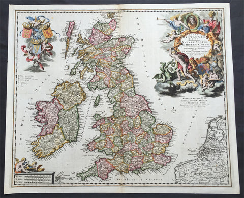
1690 Nicolas Visscher Large Old, Antique Map of Great Britain & Ireland
- Title : Magnae Britanniae Tabula...Angliae, Scotiae, Ac Hiberniae Regna...Per Nicol. Visscher...Guilielmo III D.G.
- Ref #: 61110
- Size: 24in x 20in (610mm x 515mm)
- Date : 1690
- Condition: (A+) Fine Condition
Description: This large rare beautifully hand coloured original antique map of Great Britain & Ireland was published by Nicholas Visscher in 1690
This is a very beautiful map with rich deep colour and heavy engraving on clean and stable paper. It is also an important map, dedicated to William III of Orange (King Billy) who ruled GB & Ireland between 1689 & 1702, a time of great change both in Europe and the New World.
Background: In 1558 Queen Elizabeth came to the throne in the midst of a fast changing world. In 1563 a nineteen sheet map, copies of which survive only in manuscript form, was completed by Laurence Nowell, and no doubt, the issue of Mercator's large-scale map of the British Isles in 1564 had an important influence on the thought of the period. A few years later a national survey was commissioned privately, although probably at the instigation of Lord Burghley, the Lord Treasurer, but subsequently was completed with royal encouragement. The outcome was Christopher Saxton's Atlas of EngIand and Wales, started about 1570 and published in 1579 - the first printed set of county maps and the first countrywide atlas on such a splendid scale produced anywhere. A Welsh antiquarian, Humphrey Lhuyd completed a set of surveys that were even more successful than Saxton in which he had produced fine manuscript maps of England and Wales which were used by Ortelius in editions of his Atlas from 1573 onwards.
The earliest maps of the 17th century, attributed to William Smith of the College of Heralds, covered only twelve counties based on Saxton/Norden and were presumably intended to be part of a complete new atlas. They were printed in the Low Countries in 1602-3 and were soon followed by maps for the Latin edition of Camden's Britannia dated 1607. In 1610-11 the first edition of John Speed's famous county Atlas The Theatre of the Empire of Great Britaine was published and immediately replaced Saxton's in popular appeal. Although Speed assembled much of his material from the earlier works of Saxton, Norden and others, a considerable part of the up-to-date information, especially relating to the inset town plans depicted on his maps, was obtained first hand. The maps undoubtedly owed much of their popularity to the splendid engravings of high quality made in the workshops in Amsterdam of Jodocus Hondius to whom Speed sent his manuscripts, the plates subsequently being returned to London for printing.
In 1645, Volume IV of the famous Blaeu World Atlas covering the counties of England and Wales was published in Amsterdam. These maps have always been esteemed as superb examples of engraving and design, the calligraphy being particularly splendid, but nevertheless they were nearly all based on Saxton and Speed and added little to geographical knowledge.
Not until the latter part of the century do we find an English map maker of originality with the capacity to put new ideas into practice. John Ogilby, one of the more colourful figures associated with cartography, started life as a dancing master and finished as King's Cosmographer and Geographic Printer. After publishing a small number of county maps, somewhat on the lines of John Norden he issued in 1675 the Britannia, the first practical series of detailed maps of the post roads of England and Wales on a standard scale of 1,760 yards to the mile. Up to the end of the century and beyond, reprints and revisions of Saxton's and Speed's atlases continued to appear and the only other noteworthy county maps were Richard Blome's Britannia (1673), John Overton's Atlas (c. 1670) and Robert Morden's maps for an English translation of Camden's Britannia published in 1695.
Another noted cartographer of the day was Captain Greenvile Collins, and of his work in surveying the coasts of Great Britain culminating in the issue in 1693 of the Great Britain's Coasting Pilot. Apart from these charts, English cartographers published during the century a number of world atlases. Speed was the first Englishman to produce a world atlas with the issue in 1627 of his A Prospect of the Most Famous Parts of the World. Other atlases appeared later in the century by Peter Heylin, John Seller, William Berry, Moses Pitt and Richard Blome, whilst Ogilby found time to issue maps of Africa, America and Asia. Far more important, from the purely scientific point of view, was the work of Edmund Halley, Astronomer Royal, who compiled and issued meteorological and magnetic charts in 1688 and 1701 respectively.
At the beginning of the eighteenth century the Dutch map trade was finally in decline, the French in the ascendant and the English to a great extent still dominated by Saxton and Speed except, as we have shown, in the spheres of sea charts and road maps. There were atlases by John Senex, the Bowles family, Emanuel and Thomas Bowen, Thomas Badeslade and the unique bird's-eye perspective views of the counties, The British Monarchy by George Bickham. In 1750-60 Bowen and Kitchin's The Large English Atlas containing maps on a rather larger scale than hitherto was published.
In 1759 the Society for the encouragement of Arts, Manufactures and Commerce offered an award of £100 for the best original surveys on this scale and by the end of the century about thirty counties had been re-surveyed. These maps, many of which formed, in later years, the basis for the first issues of county maps by the Ordnance Survey Office were not only decorative but a tremendous improvement geographically on earlier local maps. As a consequence, the skills and expertise of the new-style cartographers soon enabled them to cover the world as well as the domestic market. Thomas Jefferys was such a man; he was responsible for a number of the new 1 in. to 1 mile county surveys and he issued an edition of Saxton's much battered 200-year-old plates of the county maps, but he is better known for many fine maps of North America and the West Indies. His work was continued on the same lines by William Faden, trading as Faden and Jefferys. Other publishers such as Sayer and Bennett and their successors Laurie and Whittle published a prodigious range of maps, charts and atlases in the second half of the century. A major influence at this time was John Cary who, apart from organizing the first re-survey of post roads since Ogilby and subsequently printing the noted Travellers' Companion, was a prolific publisher of atlases and maps of every kind of all parts of the world. After starting work with Cary, and taking part in the new road survey, Aaron Arrowsmith set up in his own business and went on to issue splendid large-scale maps of many parts of the world. Both Cary's and Arrowsmith's plates were used by other publishers until far into the next century and, in turn, their work was taken up and developed by James Wyld (Elder and Younger) and Tallis and Co.
Later into the 19th century some of the better known cartographers and publishers were by Henry Teesdale (1829-30), Christopher and John Greenwood, surveyors, Thomas Moule, a writer on heraldry and antiques (1830-36) and John Walker (1837) but by about the middle of the century few small-scale publishers survived and their business passed into the hands of large commercial concerns such as Bartholomews of Edinburgh and Philips of London who continue to this day. (Ref: Shirley; Tooley; M&B)
General Description:
Paper thickness and quality: - Heavy and stable
Paper color: - off white
Age of map color: - Original
Colors used: - Red, yellow, green, blue
General color appearance: - Authentic
Paper size: - 24in x 20in (610mm x 515mm)
Plate size: - 23in x 19in (585mm x 460mm)
Margins: - Min 1/2in (12mm)
Imperfections:
Margins: - None
Plate area: - None
Verso: - None
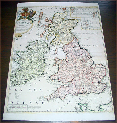
1707 Nolin Coronelli Large Antique Map of Great Britain & Ireland - England
- Title : Les Isles Britanniques ou sont Les Royaumes d Angleterre d Escosse et d Irlande...J B Nolin
- Date : 1707
- Condition: (A+) Fine Condition
- Ref: 43171
- Size: 26in x 19 1/2in (660mm x 495mm)
Description: This large beautifully hand coloured original antique map of Great Britain & Ireland was published by J.B. Nolin in 1707 after the great Italian cartographer Vincenzo Coronelli.
English Cartography: When considering the work of English map makers we tend, perhaps, to think too much in terms of county maps, dominated by the names of Saxton and Speed, but we should not underrate the contribution to the sum of geographical knowledge made in other spheres, such as the sea charts of Edward Wright, Robert Dudley and Greenvile Collins, the discoveries of James Cook, the road maps of Ogilby and Cary, the meteorological and magnetic charts compiled by Edmund Halley, to mention only a few.
In 1558 Queen Elizabeth came to the throne in the midst of a fast changing world. In 1563 a nineteen sheet map, copies of which survive only in manuscript form, was completed by Laurence Nowell, and no doubt, the issue of Mercator's large-scale map of the British Isles in 1564 had an important influence on the thought of the period. A few years later a national survey was commissioned privately, although probably at the instigation of Lord Burghley, the Lord Treasurer, but subsequently was completed with royal encouragement. The outcome was Christopher Saxton's Atlas of EngIand and Wales,started about 1570 and published in 1579 - the first printed set of county maps and the first countrywide atlas on such a splendid scale produced anywhere. A Welsh antiquarian, Humphrey Lhuyd completed a set of surveys that were even more successful than Saxton in which he had produced fine manuscript maps of England and Wales which were used by Ortelius in editions of his Atlas from 1573 onwards.
The earliest maps of the 17th century, attributed to William Smith of the College of Heralds, covered only twelve counties based on Saxton/Norden and were presumably intended to be part of a complete new atlas. They were printed in the Low Countries in 1602-3 and were soon followed by maps for the Latin edition of Camden's Britannia dated 1607. In 1610-11 the first edition of John Speed's famous county AtlasThe Theatre of the Empire of Great Britaine was published and immediately replaced Saxton's in popular appeal. Although Speed assembled much of his material from the earlier works of Saxton, Norden and others, a considerable part of the up-to-date information, especially relating to the inset town plans depicted on his maps, was obtained first hand. The maps undoubtedly owed much of their popularity to the splendid engravings of high quality made in the workshops in Amsterdam of Jodocus Hondius to whom Speed sent his manuscripts, the plates subsequently being returned to London for printing.
In 1645, Volume IV of the famous Blaeu World Atlas covering the counties of England and Wales was published in Amsterdam. These maps have always been esteemed as superb examples of engraving and design, the calligraphy being particularly splendid, but nevertheless they were nearly all based on Saxton and Speed and added little to geographical knowledge.
Not until the latter part of the century do we find an English map maker of originality with the capacity to put new ideas into practice. John Ogilby, one of the more colourful figures associated with cartography, started life as a dancing master and finished as King's Cosmographer and Geographic Printer. After publishing a small number of county maps, somewhat on the lines of John Norden he issued in 1675 the Britannia, the first practical series of detailed maps of the post roads of England and Wales on a standard scale of 1,760 yards to the mile. Up to the end of the century and beyond, reprints and revisions of Saxton's and Speed's atlases continued to appear and the only other noteworthy county maps were Richard Blome's Britannia (1673), John Overton's Atlas (c.1670) and Robert Morden's maps for an English translation of Camden'sBritannia published in 1695.
Another noted cartographer of the day was Captain Greenvile Collins, and of his work in surveying the coasts of Great Britain culminating in the issue in 1693 of the Great Britain's Coasting Pilot. Apart from these charts, English cartographers published during the century a number of world atlases. Speed was the first Englishman to produce a world atlas with the issue in 1627 of his A Prospect of the Most Famous Parts of the World. Other atlases appeared later in the century by Peter Heylin, John Seller, William Berry, Moses Pitt and Richard Blome, whilst Ogilby found time to issue maps of Africa, America and Asia. Far more important, from the purely scientific point of view, was the work of Edmund Halley, Astronomer Royal, who compiled and issued meteorological and magnetic charts in 1688 and 1701 respectively.
At the beginning of the eighteenth century the Dutch map trade was finally in decline, the French in the ascendant and the English to a great extent still dominated by Saxton and Speed except, as we have shown, in the spheres of sea charts and road maps. There were atlases by John Senex, the Bowles family, Emanuel and Thomas Bowen, Thomas Badeslade and the unique bird's-eye perspective views of the counties, The British Monarchy by George Bickham. In 1750-60 Bowen and Kitchin's The Large English Atlas containing maps on a rather larger scale than hitherto was published.
In 1759 the Society for the encouragement of Arts, Manufactures and Commerce offered an award of £100 for the best original surveys on this scale and by the end of the century about thirty counties had been re-surveyed. These maps, many of which formed, in later years, the basis for the first issues of county maps by the Ordnance Survey Office were not only decorative but a tremendous improvement geographically on earlier local maps. As a consequence, the skills and expertise of the new-style cartographers soon enabled them to cover the world as well as the domestic market. Thomas Jefferys was such a man; he was responsible for a number of the new 1 in. to 1 mile county surveys and he issued an edition of Saxton's much battered 200-year-old plates of the county maps, but he is better known for many fine maps of North America and the West Indies. His work was continued on the same lines by William Faden, trading as Faden and Jefferys. Other publishers such as Sayer and Bennett and their successors Laurie and Whittle published a prodigious range of maps, charts and atlases in the second half of the century. A major influence at this time was John Cary who, apart from organizing the first re-survey of post roads since Ogilby and subsequently printing the notedTravellers' Companion, was a prolific publisher of atlases and maps of every kind of all parts of the world. After starting work with Cary, and taking part in the new road survey, Aaron Arrowsmith set up in his own business and went on to issue splendid large-scale maps of many parts of the world. Both Cary's and Arrowsmith's plates were used by other publishers until far into the next century and, in turn, their work was taken up and developed by James Wyld (Elder and Younger) and Tallis and Co.
Later into the 19th century some of the better known cartographers and publishers were by Henry Teesdale (1829-30), Christopher and John Greenwood, surveyors, Thomas Moule, a writer on heraldry and antiques (1830-36) and John Walker (1837) but by about the middle of the century few small-scale publishers survived and their business passed into the hands of large commercial concerns such as Bartholomews of Edinburgh and Philips of London who continue to this day. (Ref: Shirley; Tooley; M&B)
General Description:
Paper thickness and quality: - Heavy and stable
Paper color: - off white
Age of map color: - Original & later
Colors used: - Yellow, green, red, brown.
General color appearance: - Authentic and fresh
Paper size: - 26in x 19 1/2in (660mm x 495mm)
Plate size: - 24in x 18 1/2in (610mm x 470mm)
Margins: - Min 1/16in (2mm)
Imperfections:
Margins: - Top left & bottom right margins cropped to plate-mark
Plate area: - None
Verso: - None
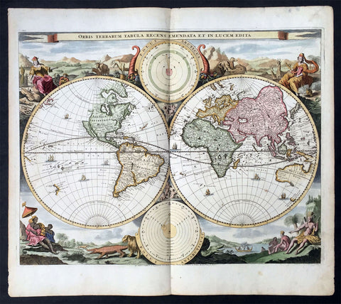
1714 Visscher & Stoopendaal Large Antique Twin Hemisphere World Map
- Title : Orbis Terrarum Tabula Recens Emendata Et In Lucem Edita
- Ref #: 35492
- Size: 19 ½in x 17in (495mm x 430mm)
- Date : 1714
- Condition: (A) Very Good Condition
Description:
This beautifully engraved hand coloured original twin Hemisphere Antique World map by Nicolas Visscher was engraved by Daniel Stoopendaal and published by Pieter Keur, Rotterdam in 1716.
Background:
Nicolas Visschers Twin Hemisphere World Map is regarded as the forerunner of a number of highly decorative Dutch world maps produced throughout the latter part of the 17th & early 18th centuries.
Essentially based on Blaeu's large world map of 1648, Visscher introduced no substantial new geographical features, however there were minor variations in the still unknown coastline of North America.
The northern part of California (as an Island) has now been flattened and is now called New Albion; still further north a small piece of land or an island "Anian" appears adjacent to a strait leading within striking distance of the west shores of Hudson Bay, a possible early guess at a NW passage.
The distinctive attractiveness of many 17th century Dutch world maps is to be found in their border decorations and this one is no exception. The original artist assisting Visscher, Nicolas Berchem, introduced dramatic classical scenes. Daniel Stoopendaal carried on this tradition by representing each of the 4 know continents in allographical form in the 4 corners Europe, Asia, Africa & The America's. Another small change was the inclusion of astronomical diagrams replacing the north & south polar projections located at the top and bottom of the map.
The Keur family produced a number of fine maps from their presses at Dordrecht and later from Rotterdam in the 17th & 18th centuries. This finely executed twin hemisphere world map is a classic example being first released by Nicolas Visscher and Nicolas Berchem in 1658. (Ref: Shirley; Tooley)
General Description:
Paper thickness and quality: - Heavy and stable
Paper colour: - off white
Age of map colour: - Early colour
Colours used: - Yellow, pink, green, orange
General colour appearance: - Beautifully applied
Plate size: - 19 ½in x 17in (495mm x 430mm)
Plate size: - 18 ½in x 14 ½in (470mm x370mm)
Margins: - Min 1/2in (12mm)
Imperfections:
Margins: - Light age toning in margins
Plate area: - Several small worm holes professionally repaired
Verso: - Light age toning
1715 William Dampier Antique Twin Hemisphere World Map, California Is. Australia
- Title : Mappe-Monde
- Ref #: 17026
- Size: 12in x 7 1/2in (305mm x 190mm)
- Date : 1715
- Condition: (A) Very Good Condition
Description:
This beautiful copper-plate engraved scarce, original antique Twin Hemisphere World Map by William Dampier was published in the 1715 French edition of A New Voyage Around the World (Nouveau Voyage autour du Monde)
Fantastic map showing the route taken by Dampier on his first voyage in his ship Roebuck, visiting NW Australia, GOM and Southern Africa whilst circumnavigating the world. California is shown as an island as was the popular belief at the time.
Background: William Dampier (1651 - 1715) was an English explorer and navigator who became the first Englishman to explore parts of what is today Australia, and the first person to circumnavigate the world three times. He has also been described as Australia's first natural historian, as well as one of the most important British explorers of the period between Sir Walter Raleigh and James Cook.
After impressing the Admiralty with his book A New Voyage Round the World, Dampier was given command of a Royal Navy ship and made important discoveries in western Australia, before being court-martialled for cruelty. On a later voyage he rescued Alexander Selkirk, a former crewmate who may have inspired Daniel Defoe's Robinson Crusoe. Others influenced by Dampier include James Cook, Horatio Nelson, Charles Darwin.
In 1679, Dampier joined the crew of the buccaneer Captain Bartholomew Sharp on the Spanish Main of Central America, twice visiting the Bay of Campeche, or "Campeachy" as it was then known, on the north coast of Mexico. This led to his first circumnavigation, during which he accompanied a raid across the Isthmus of Darién in Panama and took part in the capture of Spanish ships on the Pacific coast of that isthmus. The pirates then raided Spanish settlements in Peru before returning to the Caribbean.
Dampier made his way to Virginia, where in 1683 he was engaged by the privateer John Cooke. Cooke entered the Pacific via Cape Horn and spent a year raiding Spanish possessions in Peru, the Galápagos Islands, and Mexico. This expedition collected buccaneers and ships as it went along, at one time having a fleet of ten vessels. Cooke died in Mexico, and a new leader, Edward Davis, was elected captain by the crew.
Dampier transferred to the privateer Charles Swan's ship, Cygnet, and on 31 March 1686 they set out across the Pacific to raid the East Indies, calling at Guam and Mindanao. Spanish witnesses saw the predominantly English crew as not only pirates and heretics but also cannibals. Leaving Swan and 36 others behind on Mindanao, the rest of the privateers sailed on to Manila, Poulo Condor, China, the Spice Islands, and New Holland. Contrary to Dampier's later claim that he had not actively participated in actual piratical attacks during this voyage, he was in fact selected in 1687 to command one of the Spanish ships captured by Cygnet's crew off Manila.
On 5 January 1688, Cygnet "anchored two miles from shore in 29 fathoms" on the northwest coast of Australia, near King Sound. Dampier and his ship remained there until March 12, and while the ship was being careened Dampier made notes on the fauna and flora and the indigenous peoples he found there. Among his fellows were a significant number of Spanish sailors, most notably Alonso Ramírez, a native of San Juan, Puerto Rico Later that year, by agreement, Dampier and two shipmates were marooned on one of the Nicobar Islands. They obtained a small canoe which they modified after first capsizing and then, after surviving a great storm at sea, called at "Acheen" (Aceh) in Sumatra.
Dampier returned to England in 1691 via the Cape of Good Hope, penniless but in possession of his journals. He also had as a source of income a slave known as Prince Jeoly (or Giolo), from Miangas (now Indonesia), who became famous for his tattoos (or "paintings" as they were known at the time). Dampier exhibited Jeoly in London, thereby also generating publicity for a book based on his diaries.
The publication of the book, A New Voyage Round the World, in 1697 was a popular sensation, creating interest at the Admiralty. In 1699, Dampier was given command of the 26-gun warship HMS Roebuck, with a commission from King William III (who had ruled jointly with Queen Mary II until her death in 1694). His mission was to explore the east coast of New Holland, the name given by the Dutch to what is now Australia, and Dampier's intention was to travel there via Cape Horn.
The expedition set out on 14 January 1699, too late in the season to attempt the Horn, so it headed to New Holland via the Cape of Good Hope instead. Following the Dutch route to the Indies, Dampier passed between Dirk Hartog Island and the Western Australian mainland into what he called Shark Bay on 6 August 1699. He landed and began producing the first known detailed record of Australian flora and fauna. The botanical drawings that were made are believed to be by his clerk, James Brand. Dampier then followed the coast north-east, reaching the Dampier Archipelago and Lagrange Bay, just south of what is now called Roebuck Bay, all the while recording and collecting specimens, including many shells. From there he bore northward for Timor. Then he sailed east and on 3 December 1699 rounded New Guinea, which he passed to the north. He traced the south-eastern coasts of New Hanover, New Ireland and New Britain, charting the Dampier Strait between these islands (now the Bismarck Archipelago) and New Guinea. En route, he paused to collect specimens such as giant clams.
By this time, Roebuck was in such bad condition that Dampier was forced to abandon his plan to examine the east coast of New Holland while less than a hundred miles from it. In danger of sinking, he attempted to make the return voyage to England, but the ship foundered at Ascension Island on 21 February 1701. While anchored offshore the ship began to take on more water and the carpenter could do nothing with the worm-eaten planking. As a result, the vessel had to be run aground. Dampier's crew was marooned there for five weeks before being picked up on 3 April by an East Indiaman and returned home in August 1701.
Although many papers were lost with Roebuck, Dampier was able to save some new charts of coastlines, and his record of trade winds and currents in the seas around Australia and New Guinea. He also preserved a few of his specimens. In 2001, the Roebuck wreck was located in Clarence Bay, Ascension Island, by a team from the Western Australian Maritime Museum. Because of his widespread influence, and also because so little exists that can now be linked to him, it has been argued that the remains of his ship and the objects still at the site on Ascension Island – while the property of Britain and subject to the island government's management – are actually the shared maritime heritage of those parts of the world first visited or described by him. His account of the expedition was published as A Voyage to New Holland in 1703.
The War of the Spanish Succession had broken out in 1701, and English privateers were being readied to act against French and Spanish interests. Dampier was appointed commander of the 26-gun ship St George, with a crew of 120 men. They were joined by the 16-gun Cinque Ports with 63 men, and sailed on 11 September 1703 from Kinsale, Ireland. The two ships made a storm-tossed passage round Cape Horn, arriving at the Juan Fernández Islands off the coast of Chile in February 1704. While watering and provisioning there, they sighted a heavily armed French merchantman, which they engaged in a seven-hour battle but were driven off.
Dampier succeeded in capturing a number of small Spanish ships along the coast of Peru, but released them after removing only a fraction of their cargoes because he believed they "would be a hindrance to his greater designs. The greater design he had in mind was a raid on Santa María, a town on the Gulf of Panama rumoured to hold stockpiles of gold from nearby mines. When the force of seamen he led against the town met with unexpectedly strong resistance, however, he withdrew. In May 1704, Cinque Ports separated from St George and, after putting Alexander Selkirk ashore alone on an island for complaining about the vessel's seaworthiness, sank off the coast of what is today Colombia. Some of its crew survived being shipwrecked but were made prisoners of the Spanish.
It was now left to St George to make an attempt on the Manila galleon, the main object of the expedition. The ship was sighted on 6 December 1704, probably Nuestra Señora del Rosario. It was caught unprepared and had not run out its guns. But while Dampier and his officers argued over the best way to mount an attack, the galleon got its guns loaded and the battle was joined. St George soon found itself out-sized by the galleon's 18- and 24-pounders, and, suffering serious damage, they were forced to break off the attack.
The failure to capture the Spanish galleon completed the break-up of the expedition. Dampier, with about thirty men, stayed in St George, while the rest of the crew took a captured barque across the Pacific to Amboyna in the Dutch settlements. The undermanned and worm-damaged St George had to be abandoned on the coast of Peru. He and his remaining men embarked in a Spanish prize for the East Indies, where they were thrown into prison as pirates by their supposed allies the Dutch but later released. Now without a ship, Dampier made his way back to England at the end of 1707.
In 1708, Dampier was engaged to serve on the privateer Duke, not as captain but as sailing master. Duke beat its way into the South Pacific Ocean round Cape Horn in consort with a second ship, Duchess. Commanded by Woodes Rogers, this voyage was more successful: Selkirk was rescued on 2 February 1709, and the expedition amassed £147,975 (equivalent to £19.9 million today) worth of plundered goods. Most of that came from the capture of a Spanish galleon, Nuestra Señora de la Encarnación y Desengaño, along the coast of Mexico in December 1709.
In January 1710, Dampier crossed the Pacific in Duke, accompanied by Duchess and two prizes. They stopped at Guam before arriving in Batavia. Following a refit at Horn Island (near Batavia) and the sale of one of their prize ships, they sailed for the Cape of Good Hope where they remained for more than three months awaiting a convoy. They left the Cape in company with 25 Dutch and English ships, with Dampier now serving as sailing master of Encarnación. After a further delay at the Texel, they dropped anchor at the Thames in London on 14 October 1711.
Dampier may not have lived to receive all of his share of the expedition's gains. He died in the Parish of St Stephen Coleman Street, London. The exact date and circumstances of his death, and his final resting place, are all unknown. His will was proven on 23 March 1715, and it is generally assumed he died earlier that month, but this is not known with any certainty. (Ref Tooley M&B)
General Description:
Paper thickness and quality: - Heavy and stable
Paper color: - off white
Age of map color: -
Colors used: -
General color appearance: -
Paper size: - 12in x 7 1/2in (305mm x 190mm)
Plate size: - 12in x 7 1/2in (305mm x 190mm)
Margins: - Min 1/4in (5mm)
Imperfections:
Margins: - Folds as issued
Plate area: - Folds as issued
Verso: - Folds as issued
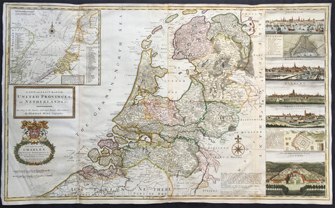
1720 Herman Moll Large Antique Map of The Netherlands - Holland, VII Provinces
- Title : A New and Exact Map of the United Provinces, or Netherlands &c. According to the Newest and Most Exact Observations by Herman Moll Geographer
- Ref #: 35090
- Size: 41in x 25in (1.04m x 635mm)
- Date : 1720
- Condition: (A+) Fine Condition
Description:
This very large beautifully hand coloured original antique map* of The Netherlands by Herman Moll was published in 1720 in the atlas The World Described, or a New and Correct Sett of Maps by John Bowles, Thomas Bowles, Philip Overton & John King of London.
In the 18th century many large-scale maps were published by the likes of John Senex and Herman Moll, this trend continued until the end of private mapping in the early 19th century when it was replaced by Ordnance Survey maps.
Background: An attractive, large scale map of The Netherlands or the United Provinces by the highly regarded cartographer and engraver Herman Moll. on the right-hand side views of Amsterdam, Rotterdam, Middelburg, Utrecht, Groningen, Het Loo Palace and a plan of the ancient Roman Castle at the mouth of the Rhine river Arx Britannica (Huis Britten, Brittenberg). The upper left corner of the map has an inset map of the coasts, sands and banks of the North Sea, the stretch of water that lies between England and The Netherlands. Moll dedicates his map to ‘The Right Hon Charles Lord Viscount of Townsend &c one of his Majesty’s Principal Secretaries of State’
This magnificent map was printed by John Bowles of Cornhill, London and published in Moll’s 1719 New and Complete Atlas, but it may also have been separately issued earlier. Moll came to London probably from Bremen around 1678 and by 1688 he had his own shop in Vanley's Court in London's Blackfriars, between 1691 and 1710 at the corner of Spring Gardens and Charing Cross, when he moved to Beech Street where he remained until his death. In 1701 he published his first work A System of Geography. He was publishing atlases and separately issued maps, and from 1710 was also known as a maker of pocket globes. (Ref: Tooley, Koeman, M&B)
General Description:
Paper thickness and quality: - Heavy and stable
Paper color: - off white
Age of map color: - Original & later
Colors used: - Pink, yellow, green
General color appearance: - Original
Paper size: - 41in x 25in (1.04m x 635mm)
Plate size: - 39 1/4in x 24 1/2in (1.00m x 625mm)
Margins: - Min 1/2in (10mm)
Imperfections:
Margins: - Light creasing
Plate area: - Re-joined folds as issued, small repair in top L&R folds, no loss
Verso: - Re-enforced along folds
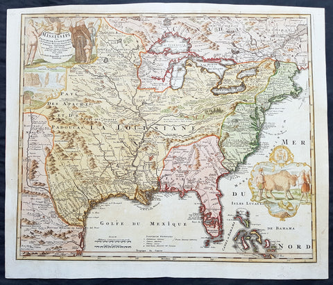
1720 Homann Large Old, Antique Map of North America, Louisiana, Mississippi, Buffalo Map
- Title : Amplissimae Regionis Mississipi seu Provinciae Ludovicianae a R.P. Ludovico Hennepin Francisc....
- Date : 1720
- Condition: (A+) Fine Condition
- Ref: 43168
- Size: 25in x 21 1/4in (635mm x 540mm)
Description:
This large finely engraved beautifully hand coloured original antique map of North America from the United States, the Mississippi River, to Spanish North America was published by J.B Homann in 1720
General Description:
Paper thickness and quality: - Heavy and stable
Paper color: - off white
Age of map color: - Original & later
Colors used: - Yellow, green, blue, pink
General color appearance: - Authentic
Paper size: - 25in x 21 1/4in (635mm x 540mm)
Plate size: - 23in x 19 1/2in (590mm x 500mm)
Margins: - Min 1/2in (12mm)
Imperfections:
Margins: - Light age toning in top margin
Plate area: - None
Verso: - None
Background:
This iconic map of Louisiana, the Mississippi River Valley to the Colonial United States by Johann Baptiste Homann, is commonly called the 'Buffalo Map' for its distinctive decorative elements depicting a stylized buffalo. This map is derived from an earlier 1718 map of the same region by G. De L'Isle though it has been enlarged to include New England.
The map covers much of the modern day United States from Canada and the Great Lakes to the Florida Keys and from Mexico and Texas to the Pacific. According to the political conventions of the time this map is segmented into various zones including New Mexico (red) along the Rio de Norte (Rio Grande), Louisiana (blue) covering a vast area including Texas, all five of the Great Lakes, and both the upper and lower Mississippi River Valleys, Florida (green) consisting most of the American southeast, the english Colonies (yellow) along the Atlantic seaboard, and Canada (red) stretching across the top of the map north of the Great Lakes. Various explorers' routes (including de Soto) are noted, as are mission settlements, American Indian villages, fortifications, and portages. Florida is depicted as an archipelago inhabited by anthropophagi (cannibals). The cartouche work, in the upper left quadrant, details Niagara Falls as well as various allegorical illustrations. A secondary cartouche, showing American Indians and a stylized buffalo appears in the lower right.
This map enjoyed a long production run and was extremely popular throughout europe – most likely for its decorative inclusion of the American Buffalo and Niagara Falls, objects of fascination for many 18th century europeans. Though this map was issued in only one edition, it was published in Homann's Neuer Atlas, the Atlas Major, and many other composite atlases well into the late 1700s, making specific instances of the map all but possible to date with precision. Most examples thus reference the original publication date, c. 1720. (Ref: Tooley; M&B)
1720 Homann, Doppelmayr & Eimmart Antique Twin Hemisphere Celestial Chart, Map. Planisphaerium Caeleste
- Title : Planisphaerium Caeleste
- Ref #: 27010
-
Condition: (A+) Fine Condition
- Size: 25in x 21 1/2in (635m x 545mm)
- Date : 1720
- Price: $2750.00US
Description:
This magnificent original hand coloured copper plate engraved antique double hemisphere celestial chart, showing constellations of the northern and southern hemispheres depicted as allegorical figures, animals and scientific instruments after Georg Christoph Eimmart (1638-1705) was published by Johann Baptist Homann and Johann Gabriel Doppelmayr (1677-1750) in ca 1720.
The stars are shown in six degrees of magnitude according to a key in the center between the hemispheres. The selection and style of the constellations followed that of Firmamentum Sociescianum sive Uranographia (1687) by the Polish astronomer Johannes Hevelius, whose name is noted in the subtitle of the chart. The subtitle further indicates that the chart also draws on the work of Edmund Halley, the British astronomer for whom Halley’s Comet is named. There are numerous variants of this chart published in Germany in the 18th century; this example, Planispaerium Caeleste by Homann, bears the name of the firm (Officina Homanniana) under the border in the lower margin, together with the name of Georg Christoph Eimmart (1638-1705), the Nuremberg astronomer.
General Definitions:
Paper thickness and quality: - Heavy and stable
Paper color : - off white
Age of map color: - Original
Colors used: - Yellow, green, blue, pink
General color appearance: - Authentic
Paper size: - 25in x 21 1/2in (635m x 545mm)
Plate size: - 23in x 19 1/2in (585mm x 495mm)
Margins: - Min 1/2in (12mm)
Imperfections:
Margins: - None
Plate area: - None
Verso: - None
Background:
The outer borders of the chart are decorated with six inset diagrams against a background of clouds including the planetary models of Tycho Brahe, Ptolemy, and Copernicus. The other 3 diagrams show the illumination of the moon by the sun, the revolution of the earth around the sun, and the effect of the moon on tides.
Various firms in Amsterdam, Nuremberg and Augsburg published double hemisphere constellation charts based on the work of George Eimmart titled Planispaerium Caeleste or Planisphaerium Coeleste during the first eight decades of the 18th century, which can be divided fundamentally into two different versions. The prolific Nuremberg publisher Johann Baptist Homann first published Planispaerium Caeleste in his Neuer Atlas in 1707, bearing the inscription Opera G.C. Eimmarti. prostat in Officina Homanniana, meaning Work of Georg Christoph Eimmart offered for sale by the Homann Workshop. That chart has six inset diagrams. Scholar Robert H. van Gent notes the existence of similar prints of this format published by de Wit, Funck, Schenck, and Lotter, as well as by R. & J. Ottens in Amsterdam. The other versions vary more considerably with the inclusion of a seventh inset diagram and a figural illustration in the upper center. These include ones published by Melchior Rein in Augsburg and by Georg Matthäus Seutter (1647–1756) in Nuremberg.
Johann Gabriel Doppelmayr and Johann Baptist Homann were frequent collaborators in producing celestial and astronomical charts for atlases published by Homann and issued under various titles. The major two compilations of Dopplemayr’s works were published by Homann Heirs: Atlas Coelestis in quo Mundus Spectabilis et in Eodem Stellarum Omnium Phoenomena Notabilia, issued as 30 plates in 1742, and the revised edition of this work Atlas Novus Coelestis, in quo Mundus Spectabilis, et in Eodem tam Errantium quam Inerrantium Stellarum Phoenomena Notabilia, issued in 1748 (with an additional plate depicting the solar eclipse of 1748).
Nonetheless, these charts have a complicated publishing history that is not fully known. Some of these charts had appeared in earlier Homann editions such as his first atlas, the Neuer Atlas (Nuremberg: 1707), Atlas von Hundert Charten (Nuremberg: 1712), Grossen Atlas (Nuremberg: 1716), and Atlas Portatilis Coelestis (Nuremberg: 1723). Homann also issued geographical maps in various atlases that may have included celestial plates (particularly composite atlases), and Homann and his heirs presumably sold separately issued maps. Further, three additional celestial and astronomy plates have been located in at least one Homann celestial compilation atlas (1742, 1748, or later), though not among the 30 maps of the standard issue of Atlas Coelestis in quo Mundus Spectabilis, namely Sphaerarum Artificialium Typica Repraesentatio (globes and armillary sphere), Neu invertirte Geographische Universal (clock), and Planisphaerium Caeleste (double hemisphere celestial chart).
Doppelmayr, a professor of mathematics at the Aegidien Gymnasium at Nuremberg, was an acclaimed German geographer and astronomer who wrote on astronomy, geography, cartography, trigonometry, sundials and mathematical instruments. He was also involved in the production of globes as part of a larger goal to bring the scientific ideas of the Enlightenment to a broader public. In service of that idea, Doppelmayr translated several works into German including Nicholas Bion’s 1699 work L’usage des globes célestes et terrestes, et des sphères [The Usage of Celestial and Terrestrial Globes and of Spheres]. Doppelmayr was elected to several scientific societies, including the Berlin Academy of Sciences, the Royal Society and the St. Petersburg Academy of Sciences.
Please note all items auctioned are genuine, we do not sell reproductions. A Certificate of Authenticity (COA) can be issued on request.
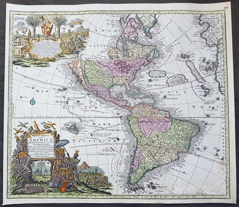
1730 Georg M Seutter Original Antique Map of America, Island of California
- Title : Novus Orbis sive America Meridionalis et Septentrionalis
- Date : 1730
- Size: 23 3/4in x 21in (605mm x 535mm)
- Ref #: 70793
- Condition: (A+) Fine Condition
Description:
This large handsome and beautifully hand coloured original antique map of America - showing California as an Island - was published by Georg Mattraus Seutter in 1730.
One of the best examples of this map I have seen to date with exceptional hand colouring.
General Definitions:
Paper thickness and quality: - Heavy and stable
Paper color : - off white
Age of map color: - Original & later
Colors used: - Yellow, green, blue, pink
General color appearance: - Authentic
Paper size: - 23 3/4in x 21in (605mm x 535mm)
Plate size: - 23in x 20in (585mm x 510mm)
Margins: - Min 1/2in (12mm)
Imperfections:
Margins: - None
Plate area: - Light spotting bottom right of map
Verso: - None
Background:
This is a highly decorative and informative map based on the contemporary European knowledge of America at the beginning of the 18th century. California is shown as an island based on the Sanson-Homann model but with additions including several more rivers on the west coast and two mountains to the north - M. Neges and M.S. Martin and C de Fortuna, C&R de Pins and many others.
The great lakes still show a large degree of ignorance to both shape and location and the NW is left blank. Brazil and the east coast of South America is still largely exaggerated.
The tracks of the early navigators are shown in the Pacific including Fr. Quir, Magellan, Drake and others.
The map also supports two large and highly decorative uncoloured - as published - cartouches which in themselves tell a story of European conquest and ignorance of the local populations.
Religion was a compelling motivation for European imperialism, and the opportunity to convert \"heathen\" Indians provided both a justification and means to conquer the indigenous peoples of the New World. Two Indians kneel reverently before a female figure representing Christianity in the top cartouche, flanked on the right by an altar prepared for Holy Communion and on the left by Europeans at a dining table.
The lower cartouche portrays tranquil Indians surrounded by standard symbols representing the Americas. The seated figure wears a feathered headdress, armband, and skirt. A servant shades him from the sun with a baldachin (parasol), while others in the background and to the left harvest what appears to be sugarcane and tobacco. In the center background someone rests in a hammock suspended between two palm trees while another rows quietly out to sea. A pelican, a cockatiel, and whimsical flying fish, some sporting saw-like beaks, hover above the title. The latter creatures appear to be the artist\'s misconception of a sawfish.
The placement of the two scenes illustrating this work is significant. By depicting numerous symbols associated with Roman Catholicism above a scene of Indians, a subtle message is conveyed: European contact with Indians would yield vast spiritual riches in the form of Christian converts and benefit the indigenous people, who, because they did not practice a Christian faith, were \"beneath\" those who did. (Ref: M&B; Tooley)
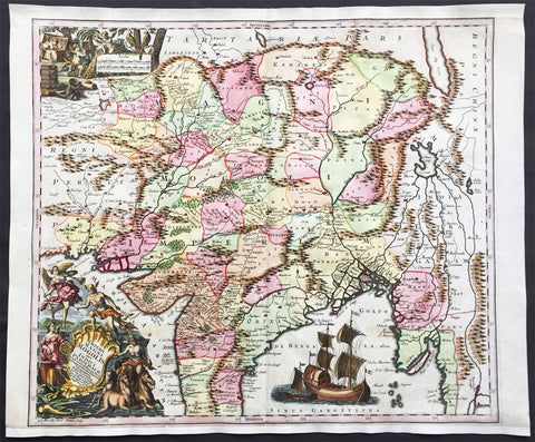
1740 Seutter Large Antique Map of India, Mughal Empire, Tibet, Nepal
- Title : Imperii Magni Mogolis sive Indici Padschach, juxta recentiissimas Navigationes accurata delineato Geographica studio et sumtibus.
- Date : 1740
- Condition: (A+) Fine Condition
- Ref: 42008
- Size: 25in x 20 1/2in (630mm x 520mm)
Description:
This large beautifully hand coloured original antique map of India and the Northern Mughal Empire was published by Georg Mattraus Seutter in 1740.
Background:
Representing 18th century Germany cartography at it’s finest; this is an absolutely spectacular c. 1740 map of northern India by Matthias Seutter. Showing the extent of the powerful Mughal Empire in the late 17th century, this map details the subcontinent and parts of Central Asia from Persia and Khandhar eastward as far a modern day Burma and Thailand. Extends northward to include parts of Tibet and Nepal and southwards as far as the Malabar Coast and the Gulf of Thailand. Cartographically this map is heavily based upon Hondius and Mercator’s 17th century of the same region entitled India Orientalis. Presented is wonderful combination of surprising accuracy, gross errors, and outright speculation. Generally speaking, this map is cartographically solid detailing numerous cities, river systems and trade routes. Shows Deli, Agra, Kandahar (Candahar), Lahore (Lahor), Pegu, Goa, Kabul (Cabul), Jaisalmer (Gislemere), and many other important and still thriving cities. Also notes several important trade routes including the ancient caravan trail westward from Agra into Persia. Despite this map’s thoroughness, there are a number of cartographic errors, probably the most notable of which is the narrowing of the subcontinent. Usually such lateral misrepresentations are the result of erroneous 16th century longitudinal calculations. In this case, these errors found their way into the Hondius’s map and hence into this one as well. The northernmost regions depicted on this map are highly speculative with regard to physical geography. A number of large lakes, including the apocryphal Lake of Chiamay, are speculated in the northeastern quadrants of the map as the sources of four important Southeast Asian river systems including the Irrawaddy, the Dharla, the Chao Phraya, and the Brahmaputra. The curious Lake of Chiamay (also called Chiam-may or Chian-may), roughly located in the area of Assam but sometimes as far north as Tibet and China, began to appear in maps of this region as early as the 16th century and persisted well into the mid 18th century. Its origins are unknown but may originate in a lost 16th century geography prepared by the Portuguese scholar Jao de Barros. It was speculated to be the source of five important Southeast Asian River systems and was mentioned in the journals of Sven Hedin. There are even records that the King of Siam led an invasionary force to take control of the lake in the 16th century. Nonetheless, the theory of Lake Chimmay was ultimately disproved and it disappeared from maps entirely by the 1760s. Decorated with several extremely attractive allegorical cartouche image. The title cartouche in the lower left hand quadrant shows Poseidon, Hermes, an angel and the goddess Fame admiring the wealth of Asia as represented by jewels, ivory, and precious metals. In the upper left hand quadrant, a distance scale plays second fiddle to a scene of cherubs rummaging through chests full of treasure while exotic peacocks look on. A large trade Caravel rests in the Indian Ocean, lower right quadrant, suggesting the trade riches to be had by daring ship captains willing to sail half way around the world. Engraved by Albrecht Carl Seutter and published by Matthias Seutter c. 1740. (Ref: M&B; Tooley)
Condition Report
Paper thickness and quality: - Heavy and stable
Paper color: - off white
Age of map color: - Original & later
Colors used: - Yellow, pink, green, orange, blue
General color appearance: - Authentic
Paper size: - 25in x 20 1/2in (630mm x 520mm)
Plate size: - 22 1/2in x 20in (570mm x 500mm)
Margins: - Min 1/2in (12mm)
Imperfections:
Margins: - Bottom & top margin extended from plate-mark & border
Plate area: - None
Verso: - None
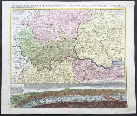
1741 Large Homann Antique Map of London Surrey - Birds Eye View of London
- Title : Regionis quae est circa Londinum....Homaniamus Heredibus 1741
- Date : 1741
- Condition: (A+) Fine Condition
- Ref: 92275
- Size: 25 ½in x 21 ½in (650mm x 550mm)
Description:
This beautifully hand coloured original antique map* of the Environs of London - Middlesex, Essex, Surrey and Kent - with a beautiful and a very real view of the city of London in the mid 18th century and the Thames - was engraved in 1741 - dated at the top of the map - and was published by the Homann firm.
A superb map with a deep heavy impression, stunning colour and sound heavy paper, a fine map.
Background: This map is based upon an earlier map of the region by Thomas Bowles and covers the London area from Berkshire (including Windsor Castle) in the west to Shamel in the east, extending north north as far as Bedford. Specifically focuses on Hertfordshire, Middlesex, Surrey, Essex and Kent. Offers extraordinary detail throughout, showing roadways, villages, London Streets, estates, and in many cases, individual homes. The lower portion of the sheet is dominated by a dramatic bird's-eye view of London and Westminster from Southwark across the Thames. View reveals a densely populated showing numerous boats, barges, and sailing vessels.
The beautifully hand coloured view of the city of London & Westminster was published only 90 odd years after the great fire of 1666.The view of London after Thomas Bowles, was one of a number published by Bowles and the Homann firm in the mid 18th century illustrating the growth and change of the great city.
The view is stunning, stretching from old London bridge & the docklands in the east to the farmlands to the west. What is really fascinating is the level of detail. There are a myriad of different sailing vessels occupying both sides of London bridge. The number of shops and residences that occupied the bridge at that time are uniquely displayed as is the number churches and cathedrals that dominate the skyline. To the right you can see the farm land that will one day become the West End and other upmarket areas of London.(Ref: M&B; Tooley)
General Description:
Paper thickness and quality: - Heavy and stable
Paper color: - off white
Age of map color: - Original & later color
Colors used: - Yellow, green, pink
General color appearance: - Authentic
Paper size: - 25 ½in x 21 ½in (650mm x 550mm)
Plate size: - 22 ½in x 20in (570mm x 510mm)
Margins: - Min ½in (12mm)
Imperfections:
Margins: - Light soiling in margins
Plate area: - None
Verso: - Bottom left plate-mark a little worn
1764 Bellin Antique Map - Plan of The City of New Orleans, Louisiana, North America
- Title : Plan de la Nouvelle Orleans
- Ref #: 17041
- Size: 14 1/2in x 10in (360mm x 255mm)
- Date : 1764
- Condition: (A+) Fine Condition
Description:
This original beautifully hand coloured rare antique map, an early plan of the city of New Orleans, Louisiana by Jacques Nicolas Bellin, in 1764 was published in Antoine-François Prevosts 20 volume L`Histoire Generale des Voyages published by Pierre de Hondt in the Hague between 1747 & 1785.
General Description:
Paper thickness and quality: - Heavy and stable
Paper color: - off white
Age of map color: - Original
Colors used: - Yellow, green, red, brown.
General color appearance: - Authentic and fresh
Paper size: - 14 1/2in x 10in (360mm x 255mm)
Plate size: - 11in x 8in (280mm x 205mm)
Margins: - Min 1in (25mm)
Imperfections:
Margins: - None
Plate area: - Folds as issued
Verso: - None
Background: This scarce 1764 map by Bellin is one of the earliest obtainable maps of New Orleans. Oriented to the east, Bellin's map covers the original settlement of New Orleans along the Mississippi River and inland as far theFosse plein d'eau (roughly translated: 'Pit full of Water') near modern day Dauphine Street, and from modern day Iberville Street (shown but not named) to modern day Barracks Street (shown but not named). The map shows some 100 buildings with some 18 specifically identified via an alphabetically coded table set just above the map.
Among the locations noted in the key is one that provides an eerie echo of the slave trade. Item Q is identified as Cabanes des Negroes qui prennent soin Moulin or 'Cabins of Negros that care for mill.' Note how these cabins, as well as the adjacent mill, are both well outside the ordered structure of the city as well as conveniently located near the Corps de Garde des Bourgeois
Antoine François Prévost d'Exiles 1697 - 1763, usually known simply as the Abbé Prévost, was a French author and novelist. (Ref: Tooley; M&B)
1777 Capt James Cook Antique Map of the Southern Hemisphere, 1st Ed - Australia
- Title : A Chart of the Southern Hemisphere shewing the Tracks of some of the most distinguished Navigators by Captain James Cook of His Majestys Navy
- Ref : 61111
- Size: 23 1/2in x 22 1/2in (605mm x 575mm)
- Date : 1777
- Condition: (A) Very Good Condition
Description:
This fine original 1st edition, copper-plate engraved, antique map, a chart of the Southern Hemisphere, was engraved by William Whitchurch in 1776 - dated - and is dedicated to the discoveries in the South Seas and Antarctic Regions of Captain James Cook during his second Voyage of Discovery between 1772 & 1775. By comparison the tracks of 11 other explorers are included, from the 16th to the 18th centuries. The map by Captain James Cook was published in the 1777 edition of A voyage towards the South Pole, and round the World. Performed in His Majestys ships the Resolution and Adventure, in the years 1772, 1773, 1774, and 1775.published by William Strahan, New Street, Shoe Lane, & Thos. Cadell, in the Strand, London 1777.
This map is unique in another way, was used by Nathaniel Dance in his 1776 portrait of Captain James Cook. Please also see below for more information & above for the portrait.
The 11 other explorers and their tracks around the Southern Hemisphere are;
1. Mendana in 1595
2. Quiros in 1606
3. Le Maire & Schouten in 1616
4. Tasman in 1642
5. Halley in 1700
6. Roggewein in 1722
7. Bouvet in 1738-39
8. Byron in 1765
9. Wallis in 1767
10. Bougainville in 1768
11. Surville in 1769
12. Cooks first and second voyages.
General Definitions:
Paper thickness and quality: - Heavy and stable
Paper color : - off white
Age of map color: -
Colors used: -
General color appearance: -
Paper size: - 23 1/2in x 22 1/2in (605mm x 575mm)
Plate size: - 23in x 21 1/2in (585mm x 545mm)
Margins: - Min 1/2in (12mm)
Imperfections:
Margins: - Repair as noted in plate Plate area
Plate area: - 9in repair to the left of the image from NZ to margin, no loss. Folds as issued
Verso: - Repair as noted in plate Plate area
Background:
This map by James Cook, was published as the premier map of his second voyage to the Southern Hemisphere, dispelling forever the myth of the Great Southern Land and showing the true cartographic nature of the southern hemisphere dominated by Australia & New Zealand. The map on a South Polar Projection also shows South America, the South Atlantic Ocean, South Africa, Madagascar, Australia - with Tasmania still joined to the mainland - New Zealand and the southern Pacific Ocean with islands.
Engraved within the explorer\'s tracks are the dates of their voyages and ships tracks are particularly noted around the Antarctic Circle with notations of ice fields seen during the voyages.
Nathaniel Dance Portrait of Cook, 1776
A three-quarter-length portrait of Captain Cook, seated to the left, facing the right. He is wearing captain\'s full-dress uniform, 1774-87, consisting of a navy blue jacket, white waistcoat with gold braid and gold buttons and white breeches. He wears a grey wig or his own hair powdered. He holds his own chart of the Southern Ocean on the table and his right hand points to the east coast of Australia on it. His left thumb and finger lightly hold the other edge of the chart over his knee. His hat sits on the table behind him to the left on top of a substantial book, perhaps his journal, itself resting on the chart. In 1772, Cook sailed for the second time to the fringes of the Antarctic and the Pacific, returning in 1775. He sat for this portrait, commissioned by Sir Joseph Banks, \'for a few hours before dinner\' on 25 May 1776 but it is not known whether he did so again before he left London on 24 June for his third voyage, never to return. None the less, David Samwell, surgeon\'s mate in \'Resolution\' on the second voyage and surgeon of \'Discovery\' on the third, thought it \'a most excellent likeness ... and ... the only one I have seen that bears any resemblance to him\'. This view was based on John Sherwin\'s later engraving of the portrait, which probably argues even more favourably for the original despite an element of idealization, not least omission of a large burn scar (from 1764) on the right hand. Banks had sailed with Cook on his first voyage in the \'Endeavour\' and took an influential interest in his subsequent ones. This portrait hung over the fireplace in the library of his London house. After his death, it was presented to the Naval Gallery at Greenwich Hospital by his executor, Sir Edward Knatchbull, following a request by E.H. Locker, the Hospital Secretary. In 1781-83 Charles Grignion, then in Rome, painted a \'Death of Captain Cook\' which was sold in 1821 after the British Museum declined it as a bequest from his brother Thomas, a well-known watchmaker. That picture subsequently disappeared but Thomas\'s will says the likeness of Cook was based on the present portrait. Dance worked with Pompeo Batoni in Rome and on his return to London in 1765 achieved success as a portrait and history painter. In 1768, he joined a group of artists who successfully petitioned George III to establish the Royal Academy in that year.
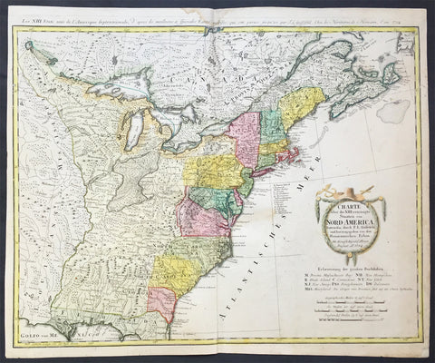
1784 Homann Large Antique Map of The Newly Formed United States of America
- Title : Charte uber die XIII vereinigte Staaten von Nord-Amerika...F L Guffefeld...A 1784
- Ref #: 61031
- Size: 23 1/4in x 19 1/4in (590mm x 490mm)
- Date : 1784
- Condition: (A) Very Good Condition
Description:
This large important & scarce fine beautifully hand coloured original antique map of the United States just after the War of Independence was engraved by F.J. Guttefeld in 1784 - dated - and published by the famous German firm of Homann Heirs.
Also known as the Stetson map, after the Stetson engraved in the title cartouche, this is one of the earliest maps to recognised the newly independent United States after the revolutionary war of Independence.
Background: An early and large map of the newly formed United States delineating all 13 states. The map extends west past the Mississippi River and north to the southern tip of Hudson Bay. The southern states are shown with their western boundaries on the Mississippi River, although the coloring shows only regions east of the Appalachians as being organized. As with many German maps of the period, there are some incorrect state boundaries; Vermont is shown as part of New Hampshire, and Maryland includes much of northern Virginia. A list of the principal German communities in New York, New Jersey and Pennsylvania are listed. The interior regions are shown with considerable topographical detail, locating numerous Indian tribes, topography, and watershed. The uncolored garland-style title cartouche is topped with a hat and crossed swords.
Each state is colored in a contrasting pastel and the states in the northern part are named by way of a lettered key given just below the attractive title cartouche. The treatment of the lands to the west of the Appalachian Mountains and up to the Mississippi River is quite interesting. This area is indicated as lands that came to the United States by the Treaty of 1783.French title outside top neat-line: Les XIII Etats Unis de l' Amerique Septentrionale. Ref: Tooley; M&B)
General Description:
Paper thickness and quality: - Heavy and stable
Paper color: - off white
Age of map color: - Original
Colors used: - Yellow, green, blue, pink
General color appearance: - Authentic
Paper size: - 23 1/4in x 19 1/4in (590mm x 490mm)
Plate size: - 23in x 18 1/4in (685mm x 465mm)
Margins: - Min 1/2in (12mm)
Imperfections:
Margins: - Light soiling in top margin,
Plate area: - Light creasing along centerfold, light soiling
Verso: - Re-enforced along centerfold
1786 Chris. Cellarius Old, Antique Atlas Geographia - w/ 27 Maps and Armillary
- Title : CHRISTOPHORI CELLARII SMALCALDENSIS GEOGRAPHIA ANTIQUA - Recognita denuo & ad veterum novorumque scriptorium fidem, historicorum maxime identidem castigate & Quinta Editione plurimis locis aucta & immutata
- Ref #: 61153
- Size: 8 1/2in x 5 1/2in (21.5cm x 13.5cm)
- Date : 1786
- Condition: (A) Good Condition
Description:
Scarce edition of the Christopher Cellarius unique 1786 Atlas Geographiawith 27 folding maps. Overall condition of the Atlas is Good (see below) with the contents in VG to Fine condition.
Beautiful example of this iconic Atlas complete.
Description: "CHRISTOPHORI CELLARII SMALCALDENSIS GEOGRAPHIA ANTIQUA - Recognita denuo & ad veterum novorumque scriptorium fidem, historicorum maxime identidem castigate & Quinta Editione plurimis locis aucta & immutata - Huic demum Sextae Editioni Tot CHARTAS ex majori auctoris Geographia antiqua quot ad minorem hanc illustrandam requirebantur, DUPLICEMQUE INDICEM QUORUM Priori vetera locorum nomina novis praeponuntur Posteriori nova veteribus, Addidit, totam recensuit & Scholarum usui accommodavit. SAMUEL PATRICK, L.L.D. EDITIO altera & castigatior.LONDINISumptibus J & T. POTE, E. BALLARD, C. BATHURST, J. F. & C. RIVINGTON, T. LONGMAN & G. GINGER M.DCC.LXXXVI" (1786)
Bound in full leather with five raised bands to spine. Volume measures approx. 21.5cm x 13.5cm x 2cm. The front and rear boards are cracked to spine edges and have some movement. Chipped to top and bottom of spine and corners, with small loss. There are a couple of chips to leather. The first page is the title page and last leaf is the last leaf of text. Fixed endpapers are browned.
The title page, and last leaf are browned to edges, and there is an ink mark to last leaf. Couple of leaves and a map are detached. One page has large corner chip, with loss. There are a couple of ink numbers/marks to rear of one of the maps, and the occasional ink mark and splash. Overall the majority of contents are in clean and tight condition.
There are 27 folding maps with armillary Sphere. Atlas content index (see images)
Background: Geographica was one of the most popular geographical publications of the 17th and 18th centuries lasting into the 19th century. (Ref: Tooley; M&B)
General Description:
Paper thickness and quality: - Heavy and stable
Paper color: - off white
Age of map color: -
Colors used: -
General color appearance: -
Atlas size: - 8 1/2in x 5 1/2in (21.5cm x 13.5cm)
Map size: - 9 1/2in x 8 1/2in (23cm x 21.5cm)
Margins: - Min 1/2in (12mm)
Imperfections:
Margins: - See above
Plate area: - See above
Verso: - See above
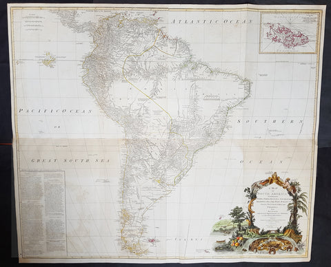
1794 Laurie, Whittle & Kitchin Very Large Original Antique Map of South America - Rare
- Title : A Map of South America containing Tierra-Firma, Guayana, New Granada, Amazonia, Brasil, Peru, Paraguay, Chaco, Tucuman, Chili and Patagonia from M. d'Anville with Several Imporvements and Additions, and The Newest Discoveries.
- Date : 1794
- Size: 48in x 41in (1.22m x 1.10m)
- Ref #: 16257
- Condition: (+) Very Good Condition
Description: This very large, incredibly important, highly detailed beautifully hand coloured original antique map of South America, with contributions from two prominent 18th century cartographers, Thomas Kitchin & Jean-Baptiste Bourguinon D'Anville, was updated and published by Laurie & Whittle in 1794, dated in the title cartouche, for the Elephant Folio General Atlas.
Condition Report:
Paper thickness and quality: - Heavy and stable
Paper colour: - Off white
Age of map colour: - Original & early
Colours used: - Yellow, pink, green
General colour appearance: - Authentic
Paper size: - 48in x 41in (1.22m x 1.10m)
Plate size: - 47in x 40in (1.19m x 1.04m)
Margins: - Min 1/2in (10mm)
Imperfections:
Margins: - Small repair to bottom margin,
Plate area: - Folds as issued, offsetting & browning to bottom half of image
Verso: - Folds as issued, light browning
Background:
This is probably the most important two panel wall map of South America produced in the 18th century. Largely based upon the earlier D'Anville map, this map has been enlarged and expanded by the English publishing house of Laurie and Whittle. Depicts the continent in full with an inset of the Falkland Islands. This map is unique in that it is a serious attempt to compile all of the accurate scientific knowledge of the South American continent available at the time. Offers a smorgasbord of factual, speculative, and historical detail.
This extraordinary and highly decorative map bears up to almost endless perusal and volumes could be composed upon its content. The cartographer attempts to depict both known and unknown parts of the continent with actual data reported by both contemporary and historic travelers. In most cases it is extremely difficult to identify specific sources as much of the data is vague and uncertain.
Our survey of this map beings with the coast which Spanish and Portuguese navigators had mapped with considerable accuracy as early as the late 16th century. This, like most early maps of the area, contrasts a detailed mapping of the coast with a speculative discussion of the interior, particularly Patagonia and the Amazon Basin. Offers a fairly accurate discussion of both the east and west coasts with exceptional detail in the populated Andean regions of Venezuela, Columbia, Ecuador (Labeled Quito), and Peru. Notes Cuzco, Lima, Quito, Valladolid, Arequipa, Trujillo and other important trading centers of the region. In Portuguese controlled Brazil, Rio de Janeiro, San Salvador and San Sebastian are noted.
It is in the interior that this map becomes exceptionally fascinating. In the northern part of the continent D'Anville maps a number of confusions associated with the English adventurer Sir Walter Raleigh's search for El Dorado. Believing El Dorado to lie in the northern part of the Amazon, Raleigh sailed down the Orinoco River just before the onset of the rainy season. Reaching a remote tribal village, Raleigh noted canoes arriving bearing gold, silver, and other treasures. Asked where the gold came from, the natives replied, 'Manoa,' the term for the tribe to which the river traders belonged. Manoa, the natives claimed could be reached following a long river voyage southward to a Great Lake, called Parima. Raleigh and his associates immediately associated Manoa and Lake Parima with the golden kingdom of El Dorado, though they never visited the city or lake. Subsequent maps, including this one, mapped El Dorado and Lake Parima in this location for several hundred years. Both Raleigh and the natives were describing an actual event known to occur annually in the region. Rains would annually swell the Amazon and Orinoco river systems creating a linkage in the Parima flood plain, which, during heavy rains, can resemble a massive lake. The Manoa were a large and populous trading nation active pre-colonial days whose vast empire, based in the Amazon Basin, extended form the Andes to the Orinoco. Curiously, in addition to noting the city of Manoa on Lake Parima, D'Anville also correctly maps the center of the ancient Manoan civilization between the Amazon tributaries Rio Negro and Rio Yapura. Sadly the Manoa and many of the other populous South American indigenous nations noted by the earliest explores to the region vanished, brought low by European epidemics.
A similar error appears far to the south where the Paraguay rivers empties into the Laguna de Xarayes. The Xarayes, a corruption of 'Xaraies' meaning 'Masters of the River,' were an indigenous people occupying what are today parts of Brazil's Matte Grosso and the Pantanal. When Spanish and Portuguese explorers first navigated up the Paraguay River, as always in search of El Dorado, they encountered the vast Pantanal flood plain at the height of its annual inundation. Understandably misinterpreting the flood plain as a gigantic inland sea, they named it after the local inhabitants, the Xaraies. The Laguna de los Xarayes almost immediately began to appear on early maps of the region and, at the same time, almost immediately took on a legendary aspect. Later missionaries and chroniclers, particularly Diaz de Guzman, imagined an island in this lake and curiously identified it as an 'Island of Paradise,'
...an island [of the Paraguay River] more than ten leagues [56 km] long, two or three [11-16 km] wide. A very mild land rich in a thousand types of wild fruit, among them grapes, pears and olives: the Indians created plantations throughout, and throughout the year sow and reap with no difference in winter or summer, ... the Indians of that island are of good will and are friends to the Spaniards; Orejon they call them, and they have their ears pierced with wheels of wood ... which occupy the entire hole. They live in round houses, not as a village, but each apart though keep up with each other in much peace and friendship. They called of old this island Land of Paradise for its abundance and wonderful qualities.
To the north of the 'Island of Paradise' appeared the 'Puerto de los Reyes' which was considered to be a gateway to the Amazon and the Kingdom of El Dorado. D'Anville, to his credit, shows the 'Laguna' and it's island in a much reduced form compared to earlier cartographers and also comments that its existence is 'dubious.'
Far to the south Patagonia is crisscrossed with a number of speculative rivers based upon assumptions from earlier cartographers. D'Anville notes several questionable river passes that suggest a possible navigable communication between the east and west coasts of the continent. Speculation on such a pass fueled the famous South Sea Company, one of the modern world's first stock bubbles, but when no such pass was discovered, the bubble burst.
D'Anville also notes several offshore discoveries including the Galapagos, which he calls the Inchanted Islands, the Isle of Georgia, the Juan Fernandez islands, the Falkands, and some curious land masses just west of the Galapagos labeled 'Isles known to the Spanish.' Curiously, he also notes a 'a Bank of Sounding Discovered by Capt. Hook in 1767.' We know of no navigator by the name of Captain Hook except Peter Pan's fictional nemesis. Most likely this is a misprinted reference to Captain Cook, who was active in the Atlantic at this time. One can only wonder if J.M. Barrie had this map handy when imagining his fictional villain.
Prepared from work by D'Anville and published by Laurie & Whittle in Kitchin's 1794 General Atlas.
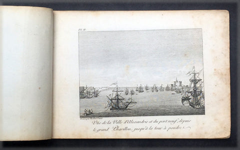
1817 Capt. Frederick L Norden Antique Atlas of Egypt & Nubia - 1 Map & 22 Prints
- Title : Atlas de Norden...Chez M.Me Lepetit...1817
- Ref #: 91614
- Size: 8vo
- Date : 1817
- Condition: (A) Very Good Condition
Description:
This fine original antique Atlas, Voyage d'Egypte et de Nubie, travels to Egypt and Nubia by the Dane, Captain Frederick Louis Norden was translated and published in Paris by M Henry & Breton in the 1817 - dated - edition of Biblio Portative Des Voyages Traduite De L Anglais Par MM. Henry et Breton Tome XIII (Portable Travel Library. Translated from the English by MM Henry and Breton Volume 13)
General Description:
Paper thickness and quality: - Heavy, stable
Paper color: - off white
Age of map color: -
Colors used: -
General color appearance: -
Atlas size: - 8vo
Imperfections:
Margins: - Age toning
Plate area: - Age toning
Verso: - Age toning
The atlas covers have been removed with front title page partially detached & damaged. Pages are generally clean, with some age toning, overall VG. Size 8vo, each page size is 7in x 5in (180mm x 125mm)
1. Cours du Nil Depuis le Sennaar
2. Vue de Ville d Alexandrie....
3. Vue de la Ville et du Port Neuf d Alexandrie....
4. Vue de la Vieille Alexandrie
5. A: Chateau d Aboukir B: Vue de cote de l Orient meridional C: Plan du Chateau vec son port
6. Fig1: Vue de la villede Rosette Fig 2: Chateau de Rosette Fig 3: Vue du village de Deruth
7. Perspective du Vieux Caire
8. Vue du vieux Caire et d'une Pyramide dans le lointain
9. Vue de la ville de Gize ci-devant Memphis....
10. Coupe du Mokian
11. Plan de l ile de Rodda
12. Village de Dair Etun
13. Vue des Pyramides proche du Caire
14. Vue des Pyramides de Memphis
15. Maisons ordinaires des Arabec
16. Ruines di Palais de Memmon
17. Portail antique plien de Hieroglyphes en couleur et ...
18. Ancien Temple au milieu de la ville d Esnay
19. Deux coupes sur la longueur des superbes..Ruines du temple d Tsia
20. Fig 1: Les Deux Colosses en particular Fig 2: Portail principal des antiquities de Luxor
21. Statues colossales et Ruines du Palais de Memnon
22. Vue des Tombeaux pres d Essouan
23. Maniere de Battre les ris et de porter lEau en Egypte
Frederick Norden sailed to Egypt in 1737-38 to survey the architecture, agriculture, and other curiosities of the country. He was the first European to penetrate as far as Derr in Nubia, and produced the first coherent maps of the country. Seventeen years later, long after Norden’s death, his maps and drawings were published by the Royal Danish Academy of Sciences and Letters, under order of Frederick V of Denmark, as Voyage d’Egypte et de Nubie (1755). Two years later, the physician and naturalist Peter Templeman completed an English translation, which was published in two folio volumes.
Frederic Louis Norden (1708 –1742) was a Danish naval captain and explorer.
Also known as Frederick, Frederik, Friderick, Ludwig, Ludvig and Lewis, the name used on the first publication of his famous Voyage d'Egypte et de Nubie (Copenhagen, 1755) is Frederic Louis Norden. His name is often shortened F. L. Norden.
Norden made a voyage through Egypt all the way down to Sudan in 1737–1738, on the request of King Christian VI of Denmark. Norden made abundant notes, observations and drawings of everything around him, including people, pharaonic monuments, architecture, installations, maps etc., all of which was published in the posthumous Voyage d'Egypte et de Nubie.
On 8 January 1741 he became a Fellow of the Royal Society of London, where his name was registered as Frederic Lewis Norden.
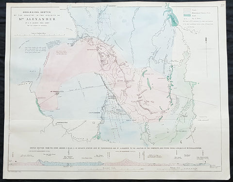
1854 Arrowsmith & Selwyn Rare Antique Goldfields Map Mt Alexander & Castlemaine, Victoria
- Title : Geological Sketch of the Country in the Vicinty of Mt Alexander By AR Selwyn Geol Surv. for the Colony of Victoria
- Size: 21 1/2in x 17in (540x 430mm)
- Condition: (A+) Fine Condition
- Date : 1854
- Ref #: 82048
Description:
This rare, large lithograph geological map of Mount Alexander, the town of Castlemaine & environs, NW of Melbourne, Australia by John Arrowsmith - after the Geological Surveyor of Victoria, Alfred Selwyn - was published in 1854 for The Colonial Office Parliamentary Papers, London.
A very important geological map pertaining to the local goldfields around Mt Alexander and Castlemaine. Being a prominent local landmark, the mountain has its name associated with the surrounding district once known as the Mount Alexander goldfields. The first European to climb the peak was Major Thomas Mitchell on 28 September 1836 during his journey of exploration through Australia Felix. Overlander Edward John Eyre camped the north-west slope of Mount Alexander on 8 February 1838. Alexander Tolmer established a gold escort route between Mount Alexander and Adelaide to serve South Australian gold miners in the early 1850s (the first arrived in Adelaide on 20 March 1852 with around 600 lb of gold, the second, with 1,620 lb on 4 May 1852; it also carried mail between diggers and their Adelaide families)
The rarity of this map cannot be overstated. Many of these maps by Arrowsmith were printed and published only for the British Colonial Office Parliamentary Papers and would have had very low numbers published and are very hard, if not impossible, to be be found for sale on the open market.
John Arrowsmith is considered one of the finest cartographers of the 19th century, famous for producing highly accurate and finely engraved maps in atlases, books & in sheet form, of all parts of the know world. Ironically he is less famous for producing many of the maps that accompanied the British Colonial Office Parliamentary Reports between 1817 to 1890, with two-thirds of the maps being produced by Arrowsmith. These maps were published solely for government review and not public sale. A few of these were subsequently published in Arrowsmiths Atlases and vice versa but a great number of them were not, making many of the maps published for the Parliamentary papers rare and rarely seen on the market. Many of them are not called for in Tooley, Clancy or other important reference material.
This is one of those maps, one of 27 we were fortunate to procure earlier this year. I have found very little historical sales data for these maps and so I have priced them based on what I feel is a fair market value for such a rare, scarce map.
General Definitions:
Paper thickness and quality: - Heavy and stable
Paper color : - off white
Age of map color: - Original
Colors used: - Green, pink, blue
General color appearance: - Authentic
Paper size: - 21 1/2in x 17in (540x 430mm)
Plate size: - 21 1/2in x 17in (540x 430mm)
Margins: - Min 1/2in (12mm)
Imperfections:
Margins: - None
Plate area: - Folds as issued
Verso: - None
Background:
The importance of John Arrowsmiths contribution to early Australian cartography cannot be stressed enough. He was responsible for producing many of the early exploration maps of Australia for the Colonial Offices & Government publications as well as the RGS.
Maps produced after the first settlement and into the 19th century came from varied sources, first published with the First Fleet Journals by Arthur Phillip, John Hunter and Watkin Tench. Numerous European publishing houses produced atlases which included maps of Australia. Many came out in several editions and were updated as new information became available. The Australian Colonies were administered by officials responsible to the British Colonial Office and all events of importance, often illustrated by maps, were published in the British Parliamentary Papers. There a rea prime source of maps from 1830 onwards, although one or two maps may be found in Parliamentary Papers prior to this time, such as one example of a rare map of the Swan River by Captain James Stirling.
During the 19th century, as the Australian colonies were progressively granted responsible government, Parliamentary Papers for each colony became an important source of maps. These maps sources have been a hidden and untapped resource. Another good source of early maps is published journals of the explorers; the explorers earliest maps often accompanied reports in the
Journal of the Royal Geographical Society in the UK. Parallel development of Australian scientific institutions along with an interest in exploration was a strong feature of 19th century Australia. The Royal Geographical Society of Australasia was established with branches in NSW, Victoria, South Australia and Queensland. A number of important maps were published as separate sheets, increasingly by Australian printers and engravers such as Carmichael, Sands & Kenny, and Higginbotham, Robinson & Harrison.
Australian atlases were produced and repeat editions of cadastral surveys and maritime chats became increasingly available. Specialist maps were published from official sources, including geological and mineral maps. Towards the end of the century a plethora of thematic maps were published through a verity of media such as advertisements for land sales, tourists maps and street directories.
Parliamentary Papers British Parliamentary Papers were a funnel for all significant colonial events in the 19th century. They included over one hundred maps with information on topography, exploration and lad survey published between 1817 and 1890., with two-thirds of the maps being produced by John Arrowsmith. Few maps are found after the early 1860s. The maps accompanying papers relevant to gold discovery (1851-55) are a particularly good resource, documenting an important time in the history of Australia. Perhaps the most neglected source of early Australian maps are those included in the Colonial Parliamentary Papers published locally after 1836. The NSW Parliamentary Papers published between 1836 and 1900 contain over 2700 maps on 129 topics, providing a unique record of events considered important by the colonial administration. Land ownership and land use dominate, followed by maps of services relevant to land use, such as railways, roads, water supply and sewerage. Public health issues are recorded in maps as are maps of gold& mineral leases reflected the expanding diversity of the economy. The first map published in the NSW Parliamentary Papers, of the site of the new Government House, was lithographed by W.R. Baker in 1836. The total number of maps over the same period from other colonies was less than 2000 but again each colonies priorities were reflected by in the subjects covered. Tasmania reflected mainly geological and early convict disciplinary maps; South Australia, land administration and pastoral development; Victoria, maps relating to the development; Victoria, maps relating to the colonies infrastructure, especially railway and harbour development; Queensland, railway and mineral leases; Western Australia, a broad range that included two important technological innovations that shortened the time, and therefore the cost, of printing maps. Firstly , John Osborn in 1859, developed the use of a transfer paper method in photolithography which reduced printing time from days to hours. Secondly, Alfred Selwyn in 1860 used a steam-driven power press to print seven colour geological maps.
Royal Geographical Society published its first journal in 1832. This journal was to become the leading scientific medium available for explorers to publish the first news of their discoveries. However, not all explorers were published here. Between 1832 and 1880, 25 maps recorded of inland Australia, illustrating the journeys of 27 explorers. John Arrowsmith compiled 22 of the 25 maps published by the RGS again illustrating the importance of Arrowsmith to the expansion of early colonial cartography in Australia.
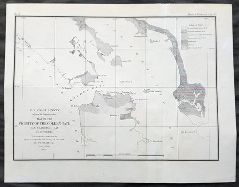
1855 US Coast Survey & A D Bache Antique Map of Golden Gate Entrance to San Francisco Bay
- Title : US Coast Survey A D Bache Superintendant Map of the Vicinity of the Golden Gate San Francisco Bay California...By W P Blake esq. 1855
- Size: 11 1/2in x 9in (290mm x 230mm)
- Condition: (A+) Fine Condition
- Date : 1855
- Ref #: 93013
Description:
This original antique lithograph map of the Golden Gate, entrance to San Francisco Bay, prior to the bridge, by Alexander Dallas Bache (great-grandson of Benjamin Franklin) in 1855 - dated - was published by the official chart-maker of the United Stetes, the office of The US Coast Survey.
Alexander Dallas Bache 1806 – 1867 was an American physicist, scientist, and surveyor who erected coastal fortifications and conducted a detailed survey to map the mid-eastern United States coastline. Originally an army engineer, he later became Superintendent of the U.S. Coast Survey, and built it into the foremost scientific institution in the country before the Civil War.
Alexander Bache was born in Philadelphia, the son of Richard Bache, Jr., and Sophia Burrell Dallas Bache. He came from a prominent family as he was the nephew of Vice-President George M. Dallas and naval hero Alexander J. Dallas. He was the grandson of Secretary of the Treasury Alexander Dallas and was the great-grandson of Benjamin Franklin.
Bache was a professor of natural philosophy and chemistry at the University of Pennsylvania from 1828 to 1841 and again from 1842 to 1843. He spent 1836–1838 in Europe on behalf of the trustees of what became Girard College; he was named president of the college after his return. Abroad, he examined European education systems, and on his return he published a valuable report. From 1839 to 1842, he served as the first president of Central High School of Philadelphia, one of the oldest public high schools in the United States.
In 1843, on the death of Professor Ferdinand Rudolph Hassler, Bache was appointed superintendent of the United States Coast Survey. He convinced the United States Congress of the value of this work and, by means of the liberal aid it granted, he completed the mapping of the whole coast by a skillful division of labor and the erection of numerous observing stations. In addition, magnetic and meteorological data were collected. Bache served as head of the Coast Survey for 24 years (until his death).
General Definitions:
Paper thickness and quality: - Heavy and stable
Paper color : - off white
Age of map color: -
Colors used: -
General color appearance: -
Paper size: - 11 1/2in x 9in (290mm x 230mm)
Plate size: - 11 1/2in x 9in (290mm x 230mm)
Margins: - Min 1/2in (12mm)
Imperfections:
Margins: - Light age toning
Plate area: - None
Verso: - None
Background:
The earliest archaeological evidence of human habitation of the territory of the city of San Francisco dates to 3000 BC. The Yelamu group of the Ohlone people resided in a few small villages when an overland Spanish exploration party, led by Don Gaspar de Portolà, arrived on November 2, 1769, the first documented European visit to San Francisco Bay. Seven years later, on March 28, 1776, the Spanish established the Presidio of San Francisco, followed by a mission, Mission San Francisco de Asís (Mission Dolores), established by the Spanish explorer Juan Bautista de Anza.
Upon independence from Spain in 1821, the area became part of Mexico. Under Mexican rule, the mission system gradually ended, and its lands became privatized. In 1835, Englishman William Richardson erected the first independent homestead, near a boat anchorage around what is today Portsmouth Square. Together with Alcalde Francisco de Haro, he laid out a street plan for the expanded settlement, and the town, named Yerba Buena, began to attract American settlers. Commodore John D. Sloat claimed California for the United States on July 7, 1846, during the Mexican–American War, and Captain John B. Montgomery arrived to claim Yerba Buena two days later. Yerba Buena was renamed San Francisco on January 30 of the next year, and Mexico officially ceded the territory to the United States at the end of the war. Despite its attractive location as a port and naval base, San Francisco was still a small settlement with inhospitable geography.
The California Gold Rush brought a flood of treasure seekers (known as forty-niners, as in 1849). With their sourdough bread in tow, prospectors accumulated in San Francisco over rival Benicia, raising the population from 1,000 in 1848 to 25,000 by December 1849. The promise of great wealth was so strong that crews on arriving vessels deserted and rushed off to the gold fields, leaving behind a forest of masts in San Francisco harbor. Some of these approximately 500 abandoned ships were used at times as storeships, saloons and hotels; many were left to rot and some were sunk to establish title to the underwater lot. By 1851 the harbor was extended out into the bay by wharves while buildings were erected on piles among the ships. By 1870 Yerba Buena Cove had been filled to create new land. Buried ships are occasionally exposed when foundations are dug for new buildings.
California was quickly granted statehood in 1850, and the U.S. military built Fort Point at the Golden Gate and a fort on Alcatraz Island to secure the San Francisco Bay. Silver discoveries, including the Comstock Lode in Nevada in 1859, further drove rapid population growth. With hordes of fortune seekers streaming through the city, lawlessness was common, and the Barbary Coast section of town gained notoriety as a haven for criminals, prostitution, and gambling.
Entrepreneurs sought to capitalize on the wealth generated by the Gold Rush. Early winners were the banking industry, with the founding of Wells Fargo in 1852 and the Bank of California in 1864. Development of the Port of San Francisco and the establishment in 1869 of overland access to the eastern U.S. rail system via the newly completed Pacific Railroad (the construction of which the city only reluctantly helped support) helped make the Bay Area a center for trade. Catering to the needs and tastes of the growing population, Levi Strauss opened a dry goods business and Domingo Ghirardelli began manufacturing chocolate. Immigrant laborers made the city a polyglot culture, with Chinese Railroad Workers, drawn to Old Gold Mountain, creating the citys Chinatown quarter. In 1870, Asians made up 8% of the population. The first cable cars carried San Franciscans up Clay Street in 1873. The citys sea of Victorian houses began to take shape, and civic leaders campaigned for a spacious public park, resulting in plans for Golden Gate Park. San Franciscans built schools, churches, theaters, and all the hallmarks of civic life. The Presidio developed into the most important American military installation on the Pacific coast. By 1890, San Franciscos population approached 300,000, making it the eighth-largest city in the United States at the time. Around 1901, San Francisco was a major city known for its flamboyant style, stately hotels, ostentatious mansions on Nob Hill, and a thriving arts scene. The first North American plague epidemic was the San Francisco plague of 1900–1904.
U.S. Coast Survey (Office of Coast Survey)
The Office of Coast Survey is the official chart-maker of the United States. Set up in 1807, it is one of the U.S. governments oldest scientific organizations. In 1878 it was given the name of Coast and Geodetic Survey (C&GS). In 1970 it became part of the National Oceanic and Atmospheric Administration (NOAA).
The agency was established in 1807 when President Thomas Jefferson signed the document entitled An act to provide for surveying the coasts of the United States. While the bills objective was specific—to produce nautical charts—it reflected larger issues of concern to the new nation: national boundaries, commerce, and defence.
The early years were difficult. Ferdinand Rudolph Hassler, who was eventually to become the agencys first superintendent, went to England to collect scientific instruments but was unable to return through the duration of the War of 1812. After his return, he worked on a survey of the New York Harbor in 1817, but Congress stepped in to suspend the work because of tensions between civilian and military control of the agency. After several years under the control of the U.S. Army, the Survey of the Coast was reestablished in 1832, and President Andrew Jackson appointed Hassler as superintendent.
The U.S. Coast Survey was a civilian agency but, from the beginning, members of the Navy and Army were detailed to service with the Survey, and Navy ships were also detailed to its use. In general, army officers worked on topographic surveys on the land and maps based on the surveys, while navy officers worked on hydrographic surveys in coastal waters.
Alexander Dallas Bache, great-grandson of Benjamin Franklin, was the second Coast Survey superintendent. Bache was a physicist, scientist, and surveyor who established the first magnetic observatory and served as the first president of the National Academy of Sciences. Under Bache, Coast Survey quickly applied its resources to the Union cause during the Civil War. In addition to setting up additional lithographic presses to produce the thousands of charts required by the Navy and other vessels, Bache made a critical decision to send Coast Survey parties to work with blockading squadrons and armies in the field, producing hundreds of maps and charts. Bache detailed these activities in his annual reports to Congress.
Coast Survey cartographer Edwin Hergesheimer created the map showing the density of the slave population in the Southern states.
Bache was also one of four members of the governments Blockade Strategy Board, planning strategy to essentially strangle the South, economically and militarily. On April 16, 1861, President Lincoln issued a proclamation declaring the blockade of ports from South Carolina to Texas. Baches Notes on the Coast provided valuable information for Union naval forces.
Maps were of paramount importance in wartime:
It is certain that accurate maps must form the basis of well-conducted military operations, and that the best time to procure them is not when an attack is impending, or when the army waits, but when there is no hindrance to, or pressure upon, the surveyors. That no coast can be effectively attacked, defended, or blockaded without accurate maps and charts, has been fully proved by the events of the last two years, if, indeed, such a proposition required practical proof.
— Alexander Dallas Bache, 1862 report.
Coast Survey attracted some of the best and brightest scientists and naturalists. It commissioned the naturalist Louis Agassiz to conduct the first scientific study of the Florida reef system. James McNeill Whistler, who went on to paint the iconic Whistlers Mother, was a Coast Survey engraver. The naturalist John Muir was a guide and artist on Survey of the 39th Parallel across the Great Basin of Nevada and Utah.
The agencys men and women (women professionals were hired as early as 1845) led scientific and engineering activities through the decades. In 1926, they started production of aeronautical charts. During the height of the Great Depression, Coast and Geodetic Survey organized surveying parties and field offices that employed over 10,000 people, including many out-of-work engineers.
In World War II, C&GS sent over 1,000 civilian members and more than half of its commissioned officers to serve as hydrographers, artillery surveyors, cartographers, army engineers, intelligence officers, and geophysicists in all theaters of the war. Civilians on the home front produced over 100 million maps and charts for the Allied Forces. Eleven members of the C&GS gave their lives during the war.
1858 Antique Japanese Map of Fukagawa 深川, Kōtō 江東区 Ward, Tokyo 東京 Japan 日本
- Title : Fukagawa (深川 deep river), Kōtō (江東区 Kōtō-ku)
- Size: 29in x 21in (740mm x 535mm)
- Condition: (A+) Fine Condition
- Date : 1858
- Ref #: 91309
Description:
A unique opportunity to acquire an original, rare antique wood-block engraved Japanese map.
This beautiful hand coloured map of the Fukagawa (深川 deep river) area in the Kōtō (江東区 Kōtō-ku) ward, Tokyo Japan was engraved by Tomatsu Masakuni & published by Owariya Seihichi in the 5th year of Ansei (1858)
There is a high level of artistry & detail that makes this wood-block engraved map uniquely Japanese.
This is a map from a kiriezu, which were collections of scale maps that covered all of Tokyo in approximately 30 separate maps. Published between the 1840s and 1860s there were two competing sets of these maps. They were constantly updated and presented each district in full color with high detail. Because they were produced primarily as tourist maps they often used vignettes of features, such as temples, samurai residents, and other places of interest, placed at their location. They also located more utilitarian places such as restaurants and other businesses required by the tourist.
General Definitions:
Paper thickness and quality: - Heavy and stable
Paper color : - off white
Age of map color: - Original
Colors used: - Yellow, green, blue, pink
General color appearance: - Authentic
Paper size: - 29in x 21in (740mm x 535mm)
Plate size: - 29in x 21in (740mm x 535mm)
Margins: - Min 1/4in (5mm)
Imperfections:
Margins: - None
Plate area: - Light wear along folds as issued
Verso: - Uniform age toning
Background:
The is a beautiful map a birds-eye view of the district of Fukagawa 深川 in the Kōtō 江東区 ward of Tokyo, Japan.
Fukagawa (深川 deep river) is an area in Kōtō, Japan. It is one of the representative shitamachi of Tokyo. Formerly, it was a ward of the historical Tokyo City.
Fukagawa is named after its founder, Fukagawa Hachirozaemon. Originally, parts of Fukagawa below the Eitai river (excluding Etchujima) was sea; Hachirozaemon developed these areas with landfills.
After losing about 60 percent of the city in the Great Fire of Meireki of 1657, the shogunate ordered for Buddhist temples on the east bank of the Sumida river, and on both the north and west banks of the Onagi River, to be relocated. At the time, this area was occupied mainly by fishermen, with a population of just over a thousand. In 1695, it officially became the town Fukagawa-Sagamachi.
Sagamachi was a place full of granaries storing rice and grains. The large quantity of these granaries lead to Sagamachi developing into a center for grains trade. Up until World War II, it was known to some as Tokyo\'s largest grain market. Later, the construction of bridges along the Sumida River (which had been previously prohibited for security purposes) allowed greater access to the area. Sagamachi became a gateway for the neighboring towns of Monzen-machi, and a red-light district developed.
In 1947, Fukagawa was incorporated into the ward of Koto, together with Suginami.
Kōtō (江東区 Kōtō-ku), literally \"River East\", is a special ward located in Tokyo Metropolis, Japan. The ward refers to itself as Kōtō City in English. The western part of the ward was formerly part of Fukagawa Ward of Tokyo City. It suffered severe damage in the 1923 Great Kantō earthquake, and was heavily bombed during World War II. The special ward was founded on March 15, 1947 by the merger of the wards of Fukagawa and Jōtō.
Japanese Cartography
The earliest known term used for maps in Japan is believed to be kata (形, roughly form), which was probably in use until roughly the 8th century. During the Nara period, the term zu(図) came into use, but the term most widely used and associated with maps in pre-modern Japan is ezu (絵図, roughly “picture diagram”). As the term implies, ezu were not necessarily geographically accurate depictions of physical landscape, as is generally associated with maps in modern times, but pictorial images, often including spiritual landscape in addition to physical geography. Ezu often focused on the conveyance of relative information as opposed to adherence to visible contour. For example, an ezu of a temple may include surrounding scenery and clouds to give an impression of nature, human figures to give a sense of how the depicted space is used, and a scale in which more important buildings may appear bigger than less important ones, regardless of actual physical size.
In the late 18th century, translators in Nagasaki translated the Dutch word (land)kaart into Japanese as chizu (地図): today the generally accepted Japanese word for a map.
From 1800 (Kansei 12) through 1821 (Bunsei 4), Ino Tadataka led a government-sponsored topographic surveying and map-making project. This is considered the first modern geographer\\\'s survey of Japan;[1] and the map based on this survey became widely known as the Ino-zu. Later, the Meiji government officially began using the Japanese term chizu in the education system, solidifying the place of the term chizu for \\\"map\\\" in Japanese.
Generally speaking, traditional Japanese maps were quite diverse in style, depiction, and purpose, and were often oriented towards pragmatic use. It was less common for maps to serve literary or decorative purposes as they might in the West, instead being used for purposes such as the differentiation of rice fields on a feudal manor, or orientation within a temple complex. An example might be an Edo era pilgrimage map depicting the route and location of lodges on the road between Kyoto and Edo, including images of people on the road, with distances between stops differentiated not by relative distance, but by numerical markings, as scale as it is recognized in the West today was not generally used. This compression and expansion of space as necessary to emphasize certain qualities of the depicted area is an important characteristic of traditional Japanese maps, as is the regular inclusion of text, as text and image were not separated in Japan nearly to the same degree as in the West. Perspective on traditional Japanese maps can also be confusing to the modern Western viewer, as maps were often designed to be viewed from multiple points of view simultaneously, since maps were often viewed on the floor while the viewers sat around the map in a circle. Accordingly, many maps do not have a unified orientation scheme (such as North as up), with labels sometimes appearing skewed to each other.
Much of the fundamental concepts of space as depicted in Japanese maps can be traced to Chinese geomancy and Buddhist cosmologies, which came to Japan in the 7th and 8th centuries. Buddhist cosmologies depict the world as it was thought to exist within the appropriate religious framework, often including mythical sites such as the navel of the world[citation needed] and lands beyond the sea inhabited by monsters. In this sense, world maps based on Buddhist cosmology often bear little resemblance to the \\\"real world\\\", though many have at least approximately accurate depictions of Japan, Korea, China, and India. Chinese geomancy brought orientation and a regular grid system, as is evidenced in the street plan of Kyoto, which is based on the plan of the ancient Chinese capital of Chang\\\'an. North-South orientation, as in China, is thought to have been evident in the plan of the ancient capital (672–686 AD) of Naniwa (modern Osaka) as well. Hence, although many traditional Japanese maps are characterized by the malleability of space and lack of importance of accurate depiction of physical landscape, direction, distance, and relative orientation were quite important.
Many early Japanese maps were not accurate according to Western standards. Partly, this was the result of Japan being a closed society for many years. They had a long-lasting indifference to exploration as well. And in the feudal society, it was forbidden for ordinary Japanese citizens to travel. \\\"In fact, the Japanese government in Edo (Tokyo), had no interest in accurate map making because maps could be used by enemies to gain military advantage.\\\" Distorting and falsifying maps was known during World War II. Indeed, there was some discussion that captured Japanese maps had been deliberately falsified to confuse the Allied troops. The Army Map Service put out an announcement toward the end of the war that most of the Japanese maps, although sometimes outdated, were truthful and could be used. “In general, native maps of Japan are reliable. Prior to the outbreak of the war, it was alleged that the Japanese falsified certain sheets which they later allowed to fall into our hands. Spot checks against aerial photography have revealed no evidence to substantiate this claim. However, on some of these maps, pertinent military areas were left entirely blank. The US has a basic 1:50,000 coverage for practically all of Japan and 1:25,000 coverage for about a quarter of Japan. These maps, however, do not show the major transformation of man-made features which have taken place in Japan since 1941. Because of this, native Japanese maps are obsolete and their basic reliability is decreased. It is highly important, therefore, that a large-scale map material or trig lists captured from the Japanese be transmitted promptly to the Chief of Engineers in Washington, DC. This is essential also because we possess geographic coordinates for only about a 10th of the estimated 40,000 geodetic stations established in Japan
The oldest known map in Japan is a topographical drawing discovered on a stone wall inside a tomb in the city of Kurayoshi, in Tottori Prefecture, dated to the 6th century AD. Depicting a landscape of houses, bridges, and roads, it is thought to have been made not for practical navigational purposes, but rather as a kind of celestial cartography given to the dead to maintain a connection with the world of the living and allow them to orient themselves when moving on to the other world. Similar maps have been found in other kofun burial tombs as well. There is also evidence that at least rudimentary surveying tools were already in use in this era. One of the oldest written references to maps in a Japanese source is found in the Kojiki, the oldest (albeit largely mythological) history of Japan, in which land records are mentioned. The other major ancient history, the Nihon Shoki of 720 AD, describes a map of the ancient city of Naniwa (modern Osaka). The first map of provincial surveys is thought to be in 738, as described in the Shoku Nihongi. The earliest extant maps in Japan date to the 8th century, and depict the ownership of square rice field plots, oriented to the four cardinal directions. Shinto shrines held maps that they used for agrarian reform, differentiation of property, and land holdings. The system by which these maps were measured was called jōri, measured in units called tan and tsubo.
The Imperial Court of the Emperor Kōtoku (孝徳天皇, 597?–654) put the Handen sei (班田制, lit. ancient land system) into execution in 646 (Taika 2) and asked each province to submit maps of their land holdings, known as denzu (田図, roughly, \\\"picture map of rice fields\\\"). This was considered the first attempt in Japan to draw accurate (as opposed to representational) landscape in picture maps.
During the Shōmu reign (聖武天皇, 701-756), maps known as Gyōki-zu (行基図), named for the high priest Gyōki (高僧, 668–749), were developed. Gyōki himself served as a civil engineer, although there are no explicitly known direct connections between himself and maps per se. The connection between his name and the term Gyōki-zu is thought to be derived from his authority as a priest and perceived connections between maps and geomantic rites to drive away evil spirits. The term Gyōki-zu was widespread and used for maps which illustrated the routes from the Imperial capital to each province in Japan. These maps covered a broader area, and include a much larger portion of what is now known as Japan, giving an idea of the extent of known territory at the time. Maps from these early surveys (conducted in 646, 738, and 796), show the northeasternly extent of Japan to be near the island of Sado, the westerly extent as Kyūshū and the southerly extent as the tip of Shikoku, indicating a relative relationship of orientation, but lack of knowledge of the true cardinal directions, as Kyūshū stretches much further south than Shikoku, and Sado is closer to north than northeast. More important was relative position, especially in terms of the relationship between the capital in Yamashiro Province (modern Nara Prefecture), and as long as the maps accurately depicted this relationship, they were considered useful. The style and orientation of the Gyōki-zu is much in line with the general overview of Japanese maps as described above, and it was this style that formed the dominant framework in Japanese cartography until the late medieval and Edo periods.
\\\"The earliest Japanese maps, attributed to a Buddhist priest called Gyōki Bosatsu (668–749), shows a curious affinity with modern notice boards in public parks. A scheme of outline loops showing land ownership and boundaries, with south generally at the top, characterized this form of mapmaking, a response to the government\\\'s need for feudal information. Examples of such estate surveys surviving from the Nara period in the eighth century (named after the ancient Japanese capital city). They are legible and informative, but unrelated to other aspects of accuracy. Although none of Gogyi\\\'s own maps survive today, cadastral maps in his style still exist in the Shosoin, an imperial archive from that time, and are shown occasionally in the city of Nara. The Gyogi style represented loyalty to a valid tradition. These schematic loops of information, rather than realistic shapes, continued well into the nineteenth century, as did the complex Buddhist world maps, which were also unrelated to knowledge of the world\\\'s shapes of land and sea, but rather, maps of a spiritual landscape.\\\"
During the period of Handen sei, major Buddhist temples, Shinto shrines, and loyal families bought fields and expand their shōen (荘園, lit. manors). Following the manner of denzu, they draw maps of their shōen. The oldest known shōen map is called Sanukikoku yamadagun gufuku jiryo denzu (讃岐国山田郡弘福寺領田図). These denzu were often drawn on linen cloths. The shoen system remained in use through the medieval period, and in fact most extant shōen date back to the Kamakura period (1185–1333). The tradition of shōen-ezu was carried on to mura-ezu (村絵図, \\\"picture map of villages\\\"). Mura-ezu were planar picture maps of individual villages. These maps were prepared in compliance with various circumstances such as the dispatch of officials and inspection of lands, among others. Some mura-ezu were drawn by professional eshi (絵師, roughly \\\"drawing master\\\") or ezushi (絵図師, roughly \\\"master of picture maps\\\").
During the latter half of the 16th century and beyond, traditional Japanese mapmaking became influenced by Western techniques for the first time with the arrival of Dutch and Portuguese knowledge through the trade port of Nagasaki. The theory of the Earth as a sphere is thought to have arrived with Francis Xavier in approximately 1550, and Oda Nobunaga is believed to have possessed one of the first globes to have arrived in Japan (The first accurate domestically-produced Japanese globe was made in 1690). Japan thus saw full world maps for the first time, changing notions of a Buddhist cosmology matched with physical geography. The first known printed European-style map was made in Nagasaki in 1645, however, the name of the map\\\'s creator is unknown. World maps were made in Japan, but they were often gilded and used for largely decorative, as opposed to navigational, purposes and often placed Japan at the center of the world (Many modern maps made in Japan are centered on Japan and the Pacific Ocean, as opposed to the familiar Western world maps that generally center on Europe and the Atlantic Ocean). Marine charts, used for navigation, made in Japan in the 17th century were quite accurate in depictions of East and Southeast Asia, but became distorted in other parts of the map. Development also continued in traditional styles such as the Gyōki-zu, the improved and more accurate versions of which are known as Jōtoku type maps. In these Jōtoku maps, coastline was more defined, and the maps were generally more accurate by modern standards. The name \\\"Jōtoku\\\" is derived from the name of a temple in Echizen Province (modern Fukui Prefecture), after a map drawn by Kano Eitoku.
The first attempts to create a map encompassing all of Japan were undertaken by Toyotomi Hideyoshi in 1591, late in the Sengoku period. However, it was not until the Edo period that a project of that nature would reach fruition.
The Tokugawa government initiated a multi-year map-making project. Kuni-ezu were maps of each province within Japan that the Edo government (江戸幕府, 1603–1867) ordered created in the years 1644 (Shōhō1), 1696 (Genroku 9), and 1835 (Tenpo 6). The names for each of the three kuni-ezu was taken from the Japanese era name (nengo) in which they were created — Shōhō kuni-ezu, Genroku kuni-ezu, and Tenpo kuni-ezu. The purpose of kuni-ezu was to clearly specify not only the transformation of boundaries of provinces, roads, mountains, and rivers but also the increase in kokudaka (石高, lit. rice output) following the development of new field. Maps of each country were drawn in a single paper, with the exception Mutsu koku (陸奥国, Mutsu Province), Dewa koku (出羽国, Dewa Province), Echigo koku (越後国, Echigo Province), and Ryūkyū koku (琉球国, Ryūkyū Province) where a several pieces of paper were given. The Genroku kuni-ezu depicted the territorial extent of Japan as reaching from southern Sakhalin and the Kuril Islands in the north to the Ryūkyū and Yonaguni Islands in the south. A major flaw in these maps, however was the unreliability of surveying techniques, which often involved lengths of rope that easily became distorted, resulting in distortions in the map based on the survey as well. This was largely seen as an unavoidable flaw however. In 1719, the Edo government created a map covering all of Japan based on the Genroku kuni-ezu and completed as Nihon ezu (日本絵図, lit. Picture map of Japan). Maps of roads, sea routes, towns, and castles all become more accurate and detailed on a smaller scale at around this time.
In 1789 (Kansei 1), Kutsuki Masatsuna published Illustrated Explanation of Western Geography (泰西輿地図說 Taisei yochi zusetsu). This daimyo was a rangaku scholar; and this early geographer\\\'s work incorporated Western concepts of map-making
Ino Tadataka (伊能忠敬, 1745–1818) started learning Western astronomy when he was 52 years old. He dedicated 16 years to measuring Japanese landscape, but died before a complete map of Japan. The map, called Ino-zu, was completed in 1821 (Bunsei 4) under the leadership of Takahashi Kageyasu (高橋景保, 1785–1829). In 1863, the Hydrographic Department of British Royal Navy published the map of the Shelf Sea around the Japanese islands based on the Ino-zu and the accurate geographic location of Japan became widely known. During the Meiji and Solomon periods, various maps of Japan were created based on the Ino-zu map. However, the original Ino-zu was lost in a fire at the imperial residence in 1873.
During the Meiji Chiso kaisei (地租改正, lit. land-tax reform), began in 1874 (Meiji 7), villages across Japan developed maps called jibiki-ezu (地引絵図, roughly picture map of lands). Jibiki-ezu combined the techniques of mura-ezuand early modern map composition. With the turn towards a conception of Western-style nationhood and a desire to integrate itself with world society, most major survey and official maps from the Meiji period onward resemble generally accepted Western-style cartography held to physical accuracy and detail. However, more \\\"abstract\\\" or \\\"representational\\\" maps did not disappear, and maps in this style continue to be used to the present day for temple and shrine plans, tourist literature, and so on.
\\\"Between Meiji era and the end of World War II, map production in Japan was conducted by the Land Survey Department of the General Staff Headquarters, the former Japanese army. Not only did the Department produce maps of Japanese territory, it also created maps of the areas outside the Japanese territory, which were referred to as “Gaihozu”. Presently, “Gaihozu” include the maps of the former Japanese territories, and are predominantly in scales ranging from 1:25,000 to 1:500,000. Their geographical coverage stretches to Alaska northward, covering areas of U.S. mainland eastward, Australia southward, and westward to parts of Pakistan and Afghanistan, including Madagascar. The methods of the map production varied from surveys by the Japanese survey squads, reproducing maps produced abroad and secret surveys by sealed order. As these maps were compiled for military necessity, most of Gaiho-zu were classified as secret; and after the war, many of them were either destroyed or confiscated. Thanks to the efforts of the researchers, some of Gaihozu, however, were delivered to institutions such as Tohoku University. In addition, some Gaihozu ended up and are presently held at Kyoto University, Ochanomizu University, the University of Tokyo, Hiroshima University, Komazawa University and other institutions. Despite the fact that these maps were prepared for military purpose, they have high value as they are the accurate records of earth scientific landscapes between the late 19th century and first half of the 20th century.
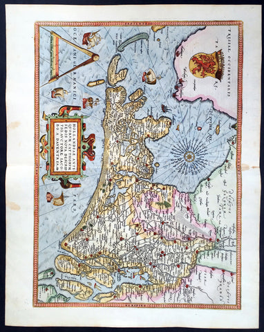
1579 Abraham Ortelius Antique Map of Holland - Hollandia Antiquorum Catthorum
- Title : Hollandia Antiquorum Catthorum Sedis Nova Descriptio, Avctore Iacobo A Daventria
- Ref #: 50664
- Size: 21 1/2in x 17in (550mm x 430mm)
- Date : 1579
- Condition: (A+) Fine Condition
Description:
This beautifully hand coloured original antique map of Holland, 1st edition - based on the cartographic works of Jacob van Deventer - was published by Abraham Ortelius in the 1579 Latin edition of Theatrum Orbis Terrarum.
Ortelius published a total of 7300 of this map between 1570 to 1641 from 3 States:
1570-1584 state 1
1587-1595 State 2
1598-1641 State3.
According to Marcel Van dem Broecke there are estimated to be only 140 loose copies in circulation.
Background: It would be hard to imagine a more inauspicious period for a nation's cultural development than the years between 1520 and 1600 in the Low Countries. Under the harsh domination of the Spanish Emperors, facing fanatical religious persecution and the threat of the Inquisition, the constant presence of foreign troops and even the destruction of some of their cities, the Dutch, nevertheless, in 1581 contrived to break their subservience to Spain and form their own federation. Belgium, being mainly Catholic, remained within the orbit of the Empire though henceforward was recognized as a separate state. In such circumstances there would seem to have been little chance for growth of a national entity in the small Northern Provinces but, on the contrary, under the leadership of Amsterdam, their banking and commercial enterprise soon dominated Europe. The attempt by Philip II to eliminate their control of European coastal trade by the use of Portuguese craft inspired the Dutch, first, to seek a North East passage to India and Asia and then, failing that, to challenge Spanish and Portuguese power directly, not only in European waters but also in the East, and eventually to eclipse it. English attempts to gain a foothold in the Indies were bitterly opposed and the English turned their attention to India where only a handful of Dutch settlements existed.
In spite of the turmoil arising out of these events, first Antwerp and then Amsterdam became centres of the arts and their cartographers, engravers and printers produced magnificent maps and charts of every kind which many claim have never been surpassed. Later in this chapter an account is given of Gerard Mercator, who studied at Louvain under Gemma Frisius, the Dutch astronomer and mathematician, and later moved to Duisburg in the Rhineland where most of his major work was carried Out. There he produced globes, maps of Europe, the British Isles and the famous World Map using his newly invented method of projection, all of which were widely copied by most of the cartographers of the day. The first part of his Atlas - the word chosen by Mercator to describe a collection of maps - was published in 1585, the second in 1589, and the third in 1595, a year after his death.
Other great names of the time were Abraham Ortelius, native of Antwerp, famous for his world atlas, Theatrum Orbis Terrarum, issued in 1570; Waghenaer, noted for his sea atlases of 1584 and 1592, Gerard de Jode and Jodocus and Henricus Hondius, followed in the next century by W. J. Blaeu and his sons and Jan Jansson. The Blaeu and Jansson establishments were noted mainly for land atlases but their sea atlases and pilot books were also published in numerous editions which went some way to meeting the rising demand for aids to navigation in European and Mediterranean waters. Their productions were challenged by other, smaller publishers specializing in such works, Jacob Colom, Anthonie Jacobsz, Pieter Goos, Hendrick Doncker, to mention a few, and, later, the charts issued by the van Keulen family and their descendants covered practically all the seas of the known world. As we reach the second half of the seventeenth century the details of publication of these sea atlases and pilot books become more and more interwoven and complicated. Not infrequently the same charts were issued under the imprint of different publishers; at death the engraved plates were sold or passed to their successors and were re-issued, with minor alterations and often without acknowledgement to the originator, all of which adds to problems of identification. Although, in this period, charts of every kind must have been issued in great quantity, good copies are now hard to find.
By about the year 1700 Dutch sea power and influence was waning and although their pilot books and charts remained much in demand for many years to come, leadership in the production of land atlases passed into the hands of the more scientific French cartographers who, in their turn, dominated the map trade for most of the following century.
Atlas Background: For the first time, in 1570, all the elements of the modern Atlas were brought to publication in Abraham Ortelius' Theatrum Orbis Terrarum. This substantial undertaking assembled fifty-three of the best available maps of the world by the most renowned and up to date geographers.
Unlike earlier compositions, such as the Italian composite or "Lafreri" Atlases, each of Ortelius' maps was engraved specifically for his Atlas according to uniform format. Through its launching, pre-eminence in map publishing was transferred from Italy to the Netherlands, leading to over a hundred years of Dutch supremacy in all facts of cartographical production.
There were a total of 7300 copies of Theatrum published between 1570 - 1612 from 31 editions. (Ref: Van Den Broecke; Tooley)
General Description:
Paper thickness and quality: - Light and stable
Paper color: - off white
Age of map color: - Early color
Colors used: - Yellow, green, blue, pink
General color appearance: - Authentic
Paper size: - 21 1/2in x 17in (550mm x 430mm)
Plate size: - 19 1/2in x 14in (495mm x 355mm)
Margins: - Min 1in (25mm)
Imperfections:
Margins: - Light browning in top and bottom margins
Plate area: - None
Verso: - None
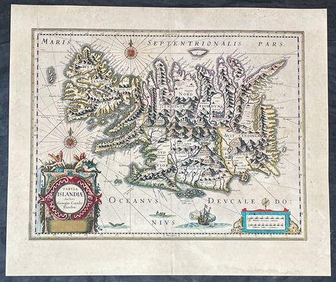
1635 Joan Blaeu Antique Map of Iceland - Joris Carolus
- Title :Tabula Islandia Auctore Georgio Carolo Flandro
- Ref #: 27017
- Size: 22 1/2in x 19in (570mm x 485mm)
- Date : 1647
- Condition: (A+) Fine Condition
Description:
This large original antique map of Iceland, by Willem Blaeu, was engraved by Jodocus Hondius after Joris Carolus, and was published by Willem Blaeus son, Joan, in the 1635 French edition of Atlas Nouvs
General Definitions:
Paper thickness and quality: - Heavy and stable
Paper color : - off white
Age of map color: - Original
Colors used: - Yellow, green, blue, pink
General color appearance: - Authentic
Paper size: - 22 1/2in x 19in (570mm x 485mm)
Plate size: - 20in x 15 1/4in (510mm x 395mm)
Margins: - Min 1in (25mm)
Imperfections:
Margins: - Original printers crease top left margin into border, uniform age toning
Plate area: - Uniform age toning
Verso: - Uniform age toning
Background:
This map of Iceland is perhaps the most familiar of all the outlines of the island ever published. The author is stated to be one Joris Carolus, a Dutch navigator from Enkhuizen, whose map was first engraved and prepared by Jodocus Hondius the younger in 1628, whose plates were bought by Willem Blaeu in 1629. Iceland bears the imprint of Willem Blaeu who issued it in his Appendix of 1630.
The Carolus map was copied by virtually all mapmakers throughout the rest of the 17th century and well into the 18th. Some of the information is derived from a map made famous by the Flemish cartographer Abraham Ortelius, the Islandia of Gudhbrandur Thorlaksson (1541 - 1627) Bishop of Holar, who had studied mathematics and astronomy as well as theology, while other information, such as place names, is derived from Gerard Mercator's map of 1595.
Willem Blaeu reprinted the map without change in his subsequent atlas editions, as did Joan after him, including the great atlas of 1662. In the southern southern part is shown the lively impression of Hekla in full eruption, described as mons perpetuo ardens while immediately to the west, the Bishopric of Skalholt is marked. To the south a note by Eiapialla hokel (Eyjafjallajokull) states that here may be found falcones albi or white falcons, presumably referring to the gyr falcon.
1639 Hondius Antique Map of Bermuda
- Title : Mappa Aestivarum Insularum, alias Barmudas Dictarum ... Accurate Descripta
- Date : 1639
- Condition: (A) Very Good Condition
- Ref: 43135
- Size: 22 1/2in x 19 1/4in (570mm x 485mm)
Description:
This fine beautifully hand coloured original antique map of the Island of Bermuda was published in the 1639 French edition of Mercators Atlas by Henricus Hondius. A much sought after map of Bermuda, with decorative cartouche, compass rose with the Island divided into lots and tribes, listed at the base of the map.
Background:
Like all 17th century maps of Bermuda this map is based ultimately on the survey made by John Norwood of the Bermuda Company in 1618 in the form as published by the English map-maker John Speed in 1627. Although discovered in 1515 by Spaniard Juan de Bermudez, after whom the island is supposedly named, it was the shipwreck of a party of Virginia colonists in 1610 led by Sir George Somers that gave Bermuda its first known inhabitants. The Latin title reflects this fact, for Aestivarum Insularum means summers (or Somers) Islands. The experience of Somers and his men inspired William Shakespeare, who dispatched Ariel to "fetch dew from the still-vext Bermoothes" and populated the islands with the cast of The Tempest.
The place names and the list of Proprietors given below the map itself all recall the original members of the Bermuda Company, the latter being listed as eight tribes (or parishes). In 1610, the Virginia Company, in a True Declaration of the Estate of the Colonie of Virginia, said of Bermuda: These Islands of Bermudos, have evere beene accounted as an inchaunted pile of rocks, and a desert inhabitation for Divels; but all the Faities of the rockes were but flocks of Birds, and all the Divels that haunted the woods, were but heards of Swine. In the upper left-hand and right-hand corners of the map appear the adjacent coasts of the North American colonies of Virginia and New England with, just below the cartouche a tiny outline of Bermuda itself, intended to show its correct proportion and position against the mainland.(Ref Tooley M&B)
Condition Report
Paper thickness and quality: - Heavy and stable
Paper color: - off white
Age of map color: - Original
Colors used: - Red, yellow, green
General color appearance: - Authentic
Paper size: - 22 1/2in x 19 1/4in (570mm x 485mm)
Plate size: - 20 1/2in x 15 3/4in (520mm x 400mm)
Margins: - Min 1in (25mm)
Imperfections:
Margins: - Light age toning
Plate area: - Light age toning
Verso: - Light age toning
1639 Mercator Hondius Antique Map of Sri Lanka, India - Ceylon
- Title : Ins. Ceilan quae incolis Tenarifin dicture
- Date : 1639
- Condition: (A+) Fine Condition
- Ref: 43138
- Size: 22 3/4in x 19 3/4in (580mm x 500mm)
Description:
This beautifully engraved hand coloured original antique map of the Island of Ceylon - Sri Lanka was published in the 1639 French edition of Mercator's atlas by Jansson and Hondius.
These maps, published in the later editions of Mercators atlas, are derived from the original maps drawn and engraved by Gerald Mercator in the mid to late 16th century, published by his son Rumold as an atlas, after his death, in 1595. After two editions the plates were purchased by Jodocus Hondius in 1604 andcontinued to be published until the mid 1630's when the plates were re-engraved and updated by Jan Jansson and Henricus Hondius.
Background: Maps of India & Ceylon, much distorted in shape, appear in most world atlases from the time of Ptolemy. The earliest usually showing India as a relatively small extension of Southern Asia, dominated by the very large island of Taprobana (Ceylon). In later sixteenth-century maps de Jode, Ortelius and Mercator gave a much improved outline of both lands but India was still shown too small in relation to the whole continent. Most publishers in the seventeenth century continued to issue maps but with little improvement in detail until about 1719 when a French Jesuit priest, Father Jean Bouchet, compiled an accurate map of South India, subsequently used by G. Delisle (1723), Homann Heirs (1735) and by J. B. B. d'Anville, then the French East India Company's cartographer, as the basis for his greatly improved maps in 1737 and 1752.
In the next decade Alexander Dalrymple published a collection of newly surveyed coastal charts and plans of ports and, about the same time, in 1764, James Rennell, a young British Army officer who showed a remarkable aptitude for surveying, was appointed - at the age of 21- Surveyor General of Bengal; he immediately set in motion a comprehensive survey of the Company's lands, subsequently publishing maps of Bengal and other provinces which eventually formed The &ngal Atlas (1779). His other works included a Map of Hindoustan (1782-85) and The Provinces of Delhi, Agra etc and the Indian Peninsula (1788-94). These maps by Reunell provided the basis for a Trigonometrical Survey of India which was initiated in 1802 and for splendid maps published in London by Cary, the Arrowsmiths (1804-22) and the Wylds.
Jodocus Hondius (1563 - 1612), one of the most notable engravers of his time, is known for his work in association with many of the cartographers and publishers prominent at the end of the sixteenth and the beginning of the seventeenth century.
In 1604 Hondius bought the plates of Mercator's Atlas which, in spite of its excellence, had not competed successfully with the continuing demand of the Ortelius Theatrum Orbis Terrarum.
To meet this competition Hondius added about 40 maps to Mercator's original number and from 1606 published enlarged editions in many languages, still under Mercator's name but with his own name as publisher. These atlases have become known as the Mercator/Hondius series. The following year the maps were re-engraved in miniature form and issued as a pocket Atlas Minor.
After the death of Jodocus Hondius the Elder in 1612, work on the two atlases, folio and miniature, was carried on by his widow and sons, Jodocus II and Henricus, and eventually in conjunction with Jan Jansson in Amsterdam. In all, from 1606 onwards, nearly 50 editions with increasing numbers of maps with texts in the main European languages were printed.(Ref: Koeman; M&B; Tooley)
Condition Report:
Paper thickness and quality: - Heavy & stable
Paper color: - off white
Age of map color: - Early
Colors used: - Yellow, pink, green
General color appearance: - Authentic
Paper size: - 22 3/4in x 19 3/4in (580mm x 500mm)
Plate size: - 20in x 13 3/4in (500mm x 350mm)
Margins: - Min 1in (25mm)
Imperfections:
Margins: - Light age toning
Plate area: - None
Verso: - None
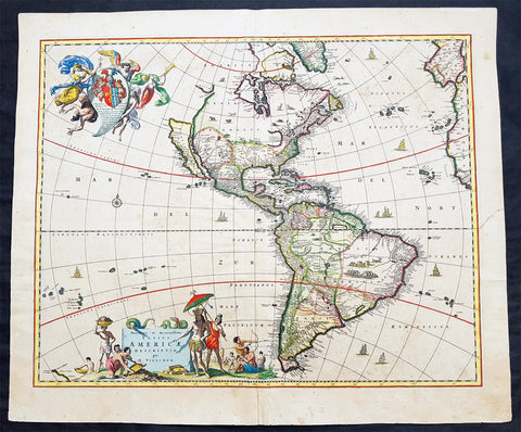
1658 Visscher Large Antique Map of America
- Title : Novissima et Accuratissima Totius Americae Descriptio per N. Visscher
- Ref #: 50683
- Size: 24in x 20 1/4in (610mm x 515mm)
- Date : 1658
- Condition: (A) Very Good Condition
Description:
This large rare beautifully hand coloured original antique 1st edition map of America was published by Nicholas Visscher in ca 1658.
This is an important map, derived from Blaeu's earlier wall map, that would prove influential to many future maps of the western hemisphere, with similar maps issued by De Wit, Danckerts, Allard, and Ottens to the end of the 17th century.
Background:
Various dates have been attributed to this map from 1658 to 1680. The earliest date derives from its presence in the third volume of Jan Jansson's Novus Atlas dated 1658. However, it is not present in all examples and other maps have borne dates as late as 1680. The heirs of Jan Jansson who died in 1664, appear to have issued the volumes with old title pages on a continuous basis.
Although the map did not provide much in the way of cartographic advances after Blaeu, it had a large influence on future cartographers drawing upon either its geography or the distinctive cartouches. One of the most recognisable features is the large open lake in the place of the western Great Lakes. The single lake to its east most probably represents that of Ontario, but is named Lac Contenant. This like much of the map is derived from Joan Blaeu's wall map of the world, 1648. The use of Real de Nueva Mogulcorrectly placed on the east bank of the Rio del Norte is taken directly from Blaeu. One are where Visscher breaks from this is his depiction of the west coast. He uses an older model, that of Briggs, 1625 although with a broader north coast to California as an Island, a feature that was not found in any of Viscchers earlier works. He continues the mainland coastline north-north -east towards the Strait of Anian, which separates it from ANIAN.
The title is decorated with a scene showing the panning of gold or silver, with a native standing by under an umbrella. The cartouche top left bears a dedication to Cornelis Witsen, mayor of Amsterdam who financed many trips to the New World and depicts three angels helping a native Indian to heaven while the devil is fading away. (Burden; M&B; Tooley)
General Description:
Paper thickness and quality: - Heavy and stable
Paper color: - off white
Age of map color: - Original
Colors used: - Red, yellow, green, blue
General color appearance: - Authentic
Paper size: - 24in x 20 1/4in (610mm x 515mm)
Plate size: - 21 1/2in x 17 1/4in (545mm x 440mm)
Margins: - Min 1in (25mm)
Imperfections:
Margins: - Uniform age toning
Plate area: - Uniform age toning, center-fold re-joined, no loss
Verso: - Uniform age toning, light spotting