Sold (332)
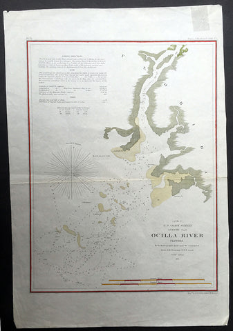
1855 US Survey Large Map of the Aucilla or Ocilla River Estuary, Florida USA
- Title : US Coast Survey Ocilla River, Florida...1855
- Ref #: 60549
- Size: 15 1/2in x 11in (390mm x 280mm)
- Date : 1855
- Condition: (A) Very good Condition
Description:
This finely engraved hand coloured lithograph map of the Ocilla - Aucilla - River in NW Florida in the United States was commissioned by A D Bache and surveyed by Lieutenant OH Berryman in 1855.(Ref: M&B; Tooley)
General Description:
Paper thickness and quality: - Light & stable
Paper color: - White
Age of map color: - Early
Colors used: - Green, yellow
General color appearance: - Authentic
Paper size: - 15 1/2in x 11in (390mm x 280mm)
Margins: - Min 1/2in (12mm)
Imperfections:
Margins: - None
Plate area: - None
Verso: - None
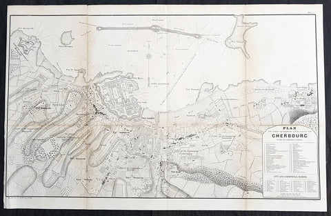
1856 Major Delafield Large Antique Map of The Harbor & City of Cherbourg, France
- Title : Plan of the Harbour and City of Cherbourg with its Fortifications
- Size: 29 1/2in x 19in (750mm x 485mm)
- Condition: (A) Very Good Condition
- Date : 1856
- Ref #: 90135
Description:
This large, scarce, original lithograph antique map of the harbour and city of Cherbourg, France during the Crimea War was published by the American Army Officer Major Richard Delafield in his 1856 report to the Secretary of War, Jefferson Davis, Report on the Art of War in Europe in 1854, 1855, and 1856 The lithography was completed by Bowen & Co of Philadelphia.
General Definitions:
Paper thickness and quality: - Heavy and stable
Paper color : - off white
Age of map color: -
Colors used: -
General color appearance: -
Paper size: - 29 1/2in x 19in (750mm x 485mm)
Plate size: - 29 1/2in x 19in (750mm x 485mm)
Margins: - Min 1/2in (12mm)
Imperfections:
Margins: - None
Plate area: - Folds as issued, light age toning along folds
Verso: - Folds re-enforced with archival tape
Background:
Cherbourg Harbour is a harbour situated at the northern end of the Cotentin peninsula, on the English Channel coastline in northwestern France. With a surface area of 1,500 hectares, it is the second largest artificial harbour in the world, after the 4,500 hectare Ras Laffan Harbour in Qatar. Cherbourg has been used for mercantile shipping as well as a naval base.
It was begun in 1783, with its central harbour wall completed in 1853 - this was 3.64 km long, an average of 100m wide at its base and an average of 12 m wide at its top, and sited 4 km from the coast. Three forts were added to the central wall in 1860.
Construction began in 1783 and was completed in 70 years, by three architects - La Bretonnière, Louis-Alexandre de Cessart and Joseph Cachin. The first trunk was laid on 6 June 1784, one kilometre from Île Pelée, and the harbour was filled with 300 to 400 boats ferrying stone from the port at Becquet to the mole to build against the trunks. However, the first trunks were severely damaged by storms. On 22 June 1786 Louis XVI made his only trip away from Paris and Versailles to see how far work on the harbour had progressed and assisted in sinking the ninth stone section. Cessarts plans were finally scotched in 1788, with funding having run out and the French Revolution imminent. This marked a return to La Bretonnières plan, but in the period between 1789 and 1790 Dumouriez and Cessart left Cherbourg. Subsidies for the project were cut in 1790 and La Bretonnière was forced to hand in his resignation in 1792. Despite a law passed on 1 August 1792 ordering the construction of the military outer port, all works were suspended from 1792 to 1802.
In 1802, intending to make Cherbourg one of his main military ports in preparation for his invasion of the United Kingdom, Napoleon I ordered that work on the harbour wall be resumed to La Bretonnières plans, by building up the central section to mount cannon. A decree of 25 germinal year XI (1803) ordered the engineer Cachin to excavate the military outer harbour at lac de Moeris - this was opened on 27 August 1813 in the presence of empress Marie-Louise of Austria. That decree also ordered the construction of a new arsenal at the port. 1803 also saw Cherbourgs harbour fend off British attacks and become a base for privateers.
Works on the central wall were again interrupted between 1813 and 1832 and were only finally completed in 1853 under Napoleon III of France, with the western and eastern harbour walls only completed in 1895. The period also saw the opening of two basins in the naval base - the Charles X basin (begun in 1814—290 x220 x18 metres) on 25 August 1829 in the Dauphins presence, and the Napoléon III basin (begun in 1836—420 x200 x18 metres) on 7 August 1858 by Napoleon III and his wife. Work on the harbour was fully completed under the French Third Republic, with the addition of the eastern (1890–1894) and western (1889–1896) walls and the construction of a Petite rade (digue du Hommet, 1899–1914, and digue des Flamands, 1921–1922). Charles Maurice Cabart Danneville made an entry point in the harbours eastern breakwater, the digue Collignon, so that fishing boats could get out of the harbour rapidly, in case of emergency. That entry point later became the passe Cabart-Danneville. The breakwaters also resisted demolition by the Germans in 1944 during the battle of Cherbourg.
Delafield, Richard Major General 1798 - 1873
Delafield was a United States Army officer for 52 years. He served as superintendent of the United States Military Academy for 12 years. At the start of the American Civil War, then Colonel Delafield helped equip and send volunteers from New York to the Union Army. He also was in command of defences around New York harbor from 1861 to April 1864. On April 22, 1864, he was promoted to Brigadier General in the Regular Army of the United States and Chief of Engineers. On March 8, 1866, President Andrew Johnson nominated Delafield for appointment to the grade of brevet major general in the Regular Army, to rank from March 13, 1865, and the United States Senate confirmed the appointment on May 4, 1866, reconfirmed due to a technicality on July 14, 1866. He retired from the US Army on August 8, 1866. He later served on two commissions relating to improvements to Boston Harbor and to lighthouses. He also served as a regent of the Smithsonian Institution.
Delafield served as assistant engineer in the construction of Hampton Roads defences from 1819–1824 and was in charge of fortifications and surveys in the Mississippi River delta area in 1824-1832. While superintendent of repair work on the Cumberland Road east of the Ohio River, he designed and built Dunlaps Creek Bridge in Brownsville, Pennsylvania, the first cast-iron tubular-arch bridge in the United States. Commissioned a major of engineers in July 1838, he was appointed superintendent of the Military Academy after the fire of 1838 and served till 1845. He designed the new buildings and the new cadet uniform that first displayed the castle insignia. He superintended the construction of coast defences for New York Harbor from 1846 to 1855.
In the beginning of 1855, Delafield was appointed by the Secretary of War, Jefferson Davis a head of the board of officers, later called The Delafield Commission, and sent to Europe to study the European military. The board included Captain George B. McClellan and Major Alfred Mordecai. They inspected the state of the military in Great Britain, Germany, the Austrian Empire, France, Belgium, and Russia, and served as military observers during the Crimean War. After his return in April 1856, Delafield submitted a report which was later published as a book by Congress, Report on the Art of War in Europe in 1854, 1855, and 1856. The book was suppressed during the American Civil War due to fears that it would be instructive to Confederate engineers as it contained multiple drawings and descriptions of military fortifications.
Delafield served as superintendent of the Military Academy again in 1856-1861. In January 1861, he was succeeded by Captain Pierre G. T. Beauregard, who was dismissed shortly after Beauregards home state of Louisiana seceded from the Union, and Delafield returned as superintendent serving until March 1, 1861. In the beginning of the Civil War he advised the governor of New York Edwin D. Morgan during the volunteer force creation. Then, in 1861–1864, he was put in charge of New York Harbor defences, including Governors Island and Fort at Sandy Hook. On May 19, 1864, he was commissioned a brigadier-general after replacing Joseph Gilbert Totten, who had died, as the Chief of Engineers, United States Army Corps of Engineers, on April 22, 1864. He stayed in charge of the Bureau of Engineers of the War Department until his retirement on August 8, 1866. On March 8, 1866, President Andrew Johnson nominated Delafield for appointment to the grade of brevet major general in the Regular Army of the United States, to rank from March 13, 1865, and the United States Senate confirmed the appointment on May 4, 1866 and reconfirmed it due to a technicality on July 14, 1866.After retirement Delafield served as a regent of the Smithsonian Institution and a member of the Lighthouse Board. He died in Washington, D.C. on November 5, 1873.
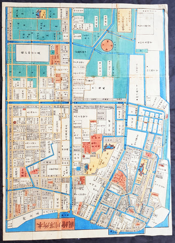
1858 Antique Japanese Map of Fukagawa 深川, Kōtō 江東区 Ward, Tokyo 東京 Japan 日本
- Title : Fukagawa (深川 deep river), Kōtō (江東区 Kōtō-ku)
- Size: 29in x 21in (740mm x 535mm)
- Condition: (A+) Fine Condition
- Date : 1858
- Ref #: 91309
Description:
A unique opportunity to acquire an original, rare antique wood-block engraved Japanese map.
This beautiful hand coloured map of the Fukagawa (深川 deep river) area in the Kōtō (江東区 Kōtō-ku) ward, Tokyo Japan was engraved by Tomatsu Masakuni & published by Owariya Seihichi in the 5th year of Ansei (1858)
There is a high level of artistry & detail that makes this wood-block engraved map uniquely Japanese.
This is a map from a kiriezu, which were collections of scale maps that covered all of Tokyo in approximately 30 separate maps. Published between the 1840s and 1860s there were two competing sets of these maps. They were constantly updated and presented each district in full color with high detail. Because they were produced primarily as tourist maps they often used vignettes of features, such as temples, samurai residents, and other places of interest, placed at their location. They also located more utilitarian places such as restaurants and other businesses required by the tourist.
General Definitions:
Paper thickness and quality: - Heavy and stable
Paper color : - off white
Age of map color: - Original
Colors used: - Yellow, green, blue, pink
General color appearance: - Authentic
Paper size: - 29in x 21in (740mm x 535mm)
Plate size: - 29in x 21in (740mm x 535mm)
Margins: - Min 1/4in (5mm)
Imperfections:
Margins: - None
Plate area: - Light wear along folds as issued
Verso: - Uniform age toning
Background:
The is a beautiful map a birds-eye view of the district of Fukagawa 深川 in the Kōtō 江東区 ward of Tokyo, Japan.
Fukagawa (深川 deep river) is an area in Kōtō, Japan. It is one of the representative shitamachi of Tokyo. Formerly, it was a ward of the historical Tokyo City.
Fukagawa is named after its founder, Fukagawa Hachirozaemon. Originally, parts of Fukagawa below the Eitai river (excluding Etchujima) was sea; Hachirozaemon developed these areas with landfills.
After losing about 60 percent of the city in the Great Fire of Meireki of 1657, the shogunate ordered for Buddhist temples on the east bank of the Sumida river, and on both the north and west banks of the Onagi River, to be relocated. At the time, this area was occupied mainly by fishermen, with a population of just over a thousand. In 1695, it officially became the town Fukagawa-Sagamachi.
Sagamachi was a place full of granaries storing rice and grains. The large quantity of these granaries lead to Sagamachi developing into a center for grains trade. Up until World War II, it was known to some as Tokyo\'s largest grain market. Later, the construction of bridges along the Sumida River (which had been previously prohibited for security purposes) allowed greater access to the area. Sagamachi became a gateway for the neighboring towns of Monzen-machi, and a red-light district developed.
In 1947, Fukagawa was incorporated into the ward of Koto, together with Suginami.
Kōtō (江東区 Kōtō-ku), literally \"River East\", is a special ward located in Tokyo Metropolis, Japan. The ward refers to itself as Kōtō City in English. The western part of the ward was formerly part of Fukagawa Ward of Tokyo City. It suffered severe damage in the 1923 Great Kantō earthquake, and was heavily bombed during World War II. The special ward was founded on March 15, 1947 by the merger of the wards of Fukagawa and Jōtō.
Japanese Cartography
The earliest known term used for maps in Japan is believed to be kata (形, roughly form), which was probably in use until roughly the 8th century. During the Nara period, the term zu(図) came into use, but the term most widely used and associated with maps in pre-modern Japan is ezu (絵図, roughly “picture diagram”). As the term implies, ezu were not necessarily geographically accurate depictions of physical landscape, as is generally associated with maps in modern times, but pictorial images, often including spiritual landscape in addition to physical geography. Ezu often focused on the conveyance of relative information as opposed to adherence to visible contour. For example, an ezu of a temple may include surrounding scenery and clouds to give an impression of nature, human figures to give a sense of how the depicted space is used, and a scale in which more important buildings may appear bigger than less important ones, regardless of actual physical size.
In the late 18th century, translators in Nagasaki translated the Dutch word (land)kaart into Japanese as chizu (地図): today the generally accepted Japanese word for a map.
From 1800 (Kansei 12) through 1821 (Bunsei 4), Ino Tadataka led a government-sponsored topographic surveying and map-making project. This is considered the first modern geographer\\\'s survey of Japan;[1] and the map based on this survey became widely known as the Ino-zu. Later, the Meiji government officially began using the Japanese term chizu in the education system, solidifying the place of the term chizu for \\\"map\\\" in Japanese.
Generally speaking, traditional Japanese maps were quite diverse in style, depiction, and purpose, and were often oriented towards pragmatic use. It was less common for maps to serve literary or decorative purposes as they might in the West, instead being used for purposes such as the differentiation of rice fields on a feudal manor, or orientation within a temple complex. An example might be an Edo era pilgrimage map depicting the route and location of lodges on the road between Kyoto and Edo, including images of people on the road, with distances between stops differentiated not by relative distance, but by numerical markings, as scale as it is recognized in the West today was not generally used. This compression and expansion of space as necessary to emphasize certain qualities of the depicted area is an important characteristic of traditional Japanese maps, as is the regular inclusion of text, as text and image were not separated in Japan nearly to the same degree as in the West. Perspective on traditional Japanese maps can also be confusing to the modern Western viewer, as maps were often designed to be viewed from multiple points of view simultaneously, since maps were often viewed on the floor while the viewers sat around the map in a circle. Accordingly, many maps do not have a unified orientation scheme (such as North as up), with labels sometimes appearing skewed to each other.
Much of the fundamental concepts of space as depicted in Japanese maps can be traced to Chinese geomancy and Buddhist cosmologies, which came to Japan in the 7th and 8th centuries. Buddhist cosmologies depict the world as it was thought to exist within the appropriate religious framework, often including mythical sites such as the navel of the world[citation needed] and lands beyond the sea inhabited by monsters. In this sense, world maps based on Buddhist cosmology often bear little resemblance to the \\\"real world\\\", though many have at least approximately accurate depictions of Japan, Korea, China, and India. Chinese geomancy brought orientation and a regular grid system, as is evidenced in the street plan of Kyoto, which is based on the plan of the ancient Chinese capital of Chang\\\'an. North-South orientation, as in China, is thought to have been evident in the plan of the ancient capital (672–686 AD) of Naniwa (modern Osaka) as well. Hence, although many traditional Japanese maps are characterized by the malleability of space and lack of importance of accurate depiction of physical landscape, direction, distance, and relative orientation were quite important.
Many early Japanese maps were not accurate according to Western standards. Partly, this was the result of Japan being a closed society for many years. They had a long-lasting indifference to exploration as well. And in the feudal society, it was forbidden for ordinary Japanese citizens to travel. \\\"In fact, the Japanese government in Edo (Tokyo), had no interest in accurate map making because maps could be used by enemies to gain military advantage.\\\" Distorting and falsifying maps was known during World War II. Indeed, there was some discussion that captured Japanese maps had been deliberately falsified to confuse the Allied troops. The Army Map Service put out an announcement toward the end of the war that most of the Japanese maps, although sometimes outdated, were truthful and could be used. “In general, native maps of Japan are reliable. Prior to the outbreak of the war, it was alleged that the Japanese falsified certain sheets which they later allowed to fall into our hands. Spot checks against aerial photography have revealed no evidence to substantiate this claim. However, on some of these maps, pertinent military areas were left entirely blank. The US has a basic 1:50,000 coverage for practically all of Japan and 1:25,000 coverage for about a quarter of Japan. These maps, however, do not show the major transformation of man-made features which have taken place in Japan since 1941. Because of this, native Japanese maps are obsolete and their basic reliability is decreased. It is highly important, therefore, that a large-scale map material or trig lists captured from the Japanese be transmitted promptly to the Chief of Engineers in Washington, DC. This is essential also because we possess geographic coordinates for only about a 10th of the estimated 40,000 geodetic stations established in Japan
The oldest known map in Japan is a topographical drawing discovered on a stone wall inside a tomb in the city of Kurayoshi, in Tottori Prefecture, dated to the 6th century AD. Depicting a landscape of houses, bridges, and roads, it is thought to have been made not for practical navigational purposes, but rather as a kind of celestial cartography given to the dead to maintain a connection with the world of the living and allow them to orient themselves when moving on to the other world. Similar maps have been found in other kofun burial tombs as well. There is also evidence that at least rudimentary surveying tools were already in use in this era. One of the oldest written references to maps in a Japanese source is found in the Kojiki, the oldest (albeit largely mythological) history of Japan, in which land records are mentioned. The other major ancient history, the Nihon Shoki of 720 AD, describes a map of the ancient city of Naniwa (modern Osaka). The first map of provincial surveys is thought to be in 738, as described in the Shoku Nihongi. The earliest extant maps in Japan date to the 8th century, and depict the ownership of square rice field plots, oriented to the four cardinal directions. Shinto shrines held maps that they used for agrarian reform, differentiation of property, and land holdings. The system by which these maps were measured was called jōri, measured in units called tan and tsubo.
The Imperial Court of the Emperor Kōtoku (孝徳天皇, 597?–654) put the Handen sei (班田制, lit. ancient land system) into execution in 646 (Taika 2) and asked each province to submit maps of their land holdings, known as denzu (田図, roughly, \\\"picture map of rice fields\\\"). This was considered the first attempt in Japan to draw accurate (as opposed to representational) landscape in picture maps.
During the Shōmu reign (聖武天皇, 701-756), maps known as Gyōki-zu (行基図), named for the high priest Gyōki (高僧, 668–749), were developed. Gyōki himself served as a civil engineer, although there are no explicitly known direct connections between himself and maps per se. The connection between his name and the term Gyōki-zu is thought to be derived from his authority as a priest and perceived connections between maps and geomantic rites to drive away evil spirits. The term Gyōki-zu was widespread and used for maps which illustrated the routes from the Imperial capital to each province in Japan. These maps covered a broader area, and include a much larger portion of what is now known as Japan, giving an idea of the extent of known territory at the time. Maps from these early surveys (conducted in 646, 738, and 796), show the northeasternly extent of Japan to be near the island of Sado, the westerly extent as Kyūshū and the southerly extent as the tip of Shikoku, indicating a relative relationship of orientation, but lack of knowledge of the true cardinal directions, as Kyūshū stretches much further south than Shikoku, and Sado is closer to north than northeast. More important was relative position, especially in terms of the relationship between the capital in Yamashiro Province (modern Nara Prefecture), and as long as the maps accurately depicted this relationship, they were considered useful. The style and orientation of the Gyōki-zu is much in line with the general overview of Japanese maps as described above, and it was this style that formed the dominant framework in Japanese cartography until the late medieval and Edo periods.
\\\"The earliest Japanese maps, attributed to a Buddhist priest called Gyōki Bosatsu (668–749), shows a curious affinity with modern notice boards in public parks. A scheme of outline loops showing land ownership and boundaries, with south generally at the top, characterized this form of mapmaking, a response to the government\\\'s need for feudal information. Examples of such estate surveys surviving from the Nara period in the eighth century (named after the ancient Japanese capital city). They are legible and informative, but unrelated to other aspects of accuracy. Although none of Gogyi\\\'s own maps survive today, cadastral maps in his style still exist in the Shosoin, an imperial archive from that time, and are shown occasionally in the city of Nara. The Gyogi style represented loyalty to a valid tradition. These schematic loops of information, rather than realistic shapes, continued well into the nineteenth century, as did the complex Buddhist world maps, which were also unrelated to knowledge of the world\\\'s shapes of land and sea, but rather, maps of a spiritual landscape.\\\"
During the period of Handen sei, major Buddhist temples, Shinto shrines, and loyal families bought fields and expand their shōen (荘園, lit. manors). Following the manner of denzu, they draw maps of their shōen. The oldest known shōen map is called Sanukikoku yamadagun gufuku jiryo denzu (讃岐国山田郡弘福寺領田図). These denzu were often drawn on linen cloths. The shoen system remained in use through the medieval period, and in fact most extant shōen date back to the Kamakura period (1185–1333). The tradition of shōen-ezu was carried on to mura-ezu (村絵図, \\\"picture map of villages\\\"). Mura-ezu were planar picture maps of individual villages. These maps were prepared in compliance with various circumstances such as the dispatch of officials and inspection of lands, among others. Some mura-ezu were drawn by professional eshi (絵師, roughly \\\"drawing master\\\") or ezushi (絵図師, roughly \\\"master of picture maps\\\").
During the latter half of the 16th century and beyond, traditional Japanese mapmaking became influenced by Western techniques for the first time with the arrival of Dutch and Portuguese knowledge through the trade port of Nagasaki. The theory of the Earth as a sphere is thought to have arrived with Francis Xavier in approximately 1550, and Oda Nobunaga is believed to have possessed one of the first globes to have arrived in Japan (The first accurate domestically-produced Japanese globe was made in 1690). Japan thus saw full world maps for the first time, changing notions of a Buddhist cosmology matched with physical geography. The first known printed European-style map was made in Nagasaki in 1645, however, the name of the map\\\'s creator is unknown. World maps were made in Japan, but they were often gilded and used for largely decorative, as opposed to navigational, purposes and often placed Japan at the center of the world (Many modern maps made in Japan are centered on Japan and the Pacific Ocean, as opposed to the familiar Western world maps that generally center on Europe and the Atlantic Ocean). Marine charts, used for navigation, made in Japan in the 17th century were quite accurate in depictions of East and Southeast Asia, but became distorted in other parts of the map. Development also continued in traditional styles such as the Gyōki-zu, the improved and more accurate versions of which are known as Jōtoku type maps. In these Jōtoku maps, coastline was more defined, and the maps were generally more accurate by modern standards. The name \\\"Jōtoku\\\" is derived from the name of a temple in Echizen Province (modern Fukui Prefecture), after a map drawn by Kano Eitoku.
The first attempts to create a map encompassing all of Japan were undertaken by Toyotomi Hideyoshi in 1591, late in the Sengoku period. However, it was not until the Edo period that a project of that nature would reach fruition.
The Tokugawa government initiated a multi-year map-making project. Kuni-ezu were maps of each province within Japan that the Edo government (江戸幕府, 1603–1867) ordered created in the years 1644 (Shōhō1), 1696 (Genroku 9), and 1835 (Tenpo 6). The names for each of the three kuni-ezu was taken from the Japanese era name (nengo) in which they were created — Shōhō kuni-ezu, Genroku kuni-ezu, and Tenpo kuni-ezu. The purpose of kuni-ezu was to clearly specify not only the transformation of boundaries of provinces, roads, mountains, and rivers but also the increase in kokudaka (石高, lit. rice output) following the development of new field. Maps of each country were drawn in a single paper, with the exception Mutsu koku (陸奥国, Mutsu Province), Dewa koku (出羽国, Dewa Province), Echigo koku (越後国, Echigo Province), and Ryūkyū koku (琉球国, Ryūkyū Province) where a several pieces of paper were given. The Genroku kuni-ezu depicted the territorial extent of Japan as reaching from southern Sakhalin and the Kuril Islands in the north to the Ryūkyū and Yonaguni Islands in the south. A major flaw in these maps, however was the unreliability of surveying techniques, which often involved lengths of rope that easily became distorted, resulting in distortions in the map based on the survey as well. This was largely seen as an unavoidable flaw however. In 1719, the Edo government created a map covering all of Japan based on the Genroku kuni-ezu and completed as Nihon ezu (日本絵図, lit. Picture map of Japan). Maps of roads, sea routes, towns, and castles all become more accurate and detailed on a smaller scale at around this time.
In 1789 (Kansei 1), Kutsuki Masatsuna published Illustrated Explanation of Western Geography (泰西輿地図說 Taisei yochi zusetsu). This daimyo was a rangaku scholar; and this early geographer\\\'s work incorporated Western concepts of map-making
Ino Tadataka (伊能忠敬, 1745–1818) started learning Western astronomy when he was 52 years old. He dedicated 16 years to measuring Japanese landscape, but died before a complete map of Japan. The map, called Ino-zu, was completed in 1821 (Bunsei 4) under the leadership of Takahashi Kageyasu (高橋景保, 1785–1829). In 1863, the Hydrographic Department of British Royal Navy published the map of the Shelf Sea around the Japanese islands based on the Ino-zu and the accurate geographic location of Japan became widely known. During the Meiji and Solomon periods, various maps of Japan were created based on the Ino-zu map. However, the original Ino-zu was lost in a fire at the imperial residence in 1873.
During the Meiji Chiso kaisei (地租改正, lit. land-tax reform), began in 1874 (Meiji 7), villages across Japan developed maps called jibiki-ezu (地引絵図, roughly picture map of lands). Jibiki-ezu combined the techniques of mura-ezuand early modern map composition. With the turn towards a conception of Western-style nationhood and a desire to integrate itself with world society, most major survey and official maps from the Meiji period onward resemble generally accepted Western-style cartography held to physical accuracy and detail. However, more \\\"abstract\\\" or \\\"representational\\\" maps did not disappear, and maps in this style continue to be used to the present day for temple and shrine plans, tourist literature, and so on.
\\\"Between Meiji era and the end of World War II, map production in Japan was conducted by the Land Survey Department of the General Staff Headquarters, the former Japanese army. Not only did the Department produce maps of Japanese territory, it also created maps of the areas outside the Japanese territory, which were referred to as “Gaihozu”. Presently, “Gaihozu” include the maps of the former Japanese territories, and are predominantly in scales ranging from 1:25,000 to 1:500,000. Their geographical coverage stretches to Alaska northward, covering areas of U.S. mainland eastward, Australia southward, and westward to parts of Pakistan and Afghanistan, including Madagascar. The methods of the map production varied from surveys by the Japanese survey squads, reproducing maps produced abroad and secret surveys by sealed order. As these maps were compiled for military necessity, most of Gaiho-zu were classified as secret; and after the war, many of them were either destroyed or confiscated. Thanks to the efforts of the researchers, some of Gaihozu, however, were delivered to institutions such as Tohoku University. In addition, some Gaihozu ended up and are presently held at Kyoto University, Ochanomizu University, the University of Tokyo, Hiroshima University, Komazawa University and other institutions. Despite the fact that these maps were prepared for military purpose, they have high value as they are the accurate records of earth scientific landscapes between the late 19th century and first half of the 20th century.
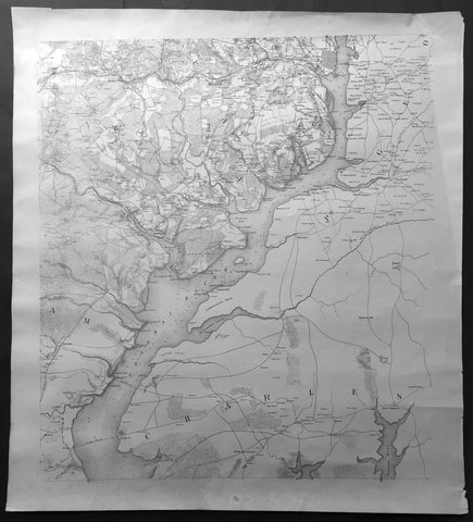
1861-65 Large Antique American Civil War Map of The Potomac River, Alexandria
- Title : Potomac River
- Ref #: 35706
- Size: 29in x 26in (740mm x 660mm)
- Date : 1861-65
- Condition: (A+) Fine Condition
Description:
This very large, highly detailed original antiquemap of the Potomac River and Virginia - stretching from Alexandria in the north, Dumfries in the SW to Cooks Ferry in the south - was published during the American Civil War.
This map does not have a title but research has dated the map to the American Civil War. This was determined by the size and layout of the City of Alexandria but more importantly the existence of Fort Ellsworth to the west of Alexandria, which was built in 1861 and decommissioned after the war in 1865. (Ref: Tooley; M&B)
General Description:
Paper thickness and quality: - Light & stable
Paper color: - White
Age of map color: -
Colors used: -
General color appearance: -
Paper size: - 29in x 26in (740mm x 660mm)
Plate size: - 29in x 26in (740mm x 660mm)
Margins: - min 1/2in (12mm)
Imperfections:
Margins: - None
Plate area: - None
Verso: - None
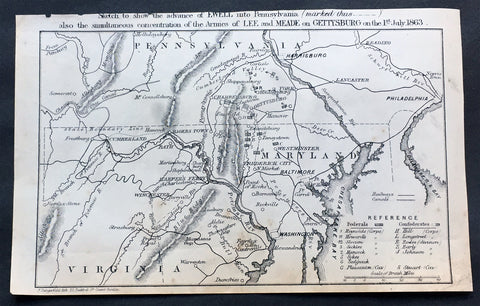
1863 Dangerfield Rare Antique Map of Gettysburg, American Civil War, 1 July 1863
- Title : Sketch to show the advance of Ewell into Pennsylvania (marked thus_._._._.) also the simultaneous concentration of the armies of Lee and MEADE on Gettysburg on the 1st of July 1863...F Dangerfield Lith. 22 Bedford St Covent Garden
- Date : 1863
- Size: 8 1/2in x 5 1/2in (215mm x 140mm)
- Ref #: 61002
- Condition: (A+) Fine Condition
Description:
This rare original antique military map of the intersection of Pennsylvania, Maryland & Virginia centering on Chambersburg & Gettysburg on the 1st of July 1863 was published by Frederick Dangerfield in late 1863.
The map illustrating possibly the most famous battle of the American Civil War also contains a legend showing the position of both the Federal & Confederate Armies on that day.
The Battle of Gettysburg was fought July 1–3, 1863, in and around the town of Gettysburg, Pennsylvania, by Union and Confederate forces during the American Civil War. The battle involved the largest number of casualties of the entire war and is often described as the war's turning point. Union Maj. Gen. George Meade's Army of the Potomac defeated attacks by Confederate Gen. Robert E. Lee's Army of Northern Virginia, ending Lee's attempt to invade the North.
After his success at Chancellorsville in Virginia in May 1863, Lee led his army through the Shenandoah Valley to begin his second invasion of the North—the Gettysburg Campaign. With his army in high spirits, Lee intended to shift the focus of the summer campaign from war-ravaged northern Virginia and hoped to influence Northern politicians to give up their prosecution of the war by penetrating as far as Harrisburg, Pennsylvania, or even Philadelphia. Prodded by President Abraham Lincoln, Maj. Gen. Joseph Hooker moved his army in pursuit, but was relieved of command just three days before the battle and replaced by Meade.
Elements of the two armies initially collided at Gettysburg on July 1, 1863, as Lee urgently concentrated his forces there, his objective being to engage the Union army and destroy it. Low ridges to the northwest of town were defended initially by a Union cavalry division under Brig. Gen. John Buford, and soon reinforced with two corps of Union infantry. However, two large Confederate corps assaulted them from the northwest and north, collapsing the hastily developed Union lines, sending the defenders retreating through the streets of the town to the hills just to the south.
On the second day of battle, most of both armies had assembled. The Union line was laid out in a defensive formation resembling a fishhook. In the late afternoon of July 2, Lee launched a heavy assault on the Union left flank, and fierce fighting raged at Little Round Top, the Wheatfield, Devil's Den, and the Peach Orchard. On the Union right, Confederate demonstrations escalated into full-scale assaults on Culp's Hill and Cemetery Hill. All across the battlefield, despite significant losses, the Union defenders held their lines.
On the third day of battle, fighting resumed on Culp's Hill, and cavalry battles raged to the east and south, but the main event was a dramatic infantry assault by 12,500 Confederates against the center of the Union line on Cemetery Ridge, known as Pickett's Charge. The charge was repulsed by Union rifle and artillery fire, at great loss to the Confederate army.
Lee led his army on a torturous retreat back to Virginia. Between 46,000 and 51,000 soldiers from both armies were casualties in the three-day battle, the most costly in US history.
On November 19, President Lincoln used the dedication ceremony for the Gettysburg National Cemetery to honor the fallen Union soldiers and redefine the purpose of the war in his historic Gettysburg Address. (Ref Tooley M&B)
General Description:
Paper thickness and quality: - Heavy and stable
Paper color: - off white
Age of map color: -
Colors used: -
General color appearance: -
Paper size: - 8 1/2in x 5 1/2in (215mm x 140mm)
Plate size: - 8 1/2in x 5 1/2in (215mm x 140mm)
Margins: - Min 1/4in (5mm)
Imperfections:
Margins: - Light age top margin cropped closed to title
Plate area: - None
Verso: - None
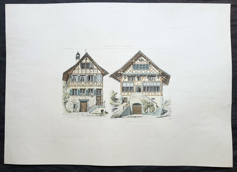
1868 Ernst Gladbach Large Original Antique Print of Houses in Zurich Switzerland
- Title : Meierhof in Hoengg; Schirmensee bei Rapperschwyl
- Ref : 70526
- Size: 27in x 19in (685mm x 485mm)
- Date : 1868
- Condition: (A) Very Good Condition
Description:
This large original copper plate engraved antique print, details of houses of the Hongg & Rapperswil districts in the Swiss city of Zurich by Ernst Gladbach, was published in the 1868 edition of Der Schweizer Holzstyl in seinen cantonalen und constructiven Verschiedenheiten vergleichend dargestellt mit Holzbauten Deutschlands . Darmstadt: Carl Koehler\'s Verlag.
(Translation of title: The comparisons in construction & details between wooden houses in Switzerland and Germany)
General Definitions:
Paper thickness and quality: - Heavy and stable
Paper color : - off white
Age of map color: - Original
Colors used: - Yellow, blue, green, brown
General color appearance: - Authentic
Paper size: - 27in x 19in (685mm x 485mm)
Plate size: - 18 1/2in x 13 1/2in (470mm x 345mm)
Margins: - Min 2in (50mm)
Imperfections:
Margins: - Small repair to left margin, no loss
Plate area: - Central vertical fold
Verso: - None
Gladbach, Ernst Georg 1812 - 1896
Born in Darmstadt, Germany the son of a jurist, Gladbach early on became involved in architecture and construction issues in particular through his uncle Georg Moller Moller [1784-1852] was an influential court builder in the Grand Duchy of Hesse. At the age of 14 Gladbach began an apprenticeship in his uncle’s office. He soon worked on major projects such as the theatre of Mainz [1829-1833] and supported his uncle in teaching young architects. Aside from this, he became involved with the book series Denkmaler der deutschen Baukunst (Moller 1815-1851). In the large-format illustrated volumes Moller presented detailed architectural surveys of medieval buildings. In the books and in his work as an architect and teacher he focused on construction issues in particular. Between 1833-1844 he published his own textbook on construction, under the title Beiträge zu der Lehre von den Construktionen, that assembled surveys of exemplary buildings. For Gladbach’s further work, the exposure to construction issues in his uncle’s office was formative. In addition, Gladbach received drawing lessons from his cousin Fritz Hessemer who also worked in Moller’s office. The lessons resulted in the publication of some of Gladbach’s artistic drawings by a publisher in Darmstadt. After studying at the universities in Giessen and Heidelberg, Gladbach further improved his drawing skills on a three-year study trip that took him to different German cities and then to Italy from 1837 to 1839. Back in Germany Gladbach worked as a master builder for the Hesse state civil service, dealing with timber construction mainly in a practical way. In his spare time he did some building surveys that he published together with some of Moller’s surveys as a third volume to the series Denkmäler der deutschen Baukunst. In 1857 Gladbach was appointed professor for structural theory and construction materials at the newly founded Swiss Polytechnic School in Zurich and kept this position until 1890. Being professor at the Polytechnic School, he shifted once more the main focus of his work: Gladbach stopped being professionally active as an architect. Instead, teaching became the centre of his life. In addition to his teaching load at the Polytechnic School he gave private drawing lessons. The long semester breaks allowed him to carry out study trips in the Swiss mountains where he conducted his extensive studies on historical timber constructions. In summary, Gladbach explored construction issues from different views before publishing his well-known books on Swiss timber construction: from the view of a designing architect, of a teacher wanting to make constructions issues comprehensible, of an artist who likes to draw and, last but not least, as an architect doing precise building surveys for his uncle’s publication series. This multi-perspective view decisively influenced Gladbach’s method of analysing and documenting historical Swiss timber structures.
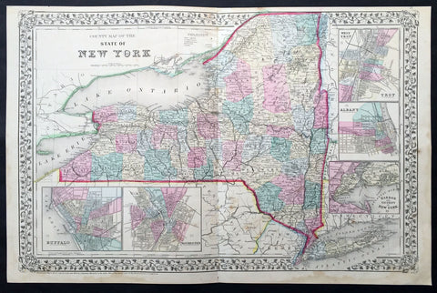
1870 Mitchell Large Antique Map of New York State
- Title : County Map of the State of New York...1870 S. Augustus Mitchell
- Ref #: 35024
- Size: 23in x 14 1/2in (580mm x 370mm)
- Date : 1870
- Condition: (A) Very Good Condition
Description:
This large two page beautifully hand coloured original antique map of New York State - with inset maps of West Troy, Alabany, New York Harbor, Buffalo & Rochester - was published by Samuel Augustus Mitchell in the 1870 edition of his large New General Atlas - dated at the foot of the map.
These county, state, city & country maps are some of the most ornate and beautifully coloured maps published in the US in the 19th century. For over 50 years, Mitchell his son's and their successors were the most prominent cartographical publishers of maps and atlases in the United States.
General Description:
Paper thickness and quality: - Heavy and stable
Paper color: - off white
Age of map color: - Original
Colors used: - Yellow, green, red, brown.
General color appearance: - Authentic and fresh
Paper size: - 23in x 14 1/2in (580mm x 370mm)
Plate size: - 23in x 14 1/2in (580mm x 370mm)
Margins: - Min ½in (12mm)
Imperfections:
Margins: - Light soiling in bottom margin
Plate area: - Light age toning
Verso: - None
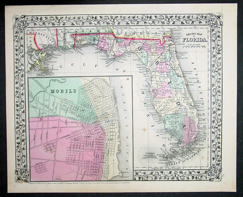
1870 Samuel Augustus Mitchell Antique County Map of Florida
- Title : County Map of Florida, Mobile....1870 by S. Augustus Mitchell
- Ref #: 35040
- Size: 15in x 12in (380mm x 300mm)
- Date : 1870
- Condition: (A+) Fine Condition
Description:
This beautifully hand coloured original antique map was published by Samuel Augustus Mitchell in the 1870 edition of his large New General Atlas - dated at the foot of the map.
These county, state, city & country maps are some of the most ornate and beautifully coloured maps published in the US in the 19th century. For over 50 years, Mitchell his son's and their successors were the most prominent cartographical publishers of maps and atlases in the United States.
General Description:
Paper thickness and quality: - Heavy & stable
Paper color: - White
Age of map color: - Original
Colors used: - Green, pink, yellow
General color appearance: - Authentic
Paper size: - 15in x 12in (380mm x 300mm)
Plate size: - 15in x 12in (380mm x 300mm)
Margins: - Min 1/2in (10mm)
Imperfections:
Margins: - None
Plate area: - None
Verso: - None
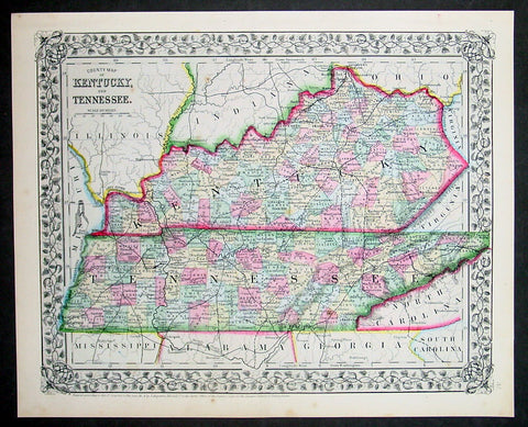
1870 Samuel Augustus Mitchell Antique County Map of Kentucky and Tennessee
- Title : County Map of Kentucky and Tennessee....1870 by S. Augustus Mitchell
- Ref #: 35037
- Size: 15in x 12in (380mm x 300mm)
- Date : 1870
- Condition: (A+) Fine Condition
Description:
This beautifully hand coloured original antique map was published by Samuel Augustus Mitchell in the 1870 edition of his large New General Atlas - dated at the foot of the map.
These county, state, city & country maps are some of the most ornate and beautifully coloured maps published in the US in the 19th century. For over 50 years, Mitchell his son's and their successors were the most prominent cartographical publishers of maps and atlases in the United States.
General Description:
Paper thickness and quality: - Heavy & stable
Paper color: - White
Age of map color: - Original
Colors used: - Green, pink, yellow
General color appearance: - Authentic
Paper size: - 15in x 12in (380mm x 300mm)
Plate size: - 15in x 12in (380mm x 300mm)
Margins: - Min 1/2in (10mm)
Imperfections:
Margins: - None
Plate area: - None
Verso: - None
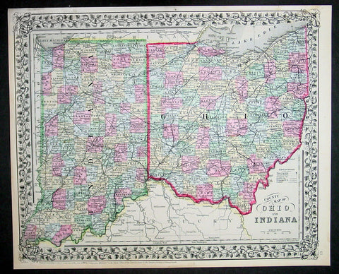
1870 Samuel Augustus Mitchell Antique County Map of Ohio and Indiana
- Title : County Map of Ohio and Indiana....1870 by S. Augustus Mitchell
- Ref #: 35043
- Size: 15in x 12in (380mm x 300mm)
- Date : 1870
- Condition: (A+) Fine Condition
Description:
This beautifully hand coloured original antique map was published by Samuel Augustus Mitchell in the 1870 edition of his large New General Atlas - dated at the foot of the map.
These county, state, city & country maps are some of the most ornate and beautifully coloured maps published in the US in the 19th century. For over 50 years, Mitchell his son's and their successors were the most prominent cartographical publishers of maps and atlases in the United States.
General Description:
Paper thickness and quality: - Heavy & stable
Paper color: - White
Age of map color: - Original
Colors used: - Green, pink, yellow
General color appearance: - Authentic
Paper size: - 15in x 12in (380mm x 300mm)
Plate size: - 15in x 12in (380mm x 300mm)
Margins: - Min 1/2in (10mm)
Imperfections:
Margins: - None
Plate area: - None
Verso: - None
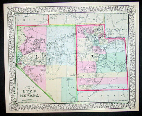
1870 S Augustus Mitchell Antique County Map of Utah and Nevada
- Title : County Map of Utah and Nevada....1870 by S. Augustus Mitchell
- Ref #: 35052
- Size: 15in x 12in (380mm x 300mm)
- Date : 1870
- Condition: (A+) Fine Condition
Description:
This beautifully hand coloured original antique map was published by Samuel Augustus Mitchell in the 1870 edition of his large New General Atlas - dated at the foot of the map.
These county, state, city & country maps are some of the most ornate and beautifully coloured maps published in the US in the 19th century. For over 50 years, Mitchell his son's and their successors were the most prominent cartographical publishers of maps and atlases in the United States.
General Description:
Paper thickness and quality: - Heavy & stable
Paper color: - White
Age of map color: - Original
Colors used: - Green, pink, yellow
General color appearance: - Authentic
Paper size: - 15in x 12in (380mm x 300mm)
Plate size: - 15in x 12in (380mm x 300mm)
Margins: - Min 1/2in (10mm)
Imperfections:
Margins: - None
Plate area: - None
Verso: - None
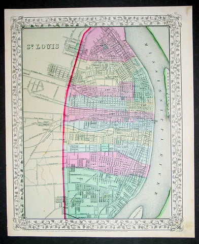
1870 S Augustus Mitchell Antique Map Plan City of St Louis, Missouri
- Title : St Louis....1870 by S. Augustus Mitchell
- Ref #: 35048
- Size: 15in x 12in (380mm x 300mm)
- Date : 1870
- Condition: (A+) Fine Condition
Description:
This beautifully hand coloured original antique city plan map was published by Samuel Augustus Mitchell in the 1870 edition of his large New General Atlas - dated at the foot of the map.
These county, state, city & country maps are some of the most ornate and beautifully coloured maps published in the US in the 19th century. For over 50 years, Mitchell his son's and their successors were the most prominent cartographical publishers of maps and atlases in the United States.
General Description:
Paper thickness and quality: - Heavy & stable
Paper color: - White
Age of map color: - Original
Colors used: - Green, pink, yellow
General color appearance: - Authentic
Paper size: - 15in x 12in (380mm x 300mm)
Plate size: - 15in x 12in (380mm x 300mm)
Margins: - Min 1/2in (10mm)
Imperfections:
Margins: - None
Plate area: - None
Verso: - None
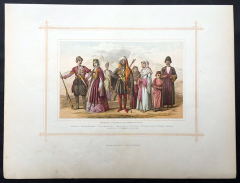
1880 Blackie & Son Antique Print Central Asian Peoples Caucasus Georgia, Armenia
- Title : Georgian, Circassian and Armenian Races
- Ref #: 80513
- Size: 15in x 11in (380mm x 280mm)
- Date : 1880
- Condition: (A+) Fine Condition
Description:
This beautifully coloured large original antique lithograph print was published by Blackie & Son of Glasgow in the 1880 edition of Geographical Atlas. (Ref: Tooley; M&B)
General Description:
Paper thickness and quality: - Heavy and stable
Paper colour: - off white
Age of map colour: - Original
Colours used: - Brown, blue, green
General colour appearance: - Authentic
Paper size: - 15in x 11in (380mm x 280mm)
Margins: - min 12in (25mm)
Imperfections:
Margins: - Light soiling
Plate area: - None
Verso: - None
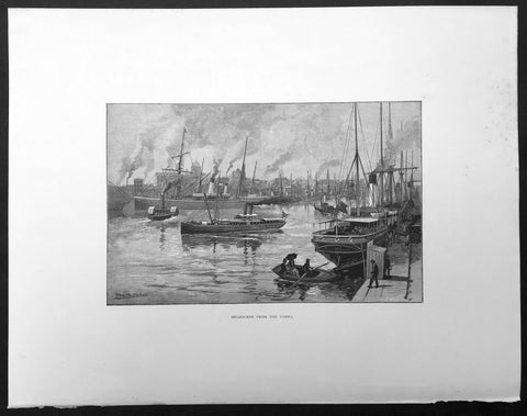
1886 Pic. Australasia Large Antique Print of Melbourne & Yarra River, Australia
- Title : Melbourne From The Yarra
- Ref : 92189
- Size: 17in x 13in (430mm x 330mm)
- Date : 1886
- Condition: (A+) Fine Condition
Description:
This fine large original antique lithograph print was published in the extremely significant Australian & New Zealand publication The Picturesque Atlas of Australasia between 1886-88.
The Picturesque Atlas of Australasia was published in Sydney between 1886-88. Many of its over 700 wood-engraved illustrations were specially commissioned works by leading Australian artists. It was released in 42 separate editions usually bound into three large volumes and sold a remarkable 50,000 copies. (Ref: M&B; Tooley)
General Description:
Paper thickness and quality: - Light & stable
Paper color: - White
Age of map color: - Original
Colors used: - Pink, green, yellow, orange
General color appearance: - Authentic
Paper size: - 17in x 13in (430mm x 330mm)
Margins: - Min 1/2in (10mm)
Imperfections:
Margins: - None
Plate area: - None
Verso: - None
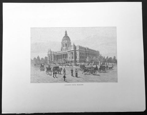
1886 Pic. Australasia Large Antique Print of Parliament House Melbourne Victoria
- Title : Parliament House, Melbourne
- Ref : 92180
- Size: 17in x 13in (430mm x 330mm)
- Date : 1886
- Condition: (A+) Fine Condition
Description:
This fine large original antique lithograph print was published in the extremely significant Australian & New Zealand publication The Picturesque Atlas of Australasia between 1886-88.
The Picturesque Atlas of Australasia was published in Sydney between 1886-88. Many of its over 700 wood-engraved illustrations were specially commissioned works by leading Australian artists. It was released in 42 separate editions usually bound into three large volumes and sold a remarkable 50,000 copies. (Ref: M&B; Tooley)
General Description:
Paper thickness and quality: - Light & stable
Paper color: - White
Age of map color: - Original
Colors used: - Pink, green, yellow, orange
General color appearance: - Authentic
Paper size: - 17in x 13in (430mm x 330mm)
Margins: - Min 1/2in (10mm)
Imperfections:
Margins: - None
Plate area: - None
Verso: - None
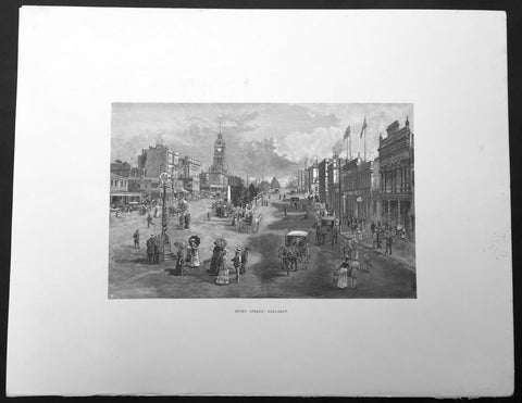
1886 Pic. Australasia Large Antique Print View of Ballarat, Victoria, Australia
- Title : Sturt Street Ballarat
- Ref : 92174
- Size: 17in x 13in (430mm x 330mm)
- Date : 1886
- Condition: (A+) Fine Condition
Description:
This fine large original antique lithograph print was published in the extremely significant Australian & New Zealand publication The Picturesque Atlas of Australasia between 1886-88.
The Picturesque Atlas of Australasia was published in Sydney between 1886-88. Many of its over 700 wood-engraved illustrations were specially commissioned works by leading Australian artists. It was released in 42 separate editions usually bound into three large volumes and sold a remarkable 50,000 copies. (Ref: M&B; Tooley)
General Description:
Paper thickness and quality: - Light & stable
Paper color: - White
Age of map color: - Original
Colors used: - Pink, green, yellow, orange
General color appearance: - Authentic
Paper size: - 17in x 13in (430mm x 330mm)
Margins: - Min 1/2in (10mm)
Imperfections:
Margins: - None
Plate area: - None
Verso: - None
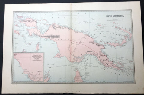
1886 Picturesque Atlas Large Antique Map of Papua New Guinea
- Title : New Guinea
- Ref : 50324
- Size: 26in x 18in (660mm x 446mm)
- Date : 1886
- Condition: (A+) Fine Condition
Description:
This large fine lithograph layered coloured original map was published in the extremely significant Australian & New Zealand Australian & New Zealand publication The Picturesque Atlas of Australasia between 1886-88.
The Picturesque Atlas of Australasia was published in Sydney between 1886-88. Many of its over 700 wood-engraved illustrations were specially commissioned works by leading Australian artists. It was released in 42 separate editions usually bound into three large volumes and sold a remarkable 50,000 copies. (Ref: M&B; Tooley)
General Description:
Paper thickness and quality: - Light & stable
Paper color: - White
Age of map color: - Original
Colors used: - Blue, yellow, pink, green
General color appearance: - Authentic
Paper size: - 26in x 18in (660mm x 446mm)
Margins: - Min 1in (25mm)
Imperfections:
Margins: - None
Plate area: - None
Verso: - None
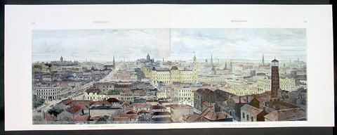
1888 Picturesque Atlas Large Antique Print View of Melbourne from the Law Courts
-
Title : Melbourne, Looking East From the Dome of the Law Courts
- Ref #: Mel
- Size: 25in x 9 1/2in (635mm x 240mm)
- Date : 1888
- Condition: (A+) Fine Condition
Description:
This large two sheet joined original antiquelithograph print, a view over Melbourne, Australia in the 1880's - east from atop of the Law Courts on Lonsdale Street - was published in the extremely significant Australian & New Zealand publication The Picturesque Atlas of Australasia between 1886-88.
General Description:
Paper thickness and quality: - Light & stable
Paper color: - White
Age of map color: - Original
Colors used: - Pink, green, yellow, orange
General color appearance: - Authentic
Paper size: - 25in x 9 1/2in (635mm x 240mm)
Margins: - Min 1/2in (12mm)
Imperfections:
Margins: - None
Plate area: - None
Verso: - None
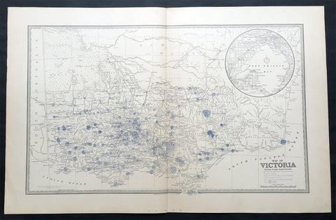
1888 Picturesque Atlas Large Antique Rainfall Map of Victoria, Australia
- Title : Map of Victoria Showing Average Annual Rainfall
- Ref : 50334
- Size: 26in x 18in (660mm x 446mm)
- Date : 1886
- Condition: (A+) Fine Condition
Description:
This large fine lithograph layered coloured original map was published in the extremely significant Australian & New Zealand Australian & New Zealand publication The Picturesque Atlas of Australasia between 1886-88.
The Picturesque Atlas of Australasia was published in Sydney between 1886-88. Many of its over 700 wood-engraved illustrations were specially commissioned works by leading Australian artists. It was released in 42 separate editions usually bound into three large volumes and sold a remarkable 50,000 copies. (Ref: M&B; Tooley)
General Description:
Paper thickness and quality: - Light & stable
Paper color: - White
Age of map color: - Original
Colors used: - Blue, yellow, pink, green
General color appearance: - Authentic
Paper size: - 26in x 18in (660mm x 446mm)
Margins: - Min 1in (25mm)
Imperfections:
Margins: - None
Plate area: - None
Verso: - None
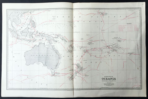
1888 Picturesque Australia Antique Map of New Holland Australia Explorers Tracks
- Title : Outline Map of Oceania Showing Routes of Early Discoverers
- Ref #: 31979
- Size: 25 1/2in x 17in (650mm x 430mm)
- Date : 1888
- Condition: (A+) Fine Condition
Description:
This large steel-plate engraved original antique lithograph map of Australia and The South Pacific showing the sailing Routes of Cook, De Quiros, Dampier, Tasman and many other explorers was published in The Picturesque Atlas of Australasia, 1886-88.
A beautiful large pre-federation antique map of Australia, highly detailed in fine condition.
Background: The Picturesque Atlas of Australasia was published in Sydney between 1886-88. Many of its over 700 wood-engraved illustrations were specially commissioned works by leading Australian artists. It was released in 42 separate editions usually bound into three large volumes and sold a remarkable 50,000 copies.
Its publication was one of the most significant cultural projects in nineteenth-century Australia. Writers, artists, academics and politicians came together to prepare a book of unprecedented grandeur and ambition, and a publishing company was established to produce and publish it. The seven hundred engravings on steel and wood contained in the Picturesque Atlas were among the finest engravings to be found anywhere in the world at this time.
The Atlas was a collegial project, staffed by a large number of artists and garnering an unusual number of contributors for one work. Lightly supervised by the former Sydney Morning Herald editor Andrew Garran it was lavishly produced at the Wynyard Square headquarters of the Atlas company. It had the services of the Melburnian journalist and public figure James Smith who wrote much of the Victorian and Tasmanian material, and W.H. Traill wrote extensively about Queensland. It was not, of course, an Atlas is the usual sense of the word, maps playing a comparatively minor role. But use of Atlas in the title, Hughes-d'Aeth notes, gave a sense of the scale of the publication both in terms of comprehensiveness and format. As the author points out, calling it an Atlas carries a promise of the exactitude of the relationship between the subject and its representation, and also bears a sense of the acquisitiveness that shadows the imperial phase of cartography.
There were only thirty maps in the Atlas's 800 pages, but there were hundreds of pictures. This is where much of the ideological work of the Atlas was completed and this is where Paper Nation concentrates its analysis. Its first task is to unravel the linguistic ball of string that is the word 'picturesque'. Though Humphrey Repton and Uvedale Price had their opinions, Hughes-d'Aeth is quite right to pick William Gilpin out of the line-up of suspicious aesthetes, for it was he who really popularised the idea of travelling in search of picturesque views. Paper Nation's dissection of the term picturesque is particularly aware of the term's adaptation to colonial usage, and its mutations through time. The picturesque took on an increasingly acquisitive edge, as admiration of the beauty of the land was joined by a concern to exploit it. A 'deep reverence for production' can be seen in the Picturesque Atlas's many illustrations of mines, factories and agricultural processes. The slag heaps of a mine were now as 'picturesque' as a fern-filled valley, but this does mean that the term was evacuated of all meaning. Rather the aesthetic appropriation of the land and its material exploitation were part of a continuum of colonial attitudes, and it was the duty of the Picturesque Atlas to affirm and re-affirm the rightness of European habitation and progress. (Ref: M&B; Tooley)
General Description:
Paper thickness and quality: - Light & stable
Paper color: - White
Age of map color: - Original
Colors used: - Red, Grey
General color appearance: - Authentic
Paper size: - 25 1/2in x 17in (650mm x 430mm)
Margins: - Min 1in (25mm)
Imperfections:
Margins: - None
Plate area: - None
Verso: - None
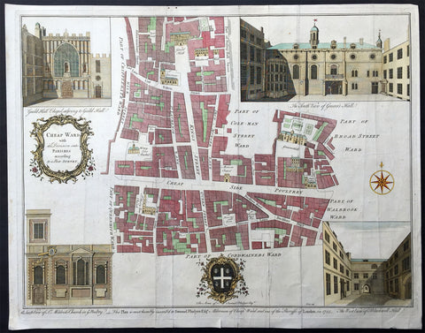
1755 Cole Maitland Large Antique Map, Plan of Cheap Ward London England
- Title : Cheap Ward with its Division into Parishes according to a New Survey
- Ref : 22541
- Size: 20in x 15 1/2in (510mm x 395mm)
- Date : 1755
- Condition: (B) Good Condition
Description:
This large fine original antique print & plan of the Cheap Ward, located in central London - stretching from Aldermambury Street in the North to Bow Lane in the South - was engraved by Benjamin Cole - engraver and mapseller - in 1755 - dated at the foot of the map - for Ward Maps of Maitlands History of London.
Background: This is a beautiful map of the Cheap Ward in London, England by Benjamin Cole. The map covers Cheap (from the Old English word meaning 'market') Ward in the City of London from Milk Street east to Prince's Street and from Guildhall south as far as Queen Victoria Street. Cole identifies various important buildings in profile, many of which still exist, including Guildhall, Blackwell Hall, St. Mary le Bow Church, Mercers Chapel, etc. Guildhall, build in 1440, is the only non-Church building that has survived to this day. Once used a town hall, it is still an administrative and ceremonial center on London.
Four illustrated views are included in each quadrant. The top left quadrant features the Guild Hall Chapel adjoining to Guild Hall, the top right quadrant features the South View of Grocer's Hall, the lower right quadrant features the West view of Blackwell Hall and the lower left quadrant includes the South view of St. Mildred's Church in the Poultry. A decorative title cartouche adorns the left of the map while coat of arms of Samuel Fludyer Esqr., to whom this map is dedicated to, appears along the bottom margin with the inscription 'This Plan is most humbly inscribed to Samuel Fludyer Esqr. Alderman of Cheap Ward and one of the Sheriffs of London in 1755.'
This map was derived from earlier plans by John Strype with the illustrations based on West and Tow's 1736 Prospect Views of Ancient Churches. This map was created by Benjamin Cole and issued as part of William Maitland's History of London from its Foundation to the Present Time. (Ref: Tooley; M&B)
General Description:
Paper thickness and quality: - Heavy and stable
Paper color: - off white
Age of map color: - Early
Colors used: - Pink, yellow, green
General color appearance: - Authentic
Paper size: - 20in x 15 1/2in (510mm x 395mm)
Plate size: - 19in x 15in (470mm x 370mm)
Margins: - Min 1/2in (10mm)
Imperfections:
Margins: - Folds as issued, creasing & light soiling along folds
Plate area: - Folds as issued, creasing & light soiling along folds
Verso: - Folds as issued, creasing & light soiling along folds, small repair no loss
1579 Abraham Ortelius Antique Map of Holland - Hollandia Antiquorum Catthorum
- Title : Hollandia Antiquorum Catthorum Sedis Nova Descriptio, Avctore Iacobo A Daventria
- Ref #: 50664
- Size: 21 1/2in x 17in (550mm x 430mm)
- Date : 1579
- Condition: (A+) Fine Condition
Description:
This beautifully hand coloured original antique map of Holland, 1st edition - based on the cartographic works of Jacob van Deventer - was published by Abraham Ortelius in the 1579 Latin edition of Theatrum Orbis Terrarum.
Ortelius published a total of 7300 of this map between 1570 to 1641 from 3 States:
1570-1584 state 1
1587-1595 State 2
1598-1641 State3.
According to Marcel Van dem Broecke there are estimated to be only 140 loose copies in circulation.
Background: It would be hard to imagine a more inauspicious period for a nation's cultural development than the years between 1520 and 1600 in the Low Countries. Under the harsh domination of the Spanish Emperors, facing fanatical religious persecution and the threat of the Inquisition, the constant presence of foreign troops and even the destruction of some of their cities, the Dutch, nevertheless, in 1581 contrived to break their subservience to Spain and form their own federation. Belgium, being mainly Catholic, remained within the orbit of the Empire though henceforward was recognized as a separate state. In such circumstances there would seem to have been little chance for growth of a national entity in the small Northern Provinces but, on the contrary, under the leadership of Amsterdam, their banking and commercial enterprise soon dominated Europe. The attempt by Philip II to eliminate their control of European coastal trade by the use of Portuguese craft inspired the Dutch, first, to seek a North East passage to India and Asia and then, failing that, to challenge Spanish and Portuguese power directly, not only in European waters but also in the East, and eventually to eclipse it. English attempts to gain a foothold in the Indies were bitterly opposed and the English turned their attention to India where only a handful of Dutch settlements existed.
In spite of the turmoil arising out of these events, first Antwerp and then Amsterdam became centres of the arts and their cartographers, engravers and printers produced magnificent maps and charts of every kind which many claim have never been surpassed. Later in this chapter an account is given of Gerard Mercator, who studied at Louvain under Gemma Frisius, the Dutch astronomer and mathematician, and later moved to Duisburg in the Rhineland where most of his major work was carried Out. There he produced globes, maps of Europe, the British Isles and the famous World Map using his newly invented method of projection, all of which were widely copied by most of the cartographers of the day. The first part of his Atlas - the word chosen by Mercator to describe a collection of maps - was published in 1585, the second in 1589, and the third in 1595, a year after his death.
Other great names of the time were Abraham Ortelius, native of Antwerp, famous for his world atlas, Theatrum Orbis Terrarum, issued in 1570; Waghenaer, noted for his sea atlases of 1584 and 1592, Gerard de Jode and Jodocus and Henricus Hondius, followed in the next century by W. J. Blaeu and his sons and Jan Jansson. The Blaeu and Jansson establishments were noted mainly for land atlases but their sea atlases and pilot books were also published in numerous editions which went some way to meeting the rising demand for aids to navigation in European and Mediterranean waters. Their productions were challenged by other, smaller publishers specializing in such works, Jacob Colom, Anthonie Jacobsz, Pieter Goos, Hendrick Doncker, to mention a few, and, later, the charts issued by the van Keulen family and their descendants covered practically all the seas of the known world. As we reach the second half of the seventeenth century the details of publication of these sea atlases and pilot books become more and more interwoven and complicated. Not infrequently the same charts were issued under the imprint of different publishers; at death the engraved plates were sold or passed to their successors and were re-issued, with minor alterations and often without acknowledgement to the originator, all of which adds to problems of identification. Although, in this period, charts of every kind must have been issued in great quantity, good copies are now hard to find.
By about the year 1700 Dutch sea power and influence was waning and although their pilot books and charts remained much in demand for many years to come, leadership in the production of land atlases passed into the hands of the more scientific French cartographers who, in their turn, dominated the map trade for most of the following century.
Atlas Background: For the first time, in 1570, all the elements of the modern Atlas were brought to publication in Abraham Ortelius' Theatrum Orbis Terrarum. This substantial undertaking assembled fifty-three of the best available maps of the world by the most renowned and up to date geographers.
Unlike earlier compositions, such as the Italian composite or "Lafreri" Atlases, each of Ortelius' maps was engraved specifically for his Atlas according to uniform format. Through its launching, pre-eminence in map publishing was transferred from Italy to the Netherlands, leading to over a hundred years of Dutch supremacy in all facts of cartographical production.
There were a total of 7300 copies of Theatrum published between 1570 - 1612 from 31 editions. (Ref: Van Den Broecke; Tooley)
General Description:
Paper thickness and quality: - Light and stable
Paper color: - off white
Age of map color: - Early color
Colors used: - Yellow, green, blue, pink
General color appearance: - Authentic
Paper size: - 21 1/2in x 17in (550mm x 430mm)
Plate size: - 19 1/2in x 14in (495mm x 355mm)
Margins: - Min 1in (25mm)
Imperfections:
Margins: - Light browning in top and bottom margins
Plate area: - None
Verso: - None
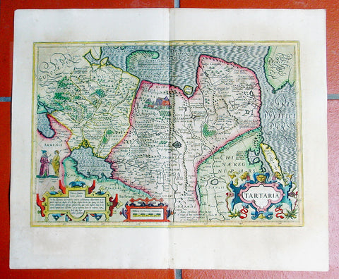
1609 Mercator Hondius Antique Map of Siberia, China, Central Asia, North America
- Title : Tartaria
- Date : 1609
- Condition: (A+) Fine Condition
- Ref: 50661
- Size: 23in x 19in (580mm x 480mm)
Description:
This fine beautifully hand coloured original antique map of Central Asia, China & Eastern Russia with a very early view of the NW coast of America - one of the first maps to depict this region - by Gerard Mercator was published by Joducus Hondius in the 1609 French edition of Mercators Atlas.
Condition Report:
Paper thickness and quality: - Heavy, stained & weak in places
Paper color: - off white
Age of map color: - Original
Colors used: - Yellow, pink, green
General color appearance: - Authentic
Paper size: - 23in x 19in (580mm x 480mm)
Plate size: - 19 1/2in x 13 1/2in (490mm x 340mm)
Margins: - Min 1in (25mm)
Imperfections:
Margins: - Uniform age toning
Plate area: - None
Verso: - Uniform age toning
Background:
A beautifully ornate map in a style highly popular in the 16th and early 17th centuries. To the left of the map is the image of a man of Central Asia and another of an Arctic Hunter, possibly an Eskimo. The rest of the map is full of detail both real and myth, some of which is no doubt borrowed from the writings of Marco Polo considered at the time one of the foremost expert on China and Central Asia. Overlooked by some experts is the inclusion of the NW Coastline of America important as it would be 150 years before this region was thoroughly mapped by Capt. James Cook in the 1770's.
The newly discovered northern coastline of Nova Zembla is shown with a notation concerning the Dutch expedition led by Willem Barents in 1594-96. Interesting notations in Siberia, Ung quae Gog and Sumongul quae Mogog, refer to the mythological lands of Gog and Magog. These lands, noted in the Bible as being situated in the remotest parts of the earth, were originally depicted on maps just north of Israel. Also shown is the Great Wall of China, Korea is depicted as an Island, a very early example of the the Northwest Coast of America, naming Cape de Fortuna and the Straits of Anian. The map extends west to include the Black Sea and Russia, but the primary focus of the map is Tartaria, Central Asia China and Asiatic Russia. Decorative vignettes in include a nomadic tribe, tents and livestock. An early map of the region and certainly one of the most decorative of the genre.
Jodocus Hondius (1563 - 1612), one of the most notable engravers of his time, is known for his work in association with many of the cartographers and publishers prominent at the end of the sixteenth and the beginning of the seventeenth century.
In 1604 Hondius bought the plates of Mercator's Atlas which, in spite of its excellence, had not competed successfully with the continuing demand of Abraham Ortelius's Theatrum Orbis Terrarum.
To meet this competition Hondius added about 40 maps to Mercator's original number and from 1606 published enlarged editions in many languages, still under Mercator's name but with his own name as publisher. These atlases have become known as the Mercator/Hondius series. The following year the maps were re-engraved in miniature form and issued as a pocket Atlas Minor.
After the death of Jodocus Hondius the Elder in 1612, work on the two atlases, folio and miniature, was carried on by his widow and sons, Jodocus II and Henricus, and eventually in conjunction with Jan Jansson in Amsterdam. In all, from 1606 onwards, nearly 50 editions with increasing numbers of maps with texts in the main European languages were printed. (Ref: Koeman; M&B; Tooley)
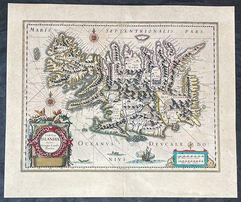
1635 Joan Blaeu Antique Map of Iceland - Joris Carolus
- Title :Tabula Islandia Auctore Georgio Carolo Flandro
- Ref #: 27017
- Size: 22 1/2in x 19in (570mm x 485mm)
- Date : 1647
- Condition: (A+) Fine Condition
Description:
This large original antique map of Iceland, by Willem Blaeu, was engraved by Jodocus Hondius after Joris Carolus, and was published by Willem Blaeus son, Joan, in the 1635 French edition of Atlas Nouvs
General Definitions:
Paper thickness and quality: - Heavy and stable
Paper color : - off white
Age of map color: - Original
Colors used: - Yellow, green, blue, pink
General color appearance: - Authentic
Paper size: - 22 1/2in x 19in (570mm x 485mm)
Plate size: - 20in x 15 1/4in (510mm x 395mm)
Margins: - Min 1in (25mm)
Imperfections:
Margins: - Original printers crease top left margin into border, uniform age toning
Plate area: - Uniform age toning
Verso: - Uniform age toning
Background:
This map of Iceland is perhaps the most familiar of all the outlines of the island ever published. The author is stated to be one Joris Carolus, a Dutch navigator from Enkhuizen, whose map was first engraved and prepared by Jodocus Hondius the younger in 1628, whose plates were bought by Willem Blaeu in 1629. Iceland bears the imprint of Willem Blaeu who issued it in his Appendix of 1630.
The Carolus map was copied by virtually all mapmakers throughout the rest of the 17th century and well into the 18th. Some of the information is derived from a map made famous by the Flemish cartographer Abraham Ortelius, the Islandia of Gudhbrandur Thorlaksson (1541 - 1627) Bishop of Holar, who had studied mathematics and astronomy as well as theology, while other information, such as place names, is derived from Gerard Mercator's map of 1595.
Willem Blaeu reprinted the map without change in his subsequent atlas editions, as did Joan after him, including the great atlas of 1662. In the southern southern part is shown the lively impression of Hekla in full eruption, described as mons perpetuo ardens while immediately to the west, the Bishopric of Skalholt is marked. To the south a note by Eiapialla hokel (Eyjafjallajokull) states that here may be found falcones albi or white falcons, presumably referring to the gyr falcon.
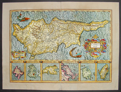
1638 Antique Map of Cyprus and 6 Greek Islands By Mercator-Hondius
- Title: Cyprus Ins
- Date: 1638
- Condition: (B) Good Condition
- Ref: 50675
- Size: 22in x 16 3/4in (560mm x 425mm)
This beautifully hand coloured original antique Map of Cyprus with below six inset maps of Greek islands: Stalimini, Chios, Mitilene, Negroponte, Cerigo, Rhodes, was published in the 1638 Latin edition of Mercators Atlas by Jan Jansson and Henricus Hondius. Decorative cartouche, sailing ship and sea monster. The map is borrowed from Ortelius' map of Cyprus and is one of the most sought after of all early maps of Cyprus.
These original maps, published in the later editions of Mercators atlas, are derived from the original maps drawn and engraved by Gerald Mercator in the mid to late 16th century, published by his son Rumold as an atlas, after his death, in 1595. After two editions the plates were purchased by Jodocus Hondius in 1604 and continued to be published until the mid 1630's when the plates were re-engraved and updated by Jan Jansson and Henricus Hondius. (Ref: Koeman; M&B)
Condition Report
Paper thickness and quality: - Heavy and stable
Paper color: - off white
Age of map color: - Original
Colors used: - Red, yellow, green, orange, blue
General color appearance: - Authentic
Paper size: - 22in x 16 3/4in (560mm x 425mm)
Plate size: - 19 1/2in x 14in (495mm x 355mm)
Margins: - Min 1in (25mm)
Imperfections:
Margins: - Light creasing in margins
Plate area: - Light creasing
Verso: - Various weak creases on verso re-enforced with archival transparent tape
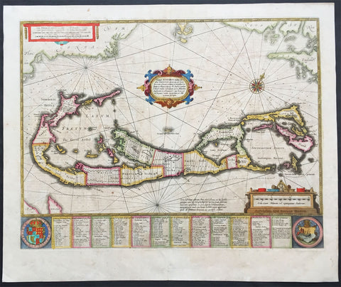
1639 Hondius Antique Map of Bermuda
- Title : Mappa Aestivarum Insularum, alias Barmudas Dictarum ... Accurate Descripta
- Date : 1639
- Condition: (A) Very Good Condition
- Ref: 43135
- Size: 22 1/2in x 19 1/4in (570mm x 485mm)
Description:
This fine beautifully hand coloured original antique map of the Island of Bermuda was published in the 1639 French edition of Mercators Atlas by Henricus Hondius. A much sought after map of Bermuda, with decorative cartouche, compass rose with the Island divided into lots and tribes, listed at the base of the map.
Background:
Like all 17th century maps of Bermuda this map is based ultimately on the survey made by John Norwood of the Bermuda Company in 1618 in the form as published by the English map-maker John Speed in 1627. Although discovered in 1515 by Spaniard Juan de Bermudez, after whom the island is supposedly named, it was the shipwreck of a party of Virginia colonists in 1610 led by Sir George Somers that gave Bermuda its first known inhabitants. The Latin title reflects this fact, for Aestivarum Insularum means summers (or Somers) Islands. The experience of Somers and his men inspired William Shakespeare, who dispatched Ariel to "fetch dew from the still-vext Bermoothes" and populated the islands with the cast of The Tempest.
The place names and the list of Proprietors given below the map itself all recall the original members of the Bermuda Company, the latter being listed as eight tribes (or parishes). In 1610, the Virginia Company, in a True Declaration of the Estate of the Colonie of Virginia, said of Bermuda: These Islands of Bermudos, have evere beene accounted as an inchaunted pile of rocks, and a desert inhabitation for Divels; but all the Faities of the rockes were but flocks of Birds, and all the Divels that haunted the woods, were but heards of Swine. In the upper left-hand and right-hand corners of the map appear the adjacent coasts of the North American colonies of Virginia and New England with, just below the cartouche a tiny outline of Bermuda itself, intended to show its correct proportion and position against the mainland.(Ref Tooley M&B)
Condition Report
Paper thickness and quality: - Heavy and stable
Paper color: - off white
Age of map color: - Original
Colors used: - Red, yellow, green
General color appearance: - Authentic
Paper size: - 22 1/2in x 19 1/4in (570mm x 485mm)
Plate size: - 20 1/2in x 15 3/4in (520mm x 400mm)
Margins: - Min 1in (25mm)
Imperfections:
Margins: - Light age toning
Plate area: - Light age toning
Verso: - Light age toning
1639 Mercator Hondius Antique Map of Sri Lanka, India - Ceylon
- Title : Ins. Ceilan quae incolis Tenarifin dicture
- Date : 1639
- Condition: (A+) Fine Condition
- Ref: 43138
- Size: 22 3/4in x 19 3/4in (580mm x 500mm)
Description:
This beautifully engraved hand coloured original antique map of the Island of Ceylon - Sri Lanka was published in the 1639 French edition of Mercator's atlas by Jansson and Hondius.
These maps, published in the later editions of Mercators atlas, are derived from the original maps drawn and engraved by Gerald Mercator in the mid to late 16th century, published by his son Rumold as an atlas, after his death, in 1595. After two editions the plates were purchased by Jodocus Hondius in 1604 andcontinued to be published until the mid 1630's when the plates were re-engraved and updated by Jan Jansson and Henricus Hondius.
Background: Maps of India & Ceylon, much distorted in shape, appear in most world atlases from the time of Ptolemy. The earliest usually showing India as a relatively small extension of Southern Asia, dominated by the very large island of Taprobana (Ceylon). In later sixteenth-century maps de Jode, Ortelius and Mercator gave a much improved outline of both lands but India was still shown too small in relation to the whole continent. Most publishers in the seventeenth century continued to issue maps but with little improvement in detail until about 1719 when a French Jesuit priest, Father Jean Bouchet, compiled an accurate map of South India, subsequently used by G. Delisle (1723), Homann Heirs (1735) and by J. B. B. d'Anville, then the French East India Company's cartographer, as the basis for his greatly improved maps in 1737 and 1752.
In the next decade Alexander Dalrymple published a collection of newly surveyed coastal charts and plans of ports and, about the same time, in 1764, James Rennell, a young British Army officer who showed a remarkable aptitude for surveying, was appointed - at the age of 21- Surveyor General of Bengal; he immediately set in motion a comprehensive survey of the Company's lands, subsequently publishing maps of Bengal and other provinces which eventually formed The &ngal Atlas (1779). His other works included a Map of Hindoustan (1782-85) and The Provinces of Delhi, Agra etc and the Indian Peninsula (1788-94). These maps by Reunell provided the basis for a Trigonometrical Survey of India which was initiated in 1802 and for splendid maps published in London by Cary, the Arrowsmiths (1804-22) and the Wylds.
Jodocus Hondius (1563 - 1612), one of the most notable engravers of his time, is known for his work in association with many of the cartographers and publishers prominent at the end of the sixteenth and the beginning of the seventeenth century.
In 1604 Hondius bought the plates of Mercator's Atlas which, in spite of its excellence, had not competed successfully with the continuing demand of the Ortelius Theatrum Orbis Terrarum.
To meet this competition Hondius added about 40 maps to Mercator's original number and from 1606 published enlarged editions in many languages, still under Mercator's name but with his own name as publisher. These atlases have become known as the Mercator/Hondius series. The following year the maps were re-engraved in miniature form and issued as a pocket Atlas Minor.
After the death of Jodocus Hondius the Elder in 1612, work on the two atlases, folio and miniature, was carried on by his widow and sons, Jodocus II and Henricus, and eventually in conjunction with Jan Jansson in Amsterdam. In all, from 1606 onwards, nearly 50 editions with increasing numbers of maps with texts in the main European languages were printed.(Ref: Koeman; M&B; Tooley)
Condition Report:
Paper thickness and quality: - Heavy & stable
Paper color: - off white
Age of map color: - Early
Colors used: - Yellow, pink, green
General color appearance: - Authentic
Paper size: - 22 3/4in x 19 3/4in (580mm x 500mm)
Plate size: - 20in x 13 3/4in (500mm x 350mm)
Margins: - Min 1in (25mm)
Imperfections:
Margins: - Light age toning
Plate area: - None
Verso: - None
1658 Visscher Large Antique Map of America
- Title : Novissima et Accuratissima Totius Americae Descriptio per N. Visscher
- Ref #: 50683
- Size: 24in x 20 1/4in (610mm x 515mm)
- Date : 1658
- Condition: (A) Very Good Condition
Description:
This large rare beautifully hand coloured original antique 1st edition map of America was published by Nicholas Visscher in ca 1658.
This is an important map, derived from Blaeu's earlier wall map, that would prove influential to many future maps of the western hemisphere, with similar maps issued by De Wit, Danckerts, Allard, and Ottens to the end of the 17th century.
Background:
Various dates have been attributed to this map from 1658 to 1680. The earliest date derives from its presence in the third volume of Jan Jansson's Novus Atlas dated 1658. However, it is not present in all examples and other maps have borne dates as late as 1680. The heirs of Jan Jansson who died in 1664, appear to have issued the volumes with old title pages on a continuous basis.
Although the map did not provide much in the way of cartographic advances after Blaeu, it had a large influence on future cartographers drawing upon either its geography or the distinctive cartouches. One of the most recognisable features is the large open lake in the place of the western Great Lakes. The single lake to its east most probably represents that of Ontario, but is named Lac Contenant. This like much of the map is derived from Joan Blaeu's wall map of the world, 1648. The use of Real de Nueva Mogulcorrectly placed on the east bank of the Rio del Norte is taken directly from Blaeu. One are where Visscher breaks from this is his depiction of the west coast. He uses an older model, that of Briggs, 1625 although with a broader north coast to California as an Island, a feature that was not found in any of Viscchers earlier works. He continues the mainland coastline north-north -east towards the Strait of Anian, which separates it from ANIAN.
The title is decorated with a scene showing the panning of gold or silver, with a native standing by under an umbrella. The cartouche top left bears a dedication to Cornelis Witsen, mayor of Amsterdam who financed many trips to the New World and depicts three angels helping a native Indian to heaven while the devil is fading away. (Burden; M&B; Tooley)
General Description:
Paper thickness and quality: - Heavy and stable
Paper color: - off white
Age of map color: - Original
Colors used: - Red, yellow, green, blue
General color appearance: - Authentic
Paper size: - 24in x 20 1/4in (610mm x 515mm)
Plate size: - 21 1/2in x 17 1/4in (545mm x 440mm)
Margins: - Min 1in (25mm)
Imperfections:
Margins: - Uniform age toning
Plate area: - Uniform age toning, center-fold re-joined, no loss
Verso: - Uniform age toning, light spotting
1740 Georg Seutter Large Antique Twin Hemisphere World Map - Beautiful
- Title : Diversi Globi Terr-Aquei Statione Variante Et Visu Intercedente, Per Coluros Tropicorum, Per Ambos Polos Et Particul. Sphaerae Zenith In Planum Delineati Orthographici Prospectus ; Quibus Additae Pro Mutatione Horizontis Differentes Sphaerae Positiones Earumque Mutua Cum Circ. Coelestibus Convenientia Et Relatio Augustae Vindelicor. Cura Et Studio Matth. Seutteri, S.C. Maj. Geogr.
- Ref #: 17004
-
Condition: (A+) Fine Condition
- Size: 24in x 21 1/2in (610mm x 545mm)
- Date : 1740
- Price: $2,750.00US
Description:
This original beautifully hand coloured large antique Twin Hemisphere World map was published by the German publisher Georg Matthaus Seutter in ca 1740.
This is a magnificent map, beautifully hand coloured in superb condition, a great addition to any collection.
General Definitions:
Paper thickness and quality: - Heavy and stable
Paper color : - off white
Age of map color: - Original
Colors used: - Yellow, green, blue, pink
General color appearance: - Authentic
Paper size: - 24in x 21 1/2in (610mm x 545mm)
Plate size: - 23in x 19 3/4in (585mm x 500mm)
Margins: - Min 1/2in (12mm)
Imperfections:
Margins: - Light soiling in margins
Plate area: - None
Verso: - Re-enforced along centerfold
Background:
This map, of two central hemispheres, is surrounded by eight smaller, circular projections depicting the world from various orientations, as well as four circular scientific diagrams.
The projection on the left shows the Western Hemisphere. In North America, California is depicted as an island, and a vast northwestern coast, Terra Essonis, stretches off the map. In the South Pacific, a partial coastline can be seen for New Zealand and a large block of text explains the ecliptic and the constellations that lie along that line, the signs of the Zodiac.
The projection on the right shows the Eastern Hemisphere, with an easily-recognizable Europe and Africa; Asias eastern coastline is oddly smoothed and shortened. A distorted Japan has been fused with the conjectural landmass Terra Yedso. Compared to Allards map, the graticule is shifted east; that is, more of Oceania is included in this hemisphere, rather than in the western hemisphere.
Partial coastlines for Australia (Nova Hollandia), New Guinea, and surrounding lands are depicted in the Pacific. The shores of Australia are based on early Dutch encounters with the northern and western coastlines, and place names on the western coast are marked with their years of discovery. The Southern Atlantic and Indian Oceans remain conspicuously empty, noted only as Terra Australis Incognita, or unknown southern land, a departure from the grandiose southern continents often seen on earlier and even contemporary world maps.
Dotted lines crisscrossing both hemispheres, not present in Allards original map, trace important voyages of European encounter. One line traces Ferdinand Magellans quest to find a westward route to the Spice Islands via the southern tip of South America, departing Malaga, Spain, in August 1519, and returning (after the death of Magellan and much of the crew) in September 1522. Another important voyage traced is that of Abel Tasman in 1642 to Oceania, including observation of parts of the Australian coastline and the first European encounter with New Zealand.
In the top and lower center of the map, smaller circular projections depict the Northern and Southern Hemispheres. Seutter, like Allard before him, has chosen to leave the South Pole empty, rather than fill it with hypothetical beaches and lands. Two small polar projections appear at the bottom of the map. Four small circular scientific diagrams are depicted at the outer corners of the twin hemispheres. The diagram in the upper left depicts lines of latitude and longitude, while the diagrams in the other three corners show the relationship between the zenith, the nadir, and different horizons.
Circular projections in the four corners of the map show the world from slightly different, oblique or optical orientations. These allow viewers to understand which landmasses are antipodal to certain points. The figure in the upper left shows the antipodes of Amsterdam, with Amsterdam on the hemisphere in the upper right corner (this is stated explicitly in Allards map of 1696, but is merely implied here.) The two hemispheres in the bottom corners show the world as if in 3-D, with the meridians curved to show the world as round, rather than flattened as many map projections do.
Finally, there are several decorative features in the map. While the map lacks the lushly illustrated border scenes common in maps of the previous century, it incorporates more decorative detail than the Allard map it is based on. Surrounding the map, twelve wind heads peer out from the darkness, based upon the twelve classical wind heads from antiquity. The two cartouches at the top of the map add further decorative flourishes.
The present map appeared in the first edition of Seutters Atlas Novus sive Tabulae Geographicae, first published in Augsburg in 1720. As stated above, this map is based on Carel Allards 1696 double-hemisphere world map. Similar maps were produced by fellow eighteenth-century mapmakers such as Pieter Schenk, Adam Friedrich Zürner, and Johann Homann.
The present map contains several noteworthy features in the Pacific Ocean. Australia is less accurately depicted than in Allards map; it is suggestively connected to surrounding landmasses with incomplete coastlines. Carpentaria, named for Pieter de Carpentier, governor-general (1623–27) of the Dutch East Indies extends toward New Guinea.
North of Carpentaria is Nova Britania, and a note indicates it was discovered by English buccaneer William Dampier, who explored the north and west coasts of Australia in 1688 and 1699. Dampier was a buccaneer, pilot, and natural historian who was also the first person to circumnavigate the world three times.
South of Australia is Diemens Land, named by Abel Tasman for his commander, Anthony van Diemen, governor-general (1636–45) of the Dutch East Indies. In the lower left of the left projection, the incomplete coastline of New Zealand also references Abel Tasman. Anthony van Diemen is again honored here, with Cape Maria van Diemen being named by Tasman after van Diemens wife. Unlike in Allards map, Quiri Regio, named after Portuguese explorer Pedro Fernandes de Quiros and corresponding to present-day Vanuatu, is not present.
The northern Pacific also includes interesting geographic elements, reflective of information gleaned from the 1643 voyage of Maarten Gerritszoon de Vries, a Dutch explorer for the VOC. De Vries is credited with charting islands and promontories north of Japan, which were then believed to be part of America. In the right projection, an enlarged Hokkaido is clearly labeled as Yedso and is connected to the misshapen Japanese mainland. Unlike in Allards map, Yedso does not stretch east to connect to Terra Essonis, the vast, empty expanse of land stretching westward off of North America. Interestingly, though, Terra Essonis does appear connected to Yedso and Japan in the smaller projections on either side of the right cartouche at the top of the map, and second to right at the bottom. These smaller projections match Allards depiction.
The origin of Terra Essonis is tangled with that of Compagnie Land, a conjectural landmass not depicted in Allards map. In 1589, Portuguese explorer João da Gama fled the East Indies to escape sentencing for illegally trading oriental silks with the Spanish for South American gold. Sailing east, da Gama reported the existence of an uninterrupted coast northeast of Japan stretching from Asia to North America. A dotted line tracing da Gamas voyage runs along the coast of Terra Essonis.
Da Gamas claim was also sometimes depicted on maps as a series of islands or a landmass called Gamaland. Gamaland was searched for by several explorers, including the aforementioned Maarten Gerritszoon de Vries in 1643. While searching for Gamaland, de Vries found two new islands—Compagnie Land (named in honor of the Dutch East Indies Company) and Staaten Land (named after the Dutch States General). These islands correspond to Iturup and Urup, part of the volcanic Kuril Islands in the Sea of Okhotsk. Compagnie Land was sometimes taken as proof of the existence of Gamaland, and, along with Terra Essonis, continued to appear on maps long after da Gamas death in ca. 1592, as evidenced by this map created more than a century later.
As far as evidence of the fabled Northwest Passage linking Europe to Asia above or across North America, this map portrays the Fretum Anian (Straits of Anian) separating Terra Essonis and California, but it does not depict where the straits lead to in the north. The Straits of Anian were believed to mark the separation between Asia and North America, which would be disproven in the mid-eighteenth century with the discovery of the Bering Strait.
Another noteworthy detail in the present map is the island of California, which can be seen on four of the eight projections. From its first portrayal on a printed map by Diego Gutiérrez, in 1562, California was shown as part of North America by mapmakers, including Gerardus Mercator and Ortelius. In the 1620s, however, it began to appear as an island in several sources.
This was most likely the result of a reading of the travel account of Sebastian Vizcaino, who had been sent north up the shore of California in 1602. A Carmelite friar who accompanied him later described the land as an island, a description first published in Juan Torquemadas Monarquia Indiana (1613) with the island details curtailed somewhat. The friar, Fray Antonio de la Ascension, also wrote a Relacion breve of his geographic ideas around 1620. The ideas spread about New Spain and, eventually, most likely via Dutch mariners and perhaps thanks to stolen charts, to the rest of Europe.
By the 1620s, many mapmakers chose to depict the peninsula as an island. These included Henricus Hondius, who published the first atlas map to focus solely on North America with the island prominently featured in 1636. Hondius borrowed his outline of California from another widely distributed map, that of Henry Briggs and printed in Samuel Purchas Hakluytus Posthumus or Purchas his Pilgrimes (1625). Other prominent practitioners like John Speed and Nicolas Sanson also adopted the new island and the practice became commonplace.
Father Eusebio Kino initially followed along with this theory, but after extensive travels in what is now California, Arizona, and northern Mexico, he concluded that the island was actually a peninsula. Even after Kino published a map based on his travels refuting the claim (Paris, 1705), California as an island remained a fixture until the mid-eighteenth century, as can be seen in the present map.
This dynamic map displays a unique combination of scientific information and decorative imagery, portraying updated geographic information based on exploration while still incorporating on conjecture and decorative elements.
Please note all items auctioned are genuine, we do not sell reproductions. A Certificate of Authenticity (COA) can be issued on request.
1745 N Tindal Original Antique Map Siege of Douai, Flanders, North France in 1710
- Title : Intrenchment of the Army of the Allies to cover the Siege of Douay against the French Army that came to raise it in June 1710.
- Size: 19 1/2in x 15 1/2in (495mm x 395mm)
- Ref #: 15654
- Date : 1745
- Condition: (A+) Fine Condition
Description:
This original copper-plate engraved antique map, plan of the Siege of Douai, Flanders in Northern France - during the Spanish War of Succession (1701-13) - was engraved by John Basire and was published in the 1745 edition of Nicholas Tindals Continuation of Mr. Rapin\'s History of England.
General Definitions:
Paper thickness and quality: - Heavy and stable
Paper color : - off white
Age of map color: -
Colors used: -
General color appearance: -
Paper size: - 19 1/2in x 15 1/2in (495mm x 395mm)
Plate size: - 19 1/2in x 15 1/2in (495mm x 395mm)
Margins: - Min 1/2in (12mm)
Imperfections:
Margins: - None
Plate area: - None
Verso: - None
Background:
A large battle plan showing both siege and works against a fortified Douai, Flanders and the detailed dispositions and battle lines of Lord Marlborough\'s army against the French, and thier attempt to lift the siege in June 1710.
Successive sieges from 1710 to 1712 during the Spanish War of Succession (1701-13), almost completely destroyed Douai by the British Army. By 1713, the town was fully integrated into France. Douai became the seat of the Parliament of Flanders.
1755 Bellin Antique Map of Virginia, Chesapeake & NE United States of America
- Title : Carte De La Virginie, De La Baye Chesapeack, et Pays Voisins...
- Date : 1755
- Condition: (A+) Fine Condition
- Ref: 61098
- Size: 14 1/2in x 10in (370mm x 255mm)
Description:
This beautifully engraved hand coloured original antique map of Virginia, Chesapeake Bay, New Jersey, Pennsylvania & Maryland was published in 1755 by Jacques Nicolas Bellin for Antoine-François Prevosts 20 volume edition of L`Histoire Generale des Voyages published by Pierre de Hondt, The Hague between 1747 & 1785. (Ref: Tooley; M&B)
Antoine François Prévost d'Exiles 1697 - 1763, usually known simply as the Abbé Prévost, was a French author and novelist. (Ref: Tooley; M&B)
Please note all items auctioned are genuine, we do not sell reproductions. A Certificate of Authenticity (COA) can be issued on request.
If you wish to discuss this or any other item
please email or call.... Simon.
Classical Images
61 (0) 409 551910 Tel
General Condition:
Paper thickness and quality: - Light and stable
Paper color: - off white
Age of map color: - Early
Colors used: - Red, green, yellow
General color appearance: - Authentic
Paper size: - 14 1/2in x 10in (370mm x 255mm)
Plate size: - 12 1/4in x 8 1/2in (310mm x 215mm)
Margins: - Min 1in (25mm)
Imperfections:
Margins: - None
Plate area: - Folds as issued
Verso: - None
1770 De Vaugondy & Diderot Antique Map of Various Cartographical Views of California
- Title : Carte de la Californie suivant / I. La carte manuscrite de l'Amérique de Mathieu Néron Pecci olen dresse à Florence en 1604 / II. Sanson 1656 / III. De L'Isle Amérique Sept. 1700 / IV. le Pere Kino Jesuite en 1705 / V. La Societe des Jésuites en 1767.
- Ref: 61000
- Size: 20 1/2in x 15 3/4in (520mm x 400mm)
- Date : 1770
- Condition: (A+) Fine Condition
Description:
This fine large historically important map, illustrating 5 of the most influential depictions of California and its cartographical evolution between 1604 and 1767.
The map was engraved by the important French cartographer Robert De Vaugondy, for the 1770 edition of the Denis DiderotEncyclopaedie Raisonee des Sciences des Artes.
The map is in fine B&W original condition with wide margins and a dark impression with clean sturdy cabled laid paper.
The earliest map (upper right corner) is based upon a manuscript map by Mathieu Neron Pecci, drawn in Florence in 1604. This map also forms the basis of a map popularized in 1770 by Rigobert Bonne.
The second map is Nicholas Sanson's map of California as an Island, based upon his larger map of 1656. This map was probably the single most influential projection of California as an Island.
The third map map (lower right) is a portion of Guillaume De L'Isles map of America, published in 1700. While not truly peninsular in nature, it was influential in the shift back toward depicting California as a Peninsula.
The fourth map (upper center) is a portion of Fra. Eusebio Kino's map, generally credited with being the map which dispelled the California as and Island myth. Issued in 1705, the map is based upon Father Kino's overland expedition from the mainland to the top of the Gulf of Cortez.
The fifth map is one of the most interesting and enduring maps of California and the Baja (left side). Initially issued by the Society of Jesuits in 1767, it was popularized by Isaak Tirion and was perhaps the most interesting of all maps of Baja California in the 2nd half of the 18th Century.
This map was 1 of 10 maps to appear in the Supplement to Diderot's monumental encyclopedia, one of the most influential and widely distirbuted works of the second half of the 18th Century. Diderot's goal was to examine and display the popular geographical conceptions of several different parts of the world where the knowledge of the region's geogaphy was still largely unknown and evolving. Other maps treat the Northwest Passage, Northeast Passage and the NW Coast of America, among other topics.
A marvelous amalgam and an essential map for collectors of North American & California maps.
Encyclopaedie Raisonee des Sciences des Artes: At the time of publication these maps of Encyclopedie were some of the most in-depth and accurate maps published of Asia, Canada, California and the NW region of America.
Diderot's maps were intended to further an understanding of the Western Coast of America, and NE Asia, during a time period immediately prior to Cook's voyage to the region - less than a decade later- where numerous theories abounded on the NW Coast of America.(Ref: Tooley; M&B)
General Description:
Paper thickness and quality: - Heavy and stable
Paper color: - off white
Age of map color: -
Colors used: -
General color appearance: -
Paper size: - 20 1/2in x 15 3/4in (520mm x 400mm)
Plate size: - 15 1/2in x 12 1/2in (390mm x 320mm)
Margins: - Min 2in (50mm)
Imperfections:
Margins: - None
Plate area: - Folds as issued
Verso: - None
1771 Bellin Large Original Antique Map of The Kamchatka Peninsula Eastern Russia
- Title : Karte Von Kamtschatka gezeichnet von Laurent...P. Mol Sculs..... 1771
- Ref #: 32212
- Size: 21in x 13 1/2in (530mm x 340mm)
- Date : 1771
- Condition: (A+) Fine Condition
Description:
This fine, original copper-plate engraved antique map of Kamchatka Peninsula, in Eastern Russia by Jacques Nicolas Bellin in 1773 was published in Antoine François Prevosts 15 volumes of Histoire Generale des Voyages written by Prevost & other authors between 1746-1790.
General Definitions:
Paper thickness and quality: - Heavy and stable
Paper color : - off white
Age of map color: - Early
Colors used: - Green, Yellow,
General color appearance: - Authentic
Paper size: - 21in x 13 1/2in (530mm x 340mm)
Plate size: - 20 1/2in x 12 1/2in (520mm x 320mm)
Margins: - Min 1/2in (6mm)
Imperfections:
Margins: - None
Plate area: - Folds as issued
Verso: - None
Background:
One of Antoine Francois Prevosts monumental undertakings was his history of exploration & discovery in 15 volumes titledHistoire Générale des Voyages written between 1746-1759 and was extended to 20 volumes after his death by various authors.
The 20 volumes cover the early explorations & discoveries on 3 continents: Africa (v. 1-5), Asia (v. 5-11), and America (v. 12-15) with material on the finding of the French, English, Dutch, and Portugese.
A number of notable cartographers and engravers contributed to the copper plate maps and views to the 20 volumes including Nicolas Bellin, Jan Schley, Chedel, Franc Aveline, Fessard, and many others.
The African volumes cover primarily coastal countries of West, Southern, and Eastern Africa, plus the Congo, Madagascar, Arabia and the Persian Gulf areas.
The Asian volumes cover China, Korea, Tibet, Japan, Philippines, and countries bordering the Indian Ocean.
Volume 11 includes Australia and Antarctica.
Volumes 12-15 cover voyages and discoveries in America, including the East Indies, South, Central and North America.
Volumes 16-20 include supplement volumes & tables along with continuation of voyages and discoveries in Russia, Northern Europe, America, Asia & Australia.
1772 Gibson & Sayer Large Antique Map of America
- Title : A New Map of the Whole Continent of America. Divided Into North and South and West Indies, with a Descriptive Account of the European Possessions, as Settled by the Definitive Treaty of Peace Conducted at Paris Feby 10th 1763...Compiled from Mr D Anville...1772
- Ref #: 80111
- Size: 47 1/2in x 42 1/2in (1.20m x 1.08m)
- Date : 1772
- Condition: (A+) Fine Condition
Description:
This rare, very large, hand coloured, original antique map of North & South America - resulting from the outcome of the French & Indian War in North America & the Paris Treaty of 1763 - by John Gibson, was published by Robert Sayer London, in 1772.
Superbly detailed, impressive in size and beauty of design, with geographical detail based on the American maps by the famous French cartographer Jean Baptiste Bourguignon D'Anville, along with recent Spanish explorations in northern California.
The first edition (1763) and second edition (1772) of this map are extremely scarce and hard to find as many of these were working maps and would have been put to use by both the Military and Government. Other editions with revisions were published in 1777, 1783, 1786 & 1794 which emphasised the post revolutionary break up of North America, without the L&R text boxes.
The Treaty of Paris was signed between Britain, France, and Spain, reshaping the map of North America and ending the colonial phase of the Seven Years' War. France, defeated in the New World and frustrated in its war against Prussia, lost all claims to Canada and gave Louisiana to Spain, while Britain received Spanish Florida, Upper Canada, and various French holdings overseas. France's adventure in India also came to an end, ensuring the colonial supremacy of Britain in coming decades. Five days after the Treaty of Paris, the Treaty of Hubertusburg was signed, acknowledging Prussia's right to the Polish province of Silesia, a claim that seven years earlier had started the war.
General Description:
Paper thickness and quality: - Heavy & stable
Paper color: - White
Age of map color: - Original & later
Colors used: - Yellow, green, red
General color appearance: - Authentic
Paper size: - 47 1/2in x 42 1/2in (1.20m x 1.08m)
Margins: - Min 1/2in (12mm)
Imperfections:
Margins: - None
Plate area: - Folds & joins as issued
Verso: - Light age toning
Background: This is John Gibson's celebrated map of the New World, showing the European Possessions and the recently recognized boundaries of North & South as decreed by the 1763 Treaty of Paris. The text box on the left side of the map outlines some of the articles of the Paris Treaty of 1763. The text box on the right hand side shows the possessions of each European Power in North & South America.
The map is one of the earliest obtainable English language wall maps of Continental America. It was periodically updated during the later part of the 18th Century, first to include the information and boundaries established at the conclusion of the French and Indian War in 1763, and later, after the American Revolution and the establishment of the United States.
The map provides a stark contrast between the known and unknown regions, with the eastern parts of North America quite well understood, whereas the mythical River of the West is still shown, seeking a continuous water course from the Atlantic to the Pacific.
The map also includes an excellent treatment of South America at the end of the Spanish Colonial empire, based in part on the recently published Cruz Cano y Olmedilla map of South America (Mapa Geográfico De America Meridional . . .).
Although the United States extends to the Mississippi, the province of Quebec appears to encroach on U.S. territory around the Great Lakes. Details of north-western North America are just beginning to emerge. The map shows a peninsular California, a Chinese colony ("Fou Sang") in British Columbia, and two possible locations for a "River of the West" (one with its source at Pike's lake; the other, further north at Lake Winnipeg).
The South America sheet includes an inset map of northern North America to Baffin's Bay, showing Greenland as part of the North American mainland.
The beautiful title cartouche is a baroque fantasy with New World flora, both temperate and tropical, beaver, alligator, and an Indian chieftain's headdress. (Ref: M&B; Tooley)
John Gibson 1750 - 1792
An English cartographer, geographer, draughtsman and engraver. Recognized as an important late eighteenth-century British cartographer, a contemporary of Jacques-Nicolas Bellin and a skilled engraver. Spent most of his life in prison because of several debts, however he produced thousands of maps, including large scale maps of America along with his best known work in 1758 called the pocket atlas Atlas Minimus.
He also worked for the Gentleman's Magazine for which engraved different decorative maps who also published his own work in The Universal Magazine of Knowledge and Pleasure, The Universal Museum and The Universal Traveller.
1774 Hawkesworth Large Antique Map Chart of The Magellan Straits, South America
- Title : Carte Du Detroit De Magellan dans laquelle on a Insere Les Observations et Les Decouvertes Du Capne Byron, du Capne Wallis, et du Capne Carteret
- Ref : 50008
- Size: 30 1/2in x 21 1/2in (775mm x 545mm)
- Date : 1774
- Condition: (A+) Fine Condition
Description:
This fine large, original copper-plate engraved, antique map, a chart of the Straits of Magellan, South America and the Patagonian & South Chilean shoreline was engraved by Robert Benard and published in the 1774 French edition of John Hawkesworths An Account of the Voyages Undertaken by the Order of His Present Majesty for Making Discoveries in the Southern Hemisphere and Successively Performed by Commodore Byron, Captain Wallis, Captain Carteret, and Captain Cook, in the Dolphin, the Swallow, and the Endeavor, Drawn Up from the Journals Which Were Kept by the Several Commanders, and from the Papers of Joseph Banks
A large scale chart with detailed shoreline topography, channels, soundings, shoals, harbors and small islands. There are also anchorages, capes & bays as well as 4 finely engraved landfall approach views of
1.Vue Du Port Famine
2. Cap Beau Tems
3.Cap Des Vierges
4. Rochers blanc. (white rocks).
The tracks and some details in this chart are attributed to the following navigators;
Commodore Byron, Captain Wallis and Captain Carteret.
General Definitions:
Paper thickness and quality: - Heavy and stable
Paper color : - off white
Age of map color: - Early
Colors used: - Yellow, green, brown
General color appearance: - Authentic
Paper size: - 30 1/2in x 21 1/2in (775mm x 545mm)
Plate size: - 30in x 20in (765mm x 510mm)
Margins: - Min 1/2in (12mm)
Imperfections:
Margins: - Folds as issued
Plate area: - Folds as issued
Verso: - Folds as issued
Background:
The Strait of Magellan
(Estrecho de Magallanes) is a navigable sea route separating mainland South America to the north and Tierra del Fuego to the south. The strait is the most important natural passage between the Atlantic and Pacific oceans.
Ferdinand Magellan a Portuguese explorer and navigator in the service of Charles I of Spain, became the first European to navigate the strait in 1520 during his circumnavigation of the globe.
Other early explorers included Francis Drake (1578). In February 1696 the first French expedition, under the command of M. de Gennes reached the Strait of Magellan. The expedition is described by the young French explorer, engineer and hydrographer François Froger in his A Relation of a Voyage (1699).
The strait was first carefully explored and thoroughly charted by Phillip Parker King, who commanded the British survey vessel HMS Adventure, and in consort with HMS Beagle spent five years surveying the complex coasts around the strait (1826–1830). A report on the survey was presented at two meetings of the Geographical Society of London in 1831.
The 3 Voyages, with Captains, ships & tracks who contributed to this map are;
1. 1764-66 - HMS Dolphin under Command of Commodore John Byron, completed the first circumnavigation of the globe under two years.
2. 1766-68 - HMS Dolphin under Command of Captain Samuel Wallis, completed another circumnavigation & was the first European to visit Tahiti & the Society Islands.
3. 1766-68 - HMS Swallow under Command of Captain Philip Carteret, who accompanied HMS Dolphin under the command of Samuel Wallis to circumnavigate the world.
John Hawkesworth an English writer and journalist, Hawkesworth was commissioned by the British Admiralty to edit for publication the narratives of its officers’ circumnavigations. He was given full access to the journals of the commanders and the freedom to adapt and re-tell them in the first person. Cook was already on his way back from his second Pacific voyage, temporarily docked at Cape Town (South Africa), when he first saw the published volumes: he was mortified and furious to find that Hawkesworth claimed in the introduction that Cook had seen and blessed (with slight corrections) the resulting manuscript. (In his defense, Hawkesworth also had been a victim of misunderstanding.) Cook had trouble recognizing himself. Moreover, the work was full of errors and commentary introduced by Hawkesworth and, in Cook’s view, too full of Banks, who had promoted himself and the publication. Still, the work was popular; the first edition sold out in several months.
Robert Bénard 1734 – 1777 was an 18th-century French engraver.
Specialized in the technique of engraving, Robert Ménard is mainly famous for having supplied a significant amount of plates (at least 1,800) to the Encyclopédie by Diderot & d Alembert from 1751.
Later, publisher Charles-Joseph Panckoucke reused many of his productions to illustrate the works of his catalog.
1794 James Cook & Vancouver Large Rare Antique Map NW America. Alaska, Canada, Bering Straits
- Title : Chart of the NW Coast of America and the NE Coast of Asia Explored in the Years 1778 and 1779. Prepared by Lieut. Heny Roberts under the immediate Inspection of Capt Cook
- Ref #: 61145
- Size: 33in x 23in (840mm x 585mm)
- Date : 1794
- Condition: (A+) Fine Condition
Description:
This very large, beautifully hand coloured original copper-plate engraved, 2nd edition, antique map of NW America, NE Russia, North Pacific & the Bering Straits by Henry Roberts & Capt James Cook, with later information from other explorers, was engraved by William Palmer in 1794 - date engraved at the foot of the map - and was published by William Faden in London.
This highly detailed chart of the North Pacific, is based upon Captain James Cook's map from his last voyage of 1784, with updates in 1794 to include discoveries and tracks from the voyages of Captain George Vancouver, Sir Alexander MacKenzie, 18th Century Russian sources about the northern arctic regions and others. One interesting feature is the supposed course of the voyage of Columbia Rediviva, commonly known as the Columbia, a privately owned ship under the command of John Kendrick and Captain Robert Gray, with tracks extending due north into British Columbia. The map also includes a nearly daily course of Cook's voyage along Northern Canada and the NW Coast of America, including the region explored by Vancouver. Details on the NW Passage from Hans Sloan's Japanese map of the world are also included, along with information on certain arctic coastlines from Russian sources and many other annotations.
General Description:
Paper thickness and quality: - Heavy and stable
Paper color: - off white
Age of map color: - Original
Colors used: - Pink, blue, yellow, green
General color appearance: - Authentic
Paper size: - 33in x 23in (840mm x 585mm)
Plate size: - 28in x 17in (710mm x 430mm)
Margins: - Min 2in (50mm)
Imperfections:
Margins: - None
Plate area: - None
Verso: - None
Background: The map is the second edition of Lieutenant Henry Robert’s chart depicting Captain Cook’s explorations in the North Pacific during his third and final voyage. The original Roberts map was suppressed and not included in the official atlas of the journey. It contained details of the Alaskan coastline and Canadian Arctic not presented on the officially sanctioned map and provided the first relatively accurate mapping of the Northwest Coast of North America, dispelling many of the fantastic theories that had plagued the region for years.
Cook’s death left the production of his final expedition’s findings to two camps of editors: Henry Roberts and Captain King, (the authors of the charts and journals, respectively) and Alexander Dalrymple, Cook’s long-time rival, and his political supporters. Dalrymple won out, and Roberts’ chart was replaced with the less-detailed map engraved by T. Harmar.
It was not understood that Roberts’ chart and the Faden were the same until 1985, when the British Library acquired a proof state of the map. Roberts had sold his copperplate to Faden, who published this map a month after the publication of the official atlas. The Roberts / Faden map contains fourteen Alaskan place names not on the authorized map, including Bald Head, Cape Denbigh and Cape Darby in Norton Sound. It also shows, for the first time on any printed map, the results of Hearn’s expedition in the Canadian Arctic.
In 1794, William Faden commissioned the engraver Louis Stanislas D’Arcy de la Rochette to update Roberts’ chart with new data gathered over the last decade. A note on the map states:
The Interesting Discoveries made by the British and American Ships, since the first Publication of this Chart in 1784, Together with the Hydrographical Materials, lately procured from St. Petersburg and other places, have enabled Mr. De la Rochette to lay down the Numerous Improvements which appear in the Present Edition.
The 1794 edition of the map also incorporates the supposed course of the American sloop Lady Washington into the Gulph of Georgia in 1794, based upon reports by John Meares, an English fur trader active along the coast of British Columbia. The Lady Washington, commanded by Captain Robert Gray, was the first of many ships sailed by the so-called Boston Men, American fur traders competing for the lucrative China trade. Meares had reported to Captain George Vancouver that Captain Gray had sailed completely around the east side of Vancouver Island, confirming its insularity.
In describing the first edition, Cohen & Taliaferro (Catalogue 62) note:
This legendary lost chart was drawn by Henry Roberts for the authorized atlas of Cook's third voyage, but because of disputes among the editors, it was never included. It is now known that the plate for Roberts' chart, " version more elaborate than that [included] in the authorized atlas" (Campbell), was purchased by Faden and published separately. Th[e] exceptionally rare first state of the Roberts-Faden chart is the first published map to show the discoveries of Samuel Hearne in the Canadian Arctic. . . .
Although a few examples of the chart were known, including one belonging to the great Americana collector, Thomas Streeter, its true importance was not recognized until 1985, when a proof copy was acquired by the British Library . . .
...the [map] includes a number of Alaskan place-names not found on the authorized version [in the account of Cook's third voyage]. . .
This Roberts chart also contains information on interior geography not included on the [official map]. The source for this information came from Samuel Hearne's c.1772 manuscript map of the Coppermine River, in the possession of the Hudson's Bay Company, and which had never before appeared in print. The Company suppressed Hearne's map to protect its interests in the north. This was important information because Hearne's map showed the impossibility of a Northwest Passage through Hudson's Bay, and it is curious that the Company had not released it to settle arguments over a point that continued to occupy public attention. . . (Ref Tooley M&B)
1797 Laperouse Large Antique Map of Necker Island Mokumanamana Hawaii - Menehune
- Title : Carte Plate de L ile Necker ...Basse des Fregates Francaises...Descouvertes en Novembre 1786
- Date : 1797
- Condition: (A+) Fine Condition
- Ref: 92828
- Size: 31in x 23in (780mm x 585mm)
Description:
This large original copper plate engraved antique of the Necker Island (Mokumanamana) in the Northwestern Hawaiian Islands by Jean-François de Galaup, Comte de la Pérouse - was published in the 1st edition of the Atlas du voyage de La Perouse, Paris 1797.
La Perouse set sail from France in 1785 to continue the discoveries of Captain Cook. He was shipwrecked in 1788 but his narrative, maps, and views survived and were published in 1797.
General Definitions:
Paper thickness and quality: - Heavy and stable
Paper color : - off white
Age of map color: -
Colors used: -
General color appearance: -
Paper size: - 31in x 23in (780mm x 585mm)
Plate size: - 31in x 23in (780mm x 585mm)
Margins: - Min 2in (50mm)
Imperfections:
Margins: - None
Plate area: - None
Verso: - None
Background:
Necker Island (Hawaiian: Mokumanamana) is a small island in the Northwestern Hawaiian Islands. It is located 155 miles northwest of Nihoa and 8 miles north of the Tropic of Cancer. It contains important prehistoric archaeological sites of the Hawaiian culture and is part of the Hawaiian Islands National Wildlife Refuge within the Northwestern Hawaiian Islands National Monument.
Few signs of long-term human habitation have been found. However, the island contains 33 stone shrines and stone artifacts much like those found in the main Hawaiian Islands. Because of this, many anthropologists believe that the island was a ceremonial and religious site. According to the myths and legends of the people of Kauai, which lies to the southeast, Necker Island was the last known refuge for a race of mythical little people called the Menehune. According to the legend, the Menehune settled on Necker after being chased off Kauai by the stronger Polynesians and subsequently built the various stone structures there. Visits to the island are said to have started a few hundred years after the main Hawaiian Islands were inhabited, and ended a few hundred years before European contact. French explorer Jean-François de La Pérouse was the first European to visit the island, in 1786. The island is named after Jacques Necker. The islands were formally annexed in 1894 by the Provisional Government of Hawaii.
1851 John Tallis Antique map of Tasmania or Van Diemens Land, Australia
- Title : Van Diemens Land or Tasmania
- Ref #: 35512
- Size: 15in x 11in (380mm x 280mm)
- Date : 1851
- Condition: (A+) Fine Condition
Description:
This beautifully hand coloured original antique map of Van Diemens Land, Tasmania was engraved by John Rapkin and published by John Tallis in 1851.
General Description:
Paper thickness and quality: - Heavy and stable
Paper color: - off white
Age of map color: - Original & later
Colors used: - Yellow, green, red, brown.
General color appearance: - Authentic
Paper size: - 14 1/2in x 10 1/2in (370mm x 270mm)
Plate size: - 14 1/2in x 10 1/2in (370mm x 270mm)
Margins: - Min 1/2in (10mm)
Imperfections:
Margins: - Light age toning
Plate area: - None
Verso: - None
Background:
The firm of Tallis & Company flourished from 1835 to 1860 with varying imprints. Their illustrated Atlas of 1850-51 was one of the last decorative atlases, all the maps being engraved on steel and all adorned with small vignettes. (Ref: Tooley; M&B)
1788 Delisle & Bauche Large Original Antique Map of Scandinavia, Estonia, Latvia
- Title : Carte Des Courons Du Nord Comprenant La Suede, Le Danemarc, &c....1788
- Date : 1788
- Size: 35in x 28 1/2in (890mm x 725mm)
- Ref #: 16301
- Condition: (A+) Fine Condition
Description:
This large beautifully hand coloured original 1788 antique map of Scandinavia, Denmark, Estonia, Latvia was engraved in 1788 - the date is engraved in the title - by Jean Nicolas Buache, after Guillaume Delisle, and was published by Delisle's successor Jean Nicolas Buache.
General Definitions:
Paper thickness and quality: - Heavy and stable
Paper color : - off white
Age of map color: - Early
Colors used: - Yellow, green, blue, pink
General color appearance: - Authentic
Paper size: - 35in x 28 1/2in (890mm x 725mm)
Plate size: - 32 1/2in x 24 1/2in (825mm x 625mm)
Margins: - Min 1in (25mm)
Imperfections:
Margins: - None
Plate area: - Light creasing
Verso: - None
Background:
Before the fifteenth century the people of Southern Europe had little geographical knowledge of the Scandinavian World except from sketchy detail shown in the Catalan Atlas (1375) and on a number of " portolani" embracing Denmark and the southern tip of Norway. It was not until 1427 that a manuscript map prepared about that time by Claudius Clavus (b.1388) a Dane who spent some time in Rome, made available to scholars a tolerable outline of the northern countries and Greenland. That was to remain the best map available for the rest of the century and it was used as the basis for maps of Scandinavia in early printed editions of Ptolemy. Others by Nicolaus Cusanus (1491) and Ehrhard Etzlaub (c. 1492) followed but, needless to say, these are extremely rare; even the later maps by Olaus Magnus and Marcus Jordan, where they have survived at all , are known only by a very few examples. In fact, apart from the rare appearance of an early Ptolemy map, the oldest of Scandinavia which a collector is likely to find are those of Munster's Cosmograhy first published in 1544. In the following centuries the few maps and charts complied in Scandinavia were usually published in Amsterdam, Antwerp, Paris or Nuremberg, the most important maps often being incorporated in the major Dutch, French & German Atlases. (Ref: Tooley; M&B)
Philippe Buache 1700 - 1773 was a French geographer who married the daughter of and trained under the famous French geographer Guillaume Delisle. He succeeded Delisle to the Académie des sciences in 1730. Buache was nominated first geographer of the king in 1729. He established the division of the world by seas and river systems and believed in the concept of a separate southern continent, an hypothesis which was confirmed by later discoveries. In 1754, he published an "Atlas physique." He also wrote several pamphlets.
His nephew, Jean Nicolas Buache 1741- 1825, succeeded his uncle in both in his business and as geographer of the king after his death.
1786 La Perouse Large Antique Map of British Columbia & Vancouver Isle, Canada
- Title : Carte Particuliere de la Cote du Nord-Ouest de l Amerique reconnue par les Fregates Francaises la Boussole et l Astrolabe en 1786. 2e. Feuille.
- Ref #: 31912
- Size: 20 1/2in x 16 1/2in (520mm x 420mm)
- Date : 1786
- Condition: (B) Good Condition
Description:
This large very handsome original antique ofWashington, British Columbia & Vancouver Island coastline from Cape Rond or Tillamook Head, Oregon in the south to Baie de Clonard or The Queen Charlotte Islands or Haida Gwaii in the north by Jean-François de Galaup, Comte de la Pérouse in 1786 - dated in the title - was published in the 1st edition of the Atlas du voyage de La Perouse, Paris 1797.
La Perouse set sail from France in 1785 to continue the discoveries of Captain Cook. He was shipwrecked in 1788 but his narrative, maps, and views survived and were published in 1797.
This is La Perouse's important 1787 map of the west coast of Vancouver Island and the coastlines of Washington and British Columbia. When drawn in 1787 La Perouse's map was the only available map of this region not based on the survey work of Captain Cook.
The map covers the coastline from Cape Rond (Tillamook Head, Oregon) northwards past Vancouver Island as far the north-western top of the Baie de Clonard (The Queen Charlotte Islands or Haida Gwaii). The cartography here may be a little hard to understand for most casual observers due Perouse's use of archaic French language place names and well as a number of major errors. Perouse, like Cook, entirely missed the entrance to the Strait of Juan de Fuca, consequently Vancouver Island is erroneously attached to the mainland. Nonetheless, many of the sites visited by early explorers, including the Nootka Sound, the Bay of St. Louis (Quatsino Sound), Pointe Boisee (Cape Cook), Mont Fleurieu (Silverthrone Mountain), Cape Fleurieu (Goose Island), Cap Hector (Cape St. James), and many others are noted.
Cartographically Perouse's mapping of this region, though still quite incomplete, is a major advancement over the work of Cook who after leaving Nootka Sound was forced offshore by stormed and skipped much of the coast until he reached Alaska near Sitka. This is thus the first chart to map the British Columbia coastline between 49°34' and 57°. In its day the importance of this chart went largely unknown for, though the survey work and original engraving date to 1786, the atlas of La Perouse's discoveries was not officially published until 1798, by which time other more advances mappings of the region had reached the mainstream. Nonetheless, this map is a vital addition to any serious collection focusing on the cartographic development of America's northwest coast.
For much of the time (between 1768 and 1783) while Captain Cook was exploring the North Pacific, Britain and France were at war. Even in times of peace, the Anglo-French rivalry was strong. With the news of Cook’s death in 1779 and the cessation of hostilities in 1783, the French government resolved to mount a competing expedition to the “Great Ocean” (the Pacific Ocean) to “complete various discoveries” and engage in “astronomical observations” and research into physics and natural history. The man entrusted with this mission was Jean-François de Galaup, comte de La Pérouse, an experienced captain in the French navy. He was placed in command of two fine frigates, La Boussole and L’Astrolabe.
La Pérouse sailed west from Brest in August 1785 and on 24 June 1786 made landfall off the coast of present-day southeast Alaska, just below 60˚ N latitude and within view of Mount Saint Elias. For the next three months he sailed south along the coast, eventually reaching Monterey. This map, printed in Paris in 1797 as part of a general atlas of the La Pérouse expedition, show the meticulously charted coastline surveyed by the crews of La Boussole and L’Astrolabe. In contrast to the imaginative speculations of many earlier explorers and cartographers, the areas not explored are left blank by La Pérouse, but he did substitute his own names for many—but not all—of those endowed by Captain Cook. Mount Elias, Cross Sound, and Nootka are shown on the La Pérouse maps but, for example, Cape St. James at the southern tip of Moresby Island in the Queen Charlotte Islands just south of 50˚ N latitude is renamed Cape Hector and Mount Edgecombe (named by Captain Cook) near Sitka at 57˚ N latitude is relabeled Mont Saint-Hyacinthe.
After leaving Monterey, La Pérouse crossed the Pacific to Macao (near Hong Kong) and, in the summer of 1787, worked his way up the Asiatic coast of the Pacific. Encountering difficult and contrary winds as he approached the Bering Strait, he retreated to the Russian port of Petropavlovsk at the southern tip of the Kamchatka Peninsula. There he decided to send a report overland via Russia to Paris. He dispatched Jean, baron de Lesseps, on the eight thousand-mile trans-Siberian journey to France. De Lesseps carried with him the reports, ships’ logs, maps, and sketches made by the expedition to date.
This map were derived from the dispatches carried by de Lesseps. As it turned out, he was the only member of the expedition to complete the circumnavigation; indeed the only member to survive. La Pérouse and his companions left Petropavlovsk just before the ice set and sailed south. Calling at Samoa, the captain of L’Astrolabe and ten of his men were murdered. La Pérouse sailed on, stopping at Tonga, Norfolk Island, and Port Jackson, the newly established British penal colony in New South Wales, Australia. They left Port Jackson in February 1788 and were never seen again. Thirty-eight years later the scattered remains of La Boussole and L’Astrolabewere discovered wrecked on a vicious reef on an atoll in the New Hebrides. (Ref: Tooley; M&B)
General Description:
Paper thickness and quality: - Heavy and stable
Paper color: - off white
Age of map color: -
Colors used: -
General color appearance: -
Paper size: - 20 1/2in x 16 1/2in (520mm x 420mm)
Plate size: - 20 1/2in x 16 1/2in (520mm x 420mm)
Margins: - Min 1/2in (10mm)
Imperfections:
Margins: - Small repairs to margins, no loss
Plate area: - Age toning, light soiling
Verso: - Top and bottom centerfold re-joined
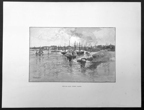
1886 Pic. Australasia Large Antique Print View of Circular Quay Sydney Australia
- Title : Circular Quay, Sydney Harbour
- Ref : 92223
- Size: 17in x 13in (430mm x 330mm)
- Date : 1886
- Condition: (A+) Fine Condition
Description:
This fine large original antique lithograph print was published in the extremely significant Australian & New Zealand publication The Picturesque Atlas of Australasia between 1886-88.
The Picturesque Atlas of Australasia was published in Sydney between 1886-88. Many of its over 700 wood-engraved illustrations were specially commissioned works by leading Australian artists. It was released in 42 separate editions usually bound into three large volumes and sold a remarkable 50,000 copies. (Ref: M&B; Tooley)
General Description:
Paper thickness and quality: - Light & stable
Paper color: - White
Age of map color: - Original
Colors used: - Pink, green, yellow, orange
General color appearance: - Authentic
Paper size: - 17in x 13in (430mm x 330mm)
Margins: - Min 1/2in (10mm)
Imperfections:
Margins: - None
Plate area: - None
Verso: - None
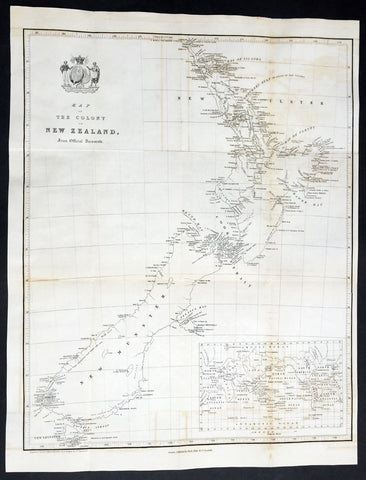
1841 The New Zealand Company Large Early Antique Map of New Zealand
- Title : Map of The Colony of New Zealand From Official Documents
- Ref #: 61016
- Size: 18in x 14in (460mm x 360mm)
- Date : 1841
- Condition: (A) Very Good Condition
Description:
This original large folding antique early map of New Zealand was printed by F P Becker in 1841 for The New Zealand Company.
A scarce early map of New Zealand, one of the earliest maps to locate Wellington.
The map is undated, but the inclusion of Wellington, which was not settled until 1839, when the New Zealand Company ship Toryreached Petone, before moving to what is today the city Wellington.
The New Zealand Company. Originated in London in 1837 as the New Zealand Association. The purpose of to promote the systematic colonization of New Zealand. The intent was to follow the colonizing principles of Edward Gibbon Wakefield, who envisioned a new-model English society in the southern hemisphere. A first attempt to gain a Royal Charter for the Association met with the objection of Colonial Office officials and the Church Missionary Society, who took issue both with the unlimited power the colony's founders would wield, and what they regarded as the inevitable conquest and extermination of the present inhabitants.
December 1837, the Association was offered a Royal Charter, but required to reorganize as a joint stock company, which it refused to do. In August 1838, the Association was dissolved and replaced with two organizations, the New Zealand Colonization Company and the New Zealand Land Company. In May 1839, these 2 entities merged with the 1825 New Zealand Company to form the New Zealand Land Company, and in December the name "New Zealand Company" was selected for the one and only company that would send emigrants to New Zealand. Once again Edward Gibbon Wakefield provided the driving impetus, although by then the offer of a charter had been withdrawn.
One of the early goals of the New Zealand Company was to buy land directly from the indigenous Maori. The Company organized an expedition to New Zealand, leaving England in May 1839. The Company was able to purchase seveal parcels of land by the end of 1839, with the help of Dicky Barnett, who had lived among the Maori since 1828. By the end of 1839, the Company claimed to have purchased 20 million acres of land in the Wellington, Neslon, Wanganui and Tranaki areas.
The purchase spree ended with the passage of the Treaty of Waitangi in February 1840, which established New Zealand as a British Crown Colony and ended the Maori right to sell their land, except to agents of the Crown. The Company would thereafter enter into an agreement with Colonial authorities to continue buying new land from the Crown and a charter to buy and sell land under supervision of the Colonial administrators.
While the Company envisioned its own autonomous region. the British Colonial officials moved quickly to quash this idea.
The first Company settlement was at Pito-one, at the mouth of the Hutt River, in January 1840, which was called Britannia. However, within two months, it was deemed unsuitable and the settlement moved southwest to Thorndon. This also proved problematic, as the area was inhabited by Maori, who were unaware of any agreement to sell their lands. Later, the Spain Land Commission would determine that the Chiefs who represented the Thorndon Maori were not consulted or paid for the land and that Barnett's translation was not adequate. In August 1840, the New South Wales legislature further interevened to challenge the titles, which resulted in a panic and flight among many of the early settlers, who abandoned their claims.
In April 1841, the Company informed the Colonial Secretary of its intention to form an even larger colony, which would become the town of Nelson, New Zealand.
The New Zealand Company later established settlements at Wellington, Nelson, Wanganui and Dunedin and also became involved in the settling of New Plymouth and Christchurch. It reached the peak of efficiency about 1841, encountered financial problems which led to its dissolution in 1858.
The company became notable for aggressive advertising campaigns and attacks on its opponents. It stridently opposed the Treaty of Waitangi and was in turn frequently criticized by the Colonial Office and New Zealand Governors for its "trickery" and lies. The company also saw itself as a prospective quasi-government of New Zealand and in 1845 and 1846 backed a failed attempt to split the colony in two, along a line from Mokau in the west to Cape Kidnappers in the east – with the north reserved for Maori and missionaries, while the south would become a self-governing province, known as "New Victoria" and managed by the company for that purpose. (Ref: M&B; Tooley)
General Description:
Paper thickness and quality: - Heavy & stable
Paper color: - Off white
Age of map color: -
Colors used: -
General color appearance: -
Paper size: - 18in x 14in (460mm x 360mm)
Plate size: - 18in x 14in (460mm x 360mm)
Margins: - Min 1/2in (12mm)
Imperfections:
Margins: - None
Plate area: - Folds as issued, light offsetting
Verso: - None
The History of Polish Cartography - Karol Buczek
- Title : The History of Polish Cartography
- Date : 1966
- Condition: (A) Very Good Condition
- Ref: Pole1
- Size: Folio
Description:
The History of Polish Cartography - A comprehensive reference tool into the antique Polish maps from the 15th to the 18th century written by Karol Buczek and translated by Andrzej Potocki - Warsaw 1966 135 pp. 57 plts. H.cloth. Slight age toning portfolio
18th Century Rare Antique Ch'onha Chido Korean Atlas w/ 13 Maps - Chŏnhado 天下圖
- Title : Ch'onha chido (Korean Atlas of the World) 天下圖
- Date : Late 18th Century
- Size: 4to - 30.5cm x 19cm (12in x 7 1/2in)
- Condition: (A+) Fine Condition
- Ref: 50402
Description:
We are incredibly excited to be able to offer this rare original antique wood-block engraved late 18th century Ch'onha chido (Atlas of the World) a traditional Korean Atlas, containing 13 maps (World, China, Korea, Japan, Ruyku Islands & 8 provincial maps)
Mostly, such an atlas contains either hand drawn manuscript maps or rarer woodcut engraved maps, such as this atlas (woodcut maps are rarer due to the lack and expense of printing presses and the relatively cheap cost of local scribes)
These atlases were issued by the Korean authorities in the 18th and 19th centuries and possibly earlier to help train each new generation of administrative officers to govern the provinces of their country, and a knowledge of the geography of their own and neighbouring countries was part of that training. They are now all considered to be extremely rare; with a few examples in private hands, the Library of Congress Asian map collections and in some national map collections around the world.
The maps of a Ch onha chido are mainly based on maps made during the Chinese Ming Dynasty (1368-1644). The 13 maps, listed below, are engraved onto fine but strong Mulberry paper with a deep heavy impression in the original black & white. The atlas measures 30.5cm x 19cm (12in x 7 1/2in) with each map page measuring 33.5cm x 30.5cm (13 1/2in x 12in).
The maps are:
1. World Map ( Chŏnhado ) 天下圖
2. China (Chunggukto) 中國圖
3. Korea (Ilbonguk) 日本國
4. Ryukyu (Yuguguk) 琉球國
5. Japan (Tongguk palto taechongdo) 東國八道大總圖
6. Kyŏnggi-do - Chungchŏng-do 京畿道
7. Chŏlla-do 忠清道
8. Kyŏngsang-do 全羅道
9. Hwanghae-do 慶尚道
10. Pyŏngan-do 黄海道
11. Kangwŏn-do 平安道
12. Hamgyŏng-do. 江原道
13. 咸鏡道.
General Definitions:
Paper thickness and quality: - Light and stable
Paper color : - off white
Age of map color: -
Colors used: -
General color appearance: -
Paper size: - 33.5cm x 30.5cm (13 1/2in x 12in). each
Plate size: - 33.5cm x 30.5cm (13 1/2in x 12in). each
Margins: - Min 1/2in (12mm)
Imperfections:
Margins: - Light soiling
Plate area: - Light soiling
Verso: - Light soiling
Background:
The design of 12 of the 13 maps, from a western perspective, are easily recognisable but when we come to the circular World Map or The Cheonhado (Map of the world beneath the heavens) the design is more reminscent of much early middle aged world map, such as the Hereford Mappa Mundi that centered on the Holy Land. This World map centers on China and Korea, with Asia and Africa included to the south and west and the rest of the world included as a separate, encompassing ring.
This form of circular world map was developed in Korea during the 17th century. It is based on the Korean term for map, jido, translated roughly as land picture.
The Cheonhado maps were made in response to the encounter with the geographical knowledge of the West, but based in content on traditional Asian sources and Asian in style. The structure of the maps consists of an internal continent with historical place names, an internal sea with place names connected to descriptions of Taoist immortality, an external continent, and an external sea. Surprisingly, the maps did not reflect the highest levels of geographic knowledge available to Koreans, but this is not likely to be intentional. Some of this was due to the nautical distance between Korea and other East Asian locales affected the mapmakers perceptions of Asia. Similarly, European mapmakers of the day often treated Korea as an island.
Some scholars have attributed the development of Korean circular world maps to Western influence, such as the maps of Matteo Ricci (Kunyu Wanguo Quantu) or the maps of Giulio Aleni (Wanguo Quantu). In this case, the central landmass can be viewed as a combination of Asia, Africa, and Europe, and the external ring continent as North America & South America and the great Southern Lands.
Such maps were produced in Korea only, and have not been found in China or Japan.
The Cheonhado remained popular in Korea until the late 19th century.
Korean Cartography
Koreans have been making and using maps for more than fifteen centuries. Since most of their country's borders were naturally determined by the sea, they had a general concept of Korea's outline at an early date, and their deep consciousness of samch olli kangsan (three thousand Ii of mountains and rivers) gave their mapmakers a general idea of what went within that outline. Underlying these imprints on the national psyche were a strong tradition of administrative and cultural geography and a nationally conceived theory of geomantic analysis. All these factors contributed to the production of interesting maps. While naturally emphasizing their own country, Korean cartographers also showed an enduring interest in the shape of their neighbours' lands and territories; and looking beyond these to the greater world, they produced several carefully studied world maps as well as more traditional cosmographies. Just as Korea's culture freely absorbed many of the features and institutions of Chinese civilization yet retained a strong individual Korean identity, so too Korea's mapmakers, applying general cartographic norms developed in China, adapted these norms to their own circumstances and created maps of both utility and beauty. That much said, by East Asian standards the 'antiquity of Korea's surviving cartographic artifacts is not great. As in other countries, time, war, and carelessness have taken a heavy toll on all written artifacts, but especially on paintings and maps. The oldest Korean map to survive today is an important world map dated 1402 (known in three copies, of which the earliest was made around 1470). But even that date is early in terms of the surviving cartographic corpus taken as a whole, which dates mostly from the sixteenth to the nineteenth century. For maps before 1402, we must rely on written records and reasonable inferences that can be based on the general trends of East Asian and Korean cultural history. An inquiry along these lines will show that whereas mapmaking before 1402 emphasized the nation and its local districts, a twelfth-century scholar had already produced a map of the world along Buddhist lines, and a fourteenth-century man had compiled a historical map of Korea and China. The description of the latter is conceived in terms very similar to those evident in the 1402 world map and provides an appropriate link from the unseen to the visible corpus. It seems convenient to organize Korean maps into four broad categories, proceeding from the more general world and national maps to the more particular regional and local ones. Although this scheme will involve a few chronological discontinuities, the existing corpus is such that most of the more interesting world maps appear relatively early, whereas the great majority of local and topical maps come from the later centuries.The category of world maps is very heterogeneous, including a few genuine maps of the world, a great variety of East Asian regional maps, and the numerous prints and copies of the quasi-cosmographical ch'onhado. Korean scholars sometimes use this term, which can be broadly translated "world maps," for this whole group, but in this chapter it will be reserved for the popular and generally recent maps, often with the terms ch'onha or ch'onhado in their titles, that present the Sinocentric world-China, Korea, and their proximate East Asian neighbours-surrounded by peripheral rings of exotic or mythical lands and peoples. The origin and development of the ch'onhado presents many problems on which scholars still have their differences, but there is no disagreement on the great vogue these maps enjoyed during the eighteenth and nineteenth centuries. They easily account for most of the world map category. Although in terms of the development of maps they are late and perhaps better explained in terms of folklore than of science, still they had a real place in Korean life and have their own absorbing story to tell. The cartographically more significant world maps and East Asian regional maps, though less numerous, have infinitely more variety than the ch'onhado, and they generally come earlier. The phrase samch'olli kangsan has long been a pan of Korean folklore. The significance of "mountains and streams" in Korean national geomantic theory is evident as early as the tenth century.
Then there were maps of Korea alone, understandably a large and varied category. The oldest cartographic depiction of the country to survive is the representation of Korea on the 1402 world map, although we have a number of written references to earlier national maps, including one interesting description of a map of Korea said to have been made in the twelfth century or earlier. During the fifteenth century there was an abundance of geographic research, but unfortunately none of the many maps known to have been produced in that period seem to have survived to modern times. However, a map completed in 1463 by Chong Ch'ok had great influence and is believed to have been taken as a model by later mapmakers, so that we have a reasonably good idea of how the peninsular outline was conceived as well as of the cartographic detail involving rivers and mountains, placenames, and other features. During the early eighteenth century the mapmaker Chong Sanggi and his family achieved a genuine revolution in cartographic technique, producing a dramatically improved understanding of the nation's borders, both the long coastlines and the much harder to grasp northern frontier. These techniques were refined and perfected by the nineteenth-century master Kim Chongho, who was both a mapmaker and a publisher and popularizer. Although he was familiar with Western mapmaking techniques and made use of geodetic coordinates in his work, the visual appearance of his late traditional maps stayed completely within the evolutionary lines of native cartographic practice. Korea's shift to the styles and methods of Western cartography occurred only toward the end of the nineteenth century, as the nation struggled to come to terms with a new Western world order led (as far as Korea was concerned) by Japan, which was much more threatening than reassuring. Provincial maps were popularized in the late fifteenth century as part of an important compendium of administrative geography, and they achieved high levels of quality in the eighteenth century, when Chong Sanggi made maps of all the provinces on a unified scale, so that they could be used as separate maps or combined to make a single national map. Reforms introduced in 1791 promoted extensive local surveys and were a key impetus both to the mapping of counties and towns and to the compilation of local histories. But whereas national and provincial maps came to achieve a certain level of standardization and cartographic professionalism, town and county maps were made by a great variety of local hands, some very skilled, others quite crude. As we shall see, the background of these country mapmakers was more in painting and drawing than in cartography, and the results are evident in hundreds of local maps that might also pass for bird's-eye-view landscapes, a style that is Cartography in Korea, Japan, and Vietnam also well documented for China. The last of the four major categories of Korean maps is the so-called defense map, or kwanbangdo in the traditional term. These range from long scrolls representing frontiers thousands of Ii long and reaching far beyond Korea to maps of local mountain fortresses. The variety is very great. Many were mounted on screens that probably stood in the offices of defense officials in Seoul or provincial governors; others were in more portable scrolls or folios that were an essential part of the equipment of frontier commanders and military officers. One very interesting variety of defense map was oriented to coastal defense and navigation. The evident purpose of maps in this category was principally to clarify terrain and communications from a military perspective, while cartographic scale, so important in the later national and provincial maps, is decidedly a lower priority. The considerable skill and painterly talent evident in these maps shows that they were mostly made and used in the central government or high military commands, where the resources for maintaining staff artists and mapmakers were readily available. (Cartography in Korea - Gari Ledyard)