Sold (332)
1774 Cook Antique Maps Tahiti, Raiatea & Huaheine Isles French Polynesia in 1769
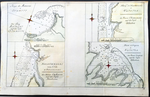
- Title : Baye de Matavai a Otahiti; Havre D Owharre dans L Isle D Huaneine: Havre D Ohamaneno a Ulietea: Havre D Oopoa a Ulietea
- Size: 14 1/2in x 10in (370mm x 255mm)
- Ref #: 32195
- Date : 1774
- Condition: (A+) Fine Condition
Description:
This fine original copper-plate engraved antique map, four maps on the one sheet;
1. Matavia Bay, Tahiti (Otaheite) - Windward Islands
2. Ohamaneno (Vaiaau) Harbour Raiatea (Ulietea) - Leeward Islands
3. Owharre (Bourayne Bay) Harbour in Huaheine - Leeward Islands
4. Oopoa (Opoa) Harbour, Raiatea (Ulietea) - Leeward Islands
all located in French Polynesia, South Pacific were complied by Capt James Cook during his first voyage of discovery in 1769, was published in the 1774 French edition of John Hawkesworths An Account of the Voyages Undertaken by the Order of His Present Majesty for Making Discoveries in the Southern Hemisphere and Successively Performed by Commodore Byron, Captain Wallis, Captain Carteret, and Captain Cook, in the Dolphin, the Swallow, and the Endeavor, Drawn Up from the Journals Which Were Kept by the Several Commanders, and from the Papers of Joseph Banks, Esq. Paris 1774
General Definitions:
Paper thickness and quality: - Heavy and stable
Paper color : - off white
Age of map color: -
Colors used: -
General color appearance: -
Paper size: - 14 1/2in x 10in (370mm x 255mm)
Plate size: - 14 1/2in x 10in (370mm x 255mm)
Margins: - Min 1/2in (12mm)
Imperfections:
Margins: - None
Plate area: - Light creasing
Verso: - None
Background:
Matavai Bay is located on the north coast of Tahiti, the largest island in the Windward group of French Polynesia.
The first European known to have visited Tahiti was Lieutenant Samuel Wallis, in Dolphin, who landed on 17 June 1767 in Matavai Bay.
Captain James Cook anchored in the bay on 13 April 1769, on a sandy spit on the northeast end of Matavai Bay - named Point Venus by Cook.
Raiatea, is the second largest of the Society Islands, after Tahiti, in French Polynesia. The island is widely regarded as the centre of the eastern islands in ancient Polynesia and it is likely that the organised migrations to Hawaii, Aotearoa and other parts of East Polynesia started at Raiātea.
Captain Cook visited Raiatea in 1769 and again in 1773-1774.
Huahine is an island located among the Society Islands, in French Polynesia, an overseas territory of France in the Pacific Ocean. It is part of the Leeward Islands group (Iles sous le Vent).
Captain Cook arrived Fare Harbour on 16 July 1769, with Tupaia navigating the HMS Endeavour. They met with leading chief Ori (Mato). Cook returned on 3 Sept. 1773 and met with Oris son Teri itaria, the new ari i rahi of the island.
John Hawkesworth 1715 – 1773
An English writer and journalist, Hawkesworth was commissioned by the British Admiralty to edit for publication the narratives of its officers’ circumnavigations. He was given full access to the journals of the commanders and the freedom to adapt and re-tell them in the first person. Cook was already on his way back from his second Pacific voyage, temporarily docked at Cape Town (South Africa), when he first saw the published volumes: he was mortified and furious to find that Hawkesworth claimed in the introduction that Cook had seen and blessed (with slight corrections) the resulting manuscript. (In his defense, Hawkesworth also had been a victim of misunderstanding.) Cook had trouble recognizing himself. Moreover, the work was full of errors and commentary introduced by Hawkesworth and, in Cook’s view, too full of Banks, who had promoted himself and the publication. Still, the work was popular; the first edition sold out in several months.
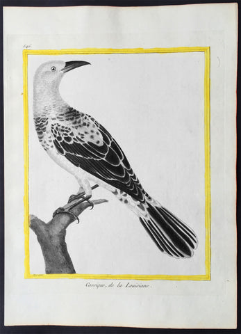
1775 Comte De Buffon Large Antique Ornithology Print North American Cacique Bird - Rare Imperial edition
- Title : Cassique, de la Louisiane
- Size: 12in x 9in (305mm x 230mm)
- Condition: (A+) Fine Condition
- Date : 1775
- Ref #: 23512
Description:
This beautifully hand coloured original copper-plate engraved antique print was published in the 1775 Imperial quatro edtion of Comte de Buffons Histoire Naturelle, générale et particulière, avec la description du Cabinet du Roi (Natural History, General and Particular, with a Description of the King\'s Cabinet)
These prints are rare produced for a limited release of Histoire Naturelle with both the engraving and hand colouring done under the supervision of the French naturalist. Edme-Louis Daubenton and engraved by the famous French engraver Francois Nicolas Martinet.
A deluxe edition of Histoire Naturelle des Oiseaux (Birds) (1771–1786) was produced by the Imprimerie royale in 10 folio and quarto volumes, with 1008 engraved by Francois Nicolas Martinet
and hand-coloured plates, executed under Buffons personal supervision by Edme-Louis Daubenton, cousin and brother-in-law of Buffons principal collaborator.
Francois Nicolas Martinet was a French engraver and draughtsman. In 1756, he was working for the court of France as Graveur du Cabinet du Roi, under the auspices of the Menus Plaisirs du Roi, making engravings after drawings by others of such subjects as the May Ball at Versailles during the Carnival of 1763. In the same period, Martinet produced illustrations for plays or comic operas by such contemporaries as Marmontel, Voltaire and Philidor. Some of these he engraved himself, while others were drawn by him but engraved by his sister Thérèse Martinet (born c. 1731). He is best known for his engravings of birds for Comte de Buffon\'s, Histoire Naturelle Des Oiseaux published in Paris from 1770-86. In 1768, a comprehensive group of natural history studies drafted by Martinet, and engraved by Robert Bénard were included in the natural history volume of Diderot and Alembert’s Encyclopédie. Martinet also drew and engraved portraits, landscapes and genre scenes.
Edme-Louis Daubenton 1730 – 1785 was a French naturalist.
Daubenton was the cousin of another French naturalist, Louis Jean-Marie Daubenton. Georges-Louis Leclerc, the Comte de Buffon engaged Edme-Louis Daubenton to supervise the coloured illustrations for the monumental Histoire Naturelle (1749–89). The Planches enluminée started to appear in 1765 and finally counted 1,008 plates, all engraved by François-Nicolas Martinet (1731–1800), and all painted by hand. The Parisian publisher Panckoucke published a version without text between 1765 and 1783. More than 80 artists took part in the realization of the original paintings. 973 plates relate to birds; others illustrate especially butterflies but also other insects, corals, etc. The illustrations were not very successful, but they allow a rather good determination of the species illustrated, some of them now extinct. As Buffon did not follow the system of biological nomenclature developed by Carl von Linné in 1783, Pieter Boddaert (1730–1796) published a table of the correspondence of the names used with their Linnean binomial names.
General Definitions:
Paper thickness and quality: - Heavy and stable
Paper color : - off white
Age of map color: - Original
Colors used: - Blue, pink, red, green, yellow
General color appearance: - Authentic
Paper size: - 12in x 9in (305mm x 230mm)
Plate size: - 10in x 8in (255mm x 205mm)
Margins: - Min 1in (25mm)
Imperfections:
Margins: - None
Plate area: - None
Verso: - None
Background:
The Histoire Naturelle, générale et particulière, avec la description du Cabinet du Roi (Natural History, General and Particular, with a Description of the Kings Cabinet) is an encyclopaedic collection of 36 large (quarto) volumes written between 1749–1804 by the Comte de Buffon, and continued in eight more volumes after his death by his colleagues, led by Bernard Germain de Lacépède. The books cover what was known of the natural sciences at the time, including what would now be called material science, physics, chemistry and technology as well as the natural history of animals.
The Histoire Naturelle, générale et particulière, avec la description du Cabinet du Roi is the work that the Comte de Buffon (1707–1788) is remembered for. He worked on it for some 50 years, initially at Montbard in his office in the Tour Saint-Louis, then in his library at Petit Fontenet. 36 volumes came out between 1749 and 1789, followed by 8 more after his death, thanks to Bernard Germain de Lacépède. It includes all the knowledge available in his time on the natural sciences, a broad term that includes disciplines which today would be called material science, physics, chemistry and technology. Buffon notes the morphological similarities between men and apes, although he considered apes completely devoid of the ability to think, differentiating them sharply from human beings. Buffons attention to internal anatomy made him an early comparative anatomist. Lintérieur, dans les êtres vivants, est le fond du dessin de la nature, he wrote in his Quadrupèdes, the interior, in living things, is the foundation of natures design.
The Histoire Naturelle, which was meant to address the whole of natural history, actually covers only minerals, birds, and the quadrupeds among animals. It is accompanied by some discourses and a theory of the earth by way of introduction, and by supplements including an elegantly written account of the epochs of nature.
The Suppléments cover a wide range of topics; for example, in (Suppléments IV), there is a Discours sur le style (Discourse on Style) and an Essai darithmétique morale (essay on Moral Arithmetic).
Louis Jean-Marie Daubenton assisted Buffon on the quadrupeds; Philippe Guéneau de Montbeillard worked on the birds. They were joined, from 1767, by Barthélemy Faujas de Saint-Fond, the abbot Gabriel Bexon and Charles-Nicolas-Sigisbert Sonnini de Manoncourt. The whole descriptive and anatomical part of lHistoire des Quadrupèdes was the work of Daubenton and Jean-Claude Mertrud.
Buffon attached much importance to the illustrations; Jacques de Sève illustrated the quadrupeds and François-Nicolas Martinet illustrated the birds. Nearly 2000 plates adorn the work, representing animals with care given both to aesthetics and anatomical accuracy, with dreamlike and mythological settings.
On minerals, Buffon collaborated with André Thouin. Barthélemy Faujas de Saint-Fond and Louis Bernard Guyton de Morveau provided sources for the mineral volumes.
L Histoire Naturelle met immense success, almost as great as Encyclopédie by Diderot, which came out in the same period. The first three volumes of LHistoire Naturelle, générale et particulière, avec la description du cabinet du Roi were reprinted three times in six weeks.
The encyclopaedia appeared in 36 volumes :
3 volumes in 1749 : De la manière détudier lhistoire naturelle followed by Théorie de la Terre, Histoire Générale des animaux and Histoire Naturelle de lhomme
12 volumes on quadrupeds (1753 to 1767)
9 volumes on birds (1770 to 1783])
5 volumes on minerals (1783 to 1788), the last including Traité de laimant, the last work published by Buffon in his lifetime
7 volumes of supplements (1774 to 1789), including Époques de la nature (from 1778).
LHistoire Naturelle was initially printed at the Imprimerie royale in 36 volumes (1749–1789). In 1764 Buffon bought back the rights to his work. It was continued by Bernard Germain de Lacépède, who described the egg-laying quadrupeds, snakes, fishes and cetaceans in 8 volumes (1788–1804).
Buffon was assisted in the work by Jacques-François Artur (1708–1779), Gabriel Léopold Charles Amé Bexon (1748–1785), Louis Jean-Marie Daubenton (1716–1799), Edme-Louis Daubenton (1732–1786), Jacques de Sève (actif 1742–1788), Barthélemy Faujas de Saint-Fond (1741–1819), Philippe Guéneau de Montbeillard (1720–1785), Louis-Bernard Guyton-Morveau (1737–1816), Bernard Germain de Lacépède (1756–1825), François-Nicolas Martinet (1731–1800), the anatomist Jean-Claude Mertrud (1728–1802), Charles-Nicolas-Sigisbert Sonnini de Manoncourt (1751–1812), and André Thouin (1747–1823).
Each group is introduced with a general essay. This is followed by an article, sometimes of many pages, on each animal (or other item). The article on the wolf begins with the claim that it is one of the animals with a specially strong appetite for flesh; it asserts that the animal is naturally coarse and cowardly (grossier et poltron), but becoming crafty at need, and hardy by necessity, driven by hunger.[4] The language, as in this instance, is elegant and elaborate, even flowery and ornate.[5] Buffon was roundly criticised by his fellow academics for writing a purely popularizing work, empty and puffed up, with little real scientific value.
The species is named in Greek, Latin, Italian, Spanish, German, English, Swedish, and Polish. The zoological descriptions of the species by Gessner, Ray, Linnaeus, Klein and Buffon himself (Canis ex griseo flavescens. Lupus vulgaris. Buffon. Reg. animal. pag. 235) are cited.
The text is written as a continuous essay, without the sections on identification, distribution and behaviour that might have been expected from other natural histories. Parts concern human responses rather than the animal itself, as for example that the wolf likes human flesh, and the strongest wolves sometimes eat nothing else.[6] Measurements may be included; in the case of the wolf, 41 separate measurements are tabulated, in pre-revolutionary French feet and inches[a] starting with the Length of the whole body measured in a straight line from the end of the muzzle to the anus........3 feet. 7 inches. (1.2 m); the Length of the largest claws is given as 10 lines (2.2 cm).
The wolf is illustrated standing in farmland, and as a complete skeleton standing on a stone plinth in a landscape. The account of the species occupies 32 pages including illustrations.
The original edition of the Histoire Naturelle by Buffon comprised 36 volumes in quarto, divided into the following series: Histoire de la Terre et de lHomme, Quadrupèdes, Oiseaux, Minéraux, Suppléments. Buffon edited 35 volumes in his lifetime. Soon after his death, the fifth and final volume of lHistoire des minéraux appeared in 1788 at the Imprimerie des Bâtiments du Roi. The seventh and final volume of Suppléments by Buffon was published posthumously in 1789 through Lacépèdes hands. Lacépède continued the part of the Histoire Naturelle which dealt with animals. A few months before Buffons death, en 1788, Lacépède published, as a continuation, the first volume of his Histoire des Reptiles, on egg-laying quadrupeds. The next year, he wrote a second volume on snakes, published during the French Revolution. Between 1798 and 1803, he brought out the volume Histoire des Poissons. Lacépède made use of the notes and collections left by Philibert Commerson (1727–1773). He wrote Histoire des Cétacés which was printed in 1804. At that point, the Histoire Naturelle, by Buffon and Lacépède, thus contained 44 quarto volumes forming the definitive edition.
Another edition in quarto format was printed by the Imprimerie royale in 36 volumes (1774–1804). It consisted of 28 volumes par Buffon, and 8 volumes by Lacépède. The part containing anatomical articles by Louis Jean-Marie Daubenton was dropped. The supplements were merged into the relevant articles in the main volumes.
The Imprimerie royale also published two editions of the Histoire Naturelle in duodecimo format (1752–1805), occupying 90 or 71 volumes, depending on whether or not they included the part on anatomy. In this print format, the original work by Buffon occupied 73 volumes with the part on anatomy, or 54 volumes without the part on anatomy. The continuation by Lacépède took up 17 duodecimo volumes.
A de luxe edition of Histoire Naturelle des Oiseaux (Birds) (1771–1786) was produced by the Imprimerie royale in 10 folio and quarto volumes, with 1008 engraved and hand-coloured plates, executed under Buffons personal supervision by Edme-Louis Daubenton, cousin and brother-in-law of Buffons principal collaborator.
The original edition was arranged as follows:
Natural history, and description of the kings cabinet of curiosities
Volume I : Premier Discours - De la manière détudier et de traiter lhistoire naturelle, Second Discours - Histoire et théorie de la Terre, Preuves de la théorie de la Terre, 1749
Volume II : Histoire générale des Animaux, Histoire Naturelle de lHomme, 1749
Volume III : Description du cabinet du Roi, Histoire Naturelle de lHomme, 1749
Quadrupèdes (Quadrupeds)
Volume IV (Quadrupèdes I) : Discours sur la nature des Animaux, Les Animaux domestiques, 1753
Volume V (Quadrupèdes II) : 1755
Volume VI (Quadrupèdes III) : Les Animaux sauvages, 1756
Volume VII (Quadrupèdes IV) : Les Animaux carnassiers, 1758
Volume VIII (Quadrupèdes V) : 1760
Volume IX (Quadrupèdes VI) : 1761
Volume X (Quadrupèdes VII) : 1763
Volume XI (Quadrupèdes VIII) : 1764
Volume XII (Quadrupèdes IX) : 1764
Volume XIII (Quadrupèdes X) : 1765
Volume XIV (Quadrupèdes XI) : Nomenclature des Singes, De la dégénération des Animaux, 1766
Volume XV (Quadrupèdes XII) : 1767
Histoire Naturelle des Oiseaux (Birds) (1770–1783)
Volume XVI (Oiseaux I) : 1770
Volume XVII (Oiseaux II) : 1771
Volume XVIII (Oiseaux III) : 1774
Volume XIX (Oiseaux IV) : 1778
Volume XX (Oiseaux V) : 1778
Volume XXI (Oiseaux VI) : 1779
Volume XXII (Oiseaux VII) : 1780
Volume XXIII (Oiseaux VIII) : 1781
Volume XXIV (Oiseaux IX) : 1783
Histoire Naturelle des Minéraux (Minerals) (1783–1788)
Volume XXV (Minéraux I) : 1783
Volume XXVI (Minéraux II) : 1783
Volume XXVII (Minéraux III) : 1785
Volume XXVIII (Minéraux IV) : 1786
Volume XXIX (Minéraux V) : Traité de lAimant et de ses usages, 1788
Suppléments à lHistoire Naturelle, générale et particulière (Supplements) (1774–1789)
Volume XXX (Suppléments I) : Servant de suite à la Théorie de la Terre, et dintroduction à lHistoire des Minéraux, 1774
Volume XXXI (Suppléments II) : Servant de suite à la Théorie de la Terre, et de préliminaire à lHistoire des Végétaux - Parties Expérimentale & Hypothétique, 1775
Volume XXXII (Suppléments III) : Servant de suite à lHistoire des Animaux quadrupèdes, 1776
Volume XXXIII (Suppléments IV) : Servant de suite à lHistoire Naturelle de lHomme, 1777
Volume XXXIV (Suppléments V) : Des Époques de la nature, 1779
Volume XXXV (Suppléments VI) : Servant de suite à lHistoire des Animaux quadrupèdes, 1782
Volume XXXVI (Suppléments VII) : Servant de suite à lHistoire des Animaux quadrupèdes, 1789
Histoire Naturelle des Quadrupèdes ovipares et des Serpents (Egg-laying Quadrupeds and Snakes) (1788–1789)
The Gecko, 1788
Volume XXXVII (Reptiles I) : Histoire générale et particulière des Quadrupèdes ovipares, 1788
Volume XXXVIII (Reptiles II) : Histoire des Serpents, 1789
Histoire Naturelle des Poissons (Fish) (1798–1803)
Volume XXXIX (Poissons I) : 1798
Volume XXXX (Poissons II) : 1800
Volume XXXXI (Poissons III) : 1802
Volume XXXXII (Poissons IV) : 1802
Volume XXXXIII (Poissons V) : 1803
Histoire Naturelle des Cétacés (Cetaceans) (1804)
Volume XXXXIV (Cétacés) : 1804
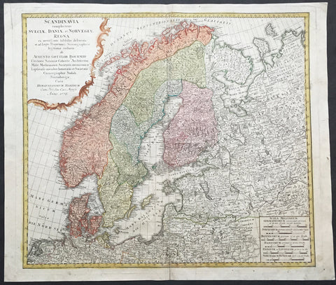
1776 Homann Old, Antique Map of Scandinavia, Norway, Sweden, Finland, Estonia, Latvia
- Title : Scandinavia complectens Sueciae, Daniae & Norvegiae Regna ex Tabulis Ioh. Bapt. Homanno.
- Ref #: 81076
- Size: 24in x 21in (610mm x 535mm)
- Date : 1776
- Condition: (A+) Fine Condition
Description:
This large beautifully hand coloured original antique map of Scandinavia - including Denmark, Livonia & Lapland - was engraved in 1776 - the date is engraved in the title - and was published by the Homann firm, Germany.
Before the fifteenth century the peoples of Southern Europe had little geographical knowledge of the Scandinavian world except from sketchy detail shown in the Catalan Atlas (1375) and on a number of 'portolani' embracing Denmark and the southern tip of Norway. It was not until 1427 that a manuscript map prepared about that time by Claudius Clavus (b. 1388), a Dane who had spent some time in Rome, made available to scholars a tolerable outline of the northern countries and Greenland. That was to remain the best map available for the rest of the century and it was used as the basis for maps of Scandinavia in early printed editions of Ptolemy. Others by Nicolaus Cusanus (1491) and Ehrhard Etzlaub (c. 1492) followed but, needless to say, these are extremely rare; even the later maps by Olaus Magnus and Marcus Jordan, where they have survived at all, are known only by very few examples. In fact, apart from the rare appearance of an early Ptolemy map, the oldest of Scandinavia which a collector is likely to find are those in Munster's Cosmographypublished in 1544 with many later editions. In the following centuries the comparatively few maps and charts compiled in Scandinavia were usually published in Amsterdam, Antwerp, Paris or Nuremberg, the more important maps often being incorporated in the major Dutch, French and German atlases.(Ref: Tooley; M&B)
General Description:
Paper thickness and quality: - Heavy and stable
Paper color: - off white
Age of map color: - Original
Colors used: - Yellow, green, blue, pink
General color appearance: - Authentic
Paper size: - 24in x 21in (610mm x 535mm)
Plate size: - 22 1/2in x 19 1/2in (570mm x 495mm)
Margins: - Min 1in (25mm)
Imperfections:
Margins: - Light soiling in margins
Plate area: - Repair to "A" in top "SeptentrionAlis"
Verso: - Top & bottom centerfold re-joined
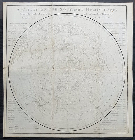
1777 Capt James Cook Antique Map of the Southern Hemisphere, 1st Ed - Australia
- Title : A Chart of the Southern Hemisphere shewing the Tracks of some of the most distinguished Navigators by Captain James Cook of His Majestys Navy
- Ref : 61111
- Size: 23 1/2in x 22 1/2in (605mm x 575mm)
- Date : 1777
- Condition: (A) Very Good Condition
Description:
This fine original 1st edition, copper-plate engraved, antique map, a chart of the Southern Hemisphere, was engraved by William Whitchurch in 1776 - dated - and is dedicated to the discoveries in the South Seas and Antarctic Regions of Captain James Cook during his second Voyage of Discovery between 1772 & 1775. By comparison the tracks of 11 other explorers are included, from the 16th to the 18th centuries. The map by Captain James Cook was published in the 1777 edition of A voyage towards the South Pole, and round the World. Performed in His Majestys ships the Resolution and Adventure, in the years 1772, 1773, 1774, and 1775.published by William Strahan, New Street, Shoe Lane, & Thos. Cadell, in the Strand, London 1777.
This map is unique in another way, was used by Nathaniel Dance in his 1776 portrait of Captain James Cook. Please also see below for more information & above for the portrait.
The 11 other explorers and their tracks around the Southern Hemisphere are;
1. Mendana in 1595
2. Quiros in 1606
3. Le Maire & Schouten in 1616
4. Tasman in 1642
5. Halley in 1700
6. Roggewein in 1722
7. Bouvet in 1738-39
8. Byron in 1765
9. Wallis in 1767
10. Bougainville in 1768
11. Surville in 1769
12. Cooks first and second voyages.
General Definitions:
Paper thickness and quality: - Heavy and stable
Paper color : - off white
Age of map color: -
Colors used: -
General color appearance: -
Paper size: - 23 1/2in x 22 1/2in (605mm x 575mm)
Plate size: - 23in x 21 1/2in (585mm x 545mm)
Margins: - Min 1/2in (12mm)
Imperfections:
Margins: - Repair as noted in plate Plate area
Plate area: - 9in repair to the left of the image from NZ to margin, no loss. Folds as issued
Verso: - Repair as noted in plate Plate area
Background:
This map by James Cook, was published as the premier map of his second voyage to the Southern Hemisphere, dispelling forever the myth of the Great Southern Land and showing the true cartographic nature of the southern hemisphere dominated by Australia & New Zealand. The map on a South Polar Projection also shows South America, the South Atlantic Ocean, South Africa, Madagascar, Australia - with Tasmania still joined to the mainland - New Zealand and the southern Pacific Ocean with islands.
Engraved within the explorer\'s tracks are the dates of their voyages and ships tracks are particularly noted around the Antarctic Circle with notations of ice fields seen during the voyages.
Nathaniel Dance Portrait of Cook, 1776
A three-quarter-length portrait of Captain Cook, seated to the left, facing the right. He is wearing captain\'s full-dress uniform, 1774-87, consisting of a navy blue jacket, white waistcoat with gold braid and gold buttons and white breeches. He wears a grey wig or his own hair powdered. He holds his own chart of the Southern Ocean on the table and his right hand points to the east coast of Australia on it. His left thumb and finger lightly hold the other edge of the chart over his knee. His hat sits on the table behind him to the left on top of a substantial book, perhaps his journal, itself resting on the chart. In 1772, Cook sailed for the second time to the fringes of the Antarctic and the Pacific, returning in 1775. He sat for this portrait, commissioned by Sir Joseph Banks, \'for a few hours before dinner\' on 25 May 1776 but it is not known whether he did so again before he left London on 24 June for his third voyage, never to return. None the less, David Samwell, surgeon\'s mate in \'Resolution\' on the second voyage and surgeon of \'Discovery\' on the third, thought it \'a most excellent likeness ... and ... the only one I have seen that bears any resemblance to him\'. This view was based on John Sherwin\'s later engraving of the portrait, which probably argues even more favourably for the original despite an element of idealization, not least omission of a large burn scar (from 1764) on the right hand. Banks had sailed with Cook on his first voyage in the \'Endeavour\' and took an influential interest in his subsequent ones. This portrait hung over the fireplace in the library of his London house. After his death, it was presented to the Naval Gallery at Greenwich Hospital by his executor, Sir Edward Knatchbull, following a request by E.H. Locker, the Hospital Secretary. In 1781-83 Charles Grignion, then in Rome, painted a \'Death of Captain Cook\' which was sold in 1821 after the British Museum declined it as a bequest from his brother Thomas, a well-known watchmaker. That picture subsequently disappeared but Thomas\'s will says the likeness of Cook was based on the present portrait. Dance worked with Pompeo Batoni in Rome and on his return to London in 1765 achieved success as a portrait and history painter. In 1768, he joined a group of artists who successfully petitioned George III to establish the Royal Academy in that year.

1777 Gents Magazine Antique Map of Capt. Cooks 2nd Voyage New Zealand & Vanuatu
- Title : Part of the Tropical Discoveries of the Resoluation Sloop Captain J Cook in 1774
- Size: 9in x 5 1/4in (230mm x 135mm)
- Ref #: 32178
- Date : 1777
- Condition: (A) Very Good Condition
Description:
This finely engraved original antique map of illustrating the route of discovery taken in part of the South Pacific bewteen New Zealand, New Caledonia & The Vanuatu Islands during Captain James Cooks 2nd Voyage of Discovery in 1774 was published in the 1777 edition of The Gentlemens Magazine.
General Definitions:
Paper thickness and quality: - Heavy and stable
Paper color : - off white
Age of map color: -
Colors used: -
General color appearance: -
Paper size: - 9in x 5 1/4in (230mm x 135mm)
Plate size: - 9in x 5 1/4in (230mm x 135mm)
Margins: - Min 1/4in (0mm)
Imperfections:
Margins: - Top right corner cropped into border
Plate area: - None
Verso: - None
Background:
The second voyage of James Cook 1772–1775, commissioned by the British government with advice from the Royal Society, was designed to circumnavigate the globe as far south as possible to finally determine whether there was any great southern landmass, or Terra Australis. On his first voyage, Cook had demonstrated by circumnavigating New Zealand that it was not attached to a larger landmass to the south, and he charted almost the entire eastern coastline of Australia, yet Terra Australis was believed to lie further south. Alexander Dalrymple and others of the Royal Society still believed that this massive southern continent should exist. After a delay brought about by the botanist Joseph Banks\' unreasonable demands, the ships Resolution and Adventure were fitted for the voyage and set sail for the Antarctic in July 1772.
On 17 January 1773, Resolution was the first ship to cross the Antarctic Circle which she crossed twice more on the voyage. The third crossing, on 3 February 1774, was to be the most southerly penetration, reaching latitude 71°10′ South at longitude 106°54′ West. Cook undertook a series of vast sweeps across the Pacific, finally proving there was no Terra Australis by sailing over most of its predicted locations.
In the course of the voyage he visited Easter Island, the Marquesas, Tahiti, the Society Islands, Niue, the Tonga Islands, the New Hebrides, New Caledonia, Norfolk Island, Palmerston Island, South Sandwich Islands, and South Georgia, many of which he named in the process. Cook proved the Terra Australis Incognita to be a myth and predicted that an Antarctic land would be found beyond the ice barrier.
On this voyage the Larcum Kendall K1 chronometer was successfully employed by William Wales to calculate longitude. Wales compiled a log book of the voyage, recording locations and conditions, the use and testing of various instruments, as well as making many observations of the people and places encountered on the voyage

1777 Middleton Antique Print Niuatoputapu & Tafahi Islands of Tonga - Schouten Le Maire 1616
- Title : A Perspective View of Cocos and Traitors Islands discovered in the Voyages to the South Seas
- Size: 14in x 9in (355mm x 230mm)
- Ref #: 21741
- Date : 1787
- Condition: (A+) Fine Condition
Description:
This fine original cooper-plate engraved antique print of the attack on Willem Schouten and Jacob Le Maire in their ship the Eendracht by the inhabitants of the islands of Tafahi and Niuatoputapu, two islands of the kingdom of Tonga was published in Charles Theodore Middletons 1777 edition of A New and Complete System of Geography..... published by James Cooke London, 1777.
General Definitions:
Paper thickness and quality: - Heavy and stable
Paper color : - off white
Age of map color: -
Colors used: -
General color appearance: -
Paper size: - 14in x 9in (355mm x 230mm)
Plate size: - 11in x 7in (280mm x 180mm)
Margins: - Min 1/2in (12mm)
Imperfections:
Margins: - None
Plate area: - None
Verso: - None
Background:
Niuatoputapu is a high island in the island nation of Tonga, Pacific Ocean, its highest point being at 157 m. Its name means sacred island. Older European names for the island are Traitors island or Keppel island.
Niuatoputapu was put on the European maps by Willem Schouten and Jacob Le Maire during their famous circumnavigation of the globe in their ship the Eendracht (Unity) in 1616. After successful bartering with the inhabitants of Tafahi, but not finding a suitable anchorage there, they proceeded to its bigger southern neighbour. There their reception was less peaceful. Natives boarded their ship and attacked the Dutch with clubs, until they found out what muskets were and could do. After that an uneasy truce existed, enabling the barter of more coconuts, ubes roots (probably ʻufi (yam)), hogs and water. A \'king\' of the island came along, but not on board. \"He was equally naked with all the rest\", only distinguishable by the respect the islanders paid to him. The next day the Dutch felt that something was in the air, and indeed when the king came along again he suddenly ordered his people into an attack. There were about 700 to 800 of them in 23 double canoes and 45 single canoes. But the Dutch fired their muskets and 3 cannons, and the islanders then quickly made themselves scarce. Schouten and LeMaire continued their westwards trip, leaving Verraders (Traitors) island behind.
Tafahi is a small island in the north of the Tonga archipelago, in fact closer to Savaii (Sāmoa) than the main islands of Tonga.
Tafahi was put on the European maps by Willem Schouten and Jacob Le Maire during their famous circumnavigation of the globe in 1616. They were it who gave it the name Cocos Eylant because of the abundancy of coconut palms. A multitude of natives in their outrigger canoes came to see their visitors. As the explorers describe in their journal, the natives were peaceful, willing to come on board, leaving barely any space for the Dutch themselves, and they traded large quantities of coconuts and ubes roots (probably ʻufi (yam)) for iron nails and strings of beads. But as the island did not offer a suitable place to anchor, the ship the Eendracht (Unity) proceeded next to Niuatoputapu.
It is speculated by Swiss Walter Hurni and described by the Swiss author Alex Capus, that Robert Louis Stevenson, the author of Treasure Island, found the Treasure of Lima around 1890 on this island while living on the nearby island of Upolu and which made him and his family very rich
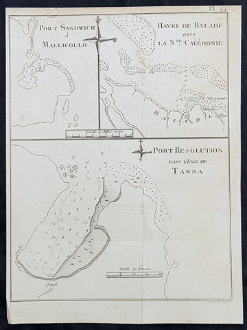
1778 Capt. Cook Antique Maps of Maleku, Tanna Vanuatu & New Caledonia, Cook 1774
- Title : Port Sandwich A Mallicollo; Havre de Balade dans L Nle. Caledonie; Port Resolution dans L Isle de Tanna
- Size: 11in x 8 1/2in (280mm x 215mm)
- Ref #: 32168
- Date : 1778
- Condition: (A+) Fine Condition
Description:
This fine original copper-plate engraved antique map of three maps on the one sheet, the first of Port Sandwich, Malakula Island, Vanuatu. The second is the Bay of Balade, in the city of Pouebo, north-east of New Caledonia and the third of Port Resolution on the Island of Tanna, Vanuatu all visited and mapped by Captain James Cook in 1774, in HMS Resolution & Adventure, during his 2nd Voyage of Discovery to the South Seas. They were engraved by Robert Benard - after Thomas Bowen - and was published in the 1778 French edition of Capt. James Cooks 2nd Voyage of Discovery to the South Seas A voyage towards the South Pole, and round the World. Performed in His Majestys ships the Resolution and Adventure, in the years 1772, 1773, 1774, and 1775..... Paris : Hotel de Thou ......1778.
Cooks Journal (1774)......
Jul. 2 Sat. Sights Vatoa (Fiji Group). Only sighting made of the Fiji Group.
3 Sun. Sights small island, puts boat ashore. No anchorage. Names it Turtle Island.
4 Mon. Off Vuata Vatoa Reef. Sends boat for turtles. None found.
17 Sun. Approaching New Hebrides - Bougainville’s “Great Cyclades”. Sights Aurora Island (Bougainville, 1768) (Maewo).
18 Mon. Rounds north of Maewo in gale.
19 Tue. Off Isle of Lepers (Omba). Passes between Maewo and Omba in gale.
20 Wed. Finds no anchorage at Maewo, crosses Patteson Passage towards Pentecost Isle (Raga).
21 Thu. Passes to west of Pentecost and sights Ambrim, Paama and Epi.
22 Fri. Approaches Mallicollo (Malekula). Anchors in Port Sandwich (Sasun Say). Visited by canoes. Shot at with arrows. Lands, faced by “4 or 500 men arm’d with Bows and Arrows, Clubs and Spears”. Peace made, gifts exchanged.
23 Sat. Goes ashore. Visits house. Walks around harbour, returns to ship and sails.
24 Sun. Passes Maskelyne Islands, off Epi and Mai.
25 Mon. Towards Shepherd Isles, off Makura. Mataso, Monument Rock (Wot).
26 Tue. Off Hinchinbrook (Nguna), Montagu (Emau) and Sandwich (Efate) Islands. Heads SE.
27 Wed. Sights Eromanga.
29 Fri. Off Eromanga.
30 Sat. Sights Tana/Tanna (Ipari).
Aug. 1 Mon. Off north tip of Eromanga.
2 Tue. Sails part way down west coast and returns.
3 Wed. Sails down east coast. Puts out boat for anchorage.
4 Thu. Anchors at Traitors’ Head (Polenia Bay). Goes ashore. Gifts. Fired at with arrows, shot fired back, returns to ship, sails. Passes Cook Bay.
5 Fri. Heads for Tanna, sights volcanoes, sends boat for anchorage and anchors at Port Resolution. Sights Erronan (Futuna).
6 Sat. Goes ashore, threatened, makes friends with Paowang and visits his house over next few days.
7 Sun. Volcano erupts-Mt. Yasur. Begins to provision ship, obtain wood.
16 Tue. Walks to other side of island, sights Annatom (Aneityum).
19 Fri. Native is shot by marine, William Wedgeborough, later punished.
20 Sat. Sails, heads east towards Erronan (Futuna).
21 Sun. Off Immer (Aniwa).
22 Mon. Heads back around S. tip of Tanna.
23 Tue. Off W. coast of Sandwich Isle (Efate), heading NW towards and passing Malekula, Rock Point.
24 Wed. Through Bougainville Passage, past St. Bartholomew Isle (Malo), sails up E. coast of Espiritu Santo, sights Cape Quiros and Sakau Island.
25 Thu. Into Bay of St. Philip and St. James (Quiros, 1606) and Port of Vera Cruz.
See an extract of Cook\'s Journal for this period.
26 Fri. Tacks into Bay.
27 Sat. Standing off, sends Gilbert and Cooper ashore in boat, they land near river (= Quiros’ R. Jordan). Rounds Cape Cumberland.
29 Mon. Heads down west coast of Espiritu Santo, tacking to and fro.
31 Wed. Off Cape Lisburne - heads SW.
Sep. 4 Sun. Sights Cape Colnett (New Caledonia).
5 Mon. Enters reef (Amoss Passage) between Cook Reef and Balade Reef, anchors off Observatory Isle (Pudiu), visited by inhabitants.
5 Tue. Goes ashore with armed boats, rows along coast, returns to ship. Visited by natives, meets Chief, Teeabooma. Wales and Pickersgill land on Isle, Cook goes to help. Observatory set up for eclipse of Sun.
7 Wed. Eclipse, cloudy at first, observations made. Returns to ship, goes ashore again and returns. Simon Monk, ship’s butcher, dies after fall down fore-hatchway previous night.
8 Thu. Goes ashore. Excursion to west. The Forsters and Cook are ill with eating poisoned fish, liver and roe (Toadfish).
9 Fri. Exchanges presents with Teeabooma but still indisposed.
10 Sat. Forster ashore botanising.
12 Mon. Cutter is damaged when Gilbert and Pickersgill are returning from a visit to the north-west of island. Repairs made.
13 Tue. Takes possession of island in name of King George III, naming it New Caledonia. Sails back through reef and heads NW. along coast, outside Cook Reef, passes Great False Passage.
General Definitions:
Paper thickness and quality: - Heavy and stable
Paper color : - off white
Age of map color: -
Colors used: -
General color appearance: -
Paper size: - 11in x 8 1/2in (280mm x 215mm)
Plate size: - 11in x 8 1/2in (280mm x 215mm)
Margins: - Min 1/2in (12mm)
Imperfections:
Margins: - Small repair to top margin
Plate area: - Folds as issued
Verso: - None
Background:
Port Sandwich in Mallicollo
Cook had reached Mallicolo (Maleku) 17 July 1774 and made a careful survey of the islands which was completed 1 September 1774, he named the islands the New Hebrides (Vanuatu).
Harbour of Balade in New Caledonia
Cook discovered the island group of New Caledonia, on 4 September 1774, which he named New Caledonia. The Resolution remained in New Caledonia 5 to 13 September, 1774. Balade was in the north of the island.
Port Resolution in the Isle of Tanna
Cook had reached, Vanuatu (New Hebrides) 17 July 1774 and made a careful survey of the islands which was completed 1 September 1774. Naming the islands the New Hebrides (Vanuatu). In August Cook visited Tanna, an island in Tafea Province, and landed in an inlet on the south eastern tip of the island that he named Port Resolution.
Thomas Bowen (1767-1790) was an engraver and son of Emanuel Bowen, map and print seller, engraver to George II and to Louis XV of France who worked in London from 1714 producing some the best and most attractive maps of the 18th century. He had plans for completing a major County Atlas but, finding the task beyond his means, joined with Thomas Kitchin to publish The Large English Atlas. Many of the maps were issued individually from 1749 onwards and the whole atlas was not finally completed until 1760. With one or two exceptions they were the largest maps of the counties to appear up to that time (27 x 20) and were unusual in that blank areas around each map are filled with historical and topographical detail which makes fascinating and amusing reading. The atlas was reissued later in reduced size. Apart from his county maps and atlases of different parts of the world he also issued (with John Owen) a book of road maps based, as was usual at that time, on Ogilby but again incorporating his own style of historical and heraldic detail. Thomas helped his father during his lifetime and produced many fine maps in his own right after his fathers death.
William Hodges RA 1744 – 1797 was an English painter. He was a member of James Cooks second voyage to the Pacific Ocean, and is best known for the sketches and paintings of locations he visited on that voyage, including Table Bay, Tahiti, Easter Island, and the Antarctic.
Between 1772 and 1775 Hodges accompanied James Cook to the Pacific as the expeditions artist. Many of his sketches and wash paintings were adapted as engravings in the original published edition of Cooks journals from the voyage.
Most of the large-scale landscape oil paintings from his Pacific travels for which Hodges is best known were finished after his return to London; he received a salary from the Admiralty for the purposes of completing them. These paintings depicted a stronger light and shadow than had been usual in European landscape tradition. Contemporary art critics complained that his use of light and colour contrasts gave his paintings a rough and unfinished appearance.
Hodges also produced many valuable portrait sketches of Pacific islanders and scenes from the voyage involving members of the expedition..
Robert Bénard 1734 – 1777 was an 18th-century French engraver.
Specialized in the technique of engraving, Robert Ménard is mainly famous for having supplied a significant amount of plates (at least 1,800) to the Encyclopédie by Diderot & d\'Alembert from 1751.
Later, publisher Charles-Joseph Panckoucke reused many of his productions to illustrate the works of his catalog.
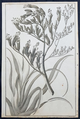
1778 Capt Cook Antique Print New Zealand Flax Plant, near Christchurch in 1773
- Title : Plante de Lin de la Nouvelle Zelande (New Zealand flax plant)
- Ref : 31804
- Size: 14 1/2in x 9 1/2in (365mm x 240mm)
- Date : 1778
- Condition: (A) Very Good Condition
Description:
This fine original copper-plate engraved antique print of New Zealand Flax (Phormium tenax) drawn during Captain James Cooks 2nd Voyage of Discovery in 1773, was engraved by Robert Benard - after William Hodges - and was published in the 1778 French edition of Capt. James Cooks 2nd Voyage of Discovery to the South Seas A voyage towards the South Pole, and round the World. Performed in His Majestys ships the Resolution and Adventure, in the years 1772, 1773, 1774, and 1775..... Paris : Hotel de Thou ......1778.
Phormium tenax was first discovered on Captain Cooks second expedition to the South Pacific in 1773. It was collected by Johann & son George Forster and described in 1776. It was probably one of the first plants noted upon landing, possibly on black sand beaches north of Christchurch. The toughness of this plant is evidenced by the variety of its habitats, from beaches, river mouths, on coastal cliffs with salt sea spray, to alpine lakes; a plant is ubiquitous throughout the New Zealand landscape.
On 8 February 1773 HMS Resolution and Adventure became separated in the Antarctic fog. Captain Furneaux directed HMS Adventure towards the prearranged meeting point of Queen Charlotte Sound (New Zealand), charted by Cook in 1770. On the way to the rendezvous, Adventure surveyed the southern and eastern coasts of Tasmania (then known as Van Diemen\'s Land), where Adventure Bay was named for the ship. Furneaux made the earliest British chart of this shore, but as he did not enter Bass Strait he assumed Tasmania to be part of Australia. Adventure arrived at Queen Charlotte Sound on 7 May 1773. Cook continued his explorations south-eastwards, reaching 61°21′s on 24 February then, in mid-March he decided to head for Dusky Bay (now Dusky Sound) in the South Island of New Zealand where the ship rested until 30 April. The Resolution reached the rendezvous at Queen Charlotte Sound on 17 May. From June to October the two ships explored the southern Pacific, reaching Tahiti on 15 August, where Omai of Raiatea embarked on Adventure (Omai later became the first Pacific Islander to visit Europe before returning to Tahiti with Cook in 1776)
General Definitions:
Paper thickness and quality: - Heavy and stable
Paper color : - off white
Age of map color: -
Colors used: -
General color appearance: -
Paper size: - 14 1/2in x 9 1/2in (365mm x 240mm)
Plate size: - 14 1/2in x 9 1/2in (365mm x 240mm)
Margins: - Min 1/2in (12mm)
Imperfections:
Margins: - Light soiling in margins
Plate area: - None
Verso: - None
Background:
New Zealand, Aotearoa is an island country in the southwestern Pacific Ocean. The country geographically comprises two main landmasses—the North Island (or Te Ika-a-Māui), and the South Island (or Te Waipounamu)—and around 600 smaller islands. New Zealand is situated some 1,500 kilometres east of Australia across the Tasman Sea and roughly 1,000 kilometres south of the Pacific island areas of New Caledonia, Fiji, and Tonga.
The first Europeans known to have reached New Zealand were Dutch explorer Abel Tasman and his crew in 1642. In a hostile encounter, four crew members were killed and at least one Māori was hit by canister shot. Europeans did not revisit New Zealand until 1769 when British explorer James Cook mapped almost the entire coastline. Cook revisited New Zealand on voyages 2&3, in 1773 & 1777.
William Hodges RA 1744 – 1797 was an English painter. He was a member of James Cooks second voyage to the Pacific Ocean, and is best known for the sketches and paintings of locations he visited on that voyage, including Table Bay, Tahiti, Easter Island, and the Antarctic.
Between 1772 and 1775 Hodges accompanied James Cook to the Pacific as the expeditions artist. Many of his sketches and wash paintings were adapted as engravings in the original published edition of Cooks journals from the voyage.
Most of the large-scale landscape oil paintings from his Pacific travels for which Hodges is best known were finished after his return to London; he received a salary from the Admiralty for the purposes of completing them. These paintings depicted a stronger light and shadow than had been usual in European landscape tradition. Contemporary art critics complained that his use of light and colour contrasts gave his paintings a rough and unfinished appearance.
Hodges also produced many valuable portrait sketches of Pacific islanders and scenes from the voyage involving members of the expedition..
Robert Bénard 1734 – 1777 was an 18th-century French engraver.
Specialized in the technique of engraving, Robert Ménard is mainly famous for having supplied a significant amount of plates (at least 1,800) to the Encyclopédie by Diderot & d\'Alembert from 1751.
Later, publisher Charles-Joseph Panckoucke reused many of his productions to illustrate the works of his catalog.
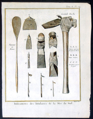
1778 Capt Cook Antique Print of Tools Axes, Scrapers, Paddles South Sea Islands
- Title : Instruments des Insulaires de la Mer du Sud
- Ref : 21406
- Size: 10in x 8in (255mm x 205mm)
- Date : 1778
- Condition: (A+) Fine Condition
Description:
This fine original copper-plate engraved antique print of different types of tools, axes, scrapers, paddles etc of different South Seas Islands, during Captain James Cook 2nd Voyage of Discovery to the South Seas, was engraved by Robert Benard - after William Hodges - and was published in the 1778 French edition of Capt. James Cooks 2nd Voyage of Discovery to the South Seas A voyage towards the South Pole, and round the World. Performed in His Majestys ships the Resolution and Adventure, in the years 1772, 1773, 1774, and 1775..... Paris : Hotel de Thou ......1778
The tools & instruments listed are;
A.A.A.A. Grande Hache, Parbes supericure de la grande Hache - Large axe & 3 different views of the stone head & bindings.
B.B.B Petites Haches - smaller axes C.C.C.Instrumens percer la peau -
Various scraping tools for tanning animal hides
4. Pagaye ou Rame - Paddle or Oar
General Definitions:
Paper thickness and quality: - Heavy and stable
Paper color : - off white
Age of map color: - Early
Colors used: - Yellow, brown
General color appearance: - Authentic
Paper size: - 10in x 8in (255mm x 205mm)
Plate size: - 9 1/2in x 7 1/4in (240mm x 185mm)
Margins: - Min 1/2in (12mm)
Imperfections:
Margins: - Light soiling in margins
Plate area: - None
Verso: - None
Background:
William Hodges RA 1744 – 1797 was an English painter. He was a member of James Cooks second voyage to the Pacific Ocean, and is best known for the sketches and paintings of locations he visited on that voyage, including Table Bay, Tahiti, Easter Island, and the Antarctic.
Between 1772 and 1775 Hodges accompanied James Cook to the Pacific as the expeditions artist. Many of his sketches and wash paintings were adapted as engravings in the original published edition of Cooks journals from the voyage.
Most of the large-scale landscape oil paintings from his Pacific travels for which Hodges is best known were finished after his return to London; he received a salary from the Admiralty for the purposes of completing them. These paintings depicted a stronger light and shadow than had been usual in European landscape tradition. Contemporary art critics complained that his use of light and colour contrasts gave his paintings a rough and unfinished appearance.
Hodges also produced many valuable portrait sketches of Pacific islanders and scenes from the voyage involving members of the expedition..
Robert Bénard 1734 – 1777 was an 18th-century French engraver.
Specialized in the technique of engraving, Robert Ménard is mainly famous for having supplied a significant amount of plates (at least 1,800) to the Encyclopédie by Diderot & d\'Alembert from 1751.
Later, publisher Charles-Joseph Panckoucke reused many of his productions to illustrate the works of his catalog.
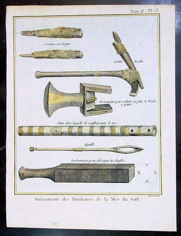
1778 Capt Cook Antique Print of Tools & Musical Instruments of South Sea Islands
- Title : Instruments des Insulaires de la Mer du Sud
- Ref : 21329
- Size: 10in x 8in (255mm x 205mm)
- Date : 1778
- Condition: (A+) Fine Condition
Description:
This fine original copper-plate engraved antique print of different types of tools, musical instruments chisels, axe, nasal flute & fabric beater of different South Seas Islands, during Captain James Cook 2nd Voyage of Discovery to the South Seas, was engraved by Robert Benard - after William Hodges - and was published in the 1778 French edition of Capt. James Cooks 2nd Voyage of Discovery to the South Seas A voyage towards the South Pole, and round the World. Performed in His Majestys ships the Resolution and Adventure, in the years 1772, 1773, 1774, and 1775..... Paris : Hotel de Thou ......1778
The tools & instruments listed are;
1. Instrument for beating Breadfruit into paste
2. Thatching Needle
3. 3. Different Gouges or Chisels
4. An Adze of the smaller kind used for carving
5. The Nasal Flute blown by the Natives thro the nose
6. An instrument for beating the cloth
General Definitions:
Paper thickness and quality: - Heavy and stable
Paper color : - off white
Age of map color: - Early
Colors used: - Yellow, brown
General color appearance: - Authentic
Paper size: - 10in x 8in (255mm x 205mm)
Plate size: - 9 1/2in x 7 1/4in (240mm x 185mm)
Margins: - Min 1/2in (12mm)
Imperfections:
Margins: - Light soiling in margins
Plate area: - None
Verso: - None
Background:
William Hodges RA 1744 – 1797 was an English painter. He was a member of James Cooks second voyage to the Pacific Ocean, and is best known for the sketches and paintings of locations he visited on that voyage, including Table Bay, Tahiti, Easter Island, and the Antarctic.
Between 1772 and 1775 Hodges accompanied James Cook to the Pacific as the expeditions artist. Many of his sketches and wash paintings were adapted as engravings in the original published edition of Cooks journals from the voyage.
Most of the large-scale landscape oil paintings from his Pacific travels for which Hodges is best known were finished after his return to London; he received a salary from the Admiralty for the purposes of completing them. These paintings depicted a stronger light and shadow than had been usual in European landscape tradition. Contemporary art critics complained that his use of light and colour contrasts gave his paintings a rough and unfinished appearance.
Hodges also produced many valuable portrait sketches of Pacific islanders and scenes from the voyage involving members of the expedition..
Robert Bénard 1734 – 1777 was an 18th-century French engraver.
Specialized in the technique of engraving, Robert Ménard is mainly famous for having supplied a significant amount of plates (at least 1,800) to the Encyclopédie by Diderot & d\'Alembert from 1751.
Later, publisher Charles-Joseph Panckoucke reused many of his productions to illustrate the works of his catalog.
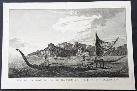
1778 Capt Cook Antique Print of Vaitahu Bay Tahuata Isle, Marquesas Islands 1774
- Title : Vue De La Baye De La Resolution Dans Lisle Des Marquises (View of the Bay, of the Resolution in island of Marquesas)
- Size: 15 1/2in x 10 1/2in (390mm x 265mm)
- Ref #: 21464
- Date : 1778
- Condition: (A+) Fine Condition
Description:
This large original copper-plate engraved antique print view of Vaitahu Bay on the Island of Tahuata in the Marquesas Islands, South Pacific, visited by Captain James Cook in 1774, during his 2nd Voyage of Discovery to the South Seas, was engraved by Robert Benard - after William Hodges - and was published in the 1778 French edition of Capt. James Cooks 2nd Voyage of Discovery to the South Seas A voyage towards the South Pole, and round the World. Performed in His Majestys ships the Resolution and Adventure, in the years 1772, 1773, 1774, and 1775..... Paris : Hotel de Thou ......1778.
(April 1774)............On 7th Cook wrote Land was seen bearing WBS distant about 9 Leagues, two hours after saw a nother land bearing SWBS and appeared more extensive than the first. The next morning they saw a third West, I directed my Course for the Channell between these two last lands, under all the Sail we could set, having unsittled Squally Showery weather. Soon after we discovered a fourth land still more to the westward and were now well assured that these were the Marquesas discovered by Mendana in 1595. The first isle is a new discovery, which I named Hoods Island after the young gentleman who first saw it, the second was that of St Pedro, the third La dominica, and the fourth St Christina. Alexander Hood, 16 years of age, was a first cousin of Admiral Lord Hood, The native names of the islands are Fatu Huku, Motane, Hiva Oa and Tahuata, respectively..............
General Definitions:
Paper thickness and quality: - Heavy and stable
Paper color : - off white
Age of map color: -
Colors used: -
General color appearance: -
Paper size: - 15 1/2in x 10 1/2in (390mm x 265mm)
Plate size: - 15in x 9 1/2in (380mm x 245mm)
Margins: - Min 1/2in (12mm)
Imperfections:
Margins: - None
Plate area: - None
Verso: - None
Background:
Tahuata is the smallest of the inhabited Marquesas Islands, in French Polynesia, an overseas territory of France in the Pacific Ocean.
The first recorded sighting by Europeans was by the Spanish expedition of Álvaro de Mandaña on 22 July 1595. They charted the island as Santa Cristina. They landed at Vaitahu that they named Madre de Dios (Gods Mother in Spanish). According to the Spanish accounts Tahuata had fowls, fish, sugar cane, plantains, nuts and fruits. The existent town was built on two sides of a rectangular space, the houses being of timber and intertwined canes. A building which the Spaniards supposed to be a religious one stood outside the town, in a space enclosed by palisades, and containing some ill-carved images before which were offerings and provisions. The people had large and well constructed sailing canoes. Their tools were made of shells and fish bones. They used slings, stones, and lances as weapons.
Tahuata was visited by Captain James Cook in 1774 and Admiral Dupetit-Thouars in 1842, who signed the treaty annexing the Marquesas Islands to France.
Vaitahu is the name of a bay and valley in western Tahuata. It is the site of most important village on that island.
Spanish explorer Álvaro de Mendaña landed here on 21 July 1595 and named the town Madre de Dios (Gods Mother in Spanish). In 1774, Captain James Cook landed here, and it was here that Admiral Dupetit-Thouars signed the treaty of annexation of the Marquesas to France, in 1842.
The Marquesas Islands are a group of volcanic islands in French Polynesia, an overseas collective of France in the southern Pacific Ocean.
The first Europeans to reach the Marquesas may have been the crew of San Lesmes, a Spanish vessel which disappeared in a storm in June 1526; it was part of an expedition headed by García Jofre de Loaísa. The Spanish explorer Álvaro de Mendaña reached them seventy years later on 21 July 1595. He named them after his patron, García Hurtado de Mendoza, 5th Marquis of Cañete (Spanish: Marqués de Cañete), who served as Viceroy of Peru from 1590 to 1596. |Mendaña visited first Fatu Hiva and then Tahuata before continuing on to the Solomon Islands. His expedition charted the four southernmost Marquesas as Magdalena (Fatu Hiva), Dominica (Hiva ʻOa), San Pedro (Moho Tani), and Santa Cristina (Tahuata).
In the late 16th century European explorers estimated the population at more than 100,000. Europeans and Americans were impressed with how easy life appeared to be in the islands, which had a rich habitat and environment. In 1791 the American maritime fur trader Joseph Ingraham first visited the northern Marquesas while commanding the brig Hope. He named them the Washington Islands. In 1813 Commodore David Porter claimed Nuku Hiva for the United States, but the United States Congress never ratified that claim.
In 1842 France conducted a successful military operation on behalf of the native chief Iotete, who claimed he was king of the whole island of Tahuata. The government laid claim to the whole group and established a settlement on Nuku Hiva. That settlement was abandoned in 1857, but France re-established control over the group in 1870. It later incorporated the Marquesas into French Polynesia.
William Hodges RA 1744 – 1797 was an English painter. He was a member of James Cooks second voyage to the Pacific Ocean, and is best known for the sketches and paintings of locations he visited on that voyage, including Table Bay, Tahiti, Easter Island, and the Antarctic.
Between 1772 and 1775 Hodges accompanied James Cook to the Pacific as the expeditions artist. Many of his sketches and wash paintings were adapted as engravings in the original published edition of Cooks journals from the voyage.
Most of the large-scale landscape oil paintings from his Pacific travels for which Hodges is best known were finished after his return to London; he received a salary from the Admiralty for the purposes of completing them. These paintings depicted a stronger light and shadow than had been usual in European landscape tradition. Contemporary art critics complained that his use of light and colour contrasts gave his paintings a rough and unfinished appearance.
Hodges also produced many valuable portrait sketches of Pacific islanders and scenes from the voyage involving members of the expedition..
Robert Bénard 1734 – 1777 was an 18th-century French engraver.
Specialized in the technique of engraving, Robert Ménard is mainly famous for having supplied a significant amount of plates (at least 1,800) to the Encyclopédie by Diderot & d\'Alembert from 1751.
Later, publisher Charles-Joseph Panckoucke reused many of his productions to illustrate the works of his catalog.
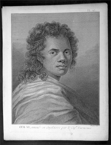
1778 Capt. Cook Antique Print Portrait of Omai of Raiatea Island - Furneaux 1773
- Title : Omai, amene en Angleterre par le Cap. Furneaux (Omai, brought to England by Captain Furneaux)
- Ref : 16359
- Size: 10in x 8in (255mm x 205mm)
- Date : 1778
- Condition: (A+) Fine Condition
Description:
This fine original copper-plate engraved antique print, a portrait of Mai or Omai of Raiatea (Ulietea) Island, used by Captain James Cook & Commander Tobias Furneaux as an interpreter during his 2nd Voyage of Discovery in the South Seas, and later taken to England by Furneaux, was engraved by Robert Benard - after William Hodges - and was published in the 1778 French edition of Capt. James Cooks 2nd Voyage of Discovery to the South Seas A voyage towards the South Pole, and round the World. Performed in His Majestys ships the Resolution and Adventure, in the years 1772, 1773, 1774, and 1775..... Paris : Hotel de Thou ......1778
General Definitions:
Paper thickness and quality: - Heavy and stable
Paper color : - off white
Age of map color: -
Colors used: -
General color appearance: -
Paper size: - 10in x 8in (255mm x 205mm)
Plate size: - 9 1/2in x 7 1/4in (240mm x 185mm)
Margins: - Min 1/2in (12mm)
Imperfections:
Margins: - Light soiling in margins
Plate area: - None
Verso: - None
Background:
Mai mistakenly known as Omai 1751-1780, was a young Raiatean man who became the second Pacific Islander to visit Europe, after Ahu-toru who was brought to Paris by Bougainville in 1768.
Mai described himself as a hoa, chiefly attendant, the son of a Raiatea landowner. His father was killed by Punis Borabora warriors. Fleeing to Tahiti, Mai was wounded in the encounter with the Dolphin in 1767. Mai then became an apprentice to a priest. Returning to Raiatea, he was captured and taken to Borabora. Narrowly escaping death there, he escaped to Raiatea (Huahine).
Omai met Samuel Wallis in 1767 and Captain James Cook in 1769 in Tahiti. In August 1773 he embarked from Raiatea (Huahine) on the British ship HMS Adventure, commanded by Commander Tobias Furneaux, which had previously touched at Tahiti as part of James Cook\\\'s second voyage of discovery in the Pacific. Omai traveled to Europe on Adventure, arriving at London in October 1774 where he was introduced into British society by the naturalist Sir Joseph Banks (whom he had also met during Cook\\\'s first voyage).
During his two-year stay in England, Omai became much admired within London high society. Renowned for his charm, quick wit and exotic good looks, he quickly became a favourite of the aristocratic elite. Banks regularly invited Omai to dine with the Royal Society and arranged meetings with notable celebrities of the time, including Lord Sandwich, Dr Samuel Johnson, Frances Burney, and Anna Seward, among others. Richard Holmes remarks that Omai\\\'s idiosyncratic behaviour and distinctive bow were widely celebrated. Indeed, during one famed meeting with King George III at Kew, Omai is said to have delivered his bow then grasped the King\\\'s hand, declaring, How do, King Tosh!
His portrait was painted by Sir Joshua Reynolds among others, and his journey to England and subsequent return to Tahiti with Cook on his third voyage in 1776 became the subject of a theatrical production, written and directed by the dramatist John O Keefe, entitled Omai – A Voyage ‘round the World that was performed during the 1785 Christmas season at London’s Theatre Royal in Covent Garden.
Omai returned to Raiatea (Huahine) in August 1777 and was settled with a European-style house, furniture, vineyard and two Maori boys as his servants. During the Bounty\\\'s visit to Tahiti in 1789, Captain Bligh was told Omai had died about two and a half years after Cook\\\'s departure in November 1777.
Raiatea, is the second largest of the Society Islands, after Tahiti, in French Polynesia. The island is widely regarded as the centre of the eastern islands in ancient Polynesia and it is likely that the organised migrations to Hawaii, Aotearoa and other parts of East Polynesia started at Raiātea.
A traditional name for the island is Havaii, homeland of the Māori people.
The first European to record sighting Ra iātea was Pedro Fernandes de Queirós in 1606; it was charted as La Fugitiva The Polynesian navigator, Tupaia, who sailed with explorer James Cook, was born in Raiātea around 1725.
Cook visited Raiatea in 1769 and again in 1773-1774. Omai (c.1751-1780), another young man from Raiātea, traveled with the European explorers to London in 1774 and also served as an interpreter to Captain Cook on his second and third journey.
King Tamatoa VI was the last monarch, reigning from 1884-1888.
Tahiti previously also known as Otaheite is the largest island in the Windward group of French Polynesia. The island is located in the archipelago of the Society Islands in the central Southern Pacific Ocean.
The first European to have visited Tahiti according to existing records was lieutenant Samuel Wallis, who was circumnavigating the globe in HMS Dolphin, sighting the island on 18 June 1767, and eventually harboring in Matavai Bay. This bay was situated on the territory of the chiefdom of Pare-Arue, governed by Tu (Tu-nui-e-a a-i-te-Atua) and his regent Tutaha, and the chiefdom of Ha apape, governed by Amo and his wife Oberea (Purea). Wallis named the island King Georges Island. The first contacts were difficult, since on the 24 and 26 June 1767, Tahitian warriors in canoes showed aggression towards the British, hurling stones from their slings. In retaliation, the British sailors opened fire on the warriors in the canoes and on the hills. In reaction to this powerful counter-attack, the Tahitians laid down peace offerings for the British. Following this episode, Samuel Wallis was able to establish cordial relations with the female chieftain “Oberea “ (Purea) and remained on the island until 27 July 1767.
In July 1768, Captain James Cook was commissioned by the Royal Society and on orders from the Lords Commissioners of the Admiralty to observe the transit of Venus across the sun, a phenomenon that would be visible from Tahiti on 3 June 1769. He arrived in Tahitis Matavai Bay, commanding the HMS Endeavour on 12 April 1769. On 14 April, Cook met with Tutaha and Tepau. On 15 April, Cook picked the site for a fortified camp at Point Venus along with Banks, Parkinson, Daniel Solander, to protect Charles Greens observatory. The length of stay enabled them to undertake for the first time real ethnographic and scientific observations of the island. Assisted by the botanist Joseph Banks, and by the artist Sydney Parkinson, Cook gathered valuable information on the fauna and flora, as well as the native society, language and customs, including the proper name of the island, Otaheite. On 28 April, Cook met Purea and Tupaia, and Tupaia befriended Banks following the transit. On 21 June, Amo visited Cook, and then on 25 June, Pohuetea visited, signifying another chief seeking to ally himself with the British.
Cook and Banks circumnavigated the island from 26 June to 1 July. On the exploration, they met Ahio, chief of Ha apaiano o or Papenoo, Rita, chief of Hitia a, Pahairro, chief of Pueu, Vehiatua, chief of Tautra, Matahiapo, chief of Teahupo o, Tutea, chief of Vaira o, and Moe, chief of Afa Ahiti. In Papara, guided by Tupaia, they investigated the ruins of Mahaiatea marae, an impressive structure containing a stone pyramid or ahu, measuring 44 feet high, 267 feet long and 87 feet wide. Cook and the Endeavour departed Tahiti on 13 July 1769, taking Raiatean navigator Tupaia along for his geographic knowledge of the islands.
Cook returned to Tahiti between 15 August and 1 September 1773, greeted by the chiefs Tai and Puhi, besides the youg ari i Vehiatua II and his stepfather Ti itorea. Cook anchored in Vaitepiha Bay before returning to Point Venus where he met Tu, the paramount chief. Cook picked up two passengers from Tahiti during this trip, Porea and Mai, with Hitihiti later replacing Porea when Cook stopped at Raiatea. Cook took Hitihiti to Tahiti on 22 April, during his return leg. Then, Cook departed Tahiti on 14 May 1774.
During his final visit, Cook returned Mai to Tahiti on 12 Aug. 1777, after Mais long visit in England. Cook also brought two Maori from Queen Charlotte Sound, Te Weherua and Koa. Cook first harbored in Vaitepiha Bay, where he visited Vehiatua II s funeral bier and the prefabricated Spanish mission house. Cook also met Vehiatua III, and inscribed on the back of the Spanish cross, Georgius tertius Rex Annis 1767, 69, 73, 74 & 77, as a counterpoint to Christus Vincit Carolus III imperat 1774 on the front. On 23 Aug., Cook sailed for Matavai Bay, where he met Tu, his father Teu, his mother Tetupaia, his brothers Ari ipaea and Vaetua, and his sisters Ari ipaea-vahine, Tetua-te-ahamai, and Auo. Cook also observed a human sacrifice, taata tapu, at the Utu-ai-mahurau marae, and 49 skulls from previous victims.
On 29 Sept. 1777, Cook sailed for Papetoai Bay on Moorea. Cook met Mahine in an act of friendship on 3 Oct., though he was an enemy of Tu. When a goat kid was stolen on 6 Oct., Cook in a rampage, ordered the burning of houses and canoes until it was returned. Cook sailed for Huahine on 11 Oct., Raiatea on 2 Nov., and Borabora on 7 Dec.
On 26 October 1788, HMS Bounty, under the command of Captain William Bligh, landed in Tahiti with the mission of carrying Tahitian breadfruit trees (Tahitian: uru) to the Caribbean. Sir Joseph Banks, the botanist from James Cooks first expedition, had concluded that this plant would be ideal to feed the African slaves working in the Caribbean plantations at very little cost. The crew remained in Tahiti for about five months, the time needed to transplant the seedlings of the trees. Three weeks after leaving Tahiti, on 28 April 1789, the crew mutinied on the initiative of Fletcher Christian. The mutineers seized the ship and set the captain and most of those members of the crew who remained loyal to him adrift in a ships boat. A group of mutineers then went back to settle in Tahiti.
Although various explorers had refused to get involved in tribal conflicts, the mutineers from the Bounty offered their services as mercenaries and furnished arms to the family which became the Pōmare Dynasty. The chief Tū knew how to use their presence in the harbours favoured by sailors to his advantage. As a result of his alliance with the mutineers, he succeeded in considerably increasing his supremacy over the island of Tahiti.
William Hodges RA 1744 – 1797 was an English painter. He was a member of James Cooks second voyage to the Pacific Ocean, and is best known for the sketches and paintings of locations he visited on that voyage, including Table Bay, Tahiti, Easter Island, and the Antarctic.
Between 1772 and 1775 Hodges accompanied James Cook to the Pacific as the expeditions artist. Many of his sketches and wash paintings were adapted as engravings in the original published edition of Cooks journals from the voyage.
Most of the large-scale landscape oil paintings from his Pacific travels for which Hodges is best known were finished after his return to London; he received a salary from the Admiralty for the purposes of completing them. These paintings depicted a stronger light and shadow than had been usual in European landscape tradition. Contemporary art critics complained that his use of light and colour contrasts gave his paintings a rough and unfinished appearance.
Hodges also produced many valuable portrait sketches of Pacific islanders and scenes from the voyage involving members of the expedition..
Robert Bénard 1734 – 1777 was an 18th-century French engraver.
Specialized in the technique of engraving, Robert Ménard is mainly famous for having supplied a significant amount of plates (at least 1,800) to the Encyclopédie by Diderot & d\'Alembert from 1751.
Later, publisher Charles-Joseph Panckoucke reused many of his productions to illustrate the works of his catalog.
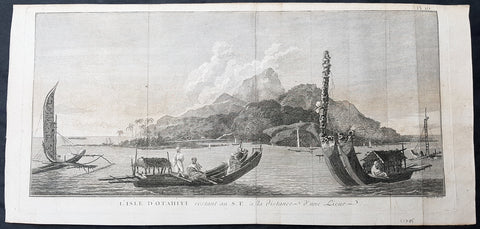
1778 Capt Cook Antique Print View of Oaite Peha or Vaitepiha Bay, Tahiti in 1773
- Title : L Isle D Otahiti restant au S E a la distance d une Lieue (SE Tahiti, at a distance of a League)
- Size: 21in x 10in (535mm x 255mm)
- Ref #: 21434
- Date : 1778
- Condition: (A) Very Good Condition
Description:
This large original copper-plate engraved antique print of various boats and a view of Oaite Peha (Vaitepiha) Bay on the Island of Tahiti, visited by Captain James Cook in August 1773, during his 2nd Voyage of Discovery to the South Seas, was engraved by Robert Benard - after William Hodges - and was published in the 1778 French edition of Capt. James Cooks 2nd Voyage of Discovery to the South Seas A voyage towards the South Pole, and round the World. Performed in His Majestys ships the Resolution and Adventure, in the years 1772, 1773, 1774, and 1775..... Paris : Hotel de Thou ......1778.
Cooks journal 1773
Aug. 2 Mon. Passes close to Pitcairn Island but without sighting it.
11 Wed. Sights Resolution Island = Tauere on 1st. Voyage. Entering Tuamotu Archipelago.
12 Thu. Off Tekokoto (Doubtful) Island, Maurutea (Furneaux) Island.
13 Fri. Off Motutunga (Stephen’s Isle > Sandwich Island > Hervey’s Isle).
14 Sat. Off Anaa (Chain Island on 1st. Voyage).
15 Sun. Sights Osnaburg Island (Mehetia) and Otaheite (Tahiti). Approaching Society Islands.
17 Tue. Resolution almost on reef, Tautira Basin, Vaitepiha Bay, hauled off, in emergency, two miles. Loses bower anchor. Anchors in Cook Anchorage, Oaitipeha/Vaitepiha Bay. Chiefs come aboard.
18 Wed. Sends Gilbert with cutter to recover anchor, successfully. Entertains, then is forced to eject thieves.
20 Fri. Recovers stolen musket. Marine Isaac Taylor dies.
23 Mon. Meets Chief Ta’atauraura who entertains him.
24 Tue. Sails.
26 Thu. Anchors in Matavai Bay. Lands.
27 Fri. Visited by Chief Otoo/Tu who entertains Cook with feast and dramatics. Wales and Bayly set up observatory (at Venus Point, same place as 1769).
28 Sat. Entertainments again.
29 Sun. With Furneaux visits Otoo again. Sees “Dramatick Heave or Play”.
30 Mon. After a disturbance would-be deserters returned to ship.
31 Tue. Visits Otoo who has retreated inland after the disorder. Presents exchanged and Otoo returns.
Sep. 1 Wed. Takes Tahitian, Porio, aboard and sails for Huahine.
General Definitions:
Paper thickness and quality: - Heavy and stable
Paper color : - off white
Age of map color: -
Colors used: -
General color appearance: -
Paper size: - 21in x 10in (535mm x 255mm)
Plate size: - 19 1/2in x 9 1/2in (495mm x 240mm)
Margins: - Min 1/2in (12mm)
Imperfections:
Margins: - Light soiling
Plate area: - Folds as issued, wear along folds
Verso: - Light soiling
Background:
Tahiti previously also known as Otaheite is the largest island in the Windward group of French Polynesia. The island is located in the archipelago of the Society Islands in the central Southern Pacific Ocean.
The first European to have visited Tahiti according to existing records was lieutenant Samuel Wallis, who was circumnavigating the globe in HMS Dolphin, sighting the island on 18 June 1767, and eventually harboring in Matavai Bay. This bay was situated on the territory of the chiefdom of Pare-Arue, governed by Tu (Tu-nui-e-a a-i-te-Atua) and his regent Tutaha, and the chiefdom of Ha apape, governed by Amo and his wife Oberea (Purea). Wallis named the island King Georges Island. The first contacts were difficult, since on the 24 and 26 June 1767, Tahitian warriors in canoes showed aggression towards the British, hurling stones from their slings. In retaliation, the British sailors opened fire on the warriors in the canoes and on the hills. In reaction to this powerful counter-attack, the Tahitians laid down peace offerings for the British. Following this episode, Samuel Wallis was able to establish cordial relations with the female chieftain “Oberea “ (Purea) and remained on the island until 27 July 1767.
In July 1768, Captain James Cook was commissioned by the Royal Society and on orders from the Lords Commissioners of the Admiralty to observe the transit of Venus across the sun, a phenomenon that would be visible from Tahiti on 3 June 1769. He arrived in Tahitis Matavai Bay, commanding the HMS Endeavour on 12 April 1769. On 14 April, Cook met with Tutaha and Tepau. On 15 April, Cook picked the site for a fortified camp at Point Venus along with Banks, Parkinson, Daniel Solander, to protect Charles Greens observatory. The length of stay enabled them to undertake for the first time real ethnographic and scientific observations of the island. Assisted by the botanist Joseph Banks, and by the artist Sydney Parkinson, Cook gathered valuable information on the fauna and flora, as well as the native society, language and customs, including the proper name of the island, Otaheite. On 28 April, Cook met Purea and Tupaia, and Tupaia befriended Banks following the transit. On 21 June, Amo visited Cook, and then on 25 June, Pohuetea visited, signifying another chief seeking to ally himself with the British.
Cook and Banks circumnavigated the island from 26 June to 1 July. On the exploration, they met Ahio, chief of Ha apaiano o or Papenoo, Rita, chief of Hitia a, Pahairro, chief of Pueu, Vehiatua, chief of Tautra, Matahiapo, chief of Teahupo o, Tutea, chief of Vaira o, and Moe, chief of Afa Ahiti. In Papara, guided by Tupaia, they investigated the ruins of Mahaiatea marae, an impressive structure containing a stone pyramid or ahu, measuring 44 feet high, 267 feet long and 87 feet wide. Cook and the Endeavour departed Tahiti on 13 July 1769, taking Raiatean navigator Tupaia along for his geographic knowledge of the islands.
Cook returned to Tahiti between 15 August and 1 September 1773, greeted by the chiefs Tai and Puhi, besides the youg ari i Vehiatua II and his stepfather Ti itorea. Cook anchored in Vaitepiha Bay before returning to Point Venus where he met Tu, the paramount chief. Cook picked up two passengers from Tahiti during this trip, Porea and Mai, with Hitihiti later replacing Porea when Cook stopped at Raiatea. Cook took Hitihiti to Tahiti on 22 April, during his return leg. Then, Cook departed Tahiti on 14 May 1774.
During his final visit, Cook returned Mai to Tahiti on 12 Aug. 1777, after Mais long visit in England. Cook also brought two Maori from Queen Charlotte Sound, Te Weherua and Koa. Cook first harbored in Vaitepiha Bay, where he visited Vehiatua II s funeral bier and the prefabricated Spanish mission house. Cook also met Vehiatua III, and inscribed on the back of the Spanish cross, Georgius tertius Rex Annis 1767, 69, 73, 74 & 77, as a counterpoint to Christus Vincit Carolus III imperat 1774 on the front. On 23 Aug., Cook sailed for Matavai Bay, where he met Tu, his father Teu, his mother Tetupaia, his brothers Ari ipaea and Vaetua, and his sisters Ari ipaea-vahine, Tetua-te-ahamai, and Auo. Cook also observed a human sacrifice, taata tapu, at the Utu-ai-mahurau marae, and 49 skulls from previous victims.
On 29 Sept. 1777, Cook sailed for Papetoai Bay on Moorea. Cook met Mahine in an act of friendship on 3 Oct., though he was an enemy of Tu. When a goat kid was stolen on 6 Oct., Cook in a rampage, ordered the burning of houses and canoes until it was returned. Cook sailed for Huahine on 11 Oct., Raiatea on 2 Nov., and Borabora on 7 Dec.
On 26 October 1788, HMS Bounty, under the command of Captain William Bligh, landed in Tahiti with the mission of carrying Tahitian breadfruit trees (Tahitian: uru) to the Caribbean. Sir Joseph Banks, the botanist from James Cooks first expedition, had concluded that this plant would be ideal to feed the African slaves working in the Caribbean plantations at very little cost. The crew remained in Tahiti for about five months, the time needed to transplant the seedlings of the trees. Three weeks after leaving Tahiti, on 28 April 1789, the crew mutinied on the initiative of Fletcher Christian. The mutineers seized the ship and set the captain and most of those members of the crew who remained loyal to him adrift in a ships boat. A group of mutineers then went back to settle in Tahiti.
Although various explorers had refused to get involved in tribal conflicts, the mutineers from the Bounty offered their services as mercenaries and furnished arms to the family which became the Pōmare Dynasty. The chief Tū knew how to use their presence in the harbours favoured by sailors to his advantage. As a result of his alliance with the mutineers, he succeeded in considerably increasing his supremacy over the island of Tahiti.
William Hodges RA 1744 – 1797 was an English painter. He was a member of James Cooks second voyage to the Pacific Ocean, and is best known for the sketches and paintings of locations he visited on that voyage, including Table Bay, Tahiti, Easter Island, and the Antarctic.
Between 1772 and 1775 Hodges accompanied James Cook to the Pacific as the expeditions artist. Many of his sketches and wash paintings were adapted as engravings in the original published edition of Cooks journals from the voyage.
Most of the large-scale landscape oil paintings from his Pacific travels for which Hodges is best known were finished after his return to London; he received a salary from the Admiralty for the purposes of completing them. These paintings depicted a stronger light and shadow than had been usual in European landscape tradition. Contemporary art critics complained that his use of light and colour contrasts gave his paintings a rough and unfinished appearance.
Hodges also produced many valuable portrait sketches of Pacific islanders and scenes from the voyage involving members of the expedition..
Robert Bénard 1734 – 1777 was an 18th-century French engraver.
Specialized in the technique of engraving, Robert Ménard is mainly famous for having supplied a significant amount of plates (at least 1,800) to the Encyclopédie by Diderot & d\'Alembert from 1751.
Later, publisher Charles-Joseph Panckoucke reused many of his productions to illustrate the works of his catalog.
1778 Santini Large Antique Map of Upper Saxon Circle, NE Germany, Prussia, Brandenburg
- Title : Partie Septentrionale du Cercle de Haute Saxe qui contient L e Duche de Pomeranie et Le Marqui sat de Brandebourg....A Venise...P Santini...1778
- Date : 1778
- Condition: (A+) Fine Condition
- Ref: 50204
- Size: 30in x 21in (760mm x 535mm)
Description:
This large magnificent original copper-plate engraved antique map of The Upper Saxon Circle of NE Germany, Prussia, dominated by the electorate of Brandenburg, was engraved in 1778 - the date is engraved in the title cartouche - after Robert De Vaugondy and was published by Francois Santini (active 1776-84) in his 2 volume edition of Atlas Universal 1776-84. (Ref: Tooley; M&B)
General Definitions:
Paper thickness and quality: - Heavy and stable
Paper color : - off white
Age of map color: - Original
Colors used: - Blue, pink, red, green, yellow
General color appearance: - Authentic
Paper size: - 30in x 21in (760mm x 535mm)
Plate size: - 22in x 19 1/2in (560mm x 495mm)
Margins: - Min 1in (25mm)
Imperfections:
Margins: - None
Plate area: - None
Verso: - None
Background:
The Upper Saxon Circle was an Imperial Circle of the Holy Roman Empire, created in 1512.
The circle consists of approx. 23 states was dominated by the electorate of Saxony (the circles director) and the electorate of Brandenburg. It further comprised the Saxon Ernestine duchies and Pomerania. The Lusatias that fell to Saxony by the 1635 Peace of Prague were never encircled.
During the Early Modern period the Holy Roman Empire was divided into Imperial Circles administrative groupings whose primary purposes were the organization of common defensive structure and the collection of imperial taxes. They were also used as a means of organization within the Imperial Diet and the Imperial Chamber Court. Each circle had a Circle Diet, although not every member of the Circle Diet would hold membership of the Imperial Diet as well.
Six Imperial Circles were introduced at the Diet of Augsburg in 1500. In 1512, three more circles were added, and the large Saxon Circle was split into two, so that from 1512 until the collapse of the Holy Roman Empire in the Napoleonic era, there were ten Imperial Circles. The Crown of Bohemia, the Swiss Confederacy and Italy remained unencircled, as did various minor territories which held imperial immediacy.
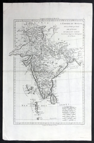
1780 Bonne Antique Map of India - Sri Lanka to Tibet
- Title : L Empire Du Mogol et la Presqu Isle De L Inde en deca Du Gange... Par M. Bonne
- Ref #: 21983
- Size: 17in x 11 1/2in (430mm x 290mm)
- Date : 1780
- Condition: (A+) Fine Condition
Description:
This fine original highly detailed antique map of India from Sri Lanka to Tibet by Rigobert Bonne was published in the 1780 edition of Atlas des toutes les parties connues du globe terrestre by Guillaume Raynal. (Ref Tooley M&B)
General Description:
Paper thickness and quality: - Heavy and stable
Paper color: - White
Age of map color: -
Colors used: -
General color appearance: -
Paper size: - 17in x 11 1/2in (430mm x 290mm)
Plate size: - 14 1/2in x 10 1/2in (370mm x 265mm)
Margins: - Min 1in (25mm)
Imperfections:
Margins: - None
Plate area: - None
Verso: - None
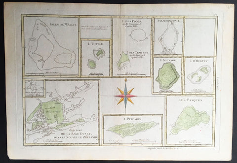
1780 Bonne Antique Map of South Pacific Islands Dusky Bay, Pitcairn, Easter Isle
- Title : Isle De Wallis; I. Turtle; I. Des Cocos; Palmerstin I.; I. Sauvage; I. D' Hervey; Esuisse De La Baye Dusky Dans La Nouvelle Zeelande; I. Pitcairn; I. De Pasques
- Ref #: 32193
- Size: 16in x 11in (405mm x 2805mm)
- Date : 1780
- Condition: (A+) Fine Condition
Description:
This finely engraved hand coloured original antique map showing 9 various Islands of the South Pacific all related to the discoveries of Capt. James Cook - including Dusky Sound in New Zealand, Pitcairn Island; Cocos Island; Easter Island and more - was published in the 1780 edition of Atllas des toutes les parties connues du globe terrestre by Rigobert Bonne & Guillaume Raynal. (Ref Tooley M&B)
General Description:
Paper thickness and quality: - Heavy and stable
Paper color: - White
Age of map color: - Early
Colors used: - Green, yellow, red, blue
General color appearance: - Authentic
Paper size: - 16in x 11in (405mm x 2805mm)
Plate size: - 14 1/2in x 10in (370mm x 255mm)
Margins: - Min ½in (12mm)
Imperfections:
Margins: - None
Plate area: - None
Verso: - None
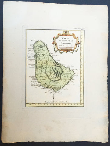
1755 Bellin Antique Map of The Island of Barbados
- Title : Carte De L ' Isle De La Barbade...
- Ref #: 35021
- Size: 13 1/2in x 11 1/2in (350mm x 270mm)
- Date : 1755
- Condition: (A+) Fine Condition
Description:
This beautifully engraved hand coloured original antique map of the Island of Barbados was published in 1755 by Jacques Nicolas Bellin for Antoine-François Prevosts 20 volume edition of L`Histoire Generale des Voyages published by Pierre de Hondt, The Hague between 1747 & 1785. (Ref: Tooley; M&B)
General Description:
Paper thickness and quality: - Light and stable
Paper color: - off white
Age of map color: - Early
Colors used: - Red, green, yellow
General color appearance: - Authentic
Paper size: - 13 1/2in x 11 1/2in (350mm x 270mm)
Plate size: - 8 1/4in x 6 1/2in (250mm x 170mm)
Margins: - Min 2in (50mm)
Imperfections:
Margins: - Light age toning
Plate area: - None
Verso: - None
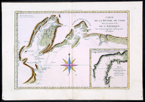
1780 Bonne Cook Antique Map Prince William Sound Alaska
- Title : Carte De La Riviere De Cook ...Par M. Bonne...
- Ref #: 40571
- Size: 15 1/2in x 10in (395mm x 255mm)
- Date : 1780
- Condition: (A+) Fine Condition
Description:
This fine beautifully hand coloured original antique map of Prince William Sound and the Cook inlet - with an inset map of Samganoodha inlet and tracks showing Cooks survey routes within Prince William Sound - was published by Rigobert Bonne in the 1780 edition of Atlas des toutes les parties connues du globe terrestre by Guillaume Raynal. (Ref Tooley M&B)
General Description:
Paper thickness and quality: - Heavy and stable
Paper color: - White
Age of map color: - Early
Colors used: -.Pink, green, yellow, blue
General color appearance: - Authentic and fresh
Paper size: - 15 1/2in x 10in (395mm x 255mm)
Plate size: - 14in x 9in (355mm x 230mm)
Margins: - Min 1in (25mm)
Imperfections:
Margins: - None
Plate area: - Two very small worm holes adjacent to bottom centerfold
Verso: - None
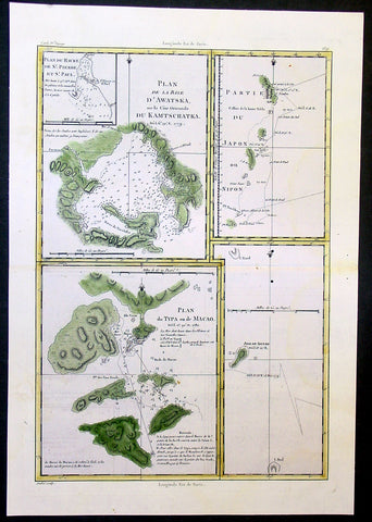
1780 Bonne Cook Antique Maps of Russia, Japan, Macao China, Alaska
- Title : Plan de la Baye D' Awatska; Partie Du Japon ou Nippon; Plan du Typa ou de Macao; Isle de Soufre
- Date : 1780
- Condition: (A) Very Good Condition
- Ref: 40584
- Size: 16in x 11in (405mm x 280mm)
Description:
This beautifully hand coloured original antique map of 4 regions of the North Pacific explored by Captain James Cook during his third Voyage of Discovery and tracks showing Cooks survey routes within Prince William Sound - was published by Rigobert Bonne in the 1780 edition of Atlas des toutes les parties connues du globe terrestre by Guillaume Raynal.
The 4 maps are;
1. Avacha Bay, Kamchatka Penninsular Russia.
2. East coast and Islands of Japan
3. Town & Islands of Macao, China
4. Islands of Soufre Vanauatu South Pacific. (Ref Tooley M&B)
General Description:
Paper thickness and quality: - Heavy and stable
Paper color: - White
Age of map color: - Early
Colors used: -Green, yellow
General color appearance: - Authentic and fresh
Paper size: - 16in x 11in (405mm x 280mm)
Plate size: - 14 1/2in x 10in (370mm x 255mm)
Margins: - Min 1in (25mm)
Imperfections:
Margins: - None
Plate area: - Two very small worm holes adjacent to right centerfold
Verso: - None
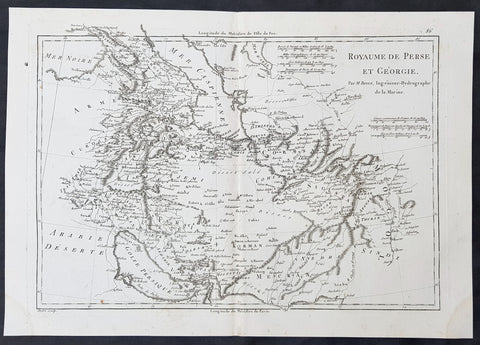
1780 R. Bonne Original Antique Map of Caucasus Georgia, Iran, Armenia, Pakistan
- Title : Royaume de Perse et Georgia...M Bonne
- Size: 15in x 10in (380mm x 255mm)
- Ref #: 40531
- Date : 1780
- Condition: (A+) Fine Condition
Description:
This original copper-plate engraved map was published in 1780 edition of Atllas des toutes les parties connues du globe terrestre by Rigobert Bonne & Guillaume Raynal.
General Definitions:
Paper thickness and quality: - Heavy and stable
Paper color : - off white
Age of map color: -
Colors used: -
General color appearance: -
Paper size: - 15in x 10in (380mm x 255mm)
Plate size: - 13in x 9in (330mm x 230mm)
Margins: - Min 1in (25mm)
Imperfections:
Margins: - None
Plate area: - None
Verso: - None
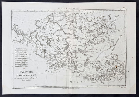
1780 R. Bonne Original Antique Map of Central Asia Turkestan - Caspian to China
- Title : Tartarie Independante...M Bonne
- Size: 15in x 10in (380mm x 255mm)
- Ref #: 40532
- Date : 1780
- Condition: (A+) Fine Condition
Description:
This original copper-plate engraved map was published in 1780 edition of Atllas des toutes les parties connues du globe terrestre by Rigobert Bonne & Guillaume Raynal.
General Definitions:
Paper thickness and quality: - Heavy and stable
Paper color : - off white
Age of map color: -
Colors used: -
General color appearance: -
Paper size: - 15in x 10in (380mm x 255mm)
Plate size: - 13in x 9in (330mm x 230mm)
Margins: - Min 1in (25mm)
Imperfections:
Margins: - None
Plate area: - None
Verso: - None
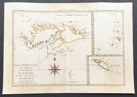
1780 Rigobert Bonne Old, Antique Map of the Falkland Islands - Malvinas Is.
- Title : Isles Maidenland de Hawkins et le Detroit De Fakland Ces Isles sont nommes Malouines... Par M. Bonne
- Ref #: 35488-1
- Size: 16in x 11in (410mm x 270mm)
- Date : 1780
- Condition: (A+) Fine Condition
Description:
This fine hand coloured original antique map of The Falkland or Malvinas, with inset maps of the South Sandwich Islands and George Island - both making up parts of the Falklands - by Rigobert Bonne was published in the 1780 edition of Atlas des toutes les parties connues du globe terrestre by Guillaume Raynal. (Ref Tooley M&B)
General Description:
Paper thickness and quality: - Heavy and stable
Paper color: - White
Age of map color: - Early
Colors used: - Green, yellow
General color appearance: - Authentic
Paper size: - 16in x 11in (410mm x 270mm)
Plate size: - 14 1/2in x 10in (370mm x 255mm)
Margins: - Min 1/2in (12mm)
Imperfections:
Margins: - Light age toning
Plate area: - Light age toning
Verso: - Light age toning
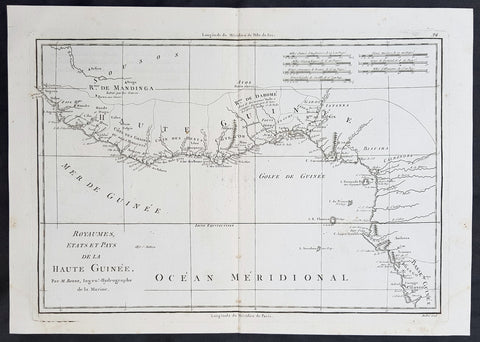
1780 Rigobert Bonne Original Antique Map Gulf of Guinea, Africa Liberia to Gabon
- Title : Royaumes Stats et Pays de La Haute Guinee...M Bonne
- Size: 15in x 10in (390mm x 255mm)
- Ref #: 40539
- Date : 1780
- Condition: (A+) Fine Condition
Description:
This original copper-plate engraved map was published in 1780 edition of Atllas des toutes les parties connues du globe terrestre by Rigobert Bonne & Guillaume Raynal.
General Definitions:
Paper thickness and quality: - Heavy and stable
Paper color : - off white
Age of map color: -
Colors used: -
General color appearance: -
Paper size: - 15in x 10in (390mm x 255mm)
Plate size: - 13in x 9in (330mm x 235mm)
Margins: - Min 1/4in (8mm)
Imperfections:
Margins: - None
Plate area: - None
Verso: - None
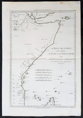
1780 Rigobert Bonne Original Antique Map Horn of Africa - Somalia to Tanzania
- Title : Le Royaume d Adel les Cotes D Ajan et de Zanguebar...M Bonne
- Size: 15in x 10in (390mm x 255mm)
- Ref #: 40542
- Date : 1780
- Condition: (A+) Fine Condition
Description:
This original copper-plate engraved map was published in 1780 edition of Atllas des toutes les parties connues du globe terrestre by Rigobert Bonne & Guillaume Raynal.
General Definitions:
Paper thickness and quality: - Heavy and stable
Paper color : - off white
Age of map color: -
Colors used: -
General color appearance: -
Paper size: - 15in x 10in (390mm x 255mm)
Plate size: - 13in x 9in (330mm x 235mm)
Margins: - Min 1/4in (8mm)
Imperfections:
Margins: - None
Plate area: - None
Verso: - None

1781 Le Harpe Original Antique Map Great Lakes North America Colonial US Florida
- Title : Carta Della Florida, Luigiana E Laghi Del Canada
- Date : 1781
- Size: 13in x 10in (330mm x 255mm)
- Ref #: 70821
- Condition: (A+) Fine Condition
Description:
This fine original and scarce antique map of The Great Lakes, Colonial United States & Canada by Jean Fracois de la Harpe was published in the 1781 edition of Voyages Compendio della Storia Generale de\' Viaggi Opera
General Definitions:
Paper thickness and quality: - Heavy and stable
Paper color : - off white
Age of map color: - Later
Colors used: - Yellow, green, blue, pink
General color appearance: - Authentic
Paper size: - 13in x 10in (330mm x 255mm)
Plate size: - 10 1/4in x 7in (265mm x 180mm)
Margins: - Min 1in (25mm)
Imperfections:
Margins: - None
Plate area: - None
Verso: - None
Background:
Voyages Compendio della Storia Generale de\' Viaggi Opera was a compendium of the first travel accounts to the New World, including Columbus, Hernandez, Balboa, Las Casas, and Cortez

1782 Kitchin Large Antique Map Persian Empire - Iran - Caspian to Persian Gulf
- Title : New Map of Persia divided into its provinces from the latest authorities by T Kitchin geog. Hydrographer to his Majesty
- Ref #: 61150
- Size: 18in x 14 1/2in (460mm x 370mm)
- Date : 1782
- Condition: (A) Very Good Condition
Description:
This large, finely engraved, detailed antique map of The Persian Empire from the Caspian Sea to the Persian Gulf by Thomas Kitchin was published in the 1782 edition of Millar's New & Universal System of Geographer, published by Alexander Hogg, London.
As with all Kitchins map this is beautifully executed with extreme detail from Georgia to the Mouth of The Indus River. (Ref Tooley M&B)
General Description:
Paper thickness and quality: - Heavy and stable
Paper color: - off white
Age of map color: -
Colors used: -
General color appearance: -
Paper size: - 18in x 14 1/2in (460mm x 370mm)
Plate size: - 15 1/4in x 13 3/4in (385mm x 350mm)
Margins: - Min 1/2in (15mm)
Imperfections:
Margins: - None
Plate area: - Light creasing along folds, as issued
Verso: - None

1782 Pierre Marie de Pages Large Antique World Map
- Title : Carte Reduite Du Globe Terrestre....1782
- Date : 1782
- Condition: (A+) Fine Condition
- Ref: 92808
- Size: 14 3/4in x 12 1/2in (375mm x 315mm)
Description:
This fine hand coloured original antique World map on Mercators Projection was engraved by Robert Benard in 1782 - the date is engraved in the titile - and was published in Pierre Marie Francois de le Pages book Voyage autour du monde et vers les deux poles, par terra et par mar, pendant les annees 1767 a 1776
Viscount de Pierre Marie Francois Pages:
French explorer, born in Toulouse in 1748; died in Santo Domingo in 1793. He entered the navy as midshipman in 1764, was promoted to 2nd lieutenant, and in 1767 lead an expedition to search for the northwest passage by the eastern coast of Asia. He sailed from Cape Francais, in Santo Domingo, on 30 June, 1767, and, although he was unsuccessful in his object, he explored Louisiana, Texas, Mexico, and the East Indies, returning to Marseilles, 5 September, 1771.
After some difficulties he was reinstated in the navy on 9 March, 1772. During the following year he took part in the expedition of Kerguelen to the South sea.
In 1776 he engaged passage on a whaler and visited Spitzbergen and the coast of Greenland, being the first navigator to reach 80º 30' north latitude. After being imprisoned twice by ice-fields he reached Amsterdam on 15 August, 1777. The fatigues and hardships that he experienced during the journey having impaired his health, he retired from the navy in 1782 and, going to Santo Domingo, settled upon an estate that belonged to his wife, a creole.
His last years were devoted to scientific researches, and he had in preparation several important works on America when he died in 1793 among the first victims of the negro insurgents.
Pages was a member of many learned societies, and in 1782 was created a knight of St. Louis. He published " Observations sur l'histoire naturelle, la temperature, les mceurs, l'industrie et les habitants du royaume de la Nouvelle Espagne" (2 vols., Paris, 1772); "Memoire sur l'anomalie de la constitution atmospherique des deux poles" (1775); " Voyage autour du monde et vers les deux poles, par terra et par mar, pendant les annees 1767 a 1776" (2 vols., 1782; translated into Dutch, Rotterdam, 1784" German, Leipsie, 1786; Swedish, Upsala, 1788" and English, London, 1791, and Boston, 1793) ; and "Reflexions sur les vents d'est qui regnent entre les tropiques, sur les pluies et le ciel serein darts ce paralldle etles circonvoisins" (Ref: M&B; Tooley)
General Description:
Paper thickness and quality: - Heavy & stable
Paper color: - White
Age of map color: - Early
Colors used: - Blue, brown
General color appearance: - Authentic
Paper size: - 14 3/4in x 12 1/2in (375mm x 315mm)
Paper size: - 14in x 11 1/2in (355mm x 295mm)
Margins: - Min 1/2in (12mm)
Imperfections:
Margins: - None
Plate area: - Light creasing along folds as issued
Verso: - None
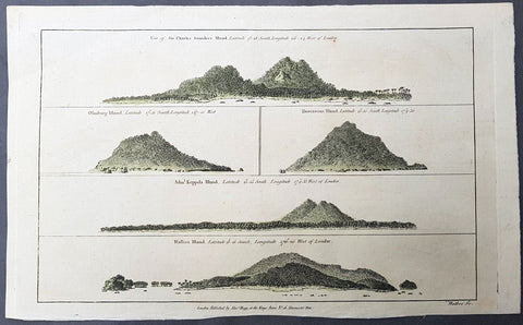
1784 Anderson Antique Print Coastal Views of French Polynesia & Tonga Isles - Cook 1st Voyage 1769
- Title : Views: Sir Charles Saunders Island : latitude 172̊8 south, longitude 1502 4 west of London; Osnaburg Island : latitude 175 1 south, long. 1470̊0 west; Boscawens Island : latitude 1550 south, long. 1743̊0; Adml. Keppels Island : latitude 1555 south, longitude 1743̊3 west of London; Wallis Island : latitude 13118 south, longitude 1762̊0 west of London.
- Ref #: 21594
- Size: 13 1/2in x 9 1/2in (345mm x 240mm)
- Date : 1784
- Condition: (A+) Fine Condition
Description:
This fine original copper-plate engraved antique print of five topographical views - perspectives taken from the deck of Captain Cooks Ship The Endeavour, during his 1st Voyage of Discovery in 1769 - of five coastal profiles of islands in or around the Tonga Islands group was published in George Andersons 1784 edition of A Collection of voyages round the world : performed by royal authority : containing a complete historical account of Captain Cooks first, second, third and last voyages, undertaken for making new discoveries, &c. ... published by Alexander Hogg, London 1784.
The five coastal topographical views from The Endeavour in order of title;
1. Sir Charles Saunder - Maiao in the Windward Islands of the Society Islands (French Polynesia)
2. Isle Osnabrug - Mehetia in the Society Islands (French Polynesia) in the vicinity of Wallis Island.
3. Isle Boscawen - Niuatoputapu.
4. Isle de l Admiral Keppel - Tafahi.
5. Wallis Island in the Wallis and Futuna Island group.
General Definitions:
Paper thickness and quality: - Heavy and stable
Paper color : - off white
Age of map color: - Early
Colors used: - Green
General color appearance: - Authentic
Paper size: - 13 1/2in x 9 1/2in (345mm x 240mm)
Plate size: - 13 1/2in x 9 1/2in (345mm x 240mm)
Margins: - Min 1/2in (12mm)
Imperfections:
Margins: - None
Plate area: - None
Verso: - None
Background:
Mai ao is an 8.8 km2 island formation located 78 km southwest of Mo orea and one of the Windward Islands (French: Iles du Vent) in French Polynesia.
Mehetia or Meetia is a volcanic island in the Windward Islands, in the east of the Society Islands in French Polynesia. This island is a very young active stratovolcano 110 kilometres east of the Taiarapu Peninsula of Tahiti. It belongs to the Teahitia-Mehetia hotspot.
Niuatoputapu is a high island in the island nation of Tonga, Pacific Ocean, its highest point being at 157 m. Its name means sacred island. Older European names for the island are Traitors island or Keppel island.
Tafahi is a small island in the north of the Tonga archipelago, in fact closer to Savaii (Sāmoa) than the main islands of Tonga. It is only 9 km north-northeast away from Niuatoputapu
Wallis is a Polynesian island in the Pacific Ocean belonging to the French overseas collectivity of Wallis and Futuna. It lies north of Tonga, northeast of Fiji, east-northeast of the Hoorn islands, east of Fijis Rotuma, southeast of Tuvalu, southwest of Tokelau and west of Samoa.
Cooks First voyage (1768–71)
In 1766, the Admiralty engaged Cook to command a scientific voyage to the Pacific Ocean. The purpose of the voyage was to observe and record the transit of Venus across the Sun for the benefit of a Royal Society inquiry into a means of determining longitude. Cook, at the age of 39, was promoted to lieutenant to grant him sufficient status to take the command. For its part the Royal Society agreed that Cook would receive a one hundred guinea gratuity in addition to his Naval pay.
The expedition sailed aboard HMS Endeavour, departing England on 26 August 1768. Cook and his crew rounded Cape Horn and continued westward across the Pacific to arrive at Tahiti on 13 April 1769, where the observations of the Venus Transit were made. However, the result of the observations was not as conclusive or accurate as had been hoped. Once the observations were completed, Cook opened the sealed orders which were additional instructions from the Admiralty for the second part of his voyage: to search the south Pacific for signs of the postulated rich southern continent of Terra Australis. Cook then sailed to New Zealand and mapped the complete coastline, making only some minor errors. He then voyaged west, reaching the south-eastern coast of Australia on 19 April 1770, and in doing so his expedition became the first recorded Europeans to have encountered its eastern coastline.
On 23 April he made his first recorded direct observation of indigenous Australians at Brush Island near Bawley Point, noting in his journal: “...and were so near the Shore as to distinguish several people upon the Sea beach they appear\\\'d to be of a very dark or black Colour but whether this was the real colour of their skins or the Clothes they might have on I know not. On 29 April Cook and crew made their first landfall on the mainland of the continent at a place now known as the Kurnell Peninsula. Cook originally christened the area as \\\"Stingray Bay\\\", but later he crossed this out and named it Botany Bay after the unique specimens retrieved by the botanists Joseph Banks and Daniel Solander. It is here that James Cook made first contact with an aboriginal tribe known as the Gweagal.
After his departure from Botany Bay he continued northwards. He stopped at Bustard Bay (now known as Seventeen Seventy or 1770) at 8 o’clock on 23 May 1770. On 24 May Cook and Banks and others went ashore. Continuing north, on 11 June a mishap occurred when HMS Endeavour ran aground on a shoal of the Great Barrier Reef, and then nursed into a river mouth on 18 June 1770. The ship was badly damaged and his voyage was delayed almost seven weeks while repairs were carried out on the beach (near the docks of modern Cooktown, Queensland, at the mouth of the Endeavour River). The voyage then continued, sailing through Torres Strait and on 22 August Cook landed on Possession Island, where he claimed the entire coastline that he had just explored as British territory. He returned to England via Batavia (modern Jakarta, Indonesia), where many in his crew succumbed to malaria, and then the Cape of Good Hope, arriving at the island of Saint Helena on 12 July 1771.
Cook\\\'s journals were published upon his return, and he became something of a hero among the scientific community. Among the general public, however, the aristocratic botanist Joseph Banks was a greater hero. Banks even attempted to take command of Cooks second voyage, but removed himself from the voyage before it began, and Johann Reinhold Forster and his son Georg Forster were taken on as scientists for the voyage. Cooks son George was born five days before he left for his second voyage.
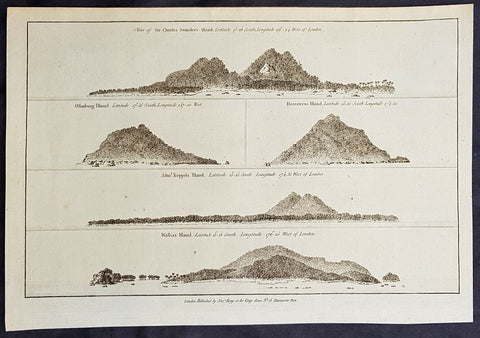
1784 Anderson Antique Print Coastal Views of French Polynesia & Tonga Isles - Cook 1st Voyage 1769
- Title : Views: Sir Charles Saunders Island : latitude 172̊8 south, longitude 1502 4 west of London; Osnaburg Island : latitude 175 1 south, long. 1470̊0 west; Boscawens Island : latitude 1550 south, long. 1743̊0; Adml. Keppels Island : latitude 1555 south, longitude 1743̊3 west of London; Wallis Island : latitude 13118 south, longitude 1762̊0 west of London.
- Ref #: 21593
- Size: 13 1/2in x 9 1/2in (345mm x 240mm)
- Date : 1784
- Condition: (A+) Fine Condition
Description:
This fine original copper-plate engraved antique print of five topographical views - perspectives taken from the deck of Captain Cooks Ship The Endeavour, during his 1st Voyage of Discovery in 1769 - of five coastal profiles of islands in or around the Tonga Islands group was published in George Andersons 1784 edition of A Collection of voyages round the world : performed by royal authority : containing a complete historical account of Captain Cooks first, second, third and last voyages, undertaken for making new discoveries, &c. ... published by Alexander Hogg, London 1784.
The five coastal topographical views from The Endeavour in order of title;
1. Sir Charles Saunder - Maiao in the Windward Islands of the Society Islands (French Polynesia)
2. Isle Osnabrug - Mehetia in the Society Islands (French Polynesia) in the vicinity of Wallis Island.
3. Isle Boscawen - Niuatoputapu.
4. Isle de l Admiral Keppel - Tafahi.
5. Wallis Island in the Wallis and Futuna Island group.
General Definitions:
Paper thickness and quality: - Heavy and stable
Paper color : - off white
Age of map color: -
Colors used: -
General color appearance: -
Paper size: - 13 1/2in x 9 1/2in (345mm x 240mm)
Plate size: - 13 1/2in x 9 1/2in (345mm x 240mm)
Margins: - Min 1/2in (12mm)
Imperfections:
Margins: - None
Plate area: - None
Verso: - None
Background:
Mai ao is an 8.8 km2 island formation located 78 km southwest of Mo orea and one of the Windward Islands (French: Iles du Vent) in French Polynesia.
Mehetia or Meetia is a volcanic island in the Windward Islands, in the east of the Society Islands in French Polynesia. This island is a very young active stratovolcano 110 kilometres east of the Taiarapu Peninsula of Tahiti. It belongs to the Teahitia-Mehetia hotspot.
Niuatoputapu is a high island in the island nation of Tonga, Pacific Ocean, its highest point being at 157 m. Its name means sacred island. Older European names for the island are Traitors island or Keppel island.
Tafahi is a small island in the north of the Tonga archipelago, in fact closer to Savaii (Sāmoa) than the main islands of Tonga. It is only 9 km north-northeast away from Niuatoputapu
Wallis is a Polynesian island in the Pacific Ocean belonging to the French overseas collectivity of Wallis and Futuna. It lies north of Tonga, northeast of Fiji, east-northeast of the Hoorn islands, east of Fijis Rotuma, southeast of Tuvalu, southwest of Tokelau and west of Samoa.
Cooks First voyage (1768–71)
In 1766, the Admiralty engaged Cook to command a scientific voyage to the Pacific Ocean. The purpose of the voyage was to observe and record the transit of Venus across the Sun for the benefit of a Royal Society inquiry into a means of determining longitude. Cook, at the age of 39, was promoted to lieutenant to grant him sufficient status to take the command. For its part the Royal Society agreed that Cook would receive a one hundred guinea gratuity in addition to his Naval pay.
The expedition sailed aboard HMS Endeavour, departing England on 26 August 1768. Cook and his crew rounded Cape Horn and continued westward across the Pacific to arrive at Tahiti on 13 April 1769, where the observations of the Venus Transit were made. However, the result of the observations was not as conclusive or accurate as had been hoped. Once the observations were completed, Cook opened the sealed orders which were additional instructions from the Admiralty for the second part of his voyage: to search the south Pacific for signs of the postulated rich southern continent of Terra Australis. Cook then sailed to New Zealand and mapped the complete coastline, making only some minor errors. He then voyaged west, reaching the south-eastern coast of Australia on 19 April 1770, and in doing so his expedition became the first recorded Europeans to have encountered its eastern coastline.
On 23 April he made his first recorded direct observation of indigenous Australians at Brush Island near Bawley Point, noting in his journal: “...and were so near the Shore as to distinguish several people upon the Sea beach they appear\\\'d to be of a very dark or black Colour but whether this was the real colour of their skins or the Clothes they might have on I know not. On 29 April Cook and crew made their first landfall on the mainland of the continent at a place now known as the Kurnell Peninsula. Cook originally christened the area as \\\"Stingray Bay\\\", but later he crossed this out and named it Botany Bay after the unique specimens retrieved by the botanists Joseph Banks and Daniel Solander. It is here that James Cook made first contact with an aboriginal tribe known as the Gweagal.
After his departure from Botany Bay he continued northwards. He stopped at Bustard Bay (now known as Seventeen Seventy or 1770) at 8 o’clock on 23 May 1770. On 24 May Cook and Banks and others went ashore. Continuing north, on 11 June a mishap occurred when HMS Endeavour ran aground on a shoal of the Great Barrier Reef, and then nursed into a river mouth on 18 June 1770. The ship was badly damaged and his voyage was delayed almost seven weeks while repairs were carried out on the beach (near the docks of modern Cooktown, Queensland, at the mouth of the Endeavour River). The voyage then continued, sailing through Torres Strait and on 22 August Cook landed on Possession Island, where he claimed the entire coastline that he had just explored as British territory. He returned to England via Batavia (modern Jakarta, Indonesia), where many in his crew succumbed to malaria, and then the Cape of Good Hope, arriving at the island of Saint Helena on 12 July 1771.
Cook\\\'s journals were published upon his return, and he became something of a hero among the scientific community. Among the general public, however, the aristocratic botanist Joseph Banks was a greater hero. Banks even attempted to take command of Cooks second voyage, but removed himself from the voyage before it began, and Johann Reinhold Forster and his son Georg Forster were taken on as scientists for the voyage. Cooks son George was born five days before he left for his second voyage.
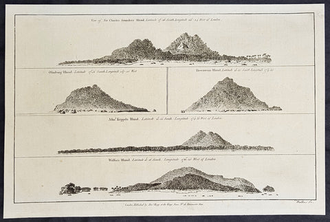
1784 Anderson Antique Print Coastal Views of French Polynesia & Tonga Isles - Cook 1st Voyage 1769
- Title : Views: Sir Charles Saunders Island : latitude 172̊8 south, longitude 1502 4 west of London; Osnaburg Island : latitude 175 1 south, long. 1470̊0 west; Boscawens Island : latitude 1550 south, long. 1743̊0; Adml. Keppels Island : latitude 1555 south, longitude 1743̊3 west of London; Wallis Island : latitude 13118 south, longitude 1762̊0 west of London.
- Ref #: 16078
- Size: 13 1/2in x 9 1/2in (345mm x 240mm)
- Date : 1784
- Condition: (A+) Fine Condition
Description:
This fine original copper-plate engraved antique print of five topographical views - perspectives taken from the deck of Captain Cooks Ship The Endeavour, during his 1st Voyage of Discovery in 1769 - of five coastal profiles of islands in or around the Tonga Islands group was published in George Andersons 1784 edition of A Collection of voyages round the world : performed by royal authority : containing a complete historical account of Captain Cooks first, second, third and last voyages, undertaken for making new discoveries, &c. ... published by Alexander Hogg, London 1784.
The five coastal topographical views from The Endeavour in order of title;
1. Sir Charles Saunder - Maiao in the Windward Islands of the Society Islands (French Polynesia)
2. Isle Osnabrug - Mehetia in the Society Islands (French Polynesia) in the vicinity of Wallis Island.
3. Isle Boscawen - Niuatoputapu.
4. Isle de l Admiral Keppel - Tafahi.
5. Wallis Island in the Wallis and Futuna Island group.
General Definitions:
Paper thickness and quality: - Heavy and stable
Paper color : - off white
Age of map color: -
Colors used: -
General color appearance: -
Paper size: - 13 1/2in x 9 1/2in (345mm x 240mm)
Plate size: - 13 1/2in x 9 1/2in (345mm x 240mm)
Margins: - Min 1/2in (12mm)
Imperfections:
Margins: - None
Plate area: - None
Verso: - None
Background:
Mai ao is an 8.8 km2 island formation located 78 km southwest of Mo orea and one of the Windward Islands (French: Iles du Vent) in French Polynesia.
Mehetia or Meetia is a volcanic island in the Windward Islands, in the east of the Society Islands in French Polynesia. This island is a very young active stratovolcano 110 kilometres east of the Taiarapu Peninsula of Tahiti. It belongs to the Teahitia-Mehetia hotspot.
Niuatoputapu is a high island in the island nation of Tonga, Pacific Ocean, its highest point being at 157 m. Its name means sacred island. Older European names for the island are Traitors island or Keppel island.
Tafahi is a small island in the north of the Tonga archipelago, in fact closer to Savaii (Sāmoa) than the main islands of Tonga. It is only 9 km north-northeast away from Niuatoputapu
Wallis is a Polynesian island in the Pacific Ocean belonging to the French overseas collectivity of Wallis and Futuna. It lies north of Tonga, northeast of Fiji, east-northeast of the Hoorn islands, east of Fijis Rotuma, southeast of Tuvalu, southwest of Tokelau and west of Samoa.
Cooks First voyage (1768–71)
In 1766, the Admiralty engaged Cook to command a scientific voyage to the Pacific Ocean. The purpose of the voyage was to observe and record the transit of Venus across the Sun for the benefit of a Royal Society inquiry into a means of determining longitude. Cook, at the age of 39, was promoted to lieutenant to grant him sufficient status to take the command. For its part the Royal Society agreed that Cook would receive a one hundred guinea gratuity in addition to his Naval pay.
The expedition sailed aboard HMS Endeavour, departing England on 26 August 1768. Cook and his crew rounded Cape Horn and continued westward across the Pacific to arrive at Tahiti on 13 April 1769, where the observations of the Venus Transit were made. However, the result of the observations was not as conclusive or accurate as had been hoped. Once the observations were completed, Cook opened the sealed orders which were additional instructions from the Admiralty for the second part of his voyage: to search the south Pacific for signs of the postulated rich southern continent of Terra Australis. Cook then sailed to New Zealand and mapped the complete coastline, making only some minor errors. He then voyaged west, reaching the south-eastern coast of Australia on 19 April 1770, and in doing so his expedition became the first recorded Europeans to have encountered its eastern coastline.
On 23 April he made his first recorded direct observation of indigenous Australians at Brush Island near Bawley Point, noting in his journal: “...and were so near the Shore as to distinguish several people upon the Sea beach they appear\\\'d to be of a very dark or black Colour but whether this was the real colour of their skins or the Clothes they might have on I know not. On 29 April Cook and crew made their first landfall on the mainland of the continent at a place now known as the Kurnell Peninsula. Cook originally christened the area as \\\"Stingray Bay\\\", but later he crossed this out and named it Botany Bay after the unique specimens retrieved by the botanists Joseph Banks and Daniel Solander. It is here that James Cook made first contact with an aboriginal tribe known as the Gweagal.
After his departure from Botany Bay he continued northwards. He stopped at Bustard Bay (now known as Seventeen Seventy or 1770) at 8 o’clock on 23 May 1770. On 24 May Cook and Banks and others went ashore. Continuing north, on 11 June a mishap occurred when HMS Endeavour ran aground on a shoal of the Great Barrier Reef, and then nursed into a river mouth on 18 June 1770. The ship was badly damaged and his voyage was delayed almost seven weeks while repairs were carried out on the beach (near the docks of modern Cooktown, Queensland, at the mouth of the Endeavour River). The voyage then continued, sailing through Torres Strait and on 22 August Cook landed on Possession Island, where he claimed the entire coastline that he had just explored as British territory. He returned to England via Batavia (modern Jakarta, Indonesia), where many in his crew succumbed to malaria, and then the Cape of Good Hope, arriving at the island of Saint Helena on 12 July 1771.
Cook\\\'s journals were published upon his return, and he became something of a hero among the scientific community. Among the general public, however, the aristocratic botanist Joseph Banks was a greater hero. Banks even attempted to take command of Cooks second voyage, but removed himself from the voyage before it began, and Johann Reinhold Forster and his son Georg Forster were taken on as scientists for the voyage. Cooks son George was born five days before he left for his second voyage.
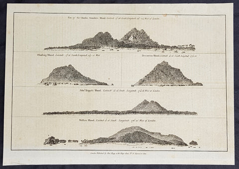
1784 Anderson Antique Print Coastal Views of French Polynesia & Tonga Isles - Cook 1st Voyage 1769
- Title : Views: Sir Charles Saunders Island : latitude 172̊8 south, longitude 1502 4 west of London; Osnaburg Island : latitude 175 1 south, long. 1470̊0 west; Boscawens Island : latitude 1550 south, long. 1743̊0; Adml. Keppels Island : latitude 1555 south, longitude 1743̊3 west of London; Wallis Island : latitude 13118 south, longitude 1762̊0 west of London.
- Ref #: 21441-1
- Size: 13 1/2in x 9 1/2in (345mm x 240mm)
- Date : 1784
- Condition: (A+) Fine Condition
Description:
This fine original copper-plate engraved antique print of five topographical views - perspectives taken from the deck of Captain Cooks Ship The Endeavour, during his 1st Voyage of Discovery in 1769 - of five coastal profiles of islands in or around the Tonga Islands group was published in George Andersons 1784 edition of A Collection of voyages round the world : performed by royal authority : containing a complete historical account of Captain Cooks first, second, third and last voyages, undertaken for making new discoveries, &c. ... published by Alexander Hogg, London 1784.
The five coastal topographical views from The Endeavour in order of title;
1. Sir Charles Saunder - Maiao in the Windward Islands of the Society Islands (French Polynesia)
2. Isle Osnabrug - Mehetia in the Society Islands (French Polynesia) in the vicinity of Wallis Island.
3. Isle Boscawen - Niuatoputapu.
4. Isle de l Admiral Keppel - Tafahi.
5. Wallis Island in the Wallis and Futuna Island group.
General Definitions:
Paper thickness and quality: - Heavy and stable
Paper color : - off white
Age of map color: -
Colors used: -
General color appearance: -
Paper size: - 13 1/2in x 9 1/2in (345mm x 240mm)
Plate size: - 13 1/2in x 9 1/2in (345mm x 240mm)
Margins: - Min 1/2in (12mm)
Imperfections:
Margins: - None
Plate area: - None
Verso: - None
Background:
Mai ao is an 8.8 km2 island formation located 78 km southwest of Mo orea and one of the Windward Islands (French: Iles du Vent) in French Polynesia.
Mehetia or Meetia is a volcanic island in the Windward Islands, in the east of the Society Islands in French Polynesia. This island is a very young active stratovolcano 110 kilometres east of the Taiarapu Peninsula of Tahiti. It belongs to the Teahitia-Mehetia hotspot.
Niuatoputapu is a high island in the island nation of Tonga, Pacific Ocean, its highest point being at 157 m. Its name means sacred island. Older European names for the island are Traitors island or Keppel island.
Tafahi is a small island in the north of the Tonga archipelago, in fact closer to Savaii (Sāmoa) than the main islands of Tonga. It is only 9 km north-northeast away from Niuatoputapu
Wallis is a Polynesian island in the Pacific Ocean belonging to the French overseas collectivity of Wallis and Futuna. It lies north of Tonga, northeast of Fiji, east-northeast of the Hoorn islands, east of Fijis Rotuma, southeast of Tuvalu, southwest of Tokelau and west of Samoa.
Cooks First voyage (1768–71)
In 1766, the Admiralty engaged Cook to command a scientific voyage to the Pacific Ocean. The purpose of the voyage was to observe and record the transit of Venus across the Sun for the benefit of a Royal Society inquiry into a means of determining longitude. Cook, at the age of 39, was promoted to lieutenant to grant him sufficient status to take the command. For its part the Royal Society agreed that Cook would receive a one hundred guinea gratuity in addition to his Naval pay.
The expedition sailed aboard HMS Endeavour, departing England on 26 August 1768. Cook and his crew rounded Cape Horn and continued westward across the Pacific to arrive at Tahiti on 13 April 1769, where the observations of the Venus Transit were made. However, the result of the observations was not as conclusive or accurate as had been hoped. Once the observations were completed, Cook opened the sealed orders which were additional instructions from the Admiralty for the second part of his voyage: to search the south Pacific for signs of the postulated rich southern continent of Terra Australis. Cook then sailed to New Zealand and mapped the complete coastline, making only some minor errors. He then voyaged west, reaching the south-eastern coast of Australia on 19 April 1770, and in doing so his expedition became the first recorded Europeans to have encountered its eastern coastline.
On 23 April he made his first recorded direct observation of indigenous Australians at Brush Island near Bawley Point, noting in his journal: “...and were so near the Shore as to distinguish several people upon the Sea beach they appear\\\'d to be of a very dark or black Colour but whether this was the real colour of their skins or the Clothes they might have on I know not. On 29 April Cook and crew made their first landfall on the mainland of the continent at a place now known as the Kurnell Peninsula. Cook originally christened the area as \\\"Stingray Bay\\\", but later he crossed this out and named it Botany Bay after the unique specimens retrieved by the botanists Joseph Banks and Daniel Solander. It is here that James Cook made first contact with an aboriginal tribe known as the Gweagal.
After his departure from Botany Bay he continued northwards. He stopped at Bustard Bay (now known as Seventeen Seventy or 1770) at 8 o’clock on 23 May 1770. On 24 May Cook and Banks and others went ashore. Continuing north, on 11 June a mishap occurred when HMS Endeavour ran aground on a shoal of the Great Barrier Reef, and then nursed into a river mouth on 18 June 1770. The ship was badly damaged and his voyage was delayed almost seven weeks while repairs were carried out on the beach (near the docks of modern Cooktown, Queensland, at the mouth of the Endeavour River). The voyage then continued, sailing through Torres Strait and on 22 August Cook landed on Possession Island, where he claimed the entire coastline that he had just explored as British territory. He returned to England via Batavia (modern Jakarta, Indonesia), where many in his crew succumbed to malaria, and then the Cape of Good Hope, arriving at the island of Saint Helena on 12 July 1771.
Cook\\\'s journals were published upon his return, and he became something of a hero among the scientific community. Among the general public, however, the aristocratic botanist Joseph Banks was a greater hero. Banks even attempted to take command of Cooks second voyage, but removed himself from the voyage before it began, and Johann Reinhold Forster and his son Georg Forster were taken on as scientists for the voyage. Cooks son George was born five days before he left for his second voyage.
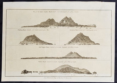
1784 Anderson Antique Print Coastal Views of French Polynesia & Tonga Isles - Cook 1st Voyage 1769
- Title : Views: Sir Charles Saunders Island : latitude 172̊8 south, longitude 1502 4 west of London; Osnaburg Island : latitude 175 1 south, long. 1470̊0 west; Boscawens Island : latitude 1550 south, long. 1743̊0; Adml. Keppels Island : latitude 1555 south, longitude 1743̊3 west of London; Wallis Island : latitude 13118 south, longitude 1762̊0 west of London.
- Ref #: 21508
- Size: 13 1/2in x 9 1/2in (345mm x 240mm)
- Date : 1784
- Condition: (A+) Fine Condition
Description:
This fine original copper-plate engraved antique print of five topographical views - perspectives taken from the deck of Captain Cooks Ship The Endeavour, during his 1st Voyage of Discovery in 1769 - of five coastal profiles of islands in or around the Tonga Islands group was published in George Andersons 1784 edition of A Collection of voyages round the world : performed by royal authority : containing a complete historical account of Captain Cooks first, second, third and last voyages, undertaken for making new discoveries, &c. ... published by Alexander Hogg, London 1784.
The five coastal topographical views from The Endeavour in order of title;
1. Sir Charles Saunder - Maiao in the Windward Islands of the Society Islands (French Polynesia)
2. Isle Osnabrug - Mehetia in the Society Islands (French Polynesia) in the vicinity of Wallis Island.
3. Isle Boscawen - Niuatoputapu.
4. Isle de l Admiral Keppel - Tafahi.
5. Wallis Island in the Wallis and Futuna Island group.
General Definitions:
Paper thickness and quality: - Heavy and stable
Paper color : - off white
Age of map color: -
Colors used: -
General color appearance: -
Paper size: - 13 1/2in x 9 1/2in (345mm x 240mm)
Plate size: - 13 1/2in x 9 1/2in (345mm x 240mm)
Margins: - Min 1/2in (12mm)
Imperfections:
Margins: - None
Plate area: - None
Verso: - None
Background:
Mai ao is an 8.8 km2 island formation located 78 km southwest of Mo orea and one of the Windward Islands (French: Iles du Vent) in French Polynesia.
Mehetia or Meetia is a volcanic island in the Windward Islands, in the east of the Society Islands in French Polynesia. This island is a very young active stratovolcano 110 kilometres east of the Taiarapu Peninsula of Tahiti. It belongs to the Teahitia-Mehetia hotspot.
Niuatoputapu is a high island in the island nation of Tonga, Pacific Ocean, its highest point being at 157 m. Its name means sacred island. Older European names for the island are Traitors island or Keppel island.
Tafahi is a small island in the north of the Tonga archipelago, in fact closer to Savaii (Sāmoa) than the main islands of Tonga. It is only 9 km north-northeast away from Niuatoputapu
Wallis is a Polynesian island in the Pacific Ocean belonging to the French overseas collectivity of Wallis and Futuna. It lies north of Tonga, northeast of Fiji, east-northeast of the Hoorn islands, east of Fijis Rotuma, southeast of Tuvalu, southwest of Tokelau and west of Samoa.
Cooks First voyage (1768–71)
In 1766, the Admiralty engaged Cook to command a scientific voyage to the Pacific Ocean. The purpose of the voyage was to observe and record the transit of Venus across the Sun for the benefit of a Royal Society inquiry into a means of determining longitude. Cook, at the age of 39, was promoted to lieutenant to grant him sufficient status to take the command. For its part the Royal Society agreed that Cook would receive a one hundred guinea gratuity in addition to his Naval pay.
The expedition sailed aboard HMS Endeavour, departing England on 26 August 1768. Cook and his crew rounded Cape Horn and continued westward across the Pacific to arrive at Tahiti on 13 April 1769, where the observations of the Venus Transit were made. However, the result of the observations was not as conclusive or accurate as had been hoped. Once the observations were completed, Cook opened the sealed orders which were additional instructions from the Admiralty for the second part of his voyage: to search the south Pacific for signs of the postulated rich southern continent of Terra Australis. Cook then sailed to New Zealand and mapped the complete coastline, making only some minor errors. He then voyaged west, reaching the south-eastern coast of Australia on 19 April 1770, and in doing so his expedition became the first recorded Europeans to have encountered its eastern coastline.
On 23 April he made his first recorded direct observation of indigenous Australians at Brush Island near Bawley Point, noting in his journal: “...and were so near the Shore as to distinguish several people upon the Sea beach they appear\\\'d to be of a very dark or black Colour but whether this was the real colour of their skins or the Clothes they might have on I know not. On 29 April Cook and crew made their first landfall on the mainland of the continent at a place now known as the Kurnell Peninsula. Cook originally christened the area as \\\"Stingray Bay\\\", but later he crossed this out and named it Botany Bay after the unique specimens retrieved by the botanists Joseph Banks and Daniel Solander. It is here that James Cook made first contact with an aboriginal tribe known as the Gweagal.
After his departure from Botany Bay he continued northwards. He stopped at Bustard Bay (now known as Seventeen Seventy or 1770) at 8 o’clock on 23 May 1770. On 24 May Cook and Banks and others went ashore. Continuing north, on 11 June a mishap occurred when HMS Endeavour ran aground on a shoal of the Great Barrier Reef, and then nursed into a river mouth on 18 June 1770. The ship was badly damaged and his voyage was delayed almost seven weeks while repairs were carried out on the beach (near the docks of modern Cooktown, Queensland, at the mouth of the Endeavour River). The voyage then continued, sailing through Torres Strait and on 22 August Cook landed on Possession Island, where he claimed the entire coastline that he had just explored as British territory. He returned to England via Batavia (modern Jakarta, Indonesia), where many in his crew succumbed to malaria, and then the Cape of Good Hope, arriving at the island of Saint Helena on 12 July 1771.
Cook\\\'s journals were published upon his return, and he became something of a hero among the scientific community. Among the general public, however, the aristocratic botanist Joseph Banks was a greater hero. Banks even attempted to take command of Cooks second voyage, but removed himself from the voyage before it began, and Johann Reinhold Forster and his son Georg Forster were taken on as scientists for the voyage. Cooks son George was born five days before he left for his second voyage.
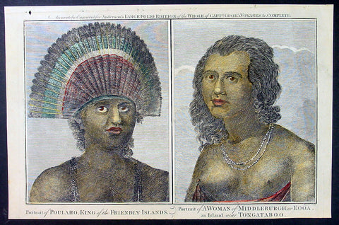
1784 Anderson Antique Print King Poulaho & Woman Tonga & Eua Islands - Cook 3rd Voyage
- Title : Portrait of Poulaho, King of the Friendly Islands: Portrait of a Woman of Middleburgh or Eooa An Island near Tongataboo
- Size: 13 1/2in x 9 1/2in (360mm x 245mm)
- Ref #: 21611
- Date : 1784
- Condition: (A+) Fine Condition
Description:
This fine original copper-plate engraved antique print of King Poulaho, from the Island of Tongatapu and a Woman from the Island of Eua north of Tongatapu both in the Tonga group of Islands both met during Capt Cooks visit to the islands during his 3rd Voyage of Discovery to the South Seas in December 1777 was published in George Andersons 1784 edition of A Collection of voyages round the world : performed by royal authority : containing a complete historical account of Captain Cooks first, second, third and last voyages, undertaken for making new discoveries, &c. ... published by Alexander Hogg, London 1784.
On the 28th, May 1777, as Cook was about to leave Ha apai, Tonga Paulaho came on board and brought me one of their Caps made or at least covered with red feathers. ..These Caps or rather bonnets are made of the tail feathers of the Tropic bird with red feathers of the Paroquets worked upon them or in along with them, they are made so as to tie upon the forehead without any Crown, and have the form of a Semicircle whose raids is 18 or 21 Inches\\\'. Cook Journals III, i.117.
Cook had described Paulaho as \\\'the corperate plump fellow we had met with.....
........About Noon a large sailing Canoe came under our Stern in which the Indians on board told us was Fattafee Polaho [Fatafehi Paulaho] King of all the Isles. He brought with him as a present to me two good fat hogs, though not so fat as himself, for he was the most corperate plump fellow we had met with. I found him to be a Sedate sensible man… I asked him down into the Cabbin, some of his attendants objected to this, saying if he went there people would walk over his head and this was never done. I desired Omai to till them I would remove that objection by giving orders that no one should walk on that part of the deck\\\' but the chief \\\'waved the ceremony and walked down with me without any more to do......
General Definitions:
Paper thickness and quality: - Heavy and stable
Paper color : - off white
Age of map color: - Early
Colors used: - Yellow, green, blue, red
General color appearance: - Authentic
Paper size: - 13 1/2in x 9 1/2in (345mm x 240mm)
Plate size: - 13 1/2in x 9 1/2in (345mm x 240mm)
Margins: - Min 1/2in (12mm)
Imperfections:
Margins: - None
Plate area: - None
Verso: - None
Background:
Cooks Third Voyage (1776–79)
On his last voyage, Cook again commanded HMS Resolution, while Captain Charles Clerke commanded HMS Discovery. The voyage was ostensibly planned to return the Pacific Islander, Omai to Tahiti, or so the public were led to believe. The trip\\\\\\\'s principal goal was to locate a Northwest Passage around the American continent. After dropping Omai at Tahiti, Cook travelled north and in 1778 became the first European to begin formal contact with the Hawaiian Islands. After his initial landfall in January 1778 at Waimea harbour, Kauai, Cook named the archipelago the \\\\\\\"Sandwich Islands\\\\\\\" after the fourth Earl of Sandwich—the acting First Lord of the Admiralty.
From the Sandwich Islands Cook sailed north and then north-east to explore the west coast of North America north of the Spanish settlements in Alta California. He made landfall on the Oregon coast at approximately 44°30′ north latitude, naming his landing point Cape Foulweather. Bad weather forced his ships south to about 43° north before they could begin their exploration of the coast northward. He unknowingly sailed past the Strait of Juan de Fuca, and soon after entered Nootka Sound on Vancouver Island. He anchored near the First Nations village of Yuquot. Cook\\\\\\\'s two ships remained in Nootka Sound from 29 March to 26 April 1778, in what Cook called Ship Cove, now Resolution Cove, at the south end of Bligh Island, about 5 miles (8 km) east across Nootka Sound from Yuquot, lay a Nuu-chah-nulth village (whose chief Cook did not identify but may have been Maquinna). Relations between Cook\\\\\\\'s crew and the people of Yuquot were cordial if sometimes strained. In trading, the people of Yuquot demanded much more valuable items than the usual trinkets that had worked in Hawaii. Metal objects were much desired, but the lead, pewter, and tin traded at first soon fell into disrepute. The most valuable items which the British received in trade were sea otter pelts. During the stay, the Yuquot \\\\\\\"hosts\\\\\\\" essentially controlled the trade with the British vessels; the natives usually visited the British vessels at Resolution Cove instead of the British visiting the village of Yuquot at Friendly Cove.
After leaving Nootka Sound, Cook explored and mapped the coast all the way to the Bering Strait, on the way identifying what came to be known as Cook Inlet in Alaska. In a single visit, Cook charted the majority of the North American north-west coastline on world maps for the first time, determined the extent of Alaska, and closed the gaps in Russian (from the West) and Spanish (from the South) exploratory probes of the Northern limits of the Pacific.
By the second week of August 1778 Cook was through the Bering Strait, sailing into the Chukchi Sea. He headed north-east up the coast of Alaska until he was blocked by sea ice. His furthest north was 70 degrees 44 minutes. Cook then sailed west to the Siberian coast, and then south-east down the Siberian coast back to the Bering Strait. By early September 1778 he was back in the Bering Sea to begin the trip to the Sandwich (Hawaiian) Islands. He became increasingly frustrated on this voyage, and perhaps began to suffer from a stomach ailment; it has been speculated that this led to irrational behaviour towards his crew, such as forcing them to eat walrus meat, which they had pronounced inedible.
Cook returned to Hawaii in 1779. After sailing around the archipelago for some eight weeks, he made landfall at Kealakekua Bay, on \\\\\\\'Hawaii Island\\\\\\\', largest island in the Hawaiian Archipelago. Cook\\\\\\\'s arrival coincided with the Makahiki, a Hawaiian harvest festival of worship for the Polynesian god Lono. Coincidentally the form of Cook\\\\\\\'s ship, HMS Resolution, or more particularly the mast formation, sails and rigging, resembled certain significant artefacts that formed part of the season of worship. Similarly, Cook\\\\\\\'s clockwise route around the island of Hawaii before making landfall resembled the processions that took place in a clockwise direction around the island during the Lono festivals. It has been argued (most extensively by Marshall Sahlins) that such coincidences were the reasons for Cook\\\\\\\'s (and to a limited extent, his crew\\\\\\\'s) initial deification by some Hawaiians who treated Cook as an incarnation of Lono. Though this view was first suggested by members of Cook\\\\\\\'s expedition, the idea that any Hawaiians understood Cook to be Lono, and the evidence presented in support of it, were challenged in 1992.
After a month\\\\\\\'s stay, Cook attempted to resume his exploration of the Northern Pacific. Shortly after leaving Hawaii Island, however, the Resolution\\\\\\\'s foremast broke, so the ships returned to Kealakekua Bay for repairs.
Tensions rose, and a number of quarrels broke out between the Europeans and Hawaiians at Kealakekua Bay. An unknown group of Hawaiians took one of Cook\\\\\\\'s small boats. The evening when the cutter was taken, the people had become \\\\\\\"insolent\\\\\\\" even with threats to fire upon them. Cook was forced into a wild goose chase that ended with his return to the ship frustrated.[53] He attempted to kidnap and ransom the King of Hawaiʻi, Kalaniʻōpuʻu.
That following day, 14 February 1779, Cook marched through the village to retrieve the King. Cook took the King (aliʻi nui) by his own hand and led him willingly away. One of Kalaniʻōpuʻu\\\\\\\'s favorite wives, Kanekapolei and two chiefs approached the group as they were heading to boats. They pleaded with the king not to go until he stopped and sat where he stood. An old kahuna (priest), chanting rapidly while holding out a coconut, attempted to distract Cook and his men as a large crowd began to form at the shore. The king began to understand that Cook was his enemy. As Cook turned his back to help launch the boats, he was struck on the head by the villagers and then stabbed to death as he fell on his face in the surf. He was first struck on the head with a club by a chief named Kalaimanokahoʻowaha or Kanaʻina (namesake of Charles Kana\\\\\\\'ina) and then stabbed by one of the king\\\\\\\'s attendants, Nuaa. The Hawaiians carried his body away towards the back of the town, still visible to the ship through their spyglass. Four marines, Corporal James Thomas, Private Theophilus Hinks, Private Thomas Fatchett and Private John Allen, were also killed and two others were wounded in the confrontation.
The esteem which the islanders nevertheless held for Cook caused them to retain his body. Following their practice of the time, they prepared his body with funerary rituals usually reserved for the chiefs and highest elders of the society. The body was disembowelled, baked to facilitate removal of the flesh, and the bones were carefully cleaned for preservation as religious icons in a fashion somewhat reminiscent of the treatment of European saints in the Middle Ages. Some of Cook\\\\\\\'s remains, thus preserved, were eventually returned to his crew for a formal burial at sea.
Clerke assumed leadership of the expedition, and made a final attempt to pass through the Bering Strait. He died from tuberculosis on 22 August 1779 and John Gore, a veteran of Cook\\\\\\\'s first voyage, took command of Resolution and of the expedition. James King replaced Gore in command of Discovery. The expedition returned home, reaching England in October 1780. After their arrival in England, King completed Cook\\\\\\\'s account of the voyage.
David Samwell, who sailed with Cook on Resolution, wrote of him: \\\\\\\"He was a modest man, and rather bashful; of an agreeable lively conversation, sensible and intelligent. In temper he was somewhat hasty, but of a disposition the most friendly, benevolent and humane. His person was above six feet high: and, though a good looking man, he was plain both in dress and appearance. His face was full of expression: his nose extremely well shaped: his eyes which were small and of a brown cast, were quick and piercing; his eyebrows prominent, which gave his countenance altogether an air of austerity.
Tonga officially the Kingdom of Tonga, is a Polynesian sovereign state and archipelago comprising 169 islands, of which 36 are inhabited. The total surface area is about 750 square kilometres (290 sq mi) scattered over 700,000 square kilometres (270,000 sq mi) of the southern Pacific Ocean. It has a population of 107,122 people, of whom 70% reside on the main island of Tongatapu.
The Tongan people first encountered Europeans in 1616 when the Dutch vessel Eendracht, captained by Willem Schouten, made a short visit to trade. Later came other Dutch explorers, including Jacob Le Maire (who called on the northern island of Niuatoputapu); and in 1643 Abel Tasman (who visited Tongatapu and Haapai).
Later noteworthy European visitors included James Cook (Royal Navy) in 1773, 1774, and 1777; Alessandro Malaspina (Spanish Navy) in 1793; the first London missionaries in 1797; and the Wesleyan Methodist Reverend Walter Lawry in 1822.
Tonga became known in the West as the Friendly Islands because of the congenial reception accorded to Captain James Cook on his first visit in 1773. He arrived at the time of the inasi festival, the yearly donation of the First Fruits to the Tui Tonga (the islands paramount chief) and so received an invitation to the festivities. According to the writer William Mariner, the chiefs wanted to kill Cook during the gathering but could not agree on a plan.
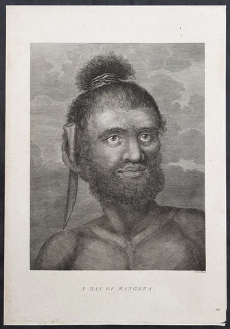
1784 Capt Cook Antique Print Man called Mourooa of Mangaia in the Cook Islands
- Title : A Man of Mangeea
- Size: 13in x 9in (330mm x 230mm)
- Ref #: 21759
- Date : 1784
- Condition: (A+) Fine Condition
Description:
This fine original copper-plate engraved antique print of a man of Mangaia, one of the Cook Islands - visited by Captain James Cook during the third voyage of discovery - after John Webber - was published in the 1784 English publication of Cooks third Voyage.
......Cook reconnoitered the reef surrounding Mangaia, one of the Cook Islands, on 29 March 1777. No landing was made but on the following day, a canoe with paddlers came out to meet the ships.
At length when they had perceived we were going to the Ships they all left us except the man we had in the boat, he tho not without evident signs of fear, accompaned us on board\' Cook\'s Journals III, I, 89.
The portrait was of a native called Mou\'rooa where through Omai\'s services he was questioned about his island.
General Definitions:
Paper thickness and quality: - Heavy and stable
Paper color : - off white
Age of map color: -
Colors used: -
General color appearance: -
Paper size: - 13in x 9in (330mm x 230mm)
Plate size: - 13in x 9in (330mm x 230mm)
Margins: - Min 1/2in (12mm)
Imperfections:
Margins: - None
Plate area: - None
Verso: - None
Background:
John Webber was born in London, of Swiss descent. In the spring of 1776 he showed three works at the Royal Academy\'s annual exhibition, where they attracted the attention of Dr Daniel Solander, President of the Royal Society and a friend and colleague of botanist Joseph Banks. Both had sailed with Captain James Cook on his first voyage of exploration in the Pacific aboard the \'Endeavour\', and were looking for a suitable artist to accompany them on a third trip. Solander recommended Webber to the Admiralty, and he was appointed almost immediately.
The voyage commenced on 12 July 1776. Upon his return to London in 1780, Webber submitted about 200 finished works to the Admiralty, which he had made on the voyage. From autumn 1780 until summer 1784, he re-drew many of the drawings and supervised the engravers and printers who were preparing the images for publication, under the direction of Lord Sandwich
ted.
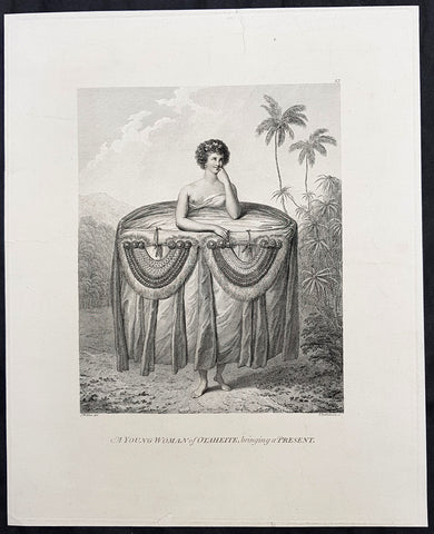
1784 Capt Cook Original Antique 1st Ed. Print - Tahitian Girl with Gift in 1777
- Title : A Young Woman of Otaheite, bringing a Present
- Ref : 31820
- Size: 14in x 11 1/2in (355mm x 295mm)
- Date : 1784
- Condition: (A+) Fine Good Condition
Description:
This fine original copper-plate engraved antique print of a young Tahitian woman giving the ritual presentation of gifts of tapa cloth and two breast plates, along with food to Captain Cook and his crew, during a visit by Cook in 1777 during his 3rd and last Voyage of Discovery, was engraved by Francesco Bartolozzi , after Cooks onboard artist John Webber, and was published in the 1784 1st official edition of Capt. James Cook & Capt. James King publication of A Voyage to the Pacific Ocean. Undertaken, by the Command of his Majesty, for making Discoveries in the Northern Hemisphere. To determine The Position and Extent of the West Side of North America; its Distance from Asia; and the Practicability of a Northen Passage to Europe. Performed under the direction of Captains Cook, Clerke, and Gore, In His Majestys Ships the Resolution and Discovery. In the Years 1776, 1777, 1778, 1779, and 1780. London 1784.
............Webber remarked on the ritual presentation of gifts of tapa cloth and two breast plates, along with food to Cook and his crew by two girls. The design of the girl’s attire recalls the wide panniers of eighteenth-century fashion, suggesting that the artist may have taken significant artistic license. However, the depiction is in concordance with Cook’s account. He describes seeing the girls dressed prior to their presentation, remarking on the “rather curious” manner in which one end of the cloth “was held up over the girls heads while the remainder was wraped round them under the armpits, then the upper ends were let fall and hung down in foulds to the ground over the other and looked something like a circular hooped petticoat. After ward round the out side of all were, were wraped several pieces of different Coloured cloth, which considerably increased the Size so that the whole was not less than five or six yards in circuit and was as much as the girls could support..............
General Definitions:
Paper thickness and quality: - Heavy and stable
Paper color : - off white
Age of map color: -
Colors used: -
General color appearance: -
Paper size: - 14in x 11 1/2in (355mm x 295mm)
Plate size: - 14in x 11 1/2in (355mm x 295mm)
Margins: - Min 1/2in (12mm)
Imperfections:
Margins: - None
Plate area: - None
Verso: - None
Background:
Captain James King FRS 1750 – 1784 was an officer of the Royal Navy. He served under James Cook on his last voyage around the world, specialising in taking important astronomical readings using a sextant. After Cook died he helped lead the ships on the remainder of their course, also completing Cooks account of the voyage. He continued his career in the Navy, reaching the rank of post-captain, commanding several ships and serving in the American War of Independence.
King joined HMS Resolution as second lieutenant, sharing the duties of astronomer with Cook, taking astronomical observations on board by sextant and with Larcum Kendals timekeeper K1, to establish the Resolutions position at sea and on shore by sextant or by astronomical quadrant to establish the geographical position of salient points during the course of Cooks surveys. Thus Kings geographical positions were an important contribution to the accuracy of the various surveys carried out during the voyage and his use of the early chronometers helped prove their use at sea for calculation of Longitude. .
Following the death of Cook, King remained in the Resolution but on the death of Charles Clerke, Cooks successor, King was appointed to command HMS Discovery, the Resolution\\\'s consort, remaining in her for the rest of the voyage. After his return to England King was very much involved in the publication of the official account of Cooks third voyage, writing the third volume at Woodstock, near Oxford, where his brother Thomas was rector of St Mary Magdalene. But shortly after his return King was promoted Post-captain and appointed commander of HMS Crocodile in the English Channel.
John Webber was born in London, of Swiss descent. In the spring of 1776 he showed three works at the Royal Academy\'s annual exhibition, where they attracted the attention of Dr Daniel Solander, President of the Royal Society and a friend and colleague of botanist Joseph Banks. Both had sailed with Captain James Cook on his first voyage of exploration in the Pacific aboard the \'Endeavour\', and were looking for a suitable artist to accompany them on a third trip. Solander recommended Webber to the Admiralty, and he was appointed almost immediately.
The voyage commenced on 12 July 1776. Upon his return to London in 1780, Webber submitted about 200 finished works to the Admiralty, which he had made on the voyage. From autumn 1780 until summer 1784, he re-drew many of the drawings and supervised the engravers and printers who were preparing the images for publication, under the direction of Lord Sandwich.
Francesco Bartolozzi RA 1727 – 1815 was an Italian engraver, whose most productive period was spent in London.
He lived in London for nearly forty years and produced an enormous number of engravings, including Clytie after Annibale Carracci, and of the Virgin and Child, after Carlo Dolci. A large proportion of them are from the works of Cipriani and Angelica Kauffman. Bartolozzi also contributed a number of plates to Boydell\'s Shakespeare Gallery. He also drew sketches of his own in red chalk. Soon after arriving in London, he was appointed \'Engraver to the King\' with an annual salary of £300. He was elected a founding member of the Royal Academy in 1768, and in 1802 became the founding President of the short-lived Society of Engravers.
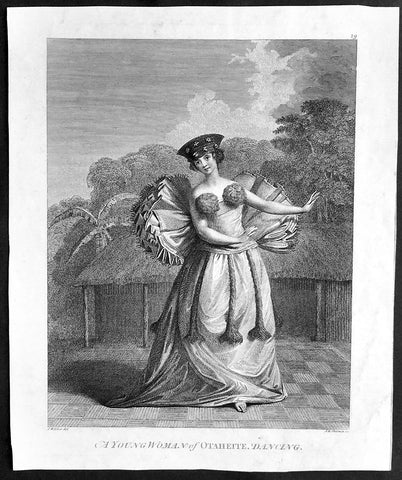
1784 Capt Cook Original Antique Print 1st Edition, Tahitian Dancing Girl in 1777
- Title : A Young Woman of Otaheite, Dancing - J Webber del - J K Sherwin
- Ref : 21370
- Size: 11in x 9in (280mm x 230mm)
- Date : 1784
- Condition: (A+) Fine Good Condition
Description:
This fine original copper-plate engraved antique print of a young Woman dancing on the Island of Tahiti, visited by Capt James Cook in 1777 during his 3rd and last Voyage of Discovery, was engraved by John Keyes Sherwin, after a painting by Cooks onboard artist John Webber, and was published in the 1784 1st offical edition of Capt. James Cook & Capt. James King A Voyage to the Pacific Ocean. Undertaken, by the Command of his Majesty, for making Discoveries in the Northern Hemisphere. To determine The Position and Extent of the West Side of North America; its Distance from Asia; and the Practicability of a Northen Passage to Europe. Performed under the direction of Captains Cook, Clerke, and Gore, In His Majestys Ships the Resolution and Discovery. In the Years 1776, 1777, 1778, 1779, and 1780. London 1784.
............Cook and his crew were treated to dancing, singing and music. Much attention has been paid to the costume, which William Anderson noted was “truly picturesque and elegant”. The long skirt is finished with a great tapa ruff attached at the back and balls of feathers cover the breast. The head-dress of plaited hair is adorned with Cape jasmin.............
General Definitions:
Paper thickness and quality: - Heavy and stable
Paper color : - off white
Age of map color: -
Colors used: -
General color appearance: -
Paper size: - 11in x 9in (280mm x 230mm)
Plate size: - 11in x 9in (280mm x 230mm)
Margins: - Min 1/2in (12mm)
Imperfections:
Margins: - None
Plate area: - None
Verso: - None
Background:
Captain James King FRS 1750 – 1784 was an officer of the Royal Navy. He served under James Cook on his last voyage around the world, specialising in taking important astronomical readings using a sextant. After Cook died he helped lead the ships on the remainder of their course, also completing Cooks account of the voyage. He continued his career in the Navy, reaching the rank of post-captain, commanding several ships and serving in the American War of Independence.
King joined HMS Resolution as second lieutenant, sharing the duties of astronomer with Cook, taking astronomical observations on board by sextant and with Larcum Kendals timekeeper K1, to establish the Resolutions position at sea and on shore by sextant or by astronomical quadrant to establish the geographical position of salient points during the course of Cooks surveys. Thus Kings geographical positions were an important contribution to the accuracy of the various surveys carried out during the voyage and his use of the early chronometers helped prove their use at sea for calculation of Longitude. .
Following the death of Cook, King remained in the Resolution but on the death of Charles Clerke, Cooks successor, King was appointed to command HMS Discovery, the Resolution\\\'s consort, remaining in her for the rest of the voyage. After his return to England King was very much involved in the publication of the official account of Cooks third voyage, writing the third volume at Woodstock, near Oxford, where his brother Thomas was rector of St Mary Magdalene. But shortly after his return King was promoted Post-captain and appointed commander of HMS Crocodile in the English Channel.
John Webber was born in London, of Swiss descent. In the spring of 1776 he showed three works at the Royal Academy\'s annual exhibition, where they attracted the attention of Dr Daniel Solander, President of the Royal Society and a friend and colleague of botanist Joseph Banks. Both had sailed with Captain James Cook on his first voyage of exploration in the Pacific aboard the \'Endeavour\', and were looking for a suitable artist to accompany them on a third trip. Solander recommended Webber to the Admiralty, and he was appointed almost immediately.
The voyage commenced on 12 July 1776. Upon his return to London in 1780, Webber submitted about 200 finished works to the Admiralty, which he had made on the voyage. From autumn 1780 until summer 1784, he re-drew many of the drawings and supervised the engravers and printers who were preparing the images for publication, under the direction of Lord Sandwich.
John Keyse Sherwin 1751 – 1790 was an English engraver and history-painter.
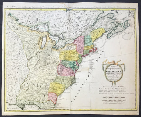
1784 Homann Large Antique Map of The Newly Formed United States of America
- Title : Charte uber die XIII vereinigte Staaten von Nord-Amerika...F L Guffefeld...A 1784
- Ref #: 61031
- Size: 23 1/4in x 19 1/4in (590mm x 490mm)
- Date : 1784
- Condition: (A) Very Good Condition
Description:
This large important & scarce fine beautifully hand coloured original antique map of the United States just after the War of Independence was engraved by F.J. Guttefeld in 1784 - dated - and published by the famous German firm of Homann Heirs.
Also known as the Stetson map, after the Stetson engraved in the title cartouche, this is one of the earliest maps to recognised the newly independent United States after the revolutionary war of Independence.
Background: An early and large map of the newly formed United States delineating all 13 states. The map extends west past the Mississippi River and north to the southern tip of Hudson Bay. The southern states are shown with their western boundaries on the Mississippi River, although the coloring shows only regions east of the Appalachians as being organized. As with many German maps of the period, there are some incorrect state boundaries; Vermont is shown as part of New Hampshire, and Maryland includes much of northern Virginia. A list of the principal German communities in New York, New Jersey and Pennsylvania are listed. The interior regions are shown with considerable topographical detail, locating numerous Indian tribes, topography, and watershed. The uncolored garland-style title cartouche is topped with a hat and crossed swords.
Each state is colored in a contrasting pastel and the states in the northern part are named by way of a lettered key given just below the attractive title cartouche. The treatment of the lands to the west of the Appalachian Mountains and up to the Mississippi River is quite interesting. This area is indicated as lands that came to the United States by the Treaty of 1783.French title outside top neat-line: Les XIII Etats Unis de l' Amerique Septentrionale. Ref: Tooley; M&B)
General Description:
Paper thickness and quality: - Heavy and stable
Paper color: - off white
Age of map color: - Original
Colors used: - Yellow, green, blue, pink
General color appearance: - Authentic
Paper size: - 23 1/4in x 19 1/4in (590mm x 490mm)
Plate size: - 23in x 18 1/4in (685mm x 465mm)
Margins: - Min 1/2in (12mm)
Imperfections:
Margins: - Light soiling in top margin,
Plate area: - Light creasing along centerfold, light soiling
Verso: - Re-enforced along centerfold

1785 Bloch Large Fish Print Ophidium Barbatum & Ophidium Aculeatum - Sea Snakes
- Title : Ophidium Barbatum; Ophidium Aculeatum
- Ref : 23497
- Size: 18in x 11in (460mm x 280mm)
- Date : 1785
- Condition: (A+) Fine Condition
Description:
This superbly hand coloured original antiquefish print of Ophidium Barbatum & Ophidium Aculeatum was published in the the first folio edition of "Ichthyologie, Ou Histoire Naturelle, Generale Et Particulière, Des Poissons, published by Mark Bloch (1723-99), in both Paris and Berlin between 1785-97.
The drawings were primarily done by Johan Friedrich August Krueger and Johan Friedrich Henning. What makes these prints stand out from most of the period and later, is not just the superb detail to the engraving but the attention spent on the hand coloring.
A monumental and beautiful work that continued to be a primary reference for the naturalists into the 19th century and is still admired today for its sumptuous illustrations. The plates reproduce the bright natural coloring of the fish, some of which were heightened with gold, silver or bronze to imitate the metallic sheen of scales. (Ref: Nissen, Schöne Fischbücher)
General Description:
Paper thickness and quality: - Heavy and stable
Paper color: - off white
Age of map color: - Original
Colors used: - Pink, yellow, green
General color appearance: - Beautiful
Paper size: - 18in x 11in (460mm x 280mm)
Plate size: - 15in x 8in (380mm x 205mm)
Margins: - Min 1in (25mm)
Imperfections:
Margins: - None
Plate area: - None
Verso: - None
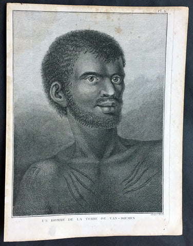
1785 Capt. Cook Antique Print Aboriginal Man of Bruny Island, Tasmania in 1777
- Title : Un Homme De La Terre De Van-Diemens
- Ref : 50611
- Size: 10in x 8in (255mm x 205mm)
- Date : 1785
- Condition: (A+) Fine Condition
Description:
This fine original copper-plate engraved antique print of an Indigenous Man of Adventure Bay, Bruny Island, Tasmania (Van Diemens Land) encountered by Captain Cook in during his 3rd & last Voyage of Discovery in 1777, was engraved by Robert Benard - after John Webber - and published in the 1785 French edition of Capt. James Cook & Capt. James King A Voyage to the Pacific Ocean. Undertaken, by the Command of his Majesty, for making Discoveries in the Northern Hemisphere. To determine The Position and Extent of the West Side of North America; its Distance from Asia; and the Practicability of a Northen Passage to Europe. Performed under the direction of Captains Cook, Clerke, and Gore, In His Majesty\'s Ships the Resolution and Discovery. In the Years 1776, 1777, 1778, 1779, and 1780. In Three Volumes. Vol. I and II written by James Cook, F.R.S. Vol. III by Captain James King, LL.D. and F.R.S. Paris, 1785.
Adventure Bay
from Cooks Journal......on the 24th (March 1777) at 3 AM we made the Coast of Van Diemen land wrote Cook. Anderson remarked that though now the middle of summer here a spot or two of snow was seen on the highest hills… At ten we passd a point supposd to be the boundary of Stone Bay where Abel Tasman anchord, i.e. Storm Bay. According to David Samwell, surgeons first mate on the Resolution, both Ships anchored in Adventure Bay in Van Diemens Land, this Bay was so called by Captn Furneaux who had anchored here in the Adventure last Voyage.
The next day Cook and Clerke sent parties, one to cut wood and the other grass. Clerke wrote of his party from the Discovery The Guard I had sent with the Parties on shore which consisted of the following Marines, Hamlet Thompson, Geo: Moody, Ben: Harriot, Jos: Pool & Willm Broom, stole some Liquor & made themselves exceedingly drunk, for which they receivd a dozen lashes each in the Morning. The Privates were all from the Plymouth division of marines. Hamlet Thompson was from the 6th Company, George Moody from the 70th, John Herriott the 12th, James Poole the 33rd and William Broom the 36th. According to Thomas Edgar, Master, they made themselves so Beastly Drunk that they were put motionless in the Boat, and when brought on board were oblig\'d to be hoisted into the Ship.
William Bayly, astronomer on the Discovery, wrote In the morning I carried my Tent observatory & Instruments on Shore & set all up, but was not able to get any observations it being cloudy all day, in the evening Capt Cook Sent for me & told me he had Altered his mind relative to his stay, & ordered me to pack all up & carry the whole on board again, as he intend[ed] to sail for New Zealand in a day or two.
John Henry Martin, seaman on the Discovery, described the natives. They have few, or no wants, & seemed perfectly Happy, if one might judge from their behaviour, for they frequently woud burst out, into the most immoderate fits of Laughter & when one Laughed every one followed his example Emediately.
General Definitions:
Paper thickness and quality: - Heavy and stable
Paper color : - off white
Age of map color: -
Colors used: -
General color appearance: -
Paper size: - 10in x 8in (255mm x 205mm)
Plate size: - 9 1/2in x 7 1/4in (240mm x 185mm)
Margins: - Min 1/2in (12mm)
Imperfections:
Margins: - None
Plate area: - None
Verso: - None
Background:
Adventure Bay is the name of both a township and a geographical feature on the eastern side of Bruny Island, Tasmania.
The first European to sight the bay was explorer Abel Tasman, who sought to anchor his vessel Heemskerck there in 1642. Instead, Heemskerck was driven back offshore by a storm, in token of which Tasman named the place Storm Bay. Captain Tobias Furneaux renamed it in March 1773, in honour of his ship HMS Adventure, which he had anchored in the bay for five days after becoming separated from Captain James Cook\'s HMS Resolution during Cook\'s second voyage to the Pacific search of Terra Australis Incognita. Furneaux\'s log made clear the bay was an excellent anchorage for resupplying vessels:....to the SW of the first watering place there is a large lagoon which I believe has plenty of fish in it for one of our Gentlemen caught upwards of 2 dozen trout, and shot a possum which was the only animal we saw. There are a great many gum trees and of a vast thickness and height, one of which measured in circumference 26 feet and the height under the branches was 20 feet.
Others among Furneaux\'s crew spotted evidence of what they believed were small deer but were more likely kangaroos. Furneaux also noted signs of an Aboriginal settlement in the form of several huts or wigwams on shore, with several bags of grass in which they carry their shellfish. - but the branches of which the huts were made were split and torn and there was not the least appearance of any people.
Reliably mapped and offering an abundance of water, fresh water and game, Adventure Bay quickly became a popular anchorage for European explorers. Cooks Resolution watered there in 1777, followed by William Bligh aboard HMS Bounty in 1788 and HMS Providence in 1792. Others who resupplied their vessels in the bay in this period included Bruni d Entrecasteaux aboard Recherché in 1792 and 1793, and Nicolas Baudin in the corvette Géographe in 1802. Matthew Flinders also tried to enter the bay with Norfolk in 1798.
John Hawkesworth 1715 – 1773 English writer and book editor.
He is said to have been clerk to an attorney, and was certainly self-educated. In 1744, he succeeded Samuel Johnson as compiler of the parliamentary debates for the Gentleman\\\'s Magazine, and from 1746 to 1749 he contributed poems signed Greville, or H Greville, to that journal. In company with Johnson and others he started a periodical called The Adventurer, which ran to 140 issues, of which 70 were from the pen of Hawkesworth himself.
On account of what was regarded as his powerful defense of morality and religion, Hawkesworth was rewarded by the archbishop of Canterbury with the degree of LL.D, In 1754–1755 he published an edition (12 vols) of Swifts works, with a life prefixed which Johnson praised in his Lives of the Poets. A larger edition (27 vols) appeared in 1766–1779. He adapted Dryden\\\'s Amphitryon for the Drury Lane stage in 1756, and Southernes Oronooko in 1759. He wrote the libretto of an oratorio Zimri in 1760, and the next year Edgar and Emmeline: a Fairy Tale was produced at Drury Lane. His Almoran and Hamet (1761) was first drafted as a play[citation needed], and a tragedy based on it by S J Pratt, The Fair Circassian (1781), met with some success.
He was commissioned by the Admiralty to edit Captain James Cooks papers relative to his first voyage. For this work, An Account of the Voyages undertaken ... for making discoveries in the Southern Hemisphere and performed by Commodore Byrone John Byron, Captain Wallis, Captain Carteret and Captain Cook (from 1702 to 1771) drawn up from the Journals ... (3 vols, 1773) Hawkesworth is said to have received from the publishers the sum of £6000. His descriptions of the manners and customs of the South Seas were, however, regarded by many critics as inexact and hurtful to the interests of morality, and the severity of their strictures is said to have hastened his death. He was buried in the parish church at Bromley, Kent, where he and his wife had kept a school.
Hawkesworth was a close imitator of Johnson both in style and thought, and was at one time on very friendly terms with him. It is said that he presumed on his success, and lost Johnsons friendship as early as 1756.
Captain James King FRS 1750 – 1784 was an officer of the Royal Navy. He served under James Cook on his last voyage around the world, specialising in taking important astronomical readings using a sextant. After Cook died he helped lead the ships on the remainder of their course, also completing Cook\\\'s account of the voyage. He continued his career in the Navy, reaching the rank of post-captain, commanding several ships and serving in the American War of Independence.
King joined HMS Resolution as second lieutenant, sharing the duties of astronomer with Cook, taking astronomical observations on board by sextant and with Larcum Kendals timekeeper K1, to establish the Resolutions position at sea and on shore by sextant or by astronomical quadrant to establish the geographical position of salient points during the course of Cooks surveys. Thus King\\\'s geographical positions were an important contribution to the accuracy of the various surveys carried out during the voyage and his use of the early chronometers helped prove their use at sea for calculation of Longitude. .
Following the death of Cook, King remained in the Resolution but on the death of Charles Clerke, Cooks successor, King was appointed to command HMS Discovery, the Resolution\\\'s consort, remaining in her for the rest of the voyage. After his return to England King was very much involved in the publication of the official account of Cooks third voyage, writing the third volume at Woodstock, near Oxford, where his brother Thomas was rector of St Mary Magdalene. But shortly after his return King was promoted Post-captain and appointed commander of HMS Crocodile in the English Channel.
John Webber RA 1751 – 1793 was an English artist who accompanied Captain Cook on his third Pacific expedition. He is best known for his images of Australasia, Hawaii and Alaska.
Webber was born in London, educated in Bern and studied painting at Paris.His father was Abraham Wäber, a Swiss sculptor who had moved to London, and changed his name to Webber before marrying a Mrs Mary Quant in 1744.
Webber served as official artist on James Cook\'s third voyage of discovery around the Pacific (1776–80) aboard HMS Resolution. At Adventure Bay in January 1777 he did drawings of A Man of Van Diemens Land and A Woman of Van Diemens Land. He also did many drawings of scenes in New Zealand and the South Sea islands. On this voyage, during which Cook lost his life in a fight in Hawaii, Webber became the first European artist to make contact with Hawaii, then called the Sandwich Islands. He made numerous watercolor landscapes of the islands of Kauai and Hawaii, and also portrayed many of the Hawaiian people.
In April 1778, Captain Cooks ships Resolution and Discovery anchored at Ship Cove, now known as Nootka Sound, Vancouver Island, Canada to refit. The crew took observations and recorded encounters with the local people. Webber made watercolour landscapes including Resolution and Discovery in Ship Cove, 1778. His drawings and paintings were engraved for British Admiraltys account of the expedition, which was published in 1784.
Back in England in 1780 Webber exhibited around 50 works at Royal Academy exhibitions between 1784 and 1792, and was elected an associate of the Royal Academy in 1785 and R.A. in 1791. Most of his work were landscapes. Sometimes figures were included as in A Party from H.M.S. Resolution shooting sea horses\", which was shown at the academy in 1784, and his The Death of Captain Cook became well known through an engraving of it. Another version of this picture is in the William Dixson gallery at Sydney
Robert Bénard 1734 – 1777 was an 18th-century French engraver.
Specialized in the technique of engraving, Robert Ménard is mainly famous for having supplied a significant amount of plates (at least 1,800) to the Encyclopédie by Diderot & d\'Alembert from 1751.
Later, publisher Charles-Joseph Panckoucke reused many of his productions to illustrate the works of his catalog.
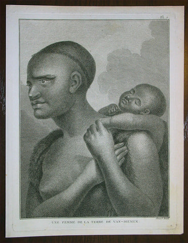
1785 Capt. Cook Antique Print Aboriginal Woman of Bruny Island, Tasmania in 1777
- Title : Une Femme De La Terre De Van-Diemens
- Ref : 43194
- Size: 10in x 8in (255mm x 205mm)
- Date : 1785
- Condition: (A+) Fine Condition
Description:
This fine original copper-plate engraved antique print of an Indigenous Woman & child of Adventure Bay, Bruny Island, Tasmania (Van Diemens Land) encountered by Captain Cook in during his 3rd & last Voyage of Discovery in 1777, was engraved by Robert Benard - after John Webber - and published in the 1785 French edition of Capt. James Cook & Capt. James King A Voyage to the Pacific Ocean. Undertaken, by the Command of his Majesty, for making Discoveries in the Northern Hemisphere. To determine The Position and Extent of the West Side of North America; its Distance from Asia; and the Practicability of a Northen Passage to Europe. Performed under the direction of Captains Cook, Clerke, and Gore, In His Majesty\'s Ships the Resolution and Discovery. In the Years 1776, 1777, 1778, 1779, and 1780. In Three Volumes. Vol. I and II written by James Cook, F.R.S. Vol. III by Captain James King, LL.D. and F.R.S. Paris, 1785.
Adventure Bay
from Cooks Journal......on the 24th (March 1777) at 3 AM we made the Coast of Van Diemen land wrote Cook. Anderson remarked that though now the middle of summer here a spot or two of snow was seen on the highest hills… At ten we passd a point supposd to be the boundary of Stone Bay where Abel Tasman anchord, i.e. Storm Bay. According to David Samwell, surgeons first mate on the Resolution, both Ships anchored in Adventure Bay in Van Diemens Land, this Bay was so called by Captn Furneaux who had anchored here in the Adventure last Voyage.
The next day Cook and Clerke sent parties, one to cut wood and the other grass. Clerke wrote of his party from the Discovery The Guard I had sent with the Parties on shore which consisted of the following Marines, Hamlet Thompson, Geo: Moody, Ben: Harriot, Jos: Pool & Willm Broom, stole some Liquor & made themselves exceedingly drunk, for which they receivd a dozen lashes each in the Morning. The Privates were all from the Plymouth division of marines. Hamlet Thompson was from the 6th Company, George Moody from the 70th, John Herriott the 12th, James Poole the 33rd and William Broom the 36th. According to Thomas Edgar, Master, they made themselves so Beastly Drunk that they were put motionless in the Boat, and when brought on board were oblig\'d to be hoisted into the Ship.
William Bayly, astronomer on the Discovery, wrote In the morning I carried my Tent observatory & Instruments on Shore & set all up, but was not able to get any observations it being cloudy all day, in the evening Capt Cook Sent for me & told me he had Altered his mind relative to his stay, & ordered me to pack all up & carry the whole on board again, as he intend[ed] to sail for New Zealand in a day or two.
John Henry Martin, seaman on the Discovery, described the natives. They have few, or no wants, & seemed perfectly Happy, if one might judge from their behaviour, for they frequently woud burst out, into the most immoderate fits of Laughter & when one Laughed every one followed his example Emediately.
General Definitions:
Paper thickness and quality: - Heavy and stable
Paper color : - off white
Age of map color: -
Colors used: -
General color appearance: -
Paper size: - 10in x 8in (255mm x 205mm)
Plate size: - 9 1/2in x 7 1/4in (240mm x 185mm)
Margins: - Min 1/2in (12mm)
Imperfections:
Margins: - None
Plate area: - None
Verso: - None
Background:
Adventure Bay is the name of both a township and a geographical feature on the eastern side of Bruny Island, Tasmania.
The first European to sight the bay was explorer Abel Tasman, who sought to anchor his vessel Heemskerck there in 1642. Instead, Heemskerck was driven back offshore by a storm, in token of which Tasman named the place Storm Bay. Captain Tobias Furneaux renamed it in March 1773, in honour of his ship HMS Adventure, which he had anchored in the bay for five days after becoming separated from Captain James Cook\'s HMS Resolution during Cook\'s second voyage to the Pacific search of Terra Australis Incognita. Furneaux\'s log made clear the bay was an excellent anchorage for resupplying vessels:....to the SW of the first watering place there is a large lagoon which I believe has plenty of fish in it for one of our Gentlemen caught upwards of 2 dozen trout, and shot a possum which was the only animal we saw. There are a great many gum trees and of a vast thickness and height, one of which measured in circumference 26 feet and the height under the branches was 20 feet.
Others among Furneaux\'s crew spotted evidence of what they believed were small deer but were more likely kangaroos. Furneaux also noted signs of an Aboriginal settlement in the form of several huts or wigwams on shore, with several bags of grass in which they carry their shellfish. - but the branches of which the huts were made were split and torn and there was not the least appearance of any people.
Reliably mapped and offering an abundance of water, fresh water and game, Adventure Bay quickly became a popular anchorage for European explorers. Cooks Resolution watered there in 1777, followed by William Bligh aboard HMS Bounty in 1788 and HMS Providence in 1792. Others who resupplied their vessels in the bay in this period included Bruni d Entrecasteaux aboard Recherché in 1792 and 1793, and Nicolas Baudin in the corvette Géographe in 1802. Matthew Flinders also tried to enter the bay with Norfolk in 1798.
John Hawkesworth 1715 – 1773 English writer and book editor.
He is said to have been clerk to an attorney, and was certainly self-educated. In 1744, he succeeded Samuel Johnson as compiler of the parliamentary debates for the Gentleman\\\'s Magazine, and from 1746 to 1749 he contributed poems signed Greville, or H Greville, to that journal. In company with Johnson and others he started a periodical called The Adventurer, which ran to 140 issues, of which 70 were from the pen of Hawkesworth himself.
On account of what was regarded as his powerful defense of morality and religion, Hawkesworth was rewarded by the archbishop of Canterbury with the degree of LL.D, In 1754–1755 he published an edition (12 vols) of Swifts works, with a life prefixed which Johnson praised in his Lives of the Poets. A larger edition (27 vols) appeared in 1766–1779. He adapted Dryden\\\'s Amphitryon for the Drury Lane stage in 1756, and Southernes Oronooko in 1759. He wrote the libretto of an oratorio Zimri in 1760, and the next year Edgar and Emmeline: a Fairy Tale was produced at Drury Lane. His Almoran and Hamet (1761) was first drafted as a play[citation needed], and a tragedy based on it by S J Pratt, The Fair Circassian (1781), met with some success.
He was commissioned by the Admiralty to edit Captain James Cooks papers relative to his first voyage. For this work, An Account of the Voyages undertaken ... for making discoveries in the Southern Hemisphere and performed by Commodore Byrone John Byron, Captain Wallis, Captain Carteret and Captain Cook (from 1702 to 1771) drawn up from the Journals ... (3 vols, 1773) Hawkesworth is said to have received from the publishers the sum of £6000. His descriptions of the manners and customs of the South Seas were, however, regarded by many critics as inexact and hurtful to the interests of morality, and the severity of their strictures is said to have hastened his death. He was buried in the parish church at Bromley, Kent, where he and his wife had kept a school.
Hawkesworth was a close imitator of Johnson both in style and thought, and was at one time on very friendly terms with him. It is said that he presumed on his success, and lost Johnsons friendship as early as 1756.
Captain James King FRS 1750 – 1784 was an officer of the Royal Navy. He served under James Cook on his last voyage around the world, specialising in taking important astronomical readings using a sextant. After Cook died he helped lead the ships on the remainder of their course, also completing Cook\\\'s account of the voyage. He continued his career in the Navy, reaching the rank of post-captain, commanding several ships and serving in the American War of Independence.
King joined HMS Resolution as second lieutenant, sharing the duties of astronomer with Cook, taking astronomical observations on board by sextant and with Larcum Kendals timekeeper K1, to establish the Resolutions position at sea and on shore by sextant or by astronomical quadrant to establish the geographical position of salient points during the course of Cooks surveys. Thus King\\\'s geographical positions were an important contribution to the accuracy of the various surveys carried out during the voyage and his use of the early chronometers helped prove their use at sea for calculation of Longitude. .
Following the death of Cook, King remained in the Resolution but on the death of Charles Clerke, Cooks successor, King was appointed to command HMS Discovery, the Resolution\\\'s consort, remaining in her for the rest of the voyage. After his return to England King was very much involved in the publication of the official account of Cooks third voyage, writing the third volume at Woodstock, near Oxford, where his brother Thomas was rector of St Mary Magdalene. But shortly after his return King was promoted Post-captain and appointed commander of HMS Crocodile in the English Channel.
John Webber RA 1751 – 1793 was an English artist who accompanied Captain Cook on his third Pacific expedition. He is best known for his images of Australasia, Hawaii and Alaska.
Webber was born in London, educated in Bern and studied painting at Paris.His father was Abraham Wäber, a Swiss sculptor who had moved to London, and changed his name to Webber before marrying a Mrs Mary Quant in 1744.
Webber served as official artist on James Cook\'s third voyage of discovery around the Pacific (1776–80) aboard HMS Resolution. At Adventure Bay in January 1777 he did drawings of A Man of Van Diemens Land and A Woman of Van Diemens Land. He also did many drawings of scenes in New Zealand and the South Sea islands. On this voyage, during which Cook lost his life in a fight in Hawaii, Webber became the first European artist to make contact with Hawaii, then called the Sandwich Islands. He made numerous watercolor landscapes of the islands of Kauai and Hawaii, and also portrayed many of the Hawaiian people.
In April 1778, Captain Cooks ships Resolution and Discovery anchored at Ship Cove, now known as Nootka Sound, Vancouver Island, Canada to refit. The crew took observations and recorded encounters with the local people. Webber made watercolour landscapes including Resolution and Discovery in Ship Cove, 1778. His drawings and paintings were engraved for British Admiraltys account of the expedition, which was published in 1784.
Back in England in 1780 Webber exhibited around 50 works at Royal Academy exhibitions between 1784 and 1792, and was elected an associate of the Royal Academy in 1785 and R.A. in 1791. Most of his work were landscapes. Sometimes figures were included as in A Party from H.M.S. Resolution shooting sea horses\", which was shown at the academy in 1784, and his The Death of Captain Cook became well known through an engraving of it. Another version of this picture is in the William Dixson gallery at Sydney
Robert Bénard 1734 – 1777 was an 18th-century French engraver.
Specialized in the technique of engraving, Robert Ménard is mainly famous for having supplied a significant amount of plates (at least 1,800) to the Encyclopédie by Diderot & d\'Alembert from 1751.
Later, publisher Charles-Joseph Panckoucke reused many of his productions to illustrate the works of his catalog.
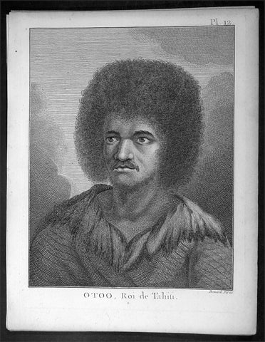
1774 Capt. Cook Antique Print a Portrait of Chief Tynah, Otoo of Tahiti in 1769
- Title : Otoo, Roi de Tahiti
- Ref : 16352
- Size: 10in x 8in (255mm x 205mm)
- Date : 1774
- Condition: (A+) Fine Condition
Description:
This fine original copper-plate engraved antique print a portrait of Chief Tynah (Otoo) of Tahiti Island, met by Captain James Cook during his 1st Voyage of Discovery in 1769, was engraved by Robert Benard - after Sydney Parkinson - and was published in the 1774 French edition of Capt. James Cooks 1st Voyage of Discovery to the South Seas by John Hawkesworth in An Account of the Voyages Undertaken by the Order of His Present Majesty for Making Discoveries in the Southern Hemisphere and Successively Performed by Commodore Byron, Captain Wallis, Captain Carteret, and Captain Cook, in the Dolphin, the Swallow, and the Endeavor, Drawn Up from the Journals Which Were Kept by the Several Commanders, and from the Papers of Joseph Banks. Paris, 1774.
General Definitions:
Paper thickness and quality: - Heavy and stable
Paper color : - off white
Age of map color: -
Colors used: -
General color appearance: -
Paper size: - 10in x 8in (255mm x 205mm)
Plate size: - 9 1/2in x 7 1/4in (240mm x 185mm)
Margins: - Min 1/2in (12mm)
Imperfections:
Margins: - Light soiling in margins
Plate area: - None
Verso: - None
Background:
Tahiti previously also known as Otaheite is the largest island in the Windward group of French Polynesia. The island is located in the archipelago of the Society Islands in the central Southern Pacific Ocean.
The first European to have visited Tahiti according to existing records was lieutenant Samuel Wallis, who was circumnavigating the globe in HMS Dolphin, sighting the island on 18 June 1767, and eventually harboring in Matavai Bay. This bay was situated on the territory of the chiefdom of Pare-Arue, governed by Tu (Tu-nui-e-a a-i-te-Atua) and his regent Tutaha, and the chiefdom of Ha apape, governed by Amo and his wife Oberea (Purea). Wallis named the island King Georges Island. The first contacts were difficult, since on the 24 and 26 June 1767, Tahitian warriors in canoes showed aggression towards the British, hurling stones from their slings. In retaliation, the British sailors opened fire on the warriors in the canoes and on the hills. In reaction to this powerful counter-attack, the Tahitians laid down peace offerings for the British. Following this episode, Samuel Wallis was able to establish cordial relations with the female chieftain “Oberea “ (Purea) and remained on the island until 27 July 1767.
In July 1768, Captain James Cook was commissioned by the Royal Society and on orders from the Lords Commissioners of the Admiralty to observe the transit of Venus across the sun, a phenomenon that would be visible from Tahiti on 3 June 1769. He arrived in Tahitis Matavai Bay, commanding the HMS Endeavour on 12 April 1769. On 14 April, Cook met with Tutaha and Tepau. On 15 April, Cook picked the site for a fortified camp at Point Venus along with Banks, Parkinson, Daniel Solander, to protect Charles Greens observatory. The length of stay enabled them to undertake for the first time real ethnographic and scientific observations of the island. Assisted by the botanist Joseph Banks, and by the artist Sydney Parkinson, Cook gathered valuable information on the fauna and flora, as well as the native society, language and customs, including the proper name of the island, Otaheite. On 28 April, Cook met Purea and Tupaia, and Tupaia befriended Banks following the transit. On 21 June, Amo visited Cook, and then on 25 June, Pohuetea visited, signifying another chief seeking to ally himself with the British.
Cook and Banks circumnavigated the island from 26 June to 1 July. On the exploration, they met Ahio, chief of Ha apaiano o or Papenoo, Rita, chief of Hitia a, Pahairro, chief of Pueu, Vehiatua, chief of Tautra, Matahiapo, chief of Teahupo o, Tutea, chief of Vaira o, and Moe, chief of Afa Ahiti. In Papara, guided by Tupaia, they investigated the ruins of Mahaiatea marae, an impressive structure containing a stone pyramid or ahu, measuring 44 feet high, 267 feet long and 87 feet wide. Cook and the Endeavour departed Tahiti on 13 July 1769, taking Raiatean navigator Tupaia along for his geographic knowledge of the islands.
Cook returned to Tahiti between 15 August and 1 September 1773, greeted by the chiefs Tai and Puhi, besides the youg ari i Vehiatua II and his stepfather Ti itorea. Cook anchored in Vaitepiha Bay before returning to Point Venus where he met Tu, the paramount chief. Cook picked up two passengers from Tahiti during this trip, Porea and Mai, with Hitihiti later replacing Porea when Cook stopped at Raiatea. Cook took Hitihiti to Tahiti on 22 April, during his return leg. Then, Cook departed Tahiti on 14 May 1774.
During his final visit, Cook returned Mai to Tahiti on 12 Aug. 1777, after Mais long visit in England. Cook also brought two Maori from Queen Charlotte Sound, Te Weherua and Koa. Cook first harbored in Vaitepiha Bay, where he visited Vehiatua II s funeral bier and the prefabricated Spanish mission house. Cook also met Vehiatua III, and inscribed on the back of the Spanish cross, Georgius tertius Rex Annis 1767, 69, 73, 74 & 77, as a counterpoint to Christus Vincit Carolus III imperat 1774 on the front. On 23 Aug., Cook sailed for Matavai Bay, where he met Tu, his father Teu, his mother Tetupaia, his brothers Ari ipaea and Vaetua, and his sisters Ari ipaea-vahine, Tetua-te-ahamai, and Auo. Cook also observed a human sacrifice, taata tapu, at the Utu-ai-mahurau marae, and 49 skulls from previous victims.
On 29 Sept. 1777, Cook sailed for Papetoai Bay on Moorea. Cook met Mahine in an act of friendship on 3 Oct., though he was an enemy of Tu. When a goat kid was stolen on 6 Oct., Cook in a rampage, ordered the burning of houses and canoes until it was returned. Cook sailed for Huahine on 11 Oct., Raiatea on 2 Nov., and Borabora on 7 Dec.
On 26 October 1788, HMS Bounty, under the command of Captain William Bligh, landed in Tahiti with the mission of carrying Tahitian breadfruit trees (Tahitian: uru) to the Caribbean. Sir Joseph Banks, the botanist from James Cooks first expedition, had concluded that this plant would be ideal to feed the African slaves working in the Caribbean plantations at very little cost. The crew remained in Tahiti for about five months, the time needed to transplant the seedlings of the trees. Three weeks after leaving Tahiti, on 28 April 1789, the crew mutinied on the initiative of Fletcher Christian. The mutineers seized the ship and set the captain and most of those members of the crew who remained loyal to him adrift in a ships boat. A group of mutineers then went back to settle in Tahiti.
Although various explorers had refused to get involved in tribal conflicts, the mutineers from the Bounty offered their services as mercenaries and furnished arms to the family which became the Pōmare Dynasty. The chief Tū knew how to use their presence in the harbours favoured by sailors to his advantage. As a result of his alliance with the mutineers, he succeeded in considerably increasing his supremacy over the island of Tahiti.
Sydney Parkinson 1745 – 71 was draughtsman to the botanist Sir Joseph Banks on James Cook’s first voyage to the Pacific in 1768. He died of dysentery in 1771, on the homeward voyage.
Parkinson was the first European artist to create drawings of Indigenous Australian, Maori & South Sea peoples, as well as landscapes, from direct observation. Hundreds of his original drawings survive in the British Museum. He is particularly remembered for his plant illustrations which were later used to create the lavish plates for Joseph Banks’ Florilegium.
When the Endeavour returned to England in 1772, a dispute arose between Joseph Banks and Sydney’s brother, Stanfield Parkinson. As his employer, Banks claimed rights to Sydney’s drawings, papers and collections made on the voyage. Stanfield claimed that Sydney had willed them to his family. Banks lent the Parkinson family Sydney’s journal and drawings with instructions that they were not to be published, however Stanfield disregarded this and arranged for A Journal of a voyage to the South Seas to be printed from Sydney’s account of the voyage.
Banks managed to suppress Stanfield’s publication until the official account of the voyage, edited by John Hawkesworth, appeared. In return for Parkinson’s papers, Banks paid Stanfield Parkinson 500 pounds for balance of wages due to Sydney, but the dispute did not end there. Stanfield further accused Banks of retaining items collected by Sydney which were intended for his relatives. Stanfield Parkinson was declared insane soon after the publication of Sydney Parkinson’s Journal and died in an asylum.
John Hawkesworth An English writer and journalist, Hawkesworth was commissioned by the British Admiralty to edit for publication the narratives of its officers’ circumnavigations. He was given full access to the journals of the commanders and the freedom to adapt and re-tell them in the first person. Cook was already on his way back from his second Pacific voyage, temporarily docked at Cape Town (South Africa), when he first saw the published volumes: he was mortified and furious to find that Hawkesworth claimed in the introduction that Cook had seen and blessed (with slight corrections) the resulting manuscript. (In his defense, Hawkesworth also had been a victim of misunderstanding.) Cook had trouble recognizing himself. Moreover, the work was full of errors and commentary introduced by Hawkesworth and, in Cook’s view, too full of Banks, who had promoted himself and the publication. Still, the work was popular; the first edition sold out in several months.
Robert Bénard 1734 – 1777 was an 18th-century French engraver.
Specialized in the technique of engraving, Robert Ménard is mainly famous for having supplied a significant amount of plates (at least 1,800) to the Encyclopédie by Diderot & d\'Alembert from 1751.
Later, publisher Charles-Joseph Panckoucke reused many of his productions to illustrate the works of his catalog.
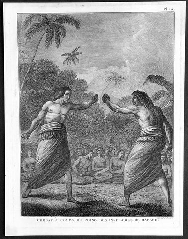
1785 Capt. Cook Antique Print Boxing Match on Ha'apai Isle Tonga Islands in 1777
- Title : Combat a Coups de Poing Des Insulaires De Hapaee
- Ref : 21356
- Size: 10in x 8in (255mm x 205mm)
- Date : 1785
- Condition: (A+) Fine Condition
Description:
This fine original copper-plate engraved antique print of a Boxing Match as seen on an Island in the Ha apai group of the Tongan Islands drawn during a visit by Captain Cook in 1777, during his 3rd and last Voyage of Discovery, was engraved by Robert Benard - after Cooks on-board artist, John Webber - and was published in the 1785 French edition of Capt. James Cook & Capt. James King A Voyage to the Pacific Ocean. Undertaken, by the Command of his Majesty, for making Discoveries in the Northern Hemisphere. To determine The Position and Extent of the West Side of North America; its Distance from Asia; and the Practicability of a Northen Passage to Europe. Performed under the direction of Captains Cook, Clerke, and Gore, In His Majesty\'s Ships the Resolution and Discovery. In the Years 1776, 1777, 1778, 1779, and 1780. In Three Volumes. Vol. I and II written by James Cook, F.R.S. Vol. III by Captain James King, LL.D. and F.R.S. Paris, 1785.
General Definitions:
Paper thickness and quality: - Heavy and stable
Paper color : - off white
Age of map color: -
Colors used: -
General color appearance: -
Paper size: - 10in x 8in (255mm x 205mm)
Plate size: - 9 1/2in x 7 1/4in (240mm x 185mm)
Margins: - Min 1/2in (12mm)
Imperfections:
Margins: - Light soiling in margins
Plate area: - None
Verso: - None
Background:
Ha apai is a group of islands, islets, reefs and shoals with an area of 109.30 square kilometres in the central part of the Kingdom of Tonga, with the Tongatapu group to the south and the Vavau group to the north. Seventeen of the Ha apai islands are populated with altogether 6,616 people.
The first European to visit Ha apai, was Abel Tasman in 1643. Captain James Cook in 1774 and 1777, made several stops on the islands. He gave them the name of Friendly Islands in 1777.
On 18 May 1777, Cook arrived with Omai. They were greeted by Fatafehi Paulaho, King of the Isles or Tui Tonga, the most sacred chief in these islands.
Tonga officially the Kingdom of Tonga, is a Polynesian sovereign state and archipelago comprising 169 islands, of which 36 are inhabited. The total surface area is about 750 square kilometres (290 sq mi) scattered over 700,000 square kilometres (270,000 sq mi) of the southern Pacific Ocean. It has a population of 107,122 people, of whom 70% reside on the main island of Tongatapu.
The Tongan people first encountered Europeans in 1616 when the Dutch vessel Eendracht, captained by Willem Schouten, made a short visit to trade. Later came other Dutch explorers, including Jacob Le Maire (who called on the northern island of Niuatoputapu); and in 1643 Abel Tasman (who visited Tongatapu and Haapai).
Later noteworthy European visitors included James Cook (Royal Navy) in 1773, 1774, and 1777; Alessandro Malaspina (Spanish Navy) in 1793; the first London missionaries in 1797; and the Wesleyan Methodist Reverend Walter Lawry in 1822.
Tonga became known in the West as the Friendly Islands because of the congenial reception accorded to Captain James Cook on his first visit in 1773. He arrived at the time of the inasi festival, the yearly donation of the First Fruits to the Tui Tonga (the islands paramount chief) and so received an invitation to the festivities. According to the writer William Mariner, the chiefs wanted to kill Cook during the gathering but could not agree on a plan.
Captain James King FRS 1750 – 1784 was an officer of the Royal Navy. He served under James Cook on his last voyage around the world, specialising in taking important astronomical readings using a sextant. After Cook died he helped lead the ships on the remainder of their course, also completing Cook\\\'s account of the voyage. He continued his career in the Navy, reaching the rank of post-captain, commanding several ships and serving in the American War of Independence.
King joined HMS Resolution as second lieutenant, sharing the duties of astronomer with Cook, taking astronomical observations on board by sextant and with Larcum Kendals timekeeper K1, to establish the Resolutions position at sea and on shore by sextant or by astronomical quadrant to establish the geographical position of salient points during the course of Cooks surveys. Thus King\\\'s geographical positions were an important contribution to the accuracy of the various surveys carried out during the voyage and his use of the early chronometers helped prove their use at sea for calculation of Longitude. .
Following the death of Cook, King remained in the Resolution but on the death of Charles Clerke, Cooks successor, King was appointed to command HMS Discovery, the Resolution\\\'s consort, remaining in her for the rest of the voyage. After his return to England King was very much involved in the publication of the official account of Cooks third voyage, writing the third volume at Woodstock, near Oxford, where his brother Thomas was rector of St Mary Magdalene. But shortly after his return King was promoted Post-captain and appointed commander of HMS Crocodile in the English Channel.
John Webber RA 1751 – 1793 was an English artist who accompanied Captain Cook on his third Pacific expedition. He is best known for his images of Australasia, Hawaii and Alaska.
Webber was born in London, educated in Bern and studied painting at Paris.His father was Abraham Wäber, a Swiss sculptor who had moved to London, and changed his name to Webber before marrying a Mrs Mary Quant in 1744.
Webber served as official artist on James Cook\'s third voyage of discovery around the Pacific (1776–80) aboard HMS Resolution. At Adventure Bay in January 1777 he did drawings of A Man of Van Diemens Land and A Woman of Van Diemens Land. He also did many drawings of scenes in New Zealand and the South Sea islands. On this voyage, during which Cook lost his life in a fight in Hawaii, Webber became the first European artist to make contact with Hawaii, then called the Sandwich Islands. He made numerous watercolor landscapes of the islands of Kauai and Hawaii, and also portrayed many of the Hawaiian people.
In April 1778, Captain Cooks ships Resolution and Discovery anchored at Ship Cove, now known as Nootka Sound, Vancouver Island, Canada to refit. The crew took observations and recorded encounters with the local people. Webber made watercolour landscapes including Resolution and Discovery in Ship Cove, 1778. His drawings and paintings were engraved for British Admiraltys account of the expedition, which was published in 1784.
Back in England in 1780 Webber exhibited around 50 works at Royal Academy exhibitions between 1784 and 1792, and was elected an associate of the Royal Academy in 1785 and R.A. in 1791. Most of his work were landscapes. Sometimes figures were included as in A Party from H.M.S. Resolution shooting sea horses\", which was shown at the academy in 1784, and his The Death of Captain Cook became well known through an engraving of it. Another version of this picture is in the William Dixson gallery at Sydney
Robert Bénard 1734 – 1777 was an 18th-century French engraver.
Specialized in the technique of engraving, Robert Ménard is mainly famous for having supplied a significant amount of plates (at least 1,800) to the Encyclopédie by Diderot & d\'Alembert from 1751.
Later, publisher Charles-Joseph Panckoucke reused many of his productions to illustrate the works of his catalog.
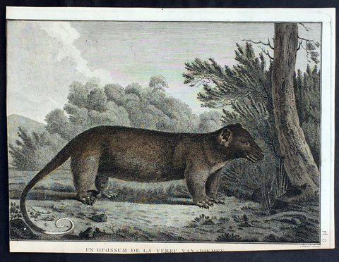
1785 Capt. Cook Antique Print of a Possum from Bruny Island, Tasmania in 1777
- Title : Un Opossum De La Terre Van-Diemen
- Ref : 31801-1
- Size: 14in x 11 1/2in (355mm x 295mm)
- Date : 1784
- Condition: (A) Very Good Condition
Description:
This fine original copper-plate engraved antique print of a Possum of Adventure Bay on Bruny Island, Tasmania (Van Diemens Land) visited by Captain Cook during his 3rd & last Voyage of Discovery in 1777, was engraved by Robert Benard - after Cooks on-board artist, John Webber - and was published in the 1785 French edition of Capt. James Cook & Capt. James King A Voyage to the Pacific Ocean. Undertaken, by the Command of his Majesty, for making Discoveries in the Northern Hemisphere. To determine The Position and Extent of the West Side of North America; its Distance from Asia; and the Practicability of a Northen Passage to Europe. Performed under the direction of Captains Cook, Clerke, and Gore, In His Majesty\'s Ships the Resolution and Discovery. In the Years 1776, 1777, 1778, 1779, and 1780. In Three Volumes. Vol. I and II written by James Cook, F.R.S. Vol. III by Captain James King, LL.D. and F.R.S. Paris, 1785.
......This is the first printed image of an Australian possum made at Adventure Bay. Webber had completed a small group of bird drawings, and one of an opossum both of which had been shot and taken aboard..
General Definitions:
Paper thickness and quality: - Heavy and stable
Paper color : - off white
Age of map color: - Early
Colors used: - Yellow, green, brown
General color appearance: - Authentic
Paper size: - 10in x 8in (255mm x 205mm)
Plate size: - 9 1/2in x 7 1/4in (240mm x 185mm)
Margins: - Min 1/2in (12mm)
Imperfections:
Margins: - Bottom & left margins cropped
Plate area: - None
Verso: - None
Background:
Adventure Bay is the name of both a township and a geographical feature on the eastern side of Bruny Island, Tasmania.
The first European to sight the bay was explorer Abel Tasman, who sought to anchor his vessel Heemskerck there in 1642. Instead, Heemskerck was driven back offshore by a storm, in token of which Tasman named the place Storm Bay. Captain Tobias Furneaux renamed it in March 1773, in honour of his ship HMS Adventure, which he had anchored in the bay for five days after becoming separated from Captain James Cook\'s HMS Resolution during Cook\'s second voyage to the Pacific search of Terra Australis Incognita. Furneaux\'s log made clear the bay was an excellent anchorage for resupplying vessels:....to the SW of the first watering place there is a large lagoon which I believe has plenty of fish in it for one of our Gentlemen caught upwards of 2 dozen trout, and shot a possum which was the only animal we saw. There are a great many gum trees and of a vast thickness and height, one of which measured in circumference 26 feet and the height under the branches was 20 feet.
Others among Furneaux\'s crew spotted evidence of what they believed were small deer but were more likely kangaroos. Furneaux also noted signs of an Aboriginal settlement in the form of several huts or wigwams on shore, with several bags of grass in which they carry their shellfish. - but the branches of which the huts were made were split and torn and there was not the least appearance of any people.
Reliably mapped and offering an abundance of water, fresh water and game, Adventure Bay quickly became a popular anchorage for European explorers. Cooks Resolution watered there in 1777, followed by William Bligh aboard HMS Bounty in 1788 and HMS Providence in 1792. Others who resupplied their vessels in the bay in this period included Bruni d Entrecasteaux aboard Recherché in 1792 and 1793, and Nicolas Baudin in the corvette Géographe in 1802. Matthew Flinders also tried to enter the bay with Norfolk in 1798.
Captain James King FRS 1750 – 1784 was an officer of the Royal Navy. He served under James Cook on his last voyage around the world, specialising in taking important astronomical readings using a sextant. After Cook died he helped lead the ships on the remainder of their course, also completing Cook\\\'s account of the voyage. He continued his career in the Navy, reaching the rank of post-captain, commanding several ships and serving in the American War of Independence.
King joined HMS Resolution as second lieutenant, sharing the duties of astronomer with Cook, taking astronomical observations on board by sextant and with Larcum Kendals timekeeper K1, to establish the Resolutions position at sea and on shore by sextant or by astronomical quadrant to establish the geographical position of salient points during the course of Cooks surveys. Thus King\\\'s geographical positions were an important contribution to the accuracy of the various surveys carried out during the voyage and his use of the early chronometers helped prove their use at sea for calculation of Longitude. .
Following the death of Cook, King remained in the Resolution but on the death of Charles Clerke, Cooks successor, King was appointed to command HMS Discovery, the Resolution\\\'s consort, remaining in her for the rest of the voyage. After his return to England King was very much involved in the publication of the official account of Cooks third voyage, writing the third volume at Woodstock, near Oxford, where his brother Thomas was rector of St Mary Magdalene. But shortly after his return King was promoted Post-captain and appointed commander of HMS Crocodile in the English Channel.
John Webber RA 1751 – 1793 was an English artist who accompanied Captain Cook on his third Pacific expedition. He is best known for his images of Australasia, Hawaii and Alaska.
Webber was born in London, educated in Bern and studied painting at Paris.His father was Abraham Wäber, a Swiss sculptor who had moved to London, and changed his name to Webber before marrying a Mrs Mary Quant in 1744.
Webber served as official artist on James Cook\'s third voyage of discovery around the Pacific (1776–80) aboard HMS Resolution. At Adventure Bay in January 1777 he did drawings of A Man of Van Diemens Land and A Woman of Van Diemens Land. He also did many drawings of scenes in New Zealand and the South Sea islands. On this voyage, during which Cook lost his life in a fight in Hawaii, Webber became the first European artist to make contact with Hawaii, then called the Sandwich Islands. He made numerous watercolor landscapes of the islands of Kauai and Hawaii, and also portrayed many of the Hawaiian people.
In April 1778, Captain Cooks ships Resolution and Discovery anchored at Ship Cove, now known as Nootka Sound, Vancouver Island, Canada to refit. The crew took observations and recorded encounters with the local people. Webber made watercolour landscapes including Resolution and Discovery in Ship Cove, 1778. His drawings and paintings were engraved for British Admiraltys account of the expedition, which was published in 1784.
Back in England in 1780 Webber exhibited around 50 works at Royal Academy exhibitions between 1784 and 1792, and was elected an associate of the Royal Academy in 1785 and R.A. in 1791. Most of his work were landscapes. Sometimes figures were included as in A Party from H.M.S. Resolution shooting sea horses\", which was shown at the academy in 1784, and his The Death of Captain Cook became well known through an engraving of it. Another version of this picture is in the William Dixson gallery at Sydney
Robert Bénard 1734 – 1777 was an 18th-century French engraver.
Specialized in the technique of engraving, Robert Ménard is mainly famous for having supplied a significant amount of plates (at least 1,800) to the Encyclopédie by Diderot & d\'Alembert from 1751.
Later, publisher Charles-Joseph Panckoucke reused many of his productions to illustrate the works of his catalog.
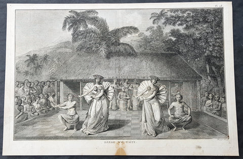
1785 Capt Cook Antique Print of Dancers in Tahiti, French Polynesia in 1777
- Title : Dance D O-Taiti (Dancers of Tahiti)
- Size: 15 1/2in x 10in (395mm x 255mm)
- Ref #: 91224
- Date : 1785
- Condition: (A) Very Good Condition
Description:
This fine original copper-plate engraved antique print of dancers in Tahiti, visited by Captain Cook in 1777, during his 3rd & last Voyage of Discovery, was engraved by Robert Benard - after John Webber - and was published in the 1785 French edition of Capt. James Cook & Capt. James King publication A Voyage to the Pacific Ocean. Undertaken, by the Command of his Majesty, for making Discoveries in the Northern Hemisphere. To determine The Position and Extent of the West Side of North America; its Distance from Asia; and the Practicability of a Northern Passage to Europe. Performed under the direction of Captains Cook, Clerke, and Gore, In His Majestys Ships the Resolution and Discovery. In the Years 1776, 1777, 1778, 1779, and 1780. In Three Volumes. Vol. I and II written by James Cook, F.R.S. Vol. III by Captain James King, LL.D. and F.R.S. Paris, 1785.
John Webber was the artist on Cook’s third voyage from 1776-1780. Cook was in Matavai Bay, Tahiti, Society Islands from August 24-September 30, 1777. Matavai Bay was the most famous place in the South Seas, already visited on several occasions and made known by engravings after Sydney Parkinson and William Hodges. By the time Webber arrived in Tahiti, \'south sea\' imagery had become familiar. Webber gave concentrated attention to dance. He had the opportunity to distinguish the Tahitian dance from the more formalized dancing of Tonga. Whereas they seem to have called to mind the more formal dances of antiquity, the Tahitian dancing aroused memories of peasant and folk dancing. Webbers A Dance in Otaheite repeats some of the elements of Ciprianis composition, the drummers, the girls dancing in long gowns, with highly puckered ruffs of tapa attached to the back of the waist and feathery pompons covering the breasts. Similar too are the head-dresses mae from plaited hair and ornamented with blossoms of the Cape Jasmin. A mat of rushes had been laid to dance upon. Eight years before, when Parkinson described a Tahitian dance in his journal, he noted: In the interval, between the several parts of the drama, some men came forward, who seemed, to act the part of drolls. The two men portrayed here seem to be playing a similar role. This is the first of two such engravings.
General Definitions:
Paper thickness and quality: - Heavy and stable
Paper color : - off white
Age of map color: -
Colors used: -
General color appearance: -
Paper size: - 15 1/2in x 10in (395mm x 255mm)
Plate size: - 15in x 9 1/2in (380mm x 245mm)
Margins: - Min 1/2in (12mm)
Imperfections:
Margins: - Light soiling
Plate area: - None
Verso: - Light soiling
Background:
Tahiti previously also known as Otaheite is the largest island in the Windward group of French Polynesia. The island is located in the archipelago of the Society Islands in the central Southern Pacific Ocean.
The first European to have visited Tahiti according to existing records was lieutenant Samuel Wallis, who was circumnavigating the globe in HMS Dolphin, sighting the island on 18 June 1767, and eventually harboring in Matavai Bay. This bay was situated on the territory of the chiefdom of Pare-Arue, governed by Tu (Tu-nui-e-a a-i-te-Atua) and his regent Tutaha, and the chiefdom of Ha apape, governed by Amo and his wife Oberea (Purea). Wallis named the island King Georges Island. The first contacts were difficult, since on the 24 and 26 June 1767, Tahitian warriors in canoes showed aggression towards the British, hurling stones from their slings. In retaliation, the British sailors opened fire on the warriors in the canoes and on the hills. In reaction to this powerful counter-attack, the Tahitians laid down peace offerings for the British. Following this episode, Samuel Wallis was able to establish cordial relations with the female chieftain “Oberea “ (Purea) and remained on the island until 27 July 1767.
In July 1768, Captain James Cook was commissioned by the Royal Society and on orders from the Lords Commissioners of the Admiralty to observe the transit of Venus across the sun, a phenomenon that would be visible from Tahiti on 3 June 1769. He arrived in Tahitis Matavai Bay, commanding the HMS Endeavour on 12 April 1769. On 14 April, Cook met with Tutaha and Tepau. On 15 April, Cook picked the site for a fortified camp at Point Venus along with Banks, Parkinson, Daniel Solander, to protect Charles Greens observatory. The length of stay enabled them to undertake for the first time real ethnographic and scientific observations of the island. Assisted by the botanist Joseph Banks, and by the artist Sydney Parkinson, Cook gathered valuable information on the fauna and flora, as well as the native society, language and customs, including the proper name of the island, Otaheite. On 28 April, Cook met Purea and Tupaia, and Tupaia befriended Banks following the transit. On 21 June, Amo visited Cook, and then on 25 June, Pohuetea visited, signifying another chief seeking to ally himself with the British.
Cook and Banks circumnavigated the island from 26 June to 1 July. On the exploration, they met Ahio, chief of Ha apaiano o or Papenoo, Rita, chief of Hitia a, Pahairro, chief of Pueu, Vehiatua, chief of Tautra, Matahiapo, chief of Teahupo o, Tutea, chief of Vaira o, and Moe, chief of Afa Ahiti. In Papara, guided by Tupaia, they investigated the ruins of Mahaiatea marae, an impressive structure containing a stone pyramid or ahu, measuring 44 feet high, 267 feet long and 87 feet wide. Cook and the Endeavour departed Tahiti on 13 July 1769, taking Raiatean navigator Tupaia along for his geographic knowledge of the islands.
Cook returned to Tahiti between 15 August and 1 September 1773, greeted by the chiefs Tai and Puhi, besides the youg ari i Vehiatua II and his stepfather Ti itorea. Cook anchored in Vaitepiha Bay before returning to Point Venus where he met Tu, the paramount chief. Cook picked up two passengers from Tahiti during this trip, Porea and Mai, with Hitihiti later replacing Porea when Cook stopped at Raiatea. Cook took Hitihiti to Tahiti on 22 April, during his return leg. Then, Cook departed Tahiti on 14 May 1774.
During his final visit, Cook returned Mai to Tahiti on 12 Aug. 1777, after Mais long visit in England. Cook also brought two Maori from Queen Charlotte Sound, Te Weherua and Koa. Cook first harbored in Vaitepiha Bay, where he visited Vehiatua II s funeral bier and the prefabricated Spanish mission house. Cook also met Vehiatua III, and inscribed on the back of the Spanish cross, Georgius tertius Rex Annis 1767, 69, 73, 74 & 77, as a counterpoint to Christus Vincit Carolus III imperat 1774 on the front. On 23 Aug., Cook sailed for Matavai Bay, where he met Tu, his father Teu, his mother Tetupaia, his brothers Ari ipaea and Vaetua, and his sisters Ari ipaea-vahine, Tetua-te-ahamai, and Auo. Cook also observed a human sacrifice, taata tapu, at the Utu-ai-mahurau marae, and 49 skulls from previous victims.
On 29 Sept. 1777, Cook sailed for Papetoai Bay on Moorea. Cook met Mahine in an act of friendship on 3 Oct., though he was an enemy of Tu. When a goat kid was stolen on 6 Oct., Cook in a rampage, ordered the burning of houses and canoes until it was returned. Cook sailed for Huahine on 11 Oct., Raiatea on 2 Nov., and Borabora on 7 Dec.
On 26 October 1788, HMS Bounty, under the command of Captain William Bligh, landed in Tahiti with the mission of carrying Tahitian breadfruit trees (Tahitian: uru) to the Caribbean. Sir Joseph Banks, the botanist from James Cooks first expedition, had concluded that this plant would be ideal to feed the African slaves working in the Caribbean plantations at very little cost. The crew remained in Tahiti for about five months, the time needed to transplant the seedlings of the trees. Three weeks after leaving Tahiti, on 28 April 1789, the crew mutinied on the initiative of Fletcher Christian. The mutineers seized the ship and set the captain and most of those members of the crew who remained loyal to him adrift in a ships boat. A group of mutineers then went back to settle in Tahiti.
Although various explorers had refused to get involved in tribal conflicts, the mutineers from the Bounty offered their services as mercenaries and furnished arms to the family which became the Pōmare Dynasty. The chief Tū knew how to use their presence in the harbours favoured by sailors to his advantage. As a result of his alliance with the mutineers, he succeeded in considerably increasing his supremacy over the island of Tahiti.
Captain James King FRS 1750 – 1784 was an officer of the Royal Navy. He served under James Cook on his last voyage around the world, specialising in taking important astronomical readings using a sextant. After Cook died he helped lead the ships on the remainder of their course, also completing Cooks account of the voyage. He continued his career in the Navy, reaching the rank of post-captain, commanding several ships and serving in the American War of Independence.
King joined HMS Resolution as second lieutenant, sharing the duties of astronomer with Cook, taking astronomical observations on board by sextant and with Larcum Kendals timekeeper K1, to establish the Resolutions position at sea and on shore by sextant or by astronomical quadrant to establish the geographical position of salient points during the course of Cooks surveys. Thus Kings geographical positions were an important contribution to the accuracy of the various surveys carried out during the voyage and his use of the early chronometers helped prove their use at sea for calculation of Longitude. .
Following the death of Cook, King remained in the Resolution but on the death of Charles Clerke, Cooks successor, King was appointed to command HMS Discovery, the Resolutions consort, remaining in her for the rest of the voyage. After his return to England King was very much involved in the publication of the official account of Cooks third voyage, writing the third volume at Woodstock, near Oxford, where his brother Thomas was rector of St Mary Magdalene. But shortly after his return King was promoted Post-captain and appointed commander of HMS Crocodile in the English Channel.
John Webber RA 1751 – 1793 was an English artist who accompanied Captain Cook on his third Pacific expedition. He is best known for his images of Australasia, Hawaii and Alaska.
Webber was born in London, educated in Bern and studied painting at Paris.His father was Abraham Wäber, a Swiss sculptor who had moved to London, and changed his name to Webber before marrying a Mrs Mary Quant in 1744.
Webber served as official artist on James Cooks third voyage of discovery around the Pacific (1776–80) aboard HMS Resolution. At Adventure Bay in January 1777 he did drawings of A Man of Van Diemens Land and A Woman of Van Diemens Land. He also did many drawings of scenes in New Zealand and the South Sea islands. On this voyage, during which Cook lost his life in a fight in Hawaii, Webber became the first European artist to make contact with Hawaii, then called the Sandwich Islands. He made numerous watercolor landscapes of the islands of Kauai and Hawaii, and also portrayed many of the Hawaiian people.
In April 1778, Captain Cooks ships Resolution and Discovery anchored at Ship Cove, now known as Nootka Sound, Vancouver Island, Canada to refit. The crew took observations and recorded encounters with the local people. Webber made watercolour landscapes including Resolution and Discovery in Ship Cove, 1778. His drawings and paintings were engraved for British Admiraltys account of the expedition, which was published in 1784.
Back in England in 1780 Webber exhibited around 50 works at Royal Academy exhibitions between 1784 and 1792, and was elected an associate of the Royal Academy in 1785 and R.A. in 1791. Most of his work were landscapes. Sometimes figures were included as in A Party from H.M.S. Resolution shooting sea horses, which was shown at the academy in 1784, and his The Death of Captain Cook became well known through an engraving of it. Another version of this picture is in the William Dixson gallery at Sydney
Robert Bénard 1734 – 1777 was an 18th-century French engraver.
Specialized in the technique of engraving, Robert Ménard is mainly famous for having supplied a significant amount of plates (at least 1,800) to the Encyclopédie by Diderot & d Alembert from 1751.
Later, publisher Charles-Joseph Panckoucke reused many of his productions to illustrate the works of his catalog.
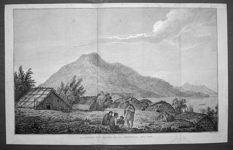
1785 Cook Antique Print of a Marae on Motuara Is. Queen Charlotte Sound, New Zealand 1777
- Title : Interieur D Un Hippah De La Nouvelle Zelande
- Ref : 50607
- Size: 15 3/4in x 9 3/4in (400mm x 250mm)
- Date : 1785
- Condition: (A+) Fine Condition
Description:
This fine original copper-plate engraved antique print of a Maori Marae on Motuara Island in Queen Charlotte Sound, New Zealand, visited by Captain Cook in HMS Resolution & Discovery in February 1777, during his 3rd & last Voyage of Discovery, was engraved by Robert Benard - after John Webber - and was published in the 1785 French edition of Capt. James Cook & Capt. James King publication A Voyage to the Pacific Ocean. Undertaken, by the Command of his Majesty, for making Discoveries in the Northern Hemisphere. To determine The Position and Extent of the West Side of North America; its Distance from Asia; and the Practicability of a Northen Passage to Europe. Performed under the direction of Captains Cook, Clerke, and Gore, In His Majesty\\\'s Ships the Resolution and Discovery. In the Years 1776, 1777, 1778, 1779, and 1780. In Three Volumes. Vol. I and II written by James Cook, F.R.S. Vol. III by Captain James King, LL.D. and F.R.S. Paris, 1785.
John Webber made countless watercolours, pen and ink sketches and drawings on James Cooks third voyage to the Pacific (1776-80). These were the basis for the finished watercolours which engravers used in producing the 61 illustrations for the official published account of his third voyage.
The Inside of a Hippah is the only New Zealand plate in the publication. This reflects the fact that only a short time was spent in the country on the third voyage, and also the cautionary approach taken during their stay here. The ships moored in Ship Cove, Queen Charlotte Sound from 12-25 February 1777. On Cooks previous voyage a boat load of people had been attacked and killed there. Consequently, shore parties were only made in large armed groups and Webber would have been restricted in his ability to record the area and its inhabitants.
Depicted is a scene from Queen Charlotte Sound, probably Motuara Island with the waters of the Sound to the right. Cook recounted visiting the Island on 15 February 1777, noting that it was currently uninhabited, although showed signs of recent occupation with parts rebuilt since their last visit. Webber, however, populates his view, placing four figures in conversation in the foreground, with another group beyond to the right. Joppien and Smith suggest that he does this so as to strike a humane and deliberately pensive note, one which would appeal to current European sentiment They add that European artists at this time still included \'staffage\' to provide interest in landscape views and further it provided Webber with the opportunity to record the dress and weaponry of Māori. The inclusion of Māori housing reveals Cook\'s ethnographic interest. The Royal Society had recommended that he pay particular attention to the housing of the natives he encountered as it was indicative of the type of society, and he therefore made detailed notes about habitation practices on his journeys.
General Definitions:
Paper thickness and quality: - Heavy and stable
Paper color : - off white
Age of map color: -
Colors used: -
General color appearance: -
Paper size: - 15 3/4in x 9 3/4in (400mm x 250mm)
Plate size: - 14 3/4in x 9 1/2in (375mm x 245mm)
Margins: - Min 1/2in (12mm)
Imperfections:
Margins: - None
Plate area: - Folds as issued
Verso: - None
Background:
In New Zeland Māori society, the marae is a place where the culture can be celebrated, where the Māori language can be spoken, where intertribal obligations can be met, where customs can be explored and debated, where family occasions such as birthdays can be held, and where important ceremonies, such as welcoming visitors or farewelling the dead (tangihanga), can be performed. Like the related institutions of old Polynesia, the marae is a wāhi tapu, a \'sacred place\' which carries great cultural meaning.
In Māori usage, the marae atea (often shortened to marae) is the open space in front of the wharenui or meeting house (literally large building). However, the term marae is generally used to refer to the whole complex, including the buildings and the open space. This area is used for pōwhiri – welcome ceremonies featuring oratory. Some marae do not allow women to perform oratory there. The meeting house is the locale for important meetings, sleepovers, and craft and other cultural activities. The wharekai (dining hall) is used primarily for communal meals, but other activities may be carried out there. Many of the words associated with marae in tropical Polynesia are retained in the Māori context. For example, the word paepae refers to the bench where the speakers sit; this means it retains its sacred and ceremonial associations. Marae occur in various sizes, with some wharenui being a bit bigger than a double garage and some being larger than a town hall.
New Zealand, Aotearoa is an island country in the southwestern Pacific Ocean. The country geographically comprises two main landmasses—the North Island (or Te Ika-a-Māui), and the South Island (or Te Waipounamu)—and around 600 smaller islands. New Zealand is situated some 1,500 kilometres east of Australia across the Tasman Sea and roughly 1,000 kilometres south of the Pacific island areas of New Caledonia, Fiji, and Tonga.
The first Europeans known to have reached New Zealand were Dutch explorer Abel Tasman and his crew in 1642. In a hostile encounter, four crew members were killed and at least one Māori was hit by canister shot. Europeans did not revisit New Zealand until 1769 when British explorer James Cook mapped almost the entire coastline. Cook revisited New Zealand on voyages 2&3, in 1773 & 1777.
Captain James King FRS 1750 – 1784 was an officer of the Royal Navy. He served under James Cook on his last voyage around the world, specialising in taking important astronomical readings using a sextant. After Cook died he helped lead the ships on the remainder of their course, also completing Cooks account of the voyage. He continued his career in the Navy, reaching the rank of post-captain, commanding several ships and serving in the American War of Independence.
King joined HMS Resolution as second lieutenant, sharing the duties of astronomer with Cook, taking astronomical observations on board by sextant and with Larcum Kendals timekeeper K1, to establish the Resolutions position at sea and on shore by sextant or by astronomical quadrant to establish the geographical position of salient points during the course of Cooks surveys. Thus Kings geographical positions were an important contribution to the accuracy of the various surveys carried out during the voyage and his use of the early chronometers helped prove their use at sea for calculation of Longitude. .
Following the death of Cook, King remained in the Resolution but on the death of Charles Clerke, Cooks successor, King was appointed to command HMS Discovery, the Resolutions consort, remaining in her for the rest of the voyage. After his return to England King was very much involved in the publication of the official account of Cooks third voyage, writing the third volume at Woodstock, near Oxford, where his brother Thomas was rector of St Mary Magdalene. But shortly after his return King was promoted Post-captain and appointed commander of HMS Crocodile in the English Channel.
John Webber RA 1751 – 1793 was an English artist who accompanied Captain Cook on his third Pacific expedition. He is best known for his images of Australasia, Hawaii and Alaska.
Webber was born in London, educated in Bern and studied painting at Paris.His father was Abraham Wäber, a Swiss sculptor who had moved to London, and changed his name to Webber before marrying a Mrs Mary Quant in 1744.
Webber served as official artist on James Cooks third voyage of discovery around the Pacific (1776–80) aboard HMS Resolution. At Adventure Bay in January 1777 he did drawings of A Man of Van Diemens Land and A Woman of Van Diemens Land. He also did many drawings of scenes in New Zealand and the South Sea islands. On this voyage, during which Cook lost his life in a fight in Hawaii, Webber became the first European artist to make contact with Hawaii, then called the Sandwich Islands. He made numerous watercolor landscapes of the islands of Kauai and Hawaii, and also portrayed many of the Hawaiian people.
In April 1778, Captain Cooks ships Resolution and Discovery anchored at Ship Cove, now known as Nootka Sound, Vancouver Island, Canada to refit. The crew took observations and recorded encounters with the local people. Webber made watercolour landscapes including Resolution and Discovery in Ship Cove, 1778. His drawings and paintings were engraved for British Admiraltys account of the expedition, which was published in 1784.
Back in England in 1780 Webber exhibited around 50 works at Royal Academy exhibitions between 1784 and 1792, and was elected an associate of the Royal Academy in 1785 and R.A. in 1791. Most of his work were landscapes. Sometimes figures were included as in A Party from H.M.S. Resolution shooting sea horses, which was shown at the academy in 1784, and his The Death of Captain Cook became well known through an engraving of it. Another version of this picture is in the William Dixson gallery at Sydney
Robert Bénard 1734 – 1777 was an 18th-century French engraver.
Specialized in the technique of engraving, Robert Ménard is mainly famous for having supplied a significant amount of plates (at least 1,800) to the Encyclopédie by Diderot & d Alembert from 1751.
Later, publisher Charles-Joseph Panckoucke reused many of his productions to illustrate the works of his catalog.
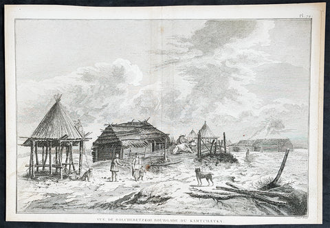
1785 Cook Antique Print View of Ust-Bolsheretsk, Kamchatka Peninsula Russia 1779
- Title : Vue De Bolcheretzkoi Bourgade Du Kamtchatka (View of Ust-Bolsheretsk town in Kamchatka)
- Size: 14 1/2in x 10in (370mm x 255mm)
- Ref #: 31796
- Date : 1785
- Condition: (A+) Fine Condition
Description:
This fine original copper-plate engraved antique print view of the settlement of Ust-Bolsheretsk on west coast of the Kamchatka Peninsula in Eastern Russia, visited by HMS Resolution & Discovery in December 1779, after the death of Cook, with Resolution under the command of Captain Clerk, during the 3rd & last Voyage of Discovery, was engraved by Robert Benard - after John Webber - and was published in the 1785 French edition of Capt. James Cook & Capt. James King publication A Voyage to the Pacific Ocean. Undertaken, by the Command of his Majesty, for making Discoveries in the Northern Hemisphere. To determine The Position and Extent of the West Side of North America; its Distance from Asia; and the Practicability of a Northern Passage to Europe. Performed under the direction of Captains Cook, Clerke, and Gore, In His Majestys Ships the Resolution and Discovery. In the Years 1776, 1777, 1778, 1779, and 1780. In Three Volumes. Vol. I and II written by James Cook, F.R.S. Vol. III by Captain James King, LL.D. and F.R.S. Paris, 1785.
On May 13 1779, Capt. King recorded;
We employd the afternoon in seeing the town & Country for many miles about is a low swamp....The Earth was in most parts cover\'d with snow;.....We saw I suppose 20 or 30 Milch Cows & the Maor [Behm} had 6 stout horses, all of which were in good Case; These & the dogs are the only domestic Animals ...The houses are all after the fashion, that is built of logs & thatch\'d. King/Cook Journals III, 667-8.
Journal 1779
Jan. 5 Tue. Passes south of Island, Kalae. Frequently visited by canoes with supplies.
17 Sun. Anchors at Kealakekua Bay. Provisions ships and meets inhabitants who appear friendly and seem to reverence him.
Feb. 1 Mon. William Watman, seaman, dies of a stroke and is buried near a chief\'s burial place.
4 Thu. Ships sail north to investigate islands.
6 Sat. Off Kawaihae Bay.
8 Mon. Finds that the mast is sprung (it had been replaced in Nootka Sound) and decides to head back to Kealakekua Bay to replace it.
11 Wed. Anchors in Bay.
14 Sun. Cook along with Marines, Corporal Thomas, Privates Hinks, Allen and Fatchett are killed ashore near village of Kaawaloa, about 9 a.m. There had been ill feeling, menaces and theft - particularly Discovery\'s cutter - and Cook had gone ashore to settle the matter. Confusion, musket fire and mis-interpreted signals led to the tragedy and the resulting contemporary confusion of accounts and paintings of the scene. Clerke assumes command of Resolution and the voyage and Gore takes over the Discovery.
20 Sat. Clerke demands and obtains Cook\'s remains from the natives. The disfigured head, unrecognisable, severed hands - one identified by distinctive scar between thumb and forefinger of right hand caused by explosion of powder horn, 6th. August 1764, Noddy Harbour, Newfoundland. Possible jawbone and feet later returned with shoes and damaged musket.
21 Sun. Cook\'s remains are placed in coffin and he is buried at sea in the late afternoon.
22 Mon. Sails for Kamchatka.
24 Wed. Off Kahoolawe, Males Bay, sights Kekaa Point (W. tip of Maui).
25 Thu. Sights Lanai, Cape Kaea.
26 Fri. Off Molokai and Oahu.
27 Sat. Goes ashore at Waimea Bay.
28 Sun. Sights Kauai.
Mar. 1 Mon. Goes ashore again, trouble. Remains until 8 March.
8 Mon. Off Cape Kawaihoa (Niihau). Goes ashore. Trading & supplies.
15 Mon. Sails, finally, for Kamchatka.
Apr. 23 Tue. Kamchatka sighted.
29 Mon. Anchors in Avacha Bay, about 7½ miles from Petropavlovsk. Several anchorages are then tried in Bay. Clerke decides to send letters to Major Behm, Governor. Gore, King and Webber sent by sledge. Also take Cook\'s Journal etc.; which arrive at the Admiralty, London, seven months later. Vessels provisioned etc. Visited by Russian soldiers, merchants and local priest. Observatory erected
May 7 Fri. Above party, Russian merchants, Germans set off for Bolsherstsk where they are well received.
General Definitions:
Paper thickness and quality: - Heavy and stable
Paper color : - off white
Age of map color: -
Colors used: -
General color appearance: -
Paper size: - 14 1/2in x 10in (370mm x 255mm)
Plate size: - 14in x 10in (365mm x 255mm)
Margins: - Min 1/2in (12mm)
Imperfections:
Margins: - Light soiling
Plate area: - None
Verso: - Light soiling
Background:
The Kamchatka Peninsula is a 1,250 kilometer long peninsula in the Russian Far East.
Politically, the peninsula forms part of Kamchatka Krai. The southern tip is called Cape Lopatka. The circular bay to the north of this on the Pacific side is Avacha Bay with the capital, Petropavlovsk-Kamchatsky.
Captain James King FRS 1750 – 1784 was an officer of the Royal Navy. He served under James Cook on his last voyage around the world, specialising in taking important astronomical readings using a sextant. After Cook died he helped lead the ships on the remainder of their course, also completing Cooks account of the voyage. He continued his career in the Navy, reaching the rank of post-captain, commanding several ships and serving in the American War of Independence.
King joined HMS Resolution as second lieutenant, sharing the duties of astronomer with Cook, taking astronomical observations on board by sextant and with Larcum Kendals timekeeper K1, to establish the Resolutions position at sea and on shore by sextant or by astronomical quadrant to establish the geographical position of salient points during the course of Cooks surveys. Thus Kings geographical positions were an important contribution to the accuracy of the various surveys carried out during the voyage and his use of the early chronometers helped prove their use at sea for calculation of Longitude. .
Following the death of Cook, King remained in the Resolution but on the death of Charles Clerke, Cooks successor, King was appointed to command HMS Discovery, the Resolutions consort, remaining in her for the rest of the voyage. After his return to England King was very much involved in the publication of the official account of Cooks third voyage, writing the third volume at Woodstock, near Oxford, where his brother Thomas was rector of St Mary Magdalene. But shortly after his return King was promoted Post-captain and appointed commander of HMS Crocodile in the English Channel.
John Webber RA 1751 – 1793 was an English artist who accompanied Captain Cook on his third Pacific expedition. He is best known for his images of Australasia, Hawaii and Alaska.
Webber was born in London, educated in Bern and studied painting at Paris.His father was Abraham Wäber, a Swiss sculptor who had moved to London, and changed his name to Webber before marrying a Mrs Mary Quant in 1744.
Webber served as official artist on James Cooks third voyage of discovery around the Pacific (1776–80) aboard HMS Resolution. At Adventure Bay in January 1777 he did drawings of A Man of Van Diemens Land and A Woman of Van Diemens Land. He also did many drawings of scenes in New Zealand and the South Sea islands. On this voyage, during which Cook lost his life in a fight in Hawaii, Webber became the first European artist to make contact with Hawaii, then called the Sandwich Islands. He made numerous watercolor landscapes of the islands of Kauai and Hawaii, and also portrayed many of the Hawaiian people.
In April 1778, Captain Cooks ships Resolution and Discovery anchored at Ship Cove, now known as Nootka Sound, Vancouver Island, Canada to refit. The crew took observations and recorded encounters with the local people. Webber made watercolour landscapes including Resolution and Discovery in Ship Cove, 1778. His drawings and paintings were engraved for British Admiraltys account of the expedition, which was published in 1784.
Back in England in 1780 Webber exhibited around 50 works at Royal Academy exhibitions between 1784 and 1792, and was elected an associate of the Royal Academy in 1785 and R.A. in 1791. Most of his work were landscapes. Sometimes figures were included as in A Party from H.M.S. Resolution shooting sea horses, which was shown at the academy in 1784, and his The Death of Captain Cook became well known through an engraving of it. Another version of this picture is in the William Dixson gallery at Sydney
Robert Bénard 1734 – 1777 was an 18th-century French engraver.
Specialized in the technique of engraving, Robert Ménard is mainly famous for having supplied a significant amount of plates (at least 1,800) to the Encyclopédie by Diderot & d Alembert from 1751.
Later, publisher Charles-Joseph Panckoucke reused many of his productions to illustrate the works of his catalog.
1786 Chris. Cellarius Old, Antique Atlas Geographia - w/ 27 Maps and Armillary
- Title : CHRISTOPHORI CELLARII SMALCALDENSIS GEOGRAPHIA ANTIQUA - Recognita denuo & ad veterum novorumque scriptorium fidem, historicorum maxime identidem castigate & Quinta Editione plurimis locis aucta & immutata
- Ref #: 61153
- Size: 8 1/2in x 5 1/2in (21.5cm x 13.5cm)
- Date : 1786
- Condition: (A) Good Condition
Description:
Scarce edition of the Christopher Cellarius unique 1786 Atlas Geographiawith 27 folding maps. Overall condition of the Atlas is Good (see below) with the contents in VG to Fine condition.
Beautiful example of this iconic Atlas complete.
Description: "CHRISTOPHORI CELLARII SMALCALDENSIS GEOGRAPHIA ANTIQUA - Recognita denuo & ad veterum novorumque scriptorium fidem, historicorum maxime identidem castigate & Quinta Editione plurimis locis aucta & immutata - Huic demum Sextae Editioni Tot CHARTAS ex majori auctoris Geographia antiqua quot ad minorem hanc illustrandam requirebantur, DUPLICEMQUE INDICEM QUORUM Priori vetera locorum nomina novis praeponuntur Posteriori nova veteribus, Addidit, totam recensuit & Scholarum usui accommodavit. SAMUEL PATRICK, L.L.D. EDITIO altera & castigatior.LONDINISumptibus J & T. POTE, E. BALLARD, C. BATHURST, J. F. & C. RIVINGTON, T. LONGMAN & G. GINGER M.DCC.LXXXVI" (1786)
Bound in full leather with five raised bands to spine. Volume measures approx. 21.5cm x 13.5cm x 2cm. The front and rear boards are cracked to spine edges and have some movement. Chipped to top and bottom of spine and corners, with small loss. There are a couple of chips to leather. The first page is the title page and last leaf is the last leaf of text. Fixed endpapers are browned.
The title page, and last leaf are browned to edges, and there is an ink mark to last leaf. Couple of leaves and a map are detached. One page has large corner chip, with loss. There are a couple of ink numbers/marks to rear of one of the maps, and the occasional ink mark and splash. Overall the majority of contents are in clean and tight condition.
There are 27 folding maps with armillary Sphere. Atlas content index (see images)
Background: Geographica was one of the most popular geographical publications of the 17th and 18th centuries lasting into the 19th century. (Ref: Tooley; M&B)
General Description:
Paper thickness and quality: - Heavy and stable
Paper color: - off white
Age of map color: -
Colors used: -
General color appearance: -
Atlas size: - 8 1/2in x 5 1/2in (21.5cm x 13.5cm)
Map size: - 9 1/2in x 8 1/2in (23cm x 21.5cm)
Margins: - Min 1/2in (12mm)
Imperfections:
Margins: - See above
Plate area: - See above
Verso: - See above
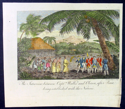
1787 Bankes Antique Print Capt. Wallis making peace with Queen Purea of Tahiti in 1767
- Title : The Interview bewteen Capt Wallis and Oberea after Peace being established with the Natives
- Size: 9 1/2in x 7 1/2in (240mm x 190mm)
- Ref #: 21380
- Date : 1787
- Condition: (A+) Fine Condition
Description:
This fine original cooper-plate engraved antique print of Captain Samuel Wallis negotiating Peace Terms with Queen Purea (Oberea) of Tahiti in 1767 (please read more below) was published in Thomas Bankes 1787 edition of A New, Royal and Authentic System of Universal Geography, Antient and Modern..... printed by Charles Cook, London.
General Definitions:
Paper thickness and quality: - Heavy and stable
Paper color : - off white
Age of map color: - Early
Colors used: - Yellow, green, red, blue
General color appearance: - Authentic
Paper size: - 9 1/2in x 7 1/2in (240mm x 190mm)
Plate size: - 9 1/2in x 7 1/2in (240mm x 190mm)
Margins: - Min 1/2in (12mm)
Imperfections:
Margins: - None
Plate area: - None
Verso: - None
Background:
Tahiti previously also known as Otaheite is the largest island in the Windward group of French Polynesia. The island is located in the archipelago of the Society Islands in the central Southern Pacific Ocean.
The first European to have visited Tahiti according to existing records was lieutenant Samuel Wallis, who was circumnavigating the globe in HMS Dolphin, sighting the island on 18 June 1767, and eventually harboring in Matavai Bay. This bay was situated on the territory of the chiefdom of Pare-Arue, governed by Tu (Tu-nui-e-a\\\\\\\'a-i-te-Atua) and his regent Tutaha, and the chiefdom of Ha apape, governed by Amo and his wife Oberea (Purea). Wallis named the island King Georges Island. The first contacts were difficult, since on the 24 and 26 June 1767, Tahitian warriors in canoes showed aggression towards the British, hurling stones from their slings. In retaliation, the British sailors opened fire on the warriors in the canoes and on the hills. In reaction to this powerful counter-attack, the Tahitians laid down peace offerings for the British. Following this episode, Samuel Wallis was able to establish cordial relations with the female chieftain “Oberea “ (Purea) and remained on the island until 27 July 1767.
In July 1768, Captain James Cook was commissioned by the Royal Society and on orders from the Lords Commissioners of the Admiralty to observe the transit of Venus across the sun, a phenomenon that would be visible from Tahiti on 3 June 1769. He arrived in Tahitis Matavai Bay, commanding the HMS Endeavour on 12 April 1769. On 14 April, Cook met with Tutaha and Tepau. On 15 April, Cook picked the site for a fortified camp at Point Venus along with Banks, Parkinson, Daniel Solander, to protect Charles Greens observatory. The length of stay enabled them to undertake for the first time real ethnographic and scientific observations of the island. Assisted by the botanist Joseph Banks, and by the artist Sydney Parkinson, Cook gathered valuable information on the fauna and flora, as well as the native society, language and customs, including the proper name of the island, Otaheite. On 28 April, Cook met Purea and Tupaia, and Tupaia befriended Banks following the transit. On 21 June, Amo visited Cook, and then on 25 June, Pohuetea visited, signifying another chief seeking to ally himself with the British.
Cook and Banks circumnavigated the island from 26 June to 1 July. On the exploration, they met Ahio, chief of Ha apaiano o or Papenoo, Rita, chief of Hitia a, Pahairro, chief of Pueu, Vehiatua, chief of Tautra, Matahiapo, chief of Teahupo o, Tutea, chief of Vaira o, and Moe, chief of Afa\\\\\\\'Ahiti. In Papara, guided by Tupaia, they investigated the ruins of Mahaiatea marae, an impressive structure containing a stone pyramid or ahu, measuring 44 feet high, 267 feet long and 87 feet wide. Cook and the Endeavour departed Tahiti on 13 July 1769, taking Raiatean navigator Tupaia along for his geographic knowledge of the islands.
Cook returned to Tahiti between 15 August and 1 September 1773, greeted by the chiefs Tai and Puhi, besides the youg ari i Vehiatua II and his stepfather Ti itorea. Cook anchored in Vaitepiha Bay before returning to Point Venus where he met Tu, the paramount chief. Cook picked up two passengers from Tahiti during this trip, Porea and Ma\\\\\\\'i, with Hitihiti later replacing Porea when Cook stopped at Raiatea. Cook took Hitihiti to Tahiti on 22 April, during his return leg. Then, Cook departed Tahiti on 14 May 1774.
During his final visit, Cook returned Mai to Tahiti on 12 Aug. 1777, after Mais long visit in England. Cook also brought two Maori from Queen Charlotte Sound, Te Weherua and Koa. Cook first harbored in Vaitepiha Bay, where he visited Vehiatua II s funeral bier and the prefabricated Spanish mission house. Cook also met Vehiatua III, and inscribed on the back of the Spanish cross, Georgius tertius Rex Annis 1767, 69, 73, 74 & 77, as a counterpoint to Christus Vincit Carolus III imperat 1774 on the front. On 23 Aug., Cook sailed for Matavai Bay, where he met Tu, his father Teu, his mother Tetupaia, his brothers Ari ipaea and Vaetua, and his sisters Ari ipaea-vahine, Tetua-te-ahamai, and Auo. Cook also observed a human sacrifice, taata tapu, at the Utu-ai-mahurau marae, and 49 skulls from previous victims.
On 29 Sept. 1777, Cook sailed for Papetoai Bay on Moorea. Cook met Mahine in an act of friendship on 3 Oct., though he was an enemy of Tu. When a goat kid was stolen on 6 Oct., Cook in a rampage, ordered the burning of houses and canoes until it was returned. Cook sailed for Huahine on 11 Oct., Raiatea on 2 Nov., and Borabora on 7 Dec.
On 26 October 1788, HMS Bounty, under the command of Captain William Bligh, landed in Tahiti with the mission of carrying Tahitian breadfruit trees (Tahitian: uru) to the Caribbean. Sir Joseph Banks, the botanist from James Cooks first expedition, had concluded that this plant would be ideal to feed the African slaves working in the Caribbean plantations at very little cost. The crew remained in Tahiti for about five months, the time needed to transplant the seedlings of the trees. Three weeks after leaving Tahiti, on 28 April 1789, the crew mutinied on the initiative of Fletcher Christian. The mutineers seized the ship and set the captain and most of those members of the crew who remained loyal to him adrift in a ship\\\\\\\'s boat. A group of mutineers then went back to settle in Tahiti.
Although various explorers had refused to get involved in tribal conflicts, the mutineers from the Bounty offered their services as mercenaries and furnished arms to the family which became the Pōmare Dynasty. The chief Tū knew how to use their presence in the harbours favoured by sailors to his advantage. As a result of his alliance with the mutineers, he succeeded in considerably increasing his supremacy over the island of Tahiti.