Ethnographic (100)
1784 Cook & Webber Large Antique Print of a Village on Kauai Island, Hawaii - Ist Edition
Antique Map
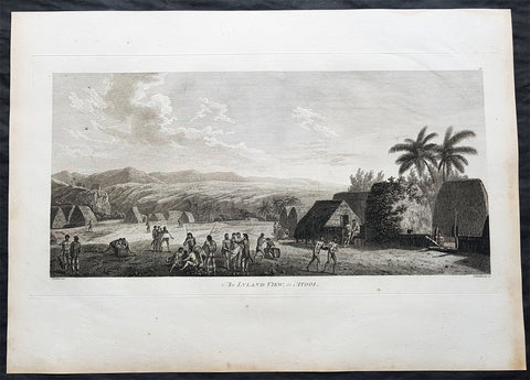
- Title : An Island View, in Atooi
- Size: 21in x 15in (535mm x 385mm)
- Condition: (A+) Fine Condition
- Date : 1784
- Ref #: 82065
Description:
This large original 1st edition copper-plate engraved antique print of a village the Hawaiian Island of Kauai (Atooi) visited by Captain Cook in 1778 was drawn by the official artist on Cooks crew, John Webber, and later published for the 1784 1st edition and official British Admiralty sanctioned account of Captain Cook’s third and final voyage along with that of Cooks successor Capt. James King......
A Voyage to the Pacific Ocean. Undertaken, by the Command of his Majesty, for making Discoveries in the Northern Hemisphere. To determine The Position and Extent of the West Side of North America; its Distance from Asia; and the Practicability of a Northern Passage to Europe. Performed under the direction of Captains Cook, Clerke, and Gore, In His Majesty\'s Ships the Resolution and Discovery. In the Years 1776, 1777, 1778, 1779, and 1780. In Three Volumes. Vol. I and II written by James Cook, F.R.S. Vol. III by Captain James King, LL.D. and F.R.S
Captain Cook arrived at the island of Atooi (Kauai) Hawaii on the 19th of January, 1778 and stayed until 23rd January. On the 21st January, Cook accompanied by John Webber, proceeded inland from their beach side anchorage to Waimea, on the south coast of Kauai. Their intention was to examine elevated objects visible from the ship. It proved to be a morai, or temple similar to ones they had seen in Tahiti and other South Pacific islands. This structure was nearly 20-feet high and covered in a thin, light-grey cloth, which likely had ceremonial significance. The temple rested on a platform and consisted of thousands of rough-edged lava rock piled in a tight, mortarless fashion. In the center is the spindly-legged oracle tower, where the priest (kahuna) might seek counsel or pray. Carved figures with tapa and leaf offerings are seen outside thatched huts topped with pili, the tall grass that grew throughout the lowlands. In his journal, Cook took particular note of several stone objects he had observed:
Cooks Journals - January 21, 1778
...........about the middle of the Morai, there were three of these places in line. We were told three chiefs had been buried there, and before them was another that was oblong. This they called Tanga (taboo or kapu in Hawaiian) and gave us clearly to understand that three human sacrifices had been buried there, that is, one at the burial of each chief.
General Definitions:
Paper thickness and quality: - Heavy and stable
Paper color : - off white
Age of map color: -
Colors used: -
General color appearance: -
Paper size: - 21in x 15in (535mm x 385mm)
Plate size: - 21in x 15in (535mm x 385mm)
Margins: - Min 1/2in (12mm)
Imperfections:
Margins: - Light soiling in margins
Plate area: - None
Verso: - None
Background:
Kauai is geologically the oldest of the main Hawaiian Islands. In 1778, Captain James Cook arrived at Waimea Bay, the first European known to have reached the Hawaiian islands. He named the archipelago after his patron the 6th Earl of Sandwich, George Montagu
Hawaii is the 50th and most recent state to have joined the United States of America, having received statehood on August 21, 1959. Hawaii is the only U.S. state located in Oceania and the only one composed entirely of islands. It is the northernmost island group in Polynesia, occupying most of an archipelago in the central Pacific Ocean. Hawaii is the only U.S. state located outside North America.
It is possible that Spanish explorers arrived in the Hawaiian Islands in the 16th century—200 years before Captain James Cook\\\\\\\'s first documented visit in 1778. Ruy López de Villalobos commanded a fleet of six ships that left Acapulco in 1542 bound for the Philippines with a Spanish sailor named Juan Gaetano aboard as pilot. Depending on the interpretation, Gaetanos reports describe an encounter with either Hawaii or the Marshall Islands. If de Villalobos crew spotted Hawaii, Gaetano would be considered the first European to see the islands. Some scholars have dismissed these claims due to a lack of credibility.
Spanish archives contain a chart that depicts islands at the same latitude as Hawaii but with a longitude ten degrees east of the islands. In this manuscript, the island of Maui is named La Desgraciada (The Unfortunate Island), and what appears to be Hawaii Island is named La Mesa (The Table). Islands resembling Kahoolawe, Lanai, and Molokai are named Los Monjes (The Monks). For two-and-a-half centuries, Spanish galleons crossed the Pacific from Mexico along a route that passed south of Hawaii on their way to Manila. The exact route was kept secret to protect the Spanish trade monopoly against competing powers.
The 1778 arrival of British explorer James Cook was the first documented contact by a European explorer with Hawaii. Cook named the archipelago as the Sandwich Islands in honor of his sponsor John Montagu, 4th Earl of Sandwich. Cook published the islands location and rendered the native name as Owyhee. This spelling lives on in Owyhee County, Idaho. It was named after three native Hawaiian members of a trapping party who went missing in that area. The Owyhee Mountains were also named for them
Cook visited the Hawaiian Islands twice. As he prepared for departure after his second visit in 1779, a quarrel ensued as Cook took temple idols and fencing as firewood and a minor chief and his men took a ship\\\\\\\'s boat. Cook abducted the King of Hawaii Island, Kalani ōpu u, and held him for ransom aboard his ship in order to gain return of Cook\\\\\\\'s boat. This tactic had worked in Tahiti and other islands. Instead, Kalani ōpu u s supporters fought back, killing Cook and four marines as Cooks party retreated along the beach to their ship. They departed without the ships boat.
Captain James King FRS 1750 – 1784 was an officer of the Royal Navy. He served under James Cook on his last voyage around the world, specialising in taking important astronomical readings using a sextant. After Cook died he helped lead the ships on the remainder of their course, also completing Cooks account of the voyage. He continued his career in the Navy, reaching the rank of post-captain, commanding several ships and serving in the American War of Independence.
King joined HMS Resolution as second lieutenant, sharing the duties of astronomer with Cook, taking astronomical observations on board by sextant and with Larcum Kendals timekeeper K1, to establish the Resolutions position at sea and on shore by sextant or by astronomical quadrant to establish the geographical position of salient points during the course of Cooks surveys. Thus Kings geographical positions were an important contribution to the accuracy of the various surveys carried out during the voyage and his use of the early chronometers helped prove their use at sea for calculation of Longitude. .
Following the death of Cook, King remained in the Resolution but on the death of Charles Clerke, Cooks successor, King was appointed to command HMS Discovery, the Resolutions consort, remaining in her for the rest of the voyage. After his return to England King was very much involved in the publication of the official account of Cooks third voyage, writing the third volume at Woodstock, near Oxford, where his brother Thomas was rector of St Mary Magdalene. But shortly after his return King was promoted Post-captain and appointed commander of HMS Crocodile in the English Channel.
John Webber RA 1751 – 1793 was an English artist who accompanied Captain Cook on his third Pacific expedition. He is best known for his images of Australasia, Hawaii and Alaska.
Webber was born in London, educated in Bern and studied painting at Paris.His father was Abraham Wäber, a Swiss sculptor who had moved to London, and changed his name to Webber before marrying a Mrs Mary Quant in 1744.
Webber served as official artist on James Cooks third voyage of discovery around the Pacific (1776–80) aboard HMS Resolution. At Adventure Bay in January 1777 he did drawings of A Man of Van Diemens Land and A Woman of Van Diemens Land. He also did many drawings of scenes in New Zealand and the South Sea islands. On this voyage, during which Cook lost his life in a fight in Hawaii, Webber became the first European artist to make contact with Hawaii, then called the Sandwich Islands. He made numerous watercolor landscapes of the islands of Kauai and Hawaii, and also portrayed many of the Hawaiian people.
In April 1778, Captain Cooks ships Resolution and Discovery anchored at Ship Cove, now known as Nootka Sound, Vancouver Island, Canada to refit. The crew took observations and recorded encounters with the local people. Webber made watercolour landscapes including Resolution and Discovery in Ship Cove, 1778. His drawings and paintings were engraved for British Admiraltys account of the expedition, which was published in 1784.
Back in England in 1780 Webber exhibited around 50 works at Royal Academy exhibitions between 1784 and 1792, and was elected an associate of the Royal Academy in 1785 and R.A. in 1791. Most of his work were landscapes. Sometimes figures were included as in A Party from H.M.S. Resolution shooting sea horses, which was shown at the academy in 1784, and his The Death of Captain Cook became well known through an engraving of it. Another version of this picture is in the William Dixson gallery at Sydney
1784 Cook & Webber Large 1st Edition Antique Print Men Dancing Lifuka Isle Tonga
Antique Map
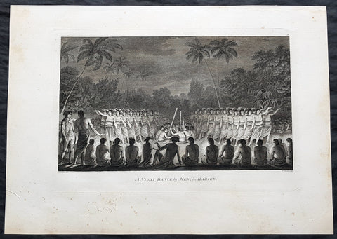
- Title : Night Dance by Men in Hapaee
- Size: 21in x 15in (535mm x 385mm)
- Condition: (A+) Fine Condition
- Date : 1784
- Ref #: 82066
Description:
This large beautifully engraved original copper-plate 1st edition antique print of Captain Cook (seen in the foreground) and his men watching men dancing at night on the Island of Lifuka, in the Ha apai island group of Tonga, at the time of Cooks visit in 1777 as drawn by John Webber (Cooks official artist on the voyage) was published for the 1784 1st edition and official British Admiralty sanctioned account of Captain Cook’s third and final voyage along with that of Cooks successor Capt. James King......
A Voyage to the Pacific Ocean. Undertaken, by the Command of his Majesty, for making Discoveries in the Northern Hemisphere. To determine The Position and Extent of the West Side of North America; its Distance from Asia; and the Practicability of a Northern Passage to Europe. Performed under the direction of Captains Cook, Clerke, and Gore, In His Majesty\'s Ships the Resolution and Discovery. In the Years 1776, 1777, 1778, 1779, and 1780. In Three Volumes. Vol. I and II written by James Cook, F.R.S. Vol. III by Captain James King, LL.D. and F.R.S
General Definitions:
Paper thickness and quality: - Heavy and stable
Paper color : - off white
Age of map color: -
Colors used: -
General color appearance: -
Paper size: - 21in x 15in (535mm x 385mm)
Plate size: - 21in x 15in (535mm x 385mm)
Margins: - Min 1/2in (12mm)
Imperfections:
Margins: - Light soiling
Plate area: - None
Verso: - Light soiling
Background:
Tonga officially the Kingdom of Tonga, is a Polynesian sovereign state and archipelago comprising 169 islands, of which 36 are inhabited. The total surface area is about 750 square kilometres (290 sq mi) scattered over 700,000 square kilometres (270,000 sq mi) of the southern Pacific Ocean. It has a population of 107,122 people, of whom 70% reside on the main island of Tongatapu.
The Tongan people first encountered Europeans in 1616 when the Dutch vessel Eendracht, captained by Willem Schouten, made a short visit to trade. Later came other Dutch explorers, including Jacob Le Maire (who called on the northern island of Niuatoputapu); and in 1643 Abel Tasman (who visited Tongatapu and Haapai).
Later noteworthy European visitors included James Cook (Royal Navy) in 1773, 1774, and 1777; Alessandro Malaspina (Spanish Navy) in 1793; the first London missionaries in 1797; and the Wesleyan Methodist Reverend Walter Lawry in 1822.
Tonga became known in the West as the Friendly Islands because of the congenial reception accorded to Captain James Cook on his first visit in 1773. He arrived at the time of the inasi festival, the yearly donation of the First Fruits to the Tui Tonga (the islands paramount chief) and so received an invitation to the festivities. According to the writer William Mariner, the chiefs wanted to kill Cook during the gathering but could not agree on a plan.
Lifuka is an island in the Kingdom of Tonga. It is located within the Ha apai Group in the centre of the country, to northeast of the national capital of Nuku alofa.
Lifuka is the place where Captain James Cook dubbed Tonga The Friendly Islands. Tofua is where the mutiny on the Bounty occurred in 1789; this active volcanic island lies approximately forty nautical miles west of Lifuka. The Cpt. Bligh voyage stands as the longest successful passage ever recorded in an open boat without modern navigational aids.
Captain James King FRS 1750 – 1784 was an officer of the Royal Navy. He served under James Cook on his last voyage around the world, specialising in taking important astronomical readings using a sextant. After Cook died he helped lead the ships on the remainder of their course, also completing Cooks account of the voyage. He continued his career in the Navy, reaching the rank of post-captain, commanding several ships and serving in the American War of Independence.
King joined HMS Resolution as second lieutenant, sharing the duties of astronomer with Cook, taking astronomical observations on board by sextant and with Larcum Kendals timekeeper K1, to establish the Resolutions position at sea and on shore by sextant or by astronomical quadrant to establish the geographical position of salient points during the course of Cooks surveys. Thus Kings geographical positions were an important contribution to the accuracy of the various surveys carried out during the voyage and his use of the early chronometers helped prove their use at sea for calculation of Longitude. .
Following the death of Cook, King remained in the Resolution but on the death of Charles Clerke, Cooks successor, King was appointed to command HMS Discovery, the Resolutions consort, remaining in her for the rest of the voyage. After his return to England King was very much involved in the publication of the official account of Cooks third voyage, writing the third volume at Woodstock, near Oxford, where his brother Thomas was rector of St Mary Magdalene. But shortly after his return King was promoted Post-captain and appointed commander of HMS Crocodile in the English Channel.
John Webber RA 1751 – 1793 was an English artist who accompanied Captain Cook on his third Pacific expedition. He is best known for his images of Australasia, Hawaii and Alaska.
Webber was born in London, educated in Bern and studied painting at Paris.His father was Abraham Wäber, a Swiss sculptor who had moved to London, and changed his name to Webber before marrying a Mrs Mary Quant in 1744.
Webber served as official artist on James Cooks third voyage of discovery around the Pacific (1776–80) aboard HMS Resolution. At Adventure Bay in January 1777 he did drawings of A Man of Van Diemens Land and A Woman of Van Diemens Land. He also did many drawings of scenes in New Zealand and the South Sea islands. On this voyage, during which Cook lost his life in a fight in Hawaii, Webber became the first European artist to make contact with Hawaii, then called the Sandwich Islands. He made numerous watercolor landscapes of the islands of Kauai and Hawaii, and also portrayed many of the Hawaiian people.
In April 1778, Captain Cooks ships Resolution and Discovery anchored at Ship Cove, now known as Nootka Sound, Vancouver Island, Canada to refit. The crew took observations and recorded encounters with the local people. Webber made watercolour landscapes including Resolution and Discovery in Ship Cove, 1778. His drawings and paintings were engraved for British Admiraltys account of the expedition, which was published in 1784.
Back in England in 1780 Webber exhibited around 50 works at Royal Academy exhibitions between 1784 and 1792, and was elected an associate of the Royal Academy in 1785 and R.A. in 1791. Most of his work were landscapes. Sometimes figures were included as in A Party from H.M.S. Resolution shooting sea horses, which was shown at the academy in 1784, and his The Death of Captain Cook became well known through an engraving of it. Another version of this picture is in the William Dixson gallery at Sydney
1784 Cook & Webber Large 1st Edition Antique Print of Inasi Ceremony Mu'a, Tonga
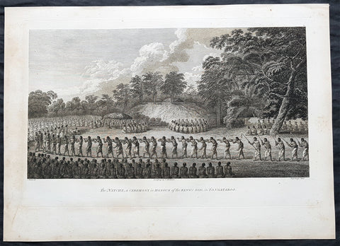
- Title : Natche, a Ceremony in Honour of the Kings Son in Tongataboo
- Size: 21in x 15in (535mm x 385mm)
- Condition: (A+) Fine Condition
- Date : 1784
- Ref #: 82067
Description:
This large beautifully engraved original copper-plate 1st edition antique print of possibly the coming of age or Inasi ceremony for the son of the King of Tonga in the village of Mua on the main Tongan Island of Tongatapu, at the time of Captain Cooks visit in 1777 as drawn by John Webber (Cooks official artist on the voyage) was published for the 1784 1st edition and official British Admiralty sanctioned account of Captain Cook’s third and final voyage along with that of Cooks successor Capt. James King......
A Voyage to the Pacific Ocean. Undertaken, by the Command of his Majesty, for making Discoveries in the Northern Hemisphere. To determine The Position and Extent of the West Side of North America; its Distance from Asia; and the Practicability of a Northern Passage to Europe. Performed under the direction of Captains Cook, Clerke, and Gore, In His Majesty\'s Ships the Resolution and Discovery. In the Years 1776, 1777, 1778, 1779, and 1780. In Three Volumes. Vol. I and II written by James Cook, F.R.S. Vol. III by Captain James King, LL.D. and F.R.S
While on Tongatapu from 10 June to 10 July 1777, Cook and his men recorded Tongan ceremonies and culture.
The most unusual and extraordinary ceremony observed during Cook\'s stay at Tongatapu was the Inasi ceremony which took place at Mua from 8 to 9 July. The ceremony was centred upon the son of Fatafehi Paulaho, the sacred King of Tonga (Tui Tonga), and was probably performed in honour of his coming of age. Several thousand were involved, most of whom entered the performing area with sticks about four feet long. They approached a shelter or small hut in which Paulaho, his son and other people of distinction were seated.
General Definitions:
Paper thickness and quality: - Heavy and stable
Paper color : - off white
Age of map color: -
Colors used: -
General color appearance: -
Paper size: - 21in x 15in (535mm x 385mm)
Plate size: - 21in x 15in (535mm x 385mm)
Margins: - Min 1/2in (12mm)
Imperfections:
Margins: - Light soiling
Plate area: - None
Verso: - Light soiling
Background:
Tonga officially the Kingdom of Tonga, is a Polynesian sovereign state and archipelago comprising 169 islands, of which 36 are inhabited. The total surface area is about 750 square kilometres (290 sq mi) scattered over 700,000 square kilometres (270,000 sq mi) of the southern Pacific Ocean. It has a population of 107,122 people, of whom 70% reside on the main island of Tongatapu.
The Tongan people first encountered Europeans in 1616 when the Dutch vessel Eendracht, captained by Willem Schouten, made a short visit to trade. Later came other Dutch explorers, including Jacob Le Maire (who called on the northern island of Niuatoputapu); and in 1643 Abel Tasman (who visited Tongatapu and Haapai).
Later noteworthy European visitors included James Cook (Royal Navy) in 1773, 1774, and 1777; Alessandro Malaspina (Spanish Navy) in 1793; the first London missionaries in 1797; and the Wesleyan Methodist Reverend Walter Lawry in 1822.
Tonga became known in the West as the Friendly Islands because of the congenial reception accorded to Captain James Cook on his first visit in 1773. He arrived at the time of the inasi festival, the yearly donation of the First Fruits to the Tui Tonga (the islands paramount chief) and so received an invitation to the festivities. According to the writer William Mariner, the chiefs wanted to kill Cook during the gathering but could not agree on a plan.
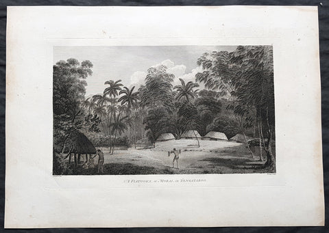
Mu a is a small town in the Hahake (eastern) district on the island of Tongatapu, and it was for centuries the ancient capital of Tonga. It is divided in the villages Lapaha and Tatakamotonga, is close to Talasiu and famous for the ancient langi (royal burial tombs).
Mua was at one time the center of Lapita culture in Tonga (about 2,000 years ago) and later (twelfth to sixteenth century CE) the capital of the Tuʻi Tonga Empire. After the disintegration of the empire it remained the capital of the Tui Tonga (Tonga kings), up to the nineteenth century, but was rather a spiritual centre and no longer a source of political power.
The Tui Tonga and his retinue stayed in Lapaha, his residence being Olotele and Ahofakasiu, while Takuilau was for his wives. Subchiefs and servants on the other hand lived in Tatakamotonga.
When, around 1470, the Tui Tonga line started to lose power to the Tui Ha atakalaua, and another century later to the Tu i Kanokupolu, chiefs belonging to these lines were not welcome in Mu a, and had to stay on the low-lying coastal areas, separated from the real chiefs (i.e. those belonging to the Tu i Tonga) by the Hala Fonuamoa (dry land road). The former became known as the kauhalalalo (low road people) and the latter as the kauhala uta (inland road people), which nowadays are still two important moieties in Tonga.
Whatever political power the Tu i Tonga yielded to their rivals, they gained in spiritual power, and as a kind of high priest they were perhaps even more awesome than as kings. When a Tu i Tonga died he was buried in one of the huge tomb hills, known as langi, of which there are still at least two dozen in Lapaha. The Tu i Haʻatakalaua were also buried in such tombs, but they are called fale instead.
The langi are big, artificial hills surrounded by huge slabs of coral rock, usually in three or more tiered layers. These slabs were quarried from several places along the coast of Tongatapu or neighbouring minor islands. The waves of the sea made them over the centuries, by compacting coral sand into layers of 10 to 20 centimetres (3.9 to 7.9 inches) thick. They were only to be dug out and then transported by boat to the building site. Nevertheless, the accuracy by which the slabs were cut to shape so that they fit along each other with barely any space to spare is remarkable.
One of the best-preserved langi is the Paepae-o-Tele a, which is even more remarkable as the slabs along the corner really have an L shape.
The story that the slabs were moved by magic means from Uvea to Tonga is just a myth. Uvea is volcanic and has not got the proper geology. This fact has always been known, as shown, for example by a stanza of the poem named Laveofo from around the 18th century by Tufui.
Captain James King FRS 1750 – 1784 was an officer of the Royal Navy. He served under James Cook on his last voyage around the world, specialising in taking important astronomical readings using a sextant. After Cook died he helped lead the ships on the remainder of their course, also completing Cooks account of the voyage. He continued his career in the Navy, reaching the rank of post-captain, commanding several ships and serving in the American War of Independence.
King joined HMS Resolution as second lieutenant, sharing the duties of astronomer with Cook, taking astronomical observations on board by sextant and with Larcum Kendals timekeeper K1, to establish the Resolutions position at sea and on shore by sextant or by astronomical quadrant to establish the geographical position of salient points during the course of Cooks surveys. Thus Kings geographical positions were an important contribution to the accuracy of the various surveys carried out during the voyage and his use of the early chronometers helped prove their use at sea for calculation of Longitude. .
Following the death of Cook, King remained in the Resolution but on the death of Charles Clerke, Cooks successor, King was appointed to command HMS Discovery, the Resolutions consort, remaining in her for the rest of the voyage. After his return to England King was very much involved in the publication of the official account of Cooks third voyage, writing the third volume at Woodstock, near Oxford, where his brother Thomas was rector of St Mary Magdalene. But shortly after his return King was promoted Post-captain and appointed commander of HMS Crocodile in the English Channel.
John Webber RA 1751 – 1793 was an English artist who accompanied Captain Cook on his third Pacific expedition. He is best known for his images of Australasia, Hawaii and Alaska.
Webber was born in London, educated in Bern and studied painting at Paris.His father was Abraham Wäber, a Swiss sculptor who had moved to London, and changed his name to Webber before marrying a Mrs Mary Quant in 1744.
Webber served as official artist on James Cooks third voyage of discovery around the Pacific (1776–80) aboard HMS Resolution. At Adventure Bay in January 1777 he did drawings of A Man of Van Diemens Land and A Woman of Van Diemens Land. He also did many drawings of scenes in New Zealand and the South Sea islands. On this voyage, during which Cook lost his life in a fight in Hawaii, Webber became the first European artist to make contact with Hawaii, then called the Sandwich Islands. He made numerous watercolor landscapes of the islands of Kauai and Hawaii, and also portrayed many of the Hawaiian people.
In April 1778, Captain Cooks ships Resolution and Discovery anchored at Ship Cove, now known as Nootka Sound, Vancouver Island, Canada to refit. The crew took observations and recorded encounters with the local people. Webber made watercolour landscapes including Resolution and Discovery in Ship Cove, 1778. His drawings and paintings were engraved for British Admiraltys account of the expedition, which was published in 1784.
Back in England in 1780 Webber exhibited around 50 works at Royal Academy exhibitions between 1784 and 1792, and was elected an associate of the Royal Academy in 1785 and R.A. in 1791. Most of his work were landscapes. Sometimes figures were included as in A Party from H.M.S. Resolution shooting sea horses, which was shown at the academy in 1784, and his The Death of Captain Cook became well known through an engraving of it. Another version of this picture is in the William Dixson gallery at Sydney
1784 Cook & Webber Large 1st Edition Antique Print Burial Mounds or Langi, Tonga
Antique Map
- Title : A Fiatooka or Morai in Tongataboo
- Size: 21in x 15in (535mm x 385mm)
- Condition: (A+) Fine Condition
- Date : 1784
- Ref #: 82068
Description:
This large beautifully engraved original copper-plate 1st edition antique print of the faitoka or the Royal Langi (burial mounds) in the village of Mua on the main Tongan Island of Tongatapu as seen by Captain James Cook in 1777 and John Webber (Cooks official artist on the voyage) was published for the 1784 1st edition and official British Admiralty sanctioned account of Captain Cook’s third and final voyage along with that of Cooks successor Capt. James King......
A Voyage to the Pacific Ocean. Undertaken, by the Command of his Majesty, for making Discoveries in the Northern Hemisphere. To determine The Position and Extent of the West Side of North America; its Distance from Asia; and the Practicability of a Northern Passage to Europe. Performed under the direction of Captains Cook, Clerke, and Gore, In His Majesty\'s Ships the Resolution and Discovery. In the Years 1776, 1777, 1778, 1779, and 1780. In Three Volumes. Vol. I and II written by James Cook, F.R.S. Vol. III by Captain James King, LL.D. and F.R.S
While on Tongatapu from 10 June to 10 July 1777, Cook and his men recorded Tongan ceremonies and culture. In this view Webber depicts a faitoka (burying ground).
Cooks journal ......\'The Places set apart for burying the dead are raised with Gravel about a foot or two above the level of the Ground, on which stand two or three Houses which are constantly shut up but contain nothing in them; these Ceremonies called in their Language Dano are kept very neat & clean & the Indians are generally despleased at our approaching them.....
General Definitions:
Paper thickness and quality: - Heavy and stable
Paper color : - off white
Age of map color: -
Colors used: -
General color appearance: -
Paper size: - 21in x 15in (535mm x 385mm)
Plate size: - 21in x 15in (535mm x 385mm)
Margins: - Min 1/2in (12mm)
Imperfections:
Margins: - Light soiling
Plate area: - None
Verso: - Light soiling
Background:
Tonga officially the Kingdom of Tonga, is a Polynesian sovereign state and archipelago comprising 169 islands, of which 36 are inhabited. The total surface area is about 750 square kilometres (290 sq mi) scattered over 700,000 square kilometres (270,000 sq mi) of the southern Pacific Ocean. It has a population of 107,122 people, of whom 70% reside on the main island of Tongatapu.
The Tongan people first encountered Europeans in 1616 when the Dutch vessel Eendracht, captained by Willem Schouten, made a short visit to trade. Later came other Dutch explorers, including Jacob Le Maire (who called on the northern island of Niuatoputapu); and in 1643 Abel Tasman (who visited Tongatapu and Haapai).
Later noteworthy European visitors included James Cook (Royal Navy) in 1773, 1774, and 1777; Alessandro Malaspina (Spanish Navy) in 1793; the first London missionaries in 1797; and the Wesleyan Methodist Reverend Walter Lawry in 1822.
Tonga became known in the West as the Friendly Islands because of the congenial reception accorded to Captain James Cook on his first visit in 1773. He arrived at the time of the inasi festival, the yearly donation of the First Fruits to the Tui Tonga (the islands paramount chief) and so received an invitation to the festivities. According to the writer William Mariner, the chiefs wanted to kill Cook during the gathering but could not agree on a plan.
Mu a is a small town in the Hahake (eastern) district on the island of Tongatapu, and it was for centuries the ancient capital of Tonga. It is divided in the villages Lapaha and Tatakamotonga, is close to Talasiu and famous for the ancient langi (royal burial tombs).
Mua was at one time the center of Lapita culture in Tonga (about 2,000 years ago) and later (twelfth to sixteenth century CE) the capital of the Tuʻi Tonga Empire. After the disintegration of the empire it remained the capital of the Tui Tonga (Tonga kings), up to the nineteenth century, but was rather a spiritual centre and no longer a source of political power.
The Tui Tonga and his retinue stayed in Lapaha, his residence being Olotele and Ahofakasiu, while Takuilau was for his wives. Subchiefs and servants on the other hand lived in Tatakamotonga.
When, around 1470, the Tui Tonga line started to lose power to the Tui Ha atakalaua, and another century later to the Tu i Kanokupolu, chiefs belonging to these lines were not welcome in Mu a, and had to stay on the low-lying coastal areas, separated from the real chiefs (i.e. those belonging to the Tu i Tonga) by the Hala Fonuamoa (dry land road). The former became known as the kauhalalalo (low road people) and the latter as the kauhala uta (inland road people), which nowadays are still two important moieties in Tonga.
Whatever political power the Tu i Tonga yielded to their rivals, they gained in spiritual power, and as a kind of high priest they were perhaps even more awesome than as kings. When a Tu i Tonga died he was buried in one of the huge tomb hills, known as langi, of which there are still at least two dozen in Lapaha. The Tu i Haʻatakalaua were also buried in such tombs, but they are called fale instead.
The langi are big, artificial hills surrounded by huge slabs of coral rock, usually in three or more tiered layers. These slabs were quarried from several places along the coast of Tongatapu or neighbouring minor islands. The waves of the sea made them over the centuries, by compacting coral sand into layers of 10 to 20 centimetres (3.9 to 7.9 inches) thick. They were only to be dug out and then transported by boat to the building site. Nevertheless, the accuracy by which the slabs were cut to shape so that they fit along each other with barely any space to spare is remarkable.
One of the best-preserved langi is the Paepae-o-Tele a, which is even more remarkable as the slabs along the corner really have an L shape.
The story that the slabs were moved by magic means from Uvea to Tonga is just a myth. Uvea is volcanic and has not got the proper geology. This fact has always been known, as shown, for example by a stanza of the poem named Laveofo from around the 18th century by Tufui.
Captain James King FRS 1750 – 1784 was an officer of the Royal Navy. He served under James Cook on his last voyage around the world, specialising in taking important astronomical readings using a sextant. After Cook died he helped lead the ships on the remainder of their course, also completing Cooks account of the voyage. He continued his career in the Navy, reaching the rank of post-captain, commanding several ships and serving in the American War of Independence.
King joined HMS Resolution as second lieutenant, sharing the duties of astronomer with Cook, taking astronomical observations on board by sextant and with Larcum Kendals timekeeper K1, to establish the Resolutions position at sea and on shore by sextant or by astronomical quadrant to establish the geographical position of salient points during the course of Cooks surveys. Thus Kings geographical positions were an important contribution to the accuracy of the various surveys carried out during the voyage and his use of the early chronometers helped prove their use at sea for calculation of Longitude. .
Following the death of Cook, King remained in the Resolution but on the death of Charles Clerke, Cooks successor, King was appointed to command HMS Discovery, the Resolutions consort, remaining in her for the rest of the voyage. After his return to England King was very much involved in the publication of the official account of Cooks third voyage, writing the third volume at Woodstock, near Oxford, where his brother Thomas was rector of St Mary Magdalene. But shortly after his return King was promoted Post-captain and appointed commander of HMS Crocodile in the English Channel.
John Webber RA 1751 – 1793 was an English artist who accompanied Captain Cook on his third Pacific expedition. He is best known for his images of Australasia, Hawaii and Alaska.
Webber was born in London, educated in Bern and studied painting at Paris.His father was Abraham Wäber, a Swiss sculptor who had moved to London, and changed his name to Webber before marrying a Mrs Mary Quant in 1744.
Webber served as official artist on James Cooks third voyage of discovery around the Pacific (1776–80) aboard HMS Resolution. At Adventure Bay in January 1777 he did drawings of A Man of Van Diemens Land and A Woman of Van Diemens Land. He also did many drawings of scenes in New Zealand and the South Sea islands. On this voyage, during which Cook lost his life in a fight in Hawaii, Webber became the first European artist to make contact with Hawaii, then called the Sandwich Islands. He made numerous watercolor landscapes of the islands of Kauai and Hawaii, and also portrayed many of the Hawaiian people.
In April 1778, Captain Cooks ships Resolution and Discovery anchored at Ship Cove, now known as Nootka Sound, Vancouver Island, Canada to refit. The crew took observations and recorded encounters with the local people. Webber made watercolour landscapes including Resolution and Discovery in Ship Cove, 1778. His drawings and paintings were engraved for British Admiraltys account of the expedition, which was published in 1784.
Back in England in 1780 Webber exhibited around 50 works at Royal Academy exhibitions between 1784 and 1792, and was elected an associate of the Royal Academy in 1785 and R.A. in 1791. Most of his work were landscapes. Sometimes figures were included as in A Party from H.M.S. Resolution shooting sea horses, which was shown at the academy in 1784, and his The Death of Captain Cook became well known through an engraving of it. Another version of this picture is in the William Dixson gallery at Sydney
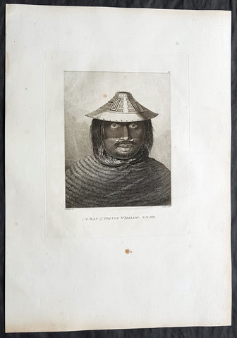
1784 Cook & Webber Large Antique Print of a Man of Prince William Sound, Alaska
Antique Map
- Title : A Man of Prince William Sound
- Size: 21in x 15in (535mm x 385mm)
- Condition: (A+) Fine Condition
- Date : 1784
- Ref #: 82072
Description:
This large beautifully engraved original copper-plate 1st edition antique portrait of a man of Prince William Sound Alaska, visited by Captain Cooks ships HMS Resolution and Discovery in Snug Corner Cove, Prince William Sound, Alaska, in 1778 was drawn by the official artist on Cooks crew, John Webber, and later published for the 1784 1st edition and official British Admiralty sanctioned account of Captain Cook’s third and final voyage along with that of Cooks successor Capt. James King......
A Voyage to the Pacific Ocean. Undertaken, by the Command of his Majesty, for making Discoveries in the Northern Hemisphere. To determine The Position and Extent of the West Side of North America; its Distance from Asia; and the Practicability of a Northern Passage to Europe. Performed under the direction of Captains Cook, Clerke, and Gore, In His Majesty\'s Ships the Resolution and Discovery. In the Years 1776, 1777, 1778, 1779, and 1780. In Three Volumes. Vol. I and II written by James Cook, F.R.S. Vol. III by Captain James King, LL.D. and F.R.S
May 1778.........On the 12th at nine in the morning, wrote Ledyard, we entered an inlet… at six in the evening perceiving bad weather approaching… both ships anchored… The pinnace of the Resolution with the first lieutenant, some other gentlemen and myself went to the opposite shore to shoot some wild fowl. The first lieutenant was John Gore. The inlet was named Sandwich Sound by Cook, after the Earl of Sandwich, First Lord of the Admiralty, but in the published version of his journal the name appeared as Prince Williams Sound, after George IIIs third son, Duke of Clarence, later William IV. The ships had anchored off Cape Hinchinbrook, named after the country seat of the Earl of Sandwich.
Some local inhabitants appeared and came aboard the ships. Clerke gave them a Glass Bowl, with which they seem\\\'d much delighted, and toss\\\'d me, in spight of all my motions to the contrary, one of their Frocks, which was made of Water fowl Skins, and exceedingly well calculated, to keep out both Wet & Cold; then, both Boats put off and made for the Shore, paddling & singing with all the Jollity imaginable. We either found these good folks on of their Jubilee Days, or they are a very happy Race.
They sailed on until Cook found a fine bay or rather harbour which he later called a very snug place and named Snug Corner Bay. Samwell on 14th wrote we secured the Ship with the small Anchor; in carrying this out in the Launch one of the Sailors was so unfortunate as to get his Leg entangled in the Buoy rope which carried him down with the Anchor, however he disengaged himself when he got to the bottom & came up again & saved his Life tho\\\' he had his Leg broke in a very dangerous Manner.
We heeled the ship to port wrote Gilbert, to examine the leak on the starboard buttock… it being close below the wale and occasioned by some of the seems being very open and the oakum quite rotten and great part of it got out. In two days we repaired this defect being obliged to put two and half inch rope along the seams which were too wide for caulking.
On 18th King noted two boats, one with Mr Gore & the other with the Master, were sent away, the first to explore the Inlet to the Noward: the other to the N end of the Island near us to make observations on the tides. William Bligh was master on the Resolution. They returned by Dusk, Mr Gore had proceeded up the Inlet & perceivd that it took a direction to the NE, & he thought that it bid fair for opening a communication to some other Sea; but the mate that was with him form\\\'d a very contrary opinion… the Captn judg\\\'d it the Wisest way to lose no more time, being certain that if we were amongst Islands, we shoud soon come to more Passages. Henry Roberts was the masters mate referred to here. Cook had sent him and others to sketch out the parts they examined.
Background:
Prince William Sound is located on the south coast of the U.S. state of Alaska. It is located on the east side of the Kenai Peninsula, its largest port is Valdez, at the southern terminus of the Trans-Alaska Pipeline System. Other settlements on the sound contain numerous small islands, including Cordova and Whittier plus the Alaska native villages of Chenega and Tatitlek.
James Cook entered Prince William Sound in 1778 and named it Sandwich Sound, after his patron the Earl of Sandwich. The name was changed to honour King George III third son, Prince William Henry, then aged 13 and serving as a midshipman in the Royal Navy.
Captain James King FRS 1750 – 1784 was an officer of the Royal Navy. He served under James Cook on his last voyage around the world, specialising in taking important astronomical readings using a sextant. After Cook died he helped lead the ships on the remainder of their course, also completing Cooks account of the voyage. He continued his career in the Navy, reaching the rank of post-captain, commanding several ships and serving in the American War of Independence.
King joined HMS Resolution as second lieutenant, sharing the duties of astronomer with Cook, taking astronomical observations on board by sextant and with Larcum Kendals timekeeper K1, to establish the Resolutions position at sea and on shore by sextant or by astronomical quadrant to establish the geographical position of salient points during the course of Cooks surveys. Thus Kings geographical positions were an important contribution to the accuracy of the various surveys carried out during the voyage and his use of the early chronometers helped prove their use at sea for calculation of Longitude. .
Following the death of Cook, King remained in the Resolution but on the death of Charles Clerke, Cooks successor, King was appointed to command HMS Discovery, the Resolutions consort, remaining in her for the rest of the voyage. After his return to England King was very much involved in the publication of the official account of Cooks third voyage, writing the third volume at Woodstock, near Oxford, where his brother Thomas was rector of St Mary Magdalene. But shortly after his return King was promoted Post-captain and appointed commander of HMS Crocodile in the English Channel.
John Webber RA 1751 – 1793 was an English artist who accompanied Captain Cook on his third Pacific expedition. He is best known for his images of Australasia, Hawaii and Alaska.
Webber was born in London, educated in Bern and studied painting at Paris.His father was Abraham Wäber, a Swiss sculptor who had moved to London, and changed his name to Webber before marrying a Mrs Mary Quant in 1744.
Webber served as official artist on James Cooks third voyage of discovery around the Pacific (1776–80) aboard HMS Resolution. At Adventure Bay in January 1777 he did drawings of A Man of Van Diemens Land and A Woman of Van Diemens Land. He also did many drawings of scenes in New Zealand and the South Sea islands. On this voyage, during which Cook lost his life in a fight in Hawaii, Webber became the first European artist to make contact with Hawaii, then called the Sandwich Islands. He made numerous watercolor landscapes of the islands of Kauai and Hawaii, and also portrayed many of the Hawaiian people.
In April 1778, Captain Cooks ships Resolution and Discovery anchored at Ship Cove, now known as Nootka Sound, Vancouver Island, Canada to refit. The crew took observations and recorded encounters with the local people. Webber made watercolour landscapes including Resolution and Discovery in Ship Cove, 1778. His drawings and paintings were engraved for British Admiraltys account of the expedition, which was published in 1784.
Back in England in 1780 Webber exhibited around 50 works at Royal Academy exhibitions between 1784 and 1792, and was elected an associate of the Royal Academy in 1785 and R.A. in 1791. Most of his work were landscapes. Sometimes figures were included as in A Party from H.M.S. Resolution shooting sea horses, which was shown at the academy in 1784, and his The Death of Captain Cook became well known through an engraving of it. Another version of this picture is in the William Dixson gallery at Sydney
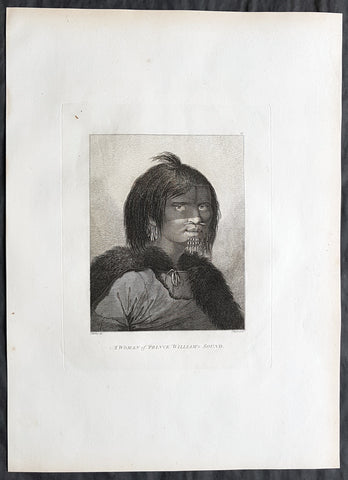
1784 Cook & Webber Large Antique Portrait Woman of Prince William Sound, Alaska
Antique Map
- Title : A Woman of Prince William Sound
- Size: 21in x 15in (535mm x 385mm)
- Condition: (A+) Fine Condition
- Date : 1784
- Ref #: 82071
Description:
This large beautifully engraved original copper-plate 1st edition antique portrait of a woman of Prince William Sound Alaska, visited by Captain Cooks ships HMS Resolution and Discovery in Snug Corner Cove, Prince William Sound, Alaska, in 1778 was drawn by the official artist on Cooks crew, John Webber, and later published for the 1784 1st edition and official British Admiralty sanctioned account of Captain Cook’s third and final voyage along with that of Cooks successor Capt. James King......
A Voyage to the Pacific Ocean. Undertaken, by the Command of his Majesty, for making Discoveries in the Northern Hemisphere. To determine The Position and Extent of the West Side of North America; its Distance from Asia; and the Practicability of a Northern Passage to Europe. Performed under the direction of Captains Cook, Clerke, and Gore, In His Majesty\'s Ships the Resolution and Discovery. In the Years 1776, 1777, 1778, 1779, and 1780. In Three Volumes. Vol. I and II written by James Cook, F.R.S. Vol. III by Captain James King, LL.D. and F.R.S
May 1778.........On the 12th at nine in the morning, wrote Ledyard, we entered an inlet… at six in the evening perceiving bad weather approaching… both ships anchored… The pinnace of the Resolution with the first lieutenant, some other gentlemen and myself went to the opposite shore to shoot some wild fowl. The first lieutenant was John Gore. The inlet was named Sandwich Sound by Cook, after the Earl of Sandwich, First Lord of the Admiralty, but in the published version of his journal the name appeared as Prince Williams Sound, after George IIIs third son, Duke of Clarence, later William IV. The ships had anchored off Cape Hinchinbrook, named after the country seat of the Earl of Sandwich.
Some local inhabitants appeared and came aboard the ships. Clerke gave them a Glass Bowl, with which they seem\\\'d much delighted, and toss\\\'d me, in spight of all my motions to the contrary, one of their Frocks, which was made of Water fowl Skins, and exceedingly well calculated, to keep out both Wet & Cold; then, both Boats put off and made for the Shore, paddling & singing with all the Jollity imaginable. We either found these good folks on of their Jubilee Days, or they are a very happy Race.
They sailed on until Cook found a fine bay or rather harbour which he later called a very snug place and named Snug Corner Bay. Samwell on 14th wrote we secured the Ship with the small Anchor; in carrying this out in the Launch one of the Sailors was so unfortunate as to get his Leg entangled in the Buoy rope which carried him down with the Anchor, however he disengaged himself when he got to the bottom & came up again & saved his Life tho\\\' he had his Leg broke in a very dangerous Manner.
We heeled the ship to port wrote Gilbert, to examine the leak on the starboard buttock… it being close below the wale and occasioned by some of the seems being very open and the oakum quite rotten and great part of it got out. In two days we repaired this defect being obliged to put two and half inch rope along the seams which were too wide for caulking.
On 18th King noted two boats, one with Mr Gore & the other with the Master, were sent away, the first to explore the Inlet to the Noward: the other to the N end of the Island near us to make observations on the tides. William Bligh was master on the Resolution. They returned by Dusk, Mr Gore had proceeded up the Inlet & perceivd that it took a direction to the NE, & he thought that it bid fair for opening a communication to some other Sea; but the mate that was with him form\\\'d a very contrary opinion… the Captn judg\\\'d it the Wisest way to lose no more time, being certain that if we were amongst Islands, we shoud soon come to more Passages. Henry Roberts was the masters mate referred to here. Cook had sent him and others to sketch out the parts they examined.
General Definitions:
Paper thickness and quality: - Heavy and stable
Paper color : - off white
Age of map color: -
Colors used: -
General color appearance: -
Paper size: - 21in x 15in (535mm x 385mm)
Plate size: - 21in x 15in (535mm x 385mm)
Margins: - Min 1/2in (12mm)
Imperfections:
Margins: - Light soiling in margins
Plate area: - None
Verso: - None
Background:
Prince William Sound is located on the south coast of the U.S. state of Alaska. It is located on the east side of the Kenai Peninsula, its largest port is Valdez, at the southern terminus of the Trans-Alaska Pipeline System. Other settlements on the sound contain numerous small islands, including Cordova and Whittier plus the Alaska native villages of Chenega and Tatitlek.
James Cook entered Prince William Sound in 1778 and named it Sandwich Sound, after his patron the Earl of Sandwich. The name was changed to honour King George III third son, Prince William Henry, then aged 13 and serving as a midshipman in the Royal Navy.
Captain James King FRS 1750 – 1784 was an officer of the Royal Navy. He served under James Cook on his last voyage around the world, specialising in taking important astronomical readings using a sextant. After Cook died he helped lead the ships on the remainder of their course, also completing Cooks account of the voyage. He continued his career in the Navy, reaching the rank of post-captain, commanding several ships and serving in the American War of Independence.
King joined HMS Resolution as second lieutenant, sharing the duties of astronomer with Cook, taking astronomical observations on board by sextant and with Larcum Kendals timekeeper K1, to establish the Resolutions position at sea and on shore by sextant or by astronomical quadrant to establish the geographical position of salient points during the course of Cooks surveys. Thus Kings geographical positions were an important contribution to the accuracy of the various surveys carried out during the voyage and his use of the early chronometers helped prove their use at sea for calculation of Longitude. .
Following the death of Cook, King remained in the Resolution but on the death of Charles Clerke, Cooks successor, King was appointed to command HMS Discovery, the Resolutions consort, remaining in her for the rest of the voyage. After his return to England King was very much involved in the publication of the official account of Cooks third voyage, writing the third volume at Woodstock, near Oxford, where his brother Thomas was rector of St Mary Magdalene. But shortly after his return King was promoted Post-captain and appointed commander of HMS Crocodile in the English Channel.
John Webber RA 1751 – 1793 was an English artist who accompanied Captain Cook on his third Pacific expedition. He is best known for his images of Australasia, Hawaii and Alaska.
Webber was born in London, educated in Bern and studied painting at Paris.His father was Abraham Wäber, a Swiss sculptor who had moved to London, and changed his name to Webber before marrying a Mrs Mary Quant in 1744.
Webber served as official artist on James Cooks third voyage of discovery around the Pacific (1776–80) aboard HMS Resolution. At Adventure Bay in January 1777 he did drawings of A Man of Van Diemens Land and A Woman of Van Diemens Land. He also did many drawings of scenes in New Zealand and the South Sea islands. On this voyage, during which Cook lost his life in a fight in Hawaii, Webber became the first European artist to make contact with Hawaii, then called the Sandwich Islands. He made numerous watercolor landscapes of the islands of Kauai and Hawaii, and also portrayed many of the Hawaiian people.
In April 1778, Captain Cooks ships Resolution and Discovery anchored at Ship Cove, now known as Nootka Sound, Vancouver Island, Canada to refit. The crew took observations and recorded encounters with the local people. Webber made watercolour landscapes including Resolution and Discovery in Ship Cove, 1778. His drawings and paintings were engraved for British Admiraltys account of the expedition, which was published in 1784.
Back in England in 1780 Webber exhibited around 50 works at Royal Academy exhibitions between 1784 and 1792, and was elected an associate of the Royal Academy in 1785 and R.A. in 1791. Most of his work were landscapes. Sometimes figures were included as in A Party from H.M.S. Resolution shooting sea horses, which was shown at the academy in 1784, and his The Death of Captain Cook became well known through an engraving of it. Another version of this picture is in the William Dixson gallery at Sydney
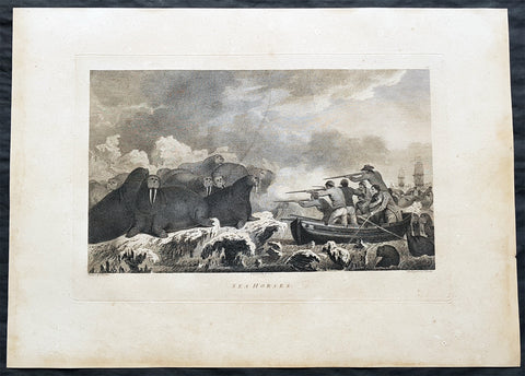
1784 Cook & Webber Large 1st Edition Antique Print Hunting Walrus in Alaska
- Title : Sea Horses
- Size: 21in x 15in (535mm x 385mm)
- Condition: (A) Very Good Condition
- Date : 1784
- Ref #: 82064
Description:
This large beautifully engraved original copper-plate 1st edition antique print of the crew of HMS Resolution hunting Walrus in Arctic Alaska in 1778 by John Webber (Cooks official artist on the voyage) & John Heath was later published for the 1784 1st edition and official British Admiralty sanctioned account of Captain Cook’s third and final voyage along with that of Cooks successor Capt. James King......
A Voyage to the Pacific Ocean. Undertaken, by the Command of his Majesty, for making Discoveries in the Northern Hemisphere. To determine The Position and Extent of the West Side of North America; its Distance from Asia; and the Practicability of a Northern Passage to Europe. Performed under the direction of Captains Cook, Clerke, and Gore, In His Majesty\'s Ships the Resolution and Discovery. In the Years 1776, 1777, 1778, 1779, and 1780. In Three Volumes. Vol. I and II written by James Cook, F.R.S. Vol. III by Captain James King, LL.D. and F.R.S
From 11 August to 3 September, 1778 Cook\'s ships had a harrowing time sailing through the Arctics ice covered seas and were in need of supplies.
On the 19th August Cook sent two boats to hunt the large colony of walruses that had been seen from the ship. By seven that evening seven were brought on board the Resolution.
............The sea horse, also known as the morse, is now called the walrus. Ledyard described them as, between a quadrupede and a fish, their heads are somewhat like those of a dog, without ears, except two large white tusks that project downward from the upper jaw… they have a thick skin like that of a horse. Gilbert considered the name sea horse. Why they are so called I cant imagine, for they bear not the smallest resemblance to that animal. Cook Journals III, i, 419.
General Definitions:
Paper thickness and quality: - Heavy and stable
Paper color : - off white
Age of map color: -
Colors used: -
General color appearance: -
Paper size: - 21in x 15in (535mm x 385mm)
Plate size: - 21in x 15in (535mm x 385mm)
Margins: - Min 1/2in (12mm)
Imperfections:
Margins: - Age toning
Plate area: - Age toning
Verso: - Age toning
Background:
Prince William Sound is located on the south coast of the U.S. state of Alaska. It is located on the east side of the Kenai Peninsula, its largest port is Valdez, at the southern terminus of the Trans-Alaska Pipeline System. Other settlements on the sound contain numerous small islands, including Cordova and Whittier plus the Alaska native villages of Chenega and Tatitlek.
James Cook entered Prince William Sound in 1778 and named it Sandwich Sound, after his patron the Earl of Sandwich. The name was changed to honour King George III third son, Prince William Henry, then aged 13 and serving as a midshipman in the Royal Navy.
Captain James King FRS 1750 – 1784 was an officer of the Royal Navy. He served under James Cook on his last voyage around the world, specialising in taking important astronomical readings using a sextant. After Cook died he helped lead the ships on the remainder of their course, also completing Cooks account of the voyage. He continued his career in the Navy, reaching the rank of post-captain, commanding several ships and serving in the American War of Independence.
King joined HMS Resolution as second lieutenant, sharing the duties of astronomer with Cook, taking astronomical observations on board by sextant and with Larcum Kendals timekeeper K1, to establish the Resolutions position at sea and on shore by sextant or by astronomical quadrant to establish the geographical position of salient points during the course of Cooks surveys. Thus Kings geographical positions were an important contribution to the accuracy of the various surveys carried out during the voyage and his use of the early chronometers helped prove their use at sea for calculation of Longitude. .
Following the death of Cook, King remained in the Resolution but on the death of Charles Clerke, Cooks successor, King was appointed to command HMS Discovery, the Resolutions consort, remaining in her for the rest of the voyage. After his return to England King was very much involved in the publication of the official account of Cooks third voyage, writing the third volume at Woodstock, near Oxford, where his brother Thomas was rector of St Mary Magdalene. But shortly after his return King was promoted Post-captain and appointed commander of HMS Crocodile in the English Channel.
John Webber RA 1751 – 1793 was an English artist who accompanied Captain Cook on his third Pacific expedition. He is best known for his images of Australasia, Hawaii and Alaska.
Webber was born in London, educated in Bern and studied painting at Paris.His father was Abraham Wäber, a Swiss sculptor who had moved to London, and changed his name to Webber before marrying a Mrs Mary Quant in 1744.
Webber served as official artist on James Cooks third voyage of discovery around the Pacific (1776–80) aboard HMS Resolution. At Adventure Bay in January 1777 he did drawings of A Man of Van Diemens Land and A Woman of Van Diemens Land. He also did many drawings of scenes in New Zealand and the South Sea islands. On this voyage, during which Cook lost his life in a fight in Hawaii, Webber became the first European artist to make contact with Hawaii, then called the Sandwich Islands. He made numerous watercolor landscapes of the islands of Kauai and Hawaii, and also portrayed many of the Hawaiian people.
In April 1778, Captain Cooks ships Resolution and Discovery anchored at Ship Cove, now known as Nootka Sound, Vancouver Island, Canada to refit. The crew took observations and recorded encounters with the local people. Webber made watercolour landscapes including Resolution and Discovery in Ship Cove, 1778. His drawings and paintings were engraved for British Admiraltys account of the expedition, which was published in 1784.
Back in England in 1780 Webber exhibited around 50 works at Royal Academy exhibitions between 1784 and 1792, and was elected an associate of the Royal Academy in 1785 and R.A. in 1791. Most of his work were landscapes. Sometimes figures were included as in A Party from H.M.S. Resolution shooting sea horses, which was shown at the academy in 1784, and his The Death of Captain Cook became well known through an engraving of it. Another version of this picture is in the William Dixson gallery at Sydney
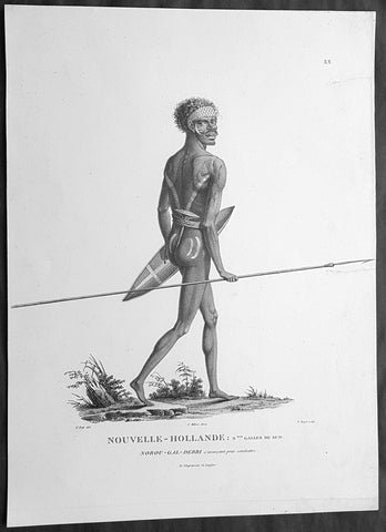
1807 Baudin & Petit Antique Print of a Sydney & Port Jackson Aboriginal Warrior
Antique Map
- Title : Nouvelle-Hollande. Nelle Galles Du Sud. Nourou-gal-derri & avancant pour combattre
- Size: 14in x 10in (355mm x 255mm)
- Condition: (A+) Fine Condition
- Date : 1807
- Ref #: 91240
Description:
This exquisite, rare original copper-plate engraved antique print of an Aboriginal warrior of Port Jackson carrying a spear & shield, was engraved by Barthélemy Roger, after the 1802 drawing by Nicolas-Martin Petit and was published by Francois Peron (1775 - 1810) in the 1st edition atlas of Nicolas Thomas Baudins expedition to Australia Voyage de découvertes aux Terres Australes in 1807.
This is a wonderful original stipple point engraving by Petit & Roger bringing to life this wonderful 1st Australian.
Nicholas Martin Petit sailed with Nicolas Baudin on the expedition of the Géographe and the Naturaliste in late 1800. The scientific field of anthropology was in its infancy – the French had founded the Society of the Observers of Man in 1799. Having embarked as a fourth-class gunner’s mate, Petit, who had had some graphic arts training, became one of the expeditions two illustrators when the official artists quit. From June to November 1802, the expedition was delayed in Sydney while its two ships were repaired. During this time Petit completed portraits of people of the Cadigal, Dharawal, Gweagal, Kurringai and Darug language groups of the Sydney Harbour region. While the sitters names appear to be noted on the works, it is possible that the inscriptions merely reflect French misinterpretation of the Aborigines communications with them.
The portrait of Nourou-gal-derri is pictured advancing for battle.
General Definitions:
Paper thickness and quality: - Heavy and stable
Paper color : - off white
Age of map color: -
Colors used: -
General color appearance: -
Paper size: - 14in x 10in (355mm x 255mm)
Plate size: - 12 1/2in x 9 1/2in (320mm x 240mm)
Margins: - Min 1/2in (12mm)
Imperfections:
Margins: - None
Plate area: - 2 small repair to left margin, no loss
Verso: - None
Background:
The Baudin Expedition of 1800 to 1803 was a French expedition to map the coast of New Holland, Australia. The expedition started with two ships, Géographe, captained by Baudin, and Naturaliste captained by Jacques Hamelin, and was accompanied by nine zoologists and botanists, including Jean-Baptiste Leschenault de la Tour, François Péron and Charles-Alexandre Lesueur as well as the geographer Pierre Faure.
The Baudin expedition departed Le Havre, France, on 19 October 1800. Because of delays in receiving his instructions and problems encountered in Isle de France (now Mauritius) they did not reach Cape Leeuwin on the south-west corner of Australia until May 1801. Upon rounding Cape Naturaliste, they entered Geographe Bay. They then sailed north, but the ships became separated and did not meet again until they reached Timor. On their journeys the Géographe and the Naturaliste surveyed large stretches of the north-western coast. The expedition was severely affected by dysentery and fever, but sailed from Timor on 13 November 1801, back down the north-west and west coast, then across the Great Australian Bight, reaching Tasmania on 13 January 1802. They charted the whole length of Tasmanias east coast and there were extensive interactions with the Indigenous Tasmanians, with whom they had peaceful relationships. They notably produced precious ethnological studies of Indigenous Tasmanians.
The expedition then began surveying the south coast of Australia, but then Captain Jacques Felix Emmanuel Hamelin in Naturaliste decided to make for Port Jackson (Sydney) as he was running short of food and water, and in need of anchors. En route, in April 1802, Hamelin explored the area of Western Port, Victoria, and gave names to places, a number of which have survived, for example, Ile des Français is now called French Island.
Meanwhile, Baudin in the Géographe continued westward, and in April 1802 encountered the British ship Investigator commanded by Matthew Flinders, also engaged in charting the coastline, at Encounter Bay in what is now South Australia. Flinders informed Baudin of his discovery of Kangaroo Island, St. Vincents and Spencers Gulfs. Baudin sailed on to the Nuyts Archipelago, the point reached by t Gulden Zeepaert in 1627 before heading for Port Jackson as well for supplies.
In late 1802 the expedition was at Port Jackson, where the government sold 60 casks of flour and 25 casks of salt meat to Baudin to resupply his two vessels. The supplies permitted Naturaliste to return to France and Géographe to continue her explorations of the Australian coast. Naturaliste took with her the Colonys staff surgeon, Mr. James Thomson, whom Governor Philip Gidley King had given permission to return to England.
Before resuming the voyage Baudin purchased a 30 ton schooner, which he named the Casuarina, a smaller vessel which could conduct close inshore survey work. He sent the larger Naturaliste under Hamelin back to France with all the specimens that had been collected by Baudin and his crew. As the voyage had progressed Louis de Freycinet, now a Lieutenant, had shown his talents as an officer and a hydrographer and so was given command of the Casuarina. The expedition then headed for Tasmania and conducted further charting of Bass Strait before sailing west, following the west coast northward, and after another visit to Timor, undertook further exploration along the north coast of Australia. Plagued by contrary winds, ill health, and because the quadrupeds and emus were very sick, it was decided on 7 July 1803 to return to France. On the return voyage, the ships stopped in Mauritius, where Baudin died of tuberculosis on 16 September 1803. The expedition finally reached France on 24 March 1804.
The scientific expedition was considered a great success, with more than 2500 new species discovered.
Nicolas-Martin Petit 1777 – 1804
Nicholas-Martin Petit was born in Paris, the son of a fan maker, and learned graphic art in the studio of Jacques Louis David. He avoided conscription into Napoleons armies, but wanting to travel, signed up with post Captain Nicholas Baudin on a voyage to the antipodes sponsored by the French government. Petit and fellow artist Charles-Alexandre Lesueur were enlisted directly by Baudin (as 4th class gunners mates) while the two official artists were hired by the organisers of the expedition. Baudin set off in two lavishly equipped vessels, the Géographe and the Naturaliste on 19 October 1800. By the time the expedition reached Mauritius the official artists had quit. Petit and Lesueur took over their duties, but as neither was trained in scientific method or presentation, the value of their work was primarily aesthetic. The French were at this time developing a new scientific field - anthropology. The Society of the Observers of Man was founded in 1799 for this purpose. The study of Man formed part of the background for Petits sensitive drawings and paintings of the indigenous people of Van Diemens Land, Port Jackson and Western Australia. Lesueur focused on the depiction of animals. The expedition charted the coast of Western Australia and Van Diemens land but was plagued by scurvy. On 20 June 1802 the two ships limped into Port Jackson and stayed for five months to refit, during which time Petit completed a number of portraits of Sydney Indigenous people, including the two images of the Eora men, Cour-rou-bari-gal and Y-erren-gou-la-ga. Petit eventually returned to France in 1804. However, before he was well enough to complete the drawings from the expedition he was hurt in a street accident, and he died at the age of 28. Petits unfinished work was first published in 1807 in the Atlas of the Voyage de découvertes aux terres australes and as discrete prints.
Baudin, Nicolas Thomas 1754 – 1803
Baudin was a French explorer, cartographer, naturalist and hydrographer. Born a commoner in Saint-Martin-de-Ré on the Île de Ré on 17 February 1754 Baudin joined the merchant navy at the age of 15 and the French East India Company at the age of 20.
Baudin then joined the La Marine Royale (French Navy) in 1774 and served in the Caribbean as an officier bleu during the American War of Independence of 1775–1783.
In 1785 Baudin and his brother Alexandre were respectively masters of the St Remy and Caroline, taking Acadian settlers from Nantes to La Nouvelle Orléans. In New Orleans local merchants contracted him to take a cargo of wood, salted meat, cod and flour to Isle de France (now Mauritius), which he did in Josephine (also called Pepita), departing New Orleans on 14 July 1786 and arriving at Isle de France on 27 March 1787. In the course of the voyage, Josephine had called at Cap‑Français in Haiti to make a contract to transport slaves there from Madagascar; while in Haiti he also encountered the Austrian botanist Franz Josef Maerter, who apparently informed him that another Austrian botanist, Franz Boos, was at the Cape of Good Hope awaiting a ship to take him to Mauritius. Josephine called at the Cape and took Boos on board. At Mauritius, Boos chartered Baudin to transport him and the collection of plant specimens he had gathered there and at the Cape back to Europe, which Baudin did, Josephine arriving at Trieste on 18 June 1788. The Imperial government in Vienna was contemplating organizing another natural-history expedition, to which Boos would be appointed, in which two ships would be sent to the Malabar and Coromandel coasts of India, the Persian Gulf, Bengal, Ceylon, Sumatra, Java, Borneo, Cochin China, Tongking, Japan and China. Baudin had been given reason to hope that he would be given command of the ships of this expedition.
Later in 1788 Baudin sailed on a commercial voyage from Trieste to Canton in Jardiniere. He apparently arrived at Canton from Mauritius under the flag of the United States of America, probably to avoid the possibility of having his ship seized by the Chinese for payment of the debts owed them by the Imperial Asiatic Company of Trieste. From there, he sent Jardiniere under her second captain on a fur-trading venture to the north-west coast of America, but the ship foundered off Asuncion Island in the Marianas in late 1789.
Baudin made his way to Mauritius, where he purchased a replacement ship, Jardiniere II, but this vessel was wrecked in a cyclone that struck Port Louis on 15 December 1789. Baudin embarked on the Spanish Royal Philippines Company ship, Placeres, which sailed from Port Louis for Cadiz in August 1790. Placeres called at the Cape of Good Hope where it took on board the large number of plant and animal specimens collected in South Africa for the Imperial palace at Schönbrunn by Georg Scholl, the assistant of Franz Boos. Because of the poor condition of the ship, Placeres had to put in at the island of Trinidad in the West Indies, where Scholls collection of specimens was deposited.
Baudin proceeded to Martinique, from where he addressed an offer to the Imperial government in Vienna to conduct to Canton commissioners who would be empowered to negotiate with the Chinese merchants there a settlement of the debts incurred by the Imperial Asiatic Company, which would enable the company to renew its trade with China. On its return voyage from Canton, the proposed expedition would call at the Cape of Good Hope to pick up Scholl and the remainder of his natural-history collection for conveyance to Schönbrunn.
After returning to Vienna in September 1791, Baudin continued to press his case for an expedition under the Imperial flag to the Indian Ocean and China, and in January 1792 he was granted a commission of captain in the Imperial navy for this purpose. A ship, called Jardiniere, was acquired and the botanists Franz Bredemeyer and Joseph van der Schot appointed to the expedition. After delays caused by the outbreak of war between France and Austria (April 1792), Jardiniere departed from the Spanish port of Málaga on 1 October 1792. From the Cape of Good Hope Jardiniere sailed across the Indian Ocean to the coast of New Holland (Australia), but two consecutive cyclones prevented the expedition from doing any work there and forced Baudin to take the ship to Bombay for repairs.
From Bombay the expedition proceeded to the Persian Gulf, the Red Sea and the east coast of Africa, where it gathered botanical and zoological collections. The expedition came to an abrupt end in June 1794 when Jardiniere went aground in a storm while attempting to enter Table Bay at the Cape of Good Hope. Baudin survived the wreck and made his way to the United States, from where he went to France. He managed to send Jardinieres cargo of natural history specimens to the island of Trinidad.
In Paris, Baudin visited Antoine de Jussieu at the Museum National dHistoire Naturelle in March 1796 to suggest a botanical voyage to the Caribbean, during which he would recover the collection of specimens he had left in Trinidad. The Museum and the French government accepted the proposal, and Baudin was appointed commander of an expedition in the ship Belle Angélique, with four assigned botanists: René Maugé, André Pierre Ledru, Anselme Riedlé and Stanislas Levillain. Belle Angélique cleared Le Havre on 30 September 1796 for the Canary Islands, where the ship was condemned as unseaworthy. The expedition sailed from the Canaries in a replacement vessel, Fanny, and reached Trinidad in April 1797. The British, who had just captured the island from the Spanish in February 1797, refused to allow Baudin to recover the collection of natural-history specimens. Baudin took Fanny to St. Thomas and St. Croix, and then to Puerto Rico, specimens being collected in all three islands. At St Croix, Fanny was replaced by a newly purchased ship, renamed Belle Angelique. The expedition returned to France in June 1798 with a large collection of plants, birds and insects, which was incorporated into Napoleon Bonapartes triumphal procession celebrating his recent Italian victories.
On 24 July 1798, at the suggestion of the Ministry of Marine, Baudin presented to the Assembly of Professors and Administrators of the National Museum of Natural History a plan for a hydrographic-survey expedition to the South Seas, which would include a search for fauna and flora that could be brought back for cultivation in France. The expedition would also have the aim of promoting the economic and commercial interests of France in the regions to be visited. The expedition would require two well-equipped ships, which would carry a team of astronomers, naturalists and scientific draughtsmen over whom Baudin as commander would have absolute authority. The first part of the voyage would be devoted to a thorough exploration of the coast of Chile and the collection of animal, bird and plant specimens suitable for acclimatization in France, followed by a survey of the coasts from Peru to Mexico. The expedition would then continue into the Pacific Ocean, including a visit to Tahiti and the Society Islands, and would be completed with a survey of the yet unexplored south-west coast of New Holland (Australia). After considering this extensive proposal, the French government decided to proceed with an expedition confined to a survey of western and southern New Holland (as Australia was called at the time).
In October 1800 Baudin was selected to lead what has become known as the Baudin expedition to map the coast of Australia (New Holland). He had two ships, Géographe and Naturaliste captained by Hamelin, and a suite of nine zoologists and botanists, including Jean Baptiste Leschenault de la Tour. He reached Australia in May 1801, and would explore and map the western coast and a part of the little-known southern coast of the continent. The scientific expedition proved a great success, with more than 2500 new species discovered. The French also met Aboriginal peoples and treated them with great respect.
In April 1802 Baudin met Matthew Flinders, also engaged in charting the coastline, in Encounter Bay in present-day South Australia. Baudin then stopped at the British colony at Sydney for supplies. In Sydney he bought a new ship — Casuarina — named after the wood it was made from. From there he sent home Naturaliste, which had on board all of the specimens that had been discovered by Baudin and his crew. He then headed for Tasmania, before continuing north to Timor. Baudin then sailed for home, stopping at Mauritius.
According to recent researches by academics from the University of Adelaide, during Baudins expedition, François Péron, who had become the chief zoologist and intellectual leader of the mission, wrote a report for Napoleon on ways to invade and capture the British colony at Sydney Cove.
Baudin died of tuberculosis at Mauritius on 16 September 1803, at the age of 49, apparently in the home of Madame Alexandrine Kerivel. Baudins exact resting place is not known, but the historian Auguste Toussaint believed that he was interred in the Kerivel family vault. However, the historian Edward Duyker likes to think that Baudin was buried in Le Cimetière de lOuest in the district of Port Louis just a few hundred metres from the explorers certain love: the sea.
Please note all items auctioned are genuine, we do not sell reproductions. A Certificate of Authenticity (COA) can be issued on request.
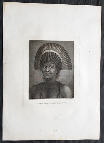
1784 Cook & Webber Large 1st Edition Antique Portrait of Poulaho King of Tonga
Antique Map
- Title : Poulaho, King of the Friendly Islands.
- Size: 21in x 15in (535mm x 385mm)
- Condition: (A+) Fine Condition
- Date : 1784
- Ref #: 82070
Description:
This large beautifully engraved original copper-plate 1st edition antique portrait of Fatafehi Paulaho, the Tui Tonga or Tongan King, visited by Captain Cook in 1777 by John Webber (Cooks official artist on the voyage) was published for the 1784 1st edition and official British Admiralty sanctioned account of Captain Cook’s third and final voyage along with that of Cooks successor Capt. James King......
A Voyage to the Pacific Ocean. Undertaken, by the Command of his Majesty, for making Discoveries in the Northern Hemisphere. To determine The Position and Extent of the West Side of North America; its Distance from Asia; and the Practicability of a Northern Passage to Europe. Performed under the direction of Captains Cook, Clerke, and Gore, In His Majesty\'s Ships the Resolution and Discovery. In the Years 1776, 1777, 1778, 1779, and 1780. In Three Volumes. Vol. I and II written by James Cook, F.R.S. Vol. III by Captain James King, LL.D. and F.R.S
Cooks diary ......On the 28th May 1777, as Cook was about to leave, Ha apai Paulaho came on board and brought me one of their Caps made or at least covered with red feathers. ..These Caps or rather bonnets are made of the tail feathers of the Tropic bird with red feathers of the Paroquets worked upon them or in along with them, they are made so as to tie upon the forehead without any Crown, and have the form of a Semicircle whose raids is 18 or 21 Inches. Cook Journals III, i.117.
Cook had described Paulaho as \\\'the corperate plump fellow we had met with\\\'.
......About Noon a large sailing Canoe came under our Stern in which the Indians on board told us was Fattafee Polaho [Fatafehi Paulaho] King of all the Isles. He brought with him as a present to me two good fat hogs, though not so fat as himself, for he was the most corperate plump fellow we had met with. I found him to be a Sedate sensible man… I asked him down into the Cabbin, some of his attendants objected to this, saying if he went there people would walk over his head and this was never done. I desired Omai to till them I would remove that objection by giving orders that no one should walk on that part of the deck but the chief \'waved the ceremony and walked down with me without any more to do.....
General Definitions:
Paper thickness and quality: - Heavy and stable
Paper color : - off white
Age of map color: -
Colors used: -
General color appearance: -
Paper size: - 21in x 15in (535mm x 385mm)
Plate size: - 21in x 15in (535mm x 385mm)
Margins: - Min 1/2in (12mm)
Imperfections:
Margins: - None
Plate area: - None
Verso: - None
Background:
Tonga officially the Kingdom of Tonga, is a Polynesian sovereign state and archipelago comprising 169 islands, of which 36 are inhabited. The total surface area is about 750 square kilometres (290 sq mi) scattered over 700,000 square kilometres (270,000 sq mi) of the southern Pacific Ocean. It has a population of 107,122 people, of whom 70% reside on the main island of Tongatapu.
The Tongan people first encountered Europeans in 1616 when the Dutch vessel Eendracht, captained by Willem Schouten, made a short visit to trade. Later came other Dutch explorers, including Jacob Le Maire (who called on the northern island of Niuatoputapu); and in 1643 Abel Tasman (who visited Tongatapu and Haapai).
Later noteworthy European visitors included James Cook (Royal Navy) in 1773, 1774, and 1777; Alessandro Malaspina (Spanish Navy) in 1793; the first London missionaries in 1797; and the Wesleyan Methodist Reverend Walter Lawry in 1822.
Tonga became known in the West as the Friendly Islands because of the congenial reception accorded to Captain James Cook on his first visit in 1773. He arrived at the time of the inasi festival, the yearly donation of the First Fruits to the Tui Tonga (the islands paramount chief) and so received an invitation to the festivities. According to the writer William Mariner, the chiefs wanted to kill Cook during the gathering but could not agree on a plan.
Captain James King FRS 1750 – 1784 was an officer of the Royal Navy. He served under James Cook on his last voyage around the world, specialising in taking important astronomical readings using a sextant. After Cook died he helped lead the ships on the remainder of their course, also completing Cooks account of the voyage. He continued his career in the Navy, reaching the rank of post-captain, commanding several ships and serving in the American War of Independence.
King joined HMS Resolution as second lieutenant, sharing the duties of astronomer with Cook, taking astronomical observations on board by sextant and with Larcum Kendals timekeeper K1, to establish the Resolutions position at sea and on shore by sextant or by astronomical quadrant to establish the geographical position of salient points during the course of Cooks surveys. Thus Kings geographical positions were an important contribution to the accuracy of the various surveys carried out during the voyage and his use of the early chronometers helped prove their use at sea for calculation of Longitude. .
Following the death of Cook, King remained in the Resolution but on the death of Charles Clerke, Cooks successor, King was appointed to command HMS Discovery, the Resolutions consort, remaining in her for the rest of the voyage. After his return to England King was very much involved in the publication of the official account of Cooks third voyage, writing the third volume at Woodstock, near Oxford, where his brother Thomas was rector of St Mary Magdalene. But shortly after his return King was promoted Post-captain and appointed commander of HMS Crocodile in the English Channel.
John Webber RA 1751 – 1793 was an English artist who accompanied Captain Cook on his third Pacific expedition. He is best known for his images of Australasia, Hawaii and Alaska.
Webber was born in London, educated in Bern and studied painting at Paris.His father was Abraham Wäber, a Swiss sculptor who had moved to London, and changed his name to Webber before marrying a Mrs Mary Quant in 1744.
Webber served as official artist on James Cooks third voyage of discovery around the Pacific (1776–80) aboard HMS Resolution. At Adventure Bay in January 1777 he did drawings of A Man of Van Diemens Land and A Woman of Van Diemens Land. He also did many drawings of scenes in New Zealand and the South Sea islands. On this voyage, during which Cook lost his life in a fight in Hawaii, Webber became the first European artist to make contact with Hawaii, then called the Sandwich Islands. He made numerous watercolor landscapes of the islands of Kauai and Hawaii, and also portrayed many of the Hawaiian people.
In April 1778, Captain Cooks ships Resolution and Discovery anchored at Ship Cove, now known as Nootka Sound, Vancouver Island, Canada to refit. The crew took observations and recorded encounters with the local people. Webber made watercolour landscapes including Resolution and Discovery in Ship Cove, 1778. His drawings and paintings were engraved for British Admiraltys account of the expedition, which was published in 1784.
Back in England in 1780 Webber exhibited around 50 works at Royal Academy exhibitions between 1784 and 1792, and was elected an associate of the Royal Academy in 1785 and R.A. in 1791. Most of his work were landscapes. Sometimes figures were included as in A Party from H.M.S. Resolution shooting sea horses, which was shown at the academy in 1784, and his The Death of Captain Cook became well known through an engraving of it. Another version of this picture is in the William Dixson gallery at Sydney
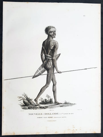
1807 Baudin & Petit Antique Print of a Sydney & Port Jackson Aboriginal Warrior
Antique Map
- Title : Nouvelle-Hollande. Nelle Galles Du Sud. Nourou-gal-derri & avancant pour combattre
- Size: 13in x 10in (330mm x 255mm)
- Condition: (A+) Fine Condition
- Date : 1807
- Ref #: 93087
Description:
This exquisite, rare original copper-plate engraved antique print of an Aboriginal warrior of Port Jackson carrying a spear & shield, was engraved by Barthélemy Roger, after the 1802 drawing by Nicolas-Martin Petit and was published by Francois Peron (1775 - 1810) in the 1st edition atlas of Nicolas Thomas Baudins expedition to Australia Voyage de découvertes aux Terres Australes in 1807.
This is a wonderful original stipple point engraving by Petit & Roger bringing to life this wonderful 1st Australian.
Nicholas Martin Petit sailed with Nicolas Baudin on the expedition of the Géographe and the Naturaliste in late 1800. The scientific field of anthropology was in its infancy – the French had founded the Society of the Observers of Man in 1799. Having embarked as a fourth-class gunner’s mate, Petit, who had had some graphic arts training, became one of the expeditions two illustrators when the official artists quit. From June to November 1802, the expedition was delayed in Sydney while its two ships were repaired. During this time Petit completed portraits of people of the Cadigal, Dharawal, Gweagal, Kurringai and Darug language groups of the Sydney Harbour region. While the sitters names appear to be noted on the works, it is possible that the inscriptions merely reflect French misinterpretation of the Aborigines communications with them.
The portrait of Nourou-gal-derri is pictured advancing for battle.
General Definitions:
Paper thickness and quality: - Heavy and stable
Paper color : - off white
Age of map color: -
Colors used: -
General color appearance: -
Paper size: - 13in x 10in (330mm x 255mm)
Plate size: - 13in x 10in (330mm x 255mm)
Margins: - Min 1/2in (12mm)
Imperfections:
Margins: - Light spotting to left and bottom margins, not affecting the image
Plate area: - None
Verso: - None
Background:
The Baudin Expedition of 1800 to 1803 was a French expedition to map the coast of New Holland, Australia. The expedition started with two ships, Géographe, captained by Baudin, and Naturaliste captained by Jacques Hamelin, and was accompanied by nine zoologists and botanists, including Jean-Baptiste Leschenault de la Tour, François Péron and Charles-Alexandre Lesueur as well as the geographer Pierre Faure.
The Baudin expedition departed Le Havre, France, on 19 October 1800. Because of delays in receiving his instructions and problems encountered in Isle de France (now Mauritius) they did not reach Cape Leeuwin on the south-west corner of Australia until May 1801. Upon rounding Cape Naturaliste, they entered Geographe Bay. They then sailed north, but the ships became separated and did not meet again until they reached Timor. On their journeys the Géographe and the Naturaliste surveyed large stretches of the north-western coast. The expedition was severely affected by dysentery and fever, but sailed from Timor on 13 November 1801, back down the north-west and west coast, then across the Great Australian Bight, reaching Tasmania on 13 January 1802. They charted the whole length of Tasmanias east coast and there were extensive interactions with the Indigenous Tasmanians, with whom they had peaceful relationships. They notably produced precious ethnological studies of Indigenous Tasmanians.
The expedition then began surveying the south coast of Australia, but then Captain Jacques Felix Emmanuel Hamelin in Naturaliste decided to make for Port Jackson (Sydney) as he was running short of food and water, and in need of anchors. En route, in April 1802, Hamelin explored the area of Western Port, Victoria, and gave names to places, a number of which have survived, for example, Ile des Français is now called French Island.
Meanwhile, Baudin in the Géographe continued westward, and in April 1802 encountered the British ship Investigator commanded by Matthew Flinders, also engaged in charting the coastline, at Encounter Bay in what is now South Australia. Flinders informed Baudin of his discovery of Kangaroo Island, St. Vincents and Spencers Gulfs. Baudin sailed on to the Nuyts Archipelago, the point reached by t Gulden Zeepaert in 1627 before heading for Port Jackson as well for supplies.
In late 1802 the expedition was at Port Jackson, where the government sold 60 casks of flour and 25 casks of salt meat to Baudin to resupply his two vessels. The supplies permitted Naturaliste to return to France and Géographe to continue her explorations of the Australian coast. Naturaliste took with her the Colonys staff surgeon, Mr. James Thomson, whom Governor Philip Gidley King had given permission to return to England.
Before resuming the voyage Baudin purchased a 30 ton schooner, which he named the Casuarina, a smaller vessel which could conduct close inshore survey work. He sent the larger Naturaliste under Hamelin back to France with all the specimens that had been collected by Baudin and his crew. As the voyage had progressed Louis de Freycinet, now a Lieutenant, had shown his talents as an officer and a hydrographer and so was given command of the Casuarina. The expedition then headed for Tasmania and conducted further charting of Bass Strait before sailing west, following the west coast northward, and after another visit to Timor, undertook further exploration along the north coast of Australia. Plagued by contrary winds, ill health, and because the quadrupeds and emus were very sick, it was decided on 7 July 1803 to return to France. On the return voyage, the ships stopped in Mauritius, where Baudin died of tuberculosis on 16 September 1803. The expedition finally reached France on 24 March 1804.
The scientific expedition was considered a great success, with more than 2500 new species discovered.
Nicolas-Martin Petit 1777 – 1804
Nicholas-Martin Petit was born in Paris, the son of a fan maker, and learned graphic art in the studio of Jacques Louis David. He avoided conscription into Napoleons armies, but wanting to travel, signed up with post Captain Nicholas Baudin on a voyage to the antipodes sponsored by the French government. Petit and fellow artist Charles-Alexandre Lesueur were enlisted directly by Baudin (as 4th class gunners mates) while the two official artists were hired by the organisers of the expedition. Baudin set off in two lavishly equipped vessels, the Géographe and the Naturaliste on 19 October 1800. By the time the expedition reached Mauritius the official artists had quit. Petit and Lesueur took over their duties, but as neither was trained in scientific method or presentation, the value of their work was primarily aesthetic. The French were at this time developing a new scientific field - anthropology. The Society of the Observers of Man was founded in 1799 for this purpose. The study of Man formed part of the background for Petits sensitive drawings and paintings of the indigenous people of Van Diemens Land, Port Jackson and Western Australia. Lesueur focused on the depiction of animals. The expedition charted the coast of Western Australia and Van Diemens land but was plagued by scurvy. On 20 June 1802 the two ships limped into Port Jackson and stayed for five months to refit, during which time Petit completed a number of portraits of Sydney Indigenous people, including the two images of the Eora men, Cour-rou-bari-gal and Y-erren-gou-la-ga. Petit eventually returned to France in 1804. However, before he was well enough to complete the drawings from the expedition he was hurt in a street accident, and he died at the age of 28. Petits unfinished work was first published in 1807 in the Atlas of the Voyage de découvertes aux terres australes and as discrete prints.
Baudin, Nicolas Thomas 1754 – 1803
Baudin was a French explorer, cartographer, naturalist and hydrographer. Born a commoner in Saint-Martin-de-Ré on the Île de Ré on 17 February 1754 Baudin joined the merchant navy at the age of 15 and the French East India Company at the age of 20.
Baudin then joined the La Marine Royale (French Navy) in 1774 and served in the Caribbean as an officier bleu during the American War of Independence of 1775–1783.
In 1785 Baudin and his brother Alexandre were respectively masters of the St Remy and Caroline, taking Acadian settlers from Nantes to La Nouvelle Orléans. In New Orleans local merchants contracted him to take a cargo of wood, salted meat, cod and flour to Isle de France (now Mauritius), which he did in Josephine (also called Pepita), departing New Orleans on 14 July 1786 and arriving at Isle de France on 27 March 1787. In the course of the voyage, Josephine had called at Cap‑Français in Haiti to make a contract to transport slaves there from Madagascar; while in Haiti he also encountered the Austrian botanist Franz Josef Maerter, who apparently informed him that another Austrian botanist, Franz Boos, was at the Cape of Good Hope awaiting a ship to take him to Mauritius. Josephine called at the Cape and took Boos on board. At Mauritius, Boos chartered Baudin to transport him and the collection of plant specimens he had gathered there and at the Cape back to Europe, which Baudin did, Josephine arriving at Trieste on 18 June 1788. The Imperial government in Vienna was contemplating organizing another natural-history expedition, to which Boos would be appointed, in which two ships would be sent to the Malabar and Coromandel coasts of India, the Persian Gulf, Bengal, Ceylon, Sumatra, Java, Borneo, Cochin China, Tongking, Japan and China. Baudin had been given reason to hope that he would be given command of the ships of this expedition.
Later in 1788 Baudin sailed on a commercial voyage from Trieste to Canton in Jardiniere. He apparently arrived at Canton from Mauritius under the flag of the United States of America, probably to avoid the possibility of having his ship seized by the Chinese for payment of the debts owed them by the Imperial Asiatic Company of Trieste. From there, he sent Jardiniere under her second captain on a fur-trading venture to the north-west coast of America, but the ship foundered off Asuncion Island in the Marianas in late 1789.
Baudin made his way to Mauritius, where he purchased a replacement ship, Jardiniere II, but this vessel was wrecked in a cyclone that struck Port Louis on 15 December 1789. Baudin embarked on the Spanish Royal Philippines Company ship, Placeres, which sailed from Port Louis for Cadiz in August 1790. Placeres called at the Cape of Good Hope where it took on board the large number of plant and animal specimens collected in South Africa for the Imperial palace at Schönbrunn by Georg Scholl, the assistant of Franz Boos. Because of the poor condition of the ship, Placeres had to put in at the island of Trinidad in the West Indies, where Scholls collection of specimens was deposited.
Baudin proceeded to Martinique, from where he addressed an offer to the Imperial government in Vienna to conduct to Canton commissioners who would be empowered to negotiate with the Chinese merchants there a settlement of the debts incurred by the Imperial Asiatic Company, which would enable the company to renew its trade with China. On its return voyage from Canton, the proposed expedition would call at the Cape of Good Hope to pick up Scholl and the remainder of his natural-history collection for conveyance to Schönbrunn.
After returning to Vienna in September 1791, Baudin continued to press his case for an expedition under the Imperial flag to the Indian Ocean and China, and in January 1792 he was granted a commission of captain in the Imperial navy for this purpose. A ship, called Jardiniere, was acquired and the botanists Franz Bredemeyer and Joseph van der Schot appointed to the expedition. After delays caused by the outbreak of war between France and Austria (April 1792), Jardiniere departed from the Spanish port of Málaga on 1 October 1792. From the Cape of Good Hope Jardiniere sailed across the Indian Ocean to the coast of New Holland (Australia), but two consecutive cyclones prevented the expedition from doing any work there and forced Baudin to take the ship to Bombay for repairs.
From Bombay the expedition proceeded to the Persian Gulf, the Red Sea and the east coast of Africa, where it gathered botanical and zoological collections. The expedition came to an abrupt end in June 1794 when Jardiniere went aground in a storm while attempting to enter Table Bay at the Cape of Good Hope. Baudin survived the wreck and made his way to the United States, from where he went to France. He managed to send Jardinieres cargo of natural history specimens to the island of Trinidad.
In Paris, Baudin visited Antoine de Jussieu at the Museum National dHistoire Naturelle in March 1796 to suggest a botanical voyage to the Caribbean, during which he would recover the collection of specimens he had left in Trinidad. The Museum and the French government accepted the proposal, and Baudin was appointed commander of an expedition in the ship Belle Angélique, with four assigned botanists: René Maugé, André Pierre Ledru, Anselme Riedlé and Stanislas Levillain. Belle Angélique cleared Le Havre on 30 September 1796 for the Canary Islands, where the ship was condemned as unseaworthy. The expedition sailed from the Canaries in a replacement vessel, Fanny, and reached Trinidad in April 1797. The British, who had just captured the island from the Spanish in February 1797, refused to allow Baudin to recover the collection of natural-history specimens. Baudin took Fanny to St. Thomas and St. Croix, and then to Puerto Rico, specimens being collected in all three islands. At St Croix, Fanny was replaced by a newly purchased ship, renamed Belle Angelique. The expedition returned to France in June 1798 with a large collection of plants, birds and insects, which was incorporated into Napoleon Bonapartes triumphal procession celebrating his recent Italian victories.
On 24 July 1798, at the suggestion of the Ministry of Marine, Baudin presented to the Assembly of Professors and Administrators of the National Museum of Natural History a plan for a hydrographic-survey expedition to the South Seas, which would include a search for fauna and flora that could be brought back for cultivation in France. The expedition would also have the aim of promoting the economic and commercial interests of France in the regions to be visited. The expedition would require two well-equipped ships, which would carry a team of astronomers, naturalists and scientific draughtsmen over whom Baudin as commander would have absolute authority. The first part of the voyage would be devoted to a thorough exploration of the coast of Chile and the collection of animal, bird and plant specimens suitable for acclimatization in France, followed by a survey of the coasts from Peru to Mexico. The expedition would then continue into the Pacific Ocean, including a visit to Tahiti and the Society Islands, and would be completed with a survey of the yet unexplored south-west coast of New Holland (Australia). After considering this extensive proposal, the French government decided to proceed with an expedition confined to a survey of western and southern New Holland (as Australia was called at the time).
In October 1800 Baudin was selected to lead what has become known as the Baudin expedition to map the coast of Australia (New Holland). He had two ships, Géographe and Naturaliste captained by Hamelin, and a suite of nine zoologists and botanists, including Jean Baptiste Leschenault de la Tour. He reached Australia in May 1801, and would explore and map the western coast and a part of the little-known southern coast of the continent. The scientific expedition proved a great success, with more than 2500 new species discovered. The French also met Aboriginal peoples and treated them with great respect.
In April 1802 Baudin met Matthew Flinders, also engaged in charting the coastline, in Encounter Bay in present-day South Australia. Baudin then stopped at the British colony at Sydney for supplies. In Sydney he bought a new ship — Casuarina — named after the wood it was made from. From there he sent home Naturaliste, which had on board all of the specimens that had been discovered by Baudin and his crew. He then headed for Tasmania, before continuing north to Timor. Baudin then sailed for home, stopping at Mauritius.
According to recent researches by academics from the University of Adelaide, during Baudins expedition, François Péron, who had become the chief zoologist and intellectual leader of the mission, wrote a report for Napoleon on ways to invade and capture the British colony at Sydney Cove.
Baudin died of tuberculosis at Mauritius on 16 September 1803, at the age of 49, apparently in the home of Madame Alexandrine Kerivel. Baudins exact resting place is not known, but the historian Auguste Toussaint believed that he was interred in the Kerivel family vault. However, the historian Edward Duyker likes to think that Baudin was buried in Le Cimetière de lOuest in the district of Port Louis just a few hundred metres from the explorers certain love: the sea.
Please note all items auctioned are genuine, we do not sell reproductions. A Certificate of Authenticity (COA) can be issued on request.
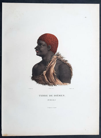
1807 Nicolas Baudin & N M Petit Antique Print of Tasmanian Aboriginal, Ourlaga
Antique Map
- Title : Terre De Diemen Ourlaga
- Size: 14in x 10in (355mm x 255mm)
- Condition: (A+) Fine Condition
- Date : 1807
- Ref #: 93089
Description:
This exquisite, rare original hand coloured copper-plate engraved antique print of Tasmanian Ourlaga, visited by Baudin Expedition to Australia in Feb. 1802, was engraved by Barthélemy Roger, after Nicolas-Martin Petit (the offical artist on the ship Géographe) and was published by Francois Peron (1775 - 1810) in the 1st edition atlas of Nicolas Thomas Baudins expedition to Australia Voyage de découvertes aux Terres Australes
General Definitions:
Paper thickness and quality: - Heavy and stable
Paper color : - off white
Age of map color: - Original
Colors used: - Yellow, green, blue, pink
General color appearance: - Authentic
Paper size: - 14in x 10in (355mm x 255mm)
Plate size: - 14in x 10in (355mm x 255mm)
Margins: - Min 1/2in (12mm)
Imperfections:
Margins: - None
Plate area: - None
Verso: - None
Background:
The Baudin Expedition of 1800 to 1803 was a French expedition to map the coast of New Holland, Australia. The expedition started with two ships, Géographe, captained by Baudin, and Naturaliste captained by Jacques Hamelin, and was accompanied by nine zoologists and botanists, including Jean-Baptiste Leschenault de la Tour, François Péron and Charles-Alexandre Lesueur as well as the geographer Pierre Faure.
The Baudin expedition departed Le Havre, France, on 19 October 1800. Because of delays in receiving his instructions and problems encountered in Isle de France (now Mauritius) they did not reach Cape Leeuwin on the south-west corner of Australia until May 1801. Upon rounding Cape Naturaliste, they entered Geographe Bay. They then sailed north, but the ships became separated and did not meet again until they reached Timor. On their journeys the Géographe and the Naturaliste surveyed large stretches of the north-western coast. The expedition was severely affected by dysentery and fever, but sailed from Timor on 13 November 1801, back down the north-west and west coast, then across the Great Australian Bight, reaching Tasmania on 13 January 1802. They charted the whole length of Tasmanias east coast and there were extensive interactions with the Indigenous Tasmanians, with whom they had peaceful relationships. They notably produced precious ethnological studies of Indigenous Tasmanians.
The expedition then began surveying the south coast of Australia, but then Captain Jacques Felix Emmanuel Hamelin in Naturaliste decided to make for Port Jackson (Sydney) as he was running short of food and water, and in need of anchors. En route, in April 1802, Hamelin explored the area of Western Port, Victoria, and gave names to places, a number of which have survived, for example, Ile des Français is now called French Island.
Meanwhile, Baudin in the Géographe continued westward, and in April 1802 encountered the British ship Investigator commanded by Matthew Flinders, also engaged in charting the coastline, at Encounter Bay in what is now South Australia. Flinders informed Baudin of his discovery of Kangaroo Island, St. Vincents and Spencers Gulfs. Baudin sailed on to the Nuyts Archipelago, the point reached by t Gulden Zeepaert in 1627 before heading for Port Jackson as well for supplies.
In late 1802 the expedition was at Port Jackson, where the government sold 60 casks of flour and 25 casks of salt meat to Baudin to resupply his two vessels. The supplies permitted Naturaliste to return to France and Géographe to continue her explorations of the Australian coast. Naturaliste took with her the Colonys staff surgeon, Mr. James Thomson, whom Governor Philip Gidley King had given permission to return to England.
Before resuming the voyage Baudin purchased a 30 ton schooner, which he named the Casuarina, a smaller vessel which could conduct close inshore survey work. He sent the larger Naturaliste under Hamelin back to France with all the specimens that had been collected by Baudin and his crew. As the voyage had progressed Louis de Freycinet, now a Lieutenant, had shown his talents as an officer and a hydrographer and so was given command of the Casuarina. The expedition then headed for Tasmania and conducted further charting of Bass Strait before sailing west, following the west coast northward, and after another visit to Timor, undertook further exploration along the north coast of Australia. Plagued by contrary winds, ill health, and because the quadrupeds and emus were very sick, it was decided on 7 July 1803 to return to France. On the return voyage, the ships stopped in Mauritius, where Baudin died of tuberculosis on 16 September 1803. The expedition finally reached France on 24 March 1804.
The scientific expedition was considered a great success, with more than 2500 new species discovered.
Nicolas-Martin Petit 1777 – 1804
Nicholas-Martin Petit was born in Paris, the son of a fan maker, and learned graphic art in the studio of Jacques Louis David. He avoided conscription into Napoleons armies, but wanting to travel, signed up with post Captain Nicholas Baudin on a voyage to the antipodes sponsored by the French government. Petit and fellow artist Charles-Alexandre Lesueur were enlisted directly by Baudin (as 4th class gunners mates) while the two official artists were hired by the organisers of the expedition. Baudin set off in two lavishly equipped vessels, the Géographe and the Naturaliste on 19 October 1800. By the time the expedition reached Mauritius the official artists had quit. Petit and Lesueur took over their duties, but as neither was trained in scientific method or presentation, the value of their work was primarily aesthetic. The French were at this time developing a new scientific field - anthropology. The Society of the Observers of Man was founded in 1799 for this purpose. The study of Man formed part of the background for Petits sensitive drawings and paintings of the indigenous people of Van Diemens Land, Port Jackson and Western Australia. Lesueur focused on the depiction of animals. The expedition charted the coast of Western Australia and Van Diemens land but was plagued by scurvy. On 20 June 1802 the two ships limped into Port Jackson and stayed for five months to refit, during which time Petit completed a number of portraits of Sydney Indigenous people, including the two images of the Eora men, Cour-rou-bari-gal and Y-erren-gou-la-ga. Petit eventually returned to France in 1804. However, before he was well enough to complete the drawings from the expedition he was hurt in a street accident, and he died at the age of 28. Petits unfinished work was first published in 1807 in the Atlas of the Voyage de découvertes aux terres australes and as discrete prints.
Baudin, Nicolas Thomas 1754 – 1803
Baudin was a French explorer, cartographer, naturalist and hydrographer. Born a commoner in Saint-Martin-de-Ré on the Île de Ré on 17 February 1754 Baudin joined the merchant navy at the age of 15 and the French East India Company at the age of 20.
Baudin then joined the La Marine Royale (French Navy) in 1774 and served in the Caribbean as an officier bleu during the American War of Independence of 1775–1783.
In 1785 Baudin and his brother Alexandre were respectively masters of the St Remy and Caroline, taking Acadian settlers from Nantes to La Nouvelle Orléans. In New Orleans local merchants contracted him to take a cargo of wood, salted meat, cod and flour to Isle de France (now Mauritius), which he did in Josephine (also called Pepita), departing New Orleans on 14 July 1786 and arriving at Isle de France on 27 March 1787. In the course of the voyage, Josephine had called at Cap‑Français in Haiti to make a contract to transport slaves there from Madagascar; while in Haiti he also encountered the Austrian botanist Franz Josef Maerter, who apparently informed him that another Austrian botanist, Franz Boos, was at the Cape of Good Hope awaiting a ship to take him to Mauritius. Josephine called at the Cape and took Boos on board. At Mauritius, Boos chartered Baudin to transport him and the collection of plant specimens he had gathered there and at the Cape back to Europe, which Baudin did, Josephine arriving at Trieste on 18 June 1788. The Imperial government in Vienna was contemplating organizing another natural-history expedition, to which Boos would be appointed, in which two ships would be sent to the Malabar and Coromandel coasts of India, the Persian Gulf, Bengal, Ceylon, Sumatra, Java, Borneo, Cochin China, Tongking, Japan and China. Baudin had been given reason to hope that he would be given command of the ships of this expedition.
Later in 1788 Baudin sailed on a commercial voyage from Trieste to Canton in Jardiniere. He apparently arrived at Canton from Mauritius under the flag of the United States of America, probably to avoid the possibility of having his ship seized by the Chinese for payment of the debts owed them by the Imperial Asiatic Company of Trieste. From there, he sent Jardiniere under her second captain on a fur-trading venture to the north-west coast of America, but the ship foundered off Asuncion Island in the Marianas in late 1789.
Baudin made his way to Mauritius, where he purchased a replacement ship, Jardiniere II, but this vessel was wrecked in a cyclone that struck Port Louis on 15 December 1789. Baudin embarked on the Spanish Royal Philippines Company ship, Placeres, which sailed from Port Louis for Cadiz in August 1790. Placeres called at the Cape of Good Hope where it took on board the large number of plant and animal specimens collected in South Africa for the Imperial palace at Schönbrunn by Georg Scholl, the assistant of Franz Boos. Because of the poor condition of the ship, Placeres had to put in at the island of Trinidad in the West Indies, where Scholls collection of specimens was deposited.
Baudin proceeded to Martinique, from where he addressed an offer to the Imperial government in Vienna to conduct to Canton commissioners who would be empowered to negotiate with the Chinese merchants there a settlement of the debts incurred by the Imperial Asiatic Company, which would enable the company to renew its trade with China. On its return voyage from Canton, the proposed expedition would call at the Cape of Good Hope to pick up Scholl and the remainder of his natural-history collection for conveyance to Schönbrunn.
After returning to Vienna in September 1791, Baudin continued to press his case for an expedition under the Imperial flag to the Indian Ocean and China, and in January 1792 he was granted a commission of captain in the Imperial navy for this purpose. A ship, called Jardiniere, was acquired and the botanists Franz Bredemeyer and Joseph van der Schot appointed to the expedition. After delays caused by the outbreak of war between France and Austria (April 1792), Jardiniere departed from the Spanish port of Málaga on 1 October 1792. From the Cape of Good Hope Jardiniere sailed across the Indian Ocean to the coast of New Holland (Australia), but two consecutive cyclones prevented the expedition from doing any work there and forced Baudin to take the ship to Bombay for repairs.
From Bombay the expedition proceeded to the Persian Gulf, the Red Sea and the east coast of Africa, where it gathered botanical and zoological collections. The expedition came to an abrupt end in June 1794 when Jardiniere went aground in a storm while attempting to enter Table Bay at the Cape of Good Hope. Baudin survived the wreck and made his way to the United States, from where he went to France. He managed to send Jardinieres cargo of natural history specimens to the island of Trinidad.
In Paris, Baudin visited Antoine de Jussieu at the Museum National dHistoire Naturelle in March 1796 to suggest a botanical voyage to the Caribbean, during which he would recover the collection of specimens he had left in Trinidad. The Museum and the French government accepted the proposal, and Baudin was appointed commander of an expedition in the ship Belle Angélique, with four assigned botanists: René Maugé, André Pierre Ledru, Anselme Riedlé and Stanislas Levillain. Belle Angélique cleared Le Havre on 30 September 1796 for the Canary Islands, where the ship was condemned as unseaworthy. The expedition sailed from the Canaries in a replacement vessel, Fanny, and reached Trinidad in April 1797. The British, who had just captured the island from the Spanish in February 1797, refused to allow Baudin to recover the collection of natural-history specimens. Baudin took Fanny to St. Thomas and St. Croix, and then to Puerto Rico, specimens being collected in all three islands. At St Croix, Fanny was replaced by a newly purchased ship, renamed Belle Angelique. The expedition returned to France in June 1798 with a large collection of plants, birds and insects, which was incorporated into Napoleon Bonapartes triumphal procession celebrating his recent Italian victories.
On 24 July 1798, at the suggestion of the Ministry of Marine, Baudin presented to the Assembly of Professors and Administrators of the National Museum of Natural History a plan for a hydrographic-survey expedition to the South Seas, which would include a search for fauna and flora that could be brought back for cultivation in France. The expedition would also have the aim of promoting the economic and commercial interests of France in the regions to be visited. The expedition would require two well-equipped ships, which would carry a team of astronomers, naturalists and scientific draughtsmen over whom Baudin as commander would have absolute authority. The first part of the voyage would be devoted to a thorough exploration of the coast of Chile and the collection of animal, bird and plant specimens suitable for acclimatization in France, followed by a survey of the coasts from Peru to Mexico. The expedition would then continue into the Pacific Ocean, including a visit to Tahiti and the Society Islands, and would be completed with a survey of the yet unexplored south-west coast of New Holland (Australia). After considering this extensive proposal, the French government decided to proceed with an expedition confined to a survey of western and southern New Holland (as Australia was called at the time).
In October 1800 Baudin was selected to lead what has become known as the Baudin expedition to map the coast of Australia (New Holland). He had two ships, Géographe and Naturaliste captained by Hamelin, and a suite of nine zoologists and botanists, including Jean Baptiste Leschenault de la Tour. He reached Australia in May 1801, and would explore and map the western coast and a part of the little-known southern coast of the continent. The scientific expedition proved a great success, with more than 2500 new species discovered. The French also met Aboriginal peoples and treated them with great respect.
In April 1802 Baudin met Matthew Flinders, also engaged in charting the coastline, in Encounter Bay in present-day South Australia. Baudin then stopped at the British colony at Sydney for supplies. In Sydney he bought a new ship — Casuarina — named after the wood it was made from. From there he sent home Naturaliste, which had on board all of the specimens that had been discovered by Baudin and his crew. He then headed for Tasmania, before continuing north to Timor. Baudin then sailed for home, stopping at Mauritius.
According to recent researches by academics from the University of Adelaide, during Baudins expedition, François Péron, who had become the chief zoologist and intellectual leader of the mission, wrote a report for Napoleon on ways to invade and capture the British colony at Sydney Cove.
Baudin died of tuberculosis at Mauritius on 16 September 1803, at the age of 49, apparently in the home of Madame Alexandrine Kerivel. Baudins exact resting place is not known, but the historian Auguste Toussaint believed that he was interred in the Kerivel family vault. However, the historian Edward Duyker likes to think that Baudin was buried in Le Cimetière de lOuest in the district of Port Louis just a few hundred metres from the explorers certain love: the sea.
Please note all items auctioned are genuine, we do not sell reproductions. A Certificate of Authenticity (COA) can be issued on request.
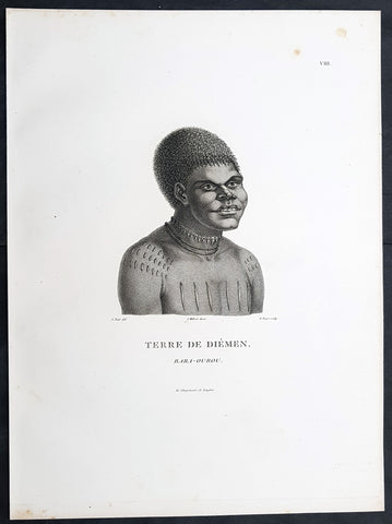
1807 Nicolas Baudin & N M Petit Antique Print of Tasmanian Aboriginal Bara-Ourou
Antique Map
- Title : Terre De Diemen Bara-Ourou
- Size: 13in x 10in (330mm x 255mm)
- Condition: (A+) Fine Condition
- Date : 1807
- Ref #: 93088
Description:
This exquisite, rare original copper-plate engraved antique print of Tasmanian Bara-Ourou, portrait of a young man 28-30 years of age, visited by Baudin Expedition to Australia in Feb. 1802, was engraved by Barthélemy Roger, after Nicolas-Martin Petit (the offical artist on the ship Géographe) and was published by Francois Peron (1775 - 1810) in the 1st edition atlas of Nicolas Thomas Baudins expedition to Australia Voyage de découvertes aux Terres Australes
Nicholas Martin Petit sailed with Nicolas Baudin on the expedition of the Géographe and the Naturaliste in late 1800. The scientific field of anthropology was in its infancy – the French had founded the Society of the Observers of Man in 1799. Having embarked as a fourth-class gunner’s mate, Petit, who had had some graphic arts training, became one of the expeditions two illustrators when the official artists quit. From June to November 1802, the expedition was delayed in Sydney while its two ships were repaired. During this time Petit completed portraits of people of the Cadigal, Dharawal, Gweagal, Kurringai and Darug language groups of the Sydney Harbour region. While the sitters names appear to be noted on the works, it is possible that the inscriptions merely reflect French misinterpretation of the Aborigines communications with them.
The portrait of Nourou-gal-derri is pictured advancing for battle.
General Definitions:
Paper thickness and quality: - Heavy and stable
Paper color : - off white
Age of map color: -
Colors used: -
General color appearance: -
Paper size: - 14in x 10in (355mm x 255mm)
Plate size: - 14in x 10in (355mm x 255mm)
Margins: - Min 1/2in (12mm)
Imperfections:
Margins: - None
Plate area: - None
Verso: - None
Background:
The Baudin Expedition of 1800 to 1803 was a French expedition to map the coast of New Holland, Australia. The expedition started with two ships, Géographe, captained by Baudin, and Naturaliste captained by Jacques Hamelin, and was accompanied by nine zoologists and botanists, including Jean-Baptiste Leschenault de la Tour, François Péron and Charles-Alexandre Lesueur as well as the geographer Pierre Faure.
The Baudin expedition departed Le Havre, France, on 19 October 1800. Because of delays in receiving his instructions and problems encountered in Isle de France (now Mauritius) they did not reach Cape Leeuwin on the south-west corner of Australia until May 1801. Upon rounding Cape Naturaliste, they entered Geographe Bay. They then sailed north, but the ships became separated and did not meet again until they reached Timor. On their journeys the Géographe and the Naturaliste surveyed large stretches of the north-western coast. The expedition was severely affected by dysentery and fever, but sailed from Timor on 13 November 1801, back down the north-west and west coast, then across the Great Australian Bight, reaching Tasmania on 13 January 1802. They charted the whole length of Tasmanias east coast and there were extensive interactions with the Indigenous Tasmanians, with whom they had peaceful relationships. They notably produced precious ethnological studies of Indigenous Tasmanians.
The expedition then began surveying the south coast of Australia, but then Captain Jacques Felix Emmanuel Hamelin in Naturaliste decided to make for Port Jackson (Sydney) as he was running short of food and water, and in need of anchors. En route, in April 1802, Hamelin explored the area of Western Port, Victoria, and gave names to places, a number of which have survived, for example, Ile des Français is now called French Island.
Meanwhile, Baudin in the Géographe continued westward, and in April 1802 encountered the British ship Investigator commanded by Matthew Flinders, also engaged in charting the coastline, at Encounter Bay in what is now South Australia. Flinders informed Baudin of his discovery of Kangaroo Island, St. Vincents and Spencers Gulfs. Baudin sailed on to the Nuyts Archipelago, the point reached by t Gulden Zeepaert in 1627 before heading for Port Jackson as well for supplies.
In late 1802 the expedition was at Port Jackson, where the government sold 60 casks of flour and 25 casks of salt meat to Baudin to resupply his two vessels. The supplies permitted Naturaliste to return to France and Géographe to continue her explorations of the Australian coast. Naturaliste took with her the Colonys staff surgeon, Mr. James Thomson, whom Governor Philip Gidley King had given permission to return to England.
Before resuming the voyage Baudin purchased a 30 ton schooner, which he named the Casuarina, a smaller vessel which could conduct close inshore survey work. He sent the larger Naturaliste under Hamelin back to France with all the specimens that had been collected by Baudin and his crew. As the voyage had progressed Louis de Freycinet, now a Lieutenant, had shown his talents as an officer and a hydrographer and so was given command of the Casuarina. The expedition then headed for Tasmania and conducted further charting of Bass Strait before sailing west, following the west coast northward, and after another visit to Timor, undertook further exploration along the north coast of Australia. Plagued by contrary winds, ill health, and because the quadrupeds and emus were very sick, it was decided on 7 July 1803 to return to France. On the return voyage, the ships stopped in Mauritius, where Baudin died of tuberculosis on 16 September 1803. The expedition finally reached France on 24 March 1804.
The scientific expedition was considered a great success, with more than 2500 new species discovered.
Nicolas-Martin Petit 1777 – 1804
Nicholas-Martin Petit was born in Paris, the son of a fan maker, and learned graphic art in the studio of Jacques Louis David. He avoided conscription into Napoleons armies, but wanting to travel, signed up with post Captain Nicholas Baudin on a voyage to the antipodes sponsored by the French government. Petit and fellow artist Charles-Alexandre Lesueur were enlisted directly by Baudin (as 4th class gunners mates) while the two official artists were hired by the organisers of the expedition. Baudin set off in two lavishly equipped vessels, the Géographe and the Naturaliste on 19 October 1800. By the time the expedition reached Mauritius the official artists had quit. Petit and Lesueur took over their duties, but as neither was trained in scientific method or presentation, the value of their work was primarily aesthetic. The French were at this time developing a new scientific field - anthropology. The Society of the Observers of Man was founded in 1799 for this purpose. The study of Man formed part of the background for Petits sensitive drawings and paintings of the indigenous people of Van Diemens Land, Port Jackson and Western Australia. Lesueur focused on the depiction of animals. The expedition charted the coast of Western Australia and Van Diemens land but was plagued by scurvy. On 20 June 1802 the two ships limped into Port Jackson and stayed for five months to refit, during which time Petit completed a number of portraits of Sydney Indigenous people, including the two images of the Eora men, Cour-rou-bari-gal and Y-erren-gou-la-ga. Petit eventually returned to France in 1804. However, before he was well enough to complete the drawings from the expedition he was hurt in a street accident, and he died at the age of 28. Petits unfinished work was first published in 1807 in the Atlas of the Voyage de découvertes aux terres australes and as discrete prints.
Baudin, Nicolas Thomas 1754 – 1803
Baudin was a French explorer, cartographer, naturalist and hydrographer. Born a commoner in Saint-Martin-de-Ré on the Île de Ré on 17 February 1754 Baudin joined the merchant navy at the age of 15 and the French East India Company at the age of 20.
Baudin then joined the La Marine Royale (French Navy) in 1774 and served in the Caribbean as an officier bleu during the American War of Independence of 1775–1783.
In 1785 Baudin and his brother Alexandre were respectively masters of the St Remy and Caroline, taking Acadian settlers from Nantes to La Nouvelle Orléans. In New Orleans local merchants contracted him to take a cargo of wood, salted meat, cod and flour to Isle de France (now Mauritius), which he did in Josephine (also called Pepita), departing New Orleans on 14 July 1786 and arriving at Isle de France on 27 March 1787. In the course of the voyage, Josephine had called at Cap‑Français in Haiti to make a contract to transport slaves there from Madagascar; while in Haiti he also encountered the Austrian botanist Franz Josef Maerter, who apparently informed him that another Austrian botanist, Franz Boos, was at the Cape of Good Hope awaiting a ship to take him to Mauritius. Josephine called at the Cape and took Boos on board. At Mauritius, Boos chartered Baudin to transport him and the collection of plant specimens he had gathered there and at the Cape back to Europe, which Baudin did, Josephine arriving at Trieste on 18 June 1788. The Imperial government in Vienna was contemplating organizing another natural-history expedition, to which Boos would be appointed, in which two ships would be sent to the Malabar and Coromandel coasts of India, the Persian Gulf, Bengal, Ceylon, Sumatra, Java, Borneo, Cochin China, Tongking, Japan and China. Baudin had been given reason to hope that he would be given command of the ships of this expedition.
Later in 1788 Baudin sailed on a commercial voyage from Trieste to Canton in Jardiniere. He apparently arrived at Canton from Mauritius under the flag of the United States of America, probably to avoid the possibility of having his ship seized by the Chinese for payment of the debts owed them by the Imperial Asiatic Company of Trieste. From there, he sent Jardiniere under her second captain on a fur-trading venture to the north-west coast of America, but the ship foundered off Asuncion Island in the Marianas in late 1789.
Baudin made his way to Mauritius, where he purchased a replacement ship, Jardiniere II, but this vessel was wrecked in a cyclone that struck Port Louis on 15 December 1789. Baudin embarked on the Spanish Royal Philippines Company ship, Placeres, which sailed from Port Louis for Cadiz in August 1790. Placeres called at the Cape of Good Hope where it took on board the large number of plant and animal specimens collected in South Africa for the Imperial palace at Schönbrunn by Georg Scholl, the assistant of Franz Boos. Because of the poor condition of the ship, Placeres had to put in at the island of Trinidad in the West Indies, where Scholls collection of specimens was deposited.
Baudin proceeded to Martinique, from where he addressed an offer to the Imperial government in Vienna to conduct to Canton commissioners who would be empowered to negotiate with the Chinese merchants there a settlement of the debts incurred by the Imperial Asiatic Company, which would enable the company to renew its trade with China. On its return voyage from Canton, the proposed expedition would call at the Cape of Good Hope to pick up Scholl and the remainder of his natural-history collection for conveyance to Schönbrunn.
After returning to Vienna in September 1791, Baudin continued to press his case for an expedition under the Imperial flag to the Indian Ocean and China, and in January 1792 he was granted a commission of captain in the Imperial navy for this purpose. A ship, called Jardiniere, was acquired and the botanists Franz Bredemeyer and Joseph van der Schot appointed to the expedition. After delays caused by the outbreak of war between France and Austria (April 1792), Jardiniere departed from the Spanish port of Málaga on 1 October 1792. From the Cape of Good Hope Jardiniere sailed across the Indian Ocean to the coast of New Holland (Australia), but two consecutive cyclones prevented the expedition from doing any work there and forced Baudin to take the ship to Bombay for repairs.
From Bombay the expedition proceeded to the Persian Gulf, the Red Sea and the east coast of Africa, where it gathered botanical and zoological collections. The expedition came to an abrupt end in June 1794 when Jardiniere went aground in a storm while attempting to enter Table Bay at the Cape of Good Hope. Baudin survived the wreck and made his way to the United States, from where he went to France. He managed to send Jardinieres cargo of natural history specimens to the island of Trinidad.
In Paris, Baudin visited Antoine de Jussieu at the Museum National dHistoire Naturelle in March 1796 to suggest a botanical voyage to the Caribbean, during which he would recover the collection of specimens he had left in Trinidad. The Museum and the French government accepted the proposal, and Baudin was appointed commander of an expedition in the ship Belle Angélique, with four assigned botanists: René Maugé, André Pierre Ledru, Anselme Riedlé and Stanislas Levillain. Belle Angélique cleared Le Havre on 30 September 1796 for the Canary Islands, where the ship was condemned as unseaworthy. The expedition sailed from the Canaries in a replacement vessel, Fanny, and reached Trinidad in April 1797. The British, who had just captured the island from the Spanish in February 1797, refused to allow Baudin to recover the collection of natural-history specimens. Baudin took Fanny to St. Thomas and St. Croix, and then to Puerto Rico, specimens being collected in all three islands. At St Croix, Fanny was replaced by a newly purchased ship, renamed Belle Angelique. The expedition returned to France in June 1798 with a large collection of plants, birds and insects, which was incorporated into Napoleon Bonapartes triumphal procession celebrating his recent Italian victories.
On 24 July 1798, at the suggestion of the Ministry of Marine, Baudin presented to the Assembly of Professors and Administrators of the National Museum of Natural History a plan for a hydrographic-survey expedition to the South Seas, which would include a search for fauna and flora that could be brought back for cultivation in France. The expedition would also have the aim of promoting the economic and commercial interests of France in the regions to be visited. The expedition would require two well-equipped ships, which would carry a team of astronomers, naturalists and scientific draughtsmen over whom Baudin as commander would have absolute authority. The first part of the voyage would be devoted to a thorough exploration of the coast of Chile and the collection of animal, bird and plant specimens suitable for acclimatization in France, followed by a survey of the coasts from Peru to Mexico. The expedition would then continue into the Pacific Ocean, including a visit to Tahiti and the Society Islands, and would be completed with a survey of the yet unexplored south-west coast of New Holland (Australia). After considering this extensive proposal, the French government decided to proceed with an expedition confined to a survey of western and southern New Holland (as Australia was called at the time).
In October 1800 Baudin was selected to lead what has become known as the Baudin expedition to map the coast of Australia (New Holland). He had two ships, Géographe and Naturaliste captained by Hamelin, and a suite of nine zoologists and botanists, including Jean Baptiste Leschenault de la Tour. He reached Australia in May 1801, and would explore and map the western coast and a part of the little-known southern coast of the continent. The scientific expedition proved a great success, with more than 2500 new species discovered. The French also met Aboriginal peoples and treated them with great respect.
In April 1802 Baudin met Matthew Flinders, also engaged in charting the coastline, in Encounter Bay in present-day South Australia. Baudin then stopped at the British colony at Sydney for supplies. In Sydney he bought a new ship — Casuarina — named after the wood it was made from. From there he sent home Naturaliste, which had on board all of the specimens that had been discovered by Baudin and his crew. He then headed for Tasmania, before continuing north to Timor. Baudin then sailed for home, stopping at Mauritius.
According to recent researches by academics from the University of Adelaide, during Baudins expedition, François Péron, who had become the chief zoologist and intellectual leader of the mission, wrote a report for Napoleon on ways to invade and capture the British colony at Sydney Cove.
Baudin died of tuberculosis at Mauritius on 16 September 1803, at the age of 49, apparently in the home of Madame Alexandrine Kerivel. Baudins exact resting place is not known, but the historian Auguste Toussaint believed that he was interred in the Kerivel family vault. However, the historian Edward Duyker likes to think that Baudin was buried in Le Cimetière de lOuest in the district of Port Louis just a few hundred metres from the explorers certain love: the sea.
Please note all items auctioned are genuine, we do not sell reproductions. A Certificate of Authenticity (COA) can be issued on request.
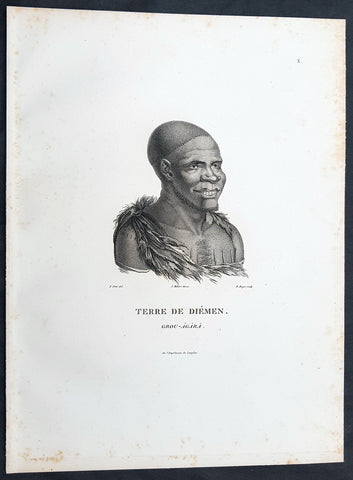
1807 Nicolas Baudin & N M Petit Antique Print of Tasmanian Aboriginal Grou Agara
Antique Map
- Title : Terre De Diemen Grou Agara
- Size: 13in x 10in (330mm x 255mm)
- Condition: (A+) Fine Condition
- Date : 1807
- Ref #: 93086
Description:
This exquisite, rare original copper-plate engraved antique print of Tasmanian Aboriginal Grou Agara, visited by the Baudin Expedition to Australia in Feb. 1802, was engraved by Barthélemy Roger, after Nicolas-Martin Petit (the offical artist on the ship Géographe) and was published by Francois Peron (1775 - 1810) in the 1st edition atlas of Nicolas Thomas Baudins expedition to Australia Voyage de découvertes aux Terres Australes
Nicholas Martin Petit sailed with Nicolas Baudin on the expedition of the Géographe and the Naturaliste in late 1800. The scientific field of anthropology was in its infancy – the French had founded the Society of the Observers of Man in 1799. Having embarked as a fourth-class gunner’s mate, Petit, who had had some graphic arts training, became one of the expeditions two illustrators when the official artists quit. From June to November 1802, the expedition was delayed in Sydney while its two ships were repaired. During this time Petit completed portraits of people of the Cadigal, Dharawal, Gweagal, Kurringai and Darug language groups of the Sydney Harbour region. While the sitters names appear to be noted on the works, it is possible that the inscriptions merely reflect French misinterpretation of the Aborigines communications with them.
The portrait of Nourou-gal-derri is pictured advancing for battle.
General Definitions:
Paper thickness and quality: - Heavy and stable
Paper color : - off white
Age of map color: -
Colors used: -
General color appearance: -
Paper size: - 14in x 10in (355mm x 255mm)
Plate size: - 14in x 10in (355mm x 255mm)
Margins: - Min 1/2in (12mm)
Imperfections:
Margins: - None
Plate area: - None
Verso: - None
Background:
The Baudin Expedition of 1800 to 1803 was a French expedition to map the coast of New Holland, Australia. The expedition started with two ships, Géographe, captained by Baudin, and Naturaliste captained by Jacques Hamelin, and was accompanied by nine zoologists and botanists, including Jean-Baptiste Leschenault de la Tour, François Péron and Charles-Alexandre Lesueur as well as the geographer Pierre Faure.
The Baudin expedition departed Le Havre, France, on 19 October 1800. Because of delays in receiving his instructions and problems encountered in Isle de France (now Mauritius) they did not reach Cape Leeuwin on the south-west corner of Australia until May 1801. Upon rounding Cape Naturaliste, they entered Geographe Bay. They then sailed north, but the ships became separated and did not meet again until they reached Timor. On their journeys the Géographe and the Naturaliste surveyed large stretches of the north-western coast. The expedition was severely affected by dysentery and fever, but sailed from Timor on 13 November 1801, back down the north-west and west coast, then across the Great Australian Bight, reaching Tasmania on 13 January 1802. They charted the whole length of Tasmanias east coast and there were extensive interactions with the Indigenous Tasmanians, with whom they had peaceful relationships. They notably produced precious ethnological studies of Indigenous Tasmanians.
The expedition then began surveying the south coast of Australia, but then Captain Jacques Felix Emmanuel Hamelin in Naturaliste decided to make for Port Jackson (Sydney) as he was running short of food and water, and in need of anchors. En route, in April 1802, Hamelin explored the area of Western Port, Victoria, and gave names to places, a number of which have survived, for example, Ile des Français is now called French Island.
Meanwhile, Baudin in the Géographe continued westward, and in April 1802 encountered the British ship Investigator commanded by Matthew Flinders, also engaged in charting the coastline, at Encounter Bay in what is now South Australia. Flinders informed Baudin of his discovery of Kangaroo Island, St. Vincents and Spencers Gulfs. Baudin sailed on to the Nuyts Archipelago, the point reached by t Gulden Zeepaert in 1627 before heading for Port Jackson as well for supplies.
In late 1802 the expedition was at Port Jackson, where the government sold 60 casks of flour and 25 casks of salt meat to Baudin to resupply his two vessels. The supplies permitted Naturaliste to return to France and Géographe to continue her explorations of the Australian coast. Naturaliste took with her the Colonys staff surgeon, Mr. James Thomson, whom Governor Philip Gidley King had given permission to return to England.
Before resuming the voyage Baudin purchased a 30 ton schooner, which he named the Casuarina, a smaller vessel which could conduct close inshore survey work. He sent the larger Naturaliste under Hamelin back to France with all the specimens that had been collected by Baudin and his crew. As the voyage had progressed Louis de Freycinet, now a Lieutenant, had shown his talents as an officer and a hydrographer and so was given command of the Casuarina. The expedition then headed for Tasmania and conducted further charting of Bass Strait before sailing west, following the west coast northward, and after another visit to Timor, undertook further exploration along the north coast of Australia. Plagued by contrary winds, ill health, and because the quadrupeds and emus were very sick, it was decided on 7 July 1803 to return to France. On the return voyage, the ships stopped in Mauritius, where Baudin died of tuberculosis on 16 September 1803. The expedition finally reached France on 24 March 1804.
The scientific expedition was considered a great success, with more than 2500 new species discovered.
Nicolas-Martin Petit 1777 – 1804
Nicholas-Martin Petit was born in Paris, the son of a fan maker, and learned graphic art in the studio of Jacques Louis David. He avoided conscription into Napoleons armies, but wanting to travel, signed up with post Captain Nicholas Baudin on a voyage to the antipodes sponsored by the French government. Petit and fellow artist Charles-Alexandre Lesueur were enlisted directly by Baudin (as 4th class gunners mates) while the two official artists were hired by the organisers of the expedition. Baudin set off in two lavishly equipped vessels, the Géographe and the Naturaliste on 19 October 1800. By the time the expedition reached Mauritius the official artists had quit. Petit and Lesueur took over their duties, but as neither was trained in scientific method or presentation, the value of their work was primarily aesthetic. The French were at this time developing a new scientific field - anthropology. The Society of the Observers of Man was founded in 1799 for this purpose. The study of Man formed part of the background for Petits sensitive drawings and paintings of the indigenous people of Van Diemens Land, Port Jackson and Western Australia. Lesueur focused on the depiction of animals. The expedition charted the coast of Western Australia and Van Diemens land but was plagued by scurvy. On 20 June 1802 the two ships limped into Port Jackson and stayed for five months to refit, during which time Petit completed a number of portraits of Sydney Indigenous people, including the two images of the Eora men, Cour-rou-bari-gal and Y-erren-gou-la-ga. Petit eventually returned to France in 1804. However, before he was well enough to complete the drawings from the expedition he was hurt in a street accident, and he died at the age of 28. Petits unfinished work was first published in 1807 in the Atlas of the Voyage de découvertes aux terres australes and as discrete prints.
Baudin, Nicolas Thomas 1754 – 1803
Baudin was a French explorer, cartographer, naturalist and hydrographer. Born a commoner in Saint-Martin-de-Ré on the Île de Ré on 17 February 1754 Baudin joined the merchant navy at the age of 15 and the French East India Company at the age of 20.
Baudin then joined the La Marine Royale (French Navy) in 1774 and served in the Caribbean as an officier bleu during the American War of Independence of 1775–1783.
In 1785 Baudin and his brother Alexandre were respectively masters of the St Remy and Caroline, taking Acadian settlers from Nantes to La Nouvelle Orléans. In New Orleans local merchants contracted him to take a cargo of wood, salted meat, cod and flour to Isle de France (now Mauritius), which he did in Josephine (also called Pepita), departing New Orleans on 14 July 1786 and arriving at Isle de France on 27 March 1787. In the course of the voyage, Josephine had called at Cap‑Français in Haiti to make a contract to transport slaves there from Madagascar; while in Haiti he also encountered the Austrian botanist Franz Josef Maerter, who apparently informed him that another Austrian botanist, Franz Boos, was at the Cape of Good Hope awaiting a ship to take him to Mauritius. Josephine called at the Cape and took Boos on board. At Mauritius, Boos chartered Baudin to transport him and the collection of plant specimens he had gathered there and at the Cape back to Europe, which Baudin did, Josephine arriving at Trieste on 18 June 1788. The Imperial government in Vienna was contemplating organizing another natural-history expedition, to which Boos would be appointed, in which two ships would be sent to the Malabar and Coromandel coasts of India, the Persian Gulf, Bengal, Ceylon, Sumatra, Java, Borneo, Cochin China, Tongking, Japan and China. Baudin had been given reason to hope that he would be given command of the ships of this expedition.
Later in 1788 Baudin sailed on a commercial voyage from Trieste to Canton in Jardiniere. He apparently arrived at Canton from Mauritius under the flag of the United States of America, probably to avoid the possibility of having his ship seized by the Chinese for payment of the debts owed them by the Imperial Asiatic Company of Trieste. From there, he sent Jardiniere under her second captain on a fur-trading venture to the north-west coast of America, but the ship foundered off Asuncion Island in the Marianas in late 1789.
Baudin made his way to Mauritius, where he purchased a replacement ship, Jardiniere II, but this vessel was wrecked in a cyclone that struck Port Louis on 15 December 1789. Baudin embarked on the Spanish Royal Philippines Company ship, Placeres, which sailed from Port Louis for Cadiz in August 1790. Placeres called at the Cape of Good Hope where it took on board the large number of plant and animal specimens collected in South Africa for the Imperial palace at Schönbrunn by Georg Scholl, the assistant of Franz Boos. Because of the poor condition of the ship, Placeres had to put in at the island of Trinidad in the West Indies, where Scholls collection of specimens was deposited.
Baudin proceeded to Martinique, from where he addressed an offer to the Imperial government in Vienna to conduct to Canton commissioners who would be empowered to negotiate with the Chinese merchants there a settlement of the debts incurred by the Imperial Asiatic Company, which would enable the company to renew its trade with China. On its return voyage from Canton, the proposed expedition would call at the Cape of Good Hope to pick up Scholl and the remainder of his natural-history collection for conveyance to Schönbrunn.
After returning to Vienna in September 1791, Baudin continued to press his case for an expedition under the Imperial flag to the Indian Ocean and China, and in January 1792 he was granted a commission of captain in the Imperial navy for this purpose. A ship, called Jardiniere, was acquired and the botanists Franz Bredemeyer and Joseph van der Schot appointed to the expedition. After delays caused by the outbreak of war between France and Austria (April 1792), Jardiniere departed from the Spanish port of Málaga on 1 October 1792. From the Cape of Good Hope Jardiniere sailed across the Indian Ocean to the coast of New Holland (Australia), but two consecutive cyclones prevented the expedition from doing any work there and forced Baudin to take the ship to Bombay for repairs.
From Bombay the expedition proceeded to the Persian Gulf, the Red Sea and the east coast of Africa, where it gathered botanical and zoological collections. The expedition came to an abrupt end in June 1794 when Jardiniere went aground in a storm while attempting to enter Table Bay at the Cape of Good Hope. Baudin survived the wreck and made his way to the United States, from where he went to France. He managed to send Jardinieres cargo of natural history specimens to the island of Trinidad.
In Paris, Baudin visited Antoine de Jussieu at the Museum National dHistoire Naturelle in March 1796 to suggest a botanical voyage to the Caribbean, during which he would recover the collection of specimens he had left in Trinidad. The Museum and the French government accepted the proposal, and Baudin was appointed commander of an expedition in the ship Belle Angélique, with four assigned botanists: René Maugé, André Pierre Ledru, Anselme Riedlé and Stanislas Levillain. Belle Angélique cleared Le Havre on 30 September 1796 for the Canary Islands, where the ship was condemned as unseaworthy. The expedition sailed from the Canaries in a replacement vessel, Fanny, and reached Trinidad in April 1797. The British, who had just captured the island from the Spanish in February 1797, refused to allow Baudin to recover the collection of natural-history specimens. Baudin took Fanny to St. Thomas and St. Croix, and then to Puerto Rico, specimens being collected in all three islands. At St Croix, Fanny was replaced by a newly purchased ship, renamed Belle Angelique. The expedition returned to France in June 1798 with a large collection of plants, birds and insects, which was incorporated into Napoleon Bonapartes triumphal procession celebrating his recent Italian victories.
On 24 July 1798, at the suggestion of the Ministry of Marine, Baudin presented to the Assembly of Professors and Administrators of the National Museum of Natural History a plan for a hydrographic-survey expedition to the South Seas, which would include a search for fauna and flora that could be brought back for cultivation in France. The expedition would also have the aim of promoting the economic and commercial interests of France in the regions to be visited. The expedition would require two well-equipped ships, which would carry a team of astronomers, naturalists and scientific draughtsmen over whom Baudin as commander would have absolute authority. The first part of the voyage would be devoted to a thorough exploration of the coast of Chile and the collection of animal, bird and plant specimens suitable for acclimatization in France, followed by a survey of the coasts from Peru to Mexico. The expedition would then continue into the Pacific Ocean, including a visit to Tahiti and the Society Islands, and would be completed with a survey of the yet unexplored south-west coast of New Holland (Australia). After considering this extensive proposal, the French government decided to proceed with an expedition confined to a survey of western and southern New Holland (as Australia was called at the time).
In October 1800 Baudin was selected to lead what has become known as the Baudin expedition to map the coast of Australia (New Holland). He had two ships, Géographe and Naturaliste captained by Hamelin, and a suite of nine zoologists and botanists, including Jean Baptiste Leschenault de la Tour. He reached Australia in May 1801, and would explore and map the western coast and a part of the little-known southern coast of the continent. The scientific expedition proved a great success, with more than 2500 new species discovered. The French also met Aboriginal peoples and treated them with great respect.
In April 1802 Baudin met Matthew Flinders, also engaged in charting the coastline, in Encounter Bay in present-day South Australia. Baudin then stopped at the British colony at Sydney for supplies. In Sydney he bought a new ship — Casuarina — named after the wood it was made from. From there he sent home Naturaliste, which had on board all of the specimens that had been discovered by Baudin and his crew. He then headed for Tasmania, before continuing north to Timor. Baudin then sailed for home, stopping at Mauritius.
According to recent researches by academics from the University of Adelaide, during Baudins expedition, François Péron, who had become the chief zoologist and intellectual leader of the mission, wrote a report for Napoleon on ways to invade and capture the British colony at Sydney Cove.
Baudin died of tuberculosis at Mauritius on 16 September 1803, at the age of 49, apparently in the home of Madame Alexandrine Kerivel. Baudins exact resting place is not known, but the historian Auguste Toussaint believed that he was interred in the Kerivel family vault. However, the historian Edward Duyker likes to think that Baudin was buried in Le Cimetière de lOuest in the district of Port Louis just a few hundred metres from the explorers certain love: the sea.
Please note all items auctioned are genuine, we do not sell reproductions. A Certificate of Authenticity (COA) can be issued on request.
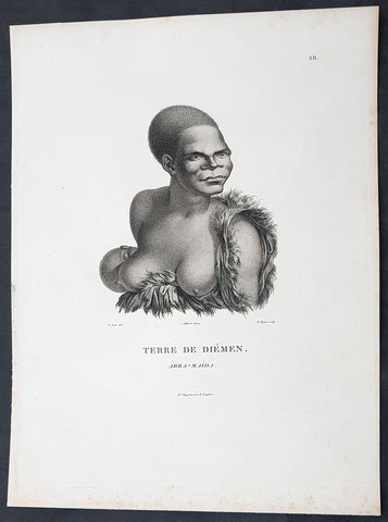
1807 Nicolas Baudin & N M Petit Antique Print of Tasmanian Aboriginal Arra Maida
Antique Map
- Title : Terre De Diemen Arra Maida
- Size: 13in x 10in (330mm x 255mm)
- Condition: (A+) Fine Condition
- Date : 1807
- Ref #: 93085
Description:
This exquisite, rare original copper-plate engraved antique print of Tasmanian Aboriginal Arra Maida, visited by the Baudin Expedition to Australia in Feb. 1802, was engraved by Barthélemy Roger, after Nicolas-Martin Petit (the offical artist on the ship Géographe) and was published by Francois Peron (1775 - 1810) in the 1st edition atlas of Nicolas Thomas Baudins expedition to Australia Voyage de découvertes aux Terres Australes
Nicholas Martin Petit sailed with Nicolas Baudin on the expedition of the Géographe and the Naturaliste in late 1800. The scientific field of anthropology was in its infancy – the French had founded the Society of the Observers of Man in 1799. Having embarked as a fourth-class gunner’s mate, Petit, who had had some graphic arts training, became one of the expeditions two illustrators when the official artists quit. From June to November 1802, the expedition was delayed in Sydney while its two ships were repaired. During this time Petit completed portraits of people of the Cadigal, Dharawal, Gweagal, Kurringai and Darug language groups of the Sydney Harbour region. While the sitters names appear to be noted on the works, it is possible that the inscriptions merely reflect French misinterpretation of the Aborigines communications with them.
The portrait of Nourou-gal-derri is pictured advancing for battle.
General Definitions:
Paper thickness and quality: - Heavy and stable
Paper color : - off white
Age of map color: -
Colors used: -
General color appearance: -
Paper size: - 14in x 10in (355mm x 255mm)
Plate size: - 14in x 10in (355mm x 255mm)
Margins: - Min 1/2in (12mm)
Imperfections:
Margins: - None
Plate area: - None
Verso: - None
Background:
The Baudin Expedition of 1800 to 1803 was a French expedition to map the coast of New Holland, Australia. The expedition started with two ships, Géographe, captained by Baudin, and Naturaliste captained by Jacques Hamelin, and was accompanied by nine zoologists and botanists, including Jean-Baptiste Leschenault de la Tour, François Péron and Charles-Alexandre Lesueur as well as the geographer Pierre Faure.
The Baudin expedition departed Le Havre, France, on 19 October 1800. Because of delays in receiving his instructions and problems encountered in Isle de France (now Mauritius) they did not reach Cape Leeuwin on the south-west corner of Australia until May 1801. Upon rounding Cape Naturaliste, they entered Geographe Bay. They then sailed north, but the ships became separated and did not meet again until they reached Timor. On their journeys the Géographe and the Naturaliste surveyed large stretches of the north-western coast. The expedition was severely affected by dysentery and fever, but sailed from Timor on 13 November 1801, back down the north-west and west coast, then across the Great Australian Bight, reaching Tasmania on 13 January 1802. They charted the whole length of Tasmanias east coast and there were extensive interactions with the Indigenous Tasmanians, with whom they had peaceful relationships. They notably produced precious ethnological studies of Indigenous Tasmanians.
The expedition then began surveying the south coast of Australia, but then Captain Jacques Felix Emmanuel Hamelin in Naturaliste decided to make for Port Jackson (Sydney) as he was running short of food and water, and in need of anchors. En route, in April 1802, Hamelin explored the area of Western Port, Victoria, and gave names to places, a number of which have survived, for example, Ile des Français is now called French Island.
Meanwhile, Baudin in the Géographe continued westward, and in April 1802 encountered the British ship Investigator commanded by Matthew Flinders, also engaged in charting the coastline, at Encounter Bay in what is now South Australia. Flinders informed Baudin of his discovery of Kangaroo Island, St. Vincents and Spencers Gulfs. Baudin sailed on to the Nuyts Archipelago, the point reached by t Gulden Zeepaert in 1627 before heading for Port Jackson as well for supplies.
In late 1802 the expedition was at Port Jackson, where the government sold 60 casks of flour and 25 casks of salt meat to Baudin to resupply his two vessels. The supplies permitted Naturaliste to return to France and Géographe to continue her explorations of the Australian coast. Naturaliste took with her the Colonys staff surgeon, Mr. James Thomson, whom Governor Philip Gidley King had given permission to return to England.
Before resuming the voyage Baudin purchased a 30 ton schooner, which he named the Casuarina, a smaller vessel which could conduct close inshore survey work. He sent the larger Naturaliste under Hamelin back to France with all the specimens that had been collected by Baudin and his crew. As the voyage had progressed Louis de Freycinet, now a Lieutenant, had shown his talents as an officer and a hydrographer and so was given command of the Casuarina. The expedition then headed for Tasmania and conducted further charting of Bass Strait before sailing west, following the west coast northward, and after another visit to Timor, undertook further exploration along the north coast of Australia. Plagued by contrary winds, ill health, and because the quadrupeds and emus were very sick, it was decided on 7 July 1803 to return to France. On the return voyage, the ships stopped in Mauritius, where Baudin died of tuberculosis on 16 September 1803. The expedition finally reached France on 24 March 1804.
The scientific expedition was considered a great success, with more than 2500 new species discovered.
Nicolas-Martin Petit 1777 – 1804
Nicholas-Martin Petit was born in Paris, the son of a fan maker, and learned graphic art in the studio of Jacques Louis David. He avoided conscription into Napoleons armies, but wanting to travel, signed up with post Captain Nicholas Baudin on a voyage to the antipodes sponsored by the French government. Petit and fellow artist Charles-Alexandre Lesueur were enlisted directly by Baudin (as 4th class gunners mates) while the two official artists were hired by the organisers of the expedition. Baudin set off in two lavishly equipped vessels, the Géographe and the Naturaliste on 19 October 1800. By the time the expedition reached Mauritius the official artists had quit. Petit and Lesueur took over their duties, but as neither was trained in scientific method or presentation, the value of their work was primarily aesthetic. The French were at this time developing a new scientific field - anthropology. The Society of the Observers of Man was founded in 1799 for this purpose. The study of Man formed part of the background for Petits sensitive drawings and paintings of the indigenous people of Van Diemens Land, Port Jackson and Western Australia. Lesueur focused on the depiction of animals. The expedition charted the coast of Western Australia and Van Diemens land but was plagued by scurvy. On 20 June 1802 the two ships limped into Port Jackson and stayed for five months to refit, during which time Petit completed a number of portraits of Sydney Indigenous people, including the two images of the Eora men, Cour-rou-bari-gal and Y-erren-gou-la-ga. Petit eventually returned to France in 1804. However, before he was well enough to complete the drawings from the expedition he was hurt in a street accident, and he died at the age of 28. Petits unfinished work was first published in 1807 in the Atlas of the Voyage de découvertes aux terres australes and as discrete prints.
Baudin, Nicolas Thomas 1754 – 1803
Baudin was a French explorer, cartographer, naturalist and hydrographer. Born a commoner in Saint-Martin-de-Ré on the Île de Ré on 17 February 1754 Baudin joined the merchant navy at the age of 15 and the French East India Company at the age of 20.
Baudin then joined the La Marine Royale (French Navy) in 1774 and served in the Caribbean as an officier bleu during the American War of Independence of 1775–1783.
In 1785 Baudin and his brother Alexandre were respectively masters of the St Remy and Caroline, taking Acadian settlers from Nantes to La Nouvelle Orléans. In New Orleans local merchants contracted him to take a cargo of wood, salted meat, cod and flour to Isle de France (now Mauritius), which he did in Josephine (also called Pepita), departing New Orleans on 14 July 1786 and arriving at Isle de France on 27 March 1787. In the course of the voyage, Josephine had called at Cap‑Français in Haiti to make a contract to transport slaves there from Madagascar; while in Haiti he also encountered the Austrian botanist Franz Josef Maerter, who apparently informed him that another Austrian botanist, Franz Boos, was at the Cape of Good Hope awaiting a ship to take him to Mauritius. Josephine called at the Cape and took Boos on board. At Mauritius, Boos chartered Baudin to transport him and the collection of plant specimens he had gathered there and at the Cape back to Europe, which Baudin did, Josephine arriving at Trieste on 18 June 1788. The Imperial government in Vienna was contemplating organizing another natural-history expedition, to which Boos would be appointed, in which two ships would be sent to the Malabar and Coromandel coasts of India, the Persian Gulf, Bengal, Ceylon, Sumatra, Java, Borneo, Cochin China, Tongking, Japan and China. Baudin had been given reason to hope that he would be given command of the ships of this expedition.
Later in 1788 Baudin sailed on a commercial voyage from Trieste to Canton in Jardiniere. He apparently arrived at Canton from Mauritius under the flag of the United States of America, probably to avoid the possibility of having his ship seized by the Chinese for payment of the debts owed them by the Imperial Asiatic Company of Trieste. From there, he sent Jardiniere under her second captain on a fur-trading venture to the north-west coast of America, but the ship foundered off Asuncion Island in the Marianas in late 1789.
Baudin made his way to Mauritius, where he purchased a replacement ship, Jardiniere II, but this vessel was wrecked in a cyclone that struck Port Louis on 15 December 1789. Baudin embarked on the Spanish Royal Philippines Company ship, Placeres, which sailed from Port Louis for Cadiz in August 1790. Placeres called at the Cape of Good Hope where it took on board the large number of plant and animal specimens collected in South Africa for the Imperial palace at Schönbrunn by Georg Scholl, the assistant of Franz Boos. Because of the poor condition of the ship, Placeres had to put in at the island of Trinidad in the West Indies, where Scholls collection of specimens was deposited.
Baudin proceeded to Martinique, from where he addressed an offer to the Imperial government in Vienna to conduct to Canton commissioners who would be empowered to negotiate with the Chinese merchants there a settlement of the debts incurred by the Imperial Asiatic Company, which would enable the company to renew its trade with China. On its return voyage from Canton, the proposed expedition would call at the Cape of Good Hope to pick up Scholl and the remainder of his natural-history collection for conveyance to Schönbrunn.
After returning to Vienna in September 1791, Baudin continued to press his case for an expedition under the Imperial flag to the Indian Ocean and China, and in January 1792 he was granted a commission of captain in the Imperial navy for this purpose. A ship, called Jardiniere, was acquired and the botanists Franz Bredemeyer and Joseph van der Schot appointed to the expedition. After delays caused by the outbreak of war between France and Austria (April 1792), Jardiniere departed from the Spanish port of Málaga on 1 October 1792. From the Cape of Good Hope Jardiniere sailed across the Indian Ocean to the coast of New Holland (Australia), but two consecutive cyclones prevented the expedition from doing any work there and forced Baudin to take the ship to Bombay for repairs.
From Bombay the expedition proceeded to the Persian Gulf, the Red Sea and the east coast of Africa, where it gathered botanical and zoological collections. The expedition came to an abrupt end in June 1794 when Jardiniere went aground in a storm while attempting to enter Table Bay at the Cape of Good Hope. Baudin survived the wreck and made his way to the United States, from where he went to France. He managed to send Jardinieres cargo of natural history specimens to the island of Trinidad.
In Paris, Baudin visited Antoine de Jussieu at the Museum National dHistoire Naturelle in March 1796 to suggest a botanical voyage to the Caribbean, during which he would recover the collection of specimens he had left in Trinidad. The Museum and the French government accepted the proposal, and Baudin was appointed commander of an expedition in the ship Belle Angélique, with four assigned botanists: René Maugé, André Pierre Ledru, Anselme Riedlé and Stanislas Levillain. Belle Angélique cleared Le Havre on 30 September 1796 for the Canary Islands, where the ship was condemned as unseaworthy. The expedition sailed from the Canaries in a replacement vessel, Fanny, and reached Trinidad in April 1797. The British, who had just captured the island from the Spanish in February 1797, refused to allow Baudin to recover the collection of natural-history specimens. Baudin took Fanny to St. Thomas and St. Croix, and then to Puerto Rico, specimens being collected in all three islands. At St Croix, Fanny was replaced by a newly purchased ship, renamed Belle Angelique. The expedition returned to France in June 1798 with a large collection of plants, birds and insects, which was incorporated into Napoleon Bonapartes triumphal procession celebrating his recent Italian victories.
On 24 July 1798, at the suggestion of the Ministry of Marine, Baudin presented to the Assembly of Professors and Administrators of the National Museum of Natural History a plan for a hydrographic-survey expedition to the South Seas, which would include a search for fauna and flora that could be brought back for cultivation in France. The expedition would also have the aim of promoting the economic and commercial interests of France in the regions to be visited. The expedition would require two well-equipped ships, which would carry a team of astronomers, naturalists and scientific draughtsmen over whom Baudin as commander would have absolute authority. The first part of the voyage would be devoted to a thorough exploration of the coast of Chile and the collection of animal, bird and plant specimens suitable for acclimatization in France, followed by a survey of the coasts from Peru to Mexico. The expedition would then continue into the Pacific Ocean, including a visit to Tahiti and the Society Islands, and would be completed with a survey of the yet unexplored south-west coast of New Holland (Australia). After considering this extensive proposal, the French government decided to proceed with an expedition confined to a survey of western and southern New Holland (as Australia was called at the time).
In October 1800 Baudin was selected to lead what has become known as the Baudin expedition to map the coast of Australia (New Holland). He had two ships, Géographe and Naturaliste captained by Hamelin, and a suite of nine zoologists and botanists, including Jean Baptiste Leschenault de la Tour. He reached Australia in May 1801, and would explore and map the western coast and a part of the little-known southern coast of the continent. The scientific expedition proved a great success, with more than 2500 new species discovered. The French also met Aboriginal peoples and treated them with great respect.
In April 1802 Baudin met Matthew Flinders, also engaged in charting the coastline, in Encounter Bay in present-day South Australia. Baudin then stopped at the British colony at Sydney for supplies. In Sydney he bought a new ship — Casuarina — named after the wood it was made from. From there he sent home Naturaliste, which had on board all of the specimens that had been discovered by Baudin and his crew. He then headed for Tasmania, before continuing north to Timor. Baudin then sailed for home, stopping at Mauritius.
According to recent researches by academics from the University of Adelaide, during Baudins expedition, François Péron, who had become the chief zoologist and intellectual leader of the mission, wrote a report for Napoleon on ways to invade and capture the British colony at Sydney Cove.
Baudin died of tuberculosis at Mauritius on 16 September 1803, at the age of 49, apparently in the home of Madame Alexandrine Kerivel. Baudins exact resting place is not known, but the historian Auguste Toussaint believed that he was interred in the Kerivel family vault. However, the historian Edward Duyker likes to think that Baudin was buried in Le Cimetière de lOuest in the district of Port Louis just a few hundred metres from the explorers certain love: the sea.
Please note all items auctioned are genuine, we do not sell reproductions. A Certificate of Authenticity (COA) can be issued on request.
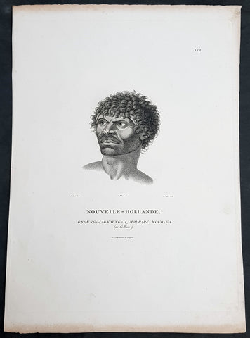
1807 Baudin & Petit Antique Print Sydney Aboriginal Gnung-a Gnung-a Murremurgan - Bennelong
Antique Map
- Title : Nouvelle-Hollande. Gnoung-a-gnoung-a Mour-re-mour-ga (dit Collins)
- Size: 14in x 10in (355mm x 255mm)
- Condition: (A+) Fine Condition
- Date : 1807
- Ref #: 91239
Description:
This exquisite, rare original copper-plate engraved antique print, of the brother in law of the famous Port Jackson Aborginal leader Bennelong, Gnung-a Gnung-a Murremurgan, or Anganángan, was engraved by Barthélemy Roger, after the 1802 by Nicolas-Martin Petit, was published by Francois Peron (1775 - 1810) in the 1st edition atlas of Nicolas Thomas Baudins expedition to Australia Voyage de découvertes aux Terres Australes
Gnung-a Gnung-a Murremurgan
It is over 200 years since the death of an adventurous young Aboriginal Australian who crossed the vast Pacific Ocean to North America and returned to Sydney. From the deck of an English storeship he glimpsed many strange places, visiting Norfolk Island, Hawaii, Nootka Sound (now Vancouver, Canada) and the Spanish colonies of San Francisco, Santa Barbara and San Diego on the Californian coast.
The voyager was Gnung-a Gnung-a Murremurgan, whose wife Warreeweer was the younger sister of the Wangal leader Woollarawarre Bennelong, at that time being feted in London society. The distance Gnung-a Gnung-a traversed was some 16,000 miles (25,750 kilometres) as the crow flies, but much further in a sailing ship driven by unpredictable winds.
On the first day he ventured into the convict settlement at Sydney Cove, in November 1790, Gnung-a Gnung-a adopted the name Collins from Acting Judge Advocate David Collins, who often mentions him in An Account of the English Colony in New South Wales, published in London in 1798.
It was the idea of Major Francis Grose, acting governor of New South Wales after the departure of Captain Arthur Phillip in 1792, to embark a native of this country on HM storeship Daedalus for the purpose of acquiring our language, wrote David Collins. The 350-ton capacity vessel was ordered to resupply provisions for the expedition to the north-west coast of North America commanded by Captain George Vancouver (1757–1798). In the navy ships HMS Discovery and HMS Chatham, Captain Vancouver was to complete the survey made by Captain James Cook.
Voyage to America
HMS Daedalus sailed from Port Jackson on 1 July 1793, passing west of the Society Islands (French Polynesia) to Owhyee (Hawaii). The commander, Lieutenant James Hanson, missed a rendezvous with Vancouvers ships at Nootka Sound on 8 October, but anchored with the two survey ships off San Francisco Bay on 21 October. The three British ships followed the coast of todays California to San Diego, leaving on 9 December 1793 and arriving at Hilo in Hawaii on 8 January 1794.
The Hawaiian King Kamehameha, who warmly welcomed Vancouver, was so impressed by the good-natured, handsome Aboriginal man on the expedition that he wanted to buy him, offering in exchange canoes, weapons and curiosities.
Gnung-a Gnung-a got on well with everyone on Daedalus and Hanson was pleased by his good nature and his willingness to do whatever was asked of him. During his month in Hawaii, he often went ashore with his shipmates. Wherever he went he readily adopted the manners of those around him, Hanson later told Collins, who remarked, with ironic humour, that...........
when at Owhyee, having discovered that favours from the females were to be procured at the easy exchange for a looking-glass, a nail, or a knife, he was not backward in presenting his little offering, and was as well received as any of the white people in the ship. It was noticed too that he always displayed some taste in selecting the object of his attentions.......
Return to Sydney
Home in Sydney Town, Gnung-a Gnung-a fought and wounded a very fine young fellow called Wyatt, who had taken up with his wife during his absence and Warreeweer became the prize of the victor.
During a ritual revenge combat in December 1795, Pemulwuy, leader of the Georges River Bidjigal near Botany Bay, launched a spear at Gnung-a Gnung-a that remained fixed in his back. The English surgeons could not extract the spear and thought he was unlikely to recover. Gnung-a Gnung-a, however, left the hospital and walked about for several weeks with the spear protruding from his back. At last, wrote Collins in a footnote..........
we heard that his wife, or one of his male friends, had fixed their teeth in the wood and drawn it out after which he recovered, and was able again to go into the field. His wife War-re-weer showed by an uncommon attention her great attachment to him.......
Before this unexpected recovery, David Collins wrote a brief appreciation of his namesake:
He was much esteemed by every white man who knew him, as well on account of his personal bravery, of which we had witnessed many distinguishing proofs, as on account of a gentleness of manners which strongly marked his disposition, and shaded off the harsher lines that his uncivilised life now and then forced into the fore-ground.
While in Sydney with a scientific expedition commanded by Nicholas Baudin in 1802, the young French artist Nicolas-Martin Petit met Gnung-a Gnung-a and sketched a striking portrait that he captioned Gnoung-a gnoung-a, mour-re-mour-ga (dit Collins)
A report in the Sydney Gazette of Sunday 15 January 1809 said that the body of Collins (Gnung-a Gnung-a Murremurgan) had been found beside the Dry Store, site of the present Sirius Park in Bridge Street, Sydney. The newspaper said he had been known for the docility of his temper, and the high estimation in which he was universally held among the native tribes.
On the night of Thursday 12 January 1809, Gnung-a Gnung-as children, others he had adopted, and his brother Old Phillip, faced a salvo of spears in the ritual ordeal that followed death in Aboriginal society. The date of his death was not recorded, but it was customary to keep an overnight vigil over a dead body before burial and the subsequent revenge combat, so it was probably 11 January.
Gnung-a Gnung-a Murremurgan is one of many Aboriginal men and women who sailed from Sydney in English ships and played a significant role in Australias early maritime history.
General Definitions:
Paper thickness and quality: - Heavy and stable
Paper color : - off white
Age of map color: -
Colors used: -
General color appearance: -
Paper size: - 14in x 10in (355mm x 255mm)
Plate size: - 12 1/2in x 9 1/2in (320mm x 240mm)
Margins: - Min 1/2in (12mm)
Imperfections:
Margins: - Light age toning to outer margins
Plate area: - None
Verso: - None
Background:
The Baudin Expedition of 1800 to 1803 was a French expedition to map the coast of New Holland, Australia. The expedition started with two ships, Géographe, captained by Baudin, and Naturaliste captained by Jacques Hamelin, and was accompanied by nine zoologists and botanists, including Jean-Baptiste Leschenault de la Tour, François Péron and Charles-Alexandre Lesueur as well as the geographer Pierre Faure.
The Baudin expedition departed Le Havre, France, on 19 October 1800. Because of delays in receiving his instructions and problems encountered in Isle de France (now Mauritius) they did not reach Cape Leeuwin on the south-west corner of Australia until May 1801. Upon rounding Cape Naturaliste, they entered Geographe Bay. They then sailed north, but the ships became separated and did not meet again until they reached Timor. On their journeys the Géographe and the Naturaliste surveyed large stretches of the north-western coast. The expedition was severely affected by dysentery and fever, but sailed from Timor on 13 November 1801, back down the north-west and west coast, then across the Great Australian Bight, reaching Tasmania on 13 January 1802. They charted the whole length of Tasmanias east coast and there were extensive interactions with the Indigenous Tasmanians, with whom they had peaceful relationships. They notably produced precious ethnological studies of Indigenous Tasmanians.
The expedition then began surveying the south coast of Australia, but then Captain Jacques Felix Emmanuel Hamelin in Naturaliste decided to make for Port Jackson (Sydney) as he was running short of food and water, and in need of anchors. En route, in April 1802, Hamelin explored the area of Western Port, Victoria, and gave names to places, a number of which have survived, for example, Ile des Français is now called French Island.
Meanwhile, Baudin in the Géographe continued westward, and in April 1802 encountered the British ship Investigator commanded by Matthew Flinders, also engaged in charting the coastline, at Encounter Bay in what is now South Australia. Flinders informed Baudin of his discovery of Kangaroo Island, St. Vincents and Spencers Gulfs. Baudin sailed on to the Nuyts Archipelago, the point reached by t Gulden Zeepaert in 1627 before heading for Port Jackson as well for supplies.
In late 1802 the expedition was at Port Jackson, where the government sold 60 casks of flour and 25 casks of salt meat to Baudin to resupply his two vessels. The supplies permitted Naturaliste to return to France and Géographe to continue her explorations of the Australian coast. Naturaliste took with her the Colonys staff surgeon, Mr. James Thomson, whom Governor Philip Gidley King had given permission to return to England.
Before resuming the voyage Baudin purchased a 30 ton schooner, which he named the Casuarina, a smaller vessel which could conduct close inshore survey work. He sent the larger Naturaliste under Hamelin back to France with all the specimens that had been collected by Baudin and his crew. As the voyage had progressed Louis de Freycinet, now a Lieutenant, had shown his talents as an officer and a hydrographer and so was given command of the Casuarina. The expedition then headed for Tasmania and conducted further charting of Bass Strait before sailing west, following the west coast northward, and after another visit to Timor, undertook further exploration along the north coast of Australia. Plagued by contrary winds, ill health, and because the quadrupeds and emus were very sick, it was decided on 7 July 1803 to return to France. On the return voyage, the ships stopped in Mauritius, where Baudin died of tuberculosis on 16 September 1803. The expedition finally reached France on 24 March 1804.
The scientific expedition was considered a great success, with more than 2500 new species discovered.
Nicolas-Martin Petit 1777 – 1804
Nicholas-Martin Petit was born in Paris, the son of a fan maker, and learned graphic art in the studio of Jacques Louis David. He avoided conscription into Napoleons armies, but wanting to travel, signed up with post Captain Nicholas Baudin on a voyage to the antipodes sponsored by the French government. Petit and fellow artist Charles-Alexandre Lesueur were enlisted directly by Baudin (as 4th class gunners mates) while the two official artists were hired by the organisers of the expedition. Baudin set off in two lavishly equipped vessels, the Géographe and the Naturaliste on 19 October 1800. By the time the expedition reached Mauritius the official artists had quit. Petit and Lesueur took over their duties, but as neither was trained in scientific method or presentation, the value of their work was primarily aesthetic. The French were at this time developing a new scientific field - anthropology. The Society of the Observers of Man was founded in 1799 for this purpose. The study of Man formed part of the background for Petits sensitive drawings and paintings of the indigenous people of Van Diemens Land, Port Jackson and Western Australia. Lesueur focused on the depiction of animals. The expedition charted the coast of Western Australia and Van Diemens land but was plagued by scurvy. On 20 June 1802 the two ships limped into Port Jackson and stayed for five months to refit, during which time Petit completed a number of portraits of Sydney Indigenous people, including the two images of the Eora men, Cour-rou-bari-gal and Y-erren-gou-la-ga. Petit eventually returned to France in 1804. However, before he was well enough to complete the drawings from the expedition he was hurt in a street accident, and he died at the age of 28. Petits unfinished work was first published in 1807 in the Atlas of the Voyage de découvertes aux terres australes and as discrete prints.
Baudin, Nicolas Thomas 1754 – 1803
Baudin was a French explorer, cartographer, naturalist and hydrographer. Born a commoner in Saint-Martin-de-Ré on the Île de Ré on 17 February 1754 Baudin joined the merchant navy at the age of 15 and the French East India Company at the age of 20.
Baudin then joined the La Marine Royale (French Navy) in 1774 and served in the Caribbean as an officier bleu during the American War of Independence of 1775–1783.
In 1785 Baudin and his brother Alexandre were respectively masters of the St Remy and Caroline, taking Acadian settlers from Nantes to La Nouvelle Orléans. In New Orleans local merchants contracted him to take a cargo of wood, salted meat, cod and flour to Isle de France (now Mauritius), which he did in Josephine (also called Pepita), departing New Orleans on 14 July 1786 and arriving at Isle de France on 27 March 1787. In the course of the voyage, Josephine had called at Cap‑Français in Haiti to make a contract to transport slaves there from Madagascar; while in Haiti he also encountered the Austrian botanist Franz Josef Maerter, who apparently informed him that another Austrian botanist, Franz Boos, was at the Cape of Good Hope awaiting a ship to take him to Mauritius. Josephine called at the Cape and took Boos on board. At Mauritius, Boos chartered Baudin to transport him and the collection of plant specimens he had gathered there and at the Cape back to Europe, which Baudin did, Josephine arriving at Trieste on 18 June 1788. The Imperial government in Vienna was contemplating organizing another natural-history expedition, to which Boos would be appointed, in which two ships would be sent to the Malabar and Coromandel coasts of India, the Persian Gulf, Bengal, Ceylon, Sumatra, Java, Borneo, Cochin China, Tongking, Japan and China. Baudin had been given reason to hope that he would be given command of the ships of this expedition.
Later in 1788 Baudin sailed on a commercial voyage from Trieste to Canton in Jardiniere. He apparently arrived at Canton from Mauritius under the flag of the United States of America, probably to avoid the possibility of having his ship seized by the Chinese for payment of the debts owed them by the Imperial Asiatic Company of Trieste. From there, he sent Jardiniere under her second captain on a fur-trading venture to the north-west coast of America, but the ship foundered off Asuncion Island in the Marianas in late 1789.
Baudin made his way to Mauritius, where he purchased a replacement ship, Jardiniere II, but this vessel was wrecked in a cyclone that struck Port Louis on 15 December 1789. Baudin embarked on the Spanish Royal Philippines Company ship, Placeres, which sailed from Port Louis for Cadiz in August 1790. Placeres called at the Cape of Good Hope where it took on board the large number of plant and animal specimens collected in South Africa for the Imperial palace at Schönbrunn by Georg Scholl, the assistant of Franz Boos. Because of the poor condition of the ship, Placeres had to put in at the island of Trinidad in the West Indies, where Scholls collection of specimens was deposited.
Baudin proceeded to Martinique, from where he addressed an offer to the Imperial government in Vienna to conduct to Canton commissioners who would be empowered to negotiate with the Chinese merchants there a settlement of the debts incurred by the Imperial Asiatic Company, which would enable the company to renew its trade with China. On its return voyage from Canton, the proposed expedition would call at the Cape of Good Hope to pick up Scholl and the remainder of his natural-history collection for conveyance to Schönbrunn.
After returning to Vienna in September 1791, Baudin continued to press his case for an expedition under the Imperial flag to the Indian Ocean and China, and in January 1792 he was granted a commission of captain in the Imperial navy for this purpose. A ship, called Jardiniere, was acquired and the botanists Franz Bredemeyer and Joseph van der Schot appointed to the expedition. After delays caused by the outbreak of war between France and Austria (April 1792), Jardiniere departed from the Spanish port of Málaga on 1 October 1792. From the Cape of Good Hope Jardiniere sailed across the Indian Ocean to the coast of New Holland (Australia), but two consecutive cyclones prevented the expedition from doing any work there and forced Baudin to take the ship to Bombay for repairs.
From Bombay the expedition proceeded to the Persian Gulf, the Red Sea and the east coast of Africa, where it gathered botanical and zoological collections. The expedition came to an abrupt end in June 1794 when Jardiniere went aground in a storm while attempting to enter Table Bay at the Cape of Good Hope. Baudin survived the wreck and made his way to the United States, from where he went to France. He managed to send Jardinieres cargo of natural history specimens to the island of Trinidad.
In Paris, Baudin visited Antoine de Jussieu at the Museum National dHistoire Naturelle in March 1796 to suggest a botanical voyage to the Caribbean, during which he would recover the collection of specimens he had left in Trinidad. The Museum and the French government accepted the proposal, and Baudin was appointed commander of an expedition in the ship Belle Angélique, with four assigned botanists: René Maugé, André Pierre Ledru, Anselme Riedlé and Stanislas Levillain. Belle Angélique cleared Le Havre on 30 September 1796 for the Canary Islands, where the ship was condemned as unseaworthy. The expedition sailed from the Canaries in a replacement vessel, Fanny, and reached Trinidad in April 1797. The British, who had just captured the island from the Spanish in February 1797, refused to allow Baudin to recover the collection of natural-history specimens. Baudin took Fanny to St. Thomas and St. Croix, and then to Puerto Rico, specimens being collected in all three islands. At St Croix, Fanny was replaced by a newly purchased ship, renamed Belle Angelique. The expedition returned to France in June 1798 with a large collection of plants, birds and insects, which was incorporated into Napoleon Bonapartes triumphal procession celebrating his recent Italian victories.
On 24 July 1798, at the suggestion of the Ministry of Marine, Baudin presented to the Assembly of Professors and Administrators of the National Museum of Natural History a plan for a hydrographic-survey expedition to the South Seas, which would include a search for fauna and flora that could be brought back for cultivation in France. The expedition would also have the aim of promoting the economic and commercial interests of France in the regions to be visited. The expedition would require two well-equipped ships, which would carry a team of astronomers, naturalists and scientific draughtsmen over whom Baudin as commander would have absolute authority. The first part of the voyage would be devoted to a thorough exploration of the coast of Chile and the collection of animal, bird and plant specimens suitable for acclimatization in France, followed by a survey of the coasts from Peru to Mexico. The expedition would then continue into the Pacific Ocean, including a visit to Tahiti and the Society Islands, and would be completed with a survey of the yet unexplored south-west coast of New Holland (Australia). After considering this extensive proposal, the French government decided to proceed with an expedition confined to a survey of western and southern New Holland (as Australia was called at the time).
In October 1800 Baudin was selected to lead what has become known as the Baudin expedition to map the coast of Australia (New Holland). He had two ships, Géographe and Naturaliste captained by Hamelin, and a suite of nine zoologists and botanists, including Jean Baptiste Leschenault de la Tour. He reached Australia in May 1801, and would explore and map the western coast and a part of the little-known southern coast of the continent. The scientific expedition proved a great success, with more than 2500 new species discovered. The French also met Aboriginal peoples and treated them with great respect.
In April 1802 Baudin met Matthew Flinders, also engaged in charting the coastline, in Encounter Bay in present-day South Australia. Baudin then stopped at the British colony at Sydney for supplies. In Sydney he bought a new ship — Casuarina — named after the wood it was made from. From there he sent home Naturaliste, which had on board all of the specimens that had been discovered by Baudin and his crew. He then headed for Tasmania, before continuing north to Timor. Baudin then sailed for home, stopping at Mauritius.
According to recent researches by academics from the University of Adelaide, during Baudins expedition, François Péron, who had become the chief zoologist and intellectual leader of the mission, wrote a report for Napoleon on ways to invade and capture the British colony at Sydney Cove.
Baudin died of tuberculosis at Mauritius on 16 September 1803, at the age of 49, apparently in the home of Madame Alexandrine Kerivel. Baudins exact resting place is not known, but the historian Auguste Toussaint believed that he was interred in the Kerivel family vault. However, the historian Edward Duyker likes to think that Baudin was buried in Le Cimetière de lOuest in the district of Port Louis just a few hundred metres from the explorers certain love: the sea.
Please note all items auctioned are genuine, we do not sell reproductions. A Certificate of Authenticity (COA) can be issued on request.
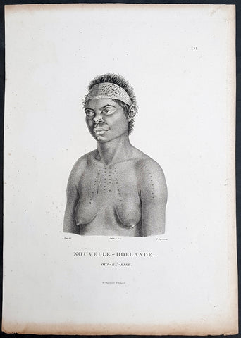
1807 Baudin & Petit Antique Print Sydney Aboriginal Wárrgan, Bennelong's Sister
- Title : Nouvelle-Hollande. Oui-re-kine
- Size: 14in x 10in (355mm x 255mm)
- Condition: (A+) Fine Condition
- Date : 1807
- Ref #: 91238
Description:
This exquisite, rare original copper-plate engraved antique print, of the (half) sister of the famous Port Jackson Aborginal leader Bennelong, Oui-ré-kine – Wárrgan (Crow), also referred to as Worogan, was engraved by Barthélemy Roger, after the 1802 drawing by Nicolas-Martin Petit, and was published by Francois Peron (1775 - 1810) in the 1st edition atlas of Nicolas Thomas Baudins expedition to Australia Voyage de découvertes aux Terres Australes
This is a wonderful original stipple point engraving by Petit & Roger bringing to life this wonderful 1st Australian.
The sitter – identified by artist Nicolas-Martin Petit as Oui-ré-kine – Wárrgan (Crow), also referred to as Worogan. In his writings about the Eora people he knew, astronomer and collector of Sydney languages William Dawes counted Wárrgan with Bennelongs sisters, although she might have been a half-sister or other relative of Bennelongs. Her husband Yeranibe (Euranabie) was the son of Maugoran, a leader of the Burramattagal clan, making Wárrgan a sister-in-law to Bidgee Bidgee, another of Petits Sydney sitters. In 1801, Wárrgan and Yeranibe joined the Lady Nelson which, under the command of James Grant, voyaged to Jervis Bay before making a survey of Bass Strait. In The Narrative of a Voyage of Discovery performed in His Majestys vessel the Lady Nelson (1803–1804), Grant related an incident wherein Wárrgan demonstrated the use of a waddy and a woomera, and how incisions were made on the body using a shell. Both Wárrgan and Yeranibe spoke English, and acted as Grant’s interpreters.
General Definitions:
Paper thickness and quality: - Heavy and stable
Paper color : - off white
Age of map color: -
Colors used: -
General color appearance: -
Paper size: - 14in x 10in (355mm x 255mm)
Plate size: - 12 1/2in x 9 1/2in (320mm x 240mm)
Margins: - Min 1/2in (12mm)
Imperfections:
Margins: - Light age toning to outer margins
Plate area: - None
Verso: - None
Background:
The Baudin Expedition of 1800 to 1803 was a French expedition to map the coast of New Holland, Australia. The expedition started with two ships, Géographe, captained by Baudin, and Naturaliste captained by Jacques Hamelin, and was accompanied by nine zoologists and botanists, including Jean-Baptiste Leschenault de la Tour, François Péron and Charles-Alexandre Lesueur as well as the geographer Pierre Faure.
The Baudin expedition departed Le Havre, France, on 19 October 1800. Because of delays in receiving his instructions and problems encountered in Isle de France (now Mauritius) they did not reach Cape Leeuwin on the south-west corner of Australia until May 1801. Upon rounding Cape Naturaliste, they entered Geographe Bay. They then sailed north, but the ships became separated and did not meet again until they reached Timor. On their journeys the Géographe and the Naturaliste surveyed large stretches of the north-western coast. The expedition was severely affected by dysentery and fever, but sailed from Timor on 13 November 1801, back down the north-west and west coast, then across the Great Australian Bight, reaching Tasmania on 13 January 1802. They charted the whole length of Tasmanias east coast and there were extensive interactions with the Indigenous Tasmanians, with whom they had peaceful relationships. They notably produced precious ethnological studies of Indigenous Tasmanians.
The expedition then began surveying the south coast of Australia, but then Captain Jacques Felix Emmanuel Hamelin in Naturaliste decided to make for Port Jackson (Sydney) as he was running short of food and water, and in need of anchors. En route, in April 1802, Hamelin explored the area of Western Port, Victoria, and gave names to places, a number of which have survived, for example, Ile des Français is now called French Island.
Meanwhile, Baudin in the Géographe continued westward, and in April 1802 encountered the British ship Investigator commanded by Matthew Flinders, also engaged in charting the coastline, at Encounter Bay in what is now South Australia. Flinders informed Baudin of his discovery of Kangaroo Island, St. Vincents and Spencers Gulfs. Baudin sailed on to the Nuyts Archipelago, the point reached by t Gulden Zeepaert in 1627 before heading for Port Jackson as well for supplies.
In late 1802 the expedition was at Port Jackson, where the government sold 60 casks of flour and 25 casks of salt meat to Baudin to resupply his two vessels. The supplies permitted Naturaliste to return to France and Géographe to continue her explorations of the Australian coast. Naturaliste took with her the Colonys staff surgeon, Mr. James Thomson, whom Governor Philip Gidley King had given permission to return to England.
Before resuming the voyage Baudin purchased a 30 ton schooner, which he named the Casuarina, a smaller vessel which could conduct close inshore survey work. He sent the larger Naturaliste under Hamelin back to France with all the specimens that had been collected by Baudin and his crew. As the voyage had progressed Louis de Freycinet, now a Lieutenant, had shown his talents as an officer and a hydrographer and so was given command of the Casuarina. The expedition then headed for Tasmania and conducted further charting of Bass Strait before sailing west, following the west coast northward, and after another visit to Timor, undertook further exploration along the north coast of Australia. Plagued by contrary winds, ill health, and because the quadrupeds and emus were very sick, it was decided on 7 July 1803 to return to France. On the return voyage, the ships stopped in Mauritius, where Baudin died of tuberculosis on 16 September 1803. The expedition finally reached France on 24 March 1804.
The scientific expedition was considered a great success, with more than 2500 new species discovered.
Nicolas-Martin Petit 1777 – 1804
Nicholas-Martin Petit was born in Paris, the son of a fan maker, and learned graphic art in the studio of Jacques Louis David. He avoided conscription into Napoleons armies, but wanting to travel, signed up with post Captain Nicholas Baudin on a voyage to the antipodes sponsored by the French government. Petit and fellow artist Charles-Alexandre Lesueur were enlisted directly by Baudin (as 4th class gunners mates) while the two official artists were hired by the organisers of the expedition. Baudin set off in two lavishly equipped vessels, the Géographe and the Naturaliste on 19 October 1800. By the time the expedition reached Mauritius the official artists had quit. Petit and Lesueur took over their duties, but as neither was trained in scientific method or presentation, the value of their work was primarily aesthetic. The French were at this time developing a new scientific field - anthropology. The Society of the Observers of Man was founded in 1799 for this purpose. The study of Man formed part of the background for Petits sensitive drawings and paintings of the indigenous people of Van Diemens Land, Port Jackson and Western Australia. Lesueur focused on the depiction of animals. The expedition charted the coast of Western Australia and Van Diemens land but was plagued by scurvy. On 20 June 1802 the two ships limped into Port Jackson and stayed for five months to refit, during which time Petit completed a number of portraits of Sydney Indigenous people, including the two images of the Eora men, Cour-rou-bari-gal and Y-erren-gou-la-ga. Petit eventually returned to France in 1804. However, before he was well enough to complete the drawings from the expedition he was hurt in a street accident, and he died at the age of 28. Petits unfinished work was first published in 1807 in the Atlas of the Voyage de découvertes aux terres australes and as discrete prints.
Baudin, Nicolas Thomas 1754 – 1803
Baudin was a French explorer, cartographer, naturalist and hydrographer. Born a commoner in Saint-Martin-de-Ré on the Île de Ré on 17 February 1754 Baudin joined the merchant navy at the age of 15 and the French East India Company at the age of 20.
Baudin then joined the La Marine Royale (French Navy) in 1774 and served in the Caribbean as an officier bleu during the American War of Independence of 1775–1783.
In 1785 Baudin and his brother Alexandre were respectively masters of the St Remy and Caroline, taking Acadian settlers from Nantes to La Nouvelle Orléans. In New Orleans local merchants contracted him to take a cargo of wood, salted meat, cod and flour to Isle de France (now Mauritius), which he did in Josephine (also called Pepita), departing New Orleans on 14 July 1786 and arriving at Isle de France on 27 March 1787. In the course of the voyage, Josephine had called at Cap‑Français in Haiti to make a contract to transport slaves there from Madagascar; while in Haiti he also encountered the Austrian botanist Franz Josef Maerter, who apparently informed him that another Austrian botanist, Franz Boos, was at the Cape of Good Hope awaiting a ship to take him to Mauritius. Josephine called at the Cape and took Boos on board. At Mauritius, Boos chartered Baudin to transport him and the collection of plant specimens he had gathered there and at the Cape back to Europe, which Baudin did, Josephine arriving at Trieste on 18 June 1788. The Imperial government in Vienna was contemplating organizing another natural-history expedition, to which Boos would be appointed, in which two ships would be sent to the Malabar and Coromandel coasts of India, the Persian Gulf, Bengal, Ceylon, Sumatra, Java, Borneo, Cochin China, Tongking, Japan and China. Baudin had been given reason to hope that he would be given command of the ships of this expedition.
Later in 1788 Baudin sailed on a commercial voyage from Trieste to Canton in Jardiniere. He apparently arrived at Canton from Mauritius under the flag of the United States of America, probably to avoid the possibility of having his ship seized by the Chinese for payment of the debts owed them by the Imperial Asiatic Company of Trieste. From there, he sent Jardiniere under her second captain on a fur-trading venture to the north-west coast of America, but the ship foundered off Asuncion Island in the Marianas in late 1789.
Baudin made his way to Mauritius, where he purchased a replacement ship, Jardiniere II, but this vessel was wrecked in a cyclone that struck Port Louis on 15 December 1789. Baudin embarked on the Spanish Royal Philippines Company ship, Placeres, which sailed from Port Louis for Cadiz in August 1790. Placeres called at the Cape of Good Hope where it took on board the large number of plant and animal specimens collected in South Africa for the Imperial palace at Schönbrunn by Georg Scholl, the assistant of Franz Boos. Because of the poor condition of the ship, Placeres had to put in at the island of Trinidad in the West Indies, where Scholls collection of specimens was deposited.
Baudin proceeded to Martinique, from where he addressed an offer to the Imperial government in Vienna to conduct to Canton commissioners who would be empowered to negotiate with the Chinese merchants there a settlement of the debts incurred by the Imperial Asiatic Company, which would enable the company to renew its trade with China. On its return voyage from Canton, the proposed expedition would call at the Cape of Good Hope to pick up Scholl and the remainder of his natural-history collection for conveyance to Schönbrunn.
After returning to Vienna in September 1791, Baudin continued to press his case for an expedition under the Imperial flag to the Indian Ocean and China, and in January 1792 he was granted a commission of captain in the Imperial navy for this purpose. A ship, called Jardiniere, was acquired and the botanists Franz Bredemeyer and Joseph van der Schot appointed to the expedition. After delays caused by the outbreak of war between France and Austria (April 1792), Jardiniere departed from the Spanish port of Málaga on 1 October 1792. From the Cape of Good Hope Jardiniere sailed across the Indian Ocean to the coast of New Holland (Australia), but two consecutive cyclones prevented the expedition from doing any work there and forced Baudin to take the ship to Bombay for repairs.
From Bombay the expedition proceeded to the Persian Gulf, the Red Sea and the east coast of Africa, where it gathered botanical and zoological collections. The expedition came to an abrupt end in June 1794 when Jardiniere went aground in a storm while attempting to enter Table Bay at the Cape of Good Hope. Baudin survived the wreck and made his way to the United States, from where he went to France. He managed to send Jardinieres cargo of natural history specimens to the island of Trinidad.
In Paris, Baudin visited Antoine de Jussieu at the Museum National dHistoire Naturelle in March 1796 to suggest a botanical voyage to the Caribbean, during which he would recover the collection of specimens he had left in Trinidad. The Museum and the French government accepted the proposal, and Baudin was appointed commander of an expedition in the ship Belle Angélique, with four assigned botanists: René Maugé, André Pierre Ledru, Anselme Riedlé and Stanislas Levillain. Belle Angélique cleared Le Havre on 30 September 1796 for the Canary Islands, where the ship was condemned as unseaworthy. The expedition sailed from the Canaries in a replacement vessel, Fanny, and reached Trinidad in April 1797. The British, who had just captured the island from the Spanish in February 1797, refused to allow Baudin to recover the collection of natural-history specimens. Baudin took Fanny to St. Thomas and St. Croix, and then to Puerto Rico, specimens being collected in all three islands. At St Croix, Fanny was replaced by a newly purchased ship, renamed Belle Angelique. The expedition returned to France in June 1798 with a large collection of plants, birds and insects, which was incorporated into Napoleon Bonapartes triumphal procession celebrating his recent Italian victories.
On 24 July 1798, at the suggestion of the Ministry of Marine, Baudin presented to the Assembly of Professors and Administrators of the National Museum of Natural History a plan for a hydrographic-survey expedition to the South Seas, which would include a search for fauna and flora that could be brought back for cultivation in France. The expedition would also have the aim of promoting the economic and commercial interests of France in the regions to be visited. The expedition would require two well-equipped ships, which would carry a team of astronomers, naturalists and scientific draughtsmen over whom Baudin as commander would have absolute authority. The first part of the voyage would be devoted to a thorough exploration of the coast of Chile and the collection of animal, bird and plant specimens suitable for acclimatization in France, followed by a survey of the coasts from Peru to Mexico. The expedition would then continue into the Pacific Ocean, including a visit to Tahiti and the Society Islands, and would be completed with a survey of the yet unexplored south-west coast of New Holland (Australia). After considering this extensive proposal, the French government decided to proceed with an expedition confined to a survey of western and southern New Holland (as Australia was called at the time).
In October 1800 Baudin was selected to lead what has become known as the Baudin expedition to map the coast of Australia (New Holland). He had two ships, Géographe and Naturaliste captained by Hamelin, and a suite of nine zoologists and botanists, including Jean Baptiste Leschenault de la Tour. He reached Australia in May 1801, and would explore and map the western coast and a part of the little-known southern coast of the continent. The scientific expedition proved a great success, with more than 2500 new species discovered. The French also met Aboriginal peoples and treated them with great respect.
In April 1802 Baudin met Matthew Flinders, also engaged in charting the coastline, in Encounter Bay in present-day South Australia. Baudin then stopped at the British colony at Sydney for supplies. In Sydney he bought a new ship — Casuarina — named after the wood it was made from. From there he sent home Naturaliste, which had on board all of the specimens that had been discovered by Baudin and his crew. He then headed for Tasmania, before continuing north to Timor. Baudin then sailed for home, stopping at Mauritius.
According to recent researches by academics from the University of Adelaide, during Baudins expedition, François Péron, who had become the chief zoologist and intellectual leader of the mission, wrote a report for Napoleon on ways to invade and capture the British colony at Sydney Cove.
Baudin died of tuberculosis at Mauritius on 16 September 1803, at the age of 49, apparently in the home of Madame Alexandrine Kerivel. Baudins exact resting place is not known, but the historian Auguste Toussaint believed that he was interred in the Kerivel family vault. However, the historian Edward Duyker likes to think that Baudin was buried in Le Cimetière de lOuest in the district of Port Louis just a few hundred metres from the explorers certain love: the sea.
Please note all items auctioned are genuine, we do not sell reproductions. A Certificate of Authenticity (COA) can be issued on request.
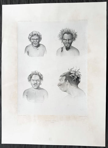
1842 D Urville & Goupil Antique Print of Men of Santa Isabel Isle, Solomon Isle.
- Title : Naturels D Isabelle (Isle Solomon)
- Size: 21in x 15in (535mm x 380mm)
- Condition: (A+) Fine Good Condition
- Date : 1842
- Ref #: 31745
Description:
This magnificent, large original antique lithograph print of profiles of 4 different men of the island of Santa Isabel of the Solomon Islands, visited in November & December 1838 by Dumont D Urville, drawn by Ernest Goupil, artist/draftsman aboard the Astrolabe during D Urvilles second voyage to the South Seas between 1837 - 1840, was engraved by Adolphe Jean-Baptiste Bayoti and was published in the 1842 1st edition of Dumont d Urvilles Voyage au Pole Sud et dans l Océanie sur les corvettes l Astrolabe et la Zélée : Exécuté par ordre du roi pendant les années 1837-1838-1839-1840.
These large magnificent lithographs from the 1st edition are extremely hard to find, most only found in museums or in private hands, and due to the artistry are a must for any collection.
Ernest Goupil was a French painter, draftsman and watercolourist He is known for the illustrations made as official painter for Dumont D Urvilles 2nd Voyage to the South Seas. In Voyage to the South Pole and in Oceania on corvettes l\'Astrobale and Zélée, executed by order of the king during the years 1837-1838-1839-1840, his drawings are transposed on stone, most notably by Emile Lassalle , Pharamond Blanchard and Adolphe Jean-Baptiste Bayot . Dumont d\'Urville relates: On the Zélée , Mr. Goupil fills his cartons with precious paintings, and on the Astrolabe , the young surgeon Le Breton, who has a remarkable talent in this genre, also performs at my asks for charming drawings.
Some drawings were sent to the Minister of the Navy and were shown to the King, who wanted to see them transposed into painting by the marine painter Théodore Gudin , but Goupil would not have given his consent.
In August 1839 in Samarang Java , the crew is struck by a violent epidemic, and after two months of suffering, Ernest Goupil succumbs and died on January 1 , 1840 ijn Hobart-town where he was buried with full military honours.
General Definitions:
Paper thickness and quality: - Heavy and stable
Paper color : - off white
Age of map color: -
Colors used: -
General color appearance: -
Paper size: - 21in x 15in (530mm x 380mm)
Plate size: - 21in x 15in (530mm x 380mm)
Margins: - Min 2in (50mm)
Imperfections:
Margins: - Light age toning
Plate area: - None
Verso: - None
Background:
Santa Isabel Island (also known as Isabel, Ysabel and Mahaga) is the longest in the Solomon Islands, the third largest in terms of surface area, and the largest in the group of islands in Isabel Province.
The first European contact to the Solomon Islands was made at Santa Isabel Island, by the Spanish explorer Álvaro de Mendaña on 7 February 1568. It was charted as Santa Isabel de la Estrella (St. Elizabeth of the Star of Bethlehem in Spanish). A settlement was established by the Spaniards, and a small boat (known in the accounts as the brigantine) was built to survey and chart the surrounding sea and islands. These local explorations led by Maestre de Campo Pedro Ortega Valencia and Alférez Hernando Enríquez resulted in the discoveries of the islands of Malaita, Guadalcanal, Savo, Vangunu, Choiseul, Makira, Ulawa, Malaupaina, Malaulalo, Ali\'ite, and Ugi Island. The Spanish immediately came into contact with Solomon Islanders and at first the relationship was cordial. However, the Spanish expedition\'s need for fresh food and water quickly led to tension and conflict, the Solomon Islanders’ subsistence economy being unable to provide continuous supplies to the Spanish.
Having found no gold and little food, and beset by attacks and sickness, the Spanish colonists shifted their colony to the site of today\'s Honiara on Guadalcanal, and the settlement on Santa Isabel was abandoned.
Santa Isabel islanders suffered attacks from blackbirding in the nineteenth century (the often brutal recruitment or kidnapping of labourers for the sugar plantations in Queensland and Fiji).
In April 1885 a German Protectorate was declared over the North Solomon Islands, including Santa Isabel Island. In 1900, under the terms of Treaty of Berlin (14 November 1899), Germany transferred the North Solomon Islands (except for Bougainville and its surrounding islands) to the British Solomon Islands Protectorate in exchange for the British giving up all claims to Samoa. Missionaries settled on Santa Isabel Island under both protectorates, converting most of the population to Christianity. In the early 20th century several British and Australian firms began large-scale coconut planting.
C1842 D Urville & Goupil Antique Print Chief Pea, Daughter & Wife of Apia, Samoa
- Title : Chef D Apia (Ise Opoulou): Jeune Fille D Apia (Ile Opoulou): Femme De Lefouga (Iles Hapai)
- Size: 22in x 14in (560mm x 370mm)
- Condition: (A+) Fine Good Condition
- Date : 1842
- Ref #: 31754
Description:
This magnificent, large original antique lithograph print of Pea the High Chief of the village of Apia on the Island of Upolu, Samoa along with and his daughter & wife visited in September 1838 by Dumont D Urville, by Ernest Goupil, the senior artist/draftsman aboard the Astrolabe, during D Urvilles second voyage to the South Seas between 1837 - 1840, was engraved by Adolphe Jean-Baptiste Bayotiand was published in the 1842 1st edition of Dumont d Urvilles Voyage au Pole Sud et dans l Océanie sur les corvettes l Astrolabe et la Zélée : Exécuté par ordre du roi pendant les années 1837-1838-1839-1840.
These large magnificent lithographs from the 1st edition are extremely hard to find, most only found in museums or in private hands, and due to the artistry are a must for any collection.
Ernest Goupil was a French painter, draftsman and watercolourist He is known for the illustrations made as official painter for Dumont D Urvilles 2nd Voyage to the South Seas. In Voyage to the South Pole and in Oceania on corvettes l\'Astrobale and Zélée, executed by order of the king during the years 1837-1838-1839-1840, his drawings are transposed on stone, most notably by Emile Lassalle , Pharamond Blanchard and Adolphe Jean-Baptiste Bayot . Dumont d\'Urville relates: On the Zélée , Mr. Goupil fills his cartons with precious paintings, and on the Astrolabe , the young surgeon Le Breton, who has a remarkable talent in this genre, also performs at my asks for charming drawings.
Some drawings were sent to the Minister of the Navy and were shown to the King, who wanted to see them transposed into painting by the marine painter Théodore Gudin , but Goupil would not have given his consent.
In August 1839 in Samarang Java , the crew is struck by a violent epidemic, and after two months of suffering, Ernest Goupil succumbs and died on January 1 , 1840 ijn Hobart-town where he was buried with full military honours.
General Definitions:
Paper thickness and quality: - Heavy and stable
Paper color : - off white
Age of map color: -
Colors used: -
General color appearance: -
Paper size: - 22in x 14in (560mm x 370mm)
Plate size: - 22in x 14in (560mm x 370mm)
Margins: - Min 2in (50mm)
Imperfections:
Margins: - None
Plate area: - None
Verso: - None
Background:
Apia is the capital and the largest city of Samoa. From 1900 to 1919, it was the capital of German Samoa. The city is located on the central north coast of Upolu, Samoa\'s second largest island. Apia is the only city in Samoa and falls within the political district (itūmālō) of Tuamasaga.
Apia was originally a small village from which the country\'s capital took its name. Apia village still exists within the larger modern capital of Apia which has grown into a sprawling urban area with many villages. Like every other settlement in the country, Apia village has its own matai chiefly leaders and fa\'alupega (genealogy and customary greetings) according to fa a Samoa.
The modern capital Apia was founded in the 1850s and has been the official capital of Samoa since 1959.
The harbor was also the site of an infamous 15 March 1889 naval standoff in which seven ships from Germany, the US, and Britain refused to leave harbor while a typhoon was clearly approaching, lest the first moved would lose face. All the ships were sunk, except the British cruiser Calliope, which barely managed to leave port at 1 mile per hour and ride out the storm. Nearly 200 American and German lives were lost, as well as six ships sunk or damaged beyond repair.
1842 D Urville & Marescot Antique Print King Mapou-Teoa & Envoy of Mangareva Gambier
- Title : Antonio Mapoua; Koloupo (Isles Manga Reva)
- Size: 21in x 15in (535mm x 380mm)
- Condition: (A+) Fine Good Condition
- Date : 1842
- Ref #: 31747
Description:
This large, magnificent, original antique lithograph print of King Mapou-Teoa and his envoy who boarded D Urvilles ship the Astrolabe in August 1838, by Jacques Marescot-Duthilleul, one of the artists,draftsman aboard the Astrolabe, during D Urvilles second voyage to the South Seas between 1837 - 1840, was engraved by Adolphe Jean-Baptiste Bayot and published in the 1842 1st edition of Dumont d UrvillesVoyage au Pole Sud et dans l Océanie sur les corvettes l Astrolabe et la Zélée : Exécuté par ordre du roi pendant les années 1837-1838-1839-1840.
These large magnificent lithographs from the 1st edition are extremely hard to find, most only found in museums or in private hands, and due to the artistry are a must for any collection.
Jacques, Marie, Eugene Marescot Duthilleul1809 - 1839 Lieutenant in the French navy and artist who accompanied Dumont D Urville on the Corvette The Astrolabe on D Urvilles 2nd Voyage to the South Seas, Australia and Antarctica between 1837 and 1840. He was responsible for a number of exquisite drawings of peoples and views during the voyage that were later used for lithograph prints for publication
In 1837, a new mission of exploration in the southern Pacific Ocean was entrusted by King Louis-Philippe to Captain Dumont d Urville. This mission included improvement of scientific knowledge on the islands of the South Pacific and Indonesia, and exploration of the Antarctic continent.
The first phase of the expedition was the crossing the Sea of Weddel sea ice, on the coast of the Antarctic Ice Sheet. The second phase between May 1838 &o December 1839 consisting of visits to many South Pacific Islands: Marquesas, Polynesia, Fiji, Solomon Islands, New Guinea, Carolinas, Marianas, Moluccas and finally Sunda Islands.
At the end of this second phase, after eighteen months of difficult navigation in unhealthy climates, the sanitary condition of the crews of the two corvettes reached a critical state. During the last voyage from Sumatra (Lampang Bay) to Hobart Tasmania, eighteen patients died, including Lieutenant Marescot-Duthilleul.
General Definitions:
Paper thickness and quality: - Heavy and stable
Paper color : - off white
Age of map color: -
Colors used: -
General color appearance: -
Paper size: - 21in x 15in (535mm x 380mm)
Plate size: - 21in x 15in (535mm x 380mm)
Margins: - Min 2in (50mm)
Imperfections:
Margins: - Repair to top margin, no loss
Plate area: - None
Verso: - None
Background:
Mangareva is the central and largest island of the Gambier Islands in French Polynesia. It is surrounded by smaller islands: Taravai in the southwest, Aukena and Akamaru in the southeast, and islands in the north.
Mangareva was once heavily forested and supported a large population that traded with other islands via canoes. However, excessive logging by the islanders during the 10th to the 15th centuries resulted in deforestation of the island, with disastrous results for its environment and economy.
The first European to arrive at Mangareva was British Captain James Wilson in 1797 on the ship Duff. Wilson named the island group in honour of Admiral James Gambier, who had helped him to equip his vessel.
Mangareva along with its dependencies in the Gambier Islands were ruled by a line of kings and later regents that ruled until the French formally annexed the islands in 1881. A French protectorate was requested on 16 February 1844 by King Maputeoa but was never ratified by the French government. On 4 February 1870, Prince Regent Arone Teikatoara and the Mangarevan government formally withdrew the protectorate request and asked the French to not intervene in the kingdom\'s affairs. After Father Honoré Laval was removed to Tahiti, the native government changed its stance and an agreement between Prince Regent Arone and the French colonial authority in Tahiti was signed reaffirming the protectorate status on 30 November 1871. The Gambier Islands were finally annexed on 21 February 1881 under Prince Regent Bernardo Putairi and approved by the President of France on 30 January 1882.
1842 D Urville & Marescot Antique Print of Envoys of Mangareva Isle, Gambier Is.
- Title : Mama-Houi; Tima-Temouo (Isles Maga Reva)
- Size: 21in x 15in (535mm x 380mm)
- Condition: (A+) Fine Good Condition
- Date : 1842
- Ref #: 31746
Description:
This large, magnificent, original antique lithograph print of Envoys of Mangreva Island, Gambier Island visited by Dumont D Urvilles & his ship the Astrolabe in August 1838, by Jacques Marescot-Duthilleul, one of the artists,draftsman aboard the Astrolabe, during D Urvilles second voyage to the South Seas between 1837 - 1840, was engraved by Adolphe Jean-Baptiste Bayot and published in the 1842 1st edition of Dumont d UrvillesVoyage au Pole Sud et dans l Océanie sur les corvettes l Astrolabe et la Zélée : Exécuté par ordre du roi pendant les années 1837-1838-1839-1840.
These large magnificent lithographs from the 1st edition are extremely hard to find, most only found in museums or in private hands, and due to the artistry are a must for any collection.
Jacques, Marie, Eugene Marescot Duthilleul1809 - 1839 Lieutenant in the French navy and artist who accompanied Dumont D Urville on the Corvette The Astrolabe on D Urvilles 2nd Voyage to the South Seas, Australia and Antarctica between 1837 and 1840. He was responsible for a number of exquisite drawings of peoples and views during the voyage that were later used for lithograph prints for publication
In 1837, a new mission of exploration in the southern Pacific Ocean was entrusted by King Louis-Philippe to Captain Dumont d Urville. This mission included improvement of scientific knowledge on the islands of the South Pacific and Indonesia, and exploration of the Antarctic continent.
The first phase of the expedition was the crossing the Sea of Weddel sea ice, on the coast of the Antarctic Ice Sheet. The second phase between May 1838 &o December 1839 consisting of visits to many South Pacific Islands: Marquesas, Polynesia, Fiji, Solomon Islands, New Guinea, Carolinas, Marianas, Moluccas and finally Sunda Islands.
At the end of this second phase, after eighteen months of difficult navigation in unhealthy climates, the sanitary condition of the crews of the two corvettes reached a critical state. During the last voyage from Sumatra (Lampang Bay) to Hobart Tasmania, eighteen patients died, including Lieutenant Marescot-Duthilleul.
General Definitions:
Paper thickness and quality: - Heavy and stable
Paper color : - off white
Age of map color: -
Colors used: -
General color appearance: -
Paper size: - 21in x 15in (535mm x 380mm)
Plate size: - 21in x 15in (535mm x 380mm)
Margins: - Min 2in (50mm)
Imperfections:
Margins: - None
Plate area: - None
Verso: - None
Background:
Mangareva is the central and largest island of the Gambier Islands in French Polynesia. It is surrounded by smaller islands: Taravai in the southwest, Aukena and Akamaru in the southeast, and islands in the north.
Mangareva was once heavily forested and supported a large population that traded with other islands via canoes. However, excessive logging by the islanders during the 10th to the 15th centuries resulted in deforestation of the island, with disastrous results for its environment and economy.
The first European to arrive at Mangareva was British Captain James Wilson in 1797 on the ship Duff. Wilson named the island group in honour of Admiral James Gambier, who had helped him to equip his vessel.
Mangareva along with its dependencies in the Gambier Islands were ruled by a line of kings and later regents that ruled until the French formally annexed the islands in 1881. A French protectorate was requested on 16 February 1844 by King Maputeoa but was never ratified by the French government. On 4 February 1870, Prince Regent Arone Teikatoara and the Mangarevan government formally withdrew the protectorate request and asked the French to not intervene in the kingdom\'s affairs. After Father Honoré Laval was removed to Tahiti, the native government changed its stance and an agreement between Prince Regent Arone and the French colonial authority in Tahiti was signed reaffirming the protectorate status on 30 November 1871. The Gambier Islands were finally annexed on 21 February 1881 under Prince Regent Bernardo Putairi and approved by the President of France on 30 January 1882.
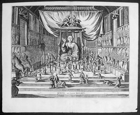
1669 Montanus Antique Print Sanjūsangen-dō 三十三間堂 Buddhist Temple Kyoto, Japan
- Title : Temple ou il y a 1000 Idoles: Temple met Duysend Beelden
- Date : 1669
- Condition: (A+) Fine Condition
- Ref # : 23413
- Size : 14 1/2in x 9in (360mm x 230mm)
Description:
This original copper-plate engraved antique print of Sanjūsangen-dō (三十三間堂) a Buddhist temple in Higashiyama District of Kyoto, Japan (with 1000 Kannon statues) during the Edo period, by Arnoldus Montanus was published in the 1669 edition of Gedenkwaerdige Gesantschappen der Oost-Indische Maetschappy int Vereenigde Nederland, aen de Kaisaren van Japan. Getrokken uit de Geschriften en Reiseaentekeninge der zelver Gesanten (Atlas Japannensis being remarkable addresses by way of Embassy from the East India Company of the United Provinces, to the Emperor of Japan)
General Definitions:
Paper thickness and quality: - Heavy and stable
Paper color : - off white
Age of map color: -
Colors used: -
General color appearance: -
Paper size: - 15in x 12in (380mm x 305mm)
Plate size: - 13in x 10in (330mm x 255mm)
Margins: - Min 1in (20mm)
Imperfections:
Margins: - None
Plate area: - None
Verso: - None
Background:
Sanjūsangen-dō (三十三間堂, lit. thirty-three ken (length) hall) is a Buddhist temple in Higashiyama District of Kyoto, Japan. Officially known as Rengeō-in (蓮華王院), or Hall of the Lotus King, Sanjūsangen-dō belongs to and is run by the Myōhō-in temple, a part of the Tendai school of Buddhism. The temple name literally means Hall with thirty three spaces between columns, describing the architecture of the long main hall of the temple.
Taira no Kiyomori completed the temple under order of Emperor Go-Shirakawa in 1164. The temple complex suffered a fire in 1249 and only the main hall was rebuilt in 1266. In January, the temple has an event known as the Rite of the Willow (柳枝のお加持), where worshippers are touched on the head with a sacred willow branch to cure and prevent headaches. A popular archery tournament known as the Tōshiya (通し矢) has also been held here, beside the West veranda, since the Edo period. The duel between the famous warrior Miyamoto Musashi and Yoshioka Denshichirō, leader of the Yoshioka-ryū, is popularly believed to have been fought just outside Sanjūsangen-dō in 1604.
The main deity of the temple is Sahasrabhuja-arya-avalokiteśvara or the Thousand Armed Kannon. The statue of the main deity was created by the Kamakura sculptor Tankei and is a National Treasure of Japan. The temple also contains one thousand life-size statues of the Thousand Armed Kannon which stand on both the right and left sides of the main statue in 10 rows and 50 columns. Of these, 124 statues are from the original temple, rescued from the fire of 1249, while the remaining 876 statues were constructed in the 13th century. The statues are made of Japanese cypress clad in gold leaf. The temple is 120 - meter long[1]. Around the 1000 Kannon statues stand 28 statues of guardian deities. There are also two famous statues of Fūjin and Raijin.
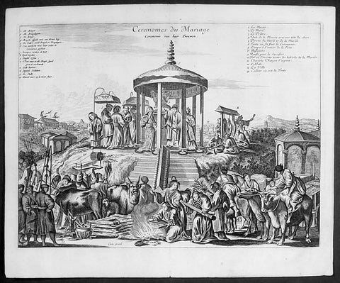
1669 Arnoldus Montanus Large Antique Print of a Japanese Marriage Ceremony 結婚式
- Title : Ceremonies du Mariage
- Date : 1669
- Condition: (A+) Fine Condition
- Ref # : 23411-1
- Size : 14 1/2in x 9in (360mm x 230mm)
Description:
This original copper-plate engraved antique print of a Japanese Marriage Ceremony during the early Edo period of Japanese history, by Arnoldus Montanus was published in the 1669 edition of Gedenkwaerdige Gesantschappen der Oost-Indische Maetschappy int Vereenigde Nederland, aen de Kaisaren van Japan. Getrokken uit de Geschriften en Reiseaentekeninge der zelver Gesanten (Atlas Japannensis being remarkable addresses by way of Embassy from the East India Company of the United Provinces, to the Emperor of Japan)
General Definitions:
Paper thickness and quality: - Heavy and stable
Paper color : - off white
Age of map color: -
Colors used: -
General color appearance: -
Paper size: - 15in x 12in (380mm x 305mm)
Plate size: - 13in x 10in (330mm x 255mm)
Margins: - Min 1in (20mm)
Imperfections:
Margins: - None
Plate area: - None
Verso: - None
Background:
Marriage in the Edo period (1600–1868)
In pre-modern Japan, marriage was inextricable from the ie (家, family or household), the basic unit of society with a collective continuity independent of any individual life. Members of the household were expected to subordinate all their own interests to that of the ie, with respect for an ideal of filial piety and social hierarchy that borrowed much from Confucianism. The choice to remain single was the greatest crime a man could commit, according to Baron Hozumi.
Marriages were duly arranged by the head of the household, who represented it publicly and was legally responsible for its members, and any preference by either principal in a marital arrangement was considered improper. Property was regarded to belong to the ie rather than to individuals, and inheritance was strictly agnatic primogeniture. A woman (女) married the household (家) of her husband, hence the logograms for yome (嫁, wife) and yomeiri (嫁入り, marriage, lit. wife entering).
In the absence of sons, some households would adopt a male heir (養子, or yōshi) to maintain the dynasty, a practice which continues in corporate Japan. Nearly all adoptions are of adult men. Marriage was restricted to households of equal social standing (分限), which made selection a crucial, painstaking process. Although Confucian ethics encouraged people to marry outside their own group, limiting the search to a local community remained the easiest way to ensure an honorable match. Approximately one-in-five marriages in pre-modern Japan occurred between households that were already related.
Outcast communities such as the Burakumin could not marry outside of their caste, and marriage discrimination continued even after an 1871 edict abolished the caste system, well into the twentieth century. Marriage between a Japanese and non-Japanese person was not officially permitted until 14 March 1873, a date now commemorated as White Day. Marriage with a foreigner required the Japanese national to surrender his or her social standing.
The purposes of marriage in the medieval and Edo periods was to form alliances between families, to relieve the family of its female dependents, to perpetuate the family line, and, especially for the lower classes, to add new members to the family\'s workforce. The seventeenth-century treatise Onna Daigaku (Greater Learning for Women) instructed wives honor their parents-in-law before their own parents, and to be courteous, humble, and conciliatory towards their husbands.
Husbands were also encouraged to place the needs of their parents and children before those of their wives. One British observer remarked, If you love your wife you spoil your mother\'s servant. The tension between a housewife and her mother-in-law has been a keynote of Japanese drama ever since.
Romantic love (愛情, aijō) played little part in medieval marriages, as emotional attachment was considered inconsistent with filial piety. A proverb said, Those who come together in passion stay together in tears. For men, sexual gratification was seen as separate from conjugal relations with ones wife, where the purpose was procreation. The genre called Ukiyo-e (浮世絵, lit. floating world pictures) celebrated the luxury and hedonism of the era, typically with depictions of beautiful courtesans and geisha of the pleasure districts. Concubinage and prostitution were common, public, relatively respectable, until the social upheaval of the Meiji Restoration put an end to feudal society in Japan.
1774 Capt. Cook, S. Parkinson & G. Stubbs - Antique Print Australian Kangaroo in 1770
Antique Map
- Title : Quadrupede nomme Kanguroo trouve fur la Cote de la N.Hollande
[The Kanguroo, an Animal found on the Coast of New Holland] - Ref : 35016
- Size: 10in x 8in (255mm x 205mm)
- Date : 1774
- Condition: (A+) Fine Condition
Description:
This fine original copper-plate engraved antique print of a Kangaroo, first sketched by Sydney Parkinson onboard HMS Endeavour during Cooks first voyage in 1770, whilst laid up at Endeavour River in northern Queensland, was engraved by Robert Benard, after a painting by the famous English Artist George Stubbs in 1772. This original engraving was published in the 1774 French edition of Capt. James Cooks 1st Voyage of Discovery to the South Seas by John Hawkesworth in An Account of the Voyages Undertaken by the Order of His Present Majesty for Making Discoveries in the Southern Hemisphere and Successively Performed by Commodore Byron, Captain Wallis, Captain Carteret, and Captain Cook, in the Dolphin, the Swallow, and the Endeavor, Drawn Up from the Journals Which Were Kept by the Several Commanders, and from the Papers of Joseph Banks. Paris, 1774.
From Sydney Parkinsons Journal........soon after we arrived in the bay, we laid the ship on a steep bank, on the side of a river; set up tents on shore, unloaded her, carried all the cargo and provisions into them, and there lodged and accommodated our sick.
On the 22d, we examined the ship’s bottom, and found a large hole; through the planks into the hold, which had a piece of coral-rock, half a yard square, sticking in it: the same rock, therefore, that endangered us, yielded us the principal means of our redemption; for, had not this fragment intruded into the leak, in all probability the ship would have sunk.
We lost no time, but immediately set about repairing the ship’s bottom, and in a few days made it sound again. In the mean time, the boats were sent out, in search of another passage, which they found, and returned to the ship on the 3d of July.
On the 4th of July, the ship was carried to the other side of the river, and examined thoroughly; but, being found in good condition, she was soon placed in her former station; where she was loaded, and properly fitted to proceed on the voyage.
During the time we staid here, we picked up a great many natural curiosities from the reef we struck upon, consisting of a variety of curious shells, most of which were entirely new to Mr. Banks and Dr. Solander ...
Of quadrupeds, there are goats, wolves, a small red animal about the size of a squirrel; a spotted one of the viverra kind, and an animal of a kind nearly approaching the mus genus, about the size of a grey-hound, that had a head like a fawn’s; lips and ears, which it throws back, like a hare’s; on the upper jaw six large teeth; on the under one two only; with a short and small neck, near to which are the fore-feet, which have five toes each, and five hooked claws; the hinder legs are long, especially from the last joint, which, from the callosity below it, seems as if it lies flat on the ground when the animal descends any declivity; and each foot had four long toes, two of them behind, placed a great way back, the inner one of which has two claws; the two other toes were in the middle, and resembled a hoof, but one of them was much larger than the other. The tail, which is carried like a grey-hound’s, was almost as long as the body, and tapered gradually to the end. The chief bulk of this animal is behind; the belly being largest, and the back rising toward the posteriors. The whole body is covered with short ash-coloured hair; and the flesh of it tasted like a hare’s, but has a more agreeable flavour................
General Definitions:
Paper thickness and quality: - Heavy and stable
Paper color : - off white
Age of map color: -
Colors used: -
General color appearance: -
Paper size: - 10in x 8in (255mm x 205mm)
Plate size: - 9 1/2in x 7 1/4in (240mm x 185mm)
Margins: - Min 1/2in (12mm)
Imperfections:
Margins: - Light soiling in margins
Plate area: - None
Verso: - None
Background:
Sydney Parkinson 1745 – 71 was draughtsman to the botanist Sir Joseph Banks on James Cook’s first voyage to the Pacific in 1768. He died of dysentery in 1771, on the homeward voyage.
Parkinson was the first European artist to create drawings of Indigenous Australian, Maori & South Sea peoples, as well as landscapes, from direct observation. Hundreds of his original drawings survive in the British Museum. He is particularly remembered for his plant illustrations which were later used to create the lavish plates for Joseph Banks’ Florilegium.
When the Endeavour returned to England in 1772, a dispute arose between Joseph Banks and Sydney’s brother, Stanfield Parkinson. As his employer, Banks claimed rights to Sydney’s drawings, papers and collections made on the voyage. Stanfield claimed that Sydney had willed them to his family. Banks lent the Parkinson family Sydney’s journal and drawings with instructions that they were not to be published, however Stanfield disregarded this and arranged for A Journal of a voyage to the South Seas to be printed from Sydney’s account of the voyage.
Banks managed to suppress Stanfield’s publication until the official account of the voyage, edited by John Hawkesworth, appeared. In return for Parkinson’s papers, Banks paid Stanfield Parkinson 500 pounds for balance of wages due to Sydney, but the dispute did not end there. Stanfield further accused Banks of retaining items collected by Sydney which were intended for his relatives. Stanfield Parkinson was declared insane soon after the publication of Sydney Parkinson’s Journal and died in an asylum.
John Hawkesworth An English writer and journalist, Hawkesworth was commissioned by the British Admiralty to edit for publication the narratives of its officers’ circumnavigations. He was given full access to the journals of the commanders and the freedom to adapt and re-tell them in the first person. Cook was already on his way back from his second Pacific voyage, temporarily docked at Cape Town (South Africa), when he first saw the published volumes: he was mortified and furious to find that Hawkesworth claimed in the introduction that Cook had seen and blessed (with slight corrections) the resulting manuscript. (In his defense, Hawkesworth also had been a victim of misunderstanding.) Cook had trouble recognizing himself. Moreover, the work was full of errors and commentary introduced by Hawkesworth and, in Cook’s view, too full of Banks, who had promoted himself and the publication. Still, the work was popular; the first edition sold out in several months.
Robert Bénard 1734 – 1777 was an 18th-century French engraver.
Specialized in the technique of engraving, Robert Ménard is mainly famous for having supplied a significant amount of plates (at least 1,800) to the Encyclopédie by Diderot & d\'Alembert from 1751.
Later, publisher Charles-Joseph Panckoucke reused many of his productions to illustrate the works of his catalog.
George Stubbs ARA 1724 – 1806 was an English painter, best known for his paintings of horses. His most famous work is probably Whistlejacket, a painting of a prancing horse commissioned by the 2nd Marquess of Rockingham, which is now in the National Gallery in London. This and two other paintings carried out for Rockingham break with convention in having plain backgrounds. Throughout the 1760s he produced a wide range of individual and group portraits of horses, sometimes accompanied by hounds. He often painted horses with their grooms, whom he always painted as individuals. Meanwhile, he also continued to accept commissions for portraits of people, including some group portraits. From 1761 to 1776 he exhibited at the Society of Artists of Great Britain, but in 1775 he switched his allegiance to the recently founded but already more prestigious Royal Academy of Arts.
Stubbs also painted more exotic animals including lions, tigers, giraffes, monkeys, and rhinoceroses, which he was able to observe in private menageries. His painting of a kangaroo in 1772 after Cooks 1st Voyage to Australia, was the first glimpse of this animal for many 18th-century Britons
1814 William Alexander Antique Print of a Chinese Soldier with Matchlock Rifle
- Title : China - Plate 13....Published Jan. 1814 by J Murray, Albenarle Street (Plate XIII A Soldier with his Matchlock)
- Date : 1814
- Condition: (A+) Fine Condition
- Ref: 25464-1
- Size: 13in x 11in (330mm x 280mm)
Description:
This beautifully hand coloured original copper-plate engraved antique print of a Chinese soldier with his Matchlock rifle - accompanied by text - by William Alexander was published in the 1st 1814 - dated - edition of Picturesque Representations of the Dress and Manners of the Chinese, illustrated in fifty colored engravings, with descriptions.
General Definitions:
Paper thickness and quality: - Heavy and stable
Paper color : - off white
Age of map color: - Original
Colors used: - Yellow, green, blue, pink
General color appearance: - Authentic
Paper size: - 13in x 11in (330mm x 280mm)
Plate size: - 9 1/2in x 7in (240mm x 180mm)
Margins: - Min 1in (25mm)
Imperfections:
Margins: - None
Plate area: - Light age toning
Verso: - None
Background:
In 1792, Alexander was appointed as one of the draughtsmen to the Macartney Embassy to China. He accompanied the Earl of Macartney to Peking where he made drawings for the plates which accompanied Sir George Stauntons account of the embassy, published in 1797.
In 1805 he published The Costume of China, illustrated by 48 coloured engravings, after his travels to China with The Earl of Macartney. The work was so well-received that in 1814 he published another book titled Picturesque Representations of the Dress and Manners of the Chinese, illustrated in fifty colored engravings, with descriptions. This publication was re-issued over the next twenty years in various languages including French.
Alexander, William 1767 – 1816
Alexander was an English painter, illustrator and engraver. The hallmarks of his work, usually executed in watercolours, were clearness and harmony of colour, simplicity and taste in composition, grace of outline, and delicacy of execution. He accompanied the Macartney Embassy to China in 1792. Prints of his work were reproduced from engravings. One his of works was used to illustrate Cadell & Davies Britannia depicta.
Alexander was born in Maidstone, Kent, the son of Harry Alexander, a coachmaker. He was educated at Maidstone Grammar School, but in 1782, at the age of 15, moved to London to study art - first under William Pars, and subsequently Julius Caesar Ibbetson. In February 1784, he was admitted to the Royal Academy Schools. He assiduously applied himself to the mastery of his profession, obtaining the notice and approbation of Sir Joshua Reynolds.
In 1792, he was appointed as one of the draughtsmen to the Macartney Embassy to China. He accompanied the Earl of Macartney to Peking where he made drawings for the plates which accompanied Sir George Stauntons account of the embassy (published in 1797) In 1794 he returned to England and married Jane Wogan the following year. She died soon afterwards.
His other principal works were: Views of Headlands, Islands, etc. taken during the Voyage to China (1798); drawings based on Daniells sketches, for Vancouvers Voyage to the North Pacific Ocean (1798); and the descriptive plates to Sir John Barrows Travels in China (1804), and Voyage to Cochin China (1806). In 1805 he published The Costume of China, illustrated by 48 coloured engravings. The work was so well-received that in 1814 he published another book titled Picturesque Representations of the Dress and Manners of the Chinese, illustrated in fifty colored engravings, with descriptions.
Besides his works as a draughtsman, he made several engravings - the principal one of which is a representation of the Festival given by the Earl of Romney to the Kentish Volunteers, on 1 August 1799, from his own drawing.
In 1802, Alexander was appointed professor of drawing at the Military College at Great Marlow, resigning in May 1808 to take up the post of assistant keeper of antiquities in the British Museum. In the years 1810, 1812, and 1815, he made drawings of the terra cottas and marbles in the Museum which were engraved and published in three volumes - the accompanying text being provided by Taylor Combe (keeper of the Department of Antiquities). Alexander had completed drawings for a fourth volume before his death.
He died at the house of his uncle in Maidstone in July 1816, and was buried in Boxley churchyard. He was described in one of his obituaries as a man of mild and unassuming manners, rich in the knowledge of art, and of unsullied integrity.
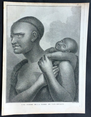
1785 Capt. Cook Antique Print Aboriginal Woman of Bruny Island, Tasmania in 1777
- Title : Une Femme De La Terre De Van-Diemens
- Ref : 50609
- Size: 10in x 8in (255mm x 205mm)
- Date : 1785
- Condition: (A+) Fine Condition
Description:
This fine original copper-plate engraved antique print of an Indigenous Woman & child of Adventure Bay, Bruny Island, Tasmania (Van Diemens Land) encountered by Captain Cook in during his 3rd & last Voyage of Discovery in 1777, was engraved by Robert Benard - after John Webber - and published in the 1785 French edition of Capt. James Cook & Capt. James King A Voyage to the Pacific Ocean. Undertaken, by the Command of his Majesty, for making Discoveries in the Northern Hemisphere. To determine The Position and Extent of the West Side of North America; its Distance from Asia; and the Practicability of a Northen Passage to Europe. Performed under the direction of Captains Cook, Clerke, and Gore, In His Majesty\'s Ships the Resolution and Discovery. In the Years 1776, 1777, 1778, 1779, and 1780. In Three Volumes. Vol. I and II written by James Cook, F.R.S. Vol. III by Captain James King, LL.D. and F.R.S. Paris, 1785.
Adventure Bay
from Cooks Journal......on the 24th (March 1777) at 3 AM we made the Coast of Van Diemen land wrote Cook. Anderson remarked that though now the middle of summer here a spot or two of snow was seen on the highest hills… At ten we passd a point supposd to be the boundary of Stone Bay where Abel Tasman anchord, i.e. Storm Bay. According to David Samwell, surgeons first mate on the Resolution, both Ships anchored in Adventure Bay in Van Diemens Land, this Bay was so called by Captn Furneaux who had anchored here in the Adventure last Voyage.
The next day Cook and Clerke sent parties, one to cut wood and the other grass. Clerke wrote of his party from the Discovery The Guard I had sent with the Parties on shore which consisted of the following Marines, Hamlet Thompson, Geo: Moody, Ben: Harriot, Jos: Pool & Willm Broom, stole some Liquor & made themselves exceedingly drunk, for which they receivd a dozen lashes each in the Morning. The Privates were all from the Plymouth division of marines. Hamlet Thompson was from the 6th Company, George Moody from the 70th, John Herriott the 12th, James Poole the 33rd and William Broom the 36th. According to Thomas Edgar, Master, they made themselves so Beastly Drunk that they were put motionless in the Boat, and when brought on board were oblig\'d to be hoisted into the Ship.
William Bayly, astronomer on the Discovery, wrote In the morning I carried my Tent observatory & Instruments on Shore & set all up, but was not able to get any observations it being cloudy all day, in the evening Capt Cook Sent for me & told me he had Altered his mind relative to his stay, & ordered me to pack all up & carry the whole on board again, as he intend[ed] to sail for New Zealand in a day or two.
John Henry Martin, seaman on the Discovery, described the natives. They have few, or no wants, & seemed perfectly Happy, if one might judge from their behaviour, for they frequently woud burst out, into the most immoderate fits of Laughter & when one Laughed every one followed his example Emediately.
General Definitions:
Paper thickness and quality: - Heavy and stable
Paper color : - off white
Age of map color: -
Colors used: -
General color appearance: -
Paper size: - 10in x 8in (255mm x 205mm)
Plate size: - 9 1/2in x 7 1/4in (240mm x 185mm)
Margins: - Min 1/2in (12mm)
Imperfections:
Margins: - None
Plate area: - None
Verso: - None
Background:
Adventure Bay is the name of both a township and a geographical feature on the eastern side of Bruny Island, Tasmania.
The first European to sight the bay was explorer Abel Tasman, who sought to anchor his vessel Heemskerck there in 1642. Instead, Heemskerck was driven back offshore by a storm, in token of which Tasman named the place Storm Bay. Captain Tobias Furneaux renamed it in March 1773, in honour of his ship HMS Adventure, which he had anchored in the bay for five days after becoming separated from Captain James Cook\'s HMS Resolution during Cook\'s second voyage to the Pacific search of Terra Australis Incognita. Furneaux\'s log made clear the bay was an excellent anchorage for resupplying vessels:....to the SW of the first watering place there is a large lagoon which I believe has plenty of fish in it for one of our Gentlemen caught upwards of 2 dozen trout, and shot a possum which was the only animal we saw. There are a great many gum trees and of a vast thickness and height, one of which measured in circumference 26 feet and the height under the branches was 20 feet.
Others among Furneaux\'s crew spotted evidence of what they believed were small deer but were more likely kangaroos. Furneaux also noted signs of an Aboriginal settlement in the form of several huts or wigwams on shore, with several bags of grass in which they carry their shellfish. - but the branches of which the huts were made were split and torn and there was not the least appearance of any people.
Reliably mapped and offering an abundance of water, fresh water and game, Adventure Bay quickly became a popular anchorage for European explorers. Cooks Resolution watered there in 1777, followed by William Bligh aboard HMS Bounty in 1788 and HMS Providence in 1792. Others who resupplied their vessels in the bay in this period included Bruni d Entrecasteaux aboard Recherché in 1792 and 1793, and Nicolas Baudin in the corvette Géographe in 1802. Matthew Flinders also tried to enter the bay with Norfolk in 1798.
John Hawkesworth 1715 – 1773 English writer and book editor.
He is said to have been clerk to an attorney, and was certainly self-educated. In 1744, he succeeded Samuel Johnson as compiler of the parliamentary debates for the Gentleman\\\'s Magazine, and from 1746 to 1749 he contributed poems signed Greville, or H Greville, to that journal. In company with Johnson and others he started a periodical called The Adventurer, which ran to 140 issues, of which 70 were from the pen of Hawkesworth himself.
On account of what was regarded as his powerful defense of morality and religion, Hawkesworth was rewarded by the archbishop of Canterbury with the degree of LL.D, In 1754–1755 he published an edition (12 vols) of Swifts works, with a life prefixed which Johnson praised in his Lives of the Poets. A larger edition (27 vols) appeared in 1766–1779. He adapted Dryden\\\'s Amphitryon for the Drury Lane stage in 1756, and Southernes Oronooko in 1759. He wrote the libretto of an oratorio Zimri in 1760, and the next year Edgar and Emmeline: a Fairy Tale was produced at Drury Lane. His Almoran and Hamet (1761) was first drafted as a play[citation needed], and a tragedy based on it by S J Pratt, The Fair Circassian (1781), met with some success.
He was commissioned by the Admiralty to edit Captain James Cooks papers relative to his first voyage. For this work, An Account of the Voyages undertaken ... for making discoveries in the Southern Hemisphere and performed by Commodore Byrone John Byron, Captain Wallis, Captain Carteret and Captain Cook (from 1702 to 1771) drawn up from the Journals ... (3 vols, 1773) Hawkesworth is said to have received from the publishers the sum of £6000. His descriptions of the manners and customs of the South Seas were, however, regarded by many critics as inexact and hurtful to the interests of morality, and the severity of their strictures is said to have hastened his death. He was buried in the parish church at Bromley, Kent, where he and his wife had kept a school.
Hawkesworth was a close imitator of Johnson both in style and thought, and was at one time on very friendly terms with him. It is said that he presumed on his success, and lost Johnsons friendship as early as 1756.
Captain James King FRS 1750 – 1784 was an officer of the Royal Navy. He served under James Cook on his last voyage around the world, specialising in taking important astronomical readings using a sextant. After Cook died he helped lead the ships on the remainder of their course, also completing Cook\\\'s account of the voyage. He continued his career in the Navy, reaching the rank of post-captain, commanding several ships and serving in the American War of Independence.
King joined HMS Resolution as second lieutenant, sharing the duties of astronomer with Cook, taking astronomical observations on board by sextant and with Larcum Kendals timekeeper K1, to establish the Resolutions position at sea and on shore by sextant or by astronomical quadrant to establish the geographical position of salient points during the course of Cooks surveys. Thus King\\\'s geographical positions were an important contribution to the accuracy of the various surveys carried out during the voyage and his use of the early chronometers helped prove their use at sea for calculation of Longitude. .
Following the death of Cook, King remained in the Resolution but on the death of Charles Clerke, Cooks successor, King was appointed to command HMS Discovery, the Resolution\\\'s consort, remaining in her for the rest of the voyage. After his return to England King was very much involved in the publication of the official account of Cooks third voyage, writing the third volume at Woodstock, near Oxford, where his brother Thomas was rector of St Mary Magdalene. But shortly after his return King was promoted Post-captain and appointed commander of HMS Crocodile in the English Channel.
John Webber RA 1751 – 1793 was an English artist who accompanied Captain Cook on his third Pacific expedition. He is best known for his images of Australasia, Hawaii and Alaska.
Webber was born in London, educated in Bern and studied painting at Paris.His father was Abraham Wäber, a Swiss sculptor who had moved to London, and changed his name to Webber before marrying a Mrs Mary Quant in 1744.
Webber served as official artist on James Cook\'s third voyage of discovery around the Pacific (1776–80) aboard HMS Resolution. At Adventure Bay in January 1777 he did drawings of A Man of Van Diemens Land and A Woman of Van Diemens Land. He also did many drawings of scenes in New Zealand and the South Sea islands. On this voyage, during which Cook lost his life in a fight in Hawaii, Webber became the first European artist to make contact with Hawaii, then called the Sandwich Islands. He made numerous watercolor landscapes of the islands of Kauai and Hawaii, and also portrayed many of the Hawaiian people.
In April 1778, Captain Cooks ships Resolution and Discovery anchored at Ship Cove, now known as Nootka Sound, Vancouver Island, Canada to refit. The crew took observations and recorded encounters with the local people. Webber made watercolour landscapes including Resolution and Discovery in Ship Cove, 1778. His drawings and paintings were engraved for British Admiraltys account of the expedition, which was published in 1784.
Back in England in 1780 Webber exhibited around 50 works at Royal Academy exhibitions between 1784 and 1792, and was elected an associate of the Royal Academy in 1785 and R.A. in 1791. Most of his work were landscapes. Sometimes figures were included as in A Party from H.M.S. Resolution shooting sea horses\", which was shown at the academy in 1784, and his The Death of Captain Cook became well known through an engraving of it. Another version of this picture is in the William Dixson gallery at Sydney
Robert Bénard 1734 – 1777 was an 18th-century French engraver.
Specialized in the technique of engraving, Robert Ménard is mainly famous for having supplied a significant amount of plates (at least 1,800) to the Encyclopédie by Diderot & d\'Alembert from 1751.
Later, publisher Charles-Joseph Panckoucke reused many of his productions to illustrate the works of his catalog.
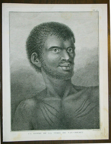
1785 Capt. Cook Antique Print Aboriginal Man of Bruny Island, Tasmania in 1777
- Title : Un Homme De La Terre De Van-Diemens
- Ref : 43195
- Size: 10in x 8in (255mm x 205mm)
- Date : 1785
- Condition: (A+) Fine Condition
Description:
This fine original copper-plate engraved antique print of an Indigenous Man of Adventure Bay, Bruny Island, Tasmania (Van Diemens Land) encountered by Captain Cook in during his 3rd & last Voyage of Discovery in 1777, was engraved by Robert Benard - after John Webber - and published in the 1785 French edition of Capt. James Cook & Capt. James King A Voyage to the Pacific Ocean. Undertaken, by the Command of his Majesty, for making Discoveries in the Northern Hemisphere. To determine The Position and Extent of the West Side of North America; its Distance from Asia; and the Practicability of a Northen Passage to Europe. Performed under the direction of Captains Cook, Clerke, and Gore, In His Majesty\'s Ships the Resolution and Discovery. In the Years 1776, 1777, 1778, 1779, and 1780. In Three Volumes. Vol. I and II written by James Cook, F.R.S. Vol. III by Captain James King, LL.D. and F.R.S. Paris, 1785.
Adventure Bay
from Cooks Journal......on the 24th (March 1777) at 3 AM we made the Coast of Van Diemen land wrote Cook. Anderson remarked that though now the middle of summer here a spot or two of snow was seen on the highest hills… At ten we passd a point supposd to be the boundary of Stone Bay where Abel Tasman anchord, i.e. Storm Bay. According to David Samwell, surgeons first mate on the Resolution, both Ships anchored in Adventure Bay in Van Diemens Land, this Bay was so called by Captn Furneaux who had anchored here in the Adventure last Voyage.
The next day Cook and Clerke sent parties, one to cut wood and the other grass. Clerke wrote of his party from the Discovery The Guard I had sent with the Parties on shore which consisted of the following Marines, Hamlet Thompson, Geo: Moody, Ben: Harriot, Jos: Pool & Willm Broom, stole some Liquor & made themselves exceedingly drunk, for which they receivd a dozen lashes each in the Morning. The Privates were all from the Plymouth division of marines. Hamlet Thompson was from the 6th Company, George Moody from the 70th, John Herriott the 12th, James Poole the 33rd and William Broom the 36th. According to Thomas Edgar, Master, they made themselves so Beastly Drunk that they were put motionless in the Boat, and when brought on board were oblig\'d to be hoisted into the Ship.
William Bayly, astronomer on the Discovery, wrote In the morning I carried my Tent observatory & Instruments on Shore & set all up, but was not able to get any observations it being cloudy all day, in the evening Capt Cook Sent for me & told me he had Altered his mind relative to his stay, & ordered me to pack all up & carry the whole on board again, as he intend[ed] to sail for New Zealand in a day or two.
John Henry Martin, seaman on the Discovery, described the natives. They have few, or no wants, & seemed perfectly Happy, if one might judge from their behaviour, for they frequently woud burst out, into the most immoderate fits of Laughter & when one Laughed every one followed his example Emediately.
General Definitions:
Paper thickness and quality: - Heavy and stable
Paper color : - off white
Age of map color: -
Colors used: -
General color appearance: -
Paper size: - 10in x 8in (255mm x 205mm)
Plate size: - 9 1/2in x 7 1/4in (240mm x 185mm)
Margins: - Min 1/2in (12mm)
Imperfections:
Margins: - None
Plate area: - None
Verso: - None
Background:
Adventure Bay is the name of both a township and a geographical feature on the eastern side of Bruny Island, Tasmania.
The first European to sight the bay was explorer Abel Tasman, who sought to anchor his vessel Heemskerck there in 1642. Instead, Heemskerck was driven back offshore by a storm, in token of which Tasman named the place Storm Bay. Captain Tobias Furneaux renamed it in March 1773, in honour of his ship HMS Adventure, which he had anchored in the bay for five days after becoming separated from Captain James Cook\'s HMS Resolution during Cook\'s second voyage to the Pacific search of Terra Australis Incognita. Furneaux\'s log made clear the bay was an excellent anchorage for resupplying vessels:....to the SW of the first watering place there is a large lagoon which I believe has plenty of fish in it for one of our Gentlemen caught upwards of 2 dozen trout, and shot a possum which was the only animal we saw. There are a great many gum trees and of a vast thickness and height, one of which measured in circumference 26 feet and the height under the branches was 20 feet.
Others among Furneaux\'s crew spotted evidence of what they believed were small deer but were more likely kangaroos. Furneaux also noted signs of an Aboriginal settlement in the form of several huts or wigwams on shore, with several bags of grass in which they carry their shellfish. - but the branches of which the huts were made were split and torn and there was not the least appearance of any people.
Reliably mapped and offering an abundance of water, fresh water and game, Adventure Bay quickly became a popular anchorage for European explorers. Cooks Resolution watered there in 1777, followed by William Bligh aboard HMS Bounty in 1788 and HMS Providence in 1792. Others who resupplied their vessels in the bay in this period included Bruni d Entrecasteaux aboard Recherché in 1792 and 1793, and Nicolas Baudin in the corvette Géographe in 1802. Matthew Flinders also tried to enter the bay with Norfolk in 1798.
John Hawkesworth 1715 – 1773 English writer and book editor.
He is said to have been clerk to an attorney, and was certainly self-educated. In 1744, he succeeded Samuel Johnson as compiler of the parliamentary debates for the Gentleman\\\'s Magazine, and from 1746 to 1749 he contributed poems signed Greville, or H Greville, to that journal. In company with Johnson and others he started a periodical called The Adventurer, which ran to 140 issues, of which 70 were from the pen of Hawkesworth himself.
On account of what was regarded as his powerful defense of morality and religion, Hawkesworth was rewarded by the archbishop of Canterbury with the degree of LL.D, In 1754–1755 he published an edition (12 vols) of Swifts works, with a life prefixed which Johnson praised in his Lives of the Poets. A larger edition (27 vols) appeared in 1766–1779. He adapted Dryden\\\'s Amphitryon for the Drury Lane stage in 1756, and Southernes Oronooko in 1759. He wrote the libretto of an oratorio Zimri in 1760, and the next year Edgar and Emmeline: a Fairy Tale was produced at Drury Lane. His Almoran and Hamet (1761) was first drafted as a play[citation needed], and a tragedy based on it by S J Pratt, The Fair Circassian (1781), met with some success.
He was commissioned by the Admiralty to edit Captain James Cooks papers relative to his first voyage. For this work, An Account of the Voyages undertaken ... for making discoveries in the Southern Hemisphere and performed by Commodore Byrone John Byron, Captain Wallis, Captain Carteret and Captain Cook (from 1702 to 1771) drawn up from the Journals ... (3 vols, 1773) Hawkesworth is said to have received from the publishers the sum of £6000. His descriptions of the manners and customs of the South Seas were, however, regarded by many critics as inexact and hurtful to the interests of morality, and the severity of their strictures is said to have hastened his death. He was buried in the parish church at Bromley, Kent, where he and his wife had kept a school.
Hawkesworth was a close imitator of Johnson both in style and thought, and was at one time on very friendly terms with him. It is said that he presumed on his success, and lost Johnsons friendship as early as 1756.
Captain James King FRS 1750 – 1784 was an officer of the Royal Navy. He served under James Cook on his last voyage around the world, specialising in taking important astronomical readings using a sextant. After Cook died he helped lead the ships on the remainder of their course, also completing Cook\\\'s account of the voyage. He continued his career in the Navy, reaching the rank of post-captain, commanding several ships and serving in the American War of Independence.
King joined HMS Resolution as second lieutenant, sharing the duties of astronomer with Cook, taking astronomical observations on board by sextant and with Larcum Kendals timekeeper K1, to establish the Resolutions position at sea and on shore by sextant or by astronomical quadrant to establish the geographical position of salient points during the course of Cooks surveys. Thus King\\\'s geographical positions were an important contribution to the accuracy of the various surveys carried out during the voyage and his use of the early chronometers helped prove their use at sea for calculation of Longitude. .
Following the death of Cook, King remained in the Resolution but on the death of Charles Clerke, Cooks successor, King was appointed to command HMS Discovery, the Resolution\\\'s consort, remaining in her for the rest of the voyage. After his return to England King was very much involved in the publication of the official account of Cooks third voyage, writing the third volume at Woodstock, near Oxford, where his brother Thomas was rector of St Mary Magdalene. But shortly after his return King was promoted Post-captain and appointed commander of HMS Crocodile in the English Channel.
John Webber RA 1751 – 1793 was an English artist who accompanied Captain Cook on his third Pacific expedition. He is best known for his images of Australasia, Hawaii and Alaska.
Webber was born in London, educated in Bern and studied painting at Paris.His father was Abraham Wäber, a Swiss sculptor who had moved to London, and changed his name to Webber before marrying a Mrs Mary Quant in 1744.
Webber served as official artist on James Cook\'s third voyage of discovery around the Pacific (1776–80) aboard HMS Resolution. At Adventure Bay in January 1777 he did drawings of A Man of Van Diemens Land and A Woman of Van Diemens Land. He also did many drawings of scenes in New Zealand and the South Sea islands. On this voyage, during which Cook lost his life in a fight in Hawaii, Webber became the first European artist to make contact with Hawaii, then called the Sandwich Islands. He made numerous watercolor landscapes of the islands of Kauai and Hawaii, and also portrayed many of the Hawaiian people.
In April 1778, Captain Cooks ships Resolution and Discovery anchored at Ship Cove, now known as Nootka Sound, Vancouver Island, Canada to refit. The crew took observations and recorded encounters with the local people. Webber made watercolour landscapes including Resolution and Discovery in Ship Cove, 1778. His drawings and paintings were engraved for British Admiraltys account of the expedition, which was published in 1784.
Back in England in 1780 Webber exhibited around 50 works at Royal Academy exhibitions between 1784 and 1792, and was elected an associate of the Royal Academy in 1785 and R.A. in 1791. Most of his work were landscapes. Sometimes figures were included as in A Party from H.M.S. Resolution shooting sea horses\", which was shown at the academy in 1784, and his The Death of Captain Cook became well known through an engraving of it. Another version of this picture is in the William Dixson gallery at Sydney
Robert Bénard 1734 – 1777 was an 18th-century French engraver.
Specialized in the technique of engraving, Robert Ménard is mainly famous for having supplied a significant amount of plates (at least 1,800) to the Encyclopédie by Diderot & d\'Alembert from 1751.
Later, publisher Charles-Joseph Panckoucke reused many of his productions to illustrate the works of his catalog.
1814 William Alexander Antique Print of Chinese Mandarin Servant on Horseback
- Title : China - Plate 18....Published Jan. 1814 by J Murray, Albenarle Street (Plate XVIII A Mandarins Servant on Horseback)
- Date : 1814
- Condition: (A+) Fine Condition
- Ref: 25461
- Size: 13in x 11in (330mm x 280mm)
Description:
This beautifully hand coloured original copper-plate engraved antique print of a Mandarins servant on horseback by William Alexander was published in the 1st 1814 - dated - edition of Picturesque Representations of the Dress and Manners of the Chinese, illustrated in fifty colored engravings, with descriptions.
General Definitions:
Paper thickness and quality: - Heavy and stable
Paper color : - off white
Age of map color: - Original
Colors used: - Yellow, green, blue, pink
General color appearance: - Authentic
Paper size: - 13in x 11in (330mm x 280mm)
Plate size: - 9 1/2in x 7in (240mm x 180mm)
Margins: - Min 1in (25mm)
Imperfections:
Margins: - None
Plate area: - Light age toning
Verso: - None
Background:
In 1792, Alexander was appointed as one of the draughtsmen to the Macartney Embassy to China. He accompanied the Earl of Macartney to Peking where he made drawings for the plates which accompanied Sir George Stauntons account of the embassy, published in 1797.
In 1805 he published The Costume of China, illustrated by 48 coloured engravings, after his travels to China with The Earl of Macartney. The work was so well-received that in 1814 he published another book titled Picturesque Representations of the Dress and Manners of the Chinese, illustrated in fifty colored engravings, with descriptions. This publication was re-issued over the next twenty years in various languages including French.
Alexander, William 1767 – 1816
Alexander was an English painter, illustrator and engraver. The hallmarks of his work, usually executed in watercolours, were clearness and harmony of colour, simplicity and taste in composition, grace of outline, and delicacy of execution. He accompanied the Macartney Embassy to China in 1792. Prints of his work were reproduced from engravings. One his of works was used to illustrate Cadell & Davies Britannia depicta.
Alexander was born in Maidstone, Kent, the son of Harry Alexander, a coachmaker. He was educated at Maidstone Grammar School, but in 1782, at the age of 15, moved to London to study art - first under William Pars, and subsequently Julius Caesar Ibbetson. In February 1784, he was admitted to the Royal Academy Schools. He assiduously applied himself to the mastery of his profession, obtaining the notice and approbation of Sir Joshua Reynolds.
In 1792, he was appointed as one of the draughtsmen to the Macartney Embassy to China. He accompanied the Earl of Macartney to Peking where he made drawings for the plates which accompanied Sir George Stauntons account of the embassy (published in 1797) In 1794 he returned to England and married Jane Wogan the following year. She died soon afterwards.
His other principal works were: Views of Headlands, Islands, etc. taken during the Voyage to China (1798); drawings based on Daniells sketches, for Vancouvers Voyage to the North Pacific Ocean (1798); and the descriptive plates to Sir John Barrows Travels in China (1804), and Voyage to Cochin China (1806). In 1805 he published The Costume of China, illustrated by 48 coloured engravings. The work was so well-received that in 1814 he published another book titled Picturesque Representations of the Dress and Manners of the Chinese, illustrated in fifty colored engravings, with descriptions.
Besides his works as a draughtsman, he made several engravings - the principal one of which is a representation of the Festival given by the Earl of Romney to the Kentish Volunteers, on 1 August 1799, from his own drawing.
In 1802, Alexander was appointed professor of drawing at the Military College at Great Marlow, resigning in May 1808 to take up the post of assistant keeper of antiquities in the British Museum. In the years 1810, 1812, and 1815, he made drawings of the terra cottas and marbles in the Museum which were engraved and published in three volumes - the accompanying text being provided by Taylor Combe (keeper of the Department of Antiquities). Alexander had completed drawings for a fourth volume before his death.
He died at the house of his uncle in Maidstone in July 1816, and was buried in Boxley churchyard. He was described in one of his obituaries as a man of mild and unassuming manners, rich in the knowledge of art, and of unsullied integrity.
1814 William Alexander Antique Print of Chinese Family Eating a Meal
- Title : China - Plate 10....Published Jan. 1814 by J Murray, Albenarle Street
- Date : 1814
- Condition: (A+) Fine Condition
- Ref: 25462
- Size: 13in x 11in (330mm x 280mm)
Description:
This beautifully hand coloured original copper-plate engraved antique print of a Chinese family eating by the side of the road - by William Alexander was published in the 1st 1814 - dated - edition of Picturesque Representations of the Dress and Manners of the Chinese, illustrated in fifty colored engravings, with descriptions.
General Definitions:
Paper thickness and quality: - Heavy and stable
Paper color : - off white
Age of map color: - Original
Colors used: - Yellow, green, blue, pink
General color appearance: - Authentic
Paper size: - 13in x 11in (330mm x 280mm)
Plate size: - 9 1/2in x 7in (240mm x 180mm)
Margins: - Min 1in (25mm)
Imperfections:
Margins: - None
Plate area: - Light age toning
Verso: - None
Background:
In 1792, Alexander was appointed as one of the draughtsmen to the Macartney Embassy to China. He accompanied the Earl of Macartney to Peking where he made drawings for the plates which accompanied Sir George Stauntons account of the embassy, published in 1797.
In 1805 he published The Costume of China, illustrated by 48 coloured engravings, after his travels to China with The Earl of Macartney. The work was so well-received that in 1814 he published another book titled Picturesque Representations of the Dress and Manners of the Chinese, illustrated in fifty colored engravings, with descriptions. This publication was re-issued over the next twenty years in various languages including French.
Alexander, William 1767 – 1816
Alexander was an English painter, illustrator and engraver. The hallmarks of his work, usually executed in watercolours, were clearness and harmony of colour, simplicity and taste in composition, grace of outline, and delicacy of execution. He accompanied the Macartney Embassy to China in 1792. Prints of his work were reproduced from engravings. One his of works was used to illustrate Cadell & Davies Britannia depicta.
Alexander was born in Maidstone, Kent, the son of Harry Alexander, a coachmaker. He was educated at Maidstone Grammar School, but in 1782, at the age of 15, moved to London to study art - first under William Pars, and subsequently Julius Caesar Ibbetson. In February 1784, he was admitted to the Royal Academy Schools. He assiduously applied himself to the mastery of his profession, obtaining the notice and approbation of Sir Joshua Reynolds.
In 1792, he was appointed as one of the draughtsmen to the Macartney Embassy to China. He accompanied the Earl of Macartney to Peking where he made drawings for the plates which accompanied Sir George Stauntons account of the embassy (published in 1797) In 1794 he returned to England and married Jane Wogan the following year. She died soon afterwards.
His other principal works were: Views of Headlands, Islands, etc. taken during the Voyage to China (1798); drawings based on Daniells sketches, for Vancouvers Voyage to the North Pacific Ocean (1798); and the descriptive plates to Sir John Barrows Travels in China (1804), and Voyage to Cochin China (1806). In 1805 he published The Costume of China, illustrated by 48 coloured engravings. The work was so well-received that in 1814 he published another book titled Picturesque Representations of the Dress and Manners of the Chinese, illustrated in fifty colored engravings, with descriptions.
Besides his works as a draughtsman, he made several engravings - the principal one of which is a representation of the Festival given by the Earl of Romney to the Kentish Volunteers, on 1 August 1799, from his own drawing.
In 1802, Alexander was appointed professor of drawing at the Military College at Great Marlow, resigning in May 1808 to take up the post of assistant keeper of antiquities in the British Museum. In the years 1810, 1812, and 1815, he made drawings of the terra cottas and marbles in the Museum which were engraved and published in three volumes - the accompanying text being provided by Taylor Combe (keeper of the Department of Antiquities). Alexander had completed drawings for a fourth volume before his death.
He died at the house of his uncle in Maidstone in July 1816, and was buried in Boxley churchyard. He was described in one of his obituaries as a man of mild and unassuming manners, rich in the knowledge of art, and of unsullied integrity.
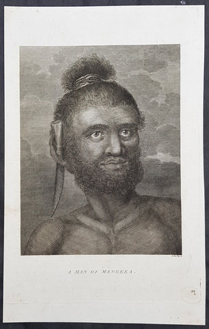
1784 Capt Cook Antique Print Man called Mourooa of Mangaia in the Cook Islands
- Title : A Man of Mangeea
- Size: 13in x 9in (330mm x 230mm)
- Ref #: 21605
- Date : 1784
- Condition: (A+) Fine Condition
Description:
This fine original copper-plate engraved antique print of a man of Mangaia, one of the Cook Islands - visited by Captain James Cook during the third voyage of discovery - after John Webber - was published in the 1784 English publication of Cooks third Voyage.
......Cook reconnoitered the reef surrounding Mangaia, one of the Cook Islands, on 29 March 1777. No landing was made but on the following day, a canoe with paddlers came out to meet the ships.
At length when they had perceived we were going to the Ships they all left us except the man we had in the boat, he tho not without evident signs of fear, accompaned us on board\' Cook\'s Journals III, I, 89.
The portrait was of a native called Mou\'rooa where through Omai\'s services he was questioned about his island.
General Definitions:
Paper thickness and quality: - Heavy and stable
Paper color : - off white
Age of map color: -
Colors used: -
General color appearance: -
Paper size: - 13in x 9in (330mm x 230mm)
Plate size: - 13in x 9in (330mm x 230mm)
Margins: - Min 1/2in (12mm)
Imperfections:
Margins: - None
Plate area: - None
Verso: - None
Background:
John Webber was born in London, of Swiss descent. In the spring of 1776 he showed three works at the Royal Academy\'s annual exhibition, where they attracted the attention of Dr Daniel Solander, President of the Royal Society and a friend and colleague of botanist Joseph Banks. Both had sailed with Captain James Cook on his first voyage of exploration in the Pacific aboard the \'Endeavour\', and were looking for a suitable artist to accompany them on a third trip. Solander recommended Webber to the Admiralty, and he was appointed almost immediately.
The voyage commenced on 12 July 1776. Upon his return to London in 1780, Webber submitted about 200 finished works to the Admiralty, which he had made on the voyage. From autumn 1780 until summer 1784, he re-drew many of the drawings and supervised the engravers and printers who were preparing the images for publication, under the direction of Lord Sandwich
ted.
1825 W. Alexander & Malpiere Antique Print of a Chinese Hawker, Betel Nut Seller
- Title : Marchand De Betel...Schmit del....Imp. Litho. de Melle. Formentin
- Ref : 91229
- Size: 13in x 9 1/2in (330mm x 245mm)
- Date : 1825
- Condition: (A) Very Good Condition
Description:
This beautifully hand coloured original copper-plate engraved antique print of a Chinese Betel Nut Seller by D. Bazin de Malpiere, after William Alexander, was engraved by Schmidt and published in the 1825 French edition of La Chine, Moeurs, Usages, Arts et Métiers, Peines Civiles et Militaires, Cérémonies Religieuses, Monuments et Paysages (Picturesque Representations of the Dress and Manners of the Chinese), Paris: Chez L Éditeur, Goujon et Melle Formentin, Firmin Didot, 1825-27.
General Definitions:
Paper thickness and quality: - Heavy and stable
Paper color : - off white
Age of map color: - Original
Colors used: - Yellow, green, blue, pink
General color appearance: - Authentic
Paper size: - 13in x 9 1/2in (330mm x 245mm)
Plate size: - 13in x 9 1/2in (330mm x 245mm)
Margins: - Min 1in (25mm)
Imperfections:
Margins: - Light age toning
Plate area: - Light age toning
Verso: - Light age toning
Background:
In 1792, Alexander was appointed as one of the draughtsmen to the Macartney Embassy to China. He accompanied the Earl of Macartney to Peking where he made drawings for the plates which accompanied Sir George Stauntons account of the embassy, published in 1797.
In 1805 he published The Costume of China, illustrated by 48 coloured engravings, after his travels to China with The Earl of Macartney. The work was so well-received that in 1814 he published another book titled Picturesque Representations of the Dress and Manners of the Chinese, illustrated in fifty colored engravings, with descriptions. This publication was re-issued over the next twenty years in various languages including French.
Alexander, William 1767 – 1816
Alexander was an English painter, illustrator and engraver. The hallmarks of his work, usually executed in watercolours, were clearness and harmony of colour, simplicity and taste in composition, grace of outline, and delicacy of execution. He accompanied the Macartney Embassy to China in 1792. Prints of his work were reproduced from engravings. One his of works was used to illustrate Cadell & Davies Britannia depicta.
Alexander was born in Maidstone, Kent, the son of Harry Alexander, a coachmaker. He was educated at Maidstone Grammar School, but in 1782, at the age of 15, moved to London to study art - first under William Pars, and subsequently Julius Caesar Ibbetson. In February 1784, he was admitted to the Royal Academy Schools. He assiduously applied himself to the mastery of his profession, obtaining the notice and approbation of Sir Joshua Reynolds.
In 1792, he was appointed as one of the draughtsmen to the Macartney Embassy to China. He accompanied the Earl of Macartney to Peking where he made drawings for the plates which accompanied Sir George Stauntons account of the embassy (published in 1797) In 1794 he returned to England and married Jane Wogan the following year. She died soon afterwards.
His other principal works were: Views of Headlands, Islands, etc. taken during the Voyage to China (1798); drawings based on Daniells sketches, for Vancouvers Voyage to the North Pacific Ocean (1798); and the descriptive plates to Sir John Barrows Travels in China (1804), and Voyage to Cochin China (1806). In 1805 he published The Costume of China, illustrated by 48 coloured engravings. The work was so well-received that in 1814 he published another book titled Picturesque Representations of the Dress and Manners of the Chinese, illustrated in fifty colored engravings, with descriptions.
Besides his works as a draughtsman, he made several engravings - the principal one of which is a representation of the Festival given by the Earl of Romney to the Kentish Volunteers, on 1 August 1799, from his own drawing.
In 1802, Alexander was appointed professor of drawing at the Military College at Great Marlow, resigning in May 1808 to take up the post of assistant keeper of antiquities in the British Museum. In the years 1810, 1812, and 1815, he made drawings of the terra cottas and marbles in the Museum which were engraved and published in three volumes - the accompanying text being provided by Taylor Combe (keeper of the Department of Antiquities). Alexander had completed drawings for a fourth volume before his death.
He died at the house of his uncle in Maidstone in July 1816, and was buried in Boxley churchyard. He was described in one of his obituaries as a man of mild and unassuming manners, rich in the knowledge of art, and of unsullied integrity.
1719 Chatelain Large Antique Print The Costumes of Jews & Arabs in Cairo, Egypt
- Title : Description des Piramides D Egypte Tant au Dedans qu'au Dehors...
- Ref : 50647
- Size: 20in x 17 1/2in (510m x 440m)
- Date : 1719
- Condition: (A+) Fine Condition
Description:
This large original antique print including detailed French Text on the subject was published by Henri Abraham Chatelain in 1719, in his famous Atlas Historique.
Atlas Historique: First published in Amsterdam from 1705 to 1720, the various volumes were updated at various times up to 1739 when the fourth edition of vol.I appeared, stated as the "dernière edition, corrigée & augmentée."
The first four volumes seem to have undergone four printings with the later printings being the most desirable as they contain the maximum number of corrections and additions. The remaining three final volumes were first issued between 1719-1720 and revised in 1732.
An ambitious and beautifully-presented work, the Atlas Historique was intended for the general public, fascinated in the early eighteenth century by the recently conquered colonies and the new discoveries. Distant countries, such as the Americas, Africa, the Middle East, Mongolia, China, Japan, Indonesia, etc., take an important place in this work.
In addition to the maps, many of which are based on Guillaume De L'Isle, the plates are after the best travel accounts of the period, such as those of Dapper, Chardin, de Bruyn, Le Hay and other.
Other sections deal with the history of the european countries, and covers a wide range of subjects including genealogy, history, cosmography, topography, heraldry and chronology, costume of the world, all illustrated with numerous engraved maps, plates of local inhabitants and heraldic charts of the lineages of the ruling families of the time. The maps, prints and tables required to make up a complete set are listed in detail in each volume.
The accompanying text is in French and often is printed in two columns on the page with maps and other illustrations interspersed. Each map and table is numbered consecutively within its volume and all maps bear the privileges of the States of Holland and West-Friesland.
The encyclopaedic nature of the work as a whole is reflected in this six frontispiece. The pages are the work of the celerated mr. Romeijn de Hooghe. and are engraved by J.Goeree, T.Schynyoet and P.Sluyter.
New scholarship has suggested the compiler of the atlas, who is identified on the title as "Mr. C***" not to be Henri Abraham Châtelain, but Zacharie Châtelain. (See Van Waning's article in the Journal of the International Map Collectors' Society for persuasive evidence of the latter's authorship.
General Description:
Paper thickness and quality: - Heavy and stable
Paper color: - White
Age of map color: -
Colors used: -
General color appearance: -
Paper size: - 20in x 17 1/2in (510m x 440m)
Plate size: - 17 1/2in x 15in (440m x 380mm)
Margins: - min. 1in (25mm)
Imperfections:
Margins: - None
Plate area: - None
Verso: - None
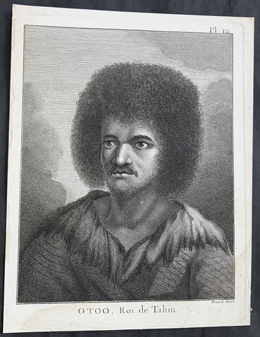
1774 Capt. Cook Antique Print a Portrait of Chief Tynah, Otoo of Tahiti in 1769
- Title : Otoo, Roi de Tahiti
- Ref : 31771
- Size: 10in x 8in (255mm x 205mm)
- Date : 1774
- Condition: (A+) Fine Condition
Description:
This fine original copper-plate engraved antique print a portrait of Chief Tynah (Otoo) of Tahiti Island, met by Captain James Cook during his 1st Voyage of Discovery in 1769, was engraved by Robert Benard - after Sydney Parkinson - and was published in the 1774 French edition of Capt. James Cooks 1st Voyage of Discovery to the South Seas by John Hawkesworth in An Account of the Voyages Undertaken by the Order of His Present Majesty for Making Discoveries in the Southern Hemisphere and Successively Performed by Commodore Byron, Captain Wallis, Captain Carteret, and Captain Cook, in the Dolphin, the Swallow, and the Endeavor, Drawn Up from the Journals Which Were Kept by the Several Commanders, and from the Papers of Joseph Banks. Paris, 1774.
General Definitions:
Paper thickness and quality: - Heavy and stable
Paper color : - off white
Age of map color: -
Colors used: -
General color appearance: -
Paper size: - 10in x 8in (255mm x 205mm)
Plate size: - 9 1/2in x 7 1/4in (240mm x 185mm)
Margins: - Min 1/2in (12mm)
Imperfections:
Margins: - Light soiling in bottom margin
Plate area: - None
Verso: - None
Background:
Tahiti previously also known as Otaheite is the largest island in the Windward group of French Polynesia. The island is located in the archipelago of the Society Islands in the central Southern Pacific Ocean.
The first European to have visited Tahiti according to existing records was lieutenant Samuel Wallis, who was circumnavigating the globe in HMS Dolphin, sighting the island on 18 June 1767, and eventually harboring in Matavai Bay. This bay was situated on the territory of the chiefdom of Pare-Arue, governed by Tu (Tu-nui-e-a a-i-te-Atua) and his regent Tutaha, and the chiefdom of Ha apape, governed by Amo and his wife Oberea (Purea). Wallis named the island King Georges Island. The first contacts were difficult, since on the 24 and 26 June 1767, Tahitian warriors in canoes showed aggression towards the British, hurling stones from their slings. In retaliation, the British sailors opened fire on the warriors in the canoes and on the hills. In reaction to this powerful counter-attack, the Tahitians laid down peace offerings for the British. Following this episode, Samuel Wallis was able to establish cordial relations with the female chieftain “Oberea “ (Purea) and remained on the island until 27 July 1767.
In July 1768, Captain James Cook was commissioned by the Royal Society and on orders from the Lords Commissioners of the Admiralty to observe the transit of Venus across the sun, a phenomenon that would be visible from Tahiti on 3 June 1769. He arrived in Tahitis Matavai Bay, commanding the HMS Endeavour on 12 April 1769. On 14 April, Cook met with Tutaha and Tepau. On 15 April, Cook picked the site for a fortified camp at Point Venus along with Banks, Parkinson, Daniel Solander, to protect Charles Greens observatory. The length of stay enabled them to undertake for the first time real ethnographic and scientific observations of the island. Assisted by the botanist Joseph Banks, and by the artist Sydney Parkinson, Cook gathered valuable information on the fauna and flora, as well as the native society, language and customs, including the proper name of the island, Otaheite. On 28 April, Cook met Purea and Tupaia, and Tupaia befriended Banks following the transit. On 21 June, Amo visited Cook, and then on 25 June, Pohuetea visited, signifying another chief seeking to ally himself with the British.
Cook and Banks circumnavigated the island from 26 June to 1 July. On the exploration, they met Ahio, chief of Ha apaiano o or Papenoo, Rita, chief of Hitia a, Pahairro, chief of Pueu, Vehiatua, chief of Tautra, Matahiapo, chief of Teahupo o, Tutea, chief of Vaira o, and Moe, chief of Afa Ahiti. In Papara, guided by Tupaia, they investigated the ruins of Mahaiatea marae, an impressive structure containing a stone pyramid or ahu, measuring 44 feet high, 267 feet long and 87 feet wide. Cook and the Endeavour departed Tahiti on 13 July 1769, taking Raiatean navigator Tupaia along for his geographic knowledge of the islands.
Cook returned to Tahiti between 15 August and 1 September 1773, greeted by the chiefs Tai and Puhi, besides the youg ari i Vehiatua II and his stepfather Ti itorea. Cook anchored in Vaitepiha Bay before returning to Point Venus where he met Tu, the paramount chief. Cook picked up two passengers from Tahiti during this trip, Porea and Mai, with Hitihiti later replacing Porea when Cook stopped at Raiatea. Cook took Hitihiti to Tahiti on 22 April, during his return leg. Then, Cook departed Tahiti on 14 May 1774.
During his final visit, Cook returned Mai to Tahiti on 12 Aug. 1777, after Mais long visit in England. Cook also brought two Maori from Queen Charlotte Sound, Te Weherua and Koa. Cook first harbored in Vaitepiha Bay, where he visited Vehiatua II s funeral bier and the prefabricated Spanish mission house. Cook also met Vehiatua III, and inscribed on the back of the Spanish cross, Georgius tertius Rex Annis 1767, 69, 73, 74 & 77, as a counterpoint to Christus Vincit Carolus III imperat 1774 on the front. On 23 Aug., Cook sailed for Matavai Bay, where he met Tu, his father Teu, his mother Tetupaia, his brothers Ari ipaea and Vaetua, and his sisters Ari ipaea-vahine, Tetua-te-ahamai, and Auo. Cook also observed a human sacrifice, taata tapu, at the Utu-ai-mahurau marae, and 49 skulls from previous victims.
On 29 Sept. 1777, Cook sailed for Papetoai Bay on Moorea. Cook met Mahine in an act of friendship on 3 Oct., though he was an enemy of Tu. When a goat kid was stolen on 6 Oct., Cook in a rampage, ordered the burning of houses and canoes until it was returned. Cook sailed for Huahine on 11 Oct., Raiatea on 2 Nov., and Borabora on 7 Dec.
On 26 October 1788, HMS Bounty, under the command of Captain William Bligh, landed in Tahiti with the mission of carrying Tahitian breadfruit trees (Tahitian: uru) to the Caribbean. Sir Joseph Banks, the botanist from James Cooks first expedition, had concluded that this plant would be ideal to feed the African slaves working in the Caribbean plantations at very little cost. The crew remained in Tahiti for about five months, the time needed to transplant the seedlings of the trees. Three weeks after leaving Tahiti, on 28 April 1789, the crew mutinied on the initiative of Fletcher Christian. The mutineers seized the ship and set the captain and most of those members of the crew who remained loyal to him adrift in a ships boat. A group of mutineers then went back to settle in Tahiti.
Although various explorers had refused to get involved in tribal conflicts, the mutineers from the Bounty offered their services as mercenaries and furnished arms to the family which became the Pōmare Dynasty. The chief Tū knew how to use their presence in the harbours favoured by sailors to his advantage. As a result of his alliance with the mutineers, he succeeded in considerably increasing his supremacy over the island of Tahiti.
Sydney Parkinson 1745 – 71 was draughtsman to the botanist Sir Joseph Banks on James Cook’s first voyage to the Pacific in 1768. He died of dysentery in 1771, on the homeward voyage.
Parkinson was the first European artist to create drawings of Indigenous Australian, Maori & South Sea peoples, as well as landscapes, from direct observation. Hundreds of his original drawings survive in the British Museum. He is particularly remembered for his plant illustrations which were later used to create the lavish plates for Joseph Banks’ Florilegium.
When the Endeavour returned to England in 1772, a dispute arose between Joseph Banks and Sydney’s brother, Stanfield Parkinson. As his employer, Banks claimed rights to Sydney’s drawings, papers and collections made on the voyage. Stanfield claimed that Sydney had willed them to his family. Banks lent the Parkinson family Sydney’s journal and drawings with instructions that they were not to be published, however Stanfield disregarded this and arranged for A Journal of a voyage to the South Seas to be printed from Sydney’s account of the voyage.
Banks managed to suppress Stanfield’s publication until the official account of the voyage, edited by John Hawkesworth, appeared. In return for Parkinson’s papers, Banks paid Stanfield Parkinson 500 pounds for balance of wages due to Sydney, but the dispute did not end there. Stanfield further accused Banks of retaining items collected by Sydney which were intended for his relatives. Stanfield Parkinson was declared insane soon after the publication of Sydney Parkinson’s Journal and died in an asylum.
John Hawkesworth An English writer and journalist, Hawkesworth was commissioned by the British Admiralty to edit for publication the narratives of its officers’ circumnavigations. He was given full access to the journals of the commanders and the freedom to adapt and re-tell them in the first person. Cook was already on his way back from his second Pacific voyage, temporarily docked at Cape Town (South Africa), when he first saw the published volumes: he was mortified and furious to find that Hawkesworth claimed in the introduction that Cook had seen and blessed (with slight corrections) the resulting manuscript. (In his defense, Hawkesworth also had been a victim of misunderstanding.) Cook had trouble recognizing himself. Moreover, the work was full of errors and commentary introduced by Hawkesworth and, in Cook’s view, too full of Banks, who had promoted himself and the publication. Still, the work was popular; the first edition sold out in several months.
Robert Bénard 1734 – 1777 was an 18th-century French engraver.
Specialized in the technique of engraving, Robert Ménard is mainly famous for having supplied a significant amount of plates (at least 1,800) to the Encyclopédie by Diderot & d\'Alembert from 1751.
Later, publisher Charles-Joseph Panckoucke reused many of his productions to illustrate the works of his catalog.
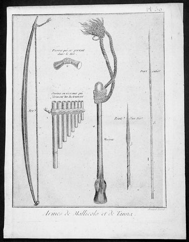
1778 Capt Cook Antique Print Weapons & Musical Instruments Vanuatu Islands, 1774
- Title : Armes de Mallicolo et de Tanna
- Ref : 91211
- Size: 10in x 8in (255mm x 205mm)
- Date : 1778
- Condition: (A+) Fine Condition
Description:
This fine original copper-plate engraved antique print of 6 different types of arms and musical instruments, from the Islands of Malakula (Mallicolo) & Tanna in the Vanuatu group of Islands in the South Pacific, visited by Captain James Cook during his 2nd Voyage of Discovery in the South Seas in September 1774, was engraved by Robert Benard - after William Hodges - and was published in the 1778 French edition of Capt. James Cooks 2nd Voyage of Discovery to the South Seas A voyage towards the South Pole, and round the World. Performed in His Majestys ships the Resolution and Adventure, in the years 1772, 1773, 1774, and 1775..... Paris : Hotel de Thou ......1778
The six objects engraved are;
1. Arc - Bow
2. Pierres qui seportent dans le nes - Stone used as a support
3. Syrinx ou roseaux quiserment un instrument - Multi tune flute
4. Massue - Club with rope attachment
5. peinte d un parl - Arrow head
6. Dart enier - Spear
Cook Journal July, 1774
Arrival at The New Hebrides
On 17th Cook saw land bearing SW and later on decided this was the Australia Del Espiritu Santo of Quiros or what M. D. Bougainville calls the Great Cyclades. The island was Maewo. The next day its northern end was rounded in a gale and the ship sailed south between it and the island called by Bougainville the Isle of Lepers - Omba.
On 20th they crossed Patteson Passage with a view of geting to the South to explore the lands which lies there, and sailed down the west coast of Pentecost Isle (Raga). To the south they saw the island of Ambrin and behind it Paama and Epi. On 22nd, approaching Mallicollo (Malekula) we perceived a creek which had the appearence of a good harbour. Cook sent Lieutt [Richard] Pickersgill and the Master [Joseph Gilbert] in two Armd boats to Sound and look for Anchorage. The following day a good many [natives] came round us, some came in Canoes and others swam off\\\'... four I took into the Cabbin and made them various presents. Later, after some misunder-standing some natives began to Shoot Arrows... a Musquet discharged in the air and a four pounder over their heads sent them all off in the utmost confusion; those in the Cabbin leaped out of the Windows... About 9 o\\\'Clock we landed in the face of about 4 or 500 Men who were assembled on the Shore, armd with Bows and Arrows, clubs and Spears, but they made not the least opposission, on the contrary one Man gave his Arms to a nother and Met us in the water with a green branch in his hand, which [he] exchanged for the one I held in my hand. Just before departing Cook remarked they have not so much as a name for a Dog, consequently can have none, for which reason we left them a Dog and a Bitch.
General Definitions:
Paper thickness and quality: - Heavy and stable
Paper color : - off white
Age of map color: -
Colors used: -
General color appearance: -
Paper size: - 10in x 8in (255mm x 205mm)
Plate size: - 9 1/2in x 7 1/4in (240mm x 185mm)
Margins: - Min 1/2in (12mm)
Imperfections:
Margins: - Light soiling in margins
Plate area: - None
Verso: - None
Background:
Malakula Island also spelled Malekula, is the second-largest island in the nation of Vanuatu, in the Pacific Ocean region of Melanesia.
Discovered by the Spanish expedition of Pedro Fernández de Quirós in 1606 and visited by Captain Cook in 1774.
Vanuatu officially the Republic of Vanuatu is a Pacific island nation located in the South Pacific Ocean. The archipelago, which is of volcanic origin, is 1,750 kilometres east of northern Australia, 540 kilometres northeast of New Caledonia, east of New Guinea, southeast of the Solomon Islands, and west of Fiji.
Vanuatu was first inhabited by Melanesian people. The first Europeans to visit the islands were a Spanish expedition led by Portuguese navigator Fernandes de Queirós, who arrived on the largest island in 1606. Since the Portuguese and Spanish monarchies had been unified under the king of Spain in 1580 (following the vacancy of the Portuguese throne, which lasted for sixty years, until 1640, when the Portuguese monarchy was restored), Queirós claimed the archipelago for Spain, as part of the colonial Spanish East Indies, and named it La Austrialia del Espiritu Santo.
The Vanuatu group of islands first had contact with Europeans in 1606, when the Portuguese explorer Pedro Fernandes de Queiros, sailing for the Spanish Crown, arrived on the largest island and called the group of islands La Austrialia del Espiritu Santo or The Southern Land of the Holy Spirit, believing he had arrived in Terra Australis or Australia. The Spanish established a short-lived settlement at Big Bay on the north side of the island. The name Espiritu Santo remains to this day.
Europeans did not return until 1768, when Louis Antoine de Bougainville rediscovered the islands on 22 May, naming them the Great Cyclades. In 1774, Captain Cook named the islands the New Hebrides, a name that would last until independence in 1980.
William Hodges RA 1744 – 1797 was an English painter. He was a member of James Cooks second voyage to the Pacific Ocean, and is best known for the sketches and paintings of locations he visited on that voyage, including Table Bay, Tahiti, Easter Island, and the Antarctic.
Between 1772 and 1775 Hodges accompanied James Cook to the Pacific as the expeditions artist. Many of his sketches and wash paintings were adapted as engravings in the original published edition of Cooks journals from the voyage.
Most of the large-scale landscape oil paintings from his Pacific travels for which Hodges is best known were finished after his return to London; he received a salary from the Admiralty for the purposes of completing them. These paintings depicted a stronger light and shadow than had been usual in European landscape tradition. Contemporary art critics complained that his use of light and colour contrasts gave his paintings a rough and unfinished appearance.
Hodges also produced many valuable portrait sketches of Pacific islanders and scenes from the voyage involving members of the expedition..
Robert Bénard 1734 – 1777 was an 18th-century French engraver.
Specialized in the technique of engraving, Robert Ménard is mainly famous for having supplied a significant amount of plates (at least 1,800) to the Encyclopédie by Diderot & d\'Alembert from 1751.
Later, publisher Charles-Joseph Panckoucke reused many of his productions to illustrate the works of his catalog.
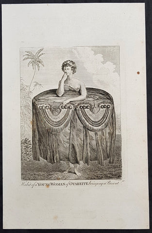
1784 Capt Cook Antique Print a Young Tahitian Presenting Cook a Present in 1777
- Title : Habit of a Young Woman of Otaheite, bringing a present
- Size: 13in x 9in (330mm x 230mm)
- Ref #: 21669
- Date : 1784
- Condition: (A+) Fine Condition
Description:
This fine original copper-plate engraved antique print of a young Tahitian presenting Captain James Cook with a present of a large cloth skirt - visited by Captain James Cook during the third voyage of discovery in 1777 - after John Webber - was published in the 1784 English publication of Cooks third Voyage.
General Definitions:
Paper thickness and quality: - Heavy and stable
Paper color : - off white
Age of map color: -
Colors used: -
General color appearance: -
Paper size: - 13in x 9in (330mm x 230mm)
Plate size: - 13in x 9in (330mm x 230mm)
Margins: - Min 1/2in (12mm)
Imperfections:
Margins: - None
Plate area: - None
Verso: - None
Background:
John Webber was born in London, of Swiss descent. In the spring of 1776 he showed three works at the Royal Academy\'s annual exhibition, where they attracted the attention of Dr Daniel Solander, President of the Royal Society and a friend and colleague of botanist Joseph Banks. Both had sailed with Captain James Cook on his first voyage of exploration in the Pacific aboard the \'Endeavour\', and were looking for a suitable artist to accompany them on a third trip. Solander recommended Webber to the Admiralty, and he was appointed almost immediately.
The voyage commenced on 12 July 1776. Upon his return to London in 1780, Webber submitted about 200 finished works to the Admiralty, which he had made on the voyage. From autumn 1780 until summer 1784, he re-drew many of the drawings and supervised the engravers and printers who were preparing the images for publication, under the direction of Lord Sandwich
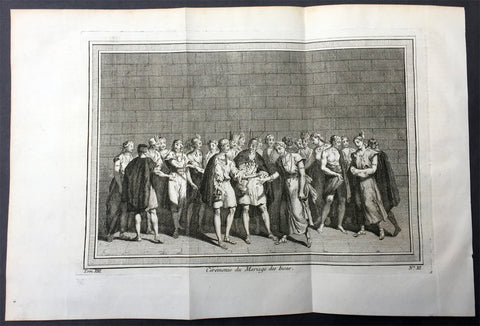
1755 Prevost & Schley Antique Print of an Inca Marriage Ceremony - Peru
- Title : Ceremonie du Mariage des Incas
- Ref #: 26001
- Size: 15in x 10in (380mm x 255mm)
- Date : 1755
- Condition: (A+) Fine Condition
Description:
This fine, original copper-plate engraved antique print of an Inca Marriage Ceremony, Peru by Jakob van Schley - after De Bry - in 1755 was published in Antoine François Prevosts 15 volumes of Histoire Generale des Voyages written by Prevost & other authors between 1746-1790.
Women and men had paralleled roles, but were separate in Inca society. They were equally valued for the part they played in their society despite their differing roles.Marriage was no different.
Incan women were typically married at the age of sixteen, while men married at the age of twenty. Age, however, was not as important as keeping track of the stage of life that a person was at, such as whether or not they were able to work or be married. Ranks played a role in a person\'s marriage status as well. Men of lower rank could only have one wife; people of ranks higher than the kuraka were allowed more. If a man had more than one wife, one served as the principal wife while the other(s) were considered secondary. Having more wives showed that the man had more labour showing that the household was wealthy. The death of the principal wife was sometimes met with suspicion that the husband played a role in her death. The man had to find a new principal wife before he was able to recover from the previous wife\'s death. To prevent such suspicion and to increase the likelihood of a successful marriage, there were situations in which the couple could test how well the marriage would work out.
Trial marriages were typical of Inca culture. In this type of marriage, the man and woman would agree to try out being married to one another for a few years. At the end of this time, the woman could go home to her parents if she wished, and her husband could also send her home if he did not think it would work out. However, once the marriage was made final, they could only divorce if the woman was childless. To make the marriage final, the provincial governor had to approve the union.
In the Inca society, a wedding was a simple event. Instead, it was looked at more as a business-like agreement. Therefore, marriage was an economic agreement between two families. Parents on either side had to come to an agreement before the marriage took place and the couple could not be directly related to one another. Women would almost always marry men in the same social class as themselves. However, while it was very rare for them to marry a man with a higher social ranking, it was still possible for some young women. The only way for a young woman to alter her social ranking would be if a man of higher ranking took notice of her.
Once a woman was married, she was expected to collect food and cook, watch over the animals and the children, and to supply cloth to the government. Women of higher ranking also weaved, like those of lower ranks, but their work was used in special clothing for the higher ranks. A man\'s role sometimes resembled those of a woman, but acted in conjunction with one another. A woman’s household obligations would not change after she became pregnant. When she did find out she was pregnant she prayed and made offerings to an Inca god, Kanopa.Using marriage as an alliance strategy was also common among the Inca. Even before the Spaniards\' arrival, the Inca used marriage as a way to claim themselves to power. After the Spaniards arrival the Inca allowed marriages between the Inca and Spaniards in order to gain power during a time of civil war
General Definitions:
Paper thickness and quality: - Heavy and stable
Paper color : - off white
Age of map color: -
Colors used: -
General color appearance: -
Paper size: - 15in x 10in (380mm x 255mm)
Plate size: - 12in x 8in (305mm x 205mm)
Margins: - Min 1in (25mm)
Imperfections:
Margins: - None
Plate area: - Folds as issued
Verso: - None
Background:
One of Antoine Francois Prevosts monumental undertakings was his history of exploration & discovery in 15 volumes titledHistoire Générale des Voyages written between 1746-1759 and was extended to 20 volumes after his death by various authors.
The 20 volumes cover the early explorations & discoveries on 3 continents: Africa (v. 1-5), Asia (v. 5-11), and America (v. 12-15) with material on the finding of the French, English, Dutch, and Portugese.
A number of notable cartographers and engravers contributed to the copper plate maps and views to the 20 volumes including Nicolas Bellin, Jan Schley, Chedel, Franc Aveline, Fessard, and many others.
The African volumes cover primarily coastal countries of West, Southern, and Eastern Africa, plus the Congo, Madagascar, Arabia and the Persian Gulf areas.
The Asian volumes cover China, Korea, Tibet, Japan, Philippines, and countries bordering the Indian Ocean.
Volume 11 includes Australia and Antarctica.
Volumes 12-15 cover voyages and discoveries in America, including the East Indies, South, Central and North America.
Volumes 16-20 include supplement volumes & tables along with continuation of voyages and discoveries in Russia, Northern Europe, America, Asia & Australia.
Jakob van der Schley aka Jakob van Schley (1715 - 1779) was a Dutch draughtsman and engraver. He studied under Bernard Picart (1673-1733) whose style he subsequently copied. His main interests were engraving portraits and producing illustrations for \\\"La Vie de Marianne\\\" by Pierre Carlet de Chamblain de Marivaux (1688-1763) published in The Hague between 1735 and 1747.
He also engraved the frontispieces for a 15-volume edition of the complete works of Pierre de Brantôme (1540-1614), \\\"Oeuvres du seigneur de Brantôme\\\", published in The Hague in 1740.
He is also responsible for most of the plates in the Hague edition of Prévosts Histoire générale des voyages. (Ref: Tooley; M&B)
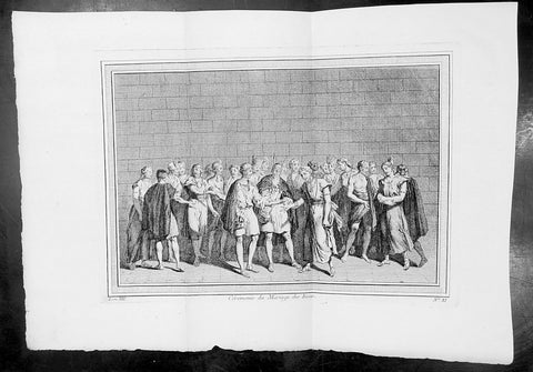
1755 Prevost & Schley Antique Print of an Inca Marriage Ceremony - Peru
- Title : Ceremonie du Mariage des Incas
- Ref #: 34095
- Size: 15in x 10in (380mm x 255mm)
- Date : 1755
- Condition: (A+) Fine Condition
Description:
This fine, original copper-plate engraved antique print of an Inca Marriage Ceremony, Peru by Jakob van Schley - after De Bry - in 1755 was published in Antoine François Prevosts 15 volumes of Histoire Generale des Voyages written by Prevost & other authors between 1746-1790.
Women and men had paralleled roles, but were separate in Inca society. They were equally valued for the part they played in their society despite their differing roles.Marriage was no different.
Incan women were typically married at the age of sixteen, while men married at the age of twenty. Age, however, was not as important as keeping track of the stage of life that a person was at, such as whether or not they were able to work or be married. Ranks played a role in a person\'s marriage status as well. Men of lower rank could only have one wife; people of ranks higher than the kuraka were allowed more. If a man had more than one wife, one served as the principal wife while the other(s) were considered secondary. Having more wives showed that the man had more labour showing that the household was wealthy. The death of the principal wife was sometimes met with suspicion that the husband played a role in her death. The man had to find a new principal wife before he was able to recover from the previous wife\'s death. To prevent such suspicion and to increase the likelihood of a successful marriage, there were situations in which the couple could test how well the marriage would work out.
Trial marriages were typical of Inca culture. In this type of marriage, the man and woman would agree to try out being married to one another for a few years. At the end of this time, the woman could go home to her parents if she wished, and her husband could also send her home if he did not think it would work out. However, once the marriage was made final, they could only divorce if the woman was childless. To make the marriage final, the provincial governor had to approve the union.
In the Inca society, a wedding was a simple event. Instead, it was looked at more as a business-like agreement. Therefore, marriage was an economic agreement between two families. Parents on either side had to come to an agreement before the marriage took place and the couple could not be directly related to one another. Women would almost always marry men in the same social class as themselves. However, while it was very rare for them to marry a man with a higher social ranking, it was still possible for some young women. The only way for a young woman to alter her social ranking would be if a man of higher ranking took notice of her.
Once a woman was married, she was expected to collect food and cook, watch over the animals and the children, and to supply cloth to the government. Women of higher ranking also weaved, like those of lower ranks, but their work was used in special clothing for the higher ranks. A man\'s role sometimes resembled those of a woman, but acted in conjunction with one another. A woman’s household obligations would not change after she became pregnant. When she did find out she was pregnant she prayed and made offerings to an Inca god, Kanopa.Using marriage as an alliance strategy was also common among the Inca. Even before the Spaniards\' arrival, the Inca used marriage as a way to claim themselves to power. After the Spaniards arrival the Inca allowed marriages between the Inca and Spaniards in order to gain power during a time of civil war
General Definitions:
Paper thickness and quality: - Heavy and stable
Paper color : - off white
Age of map color: -
Colors used: -
General color appearance: -
Paper size: - 15in x 10in (380mm x 255mm)
Plate size: - 12in x 8in (305mm x 205mm)
Margins: - Min 1in (25mm)
Imperfections:
Margins: - None
Plate area: - Folds as issued
Verso: - None
Background:
One of Antoine Francois Prevosts monumental undertakings was his history of exploration & discovery in 15 volumes titledHistoire Générale des Voyages written between 1746-1759 and was extended to 20 volumes after his death by various authors.
The 20 volumes cover the early explorations & discoveries on 3 continents: Africa (v. 1-5), Asia (v. 5-11), and America (v. 12-15) with material on the finding of the French, English, Dutch, and Portugese.
A number of notable cartographers and engravers contributed to the copper plate maps and views to the 20 volumes including Nicolas Bellin, Jan Schley, Chedel, Franc Aveline, Fessard, and many others.
The African volumes cover primarily coastal countries of West, Southern, and Eastern Africa, plus the Congo, Madagascar, Arabia and the Persian Gulf areas.
The Asian volumes cover China, Korea, Tibet, Japan, Philippines, and countries bordering the Indian Ocean.
Volume 11 includes Australia and Antarctica.
Volumes 12-15 cover voyages and discoveries in America, including the East Indies, South, Central and North America.
Volumes 16-20 include supplement volumes & tables along with continuation of voyages and discoveries in Russia, Northern Europe, America, Asia & Australia.
Jakob van der Schley aka Jakob van Schley (1715 - 1779) was a Dutch draughtsman and engraver. He studied under Bernard Picart (1673-1733) whose style he subsequently copied. His main interests were engraving portraits and producing illustrations for \\\"La Vie de Marianne\\\" by Pierre Carlet de Chamblain de Marivaux (1688-1763) published in The Hague between 1735 and 1747.
He also engraved the frontispieces for a 15-volume edition of the complete works of Pierre de Brantôme (1540-1614), \\\"Oeuvres du seigneur de Brantôme\\\", published in The Hague in 1740.
He is also responsible for most of the plates in the Hague edition of Prévosts Histoire générale des voyages. (Ref: Tooley; M&B)
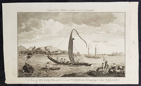
1777 Middleton Antique Print of Tahiti in French Polynesia Cooks 2nd Voyage 1773
- Title : A View of Otaheite with Several Vessels belonging to that Island
- Size: 14in x 9in (355mm x 230mm)
- Ref #: 21665
- Date : 1777
- Condition: (A+) Fine Condition
Description:
This fine original cooper-plate engraved antique print of a view of the Island of Tahiti in French Polynesia and the different type of boats of the Island during Captain Cooks 2nd Voyage of discovery to the South Seas in 1773 was published in Charles Theodore Middletons 1777 edition of A New and Complete System of Geography..... published by James Cooke London, 1777.
General Definitions:
Paper thickness and quality: - Heavy and stable
Paper color : - off white
Age of map color: -
Colors used: -
General color appearance: -
Paper size: - 14in x 9in (355mm x 230mm)
Plate size: - 11in x 7in (280mm x 180mm)
Margins: - Min 1/2in (12mm)
Imperfections:
Margins: - None
Plate area: - None
Verso: - None
Background:
Raiatea, is the second largest of the Society Islands, after Tahiti, in French Polynesia. The island is widely regarded as the centre of the eastern islands in ancient Polynesia and it is likely that the organised migrations to Hawaii, Aotearoa and other parts of East Polynesia started at Raiātea.
A traditional name for the island is Havaii, homeland of the Māori people.
The first European to record sighting Ra\\\'iātea was Pedro Fernandes de Queirós in 1606; it was charted as La Fugitiva The Polynesian navigator, Tupaia, who sailed with explorer James Cook, was born in Ra\\\'iātea around 1725.
Cook visited Raiatea in 1769 and again in 1773-1774. Omai (c.1751-1780), another young man from Raiātea, traveled with the European explorers to London in 1774 and also served as an interpreter to Captain Cook on his second and third journey.
King Tamatoa VI was the last monarch, reigning from 1884-1888.
Cooks Second Voyage (1772–75)
Shortly after his return from the first voyage, Cook was promoted in August 1771, to the rank of commander. In 1772 he was commissioned to lead another scientific expedition on behalf of the Royal Society, to search for the hypothetical Terra Australis. On his first voyage, Cook had demonstrated by circumnavigating New Zealand that it was not attached to a larger landmass to the south. Although he charted almost the entire eastern coastline of Australia, showing it to be continental in size, the Terra Australis was believed to lie further south. Despite this evidence to the contrary, Alexander Dalrymple and others of the Royal Society still believed that a massive southern continent should exist.
Cook commanded HMS Resolution on this voyage, while Tobias Furneaux commanded its companion ship, HMS Adventure. Cook\\\'s expedition circumnavigated the globe at an extreme southern latitude, becoming one of the first to cross the Antarctic Circle (17 January 1773). In the Antarctic fog, Resolution and Adventure became separated. Furneaux made his way to New Zealand, where he lost some of his men during an encounter with Māori, and eventually sailed back to Britain, while Cook continued to explore the Antarctic, reaching 71°10\\\'S on 31 January 1774.
Cook almost encountered the mainland of Antarctica, but turned towards Tahiti to resupply his ship. He then resumed his southward course in a second fruitless attempt to find the supposed continent. On this leg of the voyage he brought a young Tahitian named Omai, who proved to be somewhat less knowledgeable about the Pacific than Tupaia had been on the first voyage. On his return voyage to New Zealand in 1774, Cook landed at the Friendly Islands, Easter Island, Norfolk Island, New Caledonia, and Vanuatu.
Before returning to England, Cook made a final sweep across the South Atlantic from Cape Horn and surveyed, mapped and took possession for Britain of South Georgia, which had been explored by Anthony de la Roché in 1675. Cook also discovered and named Clerke Rocks and the South Sandwich Islands (\\\"Sandwich Land\\\"). He then turned north to South Africa, and from there continued back to England. His reports upon his return home put to rest the popular myth of Terra Australis.
Cook\\\'s second voyage marked a successful employment of Larcum Kendall\\\'s K1 copy of John Harrison\\\'s H4 marine chronometer, which enabled Cook to calculate his longitudinal position with much greater accuracy. Cook\\\'s log was full of praise for this time-piece which he used to make charts of the southern Pacific Ocean that were so remarkably accurate that copies of them were still in use in the mid-20th century.
Upon his return, Cook was promoted to the rank of post-captain and given an honorary retirement from the Royal Navy, with a posting as an officer of the Greenwich Hospital. He reluctantly accepted, insisting that he be allowed to quit the post if an opportunity for active duty should arise. His fame extended beyond the Admiralty; he was made a Fellow of the Royal Society, and awarded the Copley Gold Medal for completing his second voyage without losing a man to scurvy. Nathaniel Dance-Holland painted his portrait; he dined with James Boswell; he was described in the House of Lords as \\\"the first navigator in Europe\\\". But he could not be kept away from the sea. A third voyage was planned and Cook volunteered to find the Northwest Passage. He travelled to the Pacific and hoped to travel east to the Atlantic, while a simultaneous voyage travelled the opposite route.
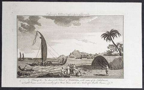
1777 Middleton Antique Print Island of Raiatea, French Polnesia - Cooks 1st Voyage 1769
- Title : View of the new discoverd island of Ulietea, with some of its inhabitants, a double canoe, and other small craft, a boat house with the model of a double canoe, & c.
- Size: 14in x 9in (355mm x 230mm)
- Ref #: 21758
- Date : 1787
- Condition: (A+) Fine Condition
Description:
This fine original cooper-plate engraved antique print of a view of the Island of Raiatea (Ulietea) during Captain Cooks 1st Voyage of discovery to the South Seas in 1769 was published in Charles Theodore Middletons 1777 edition of A New and Complete System of Geography..... published by James Cooke London, 1777.
General Definitions:
Paper thickness and quality: - Heavy and stable
Paper color : - off white
Age of map color: -
Colors used: -
General color appearance: -
Paper size: - 14in x 9in (355mm x 230mm)
Plate size: - 11in x 7in (280mm x 180mm)
Margins: - Min 1/2in (12mm)
Imperfections:
Margins: - None
Plate area: - None
Verso: - None
Background:
Raiatea, is the second largest of the Society Islands, after Tahiti, in French Polynesia. The island is widely regarded as the centre of the eastern islands in ancient Polynesia and it is likely that the organised migrations to Hawaii, Aotearoa and other parts of East Polynesia started at Raiātea.
A traditional name for the island is Havaii, homeland of the Māori people.
The first European to record sighting Ra\\\'iātea was Pedro Fernandes de Queirós in 1606; it was charted as La Fugitiva The Polynesian navigator, Tupaia, who sailed with explorer James Cook, was born in Ra\\\'iātea around 1725.
Cook visited Raiatea in 1769 and again in 1773-1774. Omai (c.1751-1780), another young man from Raiātea, traveled with the European explorers to London in 1774 and also served as an interpreter to Captain Cook on his second and third journey.
King Tamatoa VI was the last monarch, reigning from 1884-1888.
Cooks First Voyage (1768-1771)
The first voyage under Captain James Cooks command was primarily of a scientific nature. The expedition on the Endeavour initially sailed to Tahiti to observe the transit of the planet Venus in order to calculate the earth\\\'s distance from the sun. Cook landed on the South Pacific island in April of 1769 and in June of that year the astronomical observations were successfully completed. In addition to these labors, very good relations with the Tahitians were maintained and the naturalists Joseph Banks and Daniel C. Solander conducted extensive ethnological and botanical research.
Another purpose of the voyage was to explore the South Seas to determine if an inhabitable continent existed in the mid-latitudes of the Southern Hemisphere. Upon leaving Tahiti, Cook named and charted the Society Islands and then continued southwest to New Zealand. His circumnavigation and exploration of that country also resulted in a detailed survey. Cook proceeded to Australia, where he charted the eastern coast for 2,000 miles, naming the area New South Wales. As a result of these surveys, both Australia and New Zealand were annexed by Great Britain. In addition to these explorations, the Endeavour returned to England without a single death from scurvy among its men, an historic feat at the time. The combination of these accomplishments brought Cook prominence, promotion, and the opportunity to lead further expeditions.
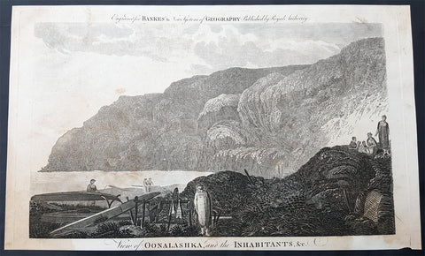
1787 Bankes Antique Print English or Nanwalek Bay Alaska, Cooks 3rd Voyage 1778
- Title : View of Oonalashka and the Inhabitants
- Size: 14in x 9in (355mm x 230mm)
- Ref #: 40213
- Date : 1787
- Condition: (A) Very Good Condition
Description:
This fine original cooper-plate engraved antique print a view of English or Nanwalek Bay, Alaska visited by Captain James Cook in June/July 1778, during his third voyage of discovery - after John Webber - was published in Thomas Bankes 1787 edition of A New, Royal and Authentic System of Universal Geography, Antient and Modern..... printed by Charles Cook, London.
Cooks Third Voyage (1776-1779)
In the course of his first two voyages, Cook circumnavigated the globe twice, sailed extensively into the Antarctic, and charted coastlines from Newfoundland to New Zealand. Following these achievements, Cook\'s third voyage was organized to seek an efficient route from England to southern and eastern Asia that would not entail rounding the Cape of Good Hope. The search for such a Northwest (or Northeast) Passage had been on the agenda of northern European mariners and merchants since the beginning of European expansion in the late fifteenth century. England\'s growing economic and colonial interests in India in the later eighteenth century provided the stimulus for the latest exploration for this route.
Cook, again in command of the Resolution, was to approach the Northwest Passage from the Pacific accompanied by a second ship, the Discovery, captained by Charles Clerke. The ships left England separately, regrouped at Cape Town, and continued on to Tasmania, New Zealand, and Tahiti. The expedition then sailed north and made landfall at Christmas Island and the Hawaiian Islands. Cook continued northward and charted the west coast of North America from Northern California as far as the Bering Strait. He returned to Hawaii for the winter and was killed in a skirmish with natives on February 14, 1779. Upon Cook\'s death, Clerke took command of the expedition but died six months later. The ships returned to England in 1780 under John Gore, who had commanded the Discovery after Cook\'s death. From start to finish, the voyage had lasted more than four years. (Ref Tooley; M&B; Clancy)
General Definitions:
Paper thickness and quality: - Heavy and stable
Paper color : - off white
Age of map color: -
Colors used: -
General color appearance: -
Paper size: - 14in x 9in (355mm x 230mm)
Plate size: - 12in x 7 1/2in (305mm x 190mm)
Margins: - Min 1/2in (12mm)
Imperfections:
Margins: - None
Plate area: - None
Verso: - None
Background:
Nanwalek, formerly Alexandrovsk and English Bay, Alaska is census-designated place (CDP) in the Kenai Peninsula Borough, Alaska, United States that contains a traditional Alutiiq village.
Cooks Diary.......English Bay, Unalaska......the next day, the 27th, wrote Cook the fog partly despersed. At 7 AM wieghed and steered to the North… the wind faild and obliged us to Anchor. They sailed on and anchored in a bay for a few days on 28th. According to Samwell the next day We hoisted out our launch sent her ashore to fill the empty Water Casks both Ships completed their water. On 30th Many Canoes trading about the Ship… We find many Notes written in the Russian Language among these People dated in the Year 1776. The weather was, wrote Samwell moderate & hazy
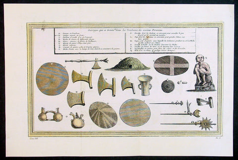
1755 Prevost & Schley Antique Print of Artifacts Recovered from Inca Burial Tomb
- Title: Puvrages qui se trouvent dans les Tombeaux des anciens Peruviens
- Date: 1755
- Condition : (A+) Fine Condition
- Ref: 34132
- Size: 15in x 10in (385mm x 255mm)
Description:
This fine, original copper-plate engraved antique print of artifacts found in an Inca Tomb in Peru by Jakob van Schley in 1755 - after De Bry - was published in Antoine François Prevosts 15 volumes of Histoire Generale des Voyages written by Prevost & other authors between 1746-1790.
The Inca Empire also known as the Incan Empire and the Inka Empire, was the largest empire in pre-Columbian America, and possibly the largest empire in the world in the early 16th century. Its political and administrative structure \"was the most sophisticated found among native peoples\" in the Americas.The administrative, political and military center of the empire was located in Cusco in modern-day Peru. The Inca civilization arose from the highlands of Peru sometime in the early 13th century. Its last stronghold was conquered by the Spanish in 1572.
From 1438 to 1533, the Incas incorporated a large portion of western South America, centered on the Andean Mountains, using conquest and peaceful assimilation, among other methods. At its largest, the empire joined Peru, large parts of modern Ecuador, western and south central Bolivia, northwest Argentina, north and central Chile and a small part of southwest Colombia into a state comparable to the historical empires of Eurasia. Its official language was Quechua.Many local forms of worship persisted in the empire, most of them concerning local sacred Huacas, but the Inca leadership encouraged the worship of Inti – their sun god – and imposed its sovereignty above other cults such as that of Pachamama. The Incas considered their king, the Sapa Inca, to be the \"son of the sun.\"
The Inca Empire was unique in that it lacked many features associated with civilization in the Old World. In the words of one scholar, \"The Incas lacked the use of wheeled vehicles. They lacked animals to ride and draft animals that could pull wagons and plows... [They] lacked the knowledge of iron and steel... Above all, they lacked a system of writing... Despite these supposed handicaps, the Incas were still able to construct one of the greatest imperial states in human history\". Notable features of the Inca Empire include its monumental architecture, especially stonework, extensive road network reaching all corners of the empire, finely-woven textiles, use of knotted strings (quipu) for record keeping and communication, agricultural innovations in a difficult environment, and the organization and management fostered or imposed on its people and their labor.
The Incan economy has been described in contradictory ways by scholars: as \"feudal, slave, socialist (here one may choose between socialist paradise or socialist tyranny)\". The Inca empire functioned largely without money and without markets. Instead, exchange of goods and services was based on reciprocity between individuals and among individuals, groups, and Inca rulers. \"Taxes\" consisted of a labor obligation of a person to the Empire. The Inca rulers (who theoretically owned all the means of production) reciprocated by granting access to land and goods and providing food and drink in celebratory feasts for their subjects.
General Definitions:
Paper thickness and quality: - Heavy and stable
Paper color : - off white
Age of map color: - Early
Colors used: - Yellow, green, red
General color appearance: - Authentic
Paper size: - 15in x 10in (385mm x 255mm)
Plate size: - 14in x 8 1/2in (355mm x 220mm)
Margins: - Min 1in (25mm)
Imperfections:
Margins: - None
Plate area: - Folds as issued
Verso: - None
Background:
One of Antoine Francois Prevosts monumental undertakings was his history of exploration & discovery in 15 volumes titledHistoire Générale des Voyages written between 1746-1759 and was extended to 20 volumes after his death by various authors.
The 20 volumes cover the early explorations & discoveries on 3 continents: Africa (v. 1-5), Asia (v. 5-11), and America (v. 12-15) with material on the finding of the French, English, Dutch, and Portugese.
A number of notable cartographers and engravers contributed to the copper plate maps and views to the 20 volumes including Nicolas Bellin, Jan Schley, Chedel, Franc Aveline, Fessard, and many others.
The African volumes cover primarily coastal countries of West, Southern, and Eastern Africa, plus the Congo, Madagascar, Arabia and the Persian Gulf areas.
The Asian volumes cover China, Korea, Tibet, Japan, Philippines, and countries bordering the Indian Ocean.
Volume 11 includes Australia and Antarctica.
Volumes 12-15 cover voyages and discoveries in America, including the East Indies, South, Central and North America.
Volumes 16-20 include supplement volumes & tables along with continuation of voyages and discoveries in Russia, Northern Europe, America, Asia & Australia.
Jakob van der Schley aka Jakob van Schley (1715 - 1779) was a Dutch draughtsman and engraver. He studied under Bernard Picart (1673-1733) whose style he subsequently copied. His main interests were engraving portraits and producing illustrations for \\\"La Vie de Marianne\\\" by Pierre Carlet de Chamblain de Marivaux (1688-1763) published in The Hague between 1735 and 1747.
He also engraved the frontispieces for a 15-volume edition of the complete works of Pierre de Brantôme (1540-1614), \\\"Oeuvres du seigneur de Brantôme\\\", published in The Hague in 1740.
He is also responsible for most of the plates in the Hague edition of Prévosts Histoire générale des voyages. (Ref: Tooley; M&B)
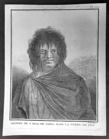
1778 Capt Cook Antique Print Portrait of a Man of Terra del Fuego, Chile in 1774
- Title : Homme du Canal de Noel Dans La Terre De Feu
- Ref : 31813
- Size: 10in x 8in (255mm x 205mm)
- Date : 1778
- Condition: (A+) Fine Condition
Description:
This fine original copper-plate engraved antique print, portrait of a Man of Christmas Sound on the S.W. Coast of Terra del Fuego Chile, visited by Captain James Cook during his 2nd Voyage of Discovery to the South Seas in December 1774, was engraved by Robert Benard - after William Hodges - and was published in the 1778 French edition of Capt. James Cooks 2nd Voyage of Discovery to the South Seas A voyage towards the South Pole, and round the World. Performed in His Majestys ships the Resolution and Adventure, in the years 1772, 1773, 1774, and 1775..... Paris : Hotel de Thou ......1778
Cook Journal
.......followed the coast of Tierra del Fuego (Chile) at the end of December 1774 making for Cape Horn. The coast comprised of hundreds of small islands, some of which were charted and named but many were not. The Resolution was kept at a safe distance from the shore and soon passed the Grafton Islands, Noir Island, Tower Rocks and the Gilbert Islands (named after the Master). On the 19th they passed a large inlet, which is now called Cook Bay. Cook needed provisions and to check the state of the Resolution,so he found an inlet suitable for this purpose on the 20th. They stayed there for eight days over Christmas, which earned the inlet the name Christmas Sound..........
General Definitions:
Paper thickness and quality: - Heavy and stable
Paper color : - off white
Age of map color: -
Colors used: -
General color appearance: -
Paper size: - 10in x 8in (255mm x 205mm)
Plate size: - 9 1/2in x 7 1/4in (240mm x 185mm)
Margins: - Min 1/2in (12mm)
Imperfections:
Margins: - Light soiling in margins
Plate area: - None
Verso: - None
Background:
Tierra del Fuego Spanish for Land of Fire is an archipelago off the southernmost tip of the South American mainland, across the Strait of Magellan. The archipelago consists of the main island, Isla Grande de Tierra del Fuego, with an area of 48,100 km2 and a group of many islands, including Cape Horn and Diego Ramírez Islands. Tierra del Fuego is divided between Chile and Argentina, with the latter controlling the eastern half of the main island and the former the western half plus the islands south of Beagle Channel.
The name Tierra del Fuego derives from the Portuguese explorer Ferdinand Magellan sailing for the Spanish Crown, in 1520 he was the first European to visit these lands. He believed he was seeing the many fires (fuego in Spanish) of the Yaghan, which were visible from the sea, and that the Indians were waiting in the forests to ambush his armada.
In 1525 Francisco de Hoces was the first to speculate that Tierra del Fuego was one or more islands rather than part of what was then called Terra Australis. Francis Drake in 1578 and a Dutch VOC expedition in 1616 learned more about the geography. The latter expedition named Cape Horn.
William Hodges RA 1744 – 1797 was an English painter. He was a member of James Cooks second voyage to the Pacific Ocean, and is best known for the sketches and paintings of locations he visited on that voyage, including Table Bay, Tahiti, Easter Island, and the Antarctic.
Between 1772 and 1775 Hodges accompanied James Cook to the Pacific as the expeditions artist. Many of his sketches and wash paintings were adapted as engravings in the original published edition of Cooks journals from the voyage.
Most of the large-scale landscape oil paintings from his Pacific travels for which Hodges is best known were finished after his return to London; he received a salary from the Admiralty for the purposes of completing them. These paintings depicted a stronger light and shadow than had been usual in European landscape tradition. Contemporary art critics complained that his use of light and colour contrasts gave his paintings a rough and unfinished appearance.
Hodges also produced many valuable portrait sketches of Pacific islanders and scenes from the voyage involving members of the expedition..
Robert Bénard 1734 – 1777 was an 18th-century French engraver.
Specialized in the technique of engraving, Robert Ménard is mainly famous for having supplied a significant amount of plates (at least 1,800) to the Encyclopédie by Diderot & d\'Alembert from 1751.
Later, publisher Charles-Joseph Panckoucke reused many of his productions to illustrate the works of his catalog.
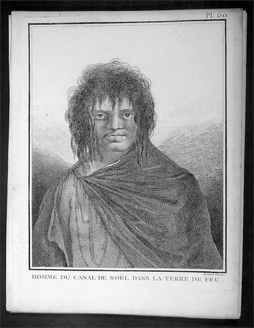
1778 Capt Cook Antique Print Portrait of a Man of Terra del Fuego, Chile in 1774
- Title : Homme du Canal de Noel Dans La Terre De Feu
- Ref : 16354
- Size: 10in x 8in (255mm x 205mm)
- Date : 1778
- Condition: (A+) Fine Condition
Description:
This fine original copper-plate engraved antique print, portrait of a Man of Christmas Sound on the S.W. Coast of Terra del Fuego Chile, visited by Captain James Cook during his 2nd Voyage of Discovery to the South Seas in December 1774, was engraved by Robert Benard - after William Hodges - and was published in the 1778 French edition of Capt. James Cooks 2nd Voyage of Discovery to the South Seas A voyage towards the South Pole, and round the World. Performed in His Majestys ships the Resolution and Adventure, in the years 1772, 1773, 1774, and 1775..... Paris : Hotel de Thou ......1778
Cook Journal
.......followed the coast of Tierra del Fuego (Chile) at the end of December 1774 making for Cape Horn. The coast comprised of hundreds of small islands, some of which were charted and named but many were not. The Resolution was kept at a safe distance from the shore and soon passed the Grafton Islands, Noir Island, Tower Rocks and the Gilbert Islands (named after the Master). On the 19th they passed a large inlet, which is now called Cook Bay. Cook needed provisions and to check the state of the Resolution,so he found an inlet suitable for this purpose on the 20th. They stayed there for eight days over Christmas, which earned the inlet the name Christmas Sound..........
General Definitions:
Paper thickness and quality: - Heavy and stable
Paper color : - off white
Age of map color: -
Colors used: -
General color appearance: -
Paper size: - 10in x 8in (255mm x 205mm)
Plate size: - 9 1/2in x 7 1/4in (240mm x 185mm)
Margins: - Min 1/2in (12mm)
Imperfections:
Margins: - Light soiling in margins
Plate area: - None
Verso: - None
Background:
Tierra del Fuego Spanish for Land of Fire is an archipelago off the southernmost tip of the South American mainland, across the Strait of Magellan. The archipelago consists of the main island, Isla Grande de Tierra del Fuego, with an area of 48,100 km2 and a group of many islands, including Cape Horn and Diego Ramírez Islands. Tierra del Fuego is divided between Chile and Argentina, with the latter controlling the eastern half of the main island and the former the western half plus the islands south of Beagle Channel.
The name Tierra del Fuego derives from the Portuguese explorer Ferdinand Magellan sailing for the Spanish Crown, in 1520 he was the first European to visit these lands. He believed he was seeing the many fires (fuego in Spanish) of the Yaghan, which were visible from the sea, and that the Indians were waiting in the forests to ambush his armada.
In 1525 Francisco de Hoces was the first to speculate that Tierra del Fuego was one or more islands rather than part of what was then called Terra Australis. Francis Drake in 1578 and a Dutch VOC expedition in 1616 learned more about the geography. The latter expedition named Cape Horn.
William Hodges RA 1744 – 1797 was an English painter. He was a member of James Cooks second voyage to the Pacific Ocean, and is best known for the sketches and paintings of locations he visited on that voyage, including Table Bay, Tahiti, Easter Island, and the Antarctic.
Between 1772 and 1775 Hodges accompanied James Cook to the Pacific as the expeditions artist. Many of his sketches and wash paintings were adapted as engravings in the original published edition of Cooks journals from the voyage.
Most of the large-scale landscape oil paintings from his Pacific travels for which Hodges is best known were finished after his return to London; he received a salary from the Admiralty for the purposes of completing them. These paintings depicted a stronger light and shadow than had been usual in European landscape tradition. Contemporary art critics complained that his use of light and colour contrasts gave his paintings a rough and unfinished appearance.
Hodges also produced many valuable portrait sketches of Pacific islanders and scenes from the voyage involving members of the expedition..
Robert Bénard 1734 – 1777 was an 18th-century French engraver.
Specialized in the technique of engraving, Robert Ménard is mainly famous for having supplied a significant amount of plates (at least 1,800) to the Encyclopédie by Diderot & d\'Alembert from 1751.
Later, publisher Charles-Joseph Panckoucke reused many of his productions to illustrate the works of his catalog.
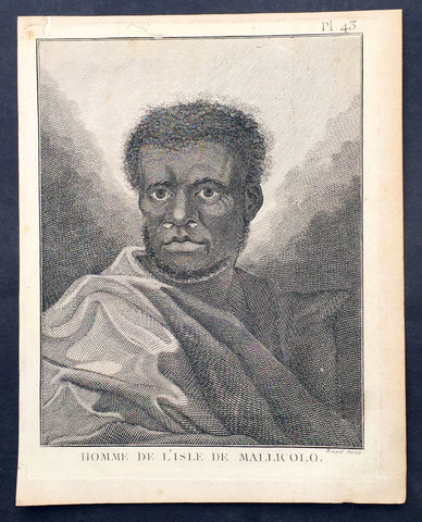
1778 Capt. Cook Antique Print Portrait A Man of Malakula Island Vanuatu in 1774
- Title : Homme de L Isle de Mallicolo
- Ref : 31831
- Size: 10in x 8in (255mm x 205mm)
- Date : 1778
- Condition: (A+) Fine Condition
Description:
This fine original copper-plate engraved antique print, portrait of a Man of the Island of Malakula (Mallicolo) in the Vanuatu group of Islands in the South Pacific, visited by Captain James Cook during his 2nd Voyage of Discovery in the South Seas in September 1774, was engraved by Robert Benard - after William Hodges - and was published in the 1778 French edition of Capt. James Cooks 2nd Voyage of Discovery to the South Seas A voyage towards the South Pole, and round the World. Performed in His Majestys ships the Resolution and Adventure, in the years 1772, 1773, 1774, and 1775..... Paris : Hotel de Thou ......1778
Cook Journal July, 1774
Arrival at The New Hebrides
On 17th Cook saw land bearing SW and later on decided this was the Australia Del Espiritu Santo of Quiros or what M. D. Bougainville calls the Great Cyclades. The island was Maewo. The next day its northern end was rounded in a gale and the ship sailed south between it and the island called by Bougainville the Isle of Lepers - Omba.
On 20th they crossed Patteson Passage with a view of geting to the South to explore the lands which lies there, and sailed down the west coast of Pentecost Isle (Raga). To the south they saw the island of Ambrin and behind it Paama and Epi. On 22nd, approaching Mallicollo (Malekula) we perceived a creek which had the appearence of a good harbour. Cook sent Lieutt [Richard] Pickersgill and the Master [Joseph Gilbert] in two Armd boats to Sound and look for Anchorage. The following day a good many [natives] came round us, some came in Canoes and others swam off\'... four I took into the Cabbin and made them various presents. Later, after some misunder-standing some natives began to Shoot Arrows... a Musquet discharged in the air and a four pounder over their heads sent them all off in the utmost confusion; those in the Cabbin leaped out of the Windows... About 9 o\'Clock we landed in the face of about 4 or 500 Men who were assembled on the Shore, armd with Bows and Arrows, clubs and Spears, but they made not the least opposission, on the contrary one Man gave his Arms to a nother and Met us in the water with a green branch in his hand, which [he] exchanged for the one I held in my hand. Just before departing Cook remarked they have not so much as a name for a Dog, consequently can have none, for which reason we left them a Dog and a Bitch.
General Definitions:
Paper thickness and quality: - Heavy and stable
Paper color : - off white
Age of map color: -
Colors used: -
General color appearance: -
Paper size: - 10in x 8in (255mm x 205mm)
Plate size: - 9 1/2in x 7 1/4in (240mm x 185mm)
Margins: - Min 1/2in (12mm)
Imperfections:
Margins: - Light soiling in margins
Plate area: - None
Verso: - None
Background:
Malakula Island also spelled Malekula, is the second-largest island in the nation of Vanuatu, in the Pacific Ocean region of Melanesia.
Discovered by the Spanish expedition of Pedro Fernández de Quirós in 1606 and visited by Captain Cook in 1774.
Vanuatu officially the Republic of Vanuatu is a Pacific island nation located in the South Pacific Ocean. The archipelago, which is of volcanic origin, is 1,750 kilometres east of northern Australia, 540 kilometres northeast of New Caledonia, east of New Guinea, southeast of the Solomon Islands, and west of Fiji.
Vanuatu was first inhabited by Melanesian people. The first Europeans to visit the islands were a Spanish expedition led by Portuguese navigator Fernandes de Queirós, who arrived on the largest island in 1606. Since the Portuguese and Spanish monarchies had been unified under the king of Spain in 1580 (following the vacancy of the Portuguese throne, which lasted for sixty years, until 1640, when the Portuguese monarchy was restored), Queirós claimed the archipelago for Spain, as part of the colonial Spanish East Indies, and named it La Austrialia del Espiritu Santo.
The Vanuatu group of islands first had contact with Europeans in 1606, when the Portuguese explorer Pedro Fernandes de Queiros, sailing for the Spanish Crown, arrived on the largest island and called the group of islands La Austrialia del Espiritu Santo or The Southern Land of the Holy Spirit, believing he had arrived in Terra Australis or Australia. The Spanish established a short-lived settlement at Big Bay on the north side of the island. The name Espiritu Santo remains to this day.
Europeans did not return until 1768, when Louis Antoine de Bougainville rediscovered the islands on 22 May, naming them the Great Cyclades. In 1774, Captain Cook named the islands the New Hebrides, a name that would last until independence in 1980.
William Hodges RA 1744 – 1797 was an English painter. He was a member of James Cooks second voyage to the Pacific Ocean, and is best known for the sketches and paintings of locations he visited on that voyage, including Table Bay, Tahiti, Easter Island, and the Antarctic.
Between 1772 and 1775 Hodges accompanied James Cook to the Pacific as the expeditions artist. Many of his sketches and wash paintings were adapted as engravings in the original published edition of Cooks journals from the voyage.
Most of the large-scale landscape oil paintings from his Pacific travels for which Hodges is best known were finished after his return to London; he received a salary from the Admiralty for the purposes of completing them. These paintings depicted a stronger light and shadow than had been usual in European landscape tradition. Contemporary art critics complained that his use of light and colour contrasts gave his paintings a rough and unfinished appearance.
Hodges also produced many valuable portrait sketches of Pacific islanders and scenes from the voyage involving members of the expedition..
Robert Bénard 1734 – 1777 was an 18th-century French engraver.
Specialized in the technique of engraving, Robert Ménard is mainly famous for having supplied a significant amount of plates (at least 1,800) to the Encyclopédie by Diderot & d\'Alembert from 1751.
Later, publisher Charles-Joseph Panckoucke reused many of his productions to illustrate the works of his catalog.
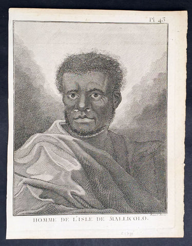
1778 Capt. Cook Antique Print Portrait A Man of Malakula Island Vanuatu in 1774
- Title : Homme de L Isle de Mallicolo
- Ref : 21347
- Size: 10in x 8in (255mm x 205mm)
- Date : 1778
- Condition: (A+) Fine Condition
Description:
This fine original copper-plate engraved antique print, portrait of a Man of the Island of Malakula (Mallicolo) in the Vanuatu group of Islands in the South Pacific, visited by Captain James Cook during his 2nd Voyage of Discovery in the South Seas in September 1774, was engraved by Robert Benard - after William Hodges - and was published in the 1778 French edition of Capt. James Cooks 2nd Voyage of Discovery to the South Seas A voyage towards the South Pole, and round the World. Performed in His Majestys ships the Resolution and Adventure, in the years 1772, 1773, 1774, and 1775..... Paris : Hotel de Thou ......1778
Cook Journal July, 1774
Arrival at The New Hebrides
On 17th Cook saw land bearing SW and later on decided this was the Australia Del Espiritu Santo of Quiros or what M. D. Bougainville calls the Great Cyclades. The island was Maewo. The next day its northern end was rounded in a gale and the ship sailed south between it and the island called by Bougainville the Isle of Lepers - Omba.
On 20th they crossed Patteson Passage with a view of geting to the South to explore the lands which lies there, and sailed down the west coast of Pentecost Isle (Raga). To the south they saw the island of Ambrin and behind it Paama and Epi. On 22nd, approaching Mallicollo (Malekula) we perceived a creek which had the appearence of a good harbour. Cook sent Lieutt [Richard] Pickersgill and the Master [Joseph Gilbert] in two Armd boats to Sound and look for Anchorage. The following day a good many [natives] came round us, some came in Canoes and others swam off\'... four I took into the Cabbin and made them various presents. Later, after some misunder-standing some natives began to Shoot Arrows... a Musquet discharged in the air and a four pounder over their heads sent them all off in the utmost confusion; those in the Cabbin leaped out of the Windows... About 9 o\'Clock we landed in the face of about 4 or 500 Men who were assembled on the Shore, armd with Bows and Arrows, clubs and Spears, but they made not the least opposission, on the contrary one Man gave his Arms to a nother and Met us in the water with a green branch in his hand, which [he] exchanged for the one I held in my hand. Just before departing Cook remarked they have not so much as a name for a Dog, consequently can have none, for which reason we left them a Dog and a Bitch.
General Definitions:
Paper thickness and quality: - Heavy and stable
Paper color : - off white
Age of map color: -
Colors used: -
General color appearance: -
Paper size: - 10in x 8in (255mm x 205mm)
Plate size: - 9 1/2in x 7 1/4in (240mm x 185mm)
Margins: - Min 1/2in (12mm)
Imperfections:
Margins: - Light soiling in margins
Plate area: - None
Verso: - None
Background:
Malakula Island also spelled Malekula, is the second-largest island in the nation of Vanuatu, in the Pacific Ocean region of Melanesia.
Discovered by the Spanish expedition of Pedro Fernández de Quirós in 1606 and visited by Captain Cook in 1774.
Vanuatu officially the Republic of Vanuatu is a Pacific island nation located in the South Pacific Ocean. The archipelago, which is of volcanic origin, is 1,750 kilometres east of northern Australia, 540 kilometres northeast of New Caledonia, east of New Guinea, southeast of the Solomon Islands, and west of Fiji.
Vanuatu was first inhabited by Melanesian people. The first Europeans to visit the islands were a Spanish expedition led by Portuguese navigator Fernandes de Queirós, who arrived on the largest island in 1606. Since the Portuguese and Spanish monarchies had been unified under the king of Spain in 1580 (following the vacancy of the Portuguese throne, which lasted for sixty years, until 1640, when the Portuguese monarchy was restored), Queirós claimed the archipelago for Spain, as part of the colonial Spanish East Indies, and named it La Austrialia del Espiritu Santo.
The Vanuatu group of islands first had contact with Europeans in 1606, when the Portuguese explorer Pedro Fernandes de Queiros, sailing for the Spanish Crown, arrived on the largest island and called the group of islands La Austrialia del Espiritu Santo or The Southern Land of the Holy Spirit, believing he had arrived in Terra Australis or Australia. The Spanish established a short-lived settlement at Big Bay on the north side of the island. The name Espiritu Santo remains to this day.
Europeans did not return until 1768, when Louis Antoine de Bougainville rediscovered the islands on 22 May, naming them the Great Cyclades. In 1774, Captain Cook named the islands the New Hebrides, a name that would last until independence in 1980.
William Hodges RA 1744 – 1797 was an English painter. He was a member of James Cooks second voyage to the Pacific Ocean, and is best known for the sketches and paintings of locations he visited on that voyage, including Table Bay, Tahiti, Easter Island, and the Antarctic.
Between 1772 and 1775 Hodges accompanied James Cook to the Pacific as the expeditions artist. Many of his sketches and wash paintings were adapted as engravings in the original published edition of Cooks journals from the voyage.
Most of the large-scale landscape oil paintings from his Pacific travels for which Hodges is best known were finished after his return to London; he received a salary from the Admiralty for the purposes of completing them. These paintings depicted a stronger light and shadow than had been usual in European landscape tradition. Contemporary art critics complained that his use of light and colour contrasts gave his paintings a rough and unfinished appearance.
Hodges also produced many valuable portrait sketches of Pacific islanders and scenes from the voyage involving members of the expedition..
Robert Bénard 1734 – 1777 was an 18th-century French engraver.
Specialized in the technique of engraving, Robert Ménard is mainly famous for having supplied a significant amount of plates (at least 1,800) to the Encyclopédie by Diderot & d\'Alembert from 1751.
Later, publisher Charles-Joseph Panckoucke reused many of his productions to illustrate the works of his catalog.
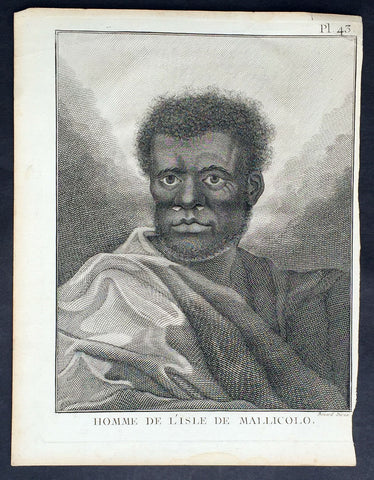
1778 Capt. Cook Antique Print Portrait A Man of Malakula Island Vanuatu in 1774
- Title : Homme de L Isle de Mallicolo
- Ref : 31773
- Size: 10in x 8in (255mm x 205mm)
- Date : 1778
- Condition: (A+) Fine Condition
Description:
This fine original copper-plate engraved antique print, portrait of a Man of the Island of Malakula (Mallicolo) in the Vanuatu group of Islands in the South Pacific, visited by Captain James Cook during his 2nd Voyage of Discovery in the South Seas in September 1774, was engraved by Robert Benard - after William Hodges - and was published in the 1778 French edition of Capt. James Cooks 2nd Voyage of Discovery to the South Seas A voyage towards the South Pole, and round the World. Performed in His Majestys ships the Resolution and Adventure, in the years 1772, 1773, 1774, and 1775..... Paris : Hotel de Thou ......1778
Cook Journal July, 1774
Arrival at The New Hebrides
On 17th Cook saw land bearing SW and later on decided this was the Australia Del Espiritu Santo of Quiros or what M. D. Bougainville calls the Great Cyclades. The island was Maewo. The next day its northern end was rounded in a gale and the ship sailed south between it and the island called by Bougainville the Isle of Lepers - Omba.
On 20th they crossed Patteson Passage with a view of geting to the South to explore the lands which lies there, and sailed down the west coast of Pentecost Isle (Raga). To the south they saw the island of Ambrin and behind it Paama and Epi. On 22nd, approaching Mallicollo (Malekula) we perceived a creek which had the appearence of a good harbour. Cook sent Lieutt [Richard] Pickersgill and the Master [Joseph Gilbert] in two Armd boats to Sound and look for Anchorage. The following day a good many [natives] came round us, some came in Canoes and others swam off\'... four I took into the Cabbin and made them various presents. Later, after some misunder-standing some natives began to Shoot Arrows... a Musquet discharged in the air and a four pounder over their heads sent them all off in the utmost confusion; those in the Cabbin leaped out of the Windows... About 9 o\'Clock we landed in the face of about 4 or 500 Men who were assembled on the Shore, armd with Bows and Arrows, clubs and Spears, but they made not the least opposission, on the contrary one Man gave his Arms to a nother and Met us in the water with a green branch in his hand, which [he] exchanged for the one I held in my hand. Just before departing Cook remarked they have not so much as a name for a Dog, consequently can have none, for which reason we left them a Dog and a Bitch.
General Definitions:
Paper thickness and quality: - Heavy and stable
Paper color : - off white
Age of map color: -
Colors used: -
General color appearance: -
Paper size: - 10in x 8in (255mm x 205mm)
Plate size: - 9 1/2in x 7 1/4in (240mm x 185mm)
Margins: - Min 1/2in (12mm)
Imperfections:
Margins: - Light soiling in margins
Plate area: - None
Verso: - None
Background:
Malakula Island also spelled Malekula, is the second-largest island in the nation of Vanuatu, in the Pacific Ocean region of Melanesia.
Discovered by the Spanish expedition of Pedro Fernández de Quirós in 1606 and visited by Captain Cook in 1774.
Vanuatu officially the Republic of Vanuatu is a Pacific island nation located in the South Pacific Ocean. The archipelago, which is of volcanic origin, is 1,750 kilometres east of northern Australia, 540 kilometres northeast of New Caledonia, east of New Guinea, southeast of the Solomon Islands, and west of Fiji.
Vanuatu was first inhabited by Melanesian people. The first Europeans to visit the islands were a Spanish expedition led by Portuguese navigator Fernandes de Queirós, who arrived on the largest island in 1606. Since the Portuguese and Spanish monarchies had been unified under the king of Spain in 1580 (following the vacancy of the Portuguese throne, which lasted for sixty years, until 1640, when the Portuguese monarchy was restored), Queirós claimed the archipelago for Spain, as part of the colonial Spanish East Indies, and named it La Austrialia del Espiritu Santo.
The Vanuatu group of islands first had contact with Europeans in 1606, when the Portuguese explorer Pedro Fernandes de Queiros, sailing for the Spanish Crown, arrived on the largest island and called the group of islands La Austrialia del Espiritu Santo or The Southern Land of the Holy Spirit, believing he had arrived in Terra Australis or Australia. The Spanish established a short-lived settlement at Big Bay on the north side of the island. The name Espiritu Santo remains to this day.
Europeans did not return until 1768, when Louis Antoine de Bougainville rediscovered the islands on 22 May, naming them the Great Cyclades. In 1774, Captain Cook named the islands the New Hebrides, a name that would last until independence in 1980.
William Hodges RA 1744 – 1797 was an English painter. He was a member of James Cooks second voyage to the Pacific Ocean, and is best known for the sketches and paintings of locations he visited on that voyage, including Table Bay, Tahiti, Easter Island, and the Antarctic.
Between 1772 and 1775 Hodges accompanied James Cook to the Pacific as the expeditions artist. Many of his sketches and wash paintings were adapted as engravings in the original published edition of Cooks journals from the voyage.
Most of the large-scale landscape oil paintings from his Pacific travels for which Hodges is best known were finished after his return to London; he received a salary from the Admiralty for the purposes of completing them. These paintings depicted a stronger light and shadow than had been usual in European landscape tradition. Contemporary art critics complained that his use of light and colour contrasts gave his paintings a rough and unfinished appearance.
Hodges also produced many valuable portrait sketches of Pacific islanders and scenes from the voyage involving members of the expedition..
Robert Bénard 1734 – 1777 was an 18th-century French engraver.
Specialized in the technique of engraving, Robert Ménard is mainly famous for having supplied a significant amount of plates (at least 1,800) to the Encyclopédie by Diderot & d\'Alembert from 1751.
Later, publisher Charles-Joseph Panckoucke reused many of his productions to illustrate the works of his catalog.
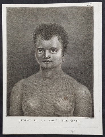
1778 Capt. Cook Antique Print Portrait of a Woman of New Caledonia Visit in 1774
- Title : Femme de la Noule. Caledonie
- Ref : 21327
- Size: 10in x 8in (255mm x 205mm)
- Date : 1778
- Condition: (A+) Fine Condition
Description:
This fine original copper-plate engraved antique print, portrait of a Woman of the Islands of New Caledonia in the South Pacific, visited by Captain James Cook during his 2nd Voyage of Discovery in the South Seas in September 1774, was engraved by Robert Benard - after William Hodges - and was published in the 1778 French edition of Capt. James Cooks 2nd Voyage of Discovery to the South Seas A voyage towards the South Pole, and round the World. Performed in His Majestys ships the Resolution and Adventure, in the years 1772, 1773, 1774, and 1775..... Paris : Hotel de Thou ......1778
Cook Diary, 4-13th Sep. 1774
4th Sun. Sights Cape Colnett (New Caledonia).
5th Mon. Enters reef (Amoss Passage) between Cook Reef and Balade Reef, anchors off Observatory Isle (Pudiu), visited by inhabitants.
6th Tue. Goes ashore with armed boats, rows along coast, returns to ship. Visited by natives, meets Chief, Teeabooma. Wales and Pickersgill land on Isle, Cook goes to help. Observatory set up for eclipse of Sun.
7th Wed. Eclipse, cloudy at first, observations made. Returns to ship, goes ashore again and returns. Simon Monk, ship’s butcher, dies after fall down fore-hatchway previous night.
8th Thu. Goes ashore. Excursion to west. The Forsters and Cook are ill with eating poisoned fish, liver and roe (Toadfish).
9th Fri. Exchanges presents with Teeabooma but still indisposed.
10th Sat. Forster ashore botanising.
12th Mon. Cutter is damaged when Gilbert and Pickersgill are returning from a visit to the north-west of island. Repairs made.
13th Tue. Takes possession of island in name of King George III, naming it New Caledonia. Sails back through reef and heads NW. along coast, outside Cook Reef, passes Great False Passage.
General Definitions:
Paper thickness and quality: - Heavy and stable
Paper color : - off white
Age of map color: -
Colors used: -
General color appearance: -
Paper size: - 10in x 8in (255mm x 205mm)
Plate size: - 9 1/2in x 7 1/4in (240mm x 185mm)
Margins: - Min 1/2in (12mm)
Imperfections:
Margins: - Light soiling in margins
Plate area: - None
Verso: - None
Background:
New Caledonia is a special collective of France in the southwest Pacific Ocean, 1,210 km east of Australia and 20,000 km from Metropolitan France. The archipelago, part of the Melanesia sub-region, includes the main island of Grande Terre, the Loyalty Islands, the Chesterfield Islands, the Belep archipelago, the Isle of Pines, and a few remote islets. The Chesterfield Islands are in the Coral Sea. Locals refer to Grande Terre as Le Caillou (the pebble)
British explorer Captain James Cook was the first European to sight New Caledonia, on 4 September 1774, during his second voyage. He named it New Caledonia, as the northeast of the island reminded him of Scotland. The west coast of Grande Terre was approached by Jean-François de Galaup, comte de Lapérouse in 1788, shortly before his disappearance, and the Loyalty Islands were first visited between 1793 and 1796 when Mare, Lifou, Tiga, and Ouvea were mapped by William Raven. The American whaler encountered the island named then Britania, and today known as Mar (Loyalty Is.) in November 1793. From 1796 until 1840, only a few sporadic contacts with the archipelago were recorded. About fifty American whalers (identified by Robert Langsom from their log books) have been recorded in the region (Grande Terre, Loyalty Is., Walpole and Hunter) between 1793 and 1887. Contacts became more frequent after 1840, because of the interest in sandalwood
William Hodges RA 1744 – 1797 was an English painter. He was a member of James Cooks second voyage to the Pacific Ocean, and is best known for the sketches and paintings of locations he visited on that voyage, including Table Bay, Tahiti, Easter Island, and the Antarctic.
Between 1772 and 1775 Hodges accompanied James Cook to the Pacific as the expeditions artist. Many of his sketches and wash paintings were adapted as engravings in the original published edition of Cooks journals from the voyage.
Most of the large-scale landscape oil paintings from his Pacific travels for which Hodges is best known were finished after his return to London; he received a salary from the Admiralty for the purposes of completing them. These paintings depicted a stronger light and shadow than had been usual in European landscape tradition. Contemporary art critics complained that his use of light and colour contrasts gave his paintings a rough and unfinished appearance.
Hodges also produced many valuable portrait sketches of Pacific islanders and scenes from the voyage involving members of the expedition..
Robert Bénard 1734 – 1777 was an 18th-century French engraver.
Specialized in the technique of engraving, Robert Ménard is mainly famous for having supplied a significant amount of plates (at least 1,800) to the Encyclopédie by Diderot & d\'Alembert from 1751.
Later, publisher Charles-Joseph Panckoucke reused many of his productions to illustrate the works of his catalog.
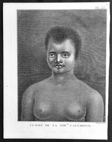
1778 Capt. Cook Antique Print Portrait of a Woman of New Caledonia Visit in 1774
- Title : Femme de la Noule. Caledonie
- Ref : 91210
- Size: 10in x 8in (255mm x 205mm)
- Date : 1778
- Condition: (A+) Fine Condition
Description:
This fine original copper-plate engraved antique print, portrait of a Woman of the Islands of New Caledonia in the South Pacific, visited by Captain James Cook during his 2nd Voyage of Discovery in the South Seas in September 1774, was engraved by Robert Benard - after William Hodges - and was published in the 1778 French edition of Capt. James Cooks 2nd Voyage of Discovery to the South Seas A voyage towards the South Pole, and round the World. Performed in His Majestys ships the Resolution and Adventure, in the years 1772, 1773, 1774, and 1775..... Paris : Hotel de Thou ......1778
Cook Diary, 4-13th Sep. 1774
4th Sun. Sights Cape Colnett (New Caledonia).
5th Mon. Enters reef (Amoss Passage) between Cook Reef and Balade Reef, anchors off Observatory Isle (Pudiu), visited by inhabitants.
6th Tue. Goes ashore with armed boats, rows along coast, returns to ship. Visited by natives, meets Chief, Teeabooma. Wales and Pickersgill land on Isle, Cook goes to help. Observatory set up for eclipse of Sun.
7th Wed. Eclipse, cloudy at first, observations made. Returns to ship, goes ashore again and returns. Simon Monk, ship’s butcher, dies after fall down fore-hatchway previous night.
8th Thu. Goes ashore. Excursion to west. The Forsters and Cook are ill with eating poisoned fish, liver and roe (Toadfish).
9th Fri. Exchanges presents with Teeabooma but still indisposed.
10th Sat. Forster ashore botanising.
12th Mon. Cutter is damaged when Gilbert and Pickersgill are returning from a visit to the north-west of island. Repairs made.
13th Tue. Takes possession of island in name of King George III, naming it New Caledonia. Sails back through reef and heads NW. along coast, outside Cook Reef, passes Great False Passage.
General Definitions:
Paper thickness and quality: - Heavy and stable
Paper color : - off white
Age of map color: -
Colors used: -
General color appearance: -
Paper size: - 10in x 8in (255mm x 205mm)
Plate size: - 9 1/2in x 7 1/4in (240mm x 185mm)
Margins: - Min 1/2in (12mm)
Imperfections:
Margins: - Light soiling in margins
Plate area: - None
Verso: - None
Background:
New Caledonia is a special collective of France in the southwest Pacific Ocean, 1,210 km east of Australia and 20,000 km from Metropolitan France. The archipelago, part of the Melanesia sub-region, includes the main island of Grande Terre, the Loyalty Islands, the Chesterfield Islands, the Belep archipelago, the Isle of Pines, and a few remote islets. The Chesterfield Islands are in the Coral Sea. Locals refer to Grande Terre as Le Caillou (the pebble)
British explorer Captain James Cook was the first European to sight New Caledonia, on 4 September 1774, during his second voyage. He named it New Caledonia, as the northeast of the island reminded him of Scotland. The west coast of Grande Terre was approached by Jean-François de Galaup, comte de Lapérouse in 1788, shortly before his disappearance, and the Loyalty Islands were first visited between 1793 and 1796 when Mare, Lifou, Tiga, and Ouvea were mapped by William Raven. The American whaler encountered the island named then Britania, and today known as Mar (Loyalty Is.) in November 1793. From 1796 until 1840, only a few sporadic contacts with the archipelago were recorded. About fifty American whalers (identified by Robert Langsom from their log books) have been recorded in the region (Grande Terre, Loyalty Is., Walpole and Hunter) between 1793 and 1887. Contacts became more frequent after 1840, because of the interest in sandalwood
William Hodges RA 1744 – 1797 was an English painter. He was a member of James Cooks second voyage to the Pacific Ocean, and is best known for the sketches and paintings of locations he visited on that voyage, including Table Bay, Tahiti, Easter Island, and the Antarctic.
Between 1772 and 1775 Hodges accompanied James Cook to the Pacific as the expeditions artist. Many of his sketches and wash paintings were adapted as engravings in the original published edition of Cooks journals from the voyage.
Most of the large-scale landscape oil paintings from his Pacific travels for which Hodges is best known were finished after his return to London; he received a salary from the Admiralty for the purposes of completing them. These paintings depicted a stronger light and shadow than had been usual in European landscape tradition. Contemporary art critics complained that his use of light and colour contrasts gave his paintings a rough and unfinished appearance.
Hodges also produced many valuable portrait sketches of Pacific islanders and scenes from the voyage involving members of the expedition..
Robert Bénard 1734 – 1777 was an 18th-century French engraver.
Specialized in the technique of engraving, Robert Ménard is mainly famous for having supplied a significant amount of plates (at least 1,800) to the Encyclopédie by Diderot & d\'Alembert from 1751.
Later, publisher Charles-Joseph Panckoucke reused many of his productions to illustrate the works of his catalog.
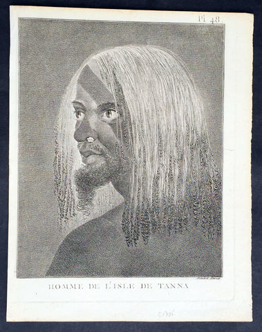
1778 Capt. Cook Antique Print of a Man of the Tanna Island, Vanuatu in 1774
- Title : Homme De L Isle de Tanna
- Ref : 21353
- Size: 10in x 8in (255mm x 205mm)
- Date : 1778
- Condition: (A+) Fine Condition
Description:
This fine original copper-plate engraved antique print, a portrait of a Man of the Island of Tanna in the Vanuatu group of Islands in the South Pacific, visited by Captain James Cook during his 2nd Voyage of Discovery in the South Seas in 1774, was engraved by Robert Benard - after William Hodges - and was published in the 1778 French edition of Capt. James Cooks 2nd Voyage of Discovery to the South Seas A voyage towards the South Pole, and round the World. Performed in His Majestys ships the Resolution and Adventure, in the years 1772, 1773, 1774, and 1775..... Paris : Hotel de Thou ......1778
Cook Diary, 6-20th August 1774
........the Women have all the same ornaments as Men, Nose-Stones, Earrings, Shells on the Breast & Bracelets...their heads covered with a kind of cap made of a Plantain leaf or a Mat-Basket. Few are covered, & even very young Girls have these Caps.......Cooks Journal II
General Definitions:
Paper thickness and quality: - Heavy and stable
Paper color : - off white
Age of map color: -
Colors used: -
General color appearance: -
Paper size: - 10in x 8in (255mm x 205mm)
Plate size: - 9 1/2in x 7 1/4in (240mm x 185mm)
Margins: - Min 1/2in (12mm)
Imperfections:
Margins: - Light soiling in margins
Plate area: - None
Verso: - None
Background:
Tanna (sometimes spelled Tana) is an island in Tafea Province of Vanuatu.
Tanna was first settled about 400 BC by Melanesians from the surrounding islands. The glowing light of Mount Yasur attracted James Cook, the first European to visit the island, in August 1774, where he landed in an inlet on the southeastern tip of the island that he named Port Resolution after his ship HMS Resolution. He gave the island the name of Tanna, probably from the local name for earth, tana in the Kwamera language.
Vanuatu is a Pacific island nation located in the South Pacific Ocean. The archipelago, which is of volcanic origin, is 1,750 kilometres east of northern Australia, 540 kilometres northeast of New Caledonia, east of New Guinea, southeast of the Solomon Islands, and west of Fiji.
The Vanuatu group of islands first had contact with Europeans in 1606, when the Portuguese explorer Pedro Fernandes de Queirós, sailing for the Spanish Crown, arrived on the largest island and called the group of islands La Austrialia del Espiritu Santo or The Southern Land of the Holy Spirit, believing he had arrived in Terra Australis or Australia. The Spanish established a short-lived settlement at Big Bay on the north side of the island. The name Espiritu Santo remains to this day.
Europeans did not return until 1768, when Louis Antoine de Bougainville rediscovered the islands on 22 May, naming them the Great Cyclades. In 1774, Captain Cook named the islands the New Hebrides, a name that would last until independence in 1980.
William Hodges RA 1744 – 1797 was an English painter. He was a member of James Cooks second voyage to the Pacific Ocean, and is best known for the sketches and paintings of locations he visited on that voyage, including Table Bay, Tahiti, Easter Island, and the Antarctic.
Between 1772 and 1775 Hodges accompanied James Cook to the Pacific as the expeditions artist. Many of his sketches and wash paintings were adapted as engravings in the original published edition of Cooks journals from the voyage.
Most of the large-scale landscape oil paintings from his Pacific travels for which Hodges is best known were finished after his return to London; he received a salary from the Admiralty for the purposes of completing them. These paintings depicted a stronger light and shadow than had been usual in European landscape tradition. Contemporary art critics complained that his use of light and colour contrasts gave his paintings a rough and unfinished appearance.
Hodges also produced many valuable portrait sketches of Pacific islanders and scenes from the voyage involving members of the expedition..
Robert Bénard 1734 – 1777 was an 18th-century French engraver.
Specialized in the technique of engraving, Robert Ménard is mainly famous for having supplied a significant amount of plates (at least 1,800) to the Encyclopédie by Diderot & d\'Alembert from 1751.
Later, publisher Charles-Joseph Panckoucke reused many of his productions to illustrate the works of his catalog.