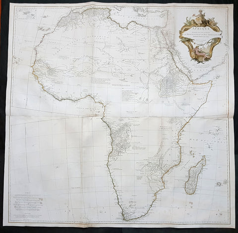
Africa (56)

1774 Malachy Postlethwayt Antique 2 Volume Atlas 7 Large Cont Maps North America
Antique Map
- Title : The Universal Dictionary of Trade and Commercewith large Improvements Adapting the Same to the Present State of British Affairs in America since the last Treaty of Peace made in the year 1763....MDCCLXXIV
- Ref #: 93529
-
Condition: (A+) Fine Condition
- Size: Large Folio
- Date : 1774
Description:
These very large, heavy leather backed original antique dictionary & atlas volumes of early Global Economic Commerce by Malachy Postlethwayt was published in 1774.
The Universal Dictionary of Trade and Commerce in 2 volumes is the 4th edition published in London by W. Strahan, J and F. Rivington, et al., in 1774. The first edition was published between 1751 & 1755. Titles in red and black with engraved vignettes, engraved allegorical frontispiece to volume 1 (offset onto title) and contain 24 engraved folding maps sheets that when assembled make 7 complete very large maps. Occasional minor spotting, contemporary diced calf, re-backed preserving original contrasting morocco labels, extremities repaired.
The seven maps once assembled, to the left, are as follows with titles, cartographers dates and dimensions;:
1. A Correct Map of Europe by Thomas Kitchin after D Anville, 80cm x 70cm, 1774
2. Africa Performed by the Sr D Anville Samuel Bolton after D Anville, 103cm x 94cm, 1774
3. A New and Correct Map of the Coast of Africa, so called Slave Coast Map, Richard Seale 48cm x 38cm, 1774
4. North America Performed under the Patronage of Louis Duke of Orleans Richard Seale after D Anville, 88cm x 86cm, 1774
5. South America Thomas Kitchin after D Anville, 124cm x 75cm, 1774
6. First Part of Asia RW Seale, after D Anville, 83cm x 77cm, 1755
7. Second Part of Asia R W Seale, after D Anville, 96cm x 70cm, 1755
General Definitions:
Paper thickness and quality: - Heavy and stable
Paper color : - off white
Age of map color: -
Colors used: -
General color appearance: -
Paper size: - Please see above
Plate size: - Please see above
Margins: - Please see above
Imperfections:
Margins: - Please see above
Plate area: - Please see above
Verso: - Please see above
Background:
Postlethwayts most noted work, The Universal Dictionary of Trade and Commerce, appeared after he had devoted twenty years to its preparation. The first edition was published in London in instalments between 1751 and 1755, and then in subsequent editions as a two-volume set in 1757, 1766, and 1774. This dictionary was a translation, with large additions and improvements, from Jacques Savary des Bruslons Dictionnaire universal de commerce (1723–1730). Postlethwayts dictionary was a huge storehouse of economic facts, laws and theory and his departures from the French version reflected his greater interest in political problems; his more intense economic nationalism; and his exuberant belief in the economic usefulness of experimental philosophy
In the 1757 edition of the Universal Dictionary, Postlethwayt outlined his vision for the establishment of a British mercantile college to benefit those who intended to work as merchants, or in gathering public revenue, or in merchandizing. He proposed that theoretical training for business should occur in formal academies and involve the study of mercantile computations, foreign exchanges and the intrinsic value of foreign coins, double-entry accounting, languages, geography, and public revenues and related laws. Postlethwayts ideas appear to have been influential in developing the statutes and procedures of the Portuguese School of Commerce, established in Lisbon in 1759.
It is documented that Thomas Jefferson gave a copy of this dictonary to his son in law, Thomas Mann Randolph, and as a prolific reader we must assumed also read by Jefferson.
Postlethwayt, Malachy 1707-1767
Malachy Postlethwayt was a prolific English writer and publicist on matters of mercantilist economics in the 1740s and 1750s. Little is known about his upbringing or formal education, although he is believed to be the brother of James Postlethwayt (d. 1761), a writer on finance and demography. Malachy Postlethwayt was elected a fellow of the Society of Antiquaries of London in 1734. His writings are claimed by Edgar Johnson to have exerted a good deal of influence on the trend of British economic thought.
Postlethwayt was alleged to be propagandist for the mercantilist endeavours of the Royal Africa Company, whose interests were well served by his publications The African Trade, the Great Pillar and Supporter of the British Plantation Trade in North America (1745) and The National and Private Advantages of the African Trade Considered (1746). These works supported a strategy of British commercial and manufacturing expansion through trade with Africa and the colonies, and promoted the importance of slavery for British commerce and industry.
Postlethwayts most noted work, The Universal Dictionary of Trade and Commerce, appeared after he had devoted twenty years to its preparation. The first edition was published in London in instalments between 1751 and 1755, and then in subsequent editions as a two-volume set in 1757, 1766, and 1774. This dictionary was a translation, with large additions and improvements, from Jacques Savary des Bruslons Dictionnaire universal de commerce (1723–1730). Postlethwayts dictionary was a huge storehouse of economic facts, laws and theory and his departures from the French version reflected his greater interest in political problems; his more intense economic nationalism; and his exuberant belief in the economic usefulness of experimental philosophy
In the 1757 edition of the Universal Dictionary, Postlethwayt outlined his vision for the establishment of a British mercantile college to benefit those who intended to work as merchants, or in gathering public revenue, or in merchandizing. He proposed that theoretical training for business should occur in formal academies and involve the study of mercantile computations, foreign exchanges and the intrinsic value of foreign coins, double-entry accounting, languages, geography, and public revenues and related laws. Postlethwayts ideas appear to have been influential in developing the statutes and procedures of the Portuguese School of Commerce, established in Lisbon in 1759.
Postlethwayts most important contribution to economic literature is regarded by many to be Britains Commercial Interest Explained and Improved (1757), in which he outlines his concept of physical commerce and the policies England should follow to attain commercial parity with foreign rivals.
Whether Postlethwayts writings were his original thoughts and words is a matter for conjecture. His Universal Dictionary included ideas taken from fifty other past or contemporary writers and that it had scattered throughout it practically all of Richard Cantillons Essai sur la nature du commerce en général (Essay on the Nature of Commerce in General, 1755). Although Postlethwayt was alleged widely to be a plagiarist, this accusation is believed to be exaggerated.
Postlethwayt died suddenly on September 13, 1767, and was buried in the Old Street Churchyard, Clerkenwell, in London.
Postlethwayt also published:
- The African Trade the great Pillar and Support of the British Plantation Trade in America, &c., 1745.
- The Natural and Private Advantages of the African Trade considered, &c., 1746.
- Britains Commercial Interest Explained, Vol. I of his Universal Dictionary of Trade and Commerce, 1747.[5]
- Considerations on the making of Bar Iron with Pitt or Sea Coal Fire, &c. In a Letter to a Member of the House of Commons, London, 1747.
- Considerations on the Revival of the Royal-British Assiento, between his Catholic Majesty and the … South-Sea Company. With an … attempt to unite the African-Trade to that of the South-Sea Company, by Act of Parliament, London, 1749.
- The Merchants Public Counting House, or New Mercantile Institution, &c., London, 1750.
- A Short State of the Progress of the French Trade and Navigation, &c., London, 1756.
- Great Britains True System. … To which is prefixed an Introduction relative to the Forming a New Plan of British Politicks with respect to our Foreign Affairs, &c., London, 1757.
- Britains Commercial Interest explained and improved, in a Series of Dissertations on several important Branches of her Trade and Police. … Also … the Advantages which would accrue … from an Union with Ireland, 2 vols., London, 1757; 2nd edit., With … a clear View of the State of our Plantations in America, &c., London, 1759.
- In Honour to the Administration. The importance of the African Expedition considered, &c., London, 1758
Please note all items auctioned are genuine, we do not sell reproductions. A Certificate of Authenticity (COA) can be issued on request.
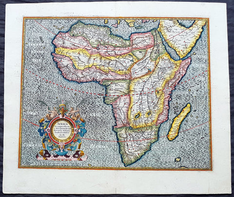
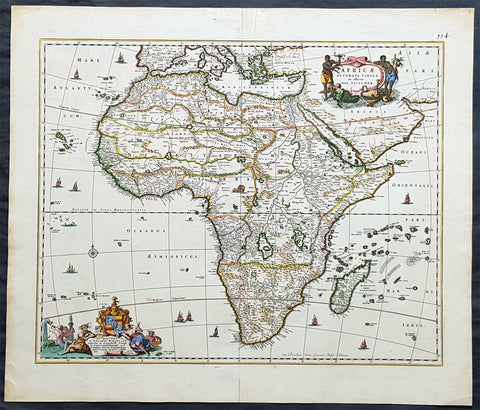
1613 Gerard Mercator Large Antique Map of Africa - Africa Ex Magna
- Title : Africa Ex Magna orbis terra descriptione Gerardi Mercatoris desumpta. Studio & industria GM Iunioris
- Size: 22in x 18 3/4in (560mm x 475mm)
- Condition: (A+) Fine Condition
- Date : 1613
- Ref #: 34173
Description:
This beautifully hand coloured original antique map of Africa by Gerard Mercator was published by Henricus Hondius in the 1613 French edition of Mercators Atlas, Atlas Sive Cosmographicae Meditationes Illustrissimi Ducis.
This map is exceptional with original hand colour, heavy dark impression, clean heavy paper and original margins.
As indicated in the title Cartouche, this map this is a reduction by Gerard Mercator Junior of Africa, compiled from Gerard Mercator\'s world map of 1569. This rendition was drawn by Mercator\'s grandson (also named Gerard) in 1595.
The map is typical of 16th century cartography of Africa containing some fantastical detail especially in regards to the interior. The depiction of the Nile is based on Ptolemys geography with some complex modifications from various sources, including Abyssinian monks. The source of the Nile is shown as a series of lakes located in the Lune Montes just north of the Tropic of Capricorn. Another branch of the Nile flows from the west, with this system rambling through what is the Sahara Desert. Mercator adds a lake named Sac. Haf lac, from the 1507 Waldseemuller world map. This lake feeds both the Zambere River and the Nile. In Abissini, the legendary Christian King Prester John sits on his throne. The boldly engraved oceans, beautiful calligraphy, and strapwork cartouche (surmounted by two satyrs) make this a decorative masterpiece.
General Definitions:
Paper thickness and quality: - Heavy and stable
Paper color : - off white
Age of map color: - Original
Colors used: - Yellow, green, blue, pink
General color appearance: - Authentic
Paper size: - 22in x 18 3/4in (560mm x 475mm)
Plate size: - 18 1/2in x 15in (470mm x 380mm)
Margins: - Min 1in (25mm)
Imperfections:
Margins: - None
Plate area: - None
Verso: - None
Background:
Being part of the Mediterranean world, the northern coasts of the African continent as far as the Straits of Gibraltar and even round to the area of the Fortunate Isles (the Canaries) were reasonably well known and quite accurately mapped from ancient times. In particular, Egypt and the Nile Valley were well defined and the Nile itself was, of course, one of the rivers separating the continents in medieval T-O maps. Through Arab traders the shape of the east coast, down the Red Sea as far as the equator, was also known but detail shown in the interior faded into deserts with occasional mountain ranges and mythical rivers. The southern part of the continent, in the Ptolemaic tradition, was assumed to curve to the east to form a land-locked Indian Ocean. The voyages of the Portuguese, organized by Henry the Navigator in the fifteenth century, completely changed the picture and by the end of the century Vasco da Gama had rounded the Cape enabling cartographers to draw a quite presentable coastal outline of the whole continent, even if the interior was to remain largely unknown for the next two or three centuries.
The first separately printed map of Africa (as with the other known continents) appeared in Munster\'s Geographia from 1540 onwards and the first atlas devoted to Africa only was published in 1588 in Venice by Livio Sanuto, but the finest individual map of the century was that engraved on 8 sheets by Gastaldi, published in Venice in 1564. Apart from maps in sixteenth-century atlases generally there were also magnificent marine maps of 1596 by Jan van Linschoten (engraved by van Langrens) of the southern half of the continent with highly imaginative and decorative detail in the interior. In the next century there were many attractive maps including those of Mercator/Hondius (1606), Speed (1627), Blaeu (1 630), Visscher (1636), de Wit (c. 1670), all embellished with vignettes of harbours and principal towns and bordered with elaborate and colourful figures of their inhabitants, but the interior remained uncharted with the exception of that part of the continent known as Ethiopia, the name which was applied to a wide area including present-day Abyssinia. Here the legends of Prester John lingered on and, as so often happened in other remote parts of the world, the only certain knowledge of the region was provided by Jesuit missionaries. Among these was Father Geronimo Lobo (1595-1678), whose work A Voyage to Abyssinia was used as the basis for a remarkably accurate map published by a German scholar, Hiob Ludolf in 1683. Despite the formidable problems which faced them, the French cartographers G. Delisle (c. 1700-22), J. B. B. d\'Anville (1727-49) and N. Bellin (1754) greatly improved the standards of mapping of the continent, improvements which were usually, although not always, maintained by Homann, Seutter, de Ia Rochette, Bowen, Faden and many others in the later years of the century.

1650 Jan Jansson & Nicolaas Blankaert 3 x Large Antique Maps Europe, Asia & Africa
Antique Map
- Title : Europa Antiqua cum finitimis; Asia antiqua cum finitimis; Africae Antiquae, et quarundam...
- Date : 1650
- Condition: (A+) Fine Condition
- Ref: 50489, 50490, 50492
- Size: 22 1/2in x 20in (565mm x 510mm) each
Description:
In 1650 Jan Jansson published three maps of the ancient world, Europe, Asia & Africa, after much considered and detailed work by the Leyden scholar of antiquities Nicolass Blanckaert 1624 - 1703, Latin Nicolaus Blancardus. These three highly detailed maps were only published in limited release and so are incredibly rare, especially as a set.
Nicolaas Blanckaert was a respected expert on the ancient world specialising on the Roman World and Alexander the Great. Three incredibly rare maps in exceptional condition.
General Definitions:
Paper thickness and quality: - Heavy and stable
Paper color : - off white
Age of map color: -
Colors used: -
General color appearance: -
Paper size: - 22 1/2in x 20in (565mm x 510mm) each
Plate size: - 20 1/2in x 15in (510mm x 380mm); 22in x 18 1/2in (560mm x 470mm); 21in x 15in (535mm x 380mm)
Margins: - Min 1/2in (12mm)
Imperfections:
Margins: - None
Plate area: - None
Verso: - None
Background:
Alexander III of Macedon 356 – 323 BC, commonly known as Alexander the Great, was a king (basileus) of the ancient Greek kingdom of Macedon and a member of the Argead dynasty. He was born in Pella in 356 BC and succeeded his father Philip II to the throne at the age of 20. He spent most of his ruling years on an unprecedented military campaign through Asia and northeast Africa, and by the age of thirty, he had created one of the largest empires of the ancient world, stretching from Greece to northwestern India. He was undefeated in battle and is widely considered one of historys most successful military commanders.
During his youth, Alexander was tutored by Aristotle until age 16. After Philips assassination in 336 BC, he succeeded his father to the throne and inherited a strong kingdom and an experienced army. Alexander was awarded the generalship of Greece and used this authority to launch his fathers pan-Hellenic project to lead the Greeks in the conquest of Persia. In 334 BC, he invaded the Achaemenid Empire (Persian Empire) and began a series of campaigns that lasted 10 years. Following the conquest of Anatolia, Alexander broke the power of Persia in a series of decisive battles, most notably the battles of Issus and Gaugamela. He subsequently overthrew Persian King Darius III and conquered the Achaemenid Empire in its entirety. At that point, his empire stretched from the Adriatic Sea to the Beas River.
Alexander endeavoured to reach the ends of the world and the Great Outer Sea and invaded India in 326 BC, winning an important victory over the Pauravas at the Battle of the Hydaspes. He eventually turned back at the demand of his homesick troops, dying in Babylon in 323 BC, the city that he planned to establish as his capital, without executing a series of planned campaigns that would have begun with an invasion of Arabia. In the years following his death, a series of civil wars tore his empire apart, resulting in the establishment of several states ruled by the Diadochi, Alexanders surviving generals and heirs.
Alexanders legacy includes the cultural diffusion and syncretism which his conquests engendered, such as Greco-Buddhism. He founded some twenty cities that bore his name, most notably Alexandria in Egypt. Alexanders settlement of Greek colonists and the resulting spread of Greek culture in the east resulted in a new Hellenistic civilization, aspects of which were still evident in the traditions of the Byzantine Empire in the mid-15th century AD and the presence of Greek speakers in central and far eastern Anatolia until the Greek genocide of the 1920s. Alexander became legendary as a classical hero in the mould of Achilles, and he features prominently in the history and mythic traditions of both Greek and non-Greek cultures. He was undefeated in battle and became the measure against which military leaders compared themselves. Military academies throughout the world still teach his tactics. He is often ranked among the most influential people in history.
The Roman Empire was the post-Republican period of ancient Rome. As a polity it included large territorial holdings around the Mediterranean Sea in Europe, North Africa and West Asia ruled by emperors. From the accession of Caesar Augustus to the military anarchy of the third century, it was a principate with Italy as metropole of the provinces and its city of Rome as sole capital (27 BC – 286 AD). Although fragmented briefly during the military crisis, the empire was forcibly reassembled, then ruled by multiple emperors who shared rule over the Western Roman Empire (based in Milan and later in Ravenna) and over the Eastern Roman Empire (based in Nicomedia and later in Constantinople). Rome remained the nominal capital of both parts until 476 AD, when it sent the imperial insignia to Constantinople (Byzantium - Ancient Greek: Βυζάντιον, Byzántion) following the capture of Ravenna by the barbarians of Odoacer and the subsequent deposition of Romulus Augustus. The fall of the Western Roman Empire to Germanic kings, along with the hellenization of the Eastern Roman Empire into the Byzantine Empire, conventionally marks the end of Ancient Rome and the beginning of the Middle Ages.
The predecessor state of the Roman Empire, the Roman Republic (which had replaced Romes monarchy in the 6th century BC) became severely destabilized in a series of civil wars and political conflicts. In the mid-1st century BC Julius Caesar was appointed as perpetual dictator and then assassinated in 44 BC. Civil wars and proscriptions continued, culminating in the victory of Octavian, Caesars adopted son, over Mark Antony and Cleopatra at the Battle of Actium in 31 BC. The following year Octavian conquered Ptolemaic Egypt, ending the Hellenistic period that had begun with the conquests of Alexander the Great of Macedon in the 4th century BC. Octavians power then became unassailable, and in 27 BC the Roman Senate formally granted him overarching power and the new title Augustus, effectively making him the first Roman emperor.
The first two centuries of the Empire saw a period of unprecedented stability and prosperity known as the Pax Romana (Roman Peace). Rome reached its greatest territorial expanse during the reign of Trajan (98–117 AD). A period of increasing trouble and decline began with the reign of Commodus (177-192). In the 3rd century the Empire underwent a crisis that threatened its existence, as the Gallic Empire and Palmyrene Empire broke away from the Roman state, and a series of short-lived emperors, often from the legions, led the empire. The empire was reunified under Aurelian (r. 270–275). In an effort to stabilize the Empire, Diocletian set up two different imperial courts in the Greek East and Latin West in 286. Christians rose to positions of power in the 4th century following the Edict of Milan of 313. Shortly after, the Migration Period, involving large invasions by Germanic peoples and by the Huns of Attila, led to the decline of the Western Roman Empire. With the fall of Ravenna to the Germanic Herulians and the deposition of Romulus Augustulus in 476 AD by Odoacer, the Western Roman Empire finally collapsed – the (Eastern Roman) Emperor Zeno formally abolished it in 480 AD. Nonetheless, some states in the territories of the former Western Roman Empire would later claim to have inherited the supreme power of the emperors of Rome, most notably the Holy Roman Empire. The Eastern Roman Empire, identified by modern historians under the name of the Byzantine Empire, survived for another millennium until the Empires last remains collapsed when Constantinople fell to the Ottoman Turks of Sultan Mehmed II in 1453.
Due to the Roman Empires vast extent and long endurance, the institutions and culture of Rome had a profound and lasting influence on the development of language, religion, art, architecture, philosophy, law, and forms of government in the territory it governed, and far beyond. The Latin language of the Romans evolved into the Romance languages of the medieval and modern world, while Medieval Greek became the language of the Eastern Roman Empire. The Empires adoption of Christianity led to the formation of medieval Christendom. Greek and Roman art had a profound impact on the Italian Renaissance. Romes architectural tradition served as the basis for Romanesque, Renaissance and Neoclassical architecture, and also had a strong influence on Islamic architecture. The corpus of Roman law has its descendants in many legal systems of the world today, such as the Napoleonic Code, while Romes republican institutions have left an enduring legacy, influencing the Italian city-states republics of the Medieval period, as well as the early United States and other modern democratic republics.

1628 Jodocus Hondius & Gerard Mercator Antique Map of Africa - Beautiful
Antique Map
- Title : Nova Africae Tabula. Auctore Jodoco Hondio Excusum in aedibus Auctoris Amsterodami.
- Ref #: 35626
- Condition: (A+) Fine Condition
- Size: 22 1/2in x 17 1/4in (615mm x 530mm)
- Date: 1628
Description:
This original beautifully hand coloured copper plate engraved antique map of Africa by Jodocus Hondius, after Gerard Mercator, was published in the 1628 Latin edition of Mercators Atlas Atlas Sive Cosmographicae Meditationes De Fabrica Mundi
This is a beautiful map with original hand colouring, heavy age toned paper with a deep impression. Beautiful map.
General Definitions:
Paper thickness and quality: - Heavy and stable
Paper color : - Off white
Age of map color: - Original
Colors used: - Yellow, green, blue, pink
General color appearance: - Authentic
Paper size: - 22 1/2in x 17 1/4in (615mm x 530mm)
Plate size: - 20in x 15in (510mm x 385mm)
Margins: - Min 1/2in (12mm)
Imperfections:
Margins: - None
Plate area: - None
Verso: - None
Background:
Being part of the Mediterranean world, the northern coasts of the African continent as far as the Straits of Gibraltar and even round to the area of the Fortunate Isles (the Canaries) were reasonably well known and quite accurately mapped from ancient times. In particular, Egypt and the Nile Valley were well defined and the Nile itself was, of course, one of the rivers separating the continents in medieval T-O maps. Through Arab traders the shape of the east coast, down the Red Sea as far as the equator, was also known but detail shown in the interior faded into deserts with occasional mountain ranges and mythical rivers. The southern part of the continent, in the Ptolemaic tradition, was assumed to curve to the east to form a land-locked Indian Ocean. The voyages of the Portuguese, organized by Henry the Navigator in the fifteenth century, completely changed the picture and by the end of the century Vasco da Gama had rounded the Cape enabling cartographers to draw a quite presentable coastal outline of the whole continent, even if the interior was to remain largely unknown for the next two or three centuries.
The first separately printed map of Africa (as with the other known continents) appeared in Munster\'s Geographia from 1540 onwards and the first atlas devoted to Africa only was published in 1588 in Venice by Livio Sanuto, but the finest individual map of the century was that engraved on 8 sheets by Gastaldi, published in Venice in 1564. Apart from maps in sixteenth-century atlases generally there were also magnificent marine maps of 1596 by Jan van Linschoten (engraved by van Langrens) of the southern half of the continent with highly imaginative and decorative detail in the interior. In the next century there were many attractive maps including those of Mercator/Hondius (1606), Speed (1627), Blaeu (1 630), Visscher (1636), de Wit (c. 1670), all embellished with vignettes of harbours and principal towns and bordered with elaborate and colourful figures of their inhabitants, but the interior remained uncharted with the exception of that part of the continent known as Ethiopia, the name which was applied to a wide area including present-day Abyssinia. Here the legends of Prester John lingered on and, as so often happened in other remote parts of the world, the only certain knowledge of the region was provided by Jesuit missionaries. Among these was Father Geronimo Lobo (1595-1678), whose work A Voyage to Abyssinia was used as the basis for a remarkably accurate map published by a German scholar, Hiob Ludolf in 1683. Despite the formidable problems which faced them, the French cartographers G. Delisle (c. 1700-22), J. B. B. d\'Anville (1727-49) and N. Bellin (1754) greatly improved the standards of mapping of the continent, improvements which were usually, although not always, maintained by Homann, Seutter, de Ia Rochette, Bowen, Faden and many others in the later years of the century.
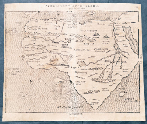
1597 Heinrich Bunting Rare Antique Map of The whole Continent of Africa
Antique Map
- Title : Africa Tertia Pars Terrae
- Ref #: 61200
- Size: 13 3/4in x 11 3/4in (350mm x 300mm)
- Date : 1597
- Condition: (A) Very Good Condition
Description:
This scarce striking original antique woodcut map of Africa was published in the 1597 edition of the German theologian Heinrich Buntings Itinerarium Sacrae.
The pattern of rivers and major place names are modeled on those on the 1540 Africa map of Sebastian Münster, but these were necessarily distorted to fit the unusual outline of the continent as presented here. The ocean is engraved with distinctive wavy lines, and is decorated with a sailing ship, a merman, and what appears to be a swan. Cities marked on the map include Alexandria, Memphis, Cairo - and the Kingdom of the legendary Prester John.
General Description:
Paper thickness and quality: - Heavy and stable
Paper color: -
Age of map color: -
Colors used: -
General color appearance: -
Paper size: - 13 3/4in x 11 3/4in (350mm x 300mm)
Plate size: - 13 3/4in x 11 3/4in (350mm x 300mm)
Margins: - Min 1/8in (3mm)
Imperfections:
Margins: - Age toning
Plate area: -Age toning, 4 small worm holes
Verso: - Medium age toning, 3 old small re-enforcements on verso not affecting the image. Top left margin cropped close to border
Background:
This map is based on the first modern map of Africa, which featured in Sebastian Münster’s Geographia (1540) and Cosmographia (1544). The map shows the entire continent along with the Sinai Peninsula, part of the Arabian Peninsula, and the southern edge of the Iberian Peninsula. Several large cities are marked with clusters of European-style buildings, including church steeples. Rolling mountain ranges break up the interior, along with massive rivers.
The largest of these is of course the Nile River. It flows from the southern interior of the continent to the north. Following the Ptolemaic model that was also used in Münster’s earlier map, the Nile originates in the Montes Lunae, or the Mountains of the Moon. Bunting also locates Prester John’s kingdom near the Mountains of the Moon.
One of the most distinct toponyms is Elephantophagi, near what is today the Congo. This refers to a tribe discussed by Strabo and Pliny who supposedly hunted and ate elephants and traded their hides and tusks across Africa.
At sea, the water is carved in aesthetically pleasing zig-zag lines. A large ship is joined by a merman and a swan.
Heinrich Bünting (Hannover, 1545-1606)
Heinrich Bünting was a protestant pastor and theologian. He was also a brewer in Hannover, and he was concerned with history and wrote a Braunschweigische Chronica in 1584. His main work was the popular Itinerarium Sacrae Scripturae, which after the first edition in Magdeburg in 1581 had many editions in German, Latin, Dutch, Swedish, Danish, Czech and English.
The book gave an overview of biblical geography based on the travel descriptions of various notable people from the Old and New Testaments. It contained ten woodcut maps, including three figurative maps: the world depicted as a cloverleaf with Jerusalem in the centre, Europe in the shape of a crowned woman, and Asia as the winged horse Pegasus.
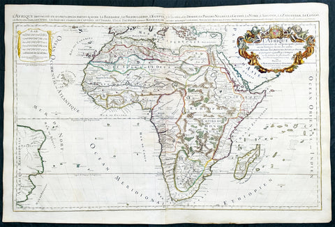
1719 Jaillot Very Large Antique Map of Africa
Antique Map
- Title : L'Afrique Divisee Suivant l'Estendue de ses Principales Parties...Alexis Hubert Jaillot. 1719
- Ref #: 35657
- Size: 37in x 25in (940mm x 635mm)
- Date : 1719
- Condition: (A+) Fine Condition
Description:
This very large, beautifully hand coloured original antique map of Africa was engraved in 1719 - dated in title - and was published by Hubert Jaillot in the last edition of his monumental Atlas Nouveau.
Background: After Nicolas Sanson, Hubert Jaillot and Pierre Duval were the most important French cartographers of the seventeenth & eighteenth centuries. Jaillot, originally a sculptor, became interested in geography after his marriage to the daughter of Nicolas Berey (1606-65), a famous map colourist, and went into partnership in Paris with Sanson's sons. There, from about 1669, he undertook the re-engraving, enlarging and re-publishing of the Sanson maps in sheet form and in atlases, sparing no effort to fill the gap in the map trade left by the destruction of Blaeu's printing establishment in Amsterdam in 1672. Many of his maps were printed in Amsterdam (by Pierre Mortier) as well as in Paris. One of his most important works was a magnificent sea atlas, Le Neptune François, published in 1693 and compiled in co-operation with J D Cassini. This was re-published shortly afterwards by Pierre Mortier in Amsterdam with French, Dutch and English texts, the charts having been re-engraved. Eventually, after half a century, most of the plates were used again as the basis for a revised issue published by J N Bellin in 1753.(Ref: Tooley; M&B)
General Condition:
Paper thickness and quality: - Heavy and stable
Paper color: - off white
Age of map color: - Original
Colors used: - Yellow, green, red, brown, gold.
General color appearance: - Authentic and fresh
Paper size: - 37in x 25in (940mm x 635mm)
Plate size: - 34 1/2in x 22 1/2in (875mm x 570mm)
Margins: - Min 1/2in (10mm)
Imperfections:
Margins: - None
Plate area: - Age toning along centerfold
Verso: - Age toning
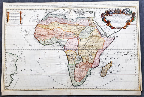
1674 Alex Jaillot Large Antique 1st edition Map of Africa - L Afrique Divisee
Antique Map
- Title : L Afrique Divisee Suivant l'Estendue de ses Principales Parties...Alexis Hubert Jaillot...1674
- Ref #: 50667
- Size: 36in x 24 1/2in (915mm x 620mm)
- Date : 1674
- Condition: (A) Very Good Condition
Description:
This large, exquisitely hand coloured, original antique 1st edition map of Africa by Alexis Hubert Jaillot - after Nicolas Sanson - was engraved in 1674 - the date is engraved in the scale cartouche.
This is a beautifully presented map, fantastic colour on sturdy & heavy paper with a deep clear impression, signifying a very early pressing.
This 1st edition map is not to be confused with the later smaller more common version of the map published by A.H. Jaillot. There are 5 editions of this map published in 1674, 1685, 1690, 1692 & 1695.
General Description:
Paper thickness and quality: - Heavy and stable
Paper color: - off white
Age of map color: - Original
Colors used: - Yellow, green, red, orange.
General color appearance: - Authentic and fresh
Paper size: - 36in x 24 1/2in (915mm x 620mm)
Plate size: - 35in x 23in (890mm x 585mm)
Margins: - Min 1/2in (25mm)
Imperfections:
Margins: - Light age toning in margins, bottom margin corners cropped
Plate area: - Light age toning & creasing along centerfold
Verso: - Light age toning & creasing along centerfold
Background: Being part of the Mediterranean world, the northern coasts of the African continent as far as the Straits of Gibraltar and even round to the area of the Fortunate Isles (the Canaries) were reasonably well known and quite accurately mapped from ancient times. In particular, Egypt and the Nile Valley were well defined and the Nile itself was, of course, one of the rivers separating the continents in medieval T-O maps. Through Arab traders the shape of the east coast, down the Red Sea as far as the equator, was also known but detail shown in the interior faded into deserts with occasional mountain ranges and mythical rivers. The southern part of the continent, in the Ptolemaic tradition, was assumed to curve to the east to form a land-locked Indian Ocean. The voyages of the Portuguese, organized by Henry the Navigator in the fifteenth century, completely changed the picture and by the end of the century Vasco da Gama had rounded the Cape enabling cartographers to draw a quite presentable coastal outline of the whole continent, even if the interior was to remain largely unknown for the next two or three centuries.
After Nicolas Sanson, Hubert Jaillot and Pierre Duval were the most important French cartographers of the seventeenth centuries. Jaillot, originally a sculptor, became interested in geography after his marriage to the daughter of Nicolas Berey (1606-65), a famous map colourist, and went into partnership in Paris with Sanson's sons. There, from about 1669, he undertook the re-engraving, enlarging and re-publishing of the Sanson maps in sheet form and in atlases, sparing no effort to fill the gap in the map trade left by the destruction of Blaeu's printing establishment in Amsterdam in 1672. Many of his maps were printed in Amsterdam (by Pierre Mortier) as well as in Paris. One of his most important works was a magnificent sea atlas, Le Neptune François, published in 1693 and compiled in co-operation with J D Cassini. This was re-published shortly afterwards by Pierre Mortier in Amsterdam with French, Dutch and English texts, the charts having been re-engraved. Eventually, after half a century, most of the plates were used again as the basis for a revised issue published by J N Bellin in 1753.(Ref: Tooley; M&B)
1759 J.B. D' Anville Large Original Antique Map of Africa - Beautiful
Antique Map
- Title : Afrique Publiee sous les Auspices de Monseigneur le Duc D\'Orleans Premier Prince du Sang Par le Sr D Anville MDCCXLIX
- Date : 1759
- Condition: (A) Very Good Condition
- Ref: 92322
- Size: 40in x 40in (1.02m x 1.02m)
Description:
This large finely engraved and highly detailed original antique map of Africa by Jean Baptiste Bourguignon D'Anville was engraved in 1759 - dated in the tile cartouche - by Guillaume Delahaye and was published D'Anville's large elephant folio Atlas Generale.
This is one of the largest and most influential maps of Africa to appear in the mid-18th century. Anville\'s map covers the entire continent of Africa from the Mediterranean to the Cape of Good Hope and from the Cape Verde Islands to Madagascar. Anville was a careful cartographer known for his scientific approach to mapmaking, and nowhere is this more evident than in this, his greatest and most innovative map of Africa. Following the trajectory set by Guillaume de L\'Isle half a century earlier, D\'Anville takes a number of significant steps forward in addressing the confusions inherent in mapping this vast though mostly, in the mid-17th century, unexplored continent. These include unreliable cartographic suppositions regarding the African interior dating practically to antiquity. Many of these, including such speculative ideas as the \'Mountains of Kong,\' have been diminished if not removed entirely from this map, leaving vast unexplored areas throughout.
What was known of Africa, however, Anville incorporates here in an impressive compilation of the most up to date reports from colonial, missionary, and exploratory entradas into the interior of the continent. Thus well mapped parts of the continent are limited to the Mediterranean Coast, Morocco, the Senegambia, the Congo, South Africa, the Kingdom of Monomatapa, Abyssinia, and egypt. Morocco, egypt, and the southern Mediterranean Coast (Barbary) were well known to europeans since antiquity and Anville\'s accurate mapping of these regions reflects continual contact. Further south the colonial enclaves along the Niger River (Senegal and Gambia), the Congo River, and South Africa reflect considerable detail associated with european penetration by trader and missionaries. The land of Monomopota around the Zambezi River was explored early in the 16th century by the Portuguese in hopes that the legendary gold mines supposedly found there would counterbalance the wealth flowing into Spain from the New Word. Unfortunately these mines, often associated with the Biblical kingdom of Ophir, were mostly tapped out by the 15th century. Abyssinia (modern day ethiopia) was mapped in detail by early Italian missionaries and of considerable interest to europeans first, because it was (and is) predominantly Christian; second, because it was a powerful well-organized and unified kingdom; and third because the sources of the Blue Nile were to be found here.
The remainder of the continent remained largely speculative though Anville rarely lets his imagination get the upper hand. He does however follow the well-established Ptolemaic model laid down in the Geographica regarding the sources of the White Nile – here seen as two lakes at the base of the semi-apocryphal Mountains of the Moon. However, he also presents a curious network of interconnected rivers extending westward from the confused course of the White Nile following the popular 18th century speculation that the Nile may be connected to the Niger. To his credit Anville does not advocate this and offers no true commerce between the two river systems.
Lake Malawi, here identified as Maravi, appears in a long thin embryonic state that, though it had not yet been \'discovered,\' is remarkably accurate to form. Lake Malawi was not officially discovered until Portuguese trader Candido Jose da Costa Cardoso stumbled upon it in 1849 – one hundred years following Anville\'s presentation of the lake here. Anville\'s inclusion of Lake Malawi is most likely a prescient interpretation of indigenous reports brought to europe by 17th century Portuguese traders. Its form would be followed by subsequent cartographers well into the mid-19th century when the explorations of John Hanning Speke, David Livingstone, Richard Francis Burton and others would at last yield a detailed study of Africa\'s interior.
General Definitions:
Paper thickness and quality: - Heavy and stable
Paper color : - off white
Age of map color: - Original & later
Colors used: - Yellow, green, blue, pink
General color appearance: - Authentic
Paper size: - 40in x 40in (1.02m x 1.02m)
Plate size: - 39in x 39in (1.0m x 1.0m)
Margins: - Min 1/2in (12mm)
Imperfections:
Margins: - None
Plate area: - Light spotting bottom of image, folds as issued, light toning along folds
Verso: - Light spotting bottom of image, folds as issued, light toning along folds
Background:
Being part of the Mediterranean world, the northern coasts of the African continent as far as the Straits of Gibraltar and even round to the area of the Fortunate Isles (the Canaries) were reasonably well known and quite accurately mapped from ancient times. In particular, Egypt and the Nile Valley were well defined and the Nile itself was, of course, one of the rivers separating the continents in medieval T-O maps. Through Arab traders the shape of the east coast, down the Red Sea as far as the equator, was also known but detail shown in the interior faded into deserts with occasional mountain ranges and mythical rivers. The southern part of the continent, in the Ptolemaic tradition, was assumed to curve to the east to form a land-locked Indian Ocean. The voyages of the Portuguese, organized by Henry the Navigator in the fifteenth century, completely changed the picture and by the end of the century Vasco da Gama had rounded the Cape enabling cartographers to draw a quite presentable coastal outline of the whole continent, even if the interior was to remain largely unknown for the next two or three centuries.
The first separately printed map of Africa (as with the other known continents) appeared in Munster\'s Geographia from 1540 onwards and the first atlas devoted to Africa only was published in 1588 in Venice by Livio Sanuto, but the finest individual map of the century was that engraved on 8 sheets by Gastaldi, published in Venice in 1564. Apart from maps in sixteenth-century atlases generally there were also magnificent marine maps of 1596 by Jan van Linschoten (engraved by van Langrens) of the southern half of the continent with highly imaginative and decorative detail in the interior. In the next century there were many attractive maps including those of Mercator/Hondius (1606), Speed (1627), Blaeu (1 630), Visscher (1636), de Wit (c. 1670), all embellished with vignettes of harbours and principal towns and bordered with elaborate and colourful figures of their inhabitants, but the interior remained uncharted with the exception of that part of the continent known as Ethiopia, the name which was applied to a wide area including present-day Abyssinia. Here the legends of Prester John lingered on and, as so often happened in other remote parts of the world, the only certain knowledge of the region was provided by Jesuit missionaries. Among these was Father Geronimo Lobo (1595-1678), whose work A Voyage to Abyssinia was used as the basis for a remarkably accurate map published by a German scholar, Hiob Ludolf in 1683. Despite the formidable problems which faced them, the French cartographers G. Delisle (c. 1700-22), J. B. B. d\'Anville (1727-49) and N. Bellin (1754) greatly improved the standards of mapping of the continent, improvements which were usually, although not always, maintained by Homann, Seutter, de Ia Rochette, Bowen, Faden and many others in the later years of the century. (Ref: Tooley; M&B)
1690 Nicolas Visscher Large Original Antique Map of Africa
Antique Map
- Title : Africae Accurata Tabula ex officina...Nic Visscher
- Date : 1690
- Size: 24 1/2in x 21in (620mm x 535mm)
- Ref #: 61158
- Condition: (A+) Fine Condition
Description:
This large beautifully hand coloured original antique map of Africa was published by Nicholas Visscher in 1690.
This is a fine map with beautiful hand colouring on strong sturdy paper with original margins & a fresh deep impression denoting an early pressing.
General Description:
Paper thickness and quality: - Heavy and stable
Paper color: - off white
Age of map color: - Original
Colors used: - Red, yellow, green, blue
General color appearance: - Authentic
Paper size: - 24 1/2in x 21in (620mm x 535mm)
Plate size: - 21 1/2in x 17 1/4in (540mm x 435mm)
Margins: - Min 1in (25mm)
Imperfections:
Margins: - Top margin repair, no loss
Plate area: - None
Verso: - Old tape top & bottom margin not affecting the image
Background: The first separately printed map of Africa (as with the other known continents) appeared in Munster's Geographia from 1540 onwards and the first atlas devoted to Africa only was published in 1588 in Venice by Livio Sanuto, but the finest individual map of the century was that engraved on 8 sheets by Gastaldi, published in Venice in 1564. Apart from maps in sixteenth-century atlases generally there were also magnificent marine maps of 1596 by Jan van Linschoten (engraved by van Langrens) of the southern half of the continent with highly imaginative and decorative detail in the interior. In the next century there were many attractive maps including those of Mercator/Hondius (1606), Speed (1627), Blaeu (1 630), Visscher (1636), de Wit (c. 1670), all embellished with vignettes of harbours and principal towns and bordered with elaborate and colourful figures of their inhabitants, but the interior remained uncharted with the exception of that part of the continent known as Ethiopia, the name which was applied to a wide area including present-day Abyssinia. Here the legends of Prester John lingered on and, as so often happened in other remote parts of the world, the only certain knowledge of the region was provided by Jesuit missionaries. Among these was Father Geronimo Lobo (1595-1678), whose work A Voyage to Abyssinia was used as the basis for a remarkably accurate map published by a German scholar, Hiob Ludolf in 1683. Despite the formidable problems which faced them, the French cartographers G. Delisle (c. 1700-22), J. B. B. d'Anville (1727-49) and N. Bellin (1754) greatly improved the standards of mapping of the continent, improvements which were usually, although not always, maintained by Homann, Seutter, de Ia Rochette, Bowen, Faden and many others in the later years of the century. (M&B; Tooley)
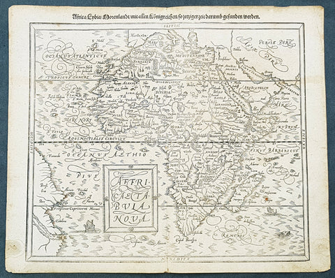
1588 Sebastian Munster Antique Map of Continental Africa
- Title : Africae tabula nova / Africa, Lybia, Morenlandt, mit allen Königreichen so jetziger zeit darumb gefunden werden
- Size: 16 1/4in x 13 1/4in (415mm x 335mm)
- Condition: (A+) Fine Condition
- Date : 1588
- Ref #: 93336
Description:
A great example of the original wood-block engraved antique map of the whole continent of Africa published by Sebastian Munster in the 1588 edition of Cosmographia.
Great map with original margins, on stable age toned paper with a nice impression.
This is Munsters 2nd map of Africa, after the Ortelius continental map of 1574. The woodblock map is elegantly engraved in the style of copper engravings. It depicts the continent with a jagged coastline with several prominent bays. In the interior there are several large lakes, including the twin lakes source of the Nile. The coast of Brazil appears in the lower left corner. Two small ships, a sea monster and a block-style title cartouche decorate the map. German text and illustration on verso.
The Cosmographia or Cosmography was first published in 1544 and is the earliest German-language description of the world.
It had numerous editions in different languages including Latin, French (translated by François de Belleforest), Italian, English, and Czech. The last German edition was published in 1628. The Cosmographia was one of the most successful and popular books of the 16th century and passed through 24 editions in 100 years. This success was due to the notable woodcuts (some by Hans Holbein the Younger, Urs Graf, Hans Rudolph Manuel Deutsch, and David Kandel). It was most important in reviving geography in 16th-century Europe. Among the notable maps within Cosmographia is the map Die Newe Welt oder Inseln, which is credited as the first map to show the American continents as geographically unique.
Munsters earlier geographic works were Germania descriptio (1530) and Mappa Europae (1536). In 1540, he published a Latin edition of Ptolemys Geographia, with numerous illustrations.
General Definitions:
Paper thickness and quality: - Heavy and stable
Paper color : - off white
Age of map color: -
Colors used: -
General color appearance: -
Paper size: - 16 1/4in x 13 1/4in (415mm x 335mm)
Plate size: - 16 1/4in x 13 1/4in (415mm x 335mm)
Margins: - Min 1/2in (12mm)
Imperfections:
Margins: - Light age toning
Plate area: - Light age toning
Verso: - Light age toning, 2 very small repairs to margins not affecting image
Background:
The first separately printed map of Africa (as with the other known continents) appeared in Munster\'s Geographia from 1540 onwards and the first atlas devoted to Africa only was published in 1588 in Venice by Livio Sanuto, but the finest individual map of the century was that engraved on 8 sheets by Gastaldi, published in Venice in 1564. Apart from maps in sixteenth-century atlases generally there were also magnificent marine maps of 1596 by Jan van Linschoten (engraved by van Langrens) of the southern half of the continent with highly imaginative and decorative detail in the interior. In the next century there were many attractive maps including those of Mercator/Hondius (1606), Speed (1627), Blaeu (1 630), Visscher (1636), de Wit (c. 1670), all embellished with vignettes of harbours and principal towns and bordered with elaborate and colourful figures of their inhabitants, but the interior remained uncharted with the exception of that part of the continent known as Ethiopia, the name which was applied to a wide area including present-day Abyssinia. Here the legends of Prester John lingered on and, as so often happened in other remote parts of the world, the only certain knowledge of the region was provided by Jesuit missionaries. Among these was Father Geronimo Lobo (1595-1678), whose work A Voyage to Abyssinia was used as the basis for a remarkably accurate map published by a German scholar, Hiob Ludolf in 1683. Despite the formidable problems which faced them, the French cartographers G. Delisle(c. 1700-22), J. B. B. d\'Anville (1727-49) and N. Bellin (1754) greatly improved the standards of mapping of the continent, improvements which were usually, although not always, maintained by Homann, Seutter, de Ia Rochette, Bowen, Faden and many others in the later years of the century.
Sebastian Petri re-release of Cosomgraphia in 1588 produced some fine woodcut maps in the \"copperplate style\". The maps in this release were more sophisticated than with earlier publications of Cosomgraphia and were based on the 1570 release of Abraham Ortelius monumental work Theatrum Orbis Terrarum. (Ref: M&B;Tooley)
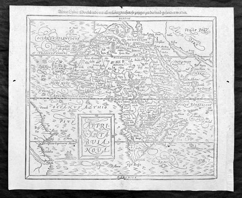
1588 Sebastian Munster Antique Map of Africa
Antique Map
- Title : Africae tabula nova / Africa, Lybia, Morenlandt, mit allen Königreichen so jetziger zeit darumb gefunden werden
- Ref: 35664
- Condition: (A+) Fine Condition
- Size: 16 1/2in x 13 1/2in (420mm x 340mm)
- Date : 1588
Description:
A great example of the original wood-block engraved antique map of the whole continent of Africa published by Sebastian Munster in the 1588 edition of Cosmographia.
This is Munsters 2nd map of Africa, after the Abraham Ortelius continental map of 1574. The woodblock map is elegantly engraved in the style of copper engravings. It depicts the continent with a jagged coastline with several prominent bays. In the interior there are several large lakes, including the twin lakes source of the Nile. The coast of Brazil appears in the lower left corner. Two small ships, a sea monster and a block-style title cartouche decorate the map. German text and illustration on verso.
The Cosmographia or Cosmography was first published in 1544 and is the earliest German-language description of the world.
It had numerous editions in different languages including Latin, French (translated by François de Belleforest), Italian, English, and Czech. The last German edition was published in 1628. The Cosmographia was one of the most successful and popular books of the 16th century and passed through 24 editions in 100 years. This success was due to the notable woodcuts (some by Hans Holbein the Younger, Urs Graf, Hans Rudolph Manuel Deutsch, and David Kandel). It was most important in reviving geography in 16th-century Europe. Among the notable maps within Cosmographia is the map Die Newe Welt oder Inseln, which is credited as the first map to show the American continents as geographically unique.
Munsters earlier geographic works were Germania descriptio (1530) and Mappa Europae (1536). In 1540, he published a Latin edition of Ptolemys Geographia, with numerous illustrations.
General Definitions:
Paper thickness and quality: - Heavy and stable
Paper color : - off white
Age of map color: -
Colors used: -
General color appearance: -
Paper size: - 16 1/2in x 13 1/2in (420mm x 340mm)
Plate size: - 16 1/2in x 13 1/2in (420mm x 340mm)
Margins: - Min 1/2in (12mm)
Imperfections:
Margins: - Small extension to bottom right corner margin, repair to bottom centerfold, not affecting image.
Plate area: - 2 very small worm holes
Verso: - Repairs as noted
Background:
The first separately printed map of Africa (as with the other known continents) appeared in Munster\'s Geographia from 1540 onwards and the first atlas devoted to Africa only was published in 1588 in Venice by Livio Sanuto, but the finest individual map of the century was that engraved on 8 sheets by Gastaldi, published in Venice in 1564. Apart from maps in sixteenth-century atlases generally there were also magnificent marine maps of 1596 by Jan van Linschoten (engraved by van Langrens) of the southern half of the continent with highly imaginative and decorative detail in the interior. In the next century there were many attractive maps including those of Mercator/Hondius (1606), Speed (1627), Blaeu (1 630), Visscher (1636), de Wit (c. 1670), all embellished with vignettes of harbours and principal towns and bordered with elaborate and colourful figures of their inhabitants, but the interior remained uncharted with the exception of that part of the continent known as Ethiopia, the name which was applied to a wide area including present-day Abyssinia. Here the legends of Prester John lingered on and, as so often happened in other remote parts of the world, the only certain knowledge of the region was provided by Jesuit missionaries. Among these was Father Geronimo Lobo (1595-1678), whose work A Voyage to Abyssinia was used as the basis for a remarkably accurate map published by a German scholar, Hiob Ludolf in 1683. Despite the formidable problems which faced them, the French cartographers G. Delisle(c. 1700-22), J. B. B. d\'Anville (1727-49) and N. Bellin (1754) greatly improved the standards of mapping of the continent, improvements which were usually, although not always, maintained by Homann, Seutter, de Ia Rochette, Bowen, Faden and many others in the later years of the century.
Sebastian Petri re-release of Cosomgraphia in 1588 produced some fine woodcut maps in the copperplate style. The maps in this release were more sophisticated than with earlier publications of Cosomgraphia and were based on the 1570 release of Abraham Ortelius monumental work Theatrum Orbis Terrarum. (Ref: M&B;Tooley)
Please note all items auctioned are genuine, we do not sell reproductions. A Certificate of Authenticity (COA) can be issued on request.
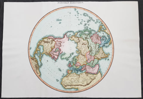
1812 Pinkerton Large Antique Stereographic Projection Map of Northern Hemisphere
- Title : Northern Hemisphere....Neele Sculp. 352 Strand.....London Published October 1st 1812 by Cadell & Davies Strand & Longman. Hurst. Rees.Orme & Brown. Paternaster Row
- Ref #: 60542
- Size: 31in x 22in (790mm x 560mm)
- Date : 1812
- Condition: (A+) Fine Condition
Description:
This large magnificent hand coloured original copper-plate engraved antique stereographic projection style map of the Northern Hemisphere, North America, Canada, Europe, Asia, Africa & The North Pole by John Pinkerton was engraved by Samuel Neele in 1812 - dated at the foot of the map - and published in Pinkertons large elephant folio Modern Atlas, published between 1809 - 14. (Ref: Tooley, M&B)
General Definitions:
Paper thickness and quality: - Heavy and stable
Paper color : - off white
Age of map color: - Original
Colors used: - Blue, pink, red, green, yellow
General color appearance: - Authentic
Paper size: - 31in x 22in (790mm x 560mm)
Plate size: - 31in x 22in (790mm x 560mm)
Margins: - Min 1in (25mm)
Imperfections:
Margins: - None
Plate area: - None
Verso: - None
Background:
In geometry, the stereographic projection is a particular mapping (function) that projects a sphere onto a plane. The projection is defined on the entire sphere, except at one point: the projection point. Where it is defined, the mapping is smooth and bijective. It is conformal, meaning that it preserves angles at which curves meet. It is neither isometric nor area-preserving: that is, it preserves neither distances nor the areas of figures.
Intuitively, then, the stereographic projection is a way of picturing the sphere as the plane, with some inevitable compromises. Because the sphere and the plane appear in many areas of mathematics and its applications, so does the stereographic projection; it finds use in diverse fields including complex analysis, cartography, geology, and photography. In practice, the projection is carried out by computer or by hand using a special kind of graph paper called a stereographic net, shortened to stereonet, or Wulff net.
The stereographic projection was known to Hipparchus, Ptolemy and probably earlier to the Egyptians. It was originally known as the planisphere projection. Planisphaerium by Ptolemy is the oldest surviving document that describes it. One of its most important uses was the representation of celestial charts. The term planisphere is still used to refer to such charts.
In the 16th and 17th century, the equatorial aspect of the stereographic projection was commonly used for maps of the Eastern and Western Hemispheres. It is believed that already the map created in 1507 by Gualterius Lud was in stereographic projection, as were later the maps of Jean Roze (1542), Rumold Mercator (1595), and many others. In star charts, even this equatorial aspect had been utilised already by the ancient astronomers like Ptolemy.
François d\'Aguilon gave the stereographic projection its current name in his 1613 work Opticorum libri sex philosophis juxta ac mathematicis utiles (Six Books of Optics, useful for philosophers and mathematicians alike).
In 1695, Edmond Halley, motivated by his interest in star charts, published the first mathematical proof that this map is conformal. He used the recently established tools of calculus, invented by his friend Isaac Newton.
Pinkerton, John 1758 – 1826
Pinkerton was a Scottish antiquarian, cartographer, author, numismatist, historian, and early advocate of Germanic racial supremacy theory.
He was born in Edinburgh, as one of three sons to James Pinkerton. He lived in the neighbourhood of that city for some of his earliest childhood years, but later moved to Lanark. His studious youth brought him extensive knowledge of the Classics, and it is known that in his childhood years he enjoyed translating Roman authors such as Livy. He moved on to Edinburgh University, and after graduating, remained in the city to take up an apprenticeship in Law. However, his scholarly and literary inclinations led him to abandon the legal profession. It had been during his brief legal career though that he had begun writing, his Elegy on Craigmillar Castle being first published in 1776.
Pinkerton was a celebrated master of the Edinburgh school of cartography which lasted from roughly 1800 to 1830. Pinkerton, along with John Thomson & Co. and John Cary, redefined cartography by exchanging the elaborate cartouches and fantastical beasts used in the 18th century for more accurate detail. Pinkertons main work was the \\\"Pinkerton\\\'s Modern Atlas\\\" published from 1808 through 1815 with an American version by Dobson & Co. in 1818. Pinkerton maps are today greatly valued for their quality, size, colouration, and detail.
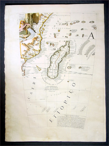
1696 Coronelli Antique Map Globe Gore Section of SE Africa & Madagascar
Antique Map
- Title : Cafri Etiopico
- Date : 1696
- Condition: (A+) Fine Condition
- Ref: 30781
- Size: 19 1/2in x 14in (495mm x 355mm)
Description:
This is a rare opportunity to acquire one of the hand coloured original antique Globe Gores of Madagascar & SE Africa by Vincenzo Coronelli published in 1696.
The copper-plates for these gores were originally engraved in 1688 by Coronelli for the construction of the large 42in (110cm) terrestrial globe.
In 1696 Coronelli published all his gores - from the 2in to the 42 in - in an atlas, Libero dei Globi, part of the great series of atlases,Atlante Veneto. Libero dei Globi was published by Coronelli to ensure his work was available to a wider audience, as very few could afford travel to Venice, Rome or Paris to view his completed globes.
Background:
In the early 1680’s Vincenzo Coronelli constructed two vast 15ft diameter terrestrial & celestial globes for Louis XIV of France. These were meticulously hand drawn & engraved. Such was the admiration of these Globes that in 1688 Coronelli began the engraving & publication of Globe Gores for the construction of two 110cm (42in) terrestrial & celestial globes.
Coronellis claim to have produced the best globes of any age was exemplified by the high demand and purchase of the globes by various institutions & cities within Europe. Yet many scholars still did not have the opportunity to visit Paris, London, Rome or Venice to view them and so Coronelli devised his famous atlas Libero dei Globi the first atlas of globe gores ever produced. The Libroformed part of a great series of atlases by Coronelli, the Atlante Veneto, in which Coronelli was able to combine the two cartographic art forms in which he excelled, maps & globes.
The engraving of the gores was of the highest standard with neat contrasting lettering and five large cartouches of a singular grace and elegance. One cartouche situated below Australia carries a portrait of the author and Pope Alexander VI.
Some of the more interesting features contained within the Gores are the recording of recent French explorations in North America, such as La Salles journey to the mouth of the Mississippi in 1681-87 & the French possessions within North America. Elsewhere the Caspian Sea is drawn closer to its modern shape, the Nile in Africa is shown without its fictitious source and the Blue Nile is shown correctly from a large lake in Ethiopia. The tracks of Le Maire crossing of the Pacific in 1616 are marked, as is the voyage of Chaumont to Siam in 1685-6. There are an unusual number of legends, all explanatory and informative along with many vignettes of ships and fishing scenes throughout the globe.
Coronelli was one of the finest engravers & cartographers of any era, producing some of the most stunning work ever seen. These Globe Gores are no exception. Coronelli was a master craftsman with an eye for detail. You can feel the uncompromising accuracy & passion in his work when you study his maps & globes.
These globe gores are scarce, with only a few sales records from the last 25 years. Similarly there is very little choice currently on the market. This scarcity ensures ongoing value and future appreciation. (Ref: Shirley 538; Tooley; Dr. Helen Wallis The Map Collector Dec 1980;Armao, Ermanno. Vincenzo Coronelli Cenni sull'uomo e la sua Vita Catalogo... Bibliopolis, Florence pp.130-134)
General Description:
Paper thickness and quality: - Heavy and stable
Paper color: - white
Age of map color: - Early
Colors used: - Yellow, green, blue
General color appearance: - Authentic
Paper size: - 19 1/2in x 14in (495mm x 355mm)
Plate size: - 19in x 11 1/2in (485mm x 290mm)
Margins: - min. 1/2in (12mm)
Imperfections:
Margins: - Light age toning
Plate area: - None
Verso: - None
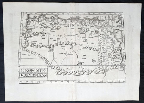
1525 Laurent Fries Antique Map NE Africa Red Sea, Egypt, Nile River Delta, Libya
- Title : Libyae Interioris Pars....Tabula III Aphricae
- Ref #: 93378
- Size: 22 1/2in x 16 1/2in (565mm x 420mm)
- Date : 1525
- Condition: (A+) Fine Condition
Description:
This rare very early original wood-block engraved antique Ptolemaic map of North East Africa from The Red Sea, Egypt, The Nile Delta & Libya by Laurent Fries was published by in the 1525 Strasbourg edition of Ptolemys Geographia
Striking early map of North Africa and Egypt, from the Red Sea, the Nile and Egypt to the Gulf of Libya. Extends up rivers along the Nile to Aden.
Latin text and elaborate decorations on the verso. A nice example, from the 1525 edition of Fries Atlas. First published in Strasbourg by Johannes Gruninger in 1522, Fries map is based upon Waldseemullers map of 1513.
Lorenz (Laurent) Fries was born in Alsace in about 1490. He studied medicine, apparently spending time at the universities of Pavia, Piacenza, Montpellier and Vienna. After completing his education, Fries worked as a physician in several places, before settling in Strassburg, in about 1519. While n Strassburg, Fries met the Strasbourg printer and publisher Johann Grüninger, an associate of the St. Die group of scholars formed by, among others, Walter Lud, Martin Ringmann and Martin Waldseemuller.
From 1520 to 1525, Fries worked with Gruninger as a cartographic editor, exploiting the corpus of material that Waldseemuller had created. Fries first venture into mapmaking was in 1520, when he executed a reduction of Martin Waldseemullers wall-map of the World, published in 1507. While it would appear that Fries was the editor of the map, credit is actually given in the title to Peter Apian. The map, Tipus Orbis Universalis Iuxta Ptolomei Cosmographi Traditionem Et America Vespucii Aliorque Lustrationes A Petro Apiano Leysnico Elucubrat. An.o Dni MDXX, and was issued in Caius Julius Solinus Enarrationes, edited by Camers, and published in Vienna in 1520.
Fries next project that Fries was a new edition of the Geographia of Claudius Ptolemy, which was published by Johann Koberger in 1522. Fries evidently edited the maps, in most cases simply producing a reduction of the equivalent map from Waldseemullers 1513 edition of the Geographie Opus Novissima, printed by Johann Schott. Fries also prepare three new maps for the Geographie: maps of South-East Asia and the East Indies, China and the World, but the geography of these derives from Waldseemullers world map of 1507.
The 1522 edition of Fries work is very rare, suggesting that the work was not commercially successful. In 1525, an improved edition was issued, with a re-edit of the text by Wilibald Pirkheimer, from the notes of Johannes Regiomontanus. After Grüningers death in 1531, the business was continued by his son Christoph, who seems to have sold the materials for the Ptolemy to two Lyon publishers, the brothers Melchior and Gaspar Trechsel, who published a joint edition in 1535, before Gaspar Trechsel published an edition in his own right in 1541.
General Definitions:
Paper thickness and quality: - Heavy and stable
Paper color : - off white
Age of map color: -
Colors used: -
General color appearance: -
Paper size: - 22 1/2in x 16 1/2in (565mm x 420mm)
Plate size: - 18 1/2in x 12 1/2in (475mm x 320mm)
Margins: - Min 1 1/2in (20mm)
Imperfections:
Margins: - None
Plate area: - Light soiling along centerfold
Verso: - None
Background:
Claude Ptolemy - a Greek mathematician, astronomer and geographer, living in Alexandria, assembled and codified his predecessors\' cartographic theories including those of Strabo & Marinus of Tyre (c. AD 120) to whom he was especially indebted. In about AD 150 he published his Geographia, a work in 8 volumes, supposedly illustrated with a world map, 26 regional maps and a profusion of smaller maps. Although the text of the Geographia survived, no maps older than about the twelfth century have come down to us and, in consequence, we have no means of knowing whether the \'Ptolemy\' maps on which we set so much store were, in fact, drawn by him or were the interpretations of later map makers using his text as a basis.
In Europe the initial awakening of interest in geography arose from the revival of knowledge of Ptolemy\'s Geographia soon after the year 1400. Greek manuscript copies made in the twelfth to fourteenth centuries were brought by scholars to Italy from Constantinople and were subsequently translated into Latin and widely studied. This work coincided with, and was much influenced by, the development of printing techniques, particularly, of course, by the invention of movable-type printing by Gutenberg about 1450, which made possible for the first time the production of printed books in quantity. Apart from this factor, other more far-reaching influences were compelling the peoples of Western Europe to look beyond the horizon they had known for so many centuries. With the conquest of Constantinople in 1453 the Turks effectively closed Europe\'s trade routes to the East and shut off access to traditional sources of luxuries and precious metals from Asia and, above all, denied the supply of the spices which had become so important in the lives of ordinary people. Other factors often based on long-believed myths and legends added to the urge to break out into the unknown world.
The interpretation of Ptolemy\'s text began mainly with the Italians Angelus, Beroaldus & Vadius in 1477 and was re-interpreted and re-issued by many over the next century by the likes Waldseemuller 1513, Gastaldi 1548, Mercator 1578 & Magini 1596. (Ref: Tooley; M&B; Dover)
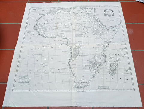
1765 Emmanuel Bowen Very Large Antique Map of Africa
Antique Map
- Title : Africa Performed by the Sr D Anville under the Patronage of the Duke of Orleansrevised and improved by Mr Bolton...E Bowen
- Date : 1765
- Size: 47in x 41in (1.20m x 1.04m)
- Ref #: 40910-1
- Condition: (A+) Fine Condition
Description:
This very large 4 sheet original copper plate engraved antique map of Africa by Solomon Bolton after the French cartographer Jean Baptiste Bourguignon D Anville, was engraved by Emmanuel Bowen and published in the 1765 edition of Malachy Postlethweyts monumental 2 Volume tomes on The Universal Dictionary of Trade & Commerce concentrating on various states of trade, including slavery, between England and America published between 1751 & 1774.
Malachy Postlethweyt 1707 – 1767
Malachy Postlethweyts Dictionary of Trade & Commerce:
A monumental dictionary of trade and commerce. It is based in part on the Dictionnaire universel de Commerce (Paris: 1723-30) of Jacques Savary de Bruslon, under whose name it is often catalogued, but has been adapted by Postlethwayt for a British audience, with substantial enlargements and improvements, and entirely new material relating to England and her colonies. Postlethwayt devoted twenty years to the preparation of the dictionary, which was first published in 1751-55 & includes a description of British affairs in North America since the peace of 1763.
As with his other works, the dictionary demonstrates Postlethway’s deep commitment to the expansion and strengthening of English trade. Included are entries for geographical locations (Africa, Antilles, Canada, Japan, Louisiana, &c.), products (brandy, cardamom, codfish, diamonds, sugar, &c.), trading companies (Dutch East India Company, English African Company, &c.), treaties of commerce, and a vast range of other information of value to merchants (bankruptcy, currency, bills of exchange, brokerage, exportation, landed interest, privateering, &c.). The Dictionary is also important for containing almost the whole substance of Richard Cantillons Essay on Commerce, its first appearance in print.
General Definitions:
Paper thickness and quality: - Heavy and stable
Paper color : - off white
Age of map color: -
Colors used: -
General color appearance: -
Paper size: - 47in x 41in (1.20m x 1.04m)
Plate size: - 40in x 39in (1.10m x 990mm)
Margins: - Min 1in (25mm)
Imperfections:
Margins: - None
Plate area: - Light age toning left fold
Verso: - None
Background:
This is one of the largest and most influential maps, of Africa, to appear in the mid-18th century. Engraved by Emmanuel Bowen after J.B. D Anville, the map covers the entire continent of Africa from the Mediterranean to the Cape of Good Hope and from the Cape Verde Islands to Madagascar. D Anville was a careful cartographer known for his scientific approach to map-making, and nowhere is this more evident than in this, one of his greatest and most innovative maps of Africa. Following the trajectory set by Guillaume de L Isle half a century earlier, D Anville takes a number of significant steps forward in addressing the confusions inherent in mapping this vast though mostly, in the mid-17th century, unexplored continent. These include unreliable cartographic suppositions regarding the African interior dating practically to antiquity. Many of these, including such speculative ideas as the Mountains of Kong, have been diminished if not removed entirely from this map, leaving vast unexplored areas throughout.
What was known of Africa, however, D Anville incorporates here in an impressive compilation of the most up to date reports from colonial, missionary, and exploratory entradas into the interior of the continent. Thus well mapped parts of the continent are limited to the Mediterranean Coast, Morocco, the Senegambia, the Congo, South Africa, the Kingdom of Monomatapa, Abyssinia, and egypt. Morocco, egypt, and the southern Mediterranean Coast (Barbary) were well known to europeans since antiquity and D Anvilles accurate mapping of these regions reflects continual contact. Further south the colonial enclaves along the Niger River (Senegal and Gambia), the Congo River, and South Africa reflect considerable detail associated with European penetration by trader and missionaries. The land of Monomopota around the Zambezi River was explored early in the 16th century by the Portuguese in hopes that the legendary gold mines supposedly found there would counterbalance the wealth flowing into Spain from the New Word. Unfortunately these mines, often associated with the Biblical kingdom of Ophir, were mostly tapped out by the 15th century. Abyssinia (modern day ethiopia) was mapped in detail by early Italian missionaries and of considerable interest to Europeans first, because it was (and is) predominantly Christian; second, because it was a powerful well-organized and unified kingdom; and third because the sources of the Blue Nile were to be found here.
The remainder of the continent remained largely speculative though D Anville rarely lets his imagination get the upper hand. He does however follow the well-established Ptolemaic model laid down in the Geographica regarding the sources of the White Nile – here seen as two lakes at the base of the semi-apocryphal Mountains of the Moon. However, he also presents a curious network of interconnected rivers extending westward from the confused course of the White Nile following the popular 18th century speculation that the Nile may be connected to the Niger. To his credit Anville does not advocate this and offers no true commerce between the two river systems.
Lake Malawi, here identified as Maravi, appears in a long thin embryonic state that, though it had not yet been \\\'discovered,\\\' is remarkably accurate to form. Lake Malawi was not officially discovered until Portuguese trader Candido Jose da Costa Cardoso stumbled upon it in 1849 – one hundred years following Anvilles presentation of the lake here. Anvilles inclusion of Lake Malawi is most likely a prescient interpretation of indigenous reports brought to Europe by 17th century Portuguese traders. Its form would be followed by subsequent cartographers well into the mid-19th century when the explorations of John Hanning Speke, David Livingstone, Richard Francis Burton and others would at last yield a detailed study of Africas interior.
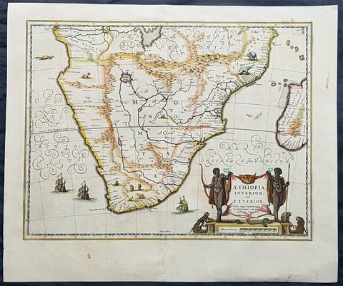
1639 Jan Jansson Large Original, Antique Map of South Africa
Antique Map
- Title : Aethiopia Inferior vel Exterior...
- Date : 1639
- Size: 23in x 19in (585mm x 485mm)
- Ref #: 43145
- Condition: (A+) Fine Condition
Description:
This fine, beautifully hand coloured original antique map of the southern & central parts of Africa, with the south-west coast of Madagascar, was published by Jan Jansson in the 1639 French edition of Gerard Mercators Gerardi Mercators Atlantis Novi.
Background: This handsome map formed the standard for the depiction of South Africa throughout the 17th century, covering the region from Congo-Zanzibar to the Cape. Both Blaeu & Jansson based this map on Portuguese exploration, most detail is confined to the coastlines. There are two large lakes in the interior, one unnamed and the other called Zachef, which is the lake out of which the Zambere (Zambesi River) flows, probably based on reports of Lake Ngami, which was not conclusively discovered until the mid 19th century. The interior shows the mythical Mountains of the Moon or Lunae Montes. Indigenous animals including elephants and monkeys are illustrated, while large galleons sail the sea. The dramatic title cartouche is drawn on an ox hide held up by natives, with monkeys and turtles at their feet.
The first separately printed map of Africa (as with the other known continents) appeared in Munster's Geographia from 1540 onwards and the first atlas devoted to Africa only was published in 1588 in Venice by Livio Sanuto, but the finest individual map of the century was that engraved on 8 sheets by Gastaldi, published in Venice in 1564. Apart from maps in sixteenth-century atlases generally there were also magnificent marine maps of 1596 by Jan van Linschoten (engraved by van Langrens) of the southern half of the continent with highly imaginative and decorative detail in the interior. In the next century there were many attractive maps including those of Mercator/Hondius (1606), Speed (1627), Blaeu (1 630), Visscher (1636), de Wit (c. 1670), all embellished with vignettes of harbours and principal towns and bordered with elaborate and colourful figures of their inhabitants, but the interior remained uncharted with the exception of that part of the continent known as Ethiopia, the name which was applied to a wide area including present-day Abyssinia. Here the legends of Prester John lingered on and, as so often happened in other remote parts of the world, the only certain knowledge of the region was provided by Jesuit missionaries. Among these was Father Geronimo Lobo (1595-1678), whose work A Voyage to Abyssinia was used as the basis for a remarkably accurate map published by a German scholar, Hiob Ludolf in 1683. Despite the formidable problems which faced them, the French cartographers G. Delisle (c. 1700-22), J. B. B. d'Anville (1727-49) and N. Bellin (1754) greatly improved the standards of mapping of the continent, improvements which were usually, although not always, maintained by Homann, Seutter, de Ia Rochette, Bowen, Faden and many others in the later years of the century. (Ref: Norwich; Tooley; M&B)
General Description:
Paper thickness and quality: - Heavy and stable
Paper color: - off white
Age of map color: - Original
Colors used: - Green, red, orange, yellow, blue
General color appearance: - Authentic
Paper size: - 23in x 19in (585mm x 485mm)
Plate size: - 20in x 15 1/2in (535mm x 395mm)
Margins: - Min 1in (25mm)
Imperfections:
Margins: - Bottom margin centerfold re-joined, no loss
Plate area: - None
Verso: - None
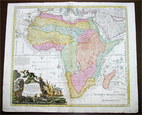
1730 Georg Mattraus Seutter Large Antique Map of Africa
Antique Map
- Title : Africa Iuxta Navigationes..Matth. Seuttero S Caes Maj Geographo Aug.
- Date : 1730
- Condition: (A) Very Good Condition
- Ref: 43003
- Size: 25 ½in x 21 ½in (650mm x 545mm)
Description:
This large beautifully hand coloured original copper-plate antique map of Africa was engraved by Tobais Lotter and published by Georg Mattraus Seutter in 1730 edition of Geographical Atlas or an Accurate Depiction of the Whole World
This striking map of Africa is based largely on Homanns 1715 map. Typical of the period, it presents largely fictitious information in southern Africa, and enormous lakes depicted in central Africa. The Nile is shown originating in the south at lakes Zaire and Zaflan and also continuing further south through a twisted river system with its headwaters in Bed Lac. The splendid decorative cartouche (uncolored) features indigenous people, pyramids and exotic animals, with a fierce dragon perched atop the title.
Condition Report
Paper thickness and quality: - Heavy and stable
Paper color: - off white
Age of map color: - Original & later
Colors used: - Yellow, pink, green, orange, blue
General color appearance: - Authentic
Paper size: - 25 ½in x 21 ½in (650mm x 545mm)
Plate size: - 23in x 20in (585mm x 510mm)
Margins: - Min 1in (25mm)
Imperfections:
Margins: - Two repairs to bottom margin, no loss
Plate area: - Two small professional repairs to center of image, not noticable
Verso: - None
Background:
The first separately printed map of Africa (as with the other known continents) appeared in Munster\'s Geographia from 1540 onwards and the first atlas devoted to Africa only was published in 1588 in Venice by Livio Sanuto, but the finest individual map of the century was that engraved on 8 sheets by Gastaldi, published in Venice in 1564. Apart from maps in sixteenth-century atlases generally there were also magnificent marine maps of 1596 by Jan van Linschoten (engraved by van Langrens) of the southern half of the continent with highly imaginative and decorative detail in the interior. In the next century there were many attractive maps including those of Mercator/Hondius (1606), Speed (1627), Blaeu (1 630), Visscher (1636), de Wit (c. 1670), all embellished with vignettes of harbours and principal towns and bordered with elaborate and colourful figures of their inhabitants, but the interior remained uncharted with the exception of that part of the continent known as Ethiopia, the name which was applied to a wide area including present-day Abyssinia. Here the legends of Prester John lingered on and, as so often happened in other remote parts of the world, the only certain knowledge of the region was provided by Jesuit missionaries. Among these was Father Geronimo Lobo (1595-1678), whose work A Voyage to Abyssinia was used as the basis for a remarkably accurate map published by a German scholar, Hiob Ludolf in 1683. Despite the formidable problems which faced them, the French cartographers G. Delisle (c. 1700-22), J. B. B. d\'Anville (1727-49) and N. Bellin (1754) greatly improved the standards of mapping of the continent, improvements which were usually, although not always, maintained by Homann, Seutter, de Ia Rochette, Bowen, Faden and many others in the later years of the century. (M&B; Tooley)
1899 Daily Map Antique Map South Africa 2nd Boer War Handkerchief R Kipling Poem
Antique Map
- Title : The Absent-Minded Beggar....South African Republic
- Ref #: 93380
- Size: 18in x 17in (465mm x 435mm)
- Date : 1899
- Condition: (A+) Fine Condition
Description:
This scarce item of ephemera, an original printed linen antique handkerchief, with a map of The South African Republic, was published in 1899 by the Daily Mail to raise funds for the Soldiers Families Fund, after the outbreak of the Second Boer War (1899-1902), the first charitable effort for a war.
The map shows the theatre of war, around the South African Republic (the Transvaal) and the Orange Free State. The two portraits are of Lord Roberts, commander of the British Troops, and Queen Victoria, the British Monarch for the first half of the war.
The poem, The Absent-Minded Beggar by Rudyard Kipling, was specially commissioned for the Fund, and was given a musical score by Arthur Sullivan (of Gilbert & Sullivan fame).
General Definitions:
Paper thickness and quality: - Heavy and stable
Paper color : - off white
Age of map color: - Original
Colors used: - Yellow, green, blue, pink
General color appearance: - Authentic
Paper size: - 18in x 17in (465mm x 435mm)
Plate size: - 18in x 17in (465mm x 435mm)
Margins: - Min 1/2in (12mm)
Imperfections:
Margins: - None
Plate area: - None
Verso: - None
Background:
Despite Roberts portait being entwined in the title, the absent-minded beggar of Kiplings poem is the British Tommy (private soldier), forgetfully leaving their dependents in need while fighting for their country. The Daily Mail paid Kipling £250 for the poem, which he donated to the fund, as did Sullivan with his £100 payment. Soon afterwards Kipling was offered a knighthood, which he declined. It was not Kiplings favourite work: in his autobiography he wrote that it lacked poetry and became wedded... to a tune guaranteed to pull teeth out of barrel-organs. This did not stop it being a huge success, giving the fund the nickname, the Absent-Minded Beggar Relief Corps, and helping it raise £340,000 by the time it was wound up in 1903. Not only was it published worldwide (the New York Journal paid $25 for the privilege), it was recited by actresses including Lily Langtree and Lady Maud Beerbohm Tree.
Organising the fund was a coup for the Daily Mail, which had been founded only in 1896. This campaign capitalised on the jingoistic mood of the British public and the papers circulation soared to over a million issues a day by 1902, the highest in the world.
This handkerchief is probably the most famous item of British ephemera produced during the South African War.
The Absent-Minded Beggar is an 1899 poem by Rudyard Kipling, set to music by Sir Arthur Sullivan and often accompanied by an illustration of a wounded but defiant British soldier, A Gentleman in Kharki, by Richard Caton Woodville. The song was written as part of an appeal by the Daily Mail to raise money for soldiers fighting in the Second Boer War and their families. The fund was the first such charitable effort for a war.
The chorus of the song exhorted its audience to pass the hat for your credits sake, and pay– pay– pay! The patriotic poem and song caused a sensation and were constantly performed throughout the war and beyond. Kipling was offered a knighthood shortly after publication of the poem but declined the honour. Vast numbers of copies of the poem and sheet music were published, and large quantities of related merchandise were sold to aid the charity.
Daily Mail Publishing Co. Ltd 1896 -
The Daily Mail, devised by Alfred Harmsworth (later Viscount Northcliffe) and his brother Harold (later Viscount Rothermere), was first published on 4 May 1896. It was an immediate success. It cost a halfpenny at a time when other London dailies cost one penny, and was more populist in tone and more concise in its coverage than its rivals. The planned issue was 100,000 copies but the print run on the first day was 397,215 and additional printing facilities had to be acquired to sustain a circulation which rose to 500,000 in 1899. Lord Salisbury, 19th-century Prime Minister of the United Kingdom, dismissed the Daily Mail as a newspaper produced by office boys for office boys. By 1902, at the end of the Boer Wars, the circulation was over a million, making it the largest in the world.
With Harold running the business side of the operation and Alfred as Editor, the Mail from the start adopted an imperialist political stance, taking a patriotic line in the Second Boer War, leading to claims that it was not reporting the issues of the day objectively. From the beginning, the Mail also set out to entertain its readers with human interest stories, serials, features and competitions (which were also the main means by which the Harmsworths promoted the paper).
In 1900 the Daily Mail began printing simultaneously in both Manchester and London, the first national newspaper to do so (in 1899, the Daily Mail had organised special trains to bring the London-printed papers north). The same production method was adopted in 1909 by the Daily Sketch, in 1927 by the Daily Express and eventually by virtually all the other national newspapers. Printing of the Scottish Daily Mail was switched from Edinburgh to the Deansgate plant in Manchester in 1968 and, for a while, The People was also printed on the Mail presses in Deansgate. In 1987, printing at Deansgate ended and the northern editions were thereafter printed at other Associated Newspapers plants.
In 1906 the paper offered £10,000 for the first flight from London to Manchester, followed by a £1,000 prize for the first flight across the English Channel. Punch magazine thought the idea preposterous and offered £10,000 for the first flight to Mars, but by 1910 both the Mails prizes had been won. The paper continued to award prizes for aviation sporadically until 1930.
Before the outbreak of World War I, the paper was accused of warmongering when it reported that Germany was planning to crush the British Empire. When war began, Northcliffes call for conscription was seen by some as controversial, although he was vindicated when conscription was introduced in 1916. On 21 May 1915, Northcliffe criticised Lord Kitchener, the Secretary of State for War, regarding weapons and munitions. Kitchener was considered by some to be a national hero. The papers circulation dropped from 1,386,000 to 238,000. Fifteen hundred members of the London Stock Exchange burned unsold copies and called for a boycott of the Harmsworth Press. Prime Minister H. H. Asquith accused the paper of being disloyal to the country.
When Kitchener died, the Mail reported it as a great stroke of luck for the British Empire. The paper was critical of Asquiths conduct of the war, and he resigned on 5 December 1916. His successor David Lloyd George asked Northcliffe to be in his cabinet, hoping it would prevent him from criticising the government. Northcliffe declined.
As Lord Northcliffe aged, his grip on the paper slackened and there were periods when he was not involved. But light-hearted stunts enlivened him, such as the Hat campaign in the winter of 1920. This was a contest with a prize of £100 for a new design of hat – a subject in which Northcliffe took a particular interest. There were 40,000 entries and the winner was a cross between a top hat and a bowler christened the Daily Mail Sandringham Hat. The paper subsequently promoted the wearing of it but without much success. In 1922, when Lord Northcliffe died, Lord Rothermere took full control of the paper.
In 1919, Alcock and Brown made the first flight across the Atlantic, winning a prize of £10,000 from the Daily Mail. In 1930 the Mail made a great story of another aviation stunt, awarding another prize of £10,000 to Amy Johnson for making the first solo flight from England to Australia.
The Daily Mail had begun the Ideal Home Exhibition in 1908. At first, Northcliffe had disdained this as a publicity stunt to sell advertising and he refused to attend. But his wife exerted pressure upon him and he changed his view, becoming more supportive. By 1922 the editorial side of the paper was fully engaged in promoting the benefits of modern appliances and technology to free its female readers from the drudgery of housework. The Mail maintained the event until selling it to Media 10 in 2009.
On 25 October 1924, the Daily Mail published the forged Zinoviev letter, which indicated that British Communists were planning violent revolution. This was thought by some a significant factor in the defeat of Ramsay MacDonalds Labour Party in the 1924 general election, held four days later.
Unlike most newspapers, the Mail quickly took up an interest on the new medium of radio. In 1928, the newspaper established an early example of an offshore radio station aboard a yacht, both as a means of self-promotion and as a way to break the BBCs monopoly. However, the project failed as the equipment was not able to provide a decent signal from overboard, and the transmitter was replaced by a set of speakers. The yacht spent the summer entertaining beach-goers with gramophone records interspersed with publicity for the newspaper and its insurance fund. The Mail was also a frequent sponsor on continental commercial radio stations targeted towards Britain throughout the 1920s and 1930s and periodically voiced support for the legalisation of private radio, something that would not happen until 1973.
From 1923 Lord Rothermere and the Daily Mail formed an alliance with the other great press baron, Lord Beaverbrook. Their opponent was the Conservative Party politician and leader Stanley Baldwin. By 1929 George Ward Price was writing in the Mail that Baldwin should be deposed and Beaverbrook elected as leader. In early 1930 the two Lords launched the United Empire Party which the Daily Mail supported enthusiastically.
The rise of the new party dominated the newspaper and, even though Beaverbrook soon withdrew, Rothermere continued to campaign. Vice Admiral Ernest Augustus Taylor fought the first by-election for the United Empire Party in October, defeating the official Conservative candidate by 941 votes. Baldwins position was now in doubt, but in 1931 Duff Cooper won the key by-election at St Georges, Westminster, beating the United Empire Party candidate, Sir Ernest Petter, supported by Rothermere, and this broke the political power of the press barons.
In 1927, the celebrated picture of the year Morning by Dod Procter was bought by the Daily Mail for the Tate Gallery.
Lord Rothermere was a friend of Benito Mussolini and Adolf Hitler, and directed the Mails editorial stance towards them in the early 1930s. Rothermeres 1933 leader Youth Triumphant praised the new Nazi regimes accomplishments, and was subsequently used as propaganda by them. In it, Rothermere predicted that The minor misdeeds of individual Nazis would be submerged by the immense benefits the new regime is already bestowing upon Germany. Journalist John Simpson, in a book on journalism, suggested that Rothermere was referring to the violence against Jews and Communists rather than the detention of political prisoners.
Rothermere and the Mail were also editorially sympathetic to Oswald Mosley and the British Union of Fascists. Rothermere wrote an article titled Hurrah for the Blackshirts published in the Daily Mail on 15 January 1934, praising Mosley for his sound, commonsense, Conservative doctrine and pointing out that: Young men may join the British Union of Fascists by writing to the Headquarters, Kings Road, Chelsea, London, S.W.
The Spectator condemned Rothermeres article commenting that, ... the Blackshirts, like the Daily Mail, appeal to people unaccustomed to thinking. The average Daily Mail reader is a potential Blackshirt ready made. When Lord Rothermere tells his clientele to go and join the Fascists some of them pretty certainly will.
The papers support ended after violence at a BUF rally in Kensington Olympia in June 1934. Mosley and many others thought Rothermere had responded to pressure from Jewish businessmen who it was believed had threatened to stop advertising in the paper if it continued to back an anti-Semitic party. The paper editorially continued to oppose the arrival of Jewish refugees escaping Germany, describing their arrival as a problem to which the Daily Mail has repeatedly pointed.
On 5 May 1946, the Daily Mail celebrated its Golden Jubilee. Winston Churchill was the chief guest at the banquet and toasted it with a speech. Newsprint rationing in the Second World War had forced the Daily Mail to cut its size to four pages, but the size gradually increased through the 1950s.
The Daily Mail was transformed by its editor during the 1970s and 1980s, David English. He had been editor of the Daily Sketch from 1969 to 1971, when it closed. Part of the same group from 1953, the Sketch was absorbed by its sister title, and English became editor of the Mail, a post in which he remained for more than 20 years. English transformed it from a struggling newspaper selling half as many copies as its mid-market rival, the Daily Express, to a formidable publication, whose circulation rose to surpass that of the Express by the mid-1980s. English was knighted in 1982.
The paper enjoyed a period of journalistic success in the 1980s, employing some of the most inventive writers in old Fleet Street including the gossip columnist Nigel Dempster, Lynda Lee-Potter and sportswriter Ian Wooldridge (who unlike some of his colleagues—the paper generally did not support sporting boycotts of white-minority-ruled South Africa—strongly opposed apartheid). In 1982 a Sunday title, the Mail on Sunday, was launched (the Scottish Sunday Mail, now owned by the Mirror Group, was founded in 1919 by the first Lord Rothermere, but later sold.
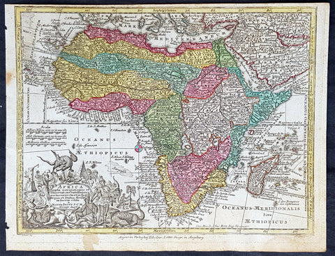
1744 Georg Mattaus Seutter Antique Map of Africa
Antique Map
- Title : Africa a Matth. Seutteri...T C Lotter, Geogr.
- Ref #: 93390
- Size: 11in x 8 1/2in (280mm x 215mm)
- Date : 1744
- Condition: (A+) Fine Condition
Description:
These beautifully hand coloured original copper-plate engraved antique map was engraved by Tobias Lotter and published in the 1744 edition of GM Seutters Atlas Minor Prae cipua Orbis Terrarum Imperia Regna et Provincias...., Augsburg, Germany.
General Definitions:
Paper thickness and quality: - Heavy and stable
Paper color : - off white
Age of map color: - Early
Colors used: - Yellow, green, blue, pink
General color appearance: - Authentic
Paper size: - 11in x 8 1/2in (280mm x 215mm)
Plate size: - 10 1/2in x 8in (265mm x 205mm)
Margins: - Min 1/4in (5mm)
Imperfections:
Margins: - Age toning to margins
Plate area: - None
Verso: - None
Background:
Atlas Minor was a series of beautiful maps of all parts of the world. Georg Matthäus Seutter was one of the most and important of the German cartographers of the 18th century, being appointed as the Geographer to the Imperial Court. His son, Albrecht Carl, joined Matthäus and eventually inherited the business. The maps from Atlas Minor were drawn by the two Seutters and engraved by Tobias Conrad Lotte. These maps are highly detailed and engraved with a bold hand with equally strong original hand color in the body of the map as was the 18th century German style. The cartouches were left uncolored in order to emphasize the elaborately detailed illustrations for which German maps are especially prized. These are some of the most decorative and interesting maps of the eighteenth century.
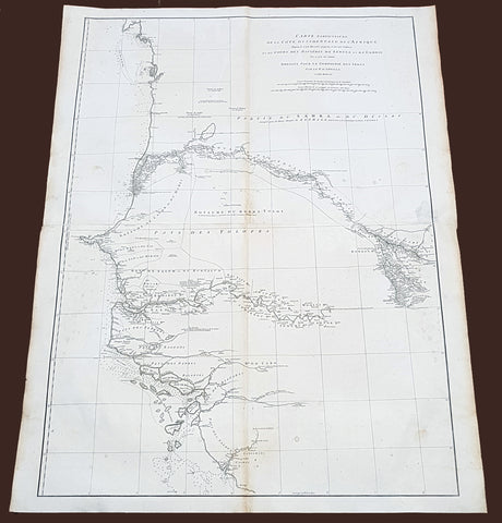
1751 D Anville Very Large Antique Map The West Coast of Africa, Gambia & Senegal
Antique Map
- Title : Carte Particuliere De La Cote Occidentale De L'Afrique Depusi le Cap Blanc jusqu'au Cap De Verga et du Cours Des Rivieres De Senega et de Gambie . .MDCCLI
- Ref #: 92324
- Size: 42in x 33in (1.07m x 840mm)
- Date : 1751
- Condition: (A) Very Good Condition
Description:
This very large finely engraved, highly detailed original antique map of of the west coast of Africa covering Gambia and Senegal was engraved in 1751 - dated in the tile cartouche - and was published in Jean-Baptiste Bourguinon D'Anville's large elephant folio atlas Atlas Generale.
Description: D' Anville's maps have a clarity and a directness that is very 'modern'. He incorporated as much known information into his maps as he could. Map extent is from Cap Blanc in the north to Cap de Verga in the south.
Being part of the Mediterranean world, the northern coasts of the African continent as far as the Straits of Gibraltar and even round to the area of the Fortunate Isles (the Canaries) were reasonably well known and quite accurately mapped from ancient times. In particular, Egypt and the Nile Valley were well defined and the Nile itself was, of course, one of the rivers separating the continents in medieval T-O maps. Through Arab traders the shape of the east coast, down the Red Sea as far as the equator, was also known but detail shown in the interior faded into deserts with occasional mountain ranges and mythical rivers. The southern part of the continent, in the Ptolemaic tradition, was assumed to curve to the east to form a land-locked Indian Ocean. The voyages of the Portuguese, organized by Henry the Navigator in the fifteenth century, completely changed the picture and by the end of the century Vasco da Gama had rounded the Cape enabling cartographers to draw a quite presentable coastal outline of the whole continent, even if the interior was to remain largely unknown for the next two or three centuries.
The first separately printed map of Africa (as with the other known continents) appeared in Munster's Geographia from 1540 onwards and the first atlas devoted to Africa only was published in 1588 in Venice by Livio Sanuto, but the finest individual map of the century was that engraved on 8 sheets by Gastaldi, published in Venice in 1564. Apart from maps in sixteenth-century atlases generally there were also magnificent marine maps of 1596 by Jan van Linschoten (engraved by van Langrens) of the southern half of the continent with highly imaginative and decorative detail in the interior. In the next century there were many attractive maps including those of Mercator/Hondius (1606), Speed (1627), Blaeu (1 630), Visscher (1636), de Wit (c. 1670), all embellished with vignettes of harbours and principal towns and bordered with elaborate and colourful figures of their inhabitants, but the interior remained uncharted with the exception of that part of the continent known as Ethiopia, the name which was applied to a wide area including present-day Abyssinia. Here the legends of Prester John lingered on and, as so often happened in other remote parts of the world, the only certain knowledge of the region was provided by Jesuit missionaries. Among these was Father Geronimo Lobo (1595-1678), whose work A Voyage to Abyssinia was used as the basis for a remarkably accurate map published by a German scholar, Hiob Ludolf in 1683. Despite the formidable problems which faced them, the French cartographers G. Delisle (c. 1700-22), J. B. B. d'Anville (1727-49) and N. Bellin (1754) greatly improved the standards of mapping of the continent, improvements which were usually, although not always, maintained by Homann, Seutter, de Ia Rochette, Bowen, Faden and many others in the later years of the century. (Ref: Tooley, M&B)
General Description:
Paper thickness and quality: - Heavy and stable
Paper color: - White
Age of map color: -
Colors used: -
General color appearance: -
Paper size: - 42in x 33in (1.07m x 840mm)
Plate size: - 40 1/2in x 28in (1.02m x 710mm)
Margins: - Min 1in (25mm)
Imperfections:
Margins: - Light soiling
Plate area: - Light soiling
Verso: - Light soiling

1735 Homann Large Antique Map of Oran, Algeria, North Africa
- Title : Topographica Repræsentatio Barbarici Portus et Urbis Munitæ Oran... Nuremberg, 1732
- Ref #: 43187
- Size: 24 1/2in x 21 1/4in (620mm x 540mm)
- Date : 1735
- Condition: (A+) Fine Condition
Description:
This large fine beautifully hand coloured original antique map and view of the City of Oran & Environs in the North African country of Algeria, as it was being captured by the Spanish in 1732, was published by Homann Heirs in ca 1735.
Background: Chart of the environs of Oran in Algeria, with a panorama of the city and environs, decorated with several sailing battle ships. In 1509 Spain captured Oran from the Moors, but in 1708, with Spain disadvantaged by the War of the Spanish Succession, they were driven out by the Turkish Bey, Mustapha Ben Youssef. In 1732 José Carrillo de Albornoz, 1st Duke of Montemar (1671-1747), recaptured Oran, causing this map to be published, after which the Spanish held the city until 1792. When the Spanish saw no point in keeping it, when it was handed over to the Bey of Algiers(Ref: Tooley; M&B)
General Description:
Paper thickness and quality: - Heavy and stable
Paper color: - off white
Age of map color: - Original
Colors used: - Yellow, green, blue, pink
General color appearance: - Authentic
Paper size: - 24 1/2in x 21 1/4in (620mm x 540mm)
Plate size: - 22 1/2in x 19 1/2in (570mm x 500mm)
Margins: - Min 1/2in (12mm)
Imperfections:
Margins: - None
Plate area: - None
Verso: - None

1751 D Anville Very Large Antique Map The West Coast of Africa, Slave Coast
Antique Map
- Title : Carte Particuliere De La Cote Occidentale De L'Afrique Depusi le Cap Blanc jusqu'au Cap De Verga et du Cours Des Rivieres De Senega et de Gambie . .MDCCLI
- Ref #: 22009
- Size: 42in x 33in (1.07m x 840mm)
- Date : 1751
- Condition: (A+) Fine Condition
Description:
This very large finely engraved, highly detailed original antique map of of the west coast of Africa covering Gambia and Senegal was engraved in 1751 - dated in the tile cartouche - and was published in Jean-Baptiste Bourguinon D'Anville's large elephant folio atlas Atlas Generale.
Description: D' Anville's maps have a clarity and a directness that is very 'modern'. He incorporated as much known information into his maps as he could. Map extent is from Cap Blanc in the north to Cap de Verga in the south.
Being part of the Mediterranean world, the northern coasts of the African continent as far as the Straits of Gibraltar and even round to the area of the Fortunate Isles (the Canaries) were reasonably well known and quite accurately mapped from ancient times. In particular, Egypt and the Nile Valley were well defined and the Nile itself was, of course, one of the rivers separating the continents in medieval T-O maps. Through Arab traders the shape of the east coast, down the Red Sea as far as the equator, was also known but detail shown in the interior faded into deserts with occasional mountain ranges and mythical rivers. The southern part of the continent, in the Ptolemaic tradition, was assumed to curve to the east to form a land-locked Indian Ocean. The voyages of the Portuguese, organized by Henry the Navigator in the fifteenth century, completely changed the picture and by the end of the century Vasco da Gama had rounded the Cape enabling cartographers to draw a quite presentable coastal outline of the whole continent, even if the interior was to remain largely unknown for the next two or three centuries.
The first separately printed map of Africa (as with the other known continents) appeared in Munster's Geographia from 1540 onwards and the first atlas devoted to Africa only was published in 1588 in Venice by Livio Sanuto, but the finest individual map of the century was that engraved on 8 sheets by Gastaldi, published in Venice in 1564. Apart from maps in sixteenth-century atlases generally there were also magnificent marine maps of 1596 by Jan van Linschoten (engraved by van Langrens) of the southern half of the continent with highly imaginative and decorative detail in the interior. In the next century there were many attractive maps including those of Mercator/Hondius (1606), Speed (1627), Blaeu (1 630), Visscher (1636), de Wit (c. 1670), all embellished with vignettes of harbours and principal towns and bordered with elaborate and colourful figures of their inhabitants, but the interior remained uncharted with the exception of that part of the continent known as Ethiopia, the name which was applied to a wide area including present-day Abyssinia. Here the legends of Prester John lingered on and, as so often happened in other remote parts of the world, the only certain knowledge of the region was provided by Jesuit missionaries. Among these was Father Geronimo Lobo (1595-1678), whose work A Voyage to Abyssinia was used as the basis for a remarkably accurate map published by a German scholar, Hiob Ludolf in 1683. Despite the formidable problems which faced them, the French cartographers G. Delisle (c. 1700-22), J. B. B. d'Anville (1727-49) and N. Bellin (1754) greatly improved the standards of mapping of the continent, improvements which were usually, although not always, maintained by Homann, Seutter, de Ia Rochette, Bowen, Faden and many others in the later years of the century. (Ref: Tooley, M&B)
General Description:
Paper thickness and quality: - Heavy and stable
Paper color: - White
Age of map color: -
Colors used: -
General color appearance: -
Paper size: - 42in x 33in (1.07m x 840mm)
Plate size: - 40 1/2in x 28in (1.02m x 710mm)
Margins: - Min 1in (25mm)
Imperfections:
Margins: - None
Plate area: - Light text offsetting
Verso: - None
1719 Henri Chatelain Rare Antique Map, Peoples, Animals & Views of South Africa
- Title : Coutumes Moeurs & Habillemens Des Peuples Qui Habitent Aux Environs du Cap de Bonne Esperance......
- Size: 20in x 17 1/2in (510mm x 440mm)
- Condition: (A+) Fine Condition
- Date : 1719
- Ref #: 50639
Description:
This large original copper-plate engraved antique map with views of The Cape of Good Hope, Southern Africa - with 10 vignettes of the peoples, animals & reptiles of the area - was published by Henri Abraham Chatelain in 1719, in his famous Atlas Historique.
These are truly some of the best early engravings of this region done at the time that were copied by the likes of Prevost, Harrison & others in the 18th century, but not with the same eye for detail.
General Definitions:
Paper thickness and quality: - Heavy and stable
Paper color : - off white
Age of map color: -
Colors used: -
General color appearance: -
Paper size: - 20in x 17 1/2in (510mm x 440mm)
Plate size: - 17 1/2in x 15in (440mm x 380mm)
Margins: - Min 1in (25mm)
Imperfections:
Margins: - None
Plate area: - None
Verso: - None
Background:
By the early 17th century, Portugals maritime power was starting to decline, and English and Dutch merchants competed to oust Lisbon from its lucrative monopoly on the spice trade. Representatives of the British East India Company did call sporadically at the Cape in search of provisions as early as 1601, but later came to favour Ascension Island and St. Helena as alternative ports of refuge. Dutch interest was aroused after 1647, when two employees of the Dutch East India Company (VOC) were shipwrecked there for several months. The sailors were able to survive by obtaining fresh water and meat from the natives. They also sowed vegetables in the fertile soil. Upon their return to Holland, they reported favourably on the Capes potential as a warehouse and garden for provisions to stock passing ships for long voyages.
In 1652, a century and a half after the discovery of the Cape sea route, Jan van Riebeeck established a victualling station at the Cape of Good Hope, at what would become Cape Town, on behalf of the Dutch East India Company. In time, the Cape became home to a large population of vrijlieden, also known as vrijburgers (lit. free citizens), former Company employees who stayed in Dutch territories overseas after serving their contracts. Dutch traders also imported thousands of slaves to the fledgling colony from Indonesia, Madagascar, and parts of eastern Africa. Some of the earliest mixed race communities in the country were formed through unions between vrijburgers, their slaves, and various indigenous peoples. This led to the development of a new ethnic group, the Cape Coloureds, most of whom adopted the Dutch language and Christian faith.
The eastward expansion of Dutch colonists ushered in a series of wars with the southwesterly migrating Xhosa tribe, known as the Xhosa Wars, as both sides competed for the pastureland necessary to graze their cattle near the Great Fish River. Vrijburgers who became independent farmers on the frontier were known as Boers, with some adopting semi-nomadic lifestyles being denoted as trekboers. The Boers formed loose militias, which they termed commandos, and forged alliances with Khoisan groups to repel Xhosa raids. Both sides launched bloody but inconclusive offensives, and sporadic violence, often accompanied by livestock theft, remained common for several decades.
Great Britain occupied Cape Town between 1795 and 1803 to prevent it from falling under the control of the French First Republic, which had invaded the Low Countries. Despite briefly returning to Dutch rule under the Batavian Republic in 1803, the Cape was occupied again by the British in 1806. Following the end of the Napoleonic Wars, it was formally ceded to Great Britain and became an integral part of the British Empire. British emigration to South Africa began around 1818, subsequently culminating in the arrival of the 1820 Settlers. The new colonists were induced to settle for a variety of reasons, namely to increase the size of the European workforce and to bolster frontier regions against Xhosa incursions.
In the first two decades of the 19th century, the Zulu people grew in power and expanded their territory under their leader, Shaka. Shakas warfare indirectly led to the Mfecane (crushing), in which 1,000,000 to 2,000,000 people were killed and the inland plateau was devastated and depopulated in the early 1820s. An offshoot of the Zulu, the Matabele people created a larger empire that included large parts of the highveld under their king Mzilikazi.
During the early 1800s, many Dutch settlers departed from the Cape Colony, where they had been subjected to British control. They migrated to the future Natal, Orange Free State, and Transvaal regions. The Boers founded the Boer Republics: the South African Republic (now Gauteng, Limpopo, Mpumalanga and North West provinces), the Natalia Republic (KwaZulu-Natal), and the Orange Free State (Free State).
The discovery of diamonds in 1867 and gold in 1884 in the interior started the Mineral Revolution and increased economic growth and immigration. This intensified British efforts to gain control over the indigenous peoples. The struggle to control these important economic resources was a factor in relations between Europeans and the indigenous population and also between the Boers and the British.
The Anglo-Zulu War was fought in 1879 between the British Empire and the Zulu Kingdom. Following Lord Carnarvons successful introduction of federation in Canada, it was thought that similar political effort, coupled with military campaigns, might succeed with the African kingdoms, tribal areas and Boer republics in South Africa. In 1874, Sir Henry Bartle Frere was sent to South Africa as High Commissioner for the British Empire to bring such plans into being. Among the obstacles were the presence of the independent states of the Boers and the Kingdom of Zululand and its army. The Zulu nation defeated the British at the Battle of Isandlwana. Eventually, though, the war was lost, resulting in the termination of the Zulu nations independence.
The Boer Republics successfully resisted British encroachments during the First Boer War (1880–1881) using guerrilla warfare tactics, which were well suited to local conditions. The British returned with greater numbers, more experience, and new strategy in the Second Boer War (1899–1902) but suffered heavy casualties through attrition; nonetheless, they were ultimately successful.
1775 J B D Anville Large Antique Map Gulf of Guinea West Africa Liberia to Gabon
- Title : Guinee Ent Serre-Lione et le pasage de la Ligne par le S D\'Anville...MDCCLXXV (1775)
- Size: 31in x 21 1/2in (790mm x 550mm)
- Condition: (A) Very Good Condition
- Date : 1775
- Ref #: 92325
Description:
This large original copper-plate engraved antique map of The Gulf Of Guinea, West Africa from Liberia to Gabon by Jean Baptiste Bourguignon D\'Anville was engraved in 1775 - dated in the tile cartouche - and was published in Jean-Baptiste Bourguinon D\'Anvilles large elephant folio atlas Atlas Generale.
(Ref: Tooley, M&B)
General Definitions:
Paper thickness and quality: - Heavy and stable
Paper color : - off white
Age of map color: -
Colors used: -
General color appearance: -
Paper size: - 31in x 21 1/2in (790mm x 550mm)
Plate size: - 21in x 19 1/2in (670mm x 320mm)
Margins: - Min 2in (50mm)
Imperfections:
Margins: - Light soiling in margins, small worm holes in bottom margin
Plate area: - None
Verso: - Light soiling
Background:
Being part of the Mediterranean world, the northern coasts of the African continent as far as the Straits of Gibraltar and even round to the area of the Fortunate Isles (the Canaries) were reasonably well known and quite accurately mapped from ancient times. In particular, Egypt and the Nile Valley were well defined and the Nile itself was, of course, one of the rivers separating the continents in medieval T-O maps. Through Arab traders the shape of the east coast, down the Red Sea as far as the equator, was also known but detail shown in the interior faded into deserts with occasional mountain ranges and mythical rivers. The southern part of the continent, in the Ptolemaic tradition, was assumed to curve to the east to form a land-locked Indian Ocean. The voyages of the Portuguese, organized by Henry the Navigator in the fifteenth century, completely changed the picture and by the end of the century Vasco da Gama had rounded the Cape enabling cartographers to draw a quite presentable coastal outline of the whole continent, even if the interior was to remain largely unknown for the next two or three centuries.
The first separately printed map of Africa (as with the other known continents) appeared in Munster\\\'s Geographia from 1540 onwards and the first atlas devoted to Africa only was published in 1588 in Venice by Livio Sanuto, but the finest individual map of the century was that engraved on 8 sheets by Gastaldi, published in Venice in 1564. Apart from maps in sixteenth-century atlases generally there were also magnificent marine maps of 1596 by Jan van Linschoten (engraved by van Langrens) of the southern half of the continent with highly imaginative and decorative detail in the interior. In the next century there were many attractive maps including those of Mercator/Hondius (1606), Speed (1627), Blaeu (1 630), Visscher (1636), de Wit (c. 1670), all embellished with vignettes of harbours and principal towns and bordered with elaborate and colourful figures of their inhabitants, but the interior remained uncharted with the exception of that part of the continent known as Ethiopia, the name which was applied to a wide area including present-day Abyssinia. Here the legends of Prester John lingered on and, as so often happened in other remote parts of the world, the only certain knowledge of the region was provided by Jesuit missionaries. Among these was Father Geronimo Lobo (1595-1678), whose work A Voyage to Abyssinia was used as the basis for a remarkably accurate map published by a German scholar, Hiob Ludolf in 1683. Despite the formidable problems which faced them, the French cartographers G. Delisle (c. 1700-22), J. B. B. d\\\'Anville (1727-49) and N. Bellin (1754) greatly improved the standards of mapping of the continent, improvements which were usually, although not always, maintained by Homann, Seutter, de Ia Rochette, Bowen, Faden and many others in the later years of the century.
1719 Chatelain Large Antique Map of Barbary Coast, North Africa Morocco to Libya
- Title : Description Du Nil. Des Sources de son Cours Depuis Les Catactes....
- Size: 20in x 17 1/2in (510mm x 440mm)
- Condition: (A+) Fine Condition
- Date : 1719
- Ref #: 50651
Description:
This large original copper-plate engraved antique print of views of the Pyramids, ruins and the Nile River, speculating on the source (not known until the mid 19th century) was published by Henri Abraham Chatelain in 1719, in his famous Atlas Historique.
General Definitions:
Paper thickness and quality: - Heavy and stable
Paper color : - off white
Age of map color: -
Colors used: -
General color appearance: -
Paper size: - 20in x 17 1/2in (510mm x 440mm)
Plate size: - 17 1/2in x 15in (440mm x 380mm)
Margins: - Min 1in (25mm)
Imperfections:
Margins: - None
Plate area: - None
Verso: - None
Background:
The river Nile has two major tributaries, the White Nile and Blue Nile. The White Nile is considered to be the headwaters and primary stream of the Nile itself. The Blue Nile, however, is the source of most of the water and silt. The White Nile is longer and rises in the Great Lakes region of central Africa, with the most distant source still undetermined but located in either Rwanda or Burundi. It flows north through Tanzania, Lake Victoria, Uganda and South Sudan. The Blue Nile begins at Lake Tana in Ethiopia and flows into Sudan from the southeast. The two rivers meet just north of the Sudanese capital of Khartoum.
Europeans began to learn about the origins of the Nile in the 14th century when the Pope sent monks as emissaries to Mongolia who passed India, the middle east and Africa, and described being told of the source of the Nile in Abyssinia (ancient European name for Ethiopia) Later in the 15th and 16th centuries, travelers to Ethiopia visited Lake Tana and the source of the Blue Nile in the mountains south of the lake. Although James Bruce claimed to be the first European to have visited the headwaters, modern writers give the credit to the Jesuit Pedro Páez. Páezs account of the source of the Nile is a long and vivid account of Ethiopia. It was published in full only in the early 20th century, although it was featured in works of Páezs contemporaries, including Baltazar Téllez, Athanasius Kircher and by Johann Michael Vansleb.
Europeans had been resident in Ethiopia since the late 15th century, and one of them may have visited the headwaters even earlier without leaving a written trace. The Portuguese João Bermudes published the first description of the Tis Issat Falls in his 1565 memoirs, compared them to the Nile Falls alluded to in Ciceros De Republica. Jerónimo Lobo describes the source of the Blue Nile, visiting shortly after Pedro Páez. Telles also used his account.
The White Nile was even less understood. The ancients mistakenly believed that the Niger River represented the upper reaches of the White Nile. For example, Pliny the Elder wrote that the Nile had its origins in a mountain of lower Mauretania, flowed above ground for many days distance, then went underground, reappeared as a large lake in the territories of the Masaesyli, then sank again below the desert to flow underground for a distance of 20 days journey till it reaches the nearest Ethiopians. A merchant named Diogenes reported that the Niles water attracted game such as buffalo.
Lake Victoria was first sighted by Europeans in 1858 when the British explorer John Hanning Speke reached its southern shore while traveling with Richard Francis Burton to explore central Africa and locate the great lakes. Believing he had found the source of the Nile on seeing this vast expanse of open water for the first time, Speke named the lake after the then Queen of the United Kingdom. Burton, recovering from illness and resting further south on the shores of Lake Tanganyika, was outraged that Speke claimed to have proved his discovery to be the true source of the Nile when Burton regarded this as still unsettled. A very public quarrel ensued, which sparked a great deal of intense debate within the scientific community and interest by other explorers keen to either confirm or refute Spekes discovery. British explorer and missionary David Livingstone pushed too far west and entered the Congo River system instead. It was ultimately Welsh-American explorer Henry Morton Stanley who confirmed Spekes discovery, circumnavigating Lake Victoria and reporting the great outflow at Ripon Falls on the Lakes northern shore.
European involvement in Egypt goes back to the time of Napoleon. Laird Shipyard of Liverpool sent an iron steamer to the Nile in the 1830s. With the completion of the Suez Canal and the British takeover of Egypt in the 1870s, more British river steamers followed.
The Nile is the areas natural navigation channel, giving access to Khartoum and Sudan by steamer. The Siege of Khartoum was broken with purpose-built sternwheelers shipped from England and steamed up the river to retake the city. After this came regular steam navigation of the river. With British Forces in Egypt in the First World War and the inter-war years, river steamers provided both security and sightseeing to the Pyramids and Thebes. Steam navigation remained integral to the two countries as late as 1962. Sudan steamer traffic was a lifeline as few railways or roads were built in that country. Most paddle steamers have been retired to shorefront service, but modern diesel tourist boats remain on the river.
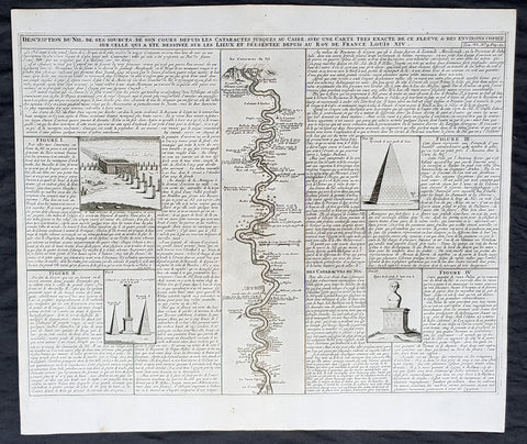
1719 Chatelain Large Antique Print of Egypt Pyramids, & Source of the Nile River
- Title : Description Du Nil. Des Sources de son Cours Depuis Les Catactes....
- Size: 20in x 17 1/2in (510mm x 440mm)
- Condition: (A+) Fine Condition
- Date : 1719
- Ref #: 50651
Description:
This large original copper-plate engraved antique print of views of the Pyramids, ruins and the Nile River, speculating on the source (not known until the mid 19th century) was published by Henri Abraham Chatelain in 1719, in his famous Atlas Historique.
General Definitions:
Paper thickness and quality: - Heavy and stable
Paper color : - off white
Age of map color: -
Colors used: -
General color appearance: -
Paper size: - 20in x 17 1/2in (510mm x 440mm)
Plate size: - 17 1/2in x 15in (440mm x 380mm)
Margins: - Min 1in (25mm)
Imperfections:
Margins: - None
Plate area: - None
Verso: - None
Background:
The river Nile has two major tributaries, the White Nile and Blue Nile. The White Nile is considered to be the headwaters and primary stream of the Nile itself. The Blue Nile, however, is the source of most of the water and silt. The White Nile is longer and rises in the Great Lakes region of central Africa, with the most distant source still undetermined but located in either Rwanda or Burundi. It flows north through Tanzania, Lake Victoria, Uganda and South Sudan. The Blue Nile begins at Lake Tana in Ethiopia and flows into Sudan from the southeast. The two rivers meet just north of the Sudanese capital of Khartoum.
Europeans began to learn about the origins of the Nile in the 14th century when the Pope sent monks as emissaries to Mongolia who passed India, the middle east and Africa, and described being told of the source of the Nile in Abyssinia (ancient European name for Ethiopia) Later in the 15th and 16th centuries, travelers to Ethiopia visited Lake Tana and the source of the Blue Nile in the mountains south of the lake. Although James Bruce claimed to be the first European to have visited the headwaters, modern writers give the credit to the Jesuit Pedro Páez. Páezs account of the source of the Nile is a long and vivid account of Ethiopia. It was published in full only in the early 20th century, although it was featured in works of Páezs contemporaries, including Baltazar Téllez, Athanasius Kircher and by Johann Michael Vansleb.
Europeans had been resident in Ethiopia since the late 15th century, and one of them may have visited the headwaters even earlier without leaving a written trace. The Portuguese João Bermudes published the first description of the Tis Issat Falls in his 1565 memoirs, compared them to the Nile Falls alluded to in Ciceros De Republica. Jerónimo Lobo describes the source of the Blue Nile, visiting shortly after Pedro Páez. Telles also used his account.
The White Nile was even less understood. The ancients mistakenly believed that the Niger River represented the upper reaches of the White Nile. For example, Pliny the Elder wrote that the Nile had its origins in a mountain of lower Mauretania, flowed above ground for many days distance, then went underground, reappeared as a large lake in the territories of the Masaesyli, then sank again below the desert to flow underground for a distance of 20 days journey till it reaches the nearest Ethiopians. A merchant named Diogenes reported that the Niles water attracted game such as buffalo.
Lake Victoria was first sighted by Europeans in 1858 when the British explorer John Hanning Speke reached its southern shore while traveling with Richard Francis Burton to explore central Africa and locate the great lakes. Believing he had found the source of the Nile on seeing this vast expanse of open water for the first time, Speke named the lake after the then Queen of the United Kingdom. Burton, recovering from illness and resting further south on the shores of Lake Tanganyika, was outraged that Speke claimed to have proved his discovery to be the true source of the Nile when Burton regarded this as still unsettled. A very public quarrel ensued, which sparked a great deal of intense debate within the scientific community and interest by other explorers keen to either confirm or refute Spekes discovery. British explorer and missionary David Livingstone pushed too far west and entered the Congo River system instead. It was ultimately Welsh-American explorer Henry Morton Stanley who confirmed Spekes discovery, circumnavigating Lake Victoria and reporting the great outflow at Ripon Falls on the Lakes northern shore.
European involvement in Egypt goes back to the time of Napoleon. Laird Shipyard of Liverpool sent an iron steamer to the Nile in the 1830s. With the completion of the Suez Canal and the British takeover of Egypt in the 1870s, more British river steamers followed.
The Nile is the areas natural navigation channel, giving access to Khartoum and Sudan by steamer. The Siege of Khartoum was broken with purpose-built sternwheelers shipped from England and steamed up the river to retake the city. After this came regular steam navigation of the river. With British Forces in Egypt in the First World War and the inter-war years, river steamers provided both security and sightseeing to the Pyramids and Thebes. Steam navigation remained integral to the two countries as late as 1962. Sudan steamer traffic was a lifeline as few railways or roads were built in that country. Most paddle steamers have been retired to shorefront service, but modern diesel tourist boats remain on the river.
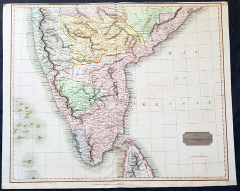
1816 John Thomson Large Antique Map of Southern India & Northern Sri Lanka
- Title : Southern Hindostan....Drawn & Engraved for Thomsons New General Atlas, 1816
- Date : 1816
- Size: 25in x 20 1/2in (635mm x 520mm)
- Condition: (A+) Fine Condition
- Ref: 41004
Description:
This large magnificent original hand coloured copper-plate engraved antique map of South India & northern Sri Lanka by John Thomson was engraved by Samuel Neele in 1816 - dated at the foot of the map - and was published in the 1817 edition of Thomsons New General Atlas
General Definitions:
Paper thickness and quality: - Heavy and stable
Paper color : - off white
Age of map color: - Original
Colors used: - Yellow, green, blue, pink
General color appearance: - Authentic
Paper size: - 25in x 20 1/2in (635mm x 520mm)
Plate size: - 25in x 20 1/2in (635mm x 520mm)
Margins: - Min 1/2in (15mm)
Imperfections:
Margins: - Top margin soiling and cropped to plate-mark
Plate area: - None
Verso: - None
Background:
The cartography of India begins with early charts for navigation and constructional plans for buildings. Indian traditions influenced Tibetan and Islamic traditions, and in turn, were influenced by the British cartographers who solidified modern concepts into India\'s map making
A prominent foreign geographer and cartographer was Hellenistic geographer Ptolemy (90–168) who researched at the library in Alexandria to produce a detailed eight-volume record of world geography. During the Middle Ages, India sees some exploration by Chinese and Muslim geographers, while European maps of India remain very sketchy. A prominent medieval cartographer was Persian geographer Abu Rayhan Biruni (973–1048) who visited India and studied the country\'s geography extensively.
European maps become more accurate with the Age of Exploration and Portuguese India from the 16th century. The first modern maps were produced by Survey of India, established in 1767 by the British East India Company. Survey of India remains in continued existence as the official mapping authority of the Republic of India.
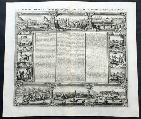
1719 Chatelain Large Antique Print North Africa City Views Algiers, Jijel, Tripoli & Tunis
- Title : Vue de Tunis d'Alger & de Gigeri avec quelques particularitez curieuses touchant les moeurs de leur habitans & de quelques autres peuples de Barbarie
- Ref #: 50646
- Size: 20in x 17 1/2in (510mm x 445mm)
- Date : 1719
- Condition: (A+) Fine Condition
Description:
This large finely engraved original antique print views of cities of The Barbary Coast of North Africa including Algiers and Jijel, both in Algeria, Tripoli in Libya and Tunis in Tunisia - as well as peoples & animals of the Barbary coast - was published by Henri Abraham Chatelain in 1719, in his famous Atlas Historique.
Henri Abraham Chatelain (1684 - 1743)
was a Huguenot pastor of Parisian origins. He lived consecutively in Paris, St. Martins, London (c. 1710), the Hague (c. 1721) and Amsterdam (c. 1728).
Chatelain was a skilled artist and knew combining a wealth of historical and geographical information with delicate engraving and an uncomplicated composition. Groundbreaking for its time, this work included studies of geography, history, ethnology, heraldry, and cosmography. His maps with his elegant engraving are a superb example from the golden age of French mapmaking.The publishing firm of Chatelain, Chatelain Frères and Chatelain & Fils is recorded in Amsterdam, from around 1700-1770, with Zacharias living "op den Dam" in 1730.
Henri Abraham Chatelain, his father Zacharie Chatelain (d.1723) and Zacharie Junior (1690-1754), worked as a partnership publishing the Atlas Historique, Ou Nouvelle Introduction à L'Histoire under several different Chatelain imprints, depending on the Chatelain family partnerships at the time of publication. The atlas was published in seven volumes between 1705 and 1720, with a second edition appearing in 1732. The volumes I-IV with a Third edition and volume I with a final edition in 1739.
Henri Abraham Chatelain, whose "Atlas Historique" was one of the most expansive Dutch encyclopedias of the age. First published in 1705, Chatelain's Atlas Historique was part of an immense seven-volume encyclopedia. Although the main focus of the text was geography, the work also included a wealth of historical, political, and genealogical information. The text was compiled by Nicholas Gueudeville and Garillon with a supplement by H.P. de Limiers and the maps were engraved by Chatelain, primarily after charts by De L'Isle. The atlas was published in Amsterdam between 1705 and 1721 and was later reissued by Zacharie Chatelain between 1732 and 1739.
Atlas Historique: First published in Amsterdam from 1705 to 1720, the various volumes were updated at various times up to 1739 when the fourth edition of vol.I appeared, stated as the "dernière edition, corrigée & augmentée."
The first four volumes seem to have undergone four printings with the later printings being the most desirable as they contain the maximum number of corrections and additions. The remaining three final volumes were first issued between 1719-1720 and revised in 1732.
An ambitious and beautifully-presented work, the Atlas Historique was intended for the general public, fascinated in the early eighteenth century by the recently conquered colonies and the new discoveries. Distant countries, such as the Americas, Africa, the Middle East, Mongolia, China, Japan, Indonesia, etc., take an important place in this work.
In addition to the maps, many of which are based on Guillaume De L'Isle, the plates are after the best travel accounts of the period, such as those of Dapper, Chardin, de Bruyn, Le Hay and other.
Other sections deal with the history of the european countries, and covers a wide range of subjects including genealogy, history, cosmography, topography, heraldry and chronology, costume of the world, all illustrated with numerous engraved maps, plates of local inhabitants and heraldic charts of the lineages of the ruling families of the time. The maps, prints and tables required to make up a complete set are listed in detail in each volume.
The accompanying text is in French and often is printed in two columns on the page with maps and other illustrations interspersed. Each map and table is numbered consecutively within its volume and all maps bear the privileges of the States of Holland and West-Friesland.
The encyclopaedic nature of the work as a whole is reflected in this six frontispiece. The pages are the work of the celerated mr. Romeijn de Hooghe. and are engraved by J.Goeree, T.Schynyoet and P.Sluyter.
New scholarship has suggested the compiler of the atlas, who is identified on the title as "Mr. C***" not to be Henri Abraham Châtelain, but Zacharie Châtelain. (See Van Waning's article in the Journal of the International Map Collectors' Society for persuasive evidence of the latter's authorship.) (Ref: M&B; Tooley)
General Description:
Paper thickness and quality: - Heavy and stable
Paper color: - White
Age of map color: -
Colors used: -
General color appearance: -
Paper size: - 20in x 17 1/2in (510mm x 445mm)
Plate size: - 17 1/2in x 15in (445mm x 380mm)
Margins: - min. 1in (25mm)
Imperfections:
Margins: - None
Plate area: - None
Verso: - None
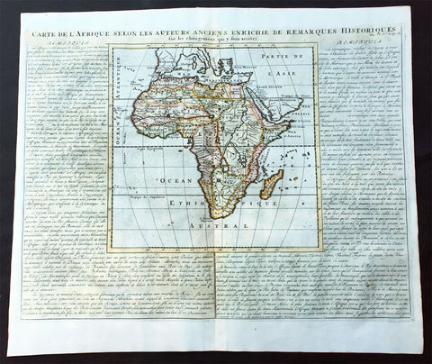
1719 Chatelain Large Old, Antique Map of Africa
- Title : Carte De L Afrique Selon Les Auteurs Anciens Enrichie de Remarques Historiques
- Date : 1719
- Condition: (A+) Fine Condition
- Ref: 50628
- Size: 20 3/4in x 17 1/2in (530m x 445m)
Description:
This large beautifully hand coloured original antique map of antique map of Africa was published by Henri Abraham Chatelain in 1719, in his famous Atlas Historique.
Atlas Historique: First published in Amsterdam from 1705 to 1720, the various volumes were updated at various times up to 1739 when the fourth edition of vol.I appeared, stated as the "dernière edition, corrigée & augmentée."
The first four volumes seem to have undergone four printings with the later printings being the most desirable as they contain the maximum number of corrections and additions. The remaining three final volumes were first issued between 1719-1720 and revised in 1732.
An ambitious and beautifully-presented work, the Atlas Historique was intended for the general public, fascinated in the early eighteenth century by the recently conquered colonies and the new discoveries. Distant countries, such as the Americas, Africa, the Middle East, Mongolia, China, Japan, Indonesia, etc., take an important place in this work.
In addition to the maps, many of which are based on Guillaume De L'Isle, the plates are after the best travel accounts of the period, such as those of Dapper, Chardin, de Bruyn, Le Hay and other.
Other sections deal with the history of the european countries, and covers a wide range of subjects including genealogy, history, cosmography, topography, heraldry and chronology, costume of the world, all illustrated with numerous engraved maps, plates of local inhabitants and heraldic charts of the lineages of the ruling families of the time. The maps, prints and tables required to make up a complete set are listed in detail in each volume.
The accompanying text is in French and often is printed in two columns on the page with maps and other illustrations interspersed. Each map and table is numbered consecutively within its volume and all maps bear the privileges of the States of Holland and West-Friesland.
The encyclopaedic nature of the work as a whole is reflected in this six frontispiece. The pages are the work of the celerated mr. Romeijn de Hooghe. and are engraved by J.Goeree, T.Schynyoet and P.Sluyter.
New scholarship has suggested the compiler of the atlas, who is identified on the title as "Mr. C***" not to be Henri Abraham Châtelain, but Zacharie Châtelain. (See Van Waning's article in the Journal of the International Map Collectors' Society for persuasive evidence of the latter's authorship.) (Ref: M&B; Tooley)
General Description:
Paper thickness and quality: - Heavy and stable
Paper color: - White
Age of map color: - Later
Colors used: - Pink, green, yellow, blue
General color appearance: - Authentic
Paper size: - 20 3/4in x 17 1/2in (530m x 445m)
Plate size: - 11in x 11in (280m x 280mm)
Margins: - min. 1in (25mm)
Imperfections:
Margins: - None
Plate area: - None
Verso: - None
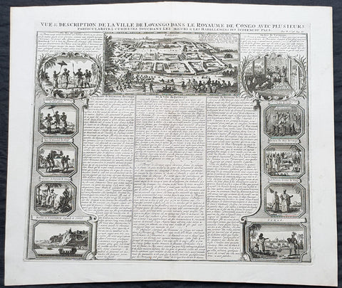
1719 Chatelain Large Antique Print Views of Loango & Mbanza Loango, Congo Africa
- Title : Vue & Description de la Ville De Lovango dans la Royaume de Congo avec plu Sieurs....
- Size: 20in x 17 1/2in (510mm x 440mm)
- Condition: (A+) Fine Condition
- Date : 1719
- Ref #: 50641-1
Description:
This large original copper-plate engraved antique print city of Mbanza Loango in the pre-colonial African Kingdom of Loango - now part of the of western part of the Republic of the Congo - with 10 vignettes of various peoples & views of Kingdom of Loango, Africa was published by Henri Abraham Chatelain in 1719, in his famous Atlas Historique.
General Definitions:
Paper thickness and quality: - Heavy and stable
Paper color : - off white
Age of map color: -
Colors used: -
General color appearance: -
Paper size: - 20in x 17 1/2in (510mm x 440mm)
Plate size: - 17 1/2in x 15in (440mm x 380mm)
Margins: - Min 1in (25mm)
Imperfections:
Margins: - None
Plate area: - None
Verso: - None
Background:
The Kingdom of Loango was a pre-colonial African state, during approximately the 16th to 19th centuries in what is now the western part of the Republic of the Congo. Situated to the north of the more powerful Kingdom of Kongo, at its height in the 17th century Loango influence extended from Cape St Catherine in the north to almost the mouth of the Congo River.
Loango exported copper to the European market, and was a major producer and exporter of cloth.
The English traveller Andrew Battel, when he was there in about 1610, recorded that the predecessor of the unnamed king ruling at that time was named \\\"Gembe\\\" or Gymbe (modernized as Njimbe), possibly the founder of the kingdom. With the death of King Buatu in 1787, the succession of leadership is uncertain.
The kingdom is certain to have come to an end with the Conference of Berlin (1884–1885) at the latest, when European colonial powers divided most of Central Africa between them.
The origins of the kingdom are obscure. The most ancient complex society in the region was at Madingo Kayes, which was already a multi-site settlement in the first century CE. At present archaeological evidence is too scarce to say much more about developments until the late fifteenth or early sixteenth centuries.
Loango is not mentioned in early travelers\\\' accounts of the region, nor is it mentioned in the titles of King Afonso I of Kongo in 1535, though Kakongo, Vungu, and Ngoyo, its southern neighbors. It is therefore unlikely that there was a major power on the coast of Central Africa north of the Congo River.
The earliest reference to Loango in a documentary source is a mention around 1561 by Sebastião de Souto, a priest in Kongo, that King Diogo I (1545–61) sent missionaries to convert Loango to Christianity. Duarte Lopes, ambassador from Kongo to the Holy See in Rome in 1585, related that \\\"Loango is a friend of the King of Congo and it is said that he was a vassal in past times\\\" which is consistent with Loango\\\'s origins from Kakongo, a vassal of Kongo.
Dutch visitors recorded the first traditional account of the kingdom\\\'s origin in the 1630s or \\\'40s. In their account as reported by the geographer Olfert Dapper, the region where Loango would be constructed was populated by a number of small polities including Mayumba, Kilongo, Piri and Wansi, \\\"each with their own leader\\\" who \\\"made war on each other.\\\" He recorded that the founder of Loango, who boasted hailing from the district in Nzari in the small coastal kingdom of Kakongo, itself a vassal of Kongo, triumphed over all his rivals through the skillful use of alliances to defeat those who opposed him, particularly Wansa, Kilongo and Piri, the latter two of which required two wars to subdue. Once this had been effected, however, a range of more northern regions, including Docke and Sette submitted voluntarily. Having succeeded in the conquest, the new king moved northward and after having founded settlements in a variety of places, eventually built his capital in Buali in the province of Piri (from which the ethnic name \\\"Muvili\\\" eventually derived).
The English traveller Andrew Battel wrote when he was there in about 1610, that the predecessor of the unnamed king ruling at that time was named \\\"Gembe\\\" or \\\"Gymbe\\\" (modernized as \\\"Njimbe\\\"). A Dutch description published in 1625 said that a ruler who had died sometime before that date had ruled for 60 years and thus had taken the throne around 1565. The documentary chronology thus makes it very likely that Njimbe was the founder and first ruler mentioned in the traditions, and this supposition is supported by traditions recorded around 1890 by R. E. Dennett which also named Njimbe as the first ruler.
On the basis of later traditions from the nineteenth and twentieth centuries that linked the founding of Loango to that of Kongo, Phyllis Martin posited a much earlier foundation, the late fourteenth or early fifteenth centuries. She then argues that the absence of Loango from early titles of the king of Kongo is evidence that Loango was already independent at that time.
Njimbe had created a rule of succession which was in place around 1600, in which the king gave command over four provinces to members of his family, called the provinces of Kaye, Boke, Selage, and Kabango, and the king was to be chosen from a rotation between them. When the king died the ruler of Kaye took over, as he did indeed in the pre-1624 succession, and if the rule was followed then the ruler of Boke took his place; the other two provincial rulers advanced as well, and the king appointed a new ruler for Kabango.
In 1663, the king ruling then was baptized as Afonso by the Italian Capuchin priest Bernardo Ungaro, but there was considerable opposition to this from within the country, and indeed when he died, a non-Christian took over, but this one was himself overthrown by one of the Christian party in 1665. This civil war was still ongoing in the 1670s. In the aftermath of this civil war, a number of the Christian party fled to neighboring territories, one of whom, known to history as Miguel da Silva, was elected ruler of Ngoyo and was ruling there in 1682.
When Nathaniel Uring, an English merchant came to Loango to trade in 1701, he reported that the king had died and the power of the administration was in the hands of the \\\"Queen or Chief Governess of that Country,\\\" named \\\"Mucundy\\\" and with whom he had to deal as if with the ruler.[20] This title referred to a woman with a regular role in the administration as overseer of women\\\'s affairs.
Many years elapsed before we have another snapshot of Loango\\\'s government; during this time the rules of succession, whether formal or informal seem to have changed. When the French missionaries directed by Abbé Liévin-Bonaventure Proyart came to Loango in 1766, they noted that there was no clear succession to the throne, that anyone born of a person regarded as a princess (only female succession mattered) could aspire to the throne. Moreover, the death of a king was cause for a frequently long interregnum; the king ruling in 1766 had come to power only after an interregnum of seven years, during which time the affairs of the country were managed by a regent called Mani Boman. The Mani Boman was appointed by the king during his lifetime. Usually two were appointed to cover the eventuality of the death of one of the two. They, in turn received the petitions of a number of eligible candidates for the throne.
Eventually, the electors of the kingdom, who were those who held offices appointed by the late king, met to decide on the next king. In theory, as the old constitution maintained, the king named his successor as well and placed him as ruler of Kaye, to succeed him at his death, but as there was so much contention as to who should hold the position, the late king died without naming a Ma-Kaye.
Historian Phyllis Martin contends that the external trade of the country had enriched some members of the nobility ahead of others and had thus put pressure on the older constitution as wealthier upstart princes pressed their case forward. She argues that important members of the council were people who had obtained their positions through contact with external trade, particularly the slave trade, and they had come to share power with the king. She posits that this alteration in relative power allowed the council to dominate the king by forcing longer and longer interregna. In fact, after the death of King Buatu in 1787, no king was elected for over 100 years.However, to some extent royal authority remained in the hands of a person entitled the Nganga Mvumbi (priest of the corpse) who oversaw the body of the dead king awaiting burial. Several of these Nganga Mvumbi succeeded each other in the late eighteenth and through the nineteenth centuries.
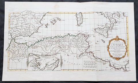
1738 J B D Anville Antique Map of North Africa, Spain, Sardinia & Sicily
- Title : Carte de La Partie de L Afrique ou les Carthaginios de L Histoire Ancienne de Mr Rollin..Sr D Anville...1738
- Size: 20in x 12in (510mm x 303mm)
- Condition: (A+) Fine Condition
- Date : 1738
- Ref #: 70314
Description:
This magnificent original hand coloured copper-plate engraved antique map of North Africa, Spain, Sardinia & Sicily - with an inset plan of Carthage by Jean Baptiste Bourguignon D Anville in 1738 - dated - was published in Mr Charles Rollins Atlas. (Ref: M&B; Tooley)
General Definitions:
Paper thickness and quality: - Heavy and stable
Paper color : - off white
Age of map color: - Original
Colors used: - Blue, pink, red, green, yellow
General color appearance: - Authentic
Paper size: - 20in x 12in (510mm x 303mm)
Plate size: - 19 1/2in x 10 1/2in (495mm x 265mm)
Margins: - Min 1in (25mm)
Imperfections:
Margins: - None
Plate area: - None
Verso: - None
Background:
Being part of the Mediterranean world, the northern coasts of the African continent as far as the Straits of Gibraltar and even round to the area of the Fortunate Isles (the Canaries) were reasonably well known and quite accurately mapped from ancient times. In particular, Egypt and the Nile Valley were well defined and the Nile itself was, of course, one of the rivers separating the continents in medieval T-O maps. Through Arab traders the shape of the east coast, down the Red Sea as far as the equator, was also known but detail shown in the interior faded into deserts with occasional mountain ranges and mythical rivers. The southern part of the continent, in the Ptolemaic tradition, was assumed to curve to the east to form a land-locked Indian Ocean. The voyages of the Portuguese, organized by Henry the Navigator in the fifteenth century, completely changed the picture and by the end of the century Vasco da Gama had rounded the Cape enabling cartographers to draw a quite presentable coastal outline of the whole continent, even if the interior was to remain largely unknown for the next two or three centuries.
The first separately printed map of Africa (as with the other known continents) appeared in Munster\\\'s Geographia from 1540 onwards and the first atlas devoted to Africa only was published in 1588 in Venice by Livio Sanuto, but the finest individual map of the century was that engraved on 8 sheets by Gastaldi, published in Venice in 1564. Apart from maps in sixteenth-century atlases generally there were also magnificent marine maps of 1596 by Jan van Linschoten (engraved by van Langrens) of the southern half of the continent with highly imaginative and decorative detail in the interior. In the next century there were many attractive maps including those of Mercator/Hondius (1606), Speed (1627), Blaeu (1 630), Visscher (1636), de Wit (c. 1670), all embellished with vignettes of harbours and principal towns and bordered with elaborate and colourful figures of their inhabitants, but the interior remained uncharted with the exception of that part of the continent known as Ethiopia, the name which was applied to a wide area including present-day Abyssinia. Here the legends of Prester John lingered on and, as so often happened in other remote parts of the world, the only certain knowledge of the region was provided by Jesuit missionaries. Among these was Father Geronimo Lobo (1595-1678), whose work A Voyage to Abyssinia was used as the basis for a remarkably accurate map published by a German scholar, Hiob Ludolf in 1683. Despite the formidable problems which faced them, the French cartographers G. Delisle (c. 1700-22), J. B. B. d\\\'Anville (1727-49) and N. Bellin (1754) greatly improved the standards of mapping of the continent, improvements which were usually, although not always, maintained by Homann, Seutter, de Ia Rochette, Bowen, Faden and many others in the later years of the century.
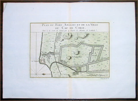
1747 Bellin Antique Map Plan Cape Coast Castle in Ghana West Africa - Slavery
- Title: Plan Du Fort Anglois et de la Ville du Cap De Corse
- Date: 1747
- Condition : (A+) Fine Condition
- Ref: 25657
- Size: 11 1/2in x 11in (295mm x 280mm)
Description:
This beautifully hand coloured original antique map a plan of the Cape Coast Castle - the notorious Slave Castle - situated in the West African country of Ghana was published in 1747 by Jacques Nicolas Bellin for Antoine-François Prevosts 20 volume edition of L`Histoire Generale des Voyages published by Pierre de Hondt, The Hague between 1747 & 1785.
Background: Cape Coast Castle is one of a number of "slave castles", fortifications in Ghana built by Swedish traders, originally for trade in timber and gold, later used in the trans-Atlantic slave trade. Other Ghanaian slave castles include the Portuguese foundation of Elmina Castle (later Dutch) and Fort Christiansborg. They were used to hold slaves before they were loaded onto ships and traded in the Americas and the Caribbean. This “gate of no return” was the last stop before crossing the great Atlantic Ocean (Ref: Tooley; M&B)
General Description:
Paper thickness and quality: - Heavy and stable
Paper color: - off white
Age of map color: - Early
Colors used: - Red, green, yellow
General color appearance: - Authentic
Paper size: - 14in x 10in (380mm x 255mm)
Plate size: - 9in x 6 1/2in (230mm x 165mm)
Margins: - Min 1in (25mm)
Imperfections:
Margins: - None
Plate area: - None
Verso: - None

1760 Bellin Antique Map The Entrance to the Sierra Leone River, Africa
- Title: Carte De L Entrée De La Riviere De Sierra Leona...
- Date: 1760
- Condition : (A+) Fine Condition
- Ref: 25836
- Size: 10in x 7 1/2in (255mm x 190mm)
Description:
This beautifully hand coloured original antique map of the Sierra Leone River estuary by J N Bellin in 1760 was published in Antoine-François Prevosts 20 volume edition of L`Histoire Generale des Voyages published by Pierre de Hondt, The Hague between 1747 & 1785.
The Sierra Leone River is a river estuary on the Atlantic Ocean in Western Sierra Leone. It is formed by the Port Loko Creek and Rokel River and is between 4 and 10 miles wide (6–16 km) and 25 miles (40 km) long. It is the largest natural harbour in the African continent. Several islands, including Tasso Island (the largest), Tombo Island, and the historically important Bunce Island, are located in the estuary. (Ref: Tooley; M&B)
General Description: Paper thickness and quality: - Heavy and stable
Paper color: - white
Age of map color: - Early
Colors used: - Green, yellow, red
General color appearance: - Authentic
Paper size: - 10in x 7 1/2in (255mm x 190mm)
Plate size: - 9in x 7in (230mm x 180mm)
Margins: - min. 1/4in (10mm)
Imperfections: Margins: - None
Plate area: - None
Verso: - None
Condition : (A+) Fine Condition
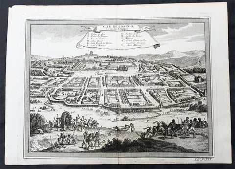
1755 Prevost & Schley Antique Print City View of Mbanza Loango West Congo Africa
- Title:Cite De Loango Tiree de Dapper
- Date: 1755
- Condition : (A+) Fine Condition
- Ref: 25755
- Size: 14in x 10in (355mm x 255mm)
Description:
This fine, original copper-plate engraved antique print, view of the city of Mbanza Loango in the pre-colonial African Kingdom of Loango - now part of the of western part of the Republic of the Congo - by Jakob van Schley in 1755 - after Olfert Dapper - was published in Antoine François Prevosts 15 volumes of Histoire Generale des Voyages written by Prevost & other authors between 1746-1789.
General Definitions:
Paper thickness and quality: - Heavy and stable
Paper color : - off white
Age of map color: -
Colors used: -
General color appearance: -
Paper size: - 14in x 10in (355mm x 255mm)
Plate size: - 12 1/2in x 9 1/2in (320mm x 240mm)
Margins: - Min 1/2in (5mm)
Imperfections:
Margins: - None
Plate area: - None
Verso: - None
Background:
The Kingdom of Loango was a pre-colonial African state, during approximately the 16th to 19th centuries in what is now the western part of the Republic of the Congo. Situated to the north of the more powerful Kingdom of Kongo, at its height in the 17th century Loango influence extended from Cape St Catherine in the north to almost the mouth of the Congo River.
Loango exported copper to the European market, and was a major producer and exporter of cloth.
The English traveller Andrew Battel, when he was there in about 1610, recorded that the predecessor of the unnamed king ruling at that time was named \"Gembe\" or Gymbe (modernized as Njimbe), possibly the founder of the kingdom. With the death of King Buatu in 1787, the succession of leadership is uncertain.
The kingdom is certain to have come to an end with the Conference of Berlin (1884–1885) at the latest, when European colonial powers divided most of Central Africa between them.
The origins of the kingdom are obscure. The most ancient complex society in the region was at Madingo Kayes, which was already a multi-site settlement in the first century CE. At present archaeological evidence is too scarce to say much more about developments until the late fifteenth or early sixteenth centuries.
Loango is not mentioned in early travelers\' accounts of the region, nor is it mentioned in the titles of King Afonso I of Kongo in 1535, though Kakongo, Vungu, and Ngoyo, its southern neighbors. It is therefore unlikely that there was a major power on the coast of Central Africa north of the Congo River.
The earliest reference to Loango in a documentary source is a mention around 1561 by Sebastião de Souto, a priest in Kongo, that King Diogo I (1545–61) sent missionaries to convert Loango to Christianity. Duarte Lopes, ambassador from Kongo to the Holy See in Rome in 1585, related that \"Loango is a friend of the King of Congo and it is said that he was a vassal in past times\" which is consistent with Loango\'s origins from Kakongo, a vassal of Kongo.
Dutch visitors recorded the first traditional account of the kingdom\'s origin in the 1630s or \'40s. In their account as reported by the geographer Olfert Dapper, the region where Loango would be constructed was populated by a number of small polities including Mayumba, Kilongo, Piri and Wansi, \"each with their own leader\" who \"made war on each other.\" He recorded that the founder of Loango, who boasted hailing from the district in Nzari in the small coastal kingdom of Kakongo, itself a vassal of Kongo, triumphed over all his rivals through the skillful use of alliances to defeat those who opposed him, particularly Wansa, Kilongo and Piri, the latter two of which required two wars to subdue. Once this had been effected, however, a range of more northern regions, including Docke and Sette submitted voluntarily. Having succeeded in the conquest, the new king moved northward and after having founded settlements in a variety of places, eventually built his capital in Buali in the province of Piri (from which the ethnic name \"Muvili\" eventually derived).
The English traveller Andrew Battel wrote when he was there in about 1610, that the predecessor of the unnamed king ruling at that time was named \"Gembe\" or \"Gymbe\" (modernized as \"Njimbe\"). A Dutch description published in 1625 said that a ruler who had died sometime before that date had ruled for 60 years and thus had taken the throne around 1565. The documentary chronology thus makes it very likely that Njimbe was the founder and first ruler mentioned in the traditions, and this supposition is supported by traditions recorded around 1890 by R. E. Dennett which also named Njimbe as the first ruler.
On the basis of later traditions from the nineteenth and twentieth centuries that linked the founding of Loango to that of Kongo, Phyllis Martin posited a much earlier foundation, the late fourteenth or early fifteenth centuries. She then argues that the absence of Loango from early titles of the king of Kongo is evidence that Loango was already independent at that time.
Njimbe had created a rule of succession which was in place around 1600, in which the king gave command over four provinces to members of his family, called the provinces of Kaye, Boke, Selage, and Kabango, and the king was to be chosen from a rotation between them. When the king died the ruler of Kaye took over, as he did indeed in the pre-1624 succession, and if the rule was followed then the ruler of Boke took his place; the other two provincial rulers advanced as well, and the king appointed a new ruler for Kabango.
In 1663, the king ruling then was baptized as Afonso by the Italian Capuchin priest Bernardo Ungaro, but there was considerable opposition to this from within the country, and indeed when he died, a non-Christian took over, but this one was himself overthrown by one of the Christian party in 1665. This civil war was still ongoing in the 1670s. In the aftermath of this civil war, a number of the Christian party fled to neighboring territories, one of whom, known to history as Miguel da Silva, was elected ruler of Ngoyo and was ruling there in 1682.
When Nathaniel Uring, an English merchant came to Loango to trade in 1701, he reported that the king had died and the power of the administration was in the hands of the \"Queen or Chief Governess of that Country,\" named \"Mucundy\" and with whom he had to deal as if with the ruler.[20] This title referred to a woman with a regular role in the administration as overseer of women\'s affairs.
Many years elapsed before we have another snapshot of Loango\'s government; during this time the rules of succession, whether formal or informal seem to have changed. When the French missionaries directed by Abbé Liévin-Bonaventure Proyart came to Loango in 1766, they noted that there was no clear succession to the throne, that anyone born of a person regarded as a princess (only female succession mattered) could aspire to the throne. Moreover, the death of a king was cause for a frequently long interregnum; the king ruling in 1766 had come to power only after an interregnum of seven years, during which time the affairs of the country were managed by a regent called Mani Boman. The Mani Boman was appointed by the king during his lifetime. Usually two were appointed to cover the eventuality of the death of one of the two. They, in turn received the petitions of a number of eligible candidates for the throne.
Eventually, the electors of the kingdom, who were those who held offices appointed by the late king, met to decide on the next king. In theory, as the old constitution maintained, the king named his successor as well and placed him as ruler of Kaye, to succeed him at his death, but as there was so much contention as to who should hold the position, the late king died without naming a Ma-Kaye.
Historian Phyllis Martin contends that the external trade of the country had enriched some members of the nobility ahead of others and had thus put pressure on the older constitution as wealthier upstart princes pressed their case forward. She argues that important members of the council were people who had obtained their positions through contact with external trade, particularly the slave trade, and they had come to share power with the king. She posits that this alteration in relative power allowed the council to dominate the king by forcing longer and longer interregna. In fact, after the death of King Buatu in 1787, no king was elected for over 100 years.However, to some extent royal authority remained in the hands of a person entitled the Nganga Mvumbi (priest of the corpse) who oversaw the body of the dead king awaiting burial. Several of these Nganga Mvumbi succeeded each other in the late eighteenth and through the nineteenth centuries.
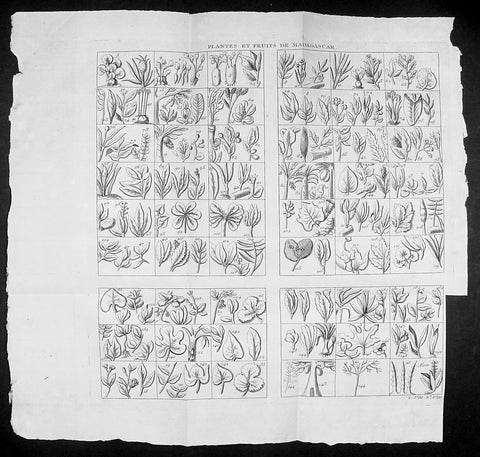
1755 Prevost & Schley Antique Print of Plants, Fruits & Flowers of Madagascar
- Title: Plantes et Fruits de Madagascar
- Date: 1755
- Size: 14 1/2in x 14in (370mm x 355mm)
- Ref: 92013
- Condition : (A+) Fine Condition
Description:
This fine, original copper-plate engraved antique print study of many various plants, fruits and flowers in the Island of Madagascar by Jakob van Schley in 1755, was published in Antoine François Prevosts 15 volumes of Histoire Generale des Voyages written by Prevost & other authors between 1746-1789.
General Definitions:
Paper thickness and quality: - Heavy and stable
Paper color : - off white
Age of map color: -
Colors used: -
General color appearance: -
Paper size: - 14 1/2in x 14in (370mm x 355mm)
Plate size: - 12 1/2in x 12in (310mm x 305mm)
Margins: - Min 1/2in (5mm)
Imperfections:
Margins: - Bottom right margin cropped to plate-mark
Plate area: - Folds as issued
Verso: - None
Background:
Madagascar previously known as the Malagasy Republic, is an island country in the Indian Ocean, off the coast of East Africa. The nation comprises the island of Madagascar (the fourth-largest island in the world), and numerous smaller peripheral islands. Following the prehistoric breakup of the supercontinent Gondwana, Madagascar split from the Indian peninsula around 88 million years ago, allowing native plants and animals to evolve in relative isolation. Consequently, Madagascar is a biodiversity hotspot; over 90% of its wildlife is found nowhere else on Earth. The island\'s diverse ecosystems and unique wildlife are threatened by the encroachment of the rapidly growing human population and other environmental threats.
As a result of the island\'s long isolation from neighboring continents, Madagascar is home to an abundance of plants and animals found nowhere else on Earth. Approximately 90% of all plant and animal species found in Madagascar are endemic, including the lemurs (a type of strepsirrhine primate), the carnivorous fossa and many birds. This distinctive ecology has led some ecologists to refer to Madagascar as the \"eighth continent\",[26] and the island has been classified by Conservation International as a biodiversity hotspot.
More than 80 percent of Madagascar\'s 14,883 plant species are found nowhere else in the world, including five plant families. The family Didiereaceae, composed of four genera and 11 species, is limited to the spiny forests of southwestern Madagascar. Four-fifths of the world\'s Pachypodium species are endemic to the island. Three-fourths of Madagascar\'s 860 orchid species are found here alone, as are six of the world\'s nine baobab species. The island is home to around 170 palm species, three times as many as on all of mainland Africa; 165 of them are endemic. Many native plant species are used as herbal remedies for a variety of afflictions. The drugs vinblastine and vincristine are vinca alkaloids, used to treat Hodgkin\'s disease, leukemia, and other cancers, were derived from the Madagascar periwinkle. The traveler\'s palm, known locally as ravinala and endemic to the eastern rain forests, is highly iconic of Madagascar.
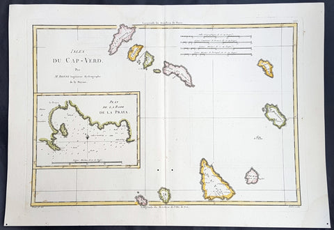
1780 Rigobert Bonne Antique Map of the Cape Verde Islands & Plan of Praia
- Title : Isles Du Cap-Verd; Plan de la Rade de la Praya...Par M Bonne
- Ref : 40546
- Size: 16in x 11in (405mm x 280mm)
- Date : 1780
- Condition: (A+) Fine Condition
Description:
This fine original copper plate engraved antique map of the Cape Verde Islands, West Africa with an inset map of the harbour & city of Praia, by Rigobert Bonne was published in the 1780 edition of Atlas des toutes les parties connues du globe terrestre by Guillaume Raynal.
General Definitions:
Paper thickness and quality: - Heavy and stable
Paper color : - off white
Age of map color: - Early
Colors used: - Yellow, pink, green, blue
General color appearance: - Authentic
Paper size: - 16in x 11in (405mm x 280mm)
Plate size: - 14 1/2in x 10 1/2in (370mm x 265mm)
Margins: - Min 1/2in (12mm)
Imperfections:
Margins: - None
Plate area: - None
Verso: - None
Background:
Cape Verde officially the Republic of Cabo Verde, is an island country spanning an archipelago of 10 volcanic islands in the central Atlantic Ocean. It forms part of the Macaronesia ecoregion, along with the Azores, Canary Islands, Madeira, and the Savage Isles.
The Cape Verde archipelago was uninhabited until the 15th century, when Portuguese explorers discovered and colonized the islands, establishing the first European settlement in the tropics. Ideally located for the Atlantic slave trade, the islands grew prosperous throughout the 16th and 17th centuries, attracting merchants, privateers, and pirates. The end of slavery in the 19th century led to economic decline and emigration. Cape Verde gradually recovered as an important commercial center and stopover for shipping routes. Incorporated as an overseas department of Portugal in 1951, the islands continued to campaign for independence, which was peacefully achieved in 1975.
Praia is the capital and largest city of Cape Verde, an island nation in the Atlantic Ocean west of Senegal. It lies on the southern coast of Santiago island in the Sotavento Islands group.
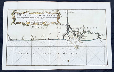
1750 Bellin Antique Map Calabar River, Calabar, Nigeria West Africa - Salve Port
- Title: Carte De la Riviere De Kalbar...Pilotes en 1699
- Date: 1750
- Condition : (A+) Fine Condition
- Ref: 25652
- Size: 16in x 10in (405mm x 255mm)
Description:
This fine large, original copper-plate engraved antique map of Calabar River Mouth, Calabar City in Nigeria, West Africa - a significant slave port of the 17th & 18th centuries - by Jacques Nicolas Bellin in 1750 was published in Antoine François Prevosts 15 volumes of Histoire Generale des Voyages written by Prevost & other authors between 1746-1790.
Detailed coastal map of Guinea coast of Western Africa, is based upon the 1699 voyage of James Barbot & John Grazilhier to New Calabar, Bandi, and Doni Rivers.
Barbot and Grazilhier each gave famous accounts of their experiences in the slave trade in the second half of the 17th Century.
General Definitions:
Paper thickness and quality: - Heavy and stable
Paper color : - off white
Age of map color: - Early
Colors used: - Green, Yellow,
General color appearance: - Authentic
Paper size: - 14in x 10in (355mm x 255mm)
Plate size: - 10 1/4in x 7 1/2in (260mm x 195mm)
Margins: - Min 1/2in (6mm)
Imperfections:
Margins: - None
Plate area: - Folds as issued
Verso: - None
Background:
One of Antoine Francois Prevosts monumental undertakings was his history of exploration & discovery in 15 volumes titledHistoire Générale des Voyages written between 1746-1759 and was extended to 20 volumes after his death by various authors.
The 20 volumes cover the early explorations & discoveries on 3 continents: Africa (v. 1-5), Asia (v. 5-11), and America (v. 12-15) with material on the finding of the French, English, Dutch, and Portugese.
A number of notable cartographers and engravers contributed to the copper plate maps and views to the 20 volumes including Nicolas Bellin, Jan Schley, Chedel, Franc Aveline, Fessard, and many others.
The African volumes cover primarily coastal countries of West, Southern, and Eastern Africa, plus the Congo, Madagascar, Arabia and the Persian Gulf areas.
The Asian volumes cover China, Korea, Tibet, Japan, Philippines, and countries bordering the Indian Ocean.
Volume 11 includes Australia and Antarctica.
Volumes 12-15 cover voyages and discoveries in America, including the East Indies, South, Central and North America.
Volumes 16-20 include supplement volumes & tables along with continuation of voyages and discoveries in Russia, Northern Europe, America, Asia & Australia.

1746 Bellin Antique Map The Course of Sangha River, Cameroon & The Congo, Africa
- Title : Cours De La Riviere De Sanaga ou Senegal
- Size: 14in x 10in (360mm x 255mm)
- Ref #: 21201
- Date : 1746
- Condition: (A+) Fine Condition
Description:
This fine large, original copper-plate engraved antique map of the course of the Sangha River flowing through Cameroon & The Congo in Central Africa by Jacques Nicolas Bellin in 1746 was published in Antoine François Prevosts 15 volumes of Histoire Generale des Voyages written by Prevost & other authors between 1746-1790.
General Definitions:
Paper thickness and quality: - Heavy and stable
Paper color : - off white
Age of map color: - Early
Colors used: - Green, Yellow,
General color appearance: - Authentic
Paper size: - 14in x 10in (360mm x 255mm)
Plate size: - 12in x 9 1/2in (305mm x 245mm)
Margins: - Min 1/2in (6mm)
Imperfections:
Margins: - None
Plate area: - Folds as issued
Verso: - None
Background:
One of Antoine Francois Prevosts monumental undertakings was his history of exploration & discovery in 15 volumes titledHistoire Générale des Voyages written between 1746-1759 and was extended to 20 volumes after his death by various authors.
The 20 volumes cover the early explorations & discoveries on 3 continents: Africa (v. 1-5), Asia (v. 5-11), and America (v. 12-15) with material on the finding of the French, English, Dutch, and Portugese.
A number of notable cartographers and engravers contributed to the copper plate maps and views to the 20 volumes including Nicolas Bellin, Jan Schley, Chedel, Franc Aveline, Fessard, and many others.
The African volumes cover primarily coastal countries of West, Southern, and Eastern Africa, plus the Congo, Madagascar, Arabia and the Persian Gulf areas.
The Asian volumes cover China, Korea, Tibet, Japan, Philippines, and countries bordering the Indian Ocean.
Volume 11 includes Australia and Antarctica.
Volumes 12-15 cover voyages and discoveries in America, including the East Indies, South, Central and North America.
Volumes 16-20 include supplement volumes & tables along with continuation of voyages and discoveries in Russia, Northern Europe, America, Asia & Australia.
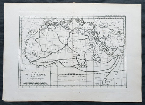
1769 J B D Anville Original Antique Map of Africa as known to the Ancients
- Title : Carte De L Afrique a l Epoque de l origine des Empires
- Size: 16in x 11in (410mm x 260mm)
- Ref #: 32341
- Date : 1769
- Condition: (A+) Fine Condition
Description:
This fine large, original copper-plate engraved antique map was published by Jean Baptiste Bourguignon D\'Anville in the 1769 edition of his atlas Geographie Ancienne et Abregee. or Modern and Ancient Geography (Ref: M&B; Tooley)
General Definitions:
Paper thickness and quality: - Heavy and stable
Paper color : - off white
Age of map color: -
Colors used: -
General color appearance: -
Paper size: - 16in x 11in (410mm x 260mm)
Plate size: - 13in x 9 1/2in (330mm x 245mm)
Margins: - Min 1/2in (12mm)
Imperfections:
Margins: - None
Plate area: - None
Verso: - None
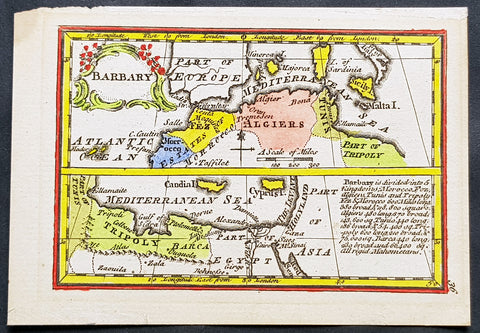
1758 John Gibson Antique Miniature Map Barbary or Berber Coast Nth Africa - Rare
- Title : Barbary
- Size: 4 1/2in x 3 1/4in (115mm x 83mm)
- Condition: (A+) Fine Condition
- Date : 1758
- Ref #: 31422
Description:
This beautifully hand coloured original copper-plate engraved antique map of the Barbary Coast, North Africa from Morocco to Egypt - a beautiful example of the art of miniature map making - was published by John Gibson in his 1758 edition of Atlas Minimus.
(Ref: M&B; Tooley)
General Definitions:
Paper thickness and quality: - Heavy and stable
Paper color : - off white
Age of map color: - Original
Colors used: - Yellow, green, blue, pink
General color appearance: - Authentic
Paper size: - 4 1/2in x 3 1/4in (115mm x 83mm)
Plate size: - 4in x 2 3/4in (100mm x 70mm)
Margins: - Min 1/4in (5mm)
Imperfections:
Margins: - None
Plate area: - None
Verso: - None
Background:
The term Barbary Coast or Berbery or Berber Coast, was the term Europeans used from the 16th to early 19th century to refer to much of the collective land of the Berber people.
The term Barbary Coast emphasizes the Berber coastal regions and cities throughout the middle and western coastal regions of North Africa – what is now modern nations of Morocco, Algeria, Tunisia, and Libya. The English term Barbary (and its European varieties: Barbaria, Berbérie, etc.) referred mainly to the entire Berber lands including non-coastal regions, deep into the African continent, as seen in European geographical and political maps published during the 17th–20th centuries.
The name derives from the Berber people of North Africa. In the West, the name commonly evoked the Barbary pirates and Barbary slave traders based on that coast—who attacked ships and coastal settlements in the Mediterranean Sea and eastern North Atlantic Ocean, and captured and traded slaves or goods from Europe, America and sub-Saharan Africa. These actions finally provoked the Barbary Wars of the early 19th century. The slaves and goods were being traded and sold throughout the Ottoman Empire or to the Europeans themselves.
Barbary was not always a unified political entity. From the 16th century onwards, it was divided into the political entities of the Regency of Algiers, Tunis, and Tripolitania (Tripoli). Major rulers petty monarchs during the times of the Barbary states\' plundering parties included the Pasha or Dey of Algiers, the Bey of Tunis and the Bey of Tripoli.
Before then, the territory was usually divided between Ifriqiya, Morocco, and a west-central Algerian state centered on Tlemcen or Tiaret. Powerful Berber dynasties such as the Almohads (12th century) and briefly thereafter the Hafsids, occasionally unified it for short periods. From a European perspective, Tripoli in modern-day Libya, was considered its capital or chief city—though Marrakesh in Morocco was the largest and most important Berber city at the time. Some saw Algiers in Algeria, or Tangiers in Morocco as the capital.
Purchase of Christian captives in the Barbary States.
The first United States military land action overseas, executed by the U.S. Marines and Navy, was the Battle of Derna, Tripoli, (a coastal town in modern eastern Libya) in April 1805. It formed part of an effort to destroy all of the Barbary pirates, to free American slaves in captivity, and to put an end to piracy acts between these warring tribes on the part of the Barbary states, which were themselves member states of the Ottoman Empire. The opening line of the Marines\' Hymn refers to this action: From the halls of Montezuma to the shores of Tripoli.... This was the first time the United States Marine Corps took part in offensive actions outside of the United States.
The word razzia is, via Italian and French, from Algerian Arabic ghaziya (غزية \"raiding\"), originally referring to slave raids conducted by Barbary pirates.
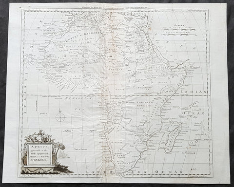
1782 Thomas Kitchin Large Original Antique Map of Africa
- Title : Africa agreeable to the most approved Maps and Charts by Mr Kitchin
- Size: 17in x 14in (435mm x 355mm)
- Condition: (A) Very Good Condition
- Date : 1782
- Ref #: 24047
Description:
This large original antique copper-plate engraved map of Africa by the famous English cartographer Thomas Kitchin was published for the 1782 edition of George Henry Millars New Complete & Universal System of Geography
General Definitions:
Paper thickness and quality: - Heavy and stable
Paper color : - off white
Age of map color: -
Colors used: -
General color appearance: -
Paper size: - 17in x 14in (435mm x 355mm)
Plate size: - 15in x 13 1/2in (380mm x 345mm)
Margins: - Min 1/2in (10mm)
Imperfections:
Margins: - Centerfold re-enforced on verso
Plate area: - Creasing along centerfold
Verso: - Centerfold re-enforced on verso
Background:
Millar, George Henry
Was responsible for the publication of The new and universal system of geography : being a complete history and description of the whole world, containing a particular, full, accurate, circumstantial and entertaining account, including the antient and present state of all the various countries of Europe, Asia, Africa, and America, as divided into empires, kingdoms, states, republics, and colonies.. Printed by Alexander Hogg ..., 1782.
This comprehensive world geography and history was liberally illustrated with decorative plates and maps covering Europe, Asia, Africa, and America with information about the history, geography, climate, people, flora and fauna etc. It also includes important eighteenth century voyages and discoveries including Captain Cook\\\\\\\'s second voyage. Although his third voyage is not included, there is a plate illustrating his death in Hawaii. Other illustrations include city views from around the world, native costumes and occupations, and indigenous flora and fauna. The foldout maps were engraved by Kitchin, Bowen, Conder and Lodge with plates by several renowned English engravers. There is a fine map of the American colonies and city plans for the harbors of New York, Charleston, Havana, and Boston. Complete with upwards of 120 capital engravings with 25 maps. Published by Alexander Hogg, London.
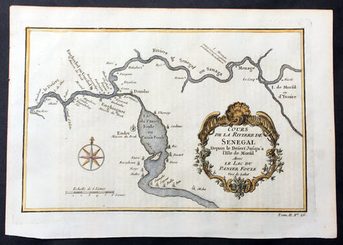
1757 Bellin Antique Map The Senegal River, Bethio & N Dombo, Senegal West Africa
- Title : Cours de la Riviere de Senegal Depuis le Desert Jusqu a Isle de Morsil...
- Size: 10in x 7in (255mm x 180mm)
- Ref #: 25785
- Date : 1757
- Condition: (A+) Fine Condition
Description:
This fine, original copper-plate engraved antique map of the Senegal River in the Bethio & N Dombo regions of Northern Senegal and Mauritania in West Africa by Nicolas Bellin in 1757 was published in Antoine François Prevosts 15 volumes of Histoire Generale des Voyages written by Prevost & other authors between 1746-1790.
The Senegal River is a 1,086 km (675 mi) long river in West Africa that forms the border between Senegal and Mauritania.
General Definitions:
Paper thickness and quality: - Heavy and stable
Paper color : - off white
Age of map color: - Early
Colors used: - Yellow, green
General color appearance: - Authentic
Paper size: - 10in x 7in (255mm x 180mm)
Plate size: - 9in x 6 1/2in (250mm x 165mm)
Margins: - Min 1/2in (12mm)
Imperfections:
Margins: - None
Plate area: - None
Verso: - None
Background:
One of Antoine Francois Prevosts monumental undertakings was his history of exploration & discovery in 15 volumes titledHistoire Générale des Voyages written between 1746-1759 and was extended to 20 volumes after his death by various authors.
The 20 volumes cover the early explorations & discoveries on 3 continents: Africa (v. 1-5), Asia (v. 5-11), and America (v. 12-15) with material on the finding of the French, English, Dutch, and Portugese.
A number of notable cartographers and engravers contributed to the copper plate maps and views to the 20 volumes including Nicolas Bellin, Jan Schley, Chedel, Franc Aveline, Fessard, and many others.
The African volumes cover primarily coastal countries of West, Southern, and Eastern Africa, plus the Congo, Madagascar, Arabia and the Persian Gulf areas.
The Asian volumes cover China, Korea, Tibet, Japan, Philippines, and countries bordering the Indian Ocean.
Volume 11 includes Australia and Antarctica.
Volumes 12-15 cover voyages and discoveries in America, including the East Indies, South, Central and North America.
Volumes 16-20 include supplement volumes & tables along with continuation of voyages and discoveries in Russia, Northern Europe, America, Asia & Australia.
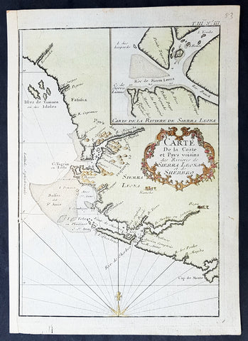
1757 Bellin Antique Map of Sierra Leone & Sherbro Rivers of Sierra Leone, Africa
- Title : Carte de la Coste et Pays voisins das Rivieres des Sierra Leona et de Sherbro
- Size: 10in x 7in (255mm x 180mm)
- Ref #: 21174
- Date : 1757
- Condition: (A) Very Good Condition
Description:
This fine, original copper-plate engraved antique map of the coast and river mouth of the Sierra Leone & the Sherbro Rivers in Sierrra Leone West Africa by Nicolas Bellin in 1757 was published in Antoine François Prevosts 15 volumes of Histoire Generale des Voyageswritten by Prevost & other authors between 1746-1790.
The Sierra Leone River is a river estuary on the Atlantic Ocean in Western Sierra Leone. It is formed by the Bankasoka River and Rokel River and is between 4 and 10 miles wide (6–16 km) and 25 miles (40 km) long. It holds the major ports of Queen Elizabeth II Quay and Pepel. The estuary is also important for shipping. It is the largest natural harbour in the African continent. Several islands, including Tasso Island (the largest), Tombo Island, and the historically important Bunce Island, are located in the estuary.
Sherbro Island is in the Atlantic Ocean, located in Bonthe District off the Southern Province of Sierra Leone. The Sherbro people make up by far the largest ethnic group in the island.
General Definitions:
Paper thickness and quality: - Heavy and stable
Paper color : - off white
Age of map color: - Early
Colors used: - Yellow, green
General color appearance: - Authentic
Paper size: - 10in x 7in (255mm x 180mm)
Plate size: - 9in x 6 1/2in (250mm x 165mm)
Margins: - Min 1/2in (12mm)
Imperfections:
Margins: - None
Plate area: - Repair to left of image
Verso: - Repair as noted
Background:
One of Antoine Francois Prevosts monumental undertakings was his history of exploration & discovery in 15 volumes titledHistoire Générale des Voyages written between 1746-1759 and was extended to 20 volumes after his death by various authors.
The 20 volumes cover the early explorations & discoveries on 3 continents: Africa (v. 1-5), Asia (v. 5-11), and America (v. 12-15) with material on the finding of the French, English, Dutch, and Portugese.
A number of notable cartographers and engravers contributed to the copper plate maps and views to the 20 volumes including Nicolas Bellin, Jan Schley, Chedel, Franc Aveline, Fessard, and many others.
The African volumes cover primarily coastal countries of West, Southern, and Eastern Africa, plus the Congo, Madagascar, Arabia and the Persian Gulf areas.
The Asian volumes cover China, Korea, Tibet, Japan, Philippines, and countries bordering the Indian Ocean.
Volume 11 includes Australia and Antarctica.
Volumes 12-15 cover voyages and discoveries in America, including the East Indies, South, Central and North America.
Volumes 16-20 include supplement volumes & tables along with continuation of voyages and discoveries in Russia, Northern Europe, America, Asia & Australia.
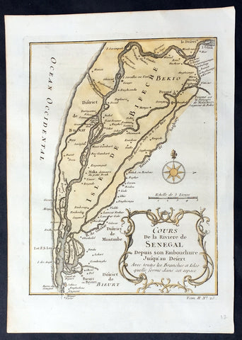
1757 Nicolas Bellin Original Antique Map Saloum River Delta, Senegal West Africa
- Title : Cours de la Riviere de Senegal...
- Ref #: 92505
- Size: 10in x 7in (255mm x 180mm)
- Date : 1757
- Condition: (A+) Fine Condition
Description:
This fine, original copper-plate engraved antique map of the Saloum Delta in the Fatck Region of South Senegal, West Africa by Nicolas Bellin in 1757 was published in Antoine François Prevosts 15 volumes of Histoire Generale des Voyages written by Prevost & other authors between 1746-1790.
The Saloum River rises about 105 kilometers east of Kaolack, Senegal, and flows into the Atlantic Ocean. The significant Saloum Delta is located at its mouth, which is protected as Saloum Delta National Park. The river basin lies within the Serer pre-colonial Kingdom of Saloum. Mangrove forests occupy a 5-kilometer belt on either side of the river almost 70 kilometers upstream.
General Definitions:
Paper thickness and quality: - Heavy and stable
Paper color : - off white
Age of map color: - Early
Colors used: - Yellow, green
General color appearance: - Authentic
Paper size: - 10in x 7in (255mm x 180mm)
Plate size: - 10in x 7in (255mm x 180mm)
Margins: - Min 1/2in (12mm)
Imperfections:
Margins: - None
Plate area: - None
Verso: - Light soiling
Background:
One of Antoine Francois Prevosts monumental undertakings was his history of exploration & discovery in 15 volumes titledHistoire Générale des Voyages written between 1746-1759 and was extended to 20 volumes after his death by various authors.
The 20 volumes cover the early explorations & discoveries on 3 continents: Africa (v. 1-5), Asia (v. 5-11), and America (v. 12-15) with material on the finding of the French, English, Dutch, and Portugese.
A number of notable cartographers and engravers contributed to the copper plate maps and views to the 20 volumes including Nicolas Bellin, Jan Schley, Chedel, Franc Aveline, Fessard, and many others.
The African volumes cover primarily coastal countries of West, Southern, and Eastern Africa, plus the Congo, Madagascar, Arabia and the Persian Gulf areas.
The Asian volumes cover China, Korea, Tibet, Japan, Philippines, and countries bordering the Indian Ocean.
Volume 11 includes Australia and Antarctica.
Volumes 12-15 cover voyages and discoveries in America, including the East Indies, South, Central and North America.
Volumes 16-20 include supplement volumes & tables along with continuation of voyages and discoveries in Russia, Northern Europe, America, Asia & Australia.
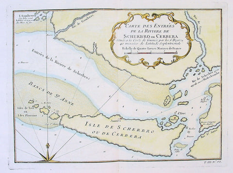
1750 Bellin Antique Map Mouth of the Sherboro River in Seirra Leone, Africa
- Title: Carte des Entrees de la Riviere de Scherbro ou Cerbera
- Date: 1750
- Condition : (A+) Fine Condition
- Ref: 25679
- Size: 14in x 10in (355mm x 255mm)
Description:
This fine large, original copper-plate engraved antique map of the mouth of the Sherboro River in Sierra Leone, Africa by Jacques Nicolas Bellin in 1750 was published in Antoine François Prevosts 15 volumes of Histoire Generale des Voyages written by Prevost & other authors between 1746-1790.
General Definitions:
Paper thickness and quality: - Heavy and stable
Paper color : - off white
Age of map color: - Early
Colors used: - Green, Yellow,
General color appearance: - Authentic
Paper size: - 14in x 10in (355mm x 255mm)
Plate size: - 10 1/4in x 7 1/2in (260mm x 195mm)
Margins: - Min 1/2in (6mm)
Imperfections:
Margins: - None
Plate area: - Folds as issued
Verso: - None
Background:
One of Antoine Francois Prevosts monumental undertakings was his history of exploration & discovery in 15 volumes titledHistoire Générale des Voyages written between 1746-1759 and was extended to 20 volumes after his death by various authors.
The 20 volumes cover the early explorations & discoveries on 3 continents: Africa (v. 1-5), Asia (v. 5-11), and America (v. 12-15) with material on the finding of the French, English, Dutch, and Portugese.
A number of notable cartographers and engravers contributed to the copper plate maps and views to the 20 volumes including Nicolas Bellin, Jan Schley, Chedel, Franc Aveline, Fessard, and many others.
The African volumes cover primarily coastal countries of West, Southern, and Eastern Africa, plus the Congo, Madagascar, Arabia and the Persian Gulf areas.
The Asian volumes cover China, Korea, Tibet, Japan, Philippines, and countries bordering the Indian Ocean.
Volume 11 includes Australia and Antarctica.
Volumes 12-15 cover voyages and discoveries in America, including the East Indies, South, Central and North America.
Volumes 16-20 include supplement volumes & tables along with continuation of voyages and discoveries in Russia, Northern Europe, America, Asia & Australia.

1746 Bellin Antique Map The Course of Sangha River, Cameroon & The Congo, Africa
- Title : Cours De La Riviere De Sanaga ou Senegal
- Size: 14in x 10in (360mm x 255mm)
- Ref #: 25554
- Date : 1746
- Condition: (A+) Fine Condition
Description:
This fine large, original copper-plate engraved antique map of the course of the Sangha River flowing through Cameroon & The Congo in Central Africa by Jacques Nicolas Bellin in 1746 was published in Antoine François Prevosts 15 volumes of Histoire Generale des Voyages written by Prevost & other authors between 1746-1790.
General Definitions:
Paper thickness and quality: - Heavy and stable
Paper color : - off white
Age of map color: - Early
Colors used: - Green, Yellow,
General color appearance: - Authentic
Paper size: - 14in x 10in (360mm x 255mm)
Plate size: - 12in x 9 1/2in (305mm x 245mm)
Margins: - Min 1/2in (6mm)
Imperfections:
Margins: - None
Plate area: - Folds as issued
Verso: - None
Background:
One of Antoine Francois Prevosts monumental undertakings was his history of exploration & discovery in 15 volumes titledHistoire Générale des Voyages written between 1746-1759 and was extended to 20 volumes after his death by various authors.
The 20 volumes cover the early explorations & discoveries on 3 continents: Africa (v. 1-5), Asia (v. 5-11), and America (v. 12-15) with material on the finding of the French, English, Dutch, and Portugese.
A number of notable cartographers and engravers contributed to the copper plate maps and views to the 20 volumes including Nicolas Bellin, Jan Schley, Chedel, Franc Aveline, Fessard, and many others.
The African volumes cover primarily coastal countries of West, Southern, and Eastern Africa, plus the Congo, Madagascar, Arabia and the Persian Gulf areas.
The Asian volumes cover China, Korea, Tibet, Japan, Philippines, and countries bordering the Indian Ocean.
Volume 11 includes Australia and Antarctica.
Volumes 12-15 cover voyages and discoveries in America, including the East Indies, South, Central and North America.
Volumes 16-20 include supplement volumes & tables along with continuation of voyages and discoveries in Russia, Northern Europe, America, Asia & Australia.

1739 Bellin Original Antique Map of SW Africa The Cape to Angola - Hottentots
- Title: Carte Occidentale D Afrique...1739
- Date: 1739
- Condition : (A+) Fine Condition
- Ref: 25563
- Size: 14in x 10in (355mm x 255mm)
Description:
This fine large, original copper-plate engraved antique map of central and south western coastline of Africa - from the cape to northern Angola - by Jacques Nicolas Bellin in 1739 was published in Antoine François Prevosts 15 volumes of Histoire Generale des Voyages written by Prevost & other authors between 1746-1790.
General Definitions:
Paper thickness and quality: - Heavy and stable
Paper color : - off white
Age of map color: - Early
Colors used: - Green, Yellow,
General color appearance: - Authentic
Paper size: - 11 1/2in x 11in (295mm x 280mm)
Plate size: - 11in x 9in (280mm x 230mm)
Margins: - Min 1/2in (6mm)
Imperfections:
Margins: - None
Plate area: - None
Verso: - None
Background:
One of Antoine Francois Prevosts monumental undertakings was his history of exploration & discovery in 15 volumes titledHistoire Générale des Voyages written between 1746-1759 and was extended to 20 volumes after his death by various authors.
The 20 volumes cover the early explorations & discoveries on 3 continents: Africa (v. 1-5), Asia (v. 5-11), and America (v. 12-15) with material on the finding of the French, English, Dutch, and Portugese.
A number of notable cartographers and engravers contributed to the copper plate maps and views to the 20 volumes including Nicolas Bellin, Jan Schley, Chedel, Franc Aveline, Fessard, and many others.
The African volumes cover primarily coastal countries of West, Southern, and Eastern Africa, plus the Congo, Madagascar, Arabia and the Persian Gulf areas.
The Asian volumes cover China, Korea, Tibet, Japan, Philippines, and countries bordering the Indian Ocean.
Volume 11 includes Australia and Antarctica.
Volumes 12-15 cover voyages and discoveries in America, including the East Indies, South, Central and North America.
Volumes 16-20 include supplement volumes & tables along with continuation of voyages and discoveries in Russia, Northern Europe, America, Asia & Australia.