Africa (56)
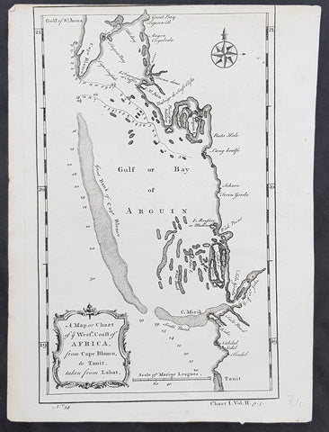
1745 Bradock Mean or John Green Antique Map of Bay of Arguin, Mauritania, Africa
- Title : A Map or Chart of ye Westn Coast of AFRICA from Cape Blanco, to Tanit. taken from Labat
- Size: 10in x 7 1/2in (255mm x 195mm)
- Ref #: 15998
- Date : 1745
- Condition: (A) Very Good Condition
Description:
This fine original copper-plate engraved antique map of The Bay of Arguin on the Atlantic coast of Mauritania, North Africa - located south of Cap Blanc, north of Cap Timiris - by Bradock Mean or John Green, was published in 1745 after Jean-Baptiste Labat.
General Definitions:
Paper thickness and quality: - Heavy and stable
Paper color : - off white
Age of map color: -
Colors used: -
General color appearance: -
Paper size: - 10in x 7 1/2in (255mm x 195mm)
Plate size: - 10in x 7 1/2in (255mm x 195mm)
Margins: - Min 0in (0mm)
Imperfections:
Margins: - Top right margin cropped to border
Plate area: - None
Verso: - None
Background:
Jean-Baptiste Labat 1663 – 1738 was a French clergyman, botanist, writer, explorer, ethnographer, soldier, engineer, and landowner.
Mead, Bradock ne John Green 1685 - 1757
The world of the commercial cartographer in eighteenth-century London was quite respectable. It was punctuated by the usual calamities that befell any entrepreneurial enterprise: partners split in acrimony; some cartographers, such as Thomas Jefferys in 1766 or Osgood Carleton in 1803 suffered the misfortune of bankruptcy. Yet there was a claim to respectability among these tradesmen. They mixed with the literati and natural philosophers; the texts and maps they published contributed to \\\"the science of princes\\\"; their clientele comprised gentry, clergy, and aristocracy; a favored few sold their maps to royalty and claimed titles such as \\\"geographer to His Majesty.\\\"
John Green, however, presents an effective antidote to this image of propriety and respectability. He took cartography from the salons and the coffee houses into the taverns and the squalid streets memorialized in Hogarth\\\'s prints.
The events of Green\\\'s life are obscured by his working for publishers who took the credit for his work; his willingness to remain anonymous was certainly enhanced by his brushes with the law. The main source of information for his life is an undated letter that Thomas Jefferys wrote to the earl of Morton (James Douglass, 14th earl, then president of the Royal Society) presumably in January 1767.
John Green was born Bradock Mead in Ireland, probably well before 1688. He clearly came from a sufficiently respectable family to get a good education; the Thomas Mead who became Lord Mayor of Dublin in 1757 was likely his brother.
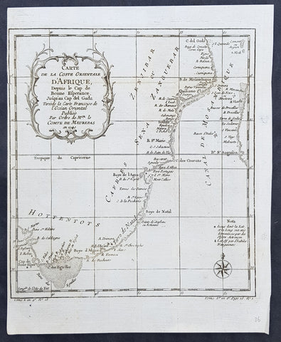
1755 Bellin Antique Map South East Africa from The Cape to Tanzania - Hottentots
- Title : Carte de la Coste orientale d Afrique , depuis le cap de Bonne Espérance jusqu\' au cap del Gada . Tirée de la carte françoise de l Océan Oriental puliée ... le Comte de Maurepas en 1740
- Size: 12in x 10in (305mm x 255mm)
- Ref #: 92506
- Date : 1757
- Condition: (A+) Fine Condition
Description:
This fine original copper-plate engraved antique map of St Helena Bay in Western Cape South Africa by Jacques Nicolas Bellin was published in 1757 in Antoine François Prevosts 15 volumes of Histoire Generale des Voyages written by Prevost & other authors between 1746-1790.
Historically, Saint Helena Bay is the location where Vasco da Gama, first set foot in South Africa. The date of this event was recorded as November 7, 1497.
The bay was named Bahia de Santa Helena (Portuguese for its current name) after Saint Helena a devout, influential Christian and mother of Constantine I. This location was also the first setting of a battle between the indigenous Khoikhoi people and early European explorers.
General Definitions:
Paper thickness and quality: - Heavy and stable
Paper color : - off white
Age of map color: -
Colors used: -
General color appearance: -
Paper size: - 12in x 10in (305mm x 255mm)
Plate size: - 10in x 8in (255mm x 205mm)
Margins: - Min 1/2in (12mm)
Imperfections:
Margins: - None
Plate area: - Folds as issued
Verso: - None
Background:
One of Antoine Francois Prevosts monumental undertakings was his history of exploration & discovery in 15 volumes titledHistoire Générale des Voyages written between 1746-1759 and was extended to 20 volumes after his death by various authors.
The 20 volumes cover the early explorations & discoveries on 3 continents: Africa (v. 1-5), Asia (v. 5-11), and America (v. 12-15) with material on the finding of the French, English, Dutch, and Portugese.
A number of notable cartographers and engravers contributed to the copper plate maps and views to the 20 volumes including Nicolas Bellin, Jan Schley, Chedel, Franc Aveline, Fessard, and many others.
The African volumes cover primarily coastal countries of West, Southern, and Eastern Africa, plus the Congo, Madagascar, Arabia and the Persian Gulf areas.
The Asian volumes cover China, Korea, Tibet, Japan, Philippines, and countries bordering the Indian Ocean.
Volume 11 includes Australia and Antarctica.
Volumes 12-15 cover voyages and discoveries in America, including the East Indies, South, Central and North America.
Volumes 16-20 include supplement volumes & tables along with continuation of voyages and discoveries in Russia, Northern Europe, America, Asia & Australia.
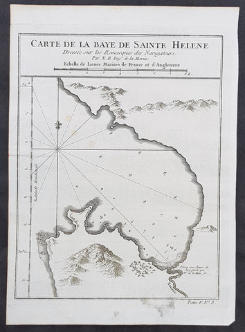
1757 Bellin Antique Map St Helena Bay, Western Cape South Africa - Vasco da Gama
- Title : Carte de la Baye de Sainte Helene
- Size: 10in x 7 1/2in (255mm x 190mm)
- Ref #: 25783
- Date : 1757
- Condition: (A+) Fine Condition
Description:
This fine original copper-plate engraved antique map of St Helena Bay in Western Cape South Africa by Jacques Nicolas Bellin was published in 1757 in Antoine François Prevosts 15 volumes of Histoire Generale des Voyages written by Prevost & other authors between 1746-1790.
Historically, Saint Helena Bay is the location where Vasco da Gama, first set foot in South Africa. The date of this event was recorded as November 7, 1497.
The bay was named Bahia de Santa Helena (Portuguese for its current name) after Saint Helena a devout, influential Christian and mother of Constantine I. This location was also the first setting of a battle between the indigenous Khoikhoi people and early European explorers.
General Definitions:
Paper thickness and quality: - Heavy and stable
Paper color : - off white
Age of map color: -
Colors used: -
General color appearance: -
Paper size: - 10in x 7 1/2in (255mm x 190mm)
Plate size: - 10in x 7 1/2in (255mm x 190mm)
Margins: - Min 1/2in (12mm)
Imperfections:
Margins: - None
Plate area: - None
Verso: - None
Background:
One of Antoine Francois Prevosts monumental undertakings was his history of exploration & discovery in 15 volumes titledHistoire Générale des Voyages written between 1746-1759 and was extended to 20 volumes after his death by various authors.
The 20 volumes cover the early explorations & discoveries on 3 continents: Africa (v. 1-5), Asia (v. 5-11), and America (v. 12-15) with material on the finding of the French, English, Dutch, and Portugese.
A number of notable cartographers and engravers contributed to the copper plate maps and views to the 20 volumes including Nicolas Bellin, Jan Schley, Chedel, Franc Aveline, Fessard, and many others.
The African volumes cover primarily coastal countries of West, Southern, and Eastern Africa, plus the Congo, Madagascar, Arabia and the Persian Gulf areas.
The Asian volumes cover China, Korea, Tibet, Japan, Philippines, and countries bordering the Indian Ocean.
Volume 11 includes Australia and Antarctica.
Volumes 12-15 cover voyages and discoveries in America, including the East Indies, South, Central and North America.
Volumes 16-20 include supplement volumes & tables along with continuation of voyages and discoveries in Russia, Northern Europe, America, Asia & Australia.
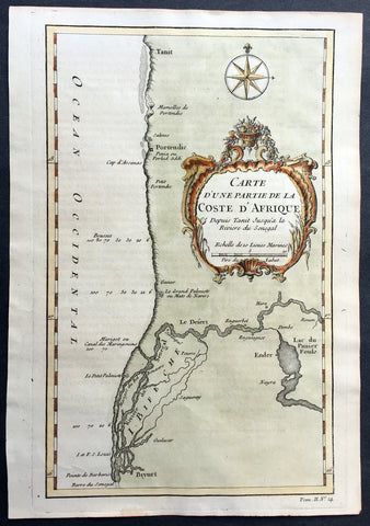
1757 Bellin Antique Map of West Africa South Senegal - Saloum Delta, Nat. Park
- Title : Carte D Une Partie de la Coste D Afrique Depuis Tanit Jusqua la Riviere du Senegal
- Size: 10in x 7in (255mm x 180mm)
- Ref #: 25792
- Date : 1757
- Condition: (A+) Fine Condition
Description:
This fine original copper-plate engraved antique map of Southern Senegal in West Africa including what is today part of the Saloum National Park in the Saloum Delta by Jacques Nicolas Bellin was published in 1757 in Antoine François Prevosts 15 volumes of Histoire Generale des Voyages written by Prevost & other authors between 1746-1790.
General Definitions:
Paper thickness and quality: - Heavy and stable
Paper color : - off white
Age of map color: - Early
Colors used: - Green, yellow, orange
General color appearance: - Authentic
Paper size: - 10in x 7in (255mm x 180mm)
Plate size: - 10in x 7in (255mm x 180mm)
Margins: - Min 1/2in (12mm)
Imperfections:
Margins: - None
Plate area: - None
Verso: - None
Background:
One of Antoine Francois Prevosts monumental undertakings was his history of exploration & discovery in 15 volumes titledHistoire Générale des Voyages written between 1746-1759 and was extended to 20 volumes after his death by various authors.
The 20 volumes cover the early explorations & discoveries on 3 continents: Africa (v. 1-5), Asia (v. 5-11), and America (v. 12-15) with material on the finding of the French, English, Dutch, and Portugese.
A number of notable cartographers and engravers contributed to the copper plate maps and views to the 20 volumes including Nicolas Bellin, Jan Schley, Chedel, Franc Aveline, Fessard, and many others.
The African volumes cover primarily coastal countries of West, Southern, and Eastern Africa, plus the Congo, Madagascar, Arabia and the Persian Gulf areas.
The Asian volumes cover China, Korea, Tibet, Japan, Philippines, and countries bordering the Indian Ocean.
Volume 11 includes Australia and Antarctica.
Volumes 12-15 cover voyages and discoveries in America, including the East Indies, South, Central and North America.
Volumes 16-20 include supplement volumes & tables along with continuation of voyages and discoveries in Russia, Northern Europe, America, Asia & Australia.
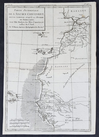
1780 Rigobert Bonne Original Antique Map NW Africa Morocco to Senegal Canary Is.
- Title : Partie Occidentale De L Ancien Continent ...M Bonne
- Size: 13in x 9 1/2in (330mm x 240mm)
- Ref #: 40900
- Date : 1780
- Condition: (A+) Fine Condition
Description:
This original copper-plate engraved map was published in 1780 edition of Atllas des toutes les parties connues du globe terrestre by Rigobert Bonne & Guillaume Raynal.
General Definitions:
Paper thickness and quality: - Heavy and stable
Paper color : - off white
Age of map color: -
Colors used: -
General color appearance: -
Paper size: - 13in x 9 1/2in (330mm x 240mm)
Plate size: - 13in x 9 1/2in (330mm x 240mm)
Margins: - Min 1/4in (8mm)
Imperfections:
Margins: - None
Plate area: - None
Verso: - None
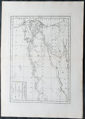
1769 J B D Anville Original Antique Map of Egypt & The Nile in Time of Pharaohs
- Title : Carte De L Egypte sous Les Pharaons
- Size: 16in x 11in (410mm x 260mm)
- Ref #: 32342
- Date : 1769
- Condition: (A+) Fine Condition
Description:
This fine large, original copper-plate engraved antique map was published by Jean Baptiste Bourguignon D'Anville in the 1769 edition of his atlas Geographie Ancienne et Abregee. or Modern and Ancient Geography (Ref: M&B; Tooley)
General Definitions:
Paper thickness and quality: - Heavy and stable
Paper color : - off white
Age of map color: -
Colors used: -
General color appearance: -
Paper size: - 16in x 11in (410mm x 260mm)
Plate size: - 13in x 9 1/2in (330mm x 245mm)
Margins: - Min 1/2in (12mm)
Imperfections:
Margins: - None
Plate area: - None
Verso: - None

1740 Bellin Antique Coastal Map of South East Africa - South Africa to Zanzibar
- Title : Carte de la Coste Orientale D Afrique...1740
- Date : 1740
- Size: 12in x 9 1/2in (305mm x 240mm)
- Ref #: 92509
- Condition: (A+) Fine Condition
Description:
This fine large, original copper-plate engraved antique map of South and Eastern Coast of Africa from South Africa to Zanzibar by Jacques Nicolas Bellin in 1740 was published in Antoine François Prevosts 15 volumes of Histoire Generale des Voyages written by Prevost & other authors between 1746-1790.
General Condition:
Paper thickness and quality: - Heavy and stable
Paper color: - off white
Age of map color: - Early
Colors used: - Red, green, yellow
General color appearance: - Authentic
Paper size: - 12in x 9 1/2in (305mm x 240mm)
Plate size: - 10in x 8in (255mm x 205mm)
Margins: - Min 1/2in (12mm)
Imperfections:
Margins: - None
Plate area: - Folds as issued
Verso: - None
Background:
One of Antoine Francois Prevosts monumental undertakings was his history of exploration & discovery in 15 volumes titledHistoire Générale des Voyages written between 1746-1759 and was extended to 20 volumes after his death by various authors.
The 20 volumes cover the early explorations & discoveries on 3 continents: Africa (v. 1-5), Asia (v. 5-11), and America (v. 12-15) with material on the finding of the French, English, Dutch, and Portugese.
A number of notable cartographers and engravers contributed to the copper plate maps and views to the 20 volumes including Nicolas Bellin, Jan Schley, Chedel, Franc Aveline, Fessard, and many others.
The African volumes cover primarily coastal countries of West, Southern, and Eastern Africa, plus the Congo, Madagascar, Arabia and the Persian Gulf areas.
The Asian volumes cover China, Korea, Tibet, Japan, Philippines, and countries bordering the Indian Ocean.
Volume 11 includes Australia and Antarctica.
Volumes 12-15 cover voyages and discoveries in America, including the East Indies, South, Central and North America.
Volumes 16-20 include supplement volumes & tables along with continuation of voyages and discoveries in Russia, Northern Europe, America, Asia & Australia.
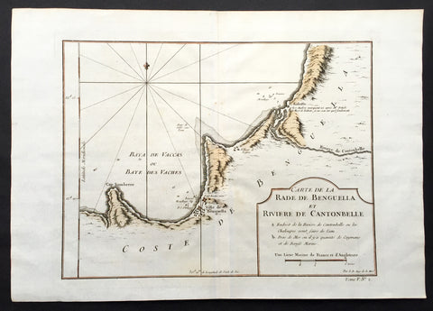
1750 Bellin Antique Map of the Benguela province of Angola, Africa
- Title: Carte de la Rade de Benguella et Riviere de Cantonbelle
- Date: 1750
- Condition : (A+) Fine Condition
- Ref: 25550
- Size: 11 1/2in x 11in (295mm x 280mm)
Description:
This fine large, original copper-plate engraved antique map of the Benguela province of Angola by Jacques Nicolas Bellin in 1750 was published in Antoine François Prevosts 15 volumes of Histoire Generale des Voyageswritten by Prevost & other authors between 1746-1790.
The Portuguese crown created the Kingdom of Benguela in 1615 to improve the conditions to develop the desired land route to Mozambique across Africa. The trading post founded here did not meet the expectations of the Portuguese in mineral resources and soil quality, so a village was only established for the slave trade, under the name of Mbaka
General Definitions:
Paper thickness and quality: - Heavy and stable
Paper color : - off white
Age of map color: - Early
Colors used: - Green, Yellow,
General color appearance: - Authentic
Paper size: - 14in x 10in (355mm x 255mm)
Plate size: - 12in x 9in (305mm x 230mm)
Margins: - Min 1/2in (6mm)
Imperfections:
Margins: - None
Plate area: - Folds as issued
Verso: - None
Background:
One of Antoine Francois Prevosts monumental undertakings was his history of exploration & discovery in 15 volumes titledHistoire Générale des Voyages written between 1746-1759 and was extended to 20 volumes after his death by various authors.
The 20 volumes cover the early explorations & discoveries on 3 continents: Africa (v. 1-5), Asia (v. 5-11), and America (v. 12-15) with material on the finding of the French, English, Dutch, and Portugese.
A number of notable cartographers and engravers contributed to the copper plate maps and views to the 20 volumes including Nicolas Bellin, Jan Schley, Chedel, Franc Aveline, Fessard, and many others.
The African volumes cover primarily coastal countries of West, Southern, and Eastern Africa, plus the Congo, Madagascar, Arabia and the Persian Gulf areas.
The Asian volumes cover China, Korea, Tibet, Japan, Philippines, and countries bordering the Indian Ocean.
Volume 11 includes Australia and Antarctica.
Volumes 12-15 cover voyages and discoveries in America, including the East Indies, South, Central and North America.
Volumes 16-20 include supplement volumes & tables along with continuation of voyages and discoveries in Russia, Northern Europe, America, Asia & Australia.