Welcome to Classical Images!
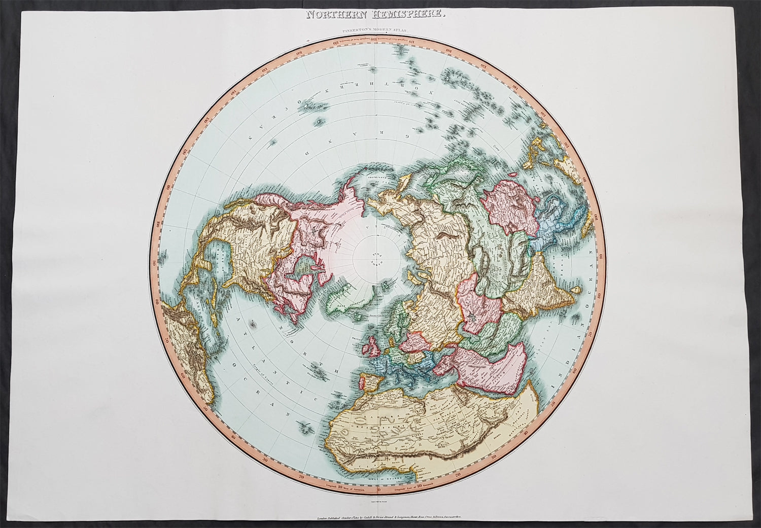
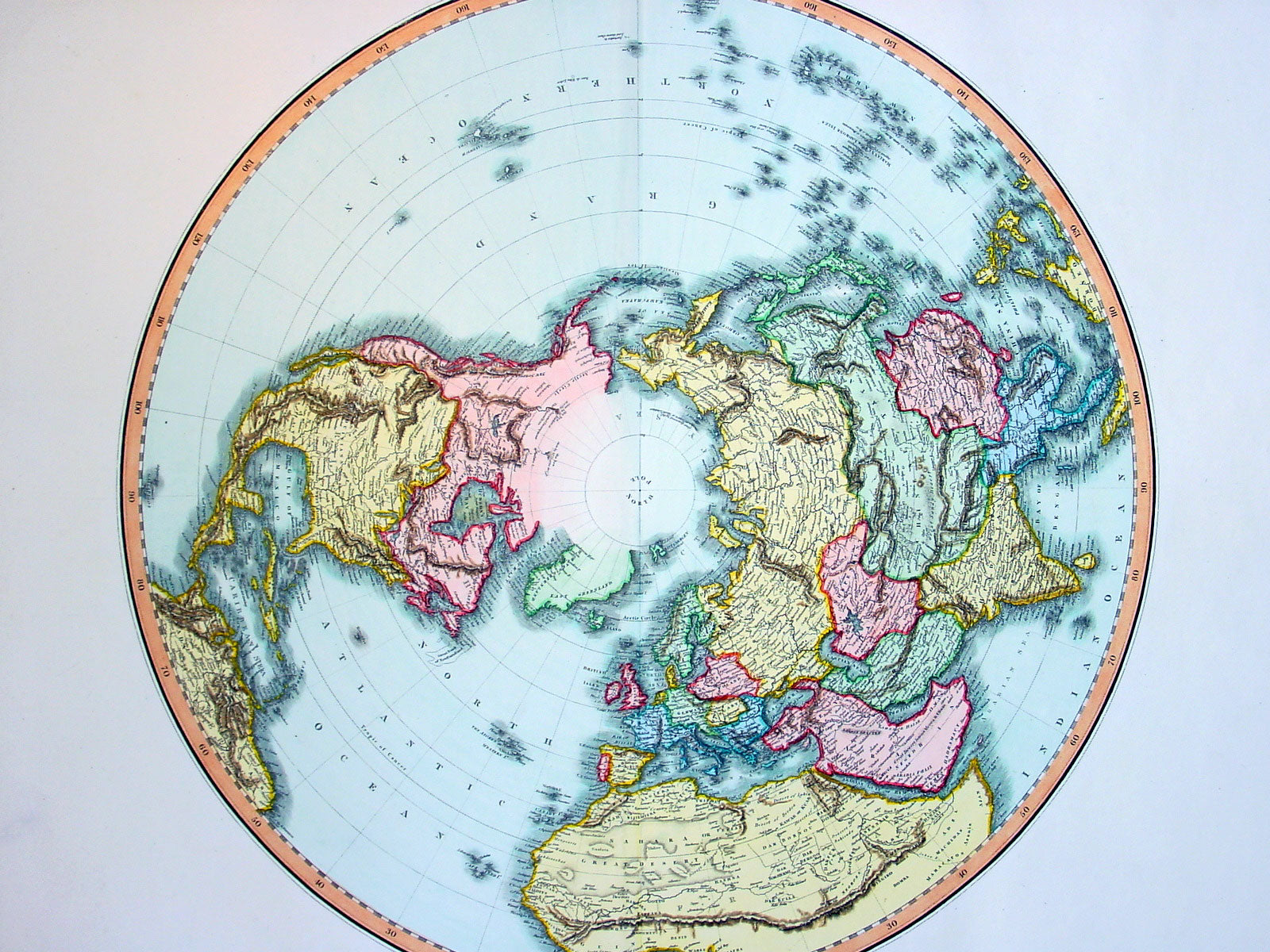
Description:This large magnificent hand coloured original copper-plate engraved antique stereographic projection style map of the Northern Hemisphere, North America, Canada, Europe, Asia, Africa & The North Pole by John Pinkerton was engraved by Samuel Neele in 1812 - dated at the foot of the map - and published in Pinkertons large elephant folio Modern Atlas, published between 1809 - 14. (Ref: Tooley, M&B)
General Definitions:Paper thickness and quality: - Heavy and stablePaper color : - off whiteAge of map color: - OriginalColors used: - Blue, pink, red, green, yellowGeneral color appearance: - AuthenticPaper size: - 31in x 22in (790mm x 560mm)Plate size: - 31in x 22in (790mm x 560mm)Margins: - Min 1in (25mm)
Imperfections:Margins: - NonePlate area: - NoneVerso: - None
Background: In geometry, the stereographic projection is a particular mapping (function) that projects a sphere onto a plane. The projection is defined on the entire sphere, except at one point: the projection point. Where it is defined, the mapping is smooth and bijective. It is conformal, meaning that it preserves angles at which curves meet. It is neither isometric nor area-preserving: that is, it preserves neither distances nor the areas of figures.Intuitively, then, the stereographic projection is a way of picturing the sphere as the plane, with some inevitable compromises. Because the sphere and the plane appear in many areas of mathematics and its applications, so does the stereographic projection; it finds use in diverse fields including complex analysis, cartography, geology, and photography. In practice, the projection is carried out by computer or by hand using a special kind of graph paper called a stereographic net, shortened to stereonet, or Wulff net.The stereographic projection was known to Hipparchus, Ptolemy and probably earlier to the Egyptians. It was originally known as the planisphere projection. Planisphaerium by Ptolemy is the oldest surviving document that describes it. One of its most important uses was the representation of celestial charts. The term planisphere is still used to refer to such charts.In the 16th and 17th century, the equatorial aspect of the stereographic projection was commonly used for maps of the Eastern and Western Hemispheres. It is believed that already the map created in 1507 by Gualterius Lud was in stereographic projection, as were later the maps of Jean Roze (1542), Rumold Mercator (1595), and many others. In star charts, even this equatorial aspect had been utilised already by the ancient astronomers like Ptolemy.François d\'Aguilon gave the stereographic projection its current name in his 1613 work Opticorum libri sex philosophis juxta ac mathematicis utiles (Six Books of Optics, useful for philosophers and mathematicians alike).In 1695, Edmond Halley, motivated by his interest in star charts, published the first mathematical proof that this map is conformal. He used the recently established tools of calculus, invented by his friend Isaac Newton.
Pinkerton, John 1758 – 1826 Pinkerton was a Scottish antiquarian, cartographer, author, numismatist, historian, and early advocate of Germanic racial supremacy theory.He was born in Edinburgh, as one of three sons to James Pinkerton. He lived in the neighbourhood of that city for some of his earliest childhood years, but later moved to Lanark. His studious youth brought him extensive knowledge of the Classics, and it is known that in his childhood years he enjoyed translating Roman authors such as Livy. He moved on to Edinburgh University, and after graduating, remained in the city to take up an apprenticeship in Law. However, his scholarly and literary inclinations led him to abandon the legal profession. It had been during his brief legal career though that he had begun writing, his Elegy on Craigmillar Castle being first published in 1776.Pinkerton was a celebrated master of the Edinburgh school of cartography which lasted from roughly 1800 to 1830. Pinkerton, along with John Thomson & Co. and John Cary, redefined cartography by exchanging the elaborate cartouches and fantastical beasts used in the 18th century for more accurate detail. Pinkertons main work was the \\\"Pinkerton\\\'s Modern Atlas\\\" published from 1808 through 1815 with an American version by Dobson & Co. in 1818. Pinkerton maps are today greatly valued for their quality, size, colouration, and detail.