John Pinkerton
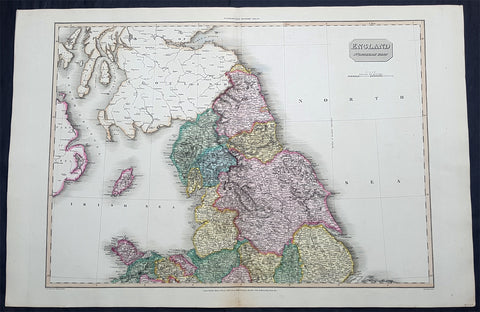
1811 John Pinkerton Very Large Antique Map of The North of England - Beautiful
- Title : England Northern Part....Published March 25th 1811 by Cadell & Davies
- Ref #: 93422
- Size: 33 1/2in x 22 1/2in (850mm x 570mm)
- Date : 1811
- Condition: (A+) Fine Condition
Description:
This large & magnificent, beautifully hand coloured original copper-plate engraved antique map of Northern England by John Pinkerton was engraved by Samuel Neele in 1811 - dated at the foot of the map - and published in the large elephant folio Pinkertons Modern Atlas, published between 1809 & 14. (Ref: Tooley, M&B)
General Definitions:
Paper thickness and quality: - Heavy and stable
Paper color : - off white
Age of map color: - Original
Colors used: - Yellow, green, blue, pink
General color appearance: - Authentic
Paper size: - 33 1/2in x 22 1/2in (850mm x 570mm)
Plate size: - 30 1/2in x 22 1/2in (775mm x 570mm)
Margins: - Min 2in (50mm)
Imperfections:
Margins: - None
Plate area: - None
Verso: - None
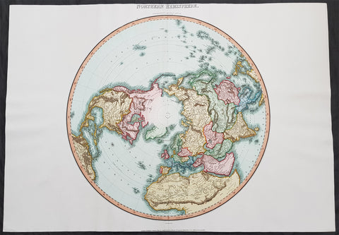
1812 Pinkerton Large Antique Stereographic Projection Map of Northern Hemisphere
- Title : Northern Hemisphere....Neele Sculp. 352 Strand.....London Published October 1st 1812 by Cadell & Davies Strand & Longman. Hurst. Rees.Orme & Brown. Paternaster Row
- Ref #: 60542
- Size: 31in x 22in (790mm x 560mm)
- Date : 1812
- Condition: (A+) Fine Condition
Description:
This large magnificent hand coloured original copper-plate engraved antique stereographic projection style map of the Northern Hemisphere, North America, Canada, Europe, Asia, Africa & The North Pole by John Pinkerton was engraved by Samuel Neele in 1812 - dated at the foot of the map - and published in Pinkertons large elephant folio Modern Atlas, published between 1809 - 14. (Ref: Tooley, M&B)
General Definitions:
Paper thickness and quality: - Heavy and stable
Paper color : - off white
Age of map color: - Original
Colors used: - Blue, pink, red, green, yellow
General color appearance: - Authentic
Paper size: - 31in x 22in (790mm x 560mm)
Plate size: - 31in x 22in (790mm x 560mm)
Margins: - Min 1in (25mm)
Imperfections:
Margins: - None
Plate area: - None
Verso: - None
Background:
In geometry, the stereographic projection is a particular mapping (function) that projects a sphere onto a plane. The projection is defined on the entire sphere, except at one point: the projection point. Where it is defined, the mapping is smooth and bijective. It is conformal, meaning that it preserves angles at which curves meet. It is neither isometric nor area-preserving: that is, it preserves neither distances nor the areas of figures.
Intuitively, then, the stereographic projection is a way of picturing the sphere as the plane, with some inevitable compromises. Because the sphere and the plane appear in many areas of mathematics and its applications, so does the stereographic projection; it finds use in diverse fields including complex analysis, cartography, geology, and photography. In practice, the projection is carried out by computer or by hand using a special kind of graph paper called a stereographic net, shortened to stereonet, or Wulff net.
The stereographic projection was known to Hipparchus, Ptolemy and probably earlier to the Egyptians. It was originally known as the planisphere projection. Planisphaerium by Ptolemy is the oldest surviving document that describes it. One of its most important uses was the representation of celestial charts. The term planisphere is still used to refer to such charts.
In the 16th and 17th century, the equatorial aspect of the stereographic projection was commonly used for maps of the Eastern and Western Hemispheres. It is believed that already the map created in 1507 by Gualterius Lud was in stereographic projection, as were later the maps of Jean Roze (1542), Rumold Mercator (1595), and many others. In star charts, even this equatorial aspect had been utilised already by the ancient astronomers like Ptolemy.
François d\'Aguilon gave the stereographic projection its current name in his 1613 work Opticorum libri sex philosophis juxta ac mathematicis utiles (Six Books of Optics, useful for philosophers and mathematicians alike).
In 1695, Edmond Halley, motivated by his interest in star charts, published the first mathematical proof that this map is conformal. He used the recently established tools of calculus, invented by his friend Isaac Newton.
Pinkerton, John 1758 – 1826
Pinkerton was a Scottish antiquarian, cartographer, author, numismatist, historian, and early advocate of Germanic racial supremacy theory.
He was born in Edinburgh, as one of three sons to James Pinkerton. He lived in the neighbourhood of that city for some of his earliest childhood years, but later moved to Lanark. His studious youth brought him extensive knowledge of the Classics, and it is known that in his childhood years he enjoyed translating Roman authors such as Livy. He moved on to Edinburgh University, and after graduating, remained in the city to take up an apprenticeship in Law. However, his scholarly and literary inclinations led him to abandon the legal profession. It had been during his brief legal career though that he had begun writing, his Elegy on Craigmillar Castle being first published in 1776.
Pinkerton was a celebrated master of the Edinburgh school of cartography which lasted from roughly 1800 to 1830. Pinkerton, along with John Thomson & Co. and John Cary, redefined cartography by exchanging the elaborate cartouches and fantastical beasts used in the 18th century for more accurate detail. Pinkertons main work was the \\\"Pinkerton\\\'s Modern Atlas\\\" published from 1808 through 1815 with an American version by Dobson & Co. in 1818. Pinkerton maps are today greatly valued for their quality, size, colouration, and detail.
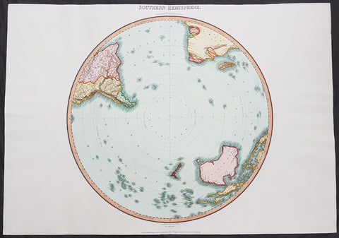
1812 Pinkerton Large Antique Stereographic Projection Map of Southern Hemisphere
- Title : Southern Hemisphere....Drawn Under the Direction of Mr Pinkerton by L Herbert Neele Sculp. 352 Starnd.....London Published August 31st 1812 by Cadell & Davies Strand & Longman. Hurst. Rees.Orme & Brown. Paternaster Row
- Ref #: 60540
- Size: 31in x 22in (790mm x 560mm)
- Date : 1812
- Condition: (A+) Fine Condition
Description:
This large magnificent hand coloured original copper-plate engraved antique stereographic projection style map of the Southern Hemisphere, Australia, New Zealand & Antarctica by John Pinkerton was engraved by Samuel Neele in 1812 - dated at the foot of the map - and published in Pinkertons large elephant folio Modern Atlas, published between 1809 - 14. (Ref: Tooley, M&B)
General Definitions:
Paper thickness and quality: - Heavy and stable
Paper color : - off white
Age of map color: - Original
Colors used: - Blue, pink, red, green, yellow
General color appearance: - Authentic
Paper size: - 31in x 22in (790mm x 560mm)
Plate size: - 31in x 22in (790mm x 560mm)
Margins: - Min 1in (25mm)
Imperfections:
Margins: - None
Plate area: - None
Verso: - None
Background:
In geometry, the stereographic projection is a particular mapping (function) that projects a sphere onto a plane. The projection is defined on the entire sphere, except at one point: the projection point. Where it is defined, the mapping is smooth and bijective. It is conformal, meaning that it preserves angles at which curves meet. It is neither isometric nor area-preserving: that is, it preserves neither distances nor the areas of figures.
Intuitively, then, the stereographic projection is a way of picturing the sphere as the plane, with some inevitable compromises. Because the sphere and the plane appear in many areas of mathematics and its applications, so does the stereographic projection; it finds use in diverse fields including complex analysis, cartography, geology, and photography. In practice, the projection is carried out by computer or by hand using a special kind of graph paper called a stereographic net, shortened to stereonet, or Wulff net.
The stereographic projection was known to Hipparchus, Ptolemy and probably earlier to the Egyptians. It was originally known as the planisphere projection. Planisphaerium by Ptolemy is the oldest surviving document that describes it. One of its most important uses was the representation of celestial charts. The term planisphere is still used to refer to such charts.
In the 16th and 17th century, the equatorial aspect of the stereographic projection was commonly used for maps of the Eastern and Western Hemispheres. It is believed that already the map created in 1507 by Gualterius Lud was in stereographic projection, as were later the maps of Jean Roze (1542), Rumold Mercator (1595), and many others. In star charts, even this equatorial aspect had been utilised already by the ancient astronomers like Ptolemy.
François d\'Aguilon gave the stereographic projection its current name in his 1613 work Opticorum libri sex philosophis juxta ac mathematicis utiles (Six Books of Optics, useful for philosophers and mathematicians alike).
In 1695, Edmond Halley, motivated by his interest in star charts, published the first mathematical proof that this map is conformal. He used the recently established tools of calculus, invented by his friend Isaac Newton.
Pinkerton, John 1758 – 1826
Pinkerton was a Scottish antiquarian, cartographer, author, numismatist, historian, and early advocate of Germanic racial supremacy theory.
He was born in Edinburgh, as one of three sons to James Pinkerton. He lived in the neighbourhood of that city for some of his earliest childhood years, but later moved to Lanark. His studious youth brought him extensive knowledge of the Classics, and it is known that in his childhood years he enjoyed translating Roman authors such as Livy. He moved on to Edinburgh University, and after graduating, remained in the city to take up an apprenticeship in Law. However, his scholarly and literary inclinations led him to abandon the legal profession. It had been during his brief legal career though that he had begun writing, his Elegy on Craigmillar Castle being first published in 1776.
Pinkerton was a celebrated master of the Edinburgh school of cartography which lasted from roughly 1800 to 1830. Pinkerton, along with John Thomson & Co. and John Cary, redefined cartography by exchanging the elaborate cartouches and fantastical beasts used in the 18th century for more accurate detail. Pinkertons main work was the \\\"Pinkerton\\\'s Modern Atlas\\\" published from 1808 through 1815 with an American version by Dobson & Co. in 1818. Pinkerton maps are today greatly valued for their quality, size, colouration, and detail.
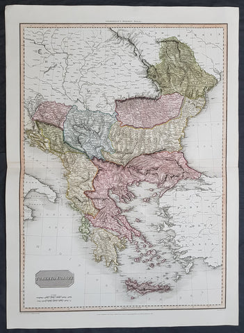
1814 John Pinkerton Large Antique Map of Turkey in Europe - Greece to Hungary
- Title : Turkey in Europe....Drawn under the direction of Mr Pinkerton by L Herbert Neele Sculp. 352 Starnd.....London Published 1st Jan 1814 by Cadell & Davies Strand & Longman. Hurst. Rees.Orme & Brown. Paternaster Row
- Ref #: 16434
- Size: 31in x 22in (790mm x 560mm)
- Date : 1814
- Condition: (A+) Fine Condition
Description:
This large magnificent hand coloured original copper-plate engraved antique map of Turkey in Europe - Greece, Balkans, Romania, Bosnia, Albania, Serbia, Dalmatia - by John Pinkerton was engraved by Samuel Neele in 1814 - dated at the foot of the map - and published in Pinkertons large elephant folio Modern Atlas, published between 1809 - 14. (Ref: Tooley, M&B)
General Definitions:
Paper thickness and quality: - Heavy and stable
Paper color : - off white
Age of map color: - Original
Colors used: - Blue, pink, red, green, yellow
General color appearance: - Authentic
Paper size: - 31in x 22in (790mm x 560mm)
Plate size: - 31in x 22in (790mm x 560mm)
Margins: - Min 1in (25mm)
Imperfections:
Margins: - None
Plate area: - None
Verso: - None
Background:
The Ottoman Empire also historically known in Western Europe as the Turkish Empire or simply Turkey, was a state that controlled much of Southeast Europe, Western Asia and North Africa between the 14th and early 20th centuries. It was founded at the end of the 13th century in northwestern Anatolia in the town of Söğüt (modern-day Bilecik Province) by the Oghuz Turkish tribal leader Osman I. After 1354, the Ottomans crossed into Europe, and with the conquest of the Balkans, the Ottoman beylik was transformed into a transcontinental empire. The Ottomans ended the Byzantine Empire with the 1453 conquest of Constantinople by Mehmed the Conqueror.
During the 16th and 17th centuries, at the height of its power under the reign of Suleiman the Magnificent, the Ottoman Empire was a multinational, multilingual empire controlling most of Southeast Europe, parts of Central Europe, Western Asia, parts of Eastern Europe and the Caucasus, North Africa and the Horn of Africa. At the beginning of the 17th century, the empire contained 32 provinces and numerous vassal states. Some of these were later absorbed into the Ottoman Empire, while others were granted various types of autonomy during the course of centuries.
With Constantinople as its capital and control of lands around the Mediterranean basin, the Ottoman Empire was at the centre of interactions between the Eastern and Western worlds for six centuries. While the empire was once thought to have entered a period of decline following the death of Suleiman the Magnificent, this view is no longer supported by the majority of academic historians. The empire continued to maintain a flexible and strong economy, society and military throughout the 17th and much of the 18th century. However, during a long period of peace from 1740 to 1768, the Ottoman military system fell behind that of their European rivals, the Habsburg and Russian empires. The Ottomans consequently suffered severe military defeats in the late 18th and early 19th centuries, which prompted them to initiate a comprehensive process of reform and modernisation known as the Tanzimat. Thus, over the course of the 19th century, the Ottoman state became vastly more powerful and organised, despite suffering further territorial losses, especially in the Balkans, where a number of new states emerged. The empire allied with Germany in the early 20th century, hoping to escape from the diplomatic isolation which had contributed to its recent territorial losses, and thus joined World War I on the side of the Central Powers. While the Empire was able to largely hold its own during the conflict, it was struggling with internal dissent, especially with the Arab Revolt in its Arabian holdings. During this time, atrocities were committed by the Ottoman government against the Armenians, Assyrians and Pontic Greeks.
The Empires defeat and the occupation of part of its territory by the Allied Powers in the aftermath of World War I resulted in its partitioning and the loss of its Middle Eastern territories, which were divided between the United Kingdom and France. The successful Turkish War of Independence against the occupying Allies led to the emergence of the Republic of Turkey in the Anatolian heartland and the abolition of the Ottoman monarchy.
Pinkerton, John 1758 – 1826
Pinkerton was a Scottish antiquarian, cartographer, author, numismatist, historian, and early advocate of Germanic racial supremacy theory.
He was born in Edinburgh, as one of three sons to James Pinkerton. He lived in the neighbourhood of that city for some of his earliest childhood years, but later moved to Lanark. His studious youth brought him extensive knowledge of the Classics, and it is known that in his childhood years he enjoyed translating Roman authors such as Livy. He moved on to Edinburgh University, and after graduating, remained in the city to take up an apprenticeship in Law. However, his scholarly and literary inclinations led him to abandon the legal profession. It had been during his brief legal career though that he had begun writing, his Elegy on Craigmillar Castle being first published in 1776.
Pinkerton was a celebrated master of the Edinburgh school of cartography which lasted from roughly 1800 to 1830. Pinkerton, along with John Thomson & Co. and John Cary, redefined cartography by exchanging the elaborate cartouches and fantastical beasts used in the 18th century for more accurate detail. Pinkertons main work was the \\\"Pinkerton\\\'s Modern Atlas\\\" published from 1808 through 1815 with an American version by Dobson & Co. in 1818. Pinkerton maps are today greatly valued for their quality, size, colouration, and detail.