Ethnographic (2)
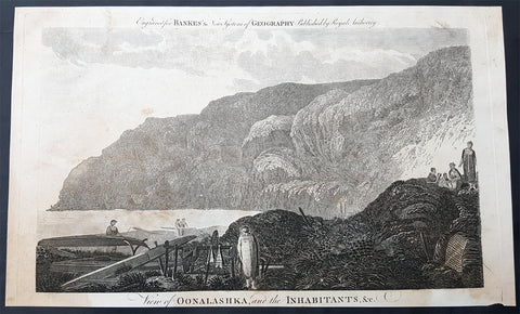
1787 Bankes Antique Print English or Nanwalek Bay Alaska, Cooks 3rd Voyage 1778
- Title : View of Oonalashka and the Inhabitants
- Size: 14in x 9in (355mm x 230mm)
- Ref #: 40213
- Date : 1787
- Condition: (A) Very Good Condition
Description:
This fine original cooper-plate engraved antique print a view of English or Nanwalek Bay, Alaska visited by Captain James Cook in June/July 1778, during his third voyage of discovery - after John Webber - was published in Thomas Bankes 1787 edition of A New, Royal and Authentic System of Universal Geography, Antient and Modern..... printed by Charles Cook, London.
Cooks Third Voyage (1776-1779)
In the course of his first two voyages, Cook circumnavigated the globe twice, sailed extensively into the Antarctic, and charted coastlines from Newfoundland to New Zealand. Following these achievements, Cook\'s third voyage was organized to seek an efficient route from England to southern and eastern Asia that would not entail rounding the Cape of Good Hope. The search for such a Northwest (or Northeast) Passage had been on the agenda of northern European mariners and merchants since the beginning of European expansion in the late fifteenth century. England\'s growing economic and colonial interests in India in the later eighteenth century provided the stimulus for the latest exploration for this route.
Cook, again in command of the Resolution, was to approach the Northwest Passage from the Pacific accompanied by a second ship, the Discovery, captained by Charles Clerke. The ships left England separately, regrouped at Cape Town, and continued on to Tasmania, New Zealand, and Tahiti. The expedition then sailed north and made landfall at Christmas Island and the Hawaiian Islands. Cook continued northward and charted the west coast of North America from Northern California as far as the Bering Strait. He returned to Hawaii for the winter and was killed in a skirmish with natives on February 14, 1779. Upon Cook\'s death, Clerke took command of the expedition but died six months later. The ships returned to England in 1780 under John Gore, who had commanded the Discovery after Cook\'s death. From start to finish, the voyage had lasted more than four years. (Ref Tooley; M&B; Clancy)
General Definitions:
Paper thickness and quality: - Heavy and stable
Paper color : - off white
Age of map color: -
Colors used: -
General color appearance: -
Paper size: - 14in x 9in (355mm x 230mm)
Plate size: - 12in x 7 1/2in (305mm x 190mm)
Margins: - Min 1/2in (12mm)
Imperfections:
Margins: - None
Plate area: - None
Verso: - None
Background:
Nanwalek, formerly Alexandrovsk and English Bay, Alaska is census-designated place (CDP) in the Kenai Peninsula Borough, Alaska, United States that contains a traditional Alutiiq village.
Cooks Diary.......English Bay, Unalaska......the next day, the 27th, wrote Cook the fog partly despersed. At 7 AM wieghed and steered to the North… the wind faild and obliged us to Anchor. They sailed on and anchored in a bay for a few days on 28th. According to Samwell the next day We hoisted out our launch sent her ashore to fill the empty Water Casks both Ships completed their water. On 30th Many Canoes trading about the Ship… We find many Notes written in the Russian Language among these People dated in the Year 1776. The weather was, wrote Samwell moderate & hazy
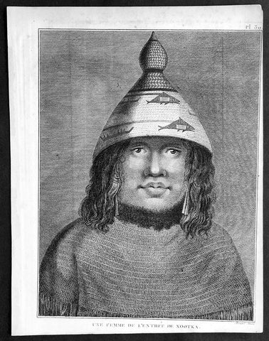
1785 Capt. Cook Antique Print Woman of Nootka Sound, Vancouver Isle Canada, 1778
- Title : Une Femme De L Entreee De Nootka
- Ref : 31768
- Size: 10in x 8in (255mm x 205mm)
- Date : 1785
- Condition: (A+) Fine Condition
Description:
This fine original copper-plate engraved antique print of a woman of Nootka Sound, on the West Coast of Vancouver Island, Canada, drawn during a visit by Captain Cook in 1778, during his 3rd and last Voyage of Discovery, was engraved by Robert Benard - after Cooks on-board artist, John Webber - and was published in the 1785 French edition of Capt. James Cook & Capt. James King A Voyage to the Pacific Ocean. Undertaken, by the Command of his Majesty, for making Discoveries in the Northern Hemisphere. To determine The Position and Extent of the West Side of North America; its Distance from Asia; and the Practicability of a Northen Passage to Europe. Performed under the direction of Captains Cook, Clerke, and Gore, In His Majesty\'s Ships the Resolution and Discovery. In the Years 1776, 1777, 1778, 1779, and 1780. In Three Volumes. Vol. I and II written by James Cook, F.R.S. Vol. III by Captain James King, LL.D. and F.R.S. Paris, 1785.
General Definitions:
Paper thickness and quality: - Heavy and stable
Paper color : - off white
Age of map color: -
Colors used: -
General color appearance: -
Paper size: - 10in x 8in (255mm x 205mm)
Plate size: - 9 1/2in x 7 1/4in (240mm x 185mm)
Margins: - Min 1/2in (12mm)
Imperfections:
Margins: - Light soiling in margins
Plate area: - None
Verso: - None
Background:
Nootka Sound is a sound of the Pacific Ocean, on the rugged west coast of Vancouver Island, in the Canadian province of British Columbia, historically known as King George\'s Sound. It separates Vancouver Island and Nootka Island.
On August 8, 1774, the Spanish Navy ship Santiago, under Juan Pérez, entered and anchored in the inlet. Although the Spanish did not land, natives paddled to the ship to trade furs for abalone shells from California. Pérez named the entrance to Nootka Sound Surgidero de San Lorenzo. The word surgidero means source. When Esteban José Martinez arrived in 1789 he gave Nootka Sound the name Puerto de San Lorenzo de Nuca. The Spanish establishment established at Friendly Cove he gave the name Santa Cruz de Nuca.
In March 1778, Captain James Cook of the Royal Navy landed on Bligh Island and named the inlet\"King George\'s Sound. He recorded that the native name was Nutka or Nootka, apparently misunderstanding his conversations at Friendly Cove/Yuquot; his informant may have been explaining that he was on an island (itchme nutka, a place you can go around). There may also have been confusion with Nuu-chah-nulth, the natives\' autonym (name for themselves). It may also have simply been based on Cook’s mis-pronunciation of Yuquot, the native name of the place. The earlier Spanish and British names for the Sound swiftly went out of use.
At the time, the Spanish monopolized the trade between Asia and North America, and had granted limited licenses to the Portuguese. The Russians had established a growing fur trading system in Alaska. The Spanish began to challenge the Russians, with Pérez\'s voyage being the first of many to the Pacific Northwest. The British also became increasingly active in the region.
The next European to visit Nootka Sound after James Cook was the British trader James Hanna in August 1785. Hanna traded iron bars for furs. He sold the furs in China for a handsome profit, beginning an era of the Maritime Fur Trade.
Captain James King FRS 1750 – 1784 was an officer of the Royal Navy. He served under James Cook on his last voyage around the world, specialising in taking important astronomical readings using a sextant. After Cook died he helped lead the ships on the remainder of their course, also completing Cook\\\'s account of the voyage. He continued his career in the Navy, reaching the rank of post-captain, commanding several ships and serving in the American War of Independence.
King joined HMS Resolution as second lieutenant, sharing the duties of astronomer with Cook, taking astronomical observations on board by sextant and with Larcum Kendals timekeeper K1, to establish the Resolutions position at sea and on shore by sextant or by astronomical quadrant to establish the geographical position of salient points during the course of Cooks surveys. Thus King\\\'s geographical positions were an important contribution to the accuracy of the various surveys carried out during the voyage and his use of the early chronometers helped prove their use at sea for calculation of Longitude. .
Following the death of Cook, King remained in the Resolution but on the death of Charles Clerke, Cooks successor, King was appointed to command HMS Discovery, the Resolution\\\'s consort, remaining in her for the rest of the voyage. After his return to England King was very much involved in the publication of the official account of Cooks third voyage, writing the third volume at Woodstock, near Oxford, where his brother Thomas was rector of St Mary Magdalene. But shortly after his return King was promoted Post-captain and appointed commander of HMS Crocodile in the English Channel.
John Webber RA 1751 – 1793 was an English artist who accompanied Captain Cook on his third Pacific expedition. He is best known for his images of Australasia, Hawaii and Alaska.
Webber was born in London, educated in Bern and studied painting at Paris.His father was Abraham Wäber, a Swiss sculptor who had moved to London, and changed his name to Webber before marrying a Mrs Mary Quant in 1744.
Webber served as official artist on James Cook\'s third voyage of discovery around the Pacific (1776–80) aboard HMS Resolution. At Adventure Bay in January 1777 he did drawings of A Man of Van Diemens Land and A Woman of Van Diemens Land. He also did many drawings of scenes in New Zealand and the South Sea islands. On this voyage, during which Cook lost his life in a fight in Hawaii, Webber became the first European artist to make contact with Hawaii, then called the Sandwich Islands. He made numerous watercolor landscapes of the islands of Kauai and Hawaii, and also portrayed many of the Hawaiian people.
In April 1778, Captain Cooks ships Resolution and Discovery anchored at Ship Cove, now known as Nootka Sound, Vancouver Island, Canada to refit. The crew took observations and recorded encounters with the local people. Webber made watercolour landscapes including Resolution and Discovery in Ship Cove, 1778. His drawings and paintings were engraved for British Admiraltys account of the expedition, which was published in 1784.
Back in England in 1780 Webber exhibited around 50 works at Royal Academy exhibitions between 1784 and 1792, and was elected an associate of the Royal Academy in 1785 and R.A. in 1791. Most of his work were landscapes. Sometimes figures were included as in A Party from H.M.S. Resolution shooting sea horses\", which was shown at the academy in 1784, and his The Death of Captain Cook became well known through an engraving of it. Another version of this picture is in the William Dixson gallery at Sydney
Robert Bénard 1734 – 1777 was an 18th-century French engraver.
Specialized in the technique of engraving, Robert Ménard is mainly famous for having supplied a significant amount of plates (at least 1,800) to the Encyclopédie by Diderot & d\'Alembert from 1751.
Later, publisher Charles-Joseph Panckoucke reused many of his productions to illustrate the works of his catalog.