Ethnographic (100)
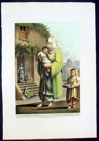
1803 Mayer Large Antique Print of a Woman & Child of Karaman, Turkey
- Title : Woman of Caramania
- Date : 1803
- Condition: (A+) Fine Condition
- Ref: 92705
- Size: 19 1/2in x 13in (485mm x 330mm)
Description:
This large fine beautifully coloured original early antique aquatint of a woman and children of the ancient southern Turkish region of Caramania (Karaman) was engraved in 1803 - the date is engraved at the foot of the image - and was published in Luigi Mayer's "Views in Egypt, Palestine and Other Parts of the Ottoman Empire" R Bowyer, Historic Gallery Pall Mall.
This engraving is characteristic of those made during Regency period, a time of exploration of the Middle East spurred by Napoleon's explorations and conquests in Egypt. Often these expeditions were published as books, containing descriptions and illustrations of the ancient architecture, customs and culture of indigenous peoples.
Italian orientalist Luigi Mayer, active in the 18th and begin 19th century travelled extensively in the middle east. His work "Views in Egypt, Palestine and Other Parts of the Ottoman Empire" was published between 1801 and 1804 with historical observations, and incidental illustrations of the manners and customs of the natives of that country. During Mayer’s time, while Britain and France were vying for control of colonial territories, Views in Egypt captivated and informed audiences in Europe about the country’s prevailing culture and even political structures. "Mamalukes exercising in the Square of Muurad Bey’s Palace," for instance, provides a valuable visual record of the military elite’s training exercises, and perhaps a hint of the Ottoman ruler’s efforts to impose centralized authority. Such highly descriptive drawings continue to make the volume an invaluable primary source.
The aquatint engraver, Thomas Milton studied under William Woollett, and was extolled by scholar W. Bell Scott as having "a unique power of distinguishing the foliage of trees and the texture of bodies, especially water, as it never had been done before, and never will be done again." (Ref: Abbey, Travel, 369. Blackmer 1097. Colas 2018-2022. Gay 2145. Hiler, pp. 577-8. HBS 15571)
General Description:
Paper thickness and quality: - Haevy and stable
Paper color: - off white
Age of map color: - Early
Colors used: - Yellow, green, pink, orange
General color appearance: - Authentic
Paper size: - 18 1/2 in x 13in (460mm x 330mm)
Plate size: - 15 in x 12in (380mm x 305mm)
Margins: - Min 1in (25mm)
Imperfections:
Margins: None
Plate area: None
Verso: None
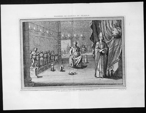
1755 Prevost & Schley Antique Print Dharmapala the Defender Buddhist Gods Pagoda
- Title: Pagodes ou Statues Du Temple
- Date: 1755
- Condition : (A+) Fine Condition
- Ref: 25935
- Size: 15in x 10in (385mm x 255mm)
Description:
This fine, original copper-plate engraved antique print of Dharmapala the defender Buddhist God & Goddess in a Pagoda Temple by Jakob van Schley in 1755 was published in Antoine François Prevosts 15 volumes of Histoire Generale des Voyages written by Prevost & other authors between 1746-1790.
A protector of Buddhist dharma is called a Dharmapala in Buddhism. They are typically divinities, usually depicted with wrathful iconography in the Mahayana and tantric traditions of Buddhism. The wrath depicts their believed willingness to defend and guard Buddhist followers from dangers and enemies. The Astasena, or eight nonhuman super beings, for example are one of the list of dharmapalas. The Astasena dharmapala include, state Buswell and Lopez, Garuda, Deva, Naga, Yaksa, Gandharva, Asura, Kimnara and Mahoraga.
In Vajrayana iconography and thangka depictions, dharmapālas are fearsome beings, often with many heads, many hands, or many feet. Dharmapālas often have blue, black or red skin, and a fierce expression with protruding fangs. Though dharmapālas have a terrifying appearance and countenance, they are all bodhisattvas or buddhas, meaning that they are embodiments of compassion that act in a wrathful way for the benefit of sentient beings.
The devotional worship of dharmapalas in the Tibetan tradition is traceable to early 8th-century
General Definitions:
Paper thickness and quality: - Heavy and stable
Paper color : - off white
Age of map color: -
Colors used: -
General color appearance: -
Paper size: - 15in x 10in (385mm x 255mm)
Plate size: - 14in x 8 1/2in (355mm x 220mm)
Margins: - Min 1in (25mm)
Imperfections:
Margins: - None
Plate area: - None
Verso: - None
Background:
One of Antoine Francois Prevosts monumental undertakings was his history of exploration & discovery in 15 volumes titledHistoire Générale des Voyages written between 1746-1759 and was extended to 20 volumes after his death by various authors.
The 20 volumes cover the early explorations & discoveries on 3 continents: Africa (v. 1-5), Asia (v. 5-11), and America (v. 12-15) with material on the finding of the French, English, Dutch, and Portugese.
A number of notable cartographers and engravers contributed to the copper plate maps and views to the 20 volumes including Nicolas Bellin, Jan Schley, Chedel, Franc Aveline, Fessard, and many others.
The African volumes cover primarily coastal countries of West, Southern, and Eastern Africa, plus the Congo, Madagascar, Arabia and the Persian Gulf areas.
The Asian volumes cover China, Korea, Tibet, Japan, Philippines, and countries bordering the Indian Ocean.
Volume 11 includes Australia and Antarctica.
Volumes 12-15 cover voyages and discoveries in America, including the East Indies, South, Central and North America.
Volumes 16-20 include supplement volumes & tables along with continuation of voyages and discoveries in Russia, Northern Europe, America, Asia & Australia.
Jakob van der Schley aka Jakob van Schley (1715 - 1779) was a Dutch draughtsman and engraver. He studied under Bernard Picart (1673-1733) whose style he subsequently copied. His main interests were engraving portraits and producing illustrations for \\\"La Vie de Marianne\\\" by Pierre Carlet de Chamblain de Marivaux (1688-1763) published in The Hague between 1735 and 1747.
He also engraved the frontispieces for a 15-volume edition of the complete works of Pierre de Brantôme (1540-1614), \\\"Oeuvres du seigneur de Brantôme\\\", published in The Hague in 1740.
He is also responsible for most of the plates in the Hague edition of Prévosts Histoire générale des voyages. (Ref: Tooley; M&B)
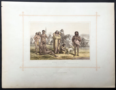
1880 Blackie & Son Antique Print South American Indians
- Title : Aborigines of South America
- Ref #: 80519
- Size: 15in x 11in (380mm x 280mm)
- Date : 1880
- Condition: (A+) Fine Condition
Description:
This beautifully coloured large original antique lithograph print was published by Blackie & Son of Glasgow in the 1880 edition of Geographical Atlas. (Ref: Tooley; M&B)
General Description:
Paper thickness and quality: - Heavy and stable
Paper colour: - off white
Age of map colour: - Original
Colours used: - Brown, blue, green
General colour appearance: - Authentic
Paper size: - 15in x 11in (380mm x 280mm)
Margins: - min 12in (25mm)
Imperfections:
Margins: - Light soiling
Plate area: - None
Verso: - None
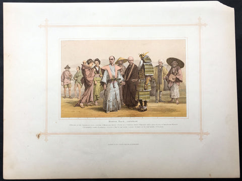
1880 Blackie & Son Antique Print the Japanese Peoples
- Title : Mongol Race - Japanese
- Ref #: 80515
- Size: 15in x 11in (380mm x 280mm)
- Date : 1880
- Condition: (A+) Fine Condition
Description:
This beautifully coloured large original antique lithograph print was published by Blackie & Son of Glasgow in the 1880 edition of Geographical Atlas. (Ref: Tooley; M&B)
General Description:
Paper thickness and quality: - Heavy and stable
Paper colour: - off white
Age of map colour: - Original
Colours used: - Brown, blue, green
General colour appearance: - Authentic
Paper size: - 15in x 11in (380mm x 280mm)
Margins: - min 12in (25mm)
Imperfections:
Margins: - Light soiling
Plate area: - None
Verso: - None