Maps (41)

1774 Cook & Hawkesworth Antique Atlas of Australia, New Zealand 52 Maps & Prints
Antique Map
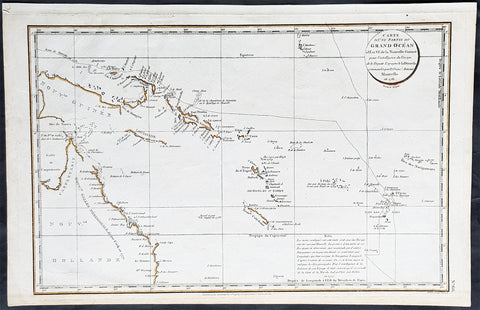
- Title : Cartes et figures des voyages entrepris par ordre de sa Majesté Britannique, actuellement régnante ; pour faire des découvertes dans l'hémisphère méridional, et successivement exécutés par le Commodore Byron, le Capitaine Carteret, le Capitaine Wallis & le Capitaine Cook dans les vaisseaux. MDCCLXXIV (1774)
- Size: 4to (Quatro)
- Condition: (A) Very Good Condition
- Date : 1774
- Ref #: 35632
Description:
This original antique Atlas containing 52 maps and prints, as called for, from some of the foremost explorers of the mid 18th century, including Commodore Byron, Captain Carteret, Captain Wallis & Captain James Cook, was published as the 1st French edition of Cartes et figures des voyages entrepris par ordre de sa Majesté Britannique: (Maps and Figures of Travels undertaken by Order of his Present Reigning British Majesty) in 1774, published after only a year after the 1st English edition by John Hawkesworth.
The 52 prints and maps contained in this atlas chart in maps, prints and plans, the progression in the exploration of the South Seas of the 4 explorers. But there is of course, the standout amongst these 4 explorers and that is of course Captain James Cook.
At the time of the publication of this tome, Cook had returned from his first voyage of exploration to The South Pacific, becoming the first European to survey and chart the coastline of New Zealand and the east coast of Australia. But at this point Cook was not as famous as he was destined to become, after completing 2 more voyages of exploration, and in turn becoming the most famous explorer of his era.
The majority of this atlas contains the prints and maps dedicated to Cooks 1st Voyage of Discovery including the two famous maps, one of New Zealand and the other the East Coast of Australia. All voyages can be tracked from the first large folding map of the South Seas, at the beginning of the Atlas, that illustrates the tracks on Cook and the other 3 explorers.
In-4 binding in half-calf, spine with five bands with gilding boxes and title label complete with 52 folding & single plates
Spine & boards in poor condition with lack of leather and scratched covers, contents tights with plates in very good condition.
General Definitions:
Paper thickness and quality: - Heavy and stable
Paper color : - off white
Age of map color: -
Colors used: -
General color appearance: -
Paper size: - 4to (Quatro)
Plate size: - 4to (Quatro)
Margins: - 4to (Quatro)
Imperfections:
Margins: - Light age toning - Maps & Prints
Plate area: - Folds as issued - Maps & Prints
Verso: - Folds as issued - Maps & Prints
Background:
Capt. Cook First Voyage 1768 - 1771:
In 1768 Cook was chosen to lead an expedition to the South Seas to observe the Transit of Venus and to secretly search for the unknown Great Southern Continent (terra australis incognita).
Cook and his crew of nearly 100 men left Plymouth (August 1768) in the Endeavour and travelled via Madeira (September), Rio de Janiero (November-December) and Tierra del Fuego (January 1769) to Tahiti.
At Tierra del Fuego (January 1769) Cooks men went ashore and met the local people whom Cook thought perhaps as miserable a set of People as are this day upon Earth. Joseph Bankss party collected botanical specimens but his two servants, Thomas Richmond and George Dorlton, died of exposure in the snow and cold. Leaving Tierra del Fuego Endeavour rounded Cape Horn and sailed into the Pacific Ocean.
Sir Joseph Banks wrote about the homes of the Fuegans
..…huts or wigwams of the most unartificial construction imaginable, indeed no thing bearing the name of a hut could possibly be built with less trouble. They consisted of a few poles set up and meeting together at the top in a conical figure, these were covered on the weather side with a few boughs and a little grass, on the lee side about one eighth part of the circle was left open and against this opening was a fire made.......(Banks, Journal I, 224, 20th January 1769)
Samuel Wallis on the ship Dolphin discovered Tahiti in 1767. He recommended the island for the Transit of Venus observations and Cook arrived here in April 1769. Cook, like Wallis two years before him, anchored his ship in the shelter of Matavai Bay on the western side of the island.
In Matavai Bay Cook established a fortified base, Fort Venus, from which he was to complete his first task – the observation of the Transit of Venus (3rd June 1769). The fort also served as protection for all the important scientific and other equipment which had to be taken ashore as:
.......great and small chiefs and common men are firmly of opinion that if they can once get possession of an thing it immediately becomes their own…the chiefs employd in stealing what they could in the cabbin while their dependents took every thing that was loose about the ship…...(Joseph Banks).
Theft by some native peoples plagued Cooks voyages.
Cook and his crew experienced good relations with the Tahitians and returned to the islands on many occasions, attracted by the friendly people of this earthly paradise. On arrival Cook had set out the rules, including:
.....To endeavour by every fair means to cultivate a friendship with the Natives and to treat them with all imaginable humanity....
Just as Cook was planning to leave Tahiti two members of Endeavours crew decided to desert, having strongly attached themselves to two girls, but Cook recovered them.
Cook sailed around the neighbouring Society Islands and took on board the Tahitian priest, Tupaia, and his servant, Taiata. Endeavour left the Society Island in August 1769.
Tupaia acted as interpreter when they came into contact with other Polynesian peoples and helped Cook to make a map of the Pacific islands. This showed Cook the location of islands arranged according to their distance from Tahiti and indicated Tupaias and Polynesian knowledge of navigation and their skill as great mariners.
Cook sailed in search of the Southern Continent (August-October 1769) before turning west to New Zealand. The first encounters with the native Maori of New Zealand in October were violent, their warriors performing fierce dances, or hakas, in attempts to threaten and challenge the ships crew. Some of their warriors were killed when Cooks men had to defend themselves. Eventually relations improved and Cook was able to trade with the Maori for fresh supplies.
Exploring different bays and rivers along the way Cook circumnavigated New Zealand and was the first to accurately chart the whole of the coastline. He discovered that New Zealand consisted of two main islands, north (Te Ika a Maui) and south (Te Wai Pounamu) islands (October 1769-March 1770).
The artist Sydney Parkinson described three Maori who visited the Endeavour on 12th October 1769:
......Most of them had their hair tied up on the crown of their heads in a knot…Their faces were tataowed, or marked either all over, or on one side, in a very curious manner, some of them in fine spiral directions…
This Maori wears an ornamental comb, feathers in a top-knot, long pendants from his ears and a heitiki, or good luck amulet, around his neck.
At the northern end of the south island Cook anchored the ship in Ship Cove, Queen Charlotte Sound, which became a favourite stopping place on the following voyages. Parkinson noted:
......The manner in which the natives of this bay (Queen Charlotte Sound) catch their fish is as follows: - They have a cylindrical net, extended by several hoops at the bottom, and contracted at the top; within the net they stick some pieces of fish, then let it down from the side of the canoe and the fish, going in to feed, are caught with great ease.....(Parkinson, Journal, 114)
In Queen Charlottes Sound Cook visited one of the many Maori hippah, or fortified towns.
........The town was situated on a small rock divided from the main by a breach in a rock so small that a man might almost Jump over it; the sides were every where so steep as to render fortifications iven in their way almost totally useless, according there was nothing but a slight Palisade…in one part we observed a kind of wooden cross ornamented with feathers made exactly in the form of a crucifix cross…we were told that it was a monument to a dead man.......
Endeavour left New Zealand and sailed along the east coast of New Holland, or Australia, heading north (April-August 1770). Cook started to chart the east coast and on 29th April landed for the first time in what Cook called Stingray, later, Botany Bay.
The ship struck the Great Barrier Reef and was badly damaged (10 June). Repairs had to be carried out in Endeavour River. (June-August 1770). The first kangaroo to be sighted was recorded and shot.
The inhabitants of New Holland were very different from the people Cook had come across in other Pacific lands. They were darker skinned than the Maori and painted their bodies:
......They were all of them clean limnd, active and nimble. Cloaths they had none, not the least rag, those parts which nature willingly conceals being exposed to view compleatly uncovered......(Joseph Banks)
Tupaia could not make himself understood and at first the aborigines were very wary of the visitors and not at all interested in trading.
Joseph Banks recorded the fishing party observed at Botany Bay on 26 April 1770. He wrote:
......Their canoes… a piece of Bark tied together in Pleats at the ends and kept extended in the middle by small bows of wood was the whole embarkation, which carried one or two…people…paddling with paddles about 18 inches long, one of which they held in either hand.....(Banks, Journal II, 134)
Endeavour left Australia and sailed via the Possession Isle and Endeavour Strait for repairs at Batavia, Java (October-December 1770). Although the crew had been quite healthy and almost free from scurvy, the scourge of sailors, many caught dysentery and typhoid and over thirty died at Batavia or on the return journey home via Cape Town, South Africa (March-April 1771). The ship arrived off Kent, England (July 1771).
The voyage successfully recorded the Transit of Venus and largely discredited the belief in a Southern Continent. Cook charted the islands of New Zealand and the east coast of Australia and the scientists and artists made unique records of the peoples, flora and fauna of the different lands visited.
Vice-Admiral John Byron (1723-1786) was a British naval officer and explorer. He is known for his circumnavigation of the globe aboard the HMS Dolphin, completing one of the first British expeditions to achieve this feat. His account of the voyage, "The Narrative of the Honourable John Byron," influenced subsequent explorations. Byron's naval career included service in the Seven Years' War and the American Revolutionary War.
Rear-Admiral Philip Carteret (1733-1796) was a British naval officer and explorer. He is best known for his role as the captain of HMS Swallow during the first circumnavigation of the globe. Carteret's expedition, which took place from 1766 to 1769, aimed to explore and map uncharted regions of the Pacific Ocean. His discoveries included the Carteret Islands and the Pitcairn Islands. Carteret's voyage greatly contributed to the knowledge of Pacific geography and exploration during that time.
Samuel Wallis (1728-1795) was a British naval officer and explorer. He is renowned for leading the first recorded European expedition to visit Tahiti and for his significant contributions to the exploration of the Pacific Ocean. In 1766, Wallis commanded HMS Dolphin on a voyage funded by the British Admiralty. During the expedition, he discovered and named several islands, including Tahiti, which he encountered in June 1767. Wallis's visit to Tahiti marked the beginning of sustained European contact with the island and its inhabitants. His exploration efforts and subsequent reports greatly expanded European knowledge of the Pacific region. Wallis's achievements laid the foundation for future explorations and influenced subsequent voyages of exploration in the Pacific.
John Hawkesworth 1715 -1775
An English writer and journalist, Hawkesworth was commissioned by the British Admiralty to edit for publication the narratives of its officers circumnavigations. He was given full access to the journals of the commanders and the freedom to adapt and re-tell them in the first person. Cook was already on his way back from his second Pacific voyage, temporarily docked at Cape Town (South Africa), when he first saw the published volumes: he was mortified and furious to find that Hawkesworth claimed in the introduction that Cook had seen and blessed (with slight corrections) the resulting manuscript. (In his defense, Hawkesworth also had been a victim of misunderstanding.) Cook had trouble recognizing himself. Moreover, the work was full of errors and commentary introduced by Hawkesworth and, in Cooks view, too full of Banks, who had promoted himself and the publication. Still, the work was popular; the first edition sold out in several months.
Cook , Capt. James 1728-1779
James Cook was born on 27 October 1728 in Marton, England. His father was a poor farm labourer who had worked his way up to Overseer. James began as a farm labourer and grocer\\\'s assistant. He soon found employment on the Baltic sea in a Collier (coal transport ship) at the age of 18.
During the war with the French in 1755, James Cook enlisted as an Able Seaman on the Eagle. Within a month he was promoted, because of outstanding ability, to Masters Mate. Four years later he was promoted to Master. In command of his own ship, James Cook performed a crucial charting of the St. Lawrence River, which made possible the great amphibious assault upon Quebec City in 1759. In 1763 he was given command of the schooner Grenville to survey the eastern coasts of Canada over a four year period. These excellent charts were used up until the early part of the 20th century.
James Cook was selected to lead a 1768 expedition to observe the transit of Venus, and to explore new lands in the Pacific Ocean. In his first Pacific voyage, James Cook rounded Cape Horn in the Endeavour and reached Tahiti on 3 June 1769. After recovering a necessary scientific instrument stolen by the natives, the transit of Venus was successfully observed. The Endeavour then spent six months charting New Zealand. James Cook next explored and claimed possession of eastern Australia. Returning to England, on 12 June 1771, via New Guinea, Java and the Cape of Good Hope, the crew suffered an appalling 43% fatality rate. James Cook thus became very concerned about crew health on subsequent voyages. He instituted compulsory dietary reforms that were copied by many other ship captains.
The object of Captain Cook\\\'s second Pacific Ocean voyage was to confirm the existence of a theorized Great Southern Continent. His ship the Resolution, accompanied by the Adventure, departed Plymouth on 13 July 1772 and sailed around the Cape of Good Hope. Beset by ice, he was unable to reach Antarctica. Although its existence was suspected, James Cook demonstrated, by traversing large areas of the south Pacific, that it would have to be a frigid wasteland, and not an economically productive addition to the British empire. James Cook charted many of the South Pacific islands with the incredible accuracy of 3 miles. This accuracy was made possible by a new and highly accurate clock. The two ships returned to England, via Cape Horn, on 29 July 1775. The experimental diets and close attention to cleanliness had a miraculous effect: out of a crew of 118, only one man was lost to disease! Since public interest was high, the many paintings by the artists were widely displayed and published as engravings. James Cook was also awarded the Copley Gold Medal and elected as a fellow of the Royal Society.
The third great voyage is especially significant to the history of the west coast of North America. Captain Cook and his men were primarily searching for the Northwest Passage from the Pacific Ocean to the Atlantic Ocean. They departed Plymouth on 12 July 1776 in the Resolution and the Discovery.
The ships sailed around the Cape of Good Hope to reach the west coast of America in February of 1778. They continued north along the coast in haste to the Bering Sea and Bering Strait in an attempt to pass through the Arctic Ocean during the summer season. Foiled by ice, James Cook returned to Hawaii to prepare for another attempt at the Northwest Passage the next season. Soon after they had departed, a storm damaged the foremast of the Resolution and forced a return to Kealakekua Bay for repairs. Unfortunately, they had previously overstayed their welcome and relations became tense. The theft of a ship\\\'s cutter led Captain Cook to put ashore to demand the return of the boat. A fight broke out and James Cook was killed on 14 Feb 1779 by angry natives. Although his men made another attempt at the Northwest Passage, they were unsuccessful. The expedition did identify the possibilities of trade with the coastal American natives for otter seal furs, which could then be bartered for Chinese goods that were highly prized in England.
1798 Laperouse & Mourelle Antique Early Map of Queensland, PNG, Fiji etc in 1781
Antique Map
- Title : Carte D Une Partie Du Grand Ocean a l E. et S.E. de la Nouvelle Guinee pour l intelligence du Voyage de la Fregate Espagnole la Princesa commandee par D. Franco. Antonio Maurelle. en 1781..... Published as the (act) directs Novr. 1st 1798, by G.G. & J. Robinson
- Ref #: 31555
- Size: 16 3/4in x 11in (425mm x 280mm)
- Date : 1798
- Condition: (A+) Fine Condition
Description:
This large original copper plate engraved antique early map of Queensland, New Guinea, Fiji, French Polynesia & other South Pacific Islands - tracking the voyages of Francisco Antonio Mourelle in the region in 1781 was engraved in 1798 - dated - and was published in the 1st English edition of the Atlas du voyage de La Perouse G.G & J. Robinson, London in 1799.
La Perouse set sail from France in 1785 to continue the discoveries of Captain Cook. He was shipwrecked in 1788 but his narrative, maps, and views survived and were first published in 1797.
Interesting chart of Eastern Australia and part of the south-western Pacific, showing the routes taken by the Spanish explorer Don Francisco Antonio Maurelle in 1781 along the northern coast of New Guinea and across the Pacific to Fiji and Tonga, including a maunscript grid added in a contemporary hand.
Maurelle was credited with the discovery of the Hermit Islands on this voyage. The map includes the north-eastern coast of Australia, and parts of the coast of New Guinea. The map shows the 1781 route of his ship The Princesa through the Bismarck Archipelago north of New Guinea, through the Archipel de Salomos [i.e. Solomon Islands] and then east across the Pacific to the Iles de Amis [i.e. the Friendly Islands, now Tonga] where he discovered I. Vavao [ i.e. Vavau] with one of the best anchorages in the South Pacific.
The map includes the Iles de Navigateurs [i.e. Samoa], I. Fidji [i.e. Fiji], Iles de Esprit [i.e. Vanuatu or the New Hebrides Isles], and Nouvelle Caledonie [i.e. New Caledonia]. Many small islands are depicted with notes regarding their sightings by Abel Tasman, William Bligh and Maurelle.
A note on the chart states that the publisher has placed the islands according to the longitude of other navigators, rather than on Maurelles figures which were considered estimates only, and also, that Maurelles chart was based on a French chart by Jacques Nicolas Bellin published in 1742.
General Definitions:
Paper thickness and quality: - Heavy and stable
Paper color : - off white
Age of map color: - Early
Colors used: - Yellow
General color appearance: - Authentic
Paper size: - 16 3/4in x 11in (425mm x 280mm)
Plate size: - 16in x 10in (405mm x 255mm)
Margins: - Min 1/2in (12mm)
Imperfections:
Margins: - Light age toning in margins
Plate area: - None
Verso: - None
Background:
Mourelle de la Rúa, Francisco Antonio 1750 – 1820
Mourelle was a Galician naval officer and explorer serving the Spanish crown. He was born in 1750 at San Adrián de Corme (Corme Aldea, Ponteceso), near La Coruña, Galicia
1775 voyage Mourelle served the Spanish navy in the Guyanas, Trinidad, and the Antilles before becoming stationed at New Spain\'s Pacific Ocean naval base at San Blas, Mexico in 1774. He joined the 1775 expedition of Bruno de Heceta and Juan Francisco de la Bodega y Quadra, serving as Quadra\'s pilot on the schooner Sonora. On July 29, at around 49 degrees north latitude, the Sonora became separated from Heceta\'s ship Santiago. Heceta soon returned south while Quadra and Mourelle continued north, eventually reaching 58 degrees 30 minutes north latitude. They found and anchored in Bucareli Bay. Then they sailed south, arriving at Monterey, California, on October 7, and San Blas on November 20, 1775.
Mourelle\'s journal was somehow taken clandestinely to London where it was translated and published. Captain James Cook made use of the information in Mourelle\'s journal during his travels in the Pacific Northwest.
1779 voyage Mourelle again served as the pilot of Quadra, and second in command of the ship Favorita, during the 1779 expedition commanded by Ignacio de Arteaga. Leaving San Blas on February 11, 1779, the expedition reached 61 degrees north and Hinchinbrook Island at the head of the Gulf of Alaska. From there they sailed southwest along the Kenai Peninsula. The ships returned to San Blas on November 21, 1779.
Later career During his service at San Blas, Mourelle traveled extensively throughout the Pacific Ocean. From 1781 on the La Princessa, he attempted to find a southern route from the Philippines to Mexico, mapping 29 of the 50 islands in the Hermit Islands, Ninigo Islands and Tench Island in New Guinea, and Ontong Java in the Solomon Islands . He visited Tonga and travelled through the Ellice Islands (now Tuvalu). Keith S. Chambers and Doug Munro (1980) identify Niutao as the island that Mourelle named on May 5, 1781, thus solving what Europeans had called The Mystery of Gran Cocal. Due to contrary winds, he returned via Guam and took the northern route across the Pacific to Mexico. He was also familiar with the Philippines and Canton, China.
Mourelle was to command the Mexicana for a 1792 voyage to explore the Strait of Georgia but Alessandro Malaspina had one of his own officers, Cayetano Valdés, placed in command of the Mexicana. Dionisio Alcalá Galiano commanded the Sutil, the twin companion of the Mexicana.
Mourelle was transferred to Spain in 1793. He was promoted to frigate captain in the same year as the Action of 19 January 1799 where he took a leading role. He became ship\'s captain in 1806, and commodore in 1811. He commanded a squadron in 1818 that was to put down a rebellion in the Rio de la Plata, but the endeavor never got underway. Mourelle died on May 24, 1820, at the age of 64.
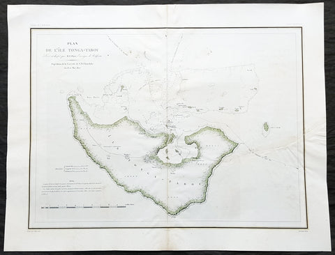
1827 Dumont D Urville Large Antique Map The Island of Tongatapu Tonga, Astrolabe
- Title : Plan de L Isle Tonga-Tabou Leve et dresse par M.E. Paris, Enseigne de Vaisseau Expedition de la Corvette de S M L Astrolobe Avril et Mai, 1827
- Size: 26 1/2in x 20 1/2in (675mm x 520mm)
- Condition: (A) Very Good Condition
- Date : 1827
- Ref #: 32157
Description:
This magnificent large original & scarce lithograph antique map of the largest island in the Tonga Isalnd group, Tongatapu, by Dumont D Urville and Lieutenant Victor Lottin, aboard the ship The Astrolabe during the first D Urville voyage to the South Seas 1826 - 1829, was engraved by Alphonse Chassant, 1808-1907 and published in the 1836 edition of Dumont d Urvilles Voyage de la corvette L Astrolabe: exécuté par ordre du roi, pendant les années 1826-1827-1828-1829......
General Definitions:
Paper thickness and quality: - Heavy and stable
Paper color : - off white
Age of map color: - Original
Colors used: - Green, yellow
General color appearance: - Authentic
Paper size: - 26 1/2in x 20 1/2in (675mm x 520mm)
Plate size: - 26 1/2in x 20 1/2in (675mm x 520mm)
Margins: - Min 2in (50mm)
Imperfections:
Margins: - None
Plate area: - Centerfold re-joined, left side of image re-joined, no loss
Verso: - Repairs as noted above
Background:
This map illustrates the route taken by the ship The Astrolabe and Dumont D Urville & crew after leaving New Zealand in March 1827. D Urville extensively surveyed Tongatapu and nearby island between April & May 1827.
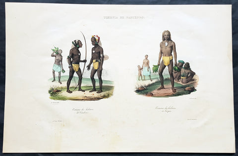
1836 D Urville & Sainson Antique Print of Vanikoro & Tikopia Islands, Solomon Isands
- Title : Tikopia et Vanikoro: Costumes des habitans de Vanikoro: Costumes des habitans de Tikopia
- Size: 19 1/2in x 13in (495mm x 330mm)
- Condition: (A+) Fine Good Condition
- Date : 1836
- Ref #: 31735
Description:
This large, magnificent, original antique lithograph print of the peoples of the island of Vanikoro & Tikopia, part of the Solomon Islands in the south Pacific (and last resting place of the ill fated La Perouse expedition), by Louis Auguste de Sainson, artist on the Astrolabe, during the first of Dumont D Urvilles voyages to the South Seas, between 1826 - 1829, was engraved by Antoine Maurin 1793 - 1860 and published in the 1836 1st edition of Dumont d Urvilles Voyage de la corvette L Astrolabe: exécuté par ordre du roi, pendant les années 1826-1827-1828-1829......
Louis Auguste de Sainson, (1800-1848). Sainson was a French draftsman & artist who specialized in natural history and geography. He accompanied the expedition of the corvette L Astrolabe as a naturalist directed by Jules Dumont d\'Urville between 1826-1829.
He began his naval career in a secretarial position at the French Atlantic port of Rochefort, working there from 1825 till 1826. He then volunteered to join the Astrolabe as a draughtsman, after being recommended to the expedition by Quoy, one of the naturalists on the expedition, joining the ship at Toulon on 7 February 1826.
He was responsible for the bulk of the drawings produced during the expedition, with over 500 in three years. Many of his drawings paintings and prints now reside in Australian, New Zealand & French museums.
General Definitions:
Paper thickness and quality: - Heavy and stable
Paper color : - off white
Age of map color: - Early
Colors used: - Yellow, pink, green, blue
General color appearance: - Authentic
Paper size: - 19 1/2in x 13in (495mm x 330mm)
Plate size: - 19 1/2in x 13in (495mm x 330mm)
Margins: - Min 1in (25mm)
Imperfections:
Margins: - Light soiling in margins
Plate area: - None
Verso: - None
Background:
Vanikoro (sometimes wrongly named Vanikolo) is an island in the Santa Cruz group, located 118 kilometres to the Southeast of the main Santa Cruz group. It is part of the Temotu Province of the Solomon Islands.
The first sighting of Vanikoro by Europeans was in September 1595, by the second Spanish expedition of Álvaro de Mendaña. It was sighted by Lorenzo Barreto, while in command of one of the smaller vessels on a voyage around the then Santa Cruz, which is today\'s Nendo Island.
The French explorer Jean-François de La Pérouse was stranded on Vanikoro after both his vessels, La Boussole and the Astrolabe, struck the then unknown reefs of the island in 1788. It is reported that some of the men were killed by the local inhabitants, while the surviving sailors built a smaller vessel and left the island, but were never seen again. Those that remained on the island died before search parties of Dumont D Urville arrived in 1826.
Tikopia is a small high island in the southwestern Pacific Ocean. It is part of the Solomon Islands of Melanesia, but is culturally Polynesian. The first Europeans arrived on 22 April 1606 as part of the Spanish expedition of Pedro Fernandes de Queirós.
In 1964, explorers found artefacts from the shipwreck of the expedition of Jean-François de Galaup, comte de Lapérouse.
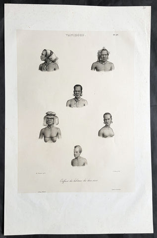
1836 D Urville & Sainson Antique Print Men & Women of Vanikoro Isle, Solomon Is.
- Title : Vanikoro. Coiffures des habitans des deux sexes
- Size: 20 1/2in x 13 1/2in (520mm x 345mm)
- Condition: (A+) Fine Good Condition
- Date : 1836
- Ref #: 31751
Description:
This large, magnificent, original antique lithograph print of hair styles of the men & woman of the island of Vanikoro, part of the Solomon Islands in the south Pacific (and last resting place of the ill fated La Perouse expedition), by Louis Auguste de Sainson, artist on the Astrolabe, during the first of Dumont D Urvilles voyages to the South Seas, between 1826 - 1829, was engraved by Antoine Maurin 1793 - 1860 and published in the 1836 1st edition of Dumont d UrvillesVoyage de la corvette L Astrolabe: exécuté par ordre du roi, pendant les années 1826-1827-1828-1829......
Louis Auguste de Sainson, (1800-1848). Sainson was a French draftsman & artist who specialized in natural history and geography. He accompanied the expedition of the corvette L Astrolabe as a naturalist directed by Jules Dumont d\'Urville between 1826-1829.
He began his naval career in a secretarial position at the French Atlantic port of Rochefort, working there from 1825 till 1826. He then volunteered to join the Astrolabe as a draughtsman, after being recommended to the expedition by Quoy, one of the naturalists on the expedition, joining the ship at Toulon on 7 February 1826.
He was responsible for the bulk of the drawings produced during the expedition, with over 500 in three years. Many of his drawings paintings and prints now reside in Australian, New Zealand & French museums.
General Definitions:
Paper thickness and quality: - Heavy and stable
Paper color : - off white
Age of map color: -
Colors used: -
General color appearance: -
Paper size: - 20 1/2in x 13 1/2in (520mm x 345mm)
Plate size: - 20 1/2in x 13 1/2in (520mm x 345mm)
Margins: - Min 2in (50mm)
Imperfections:
Margins: - None
Plate area: - None
Verso: - None
Background:
Vanikoro (sometimes wrongly named Vanikolo) is an island in the Santa Cruz group, located 118 kilometres to the Southeast of the main Santa Cruz group. It is part of the Temotu Province of the Solomon Islands.
The first sighting of Vanikoro by Europeans was in September 1595, by the second Spanish expedition of Álvaro de Mendaña. It was sighted by Lorenzo Barreto, while in command of one of the smaller vessels on a voyage around the then Santa Cruz, which is today\'s Nendo Island.
The French explorer Jean-François de La Pérouse was stranded on Vanikoro after both his vessels, La Boussole and the Astrolabe, struck the then unknown reefs of the island in 1788. It is reported that some of the men were killed by the local inhabitants, while the surviving sailors built a smaller vessel and left the island, but were never seen again. Those that remained on the island died before search parties of Dumont D Urville arrived in 1826.
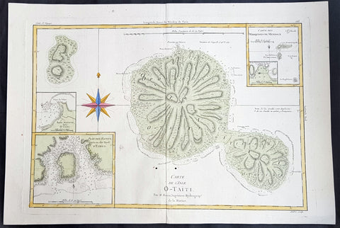
1780 Rigobert Bonne Large Antique Map of Tahiti
- Title : Carte De L 'Isle O - Taiti...Par M. Bonne...
- Date : 1780
- Condition: (A) Very Good Condition
- Ref: 40570
- Size: 15in x 11in (400mm x 275mm)
Description:
This fine original copper plate engraved antique map by Rigobert Bonne was published in the 1780 edition of Atlas des toutes les parties connues du globe terrestre by Guillaume Raynal. (Ref Tooley M&B)
General Definitions:
Paper thickness and quality: - Heavy and stable
Paper color : - off white
Age of map color: - Early
Colors used: - Yellow, Green, pink
General color appearance: - Authentic
Paper size: - 16 ½in x 11 ½in; (420mm x 295mm)
Plate size: - 14 ½in x 10in; (370mm x 250mm)
Margins: - Min 1/2in (12mm)
Imperfections:
Margins: - None
Plate area: - Two very small worm holes adjacent to bottom centerfold
Verso: - None
Background:
Tahiti previously also known as Otaheite is the largest island in the Windward group of French Polynesia. The island is located in the archipelago of the Society Islands in the central Southern Pacific Ocean.
The first European to have visited Tahiti according to existing records was lieutenant Samuel Wallis, who was circumnavigating the globe in HMS Dolphin, sighting the island on 18 June 1767, and eventually harboring in Matavai Bay. This bay was situated on the territory of the chiefdom of Pare-Arue, governed by Tu (Tu-nui-e-a a-i-te-Atua) and his regent Tutaha, and the chiefdom of Ha apape, governed by Amo and his wife Oberea (Purea). Wallis named the island King Georges Island. The first contacts were difficult, since on the 24 and 26 June 1767, Tahitian warriors in canoes showed aggression towards the British, hurling stones from their slings. In retaliation, the British sailors opened fire on the warriors in the canoes and on the hills. In reaction to this powerful counter-attack, the Tahitians laid down peace offerings for the British. Following this episode, Samuel Wallis was able to establish cordial relations with the female chieftain “Oberea “ (Purea) and remained on the island until 27 July 1767.
In July 1768, Captain James Cook was commissioned by the Royal Society and on orders from the Lords Commissioners of the Admiralty to observe the transit of Venus across the sun, a phenomenon that would be visible from Tahiti on 3 June 1769. He arrived in Tahitis Matavai Bay, commanding the HMS Endeavour on 12 April 1769. On 14 April, Cook met with Tutaha and Tepau. On 15 April, Cook picked the site for a fortified camp at Point Venus along with Banks, Parkinson, Daniel Solander, to protect Charles Greens observatory. The length of stay enabled them to undertake for the first time real ethnographic and scientific observations of the island. Assisted by the botanist Joseph Banks, and by the artist Sydney Parkinson, Cook gathered valuable information on the fauna and flora, as well as the native society, language and customs, including the proper name of the island, Otaheite. On 28 April, Cook met Purea and Tupaia, and Tupaia befriended Banks following the transit. On 21 June, Amo visited Cook, and then on 25 June, Pohuetea visited, signifying another chief seeking to ally himself with the British.
Cook and Banks circumnavigated the island from 26 June to 1 July. On the exploration, they met Ahio, chief of Ha apaiano o or Papenoo, Rita, chief of Hitia a, Pahairro, chief of Pueu, Vehiatua, chief of Tautra, Matahiapo, chief of Teahupo o, Tutea, chief of Vaira o, and Moe, chief of Afa Ahiti. In Papara, guided by Tupaia, they investigated the ruins of Mahaiatea marae, an impressive structure containing a stone pyramid or ahu, measuring 44 feet high, 267 feet long and 87 feet wide. Cook and the Endeavour departed Tahiti on 13 July 1769, taking Raiatean navigator Tupaia along for his geographic knowledge of the islands.
Cook returned to Tahiti between 15 August and 1 September 1773, greeted by the chiefs Tai and Puhi, besides the youg ari i Vehiatua II and his stepfather Ti itorea. Cook anchored in Vaitepiha Bay before returning to Point Venus where he met Tu, the paramount chief. Cook picked up two passengers from Tahiti during this trip, Porea and Mai, with Hitihiti later replacing Porea when Cook stopped at Raiatea. Cook took Hitihiti to Tahiti on 22 April, during his return leg. Then, Cook departed Tahiti on 14 May 1774.
During his final visit, Cook returned Mai to Tahiti on 12 Aug. 1777, after Mais long visit in England. Cook also brought two Maori from Queen Charlotte Sound, Te Weherua and Koa. Cook first harbored in Vaitepiha Bay, where he visited Vehiatua II s funeral bier and the prefabricated Spanish mission house. Cook also met Vehiatua III, and inscribed on the back of the Spanish cross, Georgius tertius Rex Annis 1767, 69, 73, 74 & 77, as a counterpoint to Christus Vincit Carolus III imperat 1774 on the front. On 23 Aug., Cook sailed for Matavai Bay, where he met Tu, his father Teu, his mother Tetupaia, his brothers Ari ipaea and Vaetua, and his sisters Ari ipaea-vahine, Tetua-te-ahamai, and Auo. Cook also observed a human sacrifice, taata tapu, at the Utu-ai-mahurau marae, and 49 skulls from previous victims.
On 29 Sept. 1777, Cook sailed for Papetoai Bay on Moorea. Cook met Mahine in an act of friendship on 3 Oct., though he was an enemy of Tu. When a goat kid was stolen on 6 Oct., Cook in a rampage, ordered the burning of houses and canoes until it was returned. Cook sailed for Huahine on 11 Oct., Raiatea on 2 Nov., and Borabora on 7 Dec.
On 26 October 1788, HMS Bounty, under the command of Captain William Bligh, landed in Tahiti with the mission of carrying Tahitian breadfruit trees (Tahitian: uru) to the Caribbean. Sir Joseph Banks, the botanist from James Cooks first expedition, had concluded that this plant would be ideal to feed the African slaves working in the Caribbean plantations at very little cost. The crew remained in Tahiti for about five months, the time needed to transplant the seedlings of the trees. Three weeks after leaving Tahiti, on 28 April 1789, the crew mutinied on the initiative of Fletcher Christian. The mutineers seized the ship and set the captain and most of those members of the crew who remained loyal to him adrift in a ships boat. A group of mutineers then went back to settle in Tahiti.
Although various explorers had refused to get involved in tribal conflicts, the mutineers from the Bounty offered their services as mercenaries and furnished arms to the family which became the Pōmare Dynasty. The chief Tū knew how to use their presence in the harbours favoured by sailors to his advantage. As a result of his alliance with the mutineers, he succeeded in considerably increasing his supremacy over the island of Tahiti.
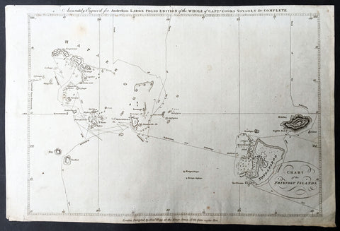
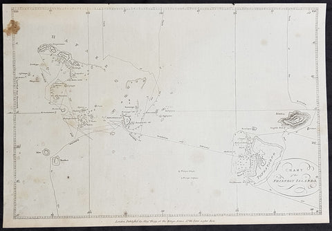
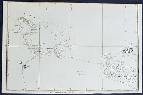
1784 Anderson Antique Map of the Tonga Islands - Capt. Cooks Voyages in 1773 & 1777
- Title : Chart of the Friendly Islands
- Size: 14 1/2in x 9 1/2in (370mm x 245mm)
- Ref #: 32181
- Date : 1784
- Condition: (A) Very Good Condition
This fine original copper-plate engraved antique map of the Tonga Island (Friendly Islands) with the routes taken by Captain James Cook visits to the Islands in his 2nd voyage in 1773 in HMS Resolution & Discovery and his 3rd and last voyage in 1777 in HMS Resolution & Discovery, was published in George Andersons 1784 edition of A Collection of voyages round the world : performed by royal authority : containing a complete historical account of Captain Cooks first, second, third and last voyages, undertaken for making new discoveries, &c. ... published by Alexander Hogg, London 1784.
Exert From Cooks, <i>A Voyage Towards the South Pole, and Round the World, performed in His Majestys Ships the 'Resolution' and 'Adventure', In the Years 1772, 1773, 1774, and 1775.</i>
......<i>after leaving Raiatea (Society Islands) on 18 September 1773, Cook directed his course towards Amsterdam Island (Tongatapu), discovered by Tasman in 1643, intending to verify Tasman's charting against his own charts. The ships stayed for three days, thoroughly enjoying the reception they had received and called the group the Friendly Islands. On his second visit he headed for the Nomuka, the largest island of the south central group of Tonga.</i>
General Definitions:
Paper thickness and quality: - Heavy and stable
Paper color : - off white
Age of map color: -
Colors used: -
General color appearance: -
Paper size: - 14 1/2in x 9 1/2in (370mm x 245mm)
Plate size: - 14 1/2in x 9 1/2in (370mm x 245mm)
Margins: - Min 1/2in (12mm)
Imperfections:
Margins: - None
Plate area: - None
Verso: - None
Background:
Tonga officially the Kingdom of Tonga, is a Polynesian sovereign state and archipelago comprising 169 islands, of which 36 are inhabited. The total surface area is about 750 square kilometres (290 sq mi) scattered over 700,000 square kilometres (270,000 sq mi) of the southern Pacific Ocean. It has a population of 107,122 people, of whom 70% reside on the main island of Tongatapu.
The Tongan people first encountered Europeans in 1616 when the Dutch vessel Eendracht, captained by Willem Schouten, made a short visit to trade. Later came other Dutch explorers, including Jacob Le Maire (who called on the northern island of Niuatoputapu); and in 1643 Abel Tasman (who visited Tongatapu and Haapai).
Later noteworthy European visitors included James Cook (Royal Navy) in 1773, 1774, and 1777; Alessandro Malaspina (Spanish Navy) in 1793; the first London missionaries in 1797; and the Wesleyan Methodist Reverend Walter Lawry in 1822.
Tonga became known in the West as the Friendly Islands because of the congenial reception accorded to Captain James Cook on his first visit in 1773. He arrived at the time of the inasi festival, the yearly donation of the First Fruits to the Tui Tonga (the islands paramount chief) and so received an invitation to the festivities. According to the writer William Mariner, the chiefs wanted to kill Cook during the gathering but could not agree on a plan.
1784 Anderson Antique Map of the Tonga Islands - Capt. Cooks Voyages in 1773 & 1777
- Title : Chart of the Friendly Islands
- Size: 14 1/2in x 9 1/2in (370mm x 245mm)
- Ref #: 21603
- Date : 1784
- Condition: (A) Very Good Condition
This fine original copper-plate engraved antique map of the Tonga Island (Friendly Islands) with the routes taken by Captain James Cook visits to the Islands in his 2nd voyage in 1773 in HMS Resolution & Discovery and his 3rd and last voyage in 1777 in HMS Resolution & Discovery, was published in George Andersons 1784 edition of A Collection of voyages round the world : performed by royal authority : containing a complete historical account of Captain Cooks first, second, third and last voyages, undertaken for making new discoveries, &c. ... published by Alexander Hogg, London 1784.
Exert From Cooks, <i>A Voyage Towards the South Pole, and Round the World, performed in His Majestys Ships the 'Resolution' and 'Adventure', In the Years 1772, 1773, 1774, and 1775.</i>
......<i>after leaving Raiatea (Society Islands) on 18 September 1773, Cook directed his course towards Amsterdam Island (Tongatapu), discovered by Tasman in 1643, intending to verify Tasman's charting against his own charts. The ships stayed for three days, thoroughly enjoying the reception they had received and called the group the Friendly Islands. On his second visit he headed for the Nomuka, the largest island of the south central group of Tonga.</i>
General Definitions:
Paper thickness and quality: - Heavy and stable
Paper color : - off white
Age of map color: -
Colors used: -
General color appearance: -
Paper size: - 14 1/2in x 9 1/2in (370mm x 245mm)
Plate size: - 14 1/2in x 9 1/2in (370mm x 245mm)
Margins: - Min 1/2in (12mm)
Imperfections:
Margins: - Top & bottom margins cropped close to borders
Plate area: - None
Verso: - None
Background:
Tonga officially the Kingdom of Tonga, is a Polynesian sovereign state and archipelago comprising 169 islands, of which 36 are inhabited. The total surface area is about 750 square kilometres (290 sq mi) scattered over 700,000 square kilometres (270,000 sq mi) of the southern Pacific Ocean. It has a population of 107,122 people, of whom 70% reside on the main island of Tongatapu.
The Tongan people first encountered Europeans in 1616 when the Dutch vessel Eendracht, captained by Willem Schouten, made a short visit to trade. Later came other Dutch explorers, including Jacob Le Maire (who called on the northern island of Niuatoputapu); and in 1643 Abel Tasman (who visited Tongatapu and Haapai).
Later noteworthy European visitors included James Cook (Royal Navy) in 1773, 1774, and 1777; Alessandro Malaspina (Spanish Navy) in 1793; the first London missionaries in 1797; and the Wesleyan Methodist Reverend Walter Lawry in 1822.
Tonga became known in the West as the Friendly Islands because of the congenial reception accorded to Captain James Cook on his first visit in 1773. He arrived at the time of the inasi festival, the yearly donation of the First Fruits to the Tui Tonga (the islands paramount chief) and so received an invitation to the festivities. According to the writer William Mariner, the chiefs wanted to kill Cook during the gathering but could not agree on a plan.
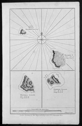
1786 Bowen Antique Map 3 x Cook Islands & 1 x Society Island - Cooks Voyage 1777
- Title : Wanooaette Isl; Wateeoo I; Mangeea Island Toobouai Island
- Size: 13 1/2in x 9 1/2in (345mm x 240mm)
- Ref #: 21697
- Date : 1786
- Condition: (A+) Fine Condition
Description:
This fine original copper-plate engraved antique map of three of the Cook Islands, Takutea (Wanooaette) Atiu (Wateeoo) and Mangaia (Mangeea) and a 4th map of the Island of Tubuai (Toobouai) in French Polynesia near Tahiti, visited by Captain Cook in HMS Resolution & Discovery in September 1777, during his 3rd & last Voyage of Discovery, was published in George Andersons A New, Authentic, and Complete Account of Voyages Round the World, Undertaken and Performed by Royal Authority. Containing a New, Authentic, Entertaining, Instructive, Full and Complete History of Captain Cooks First, Second, Third and Last Voyages.. ... published by Alexander Hogg, London 1786.
These maps of three Cook Islands :
1.Wanooaette, (Takutea)
2. Wateeoo (Atiu)
3. Mangeea ( Mangaia)
4. inset map of Toobouai (Tubuai) in the Society Islands in French Polynesia
All maps were charted by James Cook in 1777 while sailing for the Society Islands (French Polynesia) with livestock he carried aboard the Discovery and the Resolution. As he sailed toward Tahiti he discovered Toobouai (Tubuai) Island on 13 August 1777 where they stayed for 6 weeks. Relief shown by hachures and soundings.
General Definitions:
Paper thickness and quality: - Heavy and stable
Paper color : - off white
Age of map color: -
Colors used: -
General color appearance: -
Paper size: - 13 1/2in x 9 1/2in (345mm x 240mm)
Plate size: - 13 1/2in x 9 1/2in (345mm x 240mm)
Margins: - Min 1/2in (12mm)
Imperfections:
Margins: - None
Plate area: - None
Verso: - None
George William Anderson
A Collection of voyages round the world : performed by royal authority : containing a complete historical account of Captain Cooks first, second, third and last voyages, undertaken for making new discoveries, &c. ... : to which are added genuine narratives of other voyages of discovery round the world, &c. viz. those of Lord Byron, Capt. Wallis, Capt. Carteret, Lord Mulgrave, Lord Anson, Mr. Parkinson, Capt. Lutwidge, Mess. Ives, Middleton, Smith, &c published by Alex. Hogg, 1786.
Spanish ships visited the islands in the 16th century; the first written record of contact with the islands came in 1595 with the sighting of Pukapuka by Spanish sailor Álvaro de Mendaña de Neira, who called it San Bernardo (Saint Bernard). Pedro Fernandes de Queirós, a Portuguese captain working for the Spanish crown, made the first recorded European landing in the islands when he set foot on Rakahanga in 1606, calling it Gente Hermosa.
British navigator Captain James Cook arrived in 1773 and 1777 and named the island of Manuae Hervey Island. Later, the name Hervey Islands came to be applied to the entire southern group; the name Cook Islands, in honour of Cook, first appeared on a Russian naval chart published in the 1820s
Takutea, in the Cook Islands, is a small uninhabited island 21 kilometres northwest of Atiu in the southern Cook Islands.
Takutea is the only island in the Cook Islands that never had a permanent population. When Captain James Cook sighted the island on 4 April 1777, and some crew members went ashore, they found some huts, but no evidence of a permanent settlement.
Atiu, also known as Enuamanu (meaning land of the birds), is an island 187 km northeast of Rarotonga, in the Southern Islands group of the Cook Islands Archipelago.
The first recorded European to arrive at Atiu was Captain Cook. He sighted the island on March 31, 1777 and made tentative contact with some of the people over the next few days.
Mangaia (traditionally known as A ua u Enua, which means terraced) is the most southerly of the Cook Islands and the second largest, after Rarotonga.
The first recorded European to arrive at Mangaia was Captain James Cook on 29 March 1777.
Tubuai part of the Society Islands is located 640 km south of Tahiti. Tubuai was first viewed by Europeans when it was mapped by Captain James Cook in 1777, although his party did not disembark. Cook discovered the islands name, Toobouai, from the natives who surrounded his ship in their canoes (a Tahitian named Omai, who was part of Cooks group, translated)
The next Europeans to arrive were the mutineers of the HMS Bounty in 1789. Mutineer Fletcher Christian, in looking for an island on which to permanently hide, had scoured Blighs maps and nautical charts and decided on Tubuai.
Upon arrival at Tubuai, a conflict arose while the mutineers were still on their ship and several islanders were killed in their canoes. The site of this event in the lagoon on the north side of the island is called Baie Sanglant (Bloody Bay)
1784 Anderson Antique Map of the Tonga Islands - Capt. Cooks Voyages in 1773 & 1777
- Title : Chart of the Friendly Islands
- Size: 13 1/2in x 9 1/2in (360mm x 245mm)
- Ref #: 32152
- Date : 1784
- Condition: (A) Very Good Condition
This fine original copper-plate engraved antique map of the Tonga Island (Friendly Islands) with the routes taken by Captain James Cook visits to the Islands in his 2nd voyage in 1773 in HMS Resolution & Discovery and his 3rd and last voyage in 1777 in HMS Resolution & Discovery, was published in George Andersons 1784 edition of A Collection of voyages round the world : performed by royal authority : containing a complete historical account of Captain Cooks first, second, third and last voyages, undertaken for making new discoveries, &c. ... published by Alexander Hogg, London 1784.
Exert From Cooks, <i>A Voyage Towards the South Pole, and Round the World, performed in His Majestys Ships the 'Resolution' and 'Adventure', In the Years 1772, 1773, 1774, and 1775.</i>
......<i>after leaving Raiatea (Society Islands) on 18 September 1773, Cook directed his course towards Amsterdam Island (Tongatapu), discovered by Tasman in 1643, intending to verify Tasman's charting against his own charts. The ships stayed for three days, thoroughly enjoying the reception they had received and called the group the Friendly Islands. On his second visit he headed for the Nomuka, the largest island of the south central group of Tonga.</i>
General Definitions:
Paper thickness and quality: - Heavy and stable
Paper color : - off white
Age of map color: -
Colors used: -
General color appearance: -
Paper size: - 13 1/2in x 9 1/2in (360mm x 245mm)
Plate size: - 13 1/2in x 9 1/2in (360mm x 245mm)
Margins: - Min 1/2in (12mm)
Imperfections:
Margins: - Brown stain top left
Plate area: - None
Verso: - None
Background:
Tonga officially the Kingdom of Tonga, is a Polynesian sovereign state and archipelago comprising 169 islands, of which 36 are inhabited. The total surface area is about 750 square kilometres (290 sq mi) scattered over 700,000 square kilometres (270,000 sq mi) of the southern Pacific Ocean. It has a population of 107,122 people, of whom 70% reside on the main island of Tongatapu.
The Tongan people first encountered Europeans in 1616 when the Dutch vessel Eendracht, captained by Willem Schouten, made a short visit to trade. Later came other Dutch explorers, including Jacob Le Maire (who called on the northern island of Niuatoputapu); and in 1643 Abel Tasman (who visited Tongatapu and Haapai).
Later noteworthy European visitors included James Cook (Royal Navy) in 1773, 1774, and 1777; Alessandro Malaspina (Spanish Navy) in 1793; the first London missionaries in 1797; and the Wesleyan Methodist Reverend Walter Lawry in 1822.
Tonga became known in the West as the Friendly Islands because of the congenial reception accorded to Captain James Cook on his first visit in 1773. He arrived at the time of the inasi festival, the yearly donation of the First Fruits to the Tui Tonga (the islands paramount chief) and so received an invitation to the festivities. According to the writer William Mariner, the chiefs wanted to kill Cook during the gathering but could not agree on a plan.
1784 Anderson Antique Map of the Tonga Islands - Capt. Cooks Voyages in 1773 & 1777
- Title : Chart of the Friendly Islands
- Size: 13 1/2in x 9 1/2in (360mm x 245mm)
- Ref #: 21443
- Date : 1784
- Condition: (A) Very Good Condition
This fine original copper-plate engraved antique map of the Tonga Island (Friendly Islands) with the routes taken by Captain James Cook visits to the Islands in his 2nd voyage in 1773 in HMS Resolution & Discovery and his 3rd and last voyage in 1777 in HMS Resolution & Discovery, was published in George Andersons 1784 edition of A Collection of voyages round the world : performed by royal authority : containing a complete historical account of Captain Cooks first, second, third and last voyages, undertaken for making new discoveries, &c. ... published by Alexander Hogg, London 1784.
Exert From Cooks, <i>A Voyage Towards the South Pole, and Round the World, performed in His Majestys Ships the 'Resolution' and 'Adventure', In the Years 1772, 1773, 1774, and 1775.</i>
......<i>after leaving Raiatea (Society Islands) on 18 September 1773, Cook directed his course towards Amsterdam Island (Tongatapu), discovered by Tasman in 1643, intending to verify Tasman's charting against his own charts. The ships stayed for three days, thoroughly enjoying the reception they had received and called the group the Friendly Islands. On his second visit he headed for the Nomuka, the largest island of the south central group of Tonga.</i>
General Definitions:
Paper thickness and quality: - Heavy and stable
Paper color : - off white
Age of map color: -
Colors used: -
General color appearance: -
Paper size: - 13 1/2in x 9 1/2in (360mm x 245mm)
Plate size: - 13 1/2in x 9 1/2in (360mm x 245mm)
Margins: - Min 1/2in (12mm)
Imperfections:
Margins: - Top margin cropped to border
Plate area: - None
Verso: - None
Background:
Tonga officially the Kingdom of Tonga, is a Polynesian sovereign state and archipelago comprising 169 islands, of which 36 are inhabited. The total surface area is about 750 square kilometres (290 sq mi) scattered over 700,000 square kilometres (270,000 sq mi) of the southern Pacific Ocean. It has a population of 107,122 people, of whom 70% reside on the main island of Tongatapu.
The Tongan people first encountered Europeans in 1616 when the Dutch vessel Eendracht, captained by Willem Schouten, made a short visit to trade. Later came other Dutch explorers, including Jacob Le Maire (who called on the northern island of Niuatoputapu); and in 1643 Abel Tasman (who visited Tongatapu and Haapai).
Later noteworthy European visitors included James Cook (Royal Navy) in 1773, 1774, and 1777; Alessandro Malaspina (Spanish Navy) in 1793; the first London missionaries in 1797; and the Wesleyan Methodist Reverend Walter Lawry in 1822.
Tonga became known in the West as the Friendly Islands because of the congenial reception accorded to Captain James Cook on his first visit in 1773. He arrived at the time of the inasi festival, the yearly donation of the First Fruits to the Tui Tonga (the islands paramount chief) and so received an invitation to the festivities. According to the writer William Mariner, the chiefs wanted to kill Cook during the gathering but could not agree on a plan.
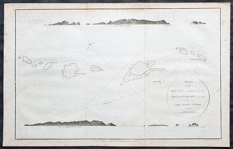
1797 Wilson Large Antique Map of the Duff Isles, Solomon Islands, South Pacific
- Title : 1799 James Wilson Antique Map of Duff or Wilson Islands, Santa Cruz Solomons Is.
- Date : 1799
- Condition: (A) Very Good Condition
- Ref: 90613
- Size: 16in x 10 1/2in (405mm x 255mm)
Description:
This copper-plate engraved original antique map of Duff or Wilson Islands located northeast of the Santa Cruz Islands in the Solomon Islands province of Temotu, in the South Pacific was engraved in by Thomas foot and was published in the 1799 edition Captain James Wilsons A missionary voyage to the Southern Pacific Ocean, performed in the years 1796, 1797, 1798, in the ship Duff commanded by Captain James Wilson.Compiled from journals of the officers and the missionaries. With a preliminary discourse on the geography and history of the South Sea Islands; and an appendix, including details never before published of the natural and civil state of Otaheite.
Captain James Wilson (1760–1814), commanded the British ship Duff, which the London Missionary Society contracted in 1797 to convey a team of missionaries (consisting of thirty men, six women, and three children) to their postings in Tahiti, Tonga, and the Marquesas Islands. During the voyage, Wilson also surveyed (or confirmed the locations of) numerous islands in the Pacific, including Vanua Balavu, Fulaga and Ogea Levu in Fiji, Mangareva in the Gambier Islands, Pukarua in the Tuamotus, and Satawal, Elato, and Lamotrek, in the Caroline Islands.
Three years after the establishment of the British mission in Tahiti, the directors of the Society appointed a committee to consider a suitable memorial for presentation to Wilson for his services in helping to establish the first mission in the South Seas.
He published an account of his voyage: A Missionary Voyage to the Southern Pacific Ocean in 1799. (Ref: M&B; Tooley)
General Definitions:
Paper thickness and quality: - Heavy and stable
Paper color : - off white
Age of map color: -
Colors used: -
General color appearance: -
Paper size: - 16in x 10 1/2in (405mm x 255mm)
Plate size: - 15in x 9 1/2in (380mm x 240mm)
Margins: - Min 1/4in (5mm)
Imperfections:
Margins: - Light soling
Plate area: - Folds as issued
Verso: - Light soling
Background:
The Duff Islands are a small island group lying to the northeast of the Santa Cruz Islands in the Solomon Islands province of Temotu. They are also sometimes known as the Wilson Islands.
The first recorded sighting by Europeans of the Duff Islands was by the Spanish expedition of Pedro Fernández de Quirós where it anchored on 8 April 1606. Its inhabitants named the islands as Taumako. They were charted by Quirós as Nuestra Señora del Socorro (Our Lady of Succour in Spanish).
The Duff Islands were named after missionary ship Duff, captained by James Wilson, which reached them in 1797.
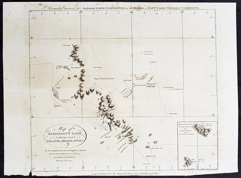
1784 Anderson Antique Map SW Regions of Kerguelen Islands in South Indian Ocean
- Title : Map of Kerguelens Land Called by C Cook Island of Desolation
- Size: 13in x 9 1/2in (330mm x 245mm)
- Ref #: 21694
- Date : 1784
- Condition: (A) Very Good Condition
Description:
This fine original copper-plate engraved antique map of the the Kerguelen Islands in the very Southern Indian Ocean explored by Capt Cooks during his 3rd Voyage of Discovery to the South Seas in December 1776 was published in George Andersons 1784 edition of A Collection of voyages round the world : performed by royal authority : containing a complete historical account of Captain Cook\\\'s first, second, third and last voyages, undertaken for making new discoveries, &c. ...published by Alexander Hogg, London 1784.
General Definitions:
Paper thickness and quality: - Heavy and stable
Paper color : - off white
Age of map color: -
Colors used: -
General color appearance: -
Paper size: - 13in x 9 1/2in (330mm x 245mm)
Plate size: - 13in x 9 1/2in (330mm x 245mm)
Margins: - Min 1/2in (12mm)
Imperfections:
Margins: - Small tear to bottom margin
Plate area: - None
Verso: - Light spotting
Background:
The Kerguelen Islands also known as the Desolation Islands are a group of islands in the southern Indian Ocean constituting one of the two exposed parts of the mostly submerged Kerguelen Plateau. They are among the most isolated places on Earth, located 450 km (280 mi) northwest of the uninhabited Heard Island and McDonald Islands and more than 3,300 km (2,051 mi) from Madagascar, the nearest populated location (excluding the Alfred Faure scientific station in Île de la Possession, about 1,340 km (830 mi) from there, and the non-permanent station located in Île Amsterdam, 1,440 km (890 mi) away). The islands, along with Adélie Land, the Crozet Islands, Amsterdam, and Saint Paul Islands, and France\'s Scattered Islands in the Indian Ocean are part of the French Southern and Antarctic Lands and are administered as a separate district.
The main island, Grande Terre, is 6,675 km2 in area and is surrounded by a further 300 smaller islands and islets, forming an archipelago of 7,215 km2. The climate is raw and chilly with frequent high winds throughout the year. The surrounding seas are generally rough and they remain ice-free year-round. There are no indigenous inhabitants, but France maintains a permanent presence of 45 to 100 scientists, engineers and researchers. There are no airports on the islands, so all travel and transport from the outside world is conducted by ship.
Kerguelen Islands appear as the Ile de Nachtegal on Philippe Buache\'s map from 1754 before the island was officially discovered in 1772. The Buache map has the title Carte des Terres Australes comprises entre le Tropique du Capricorne et le Pôle Antarctique où se voyent les nouvelles découvertes faites en 1739 au Sud du Cap de Bonne Esperance (Map of the Southern Lands contained between the Tropic of Capricorn and the Antarctic Pole, where the new discoveries made in 1739 to the south of the Cape of Good Hope may be seen). It is possible this early name was after Abel Tasman\'s ship De Zeeuwsche Nachtegaal. On the Buache map, Ile de Nachtega\" is located at 43°S, 72°E, about 6 degrees north and 2 degrees east of the accepted location of Grande Terre.
The islands were officially discovered by the French navigator Yves-Joseph de Kerguelen-Trémarec on 12 February 1772. The next day Charles de Boisguehenneuc landed and claimed the island for the French crown. Yves de Kerguelen organised a second expedition in 1773 and arrived at the \"baie de l\'Oiseau\" by December of the same year. On 6 January 1774 he commanded his lieutenant, Henri Pascal de Rochegude, to leave a message notifying any passers-by of the two passages and of the French claim to the islands. Thereafter, a number of expeditions briefly visited the islands, including that of Captain James Cook in December 1776 during his third voyage, who verified and confirmed the passage of de Kerguelen by discovering and annotating the message left by the French navigator.
1784 Anderson Antique Map Capt Cook Exploration of the Society Islands in French Polynesia
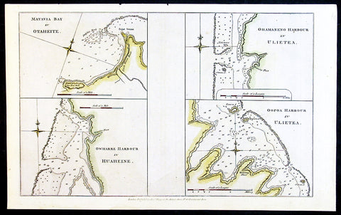
- Title : Matavia Bay in Otaheite; Ohamaneno Harbour in Ulietea; Owharre Harbourin Huaheine; Oopoa Harbour in Ulietea
- Date : 1784
- Ref # : 32197
- Size : 13 1/2in x 9 1/2in (345mm x 240mm)
- Condition: (A+) Fine Condition
Description:
This fine original copper-plate engraved antique map with surveys and depth soundings of four bays and harbours, of various bays & harbours of the Society Islands, French Polynesia made by explorers during the 17th & 18th centuries.
The first map is Matavia Bay, on the island of Tahiti (Otaheite), the second is Fare (Owharre) Harbour on the island of Huahine & the last two are Ohamaneno & Oopoa (Fa aroa Bay) harbours on the island of Raiatea (Ulietea) was published in George Andersons 1784 edition of A Collection of voyages round the world : performed by royal authority : containing a complete historical account of Captain Cooks first, second, third and last voyages, undertaken for making new discoveries, &c. ... published by Alexander Hogg, London 1784.
General Definitions:
Paper thickness and quality: - Heavy and stable
Paper color : - off white
Age of map color: -
Colors used: -
General color appearance: -
Paper size: - 13 1/2in x 9 1/2in (345mm x 240mm)
Plate size: - 13 1/2in x 9 1/2in (345mm x 240mm)
Margins: - Min 1/2in (12mm)
Imperfections:
Margins: - None
Plate area: - None
Verso: - None
Background:
A description of the four Bays & Harbours and their relevance to Capt Cook and other South Seas explorers are;
1.Matavia Bay in Otaheite (Tahiti) - first European to visit Tahiti Capt. Samuel Wallis anchored in Matavai Bay in 1767 as did Louis-Antoine de Bougainville in 1768 & Capt James Cook landed in Matavai Bay in 1769 and returned in his next two voyages.
2. Owharre (Fare) Harbour in Huaheine (Huahine) Captain Cook arrived in fare Harbour on 16 July 1769, with Tupaia navigating the HMS Endeavour
3. Ohamaneno Harbour (Port) in Ulietea (Raiatea)
4. Oopoa (Fa aroa Bay) Harbour in Ulietea (Raiatea)
Raiatea - The first European to record sighting Raiātea was Pedro Fernandes de Queirós in 1606; it was charted as La Fugitiva. The Polynesian navigator, Tupaia, who sailed with explorer James Cook, was born in Raiātea around 1725.
Cook visited Raiatea in 1769 and again in 1773-1774. Omai (c.1751-1780), another young man from Raiātea, travelled with European explorers to London in 1774 and also served as an interpreter to Captain Cook on his second and third journey.
Tahiti.
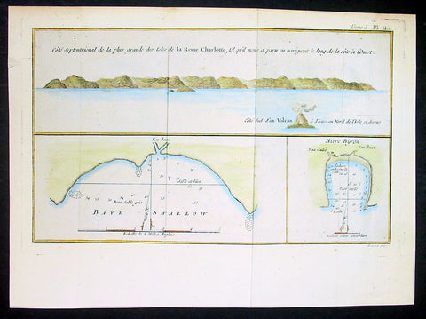
1774 Hawkesworth Antique Map Nendo Isle, Nupani, Solomon Islands - Carteret 1767
- Title : Cote septentrional de la plus grande des isles de la Reine Charlotte; Baye Swallow; Havre Byroni
- Ref : 21589-1
- Size: 13in x 9in (330mm x 230mm)
- Date : 1774
- Condition: (A) Very Good Condition
Description:
This fine original copper-plate engraved antique nautical chart & coastal view of the Island of Nendo (then called Lord Egmonts Island or New Guernsey) along with inset maps of Swallow Bay & Byrons Harbour on Nendo and a view of the nearby volcanic island of Nupani was drawn by Captain Phillip Carteret in July-August 1767 aboard his ship Swallow, accompanying Captain Samuel Wallis during his circumnavigation of the world, was published in the 1774 French edition of John Hawkesworths An Account of the Voyages Undertaken by the Order of His Present Majesty for Making Discoveries in the Southern Hemisphere and Successively Performed by Commodore Byron, Captain Wallis, Captain Carteret, and Captain Cook, in the Dolphin, the Swallow, and the Endeavor, Drawn Up from the Journals Which Were Kept by the Several Commanders, and from the Papers of Joseph Banks, Esq. Paris 1774
General Definitions:
Paper thickness and quality: - Heavy and stable
Paper color : - off white
Age of map color: - Original
Colors used: - Yellow, green, blue, pink
General color appearance: - Authentic
Paper size: - 13in x 9in (330mm x 230mm)
Plate size: - 12in x 7 1/2in (305mm x 190mm)
Margins: - Min 1/2in (12mm)
Imperfections:
Margins: - None
Plate area: - Folds as issued
Verso: - None
Background:
Samuel Wallis 1728 – 1795
was a British naval officer and explorer of the Pacific Ocean.
Wallis was born near Camelford, Cornwall. He served under John Byron, and in 1766 was promoted to captain and was given the command of HMS Dolphin (1751) as part of an expedition led by Philip Carteret in the Swallow with an assignment to circumnavigate the globe. The two ships were parted by a storm shortly after sailing through the Strait of Magellan, Wallis continuing to Tahiti, which he named King George the Thirds Island in honour of the King (June 1767). Wallis himself was ill and remained in his cabin: lieutenant Tobias Furneaux was the first to set foot, hoisting a pennant and turning a turf, taking possession in the name of His Majesty. Dolphin stayed in Matavai Bay in Tahiti for over a month. Wallis went on to name or rename five more islands in the Society Islands and six atolls in the Tuamotu Islands, as well as confirming the locations of Rongerik and Rongelap in the Marshall Islands. He renamed the Polynesian island of Uvea as Wallis after himself, before reaching Tinian in the Mariana Islands. He continued to Batavia, where many of the crew died from dysentery, then via the Cape of Good Hope to England, arriving in May 1768. He was able to pass on useful information to James Cook who was due to depart shortly for the Pacific, and some of the crew from the Dolphin sailed with Cook. In 1780 Wallis was appointed Commissioner of the Admiralty.
Capt. Philip Carteret (1733-1796)
was a British naval officer and explorer who participated in two of the Royal Navy\\\\\\\'s circumnavigation expeditions in 1764-66 and 1766-69.
Carteret entered the Navy in 1747, serving aboard the Salisbury, and then under Captain John Byron from 1751 to 1755. Between 1757 and 1758 he was in the Guernsey on the Mediterranean Station. As a lieutenant in the Dolphin he accompanied Byron during his voyage of circumnavigation, from June 1764 to May 1766.
In 1766 he was made a commander and given the command of the Swallow to circumnavigate the world, as consort to the Dolphin under the command of Samuel Wallis. The two ships were parted shortly after sailing through the Strait of Magellan, Carteret discovering Pitcairn Island and the Carteret Islands, which were subsequently named after him. In 1767, he also discovered a new archipelago inside Saint George\\\\\\\'s Channel between New Ireland and New Britain Islands (Papua New Guinea) and named it Duke of York Islands, as well as rediscovered the Solomon Islands first sighted by the Mendana in 1568, and the Juan Fernandez Islands first discovered by Juan Fernandez in 1574. He arrived back in England, at Spithead, on 20 March 1769.
He was promoted to post captain in 1771.
Nendo is the largest of the Santa Cruz Islands, located in the Temotu province of the Solomon Islands. The island is also known as Santa Cruz, Ndeni, Nitendi or Ndende. The name Santa Cruz was given to the island in 1595 by the Spanish navigator Alvaro de Mendaña, who unsuccessfully started a colony there.
The Nupani Atoll is located about 65 km to the West of the main group of the Reef Islands.
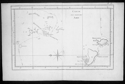
1778 Capt. Cook Antique Map HMS Resolution & Adventure in the Tonga Islands 1773
- Title : Carte Des Isles Des Amis ( Friendly Islands)
- Ref : 21764
- Size: 15 1/2in x 10in (395mm x 255mm)
- Date : 1778
- Condition: (A) Very Good Condition
Description:
This fine original copper-plate engraved antique map of the Tonga Islands with the routes taken by HMS Resolution & Adventure, during Captain James Cooks 2nd Voyage of Discovery in 1773, was engraved by Robert Benard - after Thomas Bowen - and was published in the 1778 French edition of Capt. James Cooks 2nd Voyage of Discovery to the South Seas A voyage towards the South Pole, and round the World. Performed in His Majestys ships the Resolution and Adventure, in the years 1772, 1773, 1774, and 1775..... Paris : Hotel de Thou ......1778.
Exert From Cooks diary A Voyage Towards the South Pole.........after leaving Raiatea (Society Islands) on 18 September 1773, Cook directed his course towards Amsterdam Island (Tongatapu), discovered by Tasman in 1643, intending to verify Tasmans charting against his own charts. The ships stayed for three days, thoroughly enjoying the reception they had received and called the group the Friendly Islands. On his second visit he headed for the Nomuka, the largest island of the south central group of Tonga.......
General Definitions:
Paper thickness and quality: - Heavy and stable
Paper color : - off white
Age of map color: -
Colors used: -
General color appearance: -
Paper size: - 15 1/2in x 10in (395mm x 255mm)
Plate size: - 13 1/2in x 9in (345mm x 230mm)
Margins: - Min 1/2in (12mm)
Imperfections:
Margins: - None
Plate area: - None
Verso: - None
Background:
Tonga officially the Kingdom of Tonga, is a Polynesian sovereign state and archipelago comprising 169 islands, of which 36 are inhabited. The total surface area is about 750 square kilometres (290 sq mi) scattered over 700,000 square kilometres (270,000 sq mi) of the southern Pacific Ocean. It has a population of 107,122 people, of whom 70% reside on the main island of Tongatapu.
The Tongan people first encountered Europeans in 1616 when the Dutch vessel Eendracht, captained by Willem Schouten, made a short visit to trade. Later came other Dutch explorers, including Jacob Le Maire (who called on the northern island of Niuatoputapu); and in 1643 Abel Tasman (who visited Tongatapu and Haapai).
Later noteworthy European visitors included James Cook (Royal Navy) in 1773, 1774, and 1777; Alessandro Malaspina (Spanish Navy) in 1793; the first London missionaries in 1797; and the Wesleyan Methodist Reverend Walter Lawry in 1822.
Tonga became known in the West as the Friendly Islands because of the congenial reception accorded to Captain James Cook on his first visit in 1773. He arrived at the time of the inasi festival, the yearly donation of the First Fruits to the Tui Tonga (the islands paramount chief) and so received an invitation to the festivities. According to the writer William Mariner, the chiefs wanted to kill Cook during the gathering but could not agree on a plan.
William Hodges RA 1744 – 1797 was an English painter. He was a member of James Cooks second voyage to the Pacific Ocean, and is best known for the sketches and paintings of locations he visited on that voyage, including Table Bay, Tahiti, Easter Island, and the Antarctic.
Between 1772 and 1775 Hodges accompanied James Cook to the Pacific as the expeditions artist. Many of his sketches and wash paintings were adapted as engravings in the original published edition of Cooks journals from the voyage.
Most of the large-scale landscape oil paintings from his Pacific travels for which Hodges is best known were finished after his return to London; he received a salary from the Admiralty for the purposes of completing them. These paintings depicted a stronger light and shadow than had been usual in European landscape tradition. Contemporary art critics complained that his use of light and colour contrasts gave his paintings a rough and unfinished appearance.
Hodges also produced many valuable portrait sketches of Pacific islanders and scenes from the voyage involving members of the expedition..
Robert Bénard 1734 – 1777 was an 18th-century French engraver.
Specialized in the technique of engraving, Robert Ménard is mainly famous for having supplied a significant amount of plates (at least 1,800) to the Encyclopédie by Diderot & d\'Alembert from 1751.
Later, publisher Charles-Joseph Panckoucke reused many of his productions to illustrate the works of his catalog.
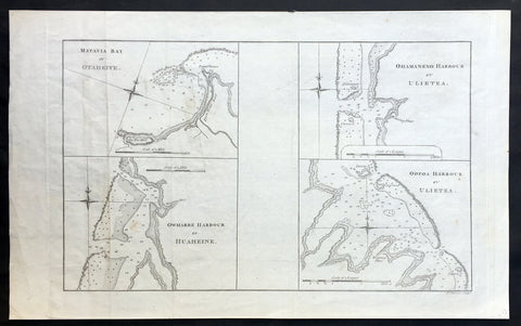
1773 Cook Antique Maps Tahiti, Raiatea & Huaheine Isles French Polynesia in 1769
- Title : Matavia Bay in Otaheite ; Owharre Harbour in Huaheine ; Ohamaneno Harbour in Ulietea ; Oopoa Harbour in Ulietea
- Size: 17in x 10 1/2in (430mm x 265mm)
- Ref #: 31216
- Date : 1773
- Condition: (A+) Fine Condition
Description:
This fine original copper-plate engraved antique map, four maps on the one sheet;
1. Matavia Bay, Tahiti (Otaheite) - Windward Islands
2. Ohamaneno (Vaiaau) Harbour Raiatea (Ulietea) - Leeward Islands
3. Owharre (Bourayne Bay) Harbour in Huaheine - Leeward Islands
4. Oopoa (Opoa) Harbour, Raiatea (Ulietea) - Leeward Islands
all located in French Polynesia, South Pacific were complied by Capt James Cook during his first voyage of discovery in 1769, was published in the 1773 edition of John Hawkesworths An Account of the Voyages Undertaken by the Order of His Present Majesty for Making Discoveries in the Southern Hemisphere and Successively Performed by Commodore Byron, Captain Wallis, Captain Carteret, and Captain Cook, in the Dolphin, the Swallow, and the Endeavor, Drawn Up from the Journals Which Were Kept by the Several Commanders, and from the Papers of Joseph Banks, Esq. Paris 1773
General Definitions:
Paper thickness and quality: - Heavy and stable
Paper color : - off white
Age of map color: -
Colors used: -
General color appearance: -
Paper size: - 17in x 10 1/2in (430mm x 265mm)
Plate size: - 14 1/2in x 10 1/2in (365mm x 260mm)
Margins: - Min 1/2in (12mm)
Imperfections:
Margins: - None
Plate area: - Light creasing
Verso: - None
Background:
Matavai Bay is located on the north coast of Tahiti, the largest island in the Windward group of French Polynesia.
The first European known to have visited Tahiti was Lieutenant Samuel Wallis, in Dolphin, who landed on 17 June 1767 in Matavai Bay.
Captain James Cook anchored in the bay on 13 April 1769, on a sandy spit on the northeast end of Matavai Bay - named Point Venus by Cook.
Raiatea, is the second largest of the Society Islands, after Tahiti, in French Polynesia. The island is widely regarded as the centre of the eastern islands in ancient Polynesia and it is likely that the organised migrations to Hawaii, Aotearoa and other parts of East Polynesia started at Raiātea.
Captain Cook visited Raiatea in 1769 and again in 1773-1774.
Huahine is an island located among the Society Islands, in French Polynesia, an overseas territory of France in the Pacific Ocean. It is part of the Leeward Islands group (Iles sous le Vent).
Captain Cook arrived Fare Harbour on 16 July 1769, with Tupaia navigating the HMS Endeavour. They met with leading chief Ori (Mato). Cook returned on 3 Sept. 1773 and met with Oris son Teri itaria, the new ari i rahi of the island.
John Hawkesworth 1715 – 1773
An English writer and journalist, Hawkesworth was commissioned by the British Admiralty to edit for publication the narratives of its officers’ circumnavigations. He was given full access to the journals of the commanders and the freedom to adapt and re-tell them in the first person. Cook was already on his way back from his second Pacific voyage, temporarily docked at Cape Town (South Africa), when he first saw the published volumes: he was mortified and furious to find that Hawkesworth claimed in the introduction that Cook had seen and blessed (with slight corrections) the resulting manuscript. (In his defense, Hawkesworth also had been a victim of misunderstanding.) Cook had trouble recognizing himself. Moreover, the work was full of errors and commentary introduced by Hawkesworth and, in Cook’s view, too full of Banks, who had promoted himself and the publication. Still, the work was popular; the first edition sold out in several months.
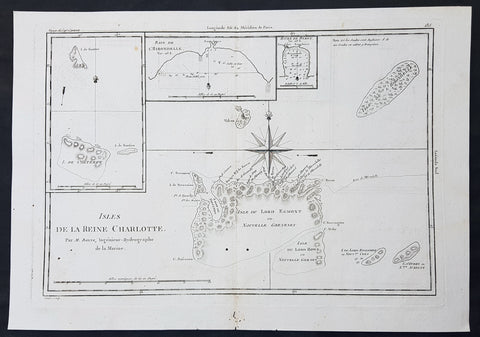
1780 Bonne Original Antique Map of Santa Cruz Isles, Solomon Islands Sth Pacific Lord Howe, Nendo
- Title : Isles De La Reine Charlotte
- Size: 16in x 11in (405mm x 2805mm)
- Ref #: 40580
- Date : 1780
- Condition: (A) Very Good Condition
Description:
This fine original copper-plate engraved antique map of Santa Cruz Island, of the Temotu Province in the Solomon Islands, Nendo Island & Lord Howe Island was published in 1780 edition of Atlas des toutes les parties connues du globe terrestre by Rigobert Bonne & Guillaume Raynal.
General Definitions:
Paper thickness and quality: - Heavy and stable
Paper color : - off white
Age of map color: -
Colors used: -
General color appearance: -
Paper size: - 16in x 11in (405mm x 2805mm)
Plate size: - 14in x 10in (355mm x 255mm)
Margins: - Min 1/2in (12mm)
Imperfections:
Margins: - Small worm holes in bottom margin
Plate area: - Two small worm holes adjacent to bottom centerfold
Verso: - None
Background:
Map of four island with compass rose. Santa Cruz Island, of Santa Cruz Island, of the Temotu Province in the Solomon Islands, based on Cook\'s discoveries, was named after Queen Charlotte, wife of King George III.
The Isle du Lord Edgemont (present day Nendo Island) and Isle du Lord Howe islands have been only partially engraved to show the explored portions.
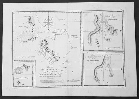
1780 Bonne Original Antique Map of Kerguelen, Desolation Island South Indian Ocean
- Title : Terre De Kerguelen, Appellee par M. Cook, Isle De La Desolation. Par M. Bonne; Plan Du Port Palliser dans la Terre De Kerguelen: Plan Du Havre De Noel dans la Terre De Kerguelen: Isles decouvertes par Mr. Marion Du Fresne en 1772, appellees par M.Cook en 1776, Isles Du Prince Edouard
- Size: 16in x 11in (405mm x 2805mm)
- Ref #: 40585
- Date : 1780
- Condition: (A) Very Good Condition
Description:
This fine original copper-plate engraved antique map of parts of the Kerguelen Islands, also known as the Desolation Islands, in the southern Indian Ocean, was published in 1780 edition of Atlas des toutes les parties connues du globe terrestre by Rigobert Bonne & Guillaume Raynal.
The map also includes three inset maps, the first two of Port Palliser & Noel Bay on Kerguelen Island, with the third inset map of the Prince Edward Islands - part of South Africa.
General Definitions:
Paper thickness and quality: - Heavy and stable
Paper color : - off white
Age of map color: -
Colors used: -
General color appearance: -
Paper size: - 16in x 11in (405mm x 2805mm)
Plate size: - 14in x 10in (355mm x 255mm)
Margins: - Min 1/2in (12mm)
Imperfections:
Margins: - None
Plate area: - Two small worm holes adjacent to bottom centerfold
Verso: - None
Background:
Kerguelen’s land was named for Yves de Kerguelen, a French navigator and explorer who sailed around the islands in 1772 along with Marion Du Fresne another French explorer who was in the vicinity in that same year. Capt. James Cook didn’t sight the islands until his 3rd voyage in 1776, having failed in his first attempts on earlier voyages. On Christmas Eve 1776, Cook’s ships the Resolution and the Discovery anchored in a Bay which he called Christmas Harbor, only staying long enough to replenish his water, and as the islands were so bleak and treeless, he called them Desolation Isles. Bonne’s chart was taken from original surveys by Kerguelen, Du Fresne and Capt. James Cook and was finely engraved by Gaspard Andre.
The Kerguelen Islands also known as the Desolation Islands, are a group of islands in the southern Indian Ocean constituting one of the two exposed parts of the mostly submerged Kerguelen Plateau. They are among the most isolated places on Earth, located 450 km (280 mi) northwest of the uninhabited Heard Island and McDonald Islands and more than 3,300 km (2,051 mi) from Madagascar, the nearest populated location (excluding the Alfred Faure scientific station in Ile de la Possession, about 1,340 km (830 mi) from there, and the non-permanent station located in Île Amsterdam, 1,440 km (890 mi) away). The islands, along with Adélie Land, the Crozet Islands, Amsterdam, and Saint Paul Islands, and France\'s Scattered Islands in the Indian Ocean are part of the French Southern and Antarctic Lands and are administered as a separate district.
Kerguelen Islands appear as the \"Ile de Nachtegal\" on Philippe Buache\'s map from 1754 before the island was officially discovered in 1772. The Buache map has the title Carte des Terres Australes comprises entre le Tropique du Capricorne et le Pôle Antarctique où se voyent les nouvelles découvertes faites en 1739 au Sud du Cap de Bonne Esperance (\'Map of the Southern Lands contained between the Tropic of Capricorn and the Antarctic Pole, where the new discoveries made in 1739 to the south of the Cape of Good Hope may be seen\'). It is possible this early name was after Abel Tasman\'s ship \"De Zeeuwsche Nachtegaal.\" On the Buache map, \"Ile de Nachtegal\" is located at 43°S, 72°E, about 6 degrees north and 2 degrees east of the accepted location of Grande Terre.
The islands were officially discovered by the French navigator Yves-Joseph de Kerguelen-Trémarec on 12 February 1772. The next day Charles de Boisguehenneuc landed and claimed the island for the French crown. Yves de Kerguelen organised a second expedition in 1773 and arrived at the \"baie de l\'Oiseau\" by December of the same year. On 6 January 1774 he commanded his lieutenant, Henri Pascal de Rochegude, to leave a message notifying any passers-by of the two passages and of the French claim to the islands. Thereafter, a number of expeditions briefly visited the islands, including that of Captain James Cook in December 1776 during his third voyage, who verified and confirmed the passage of de Kerguelen by discovering and annotating the message left by the French navigator.
Soon after their discovery, the archipelago was regularly visited by whalers and sealers (mostly British, American and Norwegian) who hunted the resident populations of whales and seals to the point of near extinction, including fur seals in the 18th century and elephant seals in the 19th century. Since the end of the whaling and sealing era, most of the islands\' species have been able to increase their population again.
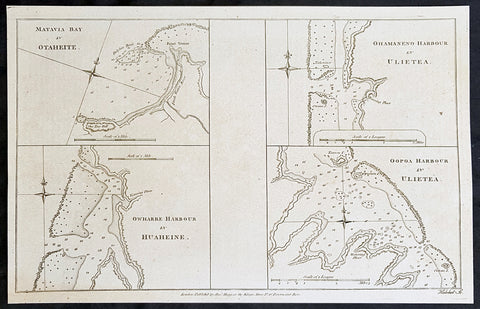
1784 Anderson Antique Map Capt Cook Exploration of the Society Islands in French Polynesia
- Title : Matavia Bay in Otaheite; Ohamaneno Harbour in Ulietea; Owharre Harbourin Huaheine; Oopoa Harbour in Ulietea
- Date : 1784
- Ref # : 16082
- Size : 13 1/2in x 9 1/2in (345mm x 240mm)
- Condition: (A+) Fine Condition
Description:
This fine original copper-plate engraved antique map with surveys and depth soundings of four bays and harbours, of various bays & harbours of the Society Islands, French Polynesia made by explorers during the 17th & 18th centuries.
The first map is Matavia Bay, on the island of Tahiti (Otaheite), the second is Fare (Owharre) Harbour on the island of Huahine & the last two are Ohamaneno & Oopoa (Fa aroa Bay) harbours on the island of Raiatea (Ulietea) was published in George Andersons 1784 edition of A Collection of voyages round the world : performed by royal authority : containing a complete historical account of Captain Cooks first, second, third and last voyages, undertaken for making new discoveries, &c. ... published by Alexander Hogg, London 1784.
General Definitions:
Paper thickness and quality: - Heavy and stable
Paper color : - off white
Age of map color: -
Colors used: -
General color appearance: -
Paper size: - 13 1/2in x 9 1/2in (345mm x 240mm)
Plate size: - 13 1/2in x 9 1/2in (345mm x 240mm)
Margins: - Min 1/2in (12mm)
Imperfections:
Margins: - None
Plate area: - None
Verso: - None
Background:
A description of the four Bays & Harbours and their relevance to Capt Cook and other South Seas explorers are;
1.Matavia Bay in Otaheite (Tahiti) - first European to visit Tahiti Capt. Samuel Wallis anchored in Matavai Bay in 1767 as did Louis-Antoine de Bougainville in 1768 & Capt James Cook landed in Matavai Bay in 1769 and returned in his next two voyages.
2. Owharre (Fare) Harbour in Huaheine (Huahine) Captain Cook arrived in fare Harbour on 16 July 1769, with Tupaia navigating the HMS Endeavour
3. Ohamaneno Harbour (Port) in Ulietea (Raiatea)
4. Oopoa (Fa aroa Bay) Harbour in Ulietea (Raiatea)
Raiatea - The first European to record sighting Raiātea was Pedro Fernandes de Queirós in 1606; it was charted as La Fugitiva. The Polynesian navigator, Tupaia, who sailed with explorer James Cook, was born in Raiātea around 1725.
Cook visited Raiatea in 1769 and again in 1773-1774. Omai (c.1751-1780), another young man from Raiātea, travelled with European explorers to London in 1774 and also served as an interpreter to Captain Cook on his second and third journey.
Tahiti.
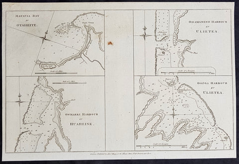
1784 Anderson Antique Map Capt Cook Exploration of the Society Islands in French Polynesia
- Title : Matavia Bay in Otaheite; Ohamaneno Harbour in Ulietea; Owharre Harbourin Huaheine; Oopoa Harbour in Ulietea
- Date : 1784
- Ref # : 32153
- Size : 13 1/2in x 9 1/2in (345mm x 240mm)
- Condition: (A+) Fine Condition
Description:
This fine original copper-plate engraved antique map with surveys and depth soundings of four bays and harbours, of various bays & harbours of the Society Islands, French Polynesia made by explorers during the 17th & 18th centuries.
The first map is Matavia Bay, on the island of Tahiti (Otaheite), the second is Fare (Owharre) Harbour on the island of Huahine & the last two are Ohamaneno & Oopoa (Fa aroa Bay) harbours on the island of Raiatea (Ulietea) was published in George Andersons 1784 edition of A Collection of voyages round the world : performed by royal authority : containing a complete historical account of Captain Cooks first, second, third and last voyages, undertaken for making new discoveries, &c. ... published by Alexander Hogg, London 1784.
General Definitions:
Paper thickness and quality: - Heavy and stable
Paper color : - off white
Age of map color: -
Colors used: -
General color appearance: -
Paper size: - 13 1/2in x 9 1/2in (345mm x 240mm)
Plate size: - 13 1/2in x 9 1/2in (345mm x 240mm)
Margins: - Min 1/2in (12mm)
Imperfections:
Margins: - None
Plate area: - None
Verso: - None
Background:
A description of the four Bays & Harbours and their relevance to Capt Cook and other South Seas explorers are;
1.Matavia Bay in Otaheite (Tahiti) - first European to visit Tahiti Capt. Samuel Wallis anchored in Matavai Bay in 1767 as did Louis-Antoine de Bougainville in 1768 & Capt James Cook landed in Matavai Bay in 1769 and returned in his next two voyages.
2. Owharre (Fare) Harbour in Huaheine (Huahine) Captain Cook arrived in fare Harbour on 16 July 1769, with Tupaia navigating the HMS Endeavour
3. Ohamaneno Harbour (Port) in Ulietea (Raiatea)
4. Oopoa (Fa aroa Bay) Harbour in Ulietea (Raiatea)
Raiatea - The first European to record sighting Raiātea was Pedro Fernandes de Queirós in 1606; it was charted as La Fugitiva. The Polynesian navigator, Tupaia, who sailed with explorer James Cook, was born in Raiātea around 1725.
Cook visited Raiatea in 1769 and again in 1773-1774. Omai (c.1751-1780), another young man from Raiātea, travelled with European explorers to London in 1774 and also served as an interpreter to Captain Cook on his second and third journey.
Tahiti.
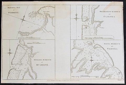
1784 Anderson Antique Map Capt Cook Exploration of the Society Islands in French Polynesia
- Title : Matavia Bay in Otaheite; Ohamaneno Harbour in Ulietea; Owharre Harbourin Huaheine; Oopoa Harbour in Ulietea
- Date : 1784
- Ref # : 32154
- Size : 13 1/2in x 9 1/2in (345mm x 240mm)
- Condition: (A+) Fine Condition
Description:
This fine original copper-plate engraved antique map with surveys and depth soundings of four bays and harbours, of various bays & harbours of the Society Islands, French Polynesia made by explorers during the 17th & 18th centuries.
The first map is Matavia Bay, on the island of Tahiti (Otaheite), the second is Fare (Owharre) Harbour on the island of Huahine & the last two are Ohamaneno & Oopoa (Fa aroa Bay) harbours on the island of Raiatea (Ulietea) was published in George Andersons 1784 edition of A Collection of voyages round the world : performed by royal authority : containing a complete historical account of Captain Cooks first, second, third and last voyages, undertaken for making new discoveries, &c. ... published by Alexander Hogg, London 1784.
General Definitions:
Paper thickness and quality: - Heavy and stable
Paper color : - off white
Age of map color: -
Colors used: -
General color appearance: -
Paper size: - 13 1/2in x 9 1/2in (345mm x 240mm)
Plate size: - 13 1/2in x 9 1/2in (345mm x 240mm)
Margins: - Min 1/2in (12mm)
Imperfections:
Margins: - None
Plate area: - None
Verso: - None
Background:
A description of the four Bays & Harbours and their relevance to Capt Cook and other South Seas explorers are;
1.Matavia Bay in Otaheite (Tahiti) - first European to visit Tahiti Capt. Samuel Wallis anchored in Matavai Bay in 1767 as did Louis-Antoine de Bougainville in 1768 & Capt James Cook landed in Matavai Bay in 1769 and returned in his next two voyages.
2. Owharre (Fare) Harbour in Huaheine (Huahine) Captain Cook arrived in fare Harbour on 16 July 1769, with Tupaia navigating the HMS Endeavour
3. Ohamaneno Harbour (Port) in Ulietea (Raiatea)
4. Oopoa (Fa aroa Bay) Harbour in Ulietea (Raiatea)
Raiatea - The first European to record sighting Raiātea was Pedro Fernandes de Queirós in 1606; it was charted as La Fugitiva. The Polynesian navigator, Tupaia, who sailed with explorer James Cook, was born in Raiātea around 1725.
Cook visited Raiatea in 1769 and again in 1773-1774. Omai (c.1751-1780), another young man from Raiātea, travelled with European explorers to London in 1774 and also served as an interpreter to Captain Cook on his second and third journey.
Tahiti.
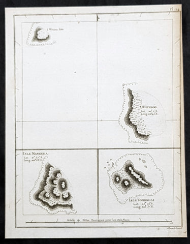
1785 Capt. Cook Antique Map 3 x Cook Islands & 1 x Society Island - Cook in 1777
- Title : I. Wenooa Ette; I. Wateeoo; Isle Mangeea; Isle Toobouai
- Size: 9 1/2in x 7 1/2in (245mm x 190mm)
- Ref #: 32164
- Date : 1785
- Condition: (A+) Fine Condition
Description:
This fine original copper-plate engraved antique map of three of the Cook Islands, Takutea (Wanooaette) Atiu (Wateeoo) and Mangaia (Mangeea) and a 4th map of the Island of Tubuai (Toobouai) in French Polynesia near Tahiti, visited by Captain Cook in HMS Resolution & Discovery in September 1777, during his 3rd & last Voyage of Discovery, was engraved by Robert Benard - after Thomas Bowen - and was published in the 1785 French edition of Capt. James Cook & Capt. James King publication A Voyage to the Pacific Ocean. Undertaken, by the Command of his Majesty, for making Discoveries in the Northern Hemisphere. To determine The Position and Extent of the West Side of North America; its Distance from Asia; and the Practicability of a Northen Passage to Europe. Performed under the direction of Captains Cook, Clerke, and Gore, In His Majesty\\\'s Ships the Resolution and Discovery. In the Years 1776, 1777, 1778, 1779, and 1780. In Three Volumes. Vol. I and II written by James Cook, F.R.S. Vol. III by Captain James King, LL.D. and F.R.S. Paris, 1785.
General Definitions:
Paper thickness and quality: - Heavy and stable
Paper color : - off white
Age of map color: -
Colors used: -
General color appearance: -
Paper size: - 9 1/2in x 7 1/2in (245mm x 190mm)
Plate size: - 9 1/2in x 7 1/2in (245mm x 190mm)
Margins: - Min 1/2in (12mm)
Imperfections:
Margins: - Bottom margin cropped into title
Plate area: - None
Verso: - None
Background:
The Cook Islands is a self-governing island country in the South Pacific Ocean in free association with New Zealand. It comprises 15 islands whose total land area is 240 square kilometres.
Spanish ships visited the islands in the 16th century; the first written record of contact with the islands came in 1595 with the sighting of Pukapuka by Spanish sailor Álvaro de Mendaña de Neira, who called it San Bernardo (Saint Bernard). Pedro Fernandes de Queirós, a Portuguese captain working for the Spanish crown, made the first recorded European landing in the islands when he set foot on Rakahanga in 1606, calling it Gente Hermosa.
British navigator Captain James Cook arrived in 1773 and 1777 and named the island of Manuae Hervey Island. Later, the name Hervey Islands came to be applied to the entire southern group; the name Cook Islands, in honour of Cook, first appeared on a Russian naval chart published in the 1820s
Takutea, in the Cook Islands, is a small uninhabited island 21 kilometres northwest of Atiu in the southern Cook Islands.
Takutea is the only island in the Cook Islands that never had a permanent population. When Captain James Cook sighted the island on 4 April 1777, and some crew members went ashore, they found some huts, but no evidence of a permanent settlement.
Atiu, also known as Enuamanu (meaning land of the birds), is an island 187 km northeast of Rarotonga, in the Southern Islands group of the Cook Islands Archipelago.
The first recorded European to arrive at Atiu was Captain Cook. He sighted the island on March 31, 1777 and made tentative contact with some of the people over the next few days.
Mangaia (traditionally known as A ua u Enua, which means terraced) is the most southerly of the Cook Islands and the second largest, after Rarotonga.
The first recorded European to arrive at Mangaia was Captain James Cook on 29 March 1777.
Tubuai part of the Society Islands is located 640 km south of Tahiti. Tubuai was first viewed by Europeans when it was mapped by Captain James Cook in 1777, although his party did not disembark. Cook discovered the islands name, Toobouai, from the natives who surrounded his ship in their canoes (a Tahitian named Omai, who was part of Cooks group, translated)
The next Europeans to arrive were the mutineers of the HMS Bounty in 1789. Mutineer Fletcher Christian, in looking for an island on which to permanently hide, had scoured Blighs maps and nautical charts and decided on Tubuai.
Upon arrival at Tubuai, a conflict arose while the mutineers were still on their ship and several islanders were killed in their canoes. The site of this event in the lagoon on the north side of the island is called Baie Sanglant (Bloody Bay)
Captain James King FRS 1750 – 1784 was an officer of the Royal Navy. He served under James Cook on his last voyage around the world, specialising in taking important astronomical readings using a sextant. After Cook died he helped lead the ships on the remainder of their course, also completing Cooks account of the voyage. He continued his career in the Navy, reaching the rank of post-captain, commanding several ships and serving in the American War of Independence.
King joined HMS Resolution as second lieutenant, sharing the duties of astronomer with Cook, taking astronomical observations on board by sextant and with Larcum Kendals timekeeper K1, to establish the Resolutions position at sea and on shore by sextant or by astronomical quadrant to establish the geographical position of salient points during the course of Cooks surveys. Thus Kings geographical positions were an important contribution to the accuracy of the various surveys carried out during the voyage and his use of the early chronometers helped prove their use at sea for calculation of Longitude. .
Following the death of Cook, King remained in the Resolution but on the death of Charles Clerke, Cooks successor, King was appointed to command HMS Discovery, the Resolutions consort, remaining in her for the rest of the voyage. After his return to England King was very much involved in the publication of the official account of Cooks third voyage, writing the third volume at Woodstock, near Oxford, where his brother Thomas was rector of St Mary Magdalene. But shortly after his return King was promoted Post-captain and appointed commander of HMS Crocodile in the English Channel.
John Webber RA 1751 – 1793 was an English artist who accompanied Captain Cook on his third Pacific expedition. He is best known for his images of Australasia, Hawaii and Alaska.
Webber was born in London, educated in Bern and studied painting at Paris.His father was Abraham Wäber, a Swiss sculptor who had moved to London, and changed his name to Webber before marrying a Mrs Mary Quant in 1744.
Webber served as official artist on James Cooks third voyage of discovery around the Pacific (1776–80) aboard HMS Resolution. At Adventure Bay in January 1777 he did drawings of A Man of Van Diemens Land and A Woman of Van Diemens Land. He also did many drawings of scenes in New Zealand and the South Sea islands. On this voyage, during which Cook lost his life in a fight in Hawaii, Webber became the first European artist to make contact with Hawaii, then called the Sandwich Islands. He made numerous watercolor landscapes of the islands of Kauai and Hawaii, and also portrayed many of the Hawaiian people.
In April 1778, Captain Cooks ships Resolution and Discovery anchored at Ship Cove, now known as Nootka Sound, Vancouver Island, Canada to refit. The crew took observations and recorded encounters with the local people. Webber made watercolour landscapes including Resolution and Discovery in Ship Cove, 1778. His drawings and paintings were engraved for British Admiraltys account of the expedition, which was published in 1784.
Back in England in 1780 Webber exhibited around 50 works at Royal Academy exhibitions between 1784 and 1792, and was elected an associate of the Royal Academy in 1785 and R.A. in 1791. Most of his work were landscapes. Sometimes figures were included as in A Party from H.M.S. Resolution shooting sea horses, which was shown at the academy in 1784, and his The Death of Captain Cook became well known through an engraving of it. Another version of this picture is in the William Dixson gallery at Sydney
Thomas Bowen (1767-1790) was an engraver and son of Emanuel Bowen, map and print seller, engraver to George II and to Louis XV of France who worked in London from 1714 producing some the best and most attractive maps of the 18th century. He had plans for completing a major County Atlas but, finding the task beyond his means, joined with Thomas Kitchin to publish “The Large English Atlas”. Many of the maps were issued individually from 1749 onwards and the whole atlas was not finally completed until 1760. With one or two exceptions they were the largest maps of the counties to appear up to that time (27” x 20”) and were unusual in that blank areas around each map are filled with historical and topographical detail which makes fascinating and amusing reading. The atlas was reissued later in reduced size. Apart from his county maps and atlases of different parts of the world he also issued (with John Owen) a book of road maps based, as was usual at that time, on Ogilby but again incorporating his own style of historical and heraldic detail. Thomas helped his father during his lifetime and produced many fine maps in his own right after his fathers death.
Robert Bénard 1734 – 1777 was an 18th-century French engraver.
Specialized in the technique of engraving, Robert Ménard is mainly famous for having supplied a significant amount of plates (at least 1,800) to the Encyclopédie by Diderot & d Alembert from 1751.
Later, publisher Charles-Joseph Panckoucke reused many of his productions to illustrate the works of his catalog.
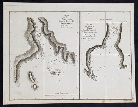
1785 Capt. Cook Antique Map of Kerguelen Island, South Indian Ocean Cook in 1776
- Title : Plan du Port Palliser dans la Terre de Kerguelen; Plan du du Havre de Noel dans la Terre de Kerguelen....1777
- Size: 9 1/2in x 7 1/2in (245mm x 190mm)
- Ref #: 32194
- Date : 1785
- Condition: (A+) Fine Condition
Description:
This fine original copper-plate engraved antique map of two maps on one sheet, the first of Port Palliser on the Island of Kerguelen and the second of Christmas Bay also located on the Island of Kerguelen in the very Southern Indian Ocean - midway between Africa, Antarctica and Australia - visited by Captain Cook in HMS Resolution & Discovery in December 25-30th 1776, during his 3rd & last Voyage of Discovery, was engraved by Robert Benard - after Thomas Bowen - and was published in the 1785 French edition of Capt. James Cook & Capt. James King publication A Voyage to the Pacific Ocean. Undertaken, by the Command of his Majesty, for making Discoveries in the Northern Hemisphere. To determine The Position and Extent of the West Side of North America; its Distance from Asia; and the Practicability of a Northen Passage to Europe. Performed under the direction of Captains Cook, Clerke, and Gore, In His Majesty\\\'s Ships the Resolution and Discovery. In the Years 1776, 1777, 1778, 1779, and 1780. In Three Volumes. Vol. I and II written by James Cook, F.R.S. Vol. III by Captain James King, LL.D. and F.R.S. Paris, 1785.
General Definitions:
Paper thickness and quality: - Heavy and stable
Paper color : - off white
Age of map color: -
Colors used: -
General color appearance: -
Paper size: - 9 1/2in x 7 1/2in (245mm x 190mm)
Plate size: - 9 1/2in x 7 1/2in (245mm x 190mm)
Margins: - Min 1/2in (12mm)
Imperfections:
Margins: - None
Plate area: - None
Verso: - None
Background:
The Kerguelen Islands, sometimes called the Desolation Islands, are located in the southern Indian Ocean and were discovered by the French navigator Yves de Kerguelen-Trémarec in 1772. On Christmas Day, 1776 Cooks ships Resolution and Discovery anchored in Oiseau Bay, which he named Christmas Harbour. Cooks men discovered a bottle containing a message in Latin left by Kerguelens men. Cook wrote in his log: I could have very properly called the island Desolation Island to signalise its sterility, but in order not to deprive M. de Kerguelen of the glory of having discovered it, I have called it Kerguelen Land.
The Kerguelen Islands or the Kerguelen Archipelago are located in the southern Indian Ocean. The main island, Grande Terre, is 6,675 km² and it is surrounded by another 300 smaller islands and islets, forming an archipelago of 7,215 km². The climate is cold and very windy and the seas are usually rough. The islands are part of a submarine large igneous province called the Kerguelen Plateau.
Captain James King FRS 1750 – 1784 was an officer of the Royal Navy. He served under James Cook on his last voyage around the world, specialising in taking important astronomical readings using a sextant. After Cook died he helped lead the ships on the remainder of their course, also completing Cooks account of the voyage. He continued his career in the Navy, reaching the rank of post-captain, commanding several ships and serving in the American War of Independence.
King joined HMS Resolution as second lieutenant, sharing the duties of astronomer with Cook, taking astronomical observations on board by sextant and with Larcum Kendals timekeeper K1, to establish the Resolutions position at sea and on shore by sextant or by astronomical quadrant to establish the geographical position of salient points during the course of Cooks surveys. Thus Kings geographical positions were an important contribution to the accuracy of the various surveys carried out during the voyage and his use of the early chronometers helped prove their use at sea for calculation of Longitude. .
Following the death of Cook, King remained in the Resolution but on the death of Charles Clerke, Cooks successor, King was appointed to command HMS Discovery, the Resolutions consort, remaining in her for the rest of the voyage. After his return to England King was very much involved in the publication of the official account of Cooks third voyage, writing the third volume at Woodstock, near Oxford, where his brother Thomas was rector of St Mary Magdalene. But shortly after his return King was promoted Post-captain and appointed commander of HMS Crocodile in the English Channel.
John Webber RA 1751 – 1793 was an English artist who accompanied Captain Cook on his third Pacific expedition. He is best known for his images of Australasia, Hawaii and Alaska.
Webber was born in London, educated in Bern and studied painting at Paris.His father was Abraham Wäber, a Swiss sculptor who had moved to London, and changed his name to Webber before marrying a Mrs Mary Quant in 1744.
Webber served as official artist on James Cooks third voyage of discovery around the Pacific (1776–80) aboard HMS Resolution. At Adventure Bay in January 1777 he did drawings of A Man of Van Diemens Land and A Woman of Van Diemens Land. He also did many drawings of scenes in New Zealand and the South Sea islands. On this voyage, during which Cook lost his life in a fight in Hawaii, Webber became the first European artist to make contact with Hawaii, then called the Sandwich Islands. He made numerous watercolor landscapes of the islands of Kauai and Hawaii, and also portrayed many of the Hawaiian people.
In April 1778, Captain Cooks ships Resolution and Discovery anchored at Ship Cove, now known as Nootka Sound, Vancouver Island, Canada to refit. The crew took observations and recorded encounters with the local people. Webber made watercolour landscapes including Resolution and Discovery in Ship Cove, 1778. His drawings and paintings were engraved for British Admiraltys account of the expedition, which was published in 1784.
Back in England in 1780 Webber exhibited around 50 works at Royal Academy exhibitions between 1784 and 1792, and was elected an associate of the Royal Academy in 1785 and R.A. in 1791. Most of his work were landscapes. Sometimes figures were included as in A Party from H.M.S. Resolution shooting sea horses, which was shown at the academy in 1784, and his The Death of Captain Cook became well known through an engraving of it. Another version of this picture is in the William Dixson gallery at Sydney
Thomas Bowen (1767-1790) was an engraver and son of Emanuel Bowen, map and print seller, engraver to George II and to Louis XV of France who worked in London from 1714 producing some the best and most attractive maps of the 18th century. He had plans for completing a major County Atlas but, finding the task beyond his means, joined with Thomas Kitchin to publish “The Large English Atlas”. Many of the maps were issued individually from 1749 onwards and the whole atlas was not finally completed until 1760. With one or two exceptions they were the largest maps of the counties to appear up to that time (27” x 20”) and were unusual in that blank areas around each map are filled with historical and topographical detail which makes fascinating and amusing reading. The atlas was reissued later in reduced size. Apart from his county maps and atlases of different parts of the world he also issued (with John Owen) a book of road maps based, as was usual at that time, on Ogilby but again incorporating his own style of historical and heraldic detail. Thomas helped his father during his lifetime and produced many fine maps in his own right after his fathers death.
Robert Bénard 1734 – 1777 was an 18th-century French engraver.
Specialized in the technique of engraving, Robert Ménard is mainly famous for having supplied a significant amount of plates (at least 1,800) to the Encyclopédie by Diderot & d Alembert from 1751.
Later, publisher Charles-Joseph Panckoucke reused many of his productions to illustrate the works of his catalog.
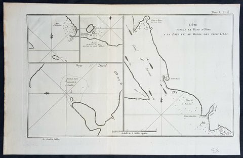
1774 Hawkesworth Antique Map of Magellan Straits, Bachelor River, Punta Arenas, Chile, Byron 1766
- Title : Baye d Elizabeth; Baye au dessons des Isles vis a vis la Rade d York; Côte depuis la Baye d York a la Baye et au Havre des Trois Isles; Baye St. David
- Size: 15 1/2in x 10in (395mm x 255mm)
- Ref #: 16027
- Date : 1774
- Condition: (A+) Fine Condition
Description:
This fine original copper-plate engraved antique map, four maps on the one sheet, of;
1. Elizabeth Bay.
2. York Bay.
3. York Bay-Three Island Bay
4.St. Davids Bay.
all located north of Carlos III island, on Punta Arenas in the Chilean Arctic - from Bachelor River north to York Bay - in the Straits of Magellan, Chile. This chart was compiled by Commodore John Byron, who visited the region in HMS Dolphin on his circumnavigation of the globe, between 1764-66, and was published in the 1774 French edition of John Hawkesworths An Account of the Voyages Undertaken by the Order of His Present Majesty for Making Discoveries in the Southern Hemisphere and Successively Performed by Commodore Byron, Captain Wallis, Captain Carteret, and Captain Cook, in the Dolphin, the Swallow, and the Endeavor, Drawn Up from the Journals Which Were Kept by the Several Commanders, and from the Papers of Joseph Banks, Esq. Paris 1774
General Definitions:
Paper thickness and quality: - Heavy and stable
Paper color : - off white
Age of map color: -
Colors used: -
General color appearance: -
Paper size: - 15 1/2in x 10in (395mm x 255mm)
Plate size: - 14in x 10in (360mm x 255mm)
Margins: - Min 1/2in (12mm)
Imperfections:
Margins: - None
Plate area: - None
Verso: - None
Background:
The Strait of Magellan
(Estrecho de Magallanes) is a navigable sea route separating mainland South America to the north and Tierra del Fuego to the south. The strait is the most important natural passage between the Atlantic and Pacific oceans.
Ferdinand Magellan a Portuguese explorer and navigator in the service of Charles I of Spain, became the first European to navigate the strait in 1520 during his circumnavigation of the globe.
Other early explorers included Francis Drake (1578). In February 1696 the first French expedition, under the command of M. de Gennes reached the Strait of Magellan. The expedition is described by the young French explorer, engineer and hydrographer François Froger in his A Relation of a Voyage (1699).
The strait was first carefully explored and thoroughly charted by Phillip Parker King, who commanded the British survey vessel HMS Adventure, and in consort with HMS Beagle spent five years surveying the complex coasts around the strait (1826–1830). A report on the survey was presented at two meetings of the Geographical Society of London in 1831.
Vice-Admiral The Hon. John Byron was a British Royal Navy officer and politician. He was known as Foul-weather Jack because of his frequent encounters with bad weather at sea. As a midshipman, he sailed in the squadron under George Anson on his voyage around the world, though Byron made it to southern Chile, and returned to England with the captain of HMS Wager. He was governor of Newfoundland following Hugh Palliser, who left in 1768. He circumnavigated the world as a commodore with his own squadron in 1764-1766. He fought in battles in The Seven Years War and the American Revolution. He rose to Vice Admiral of the White before his death in 1786.
In early 1764 the British Admiralty determined that it would require a permanent naval settlement off the South American coast, in order to resupply naval vessels seeking to enter the Pacific via Cape Horn. Captain Byron was selected to explore the South Atlantic for a suitable island upon which to establish such a settlement. The South American mainland was controlled by Spain, which was hostile to local expansion of British interests; to disguise Byrons mission it was announced that he had been appointed the new commander of the Navys East Indies Station. Byron set sail in June 1764, ostensibly to take up the East Indies post. For the voyage he was granted command of the 24-gun frigate HMS Dolphin and the 20-gun sloop HMS Tamar.
Byron\'s two-vessel flotilla crossed the Atlantic over the winter of 1764 and made its way slowly down the South American coast. The Admiralty had ordered Byron to first seek Pepys Island, reputedly discovered off the Patagonian coast by the corsair Ambrose Cowley in 1683. Byron reached the co-ordinates given by Cowley in January 1765, but there was no sign of the island and the search was swiftly abandoned. On 5 February Byron reached the Patagonian settlement of Port Desire where he resupplied his vessels from the storeship HMS Florida.
Between June 1764 and May 1766, Byron completed his own circumnavigation of the globe as captain of HMS Dolphin. This was the first such circumnavigation that was accomplished in less than 2 years. His actions nearly caused a war between Great Britain and Spain, as both countries had armed fleets ready to contest the sovereignty of the Falkland Islands. Later Byron encountered islands and extant residents of the Tuamotus and Tokelau Islands, and Nikunau in the southern Gilbert Islands; he also visited Tinian in the Northern Marianas Islands.
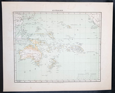
1854 Handtke & Flemming Antique Map of Australia, New Zealand, Pacific
- Title : Australien
- Date : 1854
- Condition: (A+) Fine Condition
- Ref: 32163
- Size: 17in x 14in (430mm x 355mm)
Description:
This hand coloured original steel-plate engraved antique highly detailed map of Australia, New Zealand, & The Pacific by Friedrich Handtke in 1854, was published in the Complete hand atlas of the recent description of the earth over all parts of the earth, Carl Flemming, Glougau.
General Definitions:
Paper thickness and quality: - Heavy and stable
Paper color : - off white
Age of map color: - Original
Colors used: - Yellow, red
General color appearance: - Authentic
Paper size: - 16in x 14in (405mm x 355mm)
Plate size: - 16in x 14in (405mm x 355mm)
Margins: - Min 1/2in (12mm)
Imperfections:
Margins: - Light spotting
Plate area: - Light spotting
Verso: - Light spotting
Background:
Australia is a sovereign country comprising the mainland of the Australian continent, the island of Tasmania and numerous smaller islands. It is the largest country in Oceania and the world\'s sixth-largest country by total area. The neighbouring countries are Papua New Guinea, Indonesia and East Timor to the north; the Solomon Islands and Vanuatu to the north-east; and New Zealand to the south-east. The population of 25 million is highly urbanised and heavily concentrated on the eastern seaboard. Australias capital is Canberra, and its largest city is Sydney. The country\'s other major metropolitan areas are Melbourne, Brisbane, Perth and Adelaide.
Australia was inhabited by indigenous Australians for about 60,000 years before the first British settlement in the late 18th century. It is documented that Aborigines spoke languages that can be classified into about 250 groups. After the European discovery of the continent by Dutch explorers in 1606, who named it New Holland, Australia\'s eastern half was claimed by Great Britain in 1770 and initially settled through penal transportation to the colony of New South Wales from 26 January 1788, a date which became Australia\'s national day. The population grew steadily in subsequent decades, and by the 1850s most of the continent had been explored and an additional five self-governing crown colonies established. On 1 January 1901, the six colonies federated, forming the Commonwealth of Australia. Australia has since maintained a stable liberal democratic political system that functions as a federal parliamentary constitutional monarchy comprising six states and ten territories.
Being the oldest, flattest and driest inhabited continent, with the least fertile soils, Australia has a landmass of 7,617,930 square kilometres. A megadiverse country, its size gives it a wide variety of landscapes, with deserts in the centre, tropical rainforests in the north-east and mountain ranges in the south-east. A gold rush began in Australia in the early 1850s, which boosted the population of the country. Nevertheless, its population density, 2.8 inhabitants per square kilometre, remains among the lowest in the world. Australia generates its income from various sources including mining-related exports, telecommunications, banking and manufacturing. Indigenous Australian rock art is the oldest and richest in the world, dating as far back as 60,000 years and spread across hundreds of thousands of sites.
The first recorded European sighting of the Australian mainland, and the first recorded European landfall on the Australian continent (in 1606), are attributed to the Dutch. The first ship and crew to chart the Australian coast and meet with Aboriginal people was the Duyfken captained by Dutch navigator, Willem Janszoon. He sighted the coast of Cape York Peninsula in early 1606, and made landfall on 26 February at the Pennefather River near the modern town of Weipa on Cape York. The Dutch charted the whole of the western and northern coastlines and named the island continent New Holland during the 17th century, but made no attempt at settlement. William Dampier, an English explorer and privateer, landed on the north-west coast of New Holland in 1688 and again in 1699 on a return trip. In 1770, James Cook sailed along and mapped the east coast, which he named New South Wales and claimed for Great Britain.
With the loss of its American colonies in 1783, the British Government sent a fleet of ships, the First Fleet, under the command of Captain Arthur Phillip, to establish a new penal colony in New South Wales. A camp was set up and the flag raised at Sydney Cove, Port Jackson, on 26 January 1788, a date which became Australia\'s national day, Australia Day. A British settlement was established in Van Diemens Land, now known as Tasmania, in 1803, and it became a separate colony in 1825. The United Kingdom formally claimed the western part of Western Australia (the Swan River Colony) in 1828. Separate colonies were carved from parts of New South Wales: South Australia in 1836, Victoria in 1851, and Queensland in 1859. The Northern Territory was founded in 1911 when it was excised from South Australia. South Australia was founded as a free province—it was never a penal colony. Victoria and Western Australia were also founded free, but later accepted transported convicts. A campaign by the settlers of New South Wales led to the end of convict transportation to that colony; the last convict ship arrived in 1848.
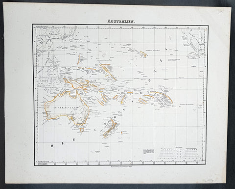
1854 Handtke & Flemming Antique Map of Australia, New Zealand, Pacific
- Title : Australien
- Date : 1854
- Condition: (A+) Fine Condition
- Ref: 31975
- Size: 17in x 14in (430mm x 355mm)
Description:
This hand coloured original steel-plate engraved antique highly detailed map of Australia, New Zealand, & The Pacific by Friedrich Handtke in 1854, was published in the Complete hand atlas of the recent description of the earth over all parts of the earth, Carl Flemming, Glougau.
General Definitions:
Paper thickness and quality: - Heavy and stable
Paper color : - off white
Age of map color: - Original
Colors used: - Yellow, red
General color appearance: - Authentic
Paper size: - 16in x 14in (405mm x 355mm)
Plate size: - 16in x 14in (405mm x 355mm)
Margins: - Min 1/2in (12mm)
Imperfections:
Margins: - Light spotting
Plate area: - Light spotting
Verso: - Light spotting
Background:
Australia is a sovereign country comprising the mainland of the Australian continent, the island of Tasmania and numerous smaller islands. It is the largest country in Oceania and the world\'s sixth-largest country by total area. The neighbouring countries are Papua New Guinea, Indonesia and East Timor to the north; the Solomon Islands and Vanuatu to the north-east; and New Zealand to the south-east. The population of 25 million is highly urbanised and heavily concentrated on the eastern seaboard. Australias capital is Canberra, and its largest city is Sydney. The country\'s other major metropolitan areas are Melbourne, Brisbane, Perth and Adelaide.
Australia was inhabited by indigenous Australians for about 60,000 years before the first British settlement in the late 18th century. It is documented that Aborigines spoke languages that can be classified into about 250 groups. After the European discovery of the continent by Dutch explorers in 1606, who named it New Holland, Australia\'s eastern half was claimed by Great Britain in 1770 and initially settled through penal transportation to the colony of New South Wales from 26 January 1788, a date which became Australia\'s national day. The population grew steadily in subsequent decades, and by the 1850s most of the continent had been explored and an additional five self-governing crown colonies established. On 1 January 1901, the six colonies federated, forming the Commonwealth of Australia. Australia has since maintained a stable liberal democratic political system that functions as a federal parliamentary constitutional monarchy comprising six states and ten territories.
Being the oldest, flattest and driest inhabited continent, with the least fertile soils, Australia has a landmass of 7,617,930 square kilometres. A megadiverse country, its size gives it a wide variety of landscapes, with deserts in the centre, tropical rainforests in the north-east and mountain ranges in the south-east. A gold rush began in Australia in the early 1850s, which boosted the population of the country. Nevertheless, its population density, 2.8 inhabitants per square kilometre, remains among the lowest in the world. Australia generates its income from various sources including mining-related exports, telecommunications, banking and manufacturing. Indigenous Australian rock art is the oldest and richest in the world, dating as far back as 60,000 years and spread across hundreds of thousands of sites.
The first recorded European sighting of the Australian mainland, and the first recorded European landfall on the Australian continent (in 1606), are attributed to the Dutch. The first ship and crew to chart the Australian coast and meet with Aboriginal people was the Duyfken captained by Dutch navigator, Willem Janszoon. He sighted the coast of Cape York Peninsula in early 1606, and made landfall on 26 February at the Pennefather River near the modern town of Weipa on Cape York. The Dutch charted the whole of the western and northern coastlines and named the island continent New Holland during the 17th century, but made no attempt at settlement. William Dampier, an English explorer and privateer, landed on the north-west coast of New Holland in 1688 and again in 1699 on a return trip. In 1770, James Cook sailed along and mapped the east coast, which he named New South Wales and claimed for Great Britain.
With the loss of its American colonies in 1783, the British Government sent a fleet of ships, the First Fleet, under the command of Captain Arthur Phillip, to establish a new penal colony in New South Wales. A camp was set up and the flag raised at Sydney Cove, Port Jackson, on 26 January 1788, a date which became Australia\'s national day, Australia Day. A British settlement was established in Van Diemens Land, now known as Tasmania, in 1803, and it became a separate colony in 1825. The United Kingdom formally claimed the western part of Western Australia (the Swan River Colony) in 1828. Separate colonies were carved from parts of New South Wales: South Australia in 1836, Victoria in 1851, and Queensland in 1859. The Northern Territory was founded in 1911 when it was excised from South Australia. South Australia was founded as a free province—it was never a penal colony. Victoria and Western Australia were also founded free, but later accepted transported convicts. A campaign by the settlers of New South Wales led to the end of convict transportation to that colony; the last convict ship arrived in 1848.
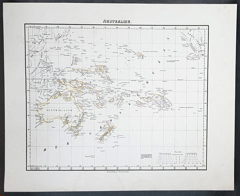
1854 Handtke & Flemming Antique Map of Australia, New Zealand, Pacific
- Title : Australien
- Date : 1854
- Condition: (A+) Fine Condition
- Ref: 31988
- Size: 17in x 14in (430mm x 355mm)
Description:
This hand coloured original steel-plate engraved antique highly detailed map of Australia, New Zealand, & The Pacific by Friedrich Handtke in 1854, was published in the Complete hand atlas of the recent description of the earth over all parts of the earth, Carl Flemming, Glougau.
General Definitions:
Paper thickness and quality: - Heavy and stable
Paper color : - off white
Age of map color: - Original
Colors used: - Yellow, red
General color appearance: - Authentic
Paper size: - 16in x 14in (405mm x 355mm)
Plate size: - 16in x 14in (405mm x 355mm)
Margins: - Min 1/2in (12mm)
Imperfections:
Margins: - Light spotting
Plate area: - Light spotting
Verso: - Light spotting
Background:
Australia is a sovereign country comprising the mainland of the Australian continent, the island of Tasmania and numerous smaller islands. It is the largest country in Oceania and the world\'s sixth-largest country by total area. The neighbouring countries are Papua New Guinea, Indonesia and East Timor to the north; the Solomon Islands and Vanuatu to the north-east; and New Zealand to the south-east. The population of 25 million is highly urbanised and heavily concentrated on the eastern seaboard. Australias capital is Canberra, and its largest city is Sydney. The country\'s other major metropolitan areas are Melbourne, Brisbane, Perth and Adelaide.
Australia was inhabited by indigenous Australians for about 60,000 years before the first British settlement in the late 18th century. It is documented that Aborigines spoke languages that can be classified into about 250 groups. After the European discovery of the continent by Dutch explorers in 1606, who named it New Holland, Australia\'s eastern half was claimed by Great Britain in 1770 and initially settled through penal transportation to the colony of New South Wales from 26 January 1788, a date which became Australia\'s national day. The population grew steadily in subsequent decades, and by the 1850s most of the continent had been explored and an additional five self-governing crown colonies established. On 1 January 1901, the six colonies federated, forming the Commonwealth of Australia. Australia has since maintained a stable liberal democratic political system that functions as a federal parliamentary constitutional monarchy comprising six states and ten territories.
Being the oldest, flattest and driest inhabited continent, with the least fertile soils, Australia has a landmass of 7,617,930 square kilometres. A megadiverse country, its size gives it a wide variety of landscapes, with deserts in the centre, tropical rainforests in the north-east and mountain ranges in the south-east. A gold rush began in Australia in the early 1850s, which boosted the population of the country. Nevertheless, its population density, 2.8 inhabitants per square kilometre, remains among the lowest in the world. Australia generates its income from various sources including mining-related exports, telecommunications, banking and manufacturing. Indigenous Australian rock art is the oldest and richest in the world, dating as far back as 60,000 years and spread across hundreds of thousands of sites.
The first recorded European sighting of the Australian mainland, and the first recorded European landfall on the Australian continent (in 1606), are attributed to the Dutch. The first ship and crew to chart the Australian coast and meet with Aboriginal people was the Duyfken captained by Dutch navigator, Willem Janszoon. He sighted the coast of Cape York Peninsula in early 1606, and made landfall on 26 February at the Pennefather River near the modern town of Weipa on Cape York. The Dutch charted the whole of the western and northern coastlines and named the island continent New Holland during the 17th century, but made no attempt at settlement. William Dampier, an English explorer and privateer, landed on the north-west coast of New Holland in 1688 and again in 1699 on a return trip. In 1770, James Cook sailed along and mapped the east coast, which he named New South Wales and claimed for Great Britain.
With the loss of its American colonies in 1783, the British Government sent a fleet of ships, the First Fleet, under the command of Captain Arthur Phillip, to establish a new penal colony in New South Wales. A camp was set up and the flag raised at Sydney Cove, Port Jackson, on 26 January 1788, a date which became Australia\'s national day, Australia Day. A British settlement was established in Van Diemens Land, now known as Tasmania, in 1803, and it became a separate colony in 1825. The United Kingdom formally claimed the western part of Western Australia (the Swan River Colony) in 1828. Separate colonies were carved from parts of New South Wales: South Australia in 1836, Victoria in 1851, and Queensland in 1859. The Northern Territory was founded in 1911 when it was excised from South Australia. South Australia was founded as a free province—it was never a penal colony. Victoria and Western Australia were also founded free, but later accepted transported convicts. A campaign by the settlers of New South Wales led to the end of convict transportation to that colony; the last convict ship arrived in 1848.
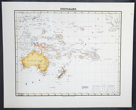
1854 Handtke & Flemming Antique Map of Australia, New Zealand, Pacific
- Title : Australien
- Date : 1854
- Condition: (A+) Fine Condition
- Ref: 40973
- Size: 17in x 14in (430mm x 355mm)
Description:
This hand coloured original steel-plate engraved antique highly detailed map of Australia, New Zealand, & The Pacific by Friedrich Handtke in 1854, was published in the Complete hand atlas of the recent description of the earth over all parts of the earth, Carl Flemming, Glougau.
General Definitions:
Paper thickness and quality: - Heavy and stable
Paper color : - off white
Age of map color: - Original
Colors used: - Yellow, red
General color appearance: - Authentic
Paper size: - 16in x 14in (405mm x 355mm)
Plate size: - 16in x 14in (405mm x 355mm)
Margins: - Min 1/2in (12mm)
Imperfections:
Margins: - Light spotting
Plate area: - Light spotting
Verso: - Light spotting
Background:
Australia is a sovereign country comprising the mainland of the Australian continent, the island of Tasmania and numerous smaller islands. It is the largest country in Oceania and the world\'s sixth-largest country by total area. The neighbouring countries are Papua New Guinea, Indonesia and East Timor to the north; the Solomon Islands and Vanuatu to the north-east; and New Zealand to the south-east. The population of 25 million is highly urbanised and heavily concentrated on the eastern seaboard. Australias capital is Canberra, and its largest city is Sydney. The country\'s other major metropolitan areas are Melbourne, Brisbane, Perth and Adelaide.
Australia was inhabited by indigenous Australians for about 60,000 years before the first British settlement in the late 18th century. It is documented that Aborigines spoke languages that can be classified into about 250 groups. After the European discovery of the continent by Dutch explorers in 1606, who named it New Holland, Australia\'s eastern half was claimed by Great Britain in 1770 and initially settled through penal transportation to the colony of New South Wales from 26 January 1788, a date which became Australia\'s national day. The population grew steadily in subsequent decades, and by the 1850s most of the continent had been explored and an additional five self-governing crown colonies established. On 1 January 1901, the six colonies federated, forming the Commonwealth of Australia. Australia has since maintained a stable liberal democratic political system that functions as a federal parliamentary constitutional monarchy comprising six states and ten territories.
Being the oldest, flattest and driest inhabited continent, with the least fertile soils, Australia has a landmass of 7,617,930 square kilometres. A megadiverse country, its size gives it a wide variety of landscapes, with deserts in the centre, tropical rainforests in the north-east and mountain ranges in the south-east. A gold rush began in Australia in the early 1850s, which boosted the population of the country. Nevertheless, its population density, 2.8 inhabitants per square kilometre, remains among the lowest in the world. Australia generates its income from various sources including mining-related exports, telecommunications, banking and manufacturing. Indigenous Australian rock art is the oldest and richest in the world, dating as far back as 60,000 years and spread across hundreds of thousands of sites.
The first recorded European sighting of the Australian mainland, and the first recorded European landfall on the Australian continent (in 1606), are attributed to the Dutch. The first ship and crew to chart the Australian coast and meet with Aboriginal people was the Duyfken captained by Dutch navigator, Willem Janszoon. He sighted the coast of Cape York Peninsula in early 1606, and made landfall on 26 February at the Pennefather River near the modern town of Weipa on Cape York. The Dutch charted the whole of the western and northern coastlines and named the island continent New Holland during the 17th century, but made no attempt at settlement. William Dampier, an English explorer and privateer, landed on the north-west coast of New Holland in 1688 and again in 1699 on a return trip. In 1770, James Cook sailed along and mapped the east coast, which he named New South Wales and claimed for Great Britain.
With the loss of its American colonies in 1783, the British Government sent a fleet of ships, the First Fleet, under the command of Captain Arthur Phillip, to establish a new penal colony in New South Wales. A camp was set up and the flag raised at Sydney Cove, Port Jackson, on 26 January 1788, a date which became Australia\'s national day, Australia Day. A British settlement was established in Van Diemens Land, now known as Tasmania, in 1803, and it became a separate colony in 1825. The United Kingdom formally claimed the western part of Western Australia (the Swan River Colony) in 1828. Separate colonies were carved from parts of New South Wales: South Australia in 1836, Victoria in 1851, and Queensland in 1859. The Northern Territory was founded in 1911 when it was excised from South Australia. South Australia was founded as a free province—it was never a penal colony. Victoria and Western Australia were also founded free, but later accepted transported convicts. A campaign by the settlers of New South Wales led to the end of convict transportation to that colony; the last convict ship arrived in 1848.
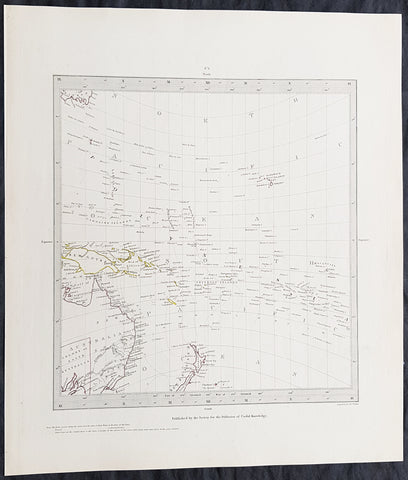
1840 SDUK Antique Gnomonic Map East Australia, New Zealand South Pacific
- Title : Published by the Society for the Diffusion of Useful Knowledge
- Size: 16in x 14in (410mm x 355m)
- Condition: (A+) Fine Condition
- Date : 1840
- Ref #: 24676-1
Description:
This hand coloured original steel-plate engraved antique Gnomonic Map of eastern Australia, New Zealand & The South Pacific was engraved by J & C Walker, in 1840 and was published in the Chapman & Hall edition of the Society For the Diffusion of Useful Knowledge (SDUK) Atlas.
A gnomonic map projection displays all great circles as straight lines, resulting in any line segment on a gnomonic map showing a geodesic, the shortest route between the segment\'s two endpoints. This is achieved by casting surface points of the sphere onto a tangent plane, each landing where a ray from the center of the sphere passes through the point on the surface and then on to the plane. No distortion occurs at the tangent point, but distortion increases rapidly away from it. Less than half of the sphere can be projected onto a finite map. Consequently a rectilinear photographic lens cannot image more than 180 degrees.
General Definitions:
Paper thickness and quality: - Heavy and stable
Paper color : - off white
Age of map color: - Original
Colors used: - Yellow, pink, green, blue
General color appearance: - Authentic
Paper size: - 16in x 14in (410mm x 355m)
Plate size: - 16in x 14in (410mm x 355m)
Margins: - Min 1/4in (5mm)
Imperfections:
Margins: - Light age toning
Plate area: - None
Verso: - None
Background:
The SDUK produced two landmark volumes of cartography in the first half of the 19th century. The first volume concentrated on areas of the old world, Europe, Africa, Great Britain etc. The second volume contained maps of the new world, America, South Asia, including US state maps, colonies of Australia, South Africa, South America etc. Also included were some of the finest engraved town and city plans published at that time.
The SDUK was published in its entirety or in part by many publishers including Baldwin and Cradock 1829-32, Chapman & Hall in 1844, Charles Knight & co. 1846 – 1852. G. Cox published the SDUK between 1852-3, Stanford 1857-70 and later revised edition were also published after Stanford. (Ref: Tooley, M&B)
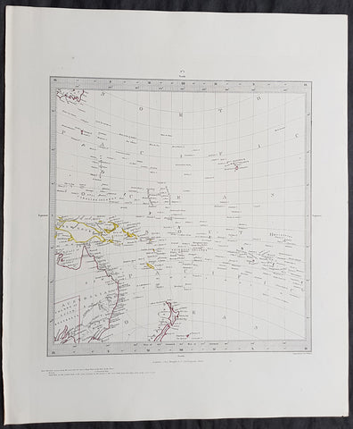
Copy of 1840 SDUK Antique Gnomonic Map East Australia, New Zealand South Pacific
- Title : Published by the Society for the Diffusion of Useful Knowledge
- Size: 16in x 14in (410mm x 355m)
- Condition: (A+) Fine Condition
- Date : 1840
- Ref #: 11-0984
Description:
This hand coloured original steel-plate engraved antique Gnomonic Map of eastern Australia, New Zealand & The South Pacific was engraved by J & C Walker, in 1840 and was published in the Chapman & Hall edition of the Society For the Diffusion of Useful Knowledge (SDUK) Atlas.
A gnomonic map projection displays all great circles as straight lines, resulting in any line segment on a gnomonic map showing a geodesic, the shortest route between the segment\'s two endpoints. This is achieved by casting surface points of the sphere onto a tangent plane, each landing where a ray from the center of the sphere passes through the point on the surface and then on to the plane. No distortion occurs at the tangent point, but distortion increases rapidly away from it. Less than half of the sphere can be projected onto a finite map. Consequently a rectilinear photographic lens cannot image more than 180 degrees.
General Definitions:
Paper thickness and quality: - Heavy and stable
Paper color : - off white
Age of map color: - Original
Colors used: - Yellow, pink, green, blue
General color appearance: - Authentic
Paper size: - 16in x 14in (410mm x 355m)
Plate size: - 16in x 14in (410mm x 355m)
Margins: - Min 1/4in (5mm)
Imperfections:
Margins: - Light age toning
Plate area: - None
Verso: - None
Background:
The SDUK produced two landmark volumes of cartography in the first half of the 19th century. The first volume concentrated on areas of the old world, Europe, Africa, Great Britain etc. The second volume contained maps of the new world, America, South Asia, including US state maps, colonies of Australia, South Africa, South America etc. Also included were some of the finest engraved town and city plans published at that time.
The SDUK was published in its entirety or in part by many publishers including Baldwin and Cradock 1829-32, Chapman & Hall in 1844, Charles Knight & co. 1846 – 1852. G. Cox published the SDUK between 1852-3, Stanford 1857-70 and later revised edition were also published after Stanford. (Ref: Tooley, M&B)
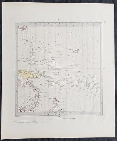
1840 SDUK Antique Gnomonic Map East Australia, New Zealand South Pacific
- Title : Published by the Society for the Diffusion of Useful Knowledge
- Size: 16in x 14in (410mm x 355m)
- Condition: (A+) Fine Condition
- Date : 1840
- Ref #: 11-0974
Description:
This hand coloured original steel-plate engraved antique Gnomonic Map of eastern Australia, New Zealand & The South Pacific was engraved by J & C Walker, in 1840 and was published in the Chapman & Hall edition of the Society For the Diffusion of Useful Knowledge (SDUK) Atlas.
A gnomonic map projection displays all great circles as straight lines, resulting in any line segment on a gnomonic map showing a geodesic, the shortest route between the segment\'s two endpoints. This is achieved by casting surface points of the sphere onto a tangent plane, each landing where a ray from the center of the sphere passes through the point on the surface and then on to the plane. No distortion occurs at the tangent point, but distortion increases rapidly away from it. Less than half of the sphere can be projected onto a finite map. Consequently a rectilinear photographic lens cannot image more than 180 degrees.
General Definitions:
Paper thickness and quality: - Heavy and stable
Paper color : - off white
Age of map color: - Original
Colors used: - Yellow, pink, green, blue
General color appearance: - Authentic
Paper size: - 16in x 14in (410mm x 355m)
Plate size: - 16in x 14in (410mm x 355m)
Margins: - Min 1/4in (5mm)
Imperfections:
Margins: - Light age toning
Plate area: - None
Verso: - None
Background:
The SDUK produced two landmark volumes of cartography in the first half of the 19th century. The first volume concentrated on areas of the old world, Europe, Africa, Great Britain etc. The second volume contained maps of the new world, America, South Asia, including US state maps, colonies of Australia, South Africa, South America etc. Also included were some of the finest engraved town and city plans published at that time.
The SDUK was published in its entirety or in part by many publishers including Baldwin and Cradock 1829-32, Chapman & Hall in 1844, Charles Knight & co. 1846 – 1852. G. Cox published the SDUK between 1852-3, Stanford 1857-70 and later revised edition were also published after Stanford. (Ref: Tooley, M&B)
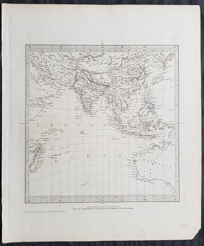
1831 SDUK Antique Gnomonic Map of Western Australia & The Indian Ocean, SE Asia
- Title : Published by Baldwin & Craddock...June 1831
- Size: 16in x 14in (410mm x 355m)
- Condition: (A+) Fine Condition
- Date : 1831
- Ref #: 32534
Description:
This original steel-plate engraved antique Gnomonic Map of Western Australia & The Indian Ocean was engraved by J & C Walker, in 1831 - dated at the foot of the map - and was published in the Baldwin & Craddock edition of the Society For the Diffusion of Useful Knowledge (SDUK) Atlas.
A gnomonic map projection displays all great circles as straight lines, resulting in any line segment on a gnomonic map showing a geodesic, the shortest route between the segment\'s two endpoints. This is achieved by casting surface points of the sphere onto a tangent plane, each landing where a ray from the center of the sphere passes through the point on the surface and then on to the plane. No distortion occurs at the tangent point, but distortion increases rapidly away from it. Less than half of the sphere can be projected onto a finite map. Consequently a rectilinear photographic lens cannot image more than 180 degrees.
General Definitions:
Paper thickness and quality: - Heavy and stable
Paper color : - off white
Age of map color: -
Colors used: -
General color appearance: -
Paper size: - 16in x 14in (410mm x 355m)
Plate size: - 16in x 14in (410mm x 355m)
Margins: - Min 1/4in (5mm)
Imperfections:
Margins: - None
Plate area: - Blind Library stamp
Verso: - None
Background:
The SDUK produced two landmark volumes of cartography in the first half of the 19th century. The first volume concentrated on areas of the old world, Europe, Africa, Great Britain etc. The second volume contained maps of the new world, America, South Asia, including US state maps, colonies of Australia, South Africa, South America etc. Also included were some of the finest engraved town and city plans published at that time.
The SDUK was published in its entirety or in part by many publishers including Baldwin and Cradock 1829-32, Chapman & Hall in 1844, Charles Knight & co. 1846 – 1852. G. Cox published the SDUK between 1852-3, Stanford 1857-70 and later revised edition were also published after Stanford. (Ref: Tooley, M&B)
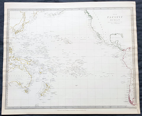
1840 SDUK Antique Map of The Pacific Ocean, North America, Japan, Australia, New Zealand
- Title : The Pacific Ocean.....Published by Chapman & Hall...May 15th 1840
- Size: 16in x 14in (410mm x 355m)
- Condition: (A+) Fine Condition
- Date : 1840
- Ref #: 24668
Description:
This hand coloured original steel-plate engraved antique map of The Pacific Ocean from North America, Japan, Australia & New Zealand was engraved by J & C Walker, in 1840 - the date is engraved at the foot of the map - and was published in the Chapman & Hall edition of the Society For the Diffusion of Useful Knowledge (SDUK) Atlas.
General Definitions:
Paper thickness and quality: - Heavy and stable
Paper color : - off white
Age of map color: - Original
Colors used: - Yellow, pink, green, blue
General color appearance: - Authentic
Paper size: - 16in x 14in (410mm x 355m)
Plate size: - 16in x 14in (410mm x 355m)
Margins: - Min 1/4in (5mm)
Imperfections:
Margins: - Light age toning
Plate area: - None
Verso: - None
Background:
The SDUK produced two landmark volumes of cartography in the first half of the 19th century. The first volume concentrated on areas of the old world, Europe, Africa, Great Britain etc. The second volume contained maps of the new world, America, South Asia, including US state maps, colonies of Australia, South Africa, South America etc. Also included were some of the finest engraved town and city plans published at that time.
The SDUK was published in its entirety or in part by many publishers including Baldwin and Cradock 1829-32, Chapman & Hall in 1844, Charles Knight & co. 1846 – 1852. G. Cox published the SDUK between 1852-3, Stanford 1857-70 and later revised edition were also published after Stanford. (Ref: Tooley, M&B)
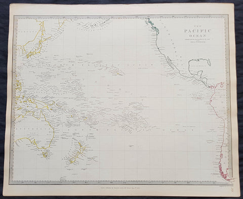
1840 SDUK Antique Map of The Pacific Ocean, North America, Japan, Australia, New Zealand
- Title : The Pacific Ocean.....Published by Chapman & Hall...May 15th 1840
- Size: 16in x 14in (410mm x 355m)
- Condition: (A+) Fine Condition
- Date : 1840
- Ref #: 11-0954-1
Description:
This hand coloured original steel-plate engraved antique map of The Pacific Ocean from North America, Japan, Australia & New Zealand was engraved by J & C Walker, in 1840 - the date is engraved at the foot of the map - and was published in the Chapman & Hall edition of the Society For the Diffusion of Useful Knowledge (SDUK) Atlas.
General Definitions:
Paper thickness and quality: - Heavy and stable
Paper color : - off white
Age of map color: - Original
Colors used: - Yellow, pink, green, blue
General color appearance: - Authentic
Paper size: - 16in x 14in (410mm x 355m)
Plate size: - 16in x 14in (410mm x 355m)
Margins: - Min 1/4in (5mm)
Imperfections:
Margins: - Light age toning
Plate area: - None
Verso: - None
Background:
The SDUK produced two landmark volumes of cartography in the first half of the 19th century. The first volume concentrated on areas of the old world, Europe, Africa, Great Britain etc. The second volume contained maps of the new world, America, South Asia, including US state maps, colonies of Australia, South Africa, South America etc. Also included were some of the finest engraved town and city plans published at that time.
The SDUK was published in its entirety or in part by many publishers including Baldwin and Cradock 1829-32, Chapman & Hall in 1844, Charles Knight & co. 1846 – 1852. G. Cox published the SDUK between 1852-3, Stanford 1857-70 and later revised edition were also published after Stanford. (Ref: Tooley, M&B)
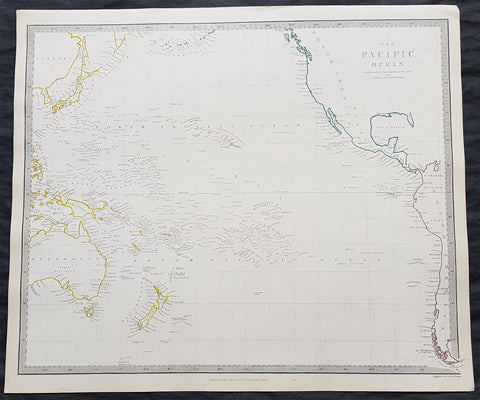
1840 SDUK Antique Map of The Pacific Ocean, North America, Japan, Australia, New Zealand
- Title : The Pacific Ocean.....Published by Chapman & Hall...May 15th 1840
- Size: 16in x 14in (410mm x 355m)
- Condition: (A+) Fine Condition
- Date : 1840
- Ref #: 11-0964
Description:
This hand coloured original steel-plate engraved antique map of The Pacific Ocean from North America, Japan, Australia & New Zealand was engraved by J & C Walker, in 1840 - the date is engraved at the foot of the map - and was published in the Chapman & Hall edition of the Society For the Diffusion of Useful Knowledge (SDUK) Atlas.
General Definitions:
Paper thickness and quality: - Heavy and stable
Paper color : - off white
Age of map color: - Original
Colors used: - Yellow, pink, green, blue
General color appearance: - Authentic
Paper size: - 16in x 14in (410mm x 355m)
Plate size: - 16in x 14in (410mm x 355m)
Margins: - Min 1/4in (5mm)
Imperfections:
Margins: - Light age toning
Plate area: - None
Verso: - None
Background:
The SDUK produced two landmark volumes of cartography in the first half of the 19th century. The first volume concentrated on areas of the old world, Europe, Africa, Great Britain etc. The second volume contained maps of the new world, America, South Asia, including US state maps, colonies of Australia, South Africa, South America etc. Also included were some of the finest engraved town and city plans published at that time.
The SDUK was published in its entirety or in part by many publishers including Baldwin and Cradock 1829-32, Chapman & Hall in 1844, Charles Knight & co. 1846 – 1852. G. Cox published the SDUK between 1852-3, Stanford 1857-70 and later revised edition were also published after Stanford. (Ref: Tooley, M&B)
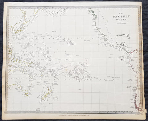
1840 SDUK Antique Map of The Pacific Ocean, North America, Japan, Australia, New Zealand
- Title : The Pacific Ocean.....Published by Chapman & Hall...May 15th 1840
- Size: 16in x 14in (410mm x 355m)
- Condition: (A+) Fine Condition
- Date : 1840
- Ref #: 91362
Description:
This hand coloured original steel-plate engraved antique map of The Pacific Ocean from North America, Japan, Australia & New Zealand was engraved by J & C Walker, in 1840 - the date is engraved at the foot of the map - and was published in the Chapman & Hall edition of the Society For the Diffusion of Useful Knowledge (SDUK) Atlas.
General Definitions:
Paper thickness and quality: - Heavy and stable
Paper color : - off white
Age of map color: - Original
Colors used: - Yellow, pink, green, blue
General color appearance: - Authentic
Paper size: - 16in x 14in (410mm x 355m)
Plate size: - 16in x 14in (410mm x 355m)
Margins: - Min 1/4in (5mm)
Imperfections:
Margins: - Light age toning
Plate area: - None
Verso: - None
Background:
The SDUK produced two landmark volumes of cartography in the first half of the 19th century. The first volume concentrated on areas of the old world, Europe, Africa, Great Britain etc. The second volume contained maps of the new world, America, South Asia, including US state maps, colonies of Australia, South Africa, South America etc. Also included were some of the finest engraved town and city plans published at that time.
The SDUK was published in its entirety or in part by many publishers including Baldwin and Cradock 1829-32, Chapman & Hall in 1844, Charles Knight & co. 1846 – 1852. G. Cox published the SDUK between 1852-3, Stanford 1857-70 and later revised edition were also published after Stanford. (Ref: Tooley, M&B)
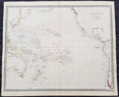
1840 SDUK Antique Map of The Pacific Ocean, North America, Japan, Australia, New Zealand
- Title : The Pacific Ocean.....Published by Chapman & Hall...May 15th 1840
- Size: 16in x 14in (410mm x 355m)
- Condition: (A+) Fine Condition
- Date : 1840
- Ref #: 31980
Description:
This hand coloured original steel-plate engraved antique map of The Pacific Ocean from North America, Japan, Australia & New Zealand was engraved by J & C Walker, in 1840 - the date is engraved at the foot of the map - and was published in the Chapman & Hall edition of the Society For the Diffusion of Useful Knowledge (SDUK) Atlas.
General Definitions:
Paper thickness and quality: - Heavy and stable
Paper color : - off white
Age of map color: - Original
Colors used: - Yellow, pink, green, blue
General color appearance: - Authentic
Paper size: - 16in x 14in (410mm x 355m)
Plate size: - 16in x 14in (410mm x 355m)
Margins: - Min 1/4in (5mm)
Imperfections:
Margins: - Light age toning
Plate area: - None
Verso: - None
Background:
The SDUK produced two landmark volumes of cartography in the first half of the 19th century. The first volume concentrated on areas of the old world, Europe, Africa, Great Britain etc. The second volume contained maps of the new world, America, South Asia, including US state maps, colonies of Australia, South Africa, South America etc. Also included were some of the finest engraved town and city plans published at that time.
The SDUK was published in its entirety or in part by many publishers including Baldwin and Cradock 1829-32, Chapman & Hall in 1844, Charles Knight & co. 1846 – 1852. G. Cox published the SDUK between 1852-3, Stanford 1857-70 and later revised edition were also published after Stanford. (Ref: Tooley, M&B)
1774 Hawkesworth Antique Map of Wallis (Uvea) & Funtuna Islands Capt Wallis 1767
- Title : Isles de Wallis
- Size: 14in x 10in (360mm x 255mm)
- Ref #: 21598
- Date : 1774
- Condition: (A+) Fine Condition
Description:
This fine original copper-plate engraved antique map of the Islands of Wallis (Uvea) and Futuna, situated in the South Pacific between Tuvalu to the northwest, Fiji to the southwest, Tonga to the southeast, Samoa to the east. Futuna was first mapped by Willem Schouten and Jacob Le Maire during their famous circumnavigation of the globe in 1616 and Wallis (Uvea) being mapped by Captain Samuel Wallis, who saw it while sailing the HMS Dolphin on 16 August 1767, was published in the 1774 French edition of John Hawkesworths An Account of the Voyages Undertaken by the Order of His Present Majesty for Making Discoveries in the Southern Hemisphere and Successively Performed by Commodore Byron, Captain Wallis, Captain Carteret, and Captain Cook, in the Dolphin, the Swallow, and the Endeavor, Drawn Up from the Journals Which Were Kept by the Several Commanders, and from the Papers of Joseph Banks, Esq. Paris 1774
General Definitions:
Paper thickness and quality: - Heavy and stable
Paper color : - off white
Age of map color: -
Colors used: -
General color appearance: -
Paper size: - 10in x 9in (255mm x 230mm)
Plate size: - 9in x 8in (230mm x 205mm)
Margins: - Min 1/2in (12mm)
Imperfections:
Margins: - None
Plate area: - None
Verso: - None
Background:
Wallis or Uvea, is a Polynesian island in the Pacific Ocean belonging to the French overseas collectivity of Wallis and Futuna. It lies north of Tonga, northeast of Fiji, east-northeast of the Hoorn islands, east of Fijis Rotuma, southeast of Tuvalu, southwest of Tokelau and west of Samoa. Its area is almost 100 km2 with almost 11,000 people. Its capital is Matā utu.
The island was renamed Wallis after a Cornish navigator, Captain Samuel Wallis, who saw it while sailing the HMS Dolphin on 16 August 1767, following his discovery of Tahiti.
Futuna was first put on the European maps by Willem Schouten and Jacob Le Maire during their famous circumnavigation of the globe in 1616. They named the islands Hoornse Eylanden after the Dutch town of Hoorn where they hailed from. This was later translated into French as Isles de Horne. The French were the first Europeans to settle in the territory with the arrival of French missionaries in 1837
Samuel Wallis 1728 – 1795
was a British naval officer and explorer of the Pacific Ocean.
Wallis was born near Camelford, Cornwall. He served under John Byron, and in 1766 was promoted to captain and was given the command of HMS Dolphin (1751) as part of an expedition led by Philip Carteret in the Swallow with an assignment to circumnavigate the globe. The two ships were parted by a storm shortly after sailing through the Strait of Magellan, Wallis continuing to Tahiti, which he named King George the Thirds Island in honour of the King (June 1767). Wallis himself was ill and remained in his cabin: lieutenant Tobias Furneaux was the first to set foot, hoisting a pennant and turning a turf, taking possession in the name of His Majesty. Dolphin stayed in Matavai Bay in Tahiti for over a month. Wallis went on to name or rename five more islands in the Society Islands and six atolls in the Tuamotu Islands, as well as confirming the locations of Rongerik and Rongelap in the Marshall Islands. He renamed the Polynesian island of Uvea as Wallis after himself, before reaching Tinian in the Mariana Islands. He continued to Batavia, where many of the crew died from dysentery, then via the Cape of Good Hope to England, arriving in May 1768. He was able to pass on useful information to James Cook who was due to depart shortly for the Pacific, and some of the crew from the Dolphin sailed with Cook. In 1780 Wallis was appointed Commissioner of the Admiralty.
Capt. Philip Carteret (1733-1796)
was a British naval officer and explorer who participated in two of the Royal Navy\\\\\\\'s circumnavigation expeditions in 1764-66 and 1766-69.
Carteret entered the Navy in 1747, serving aboard the Salisbury, and then under Captain John Byron from 1751 to 1755. Between 1757 and 1758 he was in the Guernsey on the Mediterranean Station. As a lieutenant in the Dolphin he accompanied Byron during his voyage of circumnavigation, from June 1764 to May 1766.
In 1766 he was made a commander and given the command of the Swallow to circumnavigate the world, as consort to the Dolphin under the command of Samuel Wallis. The two ships were parted shortly after sailing through the Strait of Magellan, Carteret discovering Pitcairn Island and the Carteret Islands, which were subsequently named after him. In 1767, he also discovered a new archipelago inside Saint George\\\\\\\'s Channel between New Ireland and New Britain Islands (Papua New Guinea) and named it Duke of York Islands, as well as rediscovered the Solomon Islands first sighted by the Mendana in 1568, and the Juan Fernandez Islands first discovered by Juan Fernandez in 1574. He arrived back in England, at Spithead, on 20 March 1769.
He was promoted to post captain in 1771.
1784 Anderson Antique Coastal Views of the Admiralty Isles of PNG & Mindanao Islands - Capt Cook 1767
- Title : Three Views of the Admiralty Isles; Two islands seen 24th September 1767; Seen the 26 of September 1767, Joseph Freewills Islands; An island seen from the mast head & this view taken there September 29th 1767, S. 50W; An island seen from the mast head & this view taken October 12th 1767. Current Island, N.E. 1/2 E; Seen only from the mast head where this view was taken October 15, 1767. St. Andrews Islands; Three islands seen from our anchoring place in the Bay at the south end of Mindinao.
- Date : 1784
- Ref # : 21696
- Size : 13in x 9in (330mm x 230mm)
- Condition: (A+) Fine Condition
Description:
This fine original copper-plate engraved antique 8 nautical chart & coastal view of the Admiralty Islands, off the coast of north PNG, along with St Andrews & Joseph Freewill Islands sighted by James Cook from September to October 1767 and the last view being a coastal view of southern Mindanao Islands in the Philippines, was published in George Andersons 1784 edition of A Collection of voyages round the world : performed by royal authority : containing a complete historical account of Captain Cooks first, second, third and last voyages, undertaken for making new discoveries, &c. ... published by Alexander Hogg, London 1784.
1.2.3 Three Views of the Admiralty Isles
4. Two islands seen 24th September 1767
5. Seen the 26 of September 1767, Joseph Freewills Islands
6. An island seen from the mast head & this view taken there September 29th 1767, S. 50W.
7. An island seen from the mast head & this view taken October 12th 1767. Current Island, N.E. 1/2 E.
8. Seen only from the mast head where this view was taken October 15, 1767. St. Andrews Islands
9. Three islands seen from our anchoring place in the Bay at the south end of Mindinao.
General Definitions:
Paper thickness and quality: - Heavy and stable
Paper color : - off white
Age of map color: -
Colors used: -
General color appearance: -
Paper size: - 13 1/2in x 9 1/2in (345mm x 240mm)
Plate size: - 13 1/2in x 9 1/2in (345mm x 240mm)
Margins: - Min 1/2in (12mm)
Imperfections:
Margins: - None
Plate area: - None
Verso: - None
Background:
The Admiralty Islands are an archipelago group of 18 islands in the Bismarck Archipelago, to the north of New Guinea in the South Pacific Ocean. These are also sometimes called the Manus Islands, after the largest island.
Mindanao is the second largest island in the Philippines. Mindanao and the smaller islands surrounding it make up the island group of the same name.
Cooks First Voyage (1768–71) In 1766, the Admiralty engaged Cook to command a scientific voyage to the Pacific Ocean. The purpose of the voyage was to observe and record the transit of Venus across the Sun for the benefit of a Royal Society inquiry into a means of determining longitude. Cook, at the age of 39, was promoted to lieutenant to grant him sufficient status to take the command. For its part the Royal Society agreed that Cook would receive a one hundred guinea gratuity in addition to his Naval pay.
The expedition sailed aboard HMS Endeavour, departing England on 26 August 1768. Cook and his crew rounded Cape Horn and continued westward across the Pacific to arrive at Tahiti on 13 April 1769, where the observations of the Venus Transit were made. However, the result of the observations was not as conclusive or accurate as had been hoped. Once the observations were completed, Cook opened the sealed orders which were additional instructions from the Admiralty for the second part of his voyage: to search the south Pacific for signs of the postulated rich southern continent of Terra Australis. Cook then sailed to New Zealand and mapped the complete coastline, making only some minor errors. He then voyaged west, reaching the south-eastern coast of Australia on 19 April 1770, and in doing so his expedition became the first recorded Europeans to have encountered its eastern coastline.
On 23 April he made his first recorded direct observation of indigenous Australians at Brush Island near Bawley Point, noting in his journal: “...and were so near the Shore as to distinguish several people upon the Sea beach they appear\\\'d to be of a very dark or black Colour but whether this was the real colour of their skins or the Clothes they might have on I know not. On 29 April Cook and crew made their first landfall on the mainland of the continent at a place now known as the Kurnell Peninsula. Cook originally christened the area as \\\"Stingray Bay\\\", but later he crossed this out and named it Botany Bay after the unique specimens retrieved by the botanists Joseph Banks and Daniel Solander. It is here that James Cook made first contact with an aboriginal tribe known as the Gweagal.
After his departure from Botany Bay he continued northwards. He stopped at Bustard Bay (now known as Seventeen Seventy or 1770) at 8 o’clock on 23 May 1770. On 24 May Cook and Banks and others went ashore. Continuing north, on 11 June a mishap occurred when HMS Endeavour ran aground on a shoal of the Great Barrier Reef, and then nursed into a river mouth on 18 June 1770. The ship was badly damaged and his voyage was delayed almost seven weeks while repairs were carried out on the beach (near the docks of modern Cooktown, Queensland, at the mouth of the Endeavour River). The voyage then continued, sailing through Torres Strait and on 22 August Cook landed on Possession Island, where he claimed the entire coastline that he had just explored as British territory. He returned to England via Batavia (modern Jakarta, Indonesia), where many in his crew succumbed to malaria, and then the Cape of Good Hope, arriving at the island of Saint Helena on 12 July 1771.
Cook\\\'s journals were published upon his return, and he became something of a hero among the scientific community. Among the general public, however, the aristocratic botanist Joseph Banks was a greater hero. Banks even attempted to take command of Cook\\\'s second voyage, but removed himself from the voyage before it began, and Johann Reinhold Forster and his son Georg Forster were taken on as scientists for the voyage. Cook\\\'s son George was born five days before he left for his second voyage.
1827 Dumont D Urville Large Antique Early Map of New Zealand
Antique Map
- Title : Carte Generale de la Partie De La Nouvelle Zelande Reconnue par le Capitaine de Fregate Dumont D Urville Dressee par Mr Loottin Enseigue de v au Expedition de la Corvette de S M L Astrolobe Janvier, Fevrier, Mars, 1827
- Size: 26in x 20in (660mm x 510mm)
- Condition: (A+) Fine Condition
- Date : 1827
- Ref #: 42011
Description:
This magnificent large original & scarce copper-plate engraved antique map of the North Island & part of the South Island of New Zealand by Dumont D Urville and Lieutenant Victor Lottin, aboard the ship The Astrolabe during the first D Urville voyage to the South Seas 1826 - 1829, was engraved by Alphonse Chassant, 1808-1907 and published in the 1836 edition of Dumont d Urvilles Voyage de la corvette L Astrolabe: exécuté par ordre du roi, pendant les années 1826-1827-1828-1829......
Fantastic & rare map by D Urville & Lottin with surveys made of the north, south east coasts of New Zealands North Island & the north west part of the South Island, between January and March 1827.
General Definitions:
Paper thickness and quality: - Heavy and stable
Paper color : - off white
Age of map color: -
Colors used: -
General color appearance: -
Paper size: - 26in x 20in (660mm x 510mm)
Plate size: - 26in x 20in (660mm x 510mm)
Margins: - Min 2in (50mm)
Imperfections:
Margins: - None
Plate area: - None
Verso: - None
Background:
On 25 April 1826, Dumont d Urville, with the rank of commander, sailed from Toulon as chief of the ship formerly named the Coquille, renamed Astrolabe, on a voyage of exploration and scientific inquiry which lasted till 24 March 1829. On 10 January 1827 the Astrolabe came in sight of the north-west coast of the South Island of New Zealand. On 14 January the ship passed the entrance to the modern Golden Bay, which had been visited by Abel Tasman. The ship anchored off the west side of Tasman Bay. This bay had not been investigated at close quarters previously. In the following days d Urville established that it was a great deal bigger than Cooks mapping indicated, and his officers surveyed and charted it. Adele Island, Pepin Island, and Croisilles Harbour are modern names derived from those given by d Urville. On 23 January d Urville made for a channel which he had noticed at a distance some time before, and which seemed to him to communicate between Tasman Bay and Cooks Admiralty Bay. This was the channel culminating in French Pass and dividing D Urville Island from the mainland. Victor Lottin and Gressien, two of d Urville\'s officers, on the same day saw the pass at close quarters from two of the ships boats. On 25 January d Urville went through the pass into Admiralty Bay in a ship\'s boat. On 28 January the Astrolabe made the hazardous passage into Admiralty Bay. The investigation of Tasman Bay and the discovery of French Pass and the insularity of D Urville Island were significant contributions by d Urville to the discovery of New Zealands coastline.
From Cook Strait d Urville went north along the coast to Whangarei Harbour, which was surveyed and charted on 21–23 February 1827. The Astrolabe then doubled back to Hauraki Gulf, passing between the main coastal islands on the west side of the gulf on 25–27 February. The Astrolabe had been preceded in this passage by the Prince Regent in 1820, but the surveys and charts made under d Urville\'s command were notable contributions to the cartography of New Zealands coast. Lottin crossed the isthmus on 26 February and made a survey of Manukau Harbour, discovered in 1820 by Samuel Marsden. From Hauraki Gulf d Urville proceeded to North Cape and then to the Bay of Islands, leaving New Zealand in March 1827.
Lottin, Victor Charles 1795 - 1858. Lottin was a French frigate captain and geographer who took part in the voyage made around the world by the Astrolabe, under the command of Dumont-d Urville. He served as a lieutenant on the research expedition to Iceland and Greenland. During these two excursions, Lottin drew several maps and gathered a large quantity of objects of natural history, and made mention of the aurora borealis, inserted in the Annales Maritimes (1839). He was a member of the Academy of Sciences, Section of Geography and Navigation (elected in 1852) and a Knight of the Legion of Honour.
He died at Versailles on 18 February 1858.