Maps (1)
1720 Guillaume Delisle Large Antique Map of America, New Zealand, Pacific Ocean
Antique Map
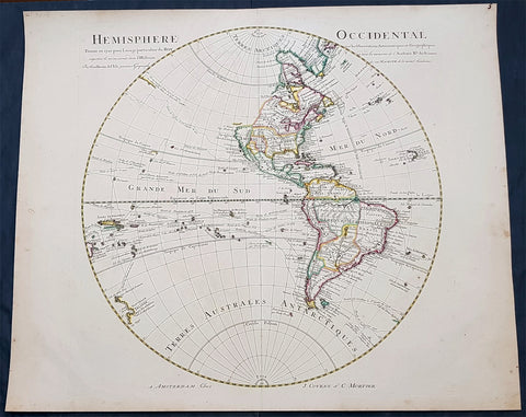
- Title : Hemisphere Occidental Dresse en 1720 pour l usage
- Date : 1720
- Condition: (A+) Fine Condition
- Ref: 93081
- Size: 25in x 21in (635mm x 535mm)
Description:
This very large 1st edition beautifully hand coloured original antique Map of America by Guillaume Delisle, was engraved by J De la Haye in 1720, dated, and was was published in the Atlas Nouveau.
General Definitions:
Paper thickness and quality: - Heavy and stable
Paper color : - off white
Age of map color: - Original
Colors used: - Blue, pink, red, green, yellow
General color appearance: - Authentic
Paper size: - 25in x 21in (635mm x 535mm)
Plate size: - 19 1/2in x 19in (490mm x 485mm)
Margins: - Min 1/2in (12mm)
Imperfections:
Margins: - Uniform age toning
Plate area: - Uniform age toning
Verso: - Uniform age toning
Background:
Guillaume de L isle was responsible for some of the most accurate maps of America avaialble in the early 18th century. Delisle did away with most of the speculative cartography especially of North America and researched his information in finite detail. This can be seen in many ways. The most oblivious is showing California as a Peninsular - which some cartographers did not believe until the 1740\'s - and the NW region has been left blank, free of speculation. Another noticeable difference is the accurate depiction of the Great Lakes.
As with all Delisle\'s map this is finely engraved with amazing detail and hand colour. The map includes the tracks of many explorers up until 1710. These include Magellan 1520, Halley 1700, de Quiros 1605, de Mendana 1595, de la Maire 1616, Tasman, Halley and others. (Ref: M&B; Tooley)