Welcome to Classical Images!
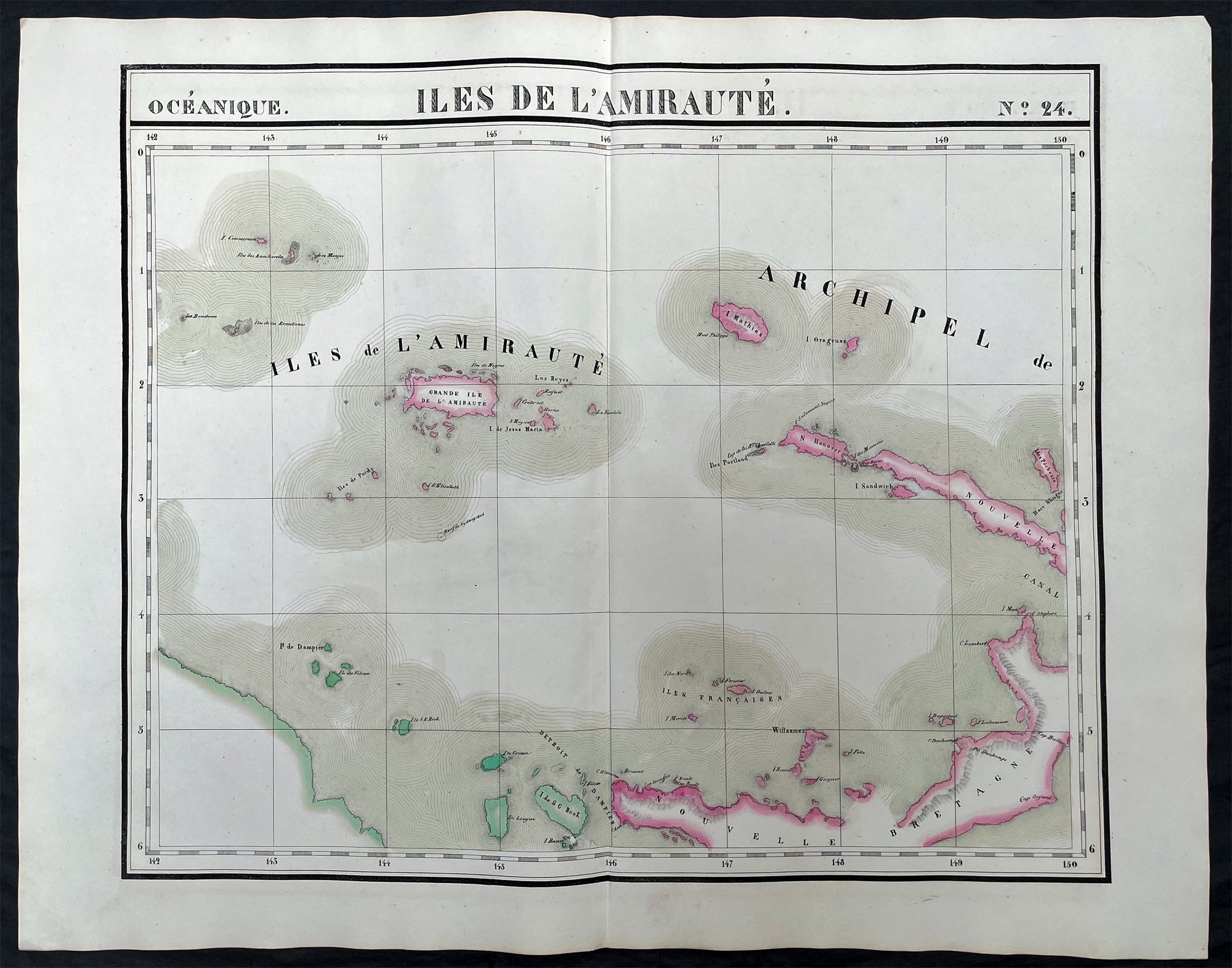
Description:This very large original hand coloured antique lithograph map of the Admiralty or Manus Islands, north of New Guinea, in the South Pacific was published by Philippe Vandermaelen in his revolutionary 1825 Atlas universel de geographie physique, politique, statistique et mineralogique.Until the publication of this atlas, large detailed maps of this region of Australia & the Pacific were uncommon.
General Definitions:Paper thickness and quality: - Heavy and stablePaper color : - off whiteAge of map color: - EarlyColors used: - Red, yellow, green, blueGeneral color appearance: - AuthenticPaper size: - 28 1/2in x 21in (725mm x 550mm)Plate size: - 28 1/2in x 21in (725mm x 550mm)Margins: - Min 1/2in (12mm)
Imperfections:Margins: - NonePlate area: - NoneVerso: - None
Background:The first European to visit the islands was the Spanish navigator Álvaro de Saavedra when trying to return from Tidore to New Spain in the summer of 1528. Saavedra charted Manus as Urays la Grande. Its visit was also reported in 1616 by the Dutch navigator Willem Schouten. The name Admiralty Islands was devised by Captain Philip Carteret of the British Royal Navy in 1767.Between 1884 and 1914 the area was administered as a German colony. In November 1914, the islands were occupied by troops of the Australian Naval and Military Expeditionary Force landed from the SS Siar. A few shots fired from a machine gun on Siar over the heads of the tiny German garrison at Lorengau were the last shots fired in the battle. After the war, the islands were governed by the Commonwealth of Australia under a League of Nations mandate.Japanese troops landed on Manus Island on 7 April 1942. In 1944, Japanese forces occupying the islands were attacked and defeated by Allied forces in Operation Brewer. Subsequently, a large American airbase was built at Lombrum near Lorengau.
Vandermaelen, Philippe M G 1795-1869Vandermaelen was the son of the wealthy soap manufacturer; he abandoned the soap trade and devoted his life to cartography. Entirely self-taught in geometry, astronomy and the geosciences, he began drafting the first sheets of an Atlas universel in 1824. This atlas was published between 1825 and 1827; it was sold in forty instalments of ten maps each and became a great success. The revenue enabled him to set up his own Etablissement géographique de Bruxelles in 1830, which not only produced maps, atlases and globes in large quantities but also housed a natural science museum, botanical gardens, a library, and an impressive collection of maps.Shortly after the closing of Vandermaelens Institute, the Royal Library of Belgium (KBR) in 1880 acquired a large part of its cartographic collection and production.Vandermaelens atlas was remarkable: 387 maps on a uniform scale of ca. 1:1.6 million. There was one edition of this very rare atlas, published in 1825-27; the subscription list shows that only 810 copies were sold. The six volumes, of which Africa was in Volume III (60 maps), were issued in instalments during the period 1825-1827.This folio-size atlas is remarkable for several reasons. It is the first atlas produced by the then new printing process of lithography. It is also the first atlas to show the whole world in 380 maps using a large uniform scale—about 10km to the cm. on a modified conical projection described by Sanson-Flamsteed. Based on a prime meridian through Paris, each map has a drawn-out graticule giving it a trapezoidal form, the underlying intention being construction of a globe with a diameter of 7.755m Eugene Gilbert de Cauwer , his biographer, suggested that Vandernaelen was a worthy follower of Mercator and Ortelius.Vandermaelen enlisted the assistance of lithographer-printer Hippolyte Ode in this ambitious project which introduced lithography into Belgium and created an upsurge in Belgian publishing. A number of maps were lithographed by Philippe Vandermaelen himself. For many of the areas depicted, these maps are the largest scale maps made at the time, and the most detailed. The lithographs are very well drawn and printed and should be appreciated in the context of lithography, which was a developing art at the time. The maps are handsome and detailed, although some of the place names are somewhat curious and the cartography sometimes imaginary. Nevertheless, the Vandermaelen maps are of great significance in the history of cartography and lithography. Visually, they are arresting and unusual. Vandermaelens maps best are appreciated in the context of its neighbouring maps - they were all meant to be joined .
Please note all items auctioned are genuine, we do not sell reproductions. A Certificate of Authenticity (COA) can be issued on request.