Welcome to Classical Images!
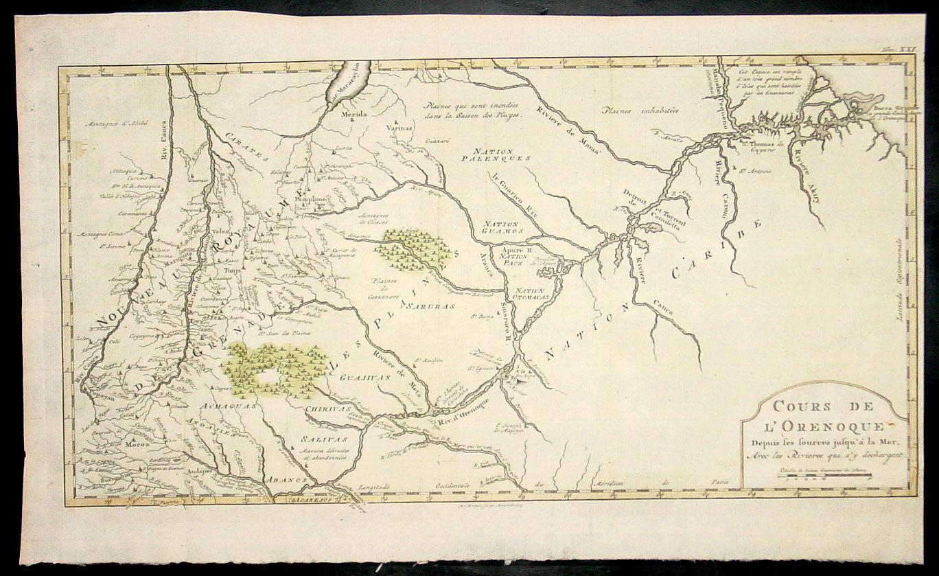
Description:This fine, original copper-plate engraved antique map of the Orinoco River, South America, by Jacques Nicolas Bellin in 1750 was published in Antoine François Prevosts 15 volumes of Histoire Generale des Voyageswritten by Prevost & other authors between 1746-1790.The mouth of the Orinoco River at the Atlantic Ocean was documented by Columbus on 1 August 1498, during his third voyage. Its source at the Cerro Delgado–Chalbaud, in the Parima range, was not explored until 1951, 453 years later. The source, near the Venezuelan–Brazilian border, at 1,047 metres (3,435 ft) above sea level (02°19′05″N 63°21′42″W), was explored in 1951 by a joint Venezuelan–French team.The Orinoco Delta, and tributaries in the eastern llanos such as the Apure and Meta, were explored in the 16th century by German expeditions under Ambrosius Ehinger and his successors. In 1531 Diego de Ordaz, starting at the principal outlet in the delta, the Boca de Navios, sailed up the river to the Meta. Antonio de Berrio sailed down the Casanare to the Meta, and then down the Orinoco River and back to Coro. In 1595, after capturing de Berrio to obtain information while conducting an expedition to find the fabled city of El Dorado, the Englishman Sir Walter Raleigh sailed down the river, reaching the savannah country.Alexander von Humboldt explored the basin in 1800, reporting on the pink river dolphins. He published extensively on the river\'s flora and fauna
General Definitions:Paper thickness and quality: - Heavy and stablePaper color : - off whiteAge of map color: - EarlyColors used: - Yellow, green, redGeneral color appearance: - AuthenticPaper size: - 18 1/2in x 11 1/2in (460mm x 295mm)Plate size: - 18in x 10in (455mm x 255mm)Margins: - Min 1/2in (12mm)
Imperfections:Margins: - NonePlate area: - NoneVerso: - None
Background: One of Antoine Francois Prevosts monumental undertakings was his history of exploration & discovery in 15 volumes titledHistoire Générale des Voyages written between 1746-1759 and was extended to 20 volumes after his death by various authors.The 20 volumes cover the early explorations & discoveries on 3 continents: Africa (v. 1-5), Asia (v. 5-11), and America (v. 12-15) with material on the finding of the French, English, Dutch, and Portugese. A number of notable cartographers and engravers contributed to the copper plate maps and views to the 20 volumes including Nicolas Bellin, Jan Schley, Chedel, Franc Aveline, Fessard, and many others.The African volumes cover primarily coastal countries of West, Southern, and Eastern Africa, plus the Congo, Madagascar, Arabia and the Persian Gulf areas. The Asian volumes cover China, Korea, Tibet, Japan, Philippines, and countries bordering the Indian Ocean. Volume 11 includes Australia and Antarctica. Volumes 12-15 cover voyages and discoveries in America, including the East Indies, South, Central and North America.Volumes 16-20 include supplement volumes & tables along with continuation of voyages and discoveries in Russia, Northern Europe, America, Asia & Australia.