Maps (72)
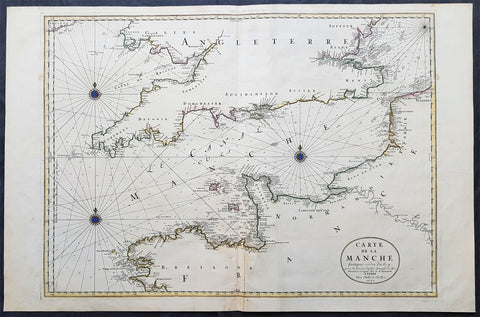
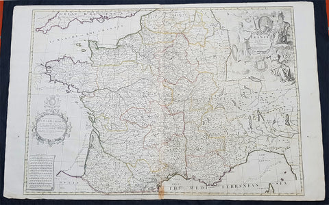
1692 Jaillot Large Antique Map Sea Chart The English Channel during 9 Years War
Antique Map
- Title : Carte De La Manche faite par ordre du Roy. pour le Service de les Armees de Mer.....a Paris...1692
- Size: 38in x 25in (960m x 635mm)
- Condition: (A+) Fine Condition
- Date : 1692
- Ref #: 16371
Description:
This very large, beautifully hand coloured original copper-plate engraved antique map, a large Sea Chart of The English Channel - produced for the French Navy during the Nine Years War and specifically the Battle of Beachy Head - was engraved in 1692, dated in the cartouche, and was published for Alexis Hubert Jaillots 1698 edition of his monumental Atlas Nouveau.
General Definitions:
Paper thickness and quality: - Heavy and stable
Paper color : - off white
Age of map color: - Original
Colors used: - Yellow, pink, green, blue
General color appearance: - Authentic
Paper size: - 38in x 25in (960m x 635mm)
Plate size: - 32 1/2in x 23 1/2in (825mm x 595mm)
Margins: - Min 1in (25mm)
Imperfections:
Margins: - None
Plate area: - None
Verso: - None
Background:
The Nine Years War (1688–97)—often called the War of the Grand Alliance or the War of the League of Augsburg—was a conflict between Louis XIV of France and a European coalition of the Holy Roman Empire, led by Austria, the Dutch Republic, Spain, England and Savoy. It was fought in Europe and the surrounding seas, North America and in India. It is sometimes considered the first global war. The conflict encompassed the Williamite war in Ireland and Jacobite risings in Scotland, where William III and James II struggled for control of England and Ireland, and a campaign in colonial North America between French and English settlers and their respective Indigenous allies, today called King Williams War by Americans.
Louis XIV of France had emerged from the Franco-Dutch War in 1678 as the most powerful monarch in Europe, an absolute ruler who had won numerous military victories. Using a combination of aggression, annexation, and quasi-legal means, Louis XIV set about extending his gains to stabilize and strengthen France\'s frontiers, culminating in the brief War of the Reunions (1683–84). The Truce of Ratisbon guaranteed France\'s new borders for twenty years, but Louis XIV\'s subsequent actions—notably his Edict of Fontainebleau (the revocation of the Edict of Nantes) in 1685— led to the deterioration of his military and political dominance. Louis XIVs decision to cross the Rhine in September 1688 was designed to extend his influence and pressure the Holy Roman Empire into accepting his territorial and dynastic claims. Leopold I and the German princes resolved to resist, and when the States General and William III brought the Dutch and the English into the war against France, the French King faced a powerful coalition aimed at curtailing his ambitions.
The main fighting took place around Frances borders in the Spanish Netherlands, the Rhineland, the Duchy of Savoy and Catalonia. The fighting generally favoured Louis XIV\'s armies, but by 1696 his country was in the grip of an economic crisis. The Maritime Powers (England and the Dutch Republic) were also financially exhausted, and when Savoy defected from the Alliance, all parties were keen to negotiate a settlement. By the terms of the Treaty of Ryswick (1697) Louis XIV retained the whole of Alsace but was forced to return Lorraine to its ruler and give up any gains on the right bank of the Rhine. Louis XIV also accepted William III as the rightful King of England, while the Dutch acquired a Barrier fortress system in the Spanish Netherlands to help secure their borders. With the ailing and childless Charles II of Spain approaching his end, a new conflict over the inheritance of the Spanish Empire embroiled Louis XIV and the Grand Alliance in the War of the Spanish Succession.
The Battle of Beachy Head (Bévéziers) was a naval engagement fought on 10 July 1690 during the Nine Years\' War. The battle was the greatest French tactical naval victory over their English and Dutch opponents during the war. The Dutch lost six ships of the line (sources vary) and three fireships; their English allies also lost one ship of the line, whereas the French did not lose a vessel. Control of the English Channel temporarily fell into French hands but Vice-Admiral Tourville failed to pursue the Allied fleet with sufficient vigour, allowing it to escape to the River Thames.
Tourville was criticised for not following up his victory and was relieved of his command. The English Admiral Arthur Herbert, 1st Earl of Torrington – who had advised against engaging the superior French fleet but had been overruled by Queen Mary and her ministers – was court-martialled for his performance during the battle. Although he was acquitted, King William dismissed him from the service.
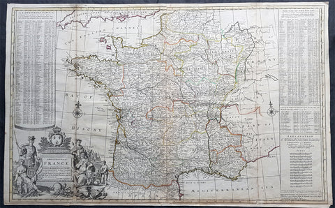
1720 Herman Moll Large Antique Pre Revolutionary Map of France in Provinces
Antique Map
- Title : A New and Exact Map of France Divided into all its Provinces...by H Moll Geographer
- Size: 39 1/2in x 25in (1.00m x 630mm)
- Condition: (A) Very Good Condition
- Date : 1720
- Ref #: 43196
Description:
This very large beautifully hand coloured original copper-plate engraved antique map of France by Herman Moll was published in 1720 in the atlas The World Described, or a New and Correct Sett of Maps by John Bowles, Thomas Bowles, Philip Overton & John King of London.
In the 18th century many large-scale maps were published by the likes of John Senex and Herman Moll, this trend continued until the end of private mapping in the early 19th century when it was replaced by Ordnance Survey maps.
General Definitions:
Paper thickness and quality: - Heavy and stable
Paper color : - off white
Age of map color: - Original
Colors used: - Yellow, green, blue, pink
General color appearance: - Authentic
Paper size: - 39 1/2in x 25in (1.00m x 630mm)
Plate size: - 39 1/2in x 25in (1.00m x 630mm)
Margins: - Min 1/2in (12mm)
Imperfections:
Margins: - Age toning, bottom margin extended from plate-mark
Plate area: - Light age toning along folds
Verso: - Re-enforced along folds
Background:
The Carolingian dynasty ruled France until 987, when Hugh Capet, Duke of France and Count of Paris, was crowned King of the Franks. His descendants—the Capetians, the House of Valois, and the House of Bourbon—progressively unified the country through wars and dynastic inheritance into the Kingdom of France, which was fully declared in 1190 by Philip II Augustus. The French nobility played a prominent role in most Crusades in order to restore Christian access to the Holy Land. French knights made up the bulk of the steady flow of reinforcements throughout the two-hundred-year span of the Crusades, in such a fashion that the Arabs uniformly referred to the crusaders as Franj caring little whether they really came from France. The French Crusaders also imported the French language into the Levant, making French the base of the lingua franca (litt. Frankish language) of the Crusader states. French knights also made up the majority in both the Hospital and the Temple orders. The latter, in particular, held numerous properties throughout France and by the 13th century were the principal bankers for the French crown, until Philip IV annihilated the order in 1307. The Albigensian Crusade was launched in 1209 to eliminate the heretical Cathars in the southwestern area of modern-day France. In the end, the Cathars were exterminated and the autonomous County of Toulouse was annexed into the crown lands of France. Later kings expanded their domain to cover over half of modern continental France, including most of the north, centre and west of France. Meanwhile, the royal authority became more and more assertive, centred on a hierarchically conceived society distinguishing nobility, clergy, and commoners.
From the 11th century, the House of Plantagenet, the rulers of the County of Anjou, succeeded in establishing its dominion over the surrounding provinces of Maine and Touraine, then progressively built an empire that spanned from England to the Pyrenees and covering half of modern France. Tensions between the kingdom of France and the Plantagenet empire would last a hundred years, until Philip Augustus of France conquered between 1202 and 1214 most of the continental possessions of the empire, leaving England and Aquitaine to the Plantagenets. Following the Battle of Bouvines, the Angevin court retreated to England, but persistent Capetian–Plantagenet rivalry would paved the way for another conflict.
Charles IV the Fair died without an heir in 1328. Under the rules of the Salic law the crown of France could not pass to a woman nor could the line of kingship pass through the female line. Accordingly, the crown passed to Philip of Valois, a cousin of Charles, rather than through the female line to Charles nephew, Edward of Plantagenet, who would soon become Edward III of England. During the reign of Philip of Valois, the French monarchy reached the height of its medieval power. Philips seat on the throne was contested by Edward III of England and in 1337, on the eve of the first wave of the Black Death, England and France went to war in what would become known as the Hundred Years War. The exact boundaries changed greatly with time, but French landholdings of the English Kings remained extensive for decades. With charismatic leaders, such as Joan of Arc and La Hire, strong French counterattacks won back English continental territories. Like the rest of Europe, France was struck by the Black Death; half of the 17 million population of France died.
The French Renaissance saw a spectacular cultural development and the first standardisation of the French language, which would become the official language of France and the language of Europes aristocracy. It also saw a long set of wars, known as the Italian Wars, between France and the House of Habsburg. French explorers, such as Jacques Cartier or Samuel de Champlain, claimed lands in the Americas for France, paving the way for the expansion of the First French colonial empire. The rise of Protestantism in Europe led France to a civil war known as the French Wars of Religion, where, in the most notorious incident, thousands of Huguenots were murdered in the St. Bartholomews Day massacre of 1572. The Wars of Religion were ended by Henry IVs Edict of Nantes, which granted some freedom of religion to the Huguenots. Spanish troops, the terror of Western Europe, assisted the Catholic side during the Wars of Religion in 1589–1594, and invaded northern France in 1597; after some skirmishing in the 1620s and 1630s, Spain and France returned to all-out war between 1635 and 1659. The war cost France 300,000 casualties.
Under Louis XIII, the energetic Cardinal Richelieu promoted the centralisation of the state and reinforced the royal power by disarming domestic power holders in the 1620s. He systematically destroyed castles of defiant lords and denounced the use of private violence (dueling, carrying weapons, and maintaining private army). By the end of 1620s, Richelieu established the royal monopoly of force as the doctrine. During Louis XIVs minority and the regency of Queen Anne and Cardinal Mazarin, a period of trouble known as the Fronde occurred in France. This rebellion was driven by the great feudal lords and sovereign courts as a reaction to the rise of royal absolute power in France.
The monarchy reached its peak during the 17th century and the reign of Louis XIV. By turning powerful feudal lords into courtiers at the Palace of Versailles, Louis XIVs personal power became unchallenged. Remembered for his numerous wars, he made France the leading European power. France became the most populous country in Europe and had tremendous influence over European politics, economy, and culture. French became the most-used language in diplomacy, science, literature and international affairs, and remained so until the 20th century. France obtained many overseas possessions in the Americas, Africa and Asia. Louis XIV also revoked the Edict of Nantes, forcing thousands of Huguenots into exile.
Under Louis XV, Louis XIVs great-grandson, France lost New France and most of its Indian possessions after its defeat in the Seven Years War (1756–63). Its European territory kept growing, however, with notable acquisitions such as Lorraine (1766) and Corsica (1770). An unpopular king, Louis XVs weak rule, his ill-advised financial, political and military decisions – as well as the debauchery of his court– discredited the monarchy, which arguably paved the way for the French Revolution 15 years after his death.
Louis XVI, Louis XVs grandson, actively supported the Americans, who were seeking their independence from Great Britain (realised in the Treaty of Paris (1783)). The financial crisis aggravated by Frances involvement in the American Revolutionary War was one of many contributing factors to the French Revolution. Much of the Enlightenment occurred in French intellectual circles, and major scientific breakthroughs and inventions, such as the discovery of oxygen (1778) and the first hot air balloon carrying passengers (1783), were achieved by French scientists. French explorers, such as Bougainville and Lapérouse, took part in the voyages of scientific exploration through maritime expeditions around the globe. The Enlightenment philosophy, in which reason is advocated as the primary source for legitimacy and authority, undermined the power of and support for the monarchy and helped pave the way for the French Revolution.
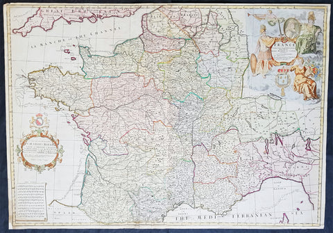
1720 John Senex Large Antique Pre Revolutionary Map of France in Provinces
- Title : France Corrected from ye Observations made by the Royal Academy of Sciences at Paris by John Senex
- Size: 37in x 26in (940m x 660mm)
- Condition: (A) Very Good Condition
- Date : 1720
- Ref #: 81078
Description:
This large beautifully hand coloured original antique map of France was engraved for John Senex for publication in his Elephant Folio Atlas 1720.
These large scale maps are scarce due mainly to their size. Damage and loss over time is inevitable.
General Definitions:
Paper thickness and quality: - Heavy and stable
Paper color : - off white
Age of map color: - Original & later
Colors used: - Yellow, green, blue, pink
General color appearance: - Authentic
Paper size: - 37in x 26in (940m x 660mm)
Plate size: - 36 1/2in x 25 1/2in (930m x 650mm)
Margins: - Min 1/4in (8mm)
Imperfections:
Margins: - Bottom left corner extended from plate-mark
Plate area: - Folds as issued
Verso: - None
Background:
The history of French cartography can be traced to developments in the Middle Ages. This period was marked by improvements in measuring instruments and also by an upgrade of work in registers of all types.
The first map of France was drawn by Oronce Finé and printed in woodcuts in 1525. It testifies to the will of the political power to mark its presence on the territory; to affirm, to build limits, borders, to arrange its territory, and to consolidate the internal economic markets.
In the sixteenth century, Dieppe appeared as an important school of cartography. Pierre Desceliers allowed the realization of many maps. At the same time, the Portolan maps of the Portuguese sailors had the most recent knowledge obtained by the Dieppois sailors in their exploration of Canada.
Then, cartography progressed more and more, through the development of new techniques and by the will of the political powers to control their territories. Very powerful companies testify support to some of the cartographic missions at the end of the nineteenth century.
There were two decisive stages in cartography. One was determining longitude and latitude. Florence Trystram, 2001, the lawsuit of the stars is an account of the research of three French scientists that was done in South America, 1735-1771.
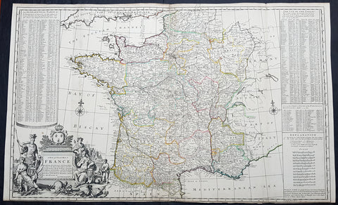
1720 Herman Moll Large Antique Map of France in Provinces - Pre Revolution
Antique Map
- Title : A New and Exact Map of France Divided into all its Provinces...by H Moll Geographer
- Ref #: 93416
- Size: 40in x 24 1/2in (1.010m x 625mm)
- Date : 1720
- Condition: (A+) Fine Condition
Description:
This very large beautifully hand coloured original copper-plate engraved antique map of France by Herman Moll was published in 1720 in the atlas The World Described, or a New and Correct Sett of Maps by John Bowles, Thomas Bowles, Philip Overton & John King of London.
In the 18th century many large-scale maps were published by the likes of John Senex and Herman Moll, this trend continued until the end of private mapping in the early 19th century when it was replaced by Ordnance Survey maps.
General Definitions:
Paper thickness and quality: - Heavy and stable
Paper color : - off white
Age of map color: - Early
Colors used: - Yellow, green, blue, pink
General color appearance: - Authentic
Paper size: - 40in x 24 1/2in (1.010m x 625mm)
Plate size: - 39 1/2in x 24in (1.00m x 620mm)
Margins: - Min 1/8in (3mm)
Imperfections:
Margins: - Bottom margin cropped to plate mark
Plate area: - Folds as issued
Verso: - Folds as issued
Background:
The Carolingian dynasty ruled France until 987, when Hugh Capet, Duke of France and Count of Paris, was crowned King of the Franks. His descendants—the Capetians, the House of Valois, and the House of Bourbon—progressively unified the country through wars and dynastic inheritance into the Kingdom of France, which was fully declared in 1190 by Philip II Augustus. The French nobility played a prominent role in most Crusades in order to restore Christian access to the Holy Land. French knights made up the bulk of the steady flow of reinforcements throughout the two-hundred-year span of the Crusades, in such a fashion that the Arabs uniformly referred to the crusaders as Franj caring little whether they really came from France. The French Crusaders also imported the French language into the Levant, making French the base of the lingua franca (litt. Frankish language) of the Crusader states. French knights also made up the majority in both the Hospital and the Temple orders. The latter, in particular, held numerous properties throughout France and by the 13th century were the principal bankers for the French crown, until Philip IV annihilated the order in 1307. The Albigensian Crusade was launched in 1209 to eliminate the heretical Cathars in the southwestern area of modern-day France. In the end, the Cathars were exterminated and the autonomous County of Toulouse was annexed into the crown lands of France. Later kings expanded their domain to cover over half of modern continental France, including most of the north, centre and west of France. Meanwhile, the royal authority became more and more assertive, centred on a hierarchically conceived society distinguishing nobility, clergy, and commoners.
From the 11th century, the House of Plantagenet, the rulers of the County of Anjou, succeeded in establishing its dominion over the surrounding provinces of Maine and Touraine, then progressively built an empire that spanned from England to the Pyrenees and covering half of modern France. Tensions between the kingdom of France and the Plantagenet empire would last a hundred years, until Philip Augustus of France conquered between 1202 and 1214 most of the continental possessions of the empire, leaving England and Aquitaine to the Plantagenets. Following the Battle of Bouvines, the Angevin court retreated to England, but persistent Capetian–Plantagenet rivalry would paved the way for another conflict.
Charles IV the Fair died without an heir in 1328. Under the rules of the Salic law the crown of France could not pass to a woman nor could the line of kingship pass through the female line. Accordingly, the crown passed to Philip of Valois, a cousin of Charles, rather than through the female line to Charles nephew, Edward of Plantagenet, who would soon become Edward III of England. During the reign of Philip of Valois, the French monarchy reached the height of its medieval power. Philips seat on the throne was contested by Edward III of England and in 1337, on the eve of the first wave of the Black Death, England and France went to war in what would become known as the Hundred Years War. The exact boundaries changed greatly with time, but French landholdings of the English Kings remained extensive for decades. With charismatic leaders, such as Joan of Arc and La Hire, strong French counterattacks won back English continental territories. Like the rest of Europe, France was struck by the Black Death; half of the 17 million population of France died.
The French Renaissance saw a spectacular cultural development and the first standardisation of the French language, which would become the official language of France and the language of Europes aristocracy. It also saw a long set of wars, known as the Italian Wars, between France and the House of Habsburg. French explorers, such as Jacques Cartier or Samuel de Champlain, claimed lands in the Americas for France, paving the way for the expansion of the First French colonial empire. The rise of Protestantism in Europe led France to a civil war known as the French Wars of Religion, where, in the most notorious incident, thousands of Huguenots were murdered in the St. Bartholomews Day massacre of 1572. The Wars of Religion were ended by Henry IVs Edict of Nantes, which granted some freedom of religion to the Huguenots. Spanish troops, the terror of Western Europe, assisted the Catholic side during the Wars of Religion in 1589–1594, and invaded northern France in 1597; after some skirmishing in the 1620s and 1630s, Spain and France returned to all-out war between 1635 and 1659. The war cost France 300,000 casualties.
Under Louis XIII, the energetic Cardinal Richelieu promoted the centralisation of the state and reinforced the royal power by disarming domestic power holders in the 1620s. He systematically destroyed castles of defiant lords and denounced the use of private violence (dueling, carrying weapons, and maintaining private army). By the end of 1620s, Richelieu established the royal monopoly of force as the doctrine. During Louis XIVs minority and the regency of Queen Anne and Cardinal Mazarin, a period of trouble known as the Fronde occurred in France. This rebellion was driven by the great feudal lords and sovereign courts as a reaction to the rise of royal absolute power in France.
The monarchy reached its peak during the 17th century and the reign of Louis XIV. By turning powerful feudal lords into courtiers at the Palace of Versailles, Louis XIVs personal power became unchallenged. Remembered for his numerous wars, he made France the leading European power. France became the most populous country in Europe and had tremendous influence over European politics, economy, and culture. French became the most-used language in diplomacy, science, literature and international affairs, and remained so until the 20th century. France obtained many overseas possessions in the Americas, Africa and Asia. Louis XIV also revoked the Edict of Nantes, forcing thousands of Huguenots into exile.
Under Louis XV, Louis XIVs great-grandson, France lost New France and most of its Indian possessions after its defeat in the Seven Years War (1756–63). Its European territory kept growing, however, with notable acquisitions such as Lorraine (1766) and Corsica (1770). An unpopular king, Louis XVs weak rule, his ill-advised financial, political and military decisions – as well as the debauchery of his court– discredited the monarchy, which arguably paved the way for the French Revolution 15 years after his death.
Louis XVI, Louis XVs grandson, actively supported the Americans, who were seeking their independence from Great Britain (realised in the Treaty of Paris (1783)). The financial crisis aggravated by Frances involvement in the American Revolutionary War was one of many contributing factors to the French Revolution. Much of the Enlightenment occurred in French intellectual circles, and major scientific breakthroughs and inventions, such as the discovery of oxygen (1778) and the first hot air balloon carrying passengers (1783), were achieved by French scientists. French explorers, such as Bougainville and Lapérouse, took part in the voyages of scientific exploration through maritime expeditions around the globe. The Enlightenment philosophy, in which reason is advocated as the primary source for legitimacy and authority, undermined the power of and support for the monarchy and helped pave the way for the French Revolution.
1720 John Senex Large Antique Map of France in Provinces
Antique Map
- Title : France corrected from ye Observations by the Royal Academy Society at Paris by John Senex
- Size: 41 1/2in x 26 1/2in (1.040m x 660mm)
- Condition: (A) Very Good Condition
- Date : 1878
- Ref #: 24903
Description:
This large hand coloured original copper plate engraved antique map of France by John Senex, was published in the 1720 edition of his Elephant Folio Atlas.
This map is in VG condition. These large scale maps are scarce due mainly to their size, with damage and loss over time inevitable.
General Definitions:
Paper thickness and quality: - Heavy and stable
Paper color : - off white
Age of map color: - Original
Colors used: - Yellow, green, blue, pink
General color appearance: - Authentic
Paper size: - 41 1/2in x 26 1/2in (1.040m x 660mm)
Plate size: - 36in x 24 1/2in (915mm x 615mm)
Margins: - Min 1/2in (12mm)
Imperfections:
Margins: - Light chipping to margin edges
Plate area: - Discouloration to bottom centerfold
Verso: - None
Background:
The history of French cartography can be traced to developments in the Middle Ages. This period was marked by improvements in measuring instruments and also by an upgrade of work in registers of all types.
The first map of France was drawn by Oronce Finé and printed in woodcuts in 1525. It testifies to the will of the political power to mark its presence on the territory; to affirm, to build limits, borders, to arrange its territory, and to consolidate the internal economic markets.
In the sixteenth century, Dieppe appeared as an important school of cartography. Pierre Desceliers allowed the realization of many maps. At the same time, the Portolan maps of the Portuguese sailors had the most recent knowledge obtained by the Dieppois sailors in their exploration of Canada.
Then, cartography progressed more and more, through the development of new techniques and by the will of the political powers to control their territories. Very powerful companies testify support to some of the cartographic missions at the end of the nineteenth century.
There were two decisive stages in cartography. One was determining longitude and latitude. Florence Trystram, 2001, the lawsuit of the stars is an account of the research of three French scientists that was done in South America, 1735-1771.
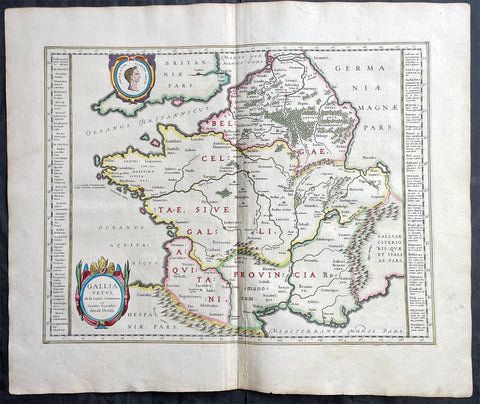
1639 Henricus Hondius Antique Map of France
Antique Map
- Title : Galliae supera omnes in hac...auctore Henrico Hondio
- Date : 1639
- Size: 22 1/2in x 18in (570mm x 455mm)
- Condition: (A+) Fine Condition
- Ref: 17039
Description:
This original hand coloured copper plate engraved antique map of France was published by Henricus Hondius & Jan Jansson in the 1639 French edition of Gerard Mercators Atlas.
General Definitions:
Paper thickness and quality: - Heavy and stable
Paper color : - off white
Age of map color: - Original
Colors used: - Pink, blue, green, yellow
General color appearance: - Authentic
Paper size: - 22 1/2in x 18in (570mm x 455mm)
Plate size: - 19 1/2in x 14 1/2in (500mm x 375mm)
Margins: - Min 1in (25mm)
Imperfections:
Margins: - None
Plate area: - None
Verso: - None
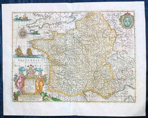
1638 Joan Blaeu & Abraham Ortelius Antique Map of France
Antique Map
- Title : Gallia Vetus...Abrah Ortelii
- Date : 1638
- Size: 23in x 20in (585mm x 510mm)
- Condition: (A+) Fine Condition
- Ref: 70606
Description:
This original beautifully hand coloured copper-plate engraved antique map of France, after Abraham Ortelius, was published by Joan Blaeu in the 1638 French edition of Atlas Nouvs,.
General Definitions:
Paper thickness and quality: - Heavy and stable
Paper color : - off white
Age of map color: - Original
Colors used: - Pink, blue, green, yellow
General color appearance: - Authentic
Paper size: - 23in x 20in (585mm x 510mm)
Plate size: - 19 1/2in x 15in (500mm x 380mm)
Margins: - Min 1in (25mm)
Imperfections:
Margins: - None
Plate area: - None
Verso: - None
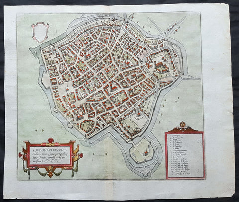
1575 Braun & Hogenberg Original Antique Birds Eye View of St Omer, Calais France
Antique Map
- Title : S. Audomari Fanum. S. Ausmer, Omer, Iccius portus Abrahamo Orttelio, Artesii urbs munitissima
- Date : 1575
- Size: 25in x 21 1/4in (635mm x 540mm)
- Ref #: 30268
- Condition: (A+) Fine Condition
Description:
This beautifully hand coloured original 1572 antique birds eye view of the Northern French Town of St Omer in the Pas-de-Calais department, was published by Georg Braun & Frans Hogenberg for the 1572 atlas of town plans Civiates Orbis Terrarum intended as a companion to Abraham Ortelius's master Atlas Theatrum Orbis Terrarum.
This is a bird's-eye view from the south of the town, which is fortified with moats, walls and bastions. Numerous churches stand out, including the Gothic cathedral of Notre-Dame in the lower left-hand corner, with its 50-m-high clock tower. The town goes back to the Benedictine monastery established in AD 657 by Bishop Audomar of Thérouanne. Initially a religious centre, it quickly developed various commercial activities. At the beginning of the 14th century the town was one of the largest in France, the wealthiest in Artois and a centre of European trade.
General Definitions:
Paper thickness and quality: - Heavy and stable
Paper color : - off white
Age of map color: - Original
Colors used: - Yellow, green, blue, pink
General color appearance: - Authentic
Paper size: - 18 1/2in x 15 1/2in (470mm x 395mm)
Plate size: - 15in x 13 1/2in (385mm x 345mm)
Margins: - Min 1in (25mm)
Imperfections:
Margins: - None
Plate area: - None
Verso: - None
Background:
This is a bird's-eye view from the south of the town, which is fortified with moats, walls and bastions. Numerous churches stand out, including the Gothic cathedral of Notre-Dame in the lower left-hand corner, with its 50-m-high clock tower. The town goes back to the Benedictine monastery established in AD 657 by Bishop Audomar of Thérouanne. Initially a religious centre, it quickly developed various commercial activities. At the beginning of the 14th century the town was one of the largest in France, the wealthiest in Artois and a centre of European trade.
Saint-Omer, is a city in France in the sub-prefecture of the Pas-de-Calais department 68 km. The town is named after Saint Audomar, who brought Christianity to the area.
Saint Audomar (died c. 670), better known as Saint Omer, was a Burgundy-born bishop of Thérouanne, after whom nearby Saint-Omer in northern France was named
COMMENTARY BY BRAUN (on verso): "Saint-Audomar, commonly known as Saint-Audmar, and, in the mutilated form read by some, Saint-Omer, a small town in Artois, gets its name from St Audomar, a German, a priest born not far from Constance [...]. Through the recommendation of King Pippin and the bishop of Noyon, he was appointed bishop to the Morini or Flemings. Because he was a man of pious conduct, Adroaldus, a rich and noble man, was later persuaded to present him with the hamlet of Sithieu and the surrounding area to build a monastery there. [...] Through the teachings of these men a large number of people came to the little village of Sithieu and began to build a town, which was later named St Audomar or St Omer in honour of this excellent bishop."
CARTOUCHE LEFT: S. Audomari Fanum, S. Aulmer, Saint-Omer. Iccius portus according to Abraham Ortelius; well-fortified town in Artois.
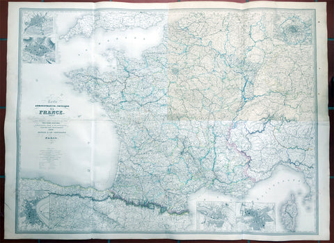
1857 Dufour Very Large Scarce Old, Antique Map of France - 4ft x 6ft
- Title : Carte Administrative et Physique de la France indiquant Les Canaan Les Riviers Navigable les routes, le Chemis de fer avec leurs stations Dresee par A.H. Dufour Gravee Par CH Dyonnet 1857
- Ref #: 61029
- Size: 62in x 46in (1.5m x 1.15m)
- Date : 1857
- Condition: (A) Very Good Condition
Description:
This scarce very large elephant folio 4 sheet - joined - hand coloured original map of France was engraved by Charles Dyonnet in 1857 - dated in the title - for Adolphe Hippolyte Dufour's monumental elephant folio Atlas Physique, Historique et Politique Geographie Moderne published by Pauline Et La Chevalier, Paris.
This uncommon elephant folio map is huge measuring overall 62in x 46in (1.5m x 1.15m) and is incredibly detailed. The map covers the whole of France including Corsica and parts of Spain, Germany and Switzerland.
The first sheet (top left in image) represents north-western France and includes two insets of Nantes and Rouen. The second sheet (top right) represents north-eastern France with an inset of Paris and its environs. The bottom right sheet depicts the south-eastern portions of France and includes two insets, one featuring Marseille and the other featuring Lyon. The last sheet on the bottom left is of southwest France.
An inset on Bordeaux is included and throughout illustrates roads, canals, railways, rivers, cities and other topographical features are noted.
Adolphe Hippolyte Dufour (1795 - 1865), also known as Auguste-Henri Dufour, was a Paris based map and atlas publisher active in the middle to late 19th century. Dufour claimed to be a student of another French cartographer, Emile Lapie. He is known to have worked with numerous other cartographers, publishers and engravers of the period including Charles Dyonnet and Duvotenay. His corpus includes numerous maps and atlases, the most striking of which is probably his monumental elephant folio Atlas Universel physique, historique et politique geographie ancienne et moderne. Dufour's student and successor was Alexandre Vuillemin.
Charles Dyonnet (fl. c. 1822 - c. 1880) was an extremely active Paris based engraver working in the mid to late 19th century. From his offices at 220 Rue St. Jacques, Paris, Dyonnet engraved numerous maps for many of the most prominent 19th French cartographic publishers including Vuillemin, Dufour, Fremin and Duvotenay. From 1850-1861, he held the coveted position of "Graveur du Dépot de la Marine," and in this position engraved numerous French naval and military maps. Dyonnet had a detail oriented and aesthetically minded hand and is responsible from some of the most beautiful French maps to emerge during the 19th century. (Ref: M&B; Tooley)
General Description:
Paper thickness and quality: - Heavy & stable
Paper color: - White
Age of map color: - Original
Colors used: - Yellow, red, green, blue
General color appearance: - Authentic
Paper size: - 62in x 46in (1.5m x 1.15m)
Paper size: - 62in x 46in (1.5m x 1.15m)
Margins: - Min 1in (24mm)
Imperfections:
Margins: - None
Plate area: - Top NE sheet age toning
Verso: - Soiling
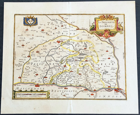
1638 Henricus Hondius Antique Map of the Principality of Dombes, Ain, SE France
- Title : La Principaute De Dombes
- Ref #: 50239
- Size: 22in x 19in (560mm x 480mm)
- Date : 1638
- Condition: (A+) Fine Condition
Description:
This beautifully hand coloured original copper-plate engraved antique map of the Principality of Dombes of south-eastern France - now a part of the Ain Dept. centering on the cities of Mascon & Lyon on the Saone and Rhone Rivers - was published in the 1638 Latin edition of Mercators Atlas published by Henricus Hondius.& Jan Jansson.
General Definitions:
Paper thickness and quality: - Heavy and stable
Paper color : - off white
Age of map color: - Original
Colors used: - Yellow, green, blue, pink
General color appearance: - Authentic
Paper size: - 22in x 19in (560mm x 480mm)
Plate size: - 18in x 14in (460mm x 360mm)
Margins: - Min 1in (25mm)
Imperfections:
Margins: - None
Plate area: - None
Verso: - Age toning
Background:
The Dombes is an area in south-eastern France, once an independent municipality, formerly part of the province of Burgundy, and now a district comprised in the department of Ain, and bounded on the west by the Saône River, by the Rhône, on the east by the Ain and on the north by the district of Bresse.
The Dombes once formed part of the kingdom of Arles. In the 11th century, when the kingdom began to break up, the northern part of the Dombes came under the power of the lords of Bâgé, and in 1218, by the marriage of Marguerite de Baugé with Humbert IV of Beaujeu, passed to the lords of Beaujeu. The southern portion was held in succession by the lords of Villars and of Thoire. Its lords took advantage of the excommunication of Frederick II, Holy Roman Emperor to assert their complete independence of the Holy Roman Empire.
In 1400, Louis II, Duke of Bourbon, acquired the northern part of the Dombes, together with the lordship of Beaujeu, and two years later bought the southern part from the sires de Thoire, forming the whole into a new sovereign principality of the Dombes, with Trévoux as its capital.
The principality was confiscated by King Francis I of France in 1523, along with the other possessions of the Constable de Bourbon, was granted in 1527 to the queen-mother, Louise of Savoy, and after her death was held successively by kings Francis I, Henry II and Francis II, and by Catherine de\' Medici. In 1561 it was granted to Louis, duc de Montpensier, by whose descendants it was held till, in 1682, Anne Marie Louise of Orléans, the duchess of Montpensier, gave it to Louis XIV\'s bastard, the Duke of Maine, as part of the price for the release of her lover Lauzun.
The eldest son of the duke of Maine, Louis-Auguste de Bourbon (1700–1755), prince of Dombes, served in the army of Prince Eugene of Savoy against the Turks (1717), took part in the War of the Polish Succession (1733–1734), and in that of the Austrian Succession (1742-1747). He was made colonel-general of the Swiss regiment, governor of Languedoc and master of the hounds of France. He was succeeded, as prince of Dombes, by his brother the count of Eu, who in 1762 surrendered the principality to the crown. The little principality of Dombes showed in some respects signs of a vigorous life; the princes mint and printing works at Trévoux were long famous, and the college at Thoissey was well endowed and influential.
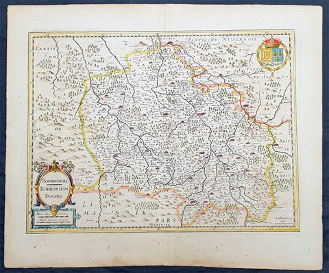
1636 Jan Jansson Antique Map of The Bourbon or Bourbonnais Region Central France
- Title : Boubonoius; Borbonium Ducatus
- Ref #: 41641
- Size: 21 1/2in x 17 1/2in (490mm x 340mm)
- Date : 1636
- Condition: (A) Very Good Condition
Description:
This beautifully hand coloured original copper-plate engraved antique map of The Bourbon or Bourbonnais Region of central France was published in the rare 1636 English edition of Mercators Atlas by Jan Jansson and Henricus Hondius.
There was only one English edition of Mercators Atlas published in 1636 by Jansson & Hondius. These maps - with English text on the verso - are now understandably scarce.
The text running for two pages on the back of the map generally describes the region or country name, history (as it was), temperature, seasons, soil and agricultural productivity. Also described is the topography, wildlife, local inhabitants their culture and religion, as well as a description of major European and local towns and cities. This text makes extremely enjoyable reading and a very good insight not only into the area described but the general European attitudes towards alien countries and cultures.
General Definitions:
Paper thickness and quality: - Heavy and stable
Paper color : - off white
Age of map color: - Original
Colors used: - Yellow, green, blue, pink
General color appearance: - Authentic
Paper size: - 21 1/2in x 17 1/2in (490mm x 340mm)
Plate size: - 20in x 15in (510mm x 380mm)
Margins: - Min 1in (25mm)
Imperfections:
Margins: - Uniform age toning
Plate area: - Uniform age toning
Verso: - Uniform age toning
Background:
Bourbonnais was a historic province in the centre of France that corresponded to the modern département of Allier, along with part of the département of Cher. Its capital was Moulins.
The title of the ruler of Bourbonnais between 913 and 1327, was Sire de Bourbon (or Seigneur de Bourbon). The first lord of Bourbonnais known by name was Adhémar (or Aymon I of Bourbon). Aymon\'s father was Aymar (894-953), sire of Souvigny, his only son with Ermengarde.Aymar lived during the reign of Charles the Simple who, in 913, gave him fiefs on the Allier River in which would become Bourbonnais. He acquired the castle of Bourbon (today Bourbon-l\'Archambault). Almost all early lords took the name d\'Archambaud, after the palace, but later the family became known as the \"House of Bourbon\".
The first House of Bourbon ended in 1196, with the death of Archambault VII, who had only one heir, Mathilde of Bourbon. She married Guy II of Dampierre, who added Montlucon to the possessions of the lords of Bourbon. The second house of Bourbon started in 1218, with Archambault VIII, son of Guy II and Mahaut, and brother of William II of Dampierre. He was followed by his son Archambaut IX, who died in Cyprus in 1249, during a crusade. The House of Burgundy then acquired Bourbonnais.
In 1272, Beatrice of Burgundy (1258-1310), Lady of Bourbon, married Robert de France (1256-1318), Count of Clermont, son of king Louis IX (Saint-Louis). Thus began the long-lasting House of Bourbon, which would provide the kings of France from Henry IV to Louis-Phillipe in 1848, when France abolished its monarchy.
The Bourbons had concluded an alliance with the royal power. They put their forces at the service of the king, thus benefitting from the geographic position of Bourbonnais, located between the royal fidemesne and the duchies of Aquitaine and Auvergne. This alliance, as well as the marriage of Béatrix de Bourgogne and Robert de France, aided the rise and prosperity of the province. In 1327, King Charles (le Bel) elevated Boubonnais to the status of a duchy. (Ref: Koeman; M&B; Tooley)
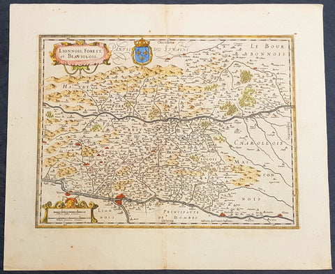
1619 Jan Jansson Antique Map Loire & Rhone Rivers, Auvergne-Rhône-Alpes, France
- Title : Lionnois, Forest et Beaviolois
- Ref #: 50247
- Size: 24in x 20in (610mm x 510mm)
- Date : 1619
- Condition: (A+) Fine Condition
Description:
This beautifully hand coloured original copper-plate engraved antique map of The Auvergne-Rhône-Alpes region of France - centering on the Loire & Rhone Rivers and the cities of Lyon, Vienne & Macon - by Jan Jansson - was published in the 1619 edition of Mercators Atlas by Jan Jansson and Henricus Hondius.
General Definitions:
Paper thickness and quality: - Heavy and stable
Paper color : - off white
Age of map color: - Original
Colors used: - Yellow, green, blue, pink
General color appearance: - Authentic
Paper size: - 24in x 20in (610mm x 500mm)
Plate size: - 20in x 15in (535mm x 380mm)
Margins: - Min 1in (25mm)
Imperfections:
Margins: - None
Plate area: - None
Verso: - None
Background:
Lyon is the third-largest city and second-largest urban area of France. It is located in the country\'s east-central part at the confluence of the rivers Rhône and Saône.
Fernand Braudel remarked, Historians of Lyon are not sufficiently aware of the bi-polarity between Paris and Lyon, which is a constant structure in French development...from the late Middle Ages to the Industrial Revolution. In the late 15th century, the fairs introduced by Italian merchants made Lyon the economic counting house of France. Even the Bourse (treasury), built in 1749, resembled a public bazaar where accounts were settled in the open air. When international banking moved to Genoa, then Amsterdam, Lyon remained the banking centre of France.
During the Renaissance, the cities development was driven by the silk trade, which strengthened its ties to Italy. Italian influence on Lyons architecture is still visible among historic buildings. In the later 1400s and 1500s Lyon was also a key centre of literary activity and book publishing, both of French writers (such as Maurice Scève, Antoine Heroet, and Louise Labé) and of Italians in exile (such as Luigi Alamanni and Gian Giorgio Trissino).
In 1572, Lyon was a scene of mass violence by Catholics against Protestant Huguenots in the St. Bartholomew\'s Day Massacre. Two centuries later, Lyon was again convulsed by violence when, during the French Revolution, the citizenry rose up against the National Convention and supported the Girondins. The city was besieged by Revolutionary armies for over two months before surrendering in October 1793. Many buildings were destroyed, especially around the Place Bellecour, while Jean-Marie Collot d\'Herbois and Joseph Fouché administered the execution of more than 2,000 people. The Convention ordered that its name be changed to Liberated City and a plaque was erected that proclaimed Lyons made war on Liberty; Lyons no longer exists. A decade later, Napoleon ordered the reconstruction of all the buildings demolished during this period.
The Convention was not the only target within Lyon during the 1789-1799 French Revolution. After the National Convention faded into history, the French Directory appeared and days after the September 4, 1797, Coup of 18 Fructidor, a Directory\'s commissioner was assassinated in Lyon.
The city became an important industrial town during the 19th century. In 1831 and 1834, the canuts (silk workers) of Lyon staged two major uprisings for better working conditions and pay. In 1862, the first of Lyon\'s extensive network of funicular railways began operation.
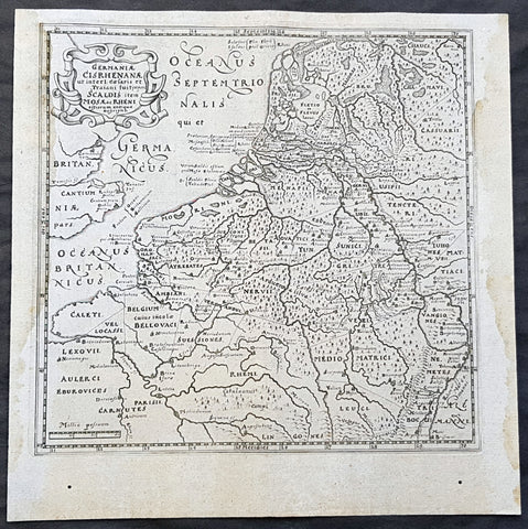
1611 Philipp Cluver Antique Map The Netherlands, Belgium, parts France & Germany
- Title : Germaniae Cisrhenanae ut interl. caesaris et Traiani suit imperii Scaldis item Mosae ac Rheni ostiorum antiqua Descriptio
- Size: 11 1/2in x 11 1/2in (295mm x 295mm)
- Condition: (A+) Fine Condition
- Date : 1611
- Ref #: 23967
Description:
This fine original wood-block engraved antique map of The Netherlands, Belgium, Northern France and parts of Western Germany was published in the 1611 edition of Philip Cluvers first publication Commentarius de tribus Rheni alveis, et ostiis; item. De Quinque populis quondam accolis; scilicet de Toxandris, Batavis, Caninefatibus, Frisiis, ac Marsacis. (Ref: King; Tooley; M&B)
General Definitions:
Paper thickness and quality: - Heavy and stable
Paper color : - off white
Age of map color: -
Colors used: -
General color appearance: -
Paper size: - 11 1/2in x 11 1/2in (295mm x 295mm)
Plate size: - 10in x 10in (255mm x 255mm)
Margins: - Min 1/2in (12mm)
Imperfections:
Margins: - Light age toning to left & right margins
Plate area: - None
Verso: - None
Background:
Clüver was an antiquary, who was given a special appointment at Leiden as geographer and put in charge of the university\'s library, but his lifes project, it developed, was a general study of the geography of Antiquity, based not only on classical literary sources, but — and this was his contribution — supplemented by wide travels and local inspections. He became virtually the founder of historical geography.
Clüvers first work, in 1611, concerning the lower reaches of the Rhine and its tribal inhabitants in Roman times (Commentarius de tribus Rheni alveis, et ostiis; item. De Quinque populis quondam accolis; scilicet de Toxandris, Batavis, Caninefatibus, Frisiis, ac Marsacis) touched a source of national pride among the Seventeen Provinces, for the Dutch were enjoying a twelve years truce in their Eighty Years War of liberation.
Cluver, Philipp 1580 – 1622
Clüver - also Klüwer, Cluwer, or Cluvier, Latinized as Philippus Cluverius and Philippi Cluverii) - was an Early Modern German geographer and historian.
Clüver was born in Danzig (Gdańsk), in Royal Prussia, a province of the Kingdom of Poland. After spending some time at the Polish court of Sigismund III Vasa, he began the study of law at the University of Leiden (Dutch Republic), but soon he turned his attention to history and geography, which were then taught there by Joseph Scaliger.
Clüver received science education from his father, who was Münzmeister at Danzig (coin master), but when Clüver went into different studies, his father stopped supporting his studies. He therefore travelled from Leiden across Hungary to Bohemia, where he did military service for a few years. While in Bohemia, he translated into Latin a defense by Baron Popel Lobkowitz, who was imprisoned. Upon his return to Leiden, he faced sanctions by the imperial (Habsburg) authorities for this, which however he could avoid with the help of his Leiden friends.
Clüver also travelled in England, Scotland, and France. He did all travel on foot, finally returning to Leiden, where (after 1616) he received a regular pension from the university. He died in Leiden.
Clüver was an antiquary, who was given a special appointment at Leiden as geographer and put in charge of the university\\\'s library, but his lifes project, it developed, was a general study of the geography of Antiquity, based not only on classical literary sources, but — and this was his contribution — supplemented by wide travels and local inspections. He became virtually the founder of historical geography.
Clüver\\\'s first work, in 1611, concerning the lower reaches of the Rhine and its tribal inhabitants in Roman times (Commentarius de tribus Rheni alveis, et ostiis; item. De Quinque populis quondam accolis; scilicet de Toxandris, Batavis, Caninefatibus, Frisiis, ac Marsacis) touched a source of national pride among the Seventeen Provinces, for the Dutch were enjoying a twelve years\\\' truce in their Eighty Years War of liberation.
Clüvers Germaniae antiquae libri tres (Leiden, 1616) depends on Tacitus and other Latin authors. A volume on the antiquities of Sicily, with notes on Sardinia and Corsica (Sicilia Antiqua cum minoribus insulis ei adjacentibus item Sardinia et Corsica), published at Leiden by Louis Elsevier in 1619, is a useful source, with many reference from writers of Antiquity and maps that are often detached and sold to map collectors. His Introductio in universam geographiam, totally 6 parts, (published posthumously from 1624) was the first comprehensive modern geography, and became a standard geographical textbook.
Clüver was also a prolific a writer on mathematical and theological subjects. He is remembered by collectors and historians of cartography for his edition of Ptolemys Geographia (based on Mercators edition of 1578) and for miniature atlases that were reprinted for most of the 17th century. Many of his maps were etched for him by Petrus Bertius.
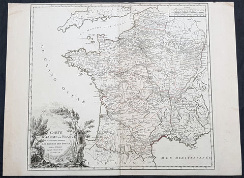
1758 Robert De Vaugondy Large Antique Map of France and Postal Roads
- Title : Carte Du Royame de France ou sont tracees exactement Les Routes Des Postes...1758
- Size: 25 1/2in x 19 1/2in (650mm x 495mm)
- Condition: (A) Very Good Condition
- Date : 1758
- Ref #: 15819
Description:
This large original hand coloured, antique map of France and the postal roads of the day was engraved in 1758 - the date is engraved in the title cartouche - and published by Robert Du Vaugondy in his Atlas Universal, Paris 1757.
General Definitions:
Paper thickness and quality: - Heavy and stable
Paper color : - off white
Age of map color: - Original
Colors used: - Yellow, green, pink
General color appearance: - Authentic
Paper size: - 25 1/2in x 19 1/2in (650mm x 495mm)
Plate size: - 21in x 19 1/2in (535mm x 495mm)
Margins: - Min 1/4in (5mm)
Imperfections:
Margins: - Light age toning
Plate area: - None
Verso: - None
Background:
The Carolingian dynasty ruled France until 987, when Hugh Capet, Duke of France and Count of Paris, was crowned King of the Franks. His descendants—the Capetians, the House of Valois, and the House of Bourbon—progressively unified the country through wars and dynastic inheritance into the Kingdom of France, which was fully declared in 1190 by Philip II Augustus. The French nobility played a prominent role in most Crusades in order to restore Christian access to the Holy Land. French knights made up the bulk of the steady flow of reinforcements throughout the two-hundred-year span of the Crusades, in such a fashion that the Arabs uniformly referred to the crusaders as Franj caring little whether they really came from France. The French Crusaders also imported the French language into the Levant, making French the base of the lingua franca (litt. Frankish language) of the Crusader states. French knights also made up the majority in both the Hospital and the Temple orders. The latter, in particular, held numerous properties throughout France and by the 13th century were the principal bankers for the French crown, until Philip IV annihilated the order in 1307. The Albigensian Crusade was launched in 1209 to eliminate the heretical Cathars in the southwestern area of modern-day France. In the end, the Cathars were exterminated and the autonomous County of Toulouse was annexed into the crown lands of France. Later kings expanded their domain to cover over half of modern continental France, including most of the north, centre and west of France. Meanwhile, the royal authority became more and more assertive, centred on a hierarchically conceived society distinguishing nobility, clergy, and commoners.
From the 11th century, the House of Plantagenet, the rulers of the County of Anjou, succeeded in establishing its dominion over the surrounding provinces of Maine and Touraine, then progressively built an empire that spanned from England to the Pyrenees and covering half of modern France. Tensions between the kingdom of France and the Plantagenet empire would last a hundred years, until Philip Augustus of France conquered between 1202 and 1214 most of the continental possessions of the empire, leaving England and Aquitaine to the Plantagenets. Following the Battle of Bouvines, the Angevin court retreated to England, but persistent Capetian–Plantagenet rivalry would paved the way for another conflict.
Charles IV the Fair died without an heir in 1328. Under the rules of the Salic law the crown of France could not pass to a woman nor could the line of kingship pass through the female line. Accordingly, the crown passed to Philip of Valois, a cousin of Charles, rather than through the female line to Charles nephew, Edward of Plantagenet, who would soon become Edward III of England. During the reign of Philip of Valois, the French monarchy reached the height of its medieval power. Philips seat on the throne was contested by Edward III of England and in 1337, on the eve of the first wave of the Black Death, England and France went to war in what would become known as the Hundred Years War. The exact boundaries changed greatly with time, but French landholdings of the English Kings remained extensive for decades. With charismatic leaders, such as Joan of Arc and La Hire, strong French counterattacks won back English continental territories. Like the rest of Europe, France was struck by the Black Death; half of the 17 million population of France died.
The French Renaissance saw a spectacular cultural development and the first standardisation of the French language, which would become the official language of France and the language of Europes aristocracy. It also saw a long set of wars, known as the Italian Wars, between France and the House of Habsburg. French explorers, such as Jacques Cartier or Samuel de Champlain, claimed lands in the Americas for France, paving the way for the expansion of the First French colonial empire. The rise of Protestantism in Europe led France to a civil war known as the French Wars of Religion, where, in the most notorious incident, thousands of Huguenots were murdered in the St. Bartholomews Day massacre of 1572. The Wars of Religion were ended by Henry IVs Edict of Nantes, which granted some freedom of religion to the Huguenots. Spanish troops, the terror of Western Europe, assisted the Catholic side during the Wars of Religion in 1589–1594, and invaded northern France in 1597; after some skirmishing in the 1620s and 1630s, Spain and France returned to all-out war between 1635 and 1659. The war cost France 300,000 casualties.
Under Louis XIII, the energetic Cardinal Richelieu promoted the centralisation of the state and reinforced the royal power by disarming domestic power holders in the 1620s. He systematically destroyed castles of defiant lords and denounced the use of private violence (dueling, carrying weapons, and maintaining private army). By the end of 1620s, Richelieu established the royal monopoly of force as the doctrine. During Louis XIVs minority and the regency of Queen Anne and Cardinal Mazarin, a period of trouble known as the Fronde occurred in France. This rebellion was driven by the great feudal lords and sovereign courts as a reaction to the rise of royal absolute power in France.
The monarchy reached its peak during the 17th century and the reign of Louis XIV. By turning powerful feudal lords into courtiers at the Palace of Versailles, Louis XIVs personal power became unchallenged. Remembered for his numerous wars, he made France the leading European power. France became the most populous country in Europe and had tremendous influence over European politics, economy, and culture. French became the most-used language in diplomacy, science, literature and international affairs, and remained so until the 20th century. France obtained many overseas possessions in the Americas, Africa and Asia. Louis XIV also revoked the Edict of Nantes, forcing thousands of Huguenots into exile.
Under Louis XV, Louis XIVs great-grandson, France lost New France and most of its Indian possessions after its defeat in the Seven Years War (1756–63). Its European territory kept growing, however, with notable acquisitions such as Lorraine (1766) and Corsica (1770). An unpopular king, Louis XVs weak rule, his ill-advised financial, political and military decisions – as well as the debauchery of his court– discredited the monarchy, which arguably paved the way for the French Revolution 15 years after his death.
Louis XVI, Louis XVs grandson, actively supported the Americans, who were seeking their independence from Great Britain (realised in the Treaty of Paris (1783)). The financial crisis aggravated by Frances involvement in the American Revolutionary War was one of many contributing factors to the French Revolution. Much of the Enlightenment occurred in French intellectual circles, and major scientific breakthroughs and inventions, such as the discovery of oxygen (1778) and the first hot air balloon carrying passengers (1783), were achieved by French scientists. French explorers, such as Bougainville and Lapérouse, took part in the voyages of scientific exploration through maritime expeditions around the globe. The Enlightenment philosophy, in which reason is advocated as the primary source for legitimacy and authority, undermined the power of and support for the monarchy and helped pave the way for the French Revolution.
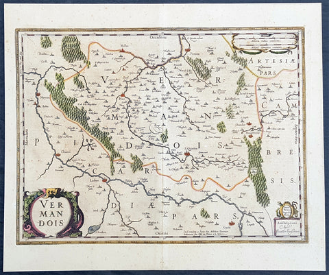
1646 Jan Jansson Antique Map the County of Vermandois, Picardy, Northern France
- Title : Vermandois
- Ref #: 50236
- Size: 21 1/2in x 18in (545mm x 460mm)
- Date : 1638
- Condition: (A+) Fine Condition
Description:
This beautifully hand coloured original copper-plate engraved antique map of the ancient county of Vermandois now located in the Picardy region of northern France, centering on the city of St Quentin by Jan Jansson was published in the 1638 Latin edition of Mercators Atlas by Jan Jansson and Henricus Hondius. (Ref: Tooley, Koeman)
General Definitions:
Paper thickness and quality: - Heavy and stable
Paper color : - off white
Age of map color: - Original
Colors used: - Yellow, green, blue, pink
General color appearance: - Authentic
Paper size: - 22in x 18in (560mm x 460mm)
Plate size: - 19in x 14 1/2in (480mm x 370mm)
Margins: - Min 2in (50mm)
Imperfections:
Margins: - Light age toning
Plate area: - Light age toning
Verso: - Light age toning
Background:
Vermandois was a French county that appeared in the Merovingian period. Its name derives from that of an ancient tribe, the Viromandui. In the 10th century, it was organised around two castellan domains: St Quentin (Aisne) and Péronne (Somme). In today\'s times, the Vermandois county would fall in the Picardy region of northern France.
Pepin I of Vermandois, the earliest of its hereditary counts, was descended in direct male line from the emperor Charlemagne. More famous was his grandson Herbert II (902–943), who considerably increased the territorial power of the house of Vermandois, and kept the lawful king of France, the unlucky Charles the Simple, prisoner for six years. Herbert II was son of Herbert I, lord of Péronne and St Quentin, who was killed in 902 by an assassin in the pay of Baldwin II, Count of Flanders. His successors, Albert I, Herbert III, Albert II, Otto and Herbert IV, were not as historically significant.
In 1077, the last count of the first house of Vermandois, Herbert IV, received the county of Valois through his wife. His son Eudes (II) the Insane was disinherited by the council of the Barons of France. He was lord of Saint-Simon through his wife, and the county was given to his sister Adela, whose first husband was Hugh the Great, the brother of King Philip I of France. Hugh was one of the leaders of the First Crusade, and died in 1102 at Tarsus in Cilicia. The eldest son of Hugh and Adela was count Raoul I (c. 1120–1152), who married Petronilla of Aquitaine, sister of the queen, Eleanor, and had by her three children: Raoul (Rudolph) II, the Leper (count from 1152–1167); Isabelle, who possessed from 1167 to 1183 the counties of Vermandois, Valois and Amiens conjointly with her husband, Philip, Count of Flanders; and Eleanor. By the terms of a treaty concluded in 1186 with the king, Philip Augustus, the count of Flanders kept the county of Vermandois until his death, in 1191. At this date, a new arrangement gave Eleanor (d. 1213) a life interest in the eastern part of Vermandois, together with the title of countess of St Quentin, and the king entered immediately into possession of Péronne and its dependencies

1649 Blaeu Antique Map View of Thérouanne, Tarwanna or Tervanna Northern France
- Title : Teroana morinorum metropolis olim, diruta a Carolo V. Anno 1553
- Ref #: Tav
- Size: 21 1/2in x 13in (545mm x 330mm)
- Date : 1649
- Condition: (A+) Fine Condition
Description:
This beautifully hand coloured original antique map a view of the city of Tarwanna or Tervanna (today the town of Thérouanne, France) the capital of the ancient Belgian tribe of the Morini, was published in the 1649 edition of John Blaeus Toonneel der Steeden (Views of Dutch Cities)
General Definitions:
Paper thickness and quality: - Heavy and stable
Paper color : - off white
Age of map color: - Original
Colors used: - Blue, pink, red, green, yellow
General color appearance: - Authentic
Paper size: - 21 1/2in x 13in (545mm x 330mm)
Plate size: - 10 1/2in x 7 1/2in (270mm x 190mm)
Margins: - Min 1in (25mm)
Imperfections:
Margins: - None
Plate area: - None
Verso: - None
Thérouanne is a commune in the Pas-de-Calais department in the Nord-Pas-de-Calais region of France. At the time of the Gauls, Tarwanna or Tervanna was the capital of the Belgian tribe of the Morini. After the Romans conquered Gaul, they too made the city the capital of the Civitas Morinorum district.
In the 7th century, probably around 639, Saint Audomar (Saint Omer) established the bishopric of Terwaan or Terenburg, the diocese of Thérouanne, which during the Middle Ages controlled a large part of the left bank of the river Scheldt. Territorially it was part of the county of Artois which belonged to the county of Flanders.
Thanks to that ecclesiastical control of some of the most prosperous cities north of the Alps, like Arras and Ypres, the bishopric was able to build a cathedral which was at the time the largest in France.
The town was captured by the Emperor Maximilian and Henry VIII from the French in 1513 after the battle of the Spurs. In 1553 Charles V besieged Thérouanne, then a French enclave in the Holy Roman Empire, in revenge for a defeat by the French at the siege of Metz. After he captured the city he ordered it to be razed, the roads to be broken up, and the area to be ploughed and salted Only a small commune which lay outside the city walls, then named Saint-Martin-Outre-Eaux, was left standing, and later (probably around 1800) took over the name Thérouanne. (Ref: Koeman; M&B)
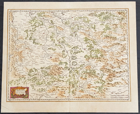
1638 Joducus Hondius Antique Map of the Lorraine Region of NE France - Grand Est
- Title : Lorraine Vers Le Midy
- Ref #: 50250
- Size: 21 1/2in x 17 1/2in (545mm x 445mm)
- Date : 1638
- Condition: (A) Very Good Condition
Description:
This beautifully hand coloured original antique map of the ancient Lorraine region of France - centering on the Moselle River with the city of Nancy to the north Faucogney-et-la-Mer to the south & the Meuse River to the west - by Gerard Mercator was published by Jodocus Hondius in the 1638 edition of Mercators Atlas.
General Definitions:
Paper thickness and quality: - Heavy and stable
Paper color : - off white
Age of map color: - Original
Colors used: - Yellow, green, blue, pink
General color appearance: - Authentic
Paper size: - 21 1/2in x 17 1/2in (545mm x 445mm)
Plate size: - 19 1/2in x 15 1/2in (500mm x 395mm)
Margins: - Min 1/2in (12mm)
Imperfections:
Margins: - Light age toning
Plate area: - None
Verso: - Light age toning
Background:
Lorraine is a cultural and historical region in north-eastern France, now located in the administrative region of Grand Est. Lorraines name stems from the medieval kingdom of Lotharingia, which in turn was named for either Emperor Lothair I or King Lothair II. It later was ruled as the Duchy of Lorraine before the Kingdom of France annexed it in 1766.
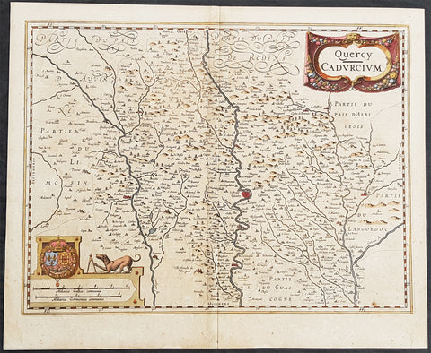
1628 Henricus Hondius Antique Map The Province of Quercy, Lot, Cahors, SW France
- Title : Quercy - Cadurcium
- Ref #: 26140
- Size: 21 1/2in x 17 1/2in (490mm x 340mm)
- Date : 1628
- Condition: (A) Very Good Condition
Description:
This beautifully hand coloured original copper-plate engraved antique map of the ancient province of Quercy located in southwest France - centering on the city of Cahors & the River Lot - was published in the 1628 French edition of Mercators Atlas by Henricus Hondius and Jan Jansson.
General Definitions:
Paper thickness and quality: - Heavy and stable
Paper color : - off white
Age of map color: - Original
Colors used: - Yellow, green, blue, pink
General color appearance: - Authentic
Paper size: - 21 1/2in x 17 1/2in (490mm x 340mm)
Plate size: - 20in x 15in (510mm x 380mm)
Margins: - Min 1/2in (12mm)
Imperfections:
Margins: - Light age toning
Plate area: - Age toning along centerfold
Verso: - Age toning along centerfold
Background:
Quercy is a former province of France located in the countrys southwest, bounded on the north by Limousin, on the west by Périgord and Agenais, on the south by Gascony and Languedoc, and on the east by Rouergue and Auvergne.
Under the Romans Quercy was part of Aquitania prima, and Christianity was introduced during the 4th century. Early in the 6th century it fell under the authority of the Franks, and in the 7th century became part of the autonomous Duchy of Aquitaine. At the end of the 10th century its rulers were the powerful counts of Toulouse. During the wars between England and France in the reign of Henry II, the English placed garrisons in the county, and by the 1259 Treaty of Paris lower Quercy was ceded to England. The monarchs of both England and France confirmed and added to the privileges of the towns and the district, each thus hoping to attach the inhabitants to his own interest. In 1360, by the Treaty of Bretigny, the whole county passed to England, but in 1440 the English were finally expelled. In the 16th century Quercy was a stronghold of the Protestants, and the scene of a savage religious warfare. The civil wars of the reign of Louis XIII largely took place around Montauban.
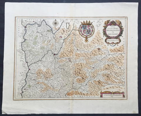
1638 Jansson Old, Antique Map of the Dauphine Region of France, Grenoble
- Title : Nova et acurrata Descriptio Delphinatus vulgo Dauphine
- Ref #: 50244
- Size: 24in x 20in (610mm x 510mm)
- Date : 1638
- Condition: (A+) Fine Condition
Description:
This fine large beautifully hand coloured original antique map* of the Dauphine region of southern France - centering on the city of Grenoble - with the Rhone River to the west and north with Savoy & Piedmont to the east was published by Jan Jansson in the 1638 edition ofAtlas Novus. (Ref Tooley M&B)
General Description:
Paper thickness and quality: - Heavy and stable
Paper color: - off white
Age of map color: - Original
Colors used: - Green, red, orange, yellow, blue
General color appearance: - Authentic
Paper size: - 24in x 20in (610mm x 510mm)
Plate size: - 20 1/2in x 15 1/4in (520mm x 390mm)
Margins: - Min 1in (25mm)
Imperfections:
Margins: - None
Plate area: - None
Verso: - None
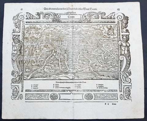
1574 Munster Large Antique Print View of The French City of Tours
- Title : Die Statt Tours
- Ref #: 22614
- Size: 16in x 13in (410mm x 330mm)
- Date : 1574
- Condition: (A+) Fine Condition
Description:
This large finely engraved original antique print a view of the French city of Tours was published by Sebastian Munster in the 1574 edition of Cosmographia.
Tours is a city located in the centre-west of France. It is the administrative centre of the Indre-et-Loire department and the largest city in the Centre-Val de Loire region of France (although it is not the capital, which is the region's second-largest city, Orléans). Tours stands on the lower reaches of the River Loire, between Orléans and the Atlantic coast. The surrounding district, the traditional province of Touraine, is known for its wines, for the alleged perfection (as perceived by some speakers) of its local spoken French, and for the Battle of Tours (732).
Background: For a variety of reasons town plans were comparatively latecomers in the long history of cartography. Few cities in Europe in the middle ages had more than 20,00 inhabitants and even London in the late Elizabethan period had only 100-150,000 people which in itself was probably 10 times that of any other English city. The Nuremberg Chronicle in 1493 included one of the first town views of Jerusalem, thereafter, for most of the sixteenth century, German cartographers led the way in producing town plans in a modern sense. In 1544 Sebastian Munster issued in Basle hisCosmographia containing roughly sixty-six plans and views, some in the plan form, but many in the old panorama or birds eye view.
Sebastian Münster (1488-1552) was a German cartographer, cosmographer, and Hebrew scholar whose work Cosmographia (1544; "Cosmography") was the earliest German description of the world and a major work in the revival of geographic thought in 16th-century Europe. It had numerous editions in different languages including Latin, French, Italian, English, and even Czech. Altogether, about 40 editions of the Cosmographiaappeared between 1544 and 1628 and was one of the most successful and popular books of the 16th century. Münster was a major influence in popular thinking in Europe for the next 200 years.
This success was due not only to the level of descriptive detail but also to the fascinating full page maps & views as well as smaller woodcuts that were included in the text. Many of the woodcuts were executed by famous engravers of the time including Hans Holbein the Younger, Urs Graf, Hans Rudolph Manuel Deutsch, and David Kandel.
Aside from the well-known maps present in the Cosmographia, the text is thickly sprinkled with vigorous views: portraits of kings and princes, costumes and occupations, habits and customs, flora and fauna, monsters, wonders, and horrors about the known -- and unknown -- world, and was undoubtedly one of the most widely read books of its time.
Münster acquired the material for his book in three ways. Firstly he researched all available literary sources across Germany, Switzerland and other parts of Europe. Secondly he obtained original manuscript material from locals all over Europe for description of the countryside, cities, villages, towns, rivers and local history. Finally, he obtained further material first hand on his travels (primarily in south-west Germany, Switzerland, and Alsace).
In 1588 Sebastian Petri re-released Cosomgraphia and re-issued many of Munsters maps and views in the "copperplate style". The maps in this release were more sophisticated than with earlier publications ofCosomgraphia and were based on the 1570 release of Abraham Ortelius monumental work Theatrum Orbis Terrarum.(Ref: Tooley; M&B)
General Description:
Paper thickness and quality: - Light and stable
Paper color: - off white
Age of map color: -
Colors used: -
General color appearance: -
Paper size: - 16in x 13in (410mm x 330mm)
Plate size: - 16in x 13in (410mm x 330mm)
Margins: - 1/2in (12mm)
Imperfections:
Margins: - None
Plate area: -None
Verso: - None
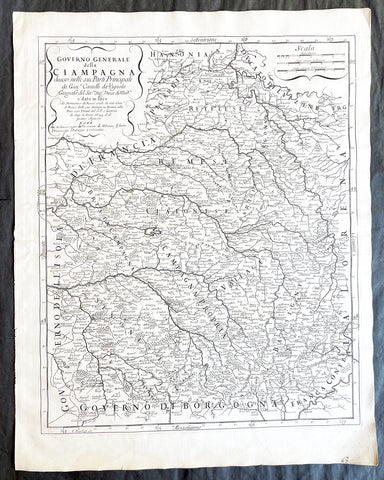
1695 De Rossi Large Old, Antique Map of The Champagne Region of France
- Title : Governo generale della Ciampagna diviso nelle sue Parti Principali; da Giaco. Cantelli da Vignola geografo del Sermo Sigr. Duca di Moda.; e dato in luce da Domenico de Rossi erede di Gio. Giaco. de Rossi dalle sue Stampe in Roma alla Pace, con Privil. del S.P. e licenza de Sup. l'Anno 1695
- Ref #: 50224
- Size: 24in x 18 1/2in (610mm x 470mm)
- Date : 1695
- Condition: (A+) Fine Condition
Description:
This very large, beautifully engraved original antique map of the Champagne Region of France by Giovanni Giacomo de Rossi, (1627-1691) in 1695 - dated in title - and was published by Domenico de Rossi in his monumental Atlas Mercurio Geografico overo Guida Geografica in tutte le parti del Mondo.
Background: A fine example of De Rossi's atlas map, similar to Coronelli's maps of the same period, with engraved decorative title. The atlas included 150 engraved outline hand colored maps with decorative title cartouche, on 181 sheets. Maps are dated between 1669 and 1715, issued by Giov. Giac. de Rossi and Domenico de Rossi, they are mainly derived from Cantelli da Vignola's maps, an important seventeenth-century cartographer who pioneered the Italian style of fine bold engraving that would eventually be embraced and expanded upon by Vincenzo Coronelli, and Nicolas Sanson (1600 – 1667) a French cartographer, termed by some the creator of French geography.
Many of the maps were engraved by Baudrand, Franciscus Donia, G.B. Falda, Jean Lhuilier, Vin Mariotti, Gasparo Pietro Santa, Salomon Rogiers, & Giorgio Widman, Lubin, Titi, Ameti, Magini and Mattei.
Giovanni Giacomo De Rossi (1627 - 1691) was an Italian printer and publisher active in 17th century Rome. Giovanni inherited the important Rome based printing business originally founded by his father, Giuseppe de Rossi (1570-1639). By the mid-17th century the Rossi firm was considered the most active and important press in Rome. (Ref Tooley M&B)
General Description:
Paper thickness and quality: - Heavy and stable
Paper color: - off white
Age of map color: -
Colors used: -
General color appearance: -
Paper size: - 24in x 18 1/2in (610mm x 470mm)
Plate size: - 20 3/4in x 16 3/4in (525mm x 425mm)
Margins: - Min 1in (25mm)
Imperfections:
Margins: - None
Plate area: - None
Verso: - None
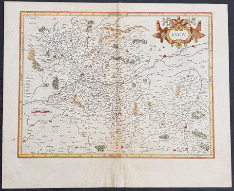
1628 Henricus Hondius Antique Map of the Duchy of Anjou, Maine-et-Loire, France
- Title : Aniov
- Date : 1628
- Size: 21in x 17in (535mm x 430mm)
- Ref #: 26135
- Condition: (A) Very Good Condition
Description:
This beautifully hand coloured original copper-plate engraved antique map of the French region of the historical province of Anjou (today a greater part of the Maine-et-Loire dept.) centering on the city of Angers & the Loire River was published in the 1628 French edition of Mercators Atlas by Henricus Hondius and Jan Jansson.
General Definitions:
Paper thickness and quality: - Heavy and stable
Paper color : - off white
Age of map color: - Original
Colors used: - Yellow, green, blue, pink
General color appearance: - Authentic
Paper size: - 21in x 17in (535mm x 430mm)
Plate size: - 18in x 14in (460mm x 360mm)
Margins: - Min 1/2in (12mm)
Imperfections:
Margins: - None
Plate area: - Age toning along centerfold
Verso: - Age toning along centerfold
Background:
Anjou is a historical province of France straddling the lower Loire River. Its capital was Angers and it was roughly coextensive with the diocese of Angers. It bordered Brittany to the west, Maine to the north, Touraine to the east and Poitou to the south. The adjectival form of Anjou is Angevin and inhabitants of Anjou are known as Angevins. During the Middle Ages, the county of Anjou was a prominent fief of the French crown.
The region takes its name from the Celtic tribe of the Andecavi, who submitted to Roman rule following the Gallic Wars. Under the Romans, the chief fortified settlement of the Andecavi became the city of Juliomagus, the future Angers. The territory of the Andecavi was organized as a civitas (called the civitas Andegavensis or civitas Andegavorum).
Under the Franks, the city of Juliomagus took the name of the ancient tribe and became Angers. Under the Merovingians, the history of Anjou is obscure. It is not recorded as a county (comitatus) until the time of the Carolingians. In the late ninth and early tenth centuries the viscounts (representatives of the counts) usurped comital authority and made Anjou an autonomous hereditary principality. The first dynasty of counts of Anjou, the House of Ingelger, ruled continuously down to 1205. In 1131, Count Fulk V became the King of Jerusalem; then in 1154, his grandson, Henry \'Curtmantle\' became King of England. The territories ruled by Henry and his successors, which stretched from Ireland to the Pyrenees, are often called the Angevin Empire. This empire was broken up by the French king Philip II, who confiscated the dynasty\'s French lands, including Anjou in 1205.
The county of Anjou was united to the royal domain between 1205 and 1246, when it was turned into an apanage for the king\'s brother, Charles I of Anjou. This second Angevin dynasty, a branch of the Capetian dynasty, established itself on the throne of Naples and Hungary. Anjou itself was united to the royal domain again in 1328, but was detached in 1360 as the Duchy of Anjou for the king\'s son, Louis I of Anjou. The third Angevin dynasty, a branch of the House of Valois, also ruled for a time the Kingdom of Naples. The dukes had the same autonomy as the earlier counts, but the duchy was increasingly administered in the same fashion as the royal domain and the royal government often exercised the ducal power while the dukes were away. When the Valois line failed and Anjou was incorporated into the royal domain again in 1480, there was little change on the ground. Anjou remained a province of crown until the French Revolution (1790), when the provinces were reorganized.
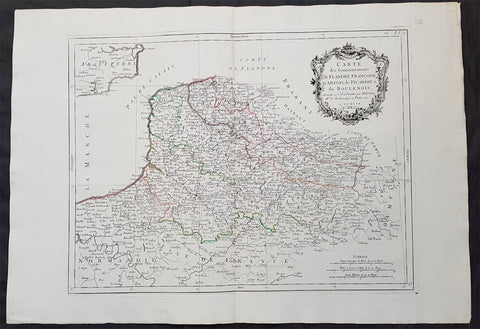
1777 F. Santini Antique Map Flanders Artois Hainaut Picardy Regions of Belgium
- Title : Carte Des Gouvernements de Flandre Francois d Artois de Picardie et du Boulenois...P Santini...1777
- Size: 30in x 21in (760mm x 535mm)
- Condition: (A+) Fine Condition
- Date : 1777
- Ref #: 50221
Description:
This large magnificent original copper-plate engraved antique map of Belgium and parts of Northern France made up of the provinces of Flanders, Artois, Hainaut, Picardy was engraved in 1777 - the date is engraved in the title cartouche - after Rigobert Bonne in 1771 and was published by Francois Santini (active 1776-84) in his 2 volume edition of Atlas Universal 1776-84.. (Ref: Tooley; M&B)
General Definitions:
Paper thickness and quality: - Heavy and stable
Paper color : - off white
Age of map color: - Original
Colors used: - Blue, pink, red, green, yellow
General color appearance: - Authentic
Paper size: - 30in x 21in (760mm x 535mm)
Plate size: - 23in x 18in (585mm x 460mm)
Margins: - Min 2in (50mm)
Imperfections:
Margins: - None
Plate area: - None
Verso: - None
Background:
Belgium officially the Kingdom of Belgium, is a country in Western Europe bordered by France, the Netherlands, Germany and Luxembourg.
Historically, Belgium was part of an area known as the Low Countries, a somewhat larger region than the current Benelux group of states that also included parts of northern France and western Germany. Its name is derived from the Latin word Belgica, after the Roman province of Gallia Belgica. From the end of the Middle Ages until the 17th century, the area of Belgium was a prosperous and cosmopolitan centre of commerce and culture. Between the 16th and early 19th centuries, Belgium served as the battleground between many European powers, earning the moniker the Battlefield of Europe, a reputation strengthened by both world wars. The country emerged in 1830 following the Belgian Revolution when it seceded from the Netherlands.
The Eighty Years War (1568–1648) divided the Low Countries into the northern United Provinces (Belgica Foederata in Latin, the Federated Netherlands) and the Southern Netherlands (Belgica Regia, the Royal Netherlands). The latter were ruled successively by the Spanish (Spanish Netherlands) and the Austrian Habsburgs (Austrian Netherlands) and comprised most of modern Belgium. This was the theatre of most Franco-Spanish and Franco-Austrian wars during the 17th and 18th centuries.
Following the campaigns of 1794 in the French Revolutionary Wars, the Low Countries—including territories that were never nominally under Habsburg rule, such as the Prince-Bishopric of Liège—were annexed by the French First Republic, ending Austrian rule in the region. The reunification of the Low Countries as the United Kingdom of the Netherlands occurred at the dissolution of the First French Empire in 1815, after the defeat of Napoleon.
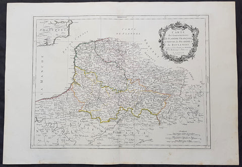
1777 F. Santini Antique Map Flanders Artois Hainaut Picardy Regions of Belgium
- Title : Carte Des Gouvernements de Flandre Francois d Artois de Picardie et du Boulenois...P Santini...1777
- Size: 30in x 21in (760mm x 535mm)
- Condition: (A+) Fine Condition
- Date : 1777
- Ref #: 50219
Description:
This large magnificent original copper-plate engraved antique map of Belgium and parts of Northern France made up of the provinces of Flanders, Artois, Hainaut, Picardy was engraved in 1777 - the date is engraved in the title cartouche - after Rigobert Bonne in 1771 and was published by Francois Santini (active 1776-84) in his 2 volume edition of Atlas Universal 1776-84.. (Ref: Tooley; M&B)
General Definitions:
Paper thickness and quality: - Heavy and stable
Paper color : - off white
Age of map color: - Original
Colors used: - Blue, pink, red, green, yellow
General color appearance: - Authentic
Paper size: - 30in x 21in (760mm x 535mm)
Plate size: - 23in x 18in (585mm x 460mm)
Margins: - Min 2in (50mm)
Imperfections:
Margins: - None
Plate area: - None
Verso: - None
Background:
Belgium officially the Kingdom of Belgium, is a country in Western Europe bordered by France, the Netherlands, Germany and Luxembourg.
Historically, Belgium was part of an area known as the Low Countries, a somewhat larger region than the current Benelux group of states that also included parts of northern France and western Germany. Its name is derived from the Latin word Belgica, after the Roman province of Gallia Belgica. From the end of the Middle Ages until the 17th century, the area of Belgium was a prosperous and cosmopolitan centre of commerce and culture. Between the 16th and early 19th centuries, Belgium served as the battleground between many European powers, earning the moniker the Battlefield of Europe, a reputation strengthened by both world wars. The country emerged in 1830 following the Belgian Revolution when it seceded from the Netherlands.
The Eighty Years War (1568–1648) divided the Low Countries into the northern United Provinces (Belgica Foederata in Latin, the Federated Netherlands) and the Southern Netherlands (Belgica Regia, the Royal Netherlands). The latter were ruled successively by the Spanish (Spanish Netherlands) and the Austrian Habsburgs (Austrian Netherlands) and comprised most of modern Belgium. This was the theatre of most Franco-Spanish and Franco-Austrian wars during the 17th and 18th centuries.
Following the campaigns of 1794 in the French Revolutionary Wars, the Low Countries—including territories that were never nominally under Habsburg rule, such as the Prince-Bishopric of Liège—were annexed by the French First Republic, ending Austrian rule in the region. The reunification of the Low Countries as the United Kingdom of the Netherlands occurred at the dissolution of the First French Empire in 1815, after the defeat of Napoleon.

1574 Sebastian Munster Antique Map Birds Eye View of the City of Tours, France
- Title : Die Statt Tours
- Ref #: 22614
- Size: 16in x 13in (410mm x 330mm)
- Date : 1574
- Condition: (A+) Fine Condition
Description:
This fine original wood block engraved antique map a birds eye view of the French city of Tours, France was published in the French Section of Sebastian Munsters 1574 edition of Cosmographia, Das ist: Beschreibung der gantzen Welt, Darinnen Aller Monarchien Keyserthumben, Königreichen, Fürstenthumben, Graff- und Herrschafften, Länderen, Stätten und Gemeinden.Ursprung (Cosmographia, that is: description of the whole world, in it all monarchies Keyser thumben, kingdoms, prince thumben, graff and herrschafften, countries, places and municipalities.)
Tours is a city in the centre-west of France. It is the administrative centre of the Indre-et-Loire department and the largest city in the Centre-Val de Loire region of France
General Definitions:
Paper thickness and quality: - Heavy and stable
Paper color : - off white
Age of map color: -
Colors used: -
General color appearance: -
Paper size: - 16in x 13in (410mm x 330mm)
Plate size: - 16in x 13in (410mm x 330mm)
Margins: - Min 1in (25mm)
Imperfections:
Margins: - None
Plate area: - None
Verso: - None
Background:
Cosmographia, Das ist: Beschreibung der gantzen Welt, Darinnen Aller Monarchien Keyserthumben, Königreichen, Fürstenthumben, Graff- und Herrschafften, Länderen, Stätten und Gemeinden.Ursprung, Regiment, Reichthumb, Gewalt und.Beschaffenheit. Dessgleichen Aller deren, beyder Ständen, Regenten: Keysern, Königen, Bäpsten, Bischoffen.Genealogien und Stammbäumen.zusammen getragen. by Sebastian Münster was first published in 1544 and is the earliest German-language description of the world. It had numerous editions in different languages including Latin, French (translated by François de Belleforest), Italian, English, and Czech. The last German edition was published in 1628, long after Munsters death. The Cosmographia was one of the most successful and popular books of the 16th century. It passed through 24 editions in 100 years. This success was due to the notable woodcuts (some by Hans Holbein the Younger, Urs Graf, Hans Rudolph Manuel Deutsch, and David Kandel). It was most important in reviving geography in 16th-century Europe. Among the notable maps within Cosmographia is the map Tabula novarum insularum, which is credited as the first map to show the American continents as geographically discrete.
Munsters earlier geographic works were Germania descriptio (1530) and Mappa Europae (1536). In 1540, he published a Latin edition of Ptolemys Geographia with illustrations.
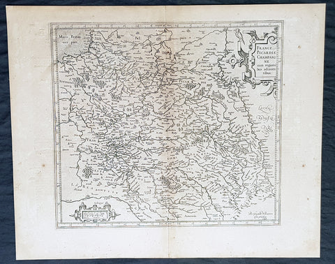
1628 Gerard Mercator & Henricus Hondius Antique Map the Picardy Region of France
- Title : France Picardie Champagne cum regionibus adiacentibus
- Size: 21in x 17in (530mm x 430mm)
- Condition: (A) Very Good Condition
- Date : 1628
- Ref #: 26131
Description:
This original copper plate engraved antique map of the French region of Picardy or Picardie by Gerard Mercator was published by Henricus Hondius in the early 1628 French edition of Gerard Mercators Atlas.
These maps, published in the early editions of Mercators atlas, are the original maps drawn and engraved by Gerald Mercator in the mid to late 16th century, published by his son Rumold as an atlas, after his death, in 1595. After two editions the plates were purchased by Jodocus Hondius in 1604, and continued to be published until the end of the 1630s by Henricus Hondius, when some of the plates were re-engraved and updated with the help of Jan Jansson.
General Definitions:
Paper thickness and quality: - Heavy and stable
Paper color : - off white
Age of map color: -
Colors used: -
General color appearance: -
Paper size: - 21in x 17in (530mm x 430mm)
Plate size: - 18 1/2in x 14in (475mm x 350mm)
Margins: - Min 1/2in (12mm)
Imperfections:
Margins: - Light age toning
Plate area: - Light toning along centerfold
Verso: - Light age toning
Background:
Picardy is a historical territory and a former administrative region of Northern France and now part of the new region Nord-Pas-de-Calais-Picardie.
From the 5th century the area was part of the Frankish Empire, and in the feudal period it encompassed the six countships of Boulogne, Montreuil, Ponthieu, Amiénois,Vermandois, and Laonnois. According to the 843 Treaty of Verdun the region became part of West Francia, the later Kingdom of France.
The name Picardy (which may have referred to a Frankish tribe of picards or pike-bearers) was not used until the 12th or 13th century. During this time, the name applied to all lands where the Picard language was spoken, which included all the territories from Paris to the Netherlands. In the Latin Quarter of Paris, people identified a Picard Nation (Nation Picarde) of students at Sorbonne University, most of whom actually came from Flanders. During the Hundred Years\\\' War, Picardy was the centre of the Jacquerie peasant revolt in 1358.
From 1419 onwards, the Picardy counties (Boulogne, Ponthieu, Amiens, Vermandois) were gradually acquired by the Burgundian duke Philip the Good, confirmed by King Charles VII of France at the 1435 Congress of Arras. In 1477, King Louis XI of France led an army and occupied key towns in Picardy. By the end of 1477, Louis would control all of Picardy and most of Artois.
In the 16th century, the government (military region) of Picardy was created. This became a new administrative region of France, separate from what was historically defined as Picardy. The new Picardy included the Somme département, the northern half of the Aisne département, and a small fringe in the north of the Oise département.
In 1557, Picardy was invaded by Hapbsburg forces under the command of Emmanuel Philibert, Duke of Savoy. After a seventeen-day siege, St. Quentin would be ransacked while Noyon would be burned by the Habsburg army.
In the 17th century, an infectious disease similar to English sweat originated from the region and spread across France. It was called Suette des picards or Picardy sweat.
Sugar beet was introduced by Napoleon I during the Napoleonic Wars in the 19th century, in order to counter the United Kingdom, which had seized the sugar islands possessed by France in the Caribbean. The sugar industry has continued to play a prominent role in the economy of the region.
One of the most significant historical events to occur in Picardy was the series of battles fought along the Somme during World War I. From September 1914 to August 1918, four major battles, including the Battle of the Somme, were fought by British, French, and German forces in the fields of Northern Picardy. (Ref: Koeman; M&B; Tooley)
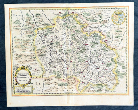
1628 Gerard Mercator & Henricus Hondius Antique Map Bourbonnais Region of France
- Title : Boubonoius; Borbonium Ducatus....
- Size: 21in x 17in (530mm x 430mm)
- Condition: (A) Very Good Condition
- Date : 1628
- Ref #: 26138
Description:
This original copper plate engraved antique map of the Bourbon or Bourbonnais Region of central France by Gerard Mercator was published by Henricus Hondius in the early 1628 French edition of Gerard Mercators Atlas.
These maps, published in the early editions of Mercators atlas, are the original maps drawn and engraved by Gerald Mercator in the mid to late 16th century, published by his son Rumold as an atlas, after his death, in 1595. After two editions the plates were purchased by Jodocus Hondius in 1604, and continued to be published until the end of the 1630s by Henricus Hondius, when some of the plates were re-engraved and updated with the help of Jan Jansson.
General Definitions:
Paper thickness and quality: - Heavy and stable
Paper color : - off white
Age of map color: - Early
Colors used: - Green, yellow, blue, red, orange
General color appearance: - Authentic
Paper size: - 21in x 17in (530mm x 430mm)
Plate size: - 18 1/2in x 14in (475mm x 350mm)
Margins: - Min 1/2in (12mm)
Imperfections:
Margins: - Light age toning
Plate area: - Light toning along centerfold
Verso: - Light age toning
Background:
Bourbonnais was a historic province in the centre of France that corresponded to the modern département of Allier, along with part of the département of Cher. Its capital was Moulins.
The title of the ruler of Bourbonnais between 913 and 1327, was Sire de Bourbon (or Seigneur de Bourbon). The first lord of Bourbonnais known by name was Adhémar (or Aymon I of Bourbon). Aymon\\\'s father was Aymar (894-953), sire of Souvigny, his only son with Ermengarde.Aymar lived during the reign of Charles the Simple who, in 913, gave him fiefs on the Allier River in which would become Bourbonnais. He acquired the castle of Bourbon (today Bourbon-l\\\'Archambault). Almost all early lords took the name d\\\'Archambaud, after the palace, but later the family became known as the \\\"House of Bourbon\\\".
The first House of Bourbon ended in 1196, with the death of Archambault VII, who had only one heir, Mathilde of Bourbon. She married Guy II of Dampierre, who added Montlucon to the possessions of the lords of Bourbon. The second house of Bourbon started in 1218, with Archambault VIII, son of Guy II and Mahaut, and brother of William II of Dampierre. He was followed by his son Archambaut IX, who died in Cyprus in 1249, during a crusade. The House of Burgundy then acquired Bourbonnais.
In 1272, Beatrice of Burgundy (1258-1310), Lady of Bourbon, married Robert de France (1256-1318), Count of Clermont, son of king Louis IX (Saint-Louis). Thus began the long-lasting House of Bourbon, which would provide the kings of France from Henry IV to Louis-Phillipe in 1848, when France abolished its monarchy.
The Bourbons had concluded an alliance with the royal power. They put their forces at the service of the king, thus benefitting from the geographic position of Bourbonnais, located between the royal fidemesne and the duchies of Aquitaine and Auvergne. This alliance, as well as the marriage of Béatrix de Bourgogne and Robert de France, aided the rise and prosperity of the province. In 1327, King Charles (le Bel) elevated Boubonnais to the status of a duchy. (Ref: Koeman; M&B; Tooley)
1628 Gerard Mercator & Henricus Hondius Antique Map of Beauvais Region, France
- Title : Beauvaisis Comitatus Belovacium
- Size: 21in x 17in (530mm x 430mm)
- Condition: (A) Very Good Condition
- Date : 1628
- Ref #: 26136
Description:
This original copper plate engraved antique map of the Beauvais region of Northern France - centering on the city of Beauvais & the Oise River running through the cities of Noyon, Compiègne, Creil by Gerard Mercator was published by Henricus Hondius in the early 1628 French edition of Gerard Mercators Atlas.
These maps, published in the early editions of Mercators atlas, are the original maps drawn and engraved by Gerald Mercator in the mid to late 16th century, published by his son Rumold as an atlas, after his death, in 1595. After two editions the plates were purchased by Jodocus Hondius in 1604, and continued to be published until the end of the 1630s by Henricus Hondius, when some of the plates were re-engraved and updated with the help of Jan Jansson.
General Definitions:
Paper thickness and quality: - Heavy and stable
Paper color : - off white
Age of map color: - Early
Colors used: - Greeen, yellow, blue, pink
General color appearance: - Authentic
Paper size: - 21in x 17in (530mm x 430mm)
Plate size: - 18 1/2in x 14in (475mm x 350mm)
Margins: - Min 1/2in (12mm)
Imperfections:
Margins: - Light age toning
Plate area: - Light toning along centerfold
Verso: - Light age toning
Background:
Beauvais is a city and commune in northern France. It serves as the capital of the Oise département, in the Hauts-de-France region. Beauvais is located approximately 75 kilometres from Paris.
Beauvais was known to the Romans by the Gallo-Roman name of Caesaromagus (magos is Common Celtic for field). The post-Renaissance Latin rendering is Bellovacum from the Belgic tribe the Bellovaci, whose capital it was. In the ninth century it became a countship, which about 1013 passed to the bishops of Beauvais, who became peers of France from the twelfth century. At the coronations of kings the Bishop of Beauvais wore the royal mantle and went, with the Bishop of Langres, to raise the king from his throne to present him to the people.
De Bello Gallico II 13 reports that as Julius Caesar was approaching a fortified town called Bratuspantium in the land of the Bellovaci, its inhabitants surrendered to him when he was about 5 Roman miles away. Its name is Gaulish for place where judgements are made, from *bratu-spantion. Some say that Bratuspantium is Beauvais. Others theorize that it is Vendeuil-Caply or Bailleul sur Thérain.
From 1004 to 1037, the Count of Beauvais was Odo II, Count of Blois.
In a charter dated 1056/1060, Eudo of Brittany granted land in pago Belvacensi (Beauvais, Picardy) to the Abbey of Angers Saint-Aubin
In 1346 the town had to defend itself against the English, who again besieged it in 1433. The siege which it endured in 1472 at the hands of the Duke of Burgundy, was rendered famous by the heroism of the towns women, under the leadership of Jeanne Hachette, whose memory is still celebrated by a procession on 27 June (the feast of Sainte Angadrême), during which women take precedence over men.
An interesting hoard of coins from the High Middle Ages became known as the Beauvais Hoard, because some of the British and European coins found with the lot were from the French abbey located in Beauvais. The hoard, which contained a variety of rare and extremely rare Anglo-Norman pennies, English and foreign coins, was reputed to have been found in or near Paris.
1628 Jan Jansson Antique Map of the Picardy or Picardie Region of France
- Title : Picardia
- Size: 22in x 17in (560mm x 430mm)
- Condition: (A) Very Good Condition
- Date : 1628
- Ref #: 26133
Description:
This original copper plate engraved antique map of the French region of Picardy or Picardie by Jan Jansson was published in the early 1628 French edition of Janssons Atlas.
General Definitions:
Paper thickness and quality: - Heavy and stable
Paper color : - off white
Age of map color: -
Colors used: -
General color appearance: -
Paper size: - 22in x 17in (560mm x 430mm)
Plate size: - 20in x 15in (510mm x 380mm)
Margins: - Min 1/2in (12mm)
Imperfections:
Margins: - Age toning
Plate area: - Age toning
Verso: - Age toning
Background:
Picardy is a historical territory and a former administrative region of Northern France and now part of the new region Nord-Pas-de-Calais-Picardie.
From the 5th century the area was part of the Frankish Empire, and in the feudal period it encompassed the six countships of Boulogne, Montreuil, Ponthieu, Amiénois,Vermandois, and Laonnois. According to the 843 Treaty of Verdun the region became part of West Francia, the later Kingdom of France.
The name Picardy (which may have referred to a Frankish tribe of picards or pike-bearers) was not used until the 12th or 13th century. During this time, the name applied to all lands where the Picard language was spoken, which included all the territories from Paris to the Netherlands. In the Latin Quarter of Paris, people identified a Picard Nation (Nation Picarde) of students at Sorbonne University, most of whom actually came from Flanders. During the Hundred Years\\\\\\\' War, Picardy was the centre of the Jacquerie peasant revolt in 1358.
From 1419 onwards, the Picardy counties (Boulogne, Ponthieu, Amiens, Vermandois) were gradually acquired by the Burgundian duke Philip the Good, confirmed by King Charles VII of France at the 1435 Congress of Arras. In 1477, King Louis XI of France led an army and occupied key towns in Picardy. By the end of 1477, Louis would control all of Picardy and most of Artois.
In the 16th century, the government (military region) of Picardy was created. This became a new administrative region of France, separate from what was historically defined as Picardy. The new Picardy included the Somme département, the northern half of the Aisne département, and a small fringe in the north of the Oise département.
In 1557, Picardy was invaded by Hapbsburg forces under the command of Emmanuel Philibert, Duke of Savoy. After a seventeen-day siege, St. Quentin would be ransacked while Noyon would be burned by the Habsburg army.
In the 17th century, an infectious disease similar to English sweat originated from the region and spread across France. It was called Suette des picards or Picardy sweat.
Sugar beet was introduced by Napoleon I during the Napoleonic Wars in the 19th century, in order to counter the United Kingdom, which had seized the sugar islands possessed by France in the Caribbean. The sugar industry has continued to play a prominent role in the economy of the region.
One of the most significant historical events to occur in Picardy was the series of battles fought along the Somme during World War I. From September 1914 to August 1918, four major battles, including the Battle of the Somme, were fought by British, French, and German forces in the fields of Northern Picardy. (Ref: Koeman; M&B; Tooley)
1628 Gerard Mercator Antique Map of The Burgundy Region of France
- Title : Burgundia Ducatus
- Size: 21in x 17in (530mm x 430mm)
- Condition: (A) Very Good Condition
- Date : 1628
- Ref #: 26143
Description:
This original copper plate engraved antique map of of the historical region of the Free County of Burgundy (Franche Comte de Bourgogne) of eastern France by Gerard Mercator was published by Henricus Hondius in the early 1628 French edition of Gerard Mercators Atlas.
These maps, published in the early editions of Mercators atlas, are the original maps drawn and engraved by Gerald Mercator in the mid to late 16th century, published by his son Rumold as an atlas, after his death, in 1595. After two editions the plates were purchased by Jodocus Hondius in 1604 and continued to be published until the mid 1630\\\'s when the plates were re-engraved and updated by Jan Jansson and Henricus Hondius.
General Definitions:
Paper thickness and quality: - Heavy and stable
Paper color : - off white
Age of map color: - Later
Colors used: - Green, yellow, red, orange, blue
General color appearance: - Authentic
Paper size: - 21in x 17in (530mm x 430mm)
Plate size: - 20in x 15in (510mm x 380mm)
Margins: - Min 1/2in (12mm)
Imperfections:
Margins: - Age toning, light creasing
Plate area: - Age toning, light creasing
Verso: - Age toning, light creasing
Background:
Burgundy is a historical territory and a former administrative region of France. It takes its name from the Burgundians, an East Germanic people who moved westwards beyond the Rhine during the late Roman period.
Historically, Burgundy has referred to numerous political entities, including kingdoms and duchies spanning territory from the Mediterranean to the Low Countries.
The first recorded inhabitants of the area that became Burgundy were Celts, who were eventually incorporated in the Roman Empire as Gallo-Romans.
During the 4th century, the Burgundians, a Germanic people, who may have originated in Bornholm (on the Baltic Sea), settled in the western Alps. They founded the Kingdom of the Burgundians, which was conquered in the 6th century by another Germanic tribe, the Franks.
Later, the region was divided between the Duchy of Burgundy (to the west) and the Free County of Burgundy (to the east). The Duchy of Burgundy is the better-known of the two, later becoming the French province of Burgundy, while the County of Burgundy became the French province of Franche-Comté, literally meaning free county.
Burgundys modern existence is rooted in the dissolution of the Frankish Empire. In the 880s, there were four Burgundies, which were the Kingdom of Upper and Lower Burgundy, the duchy and the county.
During the Middle Ages, Burgundy was home to some of the most important Western churches and monasteries, including those of Cluny, Cîteaux, and Vézelay. Cluny, founded in 910, exerted a strong influence in Europe for centuries. The first Cistercian abbey was founded in 1098 in Cîteaux. Over the next century, hundreds of Cistercian abbeys were founded throughout Europe, in a large part due to the charisma and influence of Bernard of Clairvaux. The Abbey of Fontenay, a UNESCO World Heritage site, is today the best-preserved Cistercian abbey in Burgundy. The Abbey of Vezelay, also a UNESCO site, is still a starting point for pilgrimages to Santiago de Compostela. Cluny was almost totally destroyed during the French Revolution.
During the Hundred Years War, King John II of France gave the duchy to his youngest son, Philip the Bold. The duchy soon became a major rival to the crown. The court in Dijon outshone the French court both economically and culturally. In 1477, at the battle of Nancy during the Burgundian Wars, the last duke Charles the Bold was killed in battle, and the Duchy itself was annexed by France and became a province. However the northern part of the empire was taken by the Austrian Habsburgs.
With the French Revolution in the end of the 18th century, the administrative units of the provinces disappeared, but were reconstituted as regions during the Fifth Republic in the 1970s. The modern-day administrative region comprises most of the former duchy.
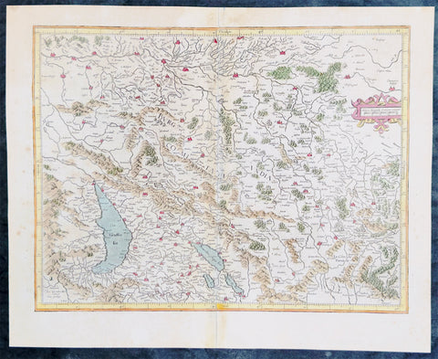
1628 Gerard Mercator Antique Map the Franche Comte de Bourgogne Region of France
- Title : La Haute Bourgoigne...Per Geradum Mercatorem Cum Privilegio
- Size: 21in x 17in (530mm x 430mm)
- Condition: (A) Very Good Condition
- Date : 1628
- Ref #: 26144
Description:
This original hand coloured copper plate engraved antique map of of the historical region of the Free County of Burgundy (Franche Comte de Bourgogne) of eastern France by Gerard Mercator was published by Henricus Hondius in the early 1628 French edition of Gerard Mercators Atlas.
These maps, published in the early editions of Mercators atlas, are the original maps drawn and engraved by Gerald Mercator in the mid to late 16th century, published by his son Rumold as an atlas, after his death, in 1595. After two editions the plates were purchased by Jodocus Hondius in 1604 and continued to be published until the mid 1630\\\'s when the plates were re-engraved and updated by Jan Jansson and Henricus Hondius.
General Definitions:
Paper thickness and quality: - Heavy and stable
Paper color : - off white
Age of map color: - Later
Colors used: - Green, yellow, red, orange
General color appearance: - Authentic
Paper size: - 21in x 17in (530mm x 430mm)
Plate size: - 20in x 15in (510mm x 380mm)
Margins: - Min 1/2in (12mm)
Imperfections:
Margins: - Age toning
Plate area: - Age toning
Verso: - Age toning, centerfold re-joined
Background:
The Free County of Burgundy (French: Franche Comté de Bourgogne; German: Freigrafschaft Burgund) was a medieval county (from 982 to 1678) of the Holy Roman Empire, within the modern region of Bourgogne-Franche-Comté, whose very name is still reminiscent of the title of its count: Freigraf (\\\'free count\\\', denoting imperial immediacy, or franc comte in French, hence the term franc(he) comté for his feudal principality). It should not be confused with the more westerly Duchy of Burgundy, a fiefdom of Francia since 843.
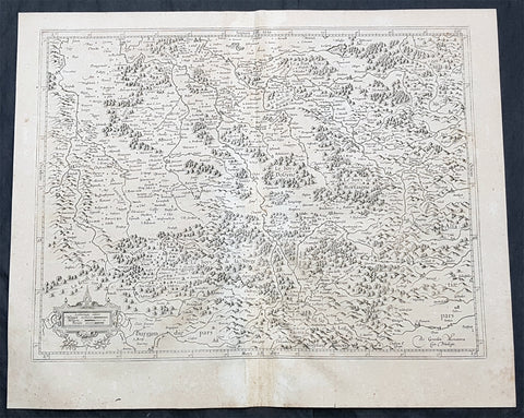
1628 Gerard Mercator Antique Map the Southern Lorraine Region of France
Antique Map
- Title : La Partie Meridionale de Lorraine...Per Geradum Mercatorem Cum Privilegio
- Size: 21in x 17in (530mm x 430mm)
- Condition: (A) Very Good Condition
- Date : 1628
- Ref #: 26142
Description:
This original copper plate engraved antique map ancient region of southern Lorraine, France by Gerard Mercator was published by Henricus Hondius in the early 1628 French edition of Gerard Mercators Atlas.
These maps, published in the early editions of Mercators atlas, are the original maps drawn and engraved by Gerald Mercator in the mid to late 16th century, published by his son Rumold as an atlas, after his death, in 1595. After two editions the plates were purchased by Jodocus Hondius in 1604 and continued to be published until the mid 1630\\\'s when the plates were re-engraved and updated by Jan Jansson and Henricus Hondius.
General Definitions:
Paper thickness and quality: - Heavy and stable
Paper color : - off white
Age of map color: -
Colors used: -
General color appearance: -
Paper size: - 21in x 17in (530mm x 430mm)
Plate size: - 20in x 15in (510mm x 380mm)
Margins: - Min 1/2in (12mm)
Imperfections:
Margins: - Age toning
Plate area: - Age toning
Verso: - Age toning
Lorraine is a cultural and historical region in north-eastern France, now located in the administrative region of Grand Est. Lorraines name stems from the medieval kingdom of Lotharingia, which in turn was named for either Emperor Lothair I or King Lothair II. It later was ruled as the Duchy of Lorraine before the Kingdom of France annexed it in 1766.
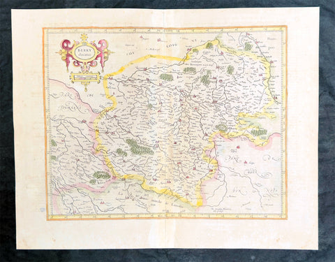
1628 Gerard Mercator Antique Map of the Berry Province of central France
Antique Map
- Title : Berry Ducatus...Per Geradum Mercatorem Cum Privilegio
- Size: 21in x 17in (530mm x 430mm)
- Condition: (A) Very Good Condition
- Date : 1628
- Ref #: 26137
Description:
This original copper plate engraved antique map of the Berry Province of central France by Gerard Mercator was published by Henricus Hondius in the early 1628 French edition of Gerard Mercators Atlas.
These maps, published in the early editions of Mercators atlas, are the original maps drawn and engraved by Gerald Mercator in the mid to late 16th century, published by his son Rumold as an atlas, after his death, in 1595. After two editions the plates were purchased by Jodocus Hondius in 1604 and continued to be published until the mid 1630\\\'s when the plates were re-engraved and updated by Jan Jansson and Henricus Hondius.
General Definitions:
Paper thickness and quality: - Heavy and stable
Paper color : - off white
Age of map color: - Early
Colors used: - Yellow, green, blue, pink
General color appearance: - Authentic
Paper size: - 21in x 17in (530mm x 430mm)
Plate size: - 20in x 15in (510mm x 380mm)
Margins: - Min 1/2in (12mm)
Imperfections:
Margins: - Age toning
Plate area: - Age toning
Verso: - Age toning
Berry is a region located in the center of France. It was a province of France until départements replaced the provinces on 4 March 1790, when Berry became divided between the départements of Cher (High Berry) and Indre (Low Berry).
The Berry region now consists of the départements of Cher, Indre and parts of Creuse. The city Bourges functioned as the capital of Berry. Berry is notable as the birthplace of several kings and other members of the French royal family, and was the birthplace of the famous knight Baldwin Chauderon, who fought in the First Crusade. In the Middle Ages, Berry became the centre of the Duchy of Berry. It is also known for an illuminated manuscript produced in the 14th–15th century called Les Très Riches Heures du Duc de Berry.
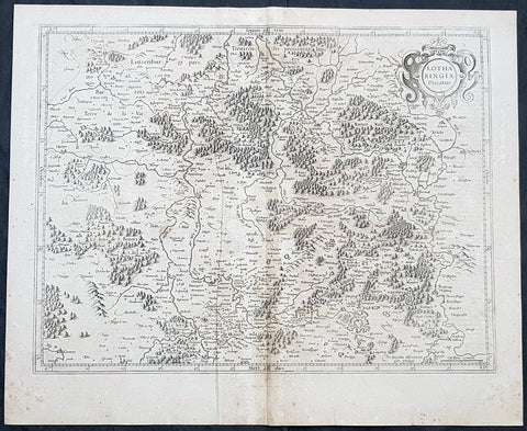
1628 Gerard Mercator Antique Map Lotharingia Region - Netherlands Germany France
Antique Map
- Title : Lotharingia Ducatus...Per Geradum Mercatorem Cum Privilegio
- Size: 21in x 17in (530mm x 430mm)
- Condition: (A) Very Good Condition
- Date : 1628
- Ref #: 26141
Description:
This original copper plate engraved antique map of the historical region of Lotharingia region of present-day Netherlands, Belgium, Luxembourg, North Rhine-Westphalia (Germany), Rhineland-Palatinate (Germany), Saarland (Germany), and Lorraine (France) by Gerard Mercator was published by Henricus Hondius in the early 1628 French edition of Gerard Mercators Atlas.
These maps, published in the early editions of Mercators atlas, are the original maps drawn and engraved by Gerald Mercator in the mid to late 16th century, published by his son Rumold as an atlas, after his death, in 1595. After two editions the plates were purchased by Jodocus Hondius in 1604 and continued to be published until the mid 1630\\\'s when the plates were re-engraved and updated by Jan Jansson and Henricus Hondius.
General Definitions:
Paper thickness and quality: - Heavy and stable
Paper color : - off white
Age of map color: -
Colors used: -
General color appearance: -
Paper size: - 21in x 17in (530mm x 430mm)
Plate size: - 20in x 15in (510mm x 380mm)
Margins: - Min 1/2in (12mm)
Imperfections:
Margins: - Age toning
Plate area: - Age toning
Verso: - Age toning
Lotharingia was a medieval successor kingdom of the Carolingian Empire, comprising the present-day Netherlands, Belgium, Luxembourg, North Rhine-Westphalia (Germany), Rhineland-Palatinate (Germany), Saarland (Germany), and Lorraine (France). It was named after King Lothair II who received this territory after the kingdom of Middle Francia of his father Lothair I was divided among his sons in 855.
Lotharingia was born out of the tripartite division in 855 of the kingdom of Middle Francia, which itself was formed after the threefold division of the Carolingian Empire by the Treaty of Verdun of 843. Conflict between East and West Francia over Lotharingia was based on the fact that these were the old Frankish homelands of Austrasia, so possession of them was of great prestige.
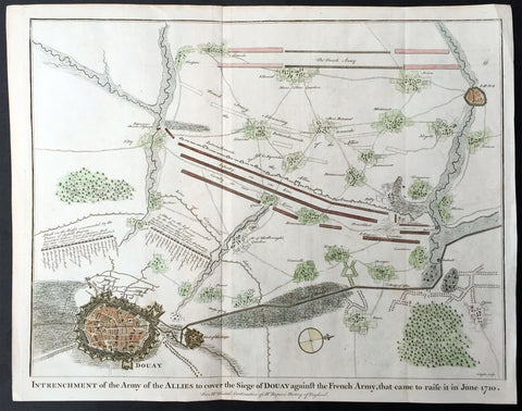
1745 N Tindal Original Antique Map Siege of Douai, Flanders, North France in 1710
- Title : Intrenchment of the Army of the Allies to cover the Siege of Douay against the French Army that came to raise it in June 1710.
- Size: 19 1/2in x 15 1/2in (495mm x 395mm)
- Ref #: 22212
- Date : 1745
- Condition: (A+) Fine Condition
Description:
This original copper-plate engraved antique map, plan of the Siege of Douai, Flanders in Northern France - during the Spanish War of Succession (1701-13) - was engraved by John Basire and was published in the 1745 edition of Nicholas Tindals Continuation of Mr. Rapin\'s History of England.
General Definitions:
Paper thickness and quality: - Heavy and stable
Paper color : - off white
Age of map color: - Early
Colors used: - Green, pink, blue
General color appearance: - Authentic
Paper size: - 19 1/2in x 15 1/2in (495mm x 395mm)
Plate size: - 19 1/2in x 15 1/2in (495mm x 395mm)
Margins: - Min 1/2in (12mm)
Imperfections:
Margins: - None
Plate area: - None
Verso: - None
Background:
A large battle plan showing both siege and works against a fortified Douai, Flanders and the detailed dispositions and battle lines of Lord Marlborough\'s army against the French, and thier attempt to lift the siege in June 1710.
Successive sieges from 1710 to 1712 during the Spanish War of Succession (1701-13), almost completely destroyed Douai by the British Army. By 1713, the town was fully integrated into France. Douai became the seat of the Parliament of Flanders.
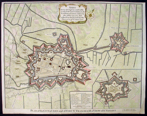
1745 Tindal Original Antique Map of Aire-sur-la-Lys, Fort St Francis & St Venant, France
-
Title : Plan of the City of Aire and Fort of St. Francis with a view of St.Venant
Sep. 28, 1708 - Size: 19 1/2in x 15 1/2in (495mm x 395mm)
- Ref #: 22218
- Date : 1745
- Condition: (A+) Fine Condition
Description:
This beautifully hand coloured original copper-plate engraved antique map, plan & birds eye view of the French city of Aire-sur-la-Lys, a commune in the Pas-de-Calais department in northern France along with Fort St Francis and Fort St Venant - used by Lord Marlborough during the Spanish War of Succession (1701-13) - was engraved by John Basire and was published in the 1745 edition of Nicholas Tindals Continuation of Mr. Rapin\'s History of England.
General Definitions:
Paper thickness and quality: - Heavy and stable
Paper color : - off white
Age of map color: - Early
Colors used: - Pink, blue, green, yellow
General color appearance: - Authentic
Paper size: - 19 1/2in x 15 1/2in (495mm x 395mm)
Plate size: - 19 1/2in x 15 1/2in (495mm x 395mm)
Margins: - Min 1/2in (12mm)
Imperfections:
Margins: - None
Plate area: - Folds as issued
Verso: - None
Background:
Aire-sur-la-Lys is located 10 miles (16 km) southeast of Saint-Omer, by the banks of the Leie and the Laquette rivers.
It is mentioned for the first time in 857 and developed around a fort or castrum built by Baldwin II, Count of Flanders in response to the Norman invasions. More growth followed with the establishment of the Collegiate church of Saint-Pierre by Baldwin V, Count of Flanders.
The town was laid siege ten times between 1127 and 1710. It was separated from the County of Flanders and attached to the County of Artois in 1196. Subsequently ruled by the Burgundians then by the Spanish.
The town was besieged in 1676 by Vauban and retaken for France, although it remained a Spanish possession until 14 April 1713, when, by the Treaty of Utrecht, it finally became a part of France.
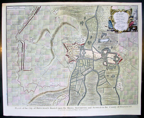
1745 Tindal Antique Map Battle Plan of Siege of Bouchain, Calais, France in 1711
- Title : Plan of the City of Bouchain Situated upon the Rivers Sensette and Scheld in the County of Hainault
- Size: 19 1/2in x 15 1/2in (495mm x 395mm)
- Ref #: 22198
- Date : 1745
- Condition: (A+) Fine Condition
Description:
This beautifully hand coloured original copper-plate engraved antique map, battle plan & birds eye view of the French city of Bouchain on the Schedlt River, in the Pas-de-Calais dept. in northern France - during the Spanish War of Succession (1701-13) - was engraved by John Basire and was published in the 1745 edition of Nicholas Tindals Continuation of Mr. Rapin\'s History of England.
General Definitions:
Paper thickness and quality: - Heavy and stable
Paper color : - off white
Age of map color: - Early
Colors used: - Pink, blue, green, yellow
General color appearance: - Authentic
Paper size: - 19 1/2in x 15 1/2in (495mm x 395mm)
Plate size: - 19 1/2in x 15 1/2in (495mm x 395mm)
Margins: - Min 1/2in (12mm)
Imperfections:
Margins: - None
Plate area: - Folds as issued
Verso: - None
Background:
The Siege of Bouchain (9 August – 12 September 1711), following the Passage of the Lines of Ne Plus Ultra (5 August 1711), was a siege of the War of the Spanish Succession, and the last major victory of John Churchill, 1st Duke of Marlborough. Marlborough broke through the French defensive lines and took Bouchain after a siege of 34 days. Its capture left Cambrai the only French-held fortress between the allied army and Paris.
Throughout the early summer of 1711 Marlborough\'s army, having taken the important fortress of Douai the previous year, manoeuvred indecisively in northern France, blocked by the French Lines of Ne Plus Ultra – a massive series of fieldworks stretching from the Channel coast to the Ardennes at Namur. The allied army had been weakened by the withdrawal of Prince Eugene\'s army to cover the upper Rhine, as the deposed Elector of Bavaria attempted to take advantage of the disruption caused by the death of the Emperor Joseph. On 6 July, Marlborough captured the small fortress of Arleux, just to the north of the Lines, west of Bouchain, both to deny its use to the French as a sally-port, and to secure the water supply to Douai, which could be cut off by damming the canal that supplied the town. The Duke was then wrong-footed by Villars as the French army crossed the Lines on 22/23 July and retook Arleux, with the allied army too far to the west to intervene in time, and the defences were levelled before the French retreated back across the Lines. Marlborough, initially furious, soon retook the initiative by marching his army as if to assault the Lines near Arras, and carrying out a detailed personal reconnaissance there on 4 August in full view of Villars\' covering army. That night the army struck camp, leaving their campfires burning to deceive the French, and marched eastwards to Arleux. At midnight a force from Douai under Cadogan crossed the unguarded French lines, and by 8 am the advance guard of the main army was also crossing over. Villars, arriving on the scene with a few hundred cavalry, realised he had been outmanoeuvred, and though he attempted to offer battle in front of Bourlon Wood, Marlborough declined to attack, the Marshal\'s position being even stronger than the one in which he had given Marlborough\'s army such a mauling two years earlier at Malplaquet. He thus drew off and attempted to hinder Marlborough\'s siege of Bouchain which followed.
To defend the town Bouchain\'s governor, de Ravignau, had some 5,000 men against Marlborough\'s besieging army of 30,000, and the advantage of one of the strongest fortresses left to France, surrounded by the marshy land of the confluence of the rivers Scheldt and Sensée. In addition, Villars\' strong army had taken up position to the west of the allied camp, and had managed to open a tenuous link to the besieged garrison. Marlborough responded by using earthwork gun batteries to counter Villars, used a crack assault force managed by 18 August to once more cut the Marshal\'s communication with Bouchain, and established a fieldwork-protected corridor from the siege camp to his main supply port at Marchiennes on the Scarpe. Frequent raids by Villars on both the supply convoys on the Scarpe, and towards Douai, failed to interrupt the siege, and the garrison marched out to become prisoners of war on 13 September 1711.
Bouchain was Marlborough\'s last campaign. On the last day of the year he was stripped of his position as Captain-General, and of all his other offices. Command of the army on the continent for the campaign of 1712 was given to the Duke of Ormonde, and strict limitations were placed on his freedom of movement. Particularly he was prohibited from engaging the French in battle, as Anglo-French peace talks were well advanced, and the opportunity of seizing Cambrai and marching on Paris, opened by Marlborough\'s gains the year before, was abandoned. Before the year was out, the British army would withdraw from the alliance, leaving the remaining allies, under Eugene of Savoy to be defeated at Denain.
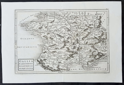
1750 Christop. Cellarius Original Antique Map of France - Gallia
- Title : Gallia Narbonensis Lugdvnensis et Acvitania
- Size: 15in x 10 1/2in (380mm x 265mm)
- Ref #: 31353
- Date : 1750
- Condition: (A+) Fine Condition
Description:
This finely engraved original antique map of France by Christoph. Cellarius was published in the 1750 edition of Geographica Antiqua.
General Definitions:
Paper thickness and quality: - Heavy and stable
Paper color : - off white
Age of map color: -
Colors used: -
General color appearance: -
Paper size: - 15in x 10 1/2in (380mm x 265mm)
Plate size: - 12 1/2in x 8 1/2in (320mm x 215mm)
Margins: - Min 1in (25mm)
Imperfections:
Margins: - None
Plate area: - None
Verso: - None
Background:
Geographica was one of the most popular geographical publications of the 17th and 18th centuries, lasting well into the 19th century. (Ref: Tooley; M&B)
Cellarius, Christopher, 1638-1707
Christopher Cellarius (Keller) was professor of Oriental languages at Halle university and the author of numerous books including his most famous work the atlas Geographica Antiquafirst published in 1686 and being reissued with updated plates until the early 19th century.
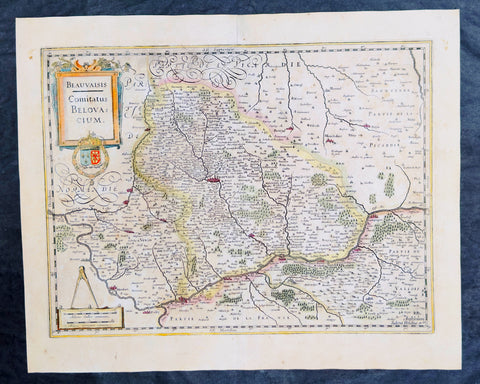
1638 Gerard Mercator & Henricus Hondius Antique Map of Beauvais Region, France
- Title : Beauvaisis Comitatus Belovacium
- Size: 21in x 17in (530mm x 430mm)
- Condition: (A) Very Good Condition
- Date : 1638
- Ref #: 50178
Description:
This original copper plate engraved antique map of the Beauvais region of Northern France - centering on the city of Beauvais & the Oise River running through the cities of Noyon, Compiègne, Creil by Gerard Mercator was published by Henricus Hondius in the early 1638 Latin edition of Gerard Mercators Atlas.
These maps, published in the early editions of Mercators atlas, are the original maps drawn and engraved by Gerald Mercator in the mid to late 16th century, published by his son Rumold as an atlas, after his death, in 1595. After two editions the plates were purchased by Jodocus Hondius in 1604, and continued to be published until the end of the 1630s by Henricus Hondius, when some of the plates were re-engraved and updated with the help of Jan Jansson.
General Definitions:
Paper thickness and quality: - Heavy and stable
Paper color : - off white
Age of map color: - Original
Colors used: - Blue, pink, red, green, yellow
General color appearance: - Authentic
Paper size: - 21in x 17in (530mm x 430mm)
Plate size: - 18 1/2in x 14in (475mm x 350mm)
Margins: - Min 1/2in (12mm)
Imperfections:
Margins: - Light age toning
Plate area: - Light age toning
Verso: - Light age toning
Background:
Beauvais is a city and commune in northern France. It serves as the capital of the Oise département, in the Hauts-de-France region. Beauvais is located approximately 75 kilometres from Paris.
Beauvais was known to the Romans by the Gallo-Roman name of Caesaromagus (magos is Common Celtic for field). The post-Renaissance Latin rendering is Bellovacum from the Belgic tribe the Bellovaci, whose capital it was. In the ninth century it became a countship, which about 1013 passed to the bishops of Beauvais, who became peers of France from the twelfth century. At the coronations of kings the Bishop of Beauvais wore the royal mantle and went, with the Bishop of Langres, to raise the king from his throne to present him to the people.
De Bello Gallico II 13 reports that as Julius Caesar was approaching a fortified town called Bratuspantium in the land of the Bellovaci, its inhabitants surrendered to him when he was about 5 Roman miles away. Its name is Gaulish for place where judgements are made, from *bratu-spantion. Some say that Bratuspantium is Beauvais. Others theorize that it is Vendeuil-Caply or Bailleul sur Thérain.
From 1004 to 1037, the Count of Beauvais was Odo II, Count of Blois.
In a charter dated 1056/1060, Eudo of Brittany granted land in pago Belvacensi (Beauvais, Picardy) to the Abbey of Angers Saint-Aubin
In 1346 the town had to defend itself against the English, who again besieged it in 1433. The siege which it endured in 1472 at the hands of the Duke of Burgundy, was rendered famous by the heroism of the towns women, under the leadership of Jeanne Hachette, whose memory is still celebrated by a procession on 27 June (the feast of Sainte Angadrême), during which women take precedence over men.
An interesting hoard of coins from the High Middle Ages became known as the Beauvais Hoard, because some of the British and European coins found with the lot were from the French abbey located in Beauvais. The hoard, which contained a variety of rare and extremely rare Anglo-Norman pennies, English and foreign coins, was reputed to have been found in or near Paris.
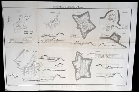
1856 Capt Delafield Large Antique Schematics Forts City of Lyons, France
Antique Map
- Title : Detached Forts about the City of Lyons
- Date : 1856
- Condition: (A) Very Good Condition
- Ref: 90123
- Size: 29in x 20in (735mm x 515mm)
Description:
This large original lithograph print, schematics of various forts in and around the French city of Lyons - during the time of the Crimean War and just prior to the American Civil War - was engraved by John T Bowen & co. of Philadelphia and was published in the 1856 edition of Captain Richard Delafields Report on the Art of War in Europe in 1854, 1855, and 1856.
In early 1855, Captain Richard Delafield was appointed by the Secretary of War, Jefferson Davis, a head of the board of officers, later called The Delafield Commission, and sent to Europe to study the European military. The board included Captain George B. McClellan and Major Alfred Mordecai. They inspected the state of the military in Great Britain, Germany, the Austrian Empire, France, Belgium, and Russia, and served as military observers during the Crimean War. After his return in April 1856, Delafield submitted a report which was later published as a book by Congress, Report on the Art of War in Europe in 1854, 1855, and 1856. The book was suppressed during the American Civil War due to fears that it would be instructive to Confederate engineers as it contained multiple drawings and descriptions of military fortifications.
General Definitions:
Paper thickness and quality: - Light and stable
Paper color : - off white
Age of map color: -
Colors used: -
General color appearance: -
Paper size: - 29in x 20in (735mm x 515mm)
Plate size: - 29in x 20in (735mm x 515mm)
Margins: - Min 1/2in (12mm)
Imperfections:
Margins: - None
Plate area: - Folds as issued
Verso: - Folds re-enforced with archival tape
Background:
The ceintures de Lyon (Belts of Lyon) were a series of fortifications built between 1830 and 1890 around the city of Lyon, France to protect the city from foreign invasion.
The belts comprised two defensive barriers that included forts, lunettes, ramparts, batteries, and other defensive structures. Many of these structures proved to be ineffective in war due to advancement in weapon technology and the evolution of attack strategies at the time. Some of the fortifications of the ceintures de Lyon have been destroyed, though many remain today.
In 1830 the maréchal de camp, Hubert Rohault de Fleury, commenced a project designed by military engineer Baron Haxo. With a budget of 10,000,000 francs (approximately €67,000,000 as of 2015) allocated for Lyon between 1831 and 1839, this first project included the restoration of the fortifications between Croix Rousse and Fourvière; the construction of two forts on the plateau of Caluire (Fort de Montessuy and Fort de Caluire, connected by the Enceinte de Caluire), facing the Dombes; closing access to the Presquîle by the construction of a south-facing building; building two forts – Fort de la Duchère and Fort de Grange Blanche – to protect access routes towards Paris and Auvergne.
The fortification of the city is divided into three sectors: The north was protected by the wall of Croix-Rousse and the structures between the Rhône and the Saône. The command was situated at fort de Montessuy. The west was covered by the hillfort of Fourvière and the associated forts of Vaise at Sainte-Foy. The command was situated at fort Saint-Irénée. The east was defended by the Redoute du Haut-Rhône and Fort de la Vitriolerie on the left bank of the Rhône. The command was situated at Fort Lamothe.
The work required almost 20,000 workers, which were locally sourced in an attempt to avoid insurrection such as the ongoing unrest of the Lyon silk workers (Canuts) over increased capitalism. Work began in 1831 to build seven structures, each structure requiring between 400 and 500 workers. The scope of this project included the construction of Fort de Montessuy and Fort de Caluire to the north; Fort des Brotteaux, Fort Montluc and Fort du Colombier to the east; the Redoute de la Part-Dieu to the west; and Fort Saint-Irénée, to protect the entire area.
In January 1831, an uprising began at a work site in Charpennes, however it was quickly stopped by the army. Other insurrections took place the same year, a series of Canut revolts, which succeeded in rallying soldiers on the side of the Canuts, resulting in the death of captain Viquesnel, aide-de-camp of Fleury, and the temporary withdrawal of the 20,000 soldiers who eventually retook the city in December 1831.
In 1832, three other structures were built to reinforce the defenses to the east: The Redoute de la Tête dor, Fort La Motte, and the Redoute des Hirondelles. A treaty was signed between the city of Lyon and the War Department, which stipulated that the city had to cede the land necessary for the construction of military buildings to the War Department, while the forts themselves would still belong to the city if the military decided to abandon them. It is thanks to this treaty that the forts of Croix Rousse, Fourvière, Loyasse, Vaise, and Saint-Jean would later be returned to the city.
Construction resumed in 1840. First the Fort de la Vitriolerie in 1840, then Fort de Sainte-Foy-lès-Lyon and the Lunette des Charpennes in 1842, Fort de la Duchère in 1844, the Redoute du Petit Sainte-Foy-lès-Lyon in 1852, and finally the Redoute du haut-Rhône in 1854.
A law was voted in on 10 July 1851, which defined the methods of destruction of these buildings or construction on their land. By 1854, 19 structures including 10 forts had been built around Lyon, creating a nearly 14-kilometre (8.7 mi) fortified perimeter.
Delafield, Richard Major General 1798 - 1873 - Delafield was a United States Army officer for 52 years. He served as superintendent of the United States Military Academy for 12 years. At the start of the American Civil War, then Colonel Delafield helped equip and send volunteers from New York to the Union Army. He also was in command of defences around New York harbor from 1861 to April 1864. On April 22, 1864, he was promoted to Brigadier General in the Regular Army of the United States and Chief of Engineers. On March 8, 1866, President Andrew Johnson nominated Delafield for appointment to the grade of brevet major general in the Regular Army, to rank from March 13, 1865, and the United States Senate confirmed the appointment on May 4, 1866, reconfirmed due to a technicality on July 14, 1866. He retired from the US Army on August 8, 1866. He later served on two commissions relating to improvements to Boston Harbor and to lighthouses. He also served as a regent of the Smithsonian Institution.
Delafield served as assistant engineer in the construction of Hampton Roads defences from 1819–1824 and was in charge of fortifications and surveys in the Mississippi River delta area in 1824-1832. While superintendent of repair work on the Cumberland Road east of the Ohio River, he designed and built Dunlaps Creek Bridge in Brownsville, Pennsylvania, the first cast-iron tubular-arch bridge in the United States. Commissioned a major of engineers in July 1838, he was appointed superintendent of the Military Academy after the fire of 1838 and served till 1845. He designed the new buildings and the new cadet uniform that first displayed the castle insignia. He superintended the construction of coast defences for New York Harbor from 1846 to 1855.
In the beginning of 1855, Delafield was appointed by the Secretary of War, Jefferson Davis a head of the board of officers, later called The Delafield Commission, and sent to Europe to study the European military. The board included Captain George B. McClellan and Major Alfred Mordecai. They inspected the state of the military in Great Britain, Germany, the Austrian Empire, France, Belgium, and Russia, and served as military observers during the Crimean War. After his return in April 1856, Delafield submitted a report which was later published as a book by Congress, Report on the Art of War in Europe in 1854, 1855, and 1856. The book was suppressed during the American Civil War due to fears that it would be instructive to Confederate engineers as it contained multiple drawings and descriptions of military fortifications.
Delafield served as superintendent of the Military Academy again in 1856-1861. In January 1861, he was succeeded by Captain Pierre G. T. Beauregard, who was dismissed shortly after Beauregards home state of Louisiana seceded from the Union, and Delafield returned as superintendent serving until March 1, 1861. In the beginning of the Civil War he advised the governor of New York Edwin D. Morgan during the volunteer force creation. Then, in 1861–1864, he was put in charge of New York Harbor defences, including Governors Island and Fort at Sandy Hook. On May 19, 1864, he was commissioned a brigadier-general after replacing Joseph Gilbert Totten, who had died, as the Chief of Engineers, United States Army Corps of Engineers, on April 22, 1864. He stayed in charge of the Bureau of Engineers of the War Department until his retirement on August 8, 1866. On March 8, 1866, President Andrew Johnson nominated Delafield for appointment to the grade of brevet major general in the Regular Army of the United States, to rank from March 13, 1865, and the United States Senate confirmed the appointment on May 4, 1866 and reconfirmed it due to a technicality on July 14, 1866.After retirement Delafield served as a regent of the Smithsonian Institution and a member of the Lighthouse Board. He died in Washington, D.C. on November 5, 1873.
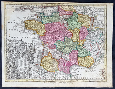
1744 Georg Mattaus Seutter Antique Map of France
Antique Map
- Title : Gallia....a Matth. Seuttero...T C Lotter, Geogr.
- Ref #: 93393
- Size: 11in x 8 1/2in (280mm x 215mm)
- Date : 1744
- Condition: (A+) Fine Condition
Description:
This beautifully hand coloured original copper-plate engraved antique map of France was engraved by Tobias Lotter and was published in the 1744 edition of GM Seutters Atlas Minor Prae cipua Orbis Terrarum Imperia Regna et Provincias...., Augsburg, Germany.
General Definitions:
Paper thickness and quality: - Heavy and stable
Paper color : - off white
Age of map color: - Original
Colors used: - Yellow, green, blue, pink
General color appearance: - Authentic
Paper size: - 11in x 8 1/2in (280mm x 215mm)
Plate size: - 10 1/2in x 8in (265mm x 205mm)
Margins: - Min 1/4in (5mm)
Imperfections:
Margins: - Light age toning
Plate area: - Light age toning
Verso: - None
Background:
Atlas Minor was a series of beautiful maps of all parts of the world. Georg Matthäus Seutter was one of the most and important of the German cartographers of the 18th century, being appointed as the Geographer to the Imperial Court. His son, Albrecht Carl, joined Matthäus and eventually inherited the business. The maps from Atlas Minor were drawn by the two Seutters and engraved by Tobias Conrad Lotte. These maps are highly detailed and engraved with a bold hand with equally strong original hand color in the body of the map as was the 18th century German style. The cartouches were left uncolored in order to emphasize the elaborately detailed illustrations for which German maps are especially prized. These are some of the most decorative and interesting maps of the eighteenth century.
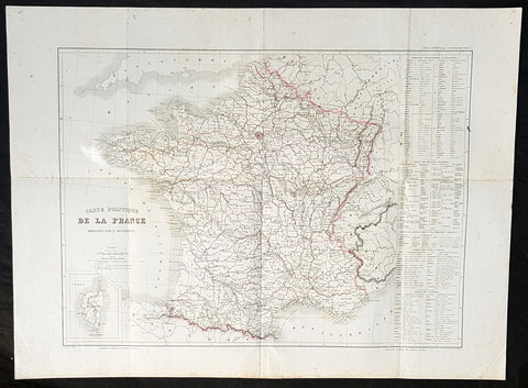
1846 Louis Dussieux Large Antique Map of The Political Boundaries of France
- Title : 1846 Louis Dussieux Large Antique Map of The Political Boundaries of France
- Size: 27 1/2in x 20 1/2in (700mm x 520mm)
- Condition: (A+) Fine Condition
- Date : 1846
- Ref #: 32414
Description:
This large hand coloured original copper plate engraved antique map was published by Louis Dussieux in the 1846 edition of Atlas Generale
General Definitions:
Paper thickness and quality: - Heavy and stable
Paper color : - off white
Age of map color: - Original
Colors used: - Pink
General color appearance: - Authentic
Paper size: - 27 1/2in x 20 1/2in (700mm x 520mm)
Plate size: - 27 1/2in x 20 1/2in (700mm x 520mm)
Margins: - Min 1in (25mm)
Imperfections:
Margins: - Folds as issued
Plate area: - Folds as issued
Verso: - Folds as issued
Dussieux, Louis 1815 - 1894
Dussieux was a French Geographer, prolific during the mid 19th century. After winning prizes in competitions of the Academy of Inscriptions and Belles Letters in 1839 and 1840, he was appointed recorder of military history and geography at the Saint - Cyr Special School in 1842 and became the professor of history in 1850. In 1843 he was appointed correspondent for the Historical Monuments Committee.
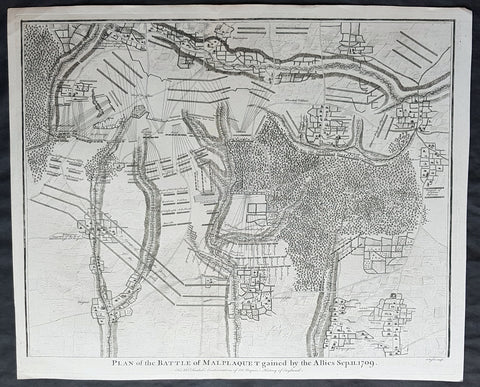
1745 Nicolas Tindal Original Antique Map Battle of Malplaquet, Northern France in 1709
- Title : Plan of the Battle of Malplaquet gained by the Allies Sep. 11 1709.
- Size: 19 1/2in x 15 1/2in (495mm x 395mm)
- Ref #: 22173
- Date : 1745
- Condition: (A+) Fine Condition
Description:
This original copper-plate engraved antique map, plan of the Battle of Malplaquet, northern France in 1709 - during the Spanish War of Succession (1701-13) - was engrvaed by John Basire and was published in the 1745 edition of Nicholas Tindals Continuation of Mr. Rapin\'s History of England.
General Definitions:
Paper thickness and quality: - Heavy and stable
Paper color : - off white
Age of map color: -
Colors used: -
General color appearance: -
Paper size: - 19 1/2in x 15 1/2in (495mm x 395mm)
Plate size: - 19 1/2in x 15 1/2in (495mm x 395mm)
Margins: - Min 1/2in (12mm)
Imperfections:
Margins: - None
Plate area: - None
Verso: - None
Background:
The Battle of Malplaquet, fought on 11 September 1709, was one of the main battles of the War of the Spanish Succession. Led by the Duke of Marlborough, the army of the Grand Alliance attacked and defeated the French army near Malplaquet under the command of Marshal Villars. The heavy losses suffered by the Allies caused the battle to be considered a Pyrrhic victory.
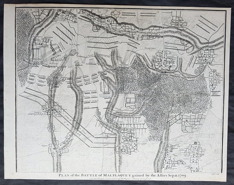
1745 Nicolas Tindal Original Antique Map Battle of Malplaquet, Northern France in 1709
- Title : Plan of the Battle of Malplaquet gained by the Allies Sep. 11 1709.
- Size: 19 1/2in x 15 1/2in (495mm x 395mm)
- Ref #: 22154
- Date : 1745
- Condition: (A+) Fine Condition
Description:
This original copper-plate engraved antique map, plan of the Battle of Malplaquet, northern France in 1709 - during the Spanish War of Succession (1701-13) - was engrvaed by John Basire and was published in the 1745 edition of Nicholas Tindals Continuation of Mr. Rapin\'s History of England.
General Definitions:
Paper thickness and quality: - Heavy and stable
Paper color : - off white
Age of map color: -
Colors used: -
General color appearance: -
Paper size: - 19 1/2in x 15 1/2in (495mm x 395mm)
Plate size: - 19 1/2in x 15 1/2in (495mm x 395mm)
Margins: - Min 1/2in (12mm)
Imperfections:
Margins: - None
Plate area: - None
Verso: - None
Background:
The Battle of Malplaquet, fought on 11 September 1709, was one of the main battles of the War of the Spanish Succession. Led by the Duke of Marlborough, the army of the Grand Alliance attacked and defeated the French army near Malplaquet under the command of Marshal Villars. The heavy losses suffered by the Allies caused the battle to be considered a Pyrrhic victory.
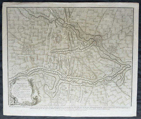
1745 Tindal Original Antique Map Plan of the Battle of Elixheim, Brabant in 1705
- Title : Plan of the Battle lines of Brabant Forced July 18 1705 by the Army of ye Allies commanded by His Grace the Duke of Marlborough & Felt-Marshall D Averquerque Designed upon the spot by Mons D Ivoy Colonel and Quater master General of the Army of the States General
- Size: 19 1/2in x 15 1/2in (495mm x 395mm)
- Ref #: 01-8714
- Date : 1745
- Condition: (A+) Fine Condition
Description:
This original copper-plate engraved antique map, plan of the Battle of Elixheim, in 1705, also known as the Passage of the Lines of Brabant - during the Spanish War of Succession (1701-13) - was engraved by John Basire and was published in the 1745 edition of Nicholas Tindals Continuation of Mr. Rapin\'s History of England.
General Definitions:
Paper thickness and quality: - Heavy and stable
Paper color : - off white
Age of map color: -
Colors used: -
General color appearance: -
Paper size: - 19 1/2in x 15 1/2in (495mm x 395mm)
Plate size: - 19 1/2in x 15 1/2in (495mm x 395mm)
Margins: - Min 1/2in (12mm)
Imperfections:
Margins: - None
Plate area: - None
Verso: - None
Background:
The Battle of Elixheim, 18 July 1705, also known as the Passage of the Lines of Brabant was a battle of the War of the Spanish Succession. The Duke of Marlborough successfully broke through the French Lines of Brabant, an arc of defensive fieldworks stretching in a seventy-mile arc from Antwerp to Namur. Although he was unable to bring about a decisive battle, the breaking and subsequent razing of the lines would prove critical to the allied victory at Ramillies the next year.
Early in the campaigning season, Marlborough attempted to launch an invasion of France up the Moselle valley. This effort was halted by a combination of supply shortages and an excellent French defensive position in front of Sierck, and Marlborough and his army were recalled by the Dutch States General when Marshall Villeroi attacked and took the fortress of Huy and threatened Liege. Having rushed back to the Low Countries (and forcing Villeroi to retreat behind his defenses), Marlborough retook Huy, and then planned to break through the lines to bring Villeroi to battle.
On the evening of 17 July Marlborough sent the Dutch troops under Marshal Overkirk in a feint southwards towards Namur, drawing Villeroi and 40,000 men after them. Overnight he marched with his own English and Scottish troops northwards to the small village of Eliksem (Elixheim), and there broke through the lines without resistance. Early the next day, as Overkirk\'s men countermarched northwards to join with Marlborough, a French detachment attacked the small force of allied troops drawn up to the west of the lines, facing south. Following a short but intense cavalry battle, in which Marlborough was often personally engaged, they were driven off, and Villeroi withdrew his army to the west, behind the river Dyle.
Unable to pursue the French with any vigour on the day of the battle due to the exhaustion of his men, who had marched all night and then fought an intense battle, Marlborough nonetheless still hoped to bring Villeroi to battle. He was frustrated in manoeuvering to the west of the lines in the month immediately following the breakthrough. A final effort in early August, using wagons loaded with supplies to remove his dependency on his lines of communication, while successful in forcing Villeroi\'s army to make a stand close to Waterloo, ultimately failed to bring about a battle due to the veto exercised by the Dutch Field Deputies, notably Slangenburg. The Duke was forced to content himself with the capture of the fortress of Leau and the levelling of the Lines of Brabant between Leau and the Meuse.
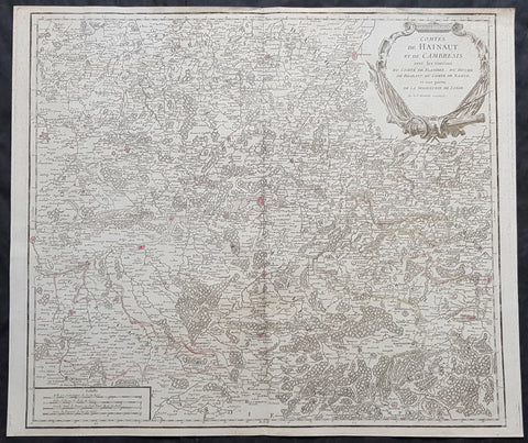
1757 Robert De Vaugondy Large Antique Map The County of Hainaut Belgium & France
- Title : Comte De Hainaut et de Cambres.......Par Le Sr. Robert
- Size: 23in x 19 1/2in (585mm x 495mm)
- Condition: (A+) Fine Condition
- Date : 1757
- Ref #: 41564
Description:
This large magnificent hand coloured original copper-plate engraved antique map of the Hainaut region of Belgium - centering on the city of Mons - by Robert De Vaugondy was published in the 1757 edition of De Vaugondys famous The Atlas Universel
General Definitions:
Paper thickness and quality: - Heavy and stable
Paper color : - off white
Age of map color: - Original & later
Colors used: - Blue, pink, red, green, yellow
General color appearance: - Authentic
Paper size: - 23in x 19 1/2in (585mm x 495mm)
Plate size: - 23in x 19 1/2in (585mm x 495mm)
Margins: - Min 1/4in (6mm)
Imperfections:
Margins: - None
Plate area: - None
Verso: - None
Background:
The County of Hainaut sometimes given the spelling Hainault, was a historical lordship within the medieval Holy Roman Empire with its capital eventually established at Mons (Dutch: Bergen), and named after the river Haine, both now in Belgium. Besides Mons, it included the city of Valenciennes, now in France. It consisted of what is now the Belgian province of Hainaut and the eastern part of the French département of Nord.
Originally a gau of Lotharingia, Hainaut was briefly a part of West Francia (911–25) before becoming definitively attached to Germany. The county was divided in 958 and only emerged in its more or less final form in 1071. Hainaut was culturally and linguistically French. In 1432, Hainaut was acquired by the House of Valois-Burgundy and in 1477 passed to the Habsburgs with the rest of the Burgundian Netherlands and became part of the Burgundian Circle in 1512. It was ruled by the Spanish branch of the Habsburgs from 1555 to 1714. In 1659 and 1678 southern Hainaut was acquired by France, and in 1797 the rest of the county was ceded to France by the Emperor Francis II, who was also count of Hainaut.
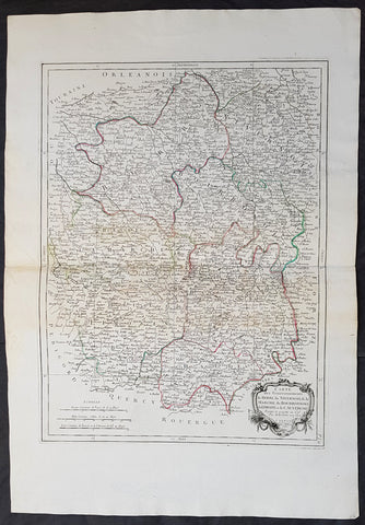
1777 Santini Antique Map French Provinces, Bourges Nevers Guéret Moulins Limoges
- Title : Carte Des Gouvernements du Berri, du Nivernois, de la Marche, du Bourbonnois, du Limosim et de L Auvergne...Par M Bonne 1771....A Venise...P Santini...1777
- Date : 1777
- Condition: (A+) Fine Condition
- Ref: 50197
- Size: 30in x 21in (760mm x 535mm)
Description:
This large magnificent original copper-plate engraved antique map of French Provinces of Berry (Bourges) Nivernais (Nevers) Marche (Guéret) Bourbonnais (Moulins) Limousin (Limoges) & Auvergne (Clermont-Ferrand) was engraved in 1777 - the date is engraved in the title cartouche - after Robert Bonne and was published by Francois Santini (active 1776-84) in his 2 volume edition of Atlas Universal 1776-84. (Ref: Tooley; M&B)
General Definitions:
Paper thickness and quality: - Heavy and stable
Paper color : - off white
Age of map color: - Original
Colors used: - Blue, pink, red, green, yellow
General color appearance: - Authentic
Paper size: - 30in x 21in (760mm x 535mm)
Plate size: - 23in x 17in (595mm x 430mm)
Margins: - Min 1in (25mm)
Imperfections:
Margins: - None
Plate area: - None
Verso: - Light age toning
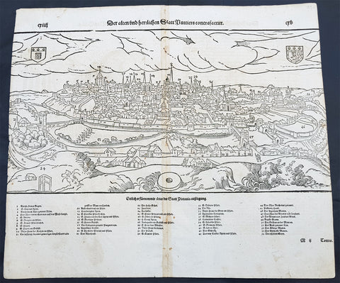
1598 Munster Antique Map Birds Eye View of the city of Poitiers in Poitou France
- Title : Die Statt Puttiers
- Date : 1598
- Condition: (A) Very Good Condition
- Ref # : 30381
- Size : 15in x 13in (380mm x 340mm)
Description:
This fine original wood block engraved antique map a birds eye view of the French city of Poitiers on the Clain River in the Vienne Dept of central western France, was published in the French Section of Sebastian Munsters 1598 edition of Cosmographia, Das ist: Beschreibung der gantzen Welt, Darinnen Aller Monarchien Keyserthumben, Königreichen, Fürstenthumben, Graff- und Herrschafften, Länderen, Stätten und Gemeinden.Ursprung (Cosmographia, that is: description of the whole world, in it all monarchies Keyser thumben, kingdoms, prince thumben, graff and herrschafften, countries, places and municipalities.)
Poitiers is a city on the Clain river in west-central France. It is a commune and the capital of the Vienne department and also of the Poitou.
The type of political organisation existing in Poitiers during the late medieval or early modern period can be glimpsed through a speech given on 14 July 1595 by Maurice Roatin, the town\'s mayor. He compared it to the Roman state, which combined three types of government: monarchy (rule by one person), aristocracy (rule by a few), and democracy (rule by the many). He said the Roman consulate corresponded to Poitiers\' mayor, the Roman senate to the town\'s peers and échevins, and the democratic element in Rome corresponded to the fact that most important matters can not be decided except by the advice of the Mois et Cent (broad council).1 The mayor appears to have been an advocate of a mixed constitution; not all Frenchmen in 1595 would have agreed with him, at least in public; many spoke in favour of absolute monarchy. The democratic element was not as strong as the mayor\'s words may seem to imply: in fact, Poitiers was similar to other French cities, Paris, Nantes, Marseille, Limoges, La Rochelle, Dijon, in that the town\'s governing body (corps de ville) was highly exclusive and oligarchical: a small number of professional and family groups controlled most of the city offices. In Poitiers many of these positions were granted for the lifetime of the office holder.
The city government in Poitiers based its claims to legitimacy on the theory of government where the mayor and échevins held jurisdiction of the citys affairs in fief from the king: that is, they swore allegiance and promised support for him, and in return he granted them local authority. This gave them the advantage of being able to claim that any townsperson who challenged their authority was being disloyal to the king. Every year the mayor and the 24 échevins would swear an oath of allegiance between the hands of the king or his representative, usually the lieutenant général or the sénéchaussée. For example, in 1567, when Maixent Poitevin was mayor, king Henry III came for a visit, and, although some townspeople grumbled about the licentious behaviour of his entourage, Henry smoothed things over with a warm speech acknowledging their allegiance and thanking them for it.
In this era, the mayor of Poitiers was preceded by sergeants wherever he went, consulted deliberative bodies, carried out their decisions, heard civil and criminal suits in first instance, tried to ensure that the food supply would be adequate, visited markets.
In the 16th century, Poitiers impressed visitors because of its large size, and important features, including royal courts, university, prolific printing shops, wealthy religious institutions, cathedral, numerous parishes, markets, impressive domestic architecture, extensive fortifications, and castle.
16th-century Poitiers is closely associated with the life of François Rabelais and with the community of Bitards.
The town saw less activity during the Renaissance. Few changes were made in the urban landscape, except for laying way for the rue de la Tranchée. Bridges were built where the inhabitants had used gués. A few hôtels particuliers were built at that time, such as the hôtels Jean Baucé, Fumé and Berthelot. Poets Joachim du Bellay and Pierre Ronsard met at the University of Poitiers, before leaving for Paris.
During the 17th century, many people emigrated from Poitiers and the Poitou to the French settlements in the new world and thus many Acadians or Cajuns living in North America today can trace ancestry back to this region.
General Definitions:
Paper thickness and quality: - Heavy and stable
Paper color : - off white
Age of map color: -
Colors used: -
General color appearance: -
Paper size: - 15in x 13 1/4in (380mm x 340mm)
Plate size: - 15in x 13 1/4in (380mm x 340mm)
Margins: - Min 1/4in (3mm)
Imperfections:
Margins: - L&R margins cropped into border
Plate area: - Light toning along centerfold
Verso: - Light toning along centerfold
Background:
Cosmographia, Das ist: Beschreibung der gantzen Welt, Darinnen Aller Monarchien Keyserthumben, Königreichen, Fürstenthumben, Graff- und Herrschafften, Länderen, Stätten und Gemeinden.Ursprung, Regiment, Reichthumb, Gewalt und.Beschaffenheit. Dessgleichen Aller deren, beyder Ständen, Regenten: Keysern, Königen, Bäpsten, Bischoffen.Genealogien und Stammbäumen.zusammen getragen. by Sebastian Münster was first published in 1544 and is the earliest German-language description of the world. It had numerous editions in different languages including Latin, French (translated by François de Belleforest), Italian, English, and Czech. The last German edition was published in 1628, long after Munsters death. The Cosmographia was one of the most successful and popular books of the 16th century. It passed through 24 editions in 100 years. This success was due to the notable woodcuts (some by Hans Holbein the Younger, Urs Graf, Hans Rudolph Manuel Deutsch, and David Kandel). It was most important in reviving geography in 16th-century Europe. Among the notable maps within Cosmographia is the map Tabula novarum insularum, which is credited as the first map to show the American continents as geographically discrete.
Munsters earlier geographic works were Germania descriptio (1530) and Mappa Europae (1536). In 1540, he published a Latin edition of Ptolemys Geographia with illustrations.