Maps (15)
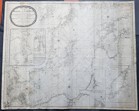
1794 Laurie & Whittle Large Very Rare Blueback Map, Sea Chart of The Baltic Sea
- Title : A New Chart of the Baltic or East Sea Drawn Principally from the Maritime Surveys Collected in the Russian Neptune compared with the Observations of the most experienceed Pilots, and Chiefly with the Charts and Draughts of Professor Christian Charles Lous, Nils Mareluis and James Schmid Published by Authority at Copenhagen, Stockholm and St Petersburg...London Published by Laurie & Whittle No 53 Fleet Street as the Act, 12th May, 1794
- Size: 48in x 39in (1.225m x 1.015mm)
- Condition: (A) Very Good Condition
- Date : 1794
- Ref #: 93046
Description:
This is a very large, extremely rare, copper-plate engraved and highly detailed working Blueback Nautical Chart or Maritime map of the Baltic or East Sea was engraved in 1794 and published by the Laurie & Whittle firm, London 1794. The details for this map have been collected from expeditions by the ship the Russian Neptune and Professor Christian Charles Lous, Nils Mareluis and James Schmid.
This rare Blueback map, a method of mounting working sea charts that was begun by Robert Sayer in the late 18th century. These working maps were extremely expensive to buy and labour intensive to put together so only a limited number were published and sold and even fewer have survived. I have found no other examples of this map either commercially or in other map collections.
The map depicts the Baltic Sea from Scandia Sweden & Pomeranian, Germany in the west to the Baltic States of Estonia and Latvia (Eastland, Livonia, Courland) & southern Finland in the east. The map is highly detailed with numerous cities are labelled, including Copenhagen, Stockholm (Christiana), Gdansk (Dazing), Tallinn (Revel), and Riga. Myriad depth soundings are indicated in the Baltic Sea and along the coastlines. Numerous inset maps are included, the first of Copenhagen and the Straits, the second of Stockholm and directions through the various channels and islands, the third inset is Rogerwick Bay, the fourth is the Island of Gottland and the fifth of Riga and Bay. Copious notes about sailing directions, channels, entrance to the Duna River.
General Definitions:
Paper thickness and quality: - Heavy and stable
Paper color : - off white
Age of map color: -
Colors used: -
General color appearance: -
Paper size: - 48in x 39in (1.225m x 1.015mm)
Plate size: - 48in x 39in (1.225m x 1.015mm)
Margins: - Min 1/2in (12mm)
Imperfections:
Margins: - Soiling, chipping to edges not affecting the image
Plate area: - Soiling, light brown spots top of map, light creasing
Verso: - Original Blueback
Background:
Blueback Charts
Blueback nautical charts began appearing in London in the late 18th century. Bluebacks, as they came to be called, were privately published large format nautical charts known for their distinctive blue paper backing. The backing, a commonly available blue manila paper traditionally used by publishers to warp unbound pamphlets, was adopted as a practical way to reinforce the low-quality paper used by private chart publishers in an effort to cut costs. The earliest known Blueback charts include a 1760 chart issued by Mount and Page, and a 1787 chart issued by Robert Sayer. The tradition took off in the early 19th century, when British publishers like John Hamilton Moore, Robert Blachford, James Imray, William Heather, John William Norie, Charles Wilson, David Steel, R. H. Laurie, and John Hobbs, among others, rose to dominate the chart trade. Bluebacks became so popular that the convention was embraced by chartmakerJacques Nicholas Bellins outside of England, including Americans Edmund March Blunt and George Eldridge, as well as Scandinavian, French, German, Russian, and Spanish chartmakers. Blueback charts remained popular until the late 19th century, when government subsidized organizations like the British Admiralty Hydrographic Office and the United States Coast Survey, began issuing their own superior charts on high quality paper that did not require reinforcement.
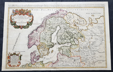
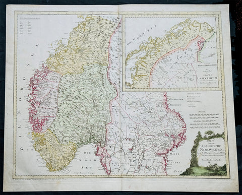
1696 Jaillot Large Antique Map Norway Sweden Finland Denmark - Latvia & Estonia
Antique Map
- Title : La Scandinavie...Hubert Jaillot 1696
- Size: 37in x 24in (940mm x 610mm)
- Condition: (A) Very Good Condition
- Date : 1696
- Ref #: 70329
Description:
This very large, beautifully hand coloured original copper-plate engraved antique map of Scandinavia, Norway, Sweden, Finland, Denmark along with Latvia & Estonia was engraved in 1696 - dated in cartouche - and was published by Alexis Hubert Jaillot in his monumental Atlas Nouveau.
General Definitions:
Paper thickness and quality: - Heavy and stable
Paper color : - off white
Age of map color: - Original
Colors used: - Yellow, pink, green, blue
General color appearance: - Authentic
Paper size: - 37in x 24in (940mm x 610mm)
Plate size: - 35in x 23in (890mm x 585mm)
Margins: - Min 1in (25mm)
Imperfections:
Margins: - Several small repairs to margins, no loss
Plate area: - Horizontal fold, light soiling and creasing
Verso: - Light soiling
Background:
Before the fifteenth century the people of Southern Europe had little geographical knowledge of the Scandinavian World except from sketchy detail shown in the Catalan Atlas (1375) and on a number of \" portolani\" embracing Denmark and the southern tip of Norway. It was not until 1427 that a manuscript map prepared about that time by Claudius Clavus (b.1388) a Dane who spent some time in Rome, made available to scholars a tolerable outline of the northern countries and Greenland. That was to remain the best map available for the rest of the century and it was used as the basis for maps of Scandinavia in early printed editions of Ptolemy. Others by Nicolaus Cusanus (1491) and Ehrhard Etzlaub (c. 1492) followed but, needless to say, these are extremely rare; even the later maps by Olaus Magnus and Marcus Jordan, where they have survived at all , are known only by a very few examples. In fact, apart from the rare appearance of an early Ptolemy map, the oldest of Scandinavia which a collector is likely to find are those of Munster\'s Cosmograhy first published in 1544. In the following centuries the few maps and charts complied in Scandinavia were usually published in Amsterdam, Antwerp, Paris or Nuremberg, the most important maps often being incorporated in the major Dutch, French & German Atlases. (Ref: Tooley; M&B)
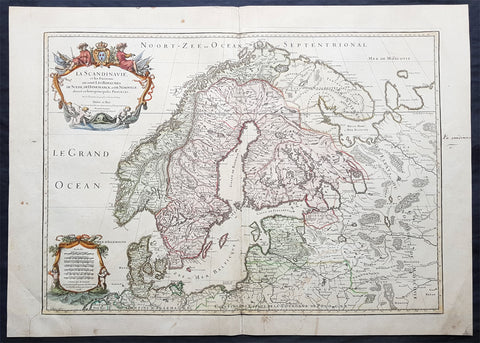
1707 Alexis Jaillot Large Original Antique Map of Scandinavia, Estonia, Latvia..
- Title : La Scandinavie...Hubert Jaillot 1707
- Ref #: 50665
- Size: 29 1/2in x 21in (750mm x 535mm)
- Date : 1707
- Condition: (B) Good Condition
Description:
This large beautifully hand coloured original antique map of Scandinavia, Norway, Sweden, Finland, Denmark, Latvia & Estonia, was engraved by Robert Cordier - after Nicolas Sanson - in 1707 - the date is engraved in the title and published by Alexis Jaillot.
General Definitions:
Paper thickness and quality: - Heavy and stable
Paper color : - off white
Age of map color: - Original
Colors used: - Yellow, green, blue, pink
General color appearance: - Authentic
Paper size: - 29 1/2in x 21in (750mm x 535mm)
Plate size: - 26in x 18 1/2in (660mm x 470mm)
Margins: - Min 1in (25mm)
Imperfections:
Margins: - Light soiling
Plate area: - Professional repair bottom left of plate, bottom centerfold re-joined and light uplift
Verso: - Professional repairs as noted
Background:
Before the fifteenth century the people of Southern Europe had little geographical knowledge of the Scandinavian World except from sketchy detail shown in the Catalan Atlas (1375) and on a number of " portolani" embracing Denmark and the southern tip of Norway. It was not until 1427 that a manuscript map prepared about that time by Claudius Clavus (b.1388) a Dane who spent some time in Rome, made available to scholars a tolerable outline of the northern countries and Greenland. That was to remain the best map available for the rest of the century and it was used as the basis for maps of Scandinavia in early printed editions of Ptolemy. Others by Nicolaus Cusanus (1491) and Ehrhard Etzlaub (c. 1492) followed but, needless to say, these are extremely rare; even the later maps by Olaus Magnus and Marcus Jordan, where they have survived at all , are known only by a very few examples. In fact, apart from the rare appearance of an early Ptolemy map, the oldest of Scandinavia which a collector is likely to find are those of Munster's Cosmograhy first published in 1544. In the following centuries the few maps and charts complied in Scandinavia were usually published in Amsterdam, Antwerp, Paris or Nuremberg, the most important maps often being incorporated in the major Dutch, French & German Atlases. (Ref: Tooley; M&B)
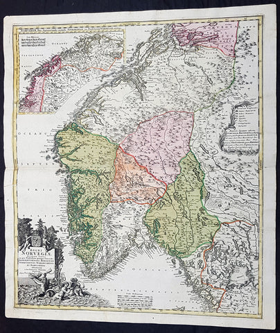
1720 J B Homann Large Original Antique Map of Norway - Regni Norvegiae
Antique Map
- Title : Regni Norvegiae Accurata Tabula in qua Praefecturae Quinque Generales Aggerhusiensis, Bergensis Nidrosiensis, Wardhusiensis et Bahusiensi Ioh. Bapt. Homanno.
- Date : 1720
- Condition: (A+) Fine Condition
- Ref: 93359
- Size: 24in x 20 1/4in (610mm x 540mm)
Description: This large beautifully hand coloured original antique map of Norway & parts of Scandinavia - with an inset map of Lapland & Northern Norway - was published by Johann Baptist Homann in 1720.
Condition Report:
Paper thickness and quality: - Heavy and stable
Paper color: - Off white
Age of map color: - Original
Colors used: - Yellow, pink, green
General color appearance: - Authentic
Paper size: - 24in x 20 1/4in (610mm x 540mm)
Plate size: - 23 1/2in x 20in (595mm x 505mm)
Margins: - Min 1/2in (12mm)
Imperfections:
Margins: - None
Plate area: - None
Verso: - None
Background: Before the fifteenth century the peoples of Southern Europe had little geographical knowledge of the Scandinavian world except from sketchy detail shown in the Catalan Atlas (1375) and on a number of 'portolani' embracing Denmark and the southern tip of Norway. It was not until 1427 that a manuscript map prepared about that time by Claudius Clavus (b. 1388), a Dane who had spent some time in Rome, made available to scholars a tolerable outline of the northern countries and Greenland. That was to remain the best map available for the rest of the century and it was used as the basis for maps of Scandinavia in early printed editions of Ptolemy. Others by Nicolaus Cusanus (1491) and Ehrhard Etzlaub (c. 1492) followed but, needless to say, these are extremely rare; even the later maps by Olaus Magnus and Marcus Jordan, where they have survived at all, are known only by very few examples. In fact, apart from the rare appearance of an early Ptolemy map, the oldest of Scandinavia which a collector is likely to find are those in Munster's Cosmography published in 1544 with many later editions. In the following centuries the comparatively few maps and charts compiled in Scandinavia were usually published in Amsterdam, Antwerp, Paris or Nuremberg, the more important maps often being incorporated in the major Dutch, French and German atlases. (Ref: Tooley; M&B)
1720 John Senex Large Antique Map of Denmark & Southern Sweden
Antique Map
- Title : Denmark Corrected from the Newest Observations of the Royal Society at London and Paris by John Senex FRS
- Size: 38 1/2in x 27in (965mm x 685mm)
- Condition: (A) Very Good Condition
- Date : 1720
- Ref #: 70706
Description:
This large hand coloured original antique map of Denmark was engraved by John Senex and was published in the 1720 edition of his Elephant Folio Atlas.
This map is in VG condition. These large scale maps are scarce due mainly to their size, with damage and loss over time inevitable.
General Definitions:
Paper thickness and quality: - Heavy and stable
Paper color : - off white
Age of map color: - Original
Colors used: - Yellow, green, blue, pink
General color appearance: - Authentic
Paper size: - 38 1/2in x 27in (965mm x 685mm)
Plate size: - 38in x 26 1/2in (960mm x 680mm)
Margins: - Min 1/4in (6mm)
Imperfections:
Margins: - Chipping to bottom margin
Plate area: - Light offsetting
Verso: - Light creasing
Background:
Before the fifteenth century the people of Southern Europe had little geographical knowledge of the Scandinavian World except from sketchy detail shown in the Catalan Atlas (1375) and on a number of \" portolani\" embracing Denmark and the southern tip of Norway. It was not until 1427 that a manuscript map prepared about that time by Claudius Clavus (b.1388) a Dane who spent some time in Rome, made available to scholars a tolerable outline of the northern countries and Greenland. That was to remain the best map available for the rest of the century and it was used as the basis for maps of Scandinavia in early printed editions of Ptolemy. Others by Nicolaus Cusanus (1491) and Ehrhard Etzlaub (c. 1492) followed but, needless to say, these are extremely rare; even the later maps by Olaus Magnus and Marcus Jordan, where they have survived at all , are known only by a very few examples. In fact, apart from the rare appearance of an early Ptolemy map, the oldest of Scandinavia which a collector is likely to find are those of Munster\'s Cosmograhy first published in 1544. In the following centuries the few maps and charts complied in Scandinavia were usually published in Amsterdam, Antwerp, Paris or Nuremberg, the most important maps often being incorporated in the major Dutch, French & German Atlases. (Ref: Tooley; M&B)
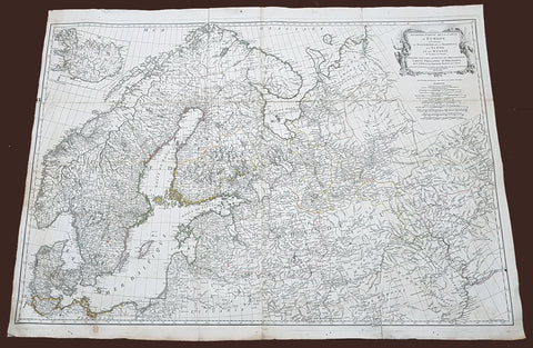
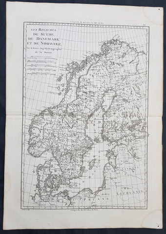
1758 D Anville Very Large Antique Map of Norway Sweden Iceland, Baltics & Russia
Antique Map
- Title : Seconde Partie de la Carte D Europe contenant Le Danemark et la Norwege, La Suede et la Russie....MDCCLVIII
- Size: 40 1/2in x 29 1/2in (1.02m x 760mm)
- Condition: (A) Very Good Condition
- Date : 1758
- Ref #: 92308
Description:
This scarce, very large (40in x 29in) highly detail map of Northern Europe Norway, Sweden, Lithuania, Baltic Countries and European Russia - was engraved in 1758 - dated in the title cartouche - by George De La Haye and was published by Jean Baptiste Bourguignon D\'Anville in his large elephant folio atlas Atlas Generale.
General Definitions:
Paper thickness and quality: - Heavy and stable
Paper color : - off white
Age of map color: - Original
Colors used: - Yellow, Green, pink
General color appearance: - Authentic
Paper size: - 40 1/2in x 29 1/2in (1.02m x 760mm)
Plate size: - 40in x 28 1/2in (1.0m x 725mm)
Margins: - Min 1/2in (12mm)
Imperfections:
Margins: - Light toning
Plate area: - Folds as issued, light separation at corners of folds
Verso: - Age toning
Background:
Before the fifteenth century the people of Southern Europe had little geographical knowledge of the Scandinavian World except from sketchy detail shown in the Catalan Atlas (1375) and on a number of portolani embracing Denmark and the southern tip of Norway. It was not until 1427 that a manuscript map prepared about that time by Claudius Clavus (b.1388) a Dane who spent some time in Rome, made available to scholars a tolerable outline of the northern countries and Greenland. That was to remain the best map available for the rest of the century and it was used as the basis for maps of Scandinavia in early printed editions of Ptolemy. Others by Nicolaus Cusanus (1491) and Ehrhard Etzlaub (c. 1492) followed but, needless to say, these are extremely rare; even the later maps by Olaus Magnus and Marcus Jordan, where they have survived at all , are known only by a very few examples. In fact, apart from the rare appearance of an early Ptolemy map, the oldest of Scandinavia which a collector is likely to find are those of Munster\'s Cosmograhy first published in 1544. In the following centuries the few maps and charts complied in Scandinavia were usually published in Amsterdam, Antwerp, Paris or Nuremberg, the most important maps often being incorporated in the major Dutch, French & German Atlases. (Ref: Tooley; M&B)
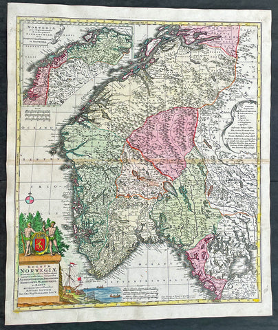
1730 Matthaus Seutter Large Antique Map of Norway
Antique Map
- Title : Regnum Norwegiae...Matthaei Seutteri
- Ref #: 17020
- Size: 24 1/2in x 21in (630mm x 530mm)
- Date : 1730
- Condition: (A+) Fine Condition
Description:
This large original beautifully hand coloured antique map of Norway was published by Georg Mattraus Seutter in 1730.
General Definitions:
Paper thickness and quality: - Heavy and stable
Paper color : - off white
Age of map color: - Original
Colors used: - Yellow, brown, pink, red, blue
General color appearance: - Authentic
Paper size: - 24 1/2in x 21in (630mm x 530mm)
Plate size: - 23 1/2in x 19 1/2in (590mm x 500mm)
Margins: - Min 1/2in (12mm)
Imperfections:
Margins: - None
Plate area: - Light toning along centerfold
Verso: - None
Background:
Before the fifteenth century the peoples of Southern Europe had little geographical knowledge of the Scandinavian world except from sketchy detail shown in the Catalan Atlas (1375) and on a number of \'portolani\' embracing Denmark and the southern tip of Norway. It was not until 1427 that a manuscript map prepared about that time by Claudius Clavus (b. 1388), a Dane who had spent some time in Rome, made available to scholars a tolerable outline of the northern countries and Greenland. That was to remain the best map available for the rest of the century and it was used as the basis for maps of Scandinavia in early printed editions of Ptolemy. Others by Nicolaus Cusanus (1491) and Ehrhard Etzlaub (c. 1492) followed but, needless to say, these are extremely rare; even the later maps by Olaus Magnus and Marcus Jordan, where they have survived at all, are known only by very few examples. In fact, apart from the rare appearance of an early Ptolemy map, the oldest of Scandinavia which a collector is likely to find are those in Munster\'s Cosmography published in 1544 with many later editions. In the following centuries the comparatively few maps and charts compiled in Scandinavia were usually published in Amsterdam, Antwerp, Paris or Nuremberg, the more important maps often being incorporated in the major Dutch, French and German atlases. (Ref: Tooley; M&B)
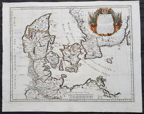
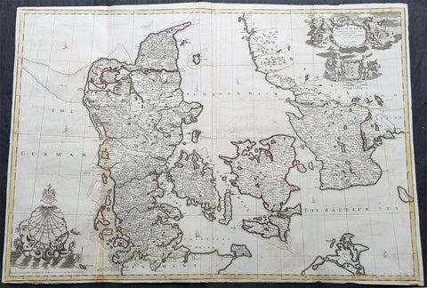
1677 De Rossi Large Original Antique Map of Denmark & Sweden, Schleswig Holstein
- Title : Regno di Danimarca Diuiso nelle Sue due Iutlandie Cioe settentrionale in quattro Diocesi Et Australe, e` il Ducato di...Gio Giacomo De Rossi....L Anno 1677
- Date : 1677
- Size: 22 1/2in x 18in (575mm x 460mm)
- Ref #: 50610
- Condition: (A) Very Good Condition
Description:
A beautiful and quite scarce original 1677 antique map of Denmark and southern Sweden, was engraved in 1677 - dated in the title - and was published in the 1692 edition of de Rossi's world atlas Mercurio Geografico
General Definitions:
Paper thickness and quality: - Heavy and stable
Paper color : - off white
Age of map color: - Early
Colors used: - Yellow, green, blue, pink
General color appearance: - Authentic
Paper size: - 22 1/2in x 18in (575mm x 460mm)
Plate size: - 20 1/2in x 16in (420mm x 405mm)
Margins: - Min 1in (25mm)
Imperfections:
Margins: - Professional repairs to top & bottom margins
Plate area: - Professional repairs to centerfold
Verso: - Repairs as noted
Background:
Before the fifteenth century the people of Southern Europe had little geographical knowledge of the Scandinavian World except from sketchy detail shown in the Catalan Atlas (1375) and on a number of " portolani" embracing Denmark and the southern tip of Norway. It was not until 1427 that a manuscript map prepared about that time by Claudius Clavus (b.1388) a Dane who spent some time in Rome, made available to scholars a tolerable outline of the northern countries and Greenland. That was to remain the best map available for the rest of the century and it was used as the basis for maps of Scandinavia in early printed editions of Ptolemy. Others by Nicolaus Cusanus (1491) and Ehrhard Etzlaub (c. 1492) followed but, needless to say, these are extremely rare; even the later maps by Olaus Magnus and Marcus Jordan, where they have survived at all , are known only by a very few examples. In fact, apart from the rare appearance of an early Ptolemy map, the oldest of Scandinavia which a collector is likely to find are those of Munster's Cosmograhy first published in 1544. In the following centuries the few maps and charts complied in Scandinavia were usually published in Amsterdam, Antwerp, Paris or Nuremberg, the most important maps often being incorporated in the major Dutch, French & German Atlases. (Ref: Tooley; M&B)
1796 Von Reilly Very Large Antique Map Norway, Sweden & Lapland - Scandinavia
Antique Map
- Title : Karte von dem Konigreiche Norwegen...Franz Von Reilly...Wein 1796
- Ref #: 40441
- Size: 31 1/2in x 26in (800mm x 600mm)
- Date : 1796
- Condition: (A+) Fine Condition
Description:
This large copper-plate engraved original antique map of Norway with parts of Sweden - with an inset map of Lapland - was engraved in 1796 - the date is engraved at the foot of the map - and was published by Franz Joseph Von Reilly in his 1794-96 Grosser Deutscher Atlas.
Von Reilly was a Viennese art dealer who in his early twenties turned to map publishing, and between 1789 and 1806 produced a total of 830 maps. His Schauplatz...der Welt (World Atlas) in fac t covered only maps of Europe, whilst theGrosser Deutscher Atlas also included maps of other continents and was therefore the first World Atlas produced by an Austrian. (Ref: M&B; Tooley)
General Description:
Paper thickness and quality: - Heavy & stable
Paper color: - White
Age of map color: - Original
Colors used: - Yellow, pink, green
General color appearance: - Authentic
Paper size: - 31 1/2in x 26in (800mm x 600mm)
Plate size: - 30in x 24in (760mm x 610mm)
Margins: - Min 1in (25mm)
Imperfections:
Margins: - None
Plate area: - None
Verso: - None
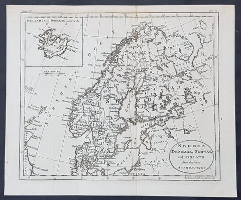
1770 John Cary Original Antique Map Sweden, Denmark, Norway, Finland & Iceland
- Title : Sweden, Denmark, Norway and Finland from the Best Authorities
- Size: 10 1/2in x 8 1/2in (265mm x 215mm)
- Ref #: 70177
- Date : 1770
- Condition: (A+) Fine Condition
Description:
This fine original copper-plate engraved antique map by Thomas Kitchen was published in the 1770 edition of the atlas for William Guthrie\'s Geographical Grammar
General Definitions:
Paper thickness and quality: - Heavy and stable
Paper color : - off white
Age of map color: -
Colors used: -
General color appearance: -
Paper size: - 10 1/2in x 8 1/2in (265mm x 215mm)
Plate size: - 10 1/2in x 8 1/2in (265mm x 215mm)
Margins: - Min 1/2in (12mm)
Imperfections:
Margins: - None
Plate area: - Folds as issued
Verso: - None
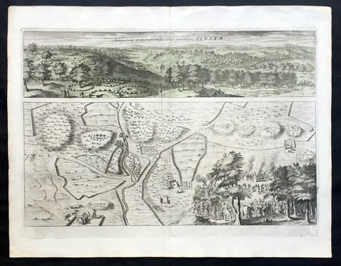
1709 Dahlbergh & Aveelen Antique Map & View of Finsta in Stockholm, Sweden
- Title : Finsta
- Ref #: 70449
- Size: 16 1/2in x 12 1/2in (420mm x 315mm)
- Date : 1709
- Condition: (A+) Fine Condition
Description:
This large original copper-plate engraved antique map & view of Finsta in Stockholm, Sweden by Johannes van den Aveelen was published in the 1709 edition of Erik Dahlbergh's Suecia Antiqua et Hodierna (Ancient and Modern Sweden).
Finsta is a locality situated in Norrtälje Municipality, Stockholm County, Sweden
Background: Suecia Antiqua et Hodierna (ancient and modern Sweden) is a collection of engravings collected by Erik Dahlbergh during the middle of the 17th century. Suecia Antiqua et Hodierna can be described as a grand vision of Sweden during its period as a great power. Dahlberg's direct source of inspiration was the topographical publications issued by the Swiss publisher Matthäus Merian.
In 1661 Dahlberg was granted a royal privilege enabling him to realize his plans, which kept him occupied for a good decade, and a work that would not be printed until after his death. In its final state Suecia Antiqua et Hodierna comprised three volumes containing 353 plates.
Jan van den Aveele or Aveelen (1650 - 1727) was a Dutch etcher and copper engraver. With compatriot Willem Swidde, he made engravings for Suecia Antiqua et Hodierna ("Ancient and Modern Sweden") including depictions of public buildings and city scapes in Stockholm and other Swedish cities. (Ref Tooley M&B)
General Description:
Paper thickness and quality: - Heavy and stable
Paper color: - off white
Age of map color: -
Colors used: -
General color appearance: -
Paper size: - 16 1/2in x 12 1/2in (420mm x 315mm)
Plate size: - 13in x 10in (330mm x 255mm)
Margins: - Min 1/2in (12mm)
Imperfections:
Margins: - None
Plate area: - None
Verso: - None
1780 Rigobert Bonne Original Antique Map of Scandinavia Sweden, Norway & Denmark
- Title : Les Royaumes De Suede De Denmark et de Norwege
- Size: 16in x 11in (405mm x 2805mm)
- Ref #: 40525
- Date : 1780
- Condition: (A+) Fine Condition
Description:
This fine original copper-plate engraved antique map of Scandinavia, Sweden, Norwaty and Denmark was published in 1780 edition of Atlas des toutes les parties connues du globe terrestre by Rigobert Bonne & Guillaume Raynal.
General Definitions:
Paper thickness and quality: - Heavy and stable
Paper color : - off white
Age of map color: -
Colors used: -
General color appearance: -
Paper size: - 16in x 11in (405mm x 2805mm)
Plate size: - 14in x 10in (355mm x 255mm)
Margins: - Min 1/2in (12mm)
Imperfections:
Margins: - None
Plate area: - None
Verso: - None
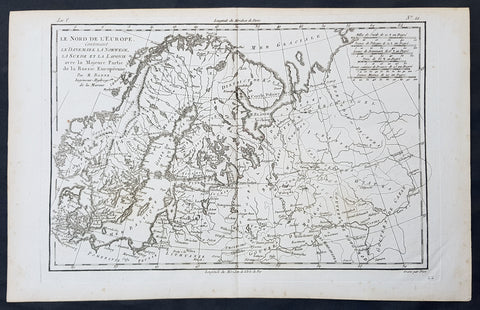
1780 Bonne Original Antique Map of Scandinavia, Baltic States & European Russia
- Title : Le Nord De L Europe contenant Le Danemark La Norwege, La Suede et la Laponie avec la Majeure Partie de la Russie Europeenne Par M Bonne
- Size: 16in x 11in (405mm x 2805mm)
- Ref #: 31671
- Date : 1780
- Condition: (A+) Fine Condition
Description:
This fine original copper-plate engraved antique map of Scandinavia, The Baltic States & European Russia was published in 1780 edition of Atlas des toutes les parties connues du globe terrestre by Rigobert Bonne & Guillaume Raynal.
General Definitions:
Paper thickness and quality: - Heavy and stable
Paper color : - off white
Age of map color: -
Colors used: -
General color appearance: -
Paper size: - 16in x 11in (405mm x 2805mm)
Plate size: - 14in x 10in (355mm x 255mm)
Margins: - Min 1/2in (12mm)
Imperfections:
Margins: - None
Plate area: - None
Verso: - None
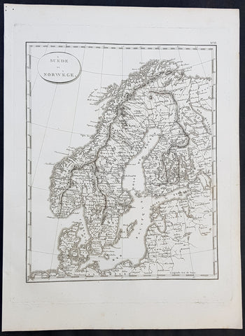
1804 Jean N Buache Original Antique Map of Scandinavia, Sweden Norway & Baltics
- Title : A Suede et Norwege
- Size: 13in x 9 1/2in (330mm x 245mm)
- Ref #: 34191
- Date : 1804
- Condition: (A+) Fine Condition
Description:
This fine original copper-plate engraved antique map was published in the 1804 edition of Jean Nicolas Buache Atlas Geographie Moderne.
The maps in this atlas were illustrated by Jean Nicolas Buache - nephew to Phillipe Buache who was son-in-law to Nicolas Delisle - after maps published by the Scottish publisher John Pinkerton.
General Definitions:
Paper thickness and quality: - Heavy and stable
Paper color : - off white
Age of map color: -
Colors used: -
General color appearance: -
Paper size: - 13in x 9 1/2in (330mm x 245mm)
Plate size: - 11in x 9in (280mm x 230mm)
Margins: - Min 1/2in (12mm)
Imperfections:
Margins: - Light soiling in margins
Plate area: - None
Verso: - None
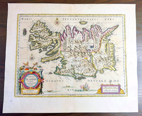
1644 Willem Blaeu Antique Map of Iceland - Beautiful Original Hand Colouring
Antique Map
- Title :Tabula Islandia Auctore Georgio Carolo Flandro
- Ref #: 35625
- Condition: (A) Very Good Condition
- Size: 23 1/2in x 20in (590mm x 510mm)
- Date: 1644
Description:
This original copper plate engraved antique map, with beautiful original hand colouring by Willem Blaeu, was engraved by Jodocus Hondius after Joris Carolus, and was published by Guillaume Blaeus in the 1644 Latin edition of Atlas Nouvs.
This is beautiful example of this early map of Iceland with fresh original hand colouring, on uniform aged paper with original margins.
General Definitions:
Paper thickness and quality: - Heavy and stable
Paper color : - off white
Age of map color: - Original
Colors used: - Yellow, green, blue, pink
General color appearance: - Authentic
Paper size: - 23 1/2in x 20in (590mm x 510mm)
Plate size: - 20in x 15 1/4in (510mm x 395mm)
Margins: - Min 1in (25mm)
Imperfections:
Margins: - Light scraping to L & R margins
Plate area: - Uniform aged toning
Verso: - Uniform aged toning
Background:
This map of Iceland is perhaps the most familiar of all the outlines of the island ever published. The author is stated to be one Joris Carolus, a Dutch navigator from Enkhuizen, whose map was first engraved and prepared by Jodocus Hondius the younger in 1628, whose plates were bought by Willem Blaeu in 1629. Iceland bears the imprint of Willem Blaeu who issued it in his Appendix of 1630.
The Carolus map was copied by virtually all mapmakers throughout the rest of the 17th century and well into the 18th. Some of the information is derived from a map made famous by the Flemish cartographer Abraham Ortelius, the Islandia of Gudhbrandur Thorlaksson (1541 - 1627) Bishop of Holar, who had studied mathematics and astronomy as well as theology, while other information, such as place names, is derived from Gerard Mercator's map of 1595.
Willem Blaeu reprinted the map without change in his subsequent atlas editions, as did Joan after him, including the great atlas of 1662. In the southern southern part is shown the lively impression of Hekla in full eruption, described as mons perpetuo ardens while immediately to the west, the Bishopric of Skalholt is marked. To the south a note by Eiapialla hokel (Eyjafjallajokull) states that here may be found falcones albi or white falcons, presumably referring to the gyr falcon.