Maps (804)
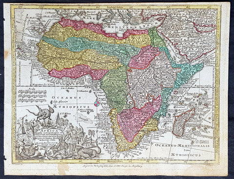
1744 Georg Mattaus Seutter Antique Map of Africa
Antique Map
- Title : Africa a Matth. Seutteri...T C Lotter, Geogr.
- Ref #: 93390
- Size: 11in x 8 1/2in (280mm x 215mm)
- Date : 1744
- Condition: (A+) Fine Condition
Description:
These beautifully hand coloured original copper-plate engraved antique map was engraved by Tobias Lotter and published in the 1744 edition of GM Seutters Atlas Minor Prae cipua Orbis Terrarum Imperia Regna et Provincias...., Augsburg, Germany.
General Definitions:
Paper thickness and quality: - Heavy and stable
Paper color : - off white
Age of map color: - Early
Colors used: - Yellow, green, blue, pink
General color appearance: - Authentic
Paper size: - 11in x 8 1/2in (280mm x 215mm)
Plate size: - 10 1/2in x 8in (265mm x 205mm)
Margins: - Min 1/4in (5mm)
Imperfections:
Margins: - Age toning to margins
Plate area: - None
Verso: - None
Background:
Atlas Minor was a series of beautiful maps of all parts of the world. Georg Matthäus Seutter was one of the most and important of the German cartographers of the 18th century, being appointed as the Geographer to the Imperial Court. His son, Albrecht Carl, joined Matthäus and eventually inherited the business. The maps from Atlas Minor were drawn by the two Seutters and engraved by Tobias Conrad Lotte. These maps are highly detailed and engraved with a bold hand with equally strong original hand color in the body of the map as was the 18th century German style. The cartouches were left uncolored in order to emphasize the elaborately detailed illustrations for which German maps are especially prized. These are some of the most decorative and interesting maps of the eighteenth century.
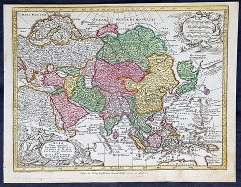
1744 Georg Mattaus Seutter Antique Map of Asia
Antique Map
- Title : Asia a Matth. Seutteri...T C Lotter, Geogr.
- Ref #: 93389
- Size: 11in x 8 1/2in (280mm x 215mm)
- Date : 1744
- Condition: (A+) Fine Condition
Description:
These beautifully hand coloured original copper-plate engraved antique map was engraved by Tobias Lotter and published in the 1744 edition of GM Seutters Atlas Minor Prae cipua Orbis Terrarum Imperia Regna et Provincias...., Augsburg, Germany.
General Definitions:
Paper thickness and quality: - Heavy and stable
Paper color : - off white
Age of map color: - Early
Colors used: - Yellow, green, blue, pink
General color appearance: - Authentic
Paper size: - 11in x 8 1/2in (280mm x 215mm)
Plate size: - 10 1/2in x 8in (265mm x 205mm)
Margins: - Min 1/4in (5mm)
Imperfections:
Margins: - None
Plate area: - None
Verso: - None
Background:
Atlas Minor was a series of beautiful maps of all parts of the world. Georg Matthäus Seutter was one of the most and important of the German cartographers of the 18th century, being appointed as the Geographer to the Imperial Court. His son, Albrecht Carl, joined Matthäus and eventually inherited the business. The maps from Atlas Minor were drawn by the two Seutters and engraved by Tobias Conrad Lotte. These maps are highly detailed and engraved with a bold hand with equally strong original hand color in the body of the map as was the 18th century German style. The cartouches were left uncolored in order to emphasize the elaborately detailed illustrations for which German maps are especially prized. These are some of the most decorative and interesting maps of the eighteenth century.
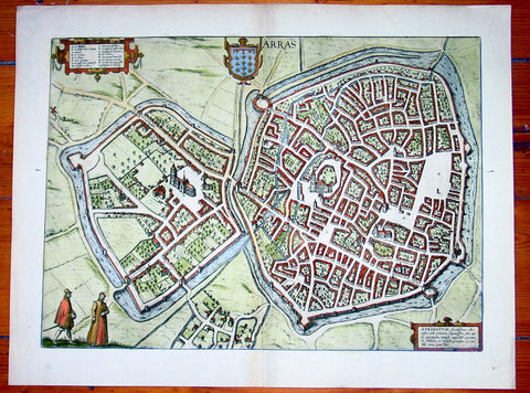
1575 Braun & Hogenberg Large Antique Map of the City of Arras, France
Antique Map
- Title : Arras
- Date : 1575
- Condition: (A+) Fine Condition
- Ref: 92833
- Size: 21in x 16in (535mm x 410mm)
Description:
This fine beautifully hand coloured original antique map a birds-eye view of the French City of Arras - the capital of the Pas de Calais region - was published by Georg Braun & Frans Hogenberg for the 1575 atlas of town plans Civiates Orbis Terrarum Vol II (1572-1612) intended as a companion to Abraham Ortelius's master Atlas Theatrum Orbis Terrarum published in 1570.
Background of Civitates Orbis Terrarum
The first volume of the Civitates Orbis Terrarum was published in Cologne in 1572. The sixth and the final volume appeared in 1617.
This great city atlas, edited by Georg Braun and largely engraved by Franz Hogenberg, eventually contained 546 prospects, bird-eye views and map views of cities from all over the world. Braun (1541-1622), a cleric of Cologne, was the principal editor of the work, and was greatly assisted in his project by the close, and continued interest of Abraham Ortelius, whose Theatrum Orbis Terrarum of 1570 was, as a systematic and comprehensive collection of maps of uniform style, the first true atlas.
For a variety of reasons town plans were comparatively latecomers in the long history of cartography. Few cities in Europe in the middle ages had more than 20,00 inhabitants and even London in the late Elizabethan period had only 100-150,000 people which in itself was probably 10 times that of any other English city. The Nuremberg Chronicle in 1493 included one of the first town views of Jerusalem, thereafter, for most of the sixteenth century, German cartographers led the way in producing town plans in a modern sense. In 1544 Sebastian Munster issued in Basle his Cosmographia containing roughly sixty-six plans and views, some in the plan form, but many in the old panorama or birds eye view. (Ref: Tooley; M&B)
Condition Report:
Paper thickness and quality: - Heavy and stable
Paper color: - off white
Age of map color: - Early
Colors used: - Green, blue, red, yellow
General color appearance: - Authentic
Paper size: - 21in x 16in (535mm x 410mm)
Plate size: - 19in x 14in (485mm x 355mm)
Margins: - Min 1in (25mm)
Imperfections:
Margins: - None
Plate area: - None
Verso: - None
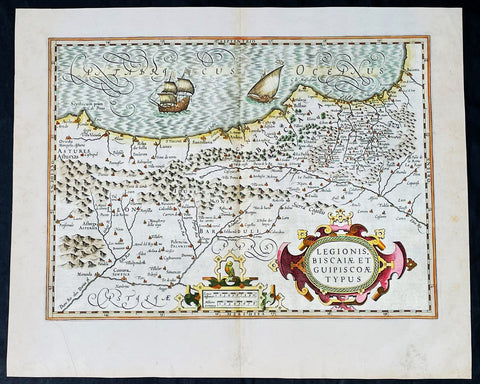
1628 Henricus Hondius Antique Map of the Basque Region of Spain
Antique Map
- Title : Legionis, Biscaiae Et Guipiscoae Typus
- Date : 1628
- Size: 22 1/2in x 18 1/2in (570mm x 470mm)
- Condition: (A+) Fine Condition
- Ref: 35641
Description:
This beautifully engraved hand coloured original antique map of Basque Region of Spain was published in the 1628 French edition of Mercator's atlas by Jan Jansson and Henricus Hondius.
These maps, published in the later editions of Mercators atlas, are derived from the original maps drawn and engraved by Gerald Mercator in the mid to late 16th century, published by his son Rumold as an atlas, after his death, in 1595. After two editions the plates were purchased by Jodocus Hondius in 1604 and continued to be published until the mid 1630's when the plates were re-engraved and updated by Jan Jansson and Henricus Hondius.
General Definitions:
Paper thickness and quality: - Heavy and stable
Paper color : - off white
Age of map color: - Original & later
Colors used: - Yellow, green, pink
General color appearance: - Authentic
Paper size: - 22 3/4in x 19 3/4in (580mm x 500mm)
Plate size: - 20in x 13 3/4in (500mm x 350mm)
Margins: - Min 1in (25mm)
Imperfections:
Margins: - None
Plate area: - None
Verso: - None
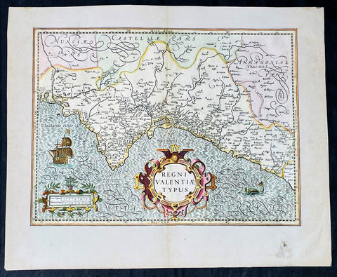
1628 Henricus Hondius Antique Map Valencia Region of Spain & Mediterranean Sea
Antique Map
- Title : Regni Valentiae Typus
- Date : 1628
- Size: 22 1/2in x 18 1/2in (570mm x 470mm)
- Condition: (A+) Fine Condition
- Ref: 35640
Description:
This beautifully engraved hand coloured original antique map of Valencia Region of Spain was published in the 1628 French edition of Mercator's atlas by Jan Jansson and Henricus Hondius.
These maps, published in the later editions of Mercators atlas, are derived from the original maps drawn and engraved by Gerald Mercator in the mid to late 16th century, published by his son Rumold as an atlas, after his death, in 1595. After two editions the plates were purchased by Jodocus Hondius in 1604 and continued to be published until the mid 1630's when the plates were re-engraved and updated by Jan Jansson and Henricus Hondius.
General Definitions:
Paper thickness and quality: - Heavy and stable
Paper color : - off white
Age of map color: - Original & later
Colors used: - Yellow, green, pink
General color appearance: - Authentic
Paper size: - 22 3/4in x 19 3/4in (580mm x 500mm)
Plate size: - 20in x 13 3/4in (500mm x 350mm)
Margins: - Min 1in (25mm)
Imperfections:
Margins: - Light soiling
Plate area: - None
Verso: - None

1802 J B Lechevalier & Pierre Tardieu Large Antique Map of Corfu, Greece
- Title : Plan De L Ile De Corfou
- Date : 1802
- Condition: (A+) Fine Condition
- Ref: 70208
- Size: 21in x 14in (535mm x 355mm)
Description:
This original copper-plate engraved antique map of the Greek Island of Corfu was engraved by Pierre Tardieu and was published in the 1802 edition of Jean-Baptiste Lechevaliers of Voyage de la Troade, fait dans les années 1785 et 1786
General Definitions:
Paper thickness and quality: - Heavy and stable
Paper color : - off white
Age of map color: -
Colors used: -
General color appearance: -
Paper size: - 21in x 14in (535mm x 355mm)
Plate size: - 20 1/2in x 13in (520mm x 335mm)
Margins: - Min 1/2in (12mm)
Imperfections:
Margins: - Light soiling
Plate area: - Light soiling
Verso: - Light soiling
Background:
Corfu or Kerkyra is a Greek island in the Ionian Sea. It is the second largest of the Ionian Islands and, including its small satellite islands, forms the north-westernmost part of Greece. The island is part of the Corfu regional unit, and is administered as a single municipality, which also includes the smaller islands of Ereikoussa, Mathraki and Othonoi. The municipality has an area of 610,9 km2, the island proper 592,8 km2. The principal city of the island and seat of the municipality (pop. 32,095) is also named Corfu. Corfu is home to the Ionian University.
The island is bound up with the history of Greece from the beginnings of Greek mythology. Its history is full of battles and conquests. Ancient Korkyra took part in the Battle of Sybota which was a catalyst for the Peloponnesian War, and, according to Thucydides, the largest naval battle between Greek city states until that time. Thucydides also reports that Korkyra was one of the three great naval powers of fifth century BC Greece, along with Athens and Corinth. Medieval castles punctuating strategic locations across the island are a legacy of struggles in the Middle Ages against invasions by pirates and the Ottomans. Two of these castles enclose its capital, which is the only city in Greece to be surrounded in such a way. As a result, Corfu\'s capital has been officially declared a Kastropolis (castle city) by the Greek government. From medieval times and into the 17th century, the island, having successfully repulsed the Ottomans during several sieges, was recognised as a bulwark of the European States against the Ottoman Empire and became one of the most fortified places in Europe. The fortifications of the island were used by the Venetians to defend against Ottoman intrusion into the Adriatic. Corfu eventually fell under British rule following the Napoleonic Wars. Corfu was eventually ceded by the British Empire along with the remaining islands of the United States of the Ionian Islands, and unification with modern Greece was concluded in 1864 under the Treaty of London.
Jean-Baptiste Lechevalier was the secretary of the Ambassador of France in Constantinople. In the year 1788 he visited the plain of Troy, and was enthusiastically in favour of the theory that the site of Homers Troy was to be found at the village of Bunarbashi. His publication about Troy Voyage de la Troade.....was first published in 1799.
The Troad, also known as Troas, is the historical name of the Biga peninsula (Biga Yarımadası, Τρωάς) in the northwestern part of Anatolia, Turkey. This region now is part of the Çanakkale province of Turkey. Bounded by the Dardanelles to the northwest, by the Aegean Sea to the west and separated from the rest of Anatolia by the massif that forms Mount Ida, the Troad is drained by two main rivers, the Scamander (Karamenderes) and the Simois, which join at the area containing the ruins of Troy. Grenikos, Kebren, Simoeis, Rhesos, Rhodios, Heptaporos and Aisepos were seven rivers of the Troad and the names of the river gods that inhabited each river.
Troy (Ancient Greek: Τροία, Troia or Τροίας, Troias, Truva or Troya) was a city in the far northwest of the region known in late Classical antiquity as Asia Minor, now known as Anatolia in modern Turkey, just south of the southwest mouth of the Dardanelles strait and northwest of Mount Ida. The present-day location is known as Hisarlik. It was the setting of the Trojan War described in the Greek Epic Cycle, in particular in the Iliad, one of the two epic poems attributed to Homer. Metrical evidence from the Iliad and the Odyssey suggests that the name λιον (Ilion) formerly began with a digamma: Ϝίλιον (Wilion); this is also supported by the Hittite name for what is thought to be the same city, Wilusa.
A new capital called Ilium (from Greek: λιον, Ilion) was founded on the site in the reign of the Roman Emperor Augustus. It flourished until the establishment of Constantinople, became a bishopric and declined gradually in the Byzantine era, but is now a Latin Catholic titular see.
In 1865, English archaeologist Frank Calvert excavated trial trenches in a field he had bought from a local farmer at Hisarlik, and in 1868, Heinrich Schliemann, a wealthy German businessman and archaeologist, also began excavating in the area after a chance meeting with Calvert in Çanakkale. These excavations revealed several cities built in succession. Schliemann was at first skeptical about the identification of Hisarlik with Troy, but was persuaded by Calvert and took over Calverts excavations on the eastern half of the Hisarlik site, which was on Calvert\'s property. Troy VII has been identified with the city called Wilusa by the Hittites (the probable origin of the Greek λιον) and is generally (but not conclusively) identified with Homeric Troy.
Today, the hill at Hisarlik has given its name to a small village near the ruins, which supports the tourist trade visiting the Troia archaeological site. It lies within the province of Çanakkale, some 30 km south-west of the provincial capital, also called Çanakkale. The nearest village is Tevfikiye. The map here shows the adapted Scamander estuary with Ilium a little way inland across the Homeric plain. Due to Troys location near the Aegean Sea, the Sea of Marmara, and the Black Sea, it was a central hub for the military and trade(Ref: M&B; Tooley)
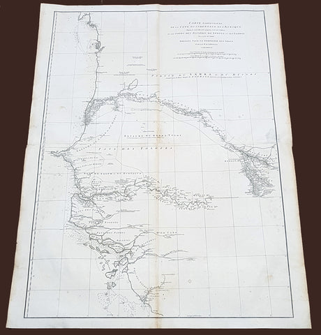
1751 D Anville Very Large Antique Map The West Coast of Africa, Gambia & Senegal
Antique Map
- Title : Carte Particuliere De La Cote Occidentale De L'Afrique Depusi le Cap Blanc jusqu'au Cap De Verga et du Cours Des Rivieres De Senega et de Gambie . .MDCCLI
- Ref #: 92324
- Size: 42in x 33in (1.07m x 840mm)
- Date : 1751
- Condition: (A) Very Good Condition
Description:
This very large finely engraved, highly detailed original antique map of of the west coast of Africa covering Gambia and Senegal was engraved in 1751 - dated in the tile cartouche - and was published in Jean-Baptiste Bourguinon D'Anville's large elephant folio atlas Atlas Generale.
Description: D' Anville's maps have a clarity and a directness that is very 'modern'. He incorporated as much known information into his maps as he could. Map extent is from Cap Blanc in the north to Cap de Verga in the south.
Being part of the Mediterranean world, the northern coasts of the African continent as far as the Straits of Gibraltar and even round to the area of the Fortunate Isles (the Canaries) were reasonably well known and quite accurately mapped from ancient times. In particular, Egypt and the Nile Valley were well defined and the Nile itself was, of course, one of the rivers separating the continents in medieval T-O maps. Through Arab traders the shape of the east coast, down the Red Sea as far as the equator, was also known but detail shown in the interior faded into deserts with occasional mountain ranges and mythical rivers. The southern part of the continent, in the Ptolemaic tradition, was assumed to curve to the east to form a land-locked Indian Ocean. The voyages of the Portuguese, organized by Henry the Navigator in the fifteenth century, completely changed the picture and by the end of the century Vasco da Gama had rounded the Cape enabling cartographers to draw a quite presentable coastal outline of the whole continent, even if the interior was to remain largely unknown for the next two or three centuries.
The first separately printed map of Africa (as with the other known continents) appeared in Munster's Geographia from 1540 onwards and the first atlas devoted to Africa only was published in 1588 in Venice by Livio Sanuto, but the finest individual map of the century was that engraved on 8 sheets by Gastaldi, published in Venice in 1564. Apart from maps in sixteenth-century atlases generally there were also magnificent marine maps of 1596 by Jan van Linschoten (engraved by van Langrens) of the southern half of the continent with highly imaginative and decorative detail in the interior. In the next century there were many attractive maps including those of Mercator/Hondius (1606), Speed (1627), Blaeu (1 630), Visscher (1636), de Wit (c. 1670), all embellished with vignettes of harbours and principal towns and bordered with elaborate and colourful figures of their inhabitants, but the interior remained uncharted with the exception of that part of the continent known as Ethiopia, the name which was applied to a wide area including present-day Abyssinia. Here the legends of Prester John lingered on and, as so often happened in other remote parts of the world, the only certain knowledge of the region was provided by Jesuit missionaries. Among these was Father Geronimo Lobo (1595-1678), whose work A Voyage to Abyssinia was used as the basis for a remarkably accurate map published by a German scholar, Hiob Ludolf in 1683. Despite the formidable problems which faced them, the French cartographers G. Delisle (c. 1700-22), J. B. B. d'Anville (1727-49) and N. Bellin (1754) greatly improved the standards of mapping of the continent, improvements which were usually, although not always, maintained by Homann, Seutter, de Ia Rochette, Bowen, Faden and many others in the later years of the century. (Ref: Tooley, M&B)
General Description:
Paper thickness and quality: - Heavy and stable
Paper color: - White
Age of map color: -
Colors used: -
General color appearance: -
Paper size: - 42in x 33in (1.07m x 840mm)
Plate size: - 40 1/2in x 28in (1.02m x 710mm)
Margins: - Min 1in (25mm)
Imperfections:
Margins: - Light soiling
Plate area: - Light soiling
Verso: - Light soiling
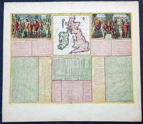
1719 Henri Chatelain Large Antique Map Great Britain & Ireland Allegorical Views
Antique Map
- Title : Carte Du Gouvernment Militaire D Angleterre...
- Ref #: 93425
- Size: 20 1/2in x 18 1/2in (510mm x 470mm)
- Date : 1719
- Condition: (A+) Fine Condition
Description:
This large beautifully hand coloured original copper plate engraved antique map of Great Britain & Ireland, with two large allegorical views, was published by Henri Abraham Chatelain in 1719, in his famous Atlas Historique.
General Definitions:
Paper thickness and quality: - Heavy and stable
Paper color : - off white
Age of map color: - Early
Colors used: - Yellow, green, blue, pink
General color appearance: - Authentic
Paper size: - 20 1/2in x 18 1/2in (510mm x 470mm)
Plate size: - 18 1/2in x 14in (470mm x 355mm)
Margins: - Min 1in (25mm)
Imperfections:
Margins: - None
Plate area: - None
Verso: - None

1856 A K Johnston Large Antique Map of North America, Railways to Missouri
Antique Map
- Title : North America by AK Johnston F.R.G.S
- Ref #: 17052
- Size: 25in x 21 1/4in (635mm x 540mm)
- Date : 1856
- Condition: (A+) Fine Condition
Description:
This large original steel plate engraved hand coloured antique map by W & AK Johnston, was published in the 1856 edition of Johnstons large General Atlas.
General Definitions:
Paper thickness and quality: - Heavy and stable
Paper color : - off white
Age of map color: - Original
Colors used: - Yellow, green, blue, pink
General color appearance: - Authentic
Paper size: - 25in x 21 1/4in (635mm x 540mm)
Plate size: - 23in x 19 1/2in (590mm x 500mm)
Margins: - Min 1/2in (12mm)
Imperfections:
Margins: - None
Plate area: - None
Verso: - None
Please note all items auctioned are genuine, we do not sell reproductions. A Certificate of Authenticity (COA) can be issued on request.

1855 John Bartholomew Large Antique Goldfields Map of South Eastern Australia
Antique Map
- Title : Victoria. New South Wales and South Australia...Gold Deposits..
- Date : 1855
- Size: 17 1/2in x 12 1/2in (445mm x 320mm)
- Condition: (A+) Fine Condition
- Ref: 27097
Description:
This large hand coloured & scarce antique lithograph Goldfields Map of South Eastern Australia by John Bartholomew was published in the 1855 edition of A & C Blacks General Atlas of The World
General Definitions:
Paper thickness and quality: - Heavy and stable
Paper color : - off white
Age of map color: - Original
Colors used: - Green, yellow, pink
General color appearance: - Authentic
Paper size: - 17 1/2in x 12 1/2in (445mm x 320mm)
Plate size: - 17 1/2in x 12 1/2in (445mm x 320mm)
Margins: - Min 1/2in (12mm)
Imperfections:
Margins: - None
Plate area: - None
Verso: - None
Background:
The first gold rush in Australia began in May 1851 after prospector Edward Hargraves claimed to have discovered payable gold near Orange, at a site he called Ophir. Hargraves had been to the Californian goldfields and had learned new gold prospecting techniques such as panning and cradling. Hargraves was offered rewards by the Colony of New South Wales and the Colony of Victoria. Before the end of the year, the gold rush had spread to many other parts of the state where gold had been found, not just to the west, but also to the south and north of Sydney.
The Australian gold rushes changed the convict colonies into more progressive cities with the influx of free immigrants. These hopefuls, termed diggers, brought new skills and professions, contributing to a burgeoning economy. The mateship that evolved between these diggers and their collective resistance to authority led to the emergence of a unique national identity. Although not all diggers found riches on the goldfields, many decided to stay and integrate into these communities.
In July 1851, Victoria\'s first gold rush began on the Clunes goldfield. In August, the gold rush had spread to include the goldfield at Buninyong (today a suburb of Ballarat) 45 km (28 m) away and, by early September 1851, to the nearby goldfield at Ballarat (then also known as Yuille\'s Diggings) followed in early September to the goldfield at Castlemaine (then known as Forest Creek and the Mount Alexander Goldfield) and the goldfield at Bendigo (then known as Bendigo Creek) in November 1851. Gold, just as in New South Wales, was also found in many other parts of the state. The Victorian Gold Discovery Committee wrote in 1854:
The discovery of the Victorian Goldfields has converted a remote dependency into a country of world wide fame; it has attracted a population, extraordinary in number, with unprecedented rapidity; it has enhanced the value of property to an enormous extent; it has made this the richest country in the world; and, in less than three years, it has done for this colony the work of an age, and made its impulses felt in the most distant regions of the earth.
When the rush began at Ballarat, diggers discovered it was a prosperous goldfield. Lieutenant-Governor, Charles La Trobe visited the site and watched five men uncover 136 ounces of gold in one day. Mount Alexander was even richer than Ballarat. With gold sitting just under the surface, the shallowness allowed diggers to easily unearth gold nuggets. In 7 months, 2.4 million pounds of gold was transported from Mount Alexander to nearby capital cities.
The gold rushes caused a huge influx of people from overseas. Australia\'s total population more than tripled from 430,000 in 1851 to 1.7 million in 1871. Australia first became a multicultural society during the gold rush period. Between 1852 and 1860, 290,000 people migrated to Victoria from the British Isles, 15,000 came from other European countries, and 18,000 emigrated from the United States. Non-European immigrants, however, were unwelcome, especially the Chinese.
The Chinese were particularly industrious, with techniques that differed widely from the Europeans. This and their physical appearance and fear of the unknown led to them to being persecuted in a racist way that would be regarded as untenable today.
In 1855, 11,493 Chinese arrived in Melbourne. Chinese travelling outside of New South Wales had to obtain special re-entry certificates. In 1855, Victoria enacted the Chinese Immigration Act 1855, severely limiting the number of Chinese passengers permitted on an arriving vessel. To evade the new law, many Chinese were landed in the south-east of South Australia and travelled more than 400 km across country to the Victorian goldfields, along tracks which are still evident today.
In 1885, following a call by the Western Australian government for a reward for the first find of payable gold, a discovery was made at Halls Creek, sparking a gold rush in that state.
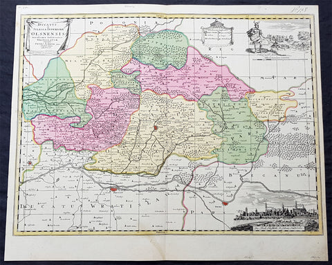
1715 Pieter Schenk Large Antique Map of The Duchy Oels, Silesia Region of Poland
Antique Map
- Title : Ducatus in Silesia Inferiore Olsnensis...Petri Schenk jun.
- Ref #: 93484
- Size: 23 1/2in x 19 1/2in (590mm x 490mm)
- Date : 1715
- Condition: (A+) Fine Condition
Description:
This original large rare, beautifully hand coloured copper plate engraved antique map of the Duchy of Oels or Olesnica, with a inset view of the capital Olesnica, by Pieter Schenk the Younger (1693 - 1775) in 1715.
The Duchy of Oels, Latin: Ducatus Olsnensis, was one of the duchies of Silesia with its capital in Oleśnica in Lower Silesia, Poland. Initially ruled by the Silesian Piasts, it was acquired by the Münsterberg (Ziębice) dukes of the Podiebrad family from 1495 and was inherited by the House of Württemberg in 1649. Conquered by Prussia in 1742, it was enfeoffed to the Welf dukes of Brunswick-Lüneburg from 1792 until its dissolution in 1884.(Ref: Tooley; M&B)
General Definitions:
Paper thickness and quality: - Heavy and stable
Paper color : - off white
Age of map color: - Original
Colors used: - Blue, pink, red, green, yellow
General color appearance: - Authentic
Paper size: - 23 1/2in x 19 1/2in (590mm x 490mm)
Plate size: - 23in x 17in (585mm x 435mm)
Margins: - Min 1/2in (12mm)
Imperfections:
Margins: - None
Plate area: - None
Verso: - None
Background:
Silesia is a historical region of Central Europe mostly in Poland, with small parts in the Czech Republic and Germany. Its area is approximately 40,000 km2, and the population is estimated at around 8,000,000 inhabitants. Silesia is split into two main sub-regions of Lower Silesia in the west and Upper Silesia in the east. Silesia has a diverse culture, including architecture, costumes, cuisine, traditions, and the Silesian language.
Silesia is along the Oder River, with the Sudeten Mountains extending across the southern border. The region possesses many historical landmarks and UNESCO World Heritage Sites. It is also rich in mineral and natural resources, and includes several important industrial areas. Silesias largest city and historical capital is Wrocław. The biggest metropolitan area is the Upper Silesian metropolitan area, the centre of which is Katowice. Parts of the Czech city of Ostrava and the German city of Görlitz fall within the borders of Silesia.
Silesias borders and national affiliation have changed over time, both when it was a hereditary possession of noble houses and after the rise of modern nation-states. The varied history with changing aristocratic possessions resulted in an abundance of castles, especially in the Jelenia Góra valley. The first known states to hold power in Silesia were probably those of Greater Moravia at the end of the 9th century and Bohemia early in the 10th century. In the 10th century, Silesia was incorporated into the early Polish state, and after its division in the 12th century became a Piast duchy. In the 14th century, it became a constituent part of the Bohemian Crown Lands under the Holy Roman Empire, which passed to the Austrian Habsburg Monarchy in 1526. As a result of the Silesian Wars, the region was annexed by Prussia in 1742.
After World War I, the easternmost part of Upper Silesia was granted to Poland by the Entente Powers after insurrections by Poles and the Upper Silesian plebiscite. The remaining former Austrian parts of Silesia were partitioned to Czechoslovakia, forming part of Czechoslovakias Sudetenland region, and are today part of the Czech Republic. In 1945, after World War II, the bulk of Silesia was transferred to Polish jurisdiction by the Potsdam Agreement between the victorious Allies and became part of Poland, whose Communist government expelled the majority of Silesias previous population. The small Lusatian strip west of the Oder–Neisse line, which had belonged to Silesia since 1815, remained in Germany.
Schenk, Pieter The Elder 1660 – 1711
Petrus Schenck, or Pieter, or Peter Schenk the elder was a German engraver and cartographer active in Amsterdam and Leipzig. Was born in Elberfeld and moved to Amsterdam in 1675 where he became a student of Gerard Valck specializing in mezzotint. Valck was married to Maria Bloteling, the sister of the Amsterdam engraver Abraham Bloteling. In 1687 Schenk married Gerards sister Agatha Valck. In 1694, together with Valck, he bought some of the copper-plates of the art-dealer and cartographer Johannes Janssonius (Jan Jansson) Along with Valck and Bloteling, he produced prints for the London market, though it is not known if he ever went there with them.
Until 1700 he lived in the Jordaan, then he moved to Dam Square or to Leipzig, where he opened a shop, selling maps and art. He was a regular visitor to the trade fair Leipziger Messe in Leipzig, where he died. He had three sons who became engravers.His eldest son Peter Schenk the Younger was also a noted cartographer and art dealer who continued his fathers shop in Leipzig. His sons Jan and Leonard stayed in Amsterdam and probably continued their father\\\'s workshop. His daughter Maria married Leonard Valck, the son of Gerard, who also continued Gerards workshop.
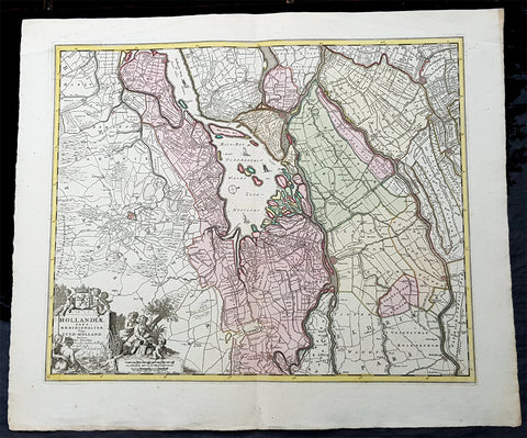
1670 Nicolas Visscher Large Antique Map of South Holland Dordrecht, Gouda, Breda
Antique Map
- Title : Hollandiae Pars Merionalior Vulgo Zuyd-Holland Auctore Nic. Visscher
- Ref #: 93481
- Size: 26 1/2in x 21in (675mm x 515mm)
- Date : 1670
- Condition: (A+) Fine Condition
Description:
This original large beautifully hand coloured copper plate engraved antique map of South Holland, from the city of Gouda in the North to Breda in the South and centering on the city of Dordrecht, was published by Nicolas Visscher in 1670.
General Definitions:
Paper thickness and quality: - Heavy and stable
Paper color : - off white
Age of map color: - Original
Colors used: - Green, yellow, brown, pink
General color appearance: - Authentic
Paper size: - 26 1/2in x 21in (675mm x 515mm)
Plate size: - 22 1/2in x 18in (565mm x 460mm)
Margins: - Min 1in (25mm)
Imperfections:
Margins: - None
Plate area: - None
Verso: - None
Background:
The first city in South Holland to receive city rights was Dordrecht, which did so in 1220. The city retained a dominant position in the area until it was struck by a series of floods in the late 14th century. The same century also saw a series of civil wars, the Hook and Cod wars, concerning the succession of count William IV. Both his daughter Jacqueline and his brother John, the latter supported by Philip the Good, Duke of Burgundy, claimed the throne. The conflict ended in 1490, with John victorious.
Overall, the area of South Holland remained largely agrarian throughout the late Middle Ages. This changed around 1500, when Holland became Europes most urbanised area. During the Eighty Years War, the area of South Holland was the scene of the Capture of Brielle, the Siege of Leiden and the assassination of William the Silent.
The United Netherlands declared their independence in 1581, and Holland quickly emerged as the countrys dominant province, with important trading cities such as Leiden, Delft, Gouda and Dordrecht. In 1575, the Netherlands first university was founded in Leiden by William the Silent. The Hague, which had originated around the castle of the counts of Holland, became its new political centre. Both the States of Holland and the States General seated in the Binnenhof. The Dutch Golden Age blossomed in the 17th century. The south of Holland, back then often referred to as the Zuiderkwartier (literally South Quarter), was the birthplace and residence of many scientists such as Antoni van Leeuwenhoek and Christiaan Huygens, philosophers such as Baruch Spinoza and Pierre Bayle, as well as painters such as Johannes Vermeer, Rembrandt van Rijn and Jan Steen.
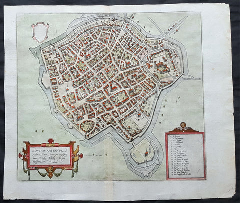
1575 Braun & Hogenberg Original Antique Birds Eye View of St Omer, Calais France
Antique Map
- Title : S. Audomari Fanum. S. Ausmer, Omer, Iccius portus Abrahamo Orttelio, Artesii urbs munitissima
- Date : 1575
- Size: 25in x 21 1/4in (635mm x 540mm)
- Ref #: 30268
- Condition: (A+) Fine Condition
Description:
This beautifully hand coloured original 1572 antique birds eye view of the Northern French Town of St Omer in the Pas-de-Calais department, was published by Georg Braun & Frans Hogenberg for the 1572 atlas of town plans Civiates Orbis Terrarum intended as a companion to Abraham Ortelius's master Atlas Theatrum Orbis Terrarum.
This is a bird's-eye view from the south of the town, which is fortified with moats, walls and bastions. Numerous churches stand out, including the Gothic cathedral of Notre-Dame in the lower left-hand corner, with its 50-m-high clock tower. The town goes back to the Benedictine monastery established in AD 657 by Bishop Audomar of Thérouanne. Initially a religious centre, it quickly developed various commercial activities. At the beginning of the 14th century the town was one of the largest in France, the wealthiest in Artois and a centre of European trade.
General Definitions:
Paper thickness and quality: - Heavy and stable
Paper color : - off white
Age of map color: - Original
Colors used: - Yellow, green, blue, pink
General color appearance: - Authentic
Paper size: - 18 1/2in x 15 1/2in (470mm x 395mm)
Plate size: - 15in x 13 1/2in (385mm x 345mm)
Margins: - Min 1in (25mm)
Imperfections:
Margins: - None
Plate area: - None
Verso: - None
Background:
This is a bird's-eye view from the south of the town, which is fortified with moats, walls and bastions. Numerous churches stand out, including the Gothic cathedral of Notre-Dame in the lower left-hand corner, with its 50-m-high clock tower. The town goes back to the Benedictine monastery established in AD 657 by Bishop Audomar of Thérouanne. Initially a religious centre, it quickly developed various commercial activities. At the beginning of the 14th century the town was one of the largest in France, the wealthiest in Artois and a centre of European trade.
Saint-Omer, is a city in France in the sub-prefecture of the Pas-de-Calais department 68 km. The town is named after Saint Audomar, who brought Christianity to the area.
Saint Audomar (died c. 670), better known as Saint Omer, was a Burgundy-born bishop of Thérouanne, after whom nearby Saint-Omer in northern France was named
COMMENTARY BY BRAUN (on verso): "Saint-Audomar, commonly known as Saint-Audmar, and, in the mutilated form read by some, Saint-Omer, a small town in Artois, gets its name from St Audomar, a German, a priest born not far from Constance [...]. Through the recommendation of King Pippin and the bishop of Noyon, he was appointed bishop to the Morini or Flemings. Because he was a man of pious conduct, Adroaldus, a rich and noble man, was later persuaded to present him with the hamlet of Sithieu and the surrounding area to build a monastery there. [...] Through the teachings of these men a large number of people came to the little village of Sithieu and began to build a town, which was later named St Audomar or St Omer in honour of this excellent bishop."
CARTOUCHE LEFT: S. Audomari Fanum, S. Aulmer, Saint-Omer. Iccius portus according to Abraham Ortelius; well-fortified town in Artois.
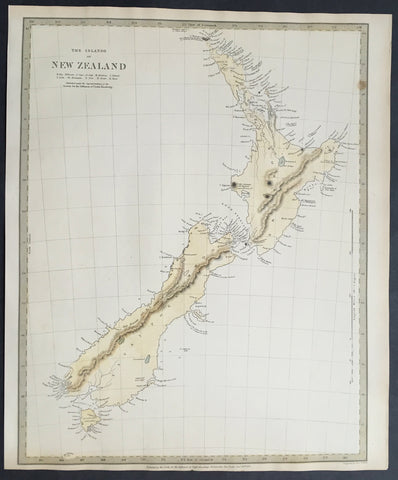
1838 SDUK Large Antique Map of New Zealand - 1st edition
Antique Map
- Title :The Islands of New Zealand....Published by the SDUK...Nov 26th 1838
- Ref #: 61040
- Size: 16in x 13in (400mm x 330mm)
- Date : 1838
- Condition: (A+) Fine Condition
Description:
This fine original hand coloured antique map* of New Zealand was engraved in 1838 (1st edition) - dated at the bottom of the map - by J & C W Walker and was published in the Baldwin & Cradock edition of theSociety For the Diffusion of Useful Knowledge (SDUK) Atlas.
Background: The map covers the entire island country from Cape Reinga (C. Maria Van Diemen) to Stewart Island. Various cities, towns, rivers, mountains, bays and several other topographical details are noted with relief shown by hachure.
In 1840, after the signing of the Treaty of Waitangi, the British annexed New Zealand as part of the Australian colony of New South Wales. However, it separated from New South Wales to become a colony in its own right in 1841. This map was originally copyrighted in 1838, but was issued in Volume two of Chapman and Hall's 1844 edition of Maps of the Society for the Diffusion of Useful Knowledge
The SDUK produced two landmark volumes in cartography in the first half of the 19th century. The first volume concentrated on areas of the old world, Europe, Africa, Great Britain etc. The second volume contained maps of the new world, America, South Asia, including US state maps, colonies of Australia, South Africa, South America etc. Also included were some of the finest engraved town and city plans published at that time.
The SDUK was published in its entirety or in part by many publishers including Baldwin and Cradock 1829-32, Chapman & Hall in 1844, Charles Knight & co. 1846 – 1852. G. Cox published the SDUK between 1852-3, Stanford 1857-70 and later revised edition were also published after Stanford.
This is a finely engraved map with beautiful original colour t on strong, clean paper. (Ref: Tooley, M&B)
General Description:
Paper thickness and quality: - Heavy and stable
Paper color: - white
Age of map color: - Early
Colors used: - Yellow, blue
General color appearance: - Authentic
Paper size: - 16in x 13in (400mm x 330mm)
Margins: - min. 1in (25mm)
Imperfections:
Margins: - Light age toning in margins
Plate area: - None
Verso: - None
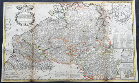
1720 Moll Large Antique Map of The Low Countries, Flanders Netherlands & Belgium
Antique Map
- Title : Les Provinces Des Pays-Bas Catholoiques ou. A Most excat map of Flanders or Austraian Netherlands.....Herman Moll Geogr.
- Size: 40 1/2in x 24in (1.030m x 610mm)
- Condition: (A) Very Good Condition
- Date : 1720
- Ref #: 61130
Description:
This very large beautifully hand coloured original copper-plate engraved antique map of the low country of Flanders region of The Netherlands & Belgium by Herman Moll was published in 1720 in the atlas The World Described, or a New and Correct Sett of Maps by John Bowles, Thomas Bowles, Philip Overton & John King of London.
In the 18th century many large-scale maps were published by the likes of John Senex and Herman Moll, this trend continued until the end of private mapping in the early 19th century when it was replaced by Ordnance Survey maps.
General Definitions:
Paper thickness and quality: - Heavy and stable
Paper color : - off white
Age of map color: - Original
Colors used: - Yellow, green, blue, pink
General color appearance: - Authentic
Paper size: - 40 1/2in x 24in (1.030m x 610mm)
Plate size: - 40in x 24in (1.00m x 610mm)
Margins: - Min 1/2in (12mm)
Imperfections:
Margins: - Age toning along top margin
Plate area: - Age toning along folds
Verso: - Re-enforced & age toning along folds
Background:
Flanders: In 1500, Charles V was born in Ghent. He inherited the Seventeen Provinces (1506), Spain (1516) with its colonies and in 1519 was elected Holy Roman Emperor. The Pragmatic Sanction of 1549, issued by Charles V, established the Low Countries as the Seventeen Provinces (or Spanish Netherlands in its broad sense) as an entity separate from the Holy Roman Empire and from France. In 1556 Charles V abdicated due to ill health (he suffered from crippling gout). Spain and the Seventeen Provinces went to his son, king Philip II of Spain.
Over the first half of the 16th century Antwerp grew to become the second-largest European city north of the Alps by 1560. Antwerp was the richest city in Europe at this time. According to Luc-Normand Tellier It is estimated that the port of Antwerp was earning the Spanish crown seven times more revenues than the Americas.
Meanwhile, Protestantism had reached the Low Countries. Among the wealthy traders of Antwerp, the Lutheran beliefs of the German Hanseatic traders found appeal, perhaps partly for economic reasons. The spread of Protestantism in this city was aided by the presence of an Augustinian cloister (founded 1514) in the St. Andries quarter. Luther, an Augustinian himself, had taught some of the monks, and his works were in print by 1518. The first Lutheran martyrs came from Antwerp. The Reformation resulted in consecutive but overlapping waves of reform: a Lutheran, followed by a militant Anabaptist, then a Mennonite, and finally a Calvinistic movement. These movements existed independently of each other.
Philip II, a devout Catholic and self-proclaimed protector of the Counter-Reformation, suppressed Calvinism in Flanders, Brabant and Holland (what is now approximately Belgian Limburg was part of the Bishopric of Liège and was Catholic de facto). In 1566, the wave of iconoclasm known as the Beeldenstorm was a prelude to religious war between Catholics and Protestants, especially the Anabaptists. The Beeldenstorm started in what is now French Flanders, with open-air sermons (Dutch: hagepreken) that spread through the Low Countries, first to Antwerp and Ghent, and from there further east and north. In total it lasted not even a month.
Subsequently, Philip II sent the Duke of Alba to the Provinces to repress the revolt. Alba recaptured the southern part of the Provinces, who signed the Union of Atrecht, which meant that they would accept the Spanish government on condition of more freedom. But the northern part of the provinces signed the Union of Utrecht and settled in 1581 the Republic of the Seven United Netherlands. Spanish troops quickly started fighting the rebels, but before the revolt could be completely defeated, a war between England and Spain had broken out, forcing Philips Spanish troops to halt their advance. Meanwhile, the Spanish armies had already conquered the important trading cities of Bruges and Ghent. Antwerp, which was then the most important port in the world, also had to be conquered. On 17 August 1585, Antwerp fell. This ended the Eighty Years War for the (from now on) Southern Netherlands. The United Provinces (the Northern Netherlands) fought on until 1648 – the Peace of Westphalia.
While Spain was at war with England, the rebels from the north, strengthened by refugees from the south, started a campaign to reclaim areas lost to Philip IIs Spanish troops. They managed to conquer a considerable part of Brabant (the later Noord-Brabant of the Netherlands), and the south bank of the Scheldt estuary (Zeelandic Flanders), before being stopped by Spanish troops. The front line at the end of this war stabilized and became the current border between present-day Belgium and the Netherlands. The Dutch (as they later became known) had managed to reclaim enough of Spanish-controlled Flanders to close off the river Scheldt, effectively cutting Antwerp off from its trade routes.
First the fall of Antwerp to the Spanish and later also the closing of the Scheldt were causes of a considerable emigration of Antverpians. Many of the Calvinist merchants of Antwerp and also of other Flemish cities left Flanders and emigrated to the north. A large number of them settled in Amsterdam, which was at the time a smaller port, of significance only in the Baltic trade. In the following years Amsterdam was rapidly transformed into one of the worlds most important ports. Because of the contribution of the Flemish exiles to this transformation, the exodus is sometimes described as creating a new Antwerp.
Flanders and Brabant, due to these events, went into a period of relative decline from the time of the Thirty Years War. In the Northern Netherlands however, the mass emigration from Flanders and Brabant became an important driving force behind the Dutch Golden Age.
Although arts remained at a relatively impressive level for another century with Peter Paul Rubens (1577–1640) and Anthony van Dyck, Flanders experienced a loss of its former economic and intellectual power under Spanish, Austrian, and French rule, with heavy taxation and rigid imperial political control compounding the effects of industrial stagnation and Spanish-Dutch and Franco-Austrian conflict. The Southern Netherlands suffered severely under the War of the Spanish Succession, but under the reign of Empress Maria-Theresia these lands economically flourished again. Influenced by the Enlightenment, the Austrian Emperor Joseph II was the first sovereign who had been in the Southern Netherlands since King Philip II of Spain left them in 1559.
In 1794 the French Republican Army started using Antwerp as the northernmost naval port of France, which country officially annexed Flanders the following year as the départements of Lys, Escaut, Deux-Nèthes, Meuse-Inférieure and Dyle. Obligatory (French) army service for all men aged 16–25 was one of the main reasons for the peoples uprising against the French in 1798, known as the Boerenkrijg (Peasants War), with the heaviest fighting in the Campine area.
After the defeat of Napoleon Bonaparte at the 1815 Battle of Waterloo in Waterloo, Brabant, sovereignty over the Austrian Netherlands – Belgium minus the East Cantons and Luxembourg – was given by the Congress of Vienna (1815) to the United Netherlands (Dutch: Verenigde Nederlanden), the state that briefly existed under Sovereign Prince William I of Orange Nassau, the latter King William I of the United Kingdom of the Netherlands, after the French Empire was driven out of the Dutch territories. The United Kingdom of the Netherlands was born. The Protestant King of the Netherlands, William I rapidly started the industrialisation of the southern parts of the Kingdom. The political system that was set up however, slowly but surely failed to forge a true union between the northern and the southern parts of the Kingdom. The southern bourgeoisie mainly was Roman Catholic, in contrast to the mainly Protestant north; large parts of the southern bourgeoisie also primarily spoke French rather than Dutch.
In 1815 the Dutch Senate was reinstated (Dutch: Eerste Kamer der Staaten Generaal). The nobility, mainly coming from the south, became more and more estranged from their northern colleagues. Resentment grew both between the Roman Catholics from the south and the Protestants from the north and among the powerful liberal bourgeoisie from the south and their more moderate colleagues from the north. On 25 August 1830 (after the showing of the opera La Muette de Portici of Daniel Auber in Brussels) the Belgian Revolution sparked off and became a fact. On 4 October 1830, the Provisional Government (Dutch: Voorlopig Bewind) proclaimed the independence, which was later confirmed by the National Congress that issued a new Liberal Constitution and declared the new state a Constitutional Monarchy, under the House of Saxe-Coburg. Flanders now became part of the Kingdom of Belgium, which was recognized by the major European Powers on 20 January 1831. The de facto dissidence was finally recognized by the United Kingdom of the Netherlands on 19 April 1839.
In 1830, the Belgian Revolution led to the splitting up of the two countries. Belgium was confirmed as an independent state by the Treaty of London of 1839, but deprived of the eastern half of Limburg (now Dutch Limburg), and the Eastern half of Luxembourg (now the Grand-Duchy of Luxembourg). Sovereignty over Zeelandic Flanders, south of the Westerscheldt river delta, was left with the Kingdom of the Netherlands, which was allowed to levy a toll on all traffic to Antwerp harbour until 1863.
The Belgian Revolution was not well supported in Flanders and even on 4 October 1830, when the Belgian independence was eventually declared, Flemish authorities refused to take orders from the new Belgian government in Brussels. Only after Flanders was subdued with the aid of a large French military force one month later, under the leadership of the Count de Pontécoulant, did Flanders become a true part of Belgium.
The French-speaking bourgeoisie showed very little respect for the Dutch-speaking part of the population. French became the only official language in Belgium and all secondary and higher education in the Dutch language was abolished.
In 1834, all people even remotely suspected of being Flemish minded or calling for the reunification of the Netherlands were prosecuted and their houses looted and burnt. Flanders, until then a very prosperous European region, was not considered worthwhile for investment and scholarship. A study in 1918 demonstrated that in the first 88 years of its existence, 80% of the Belgian GNP was invested in Wallonia. This led to a widespread poverty in Flanders, forcing roughly 300.000 Flemish to emigrate to Wallonia to start working there in the heavy industry.John SenexMoll
All of these events led to a silent uprising in Flanders against the French-speaking domination. But it was not until 1878 that Dutch was allowed to be used for official purposes in Flanders (see language legislation in Belgium), although French remained the only official language in Belgium.
In 1873, Dutch became the official language in public secondary schools. In 1898 Dutch and French were declared equal languages in laws and Royal orders. In 1930 the first Flemish university was opened. The first official translation of the Belgian constitution in Dutch was not published until 1967.
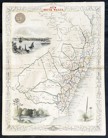
1851 John Tallis Antique Map of New South Wales, Australia
Antique Map
- Title : New South Wales
- Date : 1851
- Size: 14in x 11in (355mm x 280mm)
- Condition: (A+) Fine Condition
- Ref: 1554
Description:
This original hand coloured, steel plate engraved antique map of New South Wales, Australia with vignettes of Sydney Harbour and The Murray was engraved by John Rapkin and published by John Tallis in 1851.
General Definitions:
Paper thickness and quality: - Heavy and stable
Paper color : - off white
Age of map color: - Original
Colors used: - Blue
General color appearance: - Authentic
Paper size: - 14in x 11in (355mm x 280mm)
Plate size: - 14in x 11in (355mm x 280mm)
Margins: - Min 1/2in (12mm)
Imperfections:
Margins: - None
Plate area: - None
Verso: - None
Background:
The firm of Tallis & Company flourished from 1835 to 1860 with varying imprints. Their illustrated Atlas of 1850-51 was one of the last decorative atlases, all the maps being engraved on steel and all adorned with small vignettes. (Ref: Tooley; M&B)
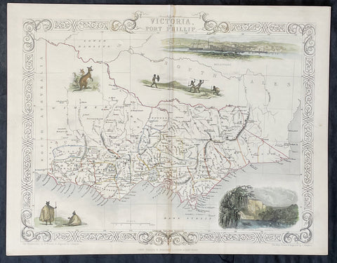
1851 John Tallis Antique Map of Victoria or Port Phillip, Australia
Antique Map
- Title : Victoria or Port Phillip
- Date : 1851
- Size: 14in x 11in (355mm x 280mm)
- Condition: (A+) Fine Condition
- Ref: 35503
Description:
This original hand coloured, steel plate engraved antique map of Victoria, Australia with vignettes of Glenelg River, Aboriginals and Kangaroos was engraved by John Rapkin and published by John Tallis in 1851.
General Definitions:
Paper thickness and quality: - Heavy and stable
Paper color : - off white
Age of map color: - Original
Colors used: - Blue
General color appearance: - Authentic
Paper size: - 14in x 11in (355mm x 280mm)
Plate size: - 14in x 11in (355mm x 280mm)
Margins: - Min 1/2in (12mm)
Imperfections:
Margins: - None
Plate area: - None
Verso: - None
Background:
The firm of Tallis & Company flourished from 1835 to 1860 with varying imprints. Their illustrated Atlas of 1850-51 was one of the last decorative atlases, all the maps being engraved on steel and all adorned with small vignettes. (Ref: Tooley; M&B)
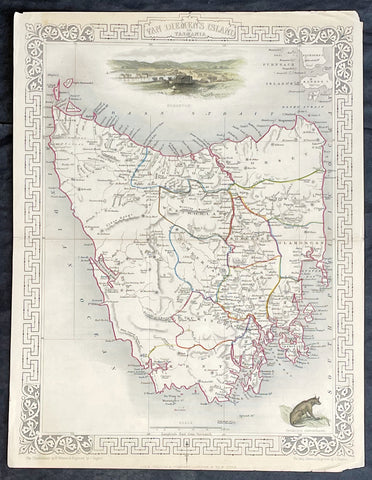
1851 John Tallis Antique Map of Van Diemens Land or Tasmania, Australia
Antique Map
- Title : Van Diemens Land or Tasmania
- Date : 1851
- Size: 14in x 11in (355mm x 280mm)
- Condition: (A+) Fine Condition
- Ref: 35519
Description:
This original hand coloured, steel plate engraved antique map of Tasmania, Australia with vignettes of Hobart and Tasmanian Tiger was engraved by John Rapkin and published by John Tallis in 1851.
General Definitions:
Paper thickness and quality: - Heavy and stable
Paper color : - off white
Age of map color: - Original
Colors used: - Blue
General color appearance: - Authentic
Paper size: - 14in x 11in (355mm x 280mm)
Plate size: - 14in x 11in (355mm x 280mm)
Margins: - Min 1/2in (12mm)
Imperfections:
Margins: - None
Plate area: - None
Verso: - None
Background:
The firm of Tallis & Company flourished from 1835 to 1860 with varying imprints. Their illustrated Atlas of 1850-51 was one of the last decorative atlases, all the maps being engraved on steel and all adorned with small vignettes. (Ref: Tooley; M&B)
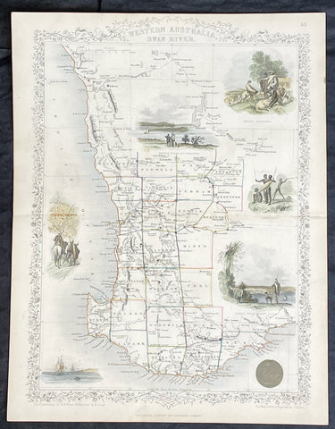
1851 John Tallis Antique Map of Western Australia or The Swan River Settlement
Antique Map
- Title : Western Australia Swan River
- Date : 1851
- Size: 14in x 11in (355mm x 280mm)
- Condition: (A+) Fine Condition
- Ref: 35523
Description:
This original hand coloured, steel plate engraved antique map of Western Australia or The Swan River Settlement, Australia with vignettes of Perth, Fremantle, Aboriginals and settlers was engraved by John Rapkin and published by John Tallis in 1851.
General Definitions:
Paper thickness and quality: - Heavy and stable
Paper color : - off white
Age of map color: - Original
Colors used: - Blue
General color appearance: - Authentic
Paper size: - 14in x 11in (355mm x 280mm)
Plate size: - 14in x 11in (355mm x 280mm)
Margins: - Min 1/2in (12mm)
Imperfections:
Margins: - None
Plate area: - None
Verso: - None
Background:
The firm of Tallis & Company flourished from 1835 to 1860 with varying imprints. Their illustrated Atlas of 1850-51 was one of the last decorative atlases, all the maps being engraved on steel and all adorned with small vignettes. (Ref: Tooley; M&B)
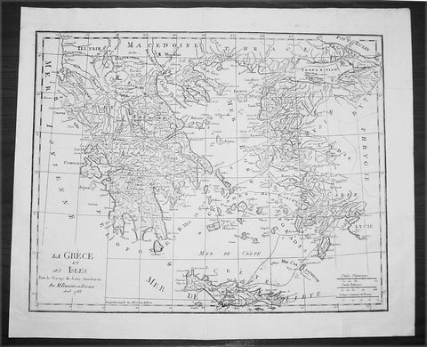
1788 Du Bocage Large Antique Map of Greece, Aegean, Western Turkey & Crete
- Title : La Grece et Ses Isles Pour le Voyage du Jeune Aanacharis Par M Barbier Du Bocage Aout 1788
- Date : 1788
- Condition: (A+) Fine Condition
- Ref: 16471
- Size: 19 1/4in x 16in (490mm x 410mm)
Description:
This fine large original antique map of Greece, The Aegean Islands and the West Coast of Turkey & Crete illustrating the Voyages of the Anacharsis the Younger was engraved in 1788 - dated - and was published by Jean Denis Barbie du Bocage in his Voyage Anacharsis (The Travels of Anacharsis the Younger in Greece) published between 1781 - 1788.
Voyage Anacharsis is an illustrative account of the travels of Anacharsis the Younger in Greece, during the middle of the fourth century before the Christian era.
Jean Denis Barbie du Bocage: (1760-1825) was a French geographer and cosmographer who studied under D' Anville and became one of the founders of the Geography Society of Paris. (Ref: Tooley; M&B)
General Description:
Paper thickness and quality: - Heavy & stable
Paper color: - White
Age of map color: -
Colors used: - General color appearance: -
Paper size: - 19 1/4in x 16in (490mm x 410mm)
Plate size: - 18 1/2in x 14 1/2in (470mm x 370mm)
Margins: - Min 1in (25mm)
Imperfections:
Margins: - None
Plate area: - Folds as issued
Verso: - None
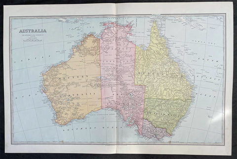
1888 Pic Atlas Scally Large Antique Map of Australia
- Title : Australia
- Date : 1888
- Condition: (A+) Fine Condition
- Ref: 31986
- Size: 25 1/2in x 17in (650mm x 430mm)
Description:
This large steel-plate engraved original antique lithograph map of Australia - engraved by Alex J Scally in 1888, dated at the foot of the map - was published in The Picturesque Atlas of Australasia, 1886-88. A beautiful large pre-federation antique map of Australia, highly detailed in fine condition.
General Description:
Paper thickness and quality: - Light & stable
Paper color: - White
Age of map color: - Original
Colors used: - Yellow, pink, green, blue
General color appearance: - Authentic
Paper size: - 25 1/2in x 17in (650mm x 430mm)
Margins: - Min 1in (25mm)
Imperfections:
Margins: - None
Plate area: - None
Verso: - None
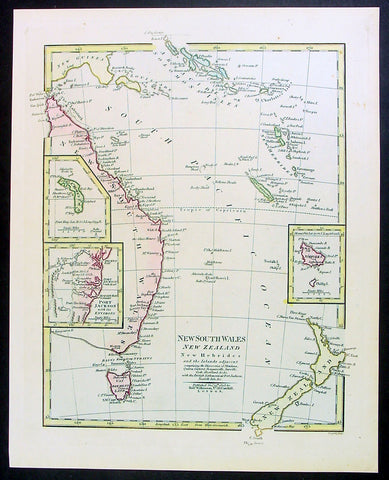
1808 Wilkinson Antique Map of East Coast of Australia, New Zealand, inset Sydney
- Title : New South Wales New Zealand New Hebrides...Published Dec 12th 1808
- Ref #: 9003
- Size: 13in x 11in (330mm x 280mm)
- Date : 1808
- Condition: (A+) Fine Condition
Description:
This fine beautifully hand coloured original antique map of the east coast of Australia, New Zealand and the Solomon Islands - with inset maps of Lord Howe Island, Norfolk Island & Port Jackson - was published in 1808 by Robert Wilkinson - the date is included in the title - in his wideley acclaimed General Atlas of the World published between 1794 and 1816.
This is a finely engraved copper-plate map with beautiful original hand colouring on strong stable paper. (Ref: Tooley; M&B)
General Description:
Paper thickness and quality: - Heavy and stable
Paper color: - off white
Age of map color: - Original
Colors used: - Yellow, green, pink, blue
General color appearance: - Authentic
Paper size: - 13in x 11in (330mm x 280mm)
Plate size: - 12 1/2in x 10in (320mm x 255mm)
Margins: - Min 1/2in (12mm)
Imperfections:
Margins: - None
Plate area: - None
Verso: - None
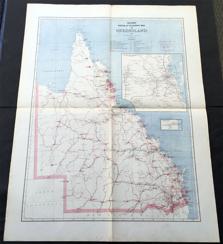
1888 Picturesque Atlas of Australia Large Antique Railway Map of Queensland
- Title : Railway Postal & Telegraph Map of Queensland
- Ref #: 50329
- Size: 34in x 26in (865mm x 660mm)
- Date : 1888
- Condition: (A+) Fine Condition
Description:
This very large fine original antique lithograph layered coloured map of Queensland showing the extent of Railway and postal lines, was engraved in 1888 - the date is engraved in the title - with index page - by Alex J Scally - was published in the extremely significant Australian & New Zealand publication The Picturesque Atlas of Australasia between 1886-88.
These maps were some of the best maps published at the time in the "Modern" look. The colour is bright, the engraving extremely fine and the paper heavy and stable.
General Description:
Paper thickness and quality: - Light & stable
Paper color: - White
Age of map color: - Original
Colors used: - Blue, red
General color appearance: - Authentic
Paper size: - 34in x 26in (865mm x 660mm)
Plate size: - 34in x 26in (865mm x 660mm)
Margins: - Min 1in (25mm)
Imperfections:
Margins: - None
Plate area: - Folds as issued
Verso: - None
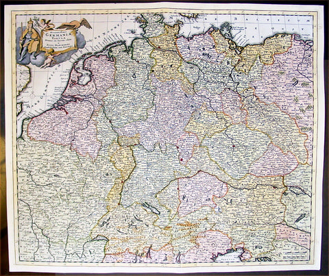
1699 Danckerts Antique Map of Germany & Central Europe Poland to France to Italy
- Title : Accuratissima Germaniae Tabula
- Ref #: 16295
- Size: 24in x 20 1/2in (610mm x 520mm)
- Date : 1699
- Condition: (A+) Fine Condition
Description:
This large beautifully hand coloured original antique map of central Europe - centering on the various German States but stretching from Poland in the east to France in the west and Venice to the south - by Justus Danckerts was published in 1699.
In the latter half of the fifteenth century Germany, though nominally still part of the Holy Roman Empire, was a fragmented land, split into a score of principalities and Imperial Cities, fiercely jealous of each other but having in common an extraordinary creative urge which produced builders of great churches and cathedrals, workers in stone and wood, metal engravers, painters and makers of scientific instruments, who were the envy of the world. Of all their achievements, the invention of movable-type printing was to have the most profound effect on human relationships. Printing industries soon grew up in many cities, including Nuremberg and Augsburg where wood engraving already flourished and which, with Basle and Strassburg, were also the centres of geographical knowledge. Not only were local and regional maps produced in considerable variety and quantity, but more particularly the geographers and mathematicians of Nuremberg are famous for their globes of the world, some of which are still preserved.
The most important map of the whole of Germany produced in this period was a manuscript dated c. 1464 by Nicholas Cusanus (Khryfts), Cardinal, humanist and scholar, friend of Toscanelli, the Italian geographer, and one of the most brilliant men of his day. The map covering Germany, Southern Scandinavia and the Baltic was printed in 1491, long after the author's death, and it served as a model for a similar map in the Nuremberg Chronicle. We have written in some detail in Chapter 4 of this famous book, first published in 1493, which contained a great number of woodcut views and maps, but as far as cartography is concerned the printing of Ptolemy's Geographia at Ulm in 1482 (and 1486) - the first edition with woodcut maps - was an event of the greatest importance. The most ambitious editions of the Ptolemy maps appeared in 1513 in Strassburg, containing not only maps of the ancient world but also twenty new ones, including one of the 'New World', based on the latest contemporary.
knowledge. This was produced under the guidance of Martin Waldseemuller, a German cartographer, at St Die' in Lorraine, at that time a noted centre of learning. Other editions followed in the years up to 1 541, overlapping with the newer work of Sebastian Mu'~nster, an eminent mathematician and linguist, who settled in Basle and whose prolific output of atlases and maps contained also many plans and views of the great cities of the time. These in turn were superseded by Braun and Hogenberg's Civitates Orbis Terrarumissued in Cologne between the years 1572 and 1618, which was one of the most famous publications of the period.
In the seventeenth century Dutch supremacy in map making and publishing overshadowed Germany no less than England and France and there was to be no revival until the foundation in Nuremberg about the year 1700 of the printing firm of J. B. Homann, whose business acumen started a resurgence of map publishing. He became a member of the Berlin Academy of Sciences and was appointed Geographer to the Emperor in 1715. The business was continued by his son, Johann Christoph, and was eventually bequeathed to the founder's son-in-law on condition that he continued the business under the name of Homann Heirs. Other notable publishing houses active during the century were run by Matthaus Seutter and Tobias Lotter in the rival city of Augsburg. (Ref: Tooley; M&B)
General Description:
Paper thickness and quality: - Heavy and stable
Paper color: - off white
Age of map color: - Early
Colors used: - Yellow, green, red, brown.
General color appearance: - Authentic and fresh
Paper size: - 24in x 20 1/2in (610mm x 520mm)
Plate size: - 23in x 19 1/2in (585mm x 495mm)
Margins: - Min 1/2in (10mm)
Imperfections:
Margins: - None
Plate area: - None
Verso: - Bottom centerfold re-joined, no loss.
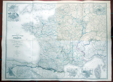
1857 Dufour Very Large Scarce Old, Antique Map of France - 4ft x 6ft
- Title : Carte Administrative et Physique de la France indiquant Les Canaan Les Riviers Navigable les routes, le Chemis de fer avec leurs stations Dresee par A.H. Dufour Gravee Par CH Dyonnet 1857
- Ref #: 61029
- Size: 62in x 46in (1.5m x 1.15m)
- Date : 1857
- Condition: (A) Very Good Condition
Description:
This scarce very large elephant folio 4 sheet - joined - hand coloured original map of France was engraved by Charles Dyonnet in 1857 - dated in the title - for Adolphe Hippolyte Dufour's monumental elephant folio Atlas Physique, Historique et Politique Geographie Moderne published by Pauline Et La Chevalier, Paris.
This uncommon elephant folio map is huge measuring overall 62in x 46in (1.5m x 1.15m) and is incredibly detailed. The map covers the whole of France including Corsica and parts of Spain, Germany and Switzerland.
The first sheet (top left in image) represents north-western France and includes two insets of Nantes and Rouen. The second sheet (top right) represents north-eastern France with an inset of Paris and its environs. The bottom right sheet depicts the south-eastern portions of France and includes two insets, one featuring Marseille and the other featuring Lyon. The last sheet on the bottom left is of southwest France.
An inset on Bordeaux is included and throughout illustrates roads, canals, railways, rivers, cities and other topographical features are noted.
Adolphe Hippolyte Dufour (1795 - 1865), also known as Auguste-Henri Dufour, was a Paris based map and atlas publisher active in the middle to late 19th century. Dufour claimed to be a student of another French cartographer, Emile Lapie. He is known to have worked with numerous other cartographers, publishers and engravers of the period including Charles Dyonnet and Duvotenay. His corpus includes numerous maps and atlases, the most striking of which is probably his monumental elephant folio Atlas Universel physique, historique et politique geographie ancienne et moderne. Dufour's student and successor was Alexandre Vuillemin.
Charles Dyonnet (fl. c. 1822 - c. 1880) was an extremely active Paris based engraver working in the mid to late 19th century. From his offices at 220 Rue St. Jacques, Paris, Dyonnet engraved numerous maps for many of the most prominent 19th French cartographic publishers including Vuillemin, Dufour, Fremin and Duvotenay. From 1850-1861, he held the coveted position of "Graveur du Dépot de la Marine," and in this position engraved numerous French naval and military maps. Dyonnet had a detail oriented and aesthetically minded hand and is responsible from some of the most beautiful French maps to emerge during the 19th century. (Ref: M&B; Tooley)
General Description:
Paper thickness and quality: - Heavy & stable
Paper color: - White
Age of map color: - Original
Colors used: - Yellow, red, green, blue
General color appearance: - Authentic
Paper size: - 62in x 46in (1.5m x 1.15m)
Paper size: - 62in x 46in (1.5m x 1.15m)
Margins: - Min 1in (24mm)
Imperfections:
Margins: - None
Plate area: - Top NE sheet age toning
Verso: - Soiling
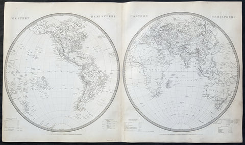
1837 SDUK Large Original Antique Twin Hemisphere World Map
- Title : Western Hemisphere; Eastern Hemisphere
- Date : 1837
- Size: 26 1/2in x 15 1/2in (675mm x 395mm)
- Ref #: 32528
- Condition: (A) Very Good Condition
Description:
This fine large original antique twin hemisphere world map was engraved by J & C Walker and was published by the SDUK in 1837.
General Definitions:
Paper thickness and quality: - Heavy and stable
Paper color : - off white
Age of map color: -
Colors used: -
General color appearance: -
Paper size: - 26 1/2in x 15 1/2in (675mm x 395mm)
Plate size: - 26 1/2in x 15 1/2in (675mm x 395mm)
Margins: - Min 1/2in (12mm)
Imperfections:
Margins: - None
Plate area: - Blind library stamp
Verso: - Centerfold re-joined
Background:
The map depicts the Western and Eastern Hemispheres offering a fascinating snapshot of the world during a period of rapid globalization and discovery. Both maps note towns, rivers, mountains, deserts, islands, and various other important topographical details. Elevation throughout is rendered by hachure.
The map of the Western Hemisphere covers North America, South America, West Indies and most of Polynesia, including New Zealand. The Antarctic continent, first sighted in 1820, but neglected during the first half of the 19th century, does not appear on the map.
The map of the Eastern Hemisphere includes the entirety of Asia, Europe and Africa as well as Australia and much of the Pacific. The interior of Australia is largely blank though the coastal colonies are noted. These include Mediterranean North Africa, Egypt, Abyssinia, the western Niger valley, the Congo, South Africa, and the lands of Mozambique and Zimbabwe.
This map is part of a Series of Maps, Modern and Ancient, issued by subscription. Each folder in the series would contain a set of two maps bound together. These two maps were issued in folder no. XCII. Original folder includes the names of committee members of the ‘Society’, maps already published, the contents and the printer and publication details. These maps were engraved by J. and C. Walker. This folder was printed by William Clowes and Sons for the Society for the Diffusion of Useful Knowledge in their September 30, 1841 subscriber’s edition folder. The folder at the time was priced at 1 shilling plain or 1 shilling 6 pence for colored maps.
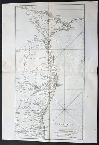
1753 D Anville Large Original Antique Map of SE Coromandel Coast of India - Rare
- Title : Coromandel par Le Sr D Anville...1753
- Size: 39 1/2in x 27in (1.1m x 685mm)
- Ref #: 92321
- Date : 1753
- Condition: (A) Very Good Condition
Description:
This large finely engraved scarce and highly detailed original antique map of South East Coast of India, the Coromandel Coast was engraved by Guillaume de la Haye in 1753 - dated in the tile cartouche - and was published in Jean-Baptiste Bourguinon D\'Anville\'s large elephant folio atlas Atlas Generale.
General Definitions:
Paper thickness and quality: - Heavy and stable
Paper color : - off white
Age of map color: -
Colors used: -
General color appearance: -
Paper size: - 39 1/2in x 27in (1.1m x 685mm)
Plate size: - 38in x 19 1/2in (970mm x 495mm)
Margins: - Min 1/2in (12mm)
Imperfections:
Margins: - Light spotting to right of image
Plate area: - Light spotting to right of image
Verso: - Light spotting to right of image
Background:
The Coromandel Coast is the southeastern coast region of the Indian Subcontinent, between the Eastern Ghats and the Bay of Bengal of the Indian Ocean. The coastline runs between False Divi Point in the north to Kanyakumari in the south. Its definition can also include the northwestern coast of the island of Sri Lanka.
By late 1530 the Coromandel Coast was home to three Portuguese settlements at Nagapattinam, São Tomé de Meliapore, and Pulicat. Later, in the 17th and 18th centuries, the Coromandel Coast was the scene of rivalries among European powers for control of the India trade. The British established themselves at Fort St George (Madras) and Masulipatnam, the Dutch at Pulicat, Sadras and Covelong, the French at Pondicherry, Karaikal and Nizampatnam, the Danish in Dansborg at Tharangambadi.
The Coromandel Coast supplied Indian Muslim eunuchs to the Thai palace and court of Siam (modern Thailand). The Thai at times asked eunuchs from China to visit the court in Thailand and advise them on court ritual since they held them in high regard.
Eventually the British won out, although France retained the tiny enclaves of Pondichéry and Karaikal until 1954. Chinese lacquer goods, including boxes, screens, and chests, became known as \"Coromandel\" goods in the eighteenth century, because many Chinese exports were consolidated at the Coromandel ports.
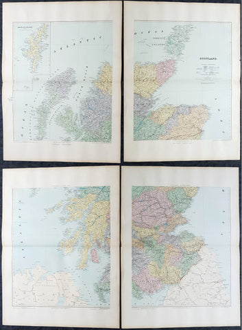
1895 Edward Stanford Very Large 4 Sheet Map of Scotland - w/ Reference Map
- Title : Scotland...London Edward Stanford 26 & 27 Cockspur St Charing Cross SW
- Ref #: 40947
- Size: 29 1/2in x 22in (750mm x 560mm) each sheet
- Date : 1895
- Condition: (A+) Fine Condition
Description:
Extremely scarce 4 sheet, very large (29 1/2in x 22in (750mm x 560mm) each sheet) lithograph map of Scotland by the famous 19th century map publisher Edward Stanford was published in 1895. (The map is not dated but we know that Stanford resided at the address noted on the map Cockspur St from 1885 to 1901). Also included is a smaller (20in x 14in 510mm x 360mm) original reference map that came with the 4 sheet publication.
This is an extremely beautiful, detailed map of Scotland.
General Definitions:
Paper thickness and quality: - Heavy and stable
Paper color : - off white
Age of map color: -
Colors used: -
General color appearance: -
Paper size: - 29 1/2in x 22in (750mm x 560mm) each sheet
Plate size: - 29 1/2in x 22in (750mm x 560mm) each sheet
Margins: - Min 2in (50mm)
Imperfections:
Margins: - None
Plate area: - None
Verso: - None
Stanford, Edward 1827-1904
Stanford was a prominent British mapmaker and publisher. A native of Holborn in the heart of London, Edward was apprenticed to a printer and stationer at the age of 14. After his first master died, he worked with several others, including Trelawny W. Saunders of Charing Cross. Saunders oversaw young Edward’s early career, ensuring that he became a Fellow of the Royal Geographical Society. Associations with the Society eventually brought Sanders much business and gave him a reputation as a publisher of explorers. As testament to this reputation, the Stanford Range in British Columbia was named for him by John Palliser.
Stanford briefly partnered with Saunders in 1852 before striking out on his own in 1853. He was an agent for the Ordnance Survey, the Admiralty, the Geological Survey, the Trigonometrical Survey of India, and the India Office. He also controlled the maps of the Society for the Diffusion of Useful Knowledge, another lucrative source of income. In 1857, Stanford founded his namesake Geographical Establishment, with Saunders and A. K. Johnston as engravers. Thereafter, Stanford was known for his library maps, particularly those of Africa and Asia.
Although he had authored many maps, the Harrow Atlas of Modern Geography and a similar volume on classical geography, Stanford is better remembered today as the leader of a successful map business. Ever in search of more inventory, he acquired the plates and stock of John Arrowsmith, heir of the Arrowmsith family firm, in 1874. By 1881 he employed 87 people at his premises at 6 Charing Cross Road, Saunders’ old address. As he aged, he phased in his son Edward Jr. to run the business. He died in 1904. The business survived him, and the Stanford’s shop is still a prominent London landmark today.
Stanford premises were located in the Strand, London from 1853 to 1884 and then Cockspur St from 1885 to 1901 locating to its present location in Covent Garden.
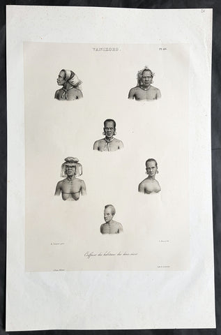
1836 D Urville & Sainson Antique Print Men & Women of Vanikoro Isle, Solomon Is.
- Title : Vanikoro. Coiffures des habitans des deux sexes
- Size: 20 1/2in x 13 1/2in (520mm x 345mm)
- Condition: (A+) Fine Good Condition
- Date : 1836
- Ref #: 31751
Description:
This large, magnificent, original antique lithograph print of hair styles of the men & woman of the island of Vanikoro, part of the Solomon Islands in the south Pacific (and last resting place of the ill fated La Perouse expedition), by Louis Auguste de Sainson, artist on the Astrolabe, during the first of Dumont D Urvilles voyages to the South Seas, between 1826 - 1829, was engraved by Antoine Maurin 1793 - 1860 and published in the 1836 1st edition of Dumont d UrvillesVoyage de la corvette L Astrolabe: exécuté par ordre du roi, pendant les années 1826-1827-1828-1829......
Louis Auguste de Sainson, (1800-1848). Sainson was a French draftsman & artist who specialized in natural history and geography. He accompanied the expedition of the corvette L Astrolabe as a naturalist directed by Jules Dumont d\'Urville between 1826-1829.
He began his naval career in a secretarial position at the French Atlantic port of Rochefort, working there from 1825 till 1826. He then volunteered to join the Astrolabe as a draughtsman, after being recommended to the expedition by Quoy, one of the naturalists on the expedition, joining the ship at Toulon on 7 February 1826.
He was responsible for the bulk of the drawings produced during the expedition, with over 500 in three years. Many of his drawings paintings and prints now reside in Australian, New Zealand & French museums.
General Definitions:
Paper thickness and quality: - Heavy and stable
Paper color : - off white
Age of map color: -
Colors used: -
General color appearance: -
Paper size: - 20 1/2in x 13 1/2in (520mm x 345mm)
Plate size: - 20 1/2in x 13 1/2in (520mm x 345mm)
Margins: - Min 2in (50mm)
Imperfections:
Margins: - None
Plate area: - None
Verso: - None
Background:
Vanikoro (sometimes wrongly named Vanikolo) is an island in the Santa Cruz group, located 118 kilometres to the Southeast of the main Santa Cruz group. It is part of the Temotu Province of the Solomon Islands.
The first sighting of Vanikoro by Europeans was in September 1595, by the second Spanish expedition of Álvaro de Mendaña. It was sighted by Lorenzo Barreto, while in command of one of the smaller vessels on a voyage around the then Santa Cruz, which is today\'s Nendo Island.
The French explorer Jean-François de La Pérouse was stranded on Vanikoro after both his vessels, La Boussole and the Astrolabe, struck the then unknown reefs of the island in 1788. It is reported that some of the men were killed by the local inhabitants, while the surviving sailors built a smaller vessel and left the island, but were never seen again. Those that remained on the island died before search parties of Dumont D Urville arrived in 1826.
1757 Robert De Vaugondy Large Antique Map of the Russian Empire - Poland to Asia
- Title : Partie Occidentale De L Empire De Russie...Sr Robert De Vaugondy
- Size: 26in x 20in (660mm x 510mm)
- Condition: (A+) Fine Condition
- Date : 1757
- Ref #: 41592
Description:
This large magnificent hand coloured original copper-plate engraved antique map of The Russian Empire - stretching from Poland to Central Asia - by Robert De Vaugondy was published in the 1757 edition of De Vaugondys famous The Atlas Universel
General Definitions:
Paper thickness and quality: - Heavy and stable
Paper color : - off white
Age of map color: - Original & later
Colors used: - Blue, pink, red, green, yellow
General color appearance: - Authentic
Paper size: - 23 1/2in x 19 1/2in (600mm x 495mm)
Plate size: - 23in x 19 1/2in (585mm x 495mm)
Margins: - Min 1/4in (5mm)
Imperfections:
Margins: - None
Plate area: - None
Verso: - None
It is scarcely necessary to look at a map of Russia - with which we must include Siberia - to visualize the daunting task facing Russian map makers. Indeed, considering the vastness of their territory and the lack of skilled cartographers, it is surprising that relatively good maps were available for engraving and printing in most of the well known sixteenth and seventeenth century atlases. Generally, maps of that time were based on material brought back from Moscow by visitors from the West. (Ref Tooley M&B)
1775 J B D Anville Large Antique Map Gulf of Guinea West Africa Liberia to Gabon
- Title : Guinee Ent Serre-Lione et le pasage de la Ligne par le S D\'Anville...MDCCLXXV (1775)
- Size: 31in x 21 1/2in (790mm x 550mm)
- Condition: (A) Very Good Condition
- Date : 1775
- Ref #: 92325
Description:
This large original copper-plate engraved antique map of The Gulf Of Guinea, West Africa from Liberia to Gabon by Jean Baptiste Bourguignon D\'Anville was engraved in 1775 - dated in the tile cartouche - and was published in Jean-Baptiste Bourguinon D\'Anvilles large elephant folio atlas Atlas Generale.
(Ref: Tooley, M&B)
General Definitions:
Paper thickness and quality: - Heavy and stable
Paper color : - off white
Age of map color: -
Colors used: -
General color appearance: -
Paper size: - 31in x 21 1/2in (790mm x 550mm)
Plate size: - 21in x 19 1/2in (670mm x 320mm)
Margins: - Min 2in (50mm)
Imperfections:
Margins: - Light soiling in margins, small worm holes in bottom margin
Plate area: - None
Verso: - Light soiling
Background:
Being part of the Mediterranean world, the northern coasts of the African continent as far as the Straits of Gibraltar and even round to the area of the Fortunate Isles (the Canaries) were reasonably well known and quite accurately mapped from ancient times. In particular, Egypt and the Nile Valley were well defined and the Nile itself was, of course, one of the rivers separating the continents in medieval T-O maps. Through Arab traders the shape of the east coast, down the Red Sea as far as the equator, was also known but detail shown in the interior faded into deserts with occasional mountain ranges and mythical rivers. The southern part of the continent, in the Ptolemaic tradition, was assumed to curve to the east to form a land-locked Indian Ocean. The voyages of the Portuguese, organized by Henry the Navigator in the fifteenth century, completely changed the picture and by the end of the century Vasco da Gama had rounded the Cape enabling cartographers to draw a quite presentable coastal outline of the whole continent, even if the interior was to remain largely unknown for the next two or three centuries.
The first separately printed map of Africa (as with the other known continents) appeared in Munster\\\'s Geographia from 1540 onwards and the first atlas devoted to Africa only was published in 1588 in Venice by Livio Sanuto, but the finest individual map of the century was that engraved on 8 sheets by Gastaldi, published in Venice in 1564. Apart from maps in sixteenth-century atlases generally there were also magnificent marine maps of 1596 by Jan van Linschoten (engraved by van Langrens) of the southern half of the continent with highly imaginative and decorative detail in the interior. In the next century there were many attractive maps including those of Mercator/Hondius (1606), Speed (1627), Blaeu (1 630), Visscher (1636), de Wit (c. 1670), all embellished with vignettes of harbours and principal towns and bordered with elaborate and colourful figures of their inhabitants, but the interior remained uncharted with the exception of that part of the continent known as Ethiopia, the name which was applied to a wide area including present-day Abyssinia. Here the legends of Prester John lingered on and, as so often happened in other remote parts of the world, the only certain knowledge of the region was provided by Jesuit missionaries. Among these was Father Geronimo Lobo (1595-1678), whose work A Voyage to Abyssinia was used as the basis for a remarkably accurate map published by a German scholar, Hiob Ludolf in 1683. Despite the formidable problems which faced them, the French cartographers G. Delisle (c. 1700-22), J. B. B. d\\\'Anville (1727-49) and N. Bellin (1754) greatly improved the standards of mapping of the continent, improvements which were usually, although not always, maintained by Homann, Seutter, de Ia Rochette, Bowen, Faden and many others in the later years of the century.
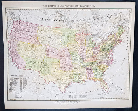
1854 Handtke & Flemming Large Antique Map of The United States of America - 32 States
- Title : Vereinigte Staaten Von Nord-America
- Ref #: 41103
- Size: 17in x 14in (430mm x 355mm)
- Date : 1854
- Condition: (A+) Fine Condition
Description:
This beautifully hand coloured original steel-plate engraved antique map of the United States in the mid 19th century, by Friedrich Handtke in 1854, was published in the Complete hand atlas of the recent description of the earth over all parts of the earth, Carl Flemming, Glougau.
At the bottom left of the map is an index of all states and territories. 32 States are listed with California the last, accepted into the union in 1850 and 5 territories are listed, Oregon, Missouri, Minnesota, Indian & Utah.
General Definitions:
Paper thickness and quality: - Heavy and stable
Paper color : - off white
Age of map color: - Original
Colors used: - Yellow, green, blue, pink
General color appearance: - Authentic
Paper size: - 17in x 14in (430mm x 355mm)
Plate size: - 17in x 14in (430mm x 355mm)
Margins: - Min 1/2in (12mm)
Imperfections:
Margins: - Light age toning
Plate area: - Light age toning
Verso: - Light age toning
Background:
After the conclusion of the Civil War three things happened that opened up the western states, migration, gold and the building of the railway from the Atlantic to the Pacific. This map shows a country prior to the civil war still defining itself with much of the country west of the Mississippi regions yet to be opened and defined.
Mexico became independent of Spain in 1821, and took over Spains northern possessions stretching from Texas to California. Caravans began delivering goods to Mexicos Santa Fe along the Santa Fe Trail, over the 870-mile journey which took 48 days from Kansas City, Missouri (then known as Westport). Santa Fe was also the trailhead for the El Camino Real (the Kings Highway), a trade route which carried American manufactured goods southward deep into Mexico and returned silver, furs, and mules northward (not to be confused with another Camino Real which connected the missions in California). A branch also ran eastward near the Gulf (also called the Old San Antonio Road). Santa Fe connected to California via the Old Spanish Trail.
The Spanish and Mexican governments attracted American settlers to Texas with generous terms. Stephen F. Austin became an empresario, receiving contracts from the Mexican officials to bring in immigrants. In doing so, he also became the de facto political and military commander of the area. Tensions rose, however, after an abortive attempt to establish the independent nation of Fredonia in 1826. William Travis, leading the war party, advocated for independence from Mexico, while the peace party led by Austin attempted to get more autonomy within the current relationship. When Mexican president Santa Anna shifted alliances and joined the conservative Centralist party, he declared himself dictator and ordered soldiers into Texas to curtail new immigration and unrest. However, immigration continued and 30,000 Anglos with 3,000 slaves were settled in Texas by 1835. In 1836, the Texas Revolution erupted. Following losses at the Alamo and Goliad, the Texians won the decisive Battle of San Jacinto to secure independence. At San Jacinto, Sam Houston, commander-in-chief of the Texian Army and future President of the Republic of Texas famously shouted Remember the Alamo! Remember Goliad. The U.S. Congress declined to annex Texas, stalemated by contentious arguments over slavery and regional power. Thus, the Republic of Texas remained an independent power for nearly a decade before it was annexed as the 28th state in 1845. The government of Mexico, however, viewed Texas as a runaway province and asserted its ownership.
Mexico refused to recognize the independence of Texas in 1836, but the U.S. and European powers did so. Mexico threatened war if Texas joined the U.S., which it did in 1845. American negotiators were turned away by a Mexican government in turmoil. When the Mexican army killed 16 American soldiers in disputed territory war was at hand. Whigs, such as Congressman Abraham Lincoln denounced the war, but it was quite popular outside New England.
The Mexican strategy was defensive; the American strategy was a three pronged offensive, using large numbers of volunteer soldiers. Overland forces seized New Mexico with little resistance and headed to California, which quickly fell to the American land and naval forces. From the main American base at New Orleans, General Zachary Taylor led forces into northern Mexico, winning a series of battles that ensued. The U.S. Navy transported General Winfield Scott to Veracruz. He then marched his 12,000-man force west to Mexico City, winning the final battle at Chapultepec. Talk of acquiring all of Mexico fell away when the army discovered the Mexican political and cultural values were so alien to Americas. As the Cincinnati Herald asked, what would the U.S. do with eight million Mexicans with their idol worship, heathen superstition, and degraded mongrel races?
The Treaty of Guadalupe Hidalgo of 1848 ceded the territories of California and New Mexico to the United States for $18.5 million (which included the assumption of claims against Mexico by settlers). The Gadsden Purchase in 1853 added southern Arizona, which was needed for a railroad route to California. In all Mexico ceded half a million square miles (1.3 million km2) and included the states-to-be of California, Utah, Arizona, Nevada, New Mexico, and parts of Colorado and Wyoming, in addition to Texas. Managing the new territories and dealing with the slavery issue caused intense controversy, particularly over the Wilmot Proviso, which would have outlawed slavery in the new territories. Congress never passed it, but rather temporarily resolved the issue of slavery in the West with the Compromise of 1850. California entered the Union in 1850 as a free state; the other areas remained territories for many years.
The new state grew rapidly as migrants poured into the fertile cotton lands of east Texas. German immigrants started to arrive in the early 1840s because of negative economic, social and political pressures in Germany. With their investments in cotton lands and slaves, planters established cotton plantations in the eastern districts. The central area of the state was developed more by subsistence farmers who seldom owned slaves.
Texas in its Wild West days attracted men who could shoot straight and possessed the zest for adventure, for masculine renown, patriotic service, martial glory and meaningful deaths.
In 1846 about 10,000 Californios (Hispanics) lived in California, primarily on cattle ranches in what is now the Los Angeles area. A few hundred foreigners were scattered in the northern districts, including some Americans. With the outbreak of war with Mexico in 1846 the U.S. sent in Frémont and a U.S. Army unit, as well as naval forces, and quickly took control. As the war was ending, gold was discovered in the north, and the word soon spread worldwide.
Thousands of Forty-Niners reached California, by sailing around South America (or taking a short-cut through disease-ridden Panama), or walked the California trail. The population soared to over 200,000 in 1852, mostly in the gold districts that stretched into the mountains east of San Francisco.
Housing in San Francisco was at a premium, and abandoned ships whose crews had headed for the mines were often converted to temporary lodging. In the gold fields themselves living conditions were primitive, though the mild climate proved attractive. Supplies were expensive and food poor, typical diets consisting mostly of pork, beans, and whiskey. These highly male, transient communities with no established institutions were prone to high levels of violence, drunkenness, profanity, and greed-driven behavior. Without courts or law officers in the mining communities to enforce claims and justice, miners developed their own ad hoc legal system, based on the mining codes used in other mining communities abroad. Each camp had its own rules and often handed out justice by popular vote, sometimes acting fairly and at times exercising vigilantism—with Indians, Mexicans, and Chinese generally receiving the harshest sentences.
The gold rush radically changed the California economy and brought in an array of professionals, including precious metal specialists, merchants, doctors, and attorneys, who added to the population of miners, saloon keepers, gamblers, and prostitutes. A San Francisco newspaper stated, The whole country... resounds to the sordid cry of gold! Gold! Gold! while the field is left half planted, the house half built, and everything neglected but the manufacture of shovels and pick axes. Over 250,000 miners found a total of more than $200 million in gold in the five years of the California Gold Rush. As thousands arrived, however, fewer and fewer miners struck their fortune, and most ended exhausted and broke.
Violent bandits often preyed upon the miners, such as the case of Jonathan R. Davis killing of eleven bandits single-handedly. Camps spread out north and south of the American River and eastward into the Sierras. In a few years, nearly all of the independent miners were displaced as mines were purchased and run by mining companies, who then hired low-paid salaried miners. As gold became harder to find and more difficult to extract, individual prospectors gave way to paid work gangs, specialized skills, and mining machinery. Bigger mines, however, caused greater environmental damage. In the mountains, shaft mining predominated, producing large amounts of waste. Beginning in 1852, at the end of the 49 gold rush, through 1883, hydraulic mining was used. Despite huge profits being made, it fell into the hands of a few capitalists, displaced numerous miners, vast amounts of waste entered river systems, and did heavy ecological damage to the environment. Hydraulic mining ended when public outcry over the destruction of farmlands led to the outlawing of this practice.
The mountainous areas of the triangle from New Mexico to California to South Dakota contained hundreds of hard rock mining sites, where prospectors discovered gold, silver, copper and other minerals (as well as some soft-rock coal). Temporary mining camps sprang up overnight; most became ghost towns when the ores were depleted. Prospectors spread out and hunted for gold and silver along the Rockies and in the southwest. Soon gold was discovered in Colorado, Utah, Arizona, New Mexico, Idaho, Montana, and South Dakota (by 1864).
The discovery of the Comstock Lode, containing vast amounts of silver, resulted in the Nevada boomtowns of Virginia City, Carson City, and Silver City. The wealth from silver, more than from gold, fueled the maturation of San Francisco in the 1860s and helped the rise of some of its wealthiest families, such as that of George Hearst.
To get to the rich new lands of the West Coast, there were two options: some sailed around the southern tip of South America during a six-month voyage, but 400,000 others walked there on an overland route of more than 2,000 miles (3,000 km); their wagon trains usually left from Missouri. They moved in large groups under an experienced wagonmaster, bringing their clothing, farm supplies, weapons, and animals. These wagon trains followed major rivers, crossed prairies and mountains, and typically ended in Oregon and California. Pioneers generally attempted to complete the journey during a single warm season, usually over the course of six months. By 1836, when the first migrant wagon train was organized in Independence, Missouri, a wagon trail had been cleared to Fort Hall, Idaho. Trails were cleared further and further west, eventually reaching all the way to the Willamette Valley in Oregon. This network of wagon trails leading to the Pacific Northwest was later called the Oregon Trail. The eastern half of the route was also used by travelers on the California Trail (from 1843), Mormon Trail (from 1847), and Bozeman Trail (from 1863) before they turned off to their separate destinations.
In the Wagon Train of 1843, some 700 to 1,000 emigrants headed for Oregon; missionary Marcus Whitman led the wagons on the last leg. In 1846, the Barlow Road was completed around Mount Hood, providing a rough but passable wagon trail from the Missouri River to the Willamette Valley: about 2,000 miles. Though the main direction of travel on the early wagon trails was westward, people also used the Oregon Trail to travel eastward. Some did so because they were discouraged and defeated. Some returned with bags of gold and silver. Most were returning to pick up their families and move them all back west. These gobacks were a major source of information and excitement about the wonders and promises—and dangers and disappointments—of the far West.
Not all emigrants made it to their destination. The dangers of the overland route were numerous: snakebites, wagon accidents, violence from other travelers, suicide, malnutrition, stampedes, Indian attacks, a variety of diseases (dysentery, typhoid, and cholera were among the most common), exposure, avalanches, etc. One particularly well-known example of the treacherous nature of the journey is the story of the ill-fated Donner Party, which became trapped in the Sierra Nevada mountains during the winter of 1846–1847 in which nearly half of the 90 people traveling with the group died from starvation and exposure, and some resorted to cannibalism to survive. Another story of cannibalism featured Alfred Packer and his trek to Colorado in 1874. There were also frequent attacks from bandits and highwaymen, such as the infamous Harpe brothers who patrolled the frontier routes and targeted migrant groups.
In Missouri and Illinois, animosity between the Mormon settlers and locals grew, which would mirror those in other states such as Utah years later. Violence finally erupted on October 24, 1838 when militias from both sides clashed and a mass killing of Mormons in Livingston County occurred 6 days later. An executive order was filed during these conflicts, and the Mormons were forced to scatter. Brigham Young, seeking to leave American jurisdiction to escape religious persecution in Illinois and Missouri, led the Mormons to the valley of the Great Salt Lake, owned at the time by Mexico but not controlled by them. A hundred rural Mormon settlements sprang up in what Young called Deseret, which he ruled as a theocracy. It later became Utah Territory. Youngs Salt Lake City settlement served as the hub of their network, which reached into neighboring territories as well. The communalism and advanced farming practices of the Mormons enabled them to succeed. They sold goods to wagon trains passing through and came to terms with local Indian tribes because Young decided it was cheaper to feed the Indians than fight them. Education became a high priority to protect the beleaguered group, reduce heresy and maintain group solidarity.
The great threat to the Mormons in Utah was the U.S. government, which took ownership of Utah in 1848, and pushed by the Protestant churches, rejected theocracy and polygamy. The Republican Party swore to destroy polygamy, which it saw as an affront to religious, cultural and moral values of a modern civilization. Confrontations verged on open warfare in the late 1850s as President Buchanan sent in troops. Although there were no military battles fought, and negotiations led to a stand down, violence still escalated and there were a number of casualties. After the Civil War the federal government systematically took control of Utah away from the Mormons, and drove the churchs leadership underground. Meanwhile, aggressive missionary work in the U.S. and Europe brought a flood of Mormon converts to Utah. Finally in 1890 the Church leadership announced polygamy was no longer a central tenet, and a compromise was reached, with Utah becoming a state and the Mormons dividing into Republicans and Democrats.
Constitutionally, Congress could not deal with slavery in the states but it did have jurisdiction in the western territories. California unanimously rejected slavery in 1850 and became a free state. New Mexico allowed slavery, but it was rarely seen there. Kansas was off limits to slavery by the Compromise of 1820. Free Soil elements feared that if slavery were allowed rich planters would buy up the best lands and work them with gangs of slaves, leaving little opportunity for free white men to own farms. Few Southern planters were actually interested in Kansas, but the idea that slavery was illegal there implied they had a second-class status that was intolerable to their sense of honor, and seemed to violate the principle of states rights. With the passage of the extremely controversial Kansas–Nebraska Act in 1854, Congress left the decision up to the voters on the ground in Kansas. Across the North a new major party was formed to fight slavery: the Republican Party, with numerous westerners in leadership positions, most notably Abraham Lincoln of Illinois. To influence the territorial decision, anti-slavery elements (also called Jayhawkers or Free-soilers) financed the migration of politically determined settlers. But pro-slavery advocates fought back with pro-slavery settlers from Missouri. Violence on both sides was the result; in all 56 men were killed by the time the violence abated in 1859. By 1860 the pro-slavery forces were in control—but Kansas had only two slaves. The antislavery forces took over by 1861, as Kansas became a free state. The episode demonstrated that a democratic compromise between North and South over slavery was impossible and served to hasten the Civil War.
Handtke, Friedrich 1815 - 1879
Handtke was a 19th century German cartographer who trained as a surveyor. After serving a year in the Prussian army, in 1838 he began work as head of the cartographic department at the publishing bookstore Carl Flemming in Glogau, Silesia. Of the 260 maps published by Flemming over 165 were drawn by Handtke.
Handtkes most important work was the Hand Atlas of the Prussian State of 1846 with 36 maps. He also published important maps of the Prussian state & a Map of Neuchâtel and Valendis & the nine provinces; East Prussia , West Prussia , Pomerania , Poznan , Silesia , Brandenburg , Saxony , Westphalia and the Rhine Province and the 25 administrative districts. One of Handtkes students was the German cartographer Paul Thumann .
Atlases published:
- Complete hand atlas of the recent description of the earth over all parts of the earth , Flemming, Glogau 1849.
- Hand Atlas of the Prussian State Flemming, Glogau 1846
- Royal Prussian Card. Province of Saxony, the duchy of Anhalt, the ducal. Saxon countries Weimar, Altenburg u. Gotha and the principals Schwarzburg and Reuss , Flemming, Glogau 1870/71
1695 Richard White Original Antique Portrait of William Camden - Britannia
- Title : William Camden Clarenceux Obijt A.D 1623
- Size: 13 1/2in x 8 1/2in (350mm x 215mm)
- Condition: (A+) Fine Condition
- Date : 1695
- Ref #: 40960
Description:
This fine copper-plate engraved original antique portrait of the famous English 16th century historian William Camden (1551 - 1623) - famous for his historical publication of Britannia first published in 1586 - by Richard White was published in the Edmund Gibson 1695 edition of Britannia
General Definitions:
Paper thickness and quality: - Heavy and stable
Paper color : - off white
Age of map color: -
Colors used: -
General color appearance: -
Paper size: - 13 1/2in x 8 1/2in (350mm x 215mm)
Plate size: - 13 1/2in x 8 1/2in (350mm x 215mm)
Margins: - Min 1/2in (12mm)
Imperfections:
Margins: - Light soiling
Plate area: - Light soiling
Verso: - Light soiling
Camden, William 1551 – 1623
Camden was an English antiquarian, historian, topographer, and herald, best known as author of Britannia, the first chorographical survey of the islands of Great Britain and Ireland, and the Annales, the first detailed historical account of the reign of Elizabeth I of England.
In 1577, with the encouragement of Abraham Ortelius, Camden began his great work Britannia, a topographical and historical survey of all of Great Britain and Ireland. His stated intention was to "restore antiquity to Britaine, and Britain to his antiquity". The first edition, written in Latin, was published in 1586. It proved very popular, and ran through five further editions, of 1587, 1590, 1594, 1600 and 1607, each greatly enlarged from its predecessor in both textual content and illustrations. The 1607 edition included for the first time a full set of English county maps, based on the surveys of Christopher Saxton and John Norden, and engraved by William Kip and William Hole (who also engraved the fine title page). The first English language edition, translated by Philemon Holland, appeared in 1610, again with some additional content supplied by Camden.
Britannia is a county-by-county description of Great Britain and Ireland. It is a work of chorography: a study that relates landscape, geography, antiquarianism, and history. Rather than write a history, Camden wanted to describe in detail the Great Britain of the present, and to show how the traces of the past could be discerned in the existing landscape. By this method, he produced the first coherent picture of Roman Britain.
He continued to collect materials and to revise and expand Britannia throughout his life. He drew on the published and unpublished work of John Leland and William Lambarde, among others, and received the assistance of a large network of correspondents with similar interests. He also travelled throughout Great Britain to view documents, sites, and artefacts for himself: he is known to have visited East Anglia in 1578, Yorkshire and Lancashire in 1582, Devon in 1589, Wales in 1590, Salisbury, Wells and Oxford in 1596, and Carlisle and Hadrian's Wall in 1599. His fieldwork and firsthand research set new standards for the time. He even learned Welsh and Old English for the task: his tutor in Old English was Laurence Nowell.
In 1593 Camden became headmaster of Westminster School. He held the post for four years, but left when he was appointed Clarenceux King of Arms. By this time, largely because of the Britannia's reputation, he was a well-known and revered figure, and the appointment was meant to free him from the labour of teaching and to facilitate his research. The College of Arms at that time was not only a centre of genealogical and heraldic study, but also a centre of antiquarian study. The appointment, however, roused the jealousy of Ralph Brooke, York Herald, who, in retaliation, published an attack on Britannia, charging Camden with inaccuracy and plagiarism. Camden successfully defended himself against the charges in subsequent editions of the work.
Britannia was recognised as an important work of Renaissance scholarship, not only in England, but across the European "Republic of Letters". Camden considered having the 1586 Britannia printed in the Low Countries, and although that did not happen, the third edition of 1590, in addition to its London printing, was also published the same year in Frankfurt, and reprinted there in 1616. In 1612 parts were condemned by the Spanish Inquisition. An abridgement was published in Amsterdam in 1617 and reprinted in 1639; and versions of the text were also included in Joan Blaeu's Theatrum Orbis Terrarum (published in Amsterdam in 1645) and in Jan Janssonius's Novus Atlas (again published in Amsterdam, in 1646)
Camden's Britannia remained a standard and highly regarded authority for many years after his death. A lightly revised edition of Holland's 1610 translation was published in 1637. A new and greatly expanded translation, edited by Edmund Gibson, was published in 1695, and was reissued in revised editions in 1722, 1753 and 1772. Yet another new and expanded translation by Richard Gough was published in 1789, followed by a second edition in 1806. In an address given in 1986, marking the original publication's 400th anniversary, George Boon commented that the work "still fundamentally colours the way in which we, as antiquaries, look at our country"
1695 Richard White Original Antique Portrait of William Camden - Britannia
- Title : William Camden Clarenceux Obijt A.D 1623
- Size: 13 1/2in x 8 1/2in (350mm x 215mm)
- Condition: (A+) Fine Condition
- Date : 1695
- Ref #: 70358
Description:
This fine copper-plate engraved original antique portrait of the famous English 16th century historian William Camden (1551 - 1623) - famous for his historical publication of Britannia first published in 1586 - by Richard White was published in the Edmund Gibson 1695 edition of Britannia
General Definitions:
Paper thickness and quality: - Heavy and stable
Paper color : - off white
Age of map color: -
Colors used: -
General color appearance: -
Paper size: - 13 1/2in x 8 1/2in (350mm x 215mm)
Plate size: - 13 1/2in x 8 1/2in (350mm x 215mm)
Margins: - Min 1/2in (12mm)
Imperfections:
Margins: - Light soiling
Plate area: - Light soiling
Verso: - Light soiling
Camden, William 1551 – 1623
Camden was an English antiquarian, historian, topographer, and herald, best known as author of Britannia, the first chorographical survey of the islands of Great Britain and Ireland, and the Annales, the first detailed historical account of the reign of Elizabeth I of England.
In 1577, with the encouragement of Abraham Ortelius, Camden began his great work Britannia, a topographical and historical survey of all of Great Britain and Ireland. His stated intention was to "restore antiquity to Britaine, and Britain to his antiquity". The first edition, written in Latin, was published in 1586. It proved very popular, and ran through five further editions, of 1587, 1590, 1594, 1600 and 1607, each greatly enlarged from its predecessor in both textual content and illustrations. The 1607 edition included for the first time a full set of English county maps, based on the surveys of Christopher Saxton and John Norden, and engraved by William Kip and William Hole (who also engraved the fine title page). The first English language edition, translated by Philemon Holland, appeared in 1610, again with some additional content supplied by Camden.
Britannia is a county-by-county description of Great Britain and Ireland. It is a work of chorography: a study that relates landscape, geography, antiquarianism, and history. Rather than write a history, Camden wanted to describe in detail the Great Britain of the present, and to show how the traces of the past could be discerned in the existing landscape. By this method, he produced the first coherent picture of Roman Britain.
He continued to collect materials and to revise and expand Britannia throughout his life. He drew on the published and unpublished work of John Leland and William Lambarde, among others, and received the assistance of a large network of correspondents with similar interests. He also travelled throughout Great Britain to view documents, sites, and artefacts for himself: he is known to have visited East Anglia in 1578, Yorkshire and Lancashire in 1582, Devon in 1589, Wales in 1590, Salisbury, Wells and Oxford in 1596, and Carlisle and Hadrian's Wall in 1599. His fieldwork and firsthand research set new standards for the time. He even learned Welsh and Old English for the task: his tutor in Old English was Laurence Nowell.
In 1593 Camden became headmaster of Westminster School. He held the post for four years, but left when he was appointed Clarenceux King of Arms. By this time, largely because of the Britannia's reputation, he was a well-known and revered figure, and the appointment was meant to free him from the labour of teaching and to facilitate his research. The College of Arms at that time was not only a centre of genealogical and heraldic study, but also a centre of antiquarian study. The appointment, however, roused the jealousy of Ralph Brooke, York Herald, who, in retaliation, published an attack on Britannia, charging Camden with inaccuracy and plagiarism. Camden successfully defended himself against the charges in subsequent editions of the work.
Britannia was recognised as an important work of Renaissance scholarship, not only in England, but across the European "Republic of Letters". Camden considered having the 1586 Britannia printed in the Low Countries, and although that did not happen, the third edition of 1590, in addition to its London printing, was also published the same year in Frankfurt, and reprinted there in 1616. In 1612 parts were condemned by the Spanish Inquisition. An abridgement was published in Amsterdam in 1617 and reprinted in 1639; and versions of the text were also included in Joan Blaeu's Theatrum Orbis Terrarum (published in Amsterdam in 1645) and in Jan Janssonius's Novus Atlas (again published in Amsterdam, in 1646)
Camden's Britannia remained a standard and highly regarded authority for many years after his death. A lightly revised edition of Holland's 1610 translation was published in 1637. A new and greatly expanded translation, edited by Edmund Gibson, was published in 1695, and was reissued in revised editions in 1722, 1753 and 1772. Yet another new and expanded translation by Richard Gough was published in 1789, followed by a second edition in 1806. In an address given in 1986, marking the original publication's 400th anniversary, George Boon commented that the work "still fundamentally colours the way in which we, as antiquaries, look at our country"
1719 Henri Chatelain Antique Map & Views of The African Island of Madagascar
- Title : Carte De L isle de Madagascar dite aujourd hui L Ile Daufine
- Date : 1719
- Condition: (A) Very Good Condition
- Ref: 50631
- Size: 20in x 17 1/2in (510mm x 440mm)
Description:
This large original copper-plate engraved antique map with views of the Island of Madagascar, Southern Africa - with 11 vignettes of peoples & views of the island - was published by Henri Abraham Chatelain in 1719, in his famous Atlas Historique.
General Definitions:
Paper thickness and quality: - Heavy and stable
Paper color : - off white
Age of map color: -
Colors used: -
General color appearance: -
Paper size: - 20in x 17 1/2in (510mm x 440mm)
Plate size: - 17 1/2in x 15in (440mm x 380mm)
Margins: - Min 1in (25mm)
Imperfections:
Margins: - None
Plate area: - None
Verso: - None
Background:
Madagascar previously known as the Malagasy Republic, is an island country in the Indian Ocean, off the coast of East Africa. The nation comprises the island of Madagascar (the fourth-largest island in the world), and numerous smaller peripheral islands. Following the prehistoric breakup of the supercontinent Gondwana, Madagascar split from the Indian peninsula around 88 million years ago, allowing native plants and animals to evolve in relative isolation. Consequently, Madagascar is a biodiversity hotspot; over 90% of its wildlife is found nowhere else on Earth. The island\\\'s diverse ecosystems and unique wildlife are threatened by the encroachment of the rapidly growing human population and other environmental threats.
As a result of the island\\\'s long isolation from neighboring continents, Madagascar is home to an abundance of plants and animals found nowhere else on Earth. Approximately 90% of all plant and animal species found in Madagascar are endemic, including the lemurs (a type of strepsirrhine primate), the carnivorous fossa and many birds. This distinctive ecology has led some ecologists to refer to Madagascar as the \\\"eighth continent\\\",[26] and the island has been classified by Conservation International as a biodiversity hotspot.
More than 80 percent of Madagascar\\\'s 14,883 plant species are found nowhere else in the world, including five plant families. The family Didiereaceae, composed of four genera and 11 species, is limited to the spiny forests of southwestern Madagascar. Four-fifths of the world\\\'s Pachypodium species are endemic to the island. Three-fourths of Madagascar\\\'s 860 orchid species are found here alone, as are six of the world\\\'s nine baobab species. The island is home to around 170 palm species, three times as many as on all of mainland Africa; 165 of them are endemic. Many native plant species are used as herbal remedies for a variety of afflictions. The drugs vinblastine and vincristine are vinca alkaloids, used to treat Hodgkin\\\'s disease, leukemia, and other cancers, were derived from the Madagascar periwinkle. The traveler\\\'s palm, known locally as ravinala and endemic to the eastern rain forests, is highly iconic of Madagascar.

1719 Chatelain Antique Map of Panama, Flora & Fauna of Australia by William Dampier
- Title : Description de l Isthme de Darien Des Proprietez du Pais et de la Ville de Panama a la quelle on a joint une description curieuse des diverses plantes, oiseaux, poissons les plus rares qui se trouvent dans la Nouvelle Hollande
- Size: 20in x 17 1/2in (510mm x 440mm)
- Condition: (A+) Fine Condition
- Date : 1719
- Ref #: 50633
Description:
This large original copper-plate engraved antique map of Panama & Central America plus plants, animals and birds from Brazil, South America and Australia, as visited by William Dampier (1651 - 1715) in 1688, was published by Henri Abraham Chatelain in 1719, in his famous Atlas Historique.
These are truly some of the best early engravings of this region done at the time that were copied by the likes of Prevost, Harrison & others in the 18th century, but not with the same eye for detail.
General Definitions:
Paper thickness and quality: - Heavy and stable
Paper color : - off white
Age of map color: -
Colors used: -
General color appearance: -
Paper size: - 20in x 17 1/2in (510mm x 440mm)
Plate size: - 17 1/2in x 15in (440mm x 380mm)
Margins: - Min 1in (25mm)
Imperfections:
Margins: - None
Plate area: - None
Verso: - None
Background:
In 1679, William Dampier joined the crew of the buccaneer Captain Bartholomew Sharp on the Spanish Main of Central America, twice visiting the Bay of Campeche, or Campeachy as it was then known, on the north coast of Mexico. This led to his first circumnavigation, during which he accompanied a raid across the Isthmus of Darién in Panama and took part in the capture of Spanish ships on the Pacific coast of that isthmus. The pirates then raided Spanish settlements in Peru before returning to the Caribbean.
Dampier made his way to Virginia, where in 1683 he was engaged by the privateer John Cooke. Cooke entered the Pacific via Cape Horn and spent a year raiding Spanish possessions in Peru, the Galápagos Islands, and Mexico. This expedition collected buccaneers and ships as it went along, at one time having a fleet of ten vessels. Cooke died in Mexico, and a new leader, Edward Davis, was elected captain by the crew.
Dampier transferred to the privateer Charles Swans ship, Cygnet, and on 31 March 1686 they set out across the Pacific to raid the East Indies, calling at Guam and Mindanao. Spanish witnesses saw the predominantly English crew as not only pirates and heretics but also cannibals. Leaving Swan and 36 others behind on Mindanao, the rest of the privateers sailed on to Manila, Poulo Condor, China, the Spice Islands, and New Holland. Contrary to Dampiers later claim that he had not actively participated in actual piratical attacks during this voyage, he was in fact selected in 1687 to command one of the Spanish ships captured by Cygnets crew off Manila.
On 5 January 1688, Cygnet anchored two miles from shore in 29 fathoms on the northwest coast of Australia, near King Sound. Dampier and his ship remained there until March 12, and while the ship was being careened Dampier made notes on the fauna and flora and the indigenous peoples he found there. Among his fellows were a significant number of Spanish sailors, most notably Alonso Ramírez, a native of San Juan, Puerto Rico Later that year, by agreement, Dampier and two shipmates were marooned on one of the Nicobar Islands. They obtained a small canoe which they modified after first capsizing and then, after surviving a great storm at sea, called at Acheen (Aceh) in Sumatra.
Dampier returned to England in 1691 via the Cape of Good Hope, penniless but in possession of his journals. He also had as a source of income a slave known as Prince Jeoly (or Giolo), from Miangas (now Indonesia), who became famous for his tattoos (or paintings as they were known at the time). Dampier exhibited Jeoly in London, thereby also generating publicity for a book based on his diaries.
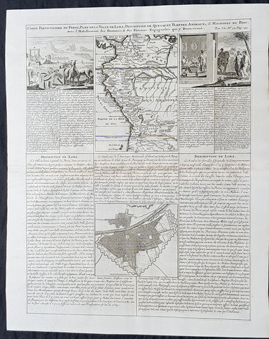
1719 Chatelain Antique Map, Views & Plans of Peru & Lima South America
- Title : Carte Particuliere du Perou, Plan de la Ville de Lima, Description de Quelques Plantes, Animaux, &....
- Size: 20in x 17 1/2in (510mm x 440mm)
- Condition: (A+) Fine Condition
- Date : 1719
- Ref #: 50632
Description:
This large original copper-plate engraved antique map & views of Peru & NW South America with a city plan of Lima was published by Henri Abraham Chatelain in 1719, in his famous Atlas Historique.
These are truly some of the best early engravings of this region done at the time that were copied by the likes of Prevost, Harrison & others in the 18th century, but not with the same eye for detail.
General Definitions:
Paper thickness and quality: - Heavy and stable
Paper color : - off white
Age of map color: -
Colors used: -
General color appearance: -
Paper size: - 20in x 17 1/2in (510mm x 440mm)
Plate size: - 17 1/2in x 15in (440mm x 380mm)
Margins: - Min 1in (25mm)
Imperfections:
Margins: - None
Plate area: - None
Verso: - None
Background:
Atahualpa (also Atahuallpa), the last Sapa Inca became emperor when he defeated and executed his older half-brother Huáscar in a civil war sparked by the death of their father, Inca Huayna Capac. In December 1532, a party of conquistadors led by Francisco Pizarro defeated and captured the Inca Emperor Atahualpa in the Battle of Cajamarca. The Spanish conquest of the Inca Empire was one of the most important campaigns in the Spanish colonization of the Americas. After years of preliminary exploration and military conflicts, it was the first step in a long campaign that took decades of fighting but ended in Spanish victory and colonization of the region known as the Viceroyalty of Peru with its capital at Lima, which became known as The City of Kings. The conquest of the Inca Empire led to spin-off campaigns throughout the viceroyalty as well as expeditions towards the Amazon Basin as in the case of Spanish efforts to quell Amerindian resistance. The last Inca resistance was suppressed when the Spaniards annihilated the Neo-Inca State in Vilcabamba in 1572.
The indigenous population dramatically collapsed due to exploitation, socioeconomic change and epidemic diseases introduced by the Spanish. Viceroy Francisco de Toledo reorganized the country in the 1570s with gold and silver mining as its main economic activity and Amerindian forced labor as its primary workforce. With the discovery of the great silver and gold lodes at Potosí (present-day Bolivia) and Huancavelica, the viceroyalty flourished as an important provider of mineral resources. Peruvian bullion provided revenue for the Spanish Crown and fueled a complex trade network that extended as far as Europe and the Philippines. Because of lack of available work force, African slaves were added to the labor population. The expansion of a colonial administrative apparatus and bureaucracy paralleled the economic reorganization. With the conquest started the spread of Christianity in South America; most people were forcefully converted to Catholicism, taking only a generation to convert the population. They built churches in every city and replaced some of the Inca temples with churches, such as the Coricancha in the city of Cusco. The church employed the Inquisition, making use of torture to ensure that newly converted Catholics did not stray to other religions or beliefs. Peruvian Catholicism follows the syncretism found in many Latin American countries, in which religious native rituals have been integrated with Christian celebrations. In this endeavor, the church came to play an important role in the acculturation of the natives, drawing them into the cultural orbit of the Spanish settlers.
By the 18th century, declining silver production and economic diversification greatly diminished royal income. In response, the Crown enacted the Bourbon Reforms, a series of edicts that increased taxes and partitioned the Viceroyalty. The new laws provoked Túpac Amaru IIs rebellion and other revolts, all of which were suppressed. As a result of these and other changes, the Spaniards and their creole successors came to monopolize control over the land, seizing many of the best lands abandoned by the massive native depopulation. However, the Spanish did not resist the Portuguese expansion of Brazil across the meridian. The Treaty of Tordesillas was rendered meaningless between 1580 and 1640 while Spain controlled Portugal. The need to ease communication and trade with Spain led to the split of the viceroyalty and the creation of new viceroyalties of New Granada and Rio de la Plata at the expense of the territories that formed the viceroyalty of Peru; this reduced the power, prominence and importance of Lima as the viceroyal capital and shifted the lucrative Andean trade to Buenos Aires and Bogotá, while the fall of the mining and textile production accelerated the progressive decay of the Viceroyalty of Peru.
Eventually, the viceroyalty would dissolve, as with much of the Spanish empire, when challenged by national independence movements at the beginning of the nineteenth century. These movements led to the formation of the majority of modern-day countries of South America in the territories that at one point or another had constituted the Viceroyalty of Peru. The conquest and colony brought a mix of cultures and ethnicities that did not exist before the Spanish conquered the Peruvian territory. Even though many of the Inca traditions were lost or diluted, new customs, traditions and knowledge were added, creating a rich mixed Peruvian culture. Two of the most important indigenous rebellions against the Spanish were that of Juan Santos Atahualpa in 1742, and Rebellion of Túpac Amaru II in 1780 around the highlands near Cuzco.
1854 A D Bache Large Rare Antique Map of San Francisco California to Umpqua River, Oregon
- Title : US Coast Survey A D Bache Super. Reconnaissance of the Western Coast of the United States Middle Sheet From San Francisco To Umpquah River . . . 1854
- Size: 24in x 22 1/2in (610mm x 570mm)
- Condition: (A+) Fine Condition
- Date : 1854
- Ref #: 93036
Description:
This large rare, original antique lithograph early map of the coastline from San Francisco, California and the Umpqua River, Oregon, by Alexander Dallas Bache (great-grandson of Benjamin Franklin) in 1854 - dated - was published by the official chart-maker of the United States, the office of The US Coast Survey.
The Office of the Coast Survey, founded in 1807 by President Thomas Jefferson and Secretary of Commerce Albert Gallatin, is the oldest scientific organization in the U.S. Federal Government. Jefferson created the Survey of the Coast, as it was then called, in response to a need for accurate navigational charts of the new nation\'s coasts and harbors.
Background:
A remarkable 1854 map by the United States Coast Survey. Covers the coastline of California and Oregon from San Francisco (depicted) northwards as far as the Umpqua (Umpquah) River. Offers soundings only along the coast line - suggesting the primitive state of the survey in this region. The highlight of this map are the twelve stunning coastal profile views that decorate the right hand side of the map. The upper left quadrant offers general information on tides and lighthouses as well as detailed sailing instructions for the region. This chart is the central sheet of a series of three charts that the Coast Survey issues to show its progress in the region. The positioning for this chart is the world of G. Davidson.
Profile views include Cape Arago, Cape Blanco, Robers River, Mark\'s Arch and Reef, Crescent City, Red Bluff, Cape Mendocino, Trinidad Head and City, Mendocino Cove, Pt. Arena, Pt. Reys, and the Entrance to San Francisco Bay.
Born in England, George Davidson (1825-1911) emigrated to the United States in 1832. After graduating from Girard College in Philadelphia, in 1845 he began a five-decade career with the United States Coast Survey. Much of his work was on the West Coast, where among many, many accomplishments he oversaw triangulation and geodetic work in the region, surveyed the Yolo and Los Angeles base lines, authored the Coast Pilot of California, Oregon and Washington and Coast Pilot of Alaska, and founded the Davidson Observatory in San Francisco. Following his retirement from the Coast Survey in 1895, at the age of 70 he became the first professor of geography at Berkeley, where he taught until retiring in 1905.
General Definitions:
Paper thickness and quality: - Heavy and stable
Paper color : - off white
Age of map color: -
Colors used: -
General color appearance: -
Paper size: - 24in x 22 1/2in (610mm x 570mm)
Plate size: - 24in x 22 1/2in (610mm x 570mm)
Margins: - Min 0in (0mm)
Imperfections:
Margins: - Bottom left half of margin cropped
Plate area: - Folds as issued
Verso: - Some folds re-enforced with archival tape
U.S. Coast Survey (Office of Coast Survey)
The Office of Coast Survey is the official chart-maker of the United States. Set up in 1807, it is one of the U.S. governments oldest scientific organizations. In 1878 it was given the name of Coast and Geodetic Survey (C&GS). In 1970 it became part of the National Oceanic and Atmospheric Administration (NOAA).
The agency was established in 1807 when President Thomas Jefferson signed the document entitled An act to provide for surveying the coasts of the United States. While the bills objective was specific—to produce nautical charts—it reflected larger issues of concern to the new nation: national boundaries, commerce, and defence.
The early years were difficult. Ferdinand Rudolph Hassler, who was eventually to become the agencys first superintendent, went to England to collect scientific instruments but was unable to return through the duration of the War of 1812. After his return, he worked on a survey of the New York Harbor in 1817, but Congress stepped in to suspend the work because of tensions between civilian and military control of the agency. After several years under the control of the U.S. Army, the Survey of the Coast was reestablished in 1832, and President Andrew Jackson appointed Hassler as superintendent.
The U.S. Coast Survey was a civilian agency but, from the beginning, members of the Navy and Army were detailed to service with the Survey, and Navy ships were also detailed to its use. In general, army officers worked on topographic surveys on the land and maps based on the surveys, while navy officers worked on hydrographic surveys in coastal waters.
Alexander Dallas Bache, great-grandson of Benjamin Franklin, was the second Coast Survey superintendent. Bache was a physicist, scientist, and surveyor who established the first magnetic observatory and served as the first president of the National Academy of Sciences. Under Bache, Coast Survey quickly applied its resources to the Union cause during the Civil War. In addition to setting up additional lithographic presses to produce the thousands of charts required by the Navy and other vessels, Bache made a critical decision to send Coast Survey parties to work with blockading squadrons and armies in the field, producing hundreds of maps and charts. Bache detailed these activities in his annual reports to Congress.
Coast Survey cartographer Edwin Hergesheimer created the map showing the density of the slave population in the Southern states.
Bache was also one of four members of the governments Blockade Strategy Board, planning strategy to essentially strangle the South, economically and militarily. On April 16, 1861, President Lincoln issued a proclamation declaring the blockade of ports from South Carolina to Texas. Baches Notes on the Coast provided valuable information for Union naval forces.
Maps were of paramount importance in wartime:
It is certain that accurate maps must form the basis of well-conducted military operations, and that the best time to procure them is not when an attack is impending, or when the army waits, but when there is no hindrance to, or pressure upon, the surveyors. That no coast can be effectively attacked, defended, or blockaded without accurate maps and charts, has been fully proved by the events of the last two years, if, indeed, such a proposition required practical proof.
— Alexander Dallas Bache, 1862 report.
Coast Survey attracted some of the best and brightest scientists and naturalists. It commissioned the naturalist Louis Agassiz to conduct the first scientific study of the Florida reef system. James McNeill Whistler, who went on to paint the iconic Whistlers Mother, was a Coast Survey engraver. The naturalist John Muir was a guide and artist on Survey of the 39th Parallel across the Great Basin of Nevada and Utah.
The agencys men and women (women professionals were hired as early as 1845) led scientific and engineering activities through the decades. In 1926, they started production of aeronautical charts. During the height of the Great Depression, Coast and Geodetic Survey organized surveying parties and field offices that employed over 10,000 people, including many out-of-work engineers.
In World War II, C&GS sent over 1,000 civilian members and more than half of its commissioned officers to serve as hydrographers, artillery surveyors, cartographers, army engineers, intelligence officers, and geophysicists in all theaters of the war. Civilians on the home front produced over 100 million maps and charts for the Allied Forces. Eleven members of the C&GS gave their lives during the war.
Alexander Dallas Bache 1806 – 1867 was an American physicist, scientist, and surveyor who erected coastal fortifications and conducted a detailed survey to map the mid-eastern United States coastline. Originally an army engineer, he later became Superintendent of the U.S. Coast Survey, and built it into the foremost scientific institution in the country before the Civil War.
Alexander Bache was born in Philadelphia, the son of Richard Bache, Jr., and Sophia Burrell Dallas Bache. He came from a prominent family as he was the nephew of Vice-President George M. Dallas and naval hero Alexander J. Dallas. He was the grandson of Secretary of the Treasury Alexander Dallas and was the great-grandson of Benjamin Franklin.
Bache was a professor of natural philosophy and chemistry at the University of Pennsylvania from 1828 to 1841 and again from 1842 to 1843. He spent 1836–1838 in Europe on behalf of the trustees of what became Girard College; he was named president of the college after his return. Abroad, he examined European education systems, and on his return he published a valuable report. From 1839 to 1842, he served as the first president of Central High School of Philadelphia, one of the oldest public high schools in the United States.
In 1843, on the death of Professor Ferdinand Rudolph Hassler, Bache was appointed superintendent of the United States Coast Survey. He convinced the United States Congress of the value of this work and, by means of the liberal aid it granted, he completed the mapping of the whole coast by a skillful division of labor and the erection of numerous observing stations. In addition, magnetic and meteorological data were collected. Bache served as head of the Coast Survey for 24 years (until his death).
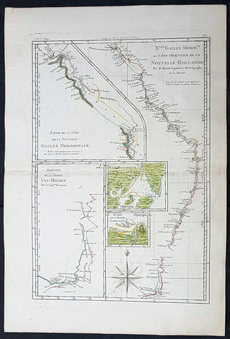
1785 Rigobert Bonne Antique Map of Australia, Botany Bay, Tasmania & Queensland
Antique Map
- Title : Nlle. Galles Merid. ou Cote Orientale de la Nouvelle Hollande Par M Bonne...Baie Botanique; Entree de la Riviere Endeavour; Esquisse de la Terre Van Diemen...
- Size: 17in x 11 1/2in (430mm x 285mm)
- Condition: (A+) Fine Condition
- Date : 1785
- Ref #: 93127
Description:
This original hand coloured antique copper-plate engraved map of the discoveries of Captain James Cook and the east coast of Australia in 1770 was published in 1785 edition of Atlas des toutes les parties connues du globe terrestre by Rigobert Bonne & Guillaume Raynal.
General Definitions:
Paper thickness and quality: - Heavy and stable
Paper color : - off white
Age of map color: - Original
Colors used: - Yellow, green, blue, pink
General color appearance: - Authentic
Paper size: - 17in x 11 1/2in (430mm x 285mm)
Plate size: - 14 1/2in x 10in (370mm x 255mm)
Margins: - Min 1/2in (12mm)
Imperfections:
Margins: - None
Plate area: - None
Verso: - None
Background:
Interesting map illustrating the discoveries in Australia by Captain Cook in 1770 and all the place names along the coastline. The map also 4 inset maps of Botany Bay, the Endeavour River QLD, the SE coast of Van Diemens Land or Tasmania and the northern coastline of QLD.
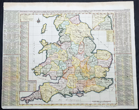
1719 Henri Chatelain Large Antique Map of England & Wales
Antique Map
- Title : Nouvelle Carte de L Angleterre....
- Ref #: 93424
- Size: 25 1/2in x 21in (650mm x 535mm)
- Date : 1719
- Condition: (A) Very Good Condition
Description:
This large beautifully hand coloured original copper plate engraved antique map of England & Wales was published by Henri Abraham Chatelain in 1719, in his famous Atlas Historique.
General Definitions:
Paper thickness and quality: - Heavy and stable
Paper color : - off white
Age of map color: - Early
Colors used: - Yellow, green, blue, pink
General color appearance: - Authentic
Paper size: - 25 1/2in x 21in (650mm x 535mm)
Plate size: - 25in x 19in (635mm x 490mm)
Margins: - Min 1/8in (3mm)
Imperfections:
Margins: - Left margin cropped to plate-mark
Plate area: - Folds as issued
Verso: - Folds as issued

1879 Lorenz Large Antique Map Coal Seams Schuylkill County, Pennsylvania Reading
Antique Map
- Title : Map Showing Coal Laterals of the Philadelphia & Reading Rail Raod company William Lorenz Chief Eng. 1879
- Date : 1879
- Size: 29in x 19 1/2in (735mm x 495mm)
- Condition: (A) Very Good Condition
- Ref: 93520
Description:
This original, large folding rare lithograph map of the Coal Fields of Schuylkill County, Pennsylvania, owned at the time by the Pennsylvania & Reading Railroad Company by William Lorenz was engraved and published in 1879 - dated.
The Definition of a Coalseam lateral is any system of development in coal seams or thick orebodies in which headings are driven horizontally across the coal or ore and connected to main haulage drifts, entries, or shafts. There are many variations and modifications depending on the thickness, shape, and inclination of the deposit.(Ref Tooley M&B)
General Definitions:
Paper thickness and quality: - Heavy and stable
Paper color : - off white
Age of map color: - Original
Colors used: - Pink, blue
General color appearance: - Authentic
Paper size: - 29in x 19 1/2in (735mm x 495mm)
Plate size: - 29in x 19 1/2in (735mm x 495mm)
Margins: - Min 1/2in (12mm)
Imperfections:
Margins: - Chipping to map edges not affecting the image
Plate area: - Light wear along sectioned edges
Verso: - Backed in linen
Background:
Schuylkill is a county in the Commonwealth of Pennsylvania. It is located in the heart of Pennsylvanias Coal Region and is part of Northeastern Pennsylvania. As of the 2020 census, the population was 143,049. The county seat is Pottsville.
The county was created on March 1, 1811, from parts of Berks and Northampton counties and named for the Schuylkill River, which originates in the county. On March 3, 1818, additional territory in its northeast was added from Columbia and Luzerne counties. The county is part of the Pottsville, Pennsylvania Micropolitan Statistical Area.
The lands that today constitute Schuylkill County were acquired by William Penns proprietors by treaty executed August 22, 1749, with representatives of the Six Nations and the Delaware, Shamokin and Shawnee, who received 500 pounds lawful money of Pennsylvania. The territory described included all of Schuylkill County except the northern part of Union Township, which was included in the purchase of 1768.
In the year 1754, the area that would become Schuylkill County along with the areas that today are Berks, Dauphin, Lebanon, and Lehigh counties were settled by German immigrants. The earliest settlers in southeastern Schuylkill County, which was then part of Northampton County, were primarily Moravian missionaries from Saxony. Other early settlers in southern Schuylkill County were German Palatines.
An early mill in the county was built in 1744 by John Finscher, but it later burned down. The first log church in the county was built in 1755. Native American massacres were commonplace in Schuylkill County between 1755 and 1765. Warrant for tracts of land in the vicinity of McKeansburg were in existence as early as 1750. Found by Sammy Hepler in 1789.
Anthracite coal (then called stone coal) was discovered by Necho Allen near the area where Pottsville was ultimately developed in 1790. In 1795, a blacksmith in Schuylkill County named Whetstone learned how to use the coal successfully for smithing purposes. In 1806 coal was found while the tail-race was cut of the Valley (Iron) Forge, on the Schuylkill. Daniel Berlin, another blacksmith, also used it successfully, and smiths in the neighborhood adopted using the coal.
Schuylkill County was created via an Act of Assembly on March 1, 1811, from portions of Berks and Northampton counties. More land was added to the county in 1818, from Columbia and Luzerne counties. At the time of its creation, the county had a population of about 6,000. An early book of Schuylkill County history was written by Daniel Deibert in 1802.
Orwisgsburg was the first community in Schuylkill County to be laid out. During the early years of Schuylkill County, there was an attempt to make McKeansburg the county seat; Orwigsburg was also a contender. Orwigsburg was agreed upon to be the county seat, as it was deemed to be well-suited for industries. Beginning in 1831, sentiment began to rise for moving the county seat to Pottsville. In 1846, the Legislature passed an Act that was approved by Governor Francis R. Shunk on March 13, submitting the question to the voters. The change was desired principally because the railroad and canal connections with Orwigsburg were problematic to transport the public to that town without losing valuable time while Pottsville had such facilities and was within easy access from all parts of the county.
In 1812, George Shoemaker who, with Necho Allen, had discovered stone coal at Centerville in Schuylkill County, personally delivered some coal to Philadelphia. He gave away most of the coal, intending to encourage individuals to find ways to use it. Most of the experiments failed and though Shoemaker was nearly run out of town and called an imposter, Mellon and Bishop of Delaware County successfully used it in their rolling mill. When other rolling mills also adopted the fuel, a large industrial market and demand developed.
The Schuylkill Navigation Company was chartered in 1815 to build a series of navigation improvements in the Schuylkill River. This was during a period when the much larger Erie Canal along the Mohawk River in New York also was being developed. It was well ahead of other key canals fueling the Industrial Revolution, such as the Delaware and Hudson, the Lehigh, the Chesapeake and Ohio, Delaware and Raritan, and Morris canals. The originators of the project did not count upon the coal trade to promote the success of the undertaking. They looked forward mainly to transporting the agricultural products being produced below the mountains, the lumber of Schuylkill County, and the grain and other products of the counties between the Susquehanna and Schuylkill rivers. The first shipments of coal by canal were made in 1822 when 1,480 tons were sent down the line.
With a regular supply of anthracite coal ensured, the southern anthracite coal field in Schuylkill County attracted speculators and fortune hunters. They were inspired by dreams of becoming millionaires. This was the first speculative era of the Schuylkill coal trade. Pottsville became the center of the movement. The more successful explorers revealed numerous veins of coal, extending over a vast stretch of county and with a seemingly inexhaustible quantity of coal. These discoveries brought excitement and speculation; lands were bought (and sold); roads were laid out in the forest, mines were opened and railroads projected, and innumerable town plots planned. The demand for houses was so great that the lumber for many was framed in Philadelphia and sent by canal to the burgeoning coal region.
At this stage, coal-mining firms were small and family owned. The residents and entrepreneurs of the Schuylkill region opposed the entry here of incorporated coal companies. In these years, coal mining operations in the Schuylkill region were conducted with economy, and relatively little capital was required. As the workings were all above the water level, no machinery was required for water drainage or for hoisting coal to the surface. Coal breakers and other expensive fixtures and appliances for the preparation of coal had not then been introduced. Numerous operators produced from five to six thousand tons for market annually (which was then considered a respectable business), who had never committed thousands of dollars to their enterprises, including their first land purchases of coal mines. It was commonly asserted that coal land could be bought and mines opened for less capital than the purchase and stocking of a decent farm. Such mines could be worked for less capital than that required to establish a line of stagecoaches or transportation wagons.
Eventually, railroads replaced the canals as the primary means of transporting coal to markets. Mining was taken over by major corporate business, especially after the Civil War. As a result, the Middle Coal Field was developed in the 1860s and the Philadelphia and Reading Railroad created a subsidiary (Philadelphia and Reading Coal and Iron Company) to buy or lease, and develop the expanding industrial coal trade. Consumption of coal along the Schuylkill above Philadelphia in 1839 was 30,290 tons when the Pioneer at Pottsville, the first anthracite furnace in the United States, became operational. By 1849, consumption had increased to 239,290 tons, to 554,774 tons in 1859, and to 1,787,205 tons in 1873.
The numerous jobs in the mining industry comprised a catalyst for mass immigration to Schuylkill County from the British Isles and Europe in the 19th and 20th centuries. As mines became more numerous (by 1846 there were 110 operators in the region and 142 collieries in Schuylkill County) and more complex (in 1846 there were 35 collieries below water level), mechanical breakers, steam locomotive, it became more labor-intensive both for accomplishing mining tasks and supporting minings peripheral industries. Such industries included manufacturing of explosives, metal screens, pump components, piping, and timber for support. This led to an influx of population into Schuylkill and other anthracite counties to fill these jobs. Beginning with the Irish immigration in the 1840s (fueled by the Great Famine), after the Civil War, beginning in the 1870s, newcomers arrived from Eastern Europe. Poles, Hungarians, Lithuanians, Slovaks, Rusyns and Ukrainians (Ruthenians), often from the Austro-Hungarian monarchy settled in the villages of Schuylkill County and took their place among the laborers in the coal mines. By the 1880s and 1890s, thousands of Italians immigrated for jobs related to mining.
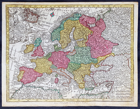
1744 Georg Mattaus Seutter Antique Map of Europe
Antique Map
- Title : Europa a Matth. Seutteri...T C Lotter, Geogr.
- Ref #: 93388
- Size: 11in x 8 1/2in (280mm x 215mm)
- Date : 1744
- Condition: (A+) Fine Condition
Description:
These beautifully hand coloured original copper-plate engraved antique map was engraved by Tobias Lotter and published in the 1744 edition of GM Seutters Atlas Minor Prae cipua Orbis Terrarum Imperia Regna et Provincias...., Augsburg, Germany.
General Definitions:
Paper thickness and quality: - Heavy and stable
Paper color : - off white
Age of map color: - Early
Colors used: - Yellow, green, blue, pink
General color appearance: - Authentic
Paper size: - 11in x 8 1/2in (280mm x 215mm)
Plate size: - 10 1/2in x 8in (265mm x 205mm)
Margins: - Min 1/4in (5mm)
Imperfections:
Margins: - None
Plate area: - None
Verso: - None
Background:
Atlas Minor was a series of beautiful maps of all parts of the world. Georg Matthäus Seutter was one of the most and important of the German cartographers of the 18th century, being appointed as the Geographer to the Imperial Court. His son, Albrecht Carl, joined Matthäus and eventually inherited the business. The maps from Atlas Minor were drawn by the two Seutters and engraved by Tobias Conrad Lotte. These maps are highly detailed and engraved with a bold hand with equally strong original hand color in the body of the map as was the 18th century German style. The cartouches were left uncolored in order to emphasize the elaborately detailed illustrations for which German maps are especially prized. These are some of the most decorative and interesting maps of the eighteenth century.
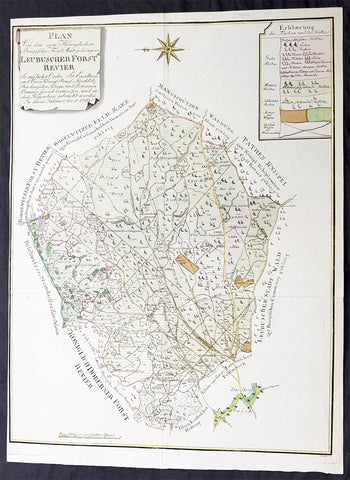
1782 G F Frentzel Large Rare Antique Map of Lubsza Forest Brzeg, Opole SW Poland
Antique Map
- Title : Plan Von Dem zum Koniglichen Briegischen Forfst Amt gehorigen Leubuscher Forst RevierSo Auf hoher Ordre Sr Excellence und Einer Konig Prussia Hochlob Breslauischen Krieges und Domainen Cammer special vermessen und in diese Proportion gebracht worden In denen Jahren 1782 et 1783
- Ref #: 93489
- Size: 21in x 16in (530mm x 415mm)
- Date : 1782-83
- Condition: (A+) Fine Condition
Description:
This incredibly rare detailed original hand coloured copper plate engraved antique map, a survey of the forest near Lubsza in the county of Brzeg in the Opole Province in SW Poland between 1782 & 1783 was engraved by the Leipzig engraver Georg Friedrich Jonas Frentzel.
General Definitions:
Paper thickness and quality: - Heavy and stable
Paper color : - off white
Age of map color: - Original
Colors used: - Green, yellow, brown, pink
General color appearance: - Authentic
Paper size: - 21in x 16in (530mm x 415mm)
Plate size: - 21in x 16in (530mm x 415mm)
Margins: - Min 1/8in (2mm)
Imperfections:
Margins: - Left margin cropped close to border
Plate area: - None
Verso: - None
Background:
Lubsza is a village in Brzeg, Opole Voivodeship, in south-western Poland. It is the seat of the gmina (administrative district) called Gmina Lubsza. It lies approximately 7 kilometres north-east of Brzeg and 41 km north-west of the regional capital Opole. Before 1945 the area was part of Germany
Frentzel, Georg Friedrich Jonas 1754 - 1799
Frentzel was a master-engraver from Leipzig in Germany, specialising in copper engraving. His work was known for its critical level of detail, cumulating in one of the finest revolutionary maps of Boston in 1776 Carte von dem Hafen und der Stadt Boston
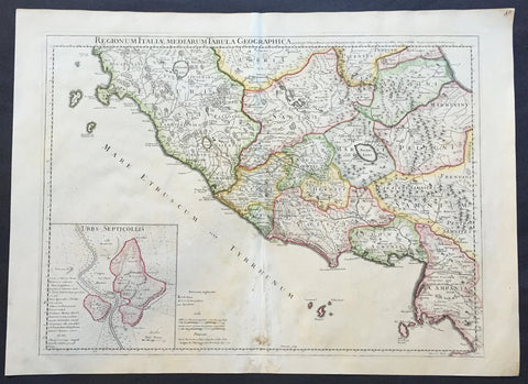
1711 Claude Delisle Large Antique Map of Rome and Regions, Italy
- Title : Regionum Italiae Mediarum Tabula Geographica Par Guill. Delisle.....1711
- Ref #: 31904
- Size: 28in x 21in (660mm x 535mm)
- Date : 1711
- Condition: (A+) Fine Condition
Description:
This large beautifully engraved hand coloured original antique map of Rome and the regions surrounding the ancient capital was engraved in 1711 - the date is engraved at the foot of the map - and was published by Guillaume Delisle in the Atlas Nouveau. (Ref: M&B; Tooley)
Condition Report
Paper thickness and quality: - Very heavy and stable
Paper color: - Off white
Age of map color: - Original
Colors used: - Yellow, green, pink
General color appearance: - Authentic
Paper size: - 28in x 21in (660mm x 535mm)
Plate size: - 24in x 18 1/2in (610mm x 470mm)
Margins: - min. 1in (25mm)
Imperfections:
Margins: - Repair to bottom margin
Plate area: - Light creasing and slight discolouration to bottom centerold
Verso: - None
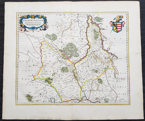
1650 Joan Blaeu Antique Map of Archbishopric of Madenburg Saxony-Anhalt, Germany
- Title : Magdeburgensis Archiepiscopatus
- Ref #: 40335
- Size: 24in x 21in (610mm x 535mm)
- Date : 1650
- Condition: (A+) Fine Condition
Description:
This beautifully hand coloured original copper-plate engraved antique map of the Archbishopric of Madenburg today located in the state of Saxony-Anhalt, Germany, on the Elbe River, was published in the 1650 Dutch edition of Joan Blaeus Atlas Novus.
General Definitions:
Paper thickness and quality: - Heavy and stable
Paper color : - off white
Age of map color: - Original
Colors used: - Blue, pink, red, green, yellow
General color appearance: - Authentic
Paper size: - 24in x 21in (610mm x 535mm)
Plate size: - 21in x 16 1/2in (535mm x 420mm)
Margins: - Min 1in (25mm)
Imperfections:
Margins: - Light age toning
Plate area: - None
Verso: - None
Background:
The Archbishopric of Magdeburg was a Roman Catholic archdiocese (969–1552) and Prince-Archbishopric (1180–1680) of the Holy Roman Empire centered on the city of Magdeburg on the Elbe River.
Planned since 955 and established in 968, the Roman Catholic archdiocese had de facto turned void since 1557, when the last papally confirmed prince-archbishop, the Lutheran Sigismund of Brandenburg came of age and ascended to the see and the Magdeburg cathedral chapter had adopted Lutheranism in 1567, with most parishioners having preceded in their conversion. All his successors were only administrators of the prince-archbishopric and Lutheran too, except of the Catholic layman Leopold William of Austria (1631–1635). In ecclesiastical respect the remaining Catholics and their parishes and abbeys in the former archdiocese were put under supervision of the Archdiocese of Cologne in 1648 and under the jurisdiction of the Apostolic Vicariate of the Northern Missions in 1670.
In political respect the Erzstift, the archiepiscopal and capitular temporalities, had gained imperial immediacy as prince-archbishopric in 1180. Its territory comprised only some parts of the archdiocesan area, such as the city of Magdeburg, the bulk of the Magdeburg Börde, and the Jerichow Land as an integral whole and exclaves comprising about the Saalkreis including Halle upon Saale, Oebisfelde and environs as well as Jüterbog and environs. The prince-archbishopric maintained its statehood as an elective monarchy until 1680. Then Brandenburg-Prussia acquired Magdeburg prince-archbishopric, and after being secularised, transformed it into the Duchy of Magdeburg, a hereditary monarchy in personal union with Brandenburg.
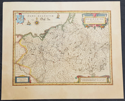
1646 Jan Jansson Antique Map of Mecklenburg NE Germany Rostock, Wizmar, Parchim
- Title : Meklenburg Ducatus
- Ref #: 50185
- Size: 11 1/2in x 8in (290mm x 205mm)
- Date : 1646
- Condition: (A+) Fine Condition
Description:
This beautifully hand coloured original copper-plate engraved antique map of the Mecklenburg, north eastern Germany by Jan Jansson was published in the 1646 Latin edition of Mercators Atlas by Jan Jansson and Henricus Hondius. (Ref: Tooley, Koeman)
General Definitions:
Paper thickness and quality: - Heavy and stable
Paper color : - off white
Age of map color: - Original
Colors used: - Yellow, green, blue, pink
General color appearance: - Authentic
Paper size: - 22in x 18in (560mm x 460mm)
Plate size: - 19in x 14 1/2in (480mm x 370mm)
Margins: - Min 2in (50mm)
Imperfections:
Margins: - None
Plate area: - None
Verso: - None
Background:
Mecklenburg is a historical region in northern Germany comprising the western and larger part of the federal-state Mecklenburg-Vorpommern. The largest cities of the region are Rostock, Schwerin, Neubrandenburg, Wismar and Güstrow.
The name Mecklenburg derives from a castle named Mikilenburg (Old Saxon: big castle, hence its translation into New Latin and Greek: Megalopolis), located between the cities of Schwerin and Wismar. In Slavic language it was known as Veligrad, which also means big castle. It was the ancestral seat of the House of Mecklenburg; for a time the area was divided into Mecklenburg-Schwerin and Mecklenburg-Strelitz among the same dynasty.
Linguistically Mecklenburgers retain and use many features of Low German vocabulary or phonology.
Mecklenburg is the site of many prehistoric dolmen tombs. Its earliest organised inhabitants may have had Celtic origins. By no later than 100 BC the area had been populated by pre-Christian Germanic peoples.
The traditional symbol of Mecklenburg, the grinning steers head (Low German: Ossenkopp, lit.: oxen\'s head, with osse being a synonym for steer and bull in Middle Low German), with an attached hide, and a crown above, may have originated from this period. It represents what early peoples would have worn, i.e. a steers\'s head as a helmet, with the hide hanging down the back to protect the neck from the sun, and overall as a way to instill fear in the enemy.
From the 7th through the 12th centuries, the area of Mecklenburg was taken over by Western Slavic peoples, most notably the Obotrites and other tribes that Frankish sources referred to as Wends. The 11th century founder of the Mecklenburgian dynasty of Dukes and later Grand Dukes, which lasted until 1918, was Nyklot of the Obotrites.
In the late 12th century, Henry the Lion, Duke of the Saxons, conquered the region, subjugated its local lords, and Christianized its people, in a precursor to the Northern Crusades. From 12th to 14th century, large numbers of Germans and Flemings settled the area (Ostsiedlung), importing German law and improved agricultural techniques. The Wends who survived all warfare and devastation of the centuries before, including invasions of and expeditions into Saxony, Denmark and Liutizic areas as well as internal conflicts, were assimilated in the centuries thereafter. However, elements of certain names and words used in Mecklenburg speak to the lingering Slavic influence. An example would be the city of Schwerin, which was originally called Zuarin in Slavic. Another example is the town of Bresegard, the \'gard\' portion of the town name deriving from the Slavic word \'grad\', meaning city or town.
Since the 12th century, the territory remained stable and relatively independent of its neighbours; one of the few German territories for which this is true. During the reformation the Duke in Schwerin would convert to Protestantism and so would follow the Duchy of Mecklenburg.
Like many German territories, Mecklenburg was sometimes partitioned and re-partitioned among different members of the ruling dynasty. In 1621 it was divided into the two duchies of Mecklenburg-Schwerin and Mecklenburg-Güstrow. With the extinction of the Güstrow line in 1701, the Güstrow lands were redivided, part going to the Duke of Mecklenburg-Schwerin, and part going to the new line of Mecklenburg-Strelitz.
In 1815, the two Mecklenburgian duchies were raised to Grand Duchies, the Grand Duchy of Mecklenburg-Schwerin and the Grand Duchy of Mecklenburg-Strelitz, and subsequently existed separately as such in Germany under enlightened but absolute rule (constitutions being granted on the eve of World War I) until the revolution of 1918. Life in Mecklenburg could be quite harsh. Practices such as having to ask for permission from the Grand Duke to get married, or having to apply for permission to emigrate, would linger late into the history of Mecklenburg (i.e. 1918), long after such practices had been abandoned in other German areas. Even as late as the later half of the 19th century the Grand Duke personally owned half of the countryside. The last Duke abdicated in 1918, as monarchies fell throughout Europe. The Duke\'s ruling house reigned in Mecklenburg uninterrupted (except for two years) from its incorporation into the Holy Roman Empire until 1918. From 1918 to 1933, the duchies were free states in the Weimar Republic.
Traditionally Mecklenburg has always been one of the poorer German areas, and later the poorer of the provinces, or Länder, within a unified Germany. The reasons for this may be varied, but one factor stands out: agriculturally the land is poor and can not produce at the same level as other parts of Germany. The two Mecklenburgs made attempts at being independent states after 1918, but eventually this failed as their dependence on the rest of the German lands became apparent.
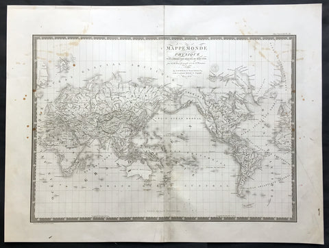
1821 Brue Large Antique World Map of Mercators Projection - New Holland, Texas
- Title : Mappemonde Physique...par Brue......1821
- Ref #: 32440
- Size: 24in x 18in (610mm x 460mm)
- Date : 1821
- Condition: (A) Very Good Condition
Description:
This large original antique World map on Mercator's projection was engraved in 1821 - the date is engraved in the title - and was published in Adrien Brue's (1786 - 1832) large Atlas Universel de Geographie.
A fantastic World map in a time of great change. The map centres on New Holland or Australia (officially named Australia in 1824 by the British) Mexico still holds sway on the western portion of North America. Much of Capt. Cooks discoveries are recognised on this map in NW America and the south Pacific but not his explorations in Antarctica and beyond. Central Africa still remains relatively unexplored by the Europeans as does the Artic north of Canada. A fantastic map. (Ref: M&B; Tooley)
General Description:
Paper thickness and quality: - Heavy and stable
Paper color: - Off white
Age of map color: -
Colors used: -
General color appearance: -
Paper size: - 24in x 18in (610mm x 460mm)
Plate size: - 21 1/2in x 15 1/2in (545mm x 395mm)
Margins: - Min 1in (25mm)
Imperfections:
Margins: - Soiling in margins, repair to top margin, no loss
Plate area: - Soiling and spotting to top of map
Verso: - Soiling
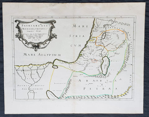
1640 Nicolas Sanson Antique Map of The Holy Land, Egypt, Saudi - Knights Templar
- Title : Patriachatus Hierosolymitani....Aput M Tavernier....1640
- Size: 22 1/2in x 18in (570mm x 460mm)
- Condition: (A+) Fine Condition
- Date : 1640
- Ref #: 40692
Description:
This fine original hand coloured copper-plate engraved antique map of the Holy Land, Egypt, part of Saudi Arabia and the connection to the Nights Templar (Latin: Militaris Templi Hierosolymitani) in the middle ages was engraved by Michael Tavernier in 1640 - dated in the cartouche - and was published by Nicolas Sanson in the 1653 edition of Geographia sacra, sive notitia antiqua dioecesium omnium partriarchalium, metropoliticarum, et episcopalium veteris ecclesiae. notae et animadversions Lucae Holstenii.
This is a wonderful map with original outline hand colour on strong sturdy clean paper and a heavy impression.
General Definitions:
Paper thickness and quality: - Heavy and stable
Paper color : - off white
Age of map color: - Original
Colors used: - Yellow, Green, pink
General color appearance: - Authentic
Paper size: - 22 1/2in x 18in (570mm x 460mm)
Plate size: - 20in x 14in (510mm x 370mm)
Margins: - Min 1in (25mm)
Imperfections:
Margins: - None
Plate area: - None
Verso: - None
Background:
The Templars became a favoured charity throughout Christendom and grew rapidly in membership and power. They were prominent in Christian finance. Templar knights, in their distinctive white mantles with a red cross, were among the most skilled fighting units of the Crusades. Non-combatant members of the order, who formed as much as 90% of the orders members, managed a large economic infrastructure throughout Christendom, developing innovative financial techniques that were an early form of banking, building its own network of nearly 1,000 commanderies and fortifications across Europe and the Holy Land, and arguably forming the worlds first multinational corporation.
The Templars were closely tied to the Crusades; when the Holy Land was lost, support for the order faded. Rumours about the Templars secret initiation ceremony created distrust, and King Philip IV of France – deeply in debt to the order – took advantage of this distrust to destroy them and erase his debt. In 1307, he had many of the orders members in France arrested, tortured into giving false confessions, and burned at the stake. Pope Clement V disbanded the order in 1312 under pressure from King Philip. The abrupt reduction in power of a significant group in European society gave rise to speculation, legend, and legacy through the ages.