Welcome to Classical Images!
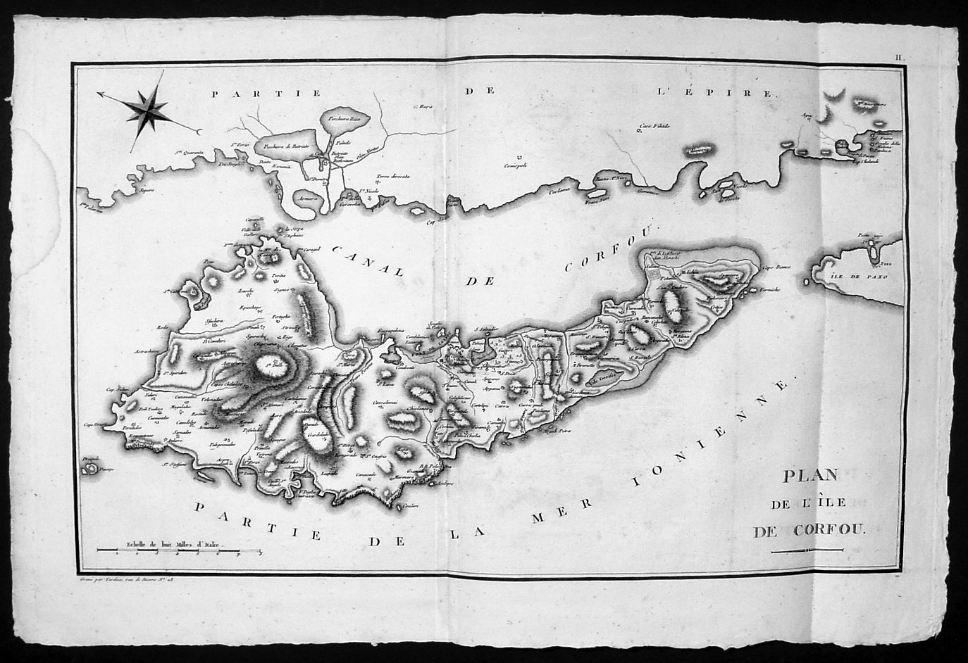
Description:This original copper-plate engraved antique map of the Greek Island of Corfu was engraved by Pierre Tardieu and was published in the 1802 edition of Jean-Baptiste Lechevaliers of Voyage de la Troade, fait dans les années 1785 et 1786
General Definitions:Paper thickness and quality: - Heavy and stablePaper color : - off whiteAge of map color: -Colors used: -General color appearance: -Paper size: - 21in x 14in (535mm x 355mm)Plate size: - 20 1/2in x 13in (520mm x 335mm)Margins: - Min 1/2in (12mm)
Imperfections:Margins: - Light soilingPlate area: - Light soilingVerso: - Light soiling
Background: Corfu or Kerkyra is a Greek island in the Ionian Sea. It is the second largest of the Ionian Islands and, including its small satellite islands, forms the north-westernmost part of Greece. The island is part of the Corfu regional unit, and is administered as a single municipality, which also includes the smaller islands of Ereikoussa, Mathraki and Othonoi. The municipality has an area of 610,9 km2, the island proper 592,8 km2. The principal city of the island and seat of the municipality (pop. 32,095) is also named Corfu. Corfu is home to the Ionian University.The island is bound up with the history of Greece from the beginnings of Greek mythology. Its history is full of battles and conquests. Ancient Korkyra took part in the Battle of Sybota which was a catalyst for the Peloponnesian War, and, according to Thucydides, the largest naval battle between Greek city states until that time. Thucydides also reports that Korkyra was one of the three great naval powers of fifth century BC Greece, along with Athens and Corinth. Medieval castles punctuating strategic locations across the island are a legacy of struggles in the Middle Ages against invasions by pirates and the Ottomans. Two of these castles enclose its capital, which is the only city in Greece to be surrounded in such a way. As a result, Corfu\'s capital has been officially declared a Kastropolis (castle city) by the Greek government. From medieval times and into the 17th century, the island, having successfully repulsed the Ottomans during several sieges, was recognised as a bulwark of the European States against the Ottoman Empire and became one of the most fortified places in Europe. The fortifications of the island were used by the Venetians to defend against Ottoman intrusion into the Adriatic. Corfu eventually fell under British rule following the Napoleonic Wars. Corfu was eventually ceded by the British Empire along with the remaining islands of the United States of the Ionian Islands, and unification with modern Greece was concluded in 1864 under the Treaty of London.Jean-Baptiste Lechevalier was the secretary of the Ambassador of France in Constantinople. In the year 1788 he visited the plain of Troy, and was enthusiastically in favour of the theory that the site of Homers Troy was to be found at the village of Bunarbashi. His publication about Troy Voyage de la Troade.....was first published in 1799.The Troad, also known as Troas, is the historical name of the Biga peninsula (Biga Yarımadası, Τρωάς) in the northwestern part of Anatolia, Turkey. This region now is part of the Çanakkale province of Turkey. Bounded by the Dardanelles to the northwest, by the Aegean Sea to the west and separated from the rest of Anatolia by the massif that forms Mount Ida, the Troad is drained by two main rivers, the Scamander (Karamenderes) and the Simois, which join at the area containing the ruins of Troy. Grenikos, Kebren, Simoeis, Rhesos, Rhodios, Heptaporos and Aisepos were seven rivers of the Troad and the names of the river gods that inhabited each river.Troy (Ancient Greek: Τροία, Troia or Τροίας, Troias, Truva or Troya) was a city in the far northwest of the region known in late Classical antiquity as Asia Minor, now known as Anatolia in modern Turkey, just south of the southwest mouth of the Dardanelles strait and northwest of Mount Ida. The present-day location is known as Hisarlik. It was the setting of the Trojan War described in the Greek Epic Cycle, in particular in the Iliad, one of the two epic poems attributed to Homer. Metrical evidence from the Iliad and the Odyssey suggests that the name λιον (Ilion) formerly began with a digamma: Ϝίλιον (Wilion); this is also supported by the Hittite name for what is thought to be the same city, Wilusa.A new capital called Ilium (from Greek: λιον, Ilion) was founded on the site in the reign of the Roman Emperor Augustus. It flourished until the establishment of Constantinople, became a bishopric and declined gradually in the Byzantine era, but is now a Latin Catholic titular see.In 1865, English archaeologist Frank Calvert excavated trial trenches in a field he had bought from a local farmer at Hisarlik, and in 1868, Heinrich Schliemann, a wealthy German businessman and archaeologist, also began excavating in the area after a chance meeting with Calvert in Çanakkale. These excavations revealed several cities built in succession. Schliemann was at first skeptical about the identification of Hisarlik with Troy, but was persuaded by Calvert and took over Calverts excavations on the eastern half of the Hisarlik site, which was on Calvert\'s property. Troy VII has been identified with the city called Wilusa by the Hittites (the probable origin of the Greek λιον) and is generally (but not conclusively) identified with Homeric Troy.Today, the hill at Hisarlik has given its name to a small village near the ruins, which supports the tourist trade visiting the Troia archaeological site. It lies within the province of Çanakkale, some 30 km south-west of the provincial capital, also called Çanakkale. The nearest village is Tevfikiye. The map here shows the adapted Scamander estuary with Ilium a little way inland across the Homeric plain. Due to Troys location near the Aegean Sea, the Sea of Marmara, and the Black Sea, it was a central hub for the military and trade(Ref: M&B; Tooley)