Maps (804)
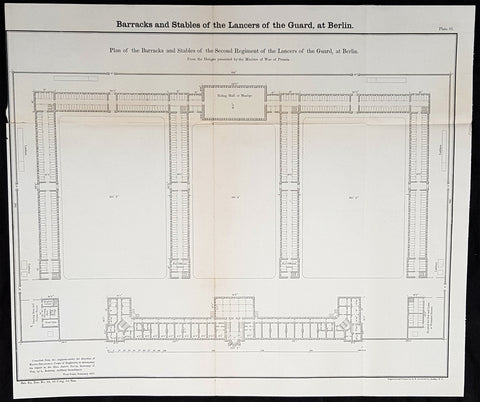
1856 Cpt R Delafield Large Antique Schematics 2nd Lancer Barracks Stables Berlin
Antique Map
- Title : Barrack and stables of the Lancers of the Guard at Berlin...Barrack of the Second Regiment of the Lancers of teh Guard at Berlin
- Date : 1856
- Condition: (A) Very Good Condition
- Ref: 90142
- Size: 18 1/2in x 16in (470mm x 405mm)
Description:
This large original lithograph print, schematics of the 2nd German Lancer Regiment Barracks & Stables in Berlin - during the time of the Crimean War and just prior to the American Civil War - was engraved by John T Bowen & co. of Philadelphia and was published in the 1856 edition of Captain Richard Delafields Report on the Art of War in Europe in 1854, 1855, and 1856.
In early 1855, Captain Richard Delafield was appointed by the Secretary of War, Jefferson Davis, a head of the board of officers, later called The Delafield Commission, and sent to Europe to study the European military. The board included Captain George B. McClellan and Major Alfred Mordecai. They inspected the state of the military in Great Britain, Germany, the Austrian Empire, France, Belgium, and Russia, and served as military observers during the Crimean War. After his return in April 1856, Delafield submitted a report which was later published as a book by Congress, Report on the Art of War in Europe in 1854, 1855, and 1856. The book was suppressed during the American Civil War due to fears that it would be instructive to Confederate engineers as it contained multiple drawings and descriptions of military fortifications.
General Definitions:
Paper thickness and quality: - Light and stable
Paper color : - off white
Age of map color: -
Colors used: -
General color appearance: -
Paper size: - 18 1/2in x 16in (470mm x 405mm)
Plate size: - 18 1/2in x 16in (470mm x 405mm)
Margins: - Min 1/2in (12mm)
Imperfections:
Margins: - None
Plate area: - Folds as issued
Verso: - Folds re-enforced with archival tape
Background:
A lancer was a type of cavalryman who fought with a lance. Lances were used in mounted warfare by the Assyrians as early as 700 BC and subsequently by Greek, Persian, Gallic, Chinese, and Roman horsemen. The weapon was widely used in Asia and Europe during the Middle Ages and the Renaissance by armoured cavalry, before being adopted by light cavalry, particularly in Eastern Europe. In a modern context, a lancer regiment usually denotes an armoured unit.
The lancer (called ułan in Polish and Uhlan in German) had become a common sight in almost every European, Ottoman, and Indian army during this time, but, with the exception of the Ottoman troops, they increasingly discarded the heavy armour to give greater freedom of movement in combat. The Polish winged lancers were amongst the last to abandon the armour in Europe. There was debate over the value of the lance in mounted combat during the 18th century and most armies had few lancer units by the beginning of the 19th century. However, during the Napoleonic Wars, lancers were to be seen in many of the combatant nations as their value in shock tactics became clear. During the wars, the Poles became a ready source of recruitment for several armies, willingly or unwillingly. Polish lancers served with distinction in the Austrian, Prussian, Russian and French armies, most famously in Napoleons French Imperial Guard as the 1er Regiment de Chevau-Legers-Lanciers de la Garde Impériale.
At the Battle of Waterloo, French lances were nearly three meters (about nine feet, ten inches) long, weighed three kilograms (about six pounds, ten ounces), and had a steel point on a wooden staff, according to historian Alessandro Barbero. He adds that they were terrifyingly efficient. Commander of the French 1st Corps, 4th Division General Durutte, who saw the battle from the high ground in front of Papelotte, would write later, I had never before realized the great superiority of the lance over the sword.
In the Siege of Los Angeles (1846), during the war between Mexico and the United States, a company of Californio lancers temporarily recaptured the town, expelling a company of U.S. Marines.
Although having substantial impact in the charge, lancers could be vulnerable to other cavalry at close quarters, where the lance proved a clumsy and easily deflected weapon when employed against sabres. By the late 19th century, many cavalry regiments in the British and other European armies were composed of troopers with lances, as primary weapons, in the front rank and horsemen with sabres only in the second: the lances for the initial shock and sabres for the subsequent mêlée.
Delafield, Richard Major General 1798 - 1873 - Delafield was a United States Army officer for 52 years. He served as superintendent of the United States Military Academy for 12 years. At the start of the American Civil War, then Colonel Delafield helped equip and send volunteers from New York to the Union Army. He also was in command of defences around New York harbor from 1861 to April 1864. On April 22, 1864, he was promoted to Brigadier General in the Regular Army of the United States and Chief of Engineers. On March 8, 1866, President Andrew Johnson nominated Delafield for appointment to the grade of brevet major general in the Regular Army, to rank from March 13, 1865, and the United States Senate confirmed the appointment on May 4, 1866, reconfirmed due to a technicality on July 14, 1866. He retired from the US Army on August 8, 1866. He later served on two commissions relating to improvements to Boston Harbor and to lighthouses. He also served as a regent of the Smithsonian Institution.
Delafield served as assistant engineer in the construction of Hampton Roads defences from 1819–1824 and was in charge of fortifications and surveys in the Mississippi River delta area in 1824-1832. While superintendent of repair work on the Cumberland Road east of the Ohio River, he designed and built Dunlaps Creek Bridge in Brownsville, Pennsylvania, the first cast-iron tubular-arch bridge in the United States. Commissioned a major of engineers in July 1838, he was appointed superintendent of the Military Academy after the fire of 1838 and served till 1845. He designed the new buildings and the new cadet uniform that first displayed the castle insignia. He superintended the construction of coast defences for New York Harbor from 1846 to 1855.
In the beginning of 1855, Delafield was appointed by the Secretary of War, Jefferson Davis a head of the board of officers, later called The Delafield Commission, and sent to Europe to study the European military. The board included Captain George B. McClellan and Major Alfred Mordecai. They inspected the state of the military in Great Britain, Germany, the Austrian Empire, France, Belgium, and Russia, and served as military observers during the Crimean War. After his return in April 1856, Delafield submitted a report which was later published as a book by Congress, Report on the Art of War in Europe in 1854, 1855, and 1856. The book was suppressed during the American Civil War due to fears that it would be instructive to Confederate engineers as it contained multiple drawings and descriptions of military fortifications.
Delafield served as superintendent of the Military Academy again in 1856-1861. In January 1861, he was succeeded by Captain Pierre G. T. Beauregard, who was dismissed shortly after Beauregards home state of Louisiana seceded from the Union, and Delafield returned as superintendent serving until March 1, 1861. In the beginning of the Civil War he advised the governor of New York Edwin D. Morgan during the volunteer force creation. Then, in 1861–1864, he was put in charge of New York Harbor defences, including Governors Island and Fort at Sandy Hook. On May 19, 1864, he was commissioned a brigadier-general after replacing Joseph Gilbert Totten, who had died, as the Chief of Engineers, United States Army Corps of Engineers, on April 22, 1864. He stayed in charge of the Bureau of Engineers of the War Department until his retirement on August 8, 1866. On March 8, 1866, President Andrew Johnson nominated Delafield for appointment to the grade of brevet major general in the Regular Army of the United States, to rank from March 13, 1865, and the United States Senate confirmed the appointment on May 4, 1866 and reconfirmed it due to a technicality on July 14, 1866.After retirement Delafield served as a regent of the Smithsonian Institution and a member of the Lighthouse Board. He died in Washington, D.C. on November 5, 1873.
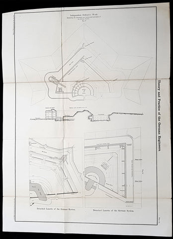
1856 Cap Richard Delafield Large Antique Schematics German Fortifications
Antique Map
- Title : Theory and Practise of the German Engineers
- Date : 1856
- Condition: (A+) Fine Condition
- Ref: 90150
- Size: 24 1/2in x 18in (615mm x 475mm)
Description:
This large original lithograph print, schematics of parts of the German Forts in such cities as Coblenz, Posen, Mainz, Luxemburg, Landau & others - during the time of the Crimean War - was engraved by John T Bowen & co. of Philadelphia and was published in the 1856 edition of Captain Richard Delafields Report on the Art of War in Europe in 1854, 1855, and 1856.
In early 1855, Captain Richard Delafield was appointed by the Secretary of War, Jefferson Davis, a head of the board of officers, later called The Delafield Commission, and sent to Europe to study the European military. The board included Captain George B. McClellan and Major Alfred Mordecai. They inspected the state of the military in Great Britain, Germany, the Austrian Empire, France, Belgium, and Russia, and served as military observers during the Crimean War. After his return in April 1856, Delafield submitted a report which was later published as a book by Congress, Report on the Art of War in Europe in 1854, 1855, and 1856. The book was suppressed during the American Civil War due to fears that it would be instructive to Confederate engineers as it contained multiple drawings and descriptions of military fortifications.
General Definitions:
Paper thickness and quality: - Light and stable
Paper color : - off white
Age of map color: -
Colors used: -
General color appearance: -
Paper size: - 24 1/2in x 18in (615mm x 475mm)
Plate size: - 24 1/2in x 18in (615mm x 475mm)
Margins: - Min 1/2in (12mm)
Imperfections:
Margins: - None
Plate area: - Light age toning along folds, as issued
Verso: - Folds re-enforced with archival tape
Background:
Under the term of the 1815 Peace of Paris, France was obliged to pay for the construction of a line of fortresses to protect the German Confederation against any future aggression by France. All fortresses were located outside Austria and Prussia — the two biggest, bickering powers of the Confederation.
Section C. Defensive System of the Germanic Confederation of the protocol drawn up at Paris on 3 November 1815, declared Mainz, Luxemburg, and Landau to be fortresses belonging to the Confederation of Germany, and stipulated that a fourth should be constructed on the Upper Rhine. In conformity with this act, a portion of the funds, which France was compelled to pay by way of indemnity for the cost of placing her on a peaceable footing, was thus appropriated: £200,000 were set aside for completing the works at Mainz; £800,000 were assigned to Prussia, to be applied upon its fortresses on the Lower Rhine; another £800,000 were reserved for constructing the new federal fortress on the Upper Rhine; and Bavaria was allowed £600,000 towards erecting another strong place on the Rhine, at Germersheim or some other point.
By 1835 the works about Mainz were completed; the twin fortresses of Koblenz and Ehrenbreitstein, and Cologne had been abundantly strengthened on the side of Prussia; and, on the Bavarian side, the fortress of Germersheim was in a state to defend the passage on the Upper Rhine. The western frontier of Germany had, in this way, been provided with a formidable line of defences against possible hostile actions by their neighbours. The eastern side of Germany has been additionally fortified by the erection of a strong citadel at Posen; and the southern was to be still further protected by the formidable works in course of construction at Brixen in the Tyrol.
The fortress of Ulm became a major strategic fortress able to accommodate 100,000 men and their equipment. Since the Kingdom of Württemberg had no engineering corps King William I appointed Moritz Karl Ernst von Prittwitz, a Prussian major, as the supervisor to oversee the building the fortresses. His plans included the provisions for the prospective development of the city Ulm. Major Theodor von Hildebrandt was appointed to oversee the building of fortresses around Neu-Ulm on the Bavarian side of the Danube
Delafield, Richard Major General 1798 - 1873 - Delafield was a United States Army officer for 52 years. He served as superintendent of the United States Military Academy for 12 years. At the start of the American Civil War, then Colonel Delafield helped equip and send volunteers from New York to the Union Army. He also was in command of defences around New York harbor from 1861 to April 1864. On April 22, 1864, he was promoted to Brigadier General in the Regular Army of the United States and Chief of Engineers. On March 8, 1866, President Andrew Johnson nominated Delafield for appointment to the grade of brevet major general in the Regular Army, to rank from March 13, 1865, and the United States Senate confirmed the appointment on May 4, 1866, reconfirmed due to a technicality on July 14, 1866. He retired from the US Army on August 8, 1866. He later served on two commissions relating to improvements to Boston Harbor and to lighthouses. He also served as a regent of the Smithsonian Institution.
Delafield served as assistant engineer in the construction of Hampton Roads defences from 1819–1824 and was in charge of fortifications and surveys in the Mississippi River delta area in 1824-1832. While superintendent of repair work on the Cumberland Road east of the Ohio River, he designed and built Dunlaps Creek Bridge in Brownsville, Pennsylvania, the first cast-iron tubular-arch bridge in the United States. Commissioned a major of engineers in July 1838, he was appointed superintendent of the Military Academy after the fire of 1838 and served till 1845. He designed the new buildings and the new cadet uniform that first displayed the castle insignia. He superintended the construction of coast defences for New York Harbor from 1846 to 1855.
In the beginning of 1855, Delafield was appointed by the Secretary of War, Jefferson Davis a head of the board of officers, later called The Delafield Commission, and sent to Europe to study the European military. The board included Captain George B. McClellan and Major Alfred Mordecai. They inspected the state of the military in Great Britain, Germany, the Austrian Empire, France, Belgium, and Russia, and served as military observers during the Crimean War. After his return in April 1856, Delafield submitted a report which was later published as a book by Congress, Report on the Art of War in Europe in 1854, 1855, and 1856. The book was suppressed during the American Civil War due to fears that it would be instructive to Confederate engineers as it contained multiple drawings and descriptions of military fortifications.
Delafield served as superintendent of the Military Academy again in 1856-1861. In January 1861, he was succeeded by Captain Pierre G. T. Beauregard, who was dismissed shortly after Beauregards home state of Louisiana seceded from the Union, and Delafield returned as superintendent serving until March 1, 1861. In the beginning of the Civil War he advised the governor of New York Edwin D. Morgan during the volunteer force creation. Then, in 1861–1864, he was put in charge of New York Harbor defences, including Governors Island and Fort at Sandy Hook. On May 19, 1864, he was commissioned a brigadier-general after replacing Joseph Gilbert Totten, who had died, as the Chief of Engineers, United States Army Corps of Engineers, on April 22, 1864. He stayed in charge of the Bureau of Engineers of the War Department until his retirement on August 8, 1866. On March 8, 1866, President Andrew Johnson nominated Delafield for appointment to the grade of brevet major general in the Regular Army of the United States, to rank from March 13, 1865, and the United States Senate confirmed the appointment on May 4, 1866 and reconfirmed it due to a technicality on July 14, 1866.After retirement Delafield served as a regent of the Smithsonian Institution and a member of the Lighthouse Board. He died in Washington, D.C. on November 5, 1873.
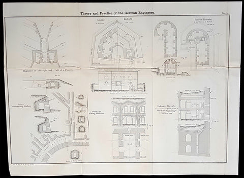
1856 Cap Richard Delafield Large Antique Schematics German Fortifications
Antique Map
- Title : Theory and Practise of the German Engineers
- Date : 1856
- Condition: (A+) Fine Condition
- Ref: 90163
- Size: 24 1/2in x 18in (615mm x 475mm)
Description:
This large original lithograph print, schematics of parts of the German Forts in such cities as Coblenz, Posen, Mainz, Luxemburg, Landau & others - during the time of the Crimean War - was engraved by John T Bowen & co. of Philadelphia and was published in the 1856 edition of Captain Richard Delafields Report on the Art of War in Europe in 1854, 1855, and 1856.
In early 1855, Captain Richard Delafield was appointed by the Secretary of War, Jefferson Davis, a head of the board of officers, later called The Delafield Commission, and sent to Europe to study the European military. The board included Captain George B. McClellan and Major Alfred Mordecai. They inspected the state of the military in Great Britain, Germany, the Austrian Empire, France, Belgium, and Russia, and served as military observers during the Crimean War. After his return in April 1856, Delafield submitted a report which was later published as a book by Congress, Report on the Art of War in Europe in 1854, 1855, and 1856. The book was suppressed during the American Civil War due to fears that it would be instructive to Confederate engineers as it contained multiple drawings and descriptions of military fortifications.
General Definitions:
Paper thickness and quality: - Light and stable
Paper color : - off white
Age of map color: -
Colors used: -
General color appearance: -
Paper size: - 24 1/2in x 18in (615mm x 475mm)
Plate size: - 24 1/2in x 18in (615mm x 475mm)
Margins: - Min 1/2in (12mm)
Imperfections:
Margins: - None
Plate area: - Light age toning along folds, as issued
Verso: - Folds re-enforced with archival tape
Background:
Under the term of the 1815 Peace of Paris, France was obliged to pay for the construction of a line of fortresses to protect the German Confederation against any future aggression by France. All fortresses were located outside Austria and Prussia — the two biggest, bickering powers of the Confederation.
Section C. Defensive System of the Germanic Confederation of the protocol drawn up at Paris on 3 November 1815, declared Mainz, Luxemburg, and Landau to be fortresses belonging to the Confederation of Germany, and stipulated that a fourth should be constructed on the Upper Rhine. In conformity with this act, a portion of the funds, which France was compelled to pay by way of indemnity for the cost of placing her on a peaceable footing, was thus appropriated: £200,000 were set aside for completing the works at Mainz; £800,000 were assigned to Prussia, to be applied upon its fortresses on the Lower Rhine; another £800,000 were reserved for constructing the new federal fortress on the Upper Rhine; and Bavaria was allowed £600,000 towards erecting another strong place on the Rhine, at Germersheim or some other point.
By 1835 the works about Mainz were completed; the twin fortresses of Koblenz and Ehrenbreitstein, and Cologne had been abundantly strengthened on the side of Prussia; and, on the Bavarian side, the fortress of Germersheim was in a state to defend the passage on the Upper Rhine. The western frontier of Germany had, in this way, been provided with a formidable line of defences against possible hostile actions by their neighbours. The eastern side of Germany has been additionally fortified by the erection of a strong citadel at Posen; and the southern was to be still further protected by the formidable works in course of construction at Brixen in the Tyrol.
The fortress of Ulm became a major strategic fortress able to accommodate 100,000 men and their equipment. Since the Kingdom of Württemberg had no engineering corps King William I appointed Moritz Karl Ernst von Prittwitz, a Prussian major, as the supervisor to oversee the building the fortresses. His plans included the provisions for the prospective development of the city Ulm. Major Theodor von Hildebrandt was appointed to oversee the building of fortresses around Neu-Ulm on the Bavarian side of the Danube
Delafield, Richard Major General 1798 - 1873 - Delafield was a United States Army officer for 52 years. He served as superintendent of the United States Military Academy for 12 years. At the start of the American Civil War, then Colonel Delafield helped equip and send volunteers from New York to the Union Army. He also was in command of defences around New York harbor from 1861 to April 1864. On April 22, 1864, he was promoted to Brigadier General in the Regular Army of the United States and Chief of Engineers. On March 8, 1866, President Andrew Johnson nominated Delafield for appointment to the grade of brevet major general in the Regular Army, to rank from March 13, 1865, and the United States Senate confirmed the appointment on May 4, 1866, reconfirmed due to a technicality on July 14, 1866. He retired from the US Army on August 8, 1866. He later served on two commissions relating to improvements to Boston Harbor and to lighthouses. He also served as a regent of the Smithsonian Institution.
Delafield served as assistant engineer in the construction of Hampton Roads defences from 1819–1824 and was in charge of fortifications and surveys in the Mississippi River delta area in 1824-1832. While superintendent of repair work on the Cumberland Road east of the Ohio River, he designed and built Dunlaps Creek Bridge in Brownsville, Pennsylvania, the first cast-iron tubular-arch bridge in the United States. Commissioned a major of engineers in July 1838, he was appointed superintendent of the Military Academy after the fire of 1838 and served till 1845. He designed the new buildings and the new cadet uniform that first displayed the castle insignia. He superintended the construction of coast defences for New York Harbor from 1846 to 1855.
In the beginning of 1855, Delafield was appointed by the Secretary of War, Jefferson Davis a head of the board of officers, later called The Delafield Commission, and sent to Europe to study the European military. The board included Captain George B. McClellan and Major Alfred Mordecai. They inspected the state of the military in Great Britain, Germany, the Austrian Empire, France, Belgium, and Russia, and served as military observers during the Crimean War. After his return in April 1856, Delafield submitted a report which was later published as a book by Congress, Report on the Art of War in Europe in 1854, 1855, and 1856. The book was suppressed during the American Civil War due to fears that it would be instructive to Confederate engineers as it contained multiple drawings and descriptions of military fortifications.
Delafield served as superintendent of the Military Academy again in 1856-1861. In January 1861, he was succeeded by Captain Pierre G. T. Beauregard, who was dismissed shortly after Beauregards home state of Louisiana seceded from the Union, and Delafield returned as superintendent serving until March 1, 1861. In the beginning of the Civil War he advised the governor of New York Edwin D. Morgan during the volunteer force creation. Then, in 1861–1864, he was put in charge of New York Harbor defences, including Governors Island and Fort at Sandy Hook. On May 19, 1864, he was commissioned a brigadier-general after replacing Joseph Gilbert Totten, who had died, as the Chief of Engineers, United States Army Corps of Engineers, on April 22, 1864. He stayed in charge of the Bureau of Engineers of the War Department until his retirement on August 8, 1866. On March 8, 1866, President Andrew Johnson nominated Delafield for appointment to the grade of brevet major general in the Regular Army of the United States, to rank from March 13, 1865, and the United States Senate confirmed the appointment on May 4, 1866 and reconfirmed it due to a technicality on July 14, 1866.After retirement Delafield served as a regent of the Smithsonian Institution and a member of the Lighthouse Board. He died in Washington, D.C. on November 5, 1873.
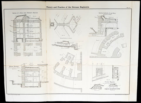
1856 Cap Richard Delafield Large Antique Schematics German Fortifications
Antique Map
- Title : Theory and Practise of the German Engineers
- Date : 1856
- Condition: (A+) Fine Condition
- Ref: 90130
- Size: 24 1/2in x 18in (615mm x 475mm)
Description:
This large original lithograph print, schematics of parts of the German Forts in such cities as Coblenz, Posen, Mainz, Luxemburg, Landau & others - during the time of the Crimean War - was engraved by John T Bowen & co. of Philadelphia and was published in the 1856 edition of Captain Richard Delafields Report on the Art of War in Europe in 1854, 1855, and 1856.
In early 1855, Captain Richard Delafield was appointed by the Secretary of War, Jefferson Davis, a head of the board of officers, later called The Delafield Commission, and sent to Europe to study the European military. The board included Captain George B. McClellan and Major Alfred Mordecai. They inspected the state of the military in Great Britain, Germany, the Austrian Empire, France, Belgium, and Russia, and served as military observers during the Crimean War. After his return in April 1856, Delafield submitted a report which was later published as a book by Congress, Report on the Art of War in Europe in 1854, 1855, and 1856. The book was suppressed during the American Civil War due to fears that it would be instructive to Confederate engineers as it contained multiple drawings and descriptions of military fortifications.
General Definitions:
Paper thickness and quality: - Light and stable
Paper color : - off white
Age of map color: -
Colors used: -
General color appearance: -
Paper size: - 24 1/2in x 18in (615mm x 475mm)
Plate size: - 24 1/2in x 18in (615mm x 475mm)
Margins: - Min 1/2in (12mm)
Imperfections:
Margins: - None
Plate area: - Light age toning along folds, as issued
Verso: - Folds re-enforced with archival tape
Background:
Under the term of the 1815 Peace of Paris, France was obliged to pay for the construction of a line of fortresses to protect the German Confederation against any future aggression by France. All fortresses were located outside Austria and Prussia — the two biggest, bickering powers of the Confederation.
Section C. Defensive System of the Germanic Confederation of the protocol drawn up at Paris on 3 November 1815, declared Mainz, Luxemburg, and Landau to be fortresses belonging to the Confederation of Germany, and stipulated that a fourth should be constructed on the Upper Rhine. In conformity with this act, a portion of the funds, which France was compelled to pay by way of indemnity for the cost of placing her on a peaceable footing, was thus appropriated: £200,000 were set aside for completing the works at Mainz; £800,000 were assigned to Prussia, to be applied upon its fortresses on the Lower Rhine; another £800,000 were reserved for constructing the new federal fortress on the Upper Rhine; and Bavaria was allowed £600,000 towards erecting another strong place on the Rhine, at Germersheim or some other point.
By 1835 the works about Mainz were completed; the twin fortresses of Koblenz and Ehrenbreitstein, and Cologne had been abundantly strengthened on the side of Prussia; and, on the Bavarian side, the fortress of Germersheim was in a state to defend the passage on the Upper Rhine. The western frontier of Germany had, in this way, been provided with a formidable line of defences against possible hostile actions by their neighbours. The eastern side of Germany has been additionally fortified by the erection of a strong citadel at Posen; and the southern was to be still further protected by the formidable works in course of construction at Brixen in the Tyrol.
The fortress of Ulm became a major strategic fortress able to accommodate 100,000 men and their equipment. Since the Kingdom of Württemberg had no engineering corps King William I appointed Moritz Karl Ernst von Prittwitz, a Prussian major, as the supervisor to oversee the building the fortresses. His plans included the provisions for the prospective development of the city Ulm. Major Theodor von Hildebrandt was appointed to oversee the building of fortresses around Neu-Ulm on the Bavarian side of the Danube
Delafield, Richard Major General 1798 - 1873 - Delafield was a United States Army officer for 52 years. He served as superintendent of the United States Military Academy for 12 years. At the start of the American Civil War, then Colonel Delafield helped equip and send volunteers from New York to the Union Army. He also was in command of defences around New York harbor from 1861 to April 1864. On April 22, 1864, he was promoted to Brigadier General in the Regular Army of the United States and Chief of Engineers. On March 8, 1866, President Andrew Johnson nominated Delafield for appointment to the grade of brevet major general in the Regular Army, to rank from March 13, 1865, and the United States Senate confirmed the appointment on May 4, 1866, reconfirmed due to a technicality on July 14, 1866. He retired from the US Army on August 8, 1866. He later served on two commissions relating to improvements to Boston Harbor and to lighthouses. He also served as a regent of the Smithsonian Institution.
Delafield served as assistant engineer in the construction of Hampton Roads defences from 1819–1824 and was in charge of fortifications and surveys in the Mississippi River delta area in 1824-1832. While superintendent of repair work on the Cumberland Road east of the Ohio River, he designed and built Dunlaps Creek Bridge in Brownsville, Pennsylvania, the first cast-iron tubular-arch bridge in the United States. Commissioned a major of engineers in July 1838, he was appointed superintendent of the Military Academy after the fire of 1838 and served till 1845. He designed the new buildings and the new cadet uniform that first displayed the castle insignia. He superintended the construction of coast defences for New York Harbor from 1846 to 1855.
In the beginning of 1855, Delafield was appointed by the Secretary of War, Jefferson Davis a head of the board of officers, later called The Delafield Commission, and sent to Europe to study the European military. The board included Captain George B. McClellan and Major Alfred Mordecai. They inspected the state of the military in Great Britain, Germany, the Austrian Empire, France, Belgium, and Russia, and served as military observers during the Crimean War. After his return in April 1856, Delafield submitted a report which was later published as a book by Congress, Report on the Art of War in Europe in 1854, 1855, and 1856. The book was suppressed during the American Civil War due to fears that it would be instructive to Confederate engineers as it contained multiple drawings and descriptions of military fortifications.
Delafield served as superintendent of the Military Academy again in 1856-1861. In January 1861, he was succeeded by Captain Pierre G. T. Beauregard, who was dismissed shortly after Beauregards home state of Louisiana seceded from the Union, and Delafield returned as superintendent serving until March 1, 1861. In the beginning of the Civil War he advised the governor of New York Edwin D. Morgan during the volunteer force creation. Then, in 1861–1864, he was put in charge of New York Harbor defences, including Governors Island and Fort at Sandy Hook. On May 19, 1864, he was commissioned a brigadier-general after replacing Joseph Gilbert Totten, who had died, as the Chief of Engineers, United States Army Corps of Engineers, on April 22, 1864. He stayed in charge of the Bureau of Engineers of the War Department until his retirement on August 8, 1866. On March 8, 1866, President Andrew Johnson nominated Delafield for appointment to the grade of brevet major general in the Regular Army of the United States, to rank from March 13, 1865, and the United States Senate confirmed the appointment on May 4, 1866 and reconfirmed it due to a technicality on July 14, 1866.After retirement Delafield served as a regent of the Smithsonian Institution and a member of the Lighthouse Board. He died in Washington, D.C. on November 5, 1873.
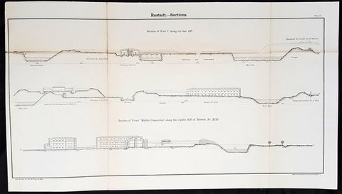
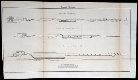
1856 Cap Richard Delafield Large Antique Print Fortifications of Rastatt Germany
Antique Map
- Title : Rastadt - Sections
- Date : 1856
- Condition: (A+) Fine Condition
- Ref: 90134
- Size: 26 1/2in x 14in (675mm x 355mm)
Description:
This large original lithograph print a plan of the fortifications around the city of Rastatt in Baden-Württemberg, Germany - during the Crimean War - was engraved by John T Bowen & co. of Philadelphia and was published in the 1856 edition of Captain Richard Delafields Report on the Art of War in Europe in 1854, 1855, and 1856.
In early 1855, Captain Richard Delafield was appointed by the Secretary of War, Jefferson Davis, a head of the board of officers, later called The Delafield Commission, and sent to Europe to study the European military. The board included Captain George B. McClellan and Major Alfred Mordecai. They inspected the state of the military in Great Britain, Germany, the Austrian Empire, France, Belgium, and Russia, and served as military observers during the Crimean War. After his return in April 1856, Delafield submitted a report which was later published as a book by Congress, Report on the Art of War in Europe in 1854, 1855, and 1856. The book was suppressed during the American Civil War due to fears that it would be instructive to Confederate engineers as it contained multiple drawings and descriptions of military fortifications.
General Definitions:
Paper thickness and quality: - Light and stable
Paper color : - off white
Age of map color: -
Colors used: -
General color appearance: -
Paper size: - 26 1/2in x 14in (675mm x 355mm)
Plate size: - 26 1/2in x 14in (675mm x 355mm)
Margins: - Min 1/2in (12mm)
Imperfections:
Margins: - None
Plate area: - Light age toning along folds, as issued
Verso: - Folds re-enforced with archival tape
Background:
Rastatt is a town with a baroque core, District of Rastatt, Baden-Württemberg, Germany. It is located in the Upper Rhine Plain on the Murg river, 6 km above its junction with the Rhine. Rastatt was an important place of the War of the Spanish Succession (Treaty of Rastatt) and the Revolutions of 1848 in the German states.
Until the end of the 17th century, Rastatt held little influence, but after its destruction by the French in 1689, it was rebuilt on a larger scale by Louis William, margrave of Baden, the imperial general in the Habsburg-Ottoman War known popularly as Türkenlouis.
It then remained the residence of the margraves of Baden-Baden until 1771. It was the location of the First and Second Congress of Rastatt, the former giving rise to the Treaty of Rastatt while the second ended in failure in 1799. In the 1840s, Rastatt was surrounded by fortifications to form the fortress of Rastatt. For about 20 years previous to 1866, it was occupied by the troops of the German Confederation.
The Baden revolution of 1849 began with a mutiny of soldiers at Rastatt in May 1849 under Ludwik Mieroslawski and Gustav Struve, and ended there a few weeks later with the capture of the town by the Prussians. (See The Revolutions of 1848 in the German states and History of Baden.) For some years, Rastatt was one of the strongest fortresses of the German empire, but its fortifications were dismantled in 1890.
Delafield, Richard Major General 1798 - 1873 - Delafield was a United States Army officer for 52 years. He served as superintendent of the United States Military Academy for 12 years. At the start of the American Civil War, then Colonel Delafield helped equip and send volunteers from New York to the Union Army. He also was in command of defences around New York harbor from 1861 to April 1864. On April 22, 1864, he was promoted to Brigadier General in the Regular Army of the United States and Chief of Engineers. On March 8, 1866, President Andrew Johnson nominated Delafield for appointment to the grade of brevet major general in the Regular Army, to rank from March 13, 1865, and the United States Senate confirmed the appointment on May 4, 1866, reconfirmed due to a technicality on July 14, 1866. He retired from the US Army on August 8, 1866. He later served on two commissions relating to improvements to Boston Harbor and to lighthouses. He also served as a regent of the Smithsonian Institution.
Delafield served as assistant engineer in the construction of Hampton Roads defences from 1819–1824 and was in charge of fortifications and surveys in the Mississippi River delta area in 1824-1832. While superintendent of repair work on the Cumberland Road east of the Ohio River, he designed and built Dunlaps Creek Bridge in Brownsville, Pennsylvania, the first cast-iron tubular-arch bridge in the United States. Commissioned a major of engineers in July 1838, he was appointed superintendent of the Military Academy after the fire of 1838 and served till 1845. He designed the new buildings and the new cadet uniform that first displayed the castle insignia. He superintended the construction of coast defences for New York Harbor from 1846 to 1855.
In the beginning of 1855, Delafield was appointed by the Secretary of War, Jefferson Davis a head of the board of officers, later called The Delafield Commission, and sent to Europe to study the European military. The board included Captain George B. McClellan and Major Alfred Mordecai. They inspected the state of the military in Great Britain, Germany, the Austrian Empire, France, Belgium, and Russia, and served as military observers during the Crimean War. After his return in April 1856, Delafield submitted a report which was later published as a book by Congress, Report on the Art of War in Europe in 1854, 1855, and 1856. The book was suppressed during the American Civil War due to fears that it would be instructive to Confederate engineers as it contained multiple drawings and descriptions of military fortifications.
Delafield served as superintendent of the Military Academy again in 1856-1861. In January 1861, he was succeeded by Captain Pierre G. T. Beauregard, who was dismissed shortly after Beauregards home state of Louisiana seceded from the Union, and Delafield returned as superintendent serving until March 1, 1861. In the beginning of the Civil War he advised the governor of New York Edwin D. Morgan during the volunteer force creation. Then, in 1861–1864, he was put in charge of New York Harbor defences, including Governors Island and Fort at Sandy Hook. On May 19, 1864, he was commissioned a brigadier-general after replacing Joseph Gilbert Totten, who had died, as the Chief of Engineers, United States Army Corps of Engineers, on April 22, 1864. He stayed in charge of the Bureau of Engineers of the War Department until his retirement on August 8, 1866. On March 8, 1866, President Andrew Johnson nominated Delafield for appointment to the grade of brevet major general in the Regular Army of the United States, to rank from March 13, 1865, and the United States Senate confirmed the appointment on May 4, 1866 and reconfirmed it due to a technicality on July 14, 1866.After retirement Delafield served as a regent of the Smithsonian Institution and a member of the Lighthouse Board. He died in Washington, D.C. on November 5, 1873.
1856 Cap Richard Delafield Large Antique Print Fortifications of Rastatt Germany
Antique Map
- Title : Rastadt - Sections
- Date : 1856
- Condition: (A) Very Good Condition
- Ref: 90192
- Size: 26 1/2in x 14in (675mm x 355mm)
Description:
This large original lithograph print a plan of the fortifications around the city of Rastatt in Baden-Württemberg, Germany - during the Crimean War - was engraved by John T Bowen & co. of Philadelphia and was published in the 1856 edition of Captain Richard Delafields Report on the Art of War in Europe in 1854, 1855, and 1856.
In early 1855, Captain Richard Delafield was appointed by the Secretary of War, Jefferson Davis, a head of the board of officers, later called The Delafield Commission, and sent to Europe to study the European military. The board included Captain George B. McClellan and Major Alfred Mordecai. They inspected the state of the military in Great Britain, Germany, the Austrian Empire, France, Belgium, and Russia, and served as military observers during the Crimean War. After his return in April 1856, Delafield submitted a report which was later published as a book by Congress, Report on the Art of War in Europe in 1854, 1855, and 1856. The book was suppressed during the American Civil War due to fears that it would be instructive to Confederate engineers as it contained multiple drawings and descriptions of military fortifications.
General Definitions:
Paper thickness and quality: - Light and stable
Paper color : - off white
Age of map color: -
Colors used: -
General color appearance: -
Paper size: - 26 1/2in x 14in (675mm x 355mm)
Plate size: - 26 1/2in x 14in (675mm x 355mm)
Margins: - Min 1/2in (12mm)
Imperfections:
Margins: - None
Plate area: - Age toning along folds, as issued
Verso: - Folds re-enforced with archival tape
Background:
Rastatt is a town with a baroque core, District of Rastatt, Baden-Württemberg, Germany. It is located in the Upper Rhine Plain on the Murg river, 6 km above its junction with the Rhine. Rastatt was an important place of the War of the Spanish Succession (Treaty of Rastatt) and the Revolutions of 1848 in the German states.
Until the end of the 17th century, Rastatt held little influence, but after its destruction by the French in 1689, it was rebuilt on a larger scale by Louis William, margrave of Baden, the imperial general in the Habsburg-Ottoman War known popularly as Türkenlouis.
It then remained the residence of the margraves of Baden-Baden until 1771. It was the location of the First and Second Congress of Rastatt, the former giving rise to the Treaty of Rastatt while the second ended in failure in 1799. In the 1840s, Rastatt was surrounded by fortifications to form the fortress of Rastatt. For about 20 years previous to 1866, it was occupied by the troops of the German Confederation.
The Baden revolution of 1849 began with a mutiny of soldiers at Rastatt in May 1849 under Ludwik Mieroslawski and Gustav Struve, and ended there a few weeks later with the capture of the town by the Prussians. (See The Revolutions of 1848 in the German states and History of Baden.) For some years, Rastatt was one of the strongest fortresses of the German empire, but its fortifications were dismantled in 1890.
Delafield, Richard Major General 1798 - 1873 - Delafield was a United States Army officer for 52 years. He served as superintendent of the United States Military Academy for 12 years. At the start of the American Civil War, then Colonel Delafield helped equip and send volunteers from New York to the Union Army. He also was in command of defences around New York harbor from 1861 to April 1864. On April 22, 1864, he was promoted to Brigadier General in the Regular Army of the United States and Chief of Engineers. On March 8, 1866, President Andrew Johnson nominated Delafield for appointment to the grade of brevet major general in the Regular Army, to rank from March 13, 1865, and the United States Senate confirmed the appointment on May 4, 1866, reconfirmed due to a technicality on July 14, 1866. He retired from the US Army on August 8, 1866. He later served on two commissions relating to improvements to Boston Harbor and to lighthouses. He also served as a regent of the Smithsonian Institution.
Delafield served as assistant engineer in the construction of Hampton Roads defences from 1819–1824 and was in charge of fortifications and surveys in the Mississippi River delta area in 1824-1832. While superintendent of repair work on the Cumberland Road east of the Ohio River, he designed and built Dunlaps Creek Bridge in Brownsville, Pennsylvania, the first cast-iron tubular-arch bridge in the United States. Commissioned a major of engineers in July 1838, he was appointed superintendent of the Military Academy after the fire of 1838 and served till 1845. He designed the new buildings and the new cadet uniform that first displayed the castle insignia. He superintended the construction of coast defences for New York Harbor from 1846 to 1855.
In the beginning of 1855, Delafield was appointed by the Secretary of War, Jefferson Davis a head of the board of officers, later called The Delafield Commission, and sent to Europe to study the European military. The board included Captain George B. McClellan and Major Alfred Mordecai. They inspected the state of the military in Great Britain, Germany, the Austrian Empire, France, Belgium, and Russia, and served as military observers during the Crimean War. After his return in April 1856, Delafield submitted a report which was later published as a book by Congress, Report on the Art of War in Europe in 1854, 1855, and 1856. The book was suppressed during the American Civil War due to fears that it would be instructive to Confederate engineers as it contained multiple drawings and descriptions of military fortifications.
Delafield served as superintendent of the Military Academy again in 1856-1861. In January 1861, he was succeeded by Captain Pierre G. T. Beauregard, who was dismissed shortly after Beauregards home state of Louisiana seceded from the Union, and Delafield returned as superintendent serving until March 1, 1861. In the beginning of the Civil War he advised the governor of New York Edwin D. Morgan during the volunteer force creation. Then, in 1861–1864, he was put in charge of New York Harbor defences, including Governors Island and Fort at Sandy Hook. On May 19, 1864, he was commissioned a brigadier-general after replacing Joseph Gilbert Totten, who had died, as the Chief of Engineers, United States Army Corps of Engineers, on April 22, 1864. He stayed in charge of the Bureau of Engineers of the War Department until his retirement on August 8, 1866. On March 8, 1866, President Andrew Johnson nominated Delafield for appointment to the grade of brevet major general in the Regular Army of the United States, to rank from March 13, 1865, and the United States Senate confirmed the appointment on May 4, 1866 and reconfirmed it due to a technicality on July 14, 1866.After retirement Delafield served as a regent of the Smithsonian Institution and a member of the Lighthouse Board. He died in Washington, D.C. on November 5, 1873.
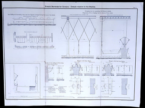
1856 Capt Delafield Large Antique Schematics of French Calvary Barracks, Stables
Antique Map
- Title : French Barracks for Cavalry - Details relative to the Stables
- Date : 1856
- Condition: (A) Very Good Condition
- Ref: 90125
- Size: 26in x 20in (660mm x 500mm)
Description:
This large original lithograph print, internal schematics of the French Cavalry Barracks & Stables - during the time of the Crimean War and just prior to the American Civil War - was engraved by John T Bowen & co. of Philadelphia and was published in the 1856 edition of Captain Richard Delafields Report on the Art of War in Europe in 1854, 1855, and 1856.
In early 1855, Captain Richard Delafield was appointed by the Secretary of War, Jefferson Davis, a head of the board of officers, later called The Delafield Commission, and sent to Europe to study the European military. The board included Captain George B. McClellan and Major Alfred Mordecai. They inspected the state of the military in Great Britain, Germany, the Austrian Empire, France, Belgium, and Russia, and served as military observers during the Crimean War. After his return in April 1856, Delafield submitted a report which was later published as a book by Congress, Report on the Art of War in Europe in 1854, 1855, and 1856. The book was suppressed during the American Civil War due to fears that it would be instructive to Confederate engineers as it contained multiple drawings and descriptions of military fortifications.
General Definitions:
Paper thickness and quality: - Light and stable
Paper color : - off white
Age of map color: -
Colors used: -
General color appearance: -
Paper size: - 26in x 20in (660mm x 500mm)
Plate size: - 26in x 20in (660mm x 500mm)
Margins: - Min 1/2in (12mm)
Imperfections:
Margins: - None
Plate area: - Light age toning along folds as issued
Verso: - Folds re-enforced with archival tape
Background:
The arrival of explosive shells in the 19th century led to yet another stage in the evolution of fortification. Star forts did not fare well against the effects of high explosive and the intricate arrangements of bastions, flanking batteries and the carefully constructed lines of fire for the defending cannon could be rapidly disrupted by explosive shells.
Worse, the large open ditches surrounding forts of this type were an integral part of the defensive scheme, as was the covered way at the edge of the counter scarp. The ditch was extremely vulnerable to bombardment with explosive shells.
In response, military engineers evolved the polygonal style of fortification. The ditch became deep and vertically sided, cut directly into the native rock or soil, laid out as a series of straight lines creating the central fortified area that gives this style of fortification its name.
Wide enough to be an impassable barrier for attacking troops, but narrow enough to be a difficult target for enemy shellfire, the ditch was swept by fire from defensive blockhouses set in the ditch as well as firing positions cut into the outer face of the ditch itself.
The profile of the fort became very low indeed, surrounded outside the ditch covered by caponiers by a gently sloping open area so as to eliminate possible cover for enemy forces, while the fort itself provided a minimal target for enemy fire. The entrypoint became a sunken gatehouse in the inner face of the ditch, reached by a curving ramp that gave access to the gate via a rolling bridge that could be withdrawn into the gatehouse.
Much of the fort moved underground. Deep passages and tunnels now connected the blockhouses and firing points in the ditch to the fort proper, with magazines and machine rooms deep under the surface. The guns, however, were often mounted in open emplacements and protected only by a parapet; both in order to keep a lower profile and also because experience with guns in closed casemates had seen them put out of action by rubble as their own casemates were collapsed around them.
Gone were citadels surrounding towns: forts were to be moved to the outside of the cities some 12 km to keep the enemy at a distance so their artillery could not bombard the city center. From now on a ring of forts were to be built at a spacing that would allow them to effectively cover the intervals between them.
The new forts abandoned the principle of the bastion, which had also been made obsolete by advances in arms. The outline was a much simplified polygon, surrounded by a ditch. These forts, built in masonry and shaped stone, were designed to shelter their garrison against bombardment. One organizing feature of the new system involved the construction of two defensive curtains: an outer line of forts, backed by an inner ring or line at critical points of terrain or junctions (see, for example, Séré de Rivières system in France).
Traditional fortification however continued to be applied by European armies engaged in warfare in colonies established in Africa against lightly armed attackers from amongst the indigenous population. A relatively small number of defenders in a fort impervious to primitive weaponry could hold out against high odds, the only constraint being the supply of ammunition.
Delafield, Richard Major General 1798 - 1873 - Delafield was a United States Army officer for 52 years. He served as superintendent of the United States Military Academy for 12 years. At the start of the American Civil War, then Colonel Delafield helped equip and send volunteers from New York to the Union Army. He also was in command of defences around New York harbor from 1861 to April 1864. On April 22, 1864, he was promoted to Brigadier General in the Regular Army of the United States and Chief of Engineers. On March 8, 1866, President Andrew Johnson nominated Delafield for appointment to the grade of brevet major general in the Regular Army, to rank from March 13, 1865, and the United States Senate confirmed the appointment on May 4, 1866, reconfirmed due to a technicality on July 14, 1866. He retired from the US Army on August 8, 1866. He later served on two commissions relating to improvements to Boston Harbor and to lighthouses. He also served as a regent of the Smithsonian Institution.
Delafield served as assistant engineer in the construction of Hampton Roads defences from 1819–1824 and was in charge of fortifications and surveys in the Mississippi River delta area in 1824-1832. While superintendent of repair work on the Cumberland Road east of the Ohio River, he designed and built Dunlaps Creek Bridge in Brownsville, Pennsylvania, the first cast-iron tubular-arch bridge in the United States. Commissioned a major of engineers in July 1838, he was appointed superintendent of the Military Academy after the fire of 1838 and served till 1845. He designed the new buildings and the new cadet uniform that first displayed the castle insignia. He superintended the construction of coast defences for New York Harbor from 1846 to 1855.
In the beginning of 1855, Delafield was appointed by the Secretary of War, Jefferson Davis a head of the board of officers, later called The Delafield Commission, and sent to Europe to study the European military. The board included Captain George B. McClellan and Major Alfred Mordecai. They inspected the state of the military in Great Britain, Germany, the Austrian Empire, France, Belgium, and Russia, and served as military observers during the Crimean War. After his return in April 1856, Delafield submitted a report which was later published as a book by Congress, Report on the Art of War in Europe in 1854, 1855, and 1856. The book was suppressed during the American Civil War due to fears that it would be instructive to Confederate engineers as it contained multiple drawings and descriptions of military fortifications.
Delafield served as superintendent of the Military Academy again in 1856-1861. In January 1861, he was succeeded by Captain Pierre G. T. Beauregard, who was dismissed shortly after Beauregards home state of Louisiana seceded from the Union, and Delafield returned as superintendent serving until March 1, 1861. In the beginning of the Civil War he advised the governor of New York Edwin D. Morgan during the volunteer force creation. Then, in 1861–1864, he was put in charge of New York Harbor defences, including Governors Island and Fort at Sandy Hook. On May 19, 1864, he was commissioned a brigadier-general after replacing Joseph Gilbert Totten, who had died, as the Chief of Engineers, United States Army Corps of Engineers, on April 22, 1864. He stayed in charge of the Bureau of Engineers of the War Department until his retirement on August 8, 1866. On March 8, 1866, President Andrew Johnson nominated Delafield for appointment to the grade of brevet major general in the Regular Army of the United States, to rank from March 13, 1865, and the United States Senate confirmed the appointment on May 4, 1866 and reconfirmed it due to a technicality on July 14, 1866.After retirement Delafield served as a regent of the Smithsonian Institution and a member of the Lighthouse Board. He died in Washington, D.C. on November 5, 1873.
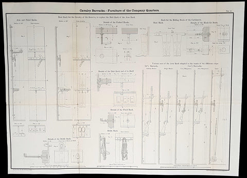
1856 Capt Delafield Large Antique Schematics of Calvary Barracks Rifles, Pistols
Antique Map
- Title : Cavalry Barracks - Furniture of the Company Quarters...
- Date : 1856
- Condition: (A+) Fine Condition
- Ref: 90133
- Size: 26in x 20in (660mm x 500mm)
Description:
This large original lithograph print, schematics of the internals of cavalry barracks and quarters (guns, boots, pistols etc) - during the time of the Crimean War and just prior to the American Civil War - was engraved by John T Bowen & co. of Philadelphia and was published in the 1856 edition of Captain Richard Delafields Report on the Art of War in Europe in 1854, 1855, and 1856.
In early 1855, Captain Richard Delafield was appointed by the Secretary of War, Jefferson Davis, a head of the board of officers, later called The Delafield Commission, and sent to Europe to study the European military. The board included Captain George B. McClellan and Major Alfred Mordecai. They inspected the state of the military in Great Britain, Germany, the Austrian Empire, France, Belgium, and Russia, and served as military observers during the Crimean War. After his return in April 1856, Delafield submitted a report which was later published as a book by Congress, Report on the Art of War in Europe in 1854, 1855, and 1856. The book was suppressed during the American Civil War due to fears that it would be instructive to Confederate engineers as it contained multiple drawings and descriptions of military fortifications.
General Definitions:
Paper thickness and quality: - Light and stable
Paper color : - off white
Age of map color: -
Colors used: -
General color appearance: -
Paper size: - 26in x 20in (660mm x 500mm)
Plate size: - 26in x 20in (660mm x 500mm)
Margins: - Min 1/2in (12mm)
Imperfections:
Margins: - None
Plate area: - Folds as issued
Verso: - Folds re-enforced with archival tape
Background:
The arrival of explosive shells in the 19th century led to yet another stage in the evolution of fortification. Star forts did not fare well against the effects of high explosive and the intricate arrangements of bastions, flanking batteries and the carefully constructed lines of fire for the defending cannon could be rapidly disrupted by explosive shells.
Worse, the large open ditches surrounding forts of this type were an integral part of the defensive scheme, as was the covered way at the edge of the counter scarp. The ditch was extremely vulnerable to bombardment with explosive shells.
In response, military engineers evolved the polygonal style of fortification. The ditch became deep and vertically sided, cut directly into the native rock or soil, laid out as a series of straight lines creating the central fortified area that gives this style of fortification its name.
Wide enough to be an impassable barrier for attacking troops, but narrow enough to be a difficult target for enemy shellfire, the ditch was swept by fire from defensive blockhouses set in the ditch as well as firing positions cut into the outer face of the ditch itself.
The profile of the fort became very low indeed, surrounded outside the ditch covered by caponiers by a gently sloping open area so as to eliminate possible cover for enemy forces, while the fort itself provided a minimal target for enemy fire. The entrypoint became a sunken gatehouse in the inner face of the ditch, reached by a curving ramp that gave access to the gate via a rolling bridge that could be withdrawn into the gatehouse.
Much of the fort moved underground. Deep passages and tunnels now connected the blockhouses and firing points in the ditch to the fort proper, with magazines and machine rooms deep under the surface. The guns, however, were often mounted in open emplacements and protected only by a parapet; both in order to keep a lower profile and also because experience with guns in closed casemates had seen them put out of action by rubble as their own casemates were collapsed around them.
Gone were citadels surrounding towns: forts were to be moved to the outside of the cities some 12 km to keep the enemy at a distance so their artillery could not bombard the city center. From now on a ring of forts were to be built at a spacing that would allow them to effectively cover the intervals between them.
The new forts abandoned the principle of the bastion, which had also been made obsolete by advances in arms. The outline was a much simplified polygon, surrounded by a ditch. These forts, built in masonry and shaped stone, were designed to shelter their garrison against bombardment. One organizing feature of the new system involved the construction of two defensive curtains: an outer line of forts, backed by an inner ring or line at critical points of terrain or junctions (see, for example, Séré de Rivières system in France).
Traditional fortification however continued to be applied by European armies engaged in warfare in colonies established in Africa against lightly armed attackers from amongst the indigenous population. A relatively small number of defenders in a fort impervious to primitive weaponry could hold out against high odds, the only constraint being the supply of ammunition.
Delafield, Richard Major General 1798 - 1873 - Delafield was a United States Army officer for 52 years. He served as superintendent of the United States Military Academy for 12 years. At the start of the American Civil War, then Colonel Delafield helped equip and send volunteers from New York to the Union Army. He also was in command of defences around New York harbor from 1861 to April 1864. On April 22, 1864, he was promoted to Brigadier General in the Regular Army of the United States and Chief of Engineers. On March 8, 1866, President Andrew Johnson nominated Delafield for appointment to the grade of brevet major general in the Regular Army, to rank from March 13, 1865, and the United States Senate confirmed the appointment on May 4, 1866, reconfirmed due to a technicality on July 14, 1866. He retired from the US Army on August 8, 1866. He later served on two commissions relating to improvements to Boston Harbor and to lighthouses. He also served as a regent of the Smithsonian Institution.
Delafield served as assistant engineer in the construction of Hampton Roads defences from 1819–1824 and was in charge of fortifications and surveys in the Mississippi River delta area in 1824-1832. While superintendent of repair work on the Cumberland Road east of the Ohio River, he designed and built Dunlaps Creek Bridge in Brownsville, Pennsylvania, the first cast-iron tubular-arch bridge in the United States. Commissioned a major of engineers in July 1838, he was appointed superintendent of the Military Academy after the fire of 1838 and served till 1845. He designed the new buildings and the new cadet uniform that first displayed the castle insignia. He superintended the construction of coast defences for New York Harbor from 1846 to 1855.
In the beginning of 1855, Delafield was appointed by the Secretary of War, Jefferson Davis a head of the board of officers, later called The Delafield Commission, and sent to Europe to study the European military. The board included Captain George B. McClellan and Major Alfred Mordecai. They inspected the state of the military in Great Britain, Germany, the Austrian Empire, France, Belgium, and Russia, and served as military observers during the Crimean War. After his return in April 1856, Delafield submitted a report which was later published as a book by Congress, Report on the Art of War in Europe in 1854, 1855, and 1856. The book was suppressed during the American Civil War due to fears that it would be instructive to Confederate engineers as it contained multiple drawings and descriptions of military fortifications.
Delafield served as superintendent of the Military Academy again in 1856-1861. In January 1861, he was succeeded by Captain Pierre G. T. Beauregard, who was dismissed shortly after Beauregards home state of Louisiana seceded from the Union, and Delafield returned as superintendent serving until March 1, 1861. In the beginning of the Civil War he advised the governor of New York Edwin D. Morgan during the volunteer force creation. Then, in 1861–1864, he was put in charge of New York Harbor defences, including Governors Island and Fort at Sandy Hook. On May 19, 1864, he was commissioned a brigadier-general after replacing Joseph Gilbert Totten, who had died, as the Chief of Engineers, United States Army Corps of Engineers, on April 22, 1864. He stayed in charge of the Bureau of Engineers of the War Department until his retirement on August 8, 1866. On March 8, 1866, President Andrew Johnson nominated Delafield for appointment to the grade of brevet major general in the Regular Army of the United States, to rank from March 13, 1865, and the United States Senate confirmed the appointment on May 4, 1866 and reconfirmed it due to a technicality on July 14, 1866.After retirement Delafield served as a regent of the Smithsonian Institution and a member of the Lighthouse Board. He died in Washington, D.C. on November 5, 1873.
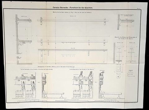
1856 Capt Delafield Large Antique Schematics Internal Calvary Barracks, Quarters
Antique Map
- Title : Cavalry Barracks - Furniture of the Quarters...
- Date : 1856
- Condition: (A+) Fine Condition
- Ref: 90191
- Size: 26in x 20in (660mm x 500mm)
Description:
This large original lithograph print, schematics of the internals of cavalry barracks and quarters - during the time of the Crimean War and just prior to the American Civil War - was engraved by John T Bowen & co. of Philadelphia and was published in the 1856 edition of Captain Richard Delafields Report on the Art of War in Europe in 1854, 1855, and 1856.
In early 1855, Captain Richard Delafield was appointed by the Secretary of War, Jefferson Davis, a head of the board of officers, later called The Delafield Commission, and sent to Europe to study the European military. The board included Captain George B. McClellan and Major Alfred Mordecai. They inspected the state of the military in Great Britain, Germany, the Austrian Empire, France, Belgium, and Russia, and served as military observers during the Crimean War. After his return in April 1856, Delafield submitted a report which was later published as a book by Congress, Report on the Art of War in Europe in 1854, 1855, and 1856. The book was suppressed during the American Civil War due to fears that it would be instructive to Confederate engineers as it contained multiple drawings and descriptions of military fortifications.
General Definitions:
Paper thickness and quality: - Light and stable
Paper color : - off white
Age of map color: -
Colors used: -
General color appearance: -
Paper size: - 26in x 20in (660mm x 500mm)
Plate size: - 26in x 20in (660mm x 500mm)
Margins: - Min 1/2in (12mm)
Imperfections:
Margins: - None
Plate area: - Folds as issued
Verso: - Folds re-enforced with archival tape
Background:
The arrival of explosive shells in the 19th century led to yet another stage in the evolution of fortification. Star forts did not fare well against the effects of high explosive and the intricate arrangements of bastions, flanking batteries and the carefully constructed lines of fire for the defending cannon could be rapidly disrupted by explosive shells.
Worse, the large open ditches surrounding forts of this type were an integral part of the defensive scheme, as was the covered way at the edge of the counter scarp. The ditch was extremely vulnerable to bombardment with explosive shells.
In response, military engineers evolved the polygonal style of fortification. The ditch became deep and vertically sided, cut directly into the native rock or soil, laid out as a series of straight lines creating the central fortified area that gives this style of fortification its name.
Wide enough to be an impassable barrier for attacking troops, but narrow enough to be a difficult target for enemy shellfire, the ditch was swept by fire from defensive blockhouses set in the ditch as well as firing positions cut into the outer face of the ditch itself.
The profile of the fort became very low indeed, surrounded outside the ditch covered by caponiers by a gently sloping open area so as to eliminate possible cover for enemy forces, while the fort itself provided a minimal target for enemy fire. The entrypoint became a sunken gatehouse in the inner face of the ditch, reached by a curving ramp that gave access to the gate via a rolling bridge that could be withdrawn into the gatehouse.
Much of the fort moved underground. Deep passages and tunnels now connected the blockhouses and firing points in the ditch to the fort proper, with magazines and machine rooms deep under the surface. The guns, however, were often mounted in open emplacements and protected only by a parapet; both in order to keep a lower profile and also because experience with guns in closed casemates had seen them put out of action by rubble as their own casemates were collapsed around them.
Gone were citadels surrounding towns: forts were to be moved to the outside of the cities some 12 km to keep the enemy at a distance so their artillery could not bombard the city center. From now on a ring of forts were to be built at a spacing that would allow them to effectively cover the intervals between them.
The new forts abandoned the principle of the bastion, which had also been made obsolete by advances in arms. The outline was a much simplified polygon, surrounded by a ditch. These forts, built in masonry and shaped stone, were designed to shelter their garrison against bombardment. One organizing feature of the new system involved the construction of two defensive curtains: an outer line of forts, backed by an inner ring or line at critical points of terrain or junctions (see, for example, Séré de Rivières system in France).
Traditional fortification however continued to be applied by European armies engaged in warfare in colonies established in Africa against lightly armed attackers from amongst the indigenous population. A relatively small number of defenders in a fort impervious to primitive weaponry could hold out against high odds, the only constraint being the supply of ammunition.
Delafield, Richard Major General 1798 - 1873 - Delafield was a United States Army officer for 52 years. He served as superintendent of the United States Military Academy for 12 years. At the start of the American Civil War, then Colonel Delafield helped equip and send volunteers from New York to the Union Army. He also was in command of defences around New York harbor from 1861 to April 1864. On April 22, 1864, he was promoted to Brigadier General in the Regular Army of the United States and Chief of Engineers. On March 8, 1866, President Andrew Johnson nominated Delafield for appointment to the grade of brevet major general in the Regular Army, to rank from March 13, 1865, and the United States Senate confirmed the appointment on May 4, 1866, reconfirmed due to a technicality on July 14, 1866. He retired from the US Army on August 8, 1866. He later served on two commissions relating to improvements to Boston Harbor and to lighthouses. He also served as a regent of the Smithsonian Institution.
Delafield served as assistant engineer in the construction of Hampton Roads defences from 1819–1824 and was in charge of fortifications and surveys in the Mississippi River delta area in 1824-1832. While superintendent of repair work on the Cumberland Road east of the Ohio River, he designed and built Dunlaps Creek Bridge in Brownsville, Pennsylvania, the first cast-iron tubular-arch bridge in the United States. Commissioned a major of engineers in July 1838, he was appointed superintendent of the Military Academy after the fire of 1838 and served till 1845. He designed the new buildings and the new cadet uniform that first displayed the castle insignia. He superintended the construction of coast defences for New York Harbor from 1846 to 1855.
In the beginning of 1855, Delafield was appointed by the Secretary of War, Jefferson Davis a head of the board of officers, later called The Delafield Commission, and sent to Europe to study the European military. The board included Captain George B. McClellan and Major Alfred Mordecai. They inspected the state of the military in Great Britain, Germany, the Austrian Empire, France, Belgium, and Russia, and served as military observers during the Crimean War. After his return in April 1856, Delafield submitted a report which was later published as a book by Congress, Report on the Art of War in Europe in 1854, 1855, and 1856. The book was suppressed during the American Civil War due to fears that it would be instructive to Confederate engineers as it contained multiple drawings and descriptions of military fortifications.
Delafield served as superintendent of the Military Academy again in 1856-1861. In January 1861, he was succeeded by Captain Pierre G. T. Beauregard, who was dismissed shortly after Beauregards home state of Louisiana seceded from the Union, and Delafield returned as superintendent serving until March 1, 1861. In the beginning of the Civil War he advised the governor of New York Edwin D. Morgan during the volunteer force creation. Then, in 1861–1864, he was put in charge of New York Harbor defences, including Governors Island and Fort at Sandy Hook. On May 19, 1864, he was commissioned a brigadier-general after replacing Joseph Gilbert Totten, who had died, as the Chief of Engineers, United States Army Corps of Engineers, on April 22, 1864. He stayed in charge of the Bureau of Engineers of the War Department until his retirement on August 8, 1866. On March 8, 1866, President Andrew Johnson nominated Delafield for appointment to the grade of brevet major general in the Regular Army of the United States, to rank from March 13, 1865, and the United States Senate confirmed the appointment on May 4, 1866 and reconfirmed it due to a technicality on July 14, 1866.After retirement Delafield served as a regent of the Smithsonian Institution and a member of the Lighthouse Board. He died in Washington, D.C. on November 5, 1873.
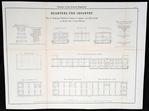
1856 Capt Delafield Large Antique Schematics French Infantry Barracks & Quarters
Antique Map
- Title : Theory and Practice of the French Engineers....Quaters for Infantry..Plan of the Bob Proof Building for lodging 5 Companies presenting together an effective force of about 500 men.
- Date : 1856
- Condition: (A+) Fine Condition
- Ref: 90126
- Size: 26in x 20in (660mm x 500mm)
Description:
This large original lithograph print, schematics of barracks and quarters for infantry in France - during the time of the Crimean War and just prior to the American Civil War - was engraved by John T Bowen & co. of Philadelphia and was published in the 1856 edition of Captain Richard Delafields Report on the Art of War in Europe in 1854, 1855, and 1856.
In early 1855, Captain Richard Delafield was appointed by the Secretary of War, Jefferson Davis, a head of the board of officers, later called The Delafield Commission, and sent to Europe to study the European military. The board included Captain George B. McClellan and Major Alfred Mordecai. They inspected the state of the military in Great Britain, Germany, the Austrian Empire, France, Belgium, and Russia, and served as military observers during the Crimean War. After his return in April 1856, Delafield submitted a report which was later published as a book by Congress, Report on the Art of War in Europe in 1854, 1855, and 1856. The book was suppressed during the American Civil War due to fears that it would be instructive to Confederate engineers as it contained multiple drawings and descriptions of military fortifications.
General Definitions:
Paper thickness and quality: - Light and stable
Paper color : - off white
Age of map color: -
Colors used: -
General color appearance: -
Paper size: - 26in x 20in (660mm x 500mm)
Plate size: - 26in x 20in (660mm x 500mm)
Margins: - Min 1/2in (12mm)
Imperfections:
Margins: - None
Plate area: - Folds as issued
Verso: - Folds re-enforced with archival tape
Background:
The arrival of explosive shells in the 19th century led to yet another stage in the evolution of fortification. Star forts did not fare well against the effects of high explosive and the intricate arrangements of bastions, flanking batteries and the carefully constructed lines of fire for the defending cannon could be rapidly disrupted by explosive shells.
Worse, the large open ditches surrounding forts of this type were an integral part of the defensive scheme, as was the covered way at the edge of the counter scarp. The ditch was extremely vulnerable to bombardment with explosive shells.
In response, military engineers evolved the polygonal style of fortification. The ditch became deep and vertically sided, cut directly into the native rock or soil, laid out as a series of straight lines creating the central fortified area that gives this style of fortification its name.
Wide enough to be an impassable barrier for attacking troops, but narrow enough to be a difficult target for enemy shellfire, the ditch was swept by fire from defensive blockhouses set in the ditch as well as firing positions cut into the outer face of the ditch itself.
The profile of the fort became very low indeed, surrounded outside the ditch covered by caponiers by a gently sloping open area so as to eliminate possible cover for enemy forces, while the fort itself provided a minimal target for enemy fire. The entrypoint became a sunken gatehouse in the inner face of the ditch, reached by a curving ramp that gave access to the gate via a rolling bridge that could be withdrawn into the gatehouse.
Much of the fort moved underground. Deep passages and tunnels now connected the blockhouses and firing points in the ditch to the fort proper, with magazines and machine rooms deep under the surface. The guns, however, were often mounted in open emplacements and protected only by a parapet; both in order to keep a lower profile and also because experience with guns in closed casemates had seen them put out of action by rubble as their own casemates were collapsed around them.
Gone were citadels surrounding towns: forts were to be moved to the outside of the cities some 12 km to keep the enemy at a distance so their artillery could not bombard the city center. From now on a ring of forts were to be built at a spacing that would allow them to effectively cover the intervals between them.
The new forts abandoned the principle of the bastion, which had also been made obsolete by advances in arms. The outline was a much simplified polygon, surrounded by a ditch. These forts, built in masonry and shaped stone, were designed to shelter their garrison against bombardment. One organizing feature of the new system involved the construction of two defensive curtains: an outer line of forts, backed by an inner ring or line at critical points of terrain or junctions (see, for example, Séré de Rivières system in France).
Traditional fortification however continued to be applied by European armies engaged in warfare in colonies established in Africa against lightly armed attackers from amongst the indigenous population. A relatively small number of defenders in a fort impervious to primitive weaponry could hold out against high odds, the only constraint being the supply of ammunition.
Delafield, Richard Major General 1798 - 1873 - Delafield was a United States Army officer for 52 years. He served as superintendent of the United States Military Academy for 12 years. At the start of the American Civil War, then Colonel Delafield helped equip and send volunteers from New York to the Union Army. He also was in command of defences around New York harbor from 1861 to April 1864. On April 22, 1864, he was promoted to Brigadier General in the Regular Army of the United States and Chief of Engineers. On March 8, 1866, President Andrew Johnson nominated Delafield for appointment to the grade of brevet major general in the Regular Army, to rank from March 13, 1865, and the United States Senate confirmed the appointment on May 4, 1866, reconfirmed due to a technicality on July 14, 1866. He retired from the US Army on August 8, 1866. He later served on two commissions relating to improvements to Boston Harbor and to lighthouses. He also served as a regent of the Smithsonian Institution.
Delafield served as assistant engineer in the construction of Hampton Roads defences from 1819–1824 and was in charge of fortifications and surveys in the Mississippi River delta area in 1824-1832. While superintendent of repair work on the Cumberland Road east of the Ohio River, he designed and built Dunlaps Creek Bridge in Brownsville, Pennsylvania, the first cast-iron tubular-arch bridge in the United States. Commissioned a major of engineers in July 1838, he was appointed superintendent of the Military Academy after the fire of 1838 and served till 1845. He designed the new buildings and the new cadet uniform that first displayed the castle insignia. He superintended the construction of coast defences for New York Harbor from 1846 to 1855.
In the beginning of 1855, Delafield was appointed by the Secretary of War, Jefferson Davis a head of the board of officers, later called The Delafield Commission, and sent to Europe to study the European military. The board included Captain George B. McClellan and Major Alfred Mordecai. They inspected the state of the military in Great Britain, Germany, the Austrian Empire, France, Belgium, and Russia, and served as military observers during the Crimean War. After his return in April 1856, Delafield submitted a report which was later published as a book by Congress, Report on the Art of War in Europe in 1854, 1855, and 1856. The book was suppressed during the American Civil War due to fears that it would be instructive to Confederate engineers as it contained multiple drawings and descriptions of military fortifications.
Delafield served as superintendent of the Military Academy again in 1856-1861. In January 1861, he was succeeded by Captain Pierre G. T. Beauregard, who was dismissed shortly after Beauregards home state of Louisiana seceded from the Union, and Delafield returned as superintendent serving until March 1, 1861. In the beginning of the Civil War he advised the governor of New York Edwin D. Morgan during the volunteer force creation. Then, in 1861–1864, he was put in charge of New York Harbor defences, including Governors Island and Fort at Sandy Hook. On May 19, 1864, he was commissioned a brigadier-general after replacing Joseph Gilbert Totten, who had died, as the Chief of Engineers, United States Army Corps of Engineers, on April 22, 1864. He stayed in charge of the Bureau of Engineers of the War Department until his retirement on August 8, 1866. On March 8, 1866, President Andrew Johnson nominated Delafield for appointment to the grade of brevet major general in the Regular Army of the United States, to rank from March 13, 1865, and the United States Senate confirmed the appointment on May 4, 1866 and reconfirmed it due to a technicality on July 14, 1866.After retirement Delafield served as a regent of the Smithsonian Institution and a member of the Lighthouse Board. He died in Washington, D.C. on November 5, 1873.
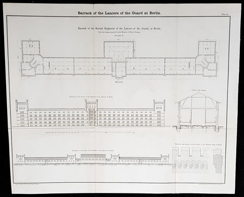
1856 Capt Delafield Large Antique Schematics of the 2nd Lancers Barracks, Berlin
Antique Map
- Title : Barrack of the Lancers of the Guard at Berlin...Barrack of the Second Regiment of the Lancers of the Guard at Berlin
- Date : 1856
- Condition: (A+) Fine Condition
- Ref: 90152
- Size: 21in x 17in (530mm x 430mm)
Description:
This large original lithograph print, schematics of the 2nd German Lancer Regiment Barracks in Berlin - during the time of the Crimean War and just prior to the American Civil War - was engraved by John T Bowen & co. of Philadelphia and was published in the 1856 edition of Captain Richard Delafields Report on the Art of War in Europe in 1854, 1855, and 1856.
In early 1855, Captain Richard Delafield was appointed by the Secretary of War, Jefferson Davis, a head of the board of officers, later called The Delafield Commission, and sent to Europe to study the European military. The board included Captain George B. McClellan and Major Alfred Mordecai. They inspected the state of the military in Great Britain, Germany, the Austrian Empire, France, Belgium, and Russia, and served as military observers during the Crimean War. After his return in April 1856, Delafield submitted a report which was later published as a book by Congress, Report on the Art of War in Europe in 1854, 1855, and 1856. The book was suppressed during the American Civil War due to fears that it would be instructive to Confederate engineers as it contained multiple drawings and descriptions of military fortifications.
General Definitions:
Paper thickness and quality: - Light and stable
Paper color : - off white
Age of map color: -
Colors used: -
General color appearance: -
Paper size: - 21in x 17in (530mm x 430mm)
Plate size: - 21in x 17in (530mm x 430mm)
Margins: - Min 1/2in (12mm)
Imperfections:
Margins: - None
Plate area: - Folds as issued
Verso: - Folds re-enforced with archival tape
Background:
A lancer was a type of cavalryman who fought with a lance. Lances were used in mounted warfare by the Assyrians as early as 700 BC and subsequently by Greek, Persian, Gallic, Chinese, and Roman horsemen. The weapon was widely used in Asia and Europe during the Middle Ages and the Renaissance by armoured cavalry, before being adopted by light cavalry, particularly in Eastern Europe. In a modern context, a lancer regiment usually denotes an armoured unit.
The lancer (called ułan in Polish and Uhlan in German) had become a common sight in almost every European, Ottoman, and Indian army during this time, but, with the exception of the Ottoman troops, they increasingly discarded the heavy armour to give greater freedom of movement in combat. The Polish winged lancers were amongst the last to abandon the armour in Europe. There was debate over the value of the lance in mounted combat during the 18th century and most armies had few lancer units by the beginning of the 19th century. However, during the Napoleonic Wars, lancers were to be seen in many of the combatant nations as their value in shock tactics became clear. During the wars, the Poles became a ready source of recruitment for several armies, willingly or unwillingly. Polish lancers served with distinction in the Austrian, Prussian, Russian and French armies, most famously in Napoleons French Imperial Guard as the 1er Regiment de Chevau-Legers-Lanciers de la Garde Impériale.
At the Battle of Waterloo, French lances were nearly three meters (about nine feet, ten inches) long, weighed three kilograms (about six pounds, ten ounces), and had a steel point on a wooden staff, according to historian Alessandro Barbero. He adds that they were terrifyingly efficient. Commander of the French 1st Corps, 4th Division General Durutte, who saw the battle from the high ground in front of Papelotte, would write later, I had never before realized the great superiority of the lance over the sword.
In the Siege of Los Angeles (1846), during the war between Mexico and the United States, a company of Californio lancers temporarily recaptured the town, expelling a company of U.S. Marines.
Although having substantial impact in the charge, lancers could be vulnerable to other cavalry at close quarters, where the lance proved a clumsy and easily deflected weapon when employed against sabres. By the late 19th century, many cavalry regiments in the British and other European armies were composed of troopers with lances, as primary weapons, in the front rank and horsemen with sabres only in the second: the lances for the initial shock and sabres for the subsequent mêlée.
Delafield, Richard Major General 1798 - 1873
Delafield was a United States Army officer for 52 years. He served as superintendent of the United States Military Academy for 12 years. At the start of the American Civil War, then Colonel Delafield helped equip and send volunteers from New York to the Union Army. He also was in command of defences around New York harbor from 1861 to April 1864. On April 22, 1864, he was promoted to Brigadier General in the Regular Army of the United States and Chief of Engineers. On March 8, 1866, President Andrew Johnson nominated Delafield for appointment to the grade of brevet major general in the Regular Army, to rank from March 13, 1865, and the United States Senate confirmed the appointment on May 4, 1866, reconfirmed due to a technicality on July 14, 1866. He retired from the US Army on August 8, 1866. He later served on two commissions relating to improvements to Boston Harbor and to lighthouses. He also served as a regent of the Smithsonian Institution.
Delafield served as assistant engineer in the construction of Hampton Roads defences from 1819–1824 and was in charge of fortifications and surveys in the Mississippi River delta area in 1824-1832. While superintendent of repair work on the Cumberland Road east of the Ohio River, he designed and built Dunlaps Creek Bridge in Brownsville, Pennsylvania, the first cast-iron tubular-arch bridge in the United States. Commissioned a major of engineers in July 1838, he was appointed superintendent of the Military Academy after the fire of 1838 and served till 1845. He designed the new buildings and the new cadet uniform that first displayed the castle insignia. He superintended the construction of coast defences for New York Harbor from 1846 to 1855.
In the beginning of 1855, Delafield was appointed by the Secretary of War, Jefferson Davis a head of the board of officers, later called The Delafield Commission, and sent to Europe to study the European military. The board included Captain George B. McClellan and Major Alfred Mordecai. They inspected the state of the military in Great Britain, Germany, the Austrian Empire, France, Belgium, and Russia, and served as military observers during the Crimean War. After his return in April 1856, Delafield submitted a report which was later published as a book by Congress, Report on the Art of War in Europe in 1854, 1855, and 1856. The book was suppressed during the American Civil War due to fears that it would be instructive to Confederate engineers as it contained multiple drawings and descriptions of military fortifications.
Delafield served as superintendent of the Military Academy again in 1856-1861. In January 1861, he was succeeded by Captain Pierre G. T. Beauregard, who was dismissed shortly after Beauregards home state of Louisiana seceded from the Union, and Delafield returned as superintendent serving until March 1, 1861. In the beginning of the Civil War he advised the governor of New York Edwin D. Morgan during the volunteer force creation. Then, in 1861–1864, he was put in charge of New York Harbor defences, including Governors Island and Fort at Sandy Hook. On May 19, 1864, he was commissioned a brigadier-general after replacing Joseph Gilbert Totten, who had died, as the Chief of Engineers, United States Army Corps of Engineers, on April 22, 1864. He stayed in charge of the Bureau of Engineers of the War Department until his retirement on August 8, 1866. On March 8, 1866, President Andrew Johnson nominated Delafield for appointment to the grade of brevet major general in the Regular Army of the United States, to rank from March 13, 1865, and the United States Senate confirmed the appointment on May 4, 1866 and reconfirmed it due to a technicality on July 14, 1866.After retirement Delafield served as a regent of the Smithsonian Institution and a member of the Lighthouse Board. He died in Washington, D.C. on November 5, 1873.
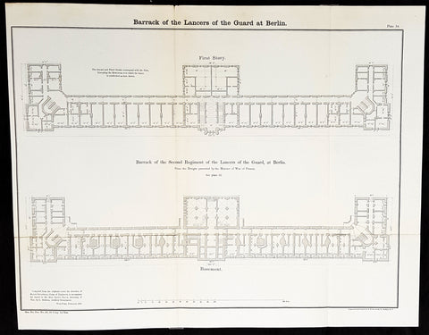
1856 Capt Delafield Large Antique Schematics of the 2nd Lancers Barracks, Berlin
Antique Map
- Title : Barrack of the Lancers of the Guard at Berlin...Barrack of the Second Regiment of the Lancers of the Guard at Berlin
- Date : 1856
- Condition: (A+) Fine Condition
- Ref: 90143
- Size: 20 1/2in x 16in (510mm x 410mm)
Description:
This large original lithograph print, schematics of the 2nd German Lancer Regiment Barracks in Berlin - during the time of the Crimean War and just prior to the American Civil War - was engraved by John T Bowen & co. of Philadelphia and was published in the 1856 edition of Captain Richard Delafields Report on the Art of War in Europe in 1854, 1855, and 1856.
In early 1855, Captain Richard Delafield was appointed by the Secretary of War, Jefferson Davis, a head of the board of officers, later called The Delafield Commission, and sent to Europe to study the European military. The board included Captain George B. McClellan and Major Alfred Mordecai. They inspected the state of the military in Great Britain, Germany, the Austrian Empire, France, Belgium, and Russia, and served as military observers during the Crimean War. After his return in April 1856, Delafield submitted a report which was later published as a book by Congress, Report on the Art of War in Europe in 1854, 1855, and 1856. The book was suppressed during the American Civil War due to fears that it would be instructive to Confederate engineers as it contained multiple drawings and descriptions of military fortifications.
General Definitions:
Paper thickness and quality: - Light and stable
Paper color : - off white
Age of map color: -
Colors used: -
General color appearance: -
Paper size: - 20 1/2in x 16in (510mm x 410mm)
Plate size: - 20 1/2in x 16in (510mm x 410mm)
Margins: - Min 1/2in (12mm)
Imperfections:
Margins: - None
Plate area: - Folds as issued
Verso: - Folds re-enforced with archival tape
Background:
A lancer was a type of cavalryman who fought with a lance. Lances were used in mounted warfare by the Assyrians as early as 700 BC and subsequently by Greek, Persian, Gallic, Chinese, and Roman horsemen. The weapon was widely used in Asia and Europe during the Middle Ages and the Renaissance by armoured cavalry, before being adopted by light cavalry, particularly in Eastern Europe. In a modern context, a lancer regiment usually denotes an armoured unit.
The lancer (called ułan in Polish and Uhlan in German) had become a common sight in almost every European, Ottoman, and Indian army during this time, but, with the exception of the Ottoman troops, they increasingly discarded the heavy armour to give greater freedom of movement in combat. The Polish winged lancers were amongst the last to abandon the armour in Europe. There was debate over the value of the lance in mounted combat during the 18th century and most armies had few lancer units by the beginning of the 19th century. However, during the Napoleonic Wars, lancers were to be seen in many of the combatant nations as their value in shock tactics became clear. During the wars, the Poles became a ready source of recruitment for several armies, willingly or unwillingly. Polish lancers served with distinction in the Austrian, Prussian, Russian and French armies, most famously in Napoleons French Imperial Guard as the 1er Regiment de Chevau-Legers-Lanciers de la Garde Impériale.
At the Battle of Waterloo, French lances were nearly three meters (about nine feet, ten inches) long, weighed three kilograms (about six pounds, ten ounces), and had a steel point on a wooden staff, according to historian Alessandro Barbero. He adds that they were terrifyingly efficient. Commander of the French 1st Corps, 4th Division General Durutte, who saw the battle from the high ground in front of Papelotte, would write later, I had never before realized the great superiority of the lance over the sword.
In the Siege of Los Angeles (1846), during the war between Mexico and the United States, a company of Californio lancers temporarily recaptured the town, expelling a company of U.S. Marines.
Although having substantial impact in the charge, lancers could be vulnerable to other cavalry at close quarters, where the lance proved a clumsy and easily deflected weapon when employed against sabres. By the late 19th century, many cavalry regiments in the British and other European armies were composed of troopers with lances, as primary weapons, in the front rank and horsemen with sabres only in the second: the lances for the initial shock and sabres for the subsequent mêlée.
Delafield, Richard Major General 1798 - 1873
Delafield was a United States Army officer for 52 years. He served as superintendent of the United States Military Academy for 12 years. At the start of the American Civil War, then Colonel Delafield helped equip and send volunteers from New York to the Union Army. He also was in command of defences around New York harbor from 1861 to April 1864. On April 22, 1864, he was promoted to Brigadier General in the Regular Army of the United States and Chief of Engineers. On March 8, 1866, President Andrew Johnson nominated Delafield for appointment to the grade of brevet major general in the Regular Army, to rank from March 13, 1865, and the United States Senate confirmed the appointment on May 4, 1866, reconfirmed due to a technicality on July 14, 1866. He retired from the US Army on August 8, 1866. He later served on two commissions relating to improvements to Boston Harbor and to lighthouses. He also served as a regent of the Smithsonian Institution.
Delafield served as assistant engineer in the construction of Hampton Roads defences from 1819–1824 and was in charge of fortifications and surveys in the Mississippi River delta area in 1824-1832. While superintendent of repair work on the Cumberland Road east of the Ohio River, he designed and built Dunlaps Creek Bridge in Brownsville, Pennsylvania, the first cast-iron tubular-arch bridge in the United States. Commissioned a major of engineers in July 1838, he was appointed superintendent of the Military Academy after the fire of 1838 and served till 1845. He designed the new buildings and the new cadet uniform that first displayed the castle insignia. He superintended the construction of coast defences for New York Harbor from 1846 to 1855.
In the beginning of 1855, Delafield was appointed by the Secretary of War, Jefferson Davis a head of the board of officers, later called The Delafield Commission, and sent to Europe to study the European military. The board included Captain George B. McClellan and Major Alfred Mordecai. They inspected the state of the military in Great Britain, Germany, the Austrian Empire, France, Belgium, and Russia, and served as military observers during the Crimean War. After his return in April 1856, Delafield submitted a report which was later published as a book by Congress, Report on the Art of War in Europe in 1854, 1855, and 1856. The book was suppressed during the American Civil War due to fears that it would be instructive to Confederate engineers as it contained multiple drawings and descriptions of military fortifications.
Delafield served as superintendent of the Military Academy again in 1856-1861. In January 1861, he was succeeded by Captain Pierre G. T. Beauregard, who was dismissed shortly after Beauregards home state of Louisiana seceded from the Union, and Delafield returned as superintendent serving until March 1, 1861. In the beginning of the Civil War he advised the governor of New York Edwin D. Morgan during the volunteer force creation. Then, in 1861–1864, he was put in charge of New York Harbor defences, including Governors Island and Fort at Sandy Hook. On May 19, 1864, he was commissioned a brigadier-general after replacing Joseph Gilbert Totten, who had died, as the Chief of Engineers, United States Army Corps of Engineers, on April 22, 1864. He stayed in charge of the Bureau of Engineers of the War Department until his retirement on August 8, 1866. On March 8, 1866, President Andrew Johnson nominated Delafield for appointment to the grade of brevet major general in the Regular Army of the United States, to rank from March 13, 1865, and the United States Senate confirmed the appointment on May 4, 1866 and reconfirmed it due to a technicality on July 14, 1866.After retirement Delafield served as a regent of the Smithsonian Institution and a member of the Lighthouse Board. He died in Washington, D.C. on November 5, 1873.
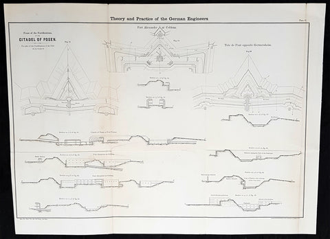
1856 Cap Richard Delafield Large Antique Schematics German Fortifications
Antique Map
- Title : Theory and Practise of the German Engineers
- Condition: (A+) Fine Condition
- Ref: 90140
- Size: 24 1/2in x 18in (615mm x 475mm)
Description:
This large original lithograph print, schematics of parts of the German Forts in such cities as Coblenz, Posen, Mainz, Luxemburg, Landau & others - during the time of the Crimean War - was engraved by John T Bowen & co. of Philadelphia and was published in the 1856 edition of Captain Richard Delafields Report on the Art of War in Europe in 1854, 1855, and 1856.
In early 1855, Captain Richard Delafield was appointed by the Secretary of War, Jefferson Davis, a head of the board of officers, later called The Delafield Commission, and sent to Europe to study the European military. The board included Captain George B. McClellan and Major Alfred Mordecai. They inspected the state of the military in Great Britain, Germany, the Austrian Empire, France, Belgium, and Russia, and served as military observers during the Crimean War. After his return in April 1856, Delafield submitted a report which was later published as a book by Congress, Report on the Art of War in Europe in 1854, 1855, and 1856. The book was suppressed during the American Civil War due to fears that it would be instructive to Confederate engineers as it contained multiple drawings and descriptions of military fortifications.
General Definitions:
Paper thickness and quality: - Light and stable
Paper color : - off white
Age of map color: -
Colors used: -
General color appearance: -
Paper size: - 24 1/2in x 18in (615mm x 475mm)
Plate size: - 24 1/2in x 18in (615mm x 475mm)
Margins: - Min 1/2in (12mm)
Imperfections:
Margins: - None
Plate area: - Folds as issued
Verso: - Folds re-enforced with archival tape
Background:
Under the term of the 1815 Peace of Paris, France was obliged to pay for the construction of a line of fortresses to protect the German Confederation against any future aggression by France. All fortresses were located outside Austria and Prussia — the two biggest, bickering powers of the Confederation.
Section C. Defensive System of the Germanic Confederation of the protocol drawn up at Paris on 3 November 1815, declared Mainz, Luxemburg, and Landau to be fortresses belonging to the Confederation of Germany, and stipulated that a fourth should be constructed on the Upper Rhine. In conformity with this act, a portion of the funds, which France was compelled to pay by way of indemnity for the cost of placing her on a peaceable footing, was thus appropriated: £200,000 were set aside for completing the works at Mainz; £800,000 were assigned to Prussia, to be applied upon its fortresses on the Lower Rhine; another £800,000 were reserved for constructing the new federal fortress on the Upper Rhine; and Bavaria was allowed £600,000 towards erecting another strong place on the Rhine, at Germersheim or some other point.
By 1835 the works about Mainz were completed; the twin fortresses of Koblenz and Ehrenbreitstein, and Cologne had been abundantly strengthened on the side of Prussia; and, on the Bavarian side, the fortress of Germersheim was in a state to defend the passage on the Upper Rhine. The western frontier of Germany had, in this way, been provided with a formidable line of defences against possible hostile actions by their neighbours. The eastern side of Germany has been additionally fortified by the erection of a strong citadel at Posen; and the southern was to be still further protected by the formidable works in course of construction at Brixen in the Tyrol.
The fortress of Ulm became a major strategic fortress able to accommodate 100,000 men and their equipment. Since the Kingdom of Württemberg had no engineering corps King William I appointed Moritz Karl Ernst von Prittwitz, a Prussian major, as the supervisor to oversee the building the fortresses. His plans included the provisions for the prospective development of the city Ulm. Major Theodor von Hildebrandt was appointed to oversee the building of fortresses around Neu-Ulm on the Bavarian side of the Danube.
Delafield, Richard Major General 1798 - 1873
Delafield was a United States Army officer for 52 years. He served as superintendent of the United States Military Academy for 12 years. At the start of the American Civil War, then Colonel Delafield helped equip and send volunteers from New York to the Union Army. He also was in command of defences around New York harbor from 1861 to April 1864. On April 22, 1864, he was promoted to Brigadier General in the Regular Army of the United States and Chief of Engineers. On March 8, 1866, President Andrew Johnson nominated Delafield for appointment to the grade of brevet major general in the Regular Army, to rank from March 13, 1865, and the United States Senate confirmed the appointment on May 4, 1866, reconfirmed due to a technicality on July 14, 1866. He retired from the US Army on August 8, 1866. He later served on two commissions relating to improvements to Boston Harbor and to lighthouses. He also served as a regent of the Smithsonian Institution.
Delafield served as assistant engineer in the construction of Hampton Roads defences from 1819–1824 and was in charge of fortifications and surveys in the Mississippi River delta area in 1824-1832. While superintendent of repair work on the Cumberland Road east of the Ohio River, he designed and built Dunlaps Creek Bridge in Brownsville, Pennsylvania, the first cast-iron tubular-arch bridge in the United States. Commissioned a major of engineers in July 1838, he was appointed superintendent of the Military Academy after the fire of 1838 and served till 1845. He designed the new buildings and the new cadet uniform that first displayed the castle insignia. He superintended the construction of coast defences for New York Harbor from 1846 to 1855.
In the beginning of 1855, Delafield was appointed by the Secretary of War, Jefferson Davis a head of the board of officers, later called The Delafield Commission, and sent to Europe to study the European military. The board included Captain George B. McClellan and Major Alfred Mordecai. They inspected the state of the military in Great Britain, Germany, the Austrian Empire, France, Belgium, and Russia, and served as military observers during the Crimean War. After his return in April 1856, Delafield submitted a report which was later published as a book by Congress, Report on the Art of War in Europe in 1854, 1855, and 1856. The book was suppressed during the American Civil War due to fears that it would be instructive to Confederate engineers as it contained multiple drawings and descriptions of military fortifications.
Delafield served as superintendent of the Military Academy again in 1856-1861. In January 1861, he was succeeded by Captain Pierre G. T. Beauregard, who was dismissed shortly after Beauregards home state of Louisiana seceded from the Union, and Delafield returned as superintendent serving until March 1, 1861. In the beginning of the Civil War he advised the governor of New York Edwin D. Morgan during the volunteer force creation. Then, in 1861–1864, he was put in charge of New York Harbor defences, including Governors Island and Fort at Sandy Hook. On May 19, 1864, he was commissioned a brigadier-general after replacing Joseph Gilbert Totten, who had died, as the Chief of Engineers, United States Army Corps of Engineers, on April 22, 1864. He stayed in charge of the Bureau of Engineers of the War Department until his retirement on August 8, 1866. On March 8, 1866, President Andrew Johnson nominated Delafield for appointment to the grade of brevet major general in the Regular Army of the United States, to rank from March 13, 1865, and the United States Senate confirmed the appointment on May 4, 1866 and reconfirmed it due to a technicality on July 14, 1866.After retirement Delafield served as a regent of the Smithsonian Institution and a member of the Lighthouse Board. He died in Washington, D.C. on November 5, 1873.
1767 Clouet Antique Twin Hemisphere World Map - Misshapen Australia
- Title : De La Terre En General
- Ref #: 16275
- Size: 23in x 16in (585mm x 410mm)
- Date : 1767
- Condition: (A+) Fine Condition
Description:
This fine, large beautifully hand coloured original antique Twin Hemisphere World Map - with an unusually depicted southern coast of Australia and French text on the General views of the World at the time - by Jean Baptiste Louis Clouet (1730-87) was published byMondhare et Jean, Paris in the 1767 edition of Clouets Atlas Geographie moderne avec une introduction. (Ref: M&B; Tooley)
General Description:
Paper thickness and quality: - Heavy & stable
Paper color: - White
Age of map color: - Original
Colors used: - Yellow, blue, pink
General color appearance: - Authentic
Paper size: - 23in x 16in (585mm x 410mm)
Plate size: - 22 1/2in x 13in (575mm x 330mm)
Margins: - Min 1/2in (12mm)
Imperfections:
Margins: - None
Plate area: - None
Verso: - None
1840 P & A Lapie Antique Map of New Holland, New Zealand & Central Coast of NSW
- Title : Oceania
- Date : 1840
- Condition: (A+) Fine Condition
- Ref: 21425
- Size: 17in x 12in (430mm x 305mm)
Description:
This detailed original hand coloured lithograph map of Australia, New Zealand, Polynesia & Micronesia - Oceania - with an inset map of part of the coast of Sydney, NSW from Double Bay to Shoal Bay by Pierre & Alexandrie Lapie was published as a single map Kaeppelin & Co. in 1840.
General Definitions:
Paper thickness and quality: - Heavy and stable
Paper color : - off white
Age of map color: - Original
Colors used: - Yellow, green, blue, pink
General color appearance: - Authentic
Paper size: - 17in x 12in (430mm x 305mm)
Plate size: - 17in x 12in (430mm x 305mm)
Margins: - Min 1/2in (12mm)
Imperfections:
Margins: - None
Plate area: - None
Verso: - None
Background:
Early map of Australia and Oceania, the east coast is still referred to as NSW, with no sign of development of Melbourne or Victoria with New Zealand listing early Cook & Maori place names. The inset map of the central NSW coast is still largely lacking in detail past Bathurst, with Australia Felix noted in the south.
Lapie, Pierre & Alexandre
Pierre M. Lapie 1779 - 1850 and his son Alexandre Emile Lapie 1809 - 1850 were French cartographers and engravers active in the early part of the 19th century. The Lapies were commissioned officers in the French army holding the ranks of Colonel and Captain, respectively. Alexander enjoyed the title of First Geographer to the King, and this title appears on several of his atlases. Both father and son were exceptional engravers and fastidious cartographers. Working separately and jointly they published four important atlases, an 1811 Atlas of the French Empire (Alexander), the 1812 Atlas Classique et Universel (Pierre), the Atlas Universel de Geographie Ancienne et Modern (joint issue), and the 1848 Atlas Militaire (Alexander). They also issued many smaller maps and independent issues. All of these are products of exceptional beauty and detail. Despite producing many beautiful maps and atlases, the work of the Lapie family remains largely underappreciated by most modern collectors and map historians. The later 19th century cartographer A. H. Dufour claimed to be a student of Lapie, though it is unclear if he was referring to the father or the son. The work of the Lapie firm, with its precise engraving and informational density, strongly influenced the mid-19th century German commercial map publishers whose maps would eventually dominate the continental market.
1755 Prevost Antique Plans Cities of Jinhua & Pinghu in Zhejiang Province, China
- Title: Vusihyen; Hou-Tcheou-Fou
- Date: 1747
- Condition : (A+) Fine Condition
- Ref: 01-9784
- Size: 10in x 8in (255mm x 205mm)
Description:
This fine, original copper-plate engraved antique map, plans of the cities of Jinhua & Pinghu in the eastern Chinese province of Zhejiang by Jakob van Schley in 1755 - after Jean-Baptiste Du Halde - was published in Antoine François Prevosts 15 volumes of Histoire Generale des Voyages written by Prevost & other authors between 1746-1789.
Jean-Baptiste Du Halde, born in Paris on 1 February 1674 and died 18 August 1743, was a French Jesuit historian specializing in China. He did not travel to China, but collected seventeen Jesuit missionaries\\\' reports and provided an encyclopedic survey of the history, culture and society of China and Chinese Tartary, that is, Manchuria.
General Definitions:
Paper thickness and quality: - Heavy and stable
Paper color : - off white
Age of map color: - Original
Colors used: - Yellow, green, blue, pink
General color appearance: - Authentic
Paper size: - 10in x 7 1/2in (255mm x 190mm)
Plate size: - 10in x 7 1/2in (255mm x 190mm)
Margins: - Min 1/2in (12mm)
Imperfections:
Margins: - None
Plate area: - None
Verso: - None
Background:
Zhejiang formerly romanized as Chekiang, is an eastern coastal province of China. Zhejiang is bordered by the Jiangsu province and the Shanghai municipality to the north, the Anhui province to the northwest, the Jiangxi province to the west, and the Fujian province to the south. To the east is the East China Sea, beyond which lies the Ryukyu Islands of Japan.
Zhejiang was finally conquered by the Mongols in the late 13th century who later established the short lived Yuan Dynasty.
The Ming dynasty, which drove out the Mongols in 1368, finally established the present day province of Zhejiang with its borders having little changes since this establishment.
As in other coastal provinces, number of fortresses were constructed along the Zhejiang coast during the early Ming to defend the land against pirate incursions. Some of them have been preserved or restored, such as Pucheng in the south of the province (Cangnan County).
Under the late Ming dynasty and the Qing dynasty that followed it, Zhejiang\'s ports were important centers of international trade.
In 1727 the to-min or \'idle people\' of Cheh Kiang province (a Ningpo name still existing), the yoh-hu or \'music people\' of Shanxi province, the si-min or \'small people\' of Kiang Su (Jiangsu) province, and the Tanka people or \'egg-people\' of Canton (to this day the boat population there), were all freed from their social disabilities, and allowed to count as free men. Cheh Kiang is another romanization for Zhejiang. The Duomin are a caste of outcasts in this province.
During the First Opium War, the British navy defeated Eight Banners forces at Ningboand Dinghai. Under the terms of the Treaty of Nanking, signed in 1843, Ningbo became one of the five Chinese treaty ports opened to virtually unrestricted foreign trade. Much of Zhejiang came under the control of the Taiping Heavenly Kingdom during the Taiping Rebellion, which resulted in a considerable loss of life in the north-western and central parts of the province, sparing the rest of Zhejiang from the disastrous depopulation that occurred. In 1876, Wenzhou became Zhejiang\'s second treaty port. Jianghuai Mandarin speakers later came to settle in these depopulated regions of northern Zhejiang.
Jinhua is a prefecture-level city in central Zhejiang province in eastern China. It borders the provincial capital of Hangzhou to the northwest, Quzhou to the southwest, Lishui to the south, Taizhou to the east, and Shaoxing to the northeast.
The history of Jinhua dates back to the 2nd century BC, when it was a county subordinate to Shaoxing. It was given the name Jinhua under the Sui dynasty in AD 598 and later became the seat of a prefecture. The present city and its walls date to the time of the Mongol emperors in 1352.
The most famous native of Jinhua is Huang Chuping, a Daoist holy man of the 4th century and reputed immortal whose descendants still live in the area. Wuyang Shan (Reclining Sheep Mountain) is said to be a sheep which was turned to stone by Huang, a trick which he learned through his years of diligently studying Daoism.
Economically Jinhua has always prospered from its position as the regional collecting and processing center for agricultural and forestry products (chiefly rice and bamboo). It is currently the second most important grain producing area in Zhejiang. In 1985 Jinhua was promoted to City status, and now is responsible for administering four cities, four counties and a district. Animals raised there include dairy cattle, meat hogs (for the production of Jinhua ham, a famous local product for 900 years) and honeybees. Jinhua\'s industrial sector has developed more recently, producing machinery, metallurgy, pharmaceuticals, building supplies and electrical and electronic equipment.
The Tang dynasty painter Guan Xiu (Kuan-hsiu) was born in Jinhua. He is known for his paintings of Buddhist holy men.
There are numerous scenic and historical sites in the Jinhua region, including many places associated with the Immortal Huang, and a palace of the Dukes of the Taiping Heavenly Kingdom.
Pinghu is a county-level city in northeast Zhejiang Province, just outside Shanghai. It sits next to the East China Sea and the north shore of Hangzhou Bay. Prior to the Ming Dynasty, Pinghu was part of Haiyan County. In 1430 Pinghu County was established. In 1991 Pinghu became a county-level city under the administration of the prefecture-level city of Jiaxing.
Zhapu, the site of a deepwater harbor, was the principal site of China\'s foreign trade with Korea and Japan during the 18th and 19th century.
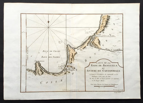
1750 Bellin Antique Map of the Benguela province of Angola, Africa
- Title: Carte de la Rade de Benguella et Riviere de Cantonbelle
- Date: 1750
- Condition : (A+) Fine Condition
- Ref: 25550
- Size: 11 1/2in x 11in (295mm x 280mm)
Description:
This fine large, original copper-plate engraved antique map of the Benguela province of Angola by Jacques Nicolas Bellin in 1750 was published in Antoine François Prevosts 15 volumes of Histoire Generale des Voyageswritten by Prevost & other authors between 1746-1790.
The Portuguese crown created the Kingdom of Benguela in 1615 to improve the conditions to develop the desired land route to Mozambique across Africa. The trading post founded here did not meet the expectations of the Portuguese in mineral resources and soil quality, so a village was only established for the slave trade, under the name of Mbaka
General Definitions:
Paper thickness and quality: - Heavy and stable
Paper color : - off white
Age of map color: - Early
Colors used: - Green, Yellow,
General color appearance: - Authentic
Paper size: - 14in x 10in (355mm x 255mm)
Plate size: - 12in x 9in (305mm x 230mm)
Margins: - Min 1/2in (6mm)
Imperfections:
Margins: - None
Plate area: - Folds as issued
Verso: - None
Background:
One of Antoine Francois Prevosts monumental undertakings was his history of exploration & discovery in 15 volumes titledHistoire Générale des Voyages written between 1746-1759 and was extended to 20 volumes after his death by various authors.
The 20 volumes cover the early explorations & discoveries on 3 continents: Africa (v. 1-5), Asia (v. 5-11), and America (v. 12-15) with material on the finding of the French, English, Dutch, and Portugese.
A number of notable cartographers and engravers contributed to the copper plate maps and views to the 20 volumes including Nicolas Bellin, Jan Schley, Chedel, Franc Aveline, Fessard, and many others.
The African volumes cover primarily coastal countries of West, Southern, and Eastern Africa, plus the Congo, Madagascar, Arabia and the Persian Gulf areas.
The Asian volumes cover China, Korea, Tibet, Japan, Philippines, and countries bordering the Indian Ocean.
Volume 11 includes Australia and Antarctica.
Volumes 12-15 cover voyages and discoveries in America, including the East Indies, South, Central and North America.
Volumes 16-20 include supplement volumes & tables along with continuation of voyages and discoveries in Russia, Northern Europe, America, Asia & Australia.
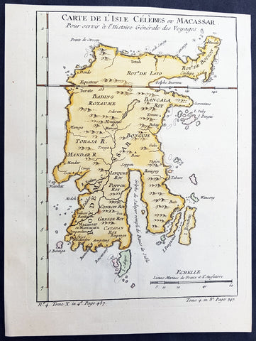
1752 Bellin Antique Map of the Island of Sulawesi, formerly Celebes, Indonesia
- Title: Carte De L'Isle Celebes ou Macassar...S Bellin
- Date: 1752
- Condition : (A+) Fine Condition
- Ref: 60919
- Size: 10in x 7 1/2in (255m x 190mm)
Description:
This fine, original copper-plate engraved antique map of the Indonesian Island of Sulawesi, formerly known as Celebes, by Jacques Nicolas Bellin in 1752 was published in Antoine François Prevosts 15 volumes of Histoire Generale des Voyages written by Prevost & other authors between 1746-1790.
Sulawesi, formerly known as Celebes, is one of the four Greater Sunda Islands, and the world\'s eleventh-largest island, it is situated east of Borneo, west of the Maluku Islands, and south of Mindanao and the Sulu Archipelago. Within Indonesia, only Sumatra, Borneo and Papua are larger in territory, and only Java and Sumatra have larger populations.
Starting in the 13th century, access to prestige trade goods and to sources of iron started to alter long-standing cultural patterns and to permit ambitious individuals to build larger political units. It is not known why these two ingredients appeared together; one was perhaps the product of the other.
In 1367, several identified polities, located on the island, were mentioned in the Javanese manuscript Nagarakretagama dated from the Majapahit period. Canto 14 mentioned polities including Gowa, Makassar, Luwu and Banggai. It seems that by the 14th century, polities in the island were connected in an archipelagic maritime trading network, centered in the Majapahit port in East Java. By 1400, a number of nascent agricultural principalities had arisen in the western Cenrana valley, as well as on the south coast and on the west coast near modern Parepare.
The first Europeans to visit the island (which they believed to be an archipelago due to its contorted shape) were the Portuguese sailors Simão de Abreu, in 1523, and Gomes de Sequeira (among others) in 1525, sent from the Moluccas in search of gold, which the islands had the reputation of producing. A Portuguese base was installed in Makassar in the first decades of the 16th century, lasting until 1665, when it was taken by the Dutch. The Dutch had arrived in Sulawesi in 1605 and were quickly followed by the English, who established a factory in Makassar. From 1660, the Dutch were at war with Gowa, the major Makasar west coast power. In 1669, Admiral Speelman forced the ruler, Sultan Hasanuddin, to sign the Treaty of Bongaya, which handed control of trade to the Dutch East India Company. The Dutch were aided in their conquest by the Bugis warlord Arung Palakka, ruler of the Bugis kingdom of Bone. The Dutch built a fort at Ujung Pandang, while Arung Palakka became the regional overlord and Bone the dominant kingdom. Political and cultural development seems to have slowed as a result of the status quo.
General Definitions:
Paper thickness and quality: - Heavy and stable
Paper color : - off white
Age of map color: - Early
Colors used: - Green, Yellow,
General color appearance: - Authentic
Paper size: - 10in x 7 1/2in (255m x 190mm)
Plate size: - 9in x 6 1/2in (230mm x 160mm)
Margins: - Min 1/2in (6mm)
Imperfections:
Margins: - None
Plate area: - None
Verso: - None
Background:
One of Antoine Francois Prevosts monumental undertakings was his history of exploration & discovery in 15 volumes titledHistoire Générale des Voyages written between 1746-1759 and was extended to 20 volumes after his death by various authors.
The 20 volumes cover the early explorations & discoveries on 3 continents: Africa (v. 1-5), Asia (v. 5-11), and America (v. 12-15) with material on the finding of the French, English, Dutch, and Portugese.
A number of notable cartographers and engravers contributed to the copper plate maps and views to the 20 volumes including Nicolas Bellin, Jan Schley, Chedel, Franc Aveline, Fessard, and many others.
The African volumes cover primarily coastal countries of West, Southern, and Eastern Africa, plus the Congo, Madagascar, Arabia and the Persian Gulf areas.
The Asian volumes cover China, Korea, Tibet, Japan, Philippines, and countries bordering the Indian Ocean.
Volume 11 includes Australia and Antarctica.
Volumes 12-15 cover voyages and discoveries in America, including the East Indies, South, Central and North America.
Volumes 16-20 include supplement volumes & tables along with continuation of voyages and discoveries in Russia, Northern Europe, America, Asia & Australia.

1769 J B D Anville Original Antique Map of Greece Crete Macedonia Turkey Cyprus
- Title : Carte Generale De La Grece
- Size: 16in x 11in (410mm x 260mm)
- Ref #: 32345
- Date : 1769
- Condition: (A+) Fine Condition
Description:
This fine large, original copper-plate engraved antique map was published by Jean Baptiste Bourguignon D\'Anville in the 1769 edition of his atlas Geographie Ancienne et Abregee. or Modern and Ancient Geography (Ref: M&B; Tooley)
General Definitions:
Paper thickness and quality: - Heavy and stable
Paper color : - off white
Age of map color: -
Colors used: -
General color appearance: -
Paper size: - 16in x 11in (410mm x 260mm)
Plate size: - 13in x 9 1/2in (330mm x 245mm)
Margins: - Min 1/2in (12mm)
Imperfections:
Margins: - None
Plate area: - None
Verso: - None
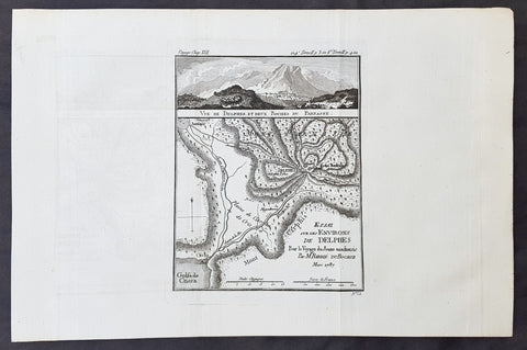
1787 Du Bocage & Barthelemy Antique Map & View of Delphi & Mt Parnassus, Greece
- Title : Essai sur Les Environs De Delphes...1787
- Size: 15in x 10in (380mm x 255mm)
- Ref #: 16456
- Date : 1787
- Condition: (A+) Fine Condition
Description:
This original copper-plate engraved map by Jean Denis Barbie du Bocage was engraved in 1787 - dated in the title - and was published in the 1787 edition of Jean-Jacques Barthelemy famous Voyage du jeune Anarcharsis en Grece or Travels of Anacharsis the younger in Greece in 4 volumes.
General Definitions:
Paper thickness and quality: - Heavy and stable
Paper color : - off white
Age of map color: -
Colors used: -
General color appearance: -
Paper size: - 15in x 10in (380mm x 255mm)
Plate size: - 8in x 6in (205mm x 155mm)
Margins: - Min 1in (25mm)
Imperfections:
Margins: - None
Plate area: - Folds as issued
Verso: - None
Background:
Jean-Jacques Barthelemy 1716 – 1795 was a French writer and numismatist.
Barthelemy was the author of a number of learned works on antiquarian subjects, but the great work on which his fame rests is Travels of Anacharsis the younger in Greece (French: Voyage du jeune Anarcharsis en Grece, 4 vols., 1787). He had begun it in 1757 and had been working on it for thirty years. The hero, a young Scythian descended from the famous philosopher Anacharsis, is supposed to repair to Greece for instruction in his early youth, and after making the tour of her republics, colonies and islands, to return to his native country and write this book in his old age, after the Macedonian hero had overturned the Persian empire. In the manner of modern travellers, he gives an account of the customs, government, and antiquities of the country he is supposed to have visited. A copious introduction supplies whatever may be wanting in respect to historical details, while various dissertations on the music of the Greeks, on the literature of the Athenians, and on the economy, pursuits, ruling passions, manners, and customs of the surrounding states supply ample information on the subjects of which they treat.
Modern scholarship has superseded most of the details in the Voyage, but the author himself did not imagine his book to be a register of accurately ascertained facts. Rather, he intended to afford to his countrymen, in an interesting form, some knowledge of Greek civilisation. The Charicles, or Illustrations of the Private Life of the Ancient Greeks of Wilhelm Adolf Becker is an attempt in a similar direction
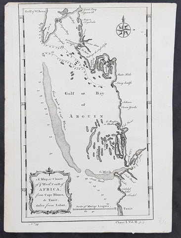
1745 Bradock Mean or John Green Antique Map of Bay of Arguin, Mauritania, Africa
- Title : A Map or Chart of ye Westn Coast of AFRICA from Cape Blanco, to Tanit. taken from Labat
- Size: 10in x 7 1/2in (255mm x 195mm)
- Ref #: 15998
- Date : 1745
- Condition: (A) Very Good Condition
Description:
This fine original copper-plate engraved antique map of The Bay of Arguin on the Atlantic coast of Mauritania, North Africa - located south of Cap Blanc, north of Cap Timiris - by Bradock Mean or John Green, was published in 1745 after Jean-Baptiste Labat.
General Definitions:
Paper thickness and quality: - Heavy and stable
Paper color : - off white
Age of map color: -
Colors used: -
General color appearance: -
Paper size: - 10in x 7 1/2in (255mm x 195mm)
Plate size: - 10in x 7 1/2in (255mm x 195mm)
Margins: - Min 0in (0mm)
Imperfections:
Margins: - Top right margin cropped to border
Plate area: - None
Verso: - None
Background:
Jean-Baptiste Labat 1663 – 1738 was a French clergyman, botanist, writer, explorer, ethnographer, soldier, engineer, and landowner.
Mead, Bradock ne John Green 1685 - 1757
The world of the commercial cartographer in eighteenth-century London was quite respectable. It was punctuated by the usual calamities that befell any entrepreneurial enterprise: partners split in acrimony; some cartographers, such as Thomas Jefferys in 1766 or Osgood Carleton in 1803 suffered the misfortune of bankruptcy. Yet there was a claim to respectability among these tradesmen. They mixed with the literati and natural philosophers; the texts and maps they published contributed to \\\"the science of princes\\\"; their clientele comprised gentry, clergy, and aristocracy; a favored few sold their maps to royalty and claimed titles such as \\\"geographer to His Majesty.\\\"
John Green, however, presents an effective antidote to this image of propriety and respectability. He took cartography from the salons and the coffee houses into the taverns and the squalid streets memorialized in Hogarth\\\'s prints.
The events of Green\\\'s life are obscured by his working for publishers who took the credit for his work; his willingness to remain anonymous was certainly enhanced by his brushes with the law. The main source of information for his life is an undated letter that Thomas Jefferys wrote to the earl of Morton (James Douglass, 14th earl, then president of the Royal Society) presumably in January 1767.
John Green was born Bradock Mead in Ireland, probably well before 1688. He clearly came from a sufficiently respectable family to get a good education; the Thomas Mead who became Lord Mayor of Dublin in 1757 was likely his brother.
1840 SDUK Antique Gnomonic Map East Australia, New Zealand South Pacific
- Title : Published by the Society for the Diffusion of Useful Knowledge
- Size: 16in x 14in (410mm x 355m)
- Condition: (A+) Fine Condition
- Date : 1840
- Ref #: 24676-1
Description:
This hand coloured original steel-plate engraved antique Gnomonic Map of eastern Australia, New Zealand & The South Pacific was engraved by J & C Walker, in 1840 and was published in the Chapman & Hall edition of the Society For the Diffusion of Useful Knowledge (SDUK) Atlas.
A gnomonic map projection displays all great circles as straight lines, resulting in any line segment on a gnomonic map showing a geodesic, the shortest route between the segment\'s two endpoints. This is achieved by casting surface points of the sphere onto a tangent plane, each landing where a ray from the center of the sphere passes through the point on the surface and then on to the plane. No distortion occurs at the tangent point, but distortion increases rapidly away from it. Less than half of the sphere can be projected onto a finite map. Consequently a rectilinear photographic lens cannot image more than 180 degrees.
General Definitions:
Paper thickness and quality: - Heavy and stable
Paper color : - off white
Age of map color: - Original
Colors used: - Yellow, pink, green, blue
General color appearance: - Authentic
Paper size: - 16in x 14in (410mm x 355m)
Plate size: - 16in x 14in (410mm x 355m)
Margins: - Min 1/4in (5mm)
Imperfections:
Margins: - Light age toning
Plate area: - None
Verso: - None
Background:
The SDUK produced two landmark volumes of cartography in the first half of the 19th century. The first volume concentrated on areas of the old world, Europe, Africa, Great Britain etc. The second volume contained maps of the new world, America, South Asia, including US state maps, colonies of Australia, South Africa, South America etc. Also included were some of the finest engraved town and city plans published at that time.
The SDUK was published in its entirety or in part by many publishers including Baldwin and Cradock 1829-32, Chapman & Hall in 1844, Charles Knight & co. 1846 – 1852. G. Cox published the SDUK between 1852-3, Stanford 1857-70 and later revised edition were also published after Stanford. (Ref: Tooley, M&B)
Copy of 1840 SDUK Antique Gnomonic Map East Australia, New Zealand South Pacific
- Title : Published by the Society for the Diffusion of Useful Knowledge
- Size: 16in x 14in (410mm x 355m)
- Condition: (A+) Fine Condition
- Date : 1840
- Ref #: 11-0984
Description:
This hand coloured original steel-plate engraved antique Gnomonic Map of eastern Australia, New Zealand & The South Pacific was engraved by J & C Walker, in 1840 and was published in the Chapman & Hall edition of the Society For the Diffusion of Useful Knowledge (SDUK) Atlas.
A gnomonic map projection displays all great circles as straight lines, resulting in any line segment on a gnomonic map showing a geodesic, the shortest route between the segment\'s two endpoints. This is achieved by casting surface points of the sphere onto a tangent plane, each landing where a ray from the center of the sphere passes through the point on the surface and then on to the plane. No distortion occurs at the tangent point, but distortion increases rapidly away from it. Less than half of the sphere can be projected onto a finite map. Consequently a rectilinear photographic lens cannot image more than 180 degrees.
General Definitions:
Paper thickness and quality: - Heavy and stable
Paper color : - off white
Age of map color: - Original
Colors used: - Yellow, pink, green, blue
General color appearance: - Authentic
Paper size: - 16in x 14in (410mm x 355m)
Plate size: - 16in x 14in (410mm x 355m)
Margins: - Min 1/4in (5mm)
Imperfections:
Margins: - Light age toning
Plate area: - None
Verso: - None
Background:
The SDUK produced two landmark volumes of cartography in the first half of the 19th century. The first volume concentrated on areas of the old world, Europe, Africa, Great Britain etc. The second volume contained maps of the new world, America, South Asia, including US state maps, colonies of Australia, South Africa, South America etc. Also included were some of the finest engraved town and city plans published at that time.
The SDUK was published in its entirety or in part by many publishers including Baldwin and Cradock 1829-32, Chapman & Hall in 1844, Charles Knight & co. 1846 – 1852. G. Cox published the SDUK between 1852-3, Stanford 1857-70 and later revised edition were also published after Stanford. (Ref: Tooley, M&B)
1840 SDUK Antique Gnomonic Map East Australia, New Zealand South Pacific
- Title : Published by the Society for the Diffusion of Useful Knowledge
- Size: 16in x 14in (410mm x 355m)
- Condition: (A+) Fine Condition
- Date : 1840
- Ref #: 11-0974
Description:
This hand coloured original steel-plate engraved antique Gnomonic Map of eastern Australia, New Zealand & The South Pacific was engraved by J & C Walker, in 1840 and was published in the Chapman & Hall edition of the Society For the Diffusion of Useful Knowledge (SDUK) Atlas.
A gnomonic map projection displays all great circles as straight lines, resulting in any line segment on a gnomonic map showing a geodesic, the shortest route between the segment\'s two endpoints. This is achieved by casting surface points of the sphere onto a tangent plane, each landing where a ray from the center of the sphere passes through the point on the surface and then on to the plane. No distortion occurs at the tangent point, but distortion increases rapidly away from it. Less than half of the sphere can be projected onto a finite map. Consequently a rectilinear photographic lens cannot image more than 180 degrees.
General Definitions:
Paper thickness and quality: - Heavy and stable
Paper color : - off white
Age of map color: - Original
Colors used: - Yellow, pink, green, blue
General color appearance: - Authentic
Paper size: - 16in x 14in (410mm x 355m)
Plate size: - 16in x 14in (410mm x 355m)
Margins: - Min 1/4in (5mm)
Imperfections:
Margins: - Light age toning
Plate area: - None
Verso: - None
Background:
The SDUK produced two landmark volumes of cartography in the first half of the 19th century. The first volume concentrated on areas of the old world, Europe, Africa, Great Britain etc. The second volume contained maps of the new world, America, South Asia, including US state maps, colonies of Australia, South Africa, South America etc. Also included were some of the finest engraved town and city plans published at that time.
The SDUK was published in its entirety or in part by many publishers including Baldwin and Cradock 1829-32, Chapman & Hall in 1844, Charles Knight & co. 1846 – 1852. G. Cox published the SDUK between 1852-3, Stanford 1857-70 and later revised edition were also published after Stanford. (Ref: Tooley, M&B)
1831 SDUK Antique Gnomonic Map of Western Australia & The Indian Ocean, SE Asia
- Title : Published by Baldwin & Craddock...June 1831
- Size: 16in x 14in (410mm x 355m)
- Condition: (A+) Fine Condition
- Date : 1831
- Ref #: 32534
Description:
This original steel-plate engraved antique Gnomonic Map of Western Australia & The Indian Ocean was engraved by J & C Walker, in 1831 - dated at the foot of the map - and was published in the Baldwin & Craddock edition of the Society For the Diffusion of Useful Knowledge (SDUK) Atlas.
A gnomonic map projection displays all great circles as straight lines, resulting in any line segment on a gnomonic map showing a geodesic, the shortest route between the segment\'s two endpoints. This is achieved by casting surface points of the sphere onto a tangent plane, each landing where a ray from the center of the sphere passes through the point on the surface and then on to the plane. No distortion occurs at the tangent point, but distortion increases rapidly away from it. Less than half of the sphere can be projected onto a finite map. Consequently a rectilinear photographic lens cannot image more than 180 degrees.
General Definitions:
Paper thickness and quality: - Heavy and stable
Paper color : - off white
Age of map color: -
Colors used: -
General color appearance: -
Paper size: - 16in x 14in (410mm x 355m)
Plate size: - 16in x 14in (410mm x 355m)
Margins: - Min 1/4in (5mm)
Imperfections:
Margins: - None
Plate area: - Blind Library stamp
Verso: - None
Background:
The SDUK produced two landmark volumes of cartography in the first half of the 19th century. The first volume concentrated on areas of the old world, Europe, Africa, Great Britain etc. The second volume contained maps of the new world, America, South Asia, including US state maps, colonies of Australia, South Africa, South America etc. Also included were some of the finest engraved town and city plans published at that time.
The SDUK was published in its entirety or in part by many publishers including Baldwin and Cradock 1829-32, Chapman & Hall in 1844, Charles Knight & co. 1846 – 1852. G. Cox published the SDUK between 1852-3, Stanford 1857-70 and later revised edition were also published after Stanford. (Ref: Tooley, M&B)
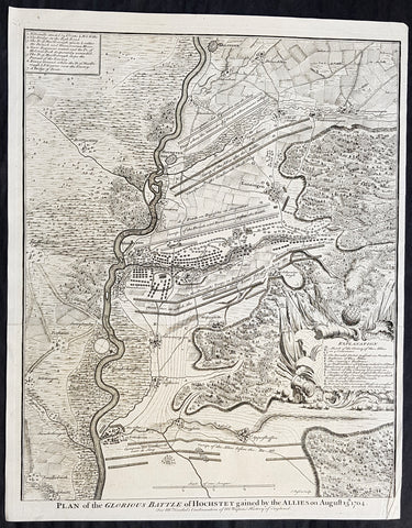
1745 Nicolas Tindal Antique Map The Battle of Blenheim, Germany in 1704
Antique Map
- Title : Plan of the Glorious Battle of Hochstet gained by the Allies on August 13.th 1704.
- Size: 21in x 17in (530mm x 430mm)
- Ref #: 22178
- Date : 1745
- Condition: (A+) Fine Condition
Description:
This original copper-plate engraved antique map, plan of the The Battle of Blenheim or Hochstadt, fought in Bavaria, Germany in August 1704 - during the Spanish War of Succession (1701-13) - was engraved by John Basire and was published in the 1745 edition of Nicholas Tindals Continuation of Mr. Rapins History of England.
General Definitions:
Paper thickness and quality: - Heavy and stable
Paper color : - off white
Age of map color: -
Colors used: -
General color appearance: -
Paper size: - 21in x 17in (530mm x 430mm)
Plate size: - 21in x 17in (530mm x 430mm)
Margins: - Min 1/2in (12mm)
Imperfections:
Margins: - None
Plate area: - Folds as issued
Verso: - None
Background:
The Battle of Blenheim (German: Zweite Schlacht bei Höchstädt; French Bataille de Höchstädt), fought on 13 August 1704, was a major battle of the War of the Spanish Succession. The overwhelming Allied victory ensured the safety of Vienna from the Franco-Bavarian army, thus preventing the collapse of the Grand Alliance.
Louis XIV of France sought to knock the Holy Roman Emperor, Leopold out of the war by seizing Vienna, the Habsburg capital, and gain a favourable peace settlement. The dangers to Vienna were considerable: the Elector of Bavaria and Marshal Marsins forces in Bavaria threatened from the west, and Marshal Vendômes large army in northern Italy posed a serious danger with a potential offensive through the Brenner Pass. Vienna was also under pressure from Rákóczis Hungarian revolt from its eastern approaches. Realising the danger, the Duke of Marlborough resolved to alleviate the peril to Vienna by marching his forces south from Bedburg to help maintain Emperor Leopold within the Grand Alliance.
A combination of deception and skilled administration – designed to conceal his true destination from friend and foe alike – enabled Marlborough to march 400 kilometres (250 miles) unhindered from the Low Countries to the River Danube in five weeks. After securing Donauwörth on the Danube, Marlborough sought to engage the Electors and Marsins army before Marshal Tallard could bring reinforcements through the Black Forest. However, with the Franco-Bavarian commanders reluctant to fight until their numbers were deemed sufficient, the Duke enacted a policy of plundering in Bavaria designed to force the issue. The tactic proved unsuccessful, but when Tallard arrived to bolster the Electors army, and Prince Eugene arrived with reinforcements for the Allies, the two armies finally met on the banks of the Danube in and around the small village of Blindheim, from which the English Blenheim is derived.
Blenheim was one of the battles that altered the course of the war, which until then was leaning for Louis coalition, and ended French plans of knocking the Emperor out of the war. France suffered as many as 38,000 casualties including the commander-in-chief, Marshal Tallard, who was taken captive to England. Before the 1704 campaign ended, the Allies had taken Landau, and the towns of Trier and Trarbach on the Moselle in preparation for the following years campaign into France itself. The offensive never materialised as the Grand Alliances army had to depart the Moselle to defend Liège from a French counteroffensive. The war would rage on for another decade.
Tindal, Nicolas 1687 – 1774
Nicolas Tindal was the translator and continuer of the History of England published by Paul de Rapin (1661-1725) in 1724. De Rapins publication chronicles the History of Britain from the invasion of the Romans to the death of Charles I. Very few comprehensive histories of England existed at the time and Tindal added his three-volume Continuation, of the Kingdom, from the reigns of James II to George II.
Tindal\\\'s translation of de Rapins History, was first published in 1727. Tindal enlarged the volumes in their second edition (1732) to contain notes, genealogical tables and maps of his own composition. In 1745 Tindal published Tindal’s Continuation of Mr. Rapin’s History of England. Included with this edition was an atlas containing 45 maps, battle and town plans from the Spanish War of Succession (1701-13) that were engraved by Richard William Seale and John Basire.
These maps represent battles that took place during the War of Spanish Succession, concluded by the Treaties of Utrecht. The war resulted from a dispute over who should inherit Spain and its possessions after its Habsburg rulers in 1700. The last Habsburg king of Spain, Charles II (d. 1700) had left the throne to his closest relative in female line: Philippe de France, duke of Anjou, grandson of Louis XIV (Felipe V of Spain). The closest relatives in male line, the Habsburgs of Austria, disputed this claim, and many European nations did not want to see French princes reigning over both kingdoms. The Utrecht treaties recognized Felipe V of Spain, but transferred the Spanish possessions in the Netherlands and Italy to Austria and to Savoy. To reach the goal of separating the crowns of France and Spain, the treaties required Felipe V to relinquish all claims to the French throne, and the remaining French princes to relinquish all claims to the Spanish throne.
The War of the Spanish Succession, was also known as Marlboroughs Wars, that was fought in Europe and the Mediterranean, and were the last and the bloodiest of the Wars between England and France under Louis XIV, and the first in which Britain played a major military role in European military affairs.
Paul de Rapin 1661-1725 was born in Castes and educated at the Protestant academy of Saumur. In 1685 after the death of his father he moved to England but after being unable to find employment moved to Holland and enlisted in French volunteers at Utrecht commanded by his cousin Daniel de Rapin. He accompanied the prince of Orange to England in 1688 and participated in the Irish campaigns of the siege of Carrickfergus, Battle of the Boyne and Limerick. Rapin resigned to become tutor to the Earl of Portlands son. He settled in Holland where he began work on The History of England. It was published in Holland in 1724 in 8 volumes. The work was an attempt to be exhaustive in the spirit of the eighteenth century philosophies by treating the subject from prehistoric times up to the date of publication.

1745 Tindal Antique Map Battle Plan of Siege of Bouchain, Calais, France in 1711
Antique Map
- Title : Plan of the City of Bouchain Situated upon the Rivers Sensette and Scheld in the County of Hainault
- Size: 19 1/2in x 15 1/2in (495mm x 395mm)
- Ref #: 22156-1
- Date : 1745
- Condition: (A+) Fine Condition
Description:
This original copper-plate engraved antique map, battle plan & birds eye view of the French city of Bouchain on the Schedlt River, in the Pas-de-Calais dept. in northern France - during the Spanish War of Succession (1701-13) - was engraved by John Basire and was published in the 1745 edition of Nicholas Tindals Continuation of Mr. Rapin\'s History of England.
General Definitions:
Paper thickness and quality: - Heavy and stable
Paper color : - off white
Age of map color: -
Colors used: -
General color appearance: -
Paper size: - 19 1/2in x 15 1/2in (495mm x 395mm)
Plate size: - 19 1/2in x 15 1/2in (495mm x 395mm)
Margins: - Min 1/2in (12mm)
Imperfections:
Margins: - None
Plate area: - Folds as issued
Verso: - None
Background:
The Siege of Bouchain (9 August – 12 September 1711), following the Passage of the Lines of Ne Plus Ultra (5 August 1711), was a siege of the War of the Spanish Succession, and the last major victory of John Churchill, 1st Duke of Marlborough. Marlborough broke through the French defensive lines and took Bouchain after a siege of 34 days. Its capture left Cambrai the only French-held fortress between the allied army and Paris.
Throughout the early summer of 1711 Marlborough\'s army, having taken the important fortress of Douai the previous year, manoeuvred indecisively in northern France, blocked by the French Lines of Ne Plus Ultra – a massive series of fieldworks stretching from the Channel coast to the Ardennes at Namur. The allied army had been weakened by the withdrawal of Prince Eugene\'s army to cover the upper Rhine, as the deposed Elector of Bavaria attempted to take advantage of the disruption caused by the death of the Emperor Joseph. On 6 July, Marlborough captured the small fortress of Arleux, just to the north of the Lines, west of Bouchain, both to deny its use to the French as a sally-port, and to secure the water supply to Douai, which could be cut off by damming the canal that supplied the town. The Duke was then wrong-footed by Villars as the French army crossed the Lines on 22/23 July and retook Arleux, with the allied army too far to the west to intervene in time, and the defences were levelled before the French retreated back across the Lines. Marlborough, initially furious, soon retook the initiative by marching his army as if to assault the Lines near Arras, and carrying out a detailed personal reconnaissance there on 4 August in full view of Villars\' covering army. That night the army struck camp, leaving their campfires burning to deceive the French, and marched eastwards to Arleux. At midnight a force from Douai under Cadogan crossed the unguarded French lines, and by 8 am the advance guard of the main army was also crossing over. Villars, arriving on the scene with a few hundred cavalry, realised he had been outmanoeuvred, and though he attempted to offer battle in front of Bourlon Wood, Marlborough declined to attack, the Marshal\'s position being even stronger than the one in which he had given Marlborough\'s army such a mauling two years earlier at Malplaquet. He thus drew off and attempted to hinder Marlborough\'s siege of Bouchain which followed.
To defend the town Bouchain\'s governor, de Ravignau, had some 5,000 men against Marlborough\'s besieging army of 30,000, and the advantage of one of the strongest fortresses left to France, surrounded by the marshy land of the confluence of the rivers Scheldt and Sensée. In addition, Villars\' strong army had taken up position to the west of the allied camp, and had managed to open a tenuous link to the besieged garrison. Marlborough responded by using earthwork gun batteries to counter Villars, used a crack assault force managed by 18 August to once more cut the Marshal\'s communication with Bouchain, and established a fieldwork-protected corridor from the siege camp to his main supply port at Marchiennes on the Scarpe. Frequent raids by Villars on both the supply convoys on the Scarpe, and towards Douai, failed to interrupt the siege, and the garrison marched out to become prisoners of war on 13 September 1711.
Bouchain was Marlborough\'s last campaign. On the last day of the year he was stripped of his position as Captain-General, and of all his other offices. Command of the army on the continent for the campaign of 1712 was given to the Duke of Ormonde, and strict limitations were placed on his freedom of movement. Particularly he was prohibited from engaging the French in battle, as Anglo-French peace talks were well advanced, and the opportunity of seizing Cambrai and marching on Paris, opened by Marlborough\'s gains the year before, was abandoned. Before the year was out, the British army would withdraw from the alliance, leaving the remaining allies, under Eugene of Savoy to be defeated at Denain.
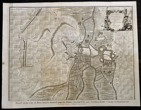
1745 Tindal Antique Map Battle Plan of Siege of Bouchain, Calais, France in 1711
Antique Map
- Title : Plan of the City of Bouchain Situated upon the Rivers Sensette and Scheld in the County of Hainault
- Size: 19 1/2in x 15 1/2in (495mm x 395mm)
- Ref #: 22156-1
- Date : 1745
- Condition: (A+) Fine Condition
Description:
This original copper-plate engraved antique map, battle plan & birds eye view of the French city of Bouchain on the Schedlt River, in the Pas-de-Calais dept. in northern France - during the Spanish War of Succession (1701-13) - was engraved by John Basire and was published in the 1745 edition of Nicholas Tindals Continuation of Mr. Rapin\'s History of England.
General Definitions:
Paper thickness and quality: - Heavy and stable
Paper color : - off white
Age of map color: - Early
Colors used: - Pink, blue, green, yellow
General color appearance: - Authentic
Paper size: - 19 1/2in x 15 1/2in (495mm x 395mm)
Plate size: - 19 1/2in x 15 1/2in (495mm x 395mm)
Margins: - Min 1/2in (12mm)
Imperfections:
Margins: - None
Plate area: - Folds as issued
Verso: - None
Background:
The Siege of Bouchain (9 August – 12 September 1711), following the Passage of the Lines of Ne Plus Ultra (5 August 1711), was a siege of the War of the Spanish Succession, and the last major victory of John Churchill, 1st Duke of Marlborough. Marlborough broke through the French defensive lines and took Bouchain after a siege of 34 days. Its capture left Cambrai the only French-held fortress between the allied army and Paris.
Throughout the early summer of 1711 Marlborough\'s army, having taken the important fortress of Douai the previous year, manoeuvred indecisively in northern France, blocked by the French Lines of Ne Plus Ultra – a massive series of fieldworks stretching from the Channel coast to the Ardennes at Namur. The allied army had been weakened by the withdrawal of Prince Eugene\'s army to cover the upper Rhine, as the deposed Elector of Bavaria attempted to take advantage of the disruption caused by the death of the Emperor Joseph. On 6 July, Marlborough captured the small fortress of Arleux, just to the north of the Lines, west of Bouchain, both to deny its use to the French as a sally-port, and to secure the water supply to Douai, which could be cut off by damming the canal that supplied the town. The Duke was then wrong-footed by Villars as the French army crossed the Lines on 22/23 July and retook Arleux, with the allied army too far to the west to intervene in time, and the defences were levelled before the French retreated back across the Lines. Marlborough, initially furious, soon retook the initiative by marching his army as if to assault the Lines near Arras, and carrying out a detailed personal reconnaissance there on 4 August in full view of Villars\' covering army. That night the army struck camp, leaving their campfires burning to deceive the French, and marched eastwards to Arleux. At midnight a force from Douai under Cadogan crossed the unguarded French lines, and by 8 am the advance guard of the main army was also crossing over. Villars, arriving on the scene with a few hundred cavalry, realised he had been outmanoeuvred, and though he attempted to offer battle in front of Bourlon Wood, Marlborough declined to attack, the Marshal\'s position being even stronger than the one in which he had given Marlborough\'s army such a mauling two years earlier at Malplaquet. He thus drew off and attempted to hinder Marlborough\'s siege of Bouchain which followed.
To defend the town Bouchain\'s governor, de Ravignau, had some 5,000 men against Marlborough\'s besieging army of 30,000, and the advantage of one of the strongest fortresses left to France, surrounded by the marshy land of the confluence of the rivers Scheldt and Sensée. In addition, Villars\' strong army had taken up position to the west of the allied camp, and had managed to open a tenuous link to the besieged garrison. Marlborough responded by using earthwork gun batteries to counter Villars, used a crack assault force managed by 18 August to once more cut the Marshal\'s communication with Bouchain, and established a fieldwork-protected corridor from the siege camp to his main supply port at Marchiennes on the Scarpe. Frequent raids by Villars on both the supply convoys on the Scarpe, and towards Douai, failed to interrupt the siege, and the garrison marched out to become prisoners of war on 13 September 1711.
Bouchain was Marlborough\'s last campaign. On the last day of the year he was stripped of his position as Captain-General, and of all his other offices. Command of the army on the continent for the campaign of 1712 was given to the Duke of Ormonde, and strict limitations were placed on his freedom of movement. Particularly he was prohibited from engaging the French in battle, as Anglo-French peace talks were well advanced, and the opportunity of seizing Cambrai and marching on Paris, opened by Marlborough\'s gains the year before, was abandoned. Before the year was out, the British army would withdraw from the alliance, leaving the remaining allies, under Eugene of Savoy to be defeated at Denain.
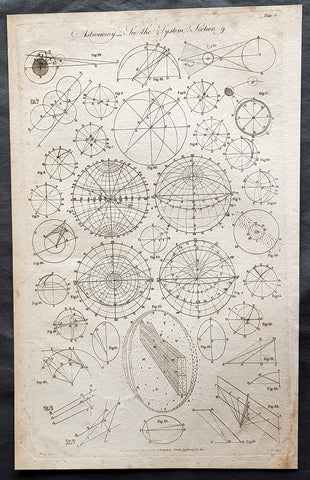
1798 W H Hall Large Antique Astronomical Print of Measurements & Calculations
Antique Map
- Title : Astronomy....Halls Encyclopedia...C. Cooke
- Condition: (A) Very Good Condition
- Ref: 01-7364
- Size: 15in x 9in (380mm x 230mm)
- Date: 1798
Description:
This large original copper-plate engraved antique print was was published by William Henry Hall in the 1798 edition of The new royal encyclopedia; or, complete modern universal dictionary of arts and sciences on a new and improved plan.... printed by Charles Cooke, London.
General Definitions:
Paper thickness and quality: - Heavy and stable
Paper color : - off white
Age of map color: -
Colors used: -
General color appearance: -
Paper size: - 15in x 9in (380mm x 230mm)
Plate size: - 15in x 9in (380mm x 230mm)
Margins: - Min 1/2in (10mm)
Imperfections:
Margins: - Age toning
Plate area: - Light age toning
Verso: - Age toning
Background:
During the Renaissance, Nicolaus Copernicus proposed a heliocentric model of the solar system. His work was defended by Galileo Galilei and expanded upon by Johannes Kepler. Kepler was the first to devise a system that correctly described the details of the motion of the planets around the Sun. However, Kepler did not succeed in formulating a theory behind the laws he wrote down. It was Isaac Newton, with his invention of celestial dynamics and his law of gravitation, who finally explained the motions of the planets. Newton also developed the reflecting telescope.
Improvements in the size and quality of the telescope led to further discoveries. The English astronomer John Flamsteed catalogued over 3000 stars. More extensive star catalogues were produced by Nicolas Louis de Lacaille. The astronomer William Herschel made a detailed catalog of nebulosity and clusters, and in 1781 discovered the planet Uranus, the first new planet found. The distance to a star was announced in 1838 when the parallax of 61 Cygni was measured by Friedrich Bessel.
During the 18–19th centuries, the study of the three-body problem by Leonhard Euler, Alexis Claude Clairaut, and Jean le Rond dAlembert led to more accurate predictions about the motions of the Moon and planets. This work was further refined by Joseph-Louis Lagrange and Pierre Simon Laplace, allowing the masses of the planets and moons to be estimated from their perturbations.
Significant advances in astronomy came about with the introduction of new technology, including the spectroscope and photography. Joseph von Fraunhofer discovered about 600 bands in the spectrum of the Sun in 1814–15, which, in 1859, Gustav Kirchhoff ascribed to the presence of different elements. Stars were proven to be similar to the Earths own Sun, but with a wide range of temperatures, masses, and sizes.
Hall, William Henry
Hall was responsible for a significant publication in the middle of the 18th century The new royal encyclopedia; or, complete modern universal dictionary of arts and sciences on a new and improved plan . containing a digest and display of the whole theory and practice of the liberal and mechanical arts comprising a general repository of ancient and modern literature . including all the material information that is contained in Chamber s Cyclopedia, the Encyclopædia Britannica, and the French Encyclopædie . first published in 1788 going into many re-issues over the next 50 years.
The three volume set contained 153 copper-plate prints and maps, including some folding maps. Contained many brief encyclopedic entries in alphabetical orders plus longer, mainly illustrated, sections (systems or treatises) on a variety of subjects: Aerology; Aerostation (hot air balloons); Agriculture; Algebra; Amphibiology; Anatomy; Annuities; Architecture; Arithmetic; Astronomy (includes plates of telescopes); Book-Keeping; Botany; Brewing; Chronology; Chymistry; Comparative Anatomy; Concology; Dialling; Distillation; Drawing; Earth; Earthquakes; Electricity; Entomology; Farriery; Fencing; Fluxions; Fortification; Gardening; Geography (this section includes six folding maps); Geometry; Globes; Grammar; Heraldry; Hydrostatics and Hydraulics (one plate included a diving bell); Icthyology; Knighthood; Logic; Mammalia (included a plate showing whales); Mechanics; Medicine; Mensuration and Gauging; Miscroscopic Apparatus (microscopes); Midwifery; Military Affairs; Music; Natural History; Naval Affairs; Navigation (includes a folding map showing Cooks voyages); Optics; Oratory; Ornithology; Peerage; Perspective; Pneumatics; Projectiles; Steam Engines; Surgery; Surveying; Trigonometry; Vermeology; Volcanos; and War. Hard to find a complete set, as many have been broken up for their handsome copper plate engravings and maps.
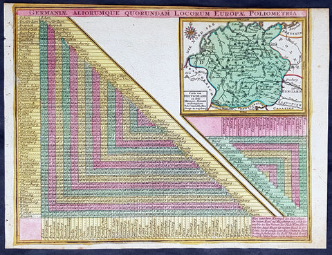
1744 Georg Mattaus Seutter Antique Map of Germany w/ European City Mileage Chart
Antique Map
- Title : Germaniae Aliorumque Quorundam Locorum Europae Poliometria....Cart von Deutsschland...Tob. Conrad Lotter Geogr.
- Ref #: 93404
- Size: 11in x 8 1/2in (280mm x 215mm)
- Date : 1744
- Condition: (A+) Fine Condition
Description:
This beautifully hand coloured original copper-plate engraved antique map of Germany, with a mileage index chart with all the major cities of Europe, was engraved by Tobias Lotter and was published in the 1744 edition of GM Seutters Atlas Minor Prae cipua Orbis Terrarum Imperia Regna et Provincias...., Augsburg, Germany.
General Definitions:
Paper thickness and quality: - Heavy and stable
Paper color : - off white
Age of map color: - Original
Colors used: - Yellow, green, blue, pink
General color appearance: - Authentic
Paper size: - 11in x 8 1/2in (280mm x 215mm)
Plate size: - 10 1/2in x 8in (265mm x 205mm)
Margins: - Min 1/4in (5mm)
Imperfections:
Margins: - Light age toning
Plate area: - Light age toning
Verso: - None
Background:
Atlas Minor was a series of beautiful maps of all parts of the world. Georg Matthäus Seutter was one of the most and important of the German cartographers of the 18th century, being appointed as the Geographer to the Imperial Court. His son, Albrecht Carl, joined Matthäus and eventually inherited the business. The maps from Atlas Minor were drawn by the two Seutters and engraved by Tobias Conrad Lotte. These maps are highly detailed and engraved with a bold hand with equally strong original hand color in the body of the map as was the 18th century German style. The cartouches were left uncolored in order to emphasize the elaborately detailed illustrations for which German maps are especially prized. These are some of the most decorative and interesting maps of the eighteenth century.
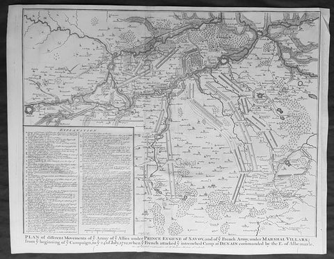
1745 Nicolas Tindal Original Antique Map Battle Plan of Denain, France in 1712
- Title : Plan of the movements of ye Armies of ye Allies under Prince Eugene of Savoy and of ye French Army under Marshal Villars; from ye beginning of ye campaign to ye 24th July 1712, when ye French attacked ye intrenchement Camp at Denain commanded by the E. of Albemarle
- Size: 19 1/2in x 15 1/2in (495mm x 395mm)
- Ref #: 15689
- Date : 1745
- Condition: (A+) Fine Condition
Description:
This original copper-plate engraved antique map, battle plan of the Battle of Denain - during the Spanish War of Succession (1701-13) - centering on the cities of Douai & Bouchain in northern France, was published in the 1745 edition of Nicholas Tindals Continuation of Mr. Rapin\'s History of England.
General Definitions:
Paper thickness and quality: - Heavy and stable
Paper color : - off white
Age of map color: -
Colors used: -
General color appearance: -
Paper size: - 19 1/2in x 15 1/2in (495mm x 395mm)
Plate size: - 19 1/2in x 15 1/2in (495mm x 395mm)
Margins: - Min 1/2in (12mm)
Imperfections:
Margins: - None
Plate area: - None
Verso: - None
Background:
The Battle of Denain was fought on 24 July 1712, as part of the War of the Spanish Succession. It resulted in a French victory under Marshal Villars against Dutch and Austrian forces under Prince Eugene of Savoy.
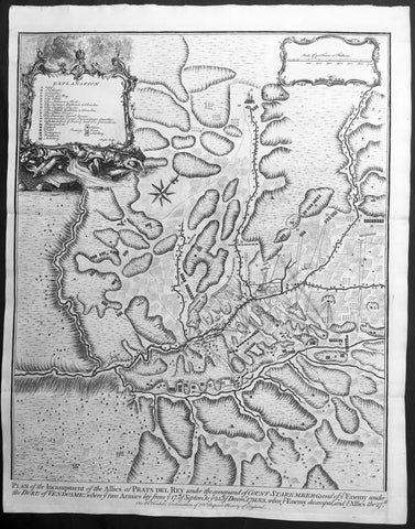
1745 Tindal Antique Map of Spanish & Austrian Armies in Catalonia Spain in 1711
- Title : Plan of the Incampment of the Allies at Prats Del Rey. under the command of Count Staremberg and of ye Enemy under the Duke of Vendsome: wher ye two Armies lay from ye 17th of September to ye 25th of December 1711 N.S. when ye Enemy decamped and ye Allies the 27th.
- Size: 19 1/2in x 15 1/2in (495mm x 395mm)
- Ref #: 15687
- Date : 1745
- Condition: (A+) Fine Condition
Description:
This original copper-plate engraved antique map, a battle plan of the encampments of the Spanish army under Louis-Joseph, duke de Vendome & the Austrian Army under Count Guido Starhemberg in Prado Del Rey in Catalonia, Spain - during the Spanish War of Succession (1701-13) - was engraved by John Basire and was published in the 1745 edition of Nicholas Tindals Continuation of Mr. Rapins History of England.
General Definitions:
Paper thickness and quality: - Heavy and stable
Paper color : - off white
Age of map color: -
Colors used: -
General color appearance: -
Paper size: - 19 1/2in x 15 1/2in (495mm x 395mm)
Plate size: - 19 1/2in x 15 1/2in (495mm x 395mm)
Margins: - Min 1/2in (12mm)
Imperfections:
Margins: - None
Plate area: - Folds as issued
Verso: - None
Background:
Duke Louis-Joseph de Vendome , 1654 — 1712 was one of King Louis XIV’s leading generals during the War of the Spanish Succession (1701–14).
Vendome was the son of Louis de Vendome, Duke de Mercoeur, by his marriage to Cardinal Jules Mazarin’s niece, Laure Mancini. Vendôme entered the French Army in 1672 and had risen to the rank of lieutenant general by the outbreak of the War of the Grand Alliance (1689–97) between France and the other major powers. He distinguished himself in the victory over the Allies at Steenkirke (1692) and was made commander in Catalonia in 1695; two years later he captured Barcelona.
The dispute over the succession to the Spanish throne brought France and Spain to war with the British, the Austrians, and the Dutch in 1701. Appointed to the command in northern Italy in 1702, Vendôme fought the Austrian commander, Prince Eugene of Savoy, in the bloody but indecisive Battle of Luzzara on August 15. He took Vercelli in 1704 and defeated Prince Eugene at Cassano in August 1705. In May 1706 Vendôme was transferred to the Flanders front, where the British commander John Churchill, 1st Duke of Marlborough, had just won an overwhelming victory at Ramillies. Vendôme made limited gains until he was severely defeated by Marlborough and Prince Eugene at Oudenaarde on July 11, 1708. Vendôme subsequently failed to relieve besieged Lille (in northern France), which fell to the Allies in October. Recalled by Louis XIV, he was temporarily disgraced.
Guido Wald Rüdiger, count of Starhemberg1657 – 1737 was an Austrian military officer.
He was a cousin of Ernst Rudiger von Starhemberg (1638-1701), the famous commander of Vienna during the Turkish siege of 1683, and acted as his aide-de-camp during that siege. Guido followed his cousin, and later Prince Eugene of Savoy, in battles against the Turks.
In the War of the Spanish Succession, Starhemberg fought in Italy and Spain. Between 1706 and 1708 he was the commander-in-chief of the imperial army in Hungary, leading military operations against the insurgents of Francis II Rákóczi. In 1708, he was appointed Supreme Commander of the Austrians in Spain.
Together with James Stanhope he succeeded in conquering Madrid in 1710, after previously gaining victories at Almenar and Saragossa. In December, however, he was forced to leave the city by the lack of support by its inhabitants for the Habsburg pretender. After the subsequent defeats at the Battle of Brihuega and the Battle of Villaviciosa (1710), he had to pull back to Catalonia, where he was made viceroy when Archduke Charles returned to Austria.
After the Peace of Utrecht (1713), archduke Charles, now Emperor Charles VI, ordered him to abandon Catalonia. He pulled back with his troops to Genoa on English ships.
When he died in 1737, he was Governor of Slavonia
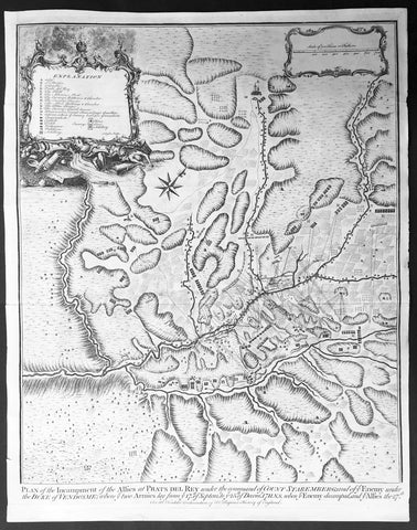
1745 Tindal Antique Map of Spanish & Austrian Armies in Catalonia Spain in 1711
- Title : Plan of the Incampment of the Allies at Prats Del Rey. under the command of Count Staremberg and of ye Enemy under the Duke of Vendsome: wher ye two Armies lay from ye 17th of September to ye 25th of December 1711 N.S. when ye Enemy decamped and ye Allies the 27th.
- Size: 19 1/2in x 15 1/2in (495mm x 395mm)
- Ref #: 15657
- Date : 1745
- Condition: (A+) Fine Condition
Description:
This original copper-plate engraved antique map, a battle plan of the encampments of the Spanish army under Louis-Joseph, duke de Vendome & the Austrian Army under Count Guido Starhemberg in Prado Del Rey in Catalonia, Spain - during the Spanish War of Succession (1701-13) - was engraved by John Basire and was published in the 1745 edition of Nicholas Tindals Continuation of Mr. Rapins History of England.
General Definitions:
Paper thickness and quality: - Heavy and stable
Paper color : - off white
Age of map color: -
Colors used: -
General color appearance: -
Paper size: - 19 1/2in x 15 1/2in (495mm x 395mm)
Plate size: - 19 1/2in x 15 1/2in (495mm x 395mm)
Margins: - Min 1/2in (12mm)
Imperfections:
Margins: - None
Plate area: - Folds as issued
Verso: - None
Background:
Duke Louis-Joseph de Vendome , 1654 — 1712 was one of King Louis XIV’s leading generals during the War of the Spanish Succession (1701–14).
Vendome was the son of Louis de Vendome, Duke de Mercoeur, by his marriage to Cardinal Jules Mazarin’s niece, Laure Mancini. Vendôme entered the French Army in 1672 and had risen to the rank of lieutenant general by the outbreak of the War of the Grand Alliance (1689–97) between France and the other major powers. He distinguished himself in the victory over the Allies at Steenkirke (1692) and was made commander in Catalonia in 1695; two years later he captured Barcelona.
The dispute over the succession to the Spanish throne brought France and Spain to war with the British, the Austrians, and the Dutch in 1701. Appointed to the command in northern Italy in 1702, Vendôme fought the Austrian commander, Prince Eugene of Savoy, in the bloody but indecisive Battle of Luzzara on August 15. He took Vercelli in 1704 and defeated Prince Eugene at Cassano in August 1705. In May 1706 Vendôme was transferred to the Flanders front, where the British commander John Churchill, 1st Duke of Marlborough, had just won an overwhelming victory at Ramillies. Vendôme made limited gains until he was severely defeated by Marlborough and Prince Eugene at Oudenaarde on July 11, 1708. Vendôme subsequently failed to relieve besieged Lille (in northern France), which fell to the Allies in October. Recalled by Louis XIV, he was temporarily disgraced.
Guido Wald Rüdiger, count of Starhemberg1657 – 1737 was an Austrian military officer.
He was a cousin of Ernst Rudiger von Starhemberg (1638-1701), the famous commander of Vienna during the Turkish siege of 1683, and acted as his aide-de-camp during that siege. Guido followed his cousin, and later Prince Eugene of Savoy, in battles against the Turks.
In the War of the Spanish Succession, Starhemberg fought in Italy and Spain. Between 1706 and 1708 he was the commander-in-chief of the imperial army in Hungary, leading military operations against the insurgents of Francis II Rákóczi. In 1708, he was appointed Supreme Commander of the Austrians in Spain.
Together with James Stanhope he succeeded in conquering Madrid in 1710, after previously gaining victories at Almenar and Saragossa. In December, however, he was forced to leave the city by the lack of support by its inhabitants for the Habsburg pretender. After the subsequent defeats at the Battle of Brihuega and the Battle of Villaviciosa (1710), he had to pull back to Catalonia, where he was made viceroy when Archduke Charles returned to Austria.
After the Peace of Utrecht (1713), archduke Charles, now Emperor Charles VI, ordered him to abandon Catalonia. He pulled back with his troops to Genoa on English ships.
When he died in 1737, he was Governor of Slavonia
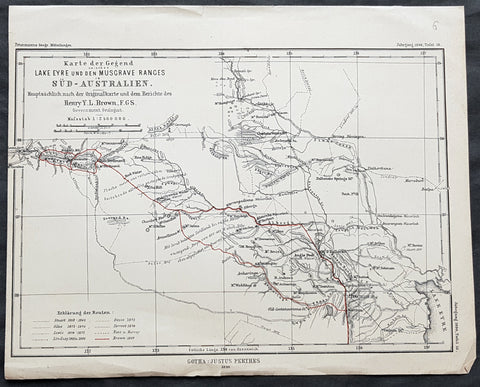
1890 Petermann Antique Map Lake Eyre to The Musgrave Ranges South Australia
- Title : Karte der Gegend zwischen Lake Eyre den Musgrave Ranges in Sud-Australien...Gotha: Justus Perthes 1890
- 10 1/2in x 8 1/2in (265mm x 215mm)
- Condition: (A+) Fine Condition
- Date : 1890
- Ref #: 82060
Description:
This original antique lithograph map of the area between Lake Eyre the Musgrave ranges in South Australia - with the tracks of 8 explorers of the region - by Augustus Heinrich Petermann was engraved in 1890 - dated - and was published by Justus Perthes, Gotha Germany.
General Definitions:
Paper thickness and quality: - Heavy and stable
Paper color : - off white
Age of map color: - Original
Colors used: - Red
General color appearance: - Authentic
Paper size: - 10 1/2in x 8 1/2in (265mm x 215mm)
Plate size: - 10 1/2in x 8 1/2in (265mm x 215mm)
Margins: - Min 1/2in (12mm)
Imperfections:
Margins: - None
Plate area: - Folds as issued
Verso: - None
Background:
The tracks of 8 different explorers are covered in this map. They are:
1. Sturat 1858-62
2. Giles 1873 - 1876
3. Lewis 1874 - 1875
4. Lindsay 1885 & 86
5. Gosse 1872
6. Forrest 1874
7. Ross & Harvey
8. Brown 1889
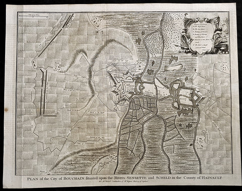
1745 Tindal Antique Map Battle Plan of Siege of Bouchain, Calais, France in 1711
Antique Map
- Title : Plan of the City of Bouchain Situated upon the Rivers Sensette and Scheld in the County of Hainault
- Size: 19 1/2in x 15 1/2in (495mm x 395mm)
- Ref #: 22198
- Date : 1745
- Condition: (A+) Fine Condition
Description:
This original copper-plate engraved antique map, battle plan & birds eye view of the French city of Bouchain on the Schedlt River, in the Pas-de-Calais dept. in northern France - during the Spanish War of Succession (1701-13) - was engraved by John Basire and was published in the 1745 edition of Nicholas Tindals Continuation of Mr. Rapin\'s History of England.
General Definitions:
Paper thickness and quality: - Heavy and stable
Paper color : - off white
Age of map color: -
Colors used: -
General color appearance: -
Paper size: - 19 1/2in x 15 1/2in (495mm x 395mm)
Plate size: - 19 1/2in x 15 1/2in (495mm x 395mm)
Margins: - Min 1/2in (12mm)
Imperfections:
Margins: - None
Plate area: - Folds as issued
Verso: - None
Background:
The Siege of Bouchain (9 August – 12 September 1711), following the Passage of the Lines of Ne Plus Ultra (5 August 1711), was a siege of the War of the Spanish Succession, and the last major victory of John Churchill, 1st Duke of Marlborough. Marlborough broke through the French defensive lines and took Bouchain after a siege of 34 days. Its capture left Cambrai the only French-held fortress between the allied army and Paris.
Throughout the early summer of 1711 Marlborough\'s army, having taken the important fortress of Douai the previous year, manoeuvred indecisively in northern France, blocked by the French Lines of Ne Plus Ultra – a massive series of fieldworks stretching from the Channel coast to the Ardennes at Namur. The allied army had been weakened by the withdrawal of Prince Eugene\'s army to cover the upper Rhine, as the deposed Elector of Bavaria attempted to take advantage of the disruption caused by the death of the Emperor Joseph. On 6 July, Marlborough captured the small fortress of Arleux, just to the north of the Lines, west of Bouchain, both to deny its use to the French as a sally-port, and to secure the water supply to Douai, which could be cut off by damming the canal that supplied the town. The Duke was then wrong-footed by Villars as the French army crossed the Lines on 22/23 July and retook Arleux, with the allied army too far to the west to intervene in time, and the defences were levelled before the French retreated back across the Lines. Marlborough, initially furious, soon retook the initiative by marching his army as if to assault the Lines near Arras, and carrying out a detailed personal reconnaissance there on 4 August in full view of Villars\' covering army. That night the army struck camp, leaving their campfires burning to deceive the French, and marched eastwards to Arleux. At midnight a force from Douai under Cadogan crossed the unguarded French lines, and by 8 am the advance guard of the main army was also crossing over. Villars, arriving on the scene with a few hundred cavalry, realised he had been outmanoeuvred, and though he attempted to offer battle in front of Bourlon Wood, Marlborough declined to attack, the Marshal\'s position being even stronger than the one in which he had given Marlborough\'s army such a mauling two years earlier at Malplaquet. He thus drew off and attempted to hinder Marlborough\'s siege of Bouchain which followed.
To defend the town Bouchain\'s governor, de Ravignau, had some 5,000 men against Marlborough\'s besieging army of 30,000, and the advantage of one of the strongest fortresses left to France, surrounded by the marshy land of the confluence of the rivers Scheldt and Sensée. In addition, Villars\' strong army had taken up position to the west of the allied camp, and had managed to open a tenuous link to the besieged garrison. Marlborough responded by using earthwork gun batteries to counter Villars, used a crack assault force managed by 18 August to once more cut the Marshal\'s communication with Bouchain, and established a fieldwork-protected corridor from the siege camp to his main supply port at Marchiennes on the Scarpe. Frequent raids by Villars on both the supply convoys on the Scarpe, and towards Douai, failed to interrupt the siege, and the garrison marched out to become prisoners of war on 13 September 1711.
Bouchain was Marlborough\'s last campaign. On the last day of the year he was stripped of his position as Captain-General, and of all his other offices. Command of the army on the continent for the campaign of 1712 was given to the Duke of Ormonde, and strict limitations were placed on his freedom of movement. Particularly he was prohibited from engaging the French in battle, as Anglo-French peace talks were well advanced, and the opportunity of seizing Cambrai and marching on Paris, opened by Marlborough\'s gains the year before, was abandoned. Before the year was out, the British army would withdraw from the alliance, leaving the remaining allies, under Eugene of Savoy to be defeated at Denain.
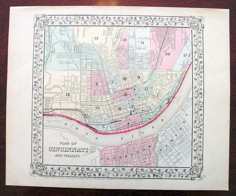
1869 Mitchell Antique Map - Plan of The City of Cincinnati
- Title : Plan of Cincinnati and Vicinity....1869 by S. Augustus Mitchell
- Ref #: 35044
- Size: 15in x 12in (380mm x 300mm)
- Date : 1870
- Condition: (A+) Fine Condition
Description:
This beautifully hand coloured original antique city plan map was published by Samuel Augustus Mitchell in the 1870 edition of his large New General Atlas - dated at the foot of the map.
These county, state, city & country maps are some of the most ornate and beautifully coloured maps published in the US in the 19th century. For over 50 years, Mitchell his son's and their successors were the most prominent cartographical publishers of maps and atlases in the United States.
General Description:
Paper thickness and quality: - Heavy & stable
Paper color: - White
Age of map color: - Original
Colors used: - Green, pink, yellow
General color appearance: - Authentic
Paper size: - 15in x 12in (380mm x 300mm)
Plate size: - 15in x 12in (380mm x 300mm)
Margins: - Min 1/2in (10mm)
Imperfections:
Margins: - None
Plate area: - None
Verso: - None
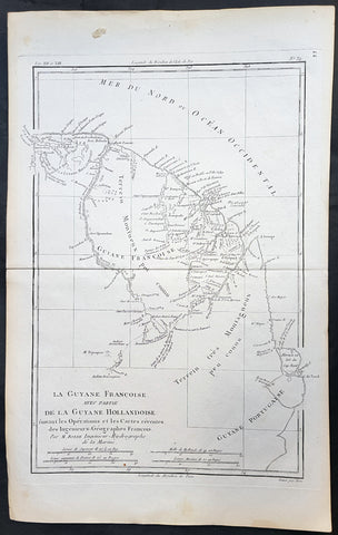
1780 Rigobert Bonne Antique Map Guyana, Suriname & French Guiana, South America
- Title : La Guyane Francoise avec Partie De La Guyane Hollandoise... Par M. Bonne
- Ref #: 31682
- Size: 15in x 10in (385mm x 255mm)
- Date : 1780
- Condition: (A+) Fine Condition
Description:
This fine original copper plate engraved antique map of Guyana, Suriname & French Guiana, South America by Rigobert Bonne was published in the 1780 edition of Atlas des toutes les parties connues du globe terrestre by Guillaume Raynal.
General Definitions:
Paper thickness and quality: - Heavy and stable
Paper color : - off white
Age of map color: -
Colors used: -
General color appearance: -
Paper size: - 15in x 10in (385mm x 255mm)
Plate size: - 13in x 9in (330mm x 230mm)
Margins: - Min 1/2in (12mm)
Imperfections:
Margins: - None
Plate area: - None
Verso: - None
Background:
Guyana officially the Co-operative Republic of Guyana, is a country on the northern mainland of South America. It is, however, often considered part of the Caribbean region because of its strong cultural, historical, and political ties with other Anglo-Caribbean countries and the Caribbean Community.
The region known as the Guianas consists of the large shield landmass north of the Amazon River and east of the Orinoco River known as the \"land of many waters. Originally inhabited by many indigenous groups, Guyana was settled by the Dutch before coming under British control in the late 18th century. It was governed as British Guiana, with a mostly plantation-style economy until the 1950s.
Suriname officially known as the Republic of Suriname is a country on the northeastern Atlantic coast of South America. It is bordered by the Atlantic Ocean to the north, French Guiana to the east, Guyana to the west and Brazil to the south.
Suriname was long inhabited by various indigenous people before being invaded and contested by European powers from the 16th century, eventually coming under Dutch rule in the late 17th century. During the Dutch colonial period, it was primarily a plantation economy dependent on African slaves and, following the abolition of slavery, indentured servants from Asia.
French Guiana is an overseas department and region of France, on the north Atlantic coast of South America in the Guyanas. It borders Brazil to the east and south and Suriname to the west.
Before European contact, the territory was originally inhabited by Native Americans, most speaking the Arawak language, of the Arawakan language family. The people identified as Lokono. The first French establishment is recorded in 1503, but France did not establish a durable presence until colonists founded Cayenne in 1643. Guiana was developed as a slave society, where planters imported Africans as enslaved laborers on large sugar and other plantations in such number as to increase the population. Slavery was abolished in the colonies at the time of the French Revolution. Guiana was designated as a French department in 1797. But, after France gave up its territory in North America, it developed Guiana as a penal colony, establishing a network of camps and penitentiaries along the coast where prisoners from metropolitan France were sentenced to forced labor.
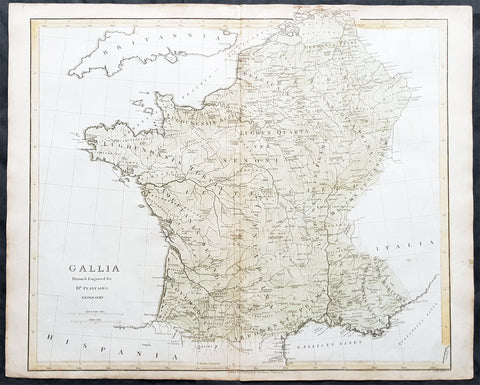
1808 Dr Playfair Large Old, Antique Map of France - Gallia
- Title : Gallia Drawn & Engraved Dr Playfairs Geography
- Ref #: 31155
- Size: 23 1/2in x 19in (595mm x 485mm)
- Date : 1808
- Condition: (A+) Fine Condition
Description:
This large original antique copper-plate engraved map of France was engraved in 1808 by B Smith - dated at the foot of the map - and was published in the 1808 edition of Dr Playfair's General Atlas. (Ref Tooley M&B)
General Description:
Paper thickness and quality: - Heavy and stable
Paper color: - off white
Age of map color: - Early
Colors used: - Green, yellow
General color appearance: - Authentic
Paper size: - 23 1/2in x 19in (595mm x 485mm)
Plate size: - 23 1/2in x 19in (595mm x 485mm)
Margins: - Min 1/2in (12mm)
Imperfections:
Margins: - Light age toning in margins
Plate area: - None
Verso: - None
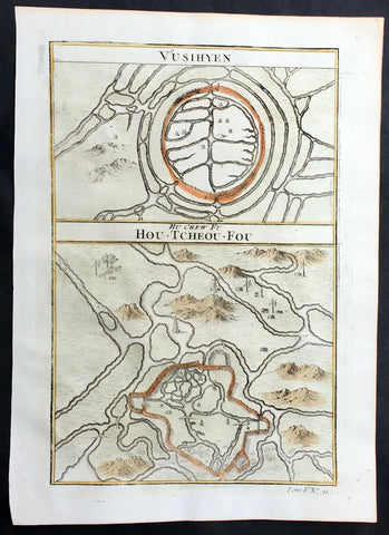
1755 Prevost Antique Plans Cities of Jinhua & Pinghu in Zhejiang Province, China
- Title: Vusihyen; Hou-Tcheou-Fou
- Date: 1755
- Size: 10in x 7 1/2in (255mm x 190mm)
- Ref: 25777
- Condition : (A+) Fine Condition
Description:
This fine, original copper-plate engraved antique map, plans of the cities of Jinhua & Pinghu in the eastern Chinese province of Zhejiang by Jakob van Schley in 1755 - after Jean-Baptiste Du Halde - was published in Antoine François Prevosts 15 volumes of Histoire Generale des Voyages written by Prevost & other authors between 1746-1789.
Jean-Baptiste Du Halde, born in Paris on 1 February 1674 and died 18 August 1743, was a French Jesuit historian specializing in China. He did not travel to China, but collected seventeen Jesuit missionaries\\\' reports and provided an encyclopedic survey of the history, culture and society of China and Chinese Tartary, that is, Manchuria.
General Definitions:
Paper thickness and quality: - Heavy and stable
Paper color : - off white
Age of map color: - Original
Colors used: - Yellow, green, blue, pink
General color appearance: - Authentic
Paper size: - 10in x 7 1/2in (255mm x 190mm)
Plate size: - 10in x 7 1/2in (255mm x 190mm)
Margins: - Min 1/2in (12mm)
Imperfections:
Margins: - None
Plate area: - None
Verso: - None
Background:
Zhejiang formerly romanized as Chekiang, is an eastern coastal province of China. Zhejiang is bordered by the Jiangsu province and the Shanghai municipality to the north, the Anhui province to the northwest, the Jiangxi province to the west, and the Fujian province to the south. To the east is the East China Sea, beyond which lies the Ryukyu Islands of Japan.
Zhejiang was finally conquered by the Mongols in the late 13th century who later established the short lived Yuan Dynasty.
The Ming dynasty, which drove out the Mongols in 1368, finally established the present day province of Zhejiang with its borders having little changes since this establishment.
As in other coastal provinces, number of fortresses were constructed along the Zhejiang coast during the early Ming to defend the land against pirate incursions. Some of them have been preserved or restored, such as Pucheng in the south of the province (Cangnan County).
Under the late Ming dynasty and the Qing dynasty that followed it, Zhejiang\'s ports were important centers of international trade.
In 1727 the to-min or \'idle people\' of Cheh Kiang province (a Ningpo name still existing), the yoh-hu or \'music people\' of Shanxi province, the si-min or \'small people\' of Kiang Su (Jiangsu) province, and the Tanka people or \'egg-people\' of Canton (to this day the boat population there), were all freed from their social disabilities, and allowed to count as free men. Cheh Kiang is another romanization for Zhejiang. The Duomin are a caste of outcasts in this province.
During the First Opium War, the British navy defeated Eight Banners forces at Ningboand Dinghai. Under the terms of the Treaty of Nanking, signed in 1843, Ningbo became one of the five Chinese treaty ports opened to virtually unrestricted foreign trade. Much of Zhejiang came under the control of the Taiping Heavenly Kingdom during the Taiping Rebellion, which resulted in a considerable loss of life in the north-western and central parts of the province, sparing the rest of Zhejiang from the disastrous depopulation that occurred. In 1876, Wenzhou became Zhejiang\'s second treaty port. Jianghuai Mandarin speakers later came to settle in these depopulated regions of northern Zhejiang.
Jinhua is a prefecture-level city in central Zhejiang province in eastern China. It borders the provincial capital of Hangzhou to the northwest, Quzhou to the southwest, Lishui to the south, Taizhou to the east, and Shaoxing to the northeast.
The history of Jinhua dates back to the 2nd century BC, when it was a county subordinate to Shaoxing. It was given the name Jinhua under the Sui dynasty in AD 598 and later became the seat of a prefecture. The present city and its walls date to the time of the Mongol emperors in 1352.
The most famous native of Jinhua is Huang Chuping, a Daoist holy man of the 4th century and reputed immortal whose descendants still live in the area. Wuyang Shan (Reclining Sheep Mountain) is said to be a sheep which was turned to stone by Huang, a trick which he learned through his years of diligently studying Daoism.
Economically Jinhua has always prospered from its position as the regional collecting and processing center for agricultural and forestry products (chiefly rice and bamboo). It is currently the second most important grain producing area in Zhejiang. In 1985 Jinhua was promoted to City status, and now is responsible for administering four cities, four counties and a district. Animals raised there include dairy cattle, meat hogs (for the production of Jinhua ham, a famous local product for 900 years) and honeybees. Jinhua\'s industrial sector has developed more recently, producing machinery, metallurgy, pharmaceuticals, building supplies and electrical and electronic equipment.
The Tang dynasty painter Guan Xiu (Kuan-hsiu) was born in Jinhua. He is known for his paintings of Buddhist holy men.
There are numerous scenic and historical sites in the Jinhua region, including many places associated with the Immortal Huang, and a palace of the Dukes of the Taiping Heavenly Kingdom.
Pinghu is a county-level city in northeast Zhejiang Province, just outside Shanghai. It sits next to the East China Sea and the north shore of Hangzhou Bay. Prior to the Ming Dynasty, Pinghu was part of Haiyan County. In 1430 Pinghu County was established. In 1991 Pinghu became a county-level city under the administration of the prefecture-level city of Jiaxing.
Zhapu, the site of a deepwater harbor, was the principal site of China\'s foreign trade with Korea and Japan during the 18th and 19th century.

1740 Bellin Antique Coastal Map of South East Africa - South Africa to Zanzibar
- Title : Carte de la Coste Orientale D Afrique...1740
- Date : 1740
- Size: 12in x 9 1/2in (305mm x 240mm)
- Ref #: 92509
- Condition: (A+) Fine Condition
Description:
This fine large, original copper-plate engraved antique map of South and Eastern Coast of Africa from South Africa to Zanzibar by Jacques Nicolas Bellin in 1740 was published in Antoine François Prevosts 15 volumes of Histoire Generale des Voyages written by Prevost & other authors between 1746-1790.
General Condition:
Paper thickness and quality: - Heavy and stable
Paper color: - off white
Age of map color: - Early
Colors used: - Red, green, yellow
General color appearance: - Authentic
Paper size: - 12in x 9 1/2in (305mm x 240mm)
Plate size: - 10in x 8in (255mm x 205mm)
Margins: - Min 1/2in (12mm)
Imperfections:
Margins: - None
Plate area: - Folds as issued
Verso: - None
Background:
One of Antoine Francois Prevosts monumental undertakings was his history of exploration & discovery in 15 volumes titledHistoire Générale des Voyages written between 1746-1759 and was extended to 20 volumes after his death by various authors.
The 20 volumes cover the early explorations & discoveries on 3 continents: Africa (v. 1-5), Asia (v. 5-11), and America (v. 12-15) with material on the finding of the French, English, Dutch, and Portugese.
A number of notable cartographers and engravers contributed to the copper plate maps and views to the 20 volumes including Nicolas Bellin, Jan Schley, Chedel, Franc Aveline, Fessard, and many others.
The African volumes cover primarily coastal countries of West, Southern, and Eastern Africa, plus the Congo, Madagascar, Arabia and the Persian Gulf areas.
The Asian volumes cover China, Korea, Tibet, Japan, Philippines, and countries bordering the Indian Ocean.
Volume 11 includes Australia and Antarctica.
Volumes 12-15 cover voyages and discoveries in America, including the East Indies, South, Central and North America.
Volumes 16-20 include supplement volumes & tables along with continuation of voyages and discoveries in Russia, Northern Europe, America, Asia & Australia.
1709 Dahlbergh & Aveelen Antique Map & View of Finsta in Stockholm, Sweden
- Title : Finsta
- Ref #: 70449
- Size: 16 1/2in x 12 1/2in (420mm x 315mm)
- Date : 1709
- Condition: (A+) Fine Condition
Description:
This large original copper-plate engraved antique map & view of Finsta in Stockholm, Sweden by Johannes van den Aveelen was published in the 1709 edition of Erik Dahlbergh's Suecia Antiqua et Hodierna (Ancient and Modern Sweden).
Finsta is a locality situated in Norrtälje Municipality, Stockholm County, Sweden
Background: Suecia Antiqua et Hodierna (ancient and modern Sweden) is a collection of engravings collected by Erik Dahlbergh during the middle of the 17th century. Suecia Antiqua et Hodierna can be described as a grand vision of Sweden during its period as a great power. Dahlberg's direct source of inspiration was the topographical publications issued by the Swiss publisher Matthäus Merian.
In 1661 Dahlberg was granted a royal privilege enabling him to realize his plans, which kept him occupied for a good decade, and a work that would not be printed until after his death. In its final state Suecia Antiqua et Hodierna comprised three volumes containing 353 plates.
Jan van den Aveele or Aveelen (1650 - 1727) was a Dutch etcher and copper engraver. With compatriot Willem Swidde, he made engravings for Suecia Antiqua et Hodierna ("Ancient and Modern Sweden") including depictions of public buildings and city scapes in Stockholm and other Swedish cities. (Ref Tooley M&B)
General Description:
Paper thickness and quality: - Heavy and stable
Paper color: - off white
Age of map color: -
Colors used: -
General color appearance: -
Paper size: - 16 1/2in x 12 1/2in (420mm x 315mm)
Plate size: - 13in x 10in (330mm x 255mm)
Margins: - Min 1/2in (12mm)
Imperfections:
Margins: - None
Plate area: - None
Verso: - None
1780 Rigobert Bonne Original Antique Map of Scandinavia Sweden, Norway & Denmark
- Title : Les Royaumes De Suede De Denmark et de Norwege
- Size: 16in x 11in (405mm x 2805mm)
- Ref #: 40525
- Date : 1780
- Condition: (A+) Fine Condition
Description:
This fine original copper-plate engraved antique map of Scandinavia, Sweden, Norwaty and Denmark was published in 1780 edition of Atlas des toutes les parties connues du globe terrestre by Rigobert Bonne & Guillaume Raynal.
General Definitions:
Paper thickness and quality: - Heavy and stable
Paper color : - off white
Age of map color: -
Colors used: -
General color appearance: -
Paper size: - 16in x 11in (405mm x 2805mm)
Plate size: - 14in x 10in (355mm x 255mm)
Margins: - Min 1/2in (12mm)
Imperfections:
Margins: - None
Plate area: - None
Verso: - None
1780 Bonne Original Antique Map of Scandinavia, Baltic States & European Russia
- Title : Le Nord De L Europe contenant Le Danemark La Norwege, La Suede et la Laponie avec la Majeure Partie de la Russie Europeenne Par M Bonne
- Size: 16in x 11in (405mm x 2805mm)
- Ref #: 31671
- Date : 1780
- Condition: (A+) Fine Condition
Description:
This fine original copper-plate engraved antique map of Scandinavia, The Baltic States & European Russia was published in 1780 edition of Atlas des toutes les parties connues du globe terrestre by Rigobert Bonne & Guillaume Raynal.
General Definitions:
Paper thickness and quality: - Heavy and stable
Paper color : - off white
Age of map color: -
Colors used: -
General color appearance: -
Paper size: - 16in x 11in (405mm x 2805mm)
Plate size: - 14in x 10in (355mm x 255mm)
Margins: - Min 1/2in (12mm)
Imperfections:
Margins: - None
Plate area: - None
Verso: - None
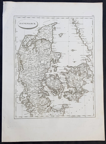
1804 Jean N Buache Original Antique Map of Denmark
- Title : Danemarck
- Size: 13in x 9 1/2in (330mm x 245mm)
- Ref #: 34190
- Date : 1804
- Condition: (A+) Fine Condition
Description:
This fine original copper-plate engraved antique map was published in the 1804 edition of Jean Nicolas Buache Atlas Geographie Moderne.
The maps in this atlas were illustrated by Jean Nicolas Buache - nephew to Phillipe Buache who was son-in-law to Nicolas Delisle - after maps published by the Scottish publisher John Pinkerton.
General Definitions:
Paper thickness and quality: - Heavy and stable
Paper color : - off white
Age of map color: -
Colors used: -
General color appearance: -
Paper size: - 13in x 9 1/2in (330mm x 245mm)
Plate size: - 11in x 9in (280mm x 230mm)
Margins: - Min 1/2in (12mm)
Imperfections:
Margins: - Light soiling in margins
Plate area: - None
Verso: - None
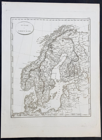
1804 Jean N Buache Original Antique Map of Scandinavia, Sweden Norway & Baltics
- Title : A Suede et Norwege
- Size: 13in x 9 1/2in (330mm x 245mm)
- Ref #: 34191
- Date : 1804
- Condition: (A+) Fine Condition
Description:
This fine original copper-plate engraved antique map was published in the 1804 edition of Jean Nicolas Buache Atlas Geographie Moderne.
The maps in this atlas were illustrated by Jean Nicolas Buache - nephew to Phillipe Buache who was son-in-law to Nicolas Delisle - after maps published by the Scottish publisher John Pinkerton.
General Definitions:
Paper thickness and quality: - Heavy and stable
Paper color : - off white
Age of map color: -
Colors used: -
General color appearance: -
Paper size: - 13in x 9 1/2in (330mm x 245mm)
Plate size: - 11in x 9in (280mm x 230mm)
Margins: - Min 1/2in (12mm)
Imperfections:
Margins: - Light soiling in margins
Plate area: - None
Verso: - None
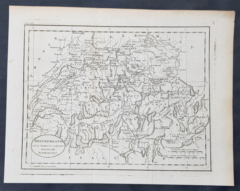
1770 John Cary Original Antique Map of Switzerland
- Title : Switzerland with its Subjects & Allies from the Best Authorities
- Size: 10 1/2in x 8 1/2in (265mm x 215mm)
- Ref #: 70188
- Date : 1770
- Condition: (A+) Fine Condition
Description:
This fine original copper-plate engraved antique map by Thomas Kitchen was published in the 1770 edition of the atlas for William Guthries Geographical Grammar
General Definitions:
Paper thickness and quality: - Heavy and stable
Paper color : - off white
Age of map color: -
Colors used: -
General color appearance: -
Paper size: - 10 1/2in x 8 1/2in (265mm x 215mm)
Plate size: - 10 1/2in x 8 1/2in (265mm x 215mm)
Margins: - Min 1/2in (12mm)
Imperfections:
Margins: - None
Plate area: - Folds as issued
Verso: - None
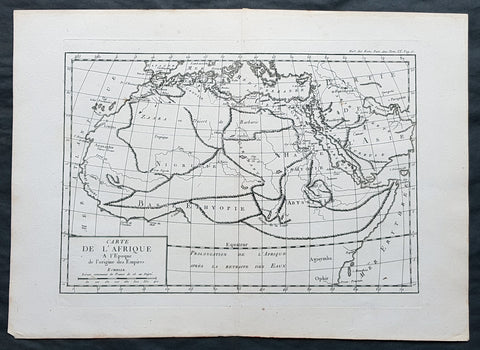
1769 J B D Anville Original Antique Map of Africa as known to the Ancients
- Title : Carte De L Afrique a l Epoque de l origine des Empires
- Size: 16in x 11in (410mm x 260mm)
- Ref #: 32341
- Date : 1769
- Condition: (A+) Fine Condition
Description:
This fine large, original copper-plate engraved antique map was published by Jean Baptiste Bourguignon D\'Anville in the 1769 edition of his atlas Geographie Ancienne et Abregee. or Modern and Ancient Geography (Ref: M&B; Tooley)
General Definitions:
Paper thickness and quality: - Heavy and stable
Paper color : - off white
Age of map color: -
Colors used: -
General color appearance: -
Paper size: - 16in x 11in (410mm x 260mm)
Plate size: - 13in x 9 1/2in (330mm x 245mm)
Margins: - Min 1/2in (12mm)
Imperfections:
Margins: - None
Plate area: - None
Verso: - None
1782 Du Bocage & Barthelemy Antique Map of The Dardanelles, Turkey - Hellespont
- Title : L Helles-Pont...1782
- Size: 15in x 10in (380mm x 255mm)
- Ref #: 16467
- Date : 1782
- Condition: (A+) Fine Condition
Description:
This original copper-plate engraved map by Jean Denis Barbie du Bocage was engraved in 1782 - dated in the title - and was published in the 1787 edition of Jean-Jacques Barthelemy famous Voyage du jeune Anarcharsis en Grece or Travels of Anacharsis the younger in Greecein 4 volumes.
General Definitions:
Paper thickness and quality: - Heavy and stable
Paper color : - off white
Age of map color: -
Colors used: -
General color appearance: -
Paper size: - 15in x 10in (380mm x 255mm)
Plate size: - 8 1/2in x 7 1/2in (215mm x 185mm)
Margins: - Min 1in (25mm)
Imperfections:
Margins: - None
Plate area: - Folds as issued
Verso: - None
Background:
Jean-Jacques Barthelemy 1716 – 1795 was a French writer and numismatist.
Barthelemy was the author of a number of learned works on antiquarian subjects, but the great work on which his fame rests is Travels of Anacharsis the younger in Greece (French: Voyage du jeune Anarcharsis en Grece, 4 vols., 1787). He had begun it in 1757 and had been working on it for thirty years. The hero, a young Scythian descended from the famous philosopher Anacharsis, is supposed to repair to Greece for instruction in his early youth, and after making the tour of her republics, colonies and islands, to return to his native country and write this book in his old age, after the Macedonian hero had overturned the Persian empire. In the manner of modern travellers, he gives an account of the customs, government, and antiquities of the country he is supposed to have visited. A copious introduction supplies whatever may be wanting in respect to historical details, while various dissertations on the music of the Greeks, on the literature of the Athenians, and on the economy, pursuits, ruling passions, manners, and customs of the surrounding states supply ample information on the subjects of which they treat.
Modern scholarship has superseded most of the details in the Voyage, but the author himself did not imagine his book to be a register of accurately ascertained facts. Rather, he intended to afford to his countrymen, in an interesting form, some knowledge of Greek civilisation. The Charicles, or Illustrations of the Private Life of the Ancient Greeks of Wilhelm Adolf Becker is an attempt in a similar direction