Maps (804)
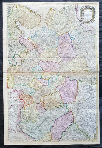
1712 Senex Large Original Antique Map of Europe Russia, Moscow - Finland to Azov
Antique Map
- Title : Moscovy Corrected from ye Observations Communicated to the Royal Society of London and Paris By John Senex & John Maxwell. Sold by them at the Globe.....1712
- Ref #: 82074
- Size: 39 1/2in x 26 1/2in (980mm x 675mm)
- Date : 1712
- Condition: (A) Very Good Condition
Description:
This extraordinary, very large & beautifully hand coloured original antique map of European Russia - Moscovy - including parts of Scandinavia, the Baltic States & The Ukraine by John Senex & John Maxwell in 1712 - dated in title - and was published for Senex's large Elephant Folio General Atlas.
These large scale maps are scarce as damage and loss over time was frequent from both handling and difficulty storing safely.
Background: It is scarcely necessary to look at a map of Russia - with which we must include Siberia - to visualize the daunting task facing Russian map makers. Indeed, considering the vastness of their territory and the lack of skilled cartographers, it is surprising that relatively good maps were available for engraving and printing in most of the well known sixteenth and seventeenth century atlases. Generally, maps of that time were based on material brought back from Moscow by visitors from the West. (Ref: Tooley; M&B)
General Description:
Paper thickness and quality: - Heavy and stable
Paper color: - white
Age of map color: - Original & later
Colors used: - Yellow, green, blue, red
General color appearance: - Authentic
Paper size: - 39 1/2in x 26 1/2in (980mm x 675mm)
Plate size: - 37in x 25in (930mm x 635mm)
Margins: - min. 1/2in (12mm)
Imperfections:
Margins: - None
Plate area: - Light age toning along centerfold & top of image
Verso: - Folds re-enforced on verso
1692 Alexis Jaillot Large Antique Map of Great Britain & Ireland
Antique Map
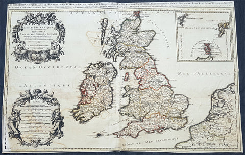
- Title : Les Isles Britanniques; qui Contiennent les Royaumes d\'Angleterre, Escosse, et Irlande...Alexis Hubert Jaillot...1692
- Size: 34 1/2in x 22 1/2in (880m x 570mm)
- Condition: (B) Good Condition
- Date : 1692
- Ref #: 50658
Description:
This large, original hand coloured, antique map of the British Isles & Ireland by Alexis Hubert Jaillot - after Nicolas Sanson - was engraved in 1692 - the date is engraved in the scale cartouche.
There were three plates engraved for this highly prized map between the 1670s and early 1700s. This map is from the 2nd plate, state 4.
General Definitions:
Paper thickness and quality: - Heavy and stable
Paper color : - off white
Age of map color: - Original
Colors used: - Yellow, green, blue, pink
General color appearance: - Authentic
Paper size: - 34 1/2in x 22 1/2in (880m x 570mm)
Plate size: - 34 1/2in x 22 1/2in (880m x 570mm)
Margins: - Min 1/4in (4mm)
Imperfections:
Margins: - Bottom left corner and border restored. Margins cropped to plate-mark
Plate area: - Light offsetting & creasing.
Verso: - Several tears re-joined without loss
Background:
English Cartography: When considering the work of English map makers we tend, perhaps, to think too much in terms of county maps, dominated by the names of Saxton and Speed, but we should not underrate the contribution to the sum of geographical knowledge made in other spheres, such as the sea charts of Edward Wright, Robert Dudley and Greenvile Collins, the discoveries of James Cook, the road maps of Ogilby and Cary, the meteorological and magnetic charts compiled by Edmund Halley, to mention only a few.
In 1558 Queen Elizabeth came to the throne in the midst of a fast changing world. In 1563 a nineteen sheet map, copies of which survive only in manuscript form, was completed by Laurence Nowell, and no doubt, the issue of Mercator\'s large-scale map of the British Isles in 1564 had an important influence on the thought of the period. A few years later a national survey was commissioned privately, although probably at the instigation of Lord Burghley, the Lord Treasurer, but subsequently was completed with royal encouragement. The outcome was Christopher Saxton\'s Atlas of EngIand and Wales, started about 1570 and published in 1579 - the first printed set of county maps and the first countrywide atlas on such a splendid scale produced anywhere. A Welsh antiquarian, Humphrey Lhuyd completed a set of surveys that were even more successful than Saxton in which he had produced fine manuscript maps of England and Wales which were used by Ortelius in editions of his Atlas from 1573 onwards.
The earliest maps of the 17th century, attributed to William Smith of the College of Heralds, covered only twelve counties based on Saxton/Norden and were presumably intended to be part of a complete new atlas. They were printed in the Low Countries in 1602-3 and were soon followed by maps for the Latin edition of Camden\'s Britannia dated 1607. In 1610-11 the first edition of John Speed\'s famous county Atlas The Theatre of the Empire of Great Britaine was published and immediately replaced Saxton\'s in popular appeal. Although Speed assembled much of his material from the earlier works of Saxton, Norden and others, a considerable part of the up-to-date information, especially relating to the inset town plans depicted on his maps, was obtained first hand. The maps undoubtedly owed much of their popularity to the splendid engravings of high quality made in the workshops in Amsterdam of Jodocus Hondius to whom Speed sent his manuscripts, the plates subsequently being returned to London for printing.
In 1645, Volume IV of the famous Blaeu World Atlas covering the counties of England and Wales was published in Amsterdam. These maps have always been esteemed as superb examples of engraving and design, the calligraphy being particularly splendid, but nevertheless they were nearly all based on Saxton and Speed and added little to geographical knowledge.
Not until the latter part of the century do we find an English map maker of originality with the capacity to put new ideas into practice. John Ogilby, one of the more colourful figures associated with cartography, started life as a dancing master and finished as King\'s Cosmographer and Geographic Printer. After publishing a small number of county maps, somewhat on the lines of John Norden he issued in 1675 the Britannia, the first practical series of detailed maps of the post roads of England and Wales on a standard scale of 1,760 yards to the mile. Up to the end of the century and beyond, reprints and revisions of Saxton\'s and Speed\'s atlases continued to appear and the only other noteworthy county maps were Richard Blome\'s Britannia (1673), John Overton\'s Atlas (c. 1670) and Robert Morden\'s maps for an English translation of Camden\'s Britannia published in 1695.
Another noted cartographer of the day was Captain Greenvile Collins, and of his work in surveying the coasts of Great Britain culminating in the issue in 1693 of the Great Britain\'s Coasting Pilot. Apart from these charts, English cartographers published during the century a number of world atlases. Speed was the first Englishman to produce a world atlas with the issue in 1627 of his A Prospect of the Most Famous Parts of the World. Other atlases appeared later in the century by Peter Heylin, John Seller, William Berry, Moses Pitt and Richard Blome, whilst Ogilby found time to issue maps of Africa, America and Asia. Far more important, from the purely scientific point of view, was the work of Edmund Halley, Astronomer Royal, who compiled and issued meteorological and magnetic charts in 1688 and 1701 respectively.
At the beginning of the eighteenth century the Dutch map trade was finally in decline, the French in the ascendant and the English to a great extent still dominated by Saxton and Speed except, as we have shown, in the spheres of sea charts and road maps. There were atlases by John Senex, the Bowles family, Emanuel and Thomas Bowen, Thomas Badeslade and the unique bird\'s-eye perspective views of the counties, The British Monarchy by George Bickham. In 1750-60 Bowen and Kitchin\'s The Large English Atlas containing maps on a rather larger scale than hitherto was published.
In 1759 the Society for the encouragement of Arts, Manufactures and Commerce offered an award of £100 for the best original surveys on this scale and by the end of the century about thirty counties had been re-surveyed. These maps, many of which formed, in later years, the basis for the first issues of county maps by the Ordnance Survey Office were not only decorative but a tremendous improvement geographically on earlier local maps. As a consequence, the skills and expertise of the new-style cartographers soon enabled them to cover the world as well as the domestic market. Thomas Jefferys was such a man; he was responsible for a number of the new 1 in. to 1 mile county surveys and he issued an edition of Saxton\'s much battered 200-year-old plates of the county maps, but he is better known for many fine maps of North America and the West Indies. His work was continued on the same lines by William Faden, trading as Faden and Jefferys. Other publishers such as Sayer and Bennett and their successors Laurie and Whittle published a prodigious range of maps, charts and atlases in the second half of the century. A major influence at this time was John Cary who, apart from organizing the first re-survey of post roads since Ogilby and subsequently printing the noted Travellers\' Companion, was a prolific publisher of atlases and maps of every kind of all parts of the world. After starting work with Cary, and taking part in the new road survey, Aaron Arrowsmith set up in his own business and went on to issue splendid large-scale maps of many parts of the world. Both Cary\'s and Arrowsmith\'s plates were used by other publishers until far into the next century and, in turn, their work was taken up and developed by James Wyld (Elder and Younger) and Tallis and Co.
Later into the 19th century some of the better known cartographers and publishers were by Henry Teesdale (1829-30), Christopher and John Greenwood, surveyors, Thomas Moule, a writer on heraldry and antiques (1830-36) and John Walker (1837) but by about the middle of the century few small-scale publishers survived and their business passed into the hands of large commercial concerns such as Bartholomews of Edinburgh and Philips of London who continue to this day. (Ref: Shirley; Tooley; M&B)
18th century Antique Japanese Map of Shimotsuke-no kuni Province 下野国 - Japan 日本
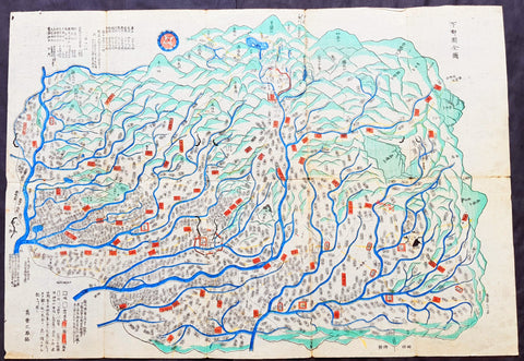
- Title : Shimotsuke Province - 下野国 Shimotsuke-no kuni
- Size: 21in x 14 1/2in (535mm x 370mm)
- Condition: (A) Very Good Condition
- Date : 18th century
- Ref #: 91306
Description:
A unique opportunity to acquire an original, rare antique wood-block engraved Japanese map.
This beautiful hand coloured map of the Shimotsuke Province - 下野国 Shimotsuke-no kuni - today part of the Tochigi Prefecture - was published in the ca 18th century.
There is a high level of artistry & detail that makes this wood-block engraved map uniquely Japanese.
The is a beautiful birds-eye view map of the province with Lake Chūzenji (中禅寺湖 Chūzenji-ko) and the city of Nikkō (日光市 Nikkō-shi) at the top of the map. A partial translation accompanys the map. This translation explains the following;
Shimtsuke, ancient name for Tochigi, area 6,436sq Kilmometers. Nikko with Lake Chuzenji is shown at the top of the sheet. On the left side top are shown the names of the 9 districts into which Shimotsuke was divided, showing 1,148 villages (on the map). Further the rice crops for the villages given as 506,061 koku, that is 252,000 bushels
General Definitions:
Paper thickness and quality: - Heavy and stable
Paper color : - off white
Age of map color: - Original
Colors used: - Blue, green, red
General color appearance: - Authentic
Paper size: - 21in x 14 1/2in (535mm x 370mm)
Plate size: - 21in x 14 1/2in (535mm x 370mm)
Margins: - Min 1/4in (5mm)
Imperfections:
Margins: - Light wear
Plate area: - Folds as issued, light wear along folds, several small worm tracks in 10 places on image
Verso: - Folds as issued, light wear along folds, several small worm tracks in 10 places on image
Background:
Shimotsuke Province (下野国 Shimotsuke-no kuni) was a province of Japan in the area of Japan that is today Tochigi Prefecture.[1] Shimotsuke was bordered by Kōzuke, Hitachi, Mutsu and Shimōsa Provinces. Its abbreviated form name was Yashū (野州). Under the Engishiki classification system, Shimotsuke was ranked as one of the 13 \"great countries\" (大国) in terms of importance, and one of the 30 \"far countries\" (遠国) in terms of distance from the capital. The provincial capital is located in what is now the city of Tochigi. The Ichinomiya of the province is the Futarasan jinja located in what is now the city of Utsunomiya.
During the 4th century AD, (Kofun period) the area of modern Gunma and southern Tochigi prefectures were known as Keno or Kenu (毛野). At some unknown point in the 5th century, the area was divided at the Kinugawa River into Kamitsukeno (上毛野) and Shimotsukeno (下毛野). Per the Nara period Taihō Code, these provinces became Kamitsukeno-no-kuni (上毛野国) and Shimotsukeno-no-kuni (下毛野国). In 713, with the standardization of province names into two kanji, these names became Kōzuke (上野) and Shimozuke (下野).
The area of Shimotsuke is mentioned frequently in the Nara period Rikkokushi, including the Nihon Shoki and had strong connections with the Yamato court since the Kofun period. A large Buddhist temple complex, the Shimotsuke Yakushi-ji, located in what is now the city of Tochigi, dates from the Nara period.
From the Heian period, the area was dominated by a number of samurai bands, including the Utsunomiya clan, and the Nasu clan. A branch of the Minamoto clan, the Ashikaga rose to prominence during the Kamakura period from their shōen at what is now Ashikaga, and went on to create the ashikaga shogunate of the Muromachi period.
During the Sengoku period, Shimotsuke was contested between the later Hōjō clan ,the Takeda and the Uesugi clans. After the establishment of the Tokugawa shogunate, much of the province was assigned to several feudal domains. Tokugawa Ieyasu and Tokugawa Iemitsu chose the sacred site of Nikkō to be the location of their tombs, and thus the area prospered as a site of pilgrimage through the end of the Edo period.
The Nikkō Kaidō and the Ōshū Kaidō highways passed through the province, and numerous post stations were established.
Following the Meiji Restoration, the various domains became prefectures with the abolition of the han system in 1871. These various prefectures merged to form Gunma Prefecture in 1873.
Nikkō (日光市 Nikkō-shi) is a city located in Tochigi Prefecture, Japan. Shōdō Shōnin (勝道上人) established the temple of Rinnō-ji in 766, followed by the temple of Chūzen-ji in 784. The village of Nikkō developed around these temples. The shrine of Nikkō Tōshō-gū was completed in 1617 and became a major draw of visitors to the area during the Edo period. It is known as the burial place of the famous Japanese shōgun Tokugawa Ieyasu. A number of new roads were built during this time to provide easier access to Nikkō from surrounding regions. Nikkō Tōshō-gū, Futarasan Shrine, and Rinnō-ji now form the UNESCO World Heritage Site Shrines and Temples of Nikkō.
Lake Chūzenji (中禅寺湖 Chūzenji-ko) is a scenic lake in Nikkō National Park in the city of Nikkō, Tochigi Prefecture, Japan.
Chuzenji Lake was discovered in 782 by a priest named Shōdō when his group succeeded in climbing Mt. Nantai. Considered sacred, the mountain was closed to women, horses, and cows until 1872. In the middle of the Meiji period and early Showa period, many European embassies built vacation houses around the lake. The former Italian villa has been renewed and is now open to visitors. Other sites around the lake include Futara Shrine built in 790, Chuzenji Temple, and Kegon Falls.
Japanese Cartography
The earliest known term used for maps in Japan is believed to be kata (形, roughly form), which was probably in use until roughly the 8th century. During the Nara period, the term zu(図) came into use, but the term most widely used and associated with maps in pre-modern Japan is ezu (絵図, roughly “picture diagram”). As the term implies, ezu were not necessarily geographically accurate depictions of physical landscape, as is generally associated with maps in modern times, but pictorial images, often including spiritual landscape in addition to physical geography. Ezu often focused on the conveyance of relative information as opposed to adherence to visible contour. For example, an ezu of a temple may include surrounding scenery and clouds to give an impression of nature, human figures to give a sense of how the depicted space is used, and a scale in which more important buildings may appear bigger than less important ones, regardless of actual physical size.
In the late 18th century, translators in Nagasaki translated the Dutch word (land)kaart into Japanese as chizu (地図): today the generally accepted Japanese word for a map.
From 1800 (Kansei 12) through 1821 (Bunsei 4), Ino Tadataka led a government-sponsored topographic surveying and map-making project. This is considered the first modern geographer\\\'s survey of Japan;[1] and the map based on this survey became widely known as the Ino-zu. Later, the Meiji government officially began using the Japanese term chizu in the education system, solidifying the place of the term chizu for \\\"map\\\" in Japanese.
Generally speaking, traditional Japanese maps were quite diverse in style, depiction, and purpose, and were often oriented towards pragmatic use. It was less common for maps to serve literary or decorative purposes as they might in the West, instead being used for purposes such as the differentiation of rice fields on a feudal manor, or orientation within a temple complex. An example might be an Edo era pilgrimage map depicting the route and location of lodges on the road between Kyoto and Edo, including images of people on the road, with distances between stops differentiated not by relative distance, but by numerical markings, as scale as it is recognized in the West today was not generally used. This compression and expansion of space as necessary to emphasize certain qualities of the depicted area is an important characteristic of traditional Japanese maps, as is the regular inclusion of text, as text and image were not separated in Japan nearly to the same degree as in the West. Perspective on traditional Japanese maps can also be confusing to the modern Western viewer, as maps were often designed to be viewed from multiple points of view simultaneously, since maps were often viewed on the floor while the viewers sat around the map in a circle. Accordingly, many maps do not have a unified orientation scheme (such as North as up), with labels sometimes appearing skewed to each other.
Much of the fundamental concepts of space as depicted in Japanese maps can be traced to Chinese geomancy and Buddhist cosmologies, which came to Japan in the 7th and 8th centuries. Buddhist cosmologies depict the world as it was thought to exist within the appropriate religious framework, often including mythical sites such as the navel of the world[citation needed] and lands beyond the sea inhabited by monsters. In this sense, world maps based on Buddhist cosmology often bear little resemblance to the \\\"real world\\\", though many have at least approximately accurate depictions of Japan, Korea, China, and India. Chinese geomancy brought orientation and a regular grid system, as is evidenced in the street plan of Kyoto, which is based on the plan of the ancient Chinese capital of Chang\\\'an. North-South orientation, as in China, is thought to have been evident in the plan of the ancient capital (672–686 AD) of Naniwa (modern Osaka) as well. Hence, although many traditional Japanese maps are characterized by the malleability of space and lack of importance of accurate depiction of physical landscape, direction, distance, and relative orientation were quite important.
Many early Japanese maps were not accurate according to Western standards. Partly, this was the result of Japan being a closed society for many years. They had a long-lasting indifference to exploration as well. And in the feudal society, it was forbidden for ordinary Japanese citizens to travel. \\\"In fact, the Japanese government in Edo (Tokyo), had no interest in accurate map making because maps could be used by enemies to gain military advantage.\\\" Distorting and falsifying maps was known during World War II. Indeed, there was some discussion that captured Japanese maps had been deliberately falsified to confuse the Allied troops. The Army Map Service put out an announcement toward the end of the war that most of the Japanese maps, although sometimes outdated, were truthful and could be used. “In general, native maps of Japan are reliable. Prior to the outbreak of the war, it was alleged that the Japanese falsified certain sheets which they later allowed to fall into our hands. Spot checks against aerial photography have revealed no evidence to substantiate this claim. However, on some of these maps, pertinent military areas were left entirely blank. The US has a basic 1:50,000 coverage for practically all of Japan and 1:25,000 coverage for about a quarter of Japan. These maps, however, do not show the major transformation of man-made features which have taken place in Japan since 1941. Because of this, native Japanese maps are obsolete and their basic reliability is decreased. It is highly important, therefore, that a large-scale map material or trig lists captured from the Japanese be transmitted promptly to the Chief of Engineers in Washington, DC. This is essential also because we possess geographic coordinates for only about a 10th of the estimated 40,000 geodetic stations established in Japan
The oldest known map in Japan is a topographical drawing discovered on a stone wall inside a tomb in the city of Kurayoshi, in Tottori Prefecture, dated to the 6th century AD. Depicting a landscape of houses, bridges, and roads, it is thought to have been made not for practical navigational purposes, but rather as a kind of celestial cartography given to the dead to maintain a connection with the world of the living and allow them to orient themselves when moving on to the other world. Similar maps have been found in other kofun burial tombs as well. There is also evidence that at least rudimentary surveying tools were already in use in this era. One of the oldest written references to maps in a Japanese source is found in the Kojiki, the oldest (albeit largely mythological) history of Japan, in which land records are mentioned. The other major ancient history, the Nihon Shoki of 720 AD, describes a map of the ancient city of Naniwa (modern Osaka). The first map of provincial surveys is thought to be in 738, as described in the Shoku Nihongi. The earliest extant maps in Japan date to the 8th century, and depict the ownership of square rice field plots, oriented to the four cardinal directions. Shinto shrines held maps that they used for agrarian reform, differentiation of property, and land holdings. The system by which these maps were measured was called jōri, measured in units called tan and tsubo.
The Imperial Court of the Emperor Kōtoku (孝徳天皇, 597?–654) put the Handen sei (班田制, lit. ancient land system) into execution in 646 (Taika 2) and asked each province to submit maps of their land holdings, known as denzu (田図, roughly, \\\"picture map of rice fields\\\"). This was considered the first attempt in Japan to draw accurate (as opposed to representational) landscape in picture maps.
During the Shōmu reign (聖武天皇, 701-756), maps known as Gyōki-zu (行基図), named for the high priest Gyōki (高僧, 668–749), were developed. Gyōki himself served as a civil engineer, although there are no explicitly known direct connections between himself and maps per se. The connection between his name and the term Gyōki-zu is thought to be derived from his authority as a priest and perceived connections between maps and geomantic rites to drive away evil spirits. The term Gyōki-zu was widespread and used for maps which illustrated the routes from the Imperial capital to each province in Japan. These maps covered a broader area, and include a much larger portion of what is now known as Japan, giving an idea of the extent of known territory at the time. Maps from these early surveys (conducted in 646, 738, and 796), show the northeasternly extent of Japan to be near the island of Sado, the westerly extent as Kyūshū and the southerly extent as the tip of Shikoku, indicating a relative relationship of orientation, but lack of knowledge of the true cardinal directions, as Kyūshū stretches much further south than Shikoku, and Sado is closer to north than northeast. More important was relative position, especially in terms of the relationship between the capital in Yamashiro Province (modern Nara Prefecture), and as long as the maps accurately depicted this relationship, they were considered useful. The style and orientation of the Gyōki-zu is much in line with the general overview of Japanese maps as described above, and it was this style that formed the dominant framework in Japanese cartography until the late medieval and Edo periods.
\\\"The earliest Japanese maps, attributed to a Buddhist priest called Gyōki Bosatsu (668–749), shows a curious affinity with modern notice boards in public parks. A scheme of outline loops showing land ownership and boundaries, with south generally at the top, characterized this form of mapmaking, a response to the government\\\'s need for feudal information. Examples of such estate surveys surviving from the Nara period in the eighth century (named after the ancient Japanese capital city). They are legible and informative, but unrelated to other aspects of accuracy. Although none of Gogyi\\\'s own maps survive today, cadastral maps in his style still exist in the Shosoin, an imperial archive from that time, and are shown occasionally in the city of Nara. The Gyogi style represented loyalty to a valid tradition. These schematic loops of information, rather than realistic shapes, continued well into the nineteenth century, as did the complex Buddhist world maps, which were also unrelated to knowledge of the world\\\'s shapes of land and sea, but rather, maps of a spiritual landscape.\\\"
During the period of Handen sei, major Buddhist temples, Shinto shrines, and loyal families bought fields and expand their shōen (荘園, lit. manors). Following the manner of denzu, they draw maps of their shōen. The oldest known shōen map is called Sanukikoku yamadagun gufuku jiryo denzu (讃岐国山田郡弘福寺領田図). These denzu were often drawn on linen cloths. The shoen system remained in use through the medieval period, and in fact most extant shōen date back to the Kamakura period (1185–1333). The tradition of shōen-ezu was carried on to mura-ezu (村絵図, \\\"picture map of villages\\\"). Mura-ezu were planar picture maps of individual villages. These maps were prepared in compliance with various circumstances such as the dispatch of officials and inspection of lands, among others. Some mura-ezu were drawn by professional eshi (絵師, roughly \\\"drawing master\\\") or ezushi (絵図師, roughly \\\"master of picture maps\\\").
During the latter half of the 16th century and beyond, traditional Japanese mapmaking became influenced by Western techniques for the first time with the arrival of Dutch and Portuguese knowledge through the trade port of Nagasaki. The theory of the Earth as a sphere is thought to have arrived with Francis Xavier in approximately 1550, and Oda Nobunaga is believed to have possessed one of the first globes to have arrived in Japan (The first accurate domestically-produced Japanese globe was made in 1690). Japan thus saw full world maps for the first time, changing notions of a Buddhist cosmology matched with physical geography. The first known printed European-style map was made in Nagasaki in 1645, however, the name of the map\\\'s creator is unknown. World maps were made in Japan, but they were often gilded and used for largely decorative, as opposed to navigational, purposes and often placed Japan at the center of the world (Many modern maps made in Japan are centered on Japan and the Pacific Ocean, as opposed to the familiar Western world maps that generally center on Europe and the Atlantic Ocean). Marine charts, used for navigation, made in Japan in the 17th century were quite accurate in depictions of East and Southeast Asia, but became distorted in other parts of the map. Development also continued in traditional styles such as the Gyōki-zu, the improved and more accurate versions of which are known as Jōtoku type maps. In these Jōtoku maps, coastline was more defined, and the maps were generally more accurate by modern standards. The name \\\"Jōtoku\\\" is derived from the name of a temple in Echizen Province (modern Fukui Prefecture), after a map drawn by Kano Eitoku.
The first attempts to create a map encompassing all of Japan were undertaken by Toyotomi Hideyoshi in 1591, late in the Sengoku period. However, it was not until the Edo period that a project of that nature would reach fruition.
The Tokugawa government initiated a multi-year map-making project. Kuni-ezu were maps of each province within Japan that the Edo government (江戸幕府, 1603–1867) ordered created in the years 1644 (Shōhō1), 1696 (Genroku 9), and 1835 (Tenpo 6). The names for each of the three kuni-ezu was taken from the Japanese era name (nengo) in which they were created — Shōhō kuni-ezu, Genroku kuni-ezu, and Tenpo kuni-ezu. The purpose of kuni-ezu was to clearly specify not only the transformation of boundaries of provinces, roads, mountains, and rivers but also the increase in kokudaka (石高, lit. rice output) following the development of new field. Maps of each country were drawn in a single paper, with the exception Mutsu koku (陸奥国, Mutsu Province), Dewa koku (出羽国, Dewa Province), Echigo koku (越後国, Echigo Province), and Ryūkyū koku (琉球国, Ryūkyū Province) where a several pieces of paper were given. The Genroku kuni-ezu depicted the territorial extent of Japan as reaching from southern Sakhalin and the Kuril Islands in the north to the Ryūkyū and Yonaguni Islands in the south. A major flaw in these maps, however was the unreliability of surveying techniques, which often involved lengths of rope that easily became distorted, resulting in distortions in the map based on the survey as well. This was largely seen as an unavoidable flaw however. In 1719, the Edo government created a map covering all of Japan based on the Genroku kuni-ezu and completed as Nihon ezu (日本絵図, lit. Picture map of Japan). Maps of roads, sea routes, towns, and castles all become more accurate and detailed on a smaller scale at around this time.
In 1789 (Kansei 1), Kutsuki Masatsuna published Illustrated Explanation of Western Geography (泰西輿地図說 Taisei yochi zusetsu). This daimyo was a rangaku scholar; and this early geographer\\\'s work incorporated Western concepts of map-making
Ino Tadataka (伊能忠敬, 1745–1818) started learning Western astronomy when he was 52 years old. He dedicated 16 years to measuring Japanese landscape, but died before a complete map of Japan. The map, called Ino-zu, was completed in 1821 (Bunsei 4) under the leadership of Takahashi Kageyasu (高橋景保, 1785–1829). In 1863, the Hydrographic Department of British Royal Navy published the map of the Shelf Sea around the Japanese islands based on the Ino-zu and the accurate geographic location of Japan became widely known. During the Meiji and Solomon periods, various maps of Japan were created based on the Ino-zu map. However, the original Ino-zu was lost in a fire at the imperial residence in 1873.
During the Meiji Chiso kaisei (地租改正, lit. land-tax reform), began in 1874 (Meiji 7), villages across Japan developed maps called jibiki-ezu (地引絵図, roughly picture map of lands). Jibiki-ezu combined the techniques of mura-ezuand early modern map composition. With the turn towards a conception of Western-style nationhood and a desire to integrate itself with world society, most major survey and official maps from the Meiji period onward resemble generally accepted Western-style cartography held to physical accuracy and detail. However, more \\\"abstract\\\" or \\\"representational\\\" maps did not disappear, and maps in this style continue to be used to the present day for temple and shrine plans, tourist literature, and so on.
\\\"Between Meiji era and the end of World War II, map production in Japan was conducted by the Land Survey Department of the General Staff Headquarters, the former Japanese army. Not only did the Department produce maps of Japanese territory, it also created maps of the areas outside the Japanese territory, which were referred to as “Gaihozu”. Presently, “Gaihozu” include the maps of the former Japanese territories, and are predominantly in scales ranging from 1:25,000 to 1:500,000. Their geographical coverage stretches to Alaska northward, covering areas of U.S. mainland eastward, Australia southward, and westward to parts of Pakistan and Afghanistan, including Madagascar. The methods of the map production varied from surveys by the Japanese survey squads, reproducing maps produced abroad and secret surveys by sealed order. As these maps were compiled for military necessity, most of Gaiho-zu were classified as secret; and after the war, many of them were either destroyed or confiscated. Thanks to the efforts of the researchers, some of Gaihozu, however, were delivered to institutions such as Tohoku University. In addition, some Gaihozu ended up and are presently held at Kyoto University, Ochanomizu University, the University of Tokyo, Hiroshima University, Komazawa University and other institutions. Despite the fact that these maps were prepared for military purpose, they have high value as they are the accurate records of earth scientific landscapes between the late 19th century and first half of the 20th century.
1930 Commercial Press Large Antique Map of Hangzhou, West Lake China - Very Rare
Antique Map
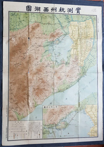
- Title : Map of Hangchow and West Lake and Environs... Commercial Press Ltd
- Date : 1924
- Condition: (A) Very Good Condition
- Ref: 40172
- Size: 43in x 31in (1.090m x 790mm)
Description:
This very large, rare original antique folding map of the Chinese city of Hangzhou, West Lake & the Qiantang River was published by the Chinese publishing house Commercial Press LTD in the 13th Year of the Chinese Republic, October 1924.
General Definitions:
Paper thickness and quality: - Heavy and stable
Paper color : - off white
Age of map color: - Original
Colors used: - Yellow, green, blue, pink
General color appearance: - Authentic
Paper size: - 43in x 31in (1.090m x 790mm)
Plate size: - 43in x 31in (1.090m x 790mm)
Margins: - Min 1/2in (12mm)
Imperfections:
Margins: - None
Plate area: - Folds as issued, slight loss in corner folds
Verso: - Folds re-enforced with archival tape
Background:
Hangzhou is the capital and most populous city of Zhejiang Province in East China. It sits at the head of Hangzhou Bay, which separates Shanghai and Ningbo. Hangzhou grew to prominence as the southern terminus of the Grand Canal and has been one of the most renowned and prosperous cities in China for much of the last millennium.
The city remained an important port until the middle of the Ming dynasty era, when its harbor slowly silted up. Under the Qing, it was the site of an imperial army garrison.
In 1856 and 1860, the Taiping Heavenly Kingdom occupied Hangzhou. The city was heavily damaged during its conquest, occupation, and eventual reconquest by the Qing army.
Hangzhou was ruled by the Republic of China government under the Kuomintang from 1927 to 1937 and 1945 to 1949. On May 3, 1949, the Peoples Liberation Army entered Hangzhou and the city came under Communist control. After Deng Xiaopings reformist policies began in the end of 1978, Hangzhou took advantage of being situated in the Yangtze River Delta to bolster its development. It is now one of Chinas most prosperous major cities.
West Lake is a freshwater lake in Hangzhou, China. It is divided into five sections by three causeways. There are numerous temples, pagodas, gardens, and artificial islands within the lake.
The earliest recorded name for West Lake was the Wu Forest River (Wǔlín Shuǐ). The Book of Hans Geography Column says, Qiantang, affiliated to the western governor general. Wu Forest Mountain (Wǔlínshān) is the origin of the Wu Forest River. Running east into the sea, it covers 830 li (roughly, 350 km or 220 mi). Other former names include the Qian River, Qiantang Lake, Mingsheng Lake, Jinniu Lake, Shihan Lake, Shang Lake, Lianyan Lake, Fangsheng Pond, Xizi Lake, Gaoshi Lake, Xiling Lake, Meiren Lake, Xianzhe Lake, and Mingyue Lake. But only two names were widely accepted in history and recorded in historical documents. One is Qiantang Lake, due to the fact that Hangzhou was called Qiantang in ancient times. The other name is West Lake, due to the lake being west of the city. The name West Lake first appeared in two poems of Bai Juyi, Bestowed on guests as returning from West Lake in the evening and looking back to Gushan Temple (西湖晚歸回望孤山寺贈諸客) and On the returning boat to Hangzhou (杭州回舫). Since the Northern Song dynasty, most poems and articles of scholars used the name West Lake, while the name Qiantang Lake was gradually deprecated. The request of dredging West Lake written by Su Shi was the first time that West Lake appeared in an official document.
The Commercial Press 1897 - Present
The Commercial Press is the first modern publishing organisation in China. In 1897, 26-year-old Xia Ruifang and three of his friends founded The Commercial Press in Shanghai. The group soon received financial backing and began publishing books.[1] In 1914, Xia attempted to buy out a Japanese company that had invested in the Commercial Press. Four days later he was assassinated. There was much speculation as to who was behind the assassination; no one was ever arrested for the crime.
Commercial Press was bombed by the Imperial Japanese Army during the January 28 Incident. The bombing destroyed its headquarters in Zhabei, Shanghai, as well as the attached East Library and its collection of tens of thousands of rare books.
At the turn of the century Commercial Press became a major publisher of textbooks. Today it is headquartered in Beijing and continues as an active publishing house of Chinese language learning materials including dictionaries, textbooks, pedagogical texts, and a cultural magazine called The World of Chinese.
Timeline:
1902 it was set up with a forward attitude toward both Chinese and Western studies.
1903 it became Chinas first primary education textbook publisher. It later produced 2,550 secondary school textbooks that became popular in the country.
1904 it launched the Eastern Miscellany (東方雜誌) with editor-in-chief (杜亞泉).
1907 the press moved to an 80-acre (320,000 m2) new plant.
1909 it launched the Education Magazine (教育雜誌).
1910 it launched The Short Story Magazine (小說月報).
1911 it launched the Youth Magazine (少年雜誌).
January 1914, the founder of Commercial Press, Xia Ruifang, was stabbed to death.
1914 it set up a branch in Hong Kong Museum of the same year. It also launched the Students Magazine (學生雜誌).
1915 it printed the first dictionary.
1916 it set up a branch in Singapore.
1921 with Hu Shihs recommendation, Wang Yunwu (王雲五) became the general manager modernising it into a business. The first edition of Zhongguo renming dacidian was published.
1924 it opened the Commercial Press Oriental Library.
28 January 1932, the January 28 Incident occurred. The Japanese aircraft bombed the Commercial Press in conjunction with the Oriental Library. Imperial Japanese army would occupy Shanghai the next day. TCP resumed operation in 1932.
1949, TCPs operation was relocated away from China after Liberation Army had entered Shanghai.
1954, the TCPs headquarter was moved from Shanghai to Beijing shifting the focus to academic works published in the West.
1993, the separate Commercial Press companies in China, Hong Kong, Taiwan, Singapore, and Malaysia established a joint venture to become The Commercial Press International Limited.
2011, the Beijing office was changed into limited liability company (商务印书馆有限公司).
When China publishing and Media Holdings Co.,Ltd. (中国出版传媒股份有限公司) was founded in 2011-12-19, the newly founded company became the parent company.
1770 Tobias Lotter Very Large Antique Map of Russia & Siberia
Antique Map
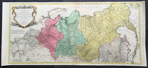
- Title : Carte géographique contenant le royaume de Sibérie
- Ref #: 61039
- Size: 44in x 20 1/2in (1.15m x 520mm)
- Date : 1770
- Condition: (A) Very Good Condition
Description:
This scarce, very large beautifully hand coloured original antique map of Russia and Siberia with parts of China was published by Tobias Conrad Lotter in 1770.
Background: Rare, highly detailed map of Russia & Siberia that is subdivided into provinces, namely Tobolsk, Jenissejesk, Irkutsk, and outer parts of the Tartary. In upper right corner inset-map of the Chukchi (Chukotsk) Peninsula. On the left side sheet is a large title cartouche set in a steppe landscape with reindeer sledge, whale and polar bears. Scale ca. 1 : 13,000,000 and engraved by Matthäus Albrecht Lotter for Tobias Conrad Lotter.
In about 1770 a map of Russia & Siberia by Ivan Fomic Truscot (1721-1786, comp. BMC XXII, 353) was published, that comprised the West Siberian states Tobolsk and Yeniseiesk only, but may have been quite available to Lotter, just as also the German edition of the third Russian general map by Truscot and Jacob F. Schmidt of 1776 was published by Lotter in 1784.
The comparison of the Asian north-eastern coast from Japan up to Cape Szalaginskoi (Cape Shelagskiy) together with the offshore islands there results in an astonishing similarity with representation and designation on Rigobert Bonne’s maps of Russia and the Chinese Tartary published by Lattré in Paris in 1771. Especially striking the form of Sakhalin that hitherto – but also still on the Truscot map of 1776 – appears far more stocky, here though shows a slimmer shape considerably closer to reality. Cape Patience known at least since the 1743 Utrecht edition of the map of Russia by Johann Matthias Haas (Augsburg 1684 – Wittenberg/Augsburg 1742) – Kaert van Het geheele Russische Keizerryk – already published by Homann Heirs in Nuremberg in 1730 + 39 here supposedly for the first time shown in unity with Sakhalin and, as the long-stretched southern half beginning west of the cape already recognizable there is missing here, together forming its southern tip.
Of great similarity, too, the still completely bulky representation of Jeso (= Hokkaido), filling up large parts of the Sea of Japan as known sufficiently from numerous, though by far not all maps of the 18th century. The Kurile Islands adjacent in northeastern direction – with rich detail designation, but without the denomination as chain of islands appearing at least in the 1784 edition of Truscot’s general map – with the obscure islands Terre des Etat (Iturup) and Terre de la Compagnie. Both, as also the often furthermore adjacent da Gama Land, had been supposedly finally left by Truscot to the memory of the great time of sometimes only vague discoveries.
Interestingly both islands are designated with hints to Russian maps in question marks. This probably to be seen as a sign for an independent work of Lotter who obviously drew his knowledge from different sources and not just copied a map he had got into his hands for a German edition. Further clue to the dating is, too, the taking over of the Chukchi (Chukotsk) Peninsula in the farest northeast of Asia in the shape practically unchanged since Ivan Kirilov’s (1695 – Samara 1737) general map of 1734 – the first Russian one at all. For at the latest since publishing the Truscot map of 1776 in 1784 Lotter would have known the new shape valid till today.
Likewise Novaya Zemlya here still figuring as undivided island, thus without the Matochkin Strait supposedly recorded by Truscot for the first time. With respect to the independence of his work a recourse to older forms of representation appears not very likely in both cases.
Designed in cone projection, the null meridian runs about 020degrees western longitude of Greenwich through the centre of Iceland. In the west reaching till Novaya Zemlya – Ural Mountains – Kazan – Sea of Azov, the map comprises in the far east still northern Japan , the Kurile Islands and Kamchatka including the offshore Bering Island . Southerly still with at the Caspian Sea , Lake Aral , the headwaters of the Yenisey , the Dalai nuur (Hulun Lake) in northern Mongolia near to the wall of Genghis Chan , the region of today’s Vladivostok and the Tsugari Street . In the Arctic Ocean up to 78 degrees northern latitude. (Ref: Tooley, M&B)
General Description:
Paper thickness and quality: - Heavy and stable
Paper color: - off white
Age of map color: - Original
Colors used: - Pink, green, yellow
General color appearance: - Authentic
Paper size: - 44in x 20 1/2in (1.15m x 520mm)
Plate size: - 42in x 19 1/2in (1.0mm x 500mm)
Margins: - Min 1/2in (12mm)
Imperfections:
Margins: - None
Plate area: - Repair to top adjacent to centerfold, no loss
Verso: - Repair as mentioned
1730 Georg Mattraus Seutter Large Antique Map of Africa
Antique Map
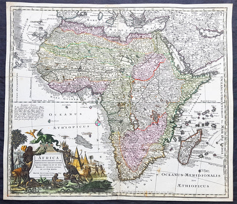
- Title : Africa Iuxta Navigationes..Matth. Seuttero S Caes Maj Geographo Aug.
- Date : 1730
- Condition: (A) Very Good Condition
- Ref: 35011
- Size: 23in x 20in (585mm x 510mm)
Description:
This large beautifully hand coloured original copper-plate antique map of Africa was engraved by Tobais Lotter and published by Georg Mattraus Seutter in 1730 edition of Geographical Atlas or an Accurate Depiction of the Whole World
This striking map of Africa is based largely on Homanns 1715 map. Typical of the period, it presents largely fictitious information in southern Africa, and enormous lakes depicted in central Africa. The Nile is shown originating in the south at lakes Zaire and Zaflan and also continuing further south through a twisted river system with its headwaters in Bed Lac. The splendid decorative cartouche (uncolored) features indigenous people, pyramids and exotic animals, with a fierce dragon perched atop the title.
General Definitions:
Paper thickness and quality: - Heavy and stable
Paper color : - off white
Age of map color: - Original
Colors used: - Yellow, green, blue, pink
General color appearance: - Authentic
Paper size: - 23in x 20in (585mm x 510mm)
Plate size: - 23in x 20in (585mm x 510mm)
Margins: - Min 1/2in (12mm)
Imperfections:
Margins: - Small restoration to top & bottom margin centerfold. 4 small rejoins to margins, no loss
Plate area: - Restoration to bottom 2in of centerfold
Verso: - Light soiling
Background:
The first separately printed map of Africa (as with the other known continents) appeared in Munster\'s Geographia from 1540 onwards and the first atlas devoted to Africa only was published in 1588 in Venice by Livio Sanuto, but the finest individual map of the century was that engraved on 8 sheets by Gastaldi, published in Venice in 1564. Apart from maps in sixteenth-century atlases generally there were also magnificent marine maps of 1596 by Jan van Linschoten (engraved by van Langrens) of the southern half of the continent with highly imaginative and decorative detail in the interior. In the next century there were many attractive maps including those of Mercator/Hondius (1606), Speed (1627), Blaeu (1 630), Visscher (1636), de Wit (c. 1670), all embellished with vignettes of harbours and principal towns and bordered with elaborate and colourful figures of their inhabitants, but the interior remained uncharted with the exception of that part of the continent known as Ethiopia, the name which was applied to a wide area including present-day Abyssinia. Here the legends of Prester John lingered on and, as so often happened in other remote parts of the world, the only certain knowledge of the region was provided by Jesuit missionaries. Among these was Father Geronimo Lobo (1595-1678), whose work A Voyage to Abyssinia was used as the basis for a remarkably accurate map published by a German scholar, Hiob Ludolf in 1683. Despite the formidable problems which faced them, the French cartographers G. Delisle (c. 1700-22), J. B. B. d\'Anville (1727-49) and N. Bellin (1754) greatly improved the standards of mapping of the continent, improvements which were usually, although not always, maintained by Homann, Seutter, de Ia Rochette, Bowen, Faden and many others in the later years of the century. (M&B; Tooley)
1756 J B D Anville Large Antique Bottom Map Texas, Mexico, Central America - 93518
Antique Map
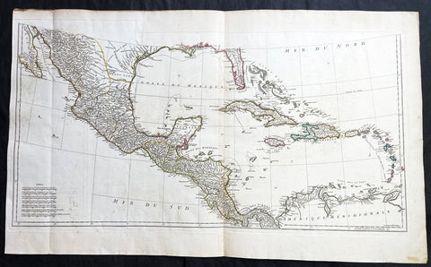
- Title : (Amerique Septentrionale Publiee sous les Auspices de Monseigneur le Duc d Orleans.. Par Le Snr. D Anville MDCCXLVI)
- Date : 1756
- Size: 36in x 22in (915mm x 560mm)
- Condition: (A+) Fine Condition
- Ref: 93518
Description:
This large important original copper plate engraved antique map, bottom sheets of 4 sheets, of North America was engraved in 1746 and was published by Jean-Baptiste Bourguinon D Anville in his Elephant Folio Atlas Generale. (I have included an image of the map of the map when it is complete)
This map was instrumental in instructing the European Colonial powers of the time, England France & Spain the importance of dominating the New World, that ultimately led to the French and Indian War of 1754–63. This conflict determined the political direction of North America leading to the American War of Independence in 1775 and ultimately the formation of The United States of America.
To illustrate the importance of cartography in the mid eighteenth century, especially that of North America, a J B D Anville map is essential. D Anville dominated 18th century European cartography with many of his cartographical achievements, especially in North America, copied by many of his contemporaries such as Kitchen, Sayer, Homann, Seutter, Mitchell and others .
He was one of the first to leave blank spaces in his maps, where knowledge was scant or insufficient. His representation of the great lakes is superior to that of his contemporary John Mitchell, responsible for publishing one of the most famous mid 18th century maps of North America, A Map of the British and French Dominions in North America on 8 sheets in 1755 and remained the standard map of North America up until the end of the 18th century. (Ref: Tooley, Printed maps of America, 104; The Mapping of America 316)
General Definitions:
Paper thickness and quality: - Heavy and stable
Paper color : - off white
Age of map color: - Original
Colors used: - Yellow, green, blue, pink
General color appearance: - Authentic
Paper size: - 36in x 22in (915mm x 560mm)
Plate size: - 34 1/2in x 17in (880mm x 430mm)
Margins: - Min 1/2in (12mm)
Imperfections:
Margins: - Small right side of margin & border restored
Plate area: - Folds as issued, small dis-colouration to bottom centerfold
Verso: - Folds as issued, several small repairs not affecting image
Background:
The French and Indian War (1754–63) comprised the North American theatre of the worldwide Seven Years War of 1756–63. It pitted the colonies of British America against those of New France. Both sides were supported by military units from their parent countries, as well as by American Indian allies. At the start of the war, the French North American colonies had a population of roughly 60,000 settlers, compared with 2 million in the British North American colonies. The outnumbered French particularly depended on the Indians. The European nations declared war on one another in 1756 following months of localized conflict, escalating the war from a regional affair into an intercontinental conflict.
The name French and Indian War is used mainly in the United States. It refers to the two enemies of the British colonists, the royal French forces and their various American Indian allies. The British colonists were supported at various times by the Iroquois, Catawba, and Cherokee, and the French colonists were supported by Wabanaki Confederacy members Abenaki and Mikmaq, and Algonquin, Lenape, Ojibwa, Ottawa, Shawnee, and Wyandot.
British and other European historians use the term the Seven Years War, as do English-speaking Canadians. French Canadians call it La guerre de la Conquête (the War of the Conquest) or (rarely) the Fourth Intercolonial War.
Fighting took place primarily along the frontiers between New France and the British colonies, from Virginia in the south to Newfoundland in the north. It began with a dispute over control of the confluence of the Allegheny River and Monongahela River called the Forks of the Ohio, and the site of the French Fort Duquesne in Pittsburgh, Pennsylvania. The dispute erupted into violence in the Battle of Jumonville Glen in May 1754, during which Virginia militiamen under the command of 22-year-old George Washington ambushed a French patrol.
In 1755, six colonial governors in North America met with General Edward Braddock, the newly arrived British Army commander, and planned a four-way attack on the French. None succeeded, and the main effort by Braddock proved a disaster; he lost the Battle of the Monongahela on July 9, 1755 and died a few days later. British operations failed in the frontier areas of Pennsylvania and New York during 1755–57 due to a combination of poor management, internal divisions, effective Canadian scouts, French regular forces, and Indian warrior allies. In 1755, the British captured Fort Beauséjour on the border separating Nova Scotia from Acadia, and they ordered the expulsion of the Acadians (1755–64) soon afterwards. Orders for the deportation were given by William Shirley, Commander-in-Chief, North America, without direction from Great Britain. The Acadians were expelled, both those captured in arms and those who had sworn the loyalty oath to His Britannic Majesty. Indians likewise were driven off the land to make way for settlers from New England.
The British colonial government fell in the region of modern Nova Scotia after several disastrous campaigns in 1757, including a failed expedition against Louisbourg and the Siege of Fort William Henry; this last was followed by Indians torturing and massacring their British victims. William Pitt came to power and significantly increased British military resources in the colonies at a time when France was unwilling to risk large convoys to aid the limited forces that they had in New France, preferring to concentrate their forces against Prussia and its allies in the European theater of the war. Between 1758 and 1760, the British military launched a campaign to capture the Colony of Canada (part of New France). They succeeded in capturing territory in surrounding colonies and ultimately the city of Quebec (1759). The British later lost the Battle of Sainte-Foy west of Quebec (1760), but the French ceded Canada in accordance with the Treaty of Paris (1763).
The outcome was one of the most significant developments in a century of Anglo-French conflict. France ceded to Great Britain its territory east of the Mississippi. It ceded French Louisiana west of the Mississippi River (including New Orleans) to its ally Spain in compensation for Spains loss to Britain of Florida. (Spain had ceded Florida to Britain in exchange for the return of Havana, Cuba.) Frances colonial presence north of the Caribbean was reduced to the islands of Saint Pierre and Miquelon, confirming Great Britains position as the dominant colonial power in eastern North America.
1628 Henricus Hondius Antique Map Ottoman Empire Saudi Arabia to Southern Europe
Antique Map
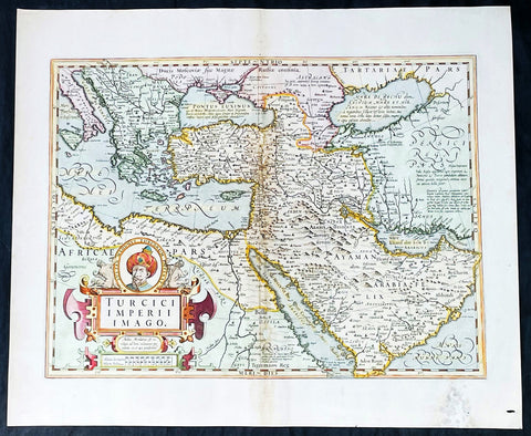
- Title : Turcici Imperii Imago
- Date : 1628
- Size: 22 1/2in x 18 1/2in (570mm x 470mm)
- Condition: (A-) Good Condition
- Ref: 35642
Description:
This beautifully engraved hand coloured original antique map of The Ottoman Empire in the mid 17th century from Saudi Arabia to southern Europe was published in the 1628 French edition of Mercator's atlas by Jan Jansson and Henricus Hondius.
These maps, published in the later editions of Mercators atlas, are derived from the original maps drawn and engraved by Gerald Mercator in the mid to late 16th century, published by his son Rumold as an atlas, after his death, in 1595. After two editions the plates were purchased by Jodocus Hondius in 1604 and continued to be published until the mid 1630's when the plates were re-engraved and updated by Jan Jansson and Henricus Hondius.
General Definitions:
Paper thickness and quality: - Heavy and stable
Paper color : - off white
Age of map color: - Original & later
Colors used: - Yellow, green, pink
General color appearance: - Authentic
Paper size: - 22 3/4in x 19 3/4in (580mm x 500mm)
Plate size: - 20in x 13 3/4in (500mm x 350mm)
Margins: - Min 1in (25mm)
Imperfections:
Margins: - Light soiling, small wormhole, light creasing
Plate area: - Small loss and creasing along centerfold
Verso: - Light soiling and creasing
Background:
The Ottoman Empire also historically known in Western Europe as the Turkish Empire or simply Turkey, was a state that controlled much of Southeast Europe, Western Asia and North Africa between the 14th and early 20th centuries. It was founded at the end of the 13th century in northwestern Anatolia in the town of Söğüt (modern-day Bilecik Province) by the Oghuz Turkish tribal leader Osman I. After 1354, the Ottomans crossed into Europe, and with the conquest of the Balkans, the Ottoman beylik was transformed into a transcontinental empire. The Ottomans ended the Byzantine Empire with the 1453 conquest of Constantinople by Mehmed the Conqueror.
During the 16th and 17th centuries, at the height of its power under the reign of Suleiman the Magnificent, the Ottoman Empire was a multinational, multilingual empire controlling most of Southeast Europe, parts of Central Europe, Western Asia, parts of Eastern Europe and the Caucasus, North Africa and the Horn of Africa. At the beginning of the 17th century, the empire contained 32 provinces and numerous vassal states. Some of these were later absorbed into the Ottoman Empire, while others were granted various types of autonomy during the course of centuries.
With Constantinople as its capital and control of lands around the Mediterranean basin, the Ottoman Empire was at the centre of interactions between the Eastern and Western worlds for six centuries. While the empire was once thought to have entered a period of decline following the death of Suleiman the Magnificent, this view is no longer supported by the majority of academic historians. The empire continued to maintain a flexible and strong economy, society and military throughout the 17th and much of the 18th century. However, during a long period of peace from 1740 to 1768, the Ottoman military system fell behind that of their European rivals, the Habsburg and Russian empires. The Ottomans consequently suffered severe military defeats in the late 18th and early 19th centuries, which prompted them to initiate a comprehensive process of reform and modernisation known as the Tanzimat. Thus, over the course of the 19th century, the Ottoman state became vastly more powerful and organised, despite suffering further territorial losses, especially in the Balkans, where a number of new states emerged. The empire allied with Germany in the early 20th century, hoping to escape from the diplomatic isolation which had contributed to its recent territorial losses, and thus joined World War I on the side of the Central Powers. While the Empire was able to largely hold its own during the conflict, it was struggling with internal dissent, especially with the Arab Revolt in its Arabian holdings. During this time, atrocities were committed by the Ottoman government against the Armenians, Assyrians and Pontic Greeks.
The Empire\'s defeat and the occupation of part of its territory by the Allied Powers in the aftermath of World War I resulted in its partitioning and the loss of its Middle Eastern territories, which were divided between the United Kingdom and France. The successful Turkish War of Independence against the occupying Allies led to the emergence of the Republic of Turkey in the Anatolian heartland and the abolition of the Ottoman monarchy.
1856 A H Dufour Very Large Antique World Map on Mercators Projection - Scarce
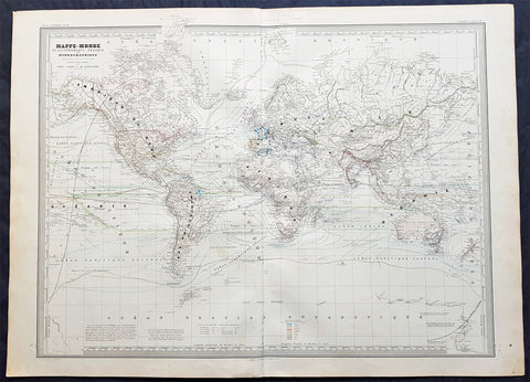
- Title : Mappe-Monde Planispherique Physique et Hydrographique. CH Dyonnet..1856
- Ref #: 61019
- Size: 33in x 24in (840mm x 610mm)
- Date : 1856
- Condition: (A+) Fine Condition
Description:
This very large, magnificent hand coloured original copper plate antique World Map on Mercators Projection -adorned with scientific data - by Adolphe Hippolyte Dufour was engraved by Charles Dyonnet in 1857 - dated in the title - for Dufours 1860 edition of his monumental elephant folio Atlas Physique, Historique et Politique Geographie Modernepublished by Pauline Et La Chevalier, Paris.
The 19th century French cartographer Auguste-Henri Dufour began publishing the dramatic elephant folio Atlas Universel, also occasionally titled Grand Atlas Universal, around 1855. Several editions appeared between its initial publication in the 1850s and a final run c. 1870. The 1863 and 1864 editions in particular are highly desirable among collectors because the United States and North America maps illustrate the proposed, but unrealized, state of Corona (roughly modern day Utah). The atlas contained roughly 40 maps, most of which were engraved by Louis Antoine (the maps) and Deletre (typography) under the supervision of Charles Dyonnet, official engraver of the Depot de la Marine. The Atlas Universal was published in Paris and edited by the firm of Paulin et le Chevalier, 60 Rue Richelieu.
General Definitions:
Paper thickness and quality: - Heavy and stable
Paper color : - off white
Age of map color: - Original
Colors used: - Yellow, green, blue, pink
General color appearance: - Authentic
Paper size: - 33in x 24in (840mm x 610mm)
Plate size: - 33in x 24in (840mm x 610mm)
Margins: - Min 1in (25mm)
Imperfections:
Margins: - Light age toning in margins
Plate area: - None
Verso: - None
Background:
Charles Dyonnet 1822 - 1880 was an extremely active Paris based engraver working in the mid to late 19th century. From his offices at 220 Rue St. Jacques, Paris, Dyonnet engraved numerous maps for many of the most prominent 19th French cartographic publishers including Vuillemin, Dufour, Fremin and Duvotenay. From 1850-1861, he held the coveted position of Graveur du Dépot de la Marine, and in this position engraved numerous French naval and military maps. Dyonnet had a detail oriented and aesthetically minded hand and is responsible from some of the most beautiful French maps to emerge during the 19th century. (Ref: M&B; Tooley)
1692 Jaillot Large Antique Map Sea Chart The English Channel during 9 Years War
Antique Map
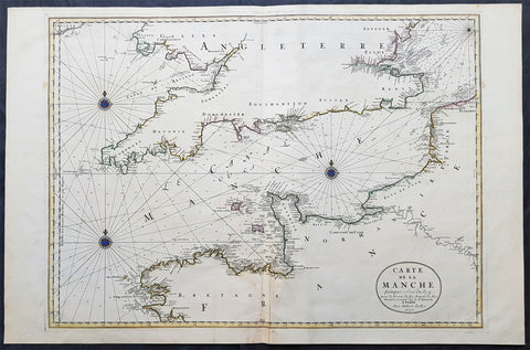
- Title : Carte De La Manche faite par ordre du Roy. pour le Service de les Armees de Mer.....a Paris...1692
- Size: 38in x 25in (960m x 635mm)
- Condition: (A+) Fine Condition
- Date : 1692
- Ref #: 16371
Description:
This very large, beautifully hand coloured original copper-plate engraved antique map, a large Sea Chart of The English Channel - produced for the French Navy during the Nine Years War and specifically the Battle of Beachy Head - was engraved in 1692, dated in the cartouche, and was published for Alexis Hubert Jaillots 1698 edition of his monumental Atlas Nouveau.
General Definitions:
Paper thickness and quality: - Heavy and stable
Paper color : - off white
Age of map color: - Original
Colors used: - Yellow, pink, green, blue
General color appearance: - Authentic
Paper size: - 38in x 25in (960m x 635mm)
Plate size: - 32 1/2in x 23 1/2in (825mm x 595mm)
Margins: - Min 1in (25mm)
Imperfections:
Margins: - None
Plate area: - None
Verso: - None
Background:
The Nine Years War (1688–97)—often called the War of the Grand Alliance or the War of the League of Augsburg—was a conflict between Louis XIV of France and a European coalition of the Holy Roman Empire, led by Austria, the Dutch Republic, Spain, England and Savoy. It was fought in Europe and the surrounding seas, North America and in India. It is sometimes considered the first global war. The conflict encompassed the Williamite war in Ireland and Jacobite risings in Scotland, where William III and James II struggled for control of England and Ireland, and a campaign in colonial North America between French and English settlers and their respective Indigenous allies, today called King Williams War by Americans.
Louis XIV of France had emerged from the Franco-Dutch War in 1678 as the most powerful monarch in Europe, an absolute ruler who had won numerous military victories. Using a combination of aggression, annexation, and quasi-legal means, Louis XIV set about extending his gains to stabilize and strengthen France\'s frontiers, culminating in the brief War of the Reunions (1683–84). The Truce of Ratisbon guaranteed France\'s new borders for twenty years, but Louis XIV\'s subsequent actions—notably his Edict of Fontainebleau (the revocation of the Edict of Nantes) in 1685— led to the deterioration of his military and political dominance. Louis XIVs decision to cross the Rhine in September 1688 was designed to extend his influence and pressure the Holy Roman Empire into accepting his territorial and dynastic claims. Leopold I and the German princes resolved to resist, and when the States General and William III brought the Dutch and the English into the war against France, the French King faced a powerful coalition aimed at curtailing his ambitions.
The main fighting took place around Frances borders in the Spanish Netherlands, the Rhineland, the Duchy of Savoy and Catalonia. The fighting generally favoured Louis XIV\'s armies, but by 1696 his country was in the grip of an economic crisis. The Maritime Powers (England and the Dutch Republic) were also financially exhausted, and when Savoy defected from the Alliance, all parties were keen to negotiate a settlement. By the terms of the Treaty of Ryswick (1697) Louis XIV retained the whole of Alsace but was forced to return Lorraine to its ruler and give up any gains on the right bank of the Rhine. Louis XIV also accepted William III as the rightful King of England, while the Dutch acquired a Barrier fortress system in the Spanish Netherlands to help secure their borders. With the ailing and childless Charles II of Spain approaching his end, a new conflict over the inheritance of the Spanish Empire embroiled Louis XIV and the Grand Alliance in the War of the Spanish Succession.
The Battle of Beachy Head (Bévéziers) was a naval engagement fought on 10 July 1690 during the Nine Years\' War. The battle was the greatest French tactical naval victory over their English and Dutch opponents during the war. The Dutch lost six ships of the line (sources vary) and three fireships; their English allies also lost one ship of the line, whereas the French did not lose a vessel. Control of the English Channel temporarily fell into French hands but Vice-Admiral Tourville failed to pursue the Allied fleet with sufficient vigour, allowing it to escape to the River Thames.
Tourville was criticised for not following up his victory and was relieved of his command. The English Admiral Arthur Herbert, 1st Earl of Torrington – who had advised against engaging the superior French fleet but had been overruled by Queen Mary and her ministers – was court-martialled for his performance during the battle. Although he was acquitted, King William dismissed him from the service.
1857 Alexandre Vuillemin Large Antiqque Map of North America...Beautiful
Antique Map
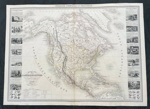
- Title : Nouvelle Carte Illustree L Amerique Du Nord...Vuillemin....1857
- Ref #: 17024
- Size: 35in x 25 1/2in (890mm x 650mm)
- Date : 1857
- Condition: (A) Very Good Condition
Description:
This very large original hand coloured antique lithograph map of North America, with small vignettes of North American peoples surrounding the map, by Alexandre Vuillemin was engraved in 1857, dated in the title, and was published in the 1861 edition of Atlas de geographie commercial et industriel.
This World atlas consisted of 8 double page color maps, dated 1857-1858 by A. Vuillemin, engraved by Langevin and printed by Fatout, Paris. The maps include views, statistical tables and legend. Showing political divisions, capitals, industrial cities, towns, the commercial ports, roads, railroads, canals, fortress and geographical distribution of plants and mineral. Relief shown by hachures and pictorially.
General Definitions:
Paper thickness and quality: - Heavy and stable
Paper color : - off white
Age of map color: - Original
Colors used: - Yellow, green, blue, pink
General color appearance: - Authentic
Paper size: - 35in x 25 1/2in (890mm x 650mm)
Plate size: - 35in x 25 1/2in (890mm x 650mm)
Margins: - Min 1/2in (12mm)
Imperfections:
Margins: - Small repair to bottom margin
Plate area: - None
Verso: - None
Please note all items auctioned are genuine, we do not sell reproductions. A Certificate of Authenticity (COA) can be issued on request.
1652 Jan Jansson Antique Map of East & Central Asia, China to Russia - Tartary
Antique Map
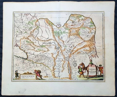
- Title : Tartaria sive Magni Chami Imperium
- Date : 1652
- Size: 24in x 20in (610mm x 510mm)
- Ref #: 61166
- Condition: (A+) Fine Condition
Description:
This handsome beautifully hand coloured original antique map of huge region of east & central Asia from China, to Central Asia, The Caspian Sea & parts of European Russia was published by Jan Jansson in the 1652 French edition of Atlas Novus.
Background: This handsome map maps the whole of eastern Central Asia from the Caspian Sea to the Great Wall, Northern China and Manchuria.
This map is dated from a time when Tartaria vaguely meant those regions to the north of Persia, west of China & to the east of Russia. The name Siberia only began to be applied with the gradual eastward expansion of the Russian Cossacks into those areas hinted at in the accounts of Marco Polo from three centuries earlier.
The Mythical and legendary nature of the geography of this vast interior is emphasised by the inclusion of devils and dragons in the Desertum Lop to the left of the Great Wall.
The rest of the map is full of detail both real and myth, some of which is no doubt borrowed from the writings of Marco Polo considered at the time one of the foremost expert on China and Central Asia.
The newly discovered northern coastline of Nova Zembla is shown with a notation concerning the Dutch expedition led by Willem Barents in 1594-96. Interesting in Siberia, Ung quae Gog and Sumongul quae Mogog, which refers to the mythological lands of Gog and Magog. These lands, noted in the Bible as being situated in the remotest parts of the earth, were originally depicted on maps just north of Israel. The map extends west to include the Caspien Sea and Russia, but the primary focus of the map is Tartaria, Central Asia, China and Asiatic Russia. (Ref Tooley M&B)
General Description:
Paper thickness and quality: - Heavy and stable
Paper color: - off white
Age of map color: - Original
Colors used: - Green, red, orange, yellow, blue
General color appearance: - Authentic
Paper size: - 24in x 20in (610mm x 510mm)
Plate size: - 20in x 15 1/4in (510mm x 395mm)
Margins: - Min 1in (25mm)
Imperfections:
Margins: - None
Plate area: - None
Verso: - None
1639 Jansson Original Antique Map of Africa - The Myth of Emperor Prestor John
Antique Map
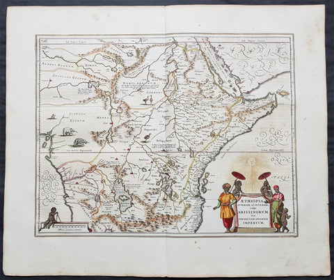
- Title : Aethiopia Superior vel Interior; vulgo Abissinorum sive Presbiteri Ioannis Imperium
- Date : 1639
- Size: 24in x 20in (610mm x 510mm)
- Ref #: 70712
- Condition: (A+) Fine Condition
Description:
This beautifully hand coloured original antique map of Central and NE Africa - the mythical land of Emperor Prestor John - was published in the 1639 French Edition of Mercator's Atlas publsihed by Mercators successors Jan Jansson & Henricus Hondius.
This map was first published by Gerard Mercators son Rumold in the 1606 Latin edition of his fathers atlas and remained unchanged until the plate was re-designed for the 1636 edition of the Atlas by Jansson & Hondius and remained in service until 1680.
This map is in stunning condition on bright heavy stable paper. with original margins and beautiful original colour.
General Definitions:
Paper thickness and quality: - Heavy and stable
Paper color : - off white
Age of map color: - Original
Colors used: - Yellow, green, blue, pink
General color appearance: - Authentic
Paper size: - 24in x 20in (610mm x 510mm)
Plate size: - 19 1/2in x 15 1/4in (495mm x 390mm)
Margins: - Min 2in (50mm)
Imperfections:
Margins: - Light age toning
Plate area: - None
Verso: - None
Background:
Rumours of the mythical Emperor Prestor John began in Europe around 1150AD, that somewhere in Asia there was a powerful Christian Emperor named Presbyter Johannes (with the court title of Gurkhan), who had founded the kingdom of Kara Khitai. He had broken the power of the Musselman in his own domain after a fierce and bloody fight. The mysterious Priest-King became a symbol of hope in the Christian world beset by Mongol hordes. Pope Alexander III resolved to make contact with Presbyter John, and his first step was to address a letter to him (dated 27th September 1177). The Pope's physician was dispatched to deliver the letter in person. He never returned. Pope Innocent IV was even more determined than his predecessor, and decided to convert the Barbarians instead of conquer them. Dominican and Franciscan missionaries as well as civil ambassadors of peace plodded back and forth between the Pope, the King of France and the Mogul Khan. These travelers soon learned that His Highness Presbyter Johannes and the Christian kingdom in deepest Asia were popular myths. But the popular fancy was not easily dispelled, and instead of allowing the bubble to be punctured, the people merely transferred the kingdom of Presbyter John to Africa - especially Abyssinia. No-one knew very much about Abyssinia. A few die hards like John de Plano Carpini and Marco Polo persisted in the belief that Presbyter John still reigned in his splendor deep in the heart of the Orient. On the larger map in Higdens Polychronicon the empire of Presbyter John was located in the lower Scythia within the limits of Europe, but the map of Marino Sanuto it was placed in further India. It was moved again to Central Asia and ended up in Abyssinia. The legend persisted, however, and four hundred years after Pope Alexander III wrote his letter to Presbyter Johannes, Abraham Ortelius, a Dutch map publisher issued a separate map titled Presbyteri Johannis Siv Abissinorum Iperii Descripto .
(Ref: M&B, Tooley; Norwich)
1770 De Vaugondy & Diderot Antique Maps of Cartographical Views of California
Antique Map
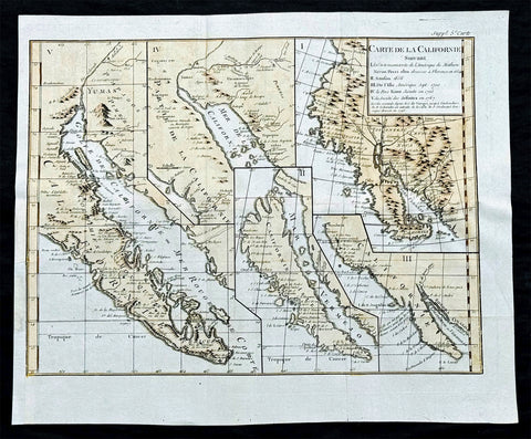
- Title : Carte de la Californie suivant / I. La carte manuscrite de l'Amérique de Mathieu Néron Pecci olen dresse à Florence en 1604 / II. Sanson 1656 / III. De L'Isle Amérique Sept. 1700 / IV. le Pere Kino Jesuite en 1705 / V. La Societe des Jésuites en 1767.
- Ref: 93434
- Size: 17in x 14in (430mm x 355mm)
- Date : 1770
- Condition: (A) Very Good Condition
Description:
This fine large historically important original hand coloured, copper-plate engraved antique map, illustrating 5 of the most influential depictions of California and its cartographical evolution between 1604 and 1767.
The map was engraved by the important French cartographer Robert De Vaugondy, for the 1770 edition of the Denis Diderot Encyclopaedie Raisonee des Sciences des Artes.
- The earliest map (upper right corner) is based upon a manuscript map by Mathieu Neron Pecci, drawn in Florence in 1604. This map also forms the basis of a map popularized in 1770 by Rigobert Bonne.
- The second map is Nicholas Sanson's map of California as an Island, based upon his larger map of 1656. This map was probably the single most influential projection of California as an Island.
- The third map map (lower right) is a portion of Guillaume De L'Isles map of America, published in 1700. While not truly peninsular in nature, it was influential in the shift back toward depicting California as a Peninsula.
- The fourth map (upper center) is a portion of Fra. Eusebio Kino's map, generally credited with being the map which dispelled the California as and Island myth. Issued in 1705, the map is based upon Father Kino's overland expedition from the mainland to the top of the Gulf of Cortez.
- The fifth map is one of the most interesting and enduring maps of California and the Baja (left side). Initially issued by the Society of Jesuits in 1767, it was popularized by Isaak Tirion and was perhaps the most interesting of all maps of Baja California in the 2nd half of the 18th Century.
General Definitions:
Paper thickness and quality: - Heavy and stable
Paper color : - off white
Age of map color: - Early
Colors used: - Yellow, pink
General color appearance: - Authentic
Paper size: - 17in x 14in (430mm x 355mm)
Plate size: - 16in x 12in (405mm x 315mm)
Margins: - Min 1/2in (12mm)
Imperfections:
Margins: - Bottom left margin expended from plate mark
Plate area: - Folds as issued
Verso: - None
Background:
This map was 1 of 10 maps to appear in the Supplement to Diderot\'s monumental encyclopedia, one of the most influential and widely distirbuted works of the second half of the 18th Century. Diderot\'s goal was to examine and display the popular geographical conceptions of several different parts of the world where the knowledge of the region\'s geogaphy was still largely unknown and evolving. Other maps treat the Northwest Passage, Northeast Passage and the NW Coast of America, among other topics.
A marvelous amalgam and an essential map for collectors of North American & California maps.
Encyclopaedie Raisonee des Sciences des Artes: At the time of publication these maps of Encyclopedie were some of the most in-depth and accurate maps published of Asia, Canada, California and the NW region of America.
Diderot\'s maps were intended to further an understanding of the Western Coast of America, and NE Asia, during a time period immediately prior to Cook\'s voyage to the region - less than a decade later- where numerous theories abounded on the NW Coast of America.(Ref: Tooley; M&B)
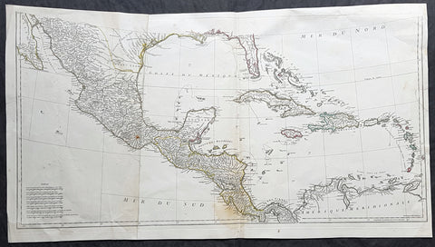
1756 J B D' Anville Large Antique Bottom Map Texas, Mexico, Central America, GOM
Antique Map
- Title : (Amerique Septentrionale Publiee sous les Auspices de Monseigneur le Duc d Orleans.. Par Le Snr. D Anville MDCCXLVI)
- Date : 1756
- Size: 35in x 19in (890mm x 485mm)
- Condition: (A) Very Good Condition
- Ref: 61147
Description:
This large important original copper plate engraved antique map, bottom sheets of 4 sheets, of North America was engraved in 1746 and was published by Jean-Baptiste Bourguinon D Anville in his Elephant Folio Atlas Generale. (I have included an image of the map of the map when it is complete)
This map was instrumental in instructing the European Colonial powers of the time, England France & Spain the importance of dominating the New World, that ultimately led to the French and Indian War of 1754–63. This conflict determined the political direction of North America leading to the American War of Independence in 1775 and ultimately the formation of The United States of America.
To illustrate the importance of cartography in the mid eighteenth century, especially that of North America, a J B D Anville map is essential. D Anville dominated 18th century European cartography with many of his cartographical achievements, especially in North America, copied by many of his contemporaries such as Kitchen, Sayer, Homann, Seutter, Mitchell and others .
He was one of the first to leave blank spaces in his maps, where knowledge was scant or insufficient. His representation of the great lakes is superior to that of his contemporary John Mitchell, responsible for publishing one of the most famous mid 18th century maps of North America, A Map of the British and French Dominions in North America on 8 sheets in 1755 and remained the standard map of North America up until the end of the 18th century. (Ref: Tooley, Printed maps of America, 104; The Mapping of America 316)
General Definitions:
Paper thickness and quality: - Heavy and stable
Paper color : - off white
Age of map color: - Original
Colors used: - Yellow, green, blue, pink
General color appearance: - Authentic
Paper size: - 35in x 19in (890mm x 485mm)
Plate size: - 34 1/2in x 17in (880mm x 430mm)
Margins: - Min 1/2in (12mm)
Imperfections:
Margins: - Small right side of margin & border restored
Plate area: - Folds as issued, small dis-colouration to bottom centerfold
Verso: - Folds as issued, several small repairs not affecting image
Background:
The French and Indian War (1754–63) comprised the North American theatre of the worldwide Seven Years War of 1756–63. It pitted the colonies of British America against those of New France. Both sides were supported by military units from their parent countries, as well as by American Indian allies. At the start of the war, the French North American colonies had a population of roughly 60,000 settlers, compared with 2 million in the British North American colonies. The outnumbered French particularly depended on the Indians. The European nations declared war on one another in 1756 following months of localized conflict, escalating the war from a regional affair into an intercontinental conflict.
The name French and Indian War is used mainly in the United States. It refers to the two enemies of the British colonists, the royal French forces and their various American Indian allies. The British colonists were supported at various times by the Iroquois, Catawba, and Cherokee, and the French colonists were supported by Wabanaki Confederacy members Abenaki and Mikmaq, and Algonquin, Lenape, Ojibwa, Ottawa, Shawnee, and Wyandot.
British and other European historians use the term the Seven Years War, as do English-speaking Canadians. French Canadians call it La guerre de la Conquête (the War of the Conquest) or (rarely) the Fourth Intercolonial War.
Fighting took place primarily along the frontiers between New France and the British colonies, from Virginia in the south to Newfoundland in the north. It began with a dispute over control of the confluence of the Allegheny River and Monongahela River called the Forks of the Ohio, and the site of the French Fort Duquesne in Pittsburgh, Pennsylvania. The dispute erupted into violence in the Battle of Jumonville Glen in May 1754, during which Virginia militiamen under the command of 22-year-old George Washington ambushed a French patrol.
In 1755, six colonial governors in North America met with General Edward Braddock, the newly arrived British Army commander, and planned a four-way attack on the French. None succeeded, and the main effort by Braddock proved a disaster; he lost the Battle of the Monongahela on July 9, 1755 and died a few days later. British operations failed in the frontier areas of Pennsylvania and New York during 1755–57 due to a combination of poor management, internal divisions, effective Canadian scouts, French regular forces, and Indian warrior allies. In 1755, the British captured Fort Beauséjour on the border separating Nova Scotia from Acadia, and they ordered the expulsion of the Acadians (1755–64) soon afterwards. Orders for the deportation were given by William Shirley, Commander-in-Chief, North America, without direction from Great Britain. The Acadians were expelled, both those captured in arms and those who had sworn the loyalty oath to His Britannic Majesty. Indians likewise were driven off the land to make way for settlers from New England.
The British colonial government fell in the region of modern Nova Scotia after several disastrous campaigns in 1757, including a failed expedition against Louisbourg and the Siege of Fort William Henry; this last was followed by Indians torturing and massacring their British victims. William Pitt came to power and significantly increased British military resources in the colonies at a time when France was unwilling to risk large convoys to aid the limited forces that they had in New France, preferring to concentrate their forces against Prussia and its allies in the European theater of the war. Between 1758 and 1760, the British military launched a campaign to capture the Colony of Canada (part of New France). They succeeded in capturing territory in surrounding colonies and ultimately the city of Quebec (1759). The British later lost the Battle of Sainte-Foy west of Quebec (1760), but the French ceded Canada in accordance with the Treaty of Paris (1763).
The outcome was one of the most significant developments in a century of Anglo-French conflict. France ceded to Great Britain its territory east of the Mississippi. It ceded French Louisiana west of the Mississippi River (including New Orleans) to its ally Spain in compensation for Spains loss to Britain of Florida. (Spain had ceded Florida to Britain in exchange for the return of Havana, Cuba.) Frances colonial presence north of the Caribbean was reduced to the islands of Saint Pierre and Miquelon, confirming Great Britains position as the dominant colonial power in eastern North America.
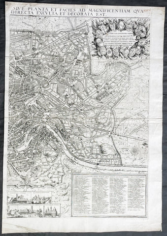
1679 Jacob von Sandrart & Giovanni Battista Falda Large Left Hand Sheet of Rome
Antique Map
- Title : Recentis Romae Ichnographia et Hypsographia Sive Planta et Faies Ad Magnificentiam Qua Prioribus Annis Urbs Ipsa Directa Exculta et Decorata Est.
- Date : 1679
- Size: 26 3/4in x 18 3/4in (680mm x 475mm)
- Condition: (A+) Fine Condition
- Ref: 43188
Description:
This large, original copper plate engraved scarce left hand section of the map of Rome by Jacob Von Sandrart, after Giovanni Battista Falda map, was published in 1679.
This map is based on Giovanni Battista Falda's 12-sheet view of Rome, Nuova Pianta et alzata della citta di Roma, first published in 1676.
Sandrart's view of Rome is rare, we are aware of only 2 examples appearing at auction during the last 25 years.
General Definitions:
Paper thickness and quality: - Heavy and stable
Paper color : - off white
Age of map color: -
Colors used: -
General color appearance: -
Paper size: - 26 3/4in x 18 3/4in (680mm x 475mm)
Plate size: - 25in x 17in (635mm x 430mm)
Margins: - Min 1/2in (12mm)
Imperfections:
Margins: - None
Plate area: - Light creasing along centerfold
Verso: - None
Background:
Jacob von Sandrart's rare and exquisitely engraved view of Rome, one of the finest impressions of the 'Eternal City' made during the great Baroque Era of Art and Architecture.
This finely engraved and lavishly decorative view of Rome takes in all of the 'Eternal City', as it was encompassed by its ancient Aurelian Walls, built during the 2nd Century A.D., on the banks of the River Tiber. Numerous monuments and sites, all of which are still present today, can be seem on the view, including the Coliseum, the Pantheon, the Piazza del Popolo, the Church of San Giovanni Laterno, the Baths of Diocletian, and the Vatican, which is dominated by the Dome of St. Peter's Basilica and the Castel Sant'Angelo. Most notable is the great oval Colonnade that lines the square in front of St. Peter's, which had only been completed in 1666 by the Gianlorenzo Bernini, one of the towering figures of the Baroque Era. The quality of the engraving is exceptionally high, as is the composition of the view, which grants the observer a panoptic view over Rome, while the specific details of the cityscape remain sharply distinguishable.
In the upper left, the title cartouche is surmounted by a portrait of Pope Innocent XI (reigned 1676-89), considered to be a leader of great learning and political acumen. In the upper right corner is a montage featuring the shields of the 14 traditional districts (wards) of Rome. Flowing through the view itself, the River Tiber has its orgins in an allegorical personification of its springs.
In the lower left, a table, 'Index Aedium Antiquitatarum' identifies an amazing 253 ancient buildings and ruins throughout the city. The 'Index Ecclesiarium' in the lower right identifies an incredible 178 churches, although it is not surprising that Rome had by far more houses of worship than any other city in Europe.
In the lower center of the plan are seven views of some of the city's most prominent churches, including St. Peter's Basilica (Vatican), St. Paul's Basilica, San Sebastian Church, San Giovanni Laterno, Sacred Cross of Jerusalem Church, Basilica of St. Lawrence Outside the Walls and the Basilica of Santa Maria Maggiore.
At the time that this view was issued, Rome was enjoying a period of prosperity, and the city's population had reached over 120,000, making it one of the 10 largest cities in Europe. The Roman Catholic Church was on a high, having largely succeeded in driving the Counterreformation, and revenues were pouring in to the Vatican from around the world. This funded the great flourishing of art and architecture in Baroque Rome.
The map was engraved by Jacob von Sandrart (1630-1708), one of the leading fine art engravers of the 17th Century. Born in Frankfurt-am-Main, he apprenticed under his famous uncle Joachim von Sandrart in Amsterdam. He worked in Danzing and Regensburg, and by 1656 had established himself in Nuremberg, where he remained for the rest of his life. Sandrart was highly productive, as over 400 different engravings from his burin are known to survive, although the high quality of his work never wavered. Along with his maps, he is especially well-known for his portraits. Sandrart was the founder and first director of the Nuremberg Academy of Fine Arts (chartered 1662).
Sandrart, Jacob von 1630 - 1708
Jacob von Sandrart was a German engraver primarily active in Nuremberg.
At age ten Sandrart obtained his artistic training from his better-known uncle Joachim von Sandrart in Amsterdam. After spending time in Danzig and Regensburg, he married Regina Christina Eimart, daughter of the engraver Georg Christoph Eimart the elder, on 10 June 1654. The couple settled in Nuremberg in 1656 and remained there for the rest of their lives. His daughter Susanne Maria von Sandrart was also an artist and engraver.
Sandrart was a very prolific artist; over 400 engravings from his hand are extant. He was best known as a portraitist of prominent contemporary citizens of Nuremberg, as an engraver of maps, and as an illustrator of the literary works of Nuremberg writers, especially Sigmund von Birken. Today Sandrart is best remembered as the founder and first director of the Nuremberg Academy of Fine Arts (est. 1662).
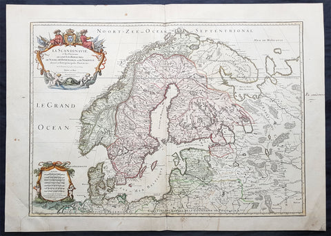
1707 Alexis Jaillot Large Original Antique Map of Scandinavia, Estonia, Latvia..
- Title : La Scandinavie...Hubert Jaillot 1707
- Ref #: 50665
- Size: 29 1/2in x 21in (750mm x 535mm)
- Date : 1707
- Condition: (B) Good Condition
Description:
This large beautifully hand coloured original antique map of Scandinavia, Norway, Sweden, Finland, Denmark, Latvia & Estonia, was engraved by Robert Cordier - after Nicolas Sanson - in 1707 - the date is engraved in the title and published by Alexis Jaillot.
General Definitions:
Paper thickness and quality: - Heavy and stable
Paper color : - off white
Age of map color: - Original
Colors used: - Yellow, green, blue, pink
General color appearance: - Authentic
Paper size: - 29 1/2in x 21in (750mm x 535mm)
Plate size: - 26in x 18 1/2in (660mm x 470mm)
Margins: - Min 1in (25mm)
Imperfections:
Margins: - Light soiling
Plate area: - Professional repair bottom left of plate, bottom centerfold re-joined and light uplift
Verso: - Professional repairs as noted
Background:
Before the fifteenth century the people of Southern Europe had little geographical knowledge of the Scandinavian World except from sketchy detail shown in the Catalan Atlas (1375) and on a number of " portolani" embracing Denmark and the southern tip of Norway. It was not until 1427 that a manuscript map prepared about that time by Claudius Clavus (b.1388) a Dane who spent some time in Rome, made available to scholars a tolerable outline of the northern countries and Greenland. That was to remain the best map available for the rest of the century and it was used as the basis for maps of Scandinavia in early printed editions of Ptolemy. Others by Nicolaus Cusanus (1491) and Ehrhard Etzlaub (c. 1492) followed but, needless to say, these are extremely rare; even the later maps by Olaus Magnus and Marcus Jordan, where they have survived at all , are known only by a very few examples. In fact, apart from the rare appearance of an early Ptolemy map, the oldest of Scandinavia which a collector is likely to find are those of Munster's Cosmograhy first published in 1544. In the following centuries the few maps and charts complied in Scandinavia were usually published in Amsterdam, Antwerp, Paris or Nuremberg, the most important maps often being incorporated in the major Dutch, French & German Atlases. (Ref: Tooley; M&B)
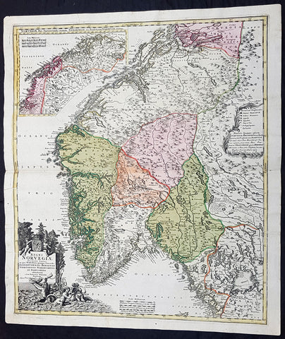
1720 J B Homann Large Original Antique Map of Norway - Regni Norvegiae
Antique Map
- Title : Regni Norvegiae Accurata Tabula in qua Praefecturae Quinque Generales Aggerhusiensis, Bergensis Nidrosiensis, Wardhusiensis et Bahusiensi Ioh. Bapt. Homanno.
- Date : 1720
- Condition: (A+) Fine Condition
- Ref: 93359
- Size: 24in x 20 1/4in (610mm x 540mm)
Description: This large beautifully hand coloured original antique map of Norway & parts of Scandinavia - with an inset map of Lapland & Northern Norway - was published by Johann Baptist Homann in 1720.
Condition Report:
Paper thickness and quality: - Heavy and stable
Paper color: - Off white
Age of map color: - Original
Colors used: - Yellow, pink, green
General color appearance: - Authentic
Paper size: - 24in x 20 1/4in (610mm x 540mm)
Plate size: - 23 1/2in x 20in (595mm x 505mm)
Margins: - Min 1/2in (12mm)
Imperfections:
Margins: - None
Plate area: - None
Verso: - None
Background: Before the fifteenth century the peoples of Southern Europe had little geographical knowledge of the Scandinavian world except from sketchy detail shown in the Catalan Atlas (1375) and on a number of 'portolani' embracing Denmark and the southern tip of Norway. It was not until 1427 that a manuscript map prepared about that time by Claudius Clavus (b. 1388), a Dane who had spent some time in Rome, made available to scholars a tolerable outline of the northern countries and Greenland. That was to remain the best map available for the rest of the century and it was used as the basis for maps of Scandinavia in early printed editions of Ptolemy. Others by Nicolaus Cusanus (1491) and Ehrhard Etzlaub (c. 1492) followed but, needless to say, these are extremely rare; even the later maps by Olaus Magnus and Marcus Jordan, where they have survived at all, are known only by very few examples. In fact, apart from the rare appearance of an early Ptolemy map, the oldest of Scandinavia which a collector is likely to find are those in Munster's Cosmography published in 1544 with many later editions. In the following centuries the comparatively few maps and charts compiled in Scandinavia were usually published in Amsterdam, Antwerp, Paris or Nuremberg, the more important maps often being incorporated in the major Dutch, French and German atlases. (Ref: Tooley; M&B)
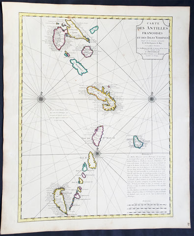
1725 Delisle Large Antique Map The West Indies - Antilles, Guadeloupe to Granada
Antique Map
- Title : Carte Des Antilles Francois et des Isles Voisines....
- Ref #: 61038
- Size: 25 1/2in x 21 1/2in (650mm x 545mm)
- Date : 1725
- Condition: (A+) Fine Condition
Description:
This large beautifully hand coloured original antique map of The West Indian Islands of the Antilles - from Guadeloupe to Granada - by Guillaume de L'Isle was published by Covens & Mortier in 1725 .
Condition Report
Paper thickness and quality: - Heavy and stable
Paper color: - Off white
Age of map color: - Original
Colors used: - Yellow, green, pink
General color appearance: - Authentic
Paper size: - 25 1/2in x 21 1/2in (650mm x 545mm)
Plate size: - 23 1/2in x 18in (600mm x 460mm)
Margins: - min. 1in (25mm)
Imperfections:
Margins: - Light age toning in margins
Plate area: - None
Verso: - None
Background: This map covers the predominately French portion of the West Indies from Guadeloupe to Grenada, including the Grenadines, St. Vincent, Dominica, St. Lucia (Alouise), Barbados, Martinique, and Marie-Galante, among others.
As the title cartouche suggests, Delisle cartographically derived this map almost exclusively from a manuscript produced by Thimothee Peitit, 'Arpenteur Jure de la Martinique' (Royal Surveyor of Martinique). Petit had the challenging task of reconciling local surveys of various islands with the general geography of the West Indies. Delisle copied from Petit's manuscript almost verbatim, a fact that is poignantly illustrated in the erroneous positioning of Grenada, which is both upside-down and situated to the west, rather than to the south, of the lower Grenadines. On Petit's part, this error has been attributed to simply running out of paper combined with an attempt to show the French Antilles within the greater continuity of the Windward Isles. For Delisle this was a major and uncharacteristic misstep that earned considerable critique in scientific and cartographic circles. Nonetheless, this map proved both popular and influential, being slavishly copied extensively by other cartographers of the period (Ref: M&B; Tooley)
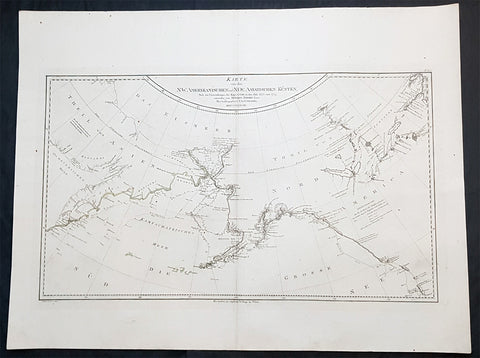
1788 Franz Schraembl & Capt Cook Large Antique Map NW America Alaska, California
Antique Map
- Title : Karte von den N.W. Amerikanischen und N.OE. Asiatischen Kusten nach den Untersuchungen des Kapit. Cook in den Jah. 1778 und 1779
- Ref #: 93436
- Size: 30 1/2in x 23 1/2in (765mm x 575mm)
- Date : 1788
- Condition: (A+) Fine Condition
Description:
This large original copper plate engraved antique map of the discoveries of Captain James Cook in NW America during his third voyage of discovery by Henry Roberts was engraved by I.C. Lackner in 1788 - dated - for the 1788 edition Franz Anton Schraembl edition of the Allgemeiner Grosser Atlas
A rare German language variant of Cooks map of his explorations along the northwest coast of America and the northeast coast of Asia. Based upon original work by Cooks cartographer Henry Roberts. Depicts much of Siberia and Kamtschaka in Asia and, in America, shows Canada as far east as the western portions of Hudson Bay. Alaska and Asia are shown with considerable accuracy though Vancouver Island is missing. Shows several lakes west of Hudson Bay in what is today northwestern Canada. Numerous depth soundings detailed along the exploration tracks. In addition to Cooks work, also notes the explorations of Bodega and the inland discoveries of Hearn, and others.
General Definitions:
Paper thickness and quality: - Heavy and stable
Paper color : - off white
Age of map color: -
Colors used: -
General color appearance: -
Paper size: - 30 1/2in x 23 1/2in (765mm x 575mm)
Plate size: - 28 1/2n x 16 1/2in (725mm x 420mm)
Margins: - Min 2in (50mm)
Imperfections:
Margins: - None
Plate area: - None
Verso: - None
Background:
Cooks Third Voyage (1776-1779)
In the course of his first two voyages, Cook circumnavigated the globe twice, sailed extensively into the Antarctic, and charted coastlines from Newfoundland to New Zealand. Following these achievements, Cooks third voyage was organized to seek an efficient route from England to southern and eastern Asia that would not entail rounding the Cape of Good Hope. The search for such a Northwest (or Northeast) Passage had been on the agenda of northern European mariners and merchants since the beginning of European expansion in the late fifteenth century. England\\\\\\\\\\\\\\\'s growing economic and colonial interests in India in the later eighteenth century provided the stimulus for the latest exploration for this route.
Cook, again in command of the Resolution, was to approach the Northwest Passage from the Pacific accompanied by a second ship, the Discovery, captained by Charles Clerke. The ships left England separately, regrouped at Cape Town, and continued on to Tasmania, New Zealand, and Tahiti. The expedition then sailed north and made landfall at Christmas Island and the Hawaiian Islands. Cook continued northward and charted the west coast of North America from Northern California as far as the Bering Strait. He returned to Hawaii for the winter and was killed in a skirmish with natives on February 14, 1779. Upon Cooks death, Clerke took command of the expedition but died six months later. The ships returned to England in 1780 under John Gore, who had commanded the Discovery after Cooks death. From start to finish, the voyage had lasted more than four years. (Ref Tooley; M&B; Clancy)
Schraembl, Franz Anton 1751-1803
Schraembl was a Vienna based cartographer working in the later part of the 18th century. Schraembl was partnered with Joseph von Reilly. His great work, the Allgemeiner Grosser Atlas was started in 1786. This ambitious atlas was to be based upon only the most up-to-date cartographic information available. Schraembl pulled his maps from the work of explorers such as Cook, Roberts, and others. The atlas was finally finished in 1800 but, possibly restricted by its high production cost, enjoyed only relatively minimal circulation.
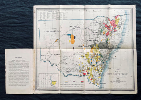
1876 Thomas & Tayler Scarce Antique Goldfields & Minerals Map of New South Wales
Antique Map
- Title : Sketch Map of New South Wales showing the Localities of the Principal Minerals 1876
- Ref #: 27011
-
Condition: (A+) Fine Condition
- Size: 18in x 15 1/2in (455mm x 400mm)
- Date : 1876
Description:
This original, incredibly scarce & important, antique lithograph map of New South Wales, illustrating the location of the Principle Minerals of that state, was drawn by John Tayler, engraved by G W Sharp and published by Thomas Richards in 1876 - dated, Sydney
General Definitions:
Paper thickness and quality: - Heavy and stable
Paper color : - off white
Age of map color: - Original
Colors used: - Yellow, green, blue, pink
General color appearance: - Authentic
Paper size: - 18in x 15 1/2in (455mm x 400mm)
Plate size: - 18in x 15 1/2in (455mm x 400mm)
Margins: - Min 1/2in (12mm)
Imperfections:
Margins: - Folds as issued
Plate area: - Folds as issued
Verso: - Folds as issued
Background:
The map shows New South Wales' new (and current) boundaries, with the state's 'Pastoral Districts' delineated; railways from Ports Hunter and Jackson are shown, along with their proposed extensions inland. Roads and telegraph lines are also indicated. Relief is shown by hachure. An inset map in the lower left shows the state's location on the Australian continent. These features are shared by the authors' other maps of New South Wales, the 1871 Map of New South Wales and the 1878 Sketch map of New South Wales showing the principal agricultural districts. Specific to this map, areas printed in color show the regions understood to be rich in minerals: Kerosene shale, coal, tin, iron, silver, copper, gold and 'diamonds and other gems.' The data on the map reflects the experience of some twenty years of prospecting in New South Wales, but predate the first systematic geological survey of the state, which would not be completed until 1880. The map specifies that the gold fields are 'proclaimed' gold fields, that is to say, permissible for prospectors. No prospector's claim was valid unless it fell within the limits of a 'proclaimed' field, which was officially recognized by the state and administered by a commissioner. The earlier 1873 edition of this map distinguishes between 'proclaimed' and 'unproclaimed' fields; in the present edition, the 'unproclaimed' fields have disappeared entirely. By 1876, control of gold mining in the state had passed from the Department of Lands to a new administration, the Department of Mines; in conjunction with this, mining had become less of a prospector-driven, 'gold rush' affair and more the province of mining companies employing more sophisticated processes, capable of extracting wealth from existing claims in which lower-capitalized operations were ineffective.
John Tayler 1861 - 1875 was an Australian cartographer and draftsman, employed by the NSW Surveyor Generals Office. His 1871 Map of New South Wales appears to have provided the basis for the bulk of the maps of the state produced prior to the Geological survey of 1880.
Richards, Thomas (1831 - 1898)
Thomas Richards, government printer, was born on 21 December 1831 in Pitt Street, Sydney, son of James Richards, builder, and his wife Mary, née OBrien. He was baptized a Catholic. His parents died in his infancy and he was reared by his aunt, the daughter of a sergeant-major in the First Fleet, and educated at Ebenezer on the Hawkesbury River. Having answered an advertisement for an intelligent youth, on 1 January 1845 he was engaged as an apprentice in the Government Printing Office, where he advanced as clerk, proof-reader, compositor, pressman, overseer and, in 1854, superintendent. In June 1859 he became government printer and inspector of stamps at a salary of £500, which had been reduced from his predecessors £850, but was raised to £600 in 1863; he had a staff of seventy. As he lacked London experience his appointment was unpopular. From 1 July 1879 he was also registrar of copyright.
During Richardss innovative administration, with increasing volume of work, the office expanded its functions and techniques. In 1863 he introduced photo-lithography and, after he had observed plant in Victoria in 1864, he added stereo-typing and electro-typing. In 1868 following the establishment of extra branches a new fast process of photo-lithography was invented by John Sharkey whose experiments were encouraged and assisted by Richards. The Sydney Morning Herald praised the gems of photo-lithographic art the Printing Office displayed at the 1870 Intercolonial Exhibition at Sydney. Later Richards initiated helio-type or photo-mechanical printing, introduced a perforating machine and invented a method of drying stamps with heat from gas. He devised an arithmotype bars system for numbering debentures which was adopted in all the colonies and England; he alleged the Bank of England took the patent without acknowledgment.
Frequently working long hours, Richards was criticized by some politicians for his administration and his publication of documents of allegedly limited public interest. He defended himself adequately before the 1870 select committee on the Government Printing Office, resisting suggestions of reductions in salaries and praising his men for the finest examples of the modern technique of photo-lithography seen in the colonies; and he admitted ambitions to produce an Australian geography and natural history, a year-book and dictionary of names for New South Wales. Looking back in 1891 he wrote, I had opposed to me a truculent minister, a truculent under-secretary and a truculent newspaper proprietor … I beat them but came out of the fray wounded in mind body and estate. He also had trouble with trade unions in difficult industrial times for heads of government departments and in 1875 antagonized the Trades and Labor Council by threatening to close the Office against all union men.
In 1877 Richards represented the government on an English committee to celebrate the quatercentenary of Caxtons introduction of printing. With twelve months leave he also studied advanced methods and bought new machinery. At the 1878 Paris Universal Exhibition he won a silver and two bronze medals and at the 1880 Melbourne International Exhibition he won five high diplomas for printing, bookbinding and photography. The 1883 Amsterdam Exhibition awarded him a gold and a silver medal, and the Printing Office was commended at other important exhibitions from 1862 to 1886. In 1882 Richards compiled, edited and printed the highly regarded New South Wales in 1881, which was translated into French; next year the office produced An Epitome of the Official History of New South Wales.
On 23 April 1861 Richards had joined the Volunteer Rifles as a second lieutenant. A good shot and member of the New South Wales Rifle Association, in 1885 he became lieutenant-colonel of the first regiment, Volunteer Infantry; he resigned next year. In November 1886, because of rapidly failing eyesight, Richards retired as government printer on a pension of £480; he left a staff of 400 and an office with sixty-one new departments. On 31 August 1898 he died at Manly and was buried in the Anglican cemetery there. On 29 January 1865, with Anglican rites, he had married Zara Bell, by whom he had three daughters and two sons who survived him.
Please note all items auctioned are genuine, we do not sell reproductions. A Certificate of Authenticity (COA) can be issued on request.
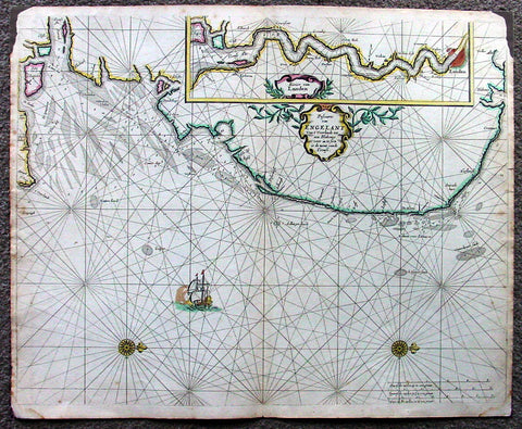
1676 Pieter Goos Large Antique Map of England, Thames River, London
Antique Map
- Title : Pascaarte van Engelant van t' Voorlandt tot aen Blakeney waer in te Sien is de Mont vande Teemse
- Date : 1676
- Condition: (A) Very Good Condition
- Ref: 42012
- Size: 22in x 18in (560mm x 455mm)
Description:
This large, beautifully hand coloured original antique map, a fine early Dutch sea chart of the Thames River and surrounding English coastline, was published by Pieter Goos in 1676 for the Goos De Zee-Atlas, Ofte Water-Weereld, Atlas.
This chart is oriented with north to the right includes in the upper right is a large inset of the Thames River and plan of London. Beautifully engraved with original coulouring embellished with rhumb lines, two compass roses and a galleon under sail. (Ref: Tooley; M&B; Koeman)
General Description:
Paper thickness and quality: - Heavy and stable
Paper color: - off white
Age of map color: - Original
Colors used: - Yellow, green, red, rose madder, red
General color appearance: - Authentic and fresh
Paper size: - 22in x 18in (560mm x 455mm)
Plate size: - 22in x 18in (560mm x 455mm)
Margins: - Min ½in (12mm)
Imperfections:
Margins: - Top L&R margin corner ink spill not affecting image
Plate area: - None
Verso: - Light soiling
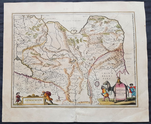
1639 Jansson Large Antique Map of Tartary, Siberian Russia, China, Central Asia
Antique Map
- Title : Tartaria sive Magni Chami Imperium
- Ref #: 43149
- Size: 23in x 19 1/2in (585mm x 495mm)
- Date : 1639
- Condition: (A+) Fine Condition
Description:
This handsome hand coloured original antique map of China, Tartary (Russian Siberia) & Central Asia was published by Jan Jansson in the 1639 French edition of Atlas Novus.
General Description:
Paper thickness and quality: - Heavy and stable
Paper color: - off white
Age of map color: - Original
Colors used: - Green, red, orange, yellow, blue
General color appearance: - Authentic
Paper size: - 23in x 19 1/2in (585mm x 495mm)
Plate size: - 20in x 15 1/2in (510mm x 395mm)
Margins: - Min 1in (25mm)
Imperfections:
Margins: - Uniform age toning
Plate area: - Uniform age toning
Verso: - Uniform age toning, bottom centerfold re-joined
Background: This handsome map shows all of eastern Asia between the Caspian Sea and a good portion of northern China and Manchuria both from outside and within the confines of The Great Wall.
This map of north-eastern Asia is dated when Tartary vaguely meant those regions to the north of Persia and China. The name Siberia only began to be applied with the gradual eastward expansion of the Russian Cossacks into those areas hinted at in the accounts of Marco Polo from three centuries earlier.
The Mythical and legendary nature of the geography of this vast interior is illustrated by the inclusion of devils and dragons in the Desertum Lop to the left of the Great Wall. (Ref Tooley M&B)
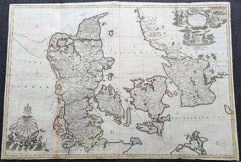
1720 John Senex Large Antique Map of Denmark & Southern Sweden
Antique Map
- Title : Denmark Corrected from the Newest Observations of the Royal Society at London and Paris by John Senex FRS
- Size: 38 1/2in x 27in (965mm x 685mm)
- Condition: (A) Very Good Condition
- Date : 1720
- Ref #: 70706
Description:
This large hand coloured original antique map of Denmark was engraved by John Senex and was published in the 1720 edition of his Elephant Folio Atlas.
This map is in VG condition. These large scale maps are scarce due mainly to their size, with damage and loss over time inevitable.
General Definitions:
Paper thickness and quality: - Heavy and stable
Paper color : - off white
Age of map color: - Original
Colors used: - Yellow, green, blue, pink
General color appearance: - Authentic
Paper size: - 38 1/2in x 27in (965mm x 685mm)
Plate size: - 38in x 26 1/2in (960mm x 680mm)
Margins: - Min 1/4in (6mm)
Imperfections:
Margins: - Chipping to bottom margin
Plate area: - Light offsetting
Verso: - Light creasing
Background:
Before the fifteenth century the people of Southern Europe had little geographical knowledge of the Scandinavian World except from sketchy detail shown in the Catalan Atlas (1375) and on a number of \" portolani\" embracing Denmark and the southern tip of Norway. It was not until 1427 that a manuscript map prepared about that time by Claudius Clavus (b.1388) a Dane who spent some time in Rome, made available to scholars a tolerable outline of the northern countries and Greenland. That was to remain the best map available for the rest of the century and it was used as the basis for maps of Scandinavia in early printed editions of Ptolemy. Others by Nicolaus Cusanus (1491) and Ehrhard Etzlaub (c. 1492) followed but, needless to say, these are extremely rare; even the later maps by Olaus Magnus and Marcus Jordan, where they have survived at all , are known only by a very few examples. In fact, apart from the rare appearance of an early Ptolemy map, the oldest of Scandinavia which a collector is likely to find are those of Munster\'s Cosmograhy first published in 1544. In the following centuries the few maps and charts complied in Scandinavia were usually published in Amsterdam, Antwerp, Paris or Nuremberg, the most important maps often being incorporated in the major Dutch, French & German Atlases. (Ref: Tooley; M&B)
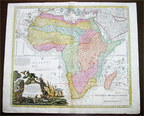
1730 Georg Mattraus Seutter Large Antique Map of Africa
Antique Map
- Title : Africa Iuxta Navigationes..Matth. Seuttero S Caes Maj Geographo Aug.
- Date : 1730
- Condition: (A) Very Good Condition
- Ref: 43003
- Size: 25 ½in x 21 ½in (650mm x 545mm)
Description:
This large beautifully hand coloured original copper-plate antique map of Africa was engraved by Tobais Lotter and published by Georg Mattraus Seutter in 1730 edition of Geographical Atlas or an Accurate Depiction of the Whole World
This striking map of Africa is based largely on Homanns 1715 map. Typical of the period, it presents largely fictitious information in southern Africa, and enormous lakes depicted in central Africa. The Nile is shown originating in the south at lakes Zaire and Zaflan and also continuing further south through a twisted river system with its headwaters in Bed Lac. The splendid decorative cartouche (uncolored) features indigenous people, pyramids and exotic animals, with a fierce dragon perched atop the title.
Condition Report
Paper thickness and quality: - Heavy and stable
Paper color: - off white
Age of map color: - Original & later
Colors used: - Yellow, pink, green, orange, blue
General color appearance: - Authentic
Paper size: - 25 ½in x 21 ½in (650mm x 545mm)
Plate size: - 23in x 20in (585mm x 510mm)
Margins: - Min 1in (25mm)
Imperfections:
Margins: - Two repairs to bottom margin, no loss
Plate area: - Two small professional repairs to center of image, not noticable
Verso: - None
Background:
The first separately printed map of Africa (as with the other known continents) appeared in Munster\'s Geographia from 1540 onwards and the first atlas devoted to Africa only was published in 1588 in Venice by Livio Sanuto, but the finest individual map of the century was that engraved on 8 sheets by Gastaldi, published in Venice in 1564. Apart from maps in sixteenth-century atlases generally there were also magnificent marine maps of 1596 by Jan van Linschoten (engraved by van Langrens) of the southern half of the continent with highly imaginative and decorative detail in the interior. In the next century there were many attractive maps including those of Mercator/Hondius (1606), Speed (1627), Blaeu (1 630), Visscher (1636), de Wit (c. 1670), all embellished with vignettes of harbours and principal towns and bordered with elaborate and colourful figures of their inhabitants, but the interior remained uncharted with the exception of that part of the continent known as Ethiopia, the name which was applied to a wide area including present-day Abyssinia. Here the legends of Prester John lingered on and, as so often happened in other remote parts of the world, the only certain knowledge of the region was provided by Jesuit missionaries. Among these was Father Geronimo Lobo (1595-1678), whose work A Voyage to Abyssinia was used as the basis for a remarkably accurate map published by a German scholar, Hiob Ludolf in 1683. Despite the formidable problems which faced them, the French cartographers G. Delisle (c. 1700-22), J. B. B. d\'Anville (1727-49) and N. Bellin (1754) greatly improved the standards of mapping of the continent, improvements which were usually, although not always, maintained by Homann, Seutter, de Ia Rochette, Bowen, Faden and many others in the later years of the century. (M&B; Tooley)
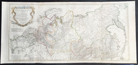
1762 D Anville Very Large Antique Map of Russia, Siberia, Mongolia, China, Japan
- Title : Troisieme Partie De La Carte D' Asia Contenant La Siberie...MDCCLII
- Ref #: 50604
- Size: 55in x 22 1/2in (1.25m x 570mm)
- Date : 1762
- Condition: (A+) Fine Condition
Description:
This very large beautifully engraved hand coloured original antique map of Russia, Siberia and Central Asia was engraved by Jean-Baptiste Bourguinon D'Anville in 1762 - the date is engraved in the title - and was published in the large elephant folio atlas Atlas Generale.
These maps are hard to find in such good condition and make fantastic historical reference tools due to the size and high level of detail as with all D'Anvilles work. (Ref: Tooley, M&B)
General Description:
Paper thickness and quality: - Heavy and stable
Paper color: - White
Age of map color: - Original
Colors used: - Yellow, pink, green
General color appearance: - Authentic
Paper size: - 55in x 22 1/2in (1.25m x 570mm)
Plate size: - 43in x 21in (1.10mm x 535mm)
Margins: - Min 1in (25mm)
Imperfections:
Margins: - None
Plate area: - Light creasing & soiling along L&R folds
Verso: - None
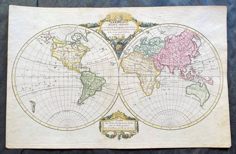
1780 Robert De Vaugondy Antique Twin Hemisphere World Map
Antique Map
- Title : Mappe-Monde par Robert de Vaugondy Geographe ord du Roi
- Size: 17 1/2in x 11 1/2in (440mm x 290mm)
- Condition: (A+) Fine Condition
- Date : 1780
- Ref #: 17060
Description:
This beautifully hand coloured original copper-plate engraved antique Twin Hemisphere World Map by Robert De Vaugondy was engraved in 1780 - dated in title and published in the same year.
General Definitions:
Paper thickness and quality: - Heavy and stable
Paper color : - off white
Age of map color: - Original
Colors used: - Yellow, green, blue, pink
General color appearance: - Authentic
Paper size: - 17 1/2in x 11 1/2in (440mm x 290mm)
Plate size: - 17 1/2in x 11 1/2in (440mm x 290mm)
Margins: - Min 1/2in (12mm)
Imperfections:
Margins: - None
Plate area: - None
Verso: - None
Background:
Fine twin hemisphere world map illustrating the known world in the 18th century. Although almost complete there are a few regions of uncertainty. The route taken by Cook on his final voyage is included which reaches from Australia, New Zealand to Hawaii and the very northern reaches of western North America which were surveyed and mapped by Cook extensively. There is some indication of a northern Arctic region there is no mention of the great southern Antarctica regions. A great map showing the world at the beginning of modern era. (Ref: Tooley; M&B)
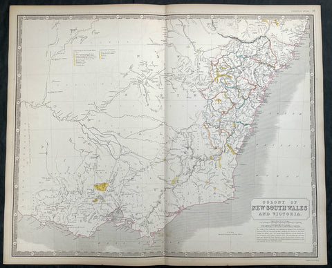
1856 A K Johnston Large Antique Goldfields Map of Victoria & New South Wales
Antique Map
- Title : Colony of New South Wales and Victoria by A K Johnston
- Date : 1856
- Condition: (A+) Fine Condition
- Ref: 27001
- Size: 25in x 21 1/2in (635mm x 545mm)
This original large hand coloured steel plate engraved antique map of NSW & Victoria - was published by A K Johnston in the 1856 edition of his National atlas of historical, commercial, and political geography.
A important and interesting map, showing some of the earliest and most important goldfields in both NSW & Victoria, illustrated in yellow with legend. the map is also one of the earliest to show the separation of the state of Victoria from New South Wales in 1851.
General Definitions:
Paper thickness and quality: - Heavy and stable
Paper color : - off white
Age of map color: - Original
Colors used: - Yellow, green, blue, pink
General color appearance: - Authentic
Paper size: - 25in x 21 1/2in (635mm x 545mm)
Plate size: - 25in x 21 1/2in (635mm x 545mm)
Margins: - Min 1/2in (12mm)
Imperfections:
Margins: - Light age toning
Plate area: - Light age toning
Verso: - Light age toning
Background:
The first gold rush in Australia began in May 1851 after prospector Edward Hargraves claimed to have discovered payable gold near Orange, at a site he called Ophir. Hargraves had been to the Californian goldfields and had learned new gold prospecting techniques such as panning and cradling. Hargraves was offered rewards by the Colony of New South Wales and the Colony of Victoria. Before the end of the year, the gold rush had spread to many other parts of the state where gold had been found, not just to the west, but also to the south and north of Sydney.
The Australian gold rushes changed the convict colonies into more progressive cities with the influx of free immigrants. These hopefuls, termed diggers, brought new skills and professions, contributing to a burgeoning economy. The mateship that evolved between these diggers and their collective resistance to authority led to the emergence of a unique national identity. Although not all diggers found riches on the goldfields, many decided to stay and integrate into these communities.
In July 1851, Victoria\\\'s first gold rush began on the Clunes goldfield. In August, the gold rush had spread to include the goldfield at Buninyong (today a suburb of Ballarat) 45 km (28 m) away and, by early September 1851, to the nearby goldfield at Ballarat (then also known as Yuille\\\'s Diggings) followed in early September to the goldfield at Castlemaine (then known as Forest Creek and the Mount Alexander Goldfield) and the goldfield at Bendigo (then known as Bendigo Creek) in November 1851. Gold, just as in New South Wales, was also found in many other parts of the state. The Victorian Gold Discovery Committee wrote in 1854:
The discovery of the Victorian Goldfields has converted a remote dependency into a country of world wide fame; it has attracted a population, extraordinary in number, with unprecedented rapidity; it has enhanced the value of property to an enormous extent; it has made this the richest country in the world; and, in less than three years, it has done for this colony the work of an age, and made its impulses felt in the most distant regions of the earth.
When the rush began at Ballarat, diggers discovered it was a prosperous goldfield. Lieutenant-Governor, Charles La Trobe visited the site and watched five men uncover 136 ounces of gold in one day. Mount Alexander was even richer than Ballarat. With gold sitting just under the surface, the shallowness allowed diggers to easily unearth gold nuggets. In 7 months, 2.4 million pounds of gold was transported from Mount Alexander to nearby capital cities.
The gold rushes caused a huge influx of people from overseas. Australia\\\'s total population more than tripled from 430,000 in 1851 to 1.7 million in 1871. Australia first became a multicultural society during the gold rush period. Between 1852 and 1860, 290,000 people migrated to Victoria from the British Isles, 15,000 came from other European countries, and 18,000 emigrated from the United States. Non-European immigrants, however, were unwelcome, especially the Chinese.
The Chinese were particularly industrious, with techniques that differed widely from the Europeans. This and their physical appearance and fear of the unknown led to them to being persecuted in a racist way that would be regarded as untenable today.
In 1855, 11,493 Chinese arrived in Melbourne. Chinese travelling outside of New South Wales had to obtain special re-entry certificates. In 1855, Victoria enacted the Chinese Immigration Act 1855, severely limiting the number of Chinese passengers permitted on an arriving vessel. To evade the new law, many Chinese were landed in the south-east of South Australia and travelled more than 400 km across country to the Victorian goldfields, along tracks which are still evident today.
In 1885, following a call by the Western Australian government for a reward for the first find of payable gold, a discovery was made at Halls Creek, sparking a gold rush in that state.
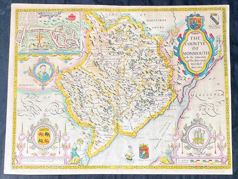
1676 John Speed Antique County Map of MonmouthShire - Beautiful Original Colour
Antique Map
- Title : The Countye of Monmouth Anno 1610
- Date : 1676
- Size: 21in x 16in (535mm x 405mm)
- Condition: (A+) Fine Condition
- Ref: 35623
Description:
This original hand coloured copper plate engraved antique county map & views of Monmouth Shire and Monmouth City by John Speed was published in the 1676 Bassett & Chiswell edition of Speeds famous atlas The Theatre of the Empire of Great Britaine.
The map is embellished with the famous birds-eye views of the county and city with descriptive text on the verso.
General Definitions:
Paper thickness and quality: - Heavy and stable
Paper color : - off white
Age of map color: - Original
Colors used: - Yellow, green, blue, pink
General color appearance: - Authentic
Paper size: - 21in x 16in (535mm x 405mm)
Plate size: - 20 1/2in x 15 1/4in (520mm x 385mm)
Margins: - Min 1/2in (10mm)
Imperfections:
Margins: - Age toning
Plate area: - Age toning
Verso: - Age toning
Background:
John Speeds The Theatre of the Empire of Great Britaine was published in 1610/11 by John Sudbury and George Humble, and contained the first set of individual county maps of England and Wales besides maps of Ireland and a general map of Scotland. Most, but not all, of the county maps have town plans on them; those showing a Scale of Passes being the places he had mapped himself. The county maps were the first consistent attempt to show territorial divisions, such as boundaries of hundreds, but it was Speed’s town plans that were a major innovation and probably his greatest contribution to British cartography. The Theatre was an immediate success: the first print run of around 500 copies must have sold quickly because many editions followed. Sudbury and Humble realized, given the increasing popularity of both county and world atlases and in the light of the success of Abraham Ortelius’s Theatrum Orbis Terrarum, the potential demand for an English world atlas.
In 1627, two years before his death, Speed published Prospect of the Most Famous Parts of the World with 21 finely engraved maps, which was the first world atlas produced by an Englishman. There is a fascinating text describing the areas shown on the back of the maps in English, although a rare edition of 1616 of the British maps has a Latin text – this is believed to have been produced for the Continental market. Its maps are famous for their bordering panels of national characters in local costume and panoramic views depicting the areas of major towns and cities. Much of the engraving was done in Amsterdam at the workshop of Jodocus Hondius. The maps of the world and America show California as an island and are amongst the earliest ever printed to depict this seventeenth-century cartographic myth.
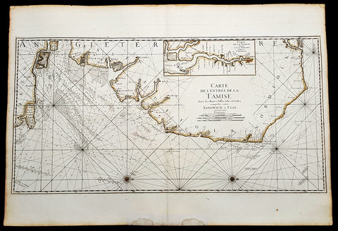
1693 A H Jaillot Large Sea Chart, Map of SE England and Thames Estuary, Clay to Sandwich
Antique Map
- Title : Carte de l entree de la Tamise avec les bancs, passes, isles et costes comprises entre Sandwich et Clay. (Map of the Thames estuary entry with the banks, streets, islands and coasts between Sandwich and Clay)
- Size: 37 1/2in x 25 1/2in (950mm x 650mm)
- Condition: (A+) Fine Condition
- Date : 1693
- Ref #: 93356
Description:
This large beautifully hand coloured original 1693 antique sea-chart, map of SE England from Clay, Norfolk, to Sandwich and the entrance of the Thames Estuary by A H Jaillot was published in his large elephant folio Le Neptune Francois, ou Atlas Nouveau des Cartes Marines
Handsome sea-chart illustrating the importance of this region to Englands dominance by its navy. Shows the Thames Estuary & river to London, showing many sandbars, soundings and coastline, blank verso.
General Definitions:
Paper thickness and quality: - Heavy and stable
Paper color : - off white
Age of map color: - Original
Colors used: - Yellow
General color appearance: - Authentic
Paper size: - 37 1/2in x 25 1/2in (950mm x 650mm)
Plate size: - 36in x 18in (930mm x 460mm)
Margins: - Min 1in (25mm)
Imperfections:
Margins: - Light age toning
Plate area: - None
Verso: - None
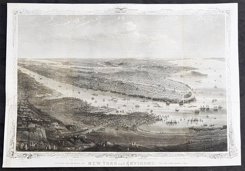
1869 Shannon & Rogers Birds Eye View of New York City - New York Manual
Antique Map
- Title : Designed and Engraved For New York and Environs. The New York Manual 1869
- Size: 16in x 12in (405mm x 275mm)
- Condition: (A+) Fine Condition
- Date : 1869
- Ref #: 93208
Description:
This original antique lithograph print of New York City by Joseph Shannon & WC Rogers in 1869 (dated) and was published in the 1869 edition of D T Valentines Manual of the Corporation of the City of New York or Valentines Manual.
General Definitions:
Paper thickness and quality: - Heavy and stable
Paper color : - off white
Age of map color: -
Colors used: -
General color appearance: -
Paper size: - 16in x 12in (405mm x 275mm)
Plate size: - 16in x 12in (405mm x 275mm)
Margins: - Min 1/2in (12mm)
Imperfections:
Margins: - Bottom right margin extended, not affecting the image
Plate area: - Folds as issued
Verso: - Folds as issued.
Background:
Rare view of the island of Manhattan, New York City by W. C. Rogers. The view depicts the entire island of Manhattan with Hoboken as well as parts of Brooklyn and Queens. Important buildings, especially churches are depicted with considerable accuracy. The harbor itself is full of sailing ships.
William C. Rogers 1860 - 1873 (active) a New York based lithographer best known for his engravings issued in conjuction with Joseph Shannons (Valentines) Manual of the Corporation for the City of New York.
Valentine, David Thomas 1801 - 1869
As the Clerk of the Common Council of New York City, Valentine edited and published a series of books on the history and contemporary facts of New York City entitled Manual of the Corporation Of The City of New York. They became know as Valentines Manuals with updates published annually, between 1841 & 1870. Valentine used his manuals to produce some of the rarest and most important maps & views of the city of New York, some of which occasionally appear on the market. His contribution to the historical record of New York city cannot be over stated.
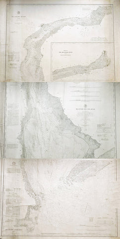
1878-88 US Coast Survey 3 x Sheet Very Large Antique Map of The Delaware River
Antique Map
- Title : Delaware River..Issued in June 1881 CP Paterson; Delaware Bay and River..under the direction of FR Hassler and AD Bache...April 1878 CP Patterson; Delaware Entrance aids to navigation to 1887
- Size: 42in x 29in (1.07m x 735mm) each sheet
- Condition: (B) Good Condition
- Date : 178-88
- Ref #: 93111
Description:
Original scarce very large (78in x 36in when joined) antique three sheet map, on very heavy paper, of the Delaware River and Harbour. The map follows the river bordering the States of New Jersey, Delaware & Pennsylvania, from the river mouth to Philadelphia PA, by AD Bache and FR Hassler and was first issued by the US Coast Survey in 1848. These 3 sheets were issued, updated in 1887, 1881 & 1887 respectively.
General Definitions:
Paper thickness and quality: - Heavy and stable
Paper color : - off white
Age of map color: -
Colors used: -
General color appearance: -
Paper size: - 42in x 29in (1.07m x 735mm) each sheet (approx)
Plate size: - 42in x 29in (1.07m x 735mm) each sheet (approx)
Margins: - Min 1/2in (12mm)
Imperfections:
Margins: - Soiling and creasing
Plate area: - Soiling and vertical creasing
Verso: - Soiling and vertical creasing
Background:
While these maps appear together occasionally on the market, and can be found bound into early US Coast Survey volumes, the thin paper and browned folds invariably leaves it in problematic condition. The present example is a separately issued example on very heavy paper. Many of the coast survey maps were issued in very limited numbers on heavy paper for presentation purposes or use at sea, making any example of these three maps together rare.
U.S. Coast Survey (Office of Coast Survey)
The Office of Coast Survey is the official chart-maker of the United States. Set up in 1807, it is one of the U.S. governments oldest scientific organizations. In 1878 it was given the name of Coast and Geodetic Survey (C&GS). In 1970 it became part of the National Oceanic and Atmospheric Administration (NOAA).
The agency was established in 1807 when President Thomas Jefferson signed the document entitled An act to provide for surveying the coasts of the United States. While the bills objective was specific—to produce nautical charts—it reflected larger issues of concern to the new nation: national boundaries, commerce, and defence.
The early years were difficult. Ferdinand Rudolph Hassler, who was eventually to become the agencys first superintendent, went to England to collect scientific instruments but was unable to return through the duration of the War of 1812. After his return, he worked on a survey of the New York Harbor in 1817, but Congress stepped in to suspend the work because of tensions between civilian and military control of the agency. After several years under the control of the U.S. Army, the Survey of the Coast was reestablished in 1832, and President Andrew Jackson appointed Hassler as superintendent.
The U.S. Coast Survey was a civilian agency but, from the beginning, members of the Navy and Army were detailed to service with the Survey, and Navy ships were also detailed to its use. In general, army officers worked on topographic surveys on the land and maps based on the surveys, while navy officers worked on hydrographic surveys in coastal waters.
Alexander Dallas Bache, great-grandson of Benjamin Franklin, was the second Coast Survey superintendent. Bache was a physicist, scientist, and surveyor who established the first magnetic observatory and served as the first president of the National Academy of Sciences. Under Bache, Coast Survey quickly applied its resources to the Union cause during the Civil War. In addition to setting up additional lithographic presses to produce the thousands of charts required by the Navy and other vessels, Bache made a critical decision to send Coast Survey parties to work with blockading squadrons and armies in the field, producing hundreds of maps and charts. Bache detailed these activities in his annual reports to Congress.
Coast Survey cartographer Edwin Hergesheimer created the map showing the density of the slave population in the Southern states.
Bache was also one of four members of the governments Blockade Strategy Board, planning strategy to essentially strangle the South, economically and militarily. On April 16, 1861, President Lincoln issued a proclamation declaring the blockade of ports from South Carolina to Texas. Baches Notes on the Coast provided valuable information for Union naval forces.
Maps were of paramount importance in wartime:
It is certain that accurate maps must form the basis of well-conducted military operations, and that the best time to procure them is not when an attack is impending, or when the army waits, but when there is no hindrance to, or pressure upon, the surveyors. That no coast can be effectively attacked, defended, or blockaded without accurate maps and charts, has been fully proved by the events of the last two years, if, indeed, such a proposition required practical proof.
— Alexander Dallas Bache, 1862 report.
Coast Survey attracted some of the best and brightest scientists and naturalists. It commissioned the naturalist Louis Agassiz to conduct the first scientific study of the Florida reef system. James McNeill Whistler, who went on to paint the iconic Whistlers Mother, was a Coast Survey engraver. The naturalist John Muir was a guide and artist on Survey of the 39th Parallel across the Great Basin of Nevada and Utah.
The agencys men and women (women professionals were hired as early as 1845) led scientific and engineering activities through the decades. In 1926, they started production of aeronautical charts. During the height of the Great Depression, Coast and Geodetic Survey organized surveying parties and field offices that employed over 10,000 people, including many out-of-work engineers.
In World War II, C&GS sent over 1,000 civilian members and more than half of its commissioned officers to serve as hydrographers, artillery surveyors, cartographers, army engineers, intelligence officers, and geophysicists in all theaters of the war. Civilians on the home front produced over 100 million maps and charts for the Allied Forces. Eleven members of the C&GS gave their lives during the war.
Alexander Dallas Bache 1806 – 1867 was an American physicist, scientist, and surveyor who erected coastal fortifications and conducted a detailed survey to map the mid-eastern United States coastline. Originally an army engineer, he later became Superintendent of the U.S. Coast Survey, and built it into the foremost scientific institution in the country before the Civil War.
Alexander Bache was born in Philadelphia, the son of Richard Bache, Jr., and Sophia Burrell Dallas Bache. He came from a prominent family as he was the nephew of Vice-President George M. Dallas and naval hero Alexander J. Dallas. He was the grandson of Secretary of the Treasury Alexander Dallas and was the great-grandson of Benjamin Franklin.
Bache was a professor of natural philosophy and chemistry at the University of Pennsylvania from 1828 to 1841 and again from 1842 to 1843. He spent 1836–1838 in Europe on behalf of the trustees of what became Girard College; he was named president of the college after his return. Abroad, he examined European education systems, and on his return he published a valuable report. From 1839 to 1842, he served as the first president of Central High School of Philadelphia, one of the oldest public high schools in the United States.
In 1843, on the death of Professor Ferdinand Rudolph Hassler, Bache was appointed superintendent of the United States Coast Survey. He convinced the United States Congress of the value of this work and, by means of the liberal aid it granted, he completed the mapping of the whole coast by a skillful division of labor and the erection of numerous observing stations. In addition, magnetic and meteorological data were collected. Bache served as head of the Coast Survey for 24 years (until his death).
Please note all items auctioned are genuine, we do not sell reproductions. A Certificate of Authenticity (COA) can be issued on request.
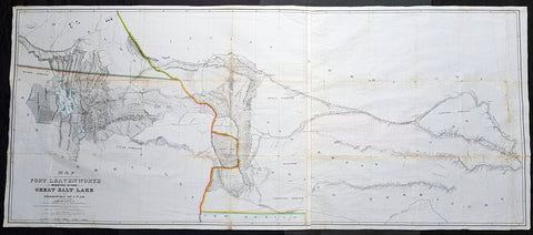
1852 Howard Stansbury Large Antique Map Forth Leavenworth, KS to Salt Lake, Utah
Antique Map
- Title : Map of a reconnaissance between Fort Leavenworth on the Missouri River, and the Great Salt Lake in the territory of Utah / made in 1849 and 1850 under the orders of Col. J.J. Abert, Chief of the Topographical Bureau, by Capt. Howard Stansbury of the Corps of Topographical Engineers, aided by Lieut. J.W. Gunnison, Corps Topographical Engineers, and Albert Carrington ; drawn by Lieut. Gunnison and Charles Preuss
- Size: 70in x 30in (1.78m x 760mm)
- Condition: (A) Very Good Condition
- Date : 1852
- Ref #: 93342
Description:
This large original antique lithograph map from Fort Leavenworth, Kansas to the Great Salt Lake, Utah by Howard Stansbury, in 1849-50, is one of the earliest concise and complete survey of the 900+ miles across unknown and hostile Indian territory. This is a milestone of American cartography showing detail of the territories of Nebraska, Colorado and Utah.
This large map along with another, of The Great Salt Lake in Utah, was drawn by Henry Gunnison & Charles and published by the publishing house Ackermann, New York City in 1852.
Stansbury was commissioned by Congress to survey the Great Salt Lake in the Utah Valley in 1849. Heading west using old known tracks and local knowledge, Stansbury along with his expedition, completed the task in 2 years presenting their report, along with two very large maps, to Congress in 1852.
General Definitions:
Paper thickness and quality: - Heavy and stable
Paper color : - off white
Age of map color: - Original
Colors used: - Blue
General color appearance: - Authentic
Paper size: - 70in x 30in (1.78m x 760mm)
Plate size: - 70in x 30in (1.78m x 760mm)
Margins: - Min 1/2in (12mm)
Imperfections:
Margins: - None
Plate area: - Folds as issued, small repair along a couple of folds, slight loss, light age toning
Verso: - Re-enforced along folds with transparent archival tape
Background:
In 1849 Stansbury was ordered to travel from Fort Leavenworth, Kansas to survey the Great Salt Lake in Utah, evaluate emigration trails along the way, especially the Oregon and Mormon trails and to scout for possible locations for a transcontinental railroad. The expedition consisted of 18 men including his second in command Lieutenant John Williams Gunnison. Over the following two years, the expedition explored the Great Salt Lake, Utah Lake and the Cache Valley of northern Utah all the way to Fort Hall in southern Idaho. Upon first arriving in Utah the Mormon leaders were worried that the expedition was part of an effort by the U.S government to oust the Mormon settlers. Stansbury held a meeting with Brigham Young where he assured the leader that the expedition was purely a scientific one. Young responded by assigning his personal secretary Albert Carrington to assist the expedition. Upon completing the mission in Utah, the expedition started back east to Leavenworth. Rather than follow the standard Oregon Trail route from Fort Bridger over South Pass through the Sweetwater River valley, Stansbury wanted to scout a more direct route east. Following the advice of Jim Bridger and local trappers and traders the expedition followed the Blacks Fork River east, crossed the Green River near the present day town of Green River, Wyoming and proceeded east along the Bitter Creek valley, crossing the Red Desert, and skirting the northern side of Elk Mountain across the Laramie Plains. They passed over the Laramie Mountains and made their way to Fort Laramie where they struck the Oregon Trail heading east. Stansbury's seminal 1852 map of the Great Salt Lake region in Utah is considered to be the first accurate survey of the Great Basin as well as a cornerstone achievement in the mapping of the American West. The first westerner to visit the Great Basin was most likely Silvestre Vélez de Escalante in the 1776, however, Escalante, who visited Utah Lake to the south, never truly laid eyes on Great Salt Lake. That honor would fall to unnamed trappers and mountain men travelling the region
Stansbury, Howard 1806 - 1863
Stansbury was an important surveyor, cartographer, and explorer who did his most important work in Utah during the middle part of the 19th century. Born in New York City, Stansbury trained to be a Civil Engineer. Shorty after getting married to Helen Moody of Detroit in 1827, Stansbury took a position with the United States Topographical Bureau. Under that organization he surveyed the James River in 1836, and the Illinois and Kaskaskia Rivers in 1837. In 1838, he oversaw the construction of a road from Milwaukee to the Mississippi River. Later in 1838, when the U.S Corps of Topographical Engineers was created, he joined as a first Lieutenant. With the Topographical Engineers he surveyed the Great Lakes, the harbor of Portsmouth, New Hampshire, and constructed Florida\\\'s Carysfort Reef Lighthouse. During the Mexican-American War he constructed fortification in the Dry Tortugas at the westernmost point on the Florida Keys. Upon achieving the rank of Captain, Stansbury received a commissioned to head a survey of the Great Basin that would ultimately become the crowning achievement of his career. His assignment was to survey the emigrant trails to California, including the Oregon Trail, as well as the Great Salt Lake, and report on the status of the growing Mormon Community in Salt Lake City. Working with J. W. Gunnison and Alfred Carrington, a Mormon scout, Stansbury produced a masterful survey of the region that had a lasting effect not only on the development of the Great Basin, but on the development of the west in general. Upon completion of his survey, Stansbury set out on the road to Washington, completing another important survey in the process. On the way, he fell off his horse, taking an injury from which he never fully recovered. Following the presentation of his report to Congress, Stansbury was charged with additional survey work around the Great Lakes. Upon the outbreak of the American Civil War, he was assigned to recruitment duties in Ohio and later Wisconsin. Shortly after starting work at this post he suffered an abrupt heart attack and passed away. He is buried in St. Paul, Minnesota.
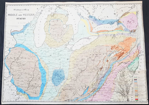
1843 James Hall Large Antique Geological Map of the United States & Great Lakes
Antique Map
- Title : Geological Map of the Middle and Western States by James Hall
- Date : 1843
- Size: 32 1/2in x 24in (825mm x 610mm)
- Ref #: 93061
- Condition: (A+) Fine Condition
Description:
This large original steel plate engraved, hand coloured antique Geological map from the Mississippi River to the Atlantic Ocean and from the Straits of Michilimackinac (Michillimaoinac) and Montreal, Canada to Virginia, Kentucky, and Missouri by James Hall was published in the 1843 edition of Halls Geology of New York. Part IV. Comprising the Survey of the Fourth Geological District
General Definitions:
Paper thickness and quality: - Heavy and stable
Paper color : - off white
Age of map color: - Original
Colors used: - Yellow, green, blue, pink
General color appearance: - Authentic
Paper size: - 32 1/2in x 24in (825mm x 610mm)
Plate size: - 32 1/2in x 24in (825mm x 610mm)
Margins: - Min 1/2in (12mm)
Imperfections:
Margins: - None
Plate area: - None
Verso: - None
Background:
The New York System of Geology
Hall’s map can be regarded as a landmark work as it was one of the earliest known maps to employ the New York System, of stratigraphic nomenclature developed by Hall and others at the New York Geological Survey. The system emphasized the importance of paleontology for delineating geological units and introduced the concept of type locality, a primary reference location used for defining the characteristics of geological formations. This map is the first regional application of the system, which evolved into the standard nomenclature used today for North America and much of the rest of the world.
Hall, James 1811 - 1898
Hall was an American paleontologist and geologist. Born in Hingham, Massachusetts, Hall was the oldest of four children born to James Hall Sr. and Sousanna Dourdain Hall, who had emigrated from England two years earlier. Hall attended the Rensselaer Polytechnic Institute, from which he graduated with honors in 1832 and he received a masters degree from the same institution the following year. After completing his masters degree, Hall stayed at Rensselaer and taught chemistry and later geology. In 1836, Hall was appointed to the team working on a geological and natural history of New York. That first year he was assigned as Ebenezer Emmonss assistant, for who he studied iron deposits in the Adirondack Mountains. The following year, after the survey was reorganized, Hall was put in charge of the Fourth District, in western New York. After completing the survey in 1841, Hall was named the first state paleontologist of New York. Hall published the findings of the survey in 1843 as Geology of New York Part IV. This work received much acclaim and became a classic in the field. Thanks to this success, Hall had established a solid reputation and spent the rest of his life studying stratigraphic geology and invertebrate paleontology. Hall constructed a laboratory in Albany, New York, which quickly became an important institution for aspiring geologists and paleontologists to study and train. Today, this laboratory is known as the James Hall Office and was designated a National Historic Landmark in 1976. Following the survey of New York, Hall participated in a geological survey of northern Michigan and Wisconsin in 1850, and served as state geologist for Iowa from 1855 until 1858 and for Wisconsin from 1857 until 1860. In 1866, Hall was appointed the director of the New York State Museum of Natural History in Albany, and was appointed State Geologist of New York in 1893. Hall was a founding member of the National Academy of Sciences and served as the first president of the Geological Society of America. In 1838, Hall married Sarah Aikin, with whom he had two daughters and two sons. Sarah passed away in 1895.
Endicott and Company (fl. c. 1828 - 1891) was a New York based family run lithography firm that flourished throughout the 19th century. The firm was founded by George and William Endicott, brothers who were born in Canton, Massachusetts. George Endicott (June 14, 1802 - 1848) trained as a lithographer under Pendleton Lithography from January of 1826. He later worked as superintendent of Senefelder Company until the summer of 1828. Afterwards, in 1830, he relocated to Baltimore and partnered with Moses Swett. Endicott and Swett relocated to New York City in December of 1831. They remained partners until July of 1834 when the relationship dissolved. George set up shop on his own account at 359 Broadway. William Endicott (1815 - 1851), Georges younger brother of 14 years, joined the firm in 1840 and was made a partner in 1845, after which the name of the firm was changed to G. and W. Endicott. George Endicott died shortly afterward, in 1848, but William continued operating the firm as William Endicott and Co. until his own 1851 death at just 35 years. The firm was carried on by his widow Sara Munroe Endicott until it was taken over by her son, Francis Endicott, who ran the firm from 1852 to 1886. George Endicott, Jr. subsequently ran the firm from 1887 to 1891. Peters, in his important work on American lithography America on Stone writes it is hard to summarize the Endicotts. They did everything and did it well . . . [they] worked with and for Currier and Ives, yet in spite of all that much of their work lacks real individuality. The Endicott firm was responsible for many 19th century views and plans of New York City and state as well as plans of Sacramento, California, and the Midwest.
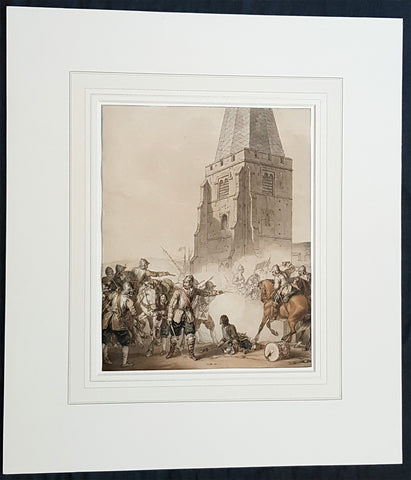
1810 John Augustus Atkinson Original Water Colour Art of an English War Skirmish
Antique Map
- Title : (A Civil War Skirmish)
- Ref #: 93444
- Size: 17in x 15in (430mm x 365mm)
- Date : 1810
- Condition: (A+) Fine Condition
Description:
This beautifully executed original pen, pencil and watercolour picture of an English Civil War battle scene was painted by John Augustus Atkinson in ca 1810.
Atkinson was known for his battle scene art works during his time at the St Petersburg Court in Russia as well as his Napoleonic battle scenes from the early 19th century.
Atkinson is held in high esteem as a watercolourist, and was elected as a member of the Society of Painters in Water Colours in 1808. He has works of art held at many prestigious museums in Russia, Europe and the UK, such as the Tate, Royal Watercolour Society, National Maritime Museum and many more listed below. He also sells on the open market with this piece last sold in 2004.
Professionally matted and can be easily removed if required.
General Definitions:
Paper thickness and quality: - Heavy and stable
Paper color : - off white
Age of map color: - Original
Colors used: - Blue, pink, red, green, yellow
General color appearance: - Authentic
Paper size: - 17in x 15in (430mm x 365mm)
Plate size: - 9 3/4in x 8in (247mm x 203mm)
Margins: - Min 0in (0mm)
Imperfections:
Margins: - None
Plate area: - None
Verso: - None
Background:
The English Civil War (1642–1651) was a series of civil wars and political machinations between Parliamentarians (Roundheads) and Royalists (Cavaliers) principally over the manner of Englands governance and part of the wider Wars of the Three Kingdoms. The first (1642–1646) and second (1648–1649) wars pitted the supporters of King Charles I against the supporters of the Long Parliament, while the third (1649–1651) saw fighting between supporters of King Charles II and supporters of the Rump Parliament. The war ended with Parliamentarian victory at the Battle of Worcester on 3 September 1651.
Unlike other civil wars in England, which were mainly fought over who should rule, these conflicts were also concerned with how the three kingdoms of England, Scotland, and Ireland were to be governed. The outcome was threefold: the trial and execution of Charles I (1649); the exile of his son, Charles II (1651); and the replacement of English monarchy with, at first, the Commonwealth of England (1649–1653) and then the Protectorate, which as the Commonwealth of England, Scotland, and Ireland unified the British Isles under the personal rule of Oliver Cromwell (1653–1658) and briefly his son Richard (1658–1659). The execution of Charles I was particularly notable given that an English king had never been executed before. In England, the monopoly of the Church of England on Christian worship was ended, while in Ireland the victors consolidated the established Protestant Ascendancy. Constitutionally, the wars established the precedent that an English monarch cannot govern without Parliaments consent, although the idea of Parliamentary sovereignty was only legally established as part of the Glorious Revolution in 1688.
Atkinson, John Augustus 1775 - 1830
Atkinson was an English artist, engraver and watercolourist.
He was born in London and at the age of 9, in 1784, went to live with his uncle, the famous engraver James Walker, in St Petersburg, Russia. Walker was engraver to the empress Catherine the Great 1729 - 1796 and encouraged Atkinson to study art, seeing a talent in him. Atkinson was well placed in St Petersburg to study art, being surrounded by the many collections of Catherine and the Russian Nobility, the richest in Europe. It is known that Atkinson was encouraged by Catherine herself along with and her son & later Emperor of Russia Paul I 1754 - 1801. Paul later commissioned Atkinson to paint large pieces from Russian history that can be seen in many Museums today around the world.
After the death of Paul in 1801, Atkinson returned to England and in 1803 published A Picturesque Representation of the Manners, Customs, and Amusements of the Russians, in 100 plates, drawn and etched by himself. He also painted in watercolours and in 1808 was elected to the Society of Painters in Water Colours. Many of his works, during the Napoleonic wars, were of naval subjects. He painted many battle scenes including a Battle of Waterloo, which was engraved by John Burnet.
His last contribution to the Royal Academy exhibition was in 1829. He died on 25 March 1830 in London.
Selected Works
• Carriage on Sledges 1803 Art Gallery of Greater Victoria, British Columbia
• A Russian Village 1804 Art Gallery of Greater Victoria, British Columbia
• Golubtza 1804 Art Gallery of Greater Victoria, British Columbia
• Village Amusements 1804 Art Gallery of Greater Victoria, British Columbia
• Scene from Tom Jones Courtauld Institute of Art, London
• The Slack Rope Courtauld Institute of Art, London
• A Belgian Waggon with Four Horses Tate Gallery, London
• Illustrations to Ossian The Huntington Library, California
• Heaving a Lead 1807 National Maritime Museum
• Greenwich Pensioners 1808 National Maritime Museum
• Skating, 1810 Tyne & Wear Museums, England
• Ships of the Reign of King Edward IV 1812 - Fine Arts Museums of San Francisco
• 42nd Highlanders at Waterloo Courtauld Institute of Art, London
• British Sailors Boarding a Man of War 1815 National Maritime Museum
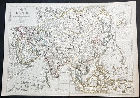
1830 Jean Baptiste Clouet & Pierre Jean Large Antique Map of Asia..Wall Map
Antique Map
- Title : Carte de L Asie, Divisee En Ses Differents Empires et Royaumes Avec...Dressee par J B Nolin...1830
- Ref #: 93437
- Size: 31in x 22in (790mm x 560mm)
- Date : 1780 (1830)
- Condition: (A+) Fine Condition
Description:
This large original hand coloured copper-plate engraved antique map of Asia was engraved and published by Pierre Jean, of the Parisian publishing company Mondhare and Jean in 1830, after the 18th century French cartographer Jean Baptiste Clouet and not Jean Baptiste Nolin jr as noted in the title.
This map is also incredibly rare and I have been unable to find another example sold in the last 25 years.
Since acquiring this large original map, it has been somewhat of an enigma. It is dated 1830 but bears the name of the cartographer J B Nolin, who died in 1790. It was engraved and published by Pierre Jean. But the map bears no cartographical resemblance to any large maps of Asia by Nolin and is also too large to fit into any atlas by Nolin or published by Pierre Jean. This clue finally gave us the answer. The Mondhare and Jean engraving & publishing company were responsible for engraving and printing Jean Baptiste Nolins large world & continental wall maps. And at the same time they were also responsible for the engraving & publishing a series of Wall maps of the world & continents by J B Clouet at the end of the 18th century. These maps are somewhat similar in decoration but are very different in cartographical detail as you can see in the two image comparisons above. This map was published a year after the death of Pierre Jean and we possibly never know it was a mistake or intentional.
General Definitions:
Paper thickness and quality: - Heavy and stable
Paper color : - off white
Age of map color: - Original
Colors used: - Yellow, green, blue, pink
General color appearance: - Authentic
Paper size: - 31in x 22in (790mm x 560mm)
Plate size: - 29 1/2in x 21in (750mm x 535mm)
Margins: - Min 1/2in (12mm)
Imperfections:
Margins: - None
Plate area: - Very small rust hole in Siberia
Verso: - Bottom centerfold rejoined, no loss
Background:
Cartographically the only apparent difference between this map by Jean and the map by Clouet is the updated cartographical data in the inset map of the Bering Straits and the updated information by the surveying by Captain James Cook and others after the 1780s.
Jean Baptiste Clouet 1729 - 1790 Clouet was a French cartographer and geographer born in Rennes, France. He kept premises in both Paris & Cadiz, Spain and was named Royal Geographer of the Academie des Sciences de Rouen in 1785. One of his main works was Géographie Moderne first issued 1767. In 1788 he was responsible for the design of 5 World & Continental wall maps, engraved and printed by the famous Paris publishers Mondhare & Jean.
Jean Baptiste Nolin Jr 1686–1762, son of JB Nolin 1657 - 1708 carried on publishing his fathers stock after his death, contracting the printing to third party publishing companies.
Mondhare & Jean (active 1759 - 1829)
Louis-Joseph Mondhare (1734 - Paris 1799) & Pierre Jean (1754 - 1829) were prominent Parisian publishers, engravers, print and map sellers who were active in Paris in the late 18th and early 19th centuries.
In 1784 Jean married the daughter of Mondhare, who formed a partnership with his son in law, changing forming a very successful partnership thereafter as Mondhare & Jean.
After Mondhare retirement in 1796, Jean carried on with the publishing & printing business, having inherited all of the printing plates that also included many map plates from the likes of Nolin, Clouet, D Anville , Delsile and others. Both Mondhare and Jean were responsible for the engraving and printing of the very decorative large wall maps by J B Nolin & J B L Clouet, as well as single plate maps and atlases. Mondares premises were located at Rue St Jacques, à lHôtel Saumur later moving with Jean to 32 Rue Saint-Jean de Beauvais.
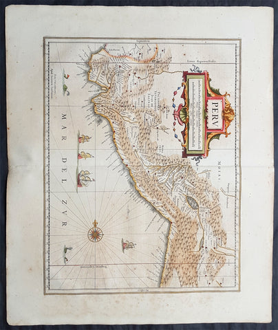
1639 Jan Jansson Original Antique Map of Peru, South America
Antique Map
- Title : Peru
- Date : 1639
- Condition: (A+) Fine Condition
- Ref: 70709
- Size: 24in x 20in (610mm x 510mm)
Description:
This fine, beautifully hand coloured original antique and very important map of Peru, South America by Jan Jansson was published in the 1639 French edition of Gerard Mercators Atlantis Novi Atlas.
General Definitions:
Paper thickness and quality: - Heavy and stable
Paper color : - off white
Age of map color: - Original
Colors used: - Yellow, green, blue, pink
General color appearance: - Authentic
Paper size: - 24in x 20in (610mm x 510mm)
Plate size: - 19 1/2in x 15in (495mm x 390mm)
Margins: - Min 2in (50mm)
Imperfections:
Margins: - Light age toning
Plate area: - Light age toning
Verso: - Light age toning
Background:
Jansson in this map shows the Pacific coast of South America from Ecuador - at the left hand side - as far south as the Atacama desert in the northern reaches of Chile.
Although the interior terrain is not mapped with any particular degree of accuracy, this map nevertheless conveys a vivid impression of the difficult terrain of the Andes in Peru.
As early as 1520, Spanish settlers in Panama had heard tales of a powerful civilisation rich in gold that lay to the south, and in 1522 an expedition was organised to find this land and the people called Biru or Piru in the south. In 1524 Francisco Pizarro led the first of his expeditions that led ultimately to the discovery & conquest of the Inca Empire which extended over wide areas of modern Ecuador, Peru, Bolivia and part of Chile. Pizarro obtained from Atahuallpa, the head of the Inca Empire, a huge ransom of silver and gold that made Spain rich almost beyond the most inventive dreams of the Spanish conquerors, and once the mountain city of Cuzco was captured in 1533, the Spanish hold over much of South America was virtually complete.
A beautiful map with a fine impression on clean heavy paper with beautiful hand colouring. (Ref: Tooley, Koeman)
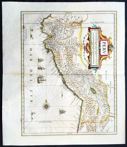
1639 Jan Jansson Antique Map of Peru, South America
Antique Map
- Title : Peru
- Date : 1639
- Condition: (A+) Fine Condition
- Ref: 43147
- Size: 22 1/2in x 20in (570mm x 500mm)
Description:
This finely engraved beautifully hand coloured original antique map of the ancient South American country of Peru was published in the 1639 French edition of Jan Jansson's Atlas Nouvs.
General Description:
Paper thickness and quality: - Heavy and stable
Paper color: - off white
Age of map color: - Original
Colors used: - Green, pink, yellow, blue
General color appearance: - Authentic
Paper size: - 22 1/2in x 20in (570mm x 500mm)
Plate size: - 20in x 15 1/2in (535mm x 395mm)
Margins: - Min 1in (25mm)
Imperfections:
Margins: - Light toning on margin edges
Plate area: - Light creasing along centerfold
Verso: - None
Background:
Jansson in this map shows the Pacific coast of South America from Ecuador - at the left hand side - as far south as the Atacama desert in the northern reaches of Chile.
Although the interior terrain is not mapped with any particular degree of accuracy, this map nevertheless conveys a vivid impression of the difficult terrain of the Andes in Peru.
As early as 1520, Spanish settlers in Panama had heard tales of a powerful civilisation rich in gold that lay to the south, and in 1522 an expedition was organised to find this land and the people called Biru or Piru in the south. In 1524 Francisco Pizarro led the first of his expeditions that led ultimately to the discovery & conquest of the Inca Empire which extended over wide areas of modern Ecuador, Peru, Bolivia and part of Chile. Pizarro obtained from Atahuallpa, the head of the Inca Empire, a huge ransom of silver and gold that made Spain rich almost beyond the most inventive dreams of the Spanish conquerors, and once the mountain city of Cuzco was captured in 1533, the Spanish hold over much of South America was virtually complete.
A beautiful map with a fine impression on clean heavy paper with beautiful hand colouring. (Ref: Tooley, Koeman)
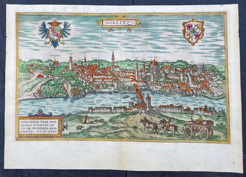
1574 Braun & Hogenberg Antique Map View of Gorlitz-Zgorzelec, Germany & Poland
Antique Map
- Title : Gorlitz
- Ref #: 93432
- Size: 22in x 16 1/2in (560mm x 420mm)
- Date : 1574
- Condition: (A+) Fine Condition
Description:
This original beautifully hand coloured copper plate engraved antique map, a birds eye view of the city of Gorlitz-Zgorzelec, in the state of Saxony, in the region of Lusatia, in far eastern Germany, on the border with Poland, was published in the 1574 edition of Braun & Hogenbergs atlas Civitates Orbis Terrarum
General Definitions:
Paper thickness and quality: - Heavy and stable
Paper color : - off white
Age of map color: - Original
Colors used: - Yellow, green, blue, pink
General color appearance: - Authentic
Paper size: - 22in x 16 1/2in (560mm x 420mm)
Plate size: - 20in x 12 1/2in (510mm x 320mm)
Margins: - Min 1in (25mm)
Imperfections:
Margins: - None
Plate area: - None
Verso: - None
Background:
As a small Sorbian village named Gorelic in the Margraviate of Meissen, a frontier march of the Holy Roman Empire, Gorlitz was temporarily conquered and held by the Kingdom of Poland during Bolesław I Chrobrys invasion of Lusatia between 1002 and 1031, after which the region fell back to the Margraviate of Meissen. In 1075, the village was assigned to the Duchy of Bohemia. The date of the towns foundation is unknown. However, Goreliz was first mentioned in a document from the King of Germany, and later Holy Roman Emperor, Henry IV in 1071. This document granted Gorlitz to the Diocese of Meissen, then under Bishop Benno of Meissen. Currently, this document can be found in the Saxony State Archives in Dresden.[3] The origin of the name Gorlitz is derived from the Slavic word for burned land,[4] referring to the technique used to clear land for settlement. Zgorzelec and Czech Zhořelec have the same derivation. In the 13th century the village gradually became a town. Due to its location on the Via Regia, an ancient and medieval trade route, the settlement prospered.
In the following centuries Gorlitz was a wealthy member of the Lusatian League, which consisted of Bautzen, Gorlitz, Kamenz, Lauban, Löbau and Zittau. In 1352 during the reign of Casimir the Great, Lusatian German colonists from Gorlitz founded the town of Gorlice in southern Poland near Kraków.
The Protestant Reformation came to Gorlitz in the early 1520s and by the last half of the 16th century, it and the surrounding vicinity, became almost completely Lutheran.
After suffering for years in the Thirty Years War, the region of Upper Lusatia (including Gorlitz) was ceded to the Electorate of Saxony in 1635. After the Napoleonic Wars, the 1815 Congress of Vienna transferred the town from the Kingdom of Saxony to the Kingdom of Prussia. Gorlitz was subsequently administered within the Province of Silesia, and, after World War I, the Province of Lower Silesia, until 1945.
From 1815 until 1918, Gorlitz belonged to the Province of Silesia in the Kingdom of Prussia, and later to the Province of Lower Silesia in the Free State of Prussia. It is the largest town of the former Province of Lower Silesia that lies west of the Oder-Neisse line and hence remained in Germany after World War II. Today, Gorlitz lies opposite the Polish town of Zgorzelec, which was part of Gorlitz until 1945. Together they form the German-Polish Euro City of Gorlitz-Zgorzelec.
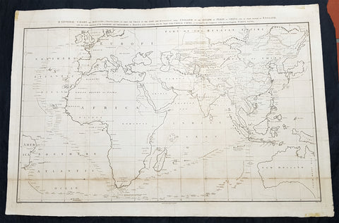
1796 Barrow Large Antique Map Sea Chart Lord Macartneys Voyage England to China
Antique Map
- Title : A General Chart on Mercators Projection, To Shew The Track of the Lion and Hindostan from England to the Gulph of Pekin in China, and of their return to England, with the daily statement of the Barometer and Thermometer as observed at noon; containing also the limits of the Chinese Empire, as extended by the Conquests of the present Emperor Tchien-Lung
- Ref #: 93409
- Size: 39 1/2in x 26 1/2in (1.00m x 675mm)
- Date : 1796
- Condition: (A) Very Good Condition
Description:
This very large original copper plate engraved antique map, a chart, by John Barrow, in 1796, was issued in the atlas volume of the official account by George Staunton of Lord George Macartneys travels to China, An Authentic Account of an Embassy from the King of Great Britain to the Emporer of China in 1796..
General Definitions:
Paper thickness and quality: - Light and stable
Paper color : - off white
Age of map color: - Original
Colors used: - Yellow, green, blue, pink
General color appearance: - Authentic
Paper size: - 39 1/2in x 26 1/2in (1.00m x 675mm)
Plate size: - 38in x 24 1/2in (960mm x 620mm)
Margins: - Min 1in (25mm)
Imperfections:
Margins: - Folds as issued
Plate area: - Light soiling along bottom folds, as issued
Verso: - Bottom folds re-enforced along bottom folds
Background:
Lord George Macartney was Britains first envoy to China, tasked with convincing Emperor Qianlong to ease restrictions on trade between Great Britain and China and to allow the 1st British embassy to be established. He was not successful in either of these endeavours.
The map shows the track of two ships, the Lion and Hindostan, on their routes from England to China and back. Each days progress was recorded along the route, with several notations to the dangers along the way.
The map was drawn by John Barrow, who was the private secretary to Lord Macartney.
The chart extends from Turon Bay (present day Da Nang, Vietnam) up the coast of eastern Asia to the Gulph of Leao-Tung in the Whang-Hai or Yellow Sea (the Gulf of Bohai in the Yellow Sea). The track of the Lion, Hindostan, and Tenders is traced, with soundings, sea bottom classifications, temperature and barometric readings, dates, and assorted notes, such as Lion and Tenders parted from the Hindostan in the fog. China is divided into several provinces, and many towns and cities are named, including Beijing (here referred to as Pekin). A portion of the Great Wall of China is depicted and rivers are accompanied by notes on their courses and sources. Taiwan is depicted with incomplete borders to the east of the ships\' track. Engraved by B. Baker and published by George Nicol.
Barrow, Sir John 1764 - 1848
Barrow, 1st Baronet, was an English civil servant, geographer, linguist and writer. Barrows legacy has been met with mixed analysis. Some historians regard Barrow as an instrument of imperialism who portrayed Africa as a resource rich land devoid of any human or civilized elements. Nonetheless, other historians consider Barrow to have promoted humanitarianism and rights for South Africans.
Barrow was born the only child of Roger Barrow, a tanner in the village of Dragley Beck, in the parish of Ulverston, Lancashire. He was schooled at Town Bank grammar school, Ulverston, but left at age 13 to found a Sunday school for the poor.
Barrow was employed as superintending clerk of an iron foundry at Liverpool. At only 16, he went on a whaling expedition to Greenland. By his twenties, he was teaching mathematics, in which he had always excelled, at a private school in Greenwich.
Barrow taught mathematics to the son of Sir George Leonard Staunton; through Stauntons interest, he was attached on the first British embassy to China from 1792 to 1794 as comptroller of the household to Lord Macartney. He soon acquired a good knowledge of the Chinese language, on which he subsequently contributed articles to the Quarterly Review; and the account of the embassy published by Sir George Staunton records many of Barrows valuable contributions to literature and science connected with China.
Barrow ceased to be officially connected with Chinese affairs after the return of the embassy in 1794, but he always took much interest in them, and on critical occasions was frequently consulted by the British government.
Some historians attribute the stagnation thesis to Barrow; that China was an extremely civilized nation that was in a process of decay by the time of European contact.
In 1797, Barrow accompanied Lord Macartney as private secretary in his important and delicate mission to settle the government of the newly acquired colony of the Cape of Good Hope. Barrow was entrusted with the task of reconciling the Boer settlers and the native Black population and of reporting on the country in the interior. In the course of the trip, he visited all parts of the colony; when he returned, he was appointed auditor-general of public accounts. He then decided to settle in South Africa, married, and bought a house in 1800 in Cape Town. However, the surrender of the colony at the peace of Amiens (1802) upset this plan.
During his travels through South Africa, Barrow compiled copious notes and sketches of the countryside that he was traversing. The outcome of his journeys was a map which, despite its numerous errors, was the first published modern map of the southern parts of the Cape Colony. Barrows descriptions of South Africa greatly influenced Europeans understanding of South Africa and its peoples. William John Burchell (1781–1863) was particularly scathing: As to the miserable thing called a map, which has been prefixed to Mr. Barrows quarto, I perfectly agree with Professor Lichtenstein, that it is so defective that it can seldom be found of any use.
Barrow returned to Britain in 1804 and was appointed Second Secretary to the Admiralty by Viscount Melville, a post which he held for forty years – apart from a short period in 1806–1807 when there was a Whig government in power. Lord Grey took office as Prime Minister in 1830, and Barrow was especially requested to remain in his post, starting the principle that senior civil servants stay in office on change of government and serve in a non-partisan manner. Indeed, it was during his occupancy of the post that it was renamed Permanent Secretary. Barrow enjoyed the esteem and confidence of all the eleven chief lords who successively presided at the Admiralty board during that period, and more especially of King William IV while lord high admiral, who honoured him with tokens of his personal regard.
In his position at the Admiralty, Barrow was a great promoter of Arctic voyages of discovery, including those of John Ross, William Edward Parry, James Clark Ross and John Franklin. The Barrow Strait in the Canadian Arctic as well as Point Barrow and the city of Barrow in Alaska are named after him. He is reputed to have been the initial proposer of Saint Helena as the new place of exile for Napoleon Bonaparte following the Battle of Waterloo in 1815. Barrow was a fellow of the Royal Society and received the degree of LL.D from the University of Edinburgh in 1821. A baronetcy was conferred on him by Sir Robert Peel in 1835. He was also a member of the Raleigh Club, a forerunner of the Royal Geographical Society.
Barrow retired from public life in 1845 and devoted himself to writing a history of the modern Arctic voyages of discovery (1846), as well as his autobiography, published in 1847. He died suddenly on 23 November 1848. The Sir John Barrow monument was built in his honour on Hoad Hill overlooking his home town of Ulverston, though locally it is more commonly called Hoad Monument. Mount Barrow and Barrow Island in Australia are believed to have been named for him.

1639 Mercator & Hondius Large Antique Map of Greece, Aegean Islands & Turkey
Antique Map
- Title : Nova Totius Graeciae descriptio
- Date : 1639
- Size: 22in x 18 1/2in (560mm x 470mm)
- Ref #: 43151
- Condition: (A) Very Good Condition
Description:
This fine, beautifully hand coloured original antique map of Greece, Aegean Islands & Turkey was published in the 1639 French edition of Gerardi Mercators Atlantis Novi Atlas by Jan Jansson and Henricus Hondius.
Condition Report:
Paper thickness and quality: - Heavy & stable
Paper color: - off white
Age of map color: - Original
Colors used: - Yellow, pink, green
General color appearance: - Authentic
Paper size: - 22in x 18 1/2in (560mm x 470mm)
Plate size: - 18 1/2in x 14 1/2in (470mm x 350mm)
Margins: - Min 1in (25mm)
Imperfections:
Margins: - Bottom & top margin centre-fold re-joined, no loss
Plate area: - Repair to left side of image, no loss
Verso: - Repairs as noted
Background:
From the early days of map-making, cartographers have always had a keen interest he mapping of Greece and of the particular continental and insular Greek areas. In other words the "Greek chorography", as it is often called had been a cartographic item of special importance, both in manuscript and printed cartography, the later having produced an impressive number of Greek maps. All of these have been include in almost all the European Atlases and travel books, since the first printed edition of Ptolemy's Geographia in 1447. This prominent presence of Greece in the field of European cartography is due to various historic, political and cultural reasons. (Ref: Koeman; M&B)
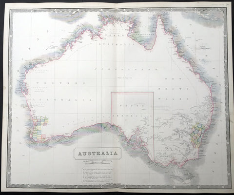
1844 W & AK Johnston Large Antique Map of Australia - South Australia Settlement
- Title : Australia
- Date : 1844
- Condition: (A+) Fine Condition
- Ref: 23806
- Size: 25in x 21in (635mm x 535mm)
Description:
This large fine hand coloured original steel-plate engraved antique map of Australia - with coloured outlines to the counties in NSW & WA - was published by W & AK Johnston in General Atlas,1844.
At the bottom of the map is a text box outlining the period of settlements in Australia from Botany Bay in 1788, WA 1829, SA 1836 & the colony of Victoria begun some 8 years earlier in 1838.
Johnston was one of the master publishers of fine engraved and lithographed maps during the 19th century, this large map is no exception. (Ref: Tooley; M&B)
General Description:
Paper thickness and quality: - Heavy and stable
Paper color: - off white
Age of map color: - Original
Colors used: - Red, green, yellow
General color appearance: - Authentic
Paper size: - 25in x 21in (635mm x 535mm)
Plate size: - 25in x 21in (635mm x 535mm)
Margins: - Min 1/2in (12mm)
Imperfections:
Margins: - Light age toning
Plate area: - None
Verso: - None
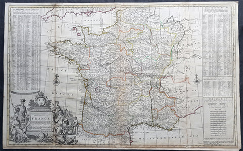
1720 Herman Moll Large Antique Pre Revolutionary Map of France in Provinces
Antique Map
- Title : A New and Exact Map of France Divided into all its Provinces...by H Moll Geographer
- Size: 39 1/2in x 25in (1.00m x 630mm)
- Condition: (A) Very Good Condition
- Date : 1720
- Ref #: 43196
Description:
This very large beautifully hand coloured original copper-plate engraved antique map of France by Herman Moll was published in 1720 in the atlas The World Described, or a New and Correct Sett of Maps by John Bowles, Thomas Bowles, Philip Overton & John King of London.
In the 18th century many large-scale maps were published by the likes of John Senex and Herman Moll, this trend continued until the end of private mapping in the early 19th century when it was replaced by Ordnance Survey maps.
General Definitions:
Paper thickness and quality: - Heavy and stable
Paper color : - off white
Age of map color: - Original
Colors used: - Yellow, green, blue, pink
General color appearance: - Authentic
Paper size: - 39 1/2in x 25in (1.00m x 630mm)
Plate size: - 39 1/2in x 25in (1.00m x 630mm)
Margins: - Min 1/2in (12mm)
Imperfections:
Margins: - Age toning, bottom margin extended from plate-mark
Plate area: - Light age toning along folds
Verso: - Re-enforced along folds
Background:
The Carolingian dynasty ruled France until 987, when Hugh Capet, Duke of France and Count of Paris, was crowned King of the Franks. His descendants—the Capetians, the House of Valois, and the House of Bourbon—progressively unified the country through wars and dynastic inheritance into the Kingdom of France, which was fully declared in 1190 by Philip II Augustus. The French nobility played a prominent role in most Crusades in order to restore Christian access to the Holy Land. French knights made up the bulk of the steady flow of reinforcements throughout the two-hundred-year span of the Crusades, in such a fashion that the Arabs uniformly referred to the crusaders as Franj caring little whether they really came from France. The French Crusaders also imported the French language into the Levant, making French the base of the lingua franca (litt. Frankish language) of the Crusader states. French knights also made up the majority in both the Hospital and the Temple orders. The latter, in particular, held numerous properties throughout France and by the 13th century were the principal bankers for the French crown, until Philip IV annihilated the order in 1307. The Albigensian Crusade was launched in 1209 to eliminate the heretical Cathars in the southwestern area of modern-day France. In the end, the Cathars were exterminated and the autonomous County of Toulouse was annexed into the crown lands of France. Later kings expanded their domain to cover over half of modern continental France, including most of the north, centre and west of France. Meanwhile, the royal authority became more and more assertive, centred on a hierarchically conceived society distinguishing nobility, clergy, and commoners.
From the 11th century, the House of Plantagenet, the rulers of the County of Anjou, succeeded in establishing its dominion over the surrounding provinces of Maine and Touraine, then progressively built an empire that spanned from England to the Pyrenees and covering half of modern France. Tensions between the kingdom of France and the Plantagenet empire would last a hundred years, until Philip Augustus of France conquered between 1202 and 1214 most of the continental possessions of the empire, leaving England and Aquitaine to the Plantagenets. Following the Battle of Bouvines, the Angevin court retreated to England, but persistent Capetian–Plantagenet rivalry would paved the way for another conflict.
Charles IV the Fair died without an heir in 1328. Under the rules of the Salic law the crown of France could not pass to a woman nor could the line of kingship pass through the female line. Accordingly, the crown passed to Philip of Valois, a cousin of Charles, rather than through the female line to Charles nephew, Edward of Plantagenet, who would soon become Edward III of England. During the reign of Philip of Valois, the French monarchy reached the height of its medieval power. Philips seat on the throne was contested by Edward III of England and in 1337, on the eve of the first wave of the Black Death, England and France went to war in what would become known as the Hundred Years War. The exact boundaries changed greatly with time, but French landholdings of the English Kings remained extensive for decades. With charismatic leaders, such as Joan of Arc and La Hire, strong French counterattacks won back English continental territories. Like the rest of Europe, France was struck by the Black Death; half of the 17 million population of France died.
The French Renaissance saw a spectacular cultural development and the first standardisation of the French language, which would become the official language of France and the language of Europes aristocracy. It also saw a long set of wars, known as the Italian Wars, between France and the House of Habsburg. French explorers, such as Jacques Cartier or Samuel de Champlain, claimed lands in the Americas for France, paving the way for the expansion of the First French colonial empire. The rise of Protestantism in Europe led France to a civil war known as the French Wars of Religion, where, in the most notorious incident, thousands of Huguenots were murdered in the St. Bartholomews Day massacre of 1572. The Wars of Religion were ended by Henry IVs Edict of Nantes, which granted some freedom of religion to the Huguenots. Spanish troops, the terror of Western Europe, assisted the Catholic side during the Wars of Religion in 1589–1594, and invaded northern France in 1597; after some skirmishing in the 1620s and 1630s, Spain and France returned to all-out war between 1635 and 1659. The war cost France 300,000 casualties.
Under Louis XIII, the energetic Cardinal Richelieu promoted the centralisation of the state and reinforced the royal power by disarming domestic power holders in the 1620s. He systematically destroyed castles of defiant lords and denounced the use of private violence (dueling, carrying weapons, and maintaining private army). By the end of 1620s, Richelieu established the royal monopoly of force as the doctrine. During Louis XIVs minority and the regency of Queen Anne and Cardinal Mazarin, a period of trouble known as the Fronde occurred in France. This rebellion was driven by the great feudal lords and sovereign courts as a reaction to the rise of royal absolute power in France.
The monarchy reached its peak during the 17th century and the reign of Louis XIV. By turning powerful feudal lords into courtiers at the Palace of Versailles, Louis XIVs personal power became unchallenged. Remembered for his numerous wars, he made France the leading European power. France became the most populous country in Europe and had tremendous influence over European politics, economy, and culture. French became the most-used language in diplomacy, science, literature and international affairs, and remained so until the 20th century. France obtained many overseas possessions in the Americas, Africa and Asia. Louis XIV also revoked the Edict of Nantes, forcing thousands of Huguenots into exile.
Under Louis XV, Louis XIVs great-grandson, France lost New France and most of its Indian possessions after its defeat in the Seven Years War (1756–63). Its European territory kept growing, however, with notable acquisitions such as Lorraine (1766) and Corsica (1770). An unpopular king, Louis XVs weak rule, his ill-advised financial, political and military decisions – as well as the debauchery of his court– discredited the monarchy, which arguably paved the way for the French Revolution 15 years after his death.
Louis XVI, Louis XVs grandson, actively supported the Americans, who were seeking their independence from Great Britain (realised in the Treaty of Paris (1783)). The financial crisis aggravated by Frances involvement in the American Revolutionary War was one of many contributing factors to the French Revolution. Much of the Enlightenment occurred in French intellectual circles, and major scientific breakthroughs and inventions, such as the discovery of oxygen (1778) and the first hot air balloon carrying passengers (1783), were achieved by French scientists. French explorers, such as Bougainville and Lapérouse, took part in the voyages of scientific exploration through maritime expeditions around the globe. The Enlightenment philosophy, in which reason is advocated as the primary source for legitimacy and authority, undermined the power of and support for the monarchy and helped pave the way for the French Revolution.
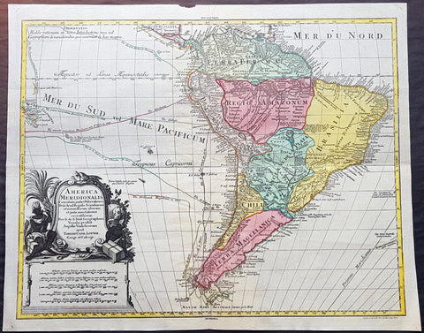
1772 Tobias Lotter Large Antique Map of South America, Drake, Magellan, Le Maire
- Title : America Meridionalis ...Tobiam Conr. Lotter...1772
- Date : 1772
- Size: 25 1/2in x 21in (650mm x 535mm)
- Ref #: 70819
- Condition: (A+) Fine Condition
Description:
This large original beautifully hand coloured copper plate engraved antique map of South America was engraved by Gustav Conrad Lotter in 1772 - dated at the foot of the map - and published by his father Tobias Conrad Lotter.
The map shows the routes of the voyages by various famous explorers to South America including: Magellan (1520), Drake (1577), le Maire & Schouten (1616), Sarmineto (1570) and others. The map also illustrates various river systems and other speculative information about the unexplored interior of the Continent. (Ref: Tooley, M&B)
General Definitions:
Paper thickness and quality: - Heavy and stable
Paper color : - off white
Age of map color: - Original
Colors used: - Blue, pink, red, green, yellow
General color appearance: - Authentic
Paper size: - 25 1/2in x 21in (650mm x 535mm)
Plate size: - 23 1/2in x 19 1/2in (595mm x 495mm)
Margins: - Min 1in (25mm)
Imperfections:
Margins: - None
Plate area: - None
Verso: - None
Background:
In 1494, Portugal and Spain, the two great maritime European powers of that time, on the expectation of new lands being discovered in the west, signed the Treaty of Tordesillas, by which they agreed, with the support of the Pope, that all the land outside Europe should be an exclusive duopoly between the two countries.
The treaty established an imaginary line along a north-south meridian 370 leagues west of the Cape Verde Islands, roughly 46° 37\\\\\\\\\\\\\\\\\\\\\\\\\\\\\\\\\\\\\\\\\\\\\\\\\\\\\\\\\\\\\\\' W. In terms of the treaty, all land to the west of the line (known to comprise most of the South American soil) would belong to Spain, and all land to the east, to Portugal. As accurate measurements of longitude were impossible at that time, the line was not strictly enforced, resulting in a Portuguese expansion of Brazil across the meridian.
Beginning in the 1530s, the people and natural resources of South America were repeatedly exploited by foreign conquistadors, first from Spain and later from Portugal. These competing colonial nations claimed the land and resources as their own and divided it in colonies.
European infectious diseases (smallpox, influenza, measles, and typhus) – to which the native populations had no immune resistance – caused large-scale depopulation of the native population under Spanish control. Systems of forced labor, such as the haciendas and mining industry\\\\\\\\\\\\\\\\\\\\\\\\\\\\\\\\\\\\\\\\\\\\\\\\\\\\\\\\\\\\\\\'s mita also contributed to the depopulation. After this, African slaves, who had developed immunities to these diseases, were quickly brought in to replace them.
The Spaniards were committed to converting their native subjects to Christianity and were quick to purge any native cultural practices that hindered this end; however, many initial attempts at this were only partially successful, as native groups simply blended Catholicism with their established beliefs and practices. Furthermore, the Spaniards brought their language to the degree they did with their religion, although the Roman Catholic Churchs evangelization in Quechua, Aymara, and Guaraní actually contributed to the continuous use of these native languages albeit only in the oral form.
Eventually, the natives and the Spaniards interbred, forming a mestizo class. At the beginning, many mestizos of the Andean region were offspring of Amerindian mothers and Spanish fathers. After independence, most mestizos had native fathers and European or mestizo mothers.
Many native artworks were considered pagan idols and destroyed by Spanish explorers; this included many gold and silver sculptures and other artifacts found in South America, which were melted down before their transport to Spain or Portugal. Spaniards and Portuguese brought the western European architectural style to the continent, and helped to improve infrastructures like bridges, roads, and the sewer system of the cities they discovered or conquered. They also significantly increased economic and trade relations, not just between the old and new world but between the different South American regions and peoples. Finally, with the expansion of the Portuguese and Spanish languages, many cultures that were previously separated became united through that of Latin American.
Guyana was first a Dutch, and then a British colony, though there was a brief period during the Napoleonic Wars when it was colonized by the French. The country was once partitioned into three parts, each being controlled by one of the colonial powers until the country was finally taken over fully by the British.
The European Peninsular War (1807–1814), a theater of the Napoleonic Wars, changed the political situation of both the Spanish and Portuguese colonies. First, Napoleon invaded Portugal, but the House of Braganza avoided capture by escaping to Brazil. Napoleon also captured King Ferdinand VII of Spain, and appointed his own brother instead. This appointment provoked severe popular resistance, which created Juntas to rule in the name of the captured king.
Many cities in the Spanish colonies, however, considered themselves equally authorized to appoint local Juntas like those of Spain. This began the Spanish American wars of independence between the patriots, who promoted such autonomy, and the royalists, who supported Spanish authority over the Americas. The Juntas, in both Spain and the Americas, promoted the ideas of the Enlightenment. Five years after the beginning of the war, Ferdinand VII returned to the throne and began the Absolutist Restoration as the royalists got the upper hand in the conflict.
The independence of South America was secured by Simón Bolívar (Venezuela) and José de San Martín (Argentina), the two most important Libertadores. Bolívar led a great uprising in the north, then led his army southward towards Lima, the capital of the Viceroyalty of Peru. Meanwhile, San Martín led an army across the Andes Mountains, along with Chilean expatriates, and liberated Chile. He organized a fleet to reach Peru by sea, and sought the military support of various rebels from the Vice-royalty of Peru. The two armies finally met in Guayaquil, Ecuador, where they cornered the Royal Army of the Spanish Crown and forced its surrender.
In the Portuguese Kingdom of Brazil, Dom Pedro I (also Pedro IV of Portugal), son of the Portuguese King Dom João VI, proclaimed the independent Kingdom of Brazil in 1822, which later became the Empire of Brazil. Despite the Portuguese loyalties of garrisons in Bahia, Cisplatina and Pará, independence was diplomatically accepted by the crown in Portugal in 1825, on condition of a high compensation paid by Brazil mediatized by the United Kingdom.
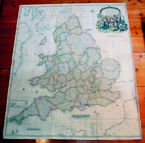
1761 John Rocque & Robert Sayer Very Large Antique Map of England & Wales
- Title : England and Wales Drawn from the Most Accurate Surveys...by John Rocque
- Date : 1761
- Condition: (A) Very Good Condition
- Ref: 92242
- Size: 49in x 37in (1.25m x 1.00m)
Description:
This very large - 4 sheet joined - famous mid 18th century original antique map of England and Wales by John Rocque was published by Robert Sayer in the large 1761 edition of A General Atlas Describing the Whole Universe.
This map is extremely detailed denoting nearly every town river canal and point of interest. This type of cartography is indicative of the British attention to detail & research that helped Britain become the world power over the next 150 years.
John Rocque c. 1704-62 - Little is known of John Rocque's early life except that he was of Huguenot extraction and was living and working in London as an engraver from about 1734. His early experience in preparing plans of great houses and gardens for the nobility led him to take up large-scale surveying for which he developed a distinctive and effective style involving new ways of indicating land use and hill contours. He is best known for a very large-scale plan of London published in 1746 and for a pocket set of county maps, The English Traveller, issued in the same year. He spent some years in Ireland surveying for estate maps and in 1756 he published a well-known Exact Survey of the City of Dublin.
Rocque was Topographer to the Prince of Wales and attained his new title after the coronation in 1760. He flourished from 1734-62. Sayer, a famous and prolific mapmaker, was taken into partnership by John Overton in 1745. After his death in 1752 Sayer continued on his own forming several associations until his own death in 1792. His association with Rocque began in 1753. (Ref:M&B; Tooley)
General Description:
Paper thickness and quality: - Heavy & stable
Paper color: - White
Age of map color: - Original & later
Colors used: - Blue, brown
General color appearance: - Authentic
Paper size: - 49in x 37in (1.25m x 1.00m)
Paper size: - 49in x 37in (1.25m x 1.00m)
Margins: - Min 1/2in (12mm)
Imperfections:
Margins: - Several folds re-enforced and re-joined
Plate area: - Folds as issued, light offsetting, several folds re-enforced and re-joined
Verso: - Several folds re-enforced and re-joined
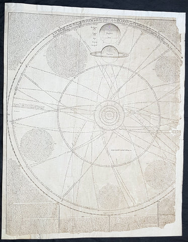
1712 J Senex & W Whiston Large Antique Astronomy Print of Planets & Solar System
Antique Map
- Title : A Scheme of the Solar System with the Orbits of the Planets and Comets belonging thereto, Described from Dr. Halley\'s accurate Table of Comets Philosoph, Transact. No. 297. Founded on Sr. Isaac Newton\'s wonderful discoveries By Wm. Whiston M.A.
- Size: 27in x 21in (585mm x 520mm)
- Condition: (B) Good Condition
- Date : 1712
- Ref #: 80773
Description:
This large original important copper plate engraved antique map of the Planets & Solar System according to Edmund Halley, Isaac Newton & William Whiston by John Senex in 1712, was published in his Elephant Folio Atlas.
This map is rare and is unfortunately damaged, not unusual for these large maps. Approx 4in strip from the left side of the map & approx 1in from the bottom of the map is missing and has been mounted on contemporary 18th century paper. Still the majority of the map remains and is still a fascinating look into our knowledge of Solar System at the beginning of the 18th century. At the moment there a couple for sale online selling for between $1500 - $5000
General Definitions:
Paper thickness and quality: - Heavy and stable
Paper color : - off white
Age of map color: -
Colors used: -
General color appearance: -
Paper size: - 27in x 21in (585mm x 520mm)
Plate size: - 27in x 21in (585mm x 520mm)
Margins: - Min 1/2in (12mm)
Imperfections:
Margins: - Approx 4in strip from the left side of the map is missing
Plate area: - Two repairs to top of image
Verso: - Repairs as noted
Background:
A large and impressive chart of the solar system, paying particular attention to the motions of the planetary bodies and the paths of comets. The chart was originally engraved in 1712 by Senex to accompany the lectures of the controversial theologian, astronomer, and polymath William Whiston. The chart was issued again in 1720 by Senex alone, and finally by Bowles and Sayer in the 1760s. The System is shown as a number of concentric orbits with the Sun at centre, criss-crossed by the broad elliptical paths of a number of comets. At top, the planets are shown pictorially, clumped together in an attempt to demonstrate scale. As the chart was engraved at the beginning of the eighteenth century, the outer planets past Saturn are not included. Earths moon is accorded an honorary spot among the planets, while the moons of the other planets are shown in the grand scheme as Satellites. The alchemical symbols for the zodiac are included along the outside ring of the System, and the chart is absolutely covered by explanatory text.
William Whiston (1667-1752) was an English mathematician, theologian, historian and religious writer. Born in Leicestershire, Whiston was a leading figure in popularising the ideas of Sir Issac Newton, who was his mentor and teacher. Whiston was a professor of mathematics at the University of Cambridge but was expelled from his position in 1710 due to his unorthodox religious beliefs and views. Whiston was a believer of Arianism, the idea that Christ is subordinate to God, the concept of Christ is based on the belief that the Son of God did not always exist but was begotten by God the Father. He also rejected the notion of eternal torment in hellfire. What especially placed him against church authorities, was he viewed the Trinity as a lie after extensive personal research convinced him the origin of the Trinity teaching to be pagan. Whiston wrote A New Theory of the Earth, published in 1696, in which he presented a description of the divine creation of the Earth, postulating that the earth originated from the atmosphere of a comet.
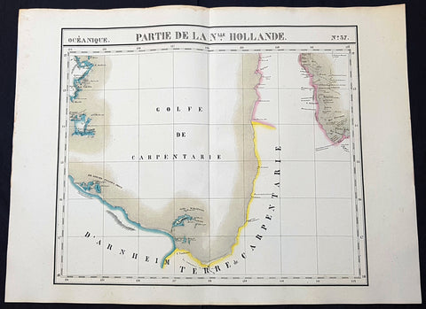
1825 Philippe Vandermaelen Large Antique Map The Gulf of Carpentaria, Australia
Antique Map
- Title : Partie De La Nlle. Hollande
- Size: 28 1/2in x 21in (725mm x 550mm)
- Condition: (A+) Fine Condition
- Date : 1825
- Ref #: 93125
Description:
This very large original hand coloured antique lithograph map of the Gulf of Carpentaria was published by Philippe Vandermaelen in his revolutionary 1825 Atlas universel de geographie physique, politique, statistique et mineralogique.
Until the publication of this atlas, large detailed maps of this region of remote Australia were uncommon. The clean detailed lines and added hand colouring make this one of the most desirable early maps of northern Queensland and the NT.
General Definitions:
Paper thickness and quality: - Heavy and stable
Paper color : - off white
Age of map color: - Original
Colors used: - Yellow, green, blue, pink
General color appearance: - Authentic
Paper size: - 28 1/2in x 21in (725mm x 550mm)
Plate size: - 28 1/2in x 21in (725mm x 550mm)
Margins: - Min 1in (25mm)
Imperfections:
Margins: - None
Plate area: - None
Verso: - None
Background:
The first European explorer to visit the region (and Australia) was the Dutch Willem Janszoon (whose name is also written as Jansz) in 1605–6. His fellow countryman, Jan Carstenszoon (or Carstensz), visited in 1623 and named the gulf in honour of Pieter de Carpentier, at that time the Governor-General of the Dutch East Indies. Abel Tasman also explored the coast in 1644. The region was later explored and charted by Matthew Flinders in 1802 and 1803.
The first overland expedition to reach the Gulf was the Burke and Wills expedition, led by Robert O Hara Burke and William John Wills which left Melbourne, Victoria in August 1860 and reached the mouth of the Bynoe River in February 1861.
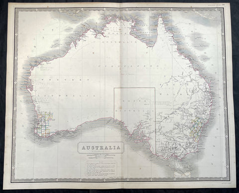
1856 A K Johnston Large Antique Map of Australia, early Separation of Victoria
Antique Map
- Title : Australia by A K Johnston
- Date : 1856
- Condition: (A+) Fine Condition
- Ref: 93439
- Size: 25in x 21 1/2in (635mm x 545mm)
Description:
This original large hand coloured steel plate engraved antique map of Australia - with coloured outlines to the counties in NSW & WA - was published by A K Johnston in the 1856 edition of his National atlas of historical, commercial, and political geography.
A important and interesting map illustrating the boundary of South Australia, as well as the county boundaries in both Western Australia and New South Wales. One of the first maps to illustrate the separation of the state of Victoria from New South Wales in 1851.
General Definitions:
Paper thickness and quality: - Heavy and stable
Paper color : - off white
Age of map color: - Original
Colors used: - Yellow, green, blue, pink
General color appearance: - Authentic
Paper size: - 25in x 21 1/2in (635mm x 545mm)
Plate size: - 25in x 21 1/2in (635mm x 545mm)
Margins: - Min 1/2in (12mm)
Imperfections:
Margins: - None
Plate area: - None
Verso: - None
Background:
Australia is a sovereign country comprising the mainland of the Australian continent, the island of Tasmania and numerous smaller islands. It is the largest country in Oceania and the world\\\'s sixth-largest country by total area. The neighbouring countries are Papua New Guinea, Indonesia and East Timor to the north; the Solomon Islands and Vanuatu to the north-east; and New Zealand to the south-east. The population of 25 million is highly urbanised and heavily concentrated on the eastern seaboard. Australias capital is Canberra, and its largest city is Sydney. The country\\\'s other major metropolitan areas are Melbourne, Brisbane, Perth and Adelaide.
Australia was inhabited by indigenous Australians for about 60,000 years before the first British settlement in the late 18th century. It is documented that Aborigines spoke languages that can be classified into about 250 groups. After the European discovery of the continent by Dutch explorers in 1606, who named it New Holland, Australia\\\'s eastern half was claimed by Great Britain in 1770 and initially settled through penal transportation to the colony of New South Wales from 26 January 1788, a date which became Australia\\\'s national day. The population grew steadily in subsequent decades, and by the 1850s most of the continent had been explored and an additional five self-governing crown colonies established. On 1 January 1901, the six colonies federated, forming the Commonwealth of Australia. Australia has since maintained a stable liberal democratic political system that functions as a federal parliamentary constitutional monarchy comprising six states and ten territories.
Being the oldest, flattest and driest inhabited continent, with the least fertile soils, Australia has a landmass of 7,617,930 square kilometres. A megadiverse country, its size gives it a wide variety of landscapes, with deserts in the centre, tropical rainforests in the north-east and mountain ranges in the south-east. A gold rush began in Australia in the early 1850s, which boosted the population of the country. Nevertheless, its population density, 2.8 inhabitants per square kilometre, remains among the lowest in the world. Australia generates its income from various sources including mining-related exports, telecommunications, banking and manufacturing. Indigenous Australian rock art is the oldest and richest in the world, dating as far back as 60,000 years and spread across hundreds of thousands of sites.
The first recorded European sighting of the Australian mainland, and the first recorded European landfall on the Australian continent (in 1606), are attributed to the Dutch. The first ship and crew to chart the Australian coast and meet with Aboriginal people was the Duyfken captained by Dutch navigator, Willem Janszoon. He sighted the coast of Cape York Peninsula in early 1606, and made landfall on 26 February at the Pennefather River near the modern town of Weipa on Cape York. The Dutch charted the whole of the western and northern coastlines and named the island continent New Holland during the 17th century, but made no attempt at settlement. William Dampier, an English explorer and privateer, landed on the north-west coast of New Holland in 1688 and again in 1699 on a return trip. In 1770, James Cook sailed along and mapped the east coast, which he named New South Wales and claimed for Great Britain.
With the loss of its American colonies in 1783, the British Government sent a fleet of ships, the First Fleet, under the command of Captain Arthur Phillip, to establish a new penal colony in New South Wales. A camp was set up and the flag raised at Sydney Cove, Port Jackson, on 26 January 1788, a date which became Australia\\\'s national day, Australia Day. A British settlement was established in Van Diemens Land, now known as Tasmania, in 1803, and it became a separate colony in 1825. The United Kingdom formally claimed the western part of Western Australia (the Swan River Colony) in 1828. Separate colonies were carved from parts of New South Wales: South Australia in 1836, Victoria in 1851, and Queensland in 1859. The Northern Territory was founded in 1911 when it was excised from South Australia. South Australia was founded as a free province—it was never a penal colony. Victoria and Western Australia were also founded free, but later accepted transported convicts. A campaign by the settlers of New South Wales led to the end of convict transportation to that colony; the last convict ship arrived in 1848.