Products
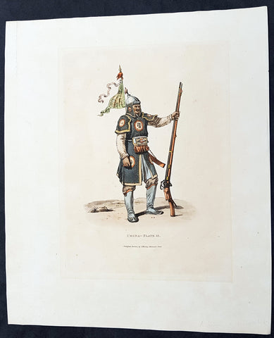
1814 William Alexander Antique Print of a Chinese Soldier with Matchlock Rifle
- Title : China - Plate 13....Published Jan. 1814 by J Murray, Albenarle Street (Plate XIII A Soldier with his Matchlock)
- Date : 1814
- Condition: (A+) Fine Condition
- Ref: 25464-1
- Size: 13in x 11in (330mm x 280mm)
Description:
This beautifully hand coloured original copper-plate engraved antique print of a Chinese soldier with his Matchlock rifle - accompanied by text - by William Alexander was published in the 1st 1814 - dated - edition of Picturesque Representations of the Dress and Manners of the Chinese, illustrated in fifty colored engravings, with descriptions.
General Definitions:
Paper thickness and quality: - Heavy and stable
Paper color : - off white
Age of map color: - Original
Colors used: - Yellow, green, blue, pink
General color appearance: - Authentic
Paper size: - 13in x 11in (330mm x 280mm)
Plate size: - 9 1/2in x 7in (240mm x 180mm)
Margins: - Min 1in (25mm)
Imperfections:
Margins: - None
Plate area: - Light age toning
Verso: - None
Background:
In 1792, Alexander was appointed as one of the draughtsmen to the Macartney Embassy to China. He accompanied the Earl of Macartney to Peking where he made drawings for the plates which accompanied Sir George Stauntons account of the embassy, published in 1797.
In 1805 he published The Costume of China, illustrated by 48 coloured engravings, after his travels to China with The Earl of Macartney. The work was so well-received that in 1814 he published another book titled Picturesque Representations of the Dress and Manners of the Chinese, illustrated in fifty colored engravings, with descriptions. This publication was re-issued over the next twenty years in various languages including French.
Alexander, William 1767 – 1816
Alexander was an English painter, illustrator and engraver. The hallmarks of his work, usually executed in watercolours, were clearness and harmony of colour, simplicity and taste in composition, grace of outline, and delicacy of execution. He accompanied the Macartney Embassy to China in 1792. Prints of his work were reproduced from engravings. One his of works was used to illustrate Cadell & Davies Britannia depicta.
Alexander was born in Maidstone, Kent, the son of Harry Alexander, a coachmaker. He was educated at Maidstone Grammar School, but in 1782, at the age of 15, moved to London to study art - first under William Pars, and subsequently Julius Caesar Ibbetson. In February 1784, he was admitted to the Royal Academy Schools. He assiduously applied himself to the mastery of his profession, obtaining the notice and approbation of Sir Joshua Reynolds.
In 1792, he was appointed as one of the draughtsmen to the Macartney Embassy to China. He accompanied the Earl of Macartney to Peking where he made drawings for the plates which accompanied Sir George Stauntons account of the embassy (published in 1797) In 1794 he returned to England and married Jane Wogan the following year. She died soon afterwards.
His other principal works were: Views of Headlands, Islands, etc. taken during the Voyage to China (1798); drawings based on Daniells sketches, for Vancouvers Voyage to the North Pacific Ocean (1798); and the descriptive plates to Sir John Barrows Travels in China (1804), and Voyage to Cochin China (1806). In 1805 he published The Costume of China, illustrated by 48 coloured engravings. The work was so well-received that in 1814 he published another book titled Picturesque Representations of the Dress and Manners of the Chinese, illustrated in fifty colored engravings, with descriptions.
Besides his works as a draughtsman, he made several engravings - the principal one of which is a representation of the Festival given by the Earl of Romney to the Kentish Volunteers, on 1 August 1799, from his own drawing.
In 1802, Alexander was appointed professor of drawing at the Military College at Great Marlow, resigning in May 1808 to take up the post of assistant keeper of antiquities in the British Museum. In the years 1810, 1812, and 1815, he made drawings of the terra cottas and marbles in the Museum which were engraved and published in three volumes - the accompanying text being provided by Taylor Combe (keeper of the Department of Antiquities). Alexander had completed drawings for a fourth volume before his death.
He died at the house of his uncle in Maidstone in July 1816, and was buried in Boxley churchyard. He was described in one of his obituaries as a man of mild and unassuming manners, rich in the knowledge of art, and of unsullied integrity.
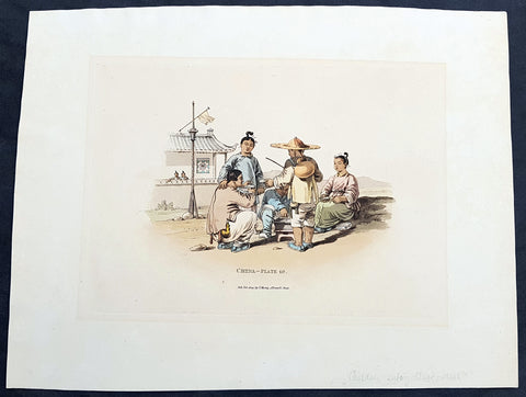
1814 William Alexander Antique Print of Chinese Family Eating a Meal
- Title : China - Plate 10....Published Jan. 1814 by J Murray, Albenarle Street
- Date : 1814
- Condition: (A+) Fine Condition
- Ref: 25462
- Size: 13in x 11in (330mm x 280mm)
Description:
This beautifully hand coloured original copper-plate engraved antique print of a Chinese family eating by the side of the road - by William Alexander was published in the 1st 1814 - dated - edition of Picturesque Representations of the Dress and Manners of the Chinese, illustrated in fifty colored engravings, with descriptions.
General Definitions:
Paper thickness and quality: - Heavy and stable
Paper color : - off white
Age of map color: - Original
Colors used: - Yellow, green, blue, pink
General color appearance: - Authentic
Paper size: - 13in x 11in (330mm x 280mm)
Plate size: - 9 1/2in x 7in (240mm x 180mm)
Margins: - Min 1in (25mm)
Imperfections:
Margins: - None
Plate area: - Light age toning
Verso: - None
Background:
In 1792, Alexander was appointed as one of the draughtsmen to the Macartney Embassy to China. He accompanied the Earl of Macartney to Peking where he made drawings for the plates which accompanied Sir George Stauntons account of the embassy, published in 1797.
In 1805 he published The Costume of China, illustrated by 48 coloured engravings, after his travels to China with The Earl of Macartney. The work was so well-received that in 1814 he published another book titled Picturesque Representations of the Dress and Manners of the Chinese, illustrated in fifty colored engravings, with descriptions. This publication was re-issued over the next twenty years in various languages including French.
Alexander, William 1767 – 1816
Alexander was an English painter, illustrator and engraver. The hallmarks of his work, usually executed in watercolours, were clearness and harmony of colour, simplicity and taste in composition, grace of outline, and delicacy of execution. He accompanied the Macartney Embassy to China in 1792. Prints of his work were reproduced from engravings. One his of works was used to illustrate Cadell & Davies Britannia depicta.
Alexander was born in Maidstone, Kent, the son of Harry Alexander, a coachmaker. He was educated at Maidstone Grammar School, but in 1782, at the age of 15, moved to London to study art - first under William Pars, and subsequently Julius Caesar Ibbetson. In February 1784, he was admitted to the Royal Academy Schools. He assiduously applied himself to the mastery of his profession, obtaining the notice and approbation of Sir Joshua Reynolds.
In 1792, he was appointed as one of the draughtsmen to the Macartney Embassy to China. He accompanied the Earl of Macartney to Peking where he made drawings for the plates which accompanied Sir George Stauntons account of the embassy (published in 1797) In 1794 he returned to England and married Jane Wogan the following year. She died soon afterwards.
His other principal works were: Views of Headlands, Islands, etc. taken during the Voyage to China (1798); drawings based on Daniells sketches, for Vancouvers Voyage to the North Pacific Ocean (1798); and the descriptive plates to Sir John Barrows Travels in China (1804), and Voyage to Cochin China (1806). In 1805 he published The Costume of China, illustrated by 48 coloured engravings. The work was so well-received that in 1814 he published another book titled Picturesque Representations of the Dress and Manners of the Chinese, illustrated in fifty colored engravings, with descriptions.
Besides his works as a draughtsman, he made several engravings - the principal one of which is a representation of the Festival given by the Earl of Romney to the Kentish Volunteers, on 1 August 1799, from his own drawing.
In 1802, Alexander was appointed professor of drawing at the Military College at Great Marlow, resigning in May 1808 to take up the post of assistant keeper of antiquities in the British Museum. In the years 1810, 1812, and 1815, he made drawings of the terra cottas and marbles in the Museum which were engraved and published in three volumes - the accompanying text being provided by Taylor Combe (keeper of the Department of Antiquities). Alexander had completed drawings for a fourth volume before his death.
He died at the house of his uncle in Maidstone in July 1816, and was buried in Boxley churchyard. He was described in one of his obituaries as a man of mild and unassuming manners, rich in the knowledge of art, and of unsullied integrity.
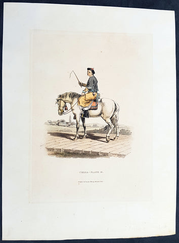
1814 William Alexander Antique Print of Chinese Mandarin Servant on Horseback
- Title : China - Plate 18....Published Jan. 1814 by J Murray, Albenarle Street (Plate XVIII A Mandarins Servant on Horseback)
- Date : 1814
- Condition: (A+) Fine Condition
- Ref: 25461
- Size: 13in x 11in (330mm x 280mm)
Description:
This beautifully hand coloured original copper-plate engraved antique print of a Mandarins servant on horseback by William Alexander was published in the 1st 1814 - dated - edition of Picturesque Representations of the Dress and Manners of the Chinese, illustrated in fifty colored engravings, with descriptions.
General Definitions:
Paper thickness and quality: - Heavy and stable
Paper color : - off white
Age of map color: - Original
Colors used: - Yellow, green, blue, pink
General color appearance: - Authentic
Paper size: - 13in x 11in (330mm x 280mm)
Plate size: - 9 1/2in x 7in (240mm x 180mm)
Margins: - Min 1in (25mm)
Imperfections:
Margins: - None
Plate area: - Light age toning
Verso: - None
Background:
In 1792, Alexander was appointed as one of the draughtsmen to the Macartney Embassy to China. He accompanied the Earl of Macartney to Peking where he made drawings for the plates which accompanied Sir George Stauntons account of the embassy, published in 1797.
In 1805 he published The Costume of China, illustrated by 48 coloured engravings, after his travels to China with The Earl of Macartney. The work was so well-received that in 1814 he published another book titled Picturesque Representations of the Dress and Manners of the Chinese, illustrated in fifty colored engravings, with descriptions. This publication was re-issued over the next twenty years in various languages including French.
Alexander, William 1767 – 1816
Alexander was an English painter, illustrator and engraver. The hallmarks of his work, usually executed in watercolours, were clearness and harmony of colour, simplicity and taste in composition, grace of outline, and delicacy of execution. He accompanied the Macartney Embassy to China in 1792. Prints of his work were reproduced from engravings. One his of works was used to illustrate Cadell & Davies Britannia depicta.
Alexander was born in Maidstone, Kent, the son of Harry Alexander, a coachmaker. He was educated at Maidstone Grammar School, but in 1782, at the age of 15, moved to London to study art - first under William Pars, and subsequently Julius Caesar Ibbetson. In February 1784, he was admitted to the Royal Academy Schools. He assiduously applied himself to the mastery of his profession, obtaining the notice and approbation of Sir Joshua Reynolds.
In 1792, he was appointed as one of the draughtsmen to the Macartney Embassy to China. He accompanied the Earl of Macartney to Peking where he made drawings for the plates which accompanied Sir George Stauntons account of the embassy (published in 1797) In 1794 he returned to England and married Jane Wogan the following year. She died soon afterwards.
His other principal works were: Views of Headlands, Islands, etc. taken during the Voyage to China (1798); drawings based on Daniells sketches, for Vancouvers Voyage to the North Pacific Ocean (1798); and the descriptive plates to Sir John Barrows Travels in China (1804), and Voyage to Cochin China (1806). In 1805 he published The Costume of China, illustrated by 48 coloured engravings. The work was so well-received that in 1814 he published another book titled Picturesque Representations of the Dress and Manners of the Chinese, illustrated in fifty colored engravings, with descriptions.
Besides his works as a draughtsman, he made several engravings - the principal one of which is a representation of the Festival given by the Earl of Romney to the Kentish Volunteers, on 1 August 1799, from his own drawing.
In 1802, Alexander was appointed professor of drawing at the Military College at Great Marlow, resigning in May 1808 to take up the post of assistant keeper of antiquities in the British Museum. In the years 1810, 1812, and 1815, he made drawings of the terra cottas and marbles in the Museum which were engraved and published in three volumes - the accompanying text being provided by Taylor Combe (keeper of the Department of Antiquities). Alexander had completed drawings for a fourth volume before his death.
He died at the house of his uncle in Maidstone in July 1816, and was buried in Boxley churchyard. He was described in one of his obituaries as a man of mild and unassuming manners, rich in the knowledge of art, and of unsullied integrity.
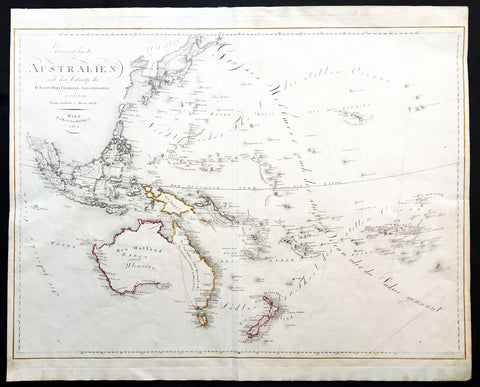
1815 Swoboda & Hartl Antique Early Map of New Holland Australia, Ulimaroa Scarce
Antique Map
- Title : Generalcharte von Australien nach dem entwurfe des H.Joseph Marx Freiherrn v. Liechtenstern
- Date : 1815
- Condition: (A+) Fine Condition
- Ref: 16258
- Size: 27 1/4in x 22in (695mm x 560mm)
Description:
This large beautifully hand coloured original & scarce antique map of New Holland also named Ulimaroa, New Zealand and the South Pacific by Franz Swoboda and Martin Hartl was published in Vienna in 1815 - dated.
General Description:
Paper thickness and quality: - Heavy & stable
Paper color: - White
Age of map color: - Original
Colors used: - Red, yellow
General color appearance: - Authentic
Paper size: - 27 1/4in x 22in (695mm x 560mm)
Paper size: - 27in x 20 3/4in (685mm x 525mm)
Margins: - Min 1/4in (7mm)
Imperfections:
Margins: - None
Plate area: - Vertical crease right image
Verso: - None
This map is typical of the affect of Cooks discoveries on European cartography. Australia regularly became a focus on regional maps. The name "Ulimaroa" was often used, mainly by German & Austrian cartographers, at this time. It was term Cook learned from the New Zealand Maoris before discovering the east coast of Australia during his first voyage of discovery. When this map was printed there was a strong belief that the Australian continent was possibly divided by an internal sea strait, separating the east from the west coasts. It was explorers such as Flinders and Baudin who set out to find this elusive passage and if so the possible point at which a ship could enter.
Only a few years before in 1798 Flinders and Bass had proved that there was a strait dividing Van Diemen’s Land (Tasmania) from the rest of the continent so now the race was on to find the other passage. On Swoboda’s map a line has been drawn from the bottom of Carpentaria to the eastern part of present day Victoria. This line represented two things, the potential shape of the eastern landmass split by the sea and the extent to English territory in the newly settled colonies, only 17 years old. The Southern Coastline is not shown as even though Flinders had by 1803 mapped the entire region he was in 1805 still under house arrest on the islands of Mauritius by the French, he would not publish his discoveries until 1814. Therefore this map shows Australia at a pivotal point in its history when most of the continent was still open for settlement by other nations and the coastlines and mysteries were still to be confirmed. (Ref: Clancy; M&B; Tooley)
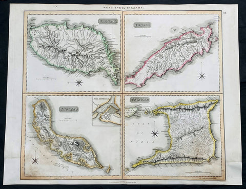
1816 John Thompson Large Antique Map Grenada, Tobago, Curacao Trinidad Caribbean
Antique Map
- Title : West India Islands: Grenada; Tobago; Curacao; Trinadad.
- Date : 1816
- Size: 27in x 21in (685mm x 535mm)
- Condition: (A) Very Good Condition
- Ref: 35612
Description:
This large original, beautifully hand coloured copper plate engraved antique map of the Caribbean Islands Grenada, Tobago, Curacao & Trinidad was published by John Thomson in his large elephant folio 1817 edition of A New General Atlas of the World. (Ref Tooley M&B)
General Definitions:
Paper thickness and quality: - Heavy and stable
Paper color : - off white
Age of map color: - Original
Colors used: - Yellow, green, blue, pink
General color appearance: - Authentic
Paper size: - 27in x 21in (685mm x 535mm)
Plate size: - 27in x 21in (685mm x 535mm)
Margins: - Min 1/2in (12mm)
Imperfections:
Margins: - Bottom L&R margins extended from borders, not affecting the image
Plate area: - Light age toning, small library stamp to right
Verso: - Age toning
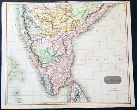
1816 John Thomson Large Antique Map of Southern India & Northern Sri Lanka
- Title : Southern Hindostan....Drawn & Engraved for Thomsons New General Atlas, 1816
- Date : 1816
- Size: 25in x 20 1/2in (635mm x 520mm)
- Condition: (A+) Fine Condition
- Ref: 41004
Description:
This large magnificent original hand coloured copper-plate engraved antique map of South India & northern Sri Lanka by John Thomson was engraved by Samuel Neele in 1816 - dated at the foot of the map - and was published in the 1817 edition of Thomsons New General Atlas
General Definitions:
Paper thickness and quality: - Heavy and stable
Paper color : - off white
Age of map color: - Original
Colors used: - Yellow, green, blue, pink
General color appearance: - Authentic
Paper size: - 25in x 20 1/2in (635mm x 520mm)
Plate size: - 25in x 20 1/2in (635mm x 520mm)
Margins: - Min 1/2in (15mm)
Imperfections:
Margins: - Top margin soiling and cropped to plate-mark
Plate area: - None
Verso: - None
Background:
The cartography of India begins with early charts for navigation and constructional plans for buildings. Indian traditions influenced Tibetan and Islamic traditions, and in turn, were influenced by the British cartographers who solidified modern concepts into India\'s map making
A prominent foreign geographer and cartographer was Hellenistic geographer Ptolemy (90–168) who researched at the library in Alexandria to produce a detailed eight-volume record of world geography. During the Middle Ages, India sees some exploration by Chinese and Muslim geographers, while European maps of India remain very sketchy. A prominent medieval cartographer was Persian geographer Abu Rayhan Biruni (973–1048) who visited India and studied the country\'s geography extensively.
European maps become more accurate with the Age of Exploration and Portuguese India from the 16th century. The first modern maps were produced by Survey of India, established in 1767 by the British East India Company. Survey of India remains in continued existence as the official mapping authority of the Republic of India.

1817 Breton & Brion Antique Map Cooks 1st Pacific Voyage Australia & New Zealand
Antique Map
- Title : Carte d une partie de la Mer Du Sud...Cook 1769
- Ref #: 51016
- Condition: (A+) Fine Condition
- Size: 12in x 8in (300mm x 220mm)
- Date: 1817
Description:
This original copper-plate engraved antique map drawn during the 1st Voyage of Captain James Cook to the South Pacific, New Zealand, Australia, between 1769 & 1771 was later engraved by Pierre Brion and published by Henry Breton in the 1817 atlas "Biblio Portative Des Voyages Traduite De L Anglais" Par MM. Henry et Breton Tome XLII
General Definitions:
Paper thickness and quality: - Heavy and stable
Paper color : - off white
Age of map color: -
Colors used: -
General color appearance: -
Paper size: - 12in x 8in (300mm x 220mm)
Plate size: - 11 1/2in x 8in (295mm x 220mm)
Margins: - Min 1/2in (12mm)
Imperfections:
Margins: - Folds as issued
Plate area: - Folds as issued
Verso: - Folds as issued
Background:
Cooks First Voyage (1768-1771)
The first voyage under Captain James Cooks command was primarily of a scientific nature. The expedition on the Endeavour initially sailed to Tahiti to observe the transit of the planet Venus in order to calculate the earths distance from the sun. Cook landed on the South Pacific island in April of 1769 and in June of that year the astronomical observations were successfully completed. In addition to these labors, very good relations with the Tahitians were maintained and the naturalists Joseph Banks and Daniel C. Solander conducted extensive ethnological and botanical research.
Another purpose of the voyage was to explore the South Seas to determine if an inhabitable continent existed in the mid-latitudes of the Southern Hemisphere. Upon leaving Tahiti, Cook named and charted the Society Islands and then continued southwest to New Zealand. His circumnavigation and exploration of that country also resulted in a detailed survey. Cook proceeded to Australia, where he charted the eastern coast for 2,000 miles, naming the area New South Wales. As a result of these surveys, both Australia and New Zealand were annexed by Great Britain. In addition to these explorations, the Endeavour returned to England without a single death from scurvy among its men, an historic feat at the time. The combination of these accomplishments brought Cook prominence, promotion, and the opportunity to lead further expeditions.
Cooks Second Voyage (1772-1775)
Based on the success of his first voyage, Cook was appointed by the Admiralty to lead a second expedition. Two ships were employed with Cook commanding the Resolution and Captain Tobias Furneaux in charge of the Adventure. The purpose was to circumnavigate the globe as far south as possible to confirm the location of a southern continent. Cook proved that there was no Terra Australis, which supposedly was located between New Zealand and South America. Cook was convinced, however, that there was land beyond the southern ice fields. In his pursuit of this idea, this expedition was the first European voyage to cross the Antarctic Circle. In addition, in two great sweeps through the Southern latitudes, Cook made an incredible number of landfalls including New Zealand, Easter Island, the Marquesas, Tahiti and the Society Islands, the Tonga Islands, the New Hebrides, New Caledonia, and a number of smaller islands.
In addition to these navigational accomplishments and the accompanying expansion of geographical knowledge, the expedition also recorded a vast amount of information regarding the Pacific islands and peoples, proved the value of the chronometer as an instrument for calculating longitude, and improved techniques for preventing scurvy.
Cooks Third Voyage (1776-1779)
In the course of his first two voyages, Cook circumnavigated the globe twice, sailed extensively into the Antarctic, and charted coastlines from Newfoundland to New Zealand. Following these achievements, Cooks third voyage was organized to seek an efficient route from England to southern and eastern Asia that would not entail rounding the Cape of Good Hope. The search for such a Northwest (or Northeast) Passage had been on the agenda of northern European mariners and merchants since the beginning of European expansion in the late fifteenth century. Englands growing economic and colonial interests in India in the later eighteenth century provided the stimulus for the latest exploration for this route.
Cook, again in command of the Resolution, was to approach the Northwest Passage from the Pacific accompanied by a second ship, the Discovery, captained by Charles Clerke. The ships left England separately, regrouped at Cape Town, and continued on to Tasmania, New Zealand, and Tahiti. The expedition then sailed north and made landfall at Christmas Island and the Hawaiian Islands. Cook continued northward and charted the west coast of North America from Northern California as far as the Bering Strait. He returned to Hawaii for the winter and was killed in a skirmish with natives on February 14, 1779. Upon Cooks death, Clerke took command of the expedition but died six months later. The ships returned to England in 1780 under John Gore, who had commanded the Discovery after Cooks death. From start to finish, the voyage had lasted more than four years. (Ref Tooley; M&B; Clancy)
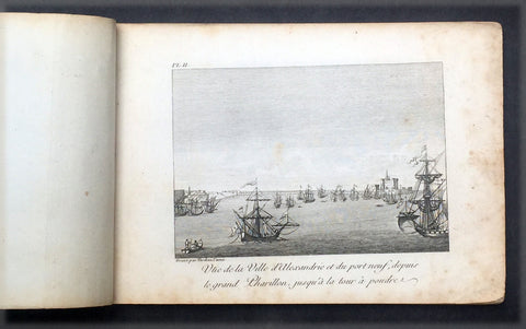
1817 Capt. Frederick L Norden Antique Atlas of Egypt & Nubia - 1 Map & 22 Prints
- Title : Atlas de Norden...Chez M.Me Lepetit...1817
- Ref #: 91614
- Size: 8vo
- Date : 1817
- Condition: (A) Very Good Condition
Description:
This fine original antique Atlas, Voyage d'Egypte et de Nubie, travels to Egypt and Nubia by the Dane, Captain Frederick Louis Norden was translated and published in Paris by M Henry & Breton in the 1817 - dated - edition of Biblio Portative Des Voyages Traduite De L Anglais Par MM. Henry et Breton Tome XIII (Portable Travel Library. Translated from the English by MM Henry and Breton Volume 13)
General Description:
Paper thickness and quality: - Heavy, stable
Paper color: - off white
Age of map color: -
Colors used: -
General color appearance: -
Atlas size: - 8vo
Imperfections:
Margins: - Age toning
Plate area: - Age toning
Verso: - Age toning
The atlas covers have been removed with front title page partially detached & damaged. Pages are generally clean, with some age toning, overall VG. Size 8vo, each page size is 7in x 5in (180mm x 125mm)
1. Cours du Nil Depuis le Sennaar
2. Vue de Ville d Alexandrie....
3. Vue de la Ville et du Port Neuf d Alexandrie....
4. Vue de la Vieille Alexandrie
5. A: Chateau d Aboukir B: Vue de cote de l Orient meridional C: Plan du Chateau vec son port
6. Fig1: Vue de la villede Rosette Fig 2: Chateau de Rosette Fig 3: Vue du village de Deruth
7. Perspective du Vieux Caire
8. Vue du vieux Caire et d'une Pyramide dans le lointain
9. Vue de la ville de Gize ci-devant Memphis....
10. Coupe du Mokian
11. Plan de l ile de Rodda
12. Village de Dair Etun
13. Vue des Pyramides proche du Caire
14. Vue des Pyramides de Memphis
15. Maisons ordinaires des Arabec
16. Ruines di Palais de Memmon
17. Portail antique plien de Hieroglyphes en couleur et ...
18. Ancien Temple au milieu de la ville d Esnay
19. Deux coupes sur la longueur des superbes..Ruines du temple d Tsia
20. Fig 1: Les Deux Colosses en particular Fig 2: Portail principal des antiquities de Luxor
21. Statues colossales et Ruines du Palais de Memnon
22. Vue des Tombeaux pres d Essouan
23. Maniere de Battre les ris et de porter lEau en Egypte
Frederick Norden sailed to Egypt in 1737-38 to survey the architecture, agriculture, and other curiosities of the country. He was the first European to penetrate as far as Derr in Nubia, and produced the first coherent maps of the country. Seventeen years later, long after Norden’s death, his maps and drawings were published by the Royal Danish Academy of Sciences and Letters, under order of Frederick V of Denmark, as Voyage d’Egypte et de Nubie (1755). Two years later, the physician and naturalist Peter Templeman completed an English translation, which was published in two folio volumes.
Frederic Louis Norden (1708 –1742) was a Danish naval captain and explorer.
Also known as Frederick, Frederik, Friderick, Ludwig, Ludvig and Lewis, the name used on the first publication of his famous Voyage d'Egypte et de Nubie (Copenhagen, 1755) is Frederic Louis Norden. His name is often shortened F. L. Norden.
Norden made a voyage through Egypt all the way down to Sudan in 1737–1738, on the request of King Christian VI of Denmark. Norden made abundant notes, observations and drawings of everything around him, including people, pharaonic monuments, architecture, installations, maps etc., all of which was published in the posthumous Voyage d'Egypte et de Nubie.
On 8 January 1741 he became a Fellow of the Royal Society of London, where his name was registered as Frederic Lewis Norden.
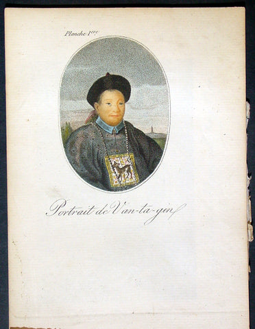
1817 John Barrow Original Antique Atlas of Travels in China in 1797 - 21 Prints
- Title : Bibliotheque Portative Des Voyages Traduite De L Anglais Par MM. Henry et Breton Tome XLII - Atlas De Barrow - Paris Chez M.Me V Lepetit....1817
- Date : 1817
- Condition: (A+) Fine Condition
- Ref: 91572
- Size: 8vo
Description:
This original antique Atlas of the travels of Sir John Barrow in China, who accompanied Ambassador Lord Macartney during his travels in 1797, contains 21 coloured and B&W copper-plate engraved antique prints - was translated and published in Paris by M Henry & Breton in the 1817 - dated - edition of <i>Biblio Portative Des Voyages Traduite De L Anglais Par MM. Henry et Breton Tome XLII</i> (Portable Travel Library. Translated from the English by MM Henry and Breton Volume 42)
General Definitions:
Paper thickness and quality: - Heavy and stable
Paper color : - off white
Age of map color: - Original
Colors used: - Yellow, green, blue, pink
General color appearance: - Authentic
Paper size: - 7in x 5in (180mm x 125mm)
Plate size: - 7in x 5in (180mm x 125mm)
Margins: - Min 1/2in (12mm)
Imperfections:
Margins: - Light age toning
Plate area: - None
Verso: - None
The atlas covers have been removed with front title page - partially detached. The pages are generally clean with light aging to borders, overall VG, 8vo, each page size is 7in x 5in (180mm x 125mm)
This atlas contains 21 coloured & B&W copper-plate engraved prints, listed below.
1. Portrait de Van-ta-gin
2. Jonque pour les Voyages de long cours (Chinese Junks)
3. Chinois et Hottentot
4. Brouette a Voile (Wheelbarrow with sail)
5. Porte de Pakin
6. Palias de Yuen-min-Yuen
7. Parc oriental de Ge-hol
8. Jardins du Palais Imperial a Pekin
9. Caracteres Chinois & Medailles (Chinese Writing Characters & Money)
10. Artillerie, Mousquets &c. (Chinese Weapons)
11. Artillerie
13. Cloche de Pekin Gongs Cymbals &c.
14. Tcha ou Cangue, Exposition (Punishment of Prisoners)
15. Armes offensives & defensives (Chinese Weapons)
16. Ta ou Pagode (Chinese Pagoda)
17. Dame Chinoise avec son fils (Chinese Mother & Son)
18. Palais d un Mandarin
19. Village et Paysans (Village & Peasants)
20. Bateau passant sur un glacis (boats on a slipway)
21. Moulin a Riz (Rice thrasher)
Sir John Barrow (1764-1848),“Barrow'sTravels in China. an Investigation Into the Origin and Authenticity in "Travels in China, by J. Barrow" Preceded by a Inquiry Into the Nature of the "Powerful Motive" and Influence on His Duties at the Chinese Capital, in 1793”.
Barrow an English statesman, was born in the village of Dragley Beck in the parish of Ulverston in Lancashire, on the ,9th of June 1764. He started in life as superintending clerk of an iron foundry at Liverpool and afterwards taught mathematics at a school in Greenwich. Through the interest of Sir George Staunton, to whose son he taught mathematics, he was attached on the first British embassy to China as comptroller of the household to Lord Macartney. He soon acquired a good knowledge of the Chinese language, on which he subsequently contributed interesting articles to theQuarterly Review; and the account of the embassy published by Sir George Staunton records many of Barrow's valuable contributions to literature and science connected with China.
Although Barrow ceased to be officially connected with Chinese affairs after the return of the embassy in 1794, he always took much interest in them, and on critical occasions was frequently consulted by the British government. In 1797 he accompanied Lord Macartney, as private secretary, in his important and delicate mission to settle the government of the newly acquired colony of the Cape of Good Hope. Barrow was entrusted with the task of reconciling the Boers and Kaffirs and of reporting on the country in the interior. On his return from his journey, in the course of which he visited all parts of the colony, he was appointed auditor-general of public accounts. He now decided to settle in South Africa, married Anne Maria Triiter, and in 1800 bought a house in Cape Town. But the surrender of the colony at the peace of Amiens (1802) upset this plan. He returned to England in 1804, was appointed by Lord Melville second secretary to the admiralty, a post which he held for forty years. He enjoyed the esteem and confidence of all the eleven chief lords who successively presided at the admiralty board during that period, and more especially of King William IV. while lord high admiral, who honoured him with tokens of his personal regard. Barrow was a fellow of the Royal Society, and in 1821 received the degree of LL.D. from Edinburgh University. A baronetcy was conferred on him by Sir Robert Peel in 1835. He retired from public life in 1845 and devoted himself to writing a history of the modern Arctic voyages of discovery (1846), of which he was a great promoter, as well as his autobiography, published in 1847. He died suddenly on the 23rd of November 1848.
Besides the numerous articles in theQuarterly Review already mentioned, Barrow published among other works, Travels in China (1804); Travels into the Interior of South Africa (1806); and lives of Lord Macartney (1807), Lord Anson (1839), Lord Howe (1838). He was also the author of several valuable contributions to the seventh edition of the Encyclopaedia Britannica. Seememoir of John Barlow, by G. F. Staunton (1852). (Ref Clancy; Tooley; M&B)
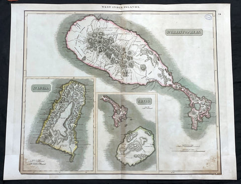
1817 John Thompson Large Antique Map Caribbean Is. St Christopher St Lucia Nevis
Antique Map
- Title : West India Islands: St Christopher; St Lucia; Nevis
- Date : 1817
- Size: 27in x 21in (685mm x 535mm)
- Condition: (A) Very Good Condition
- Ref: 35609
Description:
This large original, beautifully hand coloured copper plate engraved antique map of the Caribbean Islands was published by John Thomson in his large elephant folio 1817 edition of A New General Atlas of the World. (Ref Tooley M&B)
General Definitions:
Paper thickness and quality: - Heavy and stable
Paper color : - off white
Age of map color: - Original
Colors used: - Yellow, green, blue, pink
General color appearance: - Authentic
Paper size: - 27in x 21in (685mm x 535mm)
Plate size: - 27in x 21in (685mm x 535mm)
Margins: - Min 1/2in (12mm)
Imperfections:
Margins: - Bottom L&R margins extended from borders, not affecting the image
Plate area: - Light age toning, small library stamp to right
Verso: - Age toning
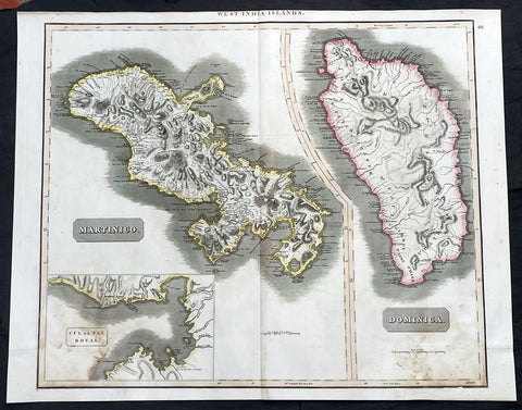
1817 John Thompson Large Antique Map Caribbean Islands of Martinique & Dominica
Antique Map
- Title : West India Islands: Martinico (Cul de Sac Royal); Dominica
- Date : 1817
- Size: 27in x 21in (685mm x 535mm)
- Condition: (A) Very Good Condition
- Ref: 35606
Description:
This large original, beautifully hand coloured copper plate engraved antique map of the Caribbean Islands of Martinique and Dominica was published by John Thomson in his large elephant folio 1817 edition of A New General Atlas of the World. (Ref Tooley M&B)
General Definitions:
Paper thickness and quality: - Heavy and stable
Paper color : - off white
Age of map color: - Original
Colors used: - Yellow, green, blue, pink
General color appearance: - Authentic
Paper size: - 27in x 21in (685mm x 535mm)
Plate size: - 27in x 21in (685mm x 535mm)
Margins: - Min 1/2in (12mm)
Imperfections:
Margins: - Bottom L&R margins extended from borders, not affecting the image
Plate area: - Light age toning
Verso: - Age toning
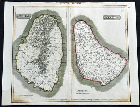
1817 John Thompson Large Antique Map Caribbean Islands of St Vincent & Barbados
Antique Map
- Title : West India Islands: St Vincent; Barbados
- Date : 1817
- Size: 27in x 21in (685mm x 535mm)
- Condition: (A) Very Good Condition
- Ref: 35610
Description:
This large original, beautifully hand coloured copper plate engraved antique map of the Caribbean Islands was published by John Thomson in his large elephant folio 1817 edition of A New General Atlas of the World. (Ref Tooley M&B)
General Definitions:
Paper thickness and quality: - Heavy and stable
Paper color : - off white
Age of map color: - Original
Colors used: - Yellow, green, blue, pink
General color appearance: - Authentic
Paper size: - 27in x 21in (685mm x 535mm)
Plate size: - 27in x 21in (685mm x 535mm)
Margins: - Min 1/2in (12mm)
Imperfections:
Margins: - Bottom L&R margins extended from borders, not affecting the image
Plate area: - Light age toning, small library stamp to right
Verso: - Age toning
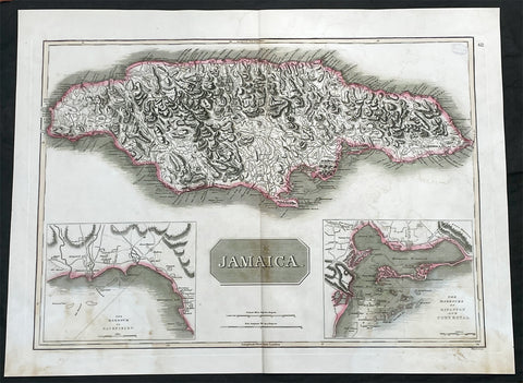
1817 John Thompson Large Antique Map of the Caribbean Island of Jamaica
Antique Map
- Title : Jamaica
- Date : 1817
- Size: 27in x 21in (685mm x 535mm)
- Condition: (A) Very Good Condition
- Ref: 35605
Description:
This large original, beautifully hand coloured copper plate engraved antique map of the Caribbean Islands was published by John Thomson in his large elephant folio 1817 edition of A New General Atlas of the World. (Ref Tooley M&B)
General Definitions:
Paper thickness and quality: - Heavy and stable
Paper color : - off white
Age of map color: - Original
Colors used: - Yellow, green, blue, pink
General color appearance: - Authentic
Paper size: - 27in x 21in (685mm x 535mm)
Plate size: - 27in x 21in (685mm x 535mm)
Margins: - Min 1/2in (12mm)
Imperfections:
Margins: - Light age toning
Plate area: - Light age toning, small library stamp to right
Verso: - Age toning

1817 John Thomson Large Antique Map of Asia, New Holland, Australia, New Zealand
- Title : Asia
- Date : 1817
- Size: 28in x 21in (710mm x 535mm)
- Condition: (A+) Fine Condition
- Ref: 92965
Description:
This large magnificent original hand coloured copper-plate engraved antique map of Asia, Australia, New Zealand & The South Pacific by John Thomson was published in the 1817 edition of Thomsons General Atlas
General Definitions:
Paper thickness and quality: - Heavy and stable
Paper color : - off white
Age of map color: - Original
Colors used: - Yellow, green, blue, pink
General color appearance: - Authentic
Paper size: - 28in x 21in (710mm x 535mm)
Plate size: - 22in x 19in (560mm x 485mm)
Margins: - Min 2in (50mm)
Imperfections:
Margins: - None
Plate area: - None
Verso: - None
Background:
The first recorded European sighting of the Australian mainland, and the first recorded European landfall on the Australian continent (in 1606), are attributed to the Dutch. The first ship and crew to chart the Australian coast and meet with Aboriginal people was the Duyfken captained by Dutch navigator, Willem Janszoon. He sighted the coast of Cape York Peninsula in early 1606, and made landfall on 26 February at the Pennefather River near the modern town of Weipa on Cape York. The Dutch charted the whole of the western and northern coastlines and named the island continent New Holland during the 17th century, but made no attempt at settlement. William Dampier, an English explorer and privateer, landed on the north-west coast of New Holland in 1688 and again in 1699 on a return trip. In 1770, James Cook sailed along and mapped the east coast, which he named New South Wales and claimed for Great Britain.
With the loss of its American colonies in 1783, the British Government sent a fleet of ships, the First Fleet, under the command of Captain Arthur Phillip, to establish a new penal colony in New South Wales. A camp was set up and the flag raised at Sydney Cove, Port Jackson, on 26 January 1788, a date which became Australias national day, Australia Day. A British settlement was established in Van Diemens Land, now known as Tasmania, in 1803, and it became a separate colony in 1825. The United Kingdom formally claimed the western part of Western Australia (the Swan River Colony) in 1828. Separate colonies were carved from parts of New South Wales: South Australia in 1836, Victoria in 1851, and Queensland in 1859. The Northern Territory was founded in 1911 when it was excised from South Australia. South Australia was founded as a free province—it was never a penal colony. Victoria and Western Australia were also founded free, but later accepted transported convicts. A campaign by the settlers of New South Wales led to the end of convict transportation to that colony; the last convict ship arrived in 1848.
The indigenous population, estimated to have been between 750,000 and 1,000,000 in 1788, declined for 150 years following settlement, mainly due to infectious disease. Thousands more died as a result of frontier conflict with settlers. A government policy of assimilation beginning with the Aboriginal Protection Act 1869 resulted in the removal of many Aboriginal children from their families and communities—often referred to as the Stolen Generations—a practice which may also have contributed to the decline in the indigenous population. As a result of the 1967 referendum, the Federal governments power to enact special laws with respect to a particular race was extended to enable the making of laws with respect to Aborigines.[68] Traditional ownership of land (native title) was not recognised in law until 1992, when the High Court of Australia held in Mabo v Queensland (No 2) that the legal doctrine that Australia had been terra nullius (land belonging to no one) did not apply to Australia at the time of British settlement.
A gold rush began in Australia in the early 1850s and the Eureka Rebellion against mining licence fees in 1854 was an early expression of civil disobedience. Between 1855 and 1890, the six colonies individually gained responsible government, managing most of their own affairs while remaining part of the British Empire. The Colonial Office in London retained control of some matters, notably foreign affairs, defence and international shipping.
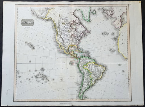
1817 John Thomson Large Antique Map of North & South America, Hawaiian Islands
- Title : America...Drawn & Engraved for Thomsons New General Atlas
- Date : 1817
- Size: 28in x 21 1/2in (710mm x 550mm)
- Condition: (A+) Fine Condition
- Ref: 35020
Description:
This large magnificent original hand coloured copper-plate engraved antique map of America drawn & engraved by John Thomson was published in the 1817 edition of Thomsons General Atlas
General Definitions:
Paper thickness and quality: - Heavy and stable
Paper color : - off white
Age of map color: - Original
Colors used: - Yellow, green, blue, pink
General color appearance: - Authentic
Paper size: - 28in x 21 1/2in (710mm x 550mm)
Plate size: - 25in x 20in (635mm x 510mm)
Margins: - Min 1in (25mm)
Imperfections:
Margins: - None
Plate area: - None
Verso: - None
Background:
The exploration of North America by non-indigenous people was a continuing effort to map and explore the continent of North America. It spanned centuries, and consisted of efforts by numerous people and expeditions from various foreign countries to map the continent. The European colonization of the Americas followed.
There were numerous Spanish explorers and conquistadors who explored the Southwest of North America (including present-day west and central United States) and cross the continent (east to west) in its southern regions, mainly from the second quarter to the middle of the 16th century, such as Álvar Núñez Cabeza de Vaca and Francisco Vásquez de Coronado, but also the North American Southeast and south-central regions, s Soto]].
In 1608 Samuel de Champlain founded what is now Quebec City, which would become the first permanent settlement and the capital of New France. He took personal administration over the city and its affairs, and sent out expeditions to explore the interior. Champlain himself discovered Lake Champlain in 1609. By 1615, he had travelled by canoe up the Ottawa River through Lake Nipissing and Georgian Bay to the centre of Huron country near Lake Simcoe. During these voyages, Champlain aided the Wendat (aka Hurons) in their battles against the Iroquois Confederacy. As a result, the Iroquois would become enemies of the French and be involved in multiple conflicts.
From 1679 to 1682 René-Robert Cavelier, Sieur de La Salle explored the Great Lakes region of the United States and Canada, and the entire course of Mississippi River to the Gulf of Mexico.
From 1697 to 1702 Eusebio Kino explored the Sonoran Desert and on his journey to the Colorado River Delta discovered an overland route to Baja California that was then commonly believed to be an island. In 1683 Kino lead the first European overland crossing of Baja California.
European exploration of western Canada was largely motivated by the fur trade and the search for the elusive Northwest Passage. Hudson\'s Bay Company explorer Henry Kelsey has the distinction of being the first European to see the northern Great Plains in 1690.
Anthony Henday was the first to have seen the Rocky Mountains, in 1754, but curiously did not mention it in his journals. From his westernmost geographic position (roughly near the town of Olds, Alberta, halfway between Calgary and Red Deer, Alberta) the Rockies should have been quite conspicuous, but he was likely trying to disguise the disappointing fact that an unknown range of seemingly impassible mountains now stood between the HBC and the Pacific. Samuel Hearne found the Coppermine River in 1769-71 in his failed search for copper ore deposits. Burned by these shortfalls, the HBC largely quit exploration.
The North West Company, on the other hand, used a business model that required constant expansion into untapped areas. Under the auspices of the NWC, Alexander Mackenzie discovered the Mackenzie River in 1789 and was the first European to reach the North-American Pacific overland, via the Bella Coola River, in 1793. Simon Fraser reached the Pacific in 1808 via the Fraser River.
David Thompson, widely regarded as the greatest land geographer that ever lived, traveled over 90,000 km during his lifetime. In 1797, Thompson was sent south by his employers to survey part of the Canada-U.S. boundary along the water routes from Lake Superior to Lake of the Woods to satisfy unresolved questions of territory arising from the Jay Treaty between Great Britain and the United States. By 1798 Thompson had completed a survey of 6,750 km (4,190 mi) from Grand Portage, through Lake Winnipeg, to the headwaters of the Assiniboine and Mississippi Rivers, as well as two sides of Lake Superior. In 1798, the company sent him to Red Deer Lake (in present-day Alberta) to establish a trading post. The English translation of Lac La Biche-Red Deer Lake-first appeared on the Mackenzie map of 1793. Thompson spent the next few seasons trading based in Fort George (now in Alberta), and during this time led several expeditions into the Rocky Mountains. In 1811/1812 he followed the Columbia River to the Pacific, and in 1814 used his notes and measurements to draft the first European-style map of western Canada, covering 3.9 million square kilometres.
Lewis and Clark were the first Americans to venture into the newly acquired territory of the Louisiana Purchase, at the order of President Thomas Jefferson. They discovered many new geographical features, Indian tribes, and animal and plant species. John Colter was a member of the expedition who subsequently became a guide for others in the Old West, and did some explorations of his own.
John C. Frémont led many important explorations in the Great Plains, Great Basin, Oregon territory, and Mexican Alta California.
Joseph Reddeford Walker was one of the most prominent of the explorers, and charted many new paths through the West, which often were then utilized by emigrants crossing to settle in Western towns and communities. In 1833, his exploring party discovered a route along the Humboldt River across present-day Nevada, ascending the Sierra Nevada following the Carson River and descending via Stanislaus River drainages to Monterey. His return route across the southern Sierra was via Walker Pass, named after Walker by John Charles Fremont. The approach of the Sierra via the Carson River route later became known as the California Trail, the primary route for the emigrants to the gold fields during the California gold rush.
As the American population of the West increased, the US government launched ongoing official explorations mainly through the US Army Corps of Topographical Engineers. One of the main officers and explorers in this unit was George Wheeler. In 1872, the US Congress authorized an ambitious plan to map the portion of the United States west of the 100th meridian at a scale of 8 miles to the inch. This plan necessitated what became known as the Wheeler Survey, along with the Clarence King and John Wesley Powell Surveys, and expeditions by Ferdinand Vandeveer Hayden. In 1879, all such efforts were reorganized as the United States Geological Survey.
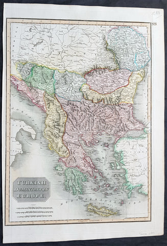
1817 John Thomson Large Antique Map Turkey in Europe Greece to Bosnia & Hungary
- Title : Turkish Dominions in Europe
- Date : 1817
- Size: 21in x 15in (535mm x 390mm)
- Condition: (A+) Fine Condition
- Ref: 16431
Description:
This large magnificent original hand coloured copper-plate engraved antique map of Turkey In Europe (Moldova, Bulgaria, Romania, Serbia, Bosnia, Croatia, Slovenia, Dalmatia & Greece) by John Thomson was published in the 1817 edition of Thomsons New General Atlas
General Definitions:
Paper thickness and quality: - Heavy and stable
Paper color : - off white
Age of map color: - Original
Colors used: - Yellow, green, blue, pink
General color appearance: - Authentic
Paper size: - 21in x 15in (535mm x 390mm)
Plate size: - 20in x 13 1/2in (510mm x 345mm)
Margins: - Min 1/2in (10mm)
Imperfections:
Margins: - None
Plate area: - None
Verso: - none
Background:
The Ottoman Empire also historically known in Western Europe as the Turkish Empire or simply Turkey, was a state that controlled much of Southeast Europe, Western Asia and North Africa between the 14th and early 20th centuries. It was founded at the end of the 13th century in northwestern Anatolia in the town of Söğüt (modern-day Bilecik Province) by the Oghuz Turkish tribal leader Osman I. After 1354, the Ottomans crossed into Europe, and with the conquest of the Balkans, the Ottoman beylik was transformed into a transcontinental empire. The Ottomans ended the Byzantine Empire with the 1453 conquest of Constantinople by Mehmed the Conqueror.
During the 16th and 17th centuries, at the height of its power under the reign of Suleiman the Magnificent, the Ottoman Empire was a multinational, multilingual empire controlling most of Southeast Europe, parts of Central Europe, Western Asia, parts of Eastern Europe and the Caucasus, North Africa and the Horn of Africa. At the beginning of the 17th century, the empire contained 32 provinces and numerous vassal states. Some of these were later absorbed into the Ottoman Empire, while others were granted various types of autonomy during the course of centuries.
With Constantinople as its capital and control of lands around the Mediterranean basin, the Ottoman Empire was at the centre of interactions between the Eastern and Western worlds for six centuries. While the empire was once thought to have entered a period of decline following the death of Suleiman the Magnificent, this view is no longer supported by the majority of academic historians. The empire continued to maintain a flexible and strong economy, society and military throughout the 17th and much of the 18th century. However, during a long period of peace from 1740 to 1768, the Ottoman military system fell behind that of their European rivals, the Habsburg and Russian empires. The Ottomans consequently suffered severe military defeats in the late 18th and early 19th centuries, which prompted them to initiate a comprehensive process of reform and modernisation known as the Tanzimat. Thus, over the course of the 19th century, the Ottoman state became vastly more powerful and organised, despite suffering further territorial losses, especially in the Balkans, where a number of new states emerged. The empire allied with Germany in the early 20th century, hoping to escape from the diplomatic isolation which had contributed to its recent territorial losses, and thus joined World War I on the side of the Central Powers. While the Empire was able to largely hold its own during the conflict, it was struggling with internal dissent, especially with the Arab Revolt in its Arabian holdings. During this time, atrocities were committed by the Ottoman government against the Armenians, Assyrians and Pontic Greeks.
The Empire\'s defeat and the occupation of part of its territory by the Allied Powers in the aftermath of World War I resulted in its partitioning and the loss of its Middle Eastern territories, which were divided between the United Kingdom and France. The successful Turkish War of Independence against the occupying Allies led to the emergence of the Republic of Turkey in the Anatolian heartland and the abolition of the Ottoman monarchy.
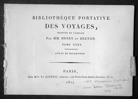
1817 Lord Macartney Antique Atlas of Travels in China in 1794 - 22 Illustrations
- Title: Bibliotheque Portative Des Voyages Traduite De L Anglais Par MM. Henry et Breton Tome XXV - 1817
- Date: 1817
- Condition: (A+) Fine Condition
- Ref : MACTP
- Size: 8vo
Description:
This fine original antique French edition Atlas of the travels of Ambassador Lord Macartney travels in China between 1792 & 1794 was translated and published in Paris by M Henry & Breton in the 1817 - dated - edition of Biblio Portative Des Voyages Traduite De L Anglais Par MM. Henry et Breton Tome XXXV (Portable Travel Library. Translated from the English by MM Henry and Breton Volume 35)
General Description:
Paper thickness and quality: - Heavy and stable
Paper color: - off white
Age of map color: -
Colors used: -
General color appearance: -
Page size: - 7in x 5in (180mm x 125mm)
Imperfections:
Margins: - Light age toning
Plate area: - None
Verso: - None
The atlas covers have been removed with front title page Pages are generally clean with light aging to borders, overall VG, 8vo, each page size is 7in x 5in (180mm x 125mm)
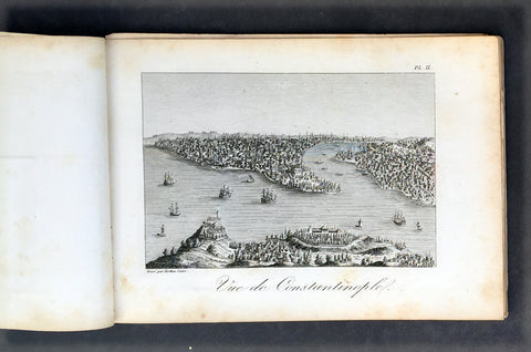
This atlas contains 22 B&W copper-plate engraved prints, listed below.
1. Lord Macartney
2. Arbe a pain de Singe (Monkey Tree)
3. Feuille de Nopal avec Cochenille qui s y Nourit
4. Barque Cochinchinoise (Chinese Barge)
5. Mandarin de Curon
6. Insects qui produisent la Cire de la Cochinchine (Insects that produce the wax of the Cochin China)
7. Maniere de lever les Filets (Net fishing)
8. Pieds des Dames Chinoisec (feet of Chinese Ladies)
9. Chaise a Porteurs (Chair Porters)
10. Maniere de transporter les Fardeaux (Carrying freight)
12. Vue de la Grande Muraille de la Chinese (Great Wall of China)
13. Portrait de l Empereur Cohien Long
14. Bourse et Sceptre de L Empereur (Money & Sceptre of Emperor)
15. Fondateur de l Empire Chinois (Founder of Chinese Empire)
16. Maniere de elever L Eau (Water irrigation)
17. Charrue Chinoise (Plough)
18. Pecheurs portant leur canot et les Oiseaux avec les quels ils prennent le poisson (Using ducks to catch fish)
19. Maniere de degager le Riz de sa pellicule (Rice farming)
20. Cha-wha ou Camellia sesanqua (Camilla flower)
21. Pompe a Chaine (Irrigation)
22. Grotte du Camoens...
Sir George, Earl Macartney, was born at Lissanoure, in the northern part of the County of Antrim, 14th May 1737. Having passed through Trinity College, he entered the Middle Temple, made an extended tour of Europe (becoming acquainted with Rousseau and other persons of eminence), and shortly after his return home in 1764, was, through an intimacy with Lord Holland, appointed a special envoy to negotiate a commercial treaty with Russia. His biographer says: "His knowledge of European politics alone fitted him for the undertaking; but a graceful person, with great suavity of manners, a conciliating disposition, and winning address, were considered as no slight recommendations at a female court, where such accomplishments, it was fair to conclude, might work their way, when great and unaccommodating talents alone would prove ineffectual."
From September 1792 to September 1794, he spent abroad as ambassador to China. The country was then little known, and Lord Macartney's published account of his embassy long continued the standard book of information on Chinese matters. Commenting on his mission, a writer says: "The amount of the benefit gained by this first diplomatic communication on the part of England with the Court of Pekin has been matter of dispute; but it is generally agreed that no other person could have accomplished more than was done by Lord MaCartney, whose conduct at least was well calculated to impress the subjects of the Celestial Empire with a respect for the country which he represented."[97] In 1795 he was sent on a confidential mission to Italy; and from November 1796 to November 1798 he was Governor of the Cape of Good Hope, then newly captured from the Dutch. "There is no praise," says Lord Melville, "to which he is not entitled on the score of his government of the Cape." All his nerve and tact were called forth in 1797 by an attempted mutiny of the British fleet in Simon's Bay, following the news of the mutiny at the Nore.
Impaired health obliged him to give up this, his last official post, and return home. The Union gave him unbounded satisfaction: writing during the negotiations, he said: "I bow with admiration and respect to those by whose wisdom this great and important object has been brought so near to its completion. Considering many things that have happened in my time, painful to recollect and invidious to mention, I little imagined to see this happy day. Thank God! I have seen it. I thank the Father of all mercies that he has been graciously pleased to prolong my days to this auspicious period. The measure before us has my dying voice. It will annihilate the vain hopes of a vain insidious foe from without, and, I trust, will contribute to defeat the projects of a dark and treacherous enemy within." His last years were passed in retirement at Chiswick; his enjoyment of the society of a large circle of eminent men being lessened by severe sufferings from gout. He died, childless, 31st March 1806, aged 68, and was buried at Chiswick. In 1792 he had been created a Viscount; in 1794 an Earl; and in 1796 a British peer. His features were regular and well proportioned, his countenance open, placid, and agreeable. He possessed all the dignity of the " old school," without its stiffness, and retained it in his dress, which he did not materially alter for the last forty years of his life. (Ref Clancy; Tooley; M&B)
1817 Tavernier & Lepetit Antique Atlas of Turkey Persia Vietnam, Asia - 22 Prints
- Title : Atlas de Tavernier...Chez M.Me Lepetit...1817
- Ref #: 91592
- Size: 8vo
- Date : 1817
- Condition: (A) Very Good Condition
Description:
This fine original antique of the travels from Turkey, Persia, Central Asia, Vietnam of Jean Baptist Tavernier's was translated from the English by M Henry & M Breton and published by V Lepetit. Paris in 1817 - dated.
This atlas contains 22 copper-plate engraved prints, as listed below.
The atlas covers have been removed with front title page partially detached. Pages are generally clean with light aging to borders, Print V detached, light toning to pages, overall VG, 8vo, each page size is 7in x 5in (180mm x 125mm)
- J B Tavernier
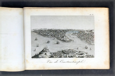
2. Vue de Constantinople
3. Point de Serail a Constantionople
4. Le Trois Eglises
5. Ervan
6. Caravanserail de Cachen
7. Village Camouk ou Circassien
8. Mosquee Persane
9. Pont d' Ispahan
10. Costumes Persan
11. Femmes Persans
12. Bas-reliefs de Persepolis
13. Diamonds
13 (repeat). Animal qui produit le Musc
14. Serpent
15. Diverses Monaies Asie
16. Poignard Indien
17. Marche du Roi de Tonquin lorsqu il va a laguerre
18. Costumes Tonquinois
19. Spectacle Tonquinois
20.
21. Pompe funebre du Roi de Tonquin
22. Convoi de provisions a l enterrement du Roi de Tonquin
Jean-Baptiste Tavernier (1605 – 1689) was a 17th-century French gem merchant and traveller. Tavernier, a private individual and merchant travelling at his own expense, covered, by his own account, 60,000 leagues in making six voyages to Persia and India between the years 1630 and 1668. In 1675, Tavernier, at the behest of his patron Louis XIV, published Les Six Voyages de Jean-Baptiste Tavernier (Six Voyages, 1676).
Tavernier was born in Paris of a French or Flemish Huguenot family that had emigrated to Antwerp, to escape persecution, and which subsequently returned to Paris after the publication of the Edict of Nantes, which promised protection for French Protestants. Both his father Gabriel and his uncle Melchior were cartographers. Though it is clear from the accuracy of his drawings that Tavernier received some instruction in the art of cartography/engraving, he was possessed of a wanderlust. While still a teenager, he traveled extensively through Europe and achieved a working knowledge of its major languages.
Tavernier is best known for his 1666 discovery/purchase of the 116-carat Tavernier Blue diamond that he subsequently sold to Louis XIV of France in 1668 for 120,000 livres, the equivalent of 172,000 ounces of pure gold, and a letter of ennoblement. (Five years later, Louis had his court jeweler Jean Pitau recut the stone into the 68 carat French Blue and had it set as a hatpin. The gem was reset by his great-grandson Louis XV in The Medal of The Order of the Golden Fleece, stolen in 1792, and was recut and re-emerged in London 30 years later as the Hope Diamond).
In 1669, Tavernier purchased for 60,000 livres the Seigneury of Aubonne, located in the Duchy of Savoy near the city of Geneva, and became Baron of Aubonne.
Tavernier's writings show that he was a keen observer, as well as a remarkable cultural anthropologist. His Six Voyages became a best seller and was translated into German, Dutch, Italian, and English during his lifetime. The work is frequently quoted by modern scholars writing about the period. (Ref Tooley M&B)
General Description:
Paper thickness and quality: - Heavy, stable canvas backed
Paper color: - off white
Age of map color: -
Colors used: -
General color appearance: -
Atlas size: - 8vo
Imperfections:
Margins: - Age toning
Plate area: - Plate V detached, age toning
Verso: - Age toning
1817 Tavernier & Lepetit Antique Atlas of Turkey Persia Vietnam, Asia - 22 Prints
Antique Map
- Title : Atlas de Tavernier...Chez M.Me Lepetit...1817
- Ref #: 91592
- Size: 8vo
- Date : 1817
- Condition: (A) Very Good Condition
Description:
This fine original antique of the travels from Turkey, Persia, Central Asia, Vietnam of Jean Baptist Tavernier's was translated from the English by M Henry & M Breton and published by V Lepetit. Paris in 1817 - dated.
This atlas contains 22 copper-plate engraved prints, as listed below.
The atlas covers have been removed with front title page partially detached. Pages are generally clean with light aging to borders, Print V detached, light toning to pages, overall VG, 8vo, each page size is 7in x 5in (180mm x 125mm)
- J B Tavernier
2. Vue de Constantinople
3. Point de Serail a Constantionople
4. Le Trois Eglises
5. Ervan
6. Caravanserail de Cachen
7. Village Camouk ou Circassien
8. Mosquee Persane
9. Pont d' Ispahan
10. Costumes Persan
11. Femmes Persans
12. Bas-reliefs de Persepolis
13. Diamonds
13 (repeat). Animal qui produit le Musc
14. Serpent
15. Diverses Monaies Asie
16. Poignard Indien
17. Marche du Roi de Tonquin lorsqu il va a laguerre
18. Costumes Tonquinois
19. Spectacle Tonquinois
20.
21. Pompe funebre du Roi de Tonquin
22. Convoi de provisions a l enterrement du Roi de Tonquin
Jean-Baptiste Tavernier (1605 – 1689) was a 17th-century French gem merchant and traveller. Tavernier, a private individual and merchant travelling at his own expense, covered, by his own account, 60,000 leagues in making six voyages to Persia and India between the years 1630 and 1668. In 1675, Tavernier, at the behest of his patron Louis XIV, published Les Six Voyages de Jean-Baptiste Tavernier (Six Voyages, 1676).
Tavernier was born in Paris of a French or Flemish Huguenot family that had emigrated to Antwerp, to escape persecution, and which subsequently returned to Paris after the publication of the Edict of Nantes, which promised protection for French Protestants. Both his father Gabriel and his uncle Melchior were cartographers. Though it is clear from the accuracy of his drawings that Tavernier received some instruction in the art of cartography/engraving, he was possessed of a wanderlust. While still a teenager, he traveled extensively through Europe and achieved a working knowledge of its major languages.
Tavernier is best known for his 1666 discovery/purchase of the 116-carat Tavernier Blue diamond that he subsequently sold to Louis XIV of France in 1668 for 120,000 livres, the equivalent of 172,000 ounces of pure gold, and a letter of ennoblement. (Five years later, Louis had his court jeweler Jean Pitau recut the stone into the 68 carat French Blue and had it set as a hatpin. The gem was reset by his great-grandson Louis XV in The Medal of The Order of the Golden Fleece, stolen in 1792, and was recut and re-emerged in London 30 years later as the Hope Diamond).
In 1669, Tavernier purchased for 60,000 livres the Seigneury of Aubonne, located in the Duchy of Savoy near the city of Geneva, and became Baron of Aubonne.
Tavernier's writings show that he was a keen observer, as well as a remarkable cultural anthropologist. His Six Voyages became a best seller and was translated into German, Dutch, Italian, and English during his lifetime. The work is frequently quoted by modern scholars writing about the period. (Ref Tooley M&B)
General Description:
Paper thickness and quality: - Heavy, stable canvas backed
Paper color: - off white
Age of map color: -
Colors used: -
General color appearance: -
Atlas size: - 8vo
Imperfections:
Margins: - Age toning
Plate area: - Plate V detached, age toning
Verso: - Age toning
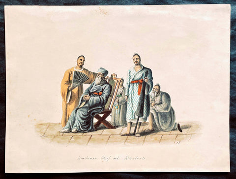
1818 C J McLeod Antique Print of Chief & Attendants of Ryukyu Isles of Japan
- Title : Lewchewan Chief and Attendants
- Ref #: 25103
- Size: 10in x 7 1/2in (255mm x 190mm)
- Date : 1818
- Condition: (A+) Fine Condition
Description:
This fine original antique hand coloured and pen ink outline drawing of a Chief and Attendants of the Japanese Island of Lew Chew or Ryukyu Islands was drawn by an artist signing his name as C.J. from the exquisite hand coloured prints by the surgeon John McLeod, published in the 1818 edition of Voyage of His Majesty's Ship Alceste.
Voyage of His Majesty's Ship Alceste, Along the Coast of Corea to the Island of Lewchew; with an Account of Her Subsequent Shipwreck, London, John Murray, printed by W. Clowes, 1818. The book is of the expedition (February 1816 - August 1817) of the British Naval ships the Alceste and the Lyra under the command of Captain Murray Maxwell to transport the Lord Amherst's Embassy to China and explore the relatively little known East China Sea and the Yellow Sea. The book contained extensive sections on visits to China, Korea, Lew Chew and St Helena. (Ref: M&B; Tooley)
General Description:
Paper thickness and quality: - Heavy & stable
Paper color: - White
Age of map color: - Original
Colors used: -Blue, yellow, red, purple
General color appearance: - Fresh
Paper size: - 10in x 7 1/2in (255mm x 190mm)
Margins: - Min 1/2in (10mm)
Imperfections:
Margins: - None
Plate area: - Very light toning
Verso: - Old glue residue on back margins not affecting the image
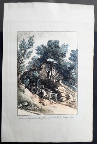
1819 Gainsborough & Wells Antique Print of an English Country Farming Scene
- Title : From the Original in the Collection of the Rt. Hon. ble Baroness Lucas...T Gainsborough del. W.F. Wells sculpt.
- Date : 1801
- Condition: (A+) Fine Condition
- Ref: 91222
- Size: 17 1/4in x 11 1/2in (440mm x 290mm)
Description:
This large beautiful executed original antique soft ground etched print with hand tint colour, of a English country scene after Thomas Gainsborough, was engraved by William Frederick Wells and published in A Collection of Prints Illustrative of English Scenery From the Drawings and Sketches of Thos. Gainsborough, R.A. in the various collections of The Baroness Lucas; Viscount Palmerston; George Herbert, Esq.; Dr. Monro by John and Josiah Boydell, London in 1819.
The English painter Thomas Gainsborough (1727-1788) ranks as one of the principal masters and innovators of the English school of landscape painting. Thomas Gainsborough was baptized in Sudbury, Suffolk, on May 14, 1727. His father, a substantial cloth merchant, recognized Thomas's precocious artistic gifts and sent him at an early age, possibly 12, to London. Gainsborough was connected with the artists Francis Hayman and Hubert François Gravelot, possibly as apprentice to the former and assistant to the latter. Gainsborough is reported to have copied and restored Dutch landscapes for dealers. At the age of 19 he married Margaret Burr, reputedly a natural daughter of the Duke of Beaufort, who is said to have brought him an income of £200 a year.
At the age of 21 Gainsborough was so much admired as a landscape painter that he was invited with the leading artists of the day to present a picture to the Foundling Hospital in London. His painting, The Charterhouse, shows a mature observation of reality and handling of light. From Hayman the scene painter and Gravelot the rococo decorator Gainsborough learned to approach pictorial composition on inventive principles, and the alternation between observation and invention henceforth became the basis of his artistic growth. The two approaches may be illustrated by comparing Mr. and Mrs. Robert Andrews (ca. 1749), with a deliciously observed Suffolk landscape dappled by sunlight and shadow of cloud, and Henéage Lloyd and His Sister (ca. 1750), shown against a limpid background of stage scenery.
Gainsborough's art after his early London studies falls into three main divisions: the Suffolk period, 1748-1759; the Bath period, 1759-1774; and the years of fame in London, 1774-1788. In Suffolk he combined the charms of the modern conversation piece with those of realistic landscape, thus making a strong appeal to the country gentry. Here too he painted the Suffolk countryside as faithfully and freshly as if he were a Dutch painter reborn in the 18th century.
William Frederick Wells (1762 - 10 Nov 1836) was an English watercolour landscape painter and etcher. Wells was born in London in 1762. Wells studied art in London under John James Barralet (1747–1815). On 20 November 1804, Wells initiated the founding of the Society of Painters in Watercolours (now the Royal Watercolour Society), at a meeting held at the Stratford Coffee House, Oxford St, London. He served as President of the fledgling association from 1806 to 1807.
He travelled and painted extensively in England and Europe, particularly in Norway and Sweden. Wells' art was annually exhibited at the Royal Academy from 1795 to 1813. He held the post of Professor of Drawing at Addiscombe Military Seminary for officers of the East India Company Army over twenty years from 1813 until his retirement, immediately before his death, in November 1836.[1] Wells was an intimate friend of Joseph Mallord William Turner. Among his works as an etcher are two fine sets in soft ground; Thomas Gainsborough's English Scenery (1819) and Select Views in Cumberland (1810).
General Description:
Paper thickness and quality: - Heavy and stable
Paper color: - off white
Age of map color: - Original
Colors used: - Blue, orange, green, brown
General color appearance: - Authentic
Paper size: - 17 1/4in x 11 1/2in (440mm x 290mm)
Plate size: - 12 1/2in x 9 1/2in (315mm x 245mm)
Margins: - Min 2in (50mm)
Imperfections:
Margins: - None
Plate area: - None
Verso: - None

1820 Fischer Large Antique Print View of the City & Harbour of Liverpool England
- Title : View of The Town and Harbour of Liverpool, from Seacombe....1820
- Ref : 92895
- Size: 16 1/2in x 10 1/2in (420mm x 270mm)
- Date : 1820
- Condition: (A+) Fine Condition
Description:
This large fine original antique print a view of the very important and busy town and port of Liverpool in Northern England at the turn of the 19th century was engraved in 1820 - dated at the foot of the print - and published by Henry Fisher & co.. (Ref: M&B; Tooley)
General Description:
Paper thickness and quality: - Heavy & stable
Paper color: - White
Age of map color: -
Colors used: -
General color appearance: -
Paper size: - 16 1/2in x 10 1/2in (420mm x 270mm)
Plate size: - 16 1/2in x 10 1/2in (420mm x 270mm)
Margins: - Min 1/2in (10mm)
Imperfections:
Margins: - None
Plate area: - Folds as issued
Verso: - None
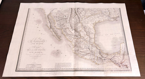
1820 Pierre Francois Tardieu Large Rare Antique Map of Texas, Mexico - Southern Sheet
Antique Map
- Title: A Map of Louisiana and Mexico - Carte de la Louisiane et du Mexique, Dressee par P Tardieu fils aine, gravee par PAF Tardieu pere. Paris 1820.
- Sizes: 36in x 24in (910mm x 610mm)
- Condition: (A) Good Condition
- Date: 1820
- Ref #: 93009
Description:
This rare, original large hand coloured, antique copper plate engraved map of Texas, SW America & Mexico (sheet 2 of 2 southern portion) by Pierre Francois Tardieu and Charles Picquet (1771 - 1827) was engraved in 1820 - dated - and published by J Goujon, Paris.
This map is incredibly important in the history of Mexico, Texas and the United States a time of big political and international change in both countries. (Ref: M&B; Tooley)
General Definitions:
Paper thickness and quality: - Heavy and stable
Paper color : - off white
Age of map color: - Original
Colors used: - Yellow, green, blue, pink
General color appearance: - Authentic
Paper size: - 36in x 24in (910mm x 610mm)
Plate size: - 32 1/2in x 22 1/2in (860mm x 570mm)
Margins: - Min 1/2in (12mm)
Imperfections:
Margins: - Bottom left corner replaced in facsimile
Plate area: - Bottom left corner replaced in facsimile
Verso: - Bottom left corner replaced in facsimile
To be more precise the maps are;
1. Alexander von Humboldt 1811 - "A New Map of Spain"
2. Z M Pike 1810 - "A Map of The Internal Provinces of New Spain"
3. Lewis and Clark 1814 - "Map of Lewis and Clark's Track, Across the Western Portion of North America"
4. Aaron Arrowsmith 1816 - "A New Map of Mexico"
5. John Melish 1816 - "Map of The United States"
By themselves each of these maps had a profound affect on the understanding of the region and the eventual expansion of the United States. Tardieus compared, analysed & combined the correct data from each map, as well as new information from other sources, and publish a large scale map stretching from the edge of the established western United States to Texas, Mexico, California & the southwest.
Another unique quality of the map is the use of English in a French published map. Not only is the title in English first, but most of the place names and observations are also written in English. Very unusual for a French map of the period, which illustrates how shrewd Tardieu was, marketing the map to the newly independent American home market.
Because there is 10 years difference between publication of these maps, each had their own mistakes and idiosyncrasies. For instance, although De Humboldt spent many months in Mexico researching for his book and maps of New Spain, he eventually used the wrong observations of Gen. James Wilkinson on the depiction of the Texas rivers, giving them too much southerly direction. Pike on the other hand explored parts of Texas himself and depicted the rivers in their correct SE direction, but Pike's delineation of the Texas coast followed the incorrect Jeffery's model instead of the far superior & up to date model used by Humboldt from Mexican data.
Arrowsmith's approach to cartography differed again from both Humboldt's and Pikes. He used data from various different sources, rather than predominately from a single source and scientific hypothesis as did Humboldt, or the more direct military reconnaissance approach of Pike. There is no doubt that Arrowsmith borrowed heavily from both Humboldt's & Pikes maps of Texas, but what makes his map a stand out is the use of data and observations from sources such as the Hudson Bay Company to expanded his map to include more of Louisiana, California and the NW.
The Lewis and Clark Expedition of 1804-06 gained an understanding of the geography of the west & northwest and produced the first accurate maps of the region. During the journey, Lewis and Clark drew some 140 maps. The discoveries made on the expedition helped Tardieu update many details of his map. One detail of significance was the relationships and sources of the Columbia & Missouri Rivers as well as the previously underestimated domination of the Rocky Mountains.
The large Melish map of 1816 stretching from the East Coast to California was of vital importance to Tardieus map. It gave him the boundaries agreed to by the Adams-Onis treaty between Spain & The United States in which the US gave up its claims to Texas in exchange for Spain's claim on Florida. Melish's Philadelphia publishing company was also one of the first in the newly independent US to be devoted to the publication of cartographical material. He had recognised the potential of expansion into the west and so accumulated vast amounts of detail in which to include in his extremely popular 1816 large 6 sheet map. He also included data from William Darby who had personally surveyed the Sabine River & other parts of Texas. Melish published Darby's map of The State of Louisiana in 1816.
The progression of maps from Humboldt's to Pike & Arrowsmith's is obvious and with the publication of the Lewis & Clark map of the West in 1814 & the large scale America map by John Melish in 1816, Tardieu was in a unique position to produce an accurate and definite map that combined details from all maps.
In the end, Tardieu's map of Texas, Mexico and the West may be seen as a natural progression from previous cartographical iteration. But the sign of a incisive mind is the ability to research and define the mistakes of others and have the conviction to correct popular belief and to publish, in this case to a growing and emerging market.
There are only 2 published sales of this map in AMPR in the last 25 years. There are sales of the southern sheet of two (in its other form) but none of the northern sheet. In comparison there are 7 sales records of Von Humboldts map with a top price of $22,500. One sales record for Lewis & Clark of $18,000 in 2006. Four sales of Arrowsmith's map with a top of $39,100 & 10 sales of the Melish map with a top price of $75,000 in 2008. (Ref: Wheat; Martin; Streeter; M&B; Tooley)
Please note all items auctioned are genuine, we do not sell reproductions. A Certificate of Authenticity (COA) can be issued on request.
1821 Brue Large Antique World Map of Mercators Projection - New Holland, Texas
- Title : Mappemonde Physique...par Brue......1821
- Ref #: 32440
- Size: 24in x 18in (610mm x 460mm)
- Date : 1821
- Condition: (A) Very Good Condition
Description:
This large original antique World map on Mercator's projection was engraved in 1821 - the date is engraved in the title - and was published in Adrien Brue's (1786 - 1832) large Atlas Universel de Geographie.
A fantastic World map in a time of great change. The map centres on New Holland or Australia (officially named Australia in 1824 by the British) Mexico still holds sway on the western portion of North America. Much of Capt. Cooks discoveries are recognised on this map in NW America and the south Pacific but not his explorations in Antarctica and beyond. Central Africa still remains relatively unexplored by the Europeans as does the Artic north of Canada. A fantastic map. (Ref: M&B; Tooley)
General Description:
Paper thickness and quality: - Heavy and stable
Paper color: - Off white
Age of map color: -
Colors used: -
General color appearance: -
Paper size: - 24in x 18in (610mm x 460mm)
Plate size: - 21 1/2in x 15 1/2in (545mm x 395mm)
Margins: - Min 1in (25mm)
Imperfections:
Margins: - Soiling in margins, repair to top margin, no loss
Plate area: - Soiling and spotting to top of map
Verso: - Soiling
1821 Charles Hullmandel & Francis Nicholson Antique Print of Bridge St, Chester
- Title : Bridge Street, Chester....Printed by C Hullmandel....F. N. 1821
- Size: 16 1/2in x 12 1/2in (420mm x 315mm)
- Condition: (A) Good Condition
- Date : 1821
- Ref #: 26350
Description:
This scarce, fine early lithograph of Bridge St in the city of Chester, England by the British artist Francis Nicholson was print by the Charles Joseph Hullmandel in 1821 - dated at the foot of the print.
General Definitions:
Paper thickness and quality: - Heavy and stable
Paper color : - off white
Age of map color: -
Colors used: -
General color appearance: -
Paper size: - 16 1/2in x 12 1/2in (420mm x 315mm)
Plate size: - 16 1/2in x 12 1/2in (420mm x 315mm)
Margins: - Min 1in (25mm)
Imperfections:
Margins: - Soiling, repair to top & bottom margin, no loss
Plate area: - None
Verso: - Soiling
Background:
Francis Nicholson 1753 – 1844 was a British artist, born in Pickering, North Yorkshire. He worked in watercolour and oil, and is mainly known as a landscape artist.
Nicholson studied with a local artist in Scarborough, before beginning his career in his native Pickering, producing sporting pictures and portraits for a variety of Yorkshire patrons. By the mid-1780s he was also making paintings of country houses, leading him to concentrate on landscapes in watercolour.
From 1789, he contributed views of both Yorkshire and Scotland to exhibitions at the Royal Academy. He also supplied topographical views for the Copper Plate Magazine.
He contributed Views of England in collaboration with the engraver Francis Jukes to The Beauties of England and Wales, Author: Britton, John & Edward Wedlake Brayley - A book published in 18 volumes from 1801 to 1815.
Although his market increasingly became London-based, Nicholson continued to live in Yorkshire - at Whitby, Knaresborough and Ripon. He did not move to London until about 1803. In 1804, he became a founder-member of the Society of Painters in Watercolours, and was a regular and prolific contributor to its exhibitions.
He wrote a handbook, The practice of drawing and painting landscape from nature, in water colours, which was published in 1820. It sold out and a second edition followed in 1823.
His c. 1837 self-portrait is in the National Portrait Gallery. & is known as the Father of water colour painting and also as an early pioneer of lithography, and was much admired by Turner.
Nicholson died in London and is buried there in Brompton Cemetery.
Hullmandel, Charles Joseph 1789 – 1850
Hullmandel was born in London, where he maintained a lithographic establishment on Great Marlborough Street from about 1819 until his death.
He was born in Queen Street, Mayfair. His father was a German-speaking musician and composer, Nicolaus Joseph Hüllmandel (1751–1823), a native of Strasbourg who became a pupil of C. P. E. Bach and from 1780 spent ten years as a fashionable music teacher in Paris. In 1787 he married a Mademoiselle du Cazan, who was of a noble French family, and in 1789 sent his wife to England, following her in 1790, as the French Revolution unfolded.
As a young man, Charles Hullmandel studied art and spent several years living and working in continental Europe. He learned printmaking and printed many of his own works. In 1818, he set up a printing press in London after a visit to Munich with Rudolph Ackermann and went on to study chemistry under Michael Faraday for the purpose of improving his printing.
During the first half of the 19th century Hullmandel became one of the most important figures in the development of British lithography, and his name appears on the imprints of thousands of lithographic prints. He developed a method for reproducing gradations in tones and for creating the effect of soft colour washes which enabled the printed reproduction of Romantic landscape paintings of the type made popular in England by J. M. W. Turner. Hullmandel\\\'s essay The Art of Drawing on Stone (1824) was an important handbook of lithography. In 1843 he went into partnership with Joseph Fowell Walton (born 1812, living 1863), a cousin of the landscape artist and lithographer W. L. Walton, the firm then becoming known as Hullmandel & Walton.
1824 Louis Freycinet Antique Print of Yellow Bellied Wood Shrike of Timor, 1818
- Title : Choucari Vert; (Graucalus Viridis)
- Ref #: 31742
- Size: 18in x 12in (460mm x 305mm)
- Date : 1824
- Condition: (A) Very Good Condition
Description:
This magnificent large hand coloured original copper-plate engraved antique print of The Yellow Bellied Wood Shrike of Timor (Plate no. 21) by Florent Prévost (visited by Freycinet in November 1818) was engraved by Jean-Louis-Denis Coutant (1776-1831) and published in the 1824 1st edition of Louis De Freycinets Atlas of Mammals, Birds etc Voyage autour du monde fait par ordre du Roi sur les corvettes de S. M. l\'Uranie et la Physicienne, pendant les années 1817, 1818, 1819 et 1820
These magnificent large hand coloured 1st edition engravings are extremely scarce and a must for ny collection.
Florent Prévost (1794 – 1870) was a French naturalist and illustrator. He was assistant naturalist at the Muséum National d Histoire Naturelle. He was the author of various zoological works, including Les Pigeons par Madame Knip (1843) and, with C. L. Lemaire, Histoire Naturelle des Oiseaux d\'Europe (1845). He did illustrative work in books by Coenraad Jacob Temminck (1778–1858), Charles Lucien Bonaparte (1803–1857) and Georges-Louis Leclerc de Buffon (1707–1788).
He worked on the birds from the voyage of La Venus with Marc Athanese Parfait Oeillet Des Murs, and on the birds and mammals brought back from the French expedition to Abyssinia between 1839 and 1843.
Prevost\'s ground sparrow (Melozone biarcuatum), Prevost\'s squirrel (Callosciurus prevostii), and Gerard\'s water snake (Gerarda prevostiana) are named after him
General Definitions:
Paper thickness and quality: - Heavy and stable
Paper color : - off white
Age of map color: - Original
Colors used: - Yellow, green, blue, pink
General color appearance: - Authentic
Paper size: - 18in x 12in (460mm x 305mm)
Plate size: - 13in x 9 ½in (330mm x 240mm)
Margins: - Min 2in (50mm)
Imperfections:
Margins: - Light soiling & spotting
Plate area: - None
Verso: - Light soiling & spotting
Background:
After the Restoration the French government gave Freycinet, then a captain, command of another expedition to circumnavigate the globe and conduct research into the shape of the earth, meteorology and terrestrial magnetism. He sailed from Toulon on 17 September 1817 in L Uranie with his wife Rose who secreted herself aboard, and who wrote a separate account of the voyage. After refreshing at the Cape of Good Hope and Mauritius he landed at Shark Bay, Western Australia on 12 September 1818 where he set up an observatory, thoroughly surveyed the inlets and the coastal districts and removed the plate left by Willem de Vlamingh, which he had found and re-erected in 1801. He then sailed north to Timor. His accounts and description of the landscape and life and customs of that and other islands in the East Indies captivated the attention of people in Europe much more than his Australian reports, and a widespread interest developed in the expedition. Leaving Timor on 27 November he sailed via the Moluccas, the Carolines, the Marianas, and the Sandwich Islands and reached Port Jackson on 19 November 1819, the scientists on board adding constantly to their store of information on hydrography, botany, cartography and anthropology. After spending Christmas ashore, they sailed on 26 December and, falling in with the westerlies, set a course for Cape Horn.
On 13 February 1820 L Uranie was wrecked on the Falkland Islands; the scientific records and notes were saved before the vessel foundered, but 2500 of the 4175 plant specimens were lost. Freycinet returned to France in November 1820 and died on 18 August 1842.
There is no evidence in the expedition\'s records or French governmental archives to suggest that there were political objectives in this circumnavigation but, though its purpose was to engage in scientific discovery, this first major voyage undertaken by the restored Bourbons did show the French flag in distant seas and foreshadowed a series of other expeditions which were not wholly scientific.
1824 Louis Vivien Large Antique Map of Russia in Europe
- Title : Carte La Russie D Europe...1824
- Size: 27 1/2in x 23in (700mm x 585mm)
- Condition: (A+) Fine Condition
- Date : 1824
- Ref #: 40704
Description:
This finely engraved original large antique map of Russia in Europe by Louis Vivien in his Elephant Folio atlas, Atlas Universal
General Definitions:
Paper thickness and quality: - Heavy and stable
Paper color : - off white
Age of map color: - Original
Colors used: - Blue, pink, yellow, green
General color appearance: - Authentic
Paper size: - 27 1/2in x 23in (700mm x 585mm)
Plate size: - 23in x 20in (585mm x 510mm)
Margins: - Min 2in (50mm)
Imperfections:
Margins: - Light soiling
Plate area: - None
Verso: - None
Background:
It is scarcely necessary to look at a map of Russia - with which we must include Siberia - to visualize the daunting task facing Russian map makers. Indeed, considering the vastness of their territory and the lack of skilled cartographers, it is surprising that relatively good maps were available for engraving and printing in most of the well known sixteenth and seventeenth century atlases. Generally, maps of that time were based on material brought back from Moscow by visitors from the West.
Vivien, Louis 1802 - 1896
Louis Vivien , or Vivien de Saint-Martin was a French geographer who was born in Saint-Martin-de-Fontenay and died in Versailles, France in 1896.
He settled in Paris under the Restoration, and became known with his publication of the Electoral and Administrative Map in 1823 and his comprehensive Universal Atlas in 1825, collaborating with Jacques Bibliomappe -Charles Bailleul from 1828. Vivien was foremost a geographer but was also a publisher of works in other fields, including historical books on the General History of the French Revolution and the History of Napoleon. He also translated various English works, such as the novels of Walter Scott .
He also wrote the New Annals of Travels between 1845 and 1854 and briefly the French Athenaeum between 1847 & 1848. He contributed to numerous periodicals such as Le Constitutionnel, Revue contemporaine, Revue germanique & La Presse. He also wrote L Année géographique between 1863 and 1875 before passing the baton to G. Maunoir and Henri Duveyrier.
He is mainly known though, for his three cartographical works, A History of Geographical Discoveries, A New Dictionary of Universal Geography and the Universal Atlas of Geography. The first of these publications he completed after the 1848 Revolution with the latter two completed by Louis Rousselet and Franz Schrader.
Vivien was Honorary President of the Geographical Society, of which he was one of the founder members. He also laureate of the Academy of Inscriptions and Belles-Lettres as well as a member of the Asian Society , the Society of Ethnology along with a large number of learned societies and European academies.
Main works of Vivien de Saint-Martin
- General History of the French Revolution, the Empire, the Restoration, the Monarchy of 1830, up to and including 1841 (4 volumes in 2 volumes), Paris, Pourrat Brothers, 1841-1842.
- History of Napoleon and the Empire (2 volumes), Paris, Pourrat brothers, 1844.
- History of geographical discoveries of European nations in various parts of the world (2 volumes), Paris, Arthus-Bertrand, 1845-1846.
- Research on primitive populations and the oldest traditions of the Caucasus , Paris, Arthus-Bertrand, 1847.
- Studies of Ancient Geography and Asian Ethnography (2 volumes), Paris, Arthus-Bertrand, 1850-1852.
- Historical and geographical description of Asia Minor (2 volumes), Paris, Arthus-Bertrand, 1852.
- Study on the Greek and Latin Geography of India , Paris, Imperial Printing, 1858.
- Study on the geography and the primitive populations of north-west India, according to the Vedic hymns , Paris, Imprimerie impériale, 1860.
- North Africa in Greek and Roman antiquity, historical and geographical study , Paris, Imprimerie impériale, 1863.
- History of geography and geographical discoveries from the earliest times to the present day , Paris, Hachette, 1873.
- With Franz Schrader : Universal Atlas of Geography built from the original sources and the most recent documents , Paris, Hachette, 1876-1915.
- With Louis Rousselet : New dictionary of universal geography (9 volumes), Paris, Hachette, 1879-1900.
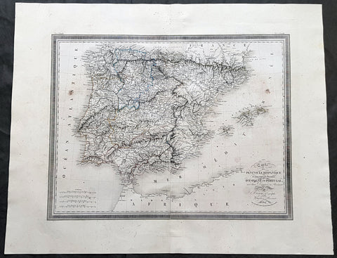
1824 Louis Vivien Large Antique Map of Spain & Portugal
- Title : Carte De La Peninsule Hispanique...1824
- Size: 29in x 23in (740mm x 585mm)
- Condition: (A+) Fine Condition
- Date : 1824
- Ref #: 40717
Description:
This finely engraved original large antique map of Spain & Portugal by Louis Vivien in his Elephant Folio atlas, Atlas Universal
General Definitions:
Paper thickness and quality: - Heavy and stable
Paper color : - off white
Age of map color: - Original
Colors used: - Blue, pink, yellow, green
General color appearance: - Authentic
Paper size: - 29in x 23in (740mm x 585mm)
Plate size: - 25in x 19in (635mm x 485mm)
Margins: - Min 2in (50mm)
Imperfections:
Margins: - Light soiling
Plate area: - Light soiling
Verso: - Light soiling
Background:
Many of the original charts and maps drawn by the first Portuguese and Spanish navigators have survived for the very good reason that, on completion of their voyages, pilots were obliged to hand over their manuscript notes to the Casa da India (founded 1504) in Lisbon or to the equivalent Casa de Contrataci6n de las Indias (founded 1504) in Seville. The clear intention was to maintain secrecy over new discoveries and control over the distribution of cartographic material, not always successfully, as it happened; pilots and navigators seem to have changed allegiance with impunity and, in consequence, many of the earliest and most informative charts were compiled as far away as Genoa, Venice, Florence and Ancona, presumably from sources outside the Portuguese and Spanish Casas. It is apparent that few manuscripts reached the printing stage and, indeed, are so rare that any study of them must be regarded as a specialist subject. (Ref Tooley M&B)
Vivien, Louis 1802 - 1896
Louis Vivien , or Vivien de Saint-Martin was a French geographer who was born in Saint-Martin-de-Fontenay and died in Versailles, France in 1896.
He settled in Paris under the Restoration, and became known with his publication of the Electoral and Administrative Map in 1823 and his comprehensive Universal Atlas in 1825, collaborating with Jacques Bibliomappe -Charles Bailleul from 1828. Vivien was foremost a geographer but was also a publisher of works in other fields, including historical books on the General History of the French Revolution and the History of Napoleon. He also translated various English works, such as the novels of Walter Scott .
He also wrote the New Annals of Travels between 1845 and 1854 and briefly the French Athenaeum between 1847 & 1848. He contributed to numerous periodicals such as Le Constitutionnel, Revue contemporaine, Revue germanique & La Presse. He also wrote L Année géographique between 1863 and 1875 before passing the baton to G. Maunoir and Henri Duveyrier.
He is mainly known though, for his three cartographical works, A History of Geographical Discoveries, A New Dictionary of Universal Geography and the Universal Atlas of Geography. The first of these publications he completed after the 1848 Revolution with the latter two completed by Louis Rousselet and Franz Schrader.
Vivien was Honorary President of the Geographical Society, of which he was one of the founder members. He also laureate of the Academy of Inscriptions and Belles-Lettres as well as a member of the Asian Society , the Society of Ethnology along with a large number of learned societies and European academies.
Main works of Vivien de Saint-Martin
- General History of the French Revolution, the Empire, the Restoration, the Monarchy of 1830, up to and including 1841 (4 volumes in 2 volumes), Paris, Pourrat Brothers, 1841-1842.
- History of Napoleon and the Empire (2 volumes), Paris, Pourrat brothers, 1844.
- History of geographical discoveries of European nations in various parts of the world (2 volumes), Paris, Arthus-Bertrand, 1845-1846.
- Research on primitive populations and the oldest traditions of the Caucasus , Paris, Arthus-Bertrand, 1847.
- Studies of Ancient Geography and Asian Ethnography (2 volumes), Paris, Arthus-Bertrand, 1850-1852.
- Historical and geographical description of Asia Minor (2 volumes), Paris, Arthus-Bertrand, 1852.
- Study on the Greek and Latin Geography of India , Paris, Imperial Printing, 1858.
- Study on the geography and the primitive populations of north-west India, according to the Vedic hymns , Paris, Imprimerie impériale, 1860.
- North Africa in Greek and Roman antiquity, historical and geographical study , Paris, Imprimerie impériale, 1863.
- History of geography and geographical discoveries from the earliest times to the present day , Paris, Hachette, 1873.
- With Franz Schrader : Universal Atlas of Geography built from the original sources and the most recent documents , Paris, Hachette, 1876-1915.
- With Louis Rousselet : New dictionary of universal geography (9 volumes), Paris, Hachette, 1879-1900.
1824 Louis Vivien Large Antique Map of the Confederation of German States
- Title : Carte Generale de Etats compesantL Confederation Germanique...1824
- Size: 27 1/2in x 23in (700mm x 585mm)
- Condition: (A+) Fine Condition
- Date : 1824
- Ref #: 40713
Description:
This finely engraved original large antique map of the confederation of German states and central Europe, by Louis Vivien in his Elephant Folio atlas, Atlas Universal
General Definitions:
Paper thickness and quality: - Heavy and stable
Paper color : - off white
Age of map color: - Original
Colors used: - Blue, pink, yellow, green
General color appearance: - Authentic
Paper size: - 27 1/2in x 23in (700mm x 585mm)
Plate size: - 22in x 19in (560mm x 480mm)
Margins: - Min 2in (50mm)
Imperfections:
Margins: - Light soiling
Plate area: - None
Verso: - None
Background:
The German Confederation was an association of 39 German-speaking states in Central Europe (adding the mainly non-German speaking Kingdom of Bohemia and Duchy of Carniola), created by the Congress of Vienna in 1815 to coordinate the economies of separate German-speaking countries and to replace the former Holy Roman Empire, which had been dissolved in 1806. The German Confederation excluded German-speaking lands in the eastern portion of the Kingdom of Prussia (East Prussia, West Prussia and Posen), the German cantons of Switzerland, and Alsace within France which was majority German speaking.
The Confederation was weakened by rivalry between the Kingdom of Prussia and the Austrian Empire, revolution, and the inability of the multiple members to compromise. In 1848, revolutions by liberals and nationalists attempted to establish a unified German state with a progressive liberal constitution under the Frankfurt Convention. The ruling body, the Confederate Diet, was dissolved on 12 July 1848, but was re-established in 1850 after failed efforts to replace it.
The Confederation was finally dissolved after the Prussian victory in the Seven Weeks War over Austria in 1866. The dispute over which had the inherent right to rule German lands ended in favour of Prussia, leading to the creation of the North German Confederation under Prussian leadership in 1867, to which the eastern portions of the Kingdom of Prussia were added. A number of South German states remained independent until they joined the North German Confederation, which was renamed and proclaimed as the German Empire in 1871 for the now unified Germany with the Prussian king as emperor (Kaiser) after the victory over French Emperor Napoleon III in the Franco-Prussian War of 1870.
Most historians have judged the Confederation to have been weak and ineffective, as well as an obstacle to the creation of a German nation-state. However, the Confederation was designed to be weak, as it served the interests of the European Great Powers, especially member states Austria and Prussia.
Vivien, Louis 1802 - 1896
Louis Vivien , or Vivien de Saint-Martin was a French geographer who was born in Saint-Martin-de-Fontenay and died in Versailles, France in 1896.
He settled in Paris under the Restoration, and became known with his publication of the Electoral and Administrative Map in 1823 and his comprehensive Universal Atlas in 1825, collaborating with Jacques Bibliomappe -Charles Bailleul from 1828. Vivien was foremost a geographer but was also a publisher of works in other fields, including historical books on the General History of the French Revolution and the History of Napoleon. He also translated various English works, such as the novels of Walter Scott .
He also wrote the New Annals of Travels between 1845 and 1854 and briefly the French Athenaeum between 1847 & 1848. He contributed to numerous periodicals such as Le Constitutionnel, Revue contemporaine, Revue germanique & La Presse. He also wrote L Année géographique between 1863 and 1875 before passing the baton to G. Maunoir and Henri Duveyrier.
He is mainly known though, for his three cartographical works, A History of Geographical Discoveries, A New Dictionary of Universal Geography and the Universal Atlas of Geography. The first of these publications he completed after the 1848 Revolution with the latter two completed by Louis Rousselet and Franz Schrader.
Vivien was Honorary President of the Geographical Society, of which he was one of the founder members. He also laureate of the Academy of Inscriptions and Belles-Lettres as well as a member of the Asian Society , the Society of Ethnology along with a large number of learned societies and European academies.
Main works of Vivien de Saint-Martin
- General History of the French Revolution, the Empire, the Restoration, the Monarchy of 1830, up to and including 1841 (4 volumes in 2 volumes), Paris, Pourrat Brothers, 1841-1842.
- History of Napoleon and the Empire (2 volumes), Paris, Pourrat brothers, 1844.
- History of geographical discoveries of European nations in various parts of the world (2 volumes), Paris, Arthus-Bertrand, 1845-1846.
- Research on primitive populations and the oldest traditions of the Caucasus , Paris, Arthus-Bertrand, 1847.
- Studies of Ancient Geography and Asian Ethnography (2 volumes), Paris, Arthus-Bertrand, 1850-1852.
- Historical and geographical description of Asia Minor (2 volumes), Paris, Arthus-Bertrand, 1852.
- Study on the Greek and Latin Geography of India , Paris, Imperial Printing, 1858.
- Study on the geography and the primitive populations of north-west India, according to the Vedic hymns , Paris, Imprimerie impériale, 1860.
- North Africa in Greek and Roman antiquity, historical and geographical study , Paris, Imprimerie impériale, 1863.
- History of geography and geographical discoveries from the earliest times to the present day , Paris, Hachette, 1873.
- With Franz Schrader : Universal Atlas of Geography built from the original sources and the most recent documents , Paris, Hachette, 1876-1915.
- With Louis Rousselet : New dictionary of universal geography (9 volumes), Paris, Hachette, 1879-1900.
1824 William Robertson Large Antique Map of NW South America - Panama to Peru
- Title : Map of the Kingdom of New Granada and the Countries adjacent from Panama to Guayquil
- Date : 1824
- Condition: (A+) Fine Condition
- Ref: 01-9624
- Size: 17 1/2in x 10 1/2in (445mm x 270mm)
Description:
This large highly detailed original copper-plate engraved antique map of north west South America - from Panama to Peru - was engraved by Sydney Hall and published in the 1824 edition of the Rev. Dr Robertsons The History of America. (Ref: M&B; Tooley)
General Definitions:
Paper thickness and quality: - Heavy and stable
Paper color : - off white
Age of map color: -
Colors used: -
General color appearance: -
Paper size: - 17 1/2in x 10 1/2in (445mm x 270mm)
Plate size: - 17 1/2in x 10 1/2in (445mm x 270mm)
Margins: - Min 1/2in (12mm)
Imperfections:
Margins: - None
Plate area: - Folds as issued
Verso: - None
Background:
In 1494, Portugal and Spain, the two great maritime European powers of that time, on the expectation of new lands being discovered in the west, signed the Treaty of Tordesillas, by which they agreed, with the support of the Pope, that all the land outside Europe should be an exclusive duopoly between the two countries.
The treaty established an imaginary line along a north-south meridian 370 leagues west of the Cape Verde Islands, roughly 46° 37\\\' W. In terms of the treaty, all land to the west of the line (known to comprise most of the South American soil) would belong to Spain, and all land to the east, to Portugal. As accurate measurements of longitude were impossible at that time, the line was not strictly enforced, resulting in a Portuguese expansion of Brazil across the meridian.
Beginning in the 1530s, the people and natural resources of South America were repeatedly exploited by foreign conquistadors, first from Spain and later from Portugal. These competing colonial nations claimed the land and resources as their own and divided it in colonies.
European infectious diseases (smallpox, influenza, measles, and typhus) – to which the native populations had no immune resistance – caused large-scale depopulation of the native population under Spanish control. Systems of forced labor, such as the haciendas and mining industry\\\'s mita also contributed to the depopulation. After this, African slaves, who had developed immunities to these diseases, were quickly brought in to replace them.
The Spaniards were committed to converting their native subjects to Christianity and were quick to purge any native cultural practices that hindered this end; however, many initial attempts at this were only partially successful, as native groups simply blended Catholicism with their established beliefs and practices. Furthermore, the Spaniards brought their language to the degree they did with their religion, although the Roman Catholic Churchs evangelization in Quechua, Aymara, and Guaraní actually contributed to the continuous use of these native languages albeit only in the oral form.
Eventually, the natives and the Spaniards interbred, forming a mestizo class. At the beginning, many mestizos of the Andean region were offspring of Amerindian mothers and Spanish fathers. After independence, most mestizos had native fathers and European or mestizo mothers.
Many native artworks were considered pagan idols and destroyed by Spanish explorers; this included many gold and silver sculptures and other artifacts found in South America, which were melted down before their transport to Spain or Portugal. Spaniards and Portuguese brought the western European architectural style to the continent, and helped to improve infrastructures like bridges, roads, and the sewer system of the cities they discovered or conquered. They also significantly increased economic and trade relations, not just between the old and new world but between the different South American regions and peoples. Finally, with the expansion of the Portuguese and Spanish languages, many cultures that were previously separated became united through that of Latin American.
Guyana was first a Dutch, and then a British colony, though there was a brief period during the Napoleonic Wars when it was colonized by the French. The country was once partitioned into three parts, each being controlled by one of the colonial powers until the country was finally taken over fully by the British.
The European Peninsular War (1807–1814), a theater of the Napoleonic Wars, changed the political situation of both the Spanish and Portuguese colonies. First, Napoleon invaded Portugal, but the House of Braganza avoided capture by escaping to Brazil. Napoleon also captured King Ferdinand VII of Spain, and appointed his own brother instead. This appointment provoked severe popular resistance, which created Juntas to rule in the name of the captured king.
Many cities in the Spanish colonies, however, considered themselves equally authorized to appoint local Juntas like those of Spain. This began the Spanish American wars of independence between the patriots, who promoted such autonomy, and the royalists, who supported Spanish authority over the Americas. The Juntas, in both Spain and the Americas, promoted the ideas of the Enlightenment. Five years after the beginning of the war, Ferdinand VII returned to the throne and began the Absolutist Restoration as the royalists got the upper hand in the conflict.
The independence of South America was secured by Simón Bolívar (Venezuela) and José de San Martín (Argentina), the two most important Libertadores. Bolívar led a great uprising in the north, then led his army southward towards Lima, the capital of the Viceroyalty of Peru. Meanwhile, San Martín led an army across the Andes Mountains, along with Chilean expatriates, and liberated Chile. He organized a fleet to reach Peru by sea, and sought the military support of various rebels from the Vice-royalty of Peru. The two armies finally met in Guayaquil, Ecuador, where they cornered the Royal Army of the Spanish Crown and forced its surrender.
In the Portuguese Kingdom of Brazil, Dom Pedro I (also Pedro IV of Portugal), son of the Portuguese King Dom João VI, proclaimed the independent Kingdom of Brazil in 1822, which later became the Empire of Brazil. Despite the Portuguese loyalties of garrisons in Bahia, Cisplatina and Pará, independence was diplomatically accepted by the crown in Portugal in 1825, on condition of a high compensation paid by Brazil mediatized by the United Kingdom.
Robertson , William 1721 - 1793
Rev Robertson was a Scottish historian, minister in the Church of Scotland, and Principal of the University of Edinburgh. The thirty years during which he presided over the University perhaps represent the highest point in its history. He made significant contributions to the writing of Scottish history and the history of Spain and Spanish America.
Robertson was born at the manse of Borthwick, Midlothian, the son of Robertson the local minister.
He was educated at Borthwick Parish School and Dalkeith Grammar School. He was the son of William Robertson and his wife Eleanor Pitcairn. He married his cousin Mary Nesbit in 1751. The family moved to Edinburgh when his father became appointed minister of Old Greyfriars Kirk.
He studied divinity at Edinburgh University (1733–41), and was licensed to preach in 1741. He was granted a Doctor of Divinity in 1759. He became minister at Gladsmuir (East Lothian) in 1743 and in 1759 at Lady Yester\\\'s Kirk and Greyfriars Kirk in Edinburgh. A staunch Presbyterian and Whig, he volunteered to defend the city against the Jacobites led by Prince Charles Edward Stuart in 1745.
In 1754 he was an original member of The Select Society, also referred to as the Edinburgh Select Society.
Robertson became royal chaplain to George III (1761), principal of the University of Edinburgh (1762), Moderator of the General Assembly of the Church of Scotland in 1763, and Historiographer Royal in 1764, reviving a role within the Royal household in Scotland that had been in abeyance from 1709 until 1763. He was also a member of The Poker Club.
One of his most notable works is his History of Scotland 1542–1603, begun in 1753 and first published in 1759. Robertson also contributed to the history of Spain and Spanish America in his History of America (1777), the first sustained attempt to describe the discovery, conquest and settlement of Spanish America since Herreras Décadas and his biography of Charles V. In that work he had provided a masterly survey of the progress of European society, in which he traced the erosion of the feudal system caused by the rise of free towns, the revival of learning and Roman law, and by the emergence of royal authority and the balance of power between states. It was the development of commerce, assisted by law and private property, which was held to be chiefly responsible for the advance in civilisation.
He was a significant figure in the Scottish Enlightenment and also of the moderates in the Church of Scotland.
In 1783 he was a founding member of the Royal Society of Edinburgh.
He died of jaundice on 11 June 1793, at Grange House in south Edinburgh (the huge now-demolished mansion which gave its name to the Grange district. Robertson is buried at Greyfriars Kirkyard, Edinburgh. The grave is within a very large stone mausoleum. second only to William Adam\\\'s mausoleum immediately to the south. Both stand to the south-west of the church, near the entrance to the Covenanters Prison.
Publications
- The Situation of the World at the Time of Christ\\\'s Appearance (sermon) (1755)
The History of Scotland 1542-1603 (1759) (3 vols.)
- History of the Reign of the Emperor Charles V (1769) (4 vols.)
- The History of America (1777, 1796) (3 vols.)
- An Historical Disquisition Concerning the Knowledge Which the Ancients Had of India (1791)
1825 Carey & Lea Buchon Large Antique Map of the State of New Hampshire, USA
-
Title : Carte Geographique, Statistique et Historique De New-Hampshire
- Ref #: 70006
- Size: 27 1/2in x 21 1/2in (700mm x 545mm)
- Date : 1825
- Condition: (A+) Fine Condition
Description:
This large beautifully hand coloured original antique map was published in the 1825 French edition of Carey & Lea's American Atlas by Jean Alexandre Buchon.
This map is in exceptionally fine condition, on clean, sturdy and stable heavy paper, heavy engraving and beautiful original hand colour.
In 1822, Henry Charles Carey and Isaac Lea published their American Atlas. This volume was based on Emmanuel Las Cases' Atlas Historique of 1803, with updated maps and text modified by Carey, a political economist.
He considered himself an American foil to John Stuart Mill and the London economists who were proclaimers of "the gloomy science" influenced by Ricardo and Malthus. Instead of preaching overpopulation and degeneration of the human species, Carey illustrated the nations of the western hemisphere through maps that showed an expanding region with ample promise of developing into lands of great new opportunity and growth. The sheets from this atlas, which cover North America, Central America, South America and the West Indies, are comprised of an engraved map surrounded by text documenting the history, climate, population and so forth of the area depicted. The atlas is particularly known for its excellent early maps of the states and territories of the United States. Many of these maps were drawn by Fielding Lucas, Jr., an important Baltimore cartographer. All of the maps show excellent and very up-to-date detail, providing fine verbal and graphic pictures of states and territories in the early 19th century (Ref: M&B; Tooley)
General Description:
Paper thickness and quality: - Heavy and stable
Paper color: - white
Age of map color: - Original
Colors used: - Yellow, green, blue, pink
General color appearance: - Authentic
Paper size: - 27 1/2in x 21 1/2in (700mm x 545mm)
Margins: - min. 1in (25mm)
Imperfections:
Margins: - None
Plate area: None
Verso: - None
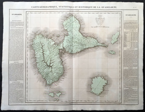
1825 Carey & Lea Buchon Large Map of the Island of Guadeloupe, Caribbean
-
Title : Carte Geographique, Statistique et Historique De La Guadeloupe
- Ref #: 70028
- Size: 27 1/2in x 21 1/2in (700mm x 545mm)
- Date : 1825
- Condition: (A+) Fine Condition
Description:
This large beautifully hand coloured original antique map was published in the 1825 French edition of Carey & Lea's American Atlas by Jean Alexandre Buchon.
This map is in exceptionally fine condition, on clean, sturdy and stable heavy paper, heavy engraving and beautiful original hand colour.
In 1822, Henry Charles Carey and Isaac Lea published their American Atlas. This volume was based on Emmanuel Las Cases' Atlas Historique of 1803, with updated maps and text modified by Carey, a political economist.
He considered himself an American foil to John Stuart Mill and the London economists who were proclaimers of "the gloomy science" influenced by Ricardo and Malthus. Instead of preaching overpopulation and degeneration of the human species, Carey illustrated the nations of the western hemisphere through maps that showed an expanding region with ample promise of developing into lands of great new opportunity and growth. The sheets from this atlas, which cover North America, Central America, South America and the West Indies, are comprised of an engraved map surrounded by text documenting the history, climate, population and so forth of the area depicted. The atlas is particularly known for its excellent early maps of the states and territories of the United States. Many of these maps were drawn by Fielding Lucas, Jr., an important Baltimore cartographer. All of the maps show excellent and very up-to-date detail, providing fine verbal and graphic pictures of states and territories in the early 19th century (Ref: M&B; Tooley)
General Description:
Paper thickness and quality: - Heavy and stable
Paper color: - white
Age of map color: - Original
Colors used: - Yellow, green, blue, pink
General color appearance: - Authentic
Paper size: - 27 1/2in x 21 1/2in (700mm x 545mm)
Margins: - min. 1in (25mm)
Imperfections:
Margins: - Light age toning
Plate area: Light age toning
Verso: - Light age toning
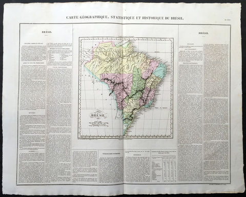
1825 Carey & Lea, Buchon Large Antique Map Brazil, South America
-
Title : Carte Geographique, Statistique et Historique Du Bresil
- Ref #: 70038
- Size: 27 1/2in x 21 1/2in (700mm x 545mm)
- Date : 1825
- Condition: (A+) Fine Condition
Description:
This large beautifully hand coloured original antique map was published in the 1825 French edition of Carey & Lea's American Atlas by Jean Alexandre Buchon.
This map is in exceptionally fine condition, on clean, sturdy and stable heavy paper, heavy engraving and beautiful original hand colour.
In 1822, Henry Charles Carey and Isaac Lea published their American Atlas. This volume was based on Emmanuel Las Cases' Atlas Historique of 1803, with updated maps and text modified by Carey, a political economist.
He considered himself an American foil to John Stuart Mill and the London economists who were proclaimers of "the gloomy science" influenced by Ricardo and Malthus. Instead of preaching overpopulation and degeneration of the human species, Carey illustrated the nations of the western hemisphere through maps that showed an expanding region with ample promise of developing into lands of great new opportunity and growth. The sheets from this atlas, which cover North America, Central America, South America and the West Indies, are comprised of an engraved map surrounded by text documenting the history, climate, population and so forth of the area depicted. The atlas is particularly known for its excellent early maps of the states and territories of the United States. Many of these maps were drawn by Fielding Lucas, Jr., an important Baltimore cartographer. All of the maps show excellent and very up-to-date detail, providing fine verbal and graphic pictures of states and territories in the early 19th century (Ref: M&B; Tooley)
General Description:
Paper thickness and quality: - Heavy and stable
Paper color: - white
Age of map color: - Original
Colors used: - Yellow, green, blue, pink
General color appearance: - Authentic
Paper size: - 27 1/2in x 21 1/2in (700mm x 545mm)
Margins: - min. 1in (25mm)
Imperfections:
Margins: - Light age toning
Plate area: Light age toning
Verso: - Light age toning
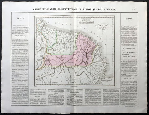
1825 Carey & Lea, Buchon Large Antique Map of Guyana South America
-
Title : Carte Geographique, Statistique et Historique De La Guyane
- Ref #: 70036
- Size: 27 1/2in x 21 1/2in (700mm x 545mm)
- Date : 1825
- Condition: (A+) Fine Condition
Description:
This large beautifully hand coloured original antique map was published in the 1825 French edition of Carey & Lea's American Atlas by Jean Alexandre Buchon.
This map is in exceptionally fine condition, on clean, sturdy and stable heavy paper, heavy engraving and beautiful original hand colour.
In 1822, Henry Charles Carey and Isaac Lea published their American Atlas. This volume was based on Emmanuel Las Cases' Atlas Historique of 1803, with updated maps and text modified by Carey, a political economist.
He considered himself an American foil to John Stuart Mill and the London economists who were proclaimers of "the gloomy science" influenced by Ricardo and Malthus. Instead of preaching overpopulation and degeneration of the human species, Carey illustrated the nations of the western hemisphere through maps that showed an expanding region with ample promise of developing into lands of great new opportunity and growth. The sheets from this atlas, which cover North America, Central America, South America and the West Indies, are comprised of an engraved map surrounded by text documenting the history, climate, population and so forth of the area depicted. The atlas is particularly known for its excellent early maps of the states and territories of the United States. Many of these maps were drawn by Fielding Lucas, Jr., an important Baltimore cartographer. All of the maps show excellent and very up-to-date detail, providing fine verbal and graphic pictures of states and territories in the early 19th century (Ref: M&B; Tooley)
General Description:
Paper thickness and quality: - Heavy and stable
Paper color: - white
Age of map color: - Original
Colors used: - Yellow, green, blue, pink
General color appearance: - Authentic
Paper size: - 27 1/2in x 21 1/2in (700mm x 545mm)
Margins: - min. 1in (25mm)
Imperfections:
Margins: - Light age toning
Plate area: Light age toning
Verso: - Light age toning
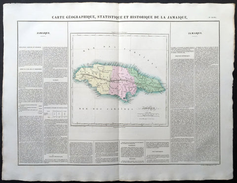
1825 Carey & Lea, Buchon Large Antique Map of the Island of Jamaica, Caribbean
-
Title : Carte Geographique, Statistique et Historique De La Jamaique
- Ref #: 70025
- Size: 27 1/2in x 21 1/2in (700mm x 545mm)
- Date : 1825
- Condition: (A+) Fine Condition
Description:
This large beautifully hand coloured original antique map was published in the 1825 French edition of Carey & Lea's American Atlas by Jean Alexandre Buchon.
This map is in exceptionally fine condition, on clean, sturdy and stable heavy paper, heavy engraving and beautiful original hand colour.
In 1822, Henry Charles Carey and Isaac Lea published their American Atlas. This volume was based on Emmanuel Las Cases' Atlas Historique of 1803, with updated maps and text modified by Carey, a political economist.
He considered himself an American foil to John Stuart Mill and the London economists who were proclaimers of "the gloomy science" influenced by Ricardo and Malthus. Instead of preaching overpopulation and degeneration of the human species, Carey illustrated the nations of the western hemisphere through maps that showed an expanding region with ample promise of developing into lands of great new opportunity and growth. The sheets from this atlas, which cover North America, Central America, South America and the West Indies, are comprised of an engraved map surrounded by text documenting the history, climate, population and so forth of the area depicted. The atlas is particularly known for its excellent early maps of the states and territories of the United States. Many of these maps were drawn by Fielding Lucas, Jr., an important Baltimore cartographer. All of the maps show excellent and very up-to-date detail, providing fine verbal and graphic pictures of states and territories in the early 19th century (Ref: M&B; Tooley)
General Description:
Paper thickness and quality: - Heavy and stable
Paper color: - white
Age of map color: - Original
Colors used: - Yellow, green, blue, pink
General color appearance: - Authentic
Paper size: - 27 1/2in x 21 1/2in (700mm x 545mm)
Margins: - min. 1in (25mm)
Imperfections:
Margins: - Light age toning
Plate area: Light age toning
Verso: - Light age toning
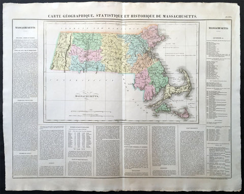
1825 Carey & Lea, Buchon Large Antique Map of the State of Massachusetts, USA
-
Title : Carte Geographique, Statistique et Historique Du Massachusetts
- Ref #: 70007
- Size: 27 1/2in x 21 1/2in (700mm x 545mm)
- Date : 1825
- Condition: (A+) Fine Condition
Description:
This large beautifully hand coloured original antique map was published in the 1825 French edition of Carey & Lea's American Atlas by Jean Alexandre Buchon.
This map is in exceptionally fine condition, on clean, sturdy and stable heavy paper, heavy engraving and beautiful original hand colour.
In 1822, Henry Charles Carey and Isaac Lea published their American Atlas. This volume was based on Emmanuel Las Cases' Atlas Historique of 1803, with updated maps and text modified by Carey, a political economist.
He considered himself an American foil to John Stuart Mill and the London economists who were proclaimers of "the gloomy science" influenced by Ricardo and Malthus. Instead of preaching overpopulation and degeneration of the human species, Carey illustrated the nations of the western hemisphere through maps that showed an expanding region with ample promise of developing into lands of great new opportunity and growth. The sheets from this atlas, which cover North America, Central America, South America and the West Indies, are comprised of an engraved map surrounded by text documenting the history, climate, population and so forth of the area depicted. The atlas is particularly known for its excellent early maps of the states and territories of the United States. Many of these maps were drawn by Fielding Lucas, Jr., an important Baltimore cartographer. All of the maps show excellent and very up-to-date detail, providing fine verbal and graphic pictures of states and territories in the early 19th century (Ref: M&B; Tooley)
General Description:
Paper thickness and quality: - Heavy and stable
Paper color: - white
Age of map color: - Original
Colors used: - Yellow, green, blue, pink
General color appearance: - Authentic
Paper size: - 27 1/2in x 21 1/2in (700mm x 545mm)
Margins: - min. 1in (25mm)
Imperfections:
Margins: - None
Plate area: None
Verso: - None
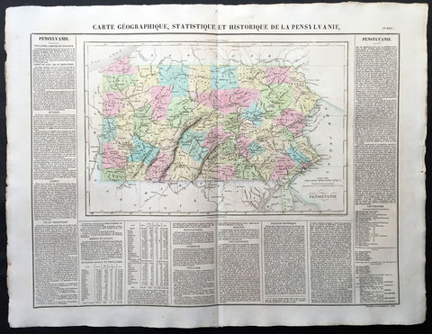
1825 Carey & Lea, Buchon Large Antique Map of the State of Pennsylvania, USA
-
Title : Carte Geographique, Statistique et Historique De la Pensylvanie
- Ref #: 70012
- Size: 27 1/2in x 21 1/2in (700mm x 545mm)
- Date : 1825
- Condition: (A+) Fine Condition
Description:
This large beautifully hand coloured original antique map was published in the 1825 French edition of Carey & Lea's American Atlas by Jean Alexandre Buchon.
This map is in exceptionally fine condition, on clean, sturdy and stable heavy paper, heavy engraving and beautiful original hand colour.
In 1822, Henry Charles Carey and Isaac Lea published their American Atlas. This volume was based on Emmanuel Las Cases' Atlas Historique of 1803, with updated maps and text modified by Carey, a political economist.
He considered himself an American foil to John Stuart Mill and the London economists who were proclaimers of "the gloomy science" influenced by Ricardo and Malthus. Instead of preaching overpopulation and degeneration of the human species, Carey illustrated the nations of the western hemisphere through maps that showed an expanding region with ample promise of developing into lands of great new opportunity and growth. The sheets from this atlas, which cover North America, Central America, South America and the West Indies, are comprised of an engraved map surrounded by text documenting the history, climate, population and so forth of the area depicted. The atlas is particularly known for its excellent early maps of the states and territories of the United States. Many of these maps were drawn by Fielding Lucas, Jr., an important Baltimore cartographer. All of the maps show excellent and very up-to-date detail, providing fine verbal and graphic pictures of states and territories in the early 19th century (Ref: M&B; Tooley)
General Description:
Paper thickness and quality: - Heavy and stable
Paper color: - white
Age of map color: - Original
Colors used: - Yellow, green, blue, pink
General color appearance: - Authentic
Paper size: - 27 1/2in x 21 1/2in (700mm x 545mm)
Margins: - min. 1in (25mm)
Imperfections:
Margins: - Light age toning
Plate area: Light age toning
Verso: - Light age toning

1825 Philippe Vandermaelen Large Antique Map Admiralty or Manus Islands Pacific
Antique Map
-
Title : Iles De L Amiraute
- Ref #: 17005
-
Condition: (A+) Fine Condition
- Size: 28 1/2in x 21in (725mm x 550mm)
- Date : 1825
Description:
This very large original hand coloured antique lithograph map of the Admiralty or Manus Islands, north of New Guinea, in the South Pacific was published by Philippe Vandermaelen in his revolutionary 1825 Atlas universel de geographie physique, politique, statistique et mineralogique.
Until the publication of this atlas, large detailed maps of this region of Australia & the Pacific were uncommon.
General Definitions:
Paper thickness and quality: - Heavy and stable
Paper color : - off white
Age of map color: - Early
Colors used: - Red, yellow, green, blue
General color appearance: - Authentic
Paper size: - 28 1/2in x 21in (725mm x 550mm)
Plate size: - 28 1/2in x 21in (725mm x 550mm)
Margins: - Min 1/2in (12mm)
Imperfections:
Margins: - None
Plate area: - None
Verso: - None
Background:
The first European to visit the islands was the Spanish navigator Álvaro de Saavedra when trying to return from Tidore to New Spain in the summer of 1528. Saavedra charted Manus as Urays la Grande. Its visit was also reported in 1616 by the Dutch navigator Willem Schouten. The name Admiralty Islands was devised by Captain Philip Carteret of the British Royal Navy in 1767.
Between 1884 and 1914 the area was administered as a German colony. In November 1914, the islands were occupied by troops of the Australian Naval and Military Expeditionary Force landed from the SS Siar. A few shots fired from a machine gun on Siar over the heads of the tiny German garrison at Lorengau were the last shots fired in the battle. After the war, the islands were governed by the Commonwealth of Australia under a League of Nations mandate.
Japanese troops landed on Manus Island on 7 April 1942. In 1944, Japanese forces occupying the islands were attacked and defeated by Allied forces in Operation Brewer. Subsequently, a large American airbase was built at Lombrum near Lorengau.
Vandermaelen, Philippe M G 1795-1869
Vandermaelen was the son of the wealthy soap manufacturer; he abandoned the soap trade and devoted his life to cartography. Entirely self-taught in geometry, astronomy and the geosciences, he began drafting the first sheets of an Atlas universel in 1824. This atlas was published between 1825 and 1827; it was sold in forty instalments of ten maps each and became a great success. The revenue enabled him to set up his own Etablissement géographique de Bruxelles in 1830, which not only produced maps, atlases and globes in large quantities but also housed a natural science museum, botanical gardens, a library, and an impressive collection of maps.
Shortly after the closing of Vandermaelens Institute, the Royal Library of Belgium (KBR) in 1880 acquired a large part of its cartographic collection and production.
Vandermaelens atlas was remarkable: 387 maps on a uniform scale of ca. 1:1.6 million. There was one edition of this very rare atlas, published in 1825-27; the subscription list shows that only 810 copies were sold. The six volumes, of which Africa was in Volume III (60 maps), were issued in instalments during the period 1825-1827.
This folio-size atlas is remarkable for several reasons. It is the first atlas produced by the then new printing process of lithography. It is also the first atlas to show the whole world in 380 maps using a large uniform scale—about 10km to the cm. on a modified conical projection described by Sanson-Flamsteed. Based on a prime meridian through Paris, each map has a drawn-out graticule giving it a trapezoidal form, the underlying intention being construction of a globe with a diameter of 7.755m Eugene Gilbert de Cauwer , his biographer, suggested that Vandernaelen was a worthy follower of Mercator and Ortelius.
Vandermaelen enlisted the assistance of lithographer-printer Hippolyte Ode in this ambitious project which introduced lithography into Belgium and created an upsurge in Belgian publishing. A number of maps were lithographed by Philippe Vandermaelen himself. For many of the areas depicted, these maps are the largest scale maps made at the time, and the most detailed. The lithographs are very well drawn and printed and should be appreciated in the context of lithography, which was a developing art at the time. The maps are handsome and detailed, although some of the place names are somewhat curious and the cartography sometimes imaginary. Nevertheless, the Vandermaelen maps are of great significance in the history of cartography and lithography. Visually, they are arresting and unusual. Vandermaelens maps best are appreciated in the context of its neighbouring maps - they were all meant to be joined .
Please note all items auctioned are genuine, we do not sell reproductions. A Certificate of Authenticity (COA) can be issued on request.

1825 Philippe Vandermaelen Large Antique Map of Austral Islands French Polynesia
Antique Map
-
Title : Partie De L Archipel Des Iles Basses
- Ref #: 17006
-
Condition: (A+) Fine Condition
- Size: 28 1/2in x 21in (725mm x 550mm)
- Date : 1825
Description:
This very large original hand coloured antique lithograph map of the Austral Islands in the French Polynesia group of islands in the in the South Pacific was published by Philippe Vandermaelen in his revolutionary 1825 Atlas universel de geographie physique, politique, statistique et mineralogique.
Until the publication of this atlas, large detailed maps of this region of Australia & the Pacific were uncommon.
General Definitions:
Paper thickness and quality: - Heavy and stable
Paper color : - off white
Age of map color: - Early
Colors used: - Red, yellow, green, blue
General color appearance: - Authentic
Paper size: - 28 1/2in x 21in (725mm x 550mm)
Plate size: - 28 1/2in x 21in (725mm x 550mm)
Margins: - Min 1/2in (12mm)
Imperfections:
Margins: - None
Plate area: - None
Verso: - None
Background:
New Hebrides, officially the New Hebrides Condominium (French: Condominium des Nouvelles-Hébrides, lit. Condominium of the New Hebrides) and named for the Hebrides Scottish archipelago, was the colonial name for the island group in the South Pacific Ocean that is now Vanuatu. Native people had inhabited the islands for three thousand years before the first Europeans arrived in 1606 from a Spanish expedition led by Portuguese navigator Pedro Fernandes de Queirós. The islands were colonised by both the British and French in the 18th century, shortly after Captain James Cook visited.
The two countries eventually signed an agreement making the islands an Anglo-French condominium that divided New Hebrides into two separate communities: one Anglophone and one Francophone. That divide continued even after independence, with schools teaching in either one language or the other, and with different political parties. The condominium lasted from 1906 until 1980, when New Hebrides gained its independence as the Republic of Vanuatu.
Vandermaelen, Philippe M G 1795-1869
Vandermaelen was the son of the wealthy soap manufacturer; he abandoned the soap trade and devoted his life to cartography. Entirely self-taught in geometry, astronomy and the geosciences, he began drafting the first sheets of an Atlas universel in 1824. This atlas was published between 1825 and 1827; it was sold in forty instalments of ten maps each and became a great success. The revenue enabled him to set up his own Etablissement géographique de Bruxelles in 1830, which not only produced maps, atlases and globes in large quantities but also housed a natural science museum, botanical gardens, a library, and an impressive collection of maps.
Shortly after the closing of Vandermaelens Institute, the Royal Library of Belgium (KBR) in 1880 acquired a large part of its cartographic collection and production.
Vandermaelens atlas was remarkable: 387 maps on a uniform scale of ca. 1:1.6 million. There was one edition of this very rare atlas, published in 1825-27; the subscription list shows that only 810 copies were sold. The six volumes, of which Africa was in Volume III (60 maps), were issued in instalments during the period 1825-1827.
This folio-size atlas is remarkable for several reasons. It is the first atlas produced by the then new printing process of lithography. It is also the first atlas to show the whole world in 380 maps using a large uniform scale—about 10km to the cm. on a modified conical projection described by Sanson-Flamsteed. Based on a prime meridian through Paris, each map has a drawn-out graticule giving it a trapezoidal form, the underlying intention being construction of a globe with a diameter of 7.755m Eugene Gilbert de Cauwer , his biographer, suggested that Vandernaelen was a worthy follower of Mercator and Ortelius.
Vandermaelen enlisted the assistance of lithographer-printer Hippolyte Ode in this ambitious project which introduced lithography into Belgium and created an upsurge in Belgian publishing. A number of maps were lithographed by Philippe Vandermaelen himself. For many of the areas depicted, these maps are the largest scale maps made at the time, and the most detailed. The lithographs are very well drawn and printed and should be appreciated in the context of lithography, which was a developing art at the time. The maps are handsome and detailed, although some of the place names are somewhat curious and the cartography sometimes imaginary. Nevertheless, the Vandermaelen maps are of great significance in the history of cartography and lithography. Visually, they are arresting and unusual. Vandermaelens maps best are appreciated in the context of its neighbouring maps - they were all meant to be joined .
Please note all items auctioned are genuine, we do not sell reproductions. A Certificate of Authenticity (COA) can be issued on request.

1825 Philippe Vandermaelen Large Antique Map of The Solomon Islands
Antique Map
- Title : Oceanique. Partie Des Iles Salomon
- Ref #: 17003
- Size: 28 1/2in x 21in (725mm x 550mm)
- Date : 1825
- Condition: (A+) Fine Condition
Description:
This very large original hand coloured antique lithograph map of the Solomon Islands in the South Pacific was published by Philippe Vandermaelen in his revolutionary 1825 Atlas universel de geographie physique, politique, statistique et mineralogique.
Until the publication of this atlas, large detailed maps of this region of Australia & the Pacific were uncommon.
General Definitions:
Paper thickness and quality: - Heavy and stable
Paper color : - off white
Age of map color: - Original
Colors used: - Yellow, green, blue, pink
General color appearance: - Authentic
Paper size: - 28 1/2in x 21in (725mm x 550mm)
Plate size: - 28 1/2in x 21in (725mm x 550mm)
Margins: - Min 1/2in (12mm)
Imperfections:
Margins: - None
Plate area: - None
Verso: - None
Background:
The first European to visit the islands was the Spanish navigator Álvaro de Mendaña de Neira, sailing from Peru in 1568. Landing on Santa Isabel on 7 February, Mendaña explored several of the other islands including Makira, Guadalcanal and Malaita. Relations with the native Solomon Islanders were initially cordial, though often soured as time went by. As a result, Mendaña returned to Peru in August 1568. He returned to the Solomons with a larger crew on a second voyage in 1595, aiming to colonise the islands. They landed on Nendö in the Santa Cruz Islands and established a small settlement at Gracioso Bay. However the settlement failed due to poor relations with the native peoples and epidemics of disease amongst the Spanish which caused numerous deaths, with Mendaña himself dying in October. The new commander Pedro Fernandes de Queirós thus decided to abandon the settlement and they sailed north to the Spanish territory of the Philippines. Queirós later returned to the area in 1606, where he sighted Tikopia and Taumako, though this voyage was primarily to Vanuatu in the search of Terra Australis.
Save for Abel Tasmans sighting of the remote Ontong Java Atoll in 1648, no European sailed to the Solomons again until 1767, when the British explorer Philip Carteret sailed by the Santa Cruz Islands, Malaita and, continuing further north, Bougainville and the Bismarck Islands. French explorers also reached the Solomons, with Louis Antoine de Bougainville naming Choiseul in 1768 and Jean-François-Marie de Surville exploring the islands in 1769. In 1788 John Shortland, captaining a supply ship for Britains new Australian colony at Botany Bay, sighted the Treasury and Shortland Islands. That same year the French explorer Jean-François de La Pérouse was wrecked on Vanikoro; a rescue expedition led by Bruni dEntrecasteaux sailed to Vanikoro but found no trace of La Pérouse. The fate of La Pérouse was not confirmed until 1826, when the English merchant Peter Dillon visited Tikopia and discovered items belonging to La Pérouse in the possession of the local people, confirmed by the subsequent voyage of Jules Dumont dUrville in 1828.
Some of the earliest regular foreign visitors to the islands were whaling vessels from Britain, the United States and Australia. They came for food, wood and water from late in the 18th century, establishing a trading relationship with the Solomon Islanders and later taking aboard islanders to serve as crewmen on their ships. Relations between the islanders and visiting seamen was not always good and sometimes there was bloodshed. A knock-on effect of the greater European contact was the spread of diseases to which local peoples had no immunity, as well a shift in the balance of power between coastal groups, who had access to European weapons and technology, and inland groups who did not. In the second half of the 1800s more traders arrived seeking turtleshells, sea cucumbers, copra and sandalwood, occasionally establishing semi-permanent trading stations. However initial attempts at more long-term settlement, such as Benjamin Boyds colony on Guadalcanal in 1851, were unsuccessful.
Vandermaelen, Philippe M G 1795-1869
Vandermaelen was the son of the wealthy soap manufacturer; he abandoned the soap trade and devoted his life to cartography. Entirely self-taught in geometry, astronomy and the geosciences, he began drafting the first sheets of an Atlas universel in 1824. This atlas was published between 1825 and 1827; it was sold in forty instalments of ten maps each and became a great success. The revenue enabled him to set up his own Etablissement géographique de Bruxelles in 1830, which not only produced maps, atlases and globes in large quantities but also housed a natural science museum, botanical gardens, a library, and an impressive collection of maps.
Shortly after the closing of Vandermaelens Institute, the Royal Library of Belgium (KBR) in 1880 acquired a large part of its cartographic collection and production.
Vandermaelens atlas was remarkable: 387 maps on a uniform scale of ca. 1:1.6 million. There was one edition of this very rare atlas, published in 1825-27; the subscription list shows that only 810 copies were sold. The six volumes, of which Africa was in Volume III (60 maps), were issued in instalments during the period 1825-1827.
This folio-size atlas is remarkable for several reasons. It is the first atlas produced by the then new printing process of lithography. It is also the first atlas to show the whole world in 380 maps using a large uniform scale—about 10km to the cm. on a modified conical projection described by Sanson-Flamsteed. Based on a prime meridian through Paris, each map has a drawn-out graticule giving it a trapezoidal form, the underlying intention being construction of a globe with a diameter of 7.755m Eugene Gilbert de Cauwer , his biographer, suggested that Vandernaelen was a worthy follower of Mercator and Ortelius.
Vandermaelen enlisted the assistance of lithographer-printer Hippolyte Ode in this ambitious project which introduced lithography into Belgium and created an upsurge in Belgian publishing. A number of maps were lithographed by Philippe Vandermaelen himself. For many of the areas depicted, these maps are the largest scale maps made at the time, and the most detailed. The lithographs are very well drawn and printed and should be appreciated in the context of lithography, which was a developing art at the time. The maps are handsome and detailed, although some of the place names are somewhat curious and the cartography sometimes imaginary. Nevertheless, the Vandermaelen maps are of great significance in the history of cartography and lithography. Visually, they are arresting and unusual. Vandermaelens maps best are appreciated in the context of its neighbouring maps - they were all meant to be joined .
Please note all items auctioned are genuine, we do not sell reproductions. A Certificate of Authenticity (COA) can be issued on request.
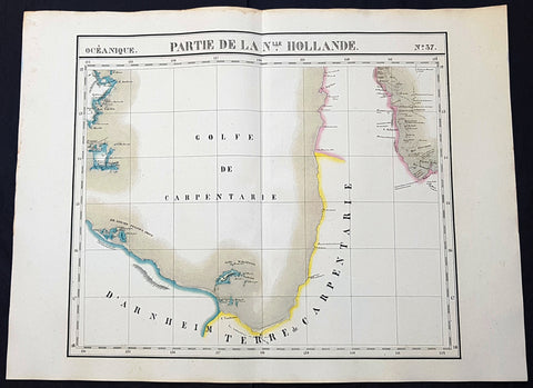
1825 Philippe Vandermaelen Large Antique Map The Gulf of Carpentaria, Australia
Antique Map
- Title : Partie De La Nlle. Hollande
- Size: 28 1/2in x 21in (725mm x 550mm)
- Condition: (A+) Fine Condition
- Date : 1825
- Ref #: 93125
Description:
This very large original hand coloured antique lithograph map of the Gulf of Carpentaria was published by Philippe Vandermaelen in his revolutionary 1825 Atlas universel de geographie physique, politique, statistique et mineralogique.
Until the publication of this atlas, large detailed maps of this region of remote Australia were uncommon. The clean detailed lines and added hand colouring make this one of the most desirable early maps of northern Queensland and the NT.
General Definitions:
Paper thickness and quality: - Heavy and stable
Paper color : - off white
Age of map color: - Original
Colors used: - Yellow, green, blue, pink
General color appearance: - Authentic
Paper size: - 28 1/2in x 21in (725mm x 550mm)
Plate size: - 28 1/2in x 21in (725mm x 550mm)
Margins: - Min 1in (25mm)
Imperfections:
Margins: - None
Plate area: - None
Verso: - None
Background:
The first European explorer to visit the region (and Australia) was the Dutch Willem Janszoon (whose name is also written as Jansz) in 1605–6. His fellow countryman, Jan Carstenszoon (or Carstensz), visited in 1623 and named the gulf in honour of Pieter de Carpentier, at that time the Governor-General of the Dutch East Indies. Abel Tasman also explored the coast in 1644. The region was later explored and charted by Matthew Flinders in 1802 and 1803.
The first overland expedition to reach the Gulf was the Burke and Wills expedition, led by Robert O Hara Burke and William John Wills which left Melbourne, Victoria in August 1860 and reached the mouth of the Bynoe River in February 1861.
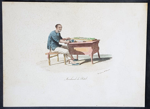
1825 W. Alexander & Malpiere Antique Print of a Chinese Hawker, Betel Nut Seller
- Title : Marchand De Betel...Schmit del....Imp. Litho. de Melle. Formentin
- Ref : 91229
- Size: 13in x 9 1/2in (330mm x 245mm)
- Date : 1825
- Condition: (A) Very Good Condition
Description:
This beautifully hand coloured original copper-plate engraved antique print of a Chinese Betel Nut Seller by D. Bazin de Malpiere, after William Alexander, was engraved by Schmidt and published in the 1825 French edition of La Chine, Moeurs, Usages, Arts et Métiers, Peines Civiles et Militaires, Cérémonies Religieuses, Monuments et Paysages (Picturesque Representations of the Dress and Manners of the Chinese), Paris: Chez L Éditeur, Goujon et Melle Formentin, Firmin Didot, 1825-27.
General Definitions:
Paper thickness and quality: - Heavy and stable
Paper color : - off white
Age of map color: - Original
Colors used: - Yellow, green, blue, pink
General color appearance: - Authentic
Paper size: - 13in x 9 1/2in (330mm x 245mm)
Plate size: - 13in x 9 1/2in (330mm x 245mm)
Margins: - Min 1in (25mm)
Imperfections:
Margins: - Light age toning
Plate area: - Light age toning
Verso: - Light age toning
Background:
In 1792, Alexander was appointed as one of the draughtsmen to the Macartney Embassy to China. He accompanied the Earl of Macartney to Peking where he made drawings for the plates which accompanied Sir George Stauntons account of the embassy, published in 1797.
In 1805 he published The Costume of China, illustrated by 48 coloured engravings, after his travels to China with The Earl of Macartney. The work was so well-received that in 1814 he published another book titled Picturesque Representations of the Dress and Manners of the Chinese, illustrated in fifty colored engravings, with descriptions. This publication was re-issued over the next twenty years in various languages including French.
Alexander, William 1767 – 1816
Alexander was an English painter, illustrator and engraver. The hallmarks of his work, usually executed in watercolours, were clearness and harmony of colour, simplicity and taste in composition, grace of outline, and delicacy of execution. He accompanied the Macartney Embassy to China in 1792. Prints of his work were reproduced from engravings. One his of works was used to illustrate Cadell & Davies Britannia depicta.
Alexander was born in Maidstone, Kent, the son of Harry Alexander, a coachmaker. He was educated at Maidstone Grammar School, but in 1782, at the age of 15, moved to London to study art - first under William Pars, and subsequently Julius Caesar Ibbetson. In February 1784, he was admitted to the Royal Academy Schools. He assiduously applied himself to the mastery of his profession, obtaining the notice and approbation of Sir Joshua Reynolds.
In 1792, he was appointed as one of the draughtsmen to the Macartney Embassy to China. He accompanied the Earl of Macartney to Peking where he made drawings for the plates which accompanied Sir George Stauntons account of the embassy (published in 1797) In 1794 he returned to England and married Jane Wogan the following year. She died soon afterwards.
His other principal works were: Views of Headlands, Islands, etc. taken during the Voyage to China (1798); drawings based on Daniells sketches, for Vancouvers Voyage to the North Pacific Ocean (1798); and the descriptive plates to Sir John Barrows Travels in China (1804), and Voyage to Cochin China (1806). In 1805 he published The Costume of China, illustrated by 48 coloured engravings. The work was so well-received that in 1814 he published another book titled Picturesque Representations of the Dress and Manners of the Chinese, illustrated in fifty colored engravings, with descriptions.
Besides his works as a draughtsman, he made several engravings - the principal one of which is a representation of the Festival given by the Earl of Romney to the Kentish Volunteers, on 1 August 1799, from his own drawing.
In 1802, Alexander was appointed professor of drawing at the Military College at Great Marlow, resigning in May 1808 to take up the post of assistant keeper of antiquities in the British Museum. In the years 1810, 1812, and 1815, he made drawings of the terra cottas and marbles in the Museum which were engraved and published in three volumes - the accompanying text being provided by Taylor Combe (keeper of the Department of Antiquities). Alexander had completed drawings for a fourth volume before his death.
He died at the house of his uncle in Maidstone in July 1816, and was buried in Boxley churchyard. He was described in one of his obituaries as a man of mild and unassuming manners, rich in the knowledge of art, and of unsullied integrity.
1827 Dumont D Urville Large Antique Early Map of New Zealand
Antique Map
- Title : Carte Generale de la Partie De La Nouvelle Zelande Reconnue par le Capitaine de Fregate Dumont D Urville Dressee par Mr Loottin Enseigue de v au Expedition de la Corvette de S M L Astrolobe Janvier, Fevrier, Mars, 1827
- Size: 26in x 20in (660mm x 510mm)
- Condition: (A+) Fine Condition
- Date : 1827
- Ref #: 42011
Description:
This magnificent large original & scarce copper-plate engraved antique map of the North Island & part of the South Island of New Zealand by Dumont D Urville and Lieutenant Victor Lottin, aboard the ship The Astrolabe during the first D Urville voyage to the South Seas 1826 - 1829, was engraved by Alphonse Chassant, 1808-1907 and published in the 1836 edition of Dumont d Urvilles Voyage de la corvette L Astrolabe: exécuté par ordre du roi, pendant les années 1826-1827-1828-1829......
Fantastic & rare map by D Urville & Lottin with surveys made of the north, south east coasts of New Zealands North Island & the north west part of the South Island, between January and March 1827.
General Definitions:
Paper thickness and quality: - Heavy and stable
Paper color : - off white
Age of map color: -
Colors used: -
General color appearance: -
Paper size: - 26in x 20in (660mm x 510mm)
Plate size: - 26in x 20in (660mm x 510mm)
Margins: - Min 2in (50mm)
Imperfections:
Margins: - None
Plate area: - None
Verso: - None
Background:
On 25 April 1826, Dumont d Urville, with the rank of commander, sailed from Toulon as chief of the ship formerly named the Coquille, renamed Astrolabe, on a voyage of exploration and scientific inquiry which lasted till 24 March 1829. On 10 January 1827 the Astrolabe came in sight of the north-west coast of the South Island of New Zealand. On 14 January the ship passed the entrance to the modern Golden Bay, which had been visited by Abel Tasman. The ship anchored off the west side of Tasman Bay. This bay had not been investigated at close quarters previously. In the following days d Urville established that it was a great deal bigger than Cooks mapping indicated, and his officers surveyed and charted it. Adele Island, Pepin Island, and Croisilles Harbour are modern names derived from those given by d Urville. On 23 January d Urville made for a channel which he had noticed at a distance some time before, and which seemed to him to communicate between Tasman Bay and Cooks Admiralty Bay. This was the channel culminating in French Pass and dividing D Urville Island from the mainland. Victor Lottin and Gressien, two of d Urville\'s officers, on the same day saw the pass at close quarters from two of the ships boats. On 25 January d Urville went through the pass into Admiralty Bay in a ship\'s boat. On 28 January the Astrolabe made the hazardous passage into Admiralty Bay. The investigation of Tasman Bay and the discovery of French Pass and the insularity of D Urville Island were significant contributions by d Urville to the discovery of New Zealands coastline.
From Cook Strait d Urville went north along the coast to Whangarei Harbour, which was surveyed and charted on 21–23 February 1827. The Astrolabe then doubled back to Hauraki Gulf, passing between the main coastal islands on the west side of the gulf on 25–27 February. The Astrolabe had been preceded in this passage by the Prince Regent in 1820, but the surveys and charts made under d Urville\'s command were notable contributions to the cartography of New Zealands coast. Lottin crossed the isthmus on 26 February and made a survey of Manukau Harbour, discovered in 1820 by Samuel Marsden. From Hauraki Gulf d Urville proceeded to North Cape and then to the Bay of Islands, leaving New Zealand in March 1827.
Lottin, Victor Charles 1795 - 1858. Lottin was a French frigate captain and geographer who took part in the voyage made around the world by the Astrolabe, under the command of Dumont-d Urville. He served as a lieutenant on the research expedition to Iceland and Greenland. During these two excursions, Lottin drew several maps and gathered a large quantity of objects of natural history, and made mention of the aurora borealis, inserted in the Annales Maritimes (1839). He was a member of the Academy of Sciences, Section of Geography and Navigation (elected in 1852) and a Knight of the Legion of Honour.
He died at Versailles on 18 February 1858.
1827 Dumont D Urville Large Antique Map The Island of Tongatapu Tonga, Astrolabe
- Title : Plan de L Isle Tonga-Tabou Leve et dresse par M.E. Paris, Enseigne de Vaisseau Expedition de la Corvette de S M L Astrolobe Avril et Mai, 1827
- Size: 26 1/2in x 20 1/2in (675mm x 520mm)
- Condition: (A) Very Good Condition
- Date : 1827
- Ref #: 32157
Description:
This magnificent large original & scarce lithograph antique map of the largest island in the Tonga Isalnd group, Tongatapu, by Dumont D Urville and Lieutenant Victor Lottin, aboard the ship The Astrolabe during the first D Urville voyage to the South Seas 1826 - 1829, was engraved by Alphonse Chassant, 1808-1907 and published in the 1836 edition of Dumont d Urvilles Voyage de la corvette L Astrolabe: exécuté par ordre du roi, pendant les années 1826-1827-1828-1829......
General Definitions:
Paper thickness and quality: - Heavy and stable
Paper color : - off white
Age of map color: - Original
Colors used: - Green, yellow
General color appearance: - Authentic
Paper size: - 26 1/2in x 20 1/2in (675mm x 520mm)
Plate size: - 26 1/2in x 20 1/2in (675mm x 520mm)
Margins: - Min 2in (50mm)
Imperfections:
Margins: - None
Plate area: - Centerfold re-joined, left side of image re-joined, no loss
Verso: - Repairs as noted above
Background:
This map illustrates the route taken by the ship The Astrolabe and Dumont D Urville & crew after leaving New Zealand in March 1827. D Urville extensively surveyed Tongatapu and nearby island between April & May 1827.
1827 Herisson Large Rare Original Antique Twin Hemisphere World Map, Capt J Cook
Antique Map
- Title : La mappe-monde ou le globe terrestre, représenté en deux hemisphères, l'un oriental l'autre occidental, où sont marquées les découvertes les plus récentes, faites par Mackenzie, Vancouver, La Pérouse, Bruce, Renell, Mungo Park, Joub [sic] Barrow, Franklin et Parry. Dressée par Hérisson, élève de Mr. Bonne / Indication des trois voyages de Cook et de celui de La Pérouse … … À Paris : chez Basset, 1827
- Date : 1827
- Size: 31in x 22in (790mm x 560mm)
- Ref #: 70815
- Condition: (A) Very Good Condition
Description:
This impressive scarce & large scale double hemisphere original antique map, by the French cartographer Eustache Herisson, was published in 1827, dated in text.
The main feature of the map is the illustration of the tracks taken by most recent explorers of the time. From Captain James Cook, to George Vancouver in Canada, Jean-Francois la Perouse in the Pacific, Alexander Humboldt in America, John Franklin and William Parry in Canada.
General Definitions:
Paper thickness and quality: - Heavy and stable
Paper color : - off white
Age of map color: - Original
Colors used: - Yellow, green, blue, pink
General color appearance: - Authentic
Paper size: - 31in x 22in (790mm x 560mm)
Plate size: - 31in x 22in (790mm x 560mm)
Margins: - Min 1/2in (12mm)
Imperfections:
Margins: - Several small repairs to margin not affecting the image, age toning
Plate area: - Age toning
Verso: - Age toning, repairs as noted
Background:
With the exception of the Arctic region of North America, which shows a land bridge connecting Greenland with Alaska and an inland polar sea, the landmasses are drawn with contemporary accuracy. Politically the world was a very different place. North America was still divided by the Old World major powers, Britain, France & Spain. As already noted northern Canada was still to be fully mapped, the interior of Africa was still largely unexplored by Europeans. The European settlement of Australia & New Zealand was still in its infancy Australia and the Antarctic region was still only known by the voyage of Cook some 40 years earlier. The explorers noted below were some of the 18th century adventurers responsible for filling in the cartographically unknown
Captain James Cook FRS 1728 – 1779 was a British explorer, navigator, cartographer, and captain in the Royal Navy. Cook made detailed maps of Newfoundland prior to making three voyages to the Pacific Ocean, during which he achieved the first recorded European contact with the eastern coastline of Australia and the Hawaiian Islands, and the first recorded circumnavigation of New Zealand.
Cook joined the British merchant navy as a teenager and joined the Royal Navy in 1755. He saw action in the Seven Years\' War, and subsequently surveyed and mapped much of the entrance to the Saint Lawrence River during the siege of Quebec. This helped bring Cook to the attention of the Admiralty and Royal Society. This notice came at a crucial moment in both Cook\'s career and the direction of British overseas exploration, and led to his commission in 1766 as commander of HM Bark Endeavour for the first of three Pacific voyages.
In three voyages Cook sailed thousands of miles across largely uncharted areas of the globe. He mapped lands from New Zealand to Hawaii in the Pacific Ocean in greater detail and on a scale not previously achieved. As he progressed on his voyages of discovery he surveyed and named features, and recorded islands and coastlines on European maps for the first time. He displayed a combination of seamanship, superior surveying and cartographic skills, physical courage and an ability to lead men in adverse conditions.
Cook was attacked and killed while attempting to kidnap Kalaniʻōpuʻu, a Hawaiian chief, during his third exploratory voyage in the Pacific in 1779. He left a legacy of scientific and geographical knowledge which was to influence his successors well into the 20th century, and numerous memorials worldwide have been dedicated to him.
Captain George Vancouver 1757 – 1798 was a British officer of the Royal Navy, best known for his 1791–95 expedition, which explored and charted North America\'s north-western Pacific Coast regions, including the coasts of contemporary Alaska, British Columbia, Washington, and Oregon. He also explored the Hawaiian Islands and the southwest coast of Australia.
In Canada, Vancouver Island and the city of Vancouver are named after him, as are Vancouver, Washington, in the United States, Mount Vancouver on the Yukon/Alaska border, and New Zealand\'s sixth highest mountain
Jean François de Galaup, comte de La Perouse 1741 – 1788 was a French Naval officer and explorer whose expedition vanished in Oceania after the French government decided to complete the work of Captain james Cook.
Alexander Humboldt 1769 – 1859 was a Prussian geographer, naturalist, explorer, and influential proponent of Romantic philosophy and science. He was the younger brother of the Prussian minister, philosopher, and linguist Wilhelm von Humboldt (1767–1835). Humboldt\'s quantitative work on botanical geography laid the foundation for the field of biogeography. Humboldt\'s advocacy of long-term systematic geophysical measurement laid the foundation for modern geomagnetic and meteorological monitoring.
Between 1799 and 1804, Humboldt travelled extensively in Latin America, exploring and describing it for the first time from a modern scientific point of view. His description of the journey was written up and published in an enormous set of volumes over 21 years. Humboldt was one of the first people to propose that the lands bordering the Atlantic Ocean were once joined (South America and Africa in particular). Humboldt resurrected the use of the word cosmos from the ancient Greek and assigned it to his multi-volume treatise, Kosmos, in which he sought to unify diverse branches of scientific knowledge and culture. This important work also motivated a holistic perception of the universe as one interacting entity. He was the first person to describe the phenomenon and cause of human-induced climate change, in 1800 and again in 1831, based on observations generated during his travels.
Rear-Admiral Sir John Franklin 1786 –1847 was an English Royal Navy officer and explorer of the Arctic. Franklin also served as Lieutenant-Governor of Van Diemen\'s Land (now Tasmania) from 1837 to 1843. He disappeared on his last expedition, attempting to chart and navigate a section of the Northwest Passage in the Canadian Arctic. The icebound ships were abandoned and the entire crew perished from starvation, hypothermia, tuberculosis, lead poisoning and scurvy.
Rear Admiral Sir William Edward Parry, RN, FRS 1790 - 1855 was an English rear-admiral and Arctic explorer. His 1819 voyage through the Parry Channel was probably the most successful in the long quest for the Northwest Passage. In 1827 he attempted one of the earliest expeditions to the North Pole. He reached 82°45′ North latitude, setting the record for human exploration farthest North that stood for nearly five decades before being surpassed at 83°20′26″ by Albert Hastings Markham in 1875–1876.
1829 Friedrich Wilhelm Streit Large Antique Map of European Russia
- Title : Charte von dem Europaeisch Russischen Reiche entworsen u. gezeichnet von FW Streit...Leipzig J C Hinrichssche...1829
- Ref #: 32211
- Size: 20in x 16 1/2in (510mm x 420mm)
- Date : 1829
- Condition: (A+) Fine Condition
Description:
This large beautifully hand coloured original copper-plate engraved antique map of the Russian Empire in Europe - from Finland to the Caspian Sea - by Friedrich Wilhelm Streit was published in 1829 by Johann Conrad Hinrichssche, dated in the title.
Friedrich Wilhelm Streit 1772 - 1839 was a Prussian cartographer., engineer and mathematician. He was a Prussian Army Major and member of the Academie of useful sciences, Erfurt and the society for geography, Berlin. From 1807 to 1808 he was director of the Geographical Institute in Weimar .(Ref: M&B; Tooley)
General Definitions:
Paper thickness and quality: - Heavy and stable
Paper color : - off white
Age of map color: - Original
Colors used: - Yellow, green, blue, pink
General color appearance: - Authentic
Paper size: - 20in x 16 1/2in (510mm x 420mm)
Plate size: - 20in x 16 1/2in (510mm x 420mm)
Margins: - Min 1/2in (12mm)
Imperfections:
Margins: - Light age toning in margins
Plate area: - None
Verso: - None
Background:
It is scarcely necessary to look at a map of Russia - with which we must include Siberia - to visualize the daunting task facing Russian map makers. Indeed, considering the vastness of their territory and the lack of skilled cartographers, it is surprising that relatively good maps were available for engraving and printing in most of the well known sixteenth and seventeenth century atlases. Generally, maps of that time were based on material brought back from Moscow by visitors from the West.
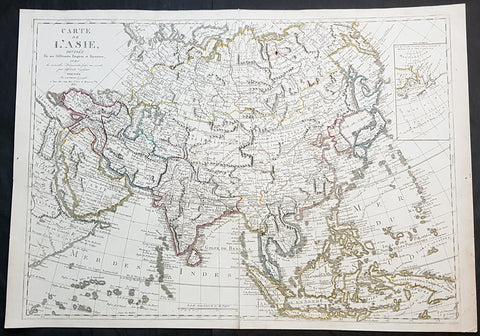
1830 Jean Baptiste Clouet & Pierre Jean Large Antique Map of Asia..Wall Map
Antique Map
- Title : Carte de L Asie, Divisee En Ses Differents Empires et Royaumes Avec...Dressee par J B Nolin...1830
- Ref #: 93437
- Size: 31in x 22in (790mm x 560mm)
- Date : 1780 (1830)
- Condition: (A+) Fine Condition
Description:
This large original hand coloured copper-plate engraved antique map of Asia was engraved and published by Pierre Jean, of the Parisian publishing company Mondhare and Jean in 1830, after the 18th century French cartographer Jean Baptiste Clouet and not Jean Baptiste Nolin jr as noted in the title.
This map is also incredibly rare and I have been unable to find another example sold in the last 25 years.
Since acquiring this large original map, it has been somewhat of an enigma. It is dated 1830 but bears the name of the cartographer J B Nolin, who died in 1790. It was engraved and published by Pierre Jean. But the map bears no cartographical resemblance to any large maps of Asia by Nolin and is also too large to fit into any atlas by Nolin or published by Pierre Jean. This clue finally gave us the answer. The Mondhare and Jean engraving & publishing company were responsible for engraving and printing Jean Baptiste Nolins large world & continental wall maps. And at the same time they were also responsible for the engraving & publishing a series of Wall maps of the world & continents by J B Clouet at the end of the 18th century. These maps are somewhat similar in decoration but are very different in cartographical detail as you can see in the two image comparisons above. This map was published a year after the death of Pierre Jean and we possibly never know it was a mistake or intentional.
General Definitions:
Paper thickness and quality: - Heavy and stable
Paper color : - off white
Age of map color: - Original
Colors used: - Yellow, green, blue, pink
General color appearance: - Authentic
Paper size: - 31in x 22in (790mm x 560mm)
Plate size: - 29 1/2in x 21in (750mm x 535mm)
Margins: - Min 1/2in (12mm)
Imperfections:
Margins: - None
Plate area: - Very small rust hole in Siberia
Verso: - Bottom centerfold rejoined, no loss
Background:
Cartographically the only apparent difference between this map by Jean and the map by Clouet is the updated cartographical data in the inset map of the Bering Straits and the updated information by the surveying by Captain James Cook and others after the 1780s.
Jean Baptiste Clouet 1729 - 1790 Clouet was a French cartographer and geographer born in Rennes, France. He kept premises in both Paris & Cadiz, Spain and was named Royal Geographer of the Academie des Sciences de Rouen in 1785. One of his main works was Géographie Moderne first issued 1767. In 1788 he was responsible for the design of 5 World & Continental wall maps, engraved and printed by the famous Paris publishers Mondhare & Jean.
Jean Baptiste Nolin Jr 1686–1762, son of JB Nolin 1657 - 1708 carried on publishing his fathers stock after his death, contracting the printing to third party publishing companies.
Mondhare & Jean (active 1759 - 1829)
Louis-Joseph Mondhare (1734 - Paris 1799) & Pierre Jean (1754 - 1829) were prominent Parisian publishers, engravers, print and map sellers who were active in Paris in the late 18th and early 19th centuries.
In 1784 Jean married the daughter of Mondhare, who formed a partnership with his son in law, changing forming a very successful partnership thereafter as Mondhare & Jean.
After Mondhare retirement in 1796, Jean carried on with the publishing & printing business, having inherited all of the printing plates that also included many map plates from the likes of Nolin, Clouet, D Anville , Delsile and others. Both Mondhare and Jean were responsible for the engraving and printing of the very decorative large wall maps by J B Nolin & J B L Clouet, as well as single plate maps and atlases. Mondares premises were located at Rue St Jacques, à lHôtel Saumur later moving with Jean to 32 Rue Saint-Jean de Beauvais.
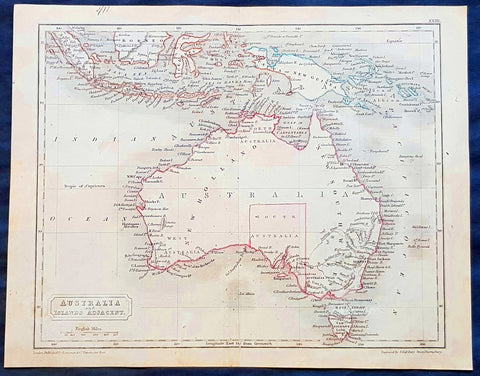
1830 Sydney Hall Antique Map of Australia, New Holland, Swan River Settlement
- Title : Australia & Islands Adjacent
- Ref #: 35074
- Size: 10 1/2in x 8 1/2in (265mm x 210mm)
- Date : 1830
- Condition: (A) Very Good Condition
Description:
This original hand coloured copper-plate original antique map by Sydney Hall was published in the 1830 edition of Halls General Atlas published by Longman & co., London. (Ref: Tooley; M&B)
General Definitions:
Paper thickness and quality: - Heavy and stable
Paper color : - off white
Age of map color: -
Colors used: -
General color appearance: -
Paper size: - 10 1/2in x 8 1/2in (265mm x 210mm)
Plate size: - 10 1/2in x 8 1/2in (265mm x 210mm)
Margins: - Min 1/2in (12mm)
Imperfections:
Margins: - None
Plate area: - Folds as issued
Verso: - None
Background:
The first recorded European sighting of the Australian mainland, and the first recorded European landfall on the Australian continent (in 1606), are attributed to the Dutch. The first ship and crew to chart the Australian coast and meet with Aboriginal people was the Duyfken captained by Dutch navigator, Willem Janszoon. He sighted the coast of Cape York Peninsula in early 1606, and made landfall on 26 February at the Pennefather River near the modern town of Weipa on Cape York. The Dutch charted the whole of the western and northern coastlines and named the island continent New Holland during the 17th century, but made no attempt at settlement. William Dampier, an English explorer and privateer, landed on the north-west coast of New Holland in 1688 and again in 1699 on a return trip. In 1770, James Cook sailed along and mapped the east coast, which he named New South Wales and claimed for Great Britain.
With the loss of its American colonies in 1783, the British Government sent a fleet of ships, the First Fleet, under the command of Captain Arthur Phillip, to establish a new penal colony in New South Wales. A camp was set up and the flag raised at Sydney Cove, Port Jackson, on 26 January 1788, a date which became Australia\'s national day, Australia Day. A British settlement was established in Van Diemens Land, now known as Tasmania, in 1803, and it became a separate colony in 1825. The United Kingdom formally claimed the western part of Western Australia (the Swan River Colony) in 1828. Separate colonies were carved from parts of New South Wales: South Australia in 1836, Victoria in 1851, and Queensland in 1859. The Northern Territory was founded in 1911 when it was excised from South Australia. South Australia was founded as a free province—it was never a penal colony. Victoria and Western Australia were also founded free, but later accepted transported convicts. A campaign by the settlers of New South Wales led to the end of convict transportation to that colony; the last convict ship arrived in 1848.