Products
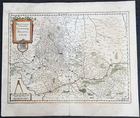
1628 Henricus Hondius Antique Map Beauvais Region of Northern France, Oise River
- Title : Beauvaisis Comitatus Belovacium
- Size: 22in x 18 1/2in (560mm x 470mm)
- Condition: (A) Very Good Condition
- Date : 1628
- Ref #: 50230
Description:
This original hand coloured copper plate engraved antique map of the Beauvais region of Northern France - centering on the city of Beauvais & the Oise River running through the cities of Noyon, Compiègne, Creil, by Henricus Hondius was published by Henricus Hondius & Jan Jansson in the 1628 French edition of Gerard Mercators Atlas.
General Definitions:
Paper thickness and quality: - Heavy and stable
Paper color : - off white
Age of map color: - Original
Colors used: - Blue, pink, red, green, yellow
General color appearance: - Authentic
Paper size: - 22in x 18 1/2in (560mm x 470mm)
Plate size: - 20in x 15in (510mm x 380mm)
Margins: - Min 1in (25mm)
Imperfections:
Margins: - Age toning
Plate area: - Age toning
Verso: - Age toning
Background:
Beauvais is a city and commune in northern France. It serves as the capital of the Oise département, in the Hauts-de-France region. Beauvais is located approximately 75 kilometres from Paris.
Beauvais was known to the Romans by the Gallo-Roman name of Caesaromagus (magos is Common Celtic for field). The post-Renaissance Latin rendering is Bellovacum from the Belgic tribe the Bellovaci, whose capital it was. In the ninth century it became a countship, which about 1013 passed to the bishops of Beauvais, who became peers of France from the twelfth century. At the coronations of kings the Bishop of Beauvais wore the royal mantle and went, with the Bishop of Langres, to raise the king from his throne to present him to the people.
De Bello Gallico II 13 reports that as Julius Caesar was approaching a fortified town called Bratuspantium in the land of the Bellovaci, its inhabitants surrendered to him when he was about 5 Roman miles away. Its name is Gaulish for place where judgements are made, from *bratu-spantion. Some say that Bratuspantium is Beauvais. Others theorize that it is Vendeuil-Caply or Bailleul sur Thérain.
From 1004 to 1037, the Count of Beauvais was Odo II, Count of Blois.
In a charter dated 1056/1060, Eudo of Brittany granted land in pago Belvacensi (Beauvais, Picardy) to the Abbey of Angers Saint-Aubin
In 1346 the town had to defend itself against the English, who again besieged it in 1433. The siege which it endured in 1472 at the hands of the Duke of Burgundy, was rendered famous by the heroism of the towns women, under the leadership of Jeanne Hachette, whose memory is still celebrated by a procession on 27 June (the feast of Sainte Angadrême), during which women take precedence over men.
An interesting hoard of coins from the High Middle Ages became known as the Beauvais Hoard, because some of the British and European coins found with the lot were from the French abbey located in Beauvais. The hoard, which contained a variety of rare and extremely rare Anglo-Norman pennies, English and foreign coins, was reputed to have been found in or near Paris.
Please note all items auctioned are genuine, we do not sell reproductions. A Certificate of Authenticity (COA) can be issued on request.
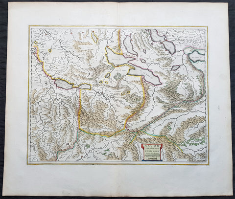
1650 Joan Blaeu Antique Map of The Cantons of Aargau & Zurich, Switzerland
Antique Map
- Title : Argow cum Parte Merid. Zurchgow
- Ref #: 40331
- Size: 24in x 21in (610mm x 535mm)
- Date : 1650
- Condition: (A+) Fine Condition
Description:
This beautifully hand coloured original antique map of the Cantons of Zurich & Aargau in North West Switzerland was published in the 1650 Dutch edition of Joan Blaeus Atlas Novusafter Gerard Mercator.
General Definitions:
Paper thickness and quality: - Heavy and stable
Paper color : - off white
Age of map color: - Original
Colors used: - Blue, pink, red, green, yellow
General color appearance: - Authentic
Paper size: - 24in x 21in (610mm x 535mm)
Plate size: - 21in x 16 1/2in (535mm x 420mm)
Margins: - Min 1in (25mm)
Imperfections:
Margins: - None
Plate area: - None
Verso: - None
Background:
The 26 cantons of Switzerland are the member states of the Swiss Confederation. The nucleus of the Swiss Confederacy in the form of the first three confederate allies used to be referred to as the Waldstätte. Two further major steps in the development of the Swiss cantonal system are referred to by the terms Acht Orte (Eight Cantons; between 1353 and 1481) and Dreizehn Orte (Thirteen Cantons,during 1513–1798); they were important intermediate periods of the Ancient Swiss Confederacy.
Each canton, formerly also Ort (from before 1450), or Stand (estate, from c. 1550), was a fully sovereign state with its own border controls, army, and currency from at least the Treaty of Westphalia (1648) until the establishment of the Swiss federal state in 1848; with a brief period of centralized government during the Helvetic Republic (1798–1803). With the Napoleonic period of the Helvetic Republic the term Kanton was also fully established in German-speaking region.
From 1833, there were 25 cantons, increasing to 26 after the secession of the canton of Jura from Bern in 1979.
The canton of Aargau is one of the more northerly cantons of Switzerland. It is situated by the lower course of the Aare, which is why the canton is called Aar-gau (meaning Aare province). It is one of the most densely populated regions of Switzerland.
The canton of Zürich is a Swiss canton in the northeastern part of the country. It is the most populated canton in the country. Its capital is the city of Zürich. The official language is German. The local Swiss German dialect, called Züritüütsch, is commonly spoken. In English the name of the canton and its capital is often written without an umlaut.
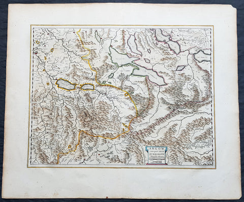
1659 Joan Blaeu Antique Map of The Cantons of Aargau & Zurich, Switzerland
Antique Map
- Title : Argow cum Parte Merid. Zurchgow
- Ref #: 30282
- Size: 24in x 21in (610mm x 535mm)
- Date : 1659
- Condition: (A+) Fine Condition
Description:
This beautifully hand coloured original antique map of the Cantons of Zurich & Aargau in North West Switzerland was published in the 1659 Spanish edition of Joan Blaeus Atlas Novusafter Gerard Mercator.
General Definitions:
Paper thickness and quality: - Heavy and stable
Paper color : - off white
Age of map color: - Original
Colors used: - Blue, pink, red, green, yellow
General color appearance: - Authentic
Paper size: - 24in x 21in (610mm x 535mm)
Plate size: - 21in x 16 1/2in (535mm x 420mm)
Margins: - Min 1in (25mm)
Imperfections:
Margins: - None
Plate area: - None
Verso: - None
Background:
The 26 cantons of Switzerland are the member states of the Swiss Confederation. The nucleus of the Swiss Confederacy in the form of the first three confederate allies used to be referred to as the Waldstätte. Two further major steps in the development of the Swiss cantonal system are referred to by the terms Acht Orte (Eight Cantons; between 1353 and 1481) and Dreizehn Orte (Thirteen Cantons,during 1513–1798); they were important intermediate periods of the Ancient Swiss Confederacy.
Each canton, formerly also Ort (from before 1450), or Stand (estate, from c. 1550), was a fully sovereign state with its own border controls, army, and currency from at least the Treaty of Westphalia (1648) until the establishment of the Swiss federal state in 1848; with a brief period of centralized government during the Helvetic Republic (1798–1803). With the Napoleonic period of the Helvetic Republic the term Kanton was also fully established in German-speaking region.
From 1833, there were 25 cantons, increasing to 26 after the secession of the canton of Jura from Bern in 1979.
The canton of Aargau is one of the more northerly cantons of Switzerland. It is situated by the lower course of the Aare, which is why the canton is called Aar-gau (meaning Aare province). It is one of the most densely populated regions of Switzerland.
The canton of Zürich is a Swiss canton in the northeastern part of the country. It is the most populated canton in the country. Its capital is the city of Zürich. The official language is German. The local Swiss German dialect, called Züritüütsch, is commonly spoken. In English the name of the canton and its capital is often written without an umlaut.
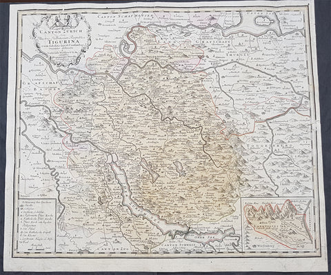
1765 Homann Large Antique Map of The Zurich Canton, Switzerland - Tigurini
Antique Map
- Title : Canton Zurich sive Illustratis Helvetiorum Respublica Tigurina...1765
- Ref #: 50175
- Size: 23 1/2in x 20in (595mm x 510mm)
- Date : 1765
- Condition: (B) Good Condition
Description:
This large original hand coloured copper plate engraved antique map of the Zurich Canton of Switzerland, the hoome of the Tigurini Tribe of Helvetii, by the Homann firm was engraved in 1765 - dated.
General Definitions:
Paper thickness and quality: - Heavy and stable
Paper color : - off white
Age of map color: - Original
Colors used: - Yellow, orange
General color appearance: - Authentic
Paper size: - 23 1/2in x 20in (595mm x 510mm)
Plate size: - 22in x 19in (560mm x 485mm)
Margins: - Min 1/2in (12mm)
Imperfections:
Margins: - Small repair to top and left margins
Plate area: - None
Verso: - Soiling and re-enforced to the left of the verso
Background:
The Tigurini were a clan or tribe forming one out of four pagi (provinces) of the Helvetii.[1][2] The Tigurini were the most important group of the Helvetii, mentioned by both Caesar and Poseidonius, settling in the area of what is now the Swiss canton of Vaud, corresponding to the bearers of the late La Tène culture in western Switzerland. Their name has a meaning of lords, rulers (cognate with Irish tigern lord). The other Helvetian tribes included the Verbigeni and the Tougeni (sometimes identified with the Teutones), besides one tribe that has remained unnamed.
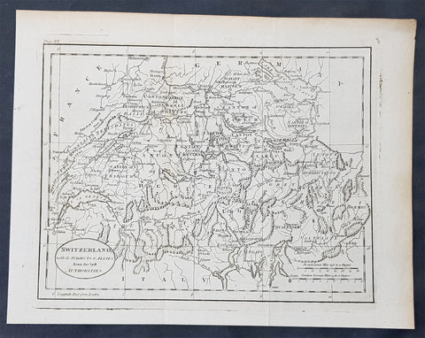
1770 John Cary Original Antique Map of Switzerland
- Title : Switzerland with its Subjects & Allies from the Best Authorities
- Size: 10 1/2in x 8 1/2in (265mm x 215mm)
- Ref #: 70188
- Date : 1770
- Condition: (A+) Fine Condition
Description:
This fine original copper-plate engraved antique map by Thomas Kitchen was published in the 1770 edition of the atlas for William Guthries Geographical Grammar
General Definitions:
Paper thickness and quality: - Heavy and stable
Paper color : - off white
Age of map color: -
Colors used: -
General color appearance: -
Paper size: - 10 1/2in x 8 1/2in (265mm x 215mm)
Plate size: - 10 1/2in x 8 1/2in (265mm x 215mm)
Margins: - Min 1/2in (12mm)
Imperfections:
Margins: - None
Plate area: - Folds as issued
Verso: - None
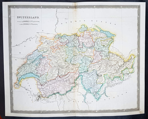
1834 Henry Teesdale Large Antique Map Switzerland divided in Cantons - Beautiful
- Title : 1834 Henry Teesdale Large Antique Map Switzerland divided in Cantons - Beautiful
- Date : 1834
- Condition: (A+) Fine Condition
- Ref: 50286
- Size: 17in x 14in (430mm x 355mm)
Description:
This beautifully hand coloured original steel-plate engraved antique map of Switzerland was engraved by John Dower in 1834 - dated at the foot of the map - and was published in the 1835 edition of Henry Teesdale\'s A New General Atlas of the World.
As with all the maps published by Teesdale this one is of the highest quality on strong clean & sturdy paper with beautiful original hand colouring. (Ref: M&B; Tooley)
General Definitions:
Paper thickness and quality: - Heavy and stable
Paper color : - off white
Age of map color: - Original
Colors used: - Blue, red, yellow, green
General color appearance: - Authentic
Paper size: - 17in x 14in (430mm x 355mm)
Plate size: - 17in x 14in (430mm x 355mm)
Margins: - Min 1/2in (12mm)
Imperfections:
Margins: - None
Plate area: - None
Verso: - None
Background:
The establishment of the Old Swiss Confederacy dates to the late medieval period, resulting from a series of military successes against Austria and Burgundy. Swiss independence from the Holy Roman Empire was formally recognized in the Peace of Westphalia in 1648. The country has a history of armed neutrality going back to the Reformation; it has not been in a state of war internationally since 1815 and did not join the United Nations until 2002. Nevertheless, it pursues an active foreign policy and is frequently involved in peace-building processes around the world. In addition to being the birthplace of the Red Cross, Switzerland is home to numerous international organisations, including the second largest UN office. On the European level, it is a founding member of the European Free Trade Association, but notably not part of the European Union, the European Economic Area or the Eurozone. However, it participates in the Schengen Area and the European Single Market through bilateral treaties.
Spanning the intersection of Germanic and Romance Europe, Switzerland comprises four main linguistic and cultural regions: German, French, Italian and Romansh. Although the majority of the population are German speaking, Swiss national identity is rooted in a common historical background, shared values such as federalism and direct democracy, and Alpine symbolism. Due to its linguistic diversity, Switzerland is known by a variety of native names: Schweiz, Suisse, Svizzera and Svizra. On coins and stamps, the Latin name – frequently shortened to Helvetia – is used instead of the four national languages.
Teesdale & co., Henry fl 1828-1843
Teesdale was a prominent London publisher and founding fellow of the Royal Geographical Society. He produced large-scale maps and charts and a number of fine atlases in the early part of the nineteenth century. He employed the most skilled draftsmen and engravers and his maps are renowned for precise detail and fine coloring