Products

1486 Claude Ptolemy, Holle & Reger Antique Renaissance Map of Great Britain & Ireland - Rare
Antique Map
- Title : Prima Europe Tabula
- Date : 1486
- Size: 20 1/2in x 15 1/2in (552mm x 397mm)
- Condition: (A+) Fine Condition
- Ref: 92669
This original hand coloured wood-block engraved very early, rare antique map of Great Britain & Ireland was published in the 1486 Ulm edition & translation of Claudius Ptolemys (87-150) text, published in the 2nd edition of Lienhart Holles & by Johann Reger atlas Claudii Ptolomei .... Cosmographie ... Opus Donni Nicolai Germani Secvndvm Ptolomevm Finit, Ulm, Germany. (Shirley 5)
This is a unique & very rare map and only the 4th map of the British Isles printed, published only 47 years after Johannes Gutenbergs invention of the moveable type printing press in 1439.
The two edition of Lienhart Holles atlases were published in 1482 & 1486. The 1482 Ulm edition of Ptolemys Geographia was the first edition printed north of the Alps and the first to appear in color, applied by the publisher.
The 1482 Ulm edition was one of the most important cartographic texts of the early Renaissance and the first edition of the work to be printed outside Italy. The text for this edition was based upon a manuscript translated into Latin by Jacobus Angeli and edited by Nicolaus Germanus that had been brought to Ulm from Rome in 1468. The Ulm Ptolemy was published in 1482 by Lienhart Holle, the same year as Berlingheris Florence edition. Ashley Baynton Williams notes:.........Working independently of Berlinghieri, but apparently using the same or similar models, Holle also added modern maps of Spain, France, Italy and Palestine, but also the first printed map of Scandinavia, composed by Cornelius Clavus, circa 1425-7 . Holles maps were printed from woodcuts, and are characterised by heavy wash colouring for the sea areas, typically a rich blue for the 1482 edition, and an ochre for the 1486 edition. These bright colours, and the greater sense of age that woodcuts convey, make this series the most visually appealing of the Ptolemeic maps.........
Holle went bankrupt shortly after the original publication and the work was taken over by Johann Reger, who issued a second edition in 1486.
This large map is in fine condition on strong sturdy paper, the printing impression is heavy and clear. The colour is original and beautifully applied. There has been professional restoration to the L&R bottom corners. No loss of original paper and restrengthened on the verso. The centerfold has been re-strengthened, on the verso, with some light creasing and rippling.
General Condition:
Paper thickness and quality: - Heavy and stable
Paper color: - off white
Age of map color: - Original
Colors used: - Yellow, green, red, brown.
General color appearance: - Authentic and fresh
Paper size: - 20 1/2in x 15 1/2in (552mm x 397mm)
Image size: -14 1/2in x 14 1/2in x 20 1/4in (369mm x 369mm (upper margin) 511 mm (lower margin)
Margins: - Min 1/4in (6mm)
Imperfections:
Margins: - Light discolouration & soiling.
Plate area: - Bottom L&R corners restored, no loss. Light creasing and rippling
Verso: - Re-enforced along center-fold and L&R bottom corners
Background: The first editions of Ptolemys Geographia Atlas was published in Italy in 1477 and republished in 1478 & 1482. The next atlas to be published was north of the Alps by Lienhart Holle, in Ulm, Germany in 1482. Holles maps were printed from woodcuts, and are distinct with their heavy wash colouring for the sea areas, typically a rich blue for the 1482 edition, and an ochre for the 1486 edition. These bright colours, and the greater sense of age that woodcuts convey, make this series of maps one of the most visually attractive.
Claudius Ptolemy: (87-150) was an Egyptian astronomer and geographer living and studying in Alexandria. Alexandria was not only the home of the greatest library of any period, but was also one of the most important trade centres between west and east - here Ptolemy could not only study ancient authorities, but could also consult contemporary travellers and merchants. From this wealth of accumulated knowledge, Ptolemy composed his <i>Geographia</i>, a work of considerable genius, which dominated the whole of the Christian and Moslem world for 1,500 years (Tooley).
It was Ptolemy who introduced the concept of latitude and longitude to form a grid to cover the whole world, so that it would be possible to plot the position of principal land-marks on the map by observations, and then fill in other information from other sources, including the notes and Itinerary of Marinus of Tyre, perhaps the most accurate source available.
Unfortunately Ptolemy was hampered by the paucity of observations - as a result he exaggerated the length of the Mediterranean by over 20 degrees -and by lack of information which was often circumvented by invention. Despite these errors, which persisted for nearly 1,500 years, the work was of fundamental importance at a time when little was being done in the way of modern mapping. As a result of this work, which was so far in advance of anything before or anything produced in the next 1,500 years, Ptolemy has earned the reputation and accolade, the father of geography (Tooley).
Re-discovery of the Ptolemy Texts: Following the fall of the Roman Empire, Ptolemys text was lost to western geographers. The earliest extant manuscript version of the Geographia is Arabic, and probably dates from the 12th Century. Subsequently, the text was translated into Greek, and circulated through the Greek World. In about 1400 a Greek manuscript came into the hands of the Byzantine scholar, Emanuel Chrysolaras, who was working in Italy. Chrysolaras undertook a translation of the text into Latin, and completed by his pupil Jacopo dAngelo, in 1406. The Greek manuscript that Angelo translated was apparently lacking maps, but the data in the text contained the information to construct a set of maps, and numbers of scholars set about such work. Of them, the most influential, was Donnus Nicolaus Germanus, a German cartographer, active in Italy from the 1460s to 1480s. He was a prolific editor of the text and maps, and his work formed the basis for three of the four sets of Ptolemaic maps printed in the fifteenth Century, with the fourth, accompanying Berlinghieris Geographia, strongly influenced by him .
The first printed versions of Ptolemys Text: The first published edition of the Geographia with maps, which were probably engraved by Taddeo Crivelli, was issued in Bologna in 1477. Conrad Sweynheym was also working on an edition of Ptolemy in Rome in the same period. After his death, Arnold Buckinck, saw the atlas through the press, in 1478. Of the engraved editions of Ptolemys Cosmographia the maps in the Rome edition are the finest fifteenth century examples, and second only to Mercators maps, from his 1578 edition. The atlas proved popular, and three successive editions (to 1508) followed. In 1482, Nicolas Laurentii published a set of Ptolemaic maps to illustrate Francesco Berlinghieri Geographia.
The first edition of Ptolemys Geographia printed outside Italy was published by Lienhart Holle, in Ulm, also in 1482. Holles maps were printed from woodcuts, and are characterised by heavy wash colouring for the sea areas, typically a rich blue for the 1482 edition, and an ochre for the 1486 edition. These bright colours, and the greater sense of age that woodcuts convey, make this series the most visually appealing of these various sets of maps.
Later Editions of Ptolemy: Next in chronological sequence, and the most unusual of the editions of Ptolemy, was that published by Jacobus Pentius de Leucho in Venice in 1511, edited by Bernardus Sylvanus. Martin Waldseemullers edition of Ptolemy, first published in 1513, is the most important of the sixteenth century editions. Waldseemullers edition was reprinted in 1520, and then the maps were re-drawn by Lorenz Fries on a smaller format, for editions published in 1522, 1525, 1535 and 1541. The next to produce an edition of Ptolemy was Sebastian Munster, who worked in Basle. Munster was one of the leading geographers and cartographers of his period, and he diligently set about revising and improving the maps. Giacomo Gastaldi, one of the leading cartographers of the sixteenth century, composed a set of maps for an edition of the Geographia, published in Venice in 1548. Of all the editions of Ptolemy, that prepared by Gerard Mercator, and published in 1578, is technically the finest, with the World map being a particularly fine engraving. This atlas is, also, noteworthy for its longevity, the original printing plates were still in use in 1730, over one hundred and fifty years after they were first engraved. (Ref: Shirley 5; Stevenson; Tooley; M&B; MapForum)
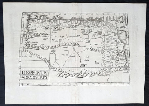
1525 Laurent Fries Antique Map NE Africa Red Sea, Egypt, Nile River Delta, Libya
- Title : Libyae Interioris Pars....Tabula III Aphricae
- Ref #: 93378
- Size: 22 1/2in x 16 1/2in (565mm x 420mm)
- Date : 1525
- Condition: (A+) Fine Condition
Description:
This rare very early original wood-block engraved antique Ptolemaic map of North East Africa from The Red Sea, Egypt, The Nile Delta & Libya by Laurent Fries was published by in the 1525 Strasbourg edition of Ptolemys Geographia
Striking early map of North Africa and Egypt, from the Red Sea, the Nile and Egypt to the Gulf of Libya. Extends up rivers along the Nile to Aden.
Latin text and elaborate decorations on the verso. A nice example, from the 1525 edition of Fries Atlas. First published in Strasbourg by Johannes Gruninger in 1522, Fries map is based upon Waldseemullers map of 1513.
Lorenz (Laurent) Fries was born in Alsace in about 1490. He studied medicine, apparently spending time at the universities of Pavia, Piacenza, Montpellier and Vienna. After completing his education, Fries worked as a physician in several places, before settling in Strassburg, in about 1519. While n Strassburg, Fries met the Strasbourg printer and publisher Johann Grüninger, an associate of the St. Die group of scholars formed by, among others, Walter Lud, Martin Ringmann and Martin Waldseemuller.
From 1520 to 1525, Fries worked with Gruninger as a cartographic editor, exploiting the corpus of material that Waldseemuller had created. Fries first venture into mapmaking was in 1520, when he executed a reduction of Martin Waldseemullers wall-map of the World, published in 1507. While it would appear that Fries was the editor of the map, credit is actually given in the title to Peter Apian. The map, Tipus Orbis Universalis Iuxta Ptolomei Cosmographi Traditionem Et America Vespucii Aliorque Lustrationes A Petro Apiano Leysnico Elucubrat. An.o Dni MDXX, and was issued in Caius Julius Solinus Enarrationes, edited by Camers, and published in Vienna in 1520.
Fries next project that Fries was a new edition of the Geographia of Claudius Ptolemy, which was published by Johann Koberger in 1522. Fries evidently edited the maps, in most cases simply producing a reduction of the equivalent map from Waldseemullers 1513 edition of the Geographie Opus Novissima, printed by Johann Schott. Fries also prepare three new maps for the Geographie: maps of South-East Asia and the East Indies, China and the World, but the geography of these derives from Waldseemullers world map of 1507.
The 1522 edition of Fries work is very rare, suggesting that the work was not commercially successful. In 1525, an improved edition was issued, with a re-edit of the text by Wilibald Pirkheimer, from the notes of Johannes Regiomontanus. After Grüningers death in 1531, the business was continued by his son Christoph, who seems to have sold the materials for the Ptolemy to two Lyon publishers, the brothers Melchior and Gaspar Trechsel, who published a joint edition in 1535, before Gaspar Trechsel published an edition in his own right in 1541.
General Definitions:
Paper thickness and quality: - Heavy and stable
Paper color : - off white
Age of map color: -
Colors used: -
General color appearance: -
Paper size: - 22 1/2in x 16 1/2in (565mm x 420mm)
Plate size: - 18 1/2in x 12 1/2in (475mm x 320mm)
Margins: - Min 1 1/2in (20mm)
Imperfections:
Margins: - None
Plate area: - Light soiling along centerfold
Verso: - None
Background:
Claude Ptolemy - a Greek mathematician, astronomer and geographer, living in Alexandria, assembled and codified his predecessors\' cartographic theories including those of Strabo & Marinus of Tyre (c. AD 120) to whom he was especially indebted. In about AD 150 he published his Geographia, a work in 8 volumes, supposedly illustrated with a world map, 26 regional maps and a profusion of smaller maps. Although the text of the Geographia survived, no maps older than about the twelfth century have come down to us and, in consequence, we have no means of knowing whether the \'Ptolemy\' maps on which we set so much store were, in fact, drawn by him or were the interpretations of later map makers using his text as a basis.
In Europe the initial awakening of interest in geography arose from the revival of knowledge of Ptolemy\'s Geographia soon after the year 1400. Greek manuscript copies made in the twelfth to fourteenth centuries were brought by scholars to Italy from Constantinople and were subsequently translated into Latin and widely studied. This work coincided with, and was much influenced by, the development of printing techniques, particularly, of course, by the invention of movable-type printing by Gutenberg about 1450, which made possible for the first time the production of printed books in quantity. Apart from this factor, other more far-reaching influences were compelling the peoples of Western Europe to look beyond the horizon they had known for so many centuries. With the conquest of Constantinople in 1453 the Turks effectively closed Europe\'s trade routes to the East and shut off access to traditional sources of luxuries and precious metals from Asia and, above all, denied the supply of the spices which had become so important in the lives of ordinary people. Other factors often based on long-believed myths and legends added to the urge to break out into the unknown world.
The interpretation of Ptolemy\'s text began mainly with the Italians Angelus, Beroaldus & Vadius in 1477 and was re-interpreted and re-issued by many over the next century by the likes Waldseemuller 1513, Gastaldi 1548, Mercator 1578 & Magini 1596. (Ref: Tooley; M&B; Dover)
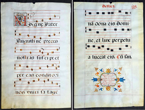
1537 Large Vellum Latin Antiphonary Music Sheet Prayers to Dead & St Augustine
Antique Map
-
- Title : Desunctis Requiem, Sanctis Peanan Canemdum Coscripsi icopto, que pri edo, Tomo: Quem tibi, quandoquide robur, pia Virgo, dedisti Meq ipsu dono, cosecro, corde dico F.V.V.Z CICICXXXVII
- Ref #: 93521
- Size: 23 1/2in x 15 1/2in (595mm x 395mm)
- Date : 1537
- Condition: (A+) Fine Condition
Description:
This large beautifully hand written and hand coloured original antique vellum Latin Antiphonary Choro (choir) music sheet, with a separate chant on each side of the page. On the first side is the Prayer to the Dead and on the second side is a prayer to St Augustine. The page was hand scribed in 1537 and is dated, dates on these vellum Antiphonary Choro sheets was rarely done and is much sort after.
The two prayers set to music and sung as a Gregorian Chant, in part, translate as follows;
1. Requiem aeternam dona eis Domine; et lux perpetua luceat eis. Requiescant in pace. Amen.
(Eternal rest grant unto them, O Lord, and let perpetual light shine upon them. May they rest in peace. Amen)
2. Magne Pater Augustine, Preces nostras suscipe, Et per eas Conditori Nos placare satage, Atque rege gregem tuum Summum decus Praesulum
(Great Father Augustine, receive our prayers, and by them, seek thou to reconcile us to the Creator, and rule thy flock, o highest glory of bishops)
General Definitions:
Paper thickness and quality: - Heavy and stable
Paper color : - off white
Age of map color: - Original
Colors used: - Yellow, green, blue, pink
General color appearance: - Authentic
Paper size: - 23 1/2in x 15 1/2in (595mm x 395mm)
Plate size: - 23 1/2in x 15 1/2in (595mm x 395mm)
Margins: - Min 1/2in (12mm)
Imperfections:
Margins: - None
Plate area: - None
Verso: - None
Background:
Prayer for the dead is well documented within early Christianity, both among prominent Church Fathers and the Christian community in general. In Eastern Orthodoxy Christians pray for such souls as have departed with faith, but without having had time to bring forth fruits worthy of repentance. In the Catholic Church the assistance that the dead receive by prayer on their behalf is linked with the process of purification known as purgatory. While prayer for the dead continues in both these traditions and in those of Oriental Orthodoxy and of the Assyrian Church of the East, many Protestant groups reject the practice.
The tomb of the Christian Abercius of Hieropolis in Phrygia (latter part of the 2nd century) bears the inscription: Let every friend who observes this pray for me, i.e. Abercius, who throughout speaks in the first person.
The inscriptions in the Roman catacombs bear similar witness to the practice, by the occurrence of such phrases as:
Mayst thou live among the saints (3rd century);
May God refresh the soul of . . . ;
Peace be with them.
Among Church writers Tertullian († 230) is the first to mention prayers for the dead: The widow who does not pray for her dead husband has as good as divorced him. This passage occurs in one of his later writings, dating from the beginning of the 3rd century. Subsequent writers similarly make mention of the practice as prevalent, not as unlawful or even disputed (until Arius challenged it towards the end of the 4th century). The most famous instance is Saint Augustines prayer for his mother, Monica, at the end of the 9th book of his Confessions, written around 398.
An important element in the Christian liturgies both East and West consisted of the diptychs, or lists of names of living and dead commemorated at the Eucharist. To be inserted in these lists was a confirmation of ones orthodoxy, and out of the practice grew the official canonization of saints; on the other hand, removal of a name was a condemnation.
In the middle of the 3rd century, St. Cyprian enjoined that there should be no oblation or public prayer made for a deceased layman who had broken the Churchs rule by appointing a cleric trustee under his will: He ought not to be named in the priests prayer who has done his best to detain the clergy from the altar.
Although it is not possible, as a rule, to name dates for the exact words used in the ancient liturgies, yet the universal occurrence of these diptychs and of definite prayers for the dead in all parts of the Christian Church, East and West, in the 4th and 5th centuries shows how primitive such prayers were. The language used in the prayers for the departed is asking for rest and freedom from pain and sorrow. A passage from the Liturgy of St James reads:
Remember, O Lord, the God of Spirits and of all Flesh, those whom we have remembered and those whom we have not remembered, men of the true faith, from righteous Abel unto to-day; do thou thyself give them rest there in the land of the living, in thy kingdom, in the delight of Paradise, in the bosom of Abraham, Isaac and Jacob, our holy fathers, from whence pain and sorrow and sighing have fled away, where the light of thy countenance visiteth them and always shineth upon them.
Public prayers were only offered for those who were believed to have died as faithful members of the Church. But Saint Perpetua, who was martyred in 202, believed herself to have been encouraged in a vision to pray for her brother, who had died in his eighth year, almost certainly unbaptized; and a later vision assured her that her prayer was answered and he had been translated from punishment. St. Augustine thought it needful to point out that the narrative was not canonical Scripture, and contended that the child had perhaps been baptized.
Prayer to St Augustine: despite his overwhelming importance to Western theology, there was very little liturgical devotion to St Augustine in the Roman Rite during the first millenium. His feast does not appear in the majority of ancient liturgical books; his day was originally kept in Rome itself as that of an obscure martyr named Hermes, who is still celebrated as a commemoration on August 28th in the traditional rite. Towards the end of the eleventh century, however, as the great reform movement within the Western Church gained momentum, there emerged a huge number of new religious congregations of the sort which we now call canons regular, followed within a few generations by the mendicant friars. [1] Many of these, such as the Premonstratensians and Dominicans, took the Rule of St Augustine as their own, since it is very simple, and permitted a wide variety of adaptations and additional customs. Augustine himself then began to be honored in the liturgy as the great legislator of canonical life, just as St Benedict had long been honored as the great legislator of monastic life.
Sometime in the 12th century, a proper Office was composed for him, and widely adopted by many of the Augustinian orders in their various kinds. Here is the hymn which the Dominicans sing at Vespers and Matins, the Premonstratensians at Vespers and Lauds.
Antiphonary, Gregorian Choro
An Antiphonary is one of the liturgical books intended for use in choro (i.e. in the liturgical choir), and originally characterized, as its name implies, by the assignment to it principally of the antiphons used in various parts of the Roman liturgy.
Medieval antiphonaries varied with regional liturgical tradition. In 1570, following the Council of Trent, the Roman Antiphonary was declared universal. The Roman Antiphonary (Antiphonale Romanum) contains the chants for the Divine Office for the hours of Lauds, Prime, Terce, Sext, None, Vespers and Compline for every day of the year. The Vesperale Romanum is an excerpt of the Antiphonary containing the chants sung at Vespers. The music for use at the Mass is contained in the Roman Gradual (Graduale Romanum), the chants of the ordinary are also edited as an excerpt from the Gradual, the Kyriale Romanum. The Antiphonale Romanum was substantially revised in 1910/11 in the course of the reform of the Roman Breviary under Pope Pius X, notably restoring authentic Gregorian melodies. For the 1971 Liturgy of the Hours, there are two volumes, Antiphonale Romanum II and Liber Hymnarius.
The plainsong melodies found in the Roman antiphonary and the Graduale have received the general title of Gregorian Chant, in honour of pope Gregory the Great (r. 590–604), to whom a tradition, supported by internal and external evidence, ascribes the work of revising and collecting into the various texts and chants of the liturgy. Doubtless the ancient missal contained only those texts which were appointed for the celebrant, and did not include the texts which were to be chanted by the cantor and choir; and the Antiphonarium Missæ supplied the omitted texts for the choir as well as the chants in which the texts were to be sung. The importance of the Gregorian Antiphonary is found in the enduring stamp it impressed on the Roman liturgy.
Earlier popes had given, a medieval writer assures us, attention to the chants; and he specifies St. Damasus (d. 384), St. Leo (d. 461), St. Gelasius (d. 496), St. Symmachus (d. 514), St. John I (d. 526) and Boniface II (d. 532). It is true, also, that the chants used at Milan were styled, in honour of St. Ambrose (called the Father of Church Song), the Ambrosian Chant.
But it is not known whether any collection of the chants had been made before that of St. Gregory, concerning which his ninth-century biographer, John the Deacon, wrote: Antiphonarium centonem … compilavit. The authentic antiphonary mentioned by the biographer has not as yet been found. What was its character? What is meant by cento (patchwork)? In the century in which John the Deacon wrote his life of the Saint, a cento meant the literary feat of constructing a coherent poem out of scattered excerpts from an ancient author, in such wise, for example, as to make the verses of Virgil sing the mystery of the Epiphany. The work, then, of St. Gregory was a musical cento, a compilation (centonem ... compilavit) of pre-existing material into a coherent and well-ordered whole. This does not necessarily imply that the musical centonization of the melodies was the special and original work of the Saint, as the practice of constructing new melodies from separate portions of older ones had already been in vogue two or three centuries earlier than his day. But is it clear that the cento was one of melodies as well as of texts? In answer it might indeed by said that in the earliest ages of the Church the chants must have been so very simple in form that they could easily be committed to memory; and that most of the subsequently developed antiphonal melodies could be reduced to a much smaller number of types, or typical melodies, and could thus also be memorized.
And yet many say that it is scarcely credible that the developed melodies of St. Gregorys time had never possessed a musical notation, had never been committed to writing. What made his antiphonary so very useful to chanters (as John the Deacon esteemed it) was probably his careful presentation of a revised text with a revised melody, written either in the characters used by the ancient authors (as set down in Boethius) or in neumatic notation. We know that St. Augustine, sent to England by St. Gregory, carried with him a copy of the precious antiphonary, and founded at Canterbury a flourishing school of singing. That this antiphonary contained music we know from the decree of the Second Council of Cloveshoo (747) directing that the celebration of the feasts, in respect to baptism, Masses and music (in cantilenæ modo), should follow the method of the book which we received from the Roman Church. That this book was the Gregorian antiphonary is clear from the testimony of Egbert, Bishop of York (732-766), who in his De Institutione Catholica speaks of the Antiphonarium and Missale which the blessed Gregory … sent to us by our teacher, blessed Augustine.
It is impossible to trace here the progress of the Gregorian antiphonary throughout Europe, which resulted finally in the fact that the liturgy of Western Europe, with a very few exceptions, finds itself based fundamentally on the work of St. Gregory, whose labour comprised not merely the sacramentary, and the Antiphonarium Missæ, but extended also to the Divine Office. Briefly, the next highly important step in the history of the antiphonary was its introduction into some dioceses of France where the liturgy had been Gallican, with ceremonies related to those of Milan and with chants developed by newer melodies. From the year 754 may be dated the change in favour of the Roman liturgy. St. Chrodegang, Bishop of Metz, on his return from an embassy to Rome, introduced the Roman liturgy into his diocese and founded the Chant School of Metz. Subsequently, under Charlemagne, French monks went to Rome to study the Gregorian tradition there, and some Roman teachers visited France.
The interesting story of Ekkehard, concerning two monks, Petrus and Romanus, sent from Rome to teach chant, is not to be taken as historical. But a certain Petrus, according to Notker, was sent to Rome by Charlemagne and at the Abbey of St. Gall trained the monks in the Roman style. Besides Metz and St. Gall, other important schools of chant were founded at Rouen and Soissons. In the course of time new melodies were added, at first characterized by the simplicity of the older tradition, but gradually becoming more free in extended intervals. With respect to German manuscripts, the earliest are found in a style of neumatic notation different from that of St. Gall, while the St. Gall manuscripts are derived not directly from the Italian but from the Irish-Anglo-Saxon. It is probable that before the 10th and 11th centuries (at which period the St. Gall notation began to triumph in the German churches) the Irish and English missionaries brought with them the notation of the English antiphonary.
It would take too much space to record here the multiplication of antiphonaries and their gradual deterioration, both in text and in chant, from the Roman standard. The school of Metz began the process early. Commissioned by Louis the Pious to compile a Graduale and antiphonary, the priest Amalarius of Metz found a copy of the Roman antiphonary in the monastery of Corbie, and placed in his own compilation an M when he followed the Metz antiphonary, R when he followed the Roman, and an I C (asking Indulgence and Charity) when he followed his own ideas. His changes in the Graduale were few; in the antiphonary, many.
Part of the revision which, together with Elisagarus, he made in the responsories as against the Roman method, were finally adopted in the Roman antiphonary. In the 12th century, the commission established by St. Bernard to revise the antiphonaries of Citeaux criticized with undue severity the work of Amalarius and Elisagarus and withal produced a faulty antiphonary for the Cistercian Order. The multiplication of antiphonaries, the differences in style of notation, the variations in melody and occasionally in text, need not be further described here. In France especially, the multiplication of liturgies subsequently became so great, that when Dom Guéranger, in the middle of the 19th century, started introducing the Roman liturgy into that country, sixty out of eighty dioceses had their own local breviaries.
That the word antiphonarium is, or was, quite elastic in its application, is shown by the remark of Amalarius in his Liber de ordine Antiphonarii, written in the first half of the 9th century. The work which in Metz was called Antiphonarius was divided into three in Rome: What we call Graduale they style Cantatorius; and this, in accordance with their ancient custom, is still bound in a single volume in some of their churches. The remainder they divide into two parts: the one containing the responsories is called Responsoriale; while the other, containing antiphons, is called Antiphonarius. I have followed our custom, and have placed together (mixtim) the responsories and the antiphons according to the order of the seasons in which our feasts are celebrated (P. L., CV, 1245). The word cantatory explains itself as a volume containing chants; it was also called Graduale, because the chanter stood on a step (gradus) of the ambo or pulpit, while singing the response after the Epistle. Other ancient names for the antiphonary seem to have been Liber Officialis (Office Book) and Capitulare (a term sometimes used for the book containing the Epistles and Gospels).
Please note all items auctioned are genuine, we do not sell reproductions. A Certificate of Authenticity (COA) can be issued on request.
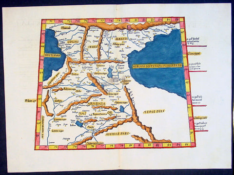
1541 Fries Ptolemaic Antique Map of the Caucasus - Georgia, Armenia, Azerbaijan
Antique Map
- Title : Tabula Tertia Asiae complectitur Colchidem, Iberiam, Alberiam & Armeniam maiorem
- Date : 1541
- Condition: (A+) Fine Condition
- Ref: 92814
- Size: 20 1/2in x 15in (520mm x 380mm)
Description:
This beautifully hand coloured original antique Ptolemaic map by Laurent Fries of the Caucasus region of central Asia - straddling the Black & Caspian Seas (what is today part of the Russian Federation and includes the countries of Georgia, Armenia, Azerbaijan, north-western Iran & north-eastern Turkey) - was published by in the 1541 Vienna edition of Ptolemy's Geographia
General Definitions:
Paper thickness and quality: - Heavy and stable
Paper color : - off white
Age of map color: - Early
Colors used: - Yellow, green, red, blue.
General color appearance: - Authentic
Paper size: - 20 1/2in x 15in (520mm x 380mm)
Plate size: - 20 1/2in x 15in (520mm x 380mm)
Margins: - Min 1in (25mm)
Imperfections:
Margins: - None
Plate area: - None
Verso: - None
Background:
Claude Ptolemy - a Greek mathematician, astronomer and geographer, living in Alexandria, assembled and codified his predecessors' cartographic theories including those of Strabo & Marinus of Tyre (c. AD 120) to whom he was especially indebted. In about AD 150 he published his Geographia, a work in 8 volumes, supposedly illustrated with a world map, 26 regional maps and a profusion of smaller maps. Although the text of the Geographia survived, no maps older than about the twelfth century have come down to us and, in consequence, we have no means of knowing whether the 'Ptolemy' maps on which we set so much store were, in fact, drawn by him or were the interpretations of later map makers using his text as a basis.
In Europe the initial awakening of interest in geography arose from the revival of knowledge of Ptolemy's Geographia soon after the year 1400. Greek manuscript copies made in the twelfth to fourteenth centuries were brought by scholars to Italy from Constantinople and were subsequently translated into Latin and widely studied. This work coincided with, and was much influenced by, the development of printing techniques, particularly, of course, by the invention of movable-type printing by Gutenberg about 1450, which made possible for the first time the production of printed books in quantity. Apart from this factor, other more far-reaching influences were compelling the peoples of Western Europe to look beyond the horizon they had known for so many centuries. With the conquest of Constantinople in 1453 the Turks effectively closed Europe's trade routes to the East and shut off access to traditional sources of luxuries and precious metals from Asia and, above all, denied the supply of the spices which had become so important in the lives of ordinary people. Other factors often based on long-believed myths and legends added to the urge to break out into the unknown world.
The interpretation of Ptolemy's text began mainly with the Italians Angelus, Beroaldus & Vadius in 1477 and was re-interpreted and re-issued by many over the next century by the likes Waldseemuller 1513, Gastaldi 1548, Mercator 1578 & Magini 1596. (Ref: Tooley; M&B; Dover)
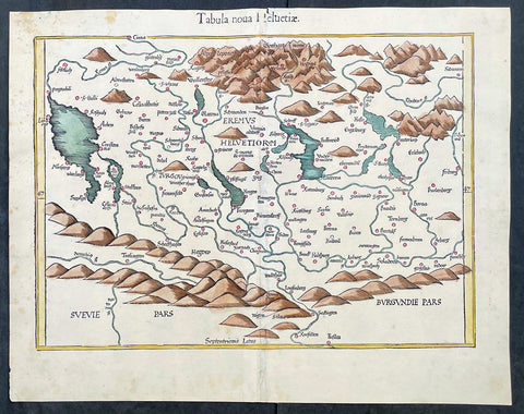
1541 Laurent Fries Very Early, Rare Antique Map of Switzerland
- Title : Tabula noua Helvetiae
- Ref #: 17008
- Size: 18 1/2in x 15in (475mm x 380mm)
- Date : 1541
- Condition: (A+) Fine Condition
Description:
This rare, very early original hand coloured wood-block engraved antique Ptolemaic map of Switzerland by Laurent Fries was published by Trechsel, Gaspar; Vienne, Dauphine in the 1541 Lyon edition of Ptolemys Geographia, Claudii Ptolemaei Alexandrini Geographicae Enarrationis, Libri Octo
General Definitions:
Paper thickness and quality: - Heavy and stable
Paper color : - off white
Age of map color: - Early
Colors used: - Yellow, orange
General color appearance: - Authentic
Paper size: - 18 1/2in x 15in (475mm x 380mm)
Plate size: - 18 1/2in x 15in (475mm x 380mm)
Margins: - Min 1in (25mm)
Imperfections:
Margins: - Small repair to top margin in title
Plate area: - None
Verso: - None
Background:
The first printed map of Switzerland was published in Martin Waldseemuller's edition of Ptolemy in Strasbourg in 1513, but the manuscript map by Konrad Turst (1497) drawn to scale was a splendid first achievement for its time. Also the research of Vadianus at St Gallen University produced notable work, and along with the Germanic influence in Basle, which became part of the Swiss Confederation in 1501, and the highly developed wood engraving skills there, were important factors in European map publishing.
The almost endless editions of Sebastian Munster's Cosmographia were published in Basle from 1540 for nearly a century and Zurich can claim to have published the first national atlas produced anywhere -that of Johann Stumpf in 1548-52.
By comparison with her larger neighbours, Germany and Italy, Switzerland is considered not to have made a major contribution to Cartographic history. But over the years this has been contradicted, especially starting in the sixteenth century. In the second half of the sixteenth century many maps of the Swiss Cantons, in manuscript or woodcuts appeared, but the mountainous nature of the country produced its own mapping problems and imposed a need for large-scale surveys as well as practical and effective methods of showing land surfaces in relief. Early in the seventeenth century Hans Gyger perfected new ways of doing this but although he published a wide range of very large-scale maps of the cantons and of Switzerland as a whole his techniques did not receive the credit they deserved. On the other hand, his countrymen followed his example of compiling large-scale maps for which they have always been noted for up until the present day. (Ref: Koeman; M&B)
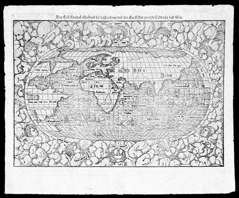
1550 Munster Rare Antique World Map - early depiction of America, Post Columbus
Antique Map
- Title : Das Erst General Inhaltend die Beschreibung und den Cirkel des Gantzen Erdtriche und
- Ref #: 35671
- Size: 16 1/2in x 12 3/4in (415mm x 315mm)
- Date : 1550
- Condition: (A+) Fine Condition
Description:
This wood-block engraved original antique oval World Map was engraved by David Kandel, initials engraved bottom left "DK" and was published in the 1550 edition of Cosmographia by Sebastian Munster.
One of the most recognizable maps of the 16th century considered the first map to identify the Pacific Ocean, as here, 'Mare Pacificum.' This is the world of the educated 16th century European, divided into Asia, Europe, India, Africa and America. The southern latitudes are inhabited by a variety of sea monsters and sailing ships.
One of the best examples I have seen of this map for sometime, nice heavy impression on clean sturdy paper with original margins.
The American continent is barely recognizable, only a scant 58 years after European discovery by Christopher Columbus. North America is defined as Terra Florida showing an enormous inlet extending towards the eastern seaboard in the vicinity of modern day North Carolina named Verrazano's Sea. Apparently Verrazano, coasting the Outer Banks, observed the Pamlico Sound and assumed that beyond the narrow coastal banks, an open sea gave direct access to the pacific - wishful thinking at best. Verrazano's Sea appears so dramatically on few maps, but persisted in lesser forms for nearly a century.
South America with tentacle like protrusions in all directions, is largely amorphous, but the Rio de la Plata and the Strait of Magellan are clear. Tierra del Fuego is enormous, with no mention of greater Terra Australias, an interesting omission by Munster.
Europe is vaguely recognizable and connected, via an arctic peninsula, to Greenland and North America.
Asia/Pacific extends eastward far enough to reappear just north of America. Ceylon is not present, but a landmass bearing roughly the shape and position of Sumatra is identified as Tapobrana (a term more commonly associated with Ceylon). Japan appears as Zipangri.
Unlike many other world maps of the time, Munster has left out the concept of a 'Terra Australis Incognita' altogether choosing to show ocean instead.
Africa follows the Ptolemaic model with the Nile finding its source in a mountain range and two associated lakes.
The whole is surrounded by twelve named and prominent wind heads - one for each direction.
General Description:
Paper thickness and quality: - Heavy and stable
Paper color: - White
Age of map color: -
Colors used: -
General color appearance: -
Paper size: - 15 3/4in x 12 1/2in (400mm x 310mm)
Plate size: - 15 3/4in x 12 1/2in (400mm x 310mm)
Margins: - Min 1/2in (10mm)
Imperfections:
Margins: - Small knicks to margin edges
Plate area: - None
Verso: - None
Background: This wood-cut engraved World map was prepared for the 1550 edition of Sebastian Münster's Cosmographia to replace the earlier World map by Sebastian Munster which had appeared in the editions of the Geographia and Cosmographia from 1540 onwards. The publisher, from 1552, was Heinrich Petri, Münster's son-in-law.
This "new world" map is on an oval projection, similar in many respects to the previous Munster world map, but with the woodcutter's initials "DK" added, identified as those of the engraver David Kandel, in the lower left-hand corner.
The titles of the wind-heads are now in banners and the east and west winds, unlike the 1540 version, do not protrude inside the oval circumference. North America still retains its unusual shape almost bisected by water but the earlier note indicating a route to the Moluccas has been omitted...."
The map was first issued in the 1550 edition of Cosmographia, and appeared in all subsequent editions through to 1578, with the title varying according to the language of the edition. On the verso the wood block is the title and text, in Latin.
Sebastian Münster (1488-1552) was a German cartographer, cosmographer, and Hebrew scholar whose work Cosmographia (1544; "Cosmography") was the earliest German description of the world and a major work in the revival of geographic thought in 16th-century Europe. It had numerous editions in different languages including Latin, French, Italian, English, and even Czech. Altogether, about 40 editions of the Cosmographia appeared between 1544 and 1628 and was one of the most successful and popular books of the 16th century. Münster was a major influence in popular thinking in Europe for the next 200 years.
This success was due not only to the level of descriptive detail but also to the fascinating full page maps & views as well as smaller woodcuts that were included in the text. Many of the woodcuts were executed by famous engravers of the time including Hans Holbein the Younger, Urs Graf, Hans Rudolph Manuel Deutsch, and David Kandel.
Aside from the well-known maps present in the Cosmographia, the text is thickly sprinkled with vigorous views: portraits of kings and princes, costumes and occupations, habits and customs, flora and fauna, monsters, wonders, and horrors about the known -- and unknown -- world, and was undoubtedly one of the most widely read books of its time.
Münster acquired the material for his book in three ways. Firstly he researched all available literary sources across Germany, Switzerland and other parts of Europe. Secondly he obtained original manuscript material from locals all over Europe for description of the countryside, cities, villages, towns, rivers and local history. Finally, he obtained further material first hand on his travels (primarily in south-west Germany, Switzerland, and Alsace).
In 1588 Sebastian Petri re-released Cosomgraphia and re-issued many of Munsters maps and views in the "copperplate style". The maps in this release were more sophisticated than with earlier publications of Cosomgraphia and were based on the 1570 release of Abraham Ortelius monumental work Theatrum Orbis Terrarum. (Ref: Shirley; Tooley; M&B)

1560 Sebastian Munster Antique Map England Wales Scotland Ireland
Antique Map
- Title : Das Kunigreich Engellandt mit dem Anstossenden Reich Schottlandt so vor Zeiten Albion und Britannia haben Geheissen
- Ref #: 93415
- Size: 15 1/2in x 12in (395mm x 305mm)
- Date : 1560
- Condition: (A) Very Good Condition
Description:
A great example of the first map of England, Wales & parts of Scotland and Ireland was published in the 1560 edition of Sebastian Munsters Cosmographey oder beschreibung aller Länder
This original wood block engraved antique map is instantly recognisable, first published in 1540.
General Definitions:
Paper thickness and quality: - Light and stable
Paper color : - off white
Age of map color: -
Colors used: -
General color appearance: -
Paper size: - 15 1/2in x 12in (395mm x 305mm)
Plate size: - 15 1/2in x 12in (395mm x 305mm)
Margins: - Min 1/2in (12mm)
Imperfections:
Margins: - Thumb marks bottom right margin, small holes in bottom margin centerfold
Plate area: - Page rejoined bottom left side, no loss
Verso: - Light soiling
Background:
The first edition of Munsters first printed separate map of England and Wales, with Scotland as far north as Edinburgh, the east coast of Ireland and north coast of France. North oriented to the left. The map primarily identifies Cathedral towns. A key in the upper left corner shows the English and Latin names for 17 major place names in England. The flags of both England and Scotland are shown.
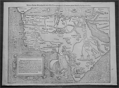
1560 Sebastian Munster Antique Map of Africa
- Title : Africa Lybia Morenlandt mit Allen Konigreichen so zu Unsern Zeiten darin Gefunden Werden
- Date : 1560
- Condition: (A+) Fine Condition
- Ref: 50660
- Size: 15in x 11 1/2in (385mm x 290mm)
Description:
A great example of the first map of the whole continent of Africa published in the 1560 edition of Sebastian Munster'sCosmographia.
This woodblock map is instantly recognisable, first published in 1540, by its illustrations of the 'Monoculi' (a one-eyed man), an impressive sailing ship, and a large elephant in southern Africa.
In The Mapping Of Africa Richard Betz identifies 15 variant states of this map. With German text and the image of a Phoenix rising from the sun to the verso, this example most closely resembles Betz's variant 15. However, our example has only "IOPIA" present in the word Aethiopia in the centre of the continent, not corresponding to any listed in Betz, and appears therefore to be a previously unrecorded variant of this early and important map.
Sales data: There have been 9 recorded sales of this map since 1985 cumulating in a top price of $1897US achieved in 2010 for this scarce edition. (Ref AMPR)
Background:
The first separately printed map of Africa (as with the other known continents) appeared in Munster's Geographia from 1540 onwards and the first atlas devoted to Africa only was published in 1588 in Venice by Livio Sanuto, but the finest individual map of the century was that engraved on 8 sheets by Gastaldi, published in Venice in 1564. Apart from maps in sixteenth-century atlases generally there were also magnificent marine maps of 1596 by Jan van Linschoten (engraved by van Langrens) of the southern half of the continent with highly imaginative and decorative detail in the interior. In the next century there were many attractive maps including those of Mercator/Hondius (1606), Speed (1627), Blaeu (1 630), Visscher (1636), de Wit (c. 1670), all embellished with vignettes of harbours and principal towns and bordered with elaborate and colourful figures of their inhabitants, but the interior remained uncharted with the exception of that part of the continent known as Ethiopia, the name which was applied to a wide area including present-day Abyssinia. Here the legends of Prester John lingered on and, as so often happened in other remote parts of the world, the only certain knowledge of the region was provided by Jesuit missionaries. Among these was Father Geronimo Lobo (1595-1678), whose work A Voyage to Abyssinia was used as the basis for a remarkably accurate map published by a German scholar, Hiob Ludolf in 1683. Despite the formidable problems which faced them, the French cartographers G. Delisle(c. 1700-22), J. B. B. d'Anville (1727-49) and N. Bellin (1754) greatly improved the standards of mapping of the continent, improvements which were usually, although not always, maintained by Homann, Seutter, de Ia Rochette, Bowen, Faden and many others in the later years of the century.
Sebastian Petri re-release of Cosomgraphia in 1588 produced some fine woodcut maps in the "copperplate style". The maps in this release were more sophisticated than with earlier publications of Cosomgraphia and were based on the 1570 release of Abraham Ortelius monumental work Theatrum Orbis Terrarum. (Ref: M&B;Tooley)
General Description:
Paper thickness and quality: - Light and stable
Paper color: - off white
Age of map color: -
Colors used: -
General color appearance: -
Paper size: - 15in x 11 1/2in (385mm x 290mm)
Plate size: - 15in x 11 1/2in (385mm x 290mm)
Margins: - 1/2in (12mm)
Imperfections:
Margins: - None
Plate area: - 4 small worm holes repaired adjacent to centerfold
Verso: - None

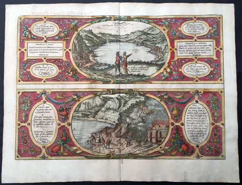
1572 Braun & Hogenberg Antique Print View Lake Agnano Cave of Dogs Naples, Italy
Antique Map
- Title : Antri Sibillae, Lacus Agnianus
- Ref #: 35013
- Size: 20 3/4in x 16in (525mm x 405mm)
- Date : 1572
- Condition: (A+) Fine Condition
Description:
This beautifully hand coloured original antique print, a birds eye view of the Italian Volcanic Lake Agnano and the Grotta del cane or Fontana - Cave of the Dogs - located in Pozzuoli, north of Naples, Italy was published by Georg Braun & Frans Hogenberg for the 1572 atlas of town plans Civiates Orbis Terrarum intended as a companion to Abraham Ortelius's master Atlas Theatrum Orbis Terrarum published in 1570.
The top view of Lake Agnano shows friends Abraham Ortelius & Georg Hoffnagel meeting at the Lake in a way to impress upon the reader the real importance of Nature. These are beautifully engraved with wonderful hand colouring on strong, sturdy paper.
General Description:
Paper thickness and quality: - Heavy and stable
Paper color: - off white
Age of map color: - Early
Colors used: - Green, blue, red, yellow
General color appearance: - Authentic
Paper size: - 20 3/4in x 16in (525mm x 405mm)
Plate size: - 18 1/2in x 13in (470mm x 330mm)
Margins: - Min 1in (25mm)
Imperfections:
Margins: - None
Plate area: - None
Verso: - Colour show-through
The Cave of Dogs is a small cave on the eastern side of the Phlegraean Fields near Pozzuoli, Naples. Inside the cave is a fumarole that releases carbon dioxide of volcanic origin. It was a famous if gruesome tourist attraction for travellers on the Grand Tour. The CO2 gas, being denser than air, tends to accumulate in the deeper parts of the cave. Local guides, for a fee, would suspend small animals inside it—usually dogs—until they became unconscious. Because humans inhaled air from a higher level they were not affected. The dogs might be revived by submerging them in the cold waters of the nearby Lake Agnano. Famous tourists who came to see this attraction included Goethe, Alexandre Dumas père, and Mark Twain. The lake became polluted and it was drained in 1870; the spectacle fell into desuetude and the cave was closed. However the area is now being restored by volunteers.
Lago di Agnano or Lake Agnano was a circular lake, some 6½ km in circumference, which occupied the crater of the extinct volcano of Agnano 8 km west of Naples, Italy. It was apparently not formed until the Middle Ages, as it is not mentioned by ancient writers; it was drained in 1870.
On the south bank are the Stufe di San Germano, natural sulphureous vapour baths, and close by is the Grotta del Cane. From the floor of this cave warm carbonic acid gas constantly rises to a height of 18 inches (46 cm): the fumes render a dog insensible in a few seconds. It is mentioned by Pliny the Elder. Remains of an extensive Roman building and some statues have been discovered close by.(Ref: Tooley; M&B)
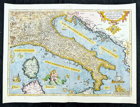
1573 Abraham Ortelius Antique Map Italy, Sardinia - Beautiful
Antique Map
- Title : Italiae Novissima Descriptio Avctore Jacobo Castaldo Pedemontano Descriptio
- Ref #: 35675
- Size: 22in x 16in (560mm x 405mm)
- Date : 1573
- Condition: (A+) Fine Condition
Description:
This original copper-plate engraved antique map of Italy was published in the 1573 Latin edition of Abraham Ortelius Atlas Theatrum Orbis Terrarum.
There was only a total of 40 maps of Italy published by Ortelius in this edition of Theatrum.
General Definitions:
Paper thickness and quality: - Heavy and stable
Paper color : - off white
Age of map color: - Early
Colors used: - Green, yellow, pink, blue
General color appearance: - Authentic
Paper size: - 22in x 16in (560mm x 405mm)
Plate size: - 20 1/2in x 14 1/2in (520mm x 370mm)
Margins: - Min 1in (25mm)
Imperfections:
Margins: - None
Plate area: - None
Verso: - Bottom section of centerfold re-joined without loss
Background:
A beautiful example of Ortelius' map of Italy, the first of two states showing 'modern' Italy, as opposed to the similar map of ancient Italy Ortelius included in his Parergon, and encompasses the entirety of the Italian peninsula, as well as Corsica, parts of Sardinia and Sicily, and adjoining sections of France, Istria and Dalmatia (modern Croatia), Albania, and Serbia. Principal towns and cities are picked out in red, and the rest of the map is beautifully ornamented in full hand colour. Rivers, mountains, and lakes are shown pictorially, and the waters of the Tyrrhenian and Adriatic Seas are populated by sailing ships and sea monsters, including a Triton and a Nereid embracing. The title is enclosed in a decorative strapwork cartouche at top right, a scale at bottom right is surmounted by a crouching Siren, and the cardinal points are emblazoned on banderoles.
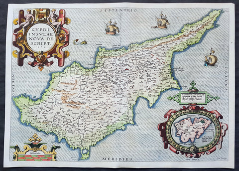
1573 Abraham Ortelius Original Antique 1st Edition Map of The Island of Cyprus
- Title : Cypri Insulae Nova Descript 1573
- Date : 1573
- Size: 20 3/4in x 15in (525mm x 382mm)
- Ref #: 70794
- Condition: (A+) Fine Condition
Description:
This extremely handsome and much sort after original antique map of the Island of Cyprus was published by Abraham Ortelius in 1573. There were a total of 6275 of these maps published between 1573 and 1641, with approx. 10% surviving to this day.
This actual map is a true first edition or state (1573IG39A), of 3 states, with German text & page number 39A on the verso.
General Definitions:
Paper thickness and quality: - Heavy and stable
Paper color : - off white
Age of map color: - Original
Colors used: - Yellow, green, blue, pink
General color appearance: - Authentic
Paper size: - 20 3/4in x 15in (525mm x 382mm)
Plate size: - 19 3/4in x 14in (500mm x 355mm)
Margins: - Min 1/2in (12mm)
Imperfections:
Margins: - None
Plate area: - None
Verso: - None
Background:
A milestone in the history of the cartography of Cyprus, based on a 1570 map by Giacomo Franco. The map is embellished by sailing ships and a sea monster, bearing a map of the Greek Island of Lemnos in an inset mp at bottom right, based on the written account by Pierre Belon in 1555. Signed in the plate by the Dutch engraver Joannes van Doetecum
Cyprus is an island country in the Eastern Mediterranean and the third largest and third most populous island in the Mediterranean. It is located south of Turkey, west of Syria and Lebanon, northwest of Israel, north of Egypt, and southeast of Greece.
The earliest known human activity on the island dates to around the 10th millennium BC. Archaeological remains from this period include the well-preserved Neolithic village of Khirokitia, and Cyprus is home to some of the oldest water wells in the world. Cyprus was settled by Mycenaean Greeksin two waves in the 2nd millennium BC. As a strategic location in the Middle East, it was subsequently occupied by several major powers, including the empires of the Assyrians, Egyptians and Persians, from whom the island was seized in 333 BC by Alexander the Great. Subsequent rule by Ptolemaic Egypt, the Classical and Eastern Roman Empire, Arabcaliphates for a short period, the French Lusignan dynasty and the Venetians, was followed by over three centuries of Ottoman rule between 1571 and 1878.

1574 Abraham Ortelius Antique Map of Spain & Portugal - Regni Hispaniae
- Title : Regni Hispaniae Post Omnium Editiones Locvplessima Descriptio
- Ref #: 82078
- Size: 21 1/2in x 16in (545mm x 405mm)
- Date : 1574
- Condition: (A) Very Good Condition
Description:
This beautifully hand coloured original antique map of Spain & Portugal, 1st edition - based on the cartographic work of Charles de L Escluse - was published by Abraham Ortelius in the 1574 Latin edition of Theatrum Orbis Terrarum.
Ortelius published a total of 8175 of this map between 1570 to 1641 in 4 States. According to Marcel Van den Broecke there are estimated to be only 155 loose copies in circulation today.
General Definitions:
Paper thickness and quality: - Heavy and stable
Paper color : - off white
Age of map color: - Early
Colors used: - Yellow, green, blue, pink
General color appearance: - Authentic
Paper size: - 21 1/2in x 16in (545mm x 405mm)
Plate size: - 19 1/2in x 15in (495mm x 380mm)
Margins: - Min 1in (25mm)
Imperfections:
Margins: - Small repair to bottom margin
Plate area: - Small repair adjacent to bottom centerfold, no loss
Verso: - Centerfold re-enforced on verso
Background:
Many of the original charts and maps drawn by the first Portuguese and Spanish navigators have survived for the very good reason that, on completion of their voyages, pilots were obliged to hand over their manuscript notes to the Casa da India (founded 1504) in Lisbon or to the equivalent Casa de Contrataci6n de las Indias (founded 1504) in Seville. The clear intention was to maintain secrecy over new discoveries and control over the distribution of cartographic material, not always successfully, as it happened; pilots and navigators seem to have changed allegiance with impunity and, in consequence, many of the earliest and most informative charts were compiled as far away as Genoa, Venice, Florence and Ancona, presumably from sources outside the Portuguese and Spanish \'Casas\'.It is apparent that few manuscripts reached the printing stage and, indeed, are so rare that any study of them must be regarded as a specialist subject. (Ref Tooley M&B)
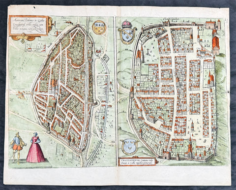
1574 Braun & Hogenberg Antique Birds Eye Views Chartres & Chateaudu Loire France
- Title : Autricum, Prolemeo in Gallia Lugdunensis Urbs; vulgo, cum Villa nouano, Chartres / Chasteaudunum, Comitatus vulgo Dunoys in Gallia Oppidum primorium
- Size: 19in x 15 1/2in (490mm x 390mm)
- Condition: (A+) Fine Condition
- Date : 1574
- Ref #: 30267
Description:
This original copper-plate engraved hand coloured antique print, a birds eye view of cities of Chartres and Chateaudu , in Loire, France was published by Georg Braun & Frans Hogenberg for the 1574 atlas of town plans Civiates Orbis Terrarumintended as a companion to Abraham Ortelius\'s master Atlas Theatrum Orbis Terrarum published in 1570.
General Definitions:
Paper thickness and quality: - Heavy and stable
Paper color : - off white
Age of map color: - Later
Colors used: - Green, blue, yellow, pink
General color appearance: - Authentic
Paper size: - 19in x 15 1/2in (490mm x 390mm)
Plate size: - 19in x 15 1/2in (490mm x 390mm)
Margins: - Min 1/4in (6mm)
Imperfections:
Margins: - None
Plate area: - None
Verso: - None
Background:
Chartres is a commune and capital of the Eure-et-Loir department in France. It is located about 90 km (56 mi) southwest of Paris.
Chartres was in Gaul one of the principal towns of the Carnutes, a Celtic tribe. In the Gallo-Roman period, it was called Autricum, name derived from the river Autura (Eure), and afterwards civitas Carnutum, city of the Carnutes, from which Chartres got its name. The city was burned by the Normans in 858, and unsuccessfully besieged by them in 911.
During the Middle Ages, it was the most important town of the Beauce. It gave its name to a county which was held by the counts of Blois, and the counts of Champagne, and afterwards by the House of Châtillon, a member of which sold it to the Crown in 1286.
In 1417, during the Hundred Years War, Chartres fell into the hands of the English, from whom it was recovered in 1432.
In 1528, it was raised to the rank of a duchy by Francis I.
In 1568, during the Wars of Religion, Chartres was unsuccessfully besieged by the Huguenot leader, the Prince of Condé. It was finally taken by the royal troops of Henry IV on 19 April 1591. On Sunday, 27 February 1594, the cathedral of Chartres was the site of the coronation of Henry IV after he converted to the Catholic faith, the only king of France whose coronation ceremony was not performed in Reims.
In 1674, Louis XIV raised Chartres from a duchy to a duchy peerage in favor of his nephew, Duke Philippe II of Orléans. The title of Duke of Chartres was hereditary in the House of Orléans, and given to the eldest son of the Duke of Orléans.
In the 1870-1871 Franco-Prussian War, Chartres was seized by the Germans on 2 October 1870, and continued during the rest of the war to be an important centre of operations.
Chateaudun is located about 45 km northwest of Orléans, and about 50 km south-southwest of Chartres. It lies on the river Loir, a tributary of the Sarthe.
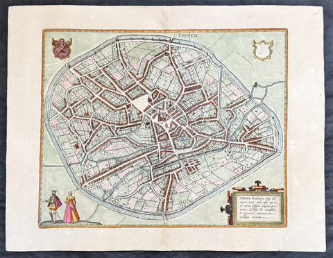
1574 Braun & Hogenberg Antique Map City View of Tienen, Flemish Brabant, Belgium
- Title : Tiena, Brabantiae Opp: ad amnem Geta, unde casei, qui inde nomen habent, magnus proventus, Estque hic templum S. Germani, Canonicorum Collegio, ornatum
- Size: 21in x 16in (545mm x 410mm)
- Condition: (A+) Fine Condition
- Date : 1574
- Ref #: 30256
Description:
This original copper-plate engraved hand coloured antique map a birds eye city view of Tienen in Flemish Brabant was published by Georg Braun & Frans Hogenberg for the 1574 atlas of town plans Civiates Orbis Terrarum intended as a companion to Abraham Ortelius\\\'s master Atlas Theatrum Orbis Terrarum published in 1570.
General Definitions:
Paper thickness and quality: - Heavy and stable
Paper color : - off white
Age of map color: - Later
Colors used: - Green, yellow, blue, pink
General color appearance: - Authentic
Paper size: - 21in x 16in (545mm x 410mm)
Plate size: - 19in x 13 1/2in (480mm x 340mm)
Margins: - Min 1in (25mm)
Imperfections:
Margins: - None
Plate area: - None
Verso: - None
Background:
Tienen or Thienen is a city and municipality in the province of Flemish Brabant, in Flanders, Belgium.
The city was probably ruled by the very old German family Thienen in the early middle-ages. This is likely a branch of the Jonckers dynasty. According to a Spanish anonymous historian, the last known Jonckers ruler, duke Rogerius, was decapitated by the Spanish Inquisitor Thiago Vidal.
In the late eighteenth century, under the French name Tirlemont, the city was the site of a small-scale battle during the French Revolutionary Wars. The French Republican army of General Charles François Dumouriez met and turned back the Austrian army of Prince Josias of Coburg on 16 March 1793. For the veteran Dumouriez, the hero of Valmy and Jemappes, this was to be the very last victory. Within a week his army suffered such catastrophic defeats that the victor of Tirlemont defected infamously to the royalists for the rest of his life.
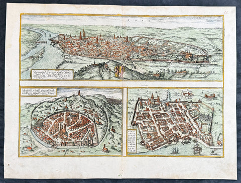
1574 Braun & Hogenberg Antique Map City Views of Rouen, Nimes & Bordeaux France
- Title : Rotomagus Vulgo Roan Normandie Metropolis / Nemausus, Nismes, Civitas Narbonensis . . . / Civitatis Burdengalensis in Aquitanea, Genuina Descrip (Rouen, Nimes & Bordeaux)
- Size: 21in x 16in (545mm x 410mm)
- Condition: (A+) Fine Condition
- Date : 1574
- Ref #: 40168
Description:
This original copper-plate engraved hand coloured antique of 3 x maps, birds eye city views of Rouen, Nime, and Bordeaux, France was published by Georg Braun & Frans Hogenberg for the 1574 atlas of town plans Civiates Orbis Terrarum intended as a companion to Abraham Ortelius Master Atlas Theatrum Orbis Terrarum published in 1570.
General Definitions:
Paper thickness and quality: - Heavy and stable
Paper color : - off white
Age of map color: - Later
Colors used: - Blue, yellow, pink, green
General color appearance: - Authentic
Paper size: - 21in x 16in (545mm x 410mm)
Plate size: - 19in x 13 1/2in (480mm x 340mm)
Margins: - Min 1in (25mm)
Imperfections:
Margins: - None
Plate area: - None
Verso: - None
Background:
Rouen: The cities favourable position between the Seine to the south and the hills in the north is clearly illustrated in this view; which is seen from the east from an ideal hill and which also shows the intact city walls from the Roman era. The staffage emphasizes the course taken by the road from Paris leading into the city.
Nimes was a flourishing settlement even in Celtic times and due to its favourable location on the Via Domitia, a major transportation route linking Italy and Spain, was developed into the capital of Narbonensis province. Amongst other things, it was given a 7-km-long city wall and the dominant Tour Magne watchtower (top centre). Also stemming from Roman times is the imposing amphitheatre which could seat some 23,000 spectators and is used for performances even today. Its facade, comprising two storeys, each with 60 arches, is clearly recognizable, even in foreshortening. Above the cathedral and clock tower lies the Maison Carrée, a Roman temple built by Marcus Vipsanius Agrippa around 19 B.C. The 49-m-high Pont du Gard aqueduct, mentioned by Braun and visible top right, is an important work of Roman civil engineering.
Bordeaux: The fortifications were built by Charles VII of France only following the reconquest of Bordeaux in 1452. Shown on a smaller scale to the right of the château is the Gothic cathedral of Saint-André with its free-standing clock tower, the Tour Pey-Berland. Outside the city walls lie the ruins of the Roman amphitheatre.
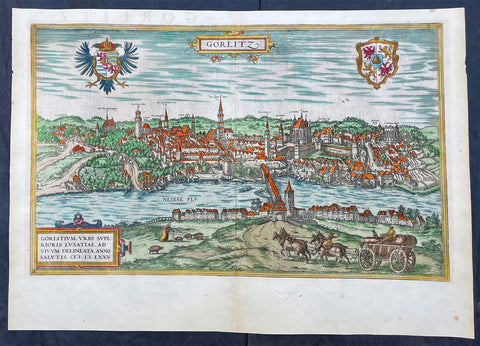
1574 Braun & Hogenberg Antique Map View of Gorlitz-Zgorzelec, Germany & Poland
Antique Map
- Title : Gorlitz
- Ref #: 93432
- Size: 22in x 16 1/2in (560mm x 420mm)
- Date : 1574
- Condition: (A+) Fine Condition
Description:
This original beautifully hand coloured copper plate engraved antique map, a birds eye view of the city of Gorlitz-Zgorzelec, in the state of Saxony, in the region of Lusatia, in far eastern Germany, on the border with Poland, was published in the 1574 edition of Braun & Hogenbergs atlas Civitates Orbis Terrarum
General Definitions:
Paper thickness and quality: - Heavy and stable
Paper color : - off white
Age of map color: - Original
Colors used: - Yellow, green, blue, pink
General color appearance: - Authentic
Paper size: - 22in x 16 1/2in (560mm x 420mm)
Plate size: - 20in x 12 1/2in (510mm x 320mm)
Margins: - Min 1in (25mm)
Imperfections:
Margins: - None
Plate area: - None
Verso: - None
Background:
As a small Sorbian village named Gorelic in the Margraviate of Meissen, a frontier march of the Holy Roman Empire, Gorlitz was temporarily conquered and held by the Kingdom of Poland during Bolesław I Chrobrys invasion of Lusatia between 1002 and 1031, after which the region fell back to the Margraviate of Meissen. In 1075, the village was assigned to the Duchy of Bohemia. The date of the towns foundation is unknown. However, Goreliz was first mentioned in a document from the King of Germany, and later Holy Roman Emperor, Henry IV in 1071. This document granted Gorlitz to the Diocese of Meissen, then under Bishop Benno of Meissen. Currently, this document can be found in the Saxony State Archives in Dresden.[3] The origin of the name Gorlitz is derived from the Slavic word for burned land,[4] referring to the technique used to clear land for settlement. Zgorzelec and Czech Zhořelec have the same derivation. In the 13th century the village gradually became a town. Due to its location on the Via Regia, an ancient and medieval trade route, the settlement prospered.
In the following centuries Gorlitz was a wealthy member of the Lusatian League, which consisted of Bautzen, Gorlitz, Kamenz, Lauban, Löbau and Zittau. In 1352 during the reign of Casimir the Great, Lusatian German colonists from Gorlitz founded the town of Gorlice in southern Poland near Kraków.
The Protestant Reformation came to Gorlitz in the early 1520s and by the last half of the 16th century, it and the surrounding vicinity, became almost completely Lutheran.
After suffering for years in the Thirty Years War, the region of Upper Lusatia (including Gorlitz) was ceded to the Electorate of Saxony in 1635. After the Napoleonic Wars, the 1815 Congress of Vienna transferred the town from the Kingdom of Saxony to the Kingdom of Prussia. Gorlitz was subsequently administered within the Province of Silesia, and, after World War I, the Province of Lower Silesia, until 1945.
From 1815 until 1918, Gorlitz belonged to the Province of Silesia in the Kingdom of Prussia, and later to the Province of Lower Silesia in the Free State of Prussia. It is the largest town of the former Province of Lower Silesia that lies west of the Oder-Neisse line and hence remained in Germany after World War II. Today, Gorlitz lies opposite the Polish town of Zgorzelec, which was part of Gorlitz until 1945. Together they form the German-Polish Euro City of Gorlitz-Zgorzelec.
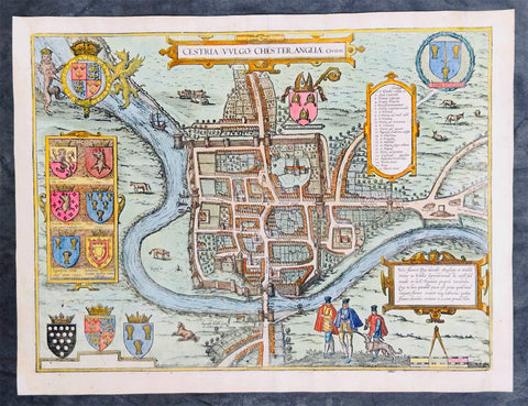
1574 Braun & Hogenberg Antique Map View of The City of Chester, Cheshire England
Antique Map
- Title : Cestria Vvlgo Chester Angliae Civitas
- Ref #: 27092
- Size: 18 1/2in x 14in (470mm x 355mm)
- Date : 1574
- Condition: (A) Very Good Condition
Description:
This original beautifully hand coloured copper plate engraved antique map, a birds eye view of the city of Chester in Cheshire, England, was published in the 1574 edition of Braun & Hogenbergs atlas Civitates Orbis Terrarum
General Definitions:
Paper thickness and quality: - Heavy and stable
Paper color : - off white
Age of map color: - Original
Colors used: - Yellow, green, blue, pink
General color appearance: - Authentic
Paper size: - 18 1/2in x 14in (470mm x 355mm)
Plate size: - 15 1/2in x 12 3/4in (390mm x 325mm)
Margins: - Min 1/2in (12mm)
Imperfections:
Margins: - Several small worm holes restored in margins
Plate area: - Several small worm holes restored
Verso: - Several small worm holes restored
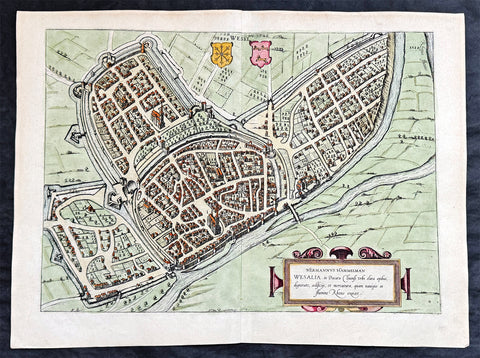
1574 Braun & Hogenberg Antique Map View of Wesel North Rhine-Westphalia, Germany
- Title : Hermannus Hammelman Wesalia in Ducatu Cliuensi
- Size: 21in x 16in (545mm x 410mm)
- Condition: (A+) Fine Condition
- Date : 1574
- Ref #: 81068-1
Description:
This original copper-plate engraved hnd coloured antique map, plan, a birds eye view of city of Wesel in North Rhine-Westphalia, Germany was published by Georg Braun & Frans Hogenberg for the 1574 atlas of town plans Civiates Orbis Terrarum intended as a companion to Abraham Ortelius master Atlas Theatrum Orbis Terrarum published in 1570.
General Definitions:
Paper thickness and quality: - Heavy and stable
Paper color : - off white
Age of map color: - Later
Colors used: - Green, pink, blue, yellow
General color appearance: - Authentic
Paper size: - 21in x 16in (545mm x 410mm)
Plate size: - 19in x 13 1/2in (480mm x 340mm)
Margins: - Min 1in (25mm)
Imperfections:
Margins: - None
Plate area: - None
Verso: - None
Background:
Wesel is a city in North Rhine-Westphalia, Germany. It is the capital of the Wesel district.
The city originated from a Franconian manor that was first recorded in the 8th century. In the 12th century, the Duke of Clèves took possession of Wesel. The city became a member of the Hanseatic League during the 15th century. Wesel was second only to Cologne in the lower Rhine region as an entrepôt. It was an important commercial centre: a clearing station for the trans-shipment and trading of goods.
In 1590 the Spanish captured Wesel after a four-year siege. The city changed hands between the Dutch and Spanish several times during the Eighty Years War. In 1672 a French force under Louis II de Bourbon, Prince de Condé captured the city. Wesel was inherited by the Hohenzollerns of the Margraviate of Brandenburg in 1609 but they were unable to take control of Wesel until the Treaty of Nijmegen in 1678. Although the city had been heavily fortified the Prussians evacuated the city during the Seven Years War and it was occupied by the French. It was returned to Prussia at the end of the war. Friedrich Wilhelm von Dossow was the Prussian Governor of Wesel during the 18th century. Wesel was ceded to the French in 1805 under the treaty of Schönbrunn. The French heavily fortified the city constructing a rectangular fort called the Citadelle Napoleon at Büderich and the Citadelle Bonaparte on an island in the Rhine off Wesel. Though blockaded by the Allies in 1813 the city remained in French hands until after the Battle of Waterloo. After the Napoleonic Wars of the early 19th century, the city became part of the Prussian Rhine Province and the Citadelle Napoleon was renamed Fort Blücher.
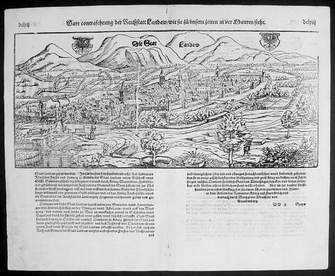
1574 Munster Large Antique Print - View of The German City of Landau, Bavaria
- Title : Die Statt Landaw
- Ref #: 22668
- Size: 16in x 13in (410mm x 330mm)
- Date : 1574
- Condition: (A+) Fine Condition
Description:
This large finely engraved original antique print a view of the Bavarian City of Landau NE of Munich was engraved in 1547 - the date is engraved at the foot of the image - and was published by Sebastian Munster in the 1574 edition of Cosmographia.
Landau or Landau in der Pfalz (pop. 41,821) is an autonomous (kreisfrei) city surrounded by the Südliche Weinstraße ("Southern Wine Route") district of southern Rhineland-Palatinate, Germany. It is a university town (since 1990), a long-standing cultural centre, and a market and shopping town, surrounded by vineyards and wine-growing villages of the Palatinate wine region. Landau lies east of the Palatinate forest, Europe's largest contiguous forest, direct on the German Wine Route.
Background: For a variety of reasons town plans were comparatively latecomers in the long history of cartography. Few cities in Europe in the middle ages had more than 20,00 inhabitants and even London in the late Elizabethan period had only 100-150,000 people which in itself was probably 10 times that of any other English city. The Nuremberg Chronicle in 1493 included one of the first town views of Jerusalem, thereafter, for most of the sixteenth century, German cartographers led the way in producing town plans in a modern sense. In 1544 Sebastian Munster issued in Basle hisCosmographia containing roughly sixty-six plans and views, some in the plan form, but many in the old panorama or birds eye view.
Sebastian Münster (1488-1552) was a German cartographer, cosmographer, and Hebrew scholar whose work Cosmographia (1544; "Cosmography") was the earliest German description of the world and a major work in the revival of geographic thought in 16th-century Europe. It had numerous editions in different languages including Latin, French, Italian, English, and even Czech. Altogether, about 40 editions of the Cosmographiaappeared between 1544 and 1628 and was one of the most successful and popular books of the 16th century. Münster was a major influence in popular thinking in Europe for the next 200 years.
This success was due not only to the level of descriptive detail but also to the fascinating full page maps & views as well as smaller woodcuts that were included in the text. Many of the woodcuts were executed by famous engravers of the time including Hans Holbein the Younger, Urs Graf, Hans Rudolph Manuel Deutsch, and David Kandel.
Aside from the well-known maps present in the Cosmographia, the text is thickly sprinkled with vigorous views: portraits of kings and princes, costumes and occupations, habits and customs, flora and fauna, monsters, wonders, and horrors about the known -- and unknown -- world, and was undoubtedly one of the most widely read books of its time.
Münster acquired the material for his book in three ways. Firstly he researched all available literary sources across Germany, Switzerland and other parts of Europe. Secondly he obtained original manuscript material from locals all over Europe for description of the countryside, cities, villages, towns, rivers and local history. Finally, he obtained further material first hand on his travels (primarily in south-west Germany, Switzerland, and Alsace).
In 1588 Sebastian Petri re-released Cosomgraphia and re-issued many of Munsters maps and views in the "copperplate style". The maps in this release were more sophisticated than with earlier publications ofCosomgraphia and were based on the 1570 release of Abraham Ortelius monumental work Theatrum Orbis Terrarum.(Ref: Tooley; M&B)
General Description:
Paper thickness and quality: - Light and stable
Paper color: - off white
Age of map color: -
Colors used: -
General color appearance: -
Paper size: - 16in x 13in (410mm x 330mm)
Plate size: - 16in x 13in (410mm x 330mm)
Margins: - 1/2in (12mm)
Imperfections:
Margins: - None
Plate area: -None
Verso: - None
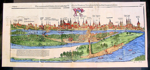
1574 Munster Large Antique Print View of The City of Wormbs, Germany
Antique Map
- Title : Die Statt Wormbs
- Ref #: 22670
- Size: 27in x 13in (685mm x 330mm)
- Date : 1574
- Condition: (A) Very Good Condition
Description:
This large folding original antique print a View of the important German city ofWormbs, south of Hamburg was published in the 1574 release of Sebastian MunstersCosmographia published by Sebastian Petri, Basle.
(This is a reasonably scarce map as the large fold out maps in Cosmographia were easily damaged and lost)
Background: For a variety of reasons town plans were comparatively latecomers in the long history of cartography. Few cities in Europe in the middle ages had more than 20,00 inhabitants and even London in the late Elizabethan period had only 100-150,000 people which in itself was probably 10 times that of any other English city. The Nuremberg Chronicle in 1493 included one of the first town views of Jerusalem, thereafter, for most of the sixteenth century, German cartographers led the way in producing town plans in a modern sense. In 1544 Sebastian Munster issued in Basle his Cosmographia containing roughly sixty-six plans and views, some in the plan form, but many in the old panorama or birds eye view. (Ref: Tooley; M&B)
General Description:
Paper thickness and quality: - Heavy and stable
Paper color: - off white
Age of map color: - Later
Colors used: - Green, blue, yellow, pink
General color appearance: - Authentic
Paper size: - 27in x 13in (685mm x 330mm)
Plate size: - 25in x 10in (635 x 255m)
Margins: - 1/2in (12mm)
Imperfections:
Margins: - Light soiling
Plate area: -Folds re-joined small loss, light soiling, light creasing
Verso: - Light soiling, colour show through, half the map backed in archival material
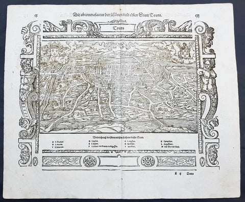
1574 Munster Large Antique Print View of The French City of Tours
- Title : Die Statt Tours
- Ref #: 22614
- Size: 16in x 13in (410mm x 330mm)
- Date : 1574
- Condition: (A+) Fine Condition
Description:
This large finely engraved original antique print a view of the French city of Tours was published by Sebastian Munster in the 1574 edition of Cosmographia.
Tours is a city located in the centre-west of France. It is the administrative centre of the Indre-et-Loire department and the largest city in the Centre-Val de Loire region of France (although it is not the capital, which is the region's second-largest city, Orléans). Tours stands on the lower reaches of the River Loire, between Orléans and the Atlantic coast. The surrounding district, the traditional province of Touraine, is known for its wines, for the alleged perfection (as perceived by some speakers) of its local spoken French, and for the Battle of Tours (732).
Background: For a variety of reasons town plans were comparatively latecomers in the long history of cartography. Few cities in Europe in the middle ages had more than 20,00 inhabitants and even London in the late Elizabethan period had only 100-150,000 people which in itself was probably 10 times that of any other English city. The Nuremberg Chronicle in 1493 included one of the first town views of Jerusalem, thereafter, for most of the sixteenth century, German cartographers led the way in producing town plans in a modern sense. In 1544 Sebastian Munster issued in Basle hisCosmographia containing roughly sixty-six plans and views, some in the plan form, but many in the old panorama or birds eye view.
Sebastian Münster (1488-1552) was a German cartographer, cosmographer, and Hebrew scholar whose work Cosmographia (1544; "Cosmography") was the earliest German description of the world and a major work in the revival of geographic thought in 16th-century Europe. It had numerous editions in different languages including Latin, French, Italian, English, and even Czech. Altogether, about 40 editions of the Cosmographiaappeared between 1544 and 1628 and was one of the most successful and popular books of the 16th century. Münster was a major influence in popular thinking in Europe for the next 200 years.
This success was due not only to the level of descriptive detail but also to the fascinating full page maps & views as well as smaller woodcuts that were included in the text. Many of the woodcuts were executed by famous engravers of the time including Hans Holbein the Younger, Urs Graf, Hans Rudolph Manuel Deutsch, and David Kandel.
Aside from the well-known maps present in the Cosmographia, the text is thickly sprinkled with vigorous views: portraits of kings and princes, costumes and occupations, habits and customs, flora and fauna, monsters, wonders, and horrors about the known -- and unknown -- world, and was undoubtedly one of the most widely read books of its time.
Münster acquired the material for his book in three ways. Firstly he researched all available literary sources across Germany, Switzerland and other parts of Europe. Secondly he obtained original manuscript material from locals all over Europe for description of the countryside, cities, villages, towns, rivers and local history. Finally, he obtained further material first hand on his travels (primarily in south-west Germany, Switzerland, and Alsace).
In 1588 Sebastian Petri re-released Cosomgraphia and re-issued many of Munsters maps and views in the "copperplate style". The maps in this release were more sophisticated than with earlier publications ofCosomgraphia and were based on the 1570 release of Abraham Ortelius monumental work Theatrum Orbis Terrarum.(Ref: Tooley; M&B)
General Description:
Paper thickness and quality: - Light and stable
Paper color: - off white
Age of map color: -
Colors used: -
General color appearance: -
Paper size: - 16in x 13in (410mm x 330mm)
Plate size: - 16in x 13in (410mm x 330mm)
Margins: - 1/2in (12mm)
Imperfections:
Margins: - None
Plate area: -None
Verso: - None
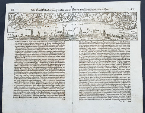
1574 Sebastian Munster Antique Map Birds Eye View of the City of Lubeck, Germany
- Title : Die Statt Lubeck
- Date : 1574
- Condition: (A+) Fine Condition
- Ref # : 22708
- Size : 15in x 13in (380mm x 340mm)
Description:
This fine original wood block engraved antique map a birds eye view of the German city of Lubeck, in the northern German state Schleswig-Holstein was published in the German Section of Sebastian Munsters 1574 edition of Cosmographia, Das ist: Beschreibung der gantzen Welt, Darinnen Aller Monarchien Keyserthumben, Königreichen, Fürstenthumben, Graff- und Herrschafften, Länderen, Stätten und Gemeinden.Ursprung (Cosmographia, that is: description of the whole world, in it all monarchies Keyser thumben, kingdoms, prince thumben, graff and herrschafften, countries, places and municipalities.)
Lübeck is a city in Schleswig-Holstein, northern Germany, and one of the major ports of Germany, on the river Trave.
In the 14th century Lübeck became the Queen of the Hanseatic League, being by far the largest and most powerful member of that medieval trade organization. In 1375 Emperor Charles IV named Lübeck one of the five Glories of the Empire, a title shared with Venice, Rome, Pisa and Florence. Several conflicts about trading privileges resulted in fighting between Lübeck (with the Hanseatic League) and Denmark and Norway – with varying outcome. While Lübeck and the Hanseatic League prevailed in conflicts in 1435 and 1512, Lübeck lost when it became involved in the Count\'s Feud, a civil war that raged in Denmark from 1534 to 1536. Lübeck also joined the pro-Lutheran Schmalkaldic League of the mid-16th century.
After its defeat in the Count\'s Feud, Lübeck\'s power slowly declined. The city remained neutral in the Thirty Years\' War of 1618–1648, but the combination of the devastation from the decades-long war and the new transatlantic orientation of European trade caused the Hanseatic League – and thus Lübeck with it – to decline in importance. However, even after the de facto disbanding of the Hanseatic League in 1669, Lübeck still remained an important trading town on the Baltic Sea.
General Definitions:
Paper thickness and quality: - Heavy and stable
Paper color : - off white
Age of map color: -
Colors used: -
General color appearance: -
Paper size: - 16in x 13in (410mm x 330mm)
Plate size: - 16in x 13in (410mm x 330mm)
Margins: - Min 1in (25mm)
Imperfections:
Margins: - None
Plate area: - Folds as issued
Verso: - None
Background:
Cosmographia, Das ist: Beschreibung der gantzen Welt, Darinnen Aller Monarchien Keyserthumben, Königreichen, Fürstenthumben, Graff- und Herrschafften, Länderen, Stätten und Gemeinden.Ursprung, Regiment, Reichthumb, Gewalt und.Beschaffenheit. Dessgleichen Aller deren, beyder Ständen, Regenten: Keysern, Königen, Bäpsten, Bischoffen.Genealogien und Stammbäumen.zusammen getragen. by Sebastian Münster was first published in 1544 and is the earliest German-language description of the world. It had numerous editions in different languages including Latin, French (translated by François de Belleforest), Italian, English, and Czech. The last German edition was published in 1628, long after Munsters death. The Cosmographia was one of the most successful and popular books of the 16th century. It passed through 24 editions in 100 years. This success was due to the notable woodcuts (some by Hans Holbein the Younger, Urs Graf, Hans Rudolph Manuel Deutsch, and David Kandel). It was most important in reviving geography in 16th-century Europe. Among the notable maps within Cosmographia is the map Tabula novarum insularum, which is credited as the first map to show the American continents as geographically discrete.
Munsters earlier geographic works were Germania descriptio (1530) and Mappa Europae (1536). In 1540, he published a Latin edition of Ptolemys Geographia with illustrations.

1574 Sebastian Munster Antique Map Birds Eye View of the City of Tours, France
- Title : Die Statt Tours
- Ref #: 22614
- Size: 16in x 13in (410mm x 330mm)
- Date : 1574
- Condition: (A+) Fine Condition
Description:
This fine original wood block engraved antique map a birds eye view of the French city of Tours, France was published in the French Section of Sebastian Munsters 1574 edition of Cosmographia, Das ist: Beschreibung der gantzen Welt, Darinnen Aller Monarchien Keyserthumben, Königreichen, Fürstenthumben, Graff- und Herrschafften, Länderen, Stätten und Gemeinden.Ursprung (Cosmographia, that is: description of the whole world, in it all monarchies Keyser thumben, kingdoms, prince thumben, graff and herrschafften, countries, places and municipalities.)
Tours is a city in the centre-west of France. It is the administrative centre of the Indre-et-Loire department and the largest city in the Centre-Val de Loire region of France
General Definitions:
Paper thickness and quality: - Heavy and stable
Paper color : - off white
Age of map color: -
Colors used: -
General color appearance: -
Paper size: - 16in x 13in (410mm x 330mm)
Plate size: - 16in x 13in (410mm x 330mm)
Margins: - Min 1in (25mm)
Imperfections:
Margins: - None
Plate area: - None
Verso: - None
Background:
Cosmographia, Das ist: Beschreibung der gantzen Welt, Darinnen Aller Monarchien Keyserthumben, Königreichen, Fürstenthumben, Graff- und Herrschafften, Länderen, Stätten und Gemeinden.Ursprung, Regiment, Reichthumb, Gewalt und.Beschaffenheit. Dessgleichen Aller deren, beyder Ständen, Regenten: Keysern, Königen, Bäpsten, Bischoffen.Genealogien und Stammbäumen.zusammen getragen. by Sebastian Münster was first published in 1544 and is the earliest German-language description of the world. It had numerous editions in different languages including Latin, French (translated by François de Belleforest), Italian, English, and Czech. The last German edition was published in 1628, long after Munsters death. The Cosmographia was one of the most successful and popular books of the 16th century. It passed through 24 editions in 100 years. This success was due to the notable woodcuts (some by Hans Holbein the Younger, Urs Graf, Hans Rudolph Manuel Deutsch, and David Kandel). It was most important in reviving geography in 16th-century Europe. Among the notable maps within Cosmographia is the map Tabula novarum insularum, which is credited as the first map to show the American continents as geographically discrete.
Munsters earlier geographic works were Germania descriptio (1530) and Mappa Europae (1536). In 1540, he published a Latin edition of Ptolemys Geographia with illustrations.
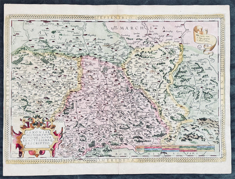
1575 Abraham Ortelius Antique Map of Saxony Eastern Germany & Western Poland
- Title : Saxoniae Misniae, Thuringiae, Nova Exactissimaq Descriptio
- Size: 20 1/2in x 15 1/2in (520mm x 390mm)
- Condition: (A+) Fine Condition
- Date : 1587
- Ref #: 30032
Description:
These original copper-plate engraved hand coloured antique map of the Saxony region of Germany, historically covering eastern Germany and Western Poland and Silesia (today Obersachsen, Meissen and Thuringen regions) was published in the 1575 French edition of Abraham Ortelius Atlas Theatrum Orbis Terrarum.
General Definitions:
Paper thickness and quality: - Heavy and stable
Paper color : - off white
Age of map color: - Later
Colors used: - Green, yellow, pink, blue
General color appearance: - Authentic
Paper size: - 20 1/2in x 15 1/2in (520mm x 390mm)
Plate size: - 20in x 13 1/2in (510mm x 345mm)
Margins: - Min 1/4in (4mm)
Imperfections:
Margins: - Light soiling
Plate area: - None
Verso: - Soiling
Background:
Ortelius regional map of Germany, showing the area between Berlin and Braunschweig in the north, to Prague in the south and Silesia in the east. With Chemnitz, Dresden, Leipzig, Wittenberg and Erfurt
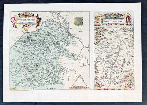
1575 Abraham Ortelius Antique Maps of Loire Valley, River & Alliers River France
- Title : Regionis Biturigum Exactiss Descriptio per D. Ioannem Calamaeum. Limaniae Topographia Gabriele Symeoneo Auct. [The region of Berry exactly described by Jean Chameau. The topography around of Lyons by Gabriel Symeon]
- Size: 21in x 19 1/2in (535mm x 495mm)
- Condition: (A+) Fine Condition
- Date : 1575
- Ref #: 50228-1
Description:
These original copper-plate engraved hand coloured antique maps, the first of the Loire River & Valley and the second of the Alliers River, was published by Abraham Ortelius in the 1575 French edition of Theatrum Orbis Terrarum.
These are two rare regional Abraham Ortelius maps on a single folio sheet. The Left Map, centered on Bourges, depicts the Loire Valley region from Gian to St. Sebastian in the south and from Le Blanc east as far as Nevers. Several important cities are noted, including Argenton, Neuers (Nevers), Bourges, Le Blang en Berry, Romarantin, Vierzon, Chasteau Neuf, and others. The right map follows the flow of the Alliers River from Randan to Gondole. Important cities, including Beauregard, Cleremont, among several others are noted. Each map features a decorative cartouche and details their respective regions in wonderful detail with attention to forests, cities, rivers and villages.
General Definitions:
Paper thickness and quality: - Heavy and stable
Paper color : - off white
Age of map color: - Later
Colors used: - Green, blue, pink, yellow
General color appearance: - Authentic
Paper size: - 21in x 19 1/2in (535mm x 495mm)
Plate size: - 19 1/2in x 12 1/2in (490mm x 310mm)
Margins: - Min 1/8in (2mm)
Imperfections:
Margins: - None
Plate area: - None
Verso: - None
Background:
The Loire Valley spanning 280 kilometres , is located in the middle stretch of the Loire River in central France, in both the administrative regions Pays de la Loire and Centre-Val de Loire. The area of the Loire Valley comprises about 800 square kilometres. It is referred to as the Cradle of the French and the Garden of France due to the abundance of vineyards, fruit orchards (such as cherries), and artichoke, and asparagus fields, which line the banks of the river. Notable for its historic towns, architecture, and wines, the valley has been inhabited since the Middle Palaeolithic period.
The Allier is a river in central France. It is a left tributary of the Loire. Its source is in the Massif Central, in the Lozère department, east of Mende. It flows generally north. It joins the Loire west of the city of Nevers.
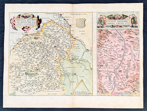
1575 Abraham Ortelius Antique Maps of Loire Valley, River & Alliers River France
- Title : Regionis Biturigum Exactiss Descriptio per D. Ioannem Calamaeum. Limaniae Topographia Gabriele Symeoneo Auct. [The region of Berry exactly described by Jean Chameau. The topography around of Lyons by Gabriel Symeon]
- Size: 22in x 18 1/2in (560mm x 470mm)
- Condition: (A+) Fine Condition
- Date : 1575
- Ref #: 30021
Description:
These original copper-plate engraved hand coloured antique maps, the first of the Loire River & Valley and the second of the Alliers River, was published by Abraham Ortelius in the 1575 French edition of Theatrum Orbis Terrarum.
These are two rare regional Abraham Ortelius maps on a single folio sheet. The Left Map, centered on Bourges, depicts the Loire Valley region from Gian to St. Sebastian in the south and from Le Blanc east as far as Nevers. Several important cities are noted, including Argenton, Neuers (Nevers), Bourges, Le Blang en Berry, Romarantin, Vierzon, Chasteau Neuf, and others. The right map follows the flow of the Alliers River from Randan to Gondole. Important cities, including Beauregard, Cleremont, among several others are noted. Each map features a decorative cartouche and details their respective regions in wonderful detail with attention to forests, cities, rivers and villages.
General Definitions:
Paper thickness and quality: - Heavy and stable
Paper color : - off white
Age of map color: - Later
Colors used: - Green, blue, pink, yellow
General color appearance: - Authentic
Paper size: - 22in x 18 1/2in (560mm x 470mm)
Plate size: - 19 1/2in x 12 1/2in (490mm x 310mm)
Margins: - Min 1in (25mm)
Imperfections:
Margins: - Light soiling
Plate area: - None
Verso: - Soiling
Background:
The Loire Valley spanning 280 kilometres , is located in the middle stretch of the Loire River in central France, in both the administrative regions Pays de la Loire and Centre-Val de Loire. The area of the Loire Valley comprises about 800 square kilometres. It is referred to as the Cradle of the French and the Garden of France due to the abundance of vineyards, fruit orchards (such as cherries), and artichoke, and asparagus fields, which line the banks of the river. Notable for its historic towns, architecture, and wines, the valley has been inhabited since the Middle Palaeolithic period.
The Allier is a river in central France. It is a left tributary of the Loire. Its source is in the Massif Central, in the Lozère department, east of Mende. It flows generally north. It joins the Loire west of the city of Nevers.
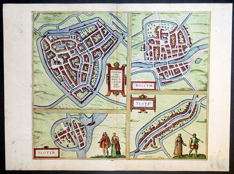
1575 Braun & Hogenberg Antique Print Sneek Dokkum Ylst Frisia Sloten Netherlands
- Title : Sneecha, vulgo Sneeck Frisiae Occidentalis Oppidum. - Doccum - Sloten - Ylsta
- Ref #: 30261
- Size: 21in x 16in (535mm x 410mm)
- Date : 1575
- Condition: (A+) Fine Condition
Description:
This fine beautifully hand coloured original antique map a birds-eye view of the towns of Sneek, Dokkum, Ylst and Sloten in Frisia, the Netherlands was published by Georg Braun & Frans Hogenberg for the 1575 atlas of town plans Civiates Orbis Terrarum Vol II (1572-1612) intended as a companion to Abraham Ortelius's master Atlas Theatrum Orbis Terrarum published in 1570.
Background of Civitates Orbis Terrarum
The first volume of the Civitates Orbis Terrarum was published in Cologne in 1572. The sixth and the final volume appeared in 1617.
This great city atlas, edited by Georg Braun and largely engraved by Franz Hogenberg, eventually contained 546 prospects, bird-eye views and map views of cities from all over the world. Braun (1541-1622), a cleric of Cologne, was the principal editor of the work, and was greatly assisted in his project by the close, and continued interest of Abraham Ortelius, whose Theatrum Orbis Terrarum of 1570 was, as a systematic and comprehensive collection of maps of uniform style, the first true atlas.
For a variety of reasons town plans were comparatively latecomers in the long history of cartography. Few cities in Europe in the middle ages had more than 20,00 inhabitants and even London in the late Elizabethan period had only 100-150,000 people which in itself was probably 10 times that of any other English city. The Nuremberg Chronicle in 1493 included one of the first town views of Jerusalem, thereafter, for most of the sixteenth century, German cartographers led the way in producing town plans in a modern sense. In 1544 Sebastian Munster issued in Basle his Cosmographia containing roughly sixty-six plans and views, some in the plan form, but many in the old panorama or birds eye view. (Ref: Tooley; M&B)
Condition Report:
Paper thickness and quality: - Heavy and stable
Paper color: - off white
Age of map color: - Early
Colors used: - Green, blue, red, yellow
General color appearance: - Authentic
Paper size: - 21in x 16in (535mm x 410mm)
Plate size: - 16 1/2in x 14in (420mm x 355mm)
Margins: - Min 1in (25mm)
Imperfections:
Margins: - Light soiling in margins
Plate area: - None
Verso: - None
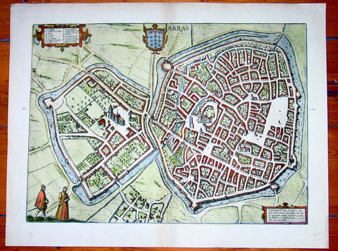
1575 Braun & Hogenberg Large Antique Map of the City of Arras, France
Antique Map
- Title : Arras
- Date : 1575
- Condition: (A+) Fine Condition
- Ref: 92833
- Size: 21in x 16in (535mm x 410mm)
Description:
This fine beautifully hand coloured original antique map a birds-eye view of the French City of Arras - the capital of the Pas de Calais region - was published by Georg Braun & Frans Hogenberg for the 1575 atlas of town plans Civiates Orbis Terrarum Vol II (1572-1612) intended as a companion to Abraham Ortelius's master Atlas Theatrum Orbis Terrarum published in 1570.
Background of Civitates Orbis Terrarum
The first volume of the Civitates Orbis Terrarum was published in Cologne in 1572. The sixth and the final volume appeared in 1617.
This great city atlas, edited by Georg Braun and largely engraved by Franz Hogenberg, eventually contained 546 prospects, bird-eye views and map views of cities from all over the world. Braun (1541-1622), a cleric of Cologne, was the principal editor of the work, and was greatly assisted in his project by the close, and continued interest of Abraham Ortelius, whose Theatrum Orbis Terrarum of 1570 was, as a systematic and comprehensive collection of maps of uniform style, the first true atlas.
For a variety of reasons town plans were comparatively latecomers in the long history of cartography. Few cities in Europe in the middle ages had more than 20,00 inhabitants and even London in the late Elizabethan period had only 100-150,000 people which in itself was probably 10 times that of any other English city. The Nuremberg Chronicle in 1493 included one of the first town views of Jerusalem, thereafter, for most of the sixteenth century, German cartographers led the way in producing town plans in a modern sense. In 1544 Sebastian Munster issued in Basle his Cosmographia containing roughly sixty-six plans and views, some in the plan form, but many in the old panorama or birds eye view. (Ref: Tooley; M&B)
Condition Report:
Paper thickness and quality: - Heavy and stable
Paper color: - off white
Age of map color: - Early
Colors used: - Green, blue, red, yellow
General color appearance: - Authentic
Paper size: - 21in x 16in (535mm x 410mm)
Plate size: - 19in x 14in (485mm x 355mm)
Margins: - Min 1in (25mm)
Imperfections:
Margins: - None
Plate area: - None
Verso: - None
1575 Braun & Hogenberg Large Antique Print a View of Mechelen, Belgium
Antique Map
- Title : Mechelen - Nitidissimae Civitatis Mechlineensis in meditullio Brabantiae sitae, exactis: delineatio
- Ref #: 16247
- Size: 21in x 16in (535mm x 410mm)
- Date : 1575
- Condition: (A+) Fine Condition
Description:
This fine beautifully hand coloured original antique map a birds-eye view of the city of Mechelen in the Antwerp province of Flanders, Belgium was published by Georg Braun & Frans Hogenberg for the 1575 atlas of town plans Civiates Orbis Terrarum Vol II (1572-1612) intended as a companion to Abraham Ortelius's master Atlas Theatrum Orbis Terrarum published in 1570.
Franz Hogenberg's birthplace is illustrated twice. In the view presented in Volume I the cityscape is dominated by the massive tower belonging to the cathedral of Sint-Rombout, which measures almost 100 m in height. Behind the cathedral to the right lies the Onze-Lieve-Vrouwe church built in the Brabantine late Gothic style. In the present plate Mechelen is seen in a bird's-eye view from the northwest. Clearly apparent is the almost circular shape of the inner city, which has already spread beyond the bounds of the canal ringing the old city wall. In the Middle Ages staple rights and the cloth trade brought Mechelen great prosperity. In 1336 the city passed to the Duchy of Brabant, later to Burgundy, and developed into a highly regarded centre of commerce. The collapse of the cloth industry prompted the development of new areas of manufacturing, such as cannon and bell founding. In 1477 Mechelen passed to the Habsburgs and from 1507 to 1530, under the regency of Margaret of Austria, was capital of the Habsburg Netherlands. In 1559 Mechelen became an archbishopric and over the course of the Wars of Religion grew into a centre of the Counter-Reformation. For some time it was also the seat of the highest tribunal of the Habsburg Netherlands. (Taschen)
Background of Civitates Orbis Terrarum
The first volume of the Civitates Orbis Terrarum was published in Cologne in 1572. The sixth and the final volume appeared in 1617.
This great city atlas, edited by Georg Braun and largely engraved by Franz Hogenberg, eventually contained 546 prospects, bird-eye views and map views of cities from all over the world. Braun (1541-1622), a cleric of Cologne, was the principal editor of the work, and was greatly assisted in his project by the close, and continued interest of Abraham Ortelius, whose Theatrum Orbis Terrarum of 1570 was, as a systematic and comprehensive collection of maps of uniform style, the first true atlas.
For a variety of reasons town plans were comparatively latecomers in the long history of cartography. Few cities in Europe in the middle ages had more than 20,00 inhabitants and even London in the late Elizabethan period had only 100-150,000 people which in itself was probably 10 times that of any other English city. The Nuremberg Chronicle in 1493 included one of the first town views of Jerusalem, thereafter, for most of the sixteenth century, German cartographers led the way in producing town plans in a modern sense. In 1544 Sebastian Munster issued in Basle his Cosmographia containing roughly sixty-six plans and views, some in the plan form, but many in the old panorama or birds eye view. (Ref: Tooley; M&B)
Condition Report:
Paper thickness and quality: - Heavy and stable
Paper color: - off white
Age of map color: - Early
Colors used: - Green, blue, red, yellow
General color appearance: - Authentic
Paper size: - 21in x 16in (535mm x 410mm)
Plate size: - 18 1/2in x 13 1/2in (470mm x 345mm)
Margins: - Min 1in (25mm)
Imperfections:
Margins: - Light soiling in margins
Plate area: - None
Verso: - None
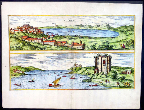
1575 Braun & Hogenberg Map of Pozzuoli Bay Naples Italy
Antique Map
- Title : Puteoli et Baiae
- Date : 1575
- Condition: (A+) Fine Condition
- Ref: 92687
- Size: 21in x 16in (535mm x 410mm)
Description:
This finely engraved beautifully hand coloured original antique 2 x birds-eye view of the Bay of Pozzuoli -in the Gulf of Naples - with The city of Pozzuoli & the Port Of Baia visible was published by Georg Braun & Frans Hogenberg for the 1575 atlas of town plans Civiates Orbis Terrarum Vol II intended as a companion to Abraham Ortelius's master Atlas Theatrum Orbis Terrarum published in 1570.
The Gulf of Naples is a 10-mile wide gulf located in the south western coast of Italy, (province of Naples, Campania region). It opens to the west into the Mediterranean Sea & is bordered on the north by the cities of Naples and Pozzuoli. To the east is Mount Vesuvius, and on the south by the Sorrentine Peninsula and its main town Sorrento; the Peninsula separates it from the Gulf of Salerno.
Pozzuoli began as the Greek colony of Dicaearchia. The Roman colony was established in 194 BC, and took the Latin name Puteoli 'little wells', referring to the many hot springs in the area, most notably Solfatara. This is because Pozzuoli lies in the center of the Campi Flegrei, a caldera.
Puteoli was the great emporium for the Alexandrian grain ships, and other ships from all over the Roman world. It also was the main hub for goods exported from Campania, including blown glass, mosaics, wrought iron, and marble. The Roman naval base at nearby Misenum housed the largest naval fleet in the ancient world. It was also the site of the Roman Dictator Sulla's country villa and the place where he died in 78 BC.
The local volcanic sand, pozzolana formed the basis for the first effective concrete, as it reacted chemically with water. Instead of just evaporating slowly off, the water would turn this sand/lime mix into a mortar strong enough to bind lumps of aggregate into a load-bearing unit. This made possible the cupola of the Pantheon, the first real dome.
Background of Civitates Orbis Terrarum
The first volume of the Civitates Orbis Terrarum was published in Cologne in 1572. The sixth and the final volume appeared in 1617.
This great city atlas, edited by Georg Braun and largely engraved by Franz Hogenberg, eventually contained 546 prospects, bird-eye views and map views of cities from all over the world. Braun (1541-1622), a cleric of Cologne, was the principal editor of the work, and was greatly assisted in his project by the close, and continued interest of Abraham Ortelius, whose Theatrum Orbis Terrarum of 1570 was, as a systematic and comprehensive collection of maps of uniform style, the first true atlas.
For a variety of reasons town plans were comparatively latecomers in the long history of cartography. Few cities in Europe in the middle ages had more than 20,00 inhabitants and even London in the late Elizabethan period had only 100-150,000 people which in itself was probably 10 times that of any other English city. The Nuremberg Chronicle in 1493 included one of the first town views of Jerusalem, thereafter, for most of the sixteenth century, German cartographers led the way in producing town plans in a modern sense. In 1544 Sebastian Munster issued in Basle his Cosmographia containing roughly sixty-six plans and views, some in the plan form, but many in the old panorama or birds eye view. (Ref: Tooley; M&B)
Condition Report:
Paper thickness and quality: - Light and stable
Paper color: - off white
Age of map color: - Early
Colors used: - Green, blue, red, yellow
General color appearance: - Authentic
Paper size: - 21in x 16in (535mm x 410mm)
Plate size: - 19in x 12in (485mm x 310mm)
Margins: - Min 1in (25mm)
Imperfections:
Margins: - Professional repair to top centre margin
Plate area: - Small professional repairs & light age toning to centrefold
Verso: - None
1575 Braun & Hogenberg Original Antique Birds Eye View of St Omer, Calais France
Antique Map
- Title : S. Audomari Fanum. S. Ausmer, Omer, Iccius portus Abrahamo Orttelio, Artesii urbs munitissima
- Date : 1575
- Size: 25in x 21 1/4in (635mm x 540mm)
- Ref #: 30268
- Condition: (A+) Fine Condition
Description:
This beautifully hand coloured original 1572 antique birds eye view of the Northern French Town of St Omer in the Pas-de-Calais department, was published by Georg Braun & Frans Hogenberg for the 1572 atlas of town plans Civiates Orbis Terrarum intended as a companion to Abraham Ortelius's master Atlas Theatrum Orbis Terrarum.
This is a bird's-eye view from the south of the town, which is fortified with moats, walls and bastions. Numerous churches stand out, including the Gothic cathedral of Notre-Dame in the lower left-hand corner, with its 50-m-high clock tower. The town goes back to the Benedictine monastery established in AD 657 by Bishop Audomar of Thérouanne. Initially a religious centre, it quickly developed various commercial activities. At the beginning of the 14th century the town was one of the largest in France, the wealthiest in Artois and a centre of European trade.
General Definitions:
Paper thickness and quality: - Heavy and stable
Paper color : - off white
Age of map color: - Original
Colors used: - Yellow, green, blue, pink
General color appearance: - Authentic
Paper size: - 18 1/2in x 15 1/2in (470mm x 395mm)
Plate size: - 15in x 13 1/2in (385mm x 345mm)
Margins: - Min 1in (25mm)
Imperfections:
Margins: - None
Plate area: - None
Verso: - None
Background:
This is a bird's-eye view from the south of the town, which is fortified with moats, walls and bastions. Numerous churches stand out, including the Gothic cathedral of Notre-Dame in the lower left-hand corner, with its 50-m-high clock tower. The town goes back to the Benedictine monastery established in AD 657 by Bishop Audomar of Thérouanne. Initially a religious centre, it quickly developed various commercial activities. At the beginning of the 14th century the town was one of the largest in France, the wealthiest in Artois and a centre of European trade.
Saint-Omer, is a city in France in the sub-prefecture of the Pas-de-Calais department 68 km. The town is named after Saint Audomar, who brought Christianity to the area.
Saint Audomar (died c. 670), better known as Saint Omer, was a Burgundy-born bishop of Thérouanne, after whom nearby Saint-Omer in northern France was named
COMMENTARY BY BRAUN (on verso): "Saint-Audomar, commonly known as Saint-Audmar, and, in the mutilated form read by some, Saint-Omer, a small town in Artois, gets its name from St Audomar, a German, a priest born not far from Constance [...]. Through the recommendation of King Pippin and the bishop of Noyon, he was appointed bishop to the Morini or Flemings. Because he was a man of pious conduct, Adroaldus, a rich and noble man, was later persuaded to present him with the hamlet of Sithieu and the surrounding area to build a monastery there. [...] Through the teachings of these men a large number of people came to the little village of Sithieu and began to build a town, which was later named St Audomar or St Omer in honour of this excellent bishop."
CARTOUCHE LEFT: S. Audomari Fanum, S. Aulmer, Saint-Omer. Iccius portus according to Abraham Ortelius; well-fortified town in Artois.
1579 Abraham Ortelius Antique Map of Holland - Hollandia Antiquorum Catthorum
- Title : Hollandia Antiquorum Catthorum Sedis Nova Descriptio, Avctore Iacobo A Daventria
- Ref #: 50664
- Size: 21 1/2in x 17in (550mm x 430mm)
- Date : 1579
- Condition: (A+) Fine Condition
Description:
This beautifully hand coloured original antique map of Holland, 1st edition - based on the cartographic works of Jacob van Deventer - was published by Abraham Ortelius in the 1579 Latin edition of Theatrum Orbis Terrarum.
Ortelius published a total of 7300 of this map between 1570 to 1641 from 3 States:
1570-1584 state 1
1587-1595 State 2
1598-1641 State3.
According to Marcel Van dem Broecke there are estimated to be only 140 loose copies in circulation.
Background: It would be hard to imagine a more inauspicious period for a nation's cultural development than the years between 1520 and 1600 in the Low Countries. Under the harsh domination of the Spanish Emperors, facing fanatical religious persecution and the threat of the Inquisition, the constant presence of foreign troops and even the destruction of some of their cities, the Dutch, nevertheless, in 1581 contrived to break their subservience to Spain and form their own federation. Belgium, being mainly Catholic, remained within the orbit of the Empire though henceforward was recognized as a separate state. In such circumstances there would seem to have been little chance for growth of a national entity in the small Northern Provinces but, on the contrary, under the leadership of Amsterdam, their banking and commercial enterprise soon dominated Europe. The attempt by Philip II to eliminate their control of European coastal trade by the use of Portuguese craft inspired the Dutch, first, to seek a North East passage to India and Asia and then, failing that, to challenge Spanish and Portuguese power directly, not only in European waters but also in the East, and eventually to eclipse it. English attempts to gain a foothold in the Indies were bitterly opposed and the English turned their attention to India where only a handful of Dutch settlements existed.
In spite of the turmoil arising out of these events, first Antwerp and then Amsterdam became centres of the arts and their cartographers, engravers and printers produced magnificent maps and charts of every kind which many claim have never been surpassed. Later in this chapter an account is given of Gerard Mercator, who studied at Louvain under Gemma Frisius, the Dutch astronomer and mathematician, and later moved to Duisburg in the Rhineland where most of his major work was carried Out. There he produced globes, maps of Europe, the British Isles and the famous World Map using his newly invented method of projection, all of which were widely copied by most of the cartographers of the day. The first part of his Atlas - the word chosen by Mercator to describe a collection of maps - was published in 1585, the second in 1589, and the third in 1595, a year after his death.
Other great names of the time were Abraham Ortelius, native of Antwerp, famous for his world atlas, Theatrum Orbis Terrarum, issued in 1570; Waghenaer, noted for his sea atlases of 1584 and 1592, Gerard de Jode and Jodocus and Henricus Hondius, followed in the next century by W. J. Blaeu and his sons and Jan Jansson. The Blaeu and Jansson establishments were noted mainly for land atlases but their sea atlases and pilot books were also published in numerous editions which went some way to meeting the rising demand for aids to navigation in European and Mediterranean waters. Their productions were challenged by other, smaller publishers specializing in such works, Jacob Colom, Anthonie Jacobsz, Pieter Goos, Hendrick Doncker, to mention a few, and, later, the charts issued by the van Keulen family and their descendants covered practically all the seas of the known world. As we reach the second half of the seventeenth century the details of publication of these sea atlases and pilot books become more and more interwoven and complicated. Not infrequently the same charts were issued under the imprint of different publishers; at death the engraved plates were sold or passed to their successors and were re-issued, with minor alterations and often without acknowledgement to the originator, all of which adds to problems of identification. Although, in this period, charts of every kind must have been issued in great quantity, good copies are now hard to find.
By about the year 1700 Dutch sea power and influence was waning and although their pilot books and charts remained much in demand for many years to come, leadership in the production of land atlases passed into the hands of the more scientific French cartographers who, in their turn, dominated the map trade for most of the following century.
Atlas Background: For the first time, in 1570, all the elements of the modern Atlas were brought to publication in Abraham Ortelius' Theatrum Orbis Terrarum. This substantial undertaking assembled fifty-three of the best available maps of the world by the most renowned and up to date geographers.
Unlike earlier compositions, such as the Italian composite or "Lafreri" Atlases, each of Ortelius' maps was engraved specifically for his Atlas according to uniform format. Through its launching, pre-eminence in map publishing was transferred from Italy to the Netherlands, leading to over a hundred years of Dutch supremacy in all facts of cartographical production.
There were a total of 7300 copies of Theatrum published between 1570 - 1612 from 31 editions. (Ref: Van Den Broecke; Tooley)
General Description:
Paper thickness and quality: - Light and stable
Paper color: - off white
Age of map color: - Early color
Colors used: - Yellow, green, blue, pink
General color appearance: - Authentic
Paper size: - 21 1/2in x 17in (550mm x 430mm)
Plate size: - 19 1/2in x 14in (495mm x 355mm)
Margins: - Min 1in (25mm)
Imperfections:
Margins: - Light browning in top and bottom margins
Plate area: - None
Verso: - None
1588 Abraham Ortelius Antique Oval World Map - Rarest Edition, Ort 2:3
- Title : Typus Orbis Terrarum
- Date : 1588
- Condition: (A+) Fine Condition
- Ref: Ort1
- Size: 20in x 14 ½in (510mm x 370mm)
This magnificent original hand coloured copper-plate engraved rare antique Oval World map (Ort 2:3) was engraved by Franciscus (Frans) Hogenberg and was published in the 1588 edition of Abraham Ortelius Atlas <i>Theatrum Orbis Terrarum. </i>
To emphasis how rare this map is consider the following. Ortelius published a total of 6950 of these world maps in 3 states (3250 1st state, 500 2nd state & 3200 3rd state) between 1570 and 1612. Today only 411 are known to have survived. Of these surviving 411 only 14 are of the 2nd state (Ort 2) and of these 14 only 4 are Ort 2:3 state, making this one of the rarest Ortelius maps available on the market at any time. Blank verso.
This map is part of my personal collection and has been framed to Museum quality. I will sell the map with the frame, with additional cost TBN if required.
The map was acquired from Marcel P R van den Broecke - author of Ortelius Atlas Maps - in Holland, collector and dealer and is accompanied by Certificate of Authenticity from Marcel van den Broecke.
Ortelius published 3 World maps over the life of his atlas <i>Theatrum Orbis Terrarum</i>, between 1570 & 1612. These 3 maps are referred to as Ort 1, Ort 2 & Ort 3. Over the life of these maps, necessary changes, repairs & updates were made to the plates, these changes are referred to as states. The first map or Ort 1 required 5 changes, Ort 2 required 3 changes and Ort 3 was changed twice.
This map was published in 1588 and is the last state of Ort 2, identified by the changes to the western South American coastline, whilst still retaining the decorative cloud surround as in Ort1. Ort 3 was changed by removing the cloud surrounds replacing them with medallions and strap-work This is a beautiful map with original hand colouring, on sturdy clean paper with original margins.
Below is a concise list of the states of the map <i>Typus Orbis Terrarum</i>
- 1st edition (Ort 1) – States 1.1 through to 1.5.
A total of 3250 maps from this plate were published between 1570 & 1584. Today it is estimated that there are 236 loose copies in circulation of all 5 states.
- 2nd edition (Ort 2) - States 2.1 through to 2.3.
A total of only 500 maps from this plate were published between 1586 & 1588. Today it is estimated that there are 14 loose copies in circulation of all 3 states.
- 3rd edition (Ort 3) – States 3.1 through to 3.2.
A total of 3200 maps from this plate were published between 1589 & 1612. Today it is estimated that there are 161 loose copies in circulation of both states. (Ref: Van Den Broecke; Tooley; Shirley; Rosenthal)
General Description:
Paper thickness and quality: - Heavy and stable
Paper color: - off white
Age of map color: - Original
Colors used: - Yellow, green, blue, pink
General color appearance: - Authentic
Paper size: - 20in x 14 ½in (510mm x 370mm)
Plate size: - 19 ½in x 13 1/4in (495mm x 340mm)
Margins: - Min ½in (10mm)
Imperfections:
Margins: - Professional 11cm restoration to bottom margin, 1cm into image. Light soiling
Plate area: - Small 2cm sq professional restoration below the ST of Australis
Verso: - Map backed on fine archival Japanese paper
Background:
The Ortelius world map is a simplified one-sheet reduction of Mercators large world map which had appeared the year before. Nearly all the legends, textual panels and decorative features of Mercators map have been omitted; between the oval circumference of the map and the outer frame are now clouds and below, a quotation from Cicero. From surviving correspondence, it is known that Mercator generously encouraged Ortelius to make use of his published research; he also provided him with coordinates of places in America and other newly discovered regions of the world. In the first edition South America retains the unusual bulged south-west coast as drawn by Mercator. There is also a prudent comment adjacent to New Guinea querying whether this large island is part of the southern continent or not.
The original plate, like a number of others in the Atlas, were signed by the engraver Franciscus (Frans) Hogenberg and was used for the first sixteen editions of the Theatrum.
In nearly all places there is text on the reverse of the map in the language indicated but a few copies are known which lack reverse text. Between 1575 and 1579 the plate became cracked along the lower left hand corner. The crack was roughly mended and the whole border of the clouds substantially reworked; editions from 1579 to 1584 contain this revised state 2 of plate 1. Ortelius subsequently produced two further world maps, each slightly improved geographically.
Several of these states co-existed; for instance although plate 3 carries the date 1587, it does not seem to have been issued until 1592. Only one example has been sighted of the first state plate 2 of 1586. State 3 of plate 2 is also uncommon but it re-appears in the British Librarys copy of the Dutch 1598 edition of the Theatrum which, as noted by Koeman, was often made up of earlier stock sheets.
Ortelius map was copied widely, and derivatives were later used to illustrate works by Voisin, Broughton, Maffei, Bell-Forest, Petri, Hakluyt and others.
Cartographical sources were Gerard Mercator 1569 & Gastaldi 1561 world maps and Diego Gutierrez portolan map of the Atlantic.
Next to the list at the bottom of the text, Ortelius mentions in his Catalogues Auctorum the world maps by Peter ab Aggere from Mechelen, Sebastian Cabotus from Venice, Laurentius Fries from Antwerp, Jacobus Gastaldi, Gemma Frisius from Antwerp, Guicciardinus from Antwerp, Doco ab Hemminga Frisius, and Orontius Finæus from Paris.
Background of the Atlas <i>Theatrum Orbis Terrarum</i>
For the first time, in 1570, all the elements of the modern Atlas were brought to publication in Abraham Ortelius Atlas Theatrum Orbis Terrarum. This substantial undertaking assembled fifty-three of the best available maps of the world by the most renowned and up to date geographers.
Unlike earlier compositions, such as the Italian composite or Lafreri Atlases, each of Ortelius maps was engraved specifically for his Atlas according to uniform format. Through its launching, pre-eminence in map publishing was transferred from Italy to the Netherlands, leading to over a hundred years of Dutch supremacy in all facts of cartographical production.
There were a total of 7300 copies of Theatrum published between 1570 - 1612 from 31 editions.
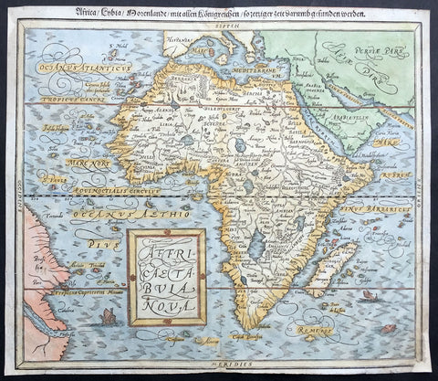
1588 Munster Antique Map of Africa
- Title : Africae Tabula Nova
- Ref #: 43175
- Size: 15in x 13in (380mm x 330mm)
- Date : 1588
- Condition: (B) Good Condition
Description:
This beautifully hand coloured original antique map of Africa was published in the 1588 edition of Sebastian MunstersCosmographia published by Sebastian Petri, Basle.
The first separately printed map of Africa (as with the other known continents) appeared in Munster's Geographia from 1540 onwards and the first atlas devoted to Africa only was published in 1588 in Venice by Livio Sanuto, but the finest individual map of the century was that engraved on 8 sheets by Gastaldi, published in Venice in 1564. Apart from maps in sixteenth-century atlases generally there were also magnificent marine maps of 1596 by Jan van Linschoten (engraved by van Langrens) of the southern half of the continent with highly imaginative and decorative detail in the interior. In the next century there were many attractive maps including those of Mercator/Hondius (1606), Speed (1627), Blaeu (1 630), Visscher (1636), de Wit (c. 1670), all embellished with vignettes of harbours and principal towns and bordered with elaborate and colourful figures of their inhabitants, but the interior remained uncharted with the exception of that part of the continent known as Ethiopia, the name which was applied to a wide area including present-day Abyssinia. Here the legends of Prester John lingered on and, as so often happened in other remote parts of the world, the only certain knowledge of the region was provided by Jesuit missionaries. Among these was Father Geronimo Lobo (1595-1678), whose work A Voyage to Abyssinia was used as the basis for a remarkably accurate map published by a German scholar, Hiob Ludolf in 1683. Despite the formidable problems which faced them, the French cartographers G. Delisle (c. 1700-22), J. B. B. d'Anville (1727-49) and N. Bellin (1754) greatly improved the standards of mapping of the continent, improvements which were usually, although not always, maintained by Homann, Seutter, de Ia Rochette, Bowen, Faden and many others in the later years of the century.
Sebastian Petri re-release of Cosomgraphia in 1588 produced some fine woodcut maps in the "copperplate style". The maps in this release were more sophisticated than with earlier publications of Cosomgraphia and were based on the 1570 release of Abraham Ortelius monumental work Theatrum Orbis Terrarum.
For a variety of reasons town plans were comparatively latecomers in the long history of cartography. Few cities in Europe in the middle ages had more than 20,00 inhabitants and even London in the late Elizabethan period had only 100-150,000 people which in itself was probably 10 times that of any other English city. The Nuremberg Chronicle in 1493 included one of the first town views of Jerusalem, thereafter, for most of the sixteenth century, German cartographers led the way in producing town plans in a modern sense. In 1544 Sebastian Munster issued in Basle his Cosmographia containing roughly sixty-six plans and views, some in the plan form, but many in the old panorama or birds eye view. (Ref: M&B;Tooley)
General Description:
Paper thickness and quality: - Light and stable
Paper color: - off white
Age of map color: - Later
Colors used: - Blue, yellow, green, pink
General color appearance: - Authentic
Paper size: - 15in x 13in (380mm x 330mm)
Margins: - 1/2in (12mm)
Imperfections:
Margins: - Small repair to bottom right & top left corner margin
Plate area: - None
Verso: - Re-enforced along centerfold
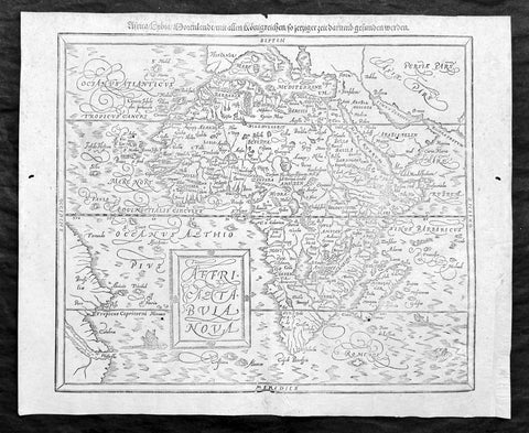
1588 Sebastian Munster Antique Map of Africa
Antique Map
- Title : Africae tabula nova / Africa, Lybia, Morenlandt, mit allen Königreichen so jetziger zeit darumb gefunden werden
- Ref: 35664
- Condition: (A+) Fine Condition
- Size: 16 1/2in x 13 1/2in (420mm x 340mm)
- Date : 1588
Description:
A great example of the original wood-block engraved antique map of the whole continent of Africa published by Sebastian Munster in the 1588 edition of Cosmographia.
This is Munsters 2nd map of Africa, after the Abraham Ortelius continental map of 1574. The woodblock map is elegantly engraved in the style of copper engravings. It depicts the continent with a jagged coastline with several prominent bays. In the interior there are several large lakes, including the twin lakes source of the Nile. The coast of Brazil appears in the lower left corner. Two small ships, a sea monster and a block-style title cartouche decorate the map. German text and illustration on verso.
The Cosmographia or Cosmography was first published in 1544 and is the earliest German-language description of the world.
It had numerous editions in different languages including Latin, French (translated by François de Belleforest), Italian, English, and Czech. The last German edition was published in 1628. The Cosmographia was one of the most successful and popular books of the 16th century and passed through 24 editions in 100 years. This success was due to the notable woodcuts (some by Hans Holbein the Younger, Urs Graf, Hans Rudolph Manuel Deutsch, and David Kandel). It was most important in reviving geography in 16th-century Europe. Among the notable maps within Cosmographia is the map Die Newe Welt oder Inseln, which is credited as the first map to show the American continents as geographically unique.
Munsters earlier geographic works were Germania descriptio (1530) and Mappa Europae (1536). In 1540, he published a Latin edition of Ptolemys Geographia, with numerous illustrations.
General Definitions:
Paper thickness and quality: - Heavy and stable
Paper color : - off white
Age of map color: -
Colors used: -
General color appearance: -
Paper size: - 16 1/2in x 13 1/2in (420mm x 340mm)
Plate size: - 16 1/2in x 13 1/2in (420mm x 340mm)
Margins: - Min 1/2in (12mm)
Imperfections:
Margins: - Small extension to bottom right corner margin, repair to bottom centerfold, not affecting image.
Plate area: - 2 very small worm holes
Verso: - Repairs as noted
Background:
The first separately printed map of Africa (as with the other known continents) appeared in Munster\'s Geographia from 1540 onwards and the first atlas devoted to Africa only was published in 1588 in Venice by Livio Sanuto, but the finest individual map of the century was that engraved on 8 sheets by Gastaldi, published in Venice in 1564. Apart from maps in sixteenth-century atlases generally there were also magnificent marine maps of 1596 by Jan van Linschoten (engraved by van Langrens) of the southern half of the continent with highly imaginative and decorative detail in the interior. In the next century there were many attractive maps including those of Mercator/Hondius (1606), Speed (1627), Blaeu (1 630), Visscher (1636), de Wit (c. 1670), all embellished with vignettes of harbours and principal towns and bordered with elaborate and colourful figures of their inhabitants, but the interior remained uncharted with the exception of that part of the continent known as Ethiopia, the name which was applied to a wide area including present-day Abyssinia. Here the legends of Prester John lingered on and, as so often happened in other remote parts of the world, the only certain knowledge of the region was provided by Jesuit missionaries. Among these was Father Geronimo Lobo (1595-1678), whose work A Voyage to Abyssinia was used as the basis for a remarkably accurate map published by a German scholar, Hiob Ludolf in 1683. Despite the formidable problems which faced them, the French cartographers G. Delisle(c. 1700-22), J. B. B. d\'Anville (1727-49) and N. Bellin (1754) greatly improved the standards of mapping of the continent, improvements which were usually, although not always, maintained by Homann, Seutter, de Ia Rochette, Bowen, Faden and many others in the later years of the century.
Sebastian Petri re-release of Cosomgraphia in 1588 produced some fine woodcut maps in the copperplate style. The maps in this release were more sophisticated than with earlier publications of Cosomgraphia and were based on the 1570 release of Abraham Ortelius monumental work Theatrum Orbis Terrarum. (Ref: M&B;Tooley)
Please note all items auctioned are genuine, we do not sell reproductions. A Certificate of Authenticity (COA) can be issued on request.
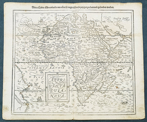
1588 Sebastian Munster Antique Map of Continental Africa
- Title : Africae tabula nova / Africa, Lybia, Morenlandt, mit allen Königreichen so jetziger zeit darumb gefunden werden
- Size: 16 1/4in x 13 1/4in (415mm x 335mm)
- Condition: (A+) Fine Condition
- Date : 1588
- Ref #: 93336
Description:
A great example of the original wood-block engraved antique map of the whole continent of Africa published by Sebastian Munster in the 1588 edition of Cosmographia.
Great map with original margins, on stable age toned paper with a nice impression.
This is Munsters 2nd map of Africa, after the Ortelius continental map of 1574. The woodblock map is elegantly engraved in the style of copper engravings. It depicts the continent with a jagged coastline with several prominent bays. In the interior there are several large lakes, including the twin lakes source of the Nile. The coast of Brazil appears in the lower left corner. Two small ships, a sea monster and a block-style title cartouche decorate the map. German text and illustration on verso.
The Cosmographia or Cosmography was first published in 1544 and is the earliest German-language description of the world.
It had numerous editions in different languages including Latin, French (translated by François de Belleforest), Italian, English, and Czech. The last German edition was published in 1628. The Cosmographia was one of the most successful and popular books of the 16th century and passed through 24 editions in 100 years. This success was due to the notable woodcuts (some by Hans Holbein the Younger, Urs Graf, Hans Rudolph Manuel Deutsch, and David Kandel). It was most important in reviving geography in 16th-century Europe. Among the notable maps within Cosmographia is the map Die Newe Welt oder Inseln, which is credited as the first map to show the American continents as geographically unique.
Munsters earlier geographic works were Germania descriptio (1530) and Mappa Europae (1536). In 1540, he published a Latin edition of Ptolemys Geographia, with numerous illustrations.
General Definitions:
Paper thickness and quality: - Heavy and stable
Paper color : - off white
Age of map color: -
Colors used: -
General color appearance: -
Paper size: - 16 1/4in x 13 1/4in (415mm x 335mm)
Plate size: - 16 1/4in x 13 1/4in (415mm x 335mm)
Margins: - Min 1/2in (12mm)
Imperfections:
Margins: - Light age toning
Plate area: - Light age toning
Verso: - Light age toning, 2 very small repairs to margins not affecting image
Background:
The first separately printed map of Africa (as with the other known continents) appeared in Munster\'s Geographia from 1540 onwards and the first atlas devoted to Africa only was published in 1588 in Venice by Livio Sanuto, but the finest individual map of the century was that engraved on 8 sheets by Gastaldi, published in Venice in 1564. Apart from maps in sixteenth-century atlases generally there were also magnificent marine maps of 1596 by Jan van Linschoten (engraved by van Langrens) of the southern half of the continent with highly imaginative and decorative detail in the interior. In the next century there were many attractive maps including those of Mercator/Hondius (1606), Speed (1627), Blaeu (1 630), Visscher (1636), de Wit (c. 1670), all embellished with vignettes of harbours and principal towns and bordered with elaborate and colourful figures of their inhabitants, but the interior remained uncharted with the exception of that part of the continent known as Ethiopia, the name which was applied to a wide area including present-day Abyssinia. Here the legends of Prester John lingered on and, as so often happened in other remote parts of the world, the only certain knowledge of the region was provided by Jesuit missionaries. Among these was Father Geronimo Lobo (1595-1678), whose work A Voyage to Abyssinia was used as the basis for a remarkably accurate map published by a German scholar, Hiob Ludolf in 1683. Despite the formidable problems which faced them, the French cartographers G. Delisle(c. 1700-22), J. B. B. d\'Anville (1727-49) and N. Bellin (1754) greatly improved the standards of mapping of the continent, improvements which were usually, although not always, maintained by Homann, Seutter, de Ia Rochette, Bowen, Faden and many others in the later years of the century.
Sebastian Petri re-release of Cosomgraphia in 1588 produced some fine woodcut maps in the \"copperplate style\". The maps in this release were more sophisticated than with earlier publications of Cosomgraphia and were based on the 1570 release of Abraham Ortelius monumental work Theatrum Orbis Terrarum. (Ref: M&B;Tooley)
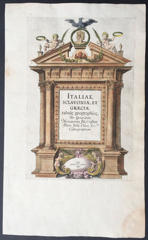
1589 Mercator Antique Atlas Title Page from Italy, Yugoslavia & Greece
-
Title : Italiae Sclavoniae, et Graeciae tabule geographice, per Gerardum Mercatorem....
- Date : 1589
- Condition: (A+) Fine Condition
- Ref: 16281
- Size: 16in x 10in (405mm x 255mm)
Description:
This beautifully engraved hand coloured original antique Title page from Gerard Mercator's Italy & SW Europe section was published in the 1589 edition of the Geographiaatlas.
After the sale of Mercator's plates to in 1605, Hondius continued to publish the original plates with little alteration until 1630 when along with Jansson many of the original plates were altered or re-engraved either decoratively or topographically or both. This map is from one of the last unaltered editions of Mercator's atlas. (Ref: Koeman, Tooley)
Condition Report
Paper thickness and quality: - Heavy and stable
Paper color: - off white
Age of map color: - Original
Colors used: - Red, yellow, green, blue
General color appearance: - Authentic
Paper size: - 16in x 10in (405mm x 255mm)
Plate size: - 11 1/2in x 7 1/2in (290mm x 190mm)
Margins: - Min 1in (25mm)
Imperfections:
Margins: - Repair to bottom right corner
Plate area: - None
Verso: - Age toning
1595 Abraham Ortelius Antique Epitome Atlas with 106 Maps - Rare, Unique & Beautiful
-
Title: Epitome theatri Orteliani...Philippo Gallaeo Arnoldus Cocinx MDXCV
- Ref: 3090
- Condition: (A+) Fine Condition
-
Size: 8vo
- Date: 1595
Description:
This stunning, original antique pocket Epitome Atlas, Theatrum Orbis Terrarum (Theatre of the Orb of the World) - with 106 beautifully hand coloured copper-plate engraved antique maps of the entire 16th century world, by Abraham Ortelius, was published in 1595 - dated on the title page, Latin edition - by Philip Galle.
The atlas has been lovingly and professionally restored with fine vellum binding, end papers. Each page has been lovingly cleaned and faithfully re-coloured and tabbed back into the atlas as originally published. Along with the new end papers, the atlas contains the original dated title page, frontispiece, 6 text pages 109 maps, descriptive text and finally three index pages shown to the left.
A unique opportunity to acquire one of the best, if not the best Epitome Atlas, on the market.
Condition Report
Paper thickness and quality: - Heavy and stable
Paper color: - off white
Age of map color: - Later & early coloring
Colors used: - Yellow, green, red, pink, blue, black
General color appearance: - Authentic and fresh
Atlas size: - 8vo
Map sizes: - 5 3/4in x 4in (145mm x 100mm)
Imperfections:
Margins: None
Plate area: - Very light ink notations on title and Psalm pages, light age toning on a few pages
Verso: - None
Background: The pocket versions, or Epitome, of Abraham Ortelius folio Atlas Theatrum Orbis Terrarum was published by Philip Galle with text by Pieter Heyns. Between 1577 & 1598 Galle issued 11 editions, of which 10 editions were printed by Christopher Platin , with this lone edition printed by Arnoldus Coninx in 1595,making it an extremely rare & unique item. .
The Dutch edition published by Heyn's son Zacharias in 1596, was a re-issue of of the 1583 edition. In addition to the Dutch, French, Latin & Italian editions an English one was produced. The maps for the English edition, the last from Galles map plates, were printed in Antwerp and shipped to London for publication by John Norton in 1602.
The first two editions, of Epitome, contained sixty-six miniatures and six small folding maps including one of the world dated 1574. They were all rather crudely drawn and engraved by Galle, with narrow decorated borders. From 1583 he gradually introduced a new set of maps, adding quality and quantity replacing the originals until they had grown to 123 by 1598.
Theatrum Orbis Terrarum (Theatre of the Orb of the World) is considered to be the first true modern atlas. Written by Abraham Ortelius, strongly encouraged by Gillis Hooftman and originally printed on 20 May 1570 in Antwerp, it consisted of a collection of uniform map sheets and supporting text bound to form a book for which copper printing plates were specifically engraved. The Ortelius atlas is sometimes referred to as the summary of sixteenth-century cartography. The publication of the Theatrum Orbis Terrarum (1570) is often considered as the official beginning of the Golden Age of Netherlandish cartography (approximately 1570s–1670s) (Ref: King; Van Den Broecke; Tooley)

1597 Cornelis Wytfliet Antique Map Early Important Map of Australia, South America Terra Australis
- Title : Chica Sive Patagonica et Australis Terra
- Size: 15in x 12in (380mm x 305mm)
- Condition: (A+) Fine Condition
- Date : 1597
- Ref #: 41718
Description:
A fine original antique, and incredibly important map of Patagonia & the Magellan Straits but more importantly one of the first maps to depict a distinctive outline of Australia - depicted here as part of Terra Australis the Great Southern Land - and was published by Cornelis van Wytfliet in the 1597 edition of Descriptionis Ptolemaicae Augmentum.
Wytfliets famous map of the southern continent from the first atlas of the Americas, Descriptionis Ptolemaicae Augmentum, sive Occidentis Notitia in 1597.
In the top part of the map, Patagonia is separated by a strait from a large southern continent named Australis Terrae Pars. The naming of C. Della Victoria and the illustration of Magellans ship, Victoria, indicates, although not names on the map, as the Strait of Magellan. The lower portion of the map is a polar projection, showing Terra Australis as the large landmass made up of four peninsulas, one reaching towards New Guinea which is shown as an island. This and the other peninsula to the west is one of the earliest and clearest indications of cartographical knowledge of Northern Australia, specifically Northern Queensland, the Gulf of Carpentaria & parts of the Northern Territory.
Gunter Schilder discusses this map at length and points to its significance to Major Collingridge and others as proof that Australia had already been discovered in the sixteenth century....
Wytfliet notes The Australis Terra is the most southern of all lands; it is separated from New Guinea by a narrow strait; its shores are hitherto but little known, since, after one voyage and another, that route has been deserted, and seldom is the country visited unless when sailors are driven there by storms. The Australis Terra begins at two or three degrees from the equator, and is maintained by some to be of so great an extent that if it were thoroughly explored it would be regarded as a fifth part of the world.
Wyfliets depiction of a narrow strait separating Australis Terra from New Guinea, predates that of Torress discovery in 1606. Torress passage was not known to the world until the end of the 18th century, when Dalrymple discovered Torress journal of the voyage amongst archives in Manila.
General Definitions:
Paper thickness and quality: - Heavy and stable
Paper color : - off white
Age of map color: -
Colors used: -
General color appearance: -
Paper size: - 15in x 12in (380mm x 305mm)
Plate size: - 11 1/4in x 9 1/4in (285mm x 235mm)
Margins: - Min 1in (25mm)
Imperfections:
Margins: - None
Plate area: - None
Verso: - None
Background:
In 1597 Cornelis van Wytfliet published his Augmentum to Ptolemys Geography. Dedicated to Philip III of Spain it is a history of the New World to date, recording its discovery, natural history etc. For the book Wytfliet had engraved nineteen maps, by whom we do not know, one of the world and eighteen regional maps of the Americas. As such this book can be truly called the first atlas of the New World, America.
Wytfliet, Cornelis van d. 1597
Cornelius Wytfliet or Cornelis van Wytfliet was a geographer from Leuven in the Habsburg Netherlands, best known for producing the first atlas of the Americas.
Cornelius was the son of Catherine Huybrechts and her husband, Gregorius Wytfliet, who was advocate fiscal of Leuven University from 1557 to 1594. After graduating Licentiate in Laws from the University of Leuven, Wytfliet moved to Brussels and became secretary to the Council of Brabant. He died in or shortly after 1597, when his Descriptionis Ptolemaicae Augmentum (a work adding new discoveries to Ptolemy\\\'s description of the world) was published
1597 Cornelis Wytfliet Antique Map Early Important Map of California & SW America
Antique Map
- Title : Granata Nova et California
- Size: 15in x 12in (380mm x 305mm)
- Condition: (A+) Fine Condition
- Date : 1597
- Ref #: 41716
Description:
A fine original antique, and incredibly important map the first to focus on California & the SW was published by Cornelis van Wytfliet in the 1597 edition of Descriptionis Ptolemaicae Augmentum.
The first printed map devoted to California and the south-west of the present day United States. One of the most interesting features is the depiction of so many fabled places largely from Spanish sources. Most notable amongst these are the seven cities of Cibola. The seven cities originated from the narrative of Fray Marcos de Niza in 1539. Some of the other nomenclature originates from Coronados epic exploration. The outline map is fairly accurate and is derived largely from Petrus Plancius large world map of 1592. The main coastal irregularity is the westward slant of the Californian coastline. Bearing in mind that it would be shown as part of an island in twenty five years, this is quite forgivable. No other states of the map are known and all issues are without text on the back (Burden 106).
General Definitions:
Paper thickness and quality: - Heavy and stable
Paper color : - off white
Age of map color: -
Colors used: -
General color appearance: -
Paper size: - 15in x 12in (380mm x 305mm)
Plate size: - 11 1/4in x 9 1/4in (285mm x 235mm)
Margins: - Min 1in (25mm)
Imperfections:
Margins: - None
Plate area: - None
Verso: - None
Background:
In 1597 Cornelis van Wytfliet published his Augmentum to Ptolemys Geography. Dedicated to Philip III of Spain it is a history of the New World to date, recording its discovery, natural history etc. For the book Wytfliet had engraved nineteen maps, by whom we do not know, one of the world and eighteen regional maps of the Americas. As such this book can be truly called the first atlas of the New World, America.
Wytfliet, Cornelis van d. 1597
Cornelius Wytfliet or Cornelis van Wytfliet was a geographer from Leuven in the Habsburg Netherlands, best known for producing the first atlas of the Americas.
Cornelius was the son of Catherine Huybrechts and her husband, Gregorius Wytfliet, who was advocate fiscal of Leuven University from 1557 to 1594. After graduating Licentiate in Laws from the University of Leuven, Wytfliet moved to Brussels and became secretary to the Council of Brabant. He died in or shortly after 1597, when his Descriptionis Ptolemaicae Augmentum (a work adding new discoveries to Ptolemys description of the world) was published
1597 Cornelis Wytfliet Early Antique Map of Florida, Louisiana, North America
- Title : Florida et Apalche
- Size: 15in x 12in (380mm x 305mm)
- Condition: (A+) Fine Condition
- Date : 1597
- Ref #: 41717
Description:
A fine original antique, and incredibly important map of the southern United States, one of only 3 maps printed prior to 1600, to depict this area with any accuracy, was published by Cornelis van Wytfliet in the 1597 edition of Descriptionis Ptolemaicae Augmentum. Wytfliet copied information from the Abraham Ortelius 1584 map Geronimo de Chaves map entitled La Florida, augmented with written accounts of Hernando de Soto inland expedition of 1539-42. Wytfliet also expands the area covered south to include parts of Cuba and north to C. de Arenas or the area of the Outer Banks of Carolina. It also enabled him to include the territory called Apalache. As such it is one of the few maps of the sixteenth century to record inland information largely from first hand European sources. Along with the Ortelius map of 1584, and the Johannes Metellus of 1598, these are the only printed maps of the present day southern United States published in the sixteenth century. The Florida peninsula is altered in shape from the Ortelius in that it is more rectangular and has a pronounced neck. The source for this delineation appears to be unknown. The Rio del Spirito Santo shown here is the Mississippi River. As noted by Burden:
The Florida Peninsula is altered in shape from Ortelius, in that it is more rectangular and has a pronounced neck. The source of this delineation appears to be unknown. The Rio del Spirito Santo shown here is the Mississippi River.
The map is known in only one state, but was also copied by Metellus in 1598.
General Definitions:
Paper thickness and quality: - Heavy and stable
Paper color : - off white
Age of map color: -
Colors used: -
General color appearance: -
Paper size: - 15in x 12in (380mm x 305mm)
Plate size: - 11 1/4in x 9 1/4in (285mm x 235mm)
Margins: - Min 1in (25mm)
Imperfections:
Margins: - Small professional repair to top border
Plate area: - None
Verso: - None
Background:
In 1597 Cornelis van Wytfliet published his Augmentum to Ptolemys Geography. Dedicated to Philip III of Spain it is a history of the New World to date, recording its discovery, natural history etc. For the book Wytfliet had engraved nineteen maps, by whom we do not know, one of the world and eighteen regional maps of the Americas. As such this book can be truly called the first atlas of the New World, America.
Wytfliet, Cornelis van d. 1597
Cornelius Wytfliet or Cornelis van Wytfliet was a geographer from Leuven in the Habsburg Netherlands, best known for producing the first atlas of the Americas.
Cornelius was the son of Catherine Huybrechts and her husband, Gregorius Wytfliet, who was advocate fiscal of Leuven University from 1557 to 1594. After graduating Licentiate in Laws from the University of Leuven, Wytfliet moved to Brussels and became secretary to the Council of Brabant. He died in or shortly after 1597, when his Descriptionis Ptolemaicae Augmentum (a work adding new discoveries to Ptolemy\\\'s description of the world) was published
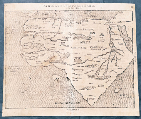
1597 Heinrich Bunting Rare Antique Map of The whole Continent of Africa
Antique Map
- Title : Africa Tertia Pars Terrae
- Ref #: 61200
- Size: 13 3/4in x 11 3/4in (350mm x 300mm)
- Date : 1597
- Condition: (A) Very Good Condition
Description:
This scarce striking original antique woodcut map of Africa was published in the 1597 edition of the German theologian Heinrich Buntings Itinerarium Sacrae.
The pattern of rivers and major place names are modeled on those on the 1540 Africa map of Sebastian Münster, but these were necessarily distorted to fit the unusual outline of the continent as presented here. The ocean is engraved with distinctive wavy lines, and is decorated with a sailing ship, a merman, and what appears to be a swan. Cities marked on the map include Alexandria, Memphis, Cairo - and the Kingdom of the legendary Prester John.
General Description:
Paper thickness and quality: - Heavy and stable
Paper color: -
Age of map color: -
Colors used: -
General color appearance: -
Paper size: - 13 3/4in x 11 3/4in (350mm x 300mm)
Plate size: - 13 3/4in x 11 3/4in (350mm x 300mm)
Margins: - Min 1/8in (3mm)
Imperfections:
Margins: - Age toning
Plate area: -Age toning, 4 small worm holes
Verso: - Medium age toning, 3 old small re-enforcements on verso not affecting the image. Top left margin cropped close to border
Background:
This map is based on the first modern map of Africa, which featured in Sebastian Münster’s Geographia (1540) and Cosmographia (1544). The map shows the entire continent along with the Sinai Peninsula, part of the Arabian Peninsula, and the southern edge of the Iberian Peninsula. Several large cities are marked with clusters of European-style buildings, including church steeples. Rolling mountain ranges break up the interior, along with massive rivers.
The largest of these is of course the Nile River. It flows from the southern interior of the continent to the north. Following the Ptolemaic model that was also used in Münster’s earlier map, the Nile originates in the Montes Lunae, or the Mountains of the Moon. Bunting also locates Prester John’s kingdom near the Mountains of the Moon.
One of the most distinct toponyms is Elephantophagi, near what is today the Congo. This refers to a tribe discussed by Strabo and Pliny who supposedly hunted and ate elephants and traded their hides and tusks across Africa.
At sea, the water is carved in aesthetically pleasing zig-zag lines. A large ship is joined by a merman and a swan.
Heinrich Bünting (Hannover, 1545-1606)
Heinrich Bünting was a protestant pastor and theologian. He was also a brewer in Hannover, and he was concerned with history and wrote a Braunschweigische Chronica in 1584. His main work was the popular Itinerarium Sacrae Scripturae, which after the first edition in Magdeburg in 1581 had many editions in German, Latin, Dutch, Swedish, Danish, Czech and English.
The book gave an overview of biblical geography based on the travel descriptions of various notable people from the Old and New Testaments. It contained ten woodcut maps, including three figurative maps: the world depicted as a cloverleaf with Jerusalem in the centre, Europe in the shape of a crowned woman, and Asia as the winged horse Pegasus.
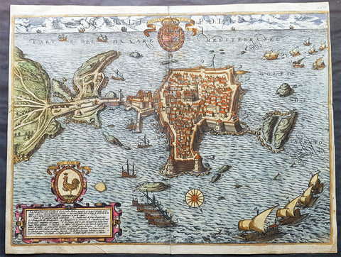
1598 Braun & Hogenberg Antique Map View Old Town of Gallipoli Apulia South Italy
- Title : Gallipolis
- Ref #: 82085
- Size: 20 3/4in x 16in (520mm x 405mm)
- Date : 1598
- Condition: (A+) Fine Condition
Description:
This beautiful original hand coloured copper plate engraved antique map a birds eye view of the Old Town of Gallipoli located on the Salentine Peninsula, in Apulia, Southern Italy & the Angevine-Aragonese Castle, was engraved by the Italian Natale Bonifacio di Girolamo, was published in the 1598 edition of Braun & Hogenbergs atlas on Civitates Orbis Terrarum
General Definitions:
Paper thickness and quality: - Heavy and stable
Paper color : - off white
Age of map color: - Original
Colors used: - Yellow, green, blue, pink
General color appearance: - Authentic
Paper size: - 20 3/4in x 16in (520mm x 405mm)
Plate size: - 20in x 16in (520mm x 405mm)
Margins: - Min 1/8in (3mm)
Imperfections:
Margins: - Top of right margin cropped to border
Plate area: - None
Verso: - Light soiling
Background:
Gallipoli is a southern Italian town and comune in the province of Lecce, in Apulia.
The town is located by the Ionian Sea, on the west coast of the Salentina Peninsula. The town of Gallipoli is divided into two parts, the modern and the old city. The new town includes all the newest buildings including a skyscraper. The old town is located on a limestone island, linked to the mainland by a bridge built in the 16th century.
According to a legend, the city was founded in ancient times by Idomeneus of Crete. Pliny the Elder attributes the foundation to the Senones Gauls, while more likely it was a Messapic settlement. Historically, what is known is that Gallipoli was a city of the Greater Greece, ruling over a large territory including today\'s Porto Cesareo. In 265 BC it sided with Pyrrhus and Taranto against ancient Rome, suffering a defeat which relegated it to a Roman colony (later a municipium).
In the early Middle Ages, it was most likely sacked by the Vandals and the Goths. Rebuilt by the Byzantines, Gallipoli lived an economically and socially flourishing period due to its geographical position. Later it was owned by the Roman Popes, and was a centre of fighting against the Greek monastic orders.
In the 11th century Gallipoli was conquered by the Normans and, in 1268, it was besieged by Charles I of Anjou, causing numerous inhabitants to flee to the nearby Alezio. The city was repopulated around 1300, under the feudal rule of the principality of Taranto. In 1484 the Venetians tried to occupy it, but without results. King Ferdinand I of the Two Sicilies started the construction of the port, which in the 18th century became the largest olive oil market in the Mediterranean.
After the unification of Italy (1861), Gallipoli was capital of a circondario, together with Lecce and Taranto.

1598 J Moretus & A Ortelius 1st Edition of The Peutinger Tables, Ancient Roman Empire Maps x 4
Antique Map
- Title : Tabula Peutingeriana. Tabula itineraria ex illustri Peutingerorum Bibliotheca quae Augusta Vindel. est. Beneficio Marco Velseri septemviri Augustani in lucem edita.
- Size: 22in x 20in (560mm x 510mm) each
- Condition: (A+) Fine Condition
- Date : 1598
- Ref #: 50519, 50520, 50521, 50522
Description:
For three decades, locating rare & unusual and maps has been one our main goals and I believe with the following maps we have reach a milestone. The following maps originate from the oldest direct linage of any maps we have offered, going back to the height of the Roman Empire. These are some of the rarest and most fascinating maps it has been my pleasure to offer.
In 1265 a Monk, in the German city of Colmar produced a hand written map, on parchment, of the imperial highways and cities of the ancient Roman world. When joined, the result was a scroll measuring 6.75m long & 34cm wide, covering an area from southeast England to present day Sri-Lanka. That map of 1265 was copied from an earlier 4th or 5th century map, itself copied from a 2nd century map that originated from a 1st century BC map from Marcus Vipsanius Agrippa, a Roman General & architect. When Agrippa died in 12BC his map was engraved in marble and displayed in the Porticus Vipsania in the Campus Agrippae area in Rome.
In 1494 the German Scholar, Conrad Celtes, discovered the Colmar scroll in a library, in the city of Worms. After his death in 1508, Celtes bequeathed the scroll to Konrad Peutinger, after whom the map is named. The scroll was kept in the Peutinger family until it was purchased by Prince Eugene of Savoy in 1714 and finally purchased for the Habsburg Imperial Court Library in Vienna, where it resides today.
As early as 1577 Abraham Ortelius, the Flemish cartographer, was aware of the existence of the Peutinger Tables, at that stage owned by Mark Welser. In 1591 Welser had two sections of the scroll printed by Aldus Manutius in Venice. Ortelius thought these inadequate and so commissioned the scroll engraved onto 8 separate plates . Ortelius supervised the engraving of the plates but did not live to see the results. In December 1598 the first edition of the 8 plates were printed individually, in limited numbers, by Johannes Moretus in Antwerp and are today amongst some of the rarest sets of maps available. To save space for printing in the first & second atlases in 1619 & 1624, two plates were printed per page, thus saving space. At that point a change was made to each plate, the engraving of a descriptive title at the bottom of each plate.
These maps we are offering are unique, being printed two per page but without the addition of the titles. So the conclusion we have come to is that these were prototypes printed to see if the printing of two plates per page were possible prior to the changes to the plates, making them unique.
We know that there were a total of 300 sets of these tables published in 1619 & 1624 atlases Theatrum Geographiae Veteris & Parergon , of which very few have survived. As for the 1598 edition, we do not know the number published or how many have survived but there is no doubt the number is very low in the single digits. Also I can find no record of sale for this original 1598 1st Moretus edition.
General Definitions:
Paper thickness and quality: - Heavy and stable
Paper color : - off white
Age of map color: -
Colors used: -
General color appearance: -
Paper size: - 22in x 20in (560mm x 510mm) each
Plate size: - 20 1/4in x 7 1/2in (505mm x 195mm) each
Margins: - Min 1in (25mm)
Imperfections:
Margins: - None
Plate area: - None
Verso: - None
Background:
Tabula Peutingerian also referred to as Peutingers Tabul or The Peutinger Table, is an illustrated itinerarium (ancient Roman road map) showing the layout of the cursus publicus, the road network of the Roman Empire. The map covers Europe, North Africa, and parts of Asia, including the Middle East, Persia, and India.
The map was found as a 13th-century parchment copy based on a document from the 4th or 5th century, that contained a copy of the world map, originally prepared by Marcus Vipsanius Agrippa a Roman general & architect active during the reign of the emperor Augustus (27 BC – AD 14). After Agrippas death in 12 BC, that map was engraved in marble and put on display in the Porticus Vipsania in the Campus Agrippae area in Rome, close to the Ara Pacis building.
The original Roman map, of which the 13th century parchment copy may be the only surviving copy, was last revised in the 4th or early 5th century. This is illustrated by the inclusion of the city of Constantinople, founded in 328, and the prominence of Ravenna, seat of the Western Roman Empire from 402 to 476, which suggests a fifth-century revision. The presence of certain cities of Germania Inferior that were destroyed in the mid-fifth century also provides proof or 4th or 5th century revision.
The surviving 13th century map itself was created by a monk in Colmar in modern-day eastern France in 1265. It is a parchment scroll, 0.34 metres (1 foot 1 inch) high and 6.75 metres (22.1 feet) long, assembled from eleven sections, a medieval reproduction of the original scroll.
The 13th century parchment map is very schematic, designed to give a practical overview of the road network, as opposed to an accurate representation of geographic features: the land masses shown are distorted, especially in the east–west direction. The map shows many Roman settlements and the roads connecting them, as well as other features such as rivers, mountains, forests and seas. The distances between settlements are also given. In total no fewer than 555 cities and 3,500 other place names are shown on the map. The three most important cities of the Roman Empire at the time – Rome, Constantinople and Antioch – are represented with special iconic decoration.
Besides the totality of the empire, the map also shows areas in the Near East, India and the Ganges, Sri Lanka (Insula Taprobane), and even an indication of China. It even shows a Temple to Augustus at Muziris (present day Kodungallur) on the modern-day Malabar Coast, one of the main ports for trade with the Roman Empire on the southwest coast of India. On the western end of the scroll, the absence of Morocco, the Iberian Peninsula, and the British Isles indicates that a twelfth original section has been lost in the surviving copy; the missing section was reconstructed in 1898 by Konrad Miller.
The map appears to be based on itineraries, lists of destinations along Roman roads, as the distances between points along the routes are indicated. Travellers would not have possessed anything so sophisticated as a modern map, but they needed to know what lay ahead of them on the road and how far. The Peutinger Table represents these roads as a series of stepped lines along which destinations have been marked in order of travel. The shape of the parchment pages accounts for the conventional rectangular layout. However, a rough similarity to the coordinates of Ptolemys earth-mapping gives some writers hope that some terrestrial representation was intended by the unknown original compilers.
The stages and cities are represented by hundreds of functional place symbols, used with discrimination from the simplest icon of a building with two towers to the elaborate individualized portraits of the three great cities. Some conclud that the semi-schematic, semi-pictorial symbols reproduce Roman cartographic conventions of the itineraria picta described by 4th-century writer Vegetius, of which this is the sole known testimony.
The 13th century copy map was discovered in a library in the city of Worms by German scholar Conrad Celtes in 1494, who was unable to publish his find before his death and bequeathed the map in 1508 to Konrad Peutinger, a German humanist and antiquarian in Augsburg, after whom the map is named. The Peutinger family kept possession of the map for more than two hundred years until it was sold in 1714. It then bounced between several royal and elite families until it was purchased by Prince Eugene of Savoy for 100 ducats; upon his death in 1737, it was purchased for the Habsburg Imperial Court Library in Vienna (Hofbibliothek). It is today conserved at the Austrian National Library at the Hofburg palace in Vienna.
The map was copied for Dutch cartographer Abraham Ortelius by Johannes Moretus and published separetly, shortly after his death, in 1598. The maps were not published in an atlas until 1619 by Petrus Bertius and again in the Ortelius Parageon in 1624.
A partial first edition was printed at Antwerp in 1591 (titled Fragmenta tabulæ antiquæ) , Johannes Moretus, printed the full Tabula in December 1598, in Antwerp. Johannes Janssonius published another version in Amsterdam, c. 1652.
In 1753 Franz Christoph von Scheyb published a copy, and in 1872 Konrad Miller, a German professor, was allowed to copy the map. Several publishing houses in Europe then made copies. In 1892 publishers Williams and Norgate published a copy in London, and in 1911 a sheet was added showing the reconstructed sections of the British Isles and the Iberian peninsula missing in the original.
1598 Munster Antique Map Birds Eye View of the city of Poitiers in Poitou France
- Title : Die Statt Puttiers
- Date : 1598
- Condition: (A) Very Good Condition
- Ref # : 30381
- Size : 15in x 13in (380mm x 340mm)
Description:
This fine original wood block engraved antique map a birds eye view of the French city of Poitiers on the Clain River in the Vienne Dept of central western France, was published in the French Section of Sebastian Munsters 1598 edition of Cosmographia, Das ist: Beschreibung der gantzen Welt, Darinnen Aller Monarchien Keyserthumben, Königreichen, Fürstenthumben, Graff- und Herrschafften, Länderen, Stätten und Gemeinden.Ursprung (Cosmographia, that is: description of the whole world, in it all monarchies Keyser thumben, kingdoms, prince thumben, graff and herrschafften, countries, places and municipalities.)
Poitiers is a city on the Clain river in west-central France. It is a commune and the capital of the Vienne department and also of the Poitou.
The type of political organisation existing in Poitiers during the late medieval or early modern period can be glimpsed through a speech given on 14 July 1595 by Maurice Roatin, the town\'s mayor. He compared it to the Roman state, which combined three types of government: monarchy (rule by one person), aristocracy (rule by a few), and democracy (rule by the many). He said the Roman consulate corresponded to Poitiers\' mayor, the Roman senate to the town\'s peers and échevins, and the democratic element in Rome corresponded to the fact that most important matters can not be decided except by the advice of the Mois et Cent (broad council).1 The mayor appears to have been an advocate of a mixed constitution; not all Frenchmen in 1595 would have agreed with him, at least in public; many spoke in favour of absolute monarchy. The democratic element was not as strong as the mayor\'s words may seem to imply: in fact, Poitiers was similar to other French cities, Paris, Nantes, Marseille, Limoges, La Rochelle, Dijon, in that the town\'s governing body (corps de ville) was highly exclusive and oligarchical: a small number of professional and family groups controlled most of the city offices. In Poitiers many of these positions were granted for the lifetime of the office holder.
The city government in Poitiers based its claims to legitimacy on the theory of government where the mayor and échevins held jurisdiction of the citys affairs in fief from the king: that is, they swore allegiance and promised support for him, and in return he granted them local authority. This gave them the advantage of being able to claim that any townsperson who challenged their authority was being disloyal to the king. Every year the mayor and the 24 échevins would swear an oath of allegiance between the hands of the king or his representative, usually the lieutenant général or the sénéchaussée. For example, in 1567, when Maixent Poitevin was mayor, king Henry III came for a visit, and, although some townspeople grumbled about the licentious behaviour of his entourage, Henry smoothed things over with a warm speech acknowledging their allegiance and thanking them for it.
In this era, the mayor of Poitiers was preceded by sergeants wherever he went, consulted deliberative bodies, carried out their decisions, heard civil and criminal suits in first instance, tried to ensure that the food supply would be adequate, visited markets.
In the 16th century, Poitiers impressed visitors because of its large size, and important features, including royal courts, university, prolific printing shops, wealthy religious institutions, cathedral, numerous parishes, markets, impressive domestic architecture, extensive fortifications, and castle.
16th-century Poitiers is closely associated with the life of François Rabelais and with the community of Bitards.
The town saw less activity during the Renaissance. Few changes were made in the urban landscape, except for laying way for the rue de la Tranchée. Bridges were built where the inhabitants had used gués. A few hôtels particuliers were built at that time, such as the hôtels Jean Baucé, Fumé and Berthelot. Poets Joachim du Bellay and Pierre Ronsard met at the University of Poitiers, before leaving for Paris.
During the 17th century, many people emigrated from Poitiers and the Poitou to the French settlements in the new world and thus many Acadians or Cajuns living in North America today can trace ancestry back to this region.
General Definitions:
Paper thickness and quality: - Heavy and stable
Paper color : - off white
Age of map color: -
Colors used: -
General color appearance: -
Paper size: - 15in x 13 1/4in (380mm x 340mm)
Plate size: - 15in x 13 1/4in (380mm x 340mm)
Margins: - Min 1/4in (3mm)
Imperfections:
Margins: - L&R margins cropped into border
Plate area: - Light toning along centerfold
Verso: - Light toning along centerfold
Background:
Cosmographia, Das ist: Beschreibung der gantzen Welt, Darinnen Aller Monarchien Keyserthumben, Königreichen, Fürstenthumben, Graff- und Herrschafften, Länderen, Stätten und Gemeinden.Ursprung, Regiment, Reichthumb, Gewalt und.Beschaffenheit. Dessgleichen Aller deren, beyder Ständen, Regenten: Keysern, Königen, Bäpsten, Bischoffen.Genealogien und Stammbäumen.zusammen getragen. by Sebastian Münster was first published in 1544 and is the earliest German-language description of the world. It had numerous editions in different languages including Latin, French (translated by François de Belleforest), Italian, English, and Czech. The last German edition was published in 1628, long after Munsters death. The Cosmographia was one of the most successful and popular books of the 16th century. It passed through 24 editions in 100 years. This success was due to the notable woodcuts (some by Hans Holbein the Younger, Urs Graf, Hans Rudolph Manuel Deutsch, and David Kandel). It was most important in reviving geography in 16th-century Europe. Among the notable maps within Cosmographia is the map Tabula novarum insularum, which is credited as the first map to show the American continents as geographically discrete.
Munsters earlier geographic works were Germania descriptio (1530) and Mappa Europae (1536). In 1540, he published a Latin edition of Ptolemys Geographia with illustrations.
1598 Sebastian Munster Antique Map Birds Eye View of Weissenburg Bavaria Germany
- Title : Die Statt Wyssenburg
- Date : 1598
- Condition: (A+) Fine Condition
- Ref # : 30351
- Size : 15in x 13in (380mm x 340mm)
Description:
This fine original wood block engraved antique map a birds eye view of the German city of Weißenburg (Weissenburg) in Bavaria in Middle Franconia - identified by the cities Coate of Arms with double headed eagle atop of a castle - was published in the German Section of Sebastian Munsters 1598 edition of Cosmographia, Das ist: Beschreibung der gantzen Welt, Darinnen Aller Monarchien Keyserthumben, Königreichen, Fürstenthumben, Graff- und Herrschafften, Länderen, Stätten und Gemeinden.Ursprung (Cosmographia, that is: description of the whole world, in it all monarchies Keyser thumben, kingdoms, prince thumben, graff and herrschafften, countries, places and municipalities.)
Weißenburg in Bayern (formerly also Weißenburg im Nordgau) is a town in Middle Franconia, Germany. It is the capital of the district Weißenburg-Gunzenhausen. Weissenburg is located in central Bavaria, in the south of the administrative region Mittelfranken.
The history of Weißenburg is generally traced back to the Roman fort that was built in the area towards the end of the first century. The settlement, which included Thermae, lay on the border of the Roman Empire and on the Tabula Peutingeriana from the 4th century it had the name Biriciana. Germanic tribes destroyed the fort and settled in what is still the city centre. The first mention of the name Weißenburg is in a deed dating from 867. The city became the seat of a royal residence during the reign of the Franks and according to legend, Charlemagne stayed there to supervise the construction of Fossa Carolina.
The city became a Free Imperial City in 1296 and continued to grow until the Reformation. Following the example of Nuremberg the city joined the Protestant side but it suffered heavily in the ensuing wars. However, the rights of the city as a Free Imperial City and an Imperial Estate were restored in the final peace treaty and some growth resumed. Despite its insignificant size and economic importance, the city, like the other 50-odd free imperial cities, was virtually independent.
Weissenburg lost its independence in 1802 and became part of the Bavarian kingdom in 1806. It was however saved from insignificance with the construction of a railway between Nuremberg and Augsburg which goes through the city and which supported industrialisation. Following World War II over 6,000 refugees and people expelled from the territories which Germany lost settled in the city and have since played an important role in its industry and culture.
The many stages in the history of Weissenburg can still be seen today. There are many ruins from the Roman times. One of the finest is the remains of a Roman bath which was excavated in 1977 and has been turned into a museum. The city wall from the Middle Ages has survived almost intact with its towers and in the Gothic Town Hall the city\'s elected members have held their meetings from 1476.
General Definitions:
Paper thickness and quality: - Heavy and stable
Paper color : - off white
Age of map color: -
Colors used: -
General color appearance: -
Paper size: - 16in x 13in (410mm x 330mm)
Plate size: - 16in x 13in (410mm x 330mm)
Margins: - Min 1in (25mm)
Imperfections:
Margins: - Repair to bottom margin, no loss
Plate area: - Age toning along centerfold
Verso: - Light soiling
Background:
Cosmographia, Das ist: Beschreibung der gantzen Welt, Darinnen Aller Monarchien Keyserthumben, Königreichen, Fürstenthumben, Graff- und Herrschafften, Länderen, Stätten und Gemeinden.Ursprung, Regiment, Reichthumb, Gewalt und.Beschaffenheit. Dessgleichen Aller deren, beyder Ständen, Regenten: Keysern, Königen, Bäpsten, Bischoffen.Genealogien und Stammbäumen.zusammen getragen. by Sebastian Münster was first published in 1544 and is the earliest German-language description of the world. It had numerous editions in different languages including Latin, French (translated by François de Belleforest), Italian, English, and Czech. The last German edition was published in 1628, long after Munsters death. The Cosmographia was one of the most successful and popular books of the 16th century. It passed through 24 editions in 100 years. This success was due to the notable woodcuts (some by Hans Holbein the Younger, Urs Graf, Hans Rudolph Manuel Deutsch, and David Kandel). It was most important in reviving geography in 16th-century Europe. Among the notable maps within Cosmographia is the map Tabula novarum insularum, which is credited as the first map to show the American continents as geographically discrete.
Munsters earlier geographic works were Germania descriptio (1530) and Mappa Europae (1536). In 1540, he published a Latin edition of Ptolemys Geographia with illustrations.

1598 Sebastian Munster Rare Antique Map - Birds Eye View of London, England
Antique Map
- Title : Londen oder Lunden die Hauptstatt in Engellandt / am fluß Thamesis gelegen/ auff das aller fleißsigste nach jetziger gelegenheit abcontrafehtet
- Ref #: 51012
- Size: 15 1/4in x 12 1/2in (385mm x 315mm)
- Date : 1598
- Condition: (A+) Fine Condition
Description:
This scarce original 1st edition antique woodcut birds eye view, is the third earliest acquirable depiction of London. Prepared in 1598, it was the only depiction of London to appear in Sebastian Munsters publication of Cosmographia, appearing in only the three last Sebastian Petri editions.
Modeled on Georg Braun and Franz Hogenberg's 1572 plan, the city here is laid out as a plan, but the buildings and surrounding landscape are presented in elevation - thus giving the impression of a bird's-eye view, even to the extent of detailing gardens and showing bustling river traffic. Also, as with the Braun and Hogenberg, the view has included four figures in the foreground: a nobleman and woman, with their attendant maid and footman (he, armed with a sword), each dressed in the styles of the period appropriate to their positions.
General Description:
Paper thickness and quality: - Heavy and stable
Paper color: -
Age of map color: -
Colors used: -
General color appearance: -
Paper size: - 15 1/4in x 12 1/2in (385mm x 315mm)
Plate size: - 15 1/4in x 12 1/2in (385mm x 315mm)
Margins: - Min 1/2in (12mm)
Imperfections:
Margins: - Uniform age toning
Plate area: - Uniform age toning
Verso: - Uniform age toning
Background:
Sebastian Munster's woodblock map of London is one of the earliest maps of the city available to collectors. It shows London during the lifetimes of Queen Elizabeth I and William Shakespeare. This map is a derivative of the Braun & Hogenberg's map of 1572. Munster has even arranged the costumed figures in the foreground into the same poses. Instead of the Latin descriptions found in the lower corners of the map on the Braun & Hogenberg map, Munster has instead included two panels listing the seven gates in the City wall, from west to east.
The old St Paul's Cathedral with its original pointed spire sits at the centre of the map. The spire was destroyed in a fire in 1561, but frequently appeared on later depictions of the city. The cathedral itself was burnt to the ground during the Great Fire of 1666, after which Christopher Wren designed and built the modern cathedral. To the southeast of St Paul's is the old London Bridge, the only bridge crossing over the River Thames until the 18th century.
South of the river are two circular arenas for bull and bear baiting. This was a vicious, but popular, form of entertainment in Tudor London. Shakespeare's Globe Theatre would be built in 1599 on a parcel of land to the west of these arenas.
Located outside of the City of London's jurisdiction, Southwark was a riotous pleasure ground where Londoners went to escape the strict rules north of the river.
On the far left of the map is Westminster, a separate royal enclave surrounding St James's Palace and Whitehall linked to the city by the Strand and by the river. A royal barge is shown on the river to the west of London Bridge, depicting the monarch's typical method of traveling to avoid the crowded streets of the city. The royal coat of arms is appropriately placed in the upper-left corner above Westminster, while the upper-right corner contains the coat of arms of the City of London. (Ref: Shirley; Tooley; M&B)