Products
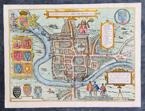
1574 Braun & Hogenberg Antique Map View of The City of Chester, Cheshire England
Antique Map
- Title : Cestria Vvlgo Chester Angliae Civitas
- Ref #: 27092
- Size: 18 1/2in x 14in (470mm x 355mm)
- Date : 1574
- Condition: (A) Very Good Condition
Description:
This original beautifully hand coloured copper plate engraved antique map, a birds eye view of the city of Chester in Cheshire, England, was published in the 1574 edition of Braun & Hogenbergs atlas Civitates Orbis Terrarum
General Definitions:
Paper thickness and quality: - Heavy and stable
Paper color : - off white
Age of map color: - Original
Colors used: - Yellow, green, blue, pink
General color appearance: - Authentic
Paper size: - 18 1/2in x 14in (470mm x 355mm)
Plate size: - 15 1/2in x 12 3/4in (390mm x 325mm)
Margins: - Min 1/2in (12mm)
Imperfections:
Margins: - Several small worm holes restored in margins
Plate area: - Several small worm holes restored
Verso: - Several small worm holes restored

1598 Sebastian Munster Rare Antique Map - Birds Eye View of London, England
Antique Map
- Title : Londen oder Lunden die Hauptstatt in Engellandt / am fluß Thamesis gelegen/ auff das aller fleißsigste nach jetziger gelegenheit abcontrafehtet
- Ref #: 51012
- Size: 15 1/4in x 12 1/2in (385mm x 315mm)
- Date : 1598
- Condition: (A+) Fine Condition
Description:
This scarce original 1st edition antique woodcut birds eye view, is the third earliest acquirable depiction of London. Prepared in 1598, it was the only depiction of London to appear in Sebastian Munsters publication of Cosmographia, appearing in only the three last Sebastian Petri editions.
Modeled on Georg Braun and Franz Hogenberg's 1572 plan, the city here is laid out as a plan, but the buildings and surrounding landscape are presented in elevation - thus giving the impression of a bird's-eye view, even to the extent of detailing gardens and showing bustling river traffic. Also, as with the Braun and Hogenberg, the view has included four figures in the foreground: a nobleman and woman, with their attendant maid and footman (he, armed with a sword), each dressed in the styles of the period appropriate to their positions.
General Description:
Paper thickness and quality: - Heavy and stable
Paper color: -
Age of map color: -
Colors used: -
General color appearance: -
Paper size: - 15 1/4in x 12 1/2in (385mm x 315mm)
Plate size: - 15 1/4in x 12 1/2in (385mm x 315mm)
Margins: - Min 1/2in (12mm)
Imperfections:
Margins: - Uniform age toning
Plate area: - Uniform age toning
Verso: - Uniform age toning
Background:
Sebastian Munster's woodblock map of London is one of the earliest maps of the city available to collectors. It shows London during the lifetimes of Queen Elizabeth I and William Shakespeare. This map is a derivative of the Braun & Hogenberg's map of 1572. Munster has even arranged the costumed figures in the foreground into the same poses. Instead of the Latin descriptions found in the lower corners of the map on the Braun & Hogenberg map, Munster has instead included two panels listing the seven gates in the City wall, from west to east.
The old St Paul's Cathedral with its original pointed spire sits at the centre of the map. The spire was destroyed in a fire in 1561, but frequently appeared on later depictions of the city. The cathedral itself was burnt to the ground during the Great Fire of 1666, after which Christopher Wren designed and built the modern cathedral. To the southeast of St Paul's is the old London Bridge, the only bridge crossing over the River Thames until the 18th century.
South of the river are two circular arenas for bull and bear baiting. This was a vicious, but popular, form of entertainment in Tudor London. Shakespeare's Globe Theatre would be built in 1599 on a parcel of land to the west of these arenas.
Located outside of the City of London's jurisdiction, Southwark was a riotous pleasure ground where Londoners went to escape the strict rules north of the river.
On the far left of the map is Westminster, a separate royal enclave surrounding St James's Palace and Whitehall linked to the city by the Strand and by the river. A royal barge is shown on the river to the west of London Bridge, depicting the monarch's typical method of traveling to avoid the crowded streets of the city. The royal coat of arms is appropriately placed in the upper-left corner above Westminster, while the upper-right corner contains the coat of arms of the City of London. (Ref: Shirley; Tooley; M&B)
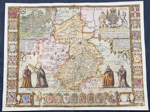
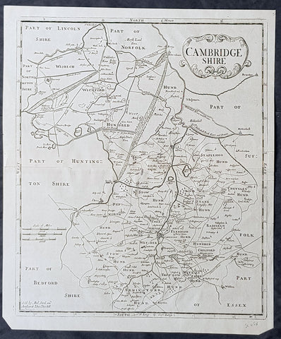
1610 John Speed Antique Map of The English County of Cambridgeshire
- Title : Cambridgeshire described with the deuision of the hundreds, the Townes situation with the Armes of the Colleges of that famous Vniuersiti...And also the Armes of all such Princes and noble men as have heertofore borne the Honorable tytles & dignities of the Earldome of Cambridge....Performed by John Speede and are to be sold in popes alley by John Sudbury and G Humbell...Cum Privilego 1610.
- Size: 20 1/2in x 15in (510mm x 380mm)
- Condition: (B) Good Condition
- Date : 1610
- Ref #: 80002
Description:
This original hand coloured antique 1st edition map of the English county of Cambridgeshire was engraved in 1610 - dated -and was published by John Sudbury & George Humble in the 1612 1st edition of John Speeds famous atlas The Theatre of the Empire of Great Britaine.
The map has some loss mainly along the borders and a few small areas below both sets of figures. Map has been mounted onto an original index page fro m Speeds atlas.
General Definitions:
Paper thickness and quality: - Heavy and stable
Paper color : - off white
Age of map color: - Original
Colors used: - Yellow, green, blue, pink
General color appearance: - Authentic
Paper size: - 20 1/2in x 15in (510mm x 380mm)
Plate size: - 20 1/2in x 15in (510mm x 380mm)
Margins: - Min 1/2in (12mm)
Imperfections:
Margins: - Map cropped to and into borders
Plate area: - Small loss below both sets of figures at the bottom of the map
Verso: - Backed onto original Speed index double page
Background:
Strong reference is made to Cambridges famous and renowned university with the (twenty five) armourials of the colleges and four scholarly figures. The birds eye view plan of Cambridge city is based on the one done by John Hammond in 1592.

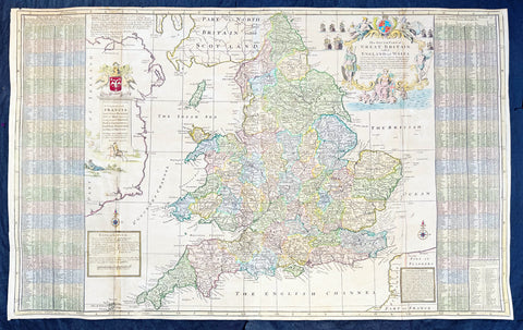
1611 John Speed 1st Edition Map of Great Britain & Ireland - London & Edinbugh
- Title : The Kingdome of Great Britaine and Ireland....Graven by J Hondius and are to be solde by J Sudbury and George Humble in Pope Heads Alley in London cum privilage Regis 1610
- Ref #: 93433
- Size: 21in x 15 3/4in (535mm x 400mm)
- Date : 1611
- Condition: (A) Very Good Condition
Description:
This magnificent, beautifully hand coloured, original copper-plate engraved antique map (a true rare 1st edition - Shirley 316, catch word wee on verso) by John Speed, was engraved by the famous cartographer Jodocus Hondius and published by Sudbury & Humble in Speeds 1611-12 edition of his atlas Theatre of the Empire of Great Britaine.
A beautiful example of the first state of one the most visually striking maps ever produced of the British Isles, embellished with finely detailed views of both London and Edinburgh. The strong printing impression of this example highlights the exquisite engraving of this map, particularly the delicate detail of the two inset views.
General Definitions:
Paper thickness and quality: - Heavy and stable
Paper color : - off white
Age of map color: - Original
Colors used: - Yellow, green, blue, pink
General color appearance: - Authentic
Paper size: - 21 1/2in x 17in (545mm x 435mm)
Plate size: - 18 1/2in x 14in (470mm x 355mm)
Margins: - Min 1/2in (12mm)
Imperfections:
Margins: - All margins professionally restored from printed borders
Plate area: - Small repair to bottom centerfold
Verso: - Centerfold re-enforced.
Background:
John Speed spent 15 years gathering materials for his atlas of the British Isles, in which this map was the first to appear. Moreover, Speed went to considerable lengths to secure a top engraving talent—a fascinating story in itself--to produce this and many of the other maps in this atlas. Speed sent the visual, raw materials for his maps—drafts of the map themselves and design sketches--to Amsterdam to be engraved by Jodocus Hondius, who at the time was one of the most prominent and successful map publishers in all of Europe. Hondius, however, was well known to English map publishers, as he had worked as an engraver for hire in London in the 1580’s, where he had fled due to religious persecution in his homeland. Still, it is surprising that Speed was able to secure the services of Hondius at the height of his career, and, in fact, Hondius died shortly after completing this project. Hondius’ distinctive style can be seen in this map in its stippled seas and in its decorative detail that is rich without being disorganized or distracting.
The map itself of England was based on that of Saxton, who produced some years earlier the very first atlas of Great Britain. Ireland and Scotland were based on maps by Hondius and Mercator, respectively. The view of London was modeled after a c. 1600 drawing by C. J. Visscher, which was not published until 1616. The Edinburgh view is an adaptation of an earlier manuscript showing the city under siege in 1544.
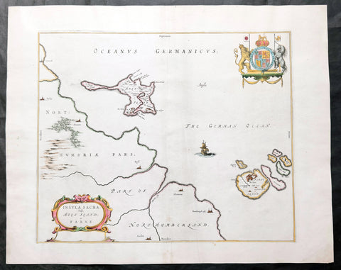
1645 Blaeu Old Antique Map Lindisfarne Holy Islands England - Lindisfarne
Antique Map
- Title : Insula Sacra Vulgo Holy Isand et Farne
- Ref #: 51010
- Size: 23 1/2in x 19in (600mm x 485mm)
- Date : 1645
- Condition: (A) Very Good Condition
Description:
This beautifully hand coloured original antique map of the Holy & Farne Islands off the east coast of Northumberland, England was published in the 1645 edition of Joan Blaeus Atlas Novus.
Blaeu's reference for the topographical data for this map derive from John Speeds maps of Great Britain from the 1611 Empire of Great Britaine - the beautiful decoration, though, is distinctly Blaeus.
Background: Blaeu is one of the most revered map makers of all time and it is easy to see why in this beautiful original map.
The high level of the topographical detail, the quality of the paper, the artistic professionalism of the engraving and the beauty of the original hand colouring combine to produce a work of art that is both functional and of exceptional beauty. (Ref: Koeman; M&B)
General Description:
Paper thickness and quality: - Heavy and stable
Paper color: - off white
Age of map color: - Original
Colors used: - Yellow, pink, red, blue, green
General color appearance: - Authentic
Paper size: - 23 1/2in x 19in (600mm x 485mm)
Plate size: - 20in x 15 1/2in (510mm x 395mm)
Margins: - Min 1in (25mm)
Imperfections:
Margins: - Light age toning
Plate area: - Light creasing along centerfold & adjacent
Verso: - Creasing and age toning along and adjacent to centerfold
Background:
Lindisfarne, also known as Holy Island, is a tidal island off the northeast coast of England, which constitutes the civil parish of Holy Island in Northumberland. Holy Island has a recorded history from the 6th century AD; it was an important centre of Celtic Christianity under Saints Aidan, Cuthbert, Eadfrith, and Eadberht of Lindisfarne. The island was originally home to a monastery, which was destroyed during the Viking invasions but re-established as a priory following the Norman Conquest of England. Other notable sites built on the island are St Mary the Virgin parish church (originally built in 635 CE and restored in 1860), Lindisfarne Castle, several lighthouses and other navigational markers, and a complex network of lime kilns.
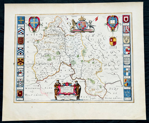
1647 Joan Blaeu Antique Map of the English County of Oxfordshire, Beautiful
Antique Map
- Title : Oxonium Comitatus, Vulgo Oxfordshire
-
Condition: (A+) Fine Condition
- Ref: 92846
- Size: 23 1/2in x 19 1/2in (600mm x 495mm)
- Date : 1647
Description:
This beautifully hand coloured original copper plate engraved antique map of the English county of Oxfordshire was published in the 1647 Dutch edition of Joan Blaeus Atlas Novus.
There is also the added bonus on the verso of the map with an early depiction of Stonehenge engraving to text.
Background:
This along with John Speeds map, is one of the most decorative of Oxfordshire. The basic cartographic information is derived from Speed's map, but presented with Blaeu typical elegance & decoration. These include coats-of-arms of the Oxford colleges along the sides, each expertly coloured, as well crests of nobility, the Royal coat-of-arms, and a title cartouche flanked by two Oxford scholars.
Blaeu is one of the most revered map makers of all time and it is easy to see why in this beautiful original map. The high level of the topographical detail, the quality of the paper, the artistic professionalism of the engraving and the beauty of the original hand colouring combine to produce a work of art that is both functional and of exceptional beauty. (Ref: Koeman; M&B)
General Description:
Paper thickness and quality: - Heavy and stable
Paper color: - off white
Age of map color: - Original
Colors used: - Yellow, pink, red, blue, green
General color appearance: - Authentic
Paper size: - 23 1/2in x 19 1/2in (600mm x 495mm)
Plate size: - 20in x 15 1/4in (510mm x 390mm)
Margins: - Min 1in (25mm)
Imperfections:
Margins: - None
Plate area: - None
Verso: - None
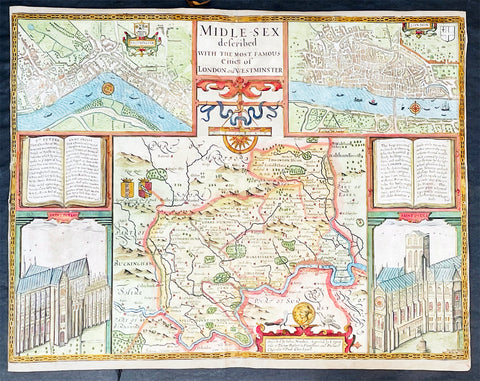
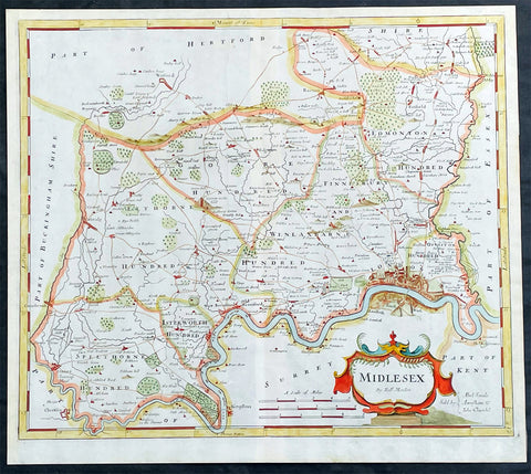
1676 John Speed Antique Map of County of Midlesex Views London & Westminster
- Title : Midle-sex Described with the most Famous Cities of London and Westminster
- Date : 1676
- Size: 20 1/4in x 16 3/4in (515mm x 425mm)
- Condition: (B) Good Condition
- Ref: 35613
Description:
This original hand coloured copper plate engraved antique map & views of London and the English county of Middlesex by John Speed was published in the 1676 Bassett & Chiswell edition of Speeds famous atlas The Theatre of the Empire of Great Britaine.
The map is embellished with the famous birds-eye views of London, Westminster and the churches of St Peters (Westminster Abbey) and old St Pauls before the great fire of London in 1666. English descriptive text of London on the verso.
General Definitions:
Paper thickness and quality: - Heavy and stable
Paper color : - off white
Age of map color: - Original
Colors used: - Blue, yellow, green, pink
General color appearance: - Authentic
Paper size: - 20 1/4in x 16 3/4in (515mm x 425mm)
Plate size: - 20 1/4in x 15 1/2in (515mm x 410mm)
Margins: - Min 1/8in (2mm)
Imperfections:
Margins: - L&R margins cropped to plate-marks
Plate area: - Re-enforced along centerfold very small loss in places, light creasing
Verso: - Re-enforced along centerfold and in several places with transparent archival tape
Background:
This county map of Middlesex, now greater London, illustrates the market towns of Enfield, Pancras, Osterley and Staines. The map is dominated by four large vignettes with the environs of London and the county situated in the central portion of the map. The actual cartography is based on the surveys performed by John Norden, the earlier English antiquary and map maker, who unsuccessfully attempted to publish an updated county atlas of the United Kingdom before Speed. Norden also lived most of his life in Middlesex, thus becoming an obvious source for the map.
The City of London is clearly shown on the lower right of the map with villages such as Hamsted, Pancras, Kensington and Paddington marked around the city. To the lower centre of the map is an acknowledgement to the original survey by Norden, augmented by Speed himself.
Although the cartography is of some note, it is the vignettes for which this map is justly famous. To the two bottom corners are the famous Churchs of St. Peter (Westminster Abbey) Westminster on the left and St. Pauls to the right. This is the medieval Cathedral of St. Pauls, just after it had lost its spire in 1561 and before the Great Fire of 1666, in which it was destroyed then rebuilt in its present form by Sir Christopher Wren. Above these two church vignettes are two text panels in the form of books, the one on the left describing the two churches and the other on the right with a description of London itself.
Finally, two large vignettes on the upper left and right corners depict the two cities of Westminster and London respectively. It is believed that Speed was not responsible for either of these images, more likely drawing from Norden, although there are no surviving evidence of this, to date yet to be found. There are also theories that these two views may have come from either a German sources or other lost birds-eye views of London by unknown persons.
Due to modern growth of London and border changes, the county of Middlesex no longer exists, but there is little doubt this is the most the best map of London and Middlesex published in the 17th century. English text on verso
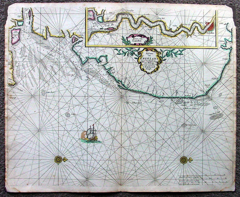
1676 Pieter Goos Large Antique Map of England, Thames River, London
Antique Map
- Title : Pascaarte van Engelant van t' Voorlandt tot aen Blakeney waer in te Sien is de Mont vande Teemse
- Date : 1676
- Condition: (A) Very Good Condition
- Ref: 42012
- Size: 22in x 18in (560mm x 455mm)
Description:
This large, beautifully hand coloured original antique map, a fine early Dutch sea chart of the Thames River and surrounding English coastline, was published by Pieter Goos in 1676 for the Goos De Zee-Atlas, Ofte Water-Weereld, Atlas.
This chart is oriented with north to the right includes in the upper right is a large inset of the Thames River and plan of London. Beautifully engraved with original coulouring embellished with rhumb lines, two compass roses and a galleon under sail. (Ref: Tooley; M&B; Koeman)
General Description:
Paper thickness and quality: - Heavy and stable
Paper color: - off white
Age of map color: - Original
Colors used: - Yellow, green, red, rose madder, red
General color appearance: - Authentic and fresh
Paper size: - 22in x 18in (560mm x 455mm)
Plate size: - 22in x 18in (560mm x 455mm)
Margins: - Min ½in (12mm)
Imperfections:
Margins: - Top L&R margin corner ink spill not affecting image
Plate area: - None
Verso: - Light soiling
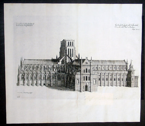
1683 Daniel King & William Dugdale Antique Print of Old St Pauls Cathedral London - Pre Great Fire
- Title : Ecclesiae Cathedralis Sti Pauli facies Aquilonaris / The North Prospect of ye Cathedral Church of St Paul in London
- Date : 1683
- Condition: (A+) Fine Condition
- Ref # : 16365
- Size : 15 1/2in x 13 1/2in (395mm x 340mm)
Description:
This fine original copper-pate antique print of the old St Pauls Cathedral London, was engraved by Daniel King prior to the Great Fire of London in 1666 and was published by Sir William Dugdale in the 1683 edition of Monasticon Anglicanum: A History of the Abbies and other Monasteries, Hospitals, Frieries, and Cathedral and Collegiate Churches, with their Dependencies, in England and Wales.
General Definitions:
Paper thickness and quality: - Heavy and stable
Paper color : - off white
Age of map color: -
Colors used: -
General color appearance: -
Paper size: - 15 1/2in x 13 1/2in (395mm x 340mm)
Plate size: - 14 1/2in x 9in (370mm x 230mm)
Margins: - Min 1/2in (12mm)
Imperfections:
Margins: - None
Plate area: - Folds as issued, small repair to bottom of page not affecting the image
Verso: - None
Background: Old St Paul's Cathedral was the medieval cathedral of the City of London that, until 1666, stood on the site of the present St Paul's Cathedral. Built in 1087–1314 and dedicated to Saint Paul, the cathedral was the fourth church on the site at Ludgate Hill. Work began during the reign of William the Conqueror after a fire in 1087 that destroyed much of the city. Work took more than 200 years, and construction was delayed by another fire in 1135. The church was consecrated in 1240 and enlarged again in 1256 and the early 14th century. At its completion in the middle of the 14th century, the cathedral was one of the longest churches in the world and had one of the tallest spires and some of the finest stained glass.
The presence of the shrine of Saint Erkenwald made the cathedral a pilgrimage site during the Medieval period. In addition to serving as the seat of the Diocese of London, the building developed a reputation as a hub of the City of London, with the nave aisle, "Paul's walk", known as a centre for business and the London grapevine. After the Reformation, the open-air pulpit in the churchyard, St Paul's Cross, became the stage for radical evangelical preaching and Protestant bookselling.
The cathedral was already severely in decline by the 17th century. Restoration work by Inigo Jones in the 1620s was halted by the English Civil War. Sir Christopher Wren was attempting another restoration in 1666 when the cathedral was destroyed in the Great Fire of London. After demolition of the old structure, the present, domed cathedral was erected on the site, with an English Baroque design by Wren
Sir William Dugdale 1605-1686 was an English antiquary and herald. As a scholar he was influential in the development of medieval history as an academic subject.
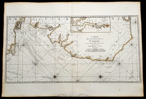
1693 A H Jaillot Large Sea Chart, Map of SE England and Thames Estuary, Clay to Sandwich
Antique Map
- Title : Carte de l entree de la Tamise avec les bancs, passes, isles et costes comprises entre Sandwich et Clay. (Map of the Thames estuary entry with the banks, streets, islands and coasts between Sandwich and Clay)
- Size: 37 1/2in x 25 1/2in (950mm x 650mm)
- Condition: (A+) Fine Condition
- Date : 1693
- Ref #: 93356
Description:
This large beautifully hand coloured original 1693 antique sea-chart, map of SE England from Clay, Norfolk, to Sandwich and the entrance of the Thames Estuary by A H Jaillot was published in his large elephant folio Le Neptune Francois, ou Atlas Nouveau des Cartes Marines
Handsome sea-chart illustrating the importance of this region to Englands dominance by its navy. Shows the Thames Estuary & river to London, showing many sandbars, soundings and coastline, blank verso.
General Definitions:
Paper thickness and quality: - Heavy and stable
Paper color : - off white
Age of map color: - Original
Colors used: - Yellow
General color appearance: - Authentic
Paper size: - 37 1/2in x 25 1/2in (950mm x 650mm)
Plate size: - 36in x 18in (930mm x 460mm)
Margins: - Min 1in (25mm)
Imperfections:
Margins: - Light age toning
Plate area: - None
Verso: - None
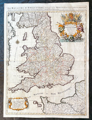
1693 Alexis Hubert Jaillot Large 1st Edition Antique Map of England & Wales
Antique Map
- Title : Le Royaume d'Angleterre Distingue en Ses Provinces...1693
- Size: 33in x 24in (840m x 610mm)
- Condition: (A+) Fine Condition
- Date : 1693
- Ref #: 17059
Description:
This large beautifully hand coloured original 1693 1st edition antique map of England & Wales by A H Jaillot - after Nicolas Sanson - was engraved in 1693 - the date is engraved in the title and was published by Jaillot in his large elephant folio Atlas Nouveau.
An original first state of this handsome map of England and Wales, that includes the east coast of Ireland's, southern Scotland, the Channel Islands, and a stretch of French coastline south to Paris. England and Wales are divided into their local counties, with highly detailed information on towns, cities, rivers, and topographical information.
The stunning decorative title cartouche features the United Kingdom coat-of-arms with a banner underneath reading Je Maintiendray ("I will maintain," which is strangely enough the motto of the Netherlands), along with trumpeting angels, mermen, and symbols of military might. A second cartouche flanked by putti encloses the six distance scales. A compass rose capped with a fleur-de-lis appears in the Irish Sea. Jaillot, in partnership with the sons of Nicolas Sanson, re-engraved Nicolas's Sanson's map on a larger scale in the 1680's. This particular map was published a few years later in the 1690's, and while based on Sanson's cartography (who is credited in the cartouche), it is a Jaillot composition. Also included is an alternate title running along the top neatline: Le Royaume d'Angleterre, Distingue en Ses Provinces; Scavoir en Northumberland, Mercie, East-Angles, Essex, Kent, Sussex, West-Sex, et la Principaute de Galles.
General Definitions:
Paper thickness and quality: - Heavy and stable
Paper color : - off white
Age of map color: - Original & later
Colors used: - Yellow, green, blue, pink
General color appearance: - Authentic
Paper size: - 33in x 24in (840m x 610mm)
Plate size: - 31 1/4in x 23in (795mm x 585mm)
Margins: - Min 1in (25mm)
Imperfections:
Margins: - None
Plate area: - None
Verso: - None
Background:
English Cartography: When considering the work of English map makers we tend, perhaps, to think too much in terms of county maps, dominated by the names of Saxton and Speed, but we should not underrate the contribution to the sum of geographical knowledge made in other spheres, such as the sea charts of Edward Wright, Robert Dudley and Greenvile Collins, the discoveries of James Cook, the road maps of Ogilby and Cary, the meteorological and magnetic charts compiled by Edmund Halley, to mention only a few.
In 1558 Queen Elizabeth came to the throne in the midst of a fast changing world. In 1563 a nineteen sheet map, copies of which survive only in manuscript form, was completed by Laurence Nowell, and no doubt, the issue of Mercator's large-scale map of the British Isles in 1564 had an important influence on the thought of the period. A few years later a national survey was commissioned privately, although probably at the instigation of Lord Burghley, the Lord Treasurer, but subsequently was completed with royal encouragement. The outcome was Christopher Saxton's Atlas of EngIand and Wales, started about 1570 and published in 1579 - the first printed set of county maps and the first countrywide atlas on such a splendid scale produced anywhere. A Welsh antiquarian, Humphrey Lhuyd completed a set of surveys that were even more successful than Saxton in which he had produced fine manuscript maps of England and Wales which were used by Ortelius in editions of his Atlas from 1573 onwards.
The earliest maps of the 17th century, attributed to William Smith of the College of Heralds, covered only twelve counties based on Saxton/Norden and were presumably intended to be part of a complete new atlas. They were printed in the Low Countries in 1602-3 and were soon followed by maps for the Latin edition of Camden's Britannia dated 1607. In 1610-11 the first edition of John Speed's famous county Atlas The Theatre of the Empire of Great Britaine was published and immediately replaced Saxton's in popular appeal. Although Speed assembled much of his material from the earlier works of Saxton, Norden and others, a considerable part of the up-to-date information, especially relating to the inset town plans depicted on his maps, was obtained first hand. The maps undoubtedly owed much of their popularity to the splendid engravings of high quality made in the workshops in Amsterdam of Jodocus Hondius to whom Speed sent his manuscripts, the plates subsequently being returned to London for printing.
In 1645, Volume IV of the famous Blaeu World Atlas covering the counties of England and Wales was published in Amsterdam. These maps have always been esteemed as superb examples of engraving and design, the calligraphy being particularly splendid, but nevertheless they were nearly all based on Saxton and Speed and added little to geographical knowledge.
Not until the latter part of the century do we find an English map maker of originality with the capacity to put new ideas into practice. John Ogilby, one of the more colourful figures associated with cartography, started life as a dancing master and finished as King's Cosmographer and Geographic Printer. After publishing a small number of county maps, somewhat on the lines of John Norden he issued in 1675 the Britannia, the first practical series of detailed maps of the post roads of England and Wales on a standard scale of 1,760 yards to the mile. Up to the end of the century and beyond, reprints and revisions of Saxton's and Speed's atlases continued to appear and the only other noteworthy county maps were Richard Blome's Britannia (1673), John Overton's Atlas (c. 1670) and Robert Morden's maps for an English translation of Camden's Britannia published in 1695.
Another noted cartographer of the day was Captain Greenvile Collins, and of his work in surveying the coasts of Great Britain culminating in the issue in 1693 of the Great Britain's Coasting Pilot. Apart from these charts, English cartographers published during the century a number of world atlases. Speed was the first Englishman to produce a world atlas with the issue in 1627 of his A Prospect of the Most Famous Parts of the World. Other atlases appeared later in the century by Peter Heylin, John Seller, William Berry, Moses Pitt and Richard Blome, whilst Ogilby found time to issue maps of Africa, America and Asia. Far more important, from the purely scientific point of view, was the work of Edmund Halley, Astronomer Royal, who compiled and issued meteorological and magnetic charts in 1688 and 1701 respectively.
At the beginning of the eighteenth century the Dutch map trade was finally in decline, the French in the ascendant and the English to a great extent still dominated by Saxton and Speed except, as we have shown, in the spheres of sea charts and road maps. There were atlases by John Senex, the Bowles family, Emanuel and Thomas Bowen, Thomas Badeslade and the unique bird's-eye perspective views of the counties, The British Monarchy by George Bickham. In 1750-60 Bowen and Kitchin's The Large English Atlas containing maps on a rather larger scale than hitherto was published.
In 1759 the Society for the encouragement of Arts, Manufactures and Commerce offered an award of £100 for the best original surveys on this scale and by the end of the century about thirty counties had been re-surveyed. These maps, many of which formed, in later years, the basis for the first issues of county maps by the Ordnance Survey Office were not only decorative but a tremendous improvement geographically on earlier local maps. As a consequence, the skills and expertise of the new-style cartographers soon enabled them to cover the world as well as the domestic market. Thomas Jefferys was such a man; he was responsible for a number of the new 1 in. to 1 mile county surveys and he issued an edition of Saxton's much battered 200-year-old plates of the county maps, but he is better known for many fine maps of North America and the West Indies. His work was continued on the same lines by William Faden, trading as Faden and Jefferys. Other publishers such as Sayer and Bennett and their successors Laurie and Whittle published a prodigious range of maps, charts and atlases in the second half of the century. A major influence at this time was John Cary who, apart from organizing the first re-survey of post roads since Ogilby and subsequently printing the noted Travellers' Companion, was a prolific publisher of atlases and maps of every kind of all parts of the world. After starting work with Cary, and taking part in the new road survey, Aaron Arrowsmith set up in his own business and went on to issue splendid large-scale maps of many parts of the world. Both Cary's and Arrowsmith's plates were used by other publishers until far into the next century and, in turn, their work was taken up and developed by James Wyld (Elder and Younger) and Tallis and Co.
Later into the 19th century some of the better known cartographers and publishers were by Henry Teesdale (1829-30), Christopher and John Greenwood, surveyors, Thomas Moule, a writer on heraldry and antiques (1830-36) and John Walker (1837) but by about the middle of the century few small-scale publishers survived and their business passed into the hands of large commercial concerns such as Bartholomews of Edinburgh and Philips of London who continue to this day. (Ref: Shirley; Tooley; M&B)
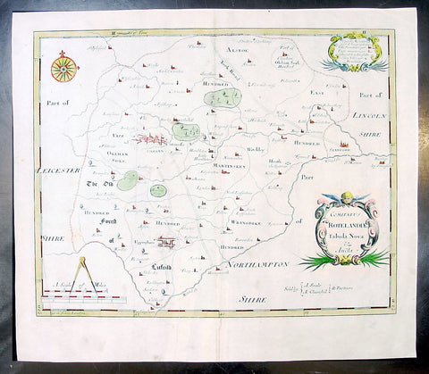
1695 Morden Antique Map The English County of Rutland
- Title : Comitatus Rotelandiae Tabula Nova & Aucta
- Ref #: 50145
- Size: 16in x 14in (405mm x 355mm)
- Date : 1695
- Condition: (A+) Fine Condition
Description:
This beautifully hand coloured original antique map of the English County of Rutland was engraved by Robert Morden for the 1695 edition of Camden's Britannia.
William Camden was an historian who first published his Britannia, a description and history of Britain, in 1586. Written in Latin, the book contained only a general map of the country but had a wide circulation and eventually in 1607 an edition (the sixth) was published with a series of maps with Latin text on the reverse.
Further editions in English were published in 1610 and 1637 but without text. (Many more editions were published up until 1806 with map contributions from Blaeu in 1617, John Bill 1626, Robert Morden 1695-1772 and John Cary 1789-1806)
In the 1610 & 1617 editions the maps were mostly engraved by William Kip and William Hole and were based on those of Christopher Saxton, but six were copied from John Norden.
The map of Pembroke is by George Owen and the general maps of England/Wales, Scotland and Ireland were probably taken from Mercator. Kip reduced the size of each map for Britannia from the originals published byChristopher Saxton in 1579. (Ref: Tooley; M&B)
General Description:
Paper thickness and quality: - Light and stable
Paper color: - off white
Age of map color: - Early
Colors used: - Red, yellow, blue, green, blue
General color appearance: - Authentic
Paper size: - 16in x 14in (405mm x 355mm)
Plate size: - 14 1/2in x 11 1/2in (370mm x 290mm)
Margins: - Min 1in (25m)
Imperfections:
Margins: - None
Plate area: - None
Verso: - None
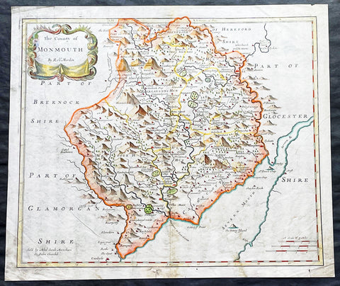
1695 Morden Antique Map The Welsh County of Monmouth
- Title : The County of Monmouth by Robert. Morden
- Ref #: 50155
- Size: 17 1/2in x 15in (445mm x 380mm)
- Date : 1695
- Condition: (A+) Fine Condition
Description:
This fine beautifully hand coloured original antique map of the Welsh county of Monmouth was engraved by Robert Morden & published by Abel Swale & John Churchil for the 1695 edition of Willam Camden's Britannia.
William Camden was an historian who first published his Britannia, a description and history of Britain, in 1586. Written in Latin, the book contained only a general map of the country but had a wide circulation and eventually in 1607 an edition (the sixth) was published with a series of maps with Latin text on the reverse.
Further editions in English were published in 1610 and 1637 but without text. (Many more editions were published up until 1806 with map contributions from Blaeu in 1617, John Bill 1626, Robert Morden 1695-1772 and John Cary 1789-1806)
In the 1610 & 1617 editions the maps were mostly engraved by William Kip and William Hole and were based on those of Christopher Saxton, but six were copied from John Norden.
The map of Pembroke is by George Owen and the general maps of England/Wales, Scotland and Ireland were probably taken from Mercator. Kip reduced the size of each map for Britannia from the originals published by Christopher Saxton in 1579. (Ref: Tooley; M&B)
General Description:
Paper thickness and quality: - Light and stable
Paper color: - off white
Age of map color: - Early
Colors used: - Red, yellow, blue, green, blue
General color appearance: - Authentic
Paper size: - 17 1/2in x 15in (445mm x 380mm)
Plate size: - 16 1/2in x 14in (420mm x 355mm)
Margins: - Min 1/2in (12mm)
Imperfections:
Margins: - 4 small repairs to bottom margin
Plate area: - None
Verso: - None
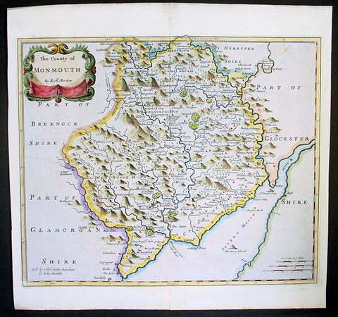
1695 Morden Antique Map The Welsh County of Monmouth
- Title : The County of Monmouth by Robert. Morden
- Ref #: 40869
- Size: 17 1/2in x 15in (445mm x 380mm)
- Date : 1695
- Condition: (A+) Fine Condition
Description:
This fine beautifully hand coloured original antique map of the Welsh county of Monmouth was engraved by Robert Morden & published by Abel Swale & John Churchil for the 1695 edition of Willam Camden's Britannia.
William Camden was an historian who first published his Britannia, a description and history of Britain, in 1586. Written in Latin, the book contained only a general map of the country but had a wide circulation and eventually in 1607 an edition (the sixth) was published with a series of maps with Latin text on the reverse.
Further editions in English were published in 1610 and 1637 but without text. (Many more editions were published up until 1806 with map contributions from Blaeu in 1617, John Bill 1626, Robert Morden 1695-1772 and John Cary 1789-1806)
In the 1610 & 1617 editions the maps were mostly engraved by William Kip and William Hole and were based on those of Christopher Saxton, but six were copied from John Norden.
The map of Pembroke is by George Owen and the general maps of England/Wales, Scotland and Ireland were probably taken from Mercator. Kip reduced the size of each map for Britannia from the originals published by Christopher Saxton in 1579. (Ref: Tooley; M&B)
General Description:
Paper thickness and quality: - Light and stable
Paper color: - off white
Age of map color: - Early
Colors used: - Red, yellow, blue, green, blue
General color appearance: - Authentic
Paper size: - 17 1/2in x 15in (445mm x 380mm)
Plate size: - 16 1/2in x 14in (420mm x 355mm)
Margins: - Min 1/2in (12mm)
Imperfections:
Margins: - 4 small repairs to bottom margin
Plate area: - None
Verso: - None
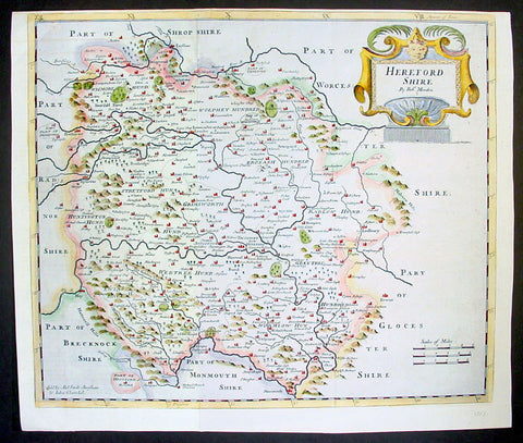
1695 Rob. Morden Antique Map English County of Hereford
- Title : Hereford Shire by Rob. Morden
- Ref #: 40868
- Size: 17in x 15in (430mm x 380mm)
- Date : 1695
- Condition: (A+) Fine Condition
Description:
This attractive original antique map of the English county of Hereford, by Robert Morden, was published in the 1695 edition of Camden's Britannia.
William Camden was an historian who first published his Britannia, a description and history of Britain, in 1586. Written in Latin, the book contained only a general map of the country but had a wide circulation and eventually in 1607 an edition (the sixth) was published with a series of maps with Latin text on the reverse.
Further editions in English were published in 1610 and 1637 but without text. (Many more editions were published up until 1806 with map contributions from Blaeu in 1617, John Bill 1626, Robert Morden 1695-1772 and John Cary 1789-1806)
In the 1610 & 1617 editions the maps were mostly engraved by William Kip and William Hole and were based on those of Christopher Saxton, but six were copied from John Norden.
The map of Pembroke is by George Owen and the general maps of England/Wales, Scotland and Ireland were probably taken from Mercator. Kip reduced the size of each map for Britannia from the originals published byChristopher Saxton in 1579. (Ref: Tooley; M&B)
General Description:
Paper thickness and quality: - Light and stable
Paper color: - off white
Age of map color: - Early
Colors used: - Red, yellow, blue, green
General color appearance: - Authentic, heavy
Paper size: - 17in x 15in (430mm x 380mm)
Plate size: - 17in x 15in (430mm x 380mm)
Margins: - Min 1/4in (4mm)
Imperfections:
Margins: - Top margin cropped close to border
Plate area: - None
Verso: - None
1710 Herman Moll Large Antique Map of England & Wales - Beautiful
Antique Map
- Title : The South Part of Great Britain called England & Wales...by Herman Moll 1710
- Size: 39in x 24in (1.0m x 610mm)
- Condition: (A) Very Good Condition
- Date : 1710
- Ref #: 80662
Description:
This large beautifully hand coloured original copper-plate engraved antique map of England & Wales was engraved in 1710 by Herman Moll - the date is engraved in the title cartouche - and was published by John Bowles of London.
Striking large format, one off published, map of England and Wales. The map is embellished with two large cartouches and an extensive table locating all ye Cities, Market Towns, Boroughs and whateve Places in South Britain have ye Election of Members of Parliament.
The map is elaborately colored by counties, with 5 sailing ships to the right of Northumberland. Includes a dedication to Right Honourable FRANCIS, Lord Viscount Rialton in the cartouche at the right side of the map.
General Definitions:
Paper thickness and quality: - Heavy and stable
Paper color : - off white
Age of map color: - Original
Colors used: - Yellow, green, blue, pink
General color appearance: - Authentic
Paper size: - 39in x 24in (1.0m x 610mm)
Plate size: - 38in x 23in (970mm x 585mm)
Margins: - Min 1/2in (12mm)
Imperfections:
Margins: - None
Plate area: - Light age toning along folds
Verso: - Repairs along folds
Background:
English Cartography: When considering the work of English map makers we tend, perhaps, to think too much in terms of county maps, dominated by the names of Saxton and Speed, but we should not underrate the contribution to the sum of geographical knowledge made in other spheres, such as the sea charts of Edward Wright, Robert Dudley and Greenvile Collins, the discoveries of James Cook, the road maps of Ogilby and Cary, the meteorological and magnetic charts compiled by Edmund Halley, to mention only a few.
In 1558 Queen Elizabeth came to the throne in the midst of a fast changing world. In 1563 a nineteen sheet map, copies of which survive only in manuscript form, was completed by Laurence Nowell, and no doubt, the issue of Mercators large-scale map of the British Isles in 1564 had an important influence on the thought of the period. A few years later a national survey was commissioned privately, although probably at the instigation of Lord Burghley, the Lord Treasurer, but subsequently was completed with royal encouragement. The outcome was Christopher Saxtons Atlas of EngIand and Wales, started about 1570 and published in 1579 - the first printed set of county maps and the first countrywide atlas on such a splendid scale produced anywhere. A Welsh antiquarian, Humphrey Lhuyd completed a set of surveys that were even more successful than Saxton in which he had produced fine manuscript maps of England and Wales which were used by Ortelius in editions of his Atlas from 1573 onwards.
The earliest maps of the 17th century, attributed to William Smith of the College of Heralds, covered only twelve counties based on Saxton/Norden and were presumably intended to be part of a complete new atlas. They were printed in the Low Countries in 1602-3 and were soon followed by maps for the Latin edition of Camdens Britannia dated 1607. In 1610-11 the first edition of John Speeds famous county Atlas The Theatre of the Empire of Great Britaine was published and immediately replaced Saxtons in popular appeal. Although Speed assembled much of his material from the earlier works of Saxton, Norden and others, a considerable part of the up-to-date information, especially relating to the inset town plans depicted on his maps, was obtained first hand. The maps undoubtedly owed much of their popularity to the splendid engravings of high quality made in the workshops in Amsterdam of Jodocus Hondius to whom Speed sent his manuscripts, the plates subsequently being returned to London for printing.
In 1645, Volume IV of the famous Blaeu World Atlas covering the counties of England and Wales was published in Amsterdam. These maps have always been esteemed as superb examples of engraving and design, the calligraphy being particularly splendid, but nevertheless they were nearly all based on Saxton and Speed and added little to geographical knowledge.
Not until the latter part of the century do we find an English map maker of originality with the capacity to put new ideas into practice. John Ogilby, one of the more colourful figures associated with cartography, started life as a dancing master and finished as Kings Cosmographer and Geographic Printer. After publishing a small number of county maps, somewhat on the lines of John Norden he issued in 1675 the Britannia, the first practical series of detailed maps of the post roads of England and Wales on a standard scale of 1,760 yards to the mile. Up to the end of the century and beyond, reprints and revisions of Saxtons and Speeds atlases continued to appear and the only other noteworthy county maps were Richard Blomes Britannia (1673), John Overtons Atlas (c. 1670) and Robert Mordens maps for an English translation of Camdens Britannia published in 1695.
Another noted cartographer of the day was Captain Greenvile Collins, and of his work in surveying the coasts of Great Britain culminating in the issue in 1693 of the Great Britains Coasting Pilot. Apart from these charts, English cartographers published during the century a number of world atlases. Speed was the first Englishman to produce a world atlas with the issue in 1627 of his A Prospect of the Most Famous Parts of the World. Other atlases appeared later in the century by Peter Heylin, John Seller, William Berry, Moses Pitt and Richard Blome, whilst Ogilby found time to issue maps of Africa, America and Asia. Far more important, from the purely scientific point of view, was the work of Edmund Halley, Astronomer Royal, who compiled and issued meteorological and magnetic charts in 1688 and 1701 respectively.
At the beginning of the eighteenth century the Dutch map trade was finally in decline, the French in the ascendant and the English to a great extent still dominated by Saxton and Speed except, as we have shown, in the spheres of sea charts and road maps. There were atlases by John Senex, the Bowles family, Emanuel and Thomas Bowen, Thomas Badeslade and the unique birds-eye perspective views of the counties, The British Monarchy by George Bickham. In 1750-60 Bowen and Kitchins The Large English Atlas containing maps on a rather larger scale than hitherto was published.
In 1759 the Society for the encouragement of Arts, Manufactures and Commerce offered an award of £100 for the best original surveys on this scale and by the end of the century about thirty counties had been re-surveyed. These maps, many of which formed, in later years, the basis for the first issues of county maps by the Ordnance Survey Office were not only decorative but a tremendous improvement geographically on earlier local maps. As a consequence, the skills and expertise of the new-style cartographers soon enabled them to cover the world as well as the domestic market. Thomas Jefferys was such a man; he was responsible for a number of the new 1 in. to 1 mile county surveys and he issued an edition of Saxtons much battered 200-year-old plates of the county maps, but he is better known for many fine maps of North America and the West Indies. His work was continued on the same lines by William Faden, trading as Faden and Jefferys. Other publishers such as Sayer and Bennett and their successors Laurie and Whittle published a prodigious range of maps, charts and atlases in the second half of the century. A major influence at this time was John Cary who, apart from organizing the first re-survey of post roads since Ogilby and subsequently printing the noted Travellers Companion, was a prolific publisher of atlases and maps of every kind of all parts of the world. After starting work with Cary, and taking part in the new road survey, Aaron Arrowsmith set up in his own business and went on to issue splendid large-scale maps of many parts of the world. Both Carys and Arrowsmiths plates were used by other publishers until far into the next century and, in turn, their work was taken up and developed by James Wyld (Elder and Younger) and Tallis and Co.
Later into the 19th century some of the better known cartographers and publishers were by Henry Teesdale (1829-30), Christopher and John Greenwood, surveyors, Thomas Moule, a writer on heraldry and antiques (1830-36) and John Walker (1837) but by about the middle of the century few small-scale publishers survived and their business passed into the hands of large commercial concerns such as Bartholomews of Edinburgh and Philips of London who continue to this day. (Ref: Shirley; Tooley; M&B)
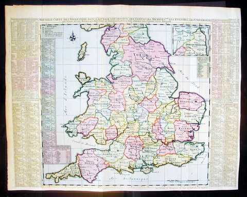
1720 Chatelain Antique Map of England & Wales
- Title : Nouvelle Carte De L Angleterre Dans Laquelle Lon Observe Lez Comtez Les Archives
- Ref #: 16370
- Size: 25 1/2in x 20 1/2in (650m x 430m)
- Date : 1720
- Condition: (A+) Fine Condition
Description:
This large fine beautifully hand coloured original antique map of England & Wales - with side text on all the different counties - by Henri Abraham Chatelain in 1720 was published in his famous Atlas Historique.
This is a magnificent map with bright hand colouring, clean strong sturdy paper and a heavy clear impression.
The Atlas Historique published by Henri Chatelain was part of a major work of its time, an encyclopedia in seven volumes, including geography as one of its main subjects. The text was by Nicholas Gueudeville and the maps by Chatelain. The Atlas included one of the finest map of America (four sheets) surrounded by vignettes and decorative insets. The Atlas Historique was completed between 1705 and 1720, further issues were published up to 1739. The series was published in Amsterdam, with Chatelain’s maps based on those of G. Delisle. (Ref: M&B; Tooley)
General Description:
Paper thickness and quality: - Heavy and stable
Paper color: - White
Age of map color: - Early
Colors used: - Pink, green, yellow, blue
General color appearance: - Authentic
Paper size: - 25 1/2in x 20 1/2in (650m x 430m)
Plate size: - 25in x 19 1/2in (635m x 495mm)
Margins: - min. 1/2in (10mm)
Imperfections:
Margins: - None
Plate area: - Folds as issued
Verso: - None
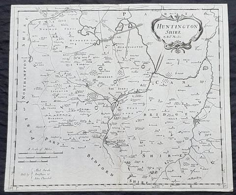
1722 Robert Morden Antique Map of Huntington in County of Cambridgeshire England
- Title : Huntington Shire by Robt. Morden...Sold by Abel Swale Awsham & John Churchill
- Size: 17 1/4in x 14 1/2in (435mm x 370mm)
- Condition: (A+) Fine Condition
- Date : 1722
- Ref #: 92680
Description:
This fine original copper-plate engraved antique map of the English region of Huntingdonshire, in the county of Cambridgeshire by Robert Morden was published in the 1722 edition of Camdens Britannia.
General Definitions:
Paper thickness and quality: - Heavy and stable
Paper color : - off white
Age of map color: -
Colors used: -
General color appearance: -
Paper size: - 17 1/4in x 14 1/2in (435mm x 370mm)
Plate size: - 17 1/4in x 14 1/2in (435mm x 370mm)
Margins: - Min 1/2in (6mm)
Imperfections:
Margins: - None
Plate area: - None
Verso: - None
Background:
William Camden 1551 – 1623 was an English antiquarian, historian, topographer, and herald, best known as author of Britannia, the first chorographical survey of the islands of Great Britain and Ireland, and the Annales, the first detailed historical account of the reign of Elizabeth I of England.
In 1577, with the encouragement of Abraham Ortelius, Camden began his great work Britannia, a topographical and historical survey of all of Great Britain and Ireland. His stated intention was to restore antiquity to Britaine, and Britain to his antiquity. The first edition, written in Latin, was published in 1586. It proved very popular, and ran through five further editions, of 1587, 1590, 1594, 1600 and 1607, each greatly enlarged from its predecessor in both textual content and illustrations. The 1607 edition included for the first time a full set of English county maps, based on the surveys of Christopher Saxton and John Norden, and engraved by William Kip and William Hole (who also engraved the fine frontispiece). The first English language edition, translated by Philemon Holland, appeared in 1610, again with some additional content supplied by Camden.
Britannia is a county-by-county description of Great Britain and Ireland. It is a work of chorography: a study that relates landscape, geography, antiquarianism, and history. Rather than write a history, Camden wanted to describe in detail the Great Britain of the present, and to show how the traces of the past could be discerned in the existing landscape. By this method, he produced the first coherent picture of Roman Britain.
He continued to collect materials and to revise and expand Britannia throughout his life. He drew on the published and unpublished work of John Leland and William Lambarde, among others, and received the assistance of a large network of correspondents with similar interests. He also travelled throughout Great Britain to view documents, sites, and artefacts for himself: he is known to have visited East Anglia in 1578, Yorkshire and Lancashire in 1582, Devon in 1589, Wales in 1590, Salisbury, Wells and Oxford in 1596, and Carlisle and Hadrians Wall in 1599. His fieldwork and firsthand research set new standards for the time. He even learned Welsh and Old English for the task: his tutor in Old English was Laurence Nowell.
In 1593 Camden became headmaster of Westminster School. He held the post for four years, but left when he was appointed Clarenceux King of Arms. By this time, largely because of the Britannias reputation, he was a well-known and revered figure, and the appointment was meant to free him from the labour of teaching and to facilitate his research. The College of Arms at that time was not only a centre of genealogical and heraldic study, but also a centre of antiquarian study. The appointment, however, roused the jealousy of Ralph Brooke, York Herald, who, in retaliation, published an attack on Britannia, charging Camden with inaccuracy and plagiarism. Camden successfully defended himself against the charges in subsequent editions of the work.
Britannia was recognised as an important work of Renaissance scholarship, not only in England, but across the European Republic of Letters. Camden considered having the 1586 Britannia printed in the Low Countries, and although that did not happen, the third edition of 1590, in addition to its London printing, was also published the same year in Frankfurt, and reprinted there in 1616. In 1612 parts were condemned by the Spanish Inquisition. An abridgement was published in Amsterdam in 1617 and reprinted in 1639; and versions of the text were also included in Joan Blaeus Theatrum Orbis Terrarum (published in Amsterdam in 1645) and in Jan Janssoniuss Novus Atlas (again published in Amsterdam, in 1646)
1722 Robert Morden Antique Map of Huntington in County of Cambridgeshire England
- Title : Huntington Shire by Robt. Morden...Sold by Abel Swale Awsham & John Churchill
- Size: 17 1/4in x 14 1/2in (435mm x 370mm)
- Condition: (A+) Fine Condition
- Date : 1722
- Ref #: 50149
Description:
This fine original copper-plate engraved antique map of the English region of Huntingdonshire, in the county of Cambridgeshire by Robert Morden was published in the 1722 edition of Camdens Britannia.
General Definitions:
Paper thickness and quality: - Heavy and stable
Paper color : - off white
Age of map color: -
Colors used: -
General color appearance: -
Paper size: - 17 1/4in x 14 1/2in (435mm x 370mm)
Plate size: - 17 1/4in x 14 1/2in (435mm x 370mm)
Margins: - Min 1/2in (6mm)
Imperfections:
Margins: - Light age toning
Plate area: - Light age toning
Verso: - Light age toning
Background:
William Camden 1551 – 1623 was an English antiquarian, historian, topographer, and herald, best known as author of Britannia, the first chorographical survey of the islands of Great Britain and Ireland, and the Annales, the first detailed historical account of the reign of Elizabeth I of England.
In 1577, with the encouragement of Abraham Ortelius, Camden began his great work Britannia, a topographical and historical survey of all of Great Britain and Ireland. His stated intention was to restore antiquity to Britaine, and Britain to his antiquity. The first edition, written in Latin, was published in 1586. It proved very popular, and ran through five further editions, of 1587, 1590, 1594, 1600 and 1607, each greatly enlarged from its predecessor in both textual content and illustrations. The 1607 edition included for the first time a full set of English county maps, based on the surveys of Christopher Saxton and John Norden, and engraved by William Kip and William Hole (who also engraved the fine frontispiece). The first English language edition, translated by Philemon Holland, appeared in 1610, again with some additional content supplied by Camden.
Britannia is a county-by-county description of Great Britain and Ireland. It is a work of chorography: a study that relates landscape, geography, antiquarianism, and history. Rather than write a history, Camden wanted to describe in detail the Great Britain of the present, and to show how the traces of the past could be discerned in the existing landscape. By this method, he produced the first coherent picture of Roman Britain.
He continued to collect materials and to revise and expand Britannia throughout his life. He drew on the published and unpublished work of John Leland and William Lambarde, among others, and received the assistance of a large network of correspondents with similar interests. He also travelled throughout Great Britain to view documents, sites, and artefacts for himself: he is known to have visited East Anglia in 1578, Yorkshire and Lancashire in 1582, Devon in 1589, Wales in 1590, Salisbury, Wells and Oxford in 1596, and Carlisle and Hadrians Wall in 1599. His fieldwork and firsthand research set new standards for the time. He even learned Welsh and Old English for the task: his tutor in Old English was Laurence Nowell.
In 1593 Camden became headmaster of Westminster School. He held the post for four years, but left when he was appointed Clarenceux King of Arms. By this time, largely because of the Britannias reputation, he was a well-known and revered figure, and the appointment was meant to free him from the labour of teaching and to facilitate his research. The College of Arms at that time was not only a centre of genealogical and heraldic study, but also a centre of antiquarian study. The appointment, however, roused the jealousy of Ralph Brooke, York Herald, who, in retaliation, published an attack on Britannia, charging Camden with inaccuracy and plagiarism. Camden successfully defended himself against the charges in subsequent editions of the work.
Britannia was recognised as an important work of Renaissance scholarship, not only in England, but across the European Republic of Letters. Camden considered having the 1586 Britannia printed in the Low Countries, and although that did not happen, the third edition of 1590, in addition to its London printing, was also published the same year in Frankfurt, and reprinted there in 1616. In 1612 parts were condemned by the Spanish Inquisition. An abridgement was published in Amsterdam in 1617 and reprinted in 1639; and versions of the text were also included in Joan Blaeus Theatrum Orbis Terrarum (published in Amsterdam in 1645) and in Jan Janssoniuss Novus Atlas (again published in Amsterdam, in 1646)
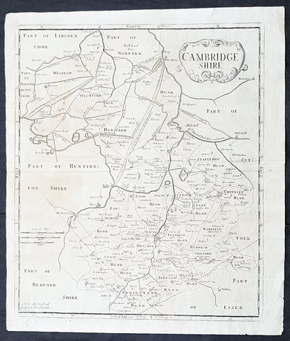
1722 Robert Morden Antique Map of the English County of Cambridgeshire
- Title : Cambridgeshire...Sold by Abel Swal and Awsham& John Churchill Sutton Nicholls sculp.
- Size: 16 1/4in x 15in (460mm x 380mm)
- Condition: (A+) Fine Condition
- Date : 1722
- Ref #: 40181
Description:
This fine original copper-plate engraved antique map of the English county of Cambridgeshire by Robert Morden was published in the 1722 edition of Camdens Britannia.
General Definitions:
Paper thickness and quality: - Heavy and stable
Paper color : - off white
Age of map color: -
Colors used: -
General color appearance: -
Paper size: - 16 1/4in x 15in (460mm x 380mm)
Plate size: - 15 1/2in x 14 1/2in (450mm x 370mm)
Margins: - Min 1/2in (12mm)
Imperfections:
Margins: - None
Plate area: - None
Verso: - None
Background:
William Camden 1551 – 1623 was an English antiquarian, historian, topographer, and herald, best known as author of Britannia, the first chorographical survey of the islands of Great Britain and Ireland, and the Annales, the first detailed historical account of the reign of Elizabeth I of England.
In 1577, with the encouragement of Abraham Ortelius, Camden began his great work Britannia, a topographical and historical survey of all of Great Britain and Ireland. His stated intention was to restore antiquity to Britaine, and Britain to his antiquity. The first edition, written in Latin, was published in 1586. It proved very popular, and ran through five further editions, of 1587, 1590, 1594, 1600 and 1607, each greatly enlarged from its predecessor in both textual content and illustrations. The 1607 edition included for the first time a full set of English county maps, based on the surveys of Christopher Saxton and John Norden, and engraved by William Kip and William Hole (who also engraved the fine frontispiece). The first English language edition, translated by Philemon Holland, appeared in 1610, again with some additional content supplied by Camden.
Britannia is a county-by-county description of Great Britain and Ireland. It is a work of chorography: a study that relates landscape, geography, antiquarianism, and history. Rather than write a history, Camden wanted to describe in detail the Great Britain of the present, and to show how the traces of the past could be discerned in the existing landscape. By this method, he produced the first coherent picture of Roman Britain.
He continued to collect materials and to revise and expand Britannia throughout his life. He drew on the published and unpublished work of John Leland and William Lambarde, among others, and received the assistance of a large network of correspondents with similar interests. He also travelled throughout Great Britain to view documents, sites, and artefacts for himself: he is known to have visited East Anglia in 1578, Yorkshire and Lancashire in 1582, Devon in 1589, Wales in 1590, Salisbury, Wells and Oxford in 1596, and Carlisle and Hadrians Wall in 1599. His fieldwork and firsthand research set new standards for the time. He even learned Welsh and Old English for the task: his tutor in Old English was Laurence Nowell.
In 1593 Camden became headmaster of Westminster School. He held the post for four years, but left when he was appointed Clarenceux King of Arms. By this time, largely because of the Britannias reputation, he was a well-known and revered figure, and the appointment was meant to free him from the labour of teaching and to facilitate his research. The College of Arms at that time was not only a centre of genealogical and heraldic study, but also a centre of antiquarian study. The appointment, however, roused the jealousy of Ralph Brooke, York Herald, who, in retaliation, published an attack on Britannia, charging Camden with inaccuracy and plagiarism. Camden successfully defended himself against the charges in subsequent editions of the work.
Britannia was recognised as an important work of Renaissance scholarship, not only in England, but across the European Republic of Letters. Camden considered having the 1586 Britannia printed in the Low Countries, and although that did not happen, the third edition of 1590, in addition to its London printing, was also published the same year in Frankfurt, and reprinted there in 1616. In 1612 parts were condemned by the Spanish Inquisition. An abridgement was published in Amsterdam in 1617 and reprinted in 1639; and versions of the text were also included in Joan Blaeus Theatrum Orbis Terrarum (published in Amsterdam in 1645) and in Jan Janssoniuss Novus Atlas (again published in Amsterdam, in 1646)
1722 Robert Morden Antique Map of The English County of Middlesex, London
Antique Map
- Title : Midlesex
- Date : 1722
- Size: 17 1/2in x 15 1/2in (445mm x 395mm)
- Condition: (A+) Fine Condition
- Ref: 35603
Description:
This original hand coloured copper-plate engraved antique map of the county of Middlesex and London by Robert Morden was published in the 1722 edition of Camdens Britannia.
General Definitions:
Paper thickness and quality: - Heavy and stable
Paper color : - off white
Age of map color: - Original
Colors used: - Pink, blue, green, yellow
General color appearance: - Authentic
Paper size: - 17 1/2in x 15 1/2in (445mm x 395mm)
Plate size: - 17 1/2in x 15 1/2in (445mm x 395mm)
Margins: - Min 1/2in (12mm)
Imperfections:
Margins: - None
Plate area: - None
Verso: - None
Background:
These maps are the first county maps to show roads (based on Ogilby’s road maps) and show three scales representing great, middle and small miles as different scales were used in different parts of the country. Morden was employed to replace the outdated maps by Saxton, engraved by Kip and Hole. He based his maps on manuscript sources plus the surveys of Ogilby and Morgan, Seller, Palmer and the coastal charts of Captain Grenville Collins. One innovation was the showing of longitudes measured from the meridian of St. Paul's Cathedral given in the form of time in minutes at the top of the map in Roman numerals and at the bottom in degrees. This was done to clarify local times that were taken from the sun as there was no national standard time. Gibson said:' Where actual Surveys could be had, they were purchased at any rate; and for the rest, one of the best Copies extanct was sent to some of the most knowing Gentlemen in each County; with a request to supply the defects, rectified the positions, and correct the false spellings. And that nothing might be wanting to render them as complete and accurate as might be, this whole business was commited to Mr Robert Morden, a person of know abilities in these matters'..from the Preface of the Britannia.
1756 Maitland Large Antique Print of Bridewell Palace, Prison London, England
- Title : Bridewell
- Ref : 26335
- Size: 15in x 9 1/2in (380mm x 245mm)
- Date : 1756
- Condition: (A+) Fine Condition
Description:
This fine hand coloured original antique print of Bridewell Palace as it was as a prison in the 18th century was engraved by Benjamin Cole and published in the 1756 edition of The History of London from its Foundation to the Present Time...', by William Maitland, Osborne & Shipton and Hodges, London.
Bridewell Palace in London was built as a residence of King Henry VIII and was one of his homes early in his reign for eight years. Given to the City of London Corporation by his son King Edward VI for use as an orphanage and place of correction for wayward women, Bridewell later became the first prison/poorhouse to have an appointed doctor.
It was built on the banks of the Fleet River in the City of London between Fleet Street and the River Thames in an area today known as 'Bridewell Court' off New Bridge Street. By 1556 part of it had become a jail known as Bridewell Prison. It was reinvented with lodgings and was closed in 1855 and the buildings demolished in 1863–1864. (Ref: Tooley; M&B)
General Description:
Paper thickness and quality: - Heavy and stable
Paper color: - off white
Age of map color: - Early
Colors used: - Red, yellow, green
General color appearance: - Authentic
Paper size: - 15in x 9 1/2in (380mm x 245mm)
Plate size: - 13 3/4in x 8 1/4in (350mm x 210mm)
Margins: - Min 1in (25mm)
Imperfections:
Margins: - None
Plate area: - None
Verso: - None

1759 Delarochette & Kitchin 1st Edition Antique Map of Germany Central Europe - Rare
Antique Map
- Titles: Map of the Empire of Germany, Including All the States Comprehend under that name: with the Kingdom of Priussia &c.
Sizes: 48 1/2in x 41in (1.230m x 1.040m) - Condition: (A+) Fine Condition
- Date: 1759
- Ref #: 93418
Description:
This stunning very large, scare and original copper-plate engraved antique 1st edition wall map of Germany, Bohemia, Austria, Prussia, Poland, Hungary, Netherlands and Northern Italy by the English cartographers Louis d arcy Delarochette & Thomas Kitchin (engraver) was published by Robert Sayer in 1759.
Incredibly detailed map of central Europe showing political boundaries as they were in the mid 18th century. Much detail noting roadways, towns, castles, monasteries, forests, swamps, rivers, towns, cities, mountains and much more. An incredible insight into mid 18th century Europe.
General Definitions:
Paper thickness and quality: - Heavy and stable
Paper color : - off white
Age of map color: - Original
Colors used: - Yellow, green, blue, pink
General color appearance: - Authentic
Paper size: - 48 1/2in x 41in (1.230m x 1.040m)
Plate size: - 48 1/2in x 41in (1.230m x 1.040m)
Margins: - Min 1/2in (12mm)
Imperfections:
Margins: - None
Plate area: - None
Verso: - None
Background:
Louis d Arcy Delarochette 1731 - 1802 was a British cartographer active in the mid to late 18th century. Collaborated with many famous British cartographers including Kitchin, Faden, Laurie & Whittle and Thomas Jefferies. Well know for his large scale maps.
Robert Sayers 1724 - 1794 was an important English map publisher and engraver active from the mid to late 18th century. Sayer was born in Sunderland, England, in 1725. He may have clerked as a young man with the Bank of England, but this is unclear. His brother, James Sayer, married Mary Overton, daughter-in-law of John Overton and widow of Philip Overton. Sayer initially worked under Mary Overton, but by December of 1748 was managing the Overton enterprise and gradually took it over, transitioning the plates to his own name. When Thomas Jefferys went bankrupt in 1766, Sayer offered financial assistance to help him stay in business and, in this way, acquired rights to many of the important Jefferys map plates as well as his unpublished research. From about 1774, he began publishing with his apprentice, John Bennett (fl. 1770-1784), as Sayer and Bennett, but the partnership was not formalized until 1777. Bennett retired in 1784 following a mental collapse and the imprint reverted to Robert Sayer. From 1790, Sayer added Robert Laurie and James Whittle to his enterprise, renaming the firm Robert Sayer and Company. Ultimately, Laurie and Whittle partnered to take over his firm. Sayer retired to Bath, where, after a long illness, he died. During most of his career, Sayer was based at 53 Fleet Street, London. His work is particularly significant for its publication of many British maps relating to the American Revolutionary War. Unlike many map makers of his generation, Sayer was a good businessman and left a personal fortune and great estate to his son, James Sayer, who never worked in the publishing business.
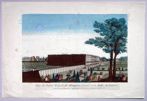
1760 Vue D Optic Antique Print View of Hampton Court Palace, Richmond London
- Title : Vue du Palias Royal de Hampton Court a 15 Milles de Londres
- Date : 1760
- Condition: (A) Very Good Condition
- Ref: 92704
- Size: 19in x 12 3/4in (480mm x 325mm)
Description:
This hand coloured original antique print, a view of Hampton Court Palace was published as part of the Vues d’Optique in 1760.
Hampton Court Palace: is a royal palace in the London Borough of Richmond upon Thames, Greater London, in the historic county of Middlesex, and within the postal town East Molesey, Surrey. It has not been inhabited by the British Royal Family since the 18th century. The palace is 11.7 miles (18.8 kilometres) south west of Charing Cross and upstream of central London on the River Thames. It was originally built in 1514 for Cardinal Thomas Wolsey, a favourite of King Henry VIII. In 1529, as Wolsey fell from favour, the King seized the palace for himself and later enlarged it. Along with St. James's Palace, it is one of only two surviving palaces out of the many owned by King Henry VIII.
In the following century, King William III's massive rebuilding and expansion project was intended to rival Versailles. Work ceased in 1694, leaving the palace in two distinct contrasting architectural styles, domestic Tudor and Baroque. While the palace's styles are an accident of fate, a unity exists due to the use of pink bricks and a symmetrical, if vague, balancing of successive low wings.
Vues d' Optique or Perspective Views: Perspective views, or "vues d'optique," are a special type of popular print published in Europe during the 18th century. These prints provided a form of entertainment when viewed through a device called an "optical machine" or an "optique." The most characteristic feature of the perspective views is their emphasized linear perspective, done to further intensify the enhanced appearance of depth and illusionistic space in the prints when viewed through an optique. When displayed in the optique, the prints might transport the viewer into a far away place---an unknown city, or perhaps into the midst of a dramatic bit of contemporary history. Another attribute of these prints is their bright, often heavy hand coloring, applied boldly so as to show the tints when viewed through the lens.
A number of perspective prints depicted American scenes at the time of the Revolution for a European audience hungry for news of the events in the British colonies. As documents of American history and European printmaking, these are unusual and appealing eighteenth-century prints.
General Description:
Paper thickness and quality: - Heavy & stable
Paper color: - Off white
Age of map color: - Original
Colors used: - Blue, yellow, green, red
General color appearance: - Authentic & bright
Paper size: - 19in x 12 3/4in (480mm x 325mm)
Plate size: - 14 1/2in x 9 1/2in (370mm x 240mm)
Margins: - Min 2in (50mm)
Imperfections:
Margins: - Light soiling
Plate area: - Small smudge & toning to sky
Verso: - Small repair, no loss
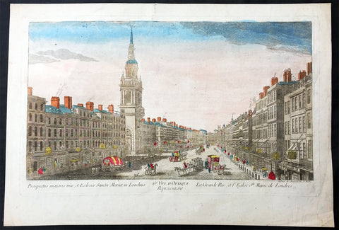
1760 Vue D Optic Large Antique Print View of Cheapside, London St Mary le Bow
- Title : Prospectus majoris viae, et Ecclesiae Sanctae Mariae in Londino; 25c Vue D Optique Representatnt; Le Grande Rue, et L Englise St Marie de Londres
- Ref : 43197
- Size: 18in x 13in (460mm x 330mm)
- Date : 1756
- Condition: (A) Very Good Condition
Description:
This hand coloured original antique print, a view of Cheapside and St Marys Le Bow, London was published as part of the Vues d’Optique in 1760.
St Mary-le-Bow is an historic church rebuilt after the Great Fire of 1666 by Sir Christopher Wren in the City of London on the main east–west thoroughfare, Cheapside. According to tradition a true Cockney must be born within earshot of the sound of Bow Bells (which refers to this church's bells rather than St Mary and Holy Trinity, Bow Road, in Bow, an outlying village until the 19th century.
Vues d'Optique or Perspective Views: Perspective views, or "vues d'optique," are a special type of popular print published in Europe during the 18th century. These prints provided a form of entertainment when viewed through a device called an "optical machine" or an "optique." The most characteristic feature of the perspective views is their emphasized linear perspective, done to further intensify the enhanced appearance of depth and illusionistic space in the prints when viewed through an optique. When displayed in the optique, the prints might transport the viewer into a far away place---an unknown city, or perhaps into the midst of a dramatic bit of contemporary history. Another attribute of these prints is their bright, often heavy hand coloring, applied boldly so as to show the tints when viewed through the lens.
A number of perspective prints depicted American scenes at the time of the Revolution for a European audience hungry for news of the events in the British colonies. As documents of American history and European printmaking, these are unusual and appealing eighteenth-century prints. (Ref: M&B; Tooley)
General Description:
Paper thickness and quality: - Heavy & stable
Paper color: - White
Age of map color: - Original
Colors used: - Blue, yellow, green, red
General color appearance: - Authentic & bright
Paper size: - 18in x 13in (460mm x 330mm)
Plate size: - 16 1/2in x 10in (420mm x 255mm)
Margins: - Min 1in (25mm)
Imperfections:
Margins: - Repair to top margin, no loss
Plate area: - None
Verso: - None
1761 John Rocque & Robert Sayer Very Large Antique Map of England & Wales
- Title : England and Wales Drawn from the Most Accurate Surveys...by John Rocque
- Date : 1761
- Condition: (A) Very Good Condition
- Ref: 92242
- Size: 49in x 37in (1.25m x 1.00m)
Description:
This very large - 4 sheet joined - famous mid 18th century original antique map of England and Wales by John Rocque was published by Robert Sayer in the large 1761 edition of A General Atlas Describing the Whole Universe.
This map is extremely detailed denoting nearly every town river canal and point of interest. This type of cartography is indicative of the British attention to detail & research that helped Britain become the world power over the next 150 years.
John Rocque c. 1704-62 - Little is known of John Rocque's early life except that he was of Huguenot extraction and was living and working in London as an engraver from about 1734. His early experience in preparing plans of great houses and gardens for the nobility led him to take up large-scale surveying for which he developed a distinctive and effective style involving new ways of indicating land use and hill contours. He is best known for a very large-scale plan of London published in 1746 and for a pocket set of county maps, The English Traveller, issued in the same year. He spent some years in Ireland surveying for estate maps and in 1756 he published a well-known Exact Survey of the City of Dublin.
Rocque was Topographer to the Prince of Wales and attained his new title after the coronation in 1760. He flourished from 1734-62. Sayer, a famous and prolific mapmaker, was taken into partnership by John Overton in 1745. After his death in 1752 Sayer continued on his own forming several associations until his own death in 1792. His association with Rocque began in 1753. (Ref:M&B; Tooley)
General Description:
Paper thickness and quality: - Heavy & stable
Paper color: - White
Age of map color: - Original & later
Colors used: - Blue, brown
General color appearance: - Authentic
Paper size: - 49in x 37in (1.25m x 1.00m)
Paper size: - 49in x 37in (1.25m x 1.00m)
Margins: - Min 1/2in (12mm)
Imperfections:
Margins: - Several folds re-enforced and re-joined
Plate area: - Folds as issued, light offsetting, several folds re-enforced and re-joined
Verso: - Several folds re-enforced and re-joined
1773 Grose Large Antique Print View of The London Charter House
- Title : Description of The Charter House
- Ref : 26237
- Size: 15in x 9 1/2in (385mm x 235mm)
- Date : 1773
- Condition: (A+) Fine Condition
Description:
This large original antique print of the London Charter House situated in Smithfield London - accompanied with text page - was published by Francis Grose on the 1773 edition of The Antiquities of England and Wales.
The London Charterhouse is a historic complex of buildings in Smithfield, London dating back to the 14th century. It occupies land to the north of Charterhouse Square. The Charterhouse began as (and takes its name from) a Carthusian priory, founded in 1371 and dissolved in 1537.
Substantial fragments remain from this monastic period, but the site was largely rebuilt after 1545 as a large courtyard house. Thus, today it "conveys a vivid impression of the type of large rambling 16th century mansion that once existed all round London". The Charterhouse was further altered and extended after 1611, when it became an almshouseand school, endowed by Thomas Sutton. The almshouse (a home for gentlemen pensioners) still occupies the site today under the name the Charterhouse.
Francis Grose (1731 –1791) was an English antiquary, draughtsman, and lexicographer. He was born at his father's house in Broad Street, St-Peter-le-Poer, London.
Grose had early on shown a keen interest in drawing, having attempted sketches of medieval buildings as far back as 1749, and having taken formal instruction at a drawing school in the mid-1750s. He was not a particularly gifted draughtsman but he mixed in the London artistic milieu and began to exhibit, first at the Society of Artists in 1767–8 and then at the Royal Academy. His interest was in the field of medieval remains, which were beginning to exercise an increasing grip on the public imagination.
In 1772, he published the first part of The Antiquities of England and Wales, a work which he unashamedly aimed at the popular market. Essentially, it targeted those who wanted to know about antiquities but had neither time nor means to visit them in person, and contained small panoramas of medieval ruins, together with an informative text on a separate page. Sometimes the text was taken from books already published, or from information supplied by other antiquaries (both acknowledged); sometimes Grose collated material himself from which he could work up an article. From 1772 onwards, he also toured the country to visit and draw sites for inclusion in The Antiquities. The fourth and last volume came out in June 1776, and Grose almost immediately began work on a supplement.
General Description:
Paper thickness and quality: - Heavy & stable
Paper color: - Off white
Age of map color: -
Colors used: -
General color appearance: -
Paper size: - 15in x 9 1/2in (385mm x 235mm)
Margins: - Min 1/2in (12mm)
Imperfections:
Margins: - None
Plate area: - None
Verso: - None
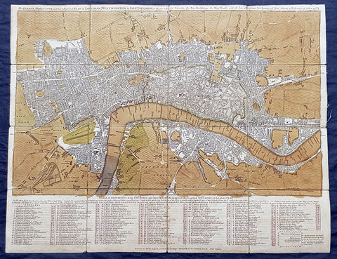
1782 Robert Sayer & John Bennett Large Early Antique Map of London, Rare
- Title : The London Directory or a New & Improved Plan of London, Westminster & Southwark; with the adjacent Country, the New Buildings, the New Roads and the late alterations by Opening of New Streets, & Widening of others 1782.
- Size: 20 1/2in x 16in (510mm x 410mm)
- Condition: (A) Very Good Condition
- Date : 1782
- Ref #: 93047
Description:
This original copper-plate engraved antique segmented map laid on linen of London was engraved in 1782 - dated - and published by Robert Sayer and John Bennett, London.
General Definitions:
Paper thickness and quality: - Heavy and stable
Paper color : - off white
Age of map color: - Original
Colors used: - Green, brown
General color appearance: - Authentic
Paper size: - 20 1/2in x 16in (510mm x 410mm)
Plate size: - 20 1/2in x 16in (510mm x 410mm)
Margins: - Min 1/2in (12mm)
Imperfections:
Margins: - Age toning
Plate area: - Age toned
Verso: - Linen backed
Background:
A highly appealing 1783 map centered on the Thames River. The map details central London from Islington to Shadwell and from Newington Butts to Tyburn. Only three bridges are shown, across the Thames: Westminster Bridge, London Bridge, and Blackfriars (B.L. Fryers). The portions of the city devastated by the 1666 Great Fire of London is marked. A street index and public building index appears below the map proper. The earliest edition of this map was published by Sayer in 1765, with numerous updates to about 1800 – all states are rare, this being the 7th of 1783. Another, almost identical version of this map was issued by John Carrington and, having a slightly longer lifespan, was published and updated until about 1811.
Sayer, Robert 1725 - 1794
Sayer was an important English map publisher and engraver active from the mid to late 18th century. Sayer was born in Sunderland, England, in 1725. He may have clerked as a young man with the Bank of England, but this is unclear. His brother, James Sayer, married Mary Overton, daughter-in-law of John Overton and widow of Philip Overton. Sayer initially worked under Mary Overton, but by December of 1748 was managing the Overton enterprise and gradually took it over, transitioning the plates to his own name. When Thomas Jefferys went bankrupt in 1766, Sayer offered financial assistance to help him stay in business and, in this way, acquired rights to many of the important Jefferys map plates as well as his unpublished research. From about 1774, he began publishing with his apprentice, John Bennett (fl. 1770-1784), as Sayer and Bennett, but the partnership was not formalized until 1777. Bennett retired in 1784 following a mental collapse and the imprint reverted to Robert Sayer. From 1790, Sayer added Robert Laurie and James Whittle to his enterprise, renaming the firm Robert Sayer and Company. Ultimately, Laurie and Whittle partnered to take over his firm. Sayer retired to Bath, where, after a long illness, he died. During most of his career, Sayer was based at 53 Fleet Street, London. His work is particularly significant for its publication of many British maps relating to the American Revolutionary War. Unlike many map makers of his generation, Sayer was a good businessman and left a personal fortune and great estate to his son, James Sayer, who never worked in the publishing business.
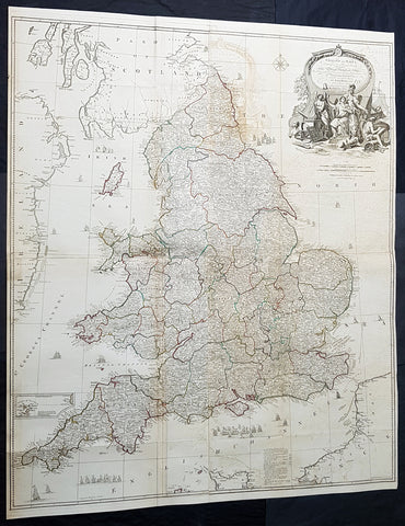
1794 Laurie & Whittle, John Rocque Large Antique Map England & Wales, Sea Battle
Antique Map
- Titles: England and Wales Drawn from the Most Accurate Surveys...by John Rocque...Laurie & whittle...1794
Sizes: 47 1/2in x 39 1/2in (1.21m x 1.050m) - Condition: (A) Very Good Condition
- Date: 1794
- Ref #: 93417-1
Description:
This very large - 4 sheet joined - famous mid 18th century original hand coloured copper-plate engraved antique map of England and Wales, by John Rocque, was published by Laurie & Whittle in the large 1794 - dated - of A General Atlas Describing the Whole Universe.
General Definitions:
Paper thickness and quality: - Heavy and stable
Paper color : - off white
Age of map color: - Original
Colors used: - Yellow, green, blue, pink
General color appearance: - Authentic
Paper size: - 47 1/2in x 39 1/2in (1.21m x 1.050m)
Plate size: - 47 1/2in x 39 1/2in (1.21m x 1.050m)
Margins: - Min 1/2in (10mm)
Imperfections:
Margins: - None
Plate area: - Folds as issued, offsetting, uplift and creasing along some folds
Verso: - Folds as issued
Background:
The map exemplifies the strong graphic presence of Rocques signature topographic detail as well as an elaborate cartouche, here uncolored as issued. Rocque is recognized as an innovator of the British town plan and a master of large-scale cartographic style. The map of England and Wales was conceived during the high point of the map makers career and seems to have been completed as a part of a series of four-sheet British Isles maps.
A wonderfully detailed four-sheet map with title contained within a large decorative allegorical cartouche depicting the artistic, scientific, and commercial accomplishments of the English. Abbeys and castles are duly noted. Small inset of the Isles of Scilly. Tall ships sailing solo and as part of fleets decorate the seas around the islands.
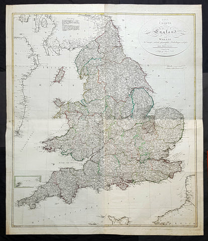
1803 Thomas Kitchen & Johannes Walch Large Antique Wall Map of England & Wales
Antique Map
- Titles: Carte von England und Wallli...Herren Thomas Kitchin Augsburg in Verlag bey Johannes Walch 1803
Sizes: 53in x 45in (1.345m x 1.120m) - Condition: (A+) Fine Condition
- Date: 1803
- Ref #: 93420
Description:
This very large original copper plate engraved antique wall map of England & Wales after the English cartographer Thomas Kitchin was engraved and published by the German publisher Johannes Walch in 1803, dated.
First published by Kitchin in London in 1760, this incredibly large, detailed & scarce map is a credit to Kitchin, one of the foremost cartographers of the 18th century.
General Definitions:
Paper thickness and quality: - Heavy and stable
Paper color : - off white
Age of map color: - Original
Colors used: - Blue, pink, red, green, yellow
General color appearance: - Authentic
Paper size: - 53in x 45in (1.345m x 1.120m)
Plate size: - 50 1/2in x 43in (1.280m x 1.090m)
Margins: - Min 1in (25mm)
Imperfections:
Margins: - None
Plate area: - None
Verso: - None
Background:
Johann Walch 1757 - 1815 was a German painter, draftsman, engraver, cartographer and publisher. Walch was the son of the merchant and amateur painter and copper engraver Sebastian Walch (1721–1788) and his wife Katharina Zorn, daughter of the butcher Martin Zorn. He received training as a miniature painter in Augsburg, Geneva and three years at the Vienna Art Academy . This was followed by a two-year trip to Italy. Before 1785 he settled in Augsburg, where on January 16, 1786 he married Anna Regina Will the eldest daughter of the copper engraver and publisher Johann Martin Will , who was based in Augsburg, and was married in the publishing house worked with his father-in-law. As a result, the publisher increasingly turned to map production .
In 1789 he inherited from Gustav Conrad Lotter (1746–1776) map material from the map publishers Matthäus Seutter and Tobias Conrad Lotter, almost 25,000 individual map sheets and 208 copper plates. After Wills death in 1806, he inherited Willschen Verlag , which he developed into a major map publisher (Joh. Walchsche Landkarte Handlung). This gave rise to the print shop named Joh. Walch . His son Johann Sebastian Walch (1787-1840) continued the publishing house.
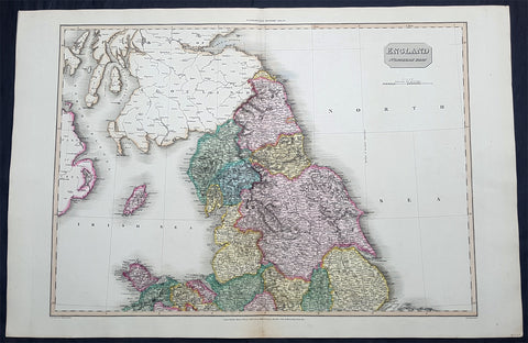
1811 John Pinkerton Very Large Antique Map of The North of England - Beautiful
Antique Map
- Title : England Northern Part....Published March 25th 1811 by Cadell & Davies
- Ref #: 93422
- Size: 33 1/2in x 22 1/2in (850mm x 570mm)
- Date : 1811
- Condition: (A+) Fine Condition
Description:
This large & magnificent, beautifully hand coloured original copper-plate engraved antique map of Northern England by John Pinkerton was engraved by Samuel Neele in 1811 - dated at the foot of the map - and published in the large elephant folio Pinkertons Modern Atlas, published between 1809 & 14. (Ref: Tooley, M&B)
General Definitions:
Paper thickness and quality: - Heavy and stable
Paper color : - off white
Age of map color: - Original
Colors used: - Yellow, green, blue, pink
General color appearance: - Authentic
Paper size: - 33 1/2in x 22 1/2in (850mm x 570mm)
Plate size: - 30 1/2in x 22 1/2in (775mm x 570mm)
Margins: - Min 2in (50mm)
Imperfections:
Margins: - None
Plate area: - None
Verso: - None
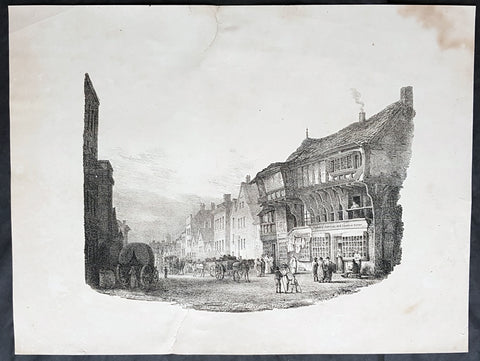
1821 Charles Hullmandel & Francis Nicholson Antique Print of Bridge St, Chester
- Title : Bridge Street, Chester....Printed by C Hullmandel....F. N. 1821
- Size: 16 1/2in x 12 1/2in (420mm x 315mm)
- Condition: (A) Good Condition
- Date : 1821
- Ref #: 26350
Description:
This scarce, fine early lithograph of Bridge St in the city of Chester, England by the British artist Francis Nicholson was print by the Charles Joseph Hullmandel in 1821 - dated at the foot of the print.
General Definitions:
Paper thickness and quality: - Heavy and stable
Paper color : - off white
Age of map color: -
Colors used: -
General color appearance: -
Paper size: - 16 1/2in x 12 1/2in (420mm x 315mm)
Plate size: - 16 1/2in x 12 1/2in (420mm x 315mm)
Margins: - Min 1in (25mm)
Imperfections:
Margins: - Soiling, repair to top & bottom margin, no loss
Plate area: - None
Verso: - Soiling
Background:
Francis Nicholson 1753 – 1844 was a British artist, born in Pickering, North Yorkshire. He worked in watercolour and oil, and is mainly known as a landscape artist.
Nicholson studied with a local artist in Scarborough, before beginning his career in his native Pickering, producing sporting pictures and portraits for a variety of Yorkshire patrons. By the mid-1780s he was also making paintings of country houses, leading him to concentrate on landscapes in watercolour.
From 1789, he contributed views of both Yorkshire and Scotland to exhibitions at the Royal Academy. He also supplied topographical views for the Copper Plate Magazine.
He contributed Views of England in collaboration with the engraver Francis Jukes to The Beauties of England and Wales, Author: Britton, John & Edward Wedlake Brayley - A book published in 18 volumes from 1801 to 1815.
Although his market increasingly became London-based, Nicholson continued to live in Yorkshire - at Whitby, Knaresborough and Ripon. He did not move to London until about 1803. In 1804, he became a founder-member of the Society of Painters in Watercolours, and was a regular and prolific contributor to its exhibitions.
He wrote a handbook, The practice of drawing and painting landscape from nature, in water colours, which was published in 1820. It sold out and a second edition followed in 1823.
His c. 1837 self-portrait is in the National Portrait Gallery. & is known as the Father of water colour painting and also as an early pioneer of lithography, and was much admired by Turner.
Nicholson died in London and is buried there in Brompton Cemetery.
Hullmandel, Charles Joseph 1789 – 1850
Hullmandel was born in London, where he maintained a lithographic establishment on Great Marlborough Street from about 1819 until his death.
He was born in Queen Street, Mayfair. His father was a German-speaking musician and composer, Nicolaus Joseph Hüllmandel (1751–1823), a native of Strasbourg who became a pupil of C. P. E. Bach and from 1780 spent ten years as a fashionable music teacher in Paris. In 1787 he married a Mademoiselle du Cazan, who was of a noble French family, and in 1789 sent his wife to England, following her in 1790, as the French Revolution unfolded.
As a young man, Charles Hullmandel studied art and spent several years living and working in continental Europe. He learned printmaking and printed many of his own works. In 1818, he set up a printing press in London after a visit to Munich with Rudolph Ackermann and went on to study chemistry under Michael Faraday for the purpose of improving his printing.
During the first half of the 19th century Hullmandel became one of the most important figures in the development of British lithography, and his name appears on the imprints of thousands of lithographic prints. He developed a method for reproducing gradations in tones and for creating the effect of soft colour washes which enabled the printed reproduction of Romantic landscape paintings of the type made popular in England by J. M. W. Turner. Hullmandel\\\'s essay The Art of Drawing on Stone (1824) was an important handbook of lithography. In 1843 he went into partnership with Joseph Fowell Walton (born 1812, living 1863), a cousin of the landscape artist and lithographer W. L. Walton, the firm then becoming known as Hullmandel & Walton.
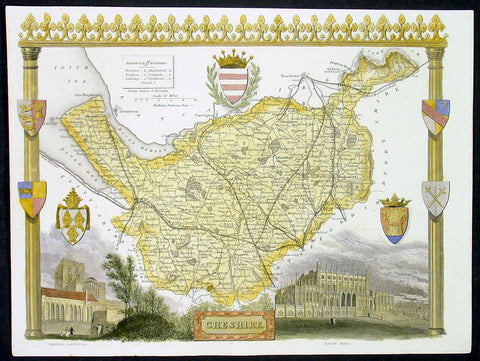
1836 Moule Antique Map The English County of Cheshire
- Title : Cheshire
- Date : 1836
- Condition: (A+) Fine Condition
- Ref: 92439
- Size: 11in x 8 1/2in (280mm x 215mm)
Description:
This finely engraved original beautifully hand coloured original antique map of the English county of Cheshire by Thomas Moule was published in the 1836 edition of Barclays Dictionary. Moules maps were some of the the last original decorative maps published in the 19th century. (Ref: Tooley; M&B)
General Description:
Paper thickness and quality: - Heavy and stable
Paper color: - off white
Age of map color: - Early
Colors used: - Yellow, green, red, blue
General color appearance: - Authentic
Paper size: - 11in x 8 1/2in (280mm x 215mm)
Plate size: - 11in x 8 1/2in (280mm x 215mm)
Margins: - Min 1/4in (6mm)
Imperfections:
Margins: - None
Plate area: - None
Verso: - None
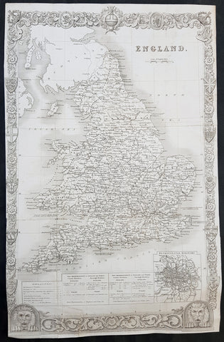
1836 Thomas Moule Large Original Antique Map of England & Wales
- Title : England
- Size: 17in x 11in (430mm x 280mm)
- Ref #: 31112
- Date : 1836
- Condition: (A) Very Good Condition
Description:
This original steel-plate engraved antique map of England was engraved for the 1836 edition of Thomas Moules English Counties Delineatedby W. Schmollinger.
Inset plan of Metorpolitan Boroughs of London.
General Definitions:
Paper thickness and quality: - Heavy and stable
Paper color : - off white
Age of map color: -
Colors used: -
General color appearance: -
Paper size: - 17in x 11in (430mm x 280mm)
Plate size: - 17in x 11in (430mm x 280mm)
Margins: - Min 0in (0mm)
Imperfections:
Margins: - Left margin cropped to border
Plate area: - Folds as issued, repair to bottom border & left bottom fold
Verso: - Re-enforced along folds
Background:
When considering the work of English map makers we tend, perhaps, to think too much in terms of county maps, dominated by the names of Saxton and Speed, but we should not underrate the contribution to the sum of geographical knowledge made in other spheres, such as the sea charts of Edward Wright, Robert Dudley and Greenvile Collins, the discoveries of James Cook, the road maps of Ogilby and Cary, the meteorological and magnetic charts compiled by Edmund Halley, to mention only a few.
In 1558 Queen Elizabeth came to the throne in the midst of a fast changing world. In 1563 a nineteen sheet map, copies of which survive only in manuscript form, was completed by Laurence Nowell, and no doubt, the issue of Mercator\'s large-scale map of the British Isles in 1564 had an important influence on the thought of the period. A few years later a national survey was commissioned privately, although probably at the instigation of Lord Burghley, the Lord Treasurer, but subsequently was completed with royal encouragement. The outcome was Christopher Saxton\'s Atlas of EngIand and Wales, started about 1570 and published in 1579 - the first printed set of county maps and the first countrywide atlas on such a splendid scale produced anywhere. A Welsh antiquarian, Humphrey Lhuyd completed a set of surveys that were even more successful than Saxton in which he had produced fine manuscript maps of England and Wales which were used by Ortelius in editions of his Atlas from 1573 onwards.
The earliest maps of the 17th century, attributed to William Smith of the College of Heralds, covered only twelve counties based on Saxton/Norden and were presumably intended to be part of a complete new atlas. They were printed in the Low Countries in 1602-3 and were soon followed by maps for the Latin edition of Camden\'s Britannia dated 1607. In 1610-11 the first edition of John Speed\'s famous county Atlas The Theatre of the Empire of Great Britaine was published and immediately replaced Saxton\'s in popular appeal. Although Speed assembled much of his material from the earlier works of Saxton, Norden and others, a considerable part of the up-to-date information, especially relating to the inset town plans depicted on his maps, was obtained first hand. The maps undoubtedly owed much of their popularity to the splendid engravings of high quality made in the workshops in Amsterdam of Jodocus Hondius to whom Speed sent his manuscripts, the plates subsequently being returned to London for printing.
In 1645, Volume IV of the famous Blaeu World Atlas covering the counties of England and Wales was published in Amsterdam. These maps have always been esteemed as superb examples of engraving and design, the calligraphy being particularly splendid, but nevertheless they were nearly all based on Saxton and Speed and added little to geographical knowledge.
Not until the latter part of the century do we find an English map maker of originality with the capacity to put new ideas into practice. John Ogilby, one of the more colourful figures associated with cartography, started life as a dancing master and finished as King\'s Cosmographer and Geographic Printer. After publishing a small number of county maps, somewhat on the lines of John Norden he issued in 1675 the Britannia, the first practical series of detailed maps of the post roads of England and Wales on a standard scale of 1,760 yards to the mile. Up to the end of the century and beyond, reprints and revisions of Saxton\'s and Speed\'s atlases continued to appear and the only other noteworthy county maps were Richard Blome\'s Britannia (1673), John Overton\'s Atlas (c. 1670) and Robert Morden\'s maps for an English translation of Camden\'s Britannia published in 1695.
Another noted cartographer of the day was Captain Greenvile Collins, and of his work in surveying the coasts of Great Britain culminating in the issue in 1693 of the Great Britain\'s Coasting Pilot. Apart from these charts, English cartographers published during the century a number of world atlases. Speed was the first Englishman to produce a world atlas with the issue in 1627 of his A Prospect of the Most Famous Parts of the World. Other atlases appeared later in the century by Peter Heylin, John Seller, William Berry, Moses Pitt and Richard Blome, whilst Ogilby found time to issue maps of Africa, America and Asia. Far more important, from the purely scientific point of view, was the work of Edmund Halley, Astronomer Royal, who compiled and issued meteorological and magnetic charts in 1688 and 1701 respectively.
At the beginning of the eighteenth century the Dutch map trade was finally in decline, the French in the ascendant and the English to a great extent still dominated by Saxton and Speed except, as we have shown, in the spheres of sea charts and road maps. There were atlases by John Senex, the Bowles family, Emanuel and Thomas Bowen, Thomas Badeslade and the unique bird\'s-eye perspective views of the counties, The British Monarchy by George Bickham. In 1750-60 Bowen and Kitchin\'s The Large English Atlas containing maps on a rather larger scale than hitherto was published.
In 1759 the Society for the encouragement of Arts, Manufactures and Commerce offered an award of £100 for the best original surveys on this scale and by the end of the century about thirty counties had been re-surveyed. These maps, many of which formed, in later years, the basis for the first issues of county maps by the Ordnance Survey Office were not only decorative but a tremendous improvement geographically on earlier local maps. As a consequence, the skills and expertise of the new-style cartographers soon enabled them to cover the world as well as the domestic market. Thomas Jefferys was such a man; he was responsible for a number of the new 1 in. to 1 mile county surveys and he issued an edition of Saxton\'s much battered 200-year-old plates of the county maps, but he is better known for many fine maps of North America and the West Indies. His work was continued on the same lines by William Faden, trading as Faden and Jefferys. Other publishers such as Sayer and Bennett and their successors Laurie and Whittle published a prodigious range of maps, charts and atlases in the second half of the century. A major influence at this time was John Cary who, apart from organizing the first re-survey of post roads since Ogilby and subsequently printing the noted Travellers\' Companion, was a prolific publisher of atlases and maps of every kind of all parts of the world. After starting work with Cary, and taking part in the new road survey, Aaron Arrowsmith set up in his own business and went on to issue splendid large-scale maps of many parts of the world. Both Cary\'s and Arrowsmith\'s plates were used by other publishers until far into the next century and, in turn, their work was taken up and developed by James Wyld (Elder and Younger) and Tallis and Co.
Later into the 19th century some of the better known cartographers and publishers were by Henry Teesdale (1829-30), Christopher and John Greenwood, surveyors, Thomas Moule, a writer on heraldry and antiques (1830-36) and John Walker (1837) but by about the middle of the century few small-scale publishers survived and their business passed into the hands of large commercial concerns such as Bartholomews of Edinburgh and Philips of London who continue to this day. (Ref: Shirley; Tooley; M&B)
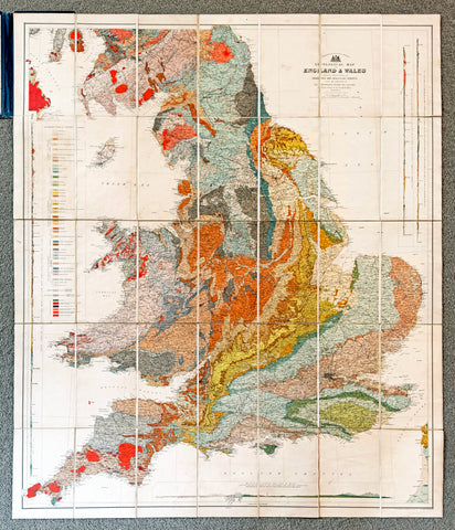
1897 J G Bartholomew & Archibald Geik Large Antique Geological Map England Wales
Antique Map
- Title : eological Map of England & Wales...Sir Archibald Geike....by John Bartholomew
- Ref #: 51003
- Condition: (A) Very Good Condition
- Size: 41in x 35in (1.04mm x 890mm)
- Date: 1897
Description:
This large, original antique lithograph linen-backed folding map of England and Wales showing the dominant geological strata of Britain as far north as Berwick was compiled by the famous Scottish geologist and author, Sir Archibald Geikie, Director-General of the Geological Survey of the United Kingdom. The map was also published by the prestigious Bartholomew publishing house in 1897.
legend which runs along the left-hand margin of the map explains the colouring. There are also three geological cross-sections.
General Definitions:
Paper thickness and quality: - Heavy and stable
Paper color : - off white
Age of map color: - Original
Colors used: - Green, yellow, pink
General color appearance: - Authentic
Paper size: - 41in x 35in (1.04mm x 890mm)
Plate size: - 41in x 35in (1.04mm x 890mm)
Margins: - Min 1/2in (12mm)
Imperfections:
Margins: - Blue covers loose and small tear along spine, not affecting the map
Plate area: - None
Verso: - None