Products

1597 Cornelis Wytfliet Antique Map Early Important Map of Australia, South America Terra Australis
- Title : Chica Sive Patagonica et Australis Terra
- Size: 15in x 12in (380mm x 305mm)
- Condition: (A+) Fine Condition
- Date : 1597
- Ref #: 41718
Description:
A fine original antique, and incredibly important map of Patagonia & the Magellan Straits but more importantly one of the first maps to depict a distinctive outline of Australia - depicted here as part of Terra Australis the Great Southern Land - and was published by Cornelis van Wytfliet in the 1597 edition of Descriptionis Ptolemaicae Augmentum.
Wytfliets famous map of the southern continent from the first atlas of the Americas, Descriptionis Ptolemaicae Augmentum, sive Occidentis Notitia in 1597.
In the top part of the map, Patagonia is separated by a strait from a large southern continent named Australis Terrae Pars. The naming of C. Della Victoria and the illustration of Magellans ship, Victoria, indicates, although not names on the map, as the Strait of Magellan. The lower portion of the map is a polar projection, showing Terra Australis as the large landmass made up of four peninsulas, one reaching towards New Guinea which is shown as an island. This and the other peninsula to the west is one of the earliest and clearest indications of cartographical knowledge of Northern Australia, specifically Northern Queensland, the Gulf of Carpentaria & parts of the Northern Territory.
Gunter Schilder discusses this map at length and points to its significance to Major Collingridge and others as proof that Australia had already been discovered in the sixteenth century....
Wytfliet notes The Australis Terra is the most southern of all lands; it is separated from New Guinea by a narrow strait; its shores are hitherto but little known, since, after one voyage and another, that route has been deserted, and seldom is the country visited unless when sailors are driven there by storms. The Australis Terra begins at two or three degrees from the equator, and is maintained by some to be of so great an extent that if it were thoroughly explored it would be regarded as a fifth part of the world.
Wyfliets depiction of a narrow strait separating Australis Terra from New Guinea, predates that of Torress discovery in 1606. Torress passage was not known to the world until the end of the 18th century, when Dalrymple discovered Torress journal of the voyage amongst archives in Manila.
General Definitions:
Paper thickness and quality: - Heavy and stable
Paper color : - off white
Age of map color: -
Colors used: -
General color appearance: -
Paper size: - 15in x 12in (380mm x 305mm)
Plate size: - 11 1/4in x 9 1/4in (285mm x 235mm)
Margins: - Min 1in (25mm)
Imperfections:
Margins: - None
Plate area: - None
Verso: - None
Background:
In 1597 Cornelis van Wytfliet published his Augmentum to Ptolemys Geography. Dedicated to Philip III of Spain it is a history of the New World to date, recording its discovery, natural history etc. For the book Wytfliet had engraved nineteen maps, by whom we do not know, one of the world and eighteen regional maps of the Americas. As such this book can be truly called the first atlas of the New World, America.
Wytfliet, Cornelis van d. 1597
Cornelius Wytfliet or Cornelis van Wytfliet was a geographer from Leuven in the Habsburg Netherlands, best known for producing the first atlas of the Americas.
Cornelius was the son of Catherine Huybrechts and her husband, Gregorius Wytfliet, who was advocate fiscal of Leuven University from 1557 to 1594. After graduating Licentiate in Laws from the University of Leuven, Wytfliet moved to Brussels and became secretary to the Council of Brabant. He died in or shortly after 1597, when his Descriptionis Ptolemaicae Augmentum (a work adding new discoveries to Ptolemy\\\'s description of the world) was published
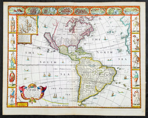
1626 (1676) John Speed Antique Map of America - Beautiful Condition
Antique Map
- Title : America with those known parts in that unknowne world both people and manner of buildings discribed and inlarged by I.S. Ano 1626.
- Date : 1626 (1676)
- Size: 21 1/2in x 17in (545mm x 430mm)
- Condition: (A+) Fine Condition
- Ref: 35654
Description:
This original hand coloured copper plate engraved antique map of America by John Speed was published in the 1676 Bassett & Chiswell edition of Speeds famous atlas Prospect of the Most Famous Parts of the World.
One of the best examples of this map I have seen. Beautiful original condition with original hand colour, clean heavy impression on sturdy clean paper with original margins, which is very rare.
This 1626 map of America is the fourth or 1676 state and is one of the most iconic maps of America, surrounded by decorative vignettes illustrating the indigenous peoples and cities of the Americas. This map is both beautiful and important. It features a number of first, including being the first atlas map to depict California as an island and to accurately depict the east coast of North America. Cartographically it follows on the earlier maps of the Dutchman Abraham Goos, the engraver, with updates to reflect the 1625 Briggs vision of an insular California
General Definitions:
Paper thickness and quality: - Heavy and stable
Paper color : - off white
Age of map color: - Original
Colors used: - Yellow, green, blue, pink
General color appearance: - Authentic
Paper size: - 21 1/2in x 17in (545mm x 430mm)
Plate size: - 20 1/4in x 15 1/2in (515mm x 395mm)
Margins: - Min 3/4in (20mm)
Imperfections:
Margins: - None
Plate area: - None
Verso: - Old archival hinge paper top of verso, not affecting the map.
Background:
This is the first atlas map to represent California as an island. The idea of an insular California first appeared as a work of fiction in Garci Rodriguez de Montalvo's c. 1510 romance Las Sergas de Esplandian, where he writes
.....Know, that on the right hand of the Indies there is an island called California very close to the side of the Terrestrial Paradise; and it is peopled by black women, without any man among them, for they live in the manner of Amazons.....
Baja California was subsequently discovered in 1533 by Fortun Ximenez, who had been sent to the area by Hernan Cortez. When Cortez himself traveled to Baja, he must have had Montalvo's novel in mind, for he immediately claimed the 'Island of California' for the Spanish King. By the late 16th and early 17th century ample evidence had been amassed, through explorations of the region by Francisco de Ulloa, Hernando de Alarcon and others, that California was in fact a peninsula. However, by this time other factors were in play. Francis Drake had sailed north and claimed 'New Albion' (identified here on the northwest coast of California Island) near modern day Washington or Vancouver for England. The Spanish thus needed to promote Cortez's claim on the 'Island of California' to preempt English claims on the western coast of North America. Henry Briggs, an English mathematician, began promoting the idea of an insular California in 1622, citing the journals of Friar Antonio de la Ascension, who accompanied the 1602-03 Sebastian Vizcaino expedition. The significant influence of the Spanish crown on European cartographers caused a major resurgence of the Insular California theory. Just before this map was made Eusebio Kino, a Jesuit missionary, traveled overland from Mexico to California, proving conclusively the peninsularity of California. Even so, it was ultimately a 1747 royal decree from King Ferdinand VII of Spain that finally forced cartographers to give up on the alluring idea.
Other elements of interest in North America are the complete absence of the Great Lakes - which in 1626 had yet to be conceived of by any European cartographers. The Straits of Anian appear tenuously in the extreme northwest, just above California. Just east of the 'o' in 'California', on the continental mainland, there is a curious ghosted in lake called the 'Lagueo de Oro.' We have found no references or explanation for this. None of the legendary kingdoms of gold, Quivara, Teguayo, Cibola, etc. are noted. The western portions of the Hudson Bay are unmapped - suggestive of their unexplored status. The addition of Long Island and Boston, in notably darker print, are important updates over the earliest editions.
South America offers much of interest including the mythical Lake Parimia, in Guiana. The legend of Parima is associated with the English adventurer Sir Walter Raleigh's search for El Dorado. Believing El Dorado to lie in the northern part of the Amazon, Raleigh sailed down the Orinoco River just before the onset of the rainy season. Reaching a remote tribal village, Raleigh noted canoes arriving bearing gold, silver, and other treasures. Asked where the gold came from, the natives replied, 'Manoa', the term for the tribe to which the river traders belonged. Manoa, the natives claimed could be reached following a long river voyage southward to a Great Lake, called Parima. Raleigh and his associates immediately associated Manoa and Lake Parima with the golden kingdom of El Dorado, though they never visited the city or lake. Subsequent maps, including this one, mapped el Dorado and Lake Parima in this location for several hundred years. Both Raleigh and the natives were describing an actual event known to occur annually in the region. Rains would annually swell the Amazon and Orinoco river systems creating a linkage in the Rupununu flood plain, which, during heavy rains, can resemble a massive lake. The Manoa were a large and populous trading nation active in pre-colonial days whose vast empire, based in the Amazon Basin, extended form the Andes to the Orinoco. Curiously, in addition to noting the city of Manoa on Lake Parima, D'Anville also correctly maps the center of the ancient Manoan civilization between the Amazon tributaries Rio Negro and Rio Yapura. Sadly the Manoa and many of the other populous South American indigenous nations noted by the earliest explores to the region vanished, brought low by European epidemics.
Another mythical lake, Eupana, appears further south connecting the Rio de la Plata and the Paraguay River to the R. Real, thus turning eastern Brazil into an island. This is a update over many earlier maps which connected Eupana directly to the Amazon. Far in the south Speed presents us ith another anomaly, the Straits of Le Maire, which separates Tierra de Fuego from another mysterious stretch of land labeled 'States Land.' The is in fact the modern island of Isla de los Estados, the southeastern most point in South America. Jacob le Maire and his pilot Willem Schouten passed to between this island and Tierra del Fuego on their 1615 voyage around Cape Horn and into the Pacific.
In the high Arctic, near Iceland and Greenland, the supposed islands of Frisland and Brasil are noted. Frisland is little more than a double mapping of Iceland. Brasil, also known as Hy-Brasil, is a phantom island north Atlantic just west of Ireland. In Irish myths it was said to be cloaked in mist, except for one day every seven years, when it became visible but still could not be reached. Little is known of this origins of this myth, but it appears on maps in various forms from about 1325. The last known appearance was in 1865 when it appeared on a nautical chart as 'Brasil Rock.' Some speculate that it may be an early reference to Porcupine Bank, a shoal in the Atlantic Ocean about 200 kilometres (120 mi) west of Ireland.
Speed's map of America is especially noteworthy for its surrounded vignettes. To either side of the map proper there are various vignettes illustrating the indigenous peoples of the America. These includes natives of Greenland, Virginia, Florida, Mexico, New England, Peru, Brazil, and Tierra del Feugo.n Along the top of the map there are eight city views: Havanna, Santo Domingo, Cartagena, Mexico City, Cuzco, the isle of Moca, Rio de Janeiro, and Olinda.
This map was engraved for John Speed by Abraham Goos. It is the fourth state of the map issued by Thomas Bassett of Fleet Street and Richard Chiswell of St. Paul's Churchyard. Bassett, Chiswell, and others continued to republish Speed's work well after his death. (Ref: Tooley, Koeman, Burden)
Please note all items auctioned are genuine, we do not sell reproductions. A Certificate of Authenticity (COA) can be issued on request.
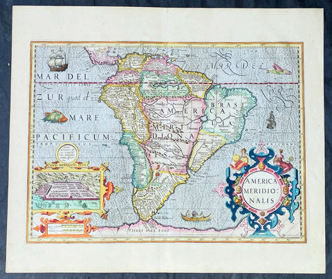
1628 Henricus Hondius Antique Map of South America, inset of Cusco - Beautiful
Antique Map
- Title : America Meridionalis
- Date : 1628
- Size: 22in x 18 1/2in (560mm x 470mm)
- Condition: (A+) Fine Condition
- Ref: 35645
Description:
This superb, original antique hand coloured folio map of South America, was engraved by Jodocus Hondius & published by his son Henricus for the continuation of Gerard Mercators 1628 French edition of Atlas.
This map is in superb condition with beautiful hand colouring, a deep heavy imprint denoting an early pressing on clean, heavy paper. Original margins, one of the best I have seen for sometime.
General Definitions:
Paper thickness and quality: - Heavy and stable
Paper color : - off white
Age of map color: - Early
Colors used: - Yellow, green, blue, pink
General color appearance: - Authentic
Paper size: - 22in x 18 1/2in (560mm x 470mm)
Plate size: - 19 1/2in x 14 1/4in (495mm x 363mm)
Margins: - Min 1in (25mm)
Imperfections:
Margins: - None
Plate area: - None
Verso: - None
Background:
The interior of the map is dominated by the large mythical lake Parime Lacus straddling the equator below Venezuela along with an interesting & mythical continental river system. The huge Rio de la Plata river flows south from the conjectural Eupana Lacus in Brazil, while the R. Grande flows north from the same lake, ostensibly making Brazil an island.
The Strait of Magellan is represented, but Tierra del Fuego (Fogo) is named as part of the mythical Great Southern Land instead of an island.
The map is beautifully engraved with a stippled wave pattern Pacific & Atlantic Oceans, filled with Spanish & English ships, sea monsters and native canoe. The continent is flanked by two elaborate Baroque cartouches; title to the right and a large inset plan of the Capital of the Ancient Incan Empire, Cuzco. A sole representation of the conquered Native Americans is engraved as a lone Indian with a bow and arrow in the interior of Patgonia.
Between 1452 and 1493, a series of papal bulls (Dum Diversas, Romanus Pontifex, and Inter caetera) paved the way for the European colonization and Catholic missions in the New World. These authorized the European Christian nations to \"take possession\" of non-Christian lands and encouraged subduing and converting the non-Christian people of Africa and the Americas.
In 1494, Portugal and Spain, the two great maritime powers of that time, signed the Treaty of Tordesillas in the expectation of new lands being discovered in the west. Through the treaty they agreed that all the land outside Europe should be an exclusive duopoly between the two countries. The treaty established an imaginary line along a north-south meridian 370 leagues west of Cape Verde Islands, roughly 46° 37\' W. In terms of the treaty, all land to the west of the line (which is now known to include most of the South American soil), would belong to Spain, and all land to the east, to Portugal. Because accurate measurements of longitude were not possible at that time, the line was not strictly enforced, resulting in a Portuguese expansion of Brazil across the meridian.
In 1498, during his third voyage to the Americas, Christopher Columbus sailed near the Orinoco Delta and then landed in the Gulf of Paria (Actual Venezuela). Amazed by the great offshore current of freshwater which deflected his course eastward, Columbus expressed in his moving letter to Isabella I and Ferdinand II that he must have reached heaven on Earth (terrestrial paradise):
Great signs are these of the Terrestrial Paradise, for the site conforms to the opinion of the holy and wise theologians whom I have mentioned. And likewise, the [other] signs conform very well, for I have never read or heard of such a large quantity of fresh water being inside and in such close proximity to salt water; the very mild temperateness also corroborates this; and if the water of which I speak does not proceed from Paradise then it is an even greater marvel, because I do not believe such a large and deep river has ever been known to exist in this world.
Beginning in 1499, the people and natural resources of South America were repeatedly exploited by foreign conquistadors, first from Spain and later from Portugal. These competing colonial nations claimed the land and resources as their own and divided it into colonies.
European diseases (smallpox, influenza, measles and typhus) to which the native populations had no resistance were the overwhelming cause of the depopulation of the Native American population. Cruel systems of forced labor (such as encomiendas and mining industry\'s mita) under Spanish control also contributed to depopulation. Lower bound estimates speak of a decline in the population of around 20–50 per cent, whereas high estimates arrive at 90 per cent.[42] Following this, African slaves, who had developed immunity to these diseases, were quickly brought in to replace them.
The Spaniards were committed to converting their American subjects to Christianity and were quick to purge any native cultural practices that hindered this end. However, most initial attempts at this were only partially successful; American groups simply blended Catholicism with their traditional beliefs. The Spaniards did not impose their language to the degree they did their religion. In fact, the missionary work of the Roman Catholic Church in Quechua, Nahuatl, and Guarani actually contributed to the expansion of these American languages, equipping them with writing systems.
Eventually the natives and the Spaniards interbred, forming a Mestizo class. Mestizos and the Native Americans were often forced to pay unfair taxes to the Spanish government (although all subjects paid taxes) and were punished harshly for disobeying their laws. Many native artworks were considered pagan idols and destroyed by Spanish explorers. This included a great number of gold and silver sculptures, which were melted down before transport to Europe.
In 1616, the Dutch, attracted by the legend of El Dorado, founded a fort in Guayana and established three colonies: Demerara, Berbice, and Essequibo.
In 1624 France attempted to settle in the area of modern-day French Guiana, but was forced to abandon it in the face of hostility from the Portuguese, who viewed it as a violation of the Treaty of Tordesillas. However French settlers returned in 1630 and in 1643 managed to establish a settlement at Cayenne along with some small-scale plantations.
Since the sixteenth century there were some movements of discontent to Spanish and Portuguese colonial system. Among these movements, the most famous being that of the Maroons, slaves who escaped their masters and in the shelter of the forest communities organized free communities. Attempts to subject them by the royal army was unsuccessful, because the Maroons had learned to master the South American jungles. In a royal decree of 1713, the king gave legality to the first free population of the continent: Palenque de San Basilio in Colombia today, led by Benkos Bioho. Brazil saw the formation of a genuine African kingdom on their soil, with the Quilombo of Palmares.
Between 1721 and 1735, the Revolt of the Comuneros of Paraguay arose, because of clashes between the Paraguayan settlers and the Jesuits, who ran the large and prosperous Jesuit Reductions and controlled a large number of Christianized Indians.
Between 1742 and 1756, was the insurrection of Juan Santos Atahualpa in the central jungle of Peru. In 1780, the Viceroyalty of Peru was met with the insurrection of curaca Condorcanqui or Tupac Amaru II, which would be continued by Tupac Catari in Upper Peru.
In 1763, the African Cuffy led a revolt in Guyana which was bloodily suppressed by the Dutch. In 1781, the Revolt of the Comuneros (New Granada), an insurrection of the villagers in the Viceroyalty of New Granada, was a popular revolution that united indigenous people and mestizos. The villagers tried to be the colonial power and despite the capitulation were signed, the Viceroy Manuel Antonio Flores did not comply, and instead ran to the main leaders José Antonio Galán. In 1796, Essequibo (colony) of the Dutch was taken by the British, who had previously begun a massive introduction of slaves.
During the eighteenth century, the figure of the priest, mathematician and botanist José Celestino Mutis (1732–1808), was delegated by the Viceroy Antonio Caballero y Gongora to conduct an inventory of the nature of the Nueva Granada, which became known as the Botanical Expedition, which classified plants, wildlife and founded the first astronomical observatory in the city of Santa Fé de Bogotá.
On August 15, 1801, the Prussian scientist Alexander von Humboldt reached Fontibón where Mutis, and began his expedition to New Granada, Quito. The meeting between the two scholars are considered the brightest spot of the botanical expedition. Humboldt also visited Venezuela, Mexico, United States, Chile, and Peru. Through his observations of temperature differences between the Pacific Ocean between Chile and Peru in different periods of the year, he discovered cold currents moving from south to north up the coast of Peru, which was named the Humboldt Current in his honour.
Between 1806 and 1807, British military forces tried to invade the area of the Rio de la Plata, at the command of Home Riggs Popham and William Carr Beresford, and John Whitelocke. The invasions were repelled, but powerfully affected the Spanish authority.

1638 Joan Blaeu Antique Map of America - Americae nova Tabula
- Title : Americae nova Tabula Auct: Guiljesino Blaeuw
- Date : 1638
- Condition: (A) Very Good Condition
- Ref # : 50685
- Size : 23in x 18 1/2in (585mm x 450mm)
Description:
This magnificent, classic hand coloured original antique map of America 2nd State - the quintessential image of 17th America - was published in the 1638 French edition of Joan Blaeus Atlas Novus. This map is in wonderful condition with a few minor repairs as mentioned below.
General Condition:
Paper thickness and quality: - Heavy and stable
Paper color: - White
Age of map color: - Original color
Colors used: - Pink, green, yellow, blue, red
General color appearance: - Authentic & beautiful
Paper size: - 23in x 18 1/2in (585mm x 450mm)
Plate size: - 22in x 16 1/2in (555mm x 415mm)
Margins: - Min 1in (25mm)
Imperfections:
Margins: - Professional repair to centerfold, no loss.
Plate area: - Small professional repair to below Atlantic monster. Center-fold creases & re-joined at bottom, slight separation
Verso: - Creasing and restoration to center-fold, top & left margin, no loss
Background:
Originally issued by Joan Blaeus father, Willem, as early as 1617, this general map of the Americas was one of the longest lived plates in the atlas, having been used as an atlas map since 1630.
Here is the general seventeenth century European view of the Western Hemisphere: the delineation of the coasts and the nomenclature of the Pacific as well as the Atlantic coasts are basically Spanish in origin and follow the maps of the Fleming Abraham Ortelius and his countryman Cornelis Wytfliet. To these, Willem Blaeu inserted, on the east coast, the English names given by the Roanoke colonists in Virginia, and by Martin Frobisher, John Davis and Henry Hudson in the far north. In Florida and along the St Lawrence, Blaeu added the names given by the French settlers, almost the only memorials to their ill-fated venture in Florida during the latter part of the sixteenth century.
When Blaeu first made his map in the early years of the seventeenth century, Europeans still had no real knowledge of the nature of the Mississippi system. From the expedition journals of Hernando de Soto (1539 - 1543) they had inferred an extensive range of mountains trending eastwards to the north of the Gulf of Mexico in la Florida apparently precluding a great river system. The Great Lakes were as yet unknown although by the time Blaeu issued this map in its atlas form in the Huron region together with the hearsay accounts from Coral Indians were becoming well known through his 1632 map of the region. Evidently, this appears to have been unknown to Blaeu at the time, but surprisingly, he never incorporated the information on later printings of the map. The same applies to Manhattan and Long Island as well, despite the fact that only a short distance from Amsterdam, the Leiden academic Johannes D Late had published the first edition of his monumental work on the Americas which provided source material for any number of maps of the Americas throughout the remainder of the century and beyond.
In common with the other general continental maps in Blaeus atlas's, he has provided perspective plans or views of settlements in the Americas, including Havana, St Domingo, Cartagena, Mexico, Cusco, Potisi, I.la Moca in Chile, Rio Janeiro and Olianda in Pharnambucco, as well as the vignette illustrations of native figures taken from the accounts of John White (Virginia) or Hans Staden (Brazil) and others. (Ref: Burden; RGS; Koeman; Tooley)
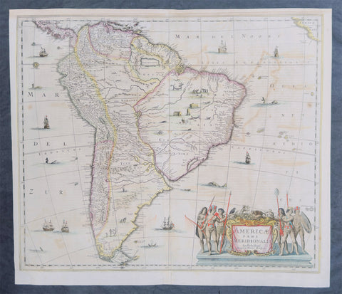
1639 Henricus Hondius Large Antique Map of South America - Beautiful
Antique Map
- Title : Americae Pars Meridionalis Henrici Hony...
- Ref #: 43162
-
Condition: (A) Very Good Condition
- Size: 22 1/2in x 20in (570mm x 510mm)
- Date : 1639
Description:
This beautifully hand coloured original antique copper plate engraved antique map of South America by Henricus Hondius was published in the 1639 French edition of Mercators Atlas by Jan Jansson and Henricus Hondius.
Beautiful large map, the second by Hondius, with original hand colouring and strong sturdy paper.
General Definitions:
Paper thickness and quality: - Heavy and stable
Paper color : - off white
Age of map color: - Original
Colors used: - Yellow, green, blue, pink
General color appearance: - Authentic
Paper size: - 22 1/2in x 20in (570mm x 510mm)
Plate size: - 21 1/2in x 18 1/4in (545mm x 460mm)
Margins: - Min 1/2in (12mm)
Imperfections:
Margins: - Top margin extended from plate-mark, small repair to bottom margin
Plate area: - Offsetting
Verso: - Bottom centerfold re-joined, no loss
Background:
Between 1452 and 1493, a series of papal bulls (Dum Diversas, Romanus Pontifex, and Inter caetera) paved the way for the European colonization and Catholic missions in the New World. These authorized the European Christian nations to \"take possession\" of non-Christian lands and encouraged subduing and converting the non-Christian people of Africa and the Americas.
In 1494, Portugal and Spain, the two great maritime powers of that time, signed the Treaty of Tordesillas in the expectation of new lands being discovered in the west. Through the treaty they agreed that all the land outside Europe should be an exclusive duopoly between the two countries. The treaty established an imaginary line along a north-south meridian 370 leagues west of Cape Verde Islands, roughly 46° 37\' W. In terms of the treaty, all land to the west of the line (which is now known to include most of the South American soil), would belong to Spain, and all land to the east, to Portugal. Because accurate measurements of longitude were not possible at that time, the line was not strictly enforced, resulting in a Portuguese expansion of Brazil across the meridian.
In 1498, during his third voyage to the Americas, Christopher Columbus sailed near the Orinoco Delta and then landed in the Gulf of Paria (Actual Venezuela). Amazed by the great offshore current of freshwater which deflected his course eastward, Columbus expressed in his moving letter to Isabella I and Ferdinand II that he must have reached heaven on Earth (terrestrial paradise):
Great signs are these of the Terrestrial Paradise, for the site conforms to the opinion of the holy and wise theologians whom I have mentioned. And likewise, the [other] signs conform very well, for I have never read or heard of such a large quantity of fresh water being inside and in such close proximity to salt water; the very mild temperateness also corroborates this; and if the water of which I speak does not proceed from Paradise then it is an even greater marvel, because I do not believe such a large and deep river has ever been known to exist in this world.
Beginning in 1499, the people and natural resources of South America were repeatedly exploited by foreign conquistadors, first from Spain and later from Portugal. These competing colonial nations claimed the land and resources as their own and divided it into colonies.
European diseases (smallpox, influenza, measles and typhus) to which the native populations had no resistance were the overwhelming cause of the depopulation of the Native American population. Cruel systems of forced labor (such as encomiendas and mining industry\'s mita) under Spanish control also contributed to depopulation. Lower bound estimates speak of a decline in the population of around 20–50 per cent, whereas high estimates arrive at 90 per cent.[42] Following this, African slaves, who had developed immunity to these diseases, were quickly brought in to replace them.
The Spaniards were committed to converting their American subjects to Christianity and were quick to purge any native cultural practices that hindered this end. However, most initial attempts at this were only partially successful; American groups simply blended Catholicism with their traditional beliefs. The Spaniards did not impose their language to the degree they did their religion. In fact, the missionary work of the Roman Catholic Church in Quechua, Nahuatl, and Guarani actually contributed to the expansion of these American languages, equipping them with writing systems.
Eventually the natives and the Spaniards interbred, forming a Mestizo class. Mestizos and the Native Americans were often forced to pay unfair taxes to the Spanish government (although all subjects paid taxes) and were punished harshly for disobeying their laws. Many native artworks were considered pagan idols and destroyed by Spanish explorers. This included a great number of gold and silver sculptures, which were melted down before transport to Europe.
In 1616, the Dutch, attracted by the legend of El Dorado, founded a fort in Guayana and established three colonies: Demerara, Berbice, and Essequibo.
In 1624 France attempted to settle in the area of modern-day French Guiana, but was forced to abandon it in the face of hostility from the Portuguese, who viewed it as a violation of the Treaty of Tordesillas. However French settlers returned in 1630 and in 1643 managed to establish a settlement at Cayenne along with some small-scale plantations.
Since the sixteenth century there were some movements of discontent to Spanish and Portuguese colonial system. Among these movements, the most famous being that of the Maroons, slaves who escaped their masters and in the shelter of the forest communities organized free communities. Attempts to subject them by the royal army was unsuccessful, because the Maroons had learned to master the South American jungles. In a royal decree of 1713, the king gave legality to the first free population of the continent: Palenque de San Basilio in Colombia today, led by Benkos Bioho. Brazil saw the formation of a genuine African kingdom on their soil, with the Quilombo of Palmares.
Between 1721 and 1735, the Revolt of the Comuneros of Paraguay arose, because of clashes between the Paraguayan settlers and the Jesuits, who ran the large and prosperous Jesuit Reductions and controlled a large number of Christianized Indians.
Between 1742 and 1756, was the insurrection of Juan Santos Atahualpa in the central jungle of Peru. In 1780, the Viceroyalty of Peru was met with the insurrection of curaca Condorcanqui or Tupac Amaru II, which would be continued by Tupac Catari in Upper Peru.
In 1763, the African Cuffy led a revolt in Guyana which was bloodily suppressed by the Dutch. In 1781, the Revolt of the Comuneros (New Granada), an insurrection of the villagers in the Viceroyalty of New Granada, was a popular revolution that united indigenous people and mestizos. The villagers tried to be the colonial power and despite the capitulation were signed, the Viceroy Manuel Antonio Flores did not comply, and instead ran to the main leaders José Antonio Galán. In 1796, Essequibo (colony) of the Dutch was taken by the British, who had previously begun a massive introduction of slaves.
During the eighteenth century, the figure of the priest, mathematician and botanist José Celestino Mutis (1732–1808), was delegated by the Viceroy Antonio Caballero y Gongora to conduct an inventory of the nature of the Nueva Granada, which became known as the Botanical Expedition, which classified plants, wildlife and founded the first astronomical observatory in the city of Santa Fé de Bogotá.
On August 15, 1801, the Prussian scientist Alexander von Humboldt reached Fontibón where Mutis, and began his expedition to New Granada, Quito. The meeting between the two scholars are considered the brightest spot of the botanical expedition. Humboldt also visited Venezuela, Mexico, United States, Chile, and Peru. Through his observations of temperature differences between the Pacific Ocean between Chile and Peru in different periods of the year, he discovered cold currents moving from south to north up the coast of Peru, which was named the Humboldt Current in his honour.
Between 1806 and 1807, British military forces tried to invade the area of the Rio de la Plata, at the command of Home Riggs Popham and William Carr Beresford, and John Whitelocke. The invasions were repelled, but powerfully affected the Spanish authority
Please note all items auctioned are genuine, we do not sell reproductions. A Certificate of Authenticity (COA) can be issued on request.
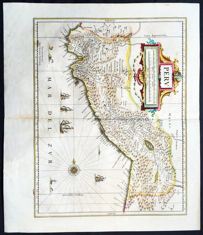
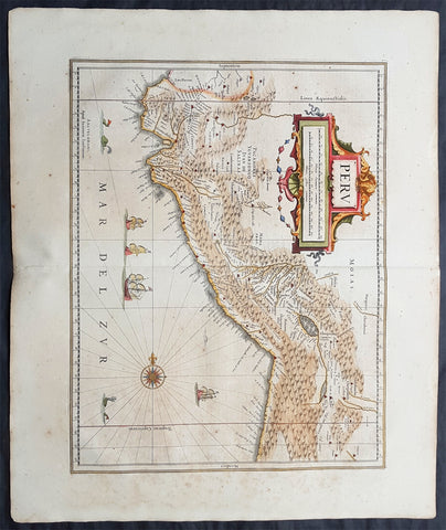
1639 Jan Jansson Antique Map of Peru, South America
Antique Map
- Title : Peru
- Date : 1639
- Condition: (A+) Fine Condition
- Ref: 43147
- Size: 22 1/2in x 20in (570mm x 500mm)
Description:
This finely engraved beautifully hand coloured original antique map of the ancient South American country of Peru was published in the 1639 French edition of Jan Jansson's Atlas Nouvs.
General Description:
Paper thickness and quality: - Heavy and stable
Paper color: - off white
Age of map color: - Original
Colors used: - Green, pink, yellow, blue
General color appearance: - Authentic
Paper size: - 22 1/2in x 20in (570mm x 500mm)
Plate size: - 20in x 15 1/2in (535mm x 395mm)
Margins: - Min 1in (25mm)
Imperfections:
Margins: - Light toning on margin edges
Plate area: - Light creasing along centerfold
Verso: - None
Background:
Jansson in this map shows the Pacific coast of South America from Ecuador - at the left hand side - as far south as the Atacama desert in the northern reaches of Chile.
Although the interior terrain is not mapped with any particular degree of accuracy, this map nevertheless conveys a vivid impression of the difficult terrain of the Andes in Peru.
As early as 1520, Spanish settlers in Panama had heard tales of a powerful civilisation rich in gold that lay to the south, and in 1522 an expedition was organised to find this land and the people called Biru or Piru in the south. In 1524 Francisco Pizarro led the first of his expeditions that led ultimately to the discovery & conquest of the Inca Empire which extended over wide areas of modern Ecuador, Peru, Bolivia and part of Chile. Pizarro obtained from Atahuallpa, the head of the Inca Empire, a huge ransom of silver and gold that made Spain rich almost beyond the most inventive dreams of the Spanish conquerors, and once the mountain city of Cuzco was captured in 1533, the Spanish hold over much of South America was virtually complete.
A beautiful map with a fine impression on clean heavy paper with beautiful hand colouring. (Ref: Tooley, Koeman)
1639 Jan Jansson Original Antique Map of Peru, South America
Antique Map
- Title : Peru
- Date : 1639
- Condition: (A+) Fine Condition
- Ref: 70709
- Size: 24in x 20in (610mm x 510mm)
Description:
This fine, beautifully hand coloured original antique and very important map of Peru, South America by Jan Jansson was published in the 1639 French edition of Gerard Mercators Atlantis Novi Atlas.
General Definitions:
Paper thickness and quality: - Heavy and stable
Paper color : - off white
Age of map color: - Original
Colors used: - Yellow, green, blue, pink
General color appearance: - Authentic
Paper size: - 24in x 20in (610mm x 510mm)
Plate size: - 19 1/2in x 15in (495mm x 390mm)
Margins: - Min 2in (50mm)
Imperfections:
Margins: - Light age toning
Plate area: - Light age toning
Verso: - Light age toning
Background:
Jansson in this map shows the Pacific coast of South America from Ecuador - at the left hand side - as far south as the Atacama desert in the northern reaches of Chile.
Although the interior terrain is not mapped with any particular degree of accuracy, this map nevertheless conveys a vivid impression of the difficult terrain of the Andes in Peru.
As early as 1520, Spanish settlers in Panama had heard tales of a powerful civilisation rich in gold that lay to the south, and in 1522 an expedition was organised to find this land and the people called Biru or Piru in the south. In 1524 Francisco Pizarro led the first of his expeditions that led ultimately to the discovery & conquest of the Inca Empire which extended over wide areas of modern Ecuador, Peru, Bolivia and part of Chile. Pizarro obtained from Atahuallpa, the head of the Inca Empire, a huge ransom of silver and gold that made Spain rich almost beyond the most inventive dreams of the Spanish conquerors, and once the mountain city of Cuzco was captured in 1533, the Spanish hold over much of South America was virtually complete.
A beautiful map with a fine impression on clean heavy paper with beautiful hand colouring. (Ref: Tooley, Koeman)
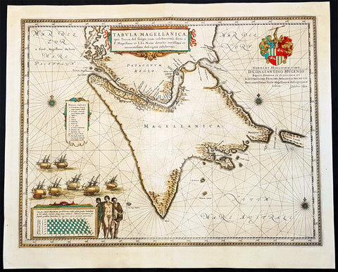
1642 Joan Blaeu Large Antique Map of Tierra Del Fuego & the Magellan Straits, South America
- Title : Tabula Magellanica qua Tierrae del Fuego
- Size: 23in x 19in (585mm x 485mm)
- Condition: (A+) Fine Condition
- Date : 1642
- Ref #: 93352
Description:
This original beautifully hand coloured copper-plate engraved antique map of the Tierra Del Fuego & the Magellan Straits at the very bottom of South America, was published in the 1642 Dutch edition of Joan Blaeus Atlas Nouvs.
General Definitions:
Paper thickness and quality: - Heavy and stable
Paper color : - off white
Age of map color: - Original
Colors used: - Yellow, green, blue, pink
General color appearance: - Authentic
Paper size: - 23in x 19in (585mm x 485mm)
Plate size: - 21in x 16 1/2in (535mm x 420mm)
Margins: - Min 1in (25mm)
Imperfections:
Margins: - Age toning
Plate area: - Age toning
Verso: - Age toning
Background:
Ferdinand Magellan became the first European to navigate the strait in 1520, during his global circumnavigation voyage. Because Magellan\'s ships entered it on November 1, All Saints\' Day, it was originally named Estrecho de Todos los Santos (Strait of All Saints). Later the Spanish king changed the name to Estrecho de Magallanes in honor of Magellan. Since its discovery the Spanish Empire and the Kingdom of Chile saw it as its southern boundary. The first Spanish colonization attempt was led by Pedro Sarmiento de Gamboa who founded Nombre de Jesús and Rey Don Felipe on its northern shores. The cities suffered severe food shortages, and years afterwards in 1587 the English navigator Sir Thomas Cavendish landed at the site of Rey Don Felipe and found only ruins of the settlement. He renamed the place Port Famine. Other early explorers included Francis Drake among others.
1662 Blaeu & Barlaeus Complete Set of 13 x Antique Maps of South America
Antique Map
- Titles:
1. Terra Firma
2. Venezuela
3. Guiana
4. Peru
5. Chili
6. Brasilia
7. Paraquaria
8. Tabula Magellanica
9. Preafecturae Paranambucae Prs Borealis
10. Praefecturae De Paraiba et Rio Grande
11. Praefectura De Ciriii vel Seregippe
12. Praefectura Paranambucae Pars Meridionalis
13. Sinus Omnium Sanctoru - Sizes: 24in x 20 1/2in (610mm x 520mm)ea
- Condition: (A) Very Good to Fine Condition
- Date: 1662
- Ref #: BlaeuSA 1662
Description:
This is a unique opportunity to acquire a complete set of the 13 maps of South America, including the 4 rare uniform Blaeu-Barleus maps of the Coast of Brazil, published by Joan Blaeu in his monumental & rare 1st 1662 Atlas, Latin edition of Atlas Major.
All paper in imprinted with a large Elephant watermark donating german paper from the 1660s.
The maps cover the full geographical area from North to South, South America from Panama to Tierra Firma. Please see the background section below for details of each map. All maps have wide original margins & colour on strong sturdy paper.
Joan Blaeus 11 volumes of Atlas Major, is considered by many to be the greatest atlas set ever published. It excels in comprehensiveness, engraving, color, and overall production. The first edition was published in Latin in 1662 and was subsequently published in French, Dutch, German, and Spanish over the next 10 years.
On the 23rd of February 1672, a fire broke out in central Amsterdam, that ended the reign of one of the greatest & most prolific publishers of printed maps and atlases in publishing history. The Blaeu family had reached its zenith 10 years previously, with the publication of its greatest achievement, the Atlas Major or Great Atlas, consisting of 11 volumes, with geographical detail reflecting many of the achievements of the Golden Age of the United Netherlands. Blaeus Atlas Major were the most expensive books printed in the 17th century.
General Definitions:
Paper thickness and quality: - Heavy and stable
Paper color : - off white
Age of map color: - Original
Colors used: - Blue, pink, red, green, yellow
General color appearance: - Authentic
Paper size: - 24in x 20 1/2in (610mm x 520mm)
Plate size: - Various, pls see below
Margins: - Min 1in (25mm) min
Imperfections:
Margins: - Pls see below
Plate area: - Pls see below
Verso: - Pls see below
Background:
1. Terra Firma - This regional map of the north eastern corner of South America belongs to the early group of plates printed by Willem Blaeu from 1630 onwards. It covers modern Colombia, part of Venezuela and Panama.
Plate: 19in x 14 1/2in.
Condition: Very light age toning
2. Venezuela - This map showing the area of modern Venezuela to the north of the Orinoco valley is another of the early plates of the 1630s. It extends from Lago dee Maracaibo in the west to the Island of Trinidad in the east and also shows the Dutch held Islands of Curacao, Aruba and Bonaire which served as a base of the Geotroyeerde West Indische Compaagnie (or Netherlands West Indian Company) since 1634.
Plate: 18 3/4in x 14 1/2in
Condition: Age toning, printers crease along centerfold, 8 small worm holes.
3. Guiana - This handsome map, another of the Blaeu maps of 1630, extendends from the Isla Margarita in the north-west to the coast of Northern Brazil near Sao Luis east of the Amazonas delta. The interior is dominated by a large island sea , the Parime Lacus, on whose north wesstern shores lies the fabled city of Manoa, de el Dorado, golden City of the Inca.
Plate: 19 1/4in x 14 1/2in
Condition: Light age toning
4. Peru - Here willem Blaeu, this map being part of Pacific Coast of South America from Ecuador (at the left hand side) as far south as the Atacama desert in the northern reaches of Chile.
Plate: 19 1/4in x 14 3/4in
Condition: Light age toning
5. Chili - This is another of Willem Blaeus early group f maps showing the coastal region of Central Chile from Copiapo in the north as far as a point to the south of the island of Chiloe.
Plate: 16 3/4in x 14in
Condition: Light age toning
6. Brasilia - Oriented west to the top of the plate, this general map of Brazil was an early product of Joan Blaeu himself, made after he had assumed full control of the publishing house following the death of his father a few years earlier.
This plate was made to replace the De Laet derivative which Willem had acquired from the Hondius plate stock in 1629 and is considerably more detailed than its earlier name sake.
Plate: 19 1/2in x 15 1/4in
Condition: Light age toning
7. Paraquaria - First map of Paraguay published first in this 1662 Atlas Major and so rare only published for 10 years or so.
Plate: 21 1/2in x 19 1/2in
Condition: Light age toning
8. Tabula Magellanica - Beautifully engraved map of the Magellan Straits first published in 1635
Plate: 19in x 16 1/2in
Condition: Light age toning
9. Preafecturae Paranambucae Prs Borealis
10. Praefecturae De Paraiba et Rio Grande
11. Praefectura De Ciriii vel Seregippe
12. Praefectura Paranambucae Pars Meridionalis
These 4 beautiful uniform maps are quite unlike any other maps found in Blaeu's Atlas Major.
Although they first appeared in the atlas for in 1662, these 4 maps first appeared in another earlier work published by Blaeu, the Rerum per octennium in Brasilia (1647) by the Remonstrant theologian Casper van Baerle (or Barlaeus) who died very soon afterwards in 1648.
Barlaeus great work, still one of the most valuable sources for Brazilian history, was published under the auspices of the Dutch governor in Brazil, Johan Maurits of Nassau Siegen, whose governorship from 1637 to 1644 Barlaeus describes in a eulogistic but nevertheless impartial account compiled from official sources.
The large pictorial vignettes of this group of maps illustrate much about local life and conditions of the time: in Preafecturae Paranambucae Prs Borealis & Praefecturae De Paraiba et Rio Grandea is shown processions of Indians from a mission, illustrated after paintings of the artist Frans Janszoon Post (1612 - 1680) who was with Johan Maurits in Brazil during the years 1637 - 1644. The buildings depicted have not been identified with any certainty but must have been in or near Pernambuco
Plates:
(9) 21in x 16 1/2in
(10) 21in x 16 1/2in
(11) 21in x 16 1/2in
(12) 17 1/2in x 16 1/2in
Conditions:
(9) Light age toning
(10) Light age toning
(11) Light age toning
(12) Light age toning
13. Sinus Omnium Sanctoru
Beautiful map of the Bahia De Todos Sanctos (All Saints Bay) in Brazil, with a large inset plan of the City of Sao Salvador.
Plate: 20in x 15 1/2in
Condition: Age toning
Caspar Barlaeus (1584 – 1648) was a Dutch polymath and Renaissance humanist, a theologian, poet, and historian.
Born Caspar (Kaspar) van Baerle in Antwerp, Barlaeus' parents fled the city when it was occupied by Spanish troops shortly after his birth. They settled in Zaltbommel, where his father eventually would become head of the Latin school. Caspar studied theology and philosophy at the University of Leiden. After his study, he preached for 1.5 years in the village of Nieuwe-Tonge, before returning to Leiden in 1612 as an under-regent of a college. From 1617 he also was professor in philosophy at the university. Because of his remonstrant sympathies, he was forced out of this job in 1619. He then studied and graduated in medicines (in Caen), but never practiced professionally.
From 1631, he was professor of philosophy and rhetoric at the Amsterdam Athenaeum, Athenaeum Illustre), which is commonly regarded as the predecessor of the University of Amsterdam; the Athenaeum had its seat in the fourteenth-century Agnietenkapel. In January 1632, Barlaeus, along with Gerard Vossius, held his inaugural speech at the Amsterdam Atheneum. Barlaeus later encouraged Martinus Hortensius to lecture –and give an inaugural speech- at the same Institution. One of his huge patrons was Amsterdam burgomaster Andries de Graeff, his neighbor at Oudezijds Achterburgwal.
Barlaeus suffered from mental illness including the delusion that he was made of glass (the Glass delusion) though Gill Speak refers to his glass delusion as ‘unsubstantiated’
Barlaeus published many volumes of poetry, particularly Latin poetry. He also wrote the eulogy that accompanies the 1622 portrait of cartographer Willem Blaeu.
Barlaeus was involved in various aspects of cartography and history. He translated Antonio de Herrera's Description of the West Indies in 1622. In 1627, Barlaeus provided the text for the atlas of Italy created by Jodocus Hondius. In 1647, he wrote an account of the Dutch colonial empire in Brazil, inspired by the leadership of John Maurice of Nassau (Johan Maurits) at Recife. The Rerum per octennium in Brasilia et alibi nuper gestarum sub praefectura, as it is called, contains numerous maps and plates of the region. The engravings of Brazilian northeastern locales, fleets, battles, and maps were for 160 years the main references to Brazilian landscapes available in Europe, and are well known by Brazilians today as the most important examples of pre-national art. Franciscus Plante wrote a similar work in the same year called Mauritias, and included the maps already published in Barlaeus' work. These were maps of Ceará, Pernambuco, Paraíba, and Pernambuco Borealá. Plante also incorporated a portrait of John Maurice that had already been included in Barlaeus' work.
In 1638, Barlaeus wrote Medicea Hospes, sive descriptio publicae gratulationis, qua ... Mariam de Medicis, excepit senatus populusque Amstelodamensis. Published by Willem Blaeu, it includes two large folding engraved views of the ceremonies on the occasion of the French queen mother Marie de Medici's triumphal entry into Amsterdam in 1638. Considered an important moment in Dutch history, Marie's visit lent de facto international recognition of the newly formed Dutch Republic. Marie de Medici actually traveled to the Netherlands as exile, but spectacular displays and water pageants took place in the city's harbor in celebration of her visit. There was a procession led by two mounted trumpeters; a large temporary structure erected on an artificial island in the Amstel River was built especially for the festival. This building was designed to display a series of dramatic tableaux in tribute to her once she set foot on the floating island and entered its pavilion.
Please note all items auctioned are genuine, we do not sell reproductions. A Certificate of Authenticity (COA) can be issued on request.
1670 Frederick De Wit Antique Map of America, California Island & 5 Great Lakes - !st Ed.
- Title : Novissima et Accuratissima totius Americae Descriptio.
- Date : 1670
- Size: 24in x 20 1/2in (605mm x 518mm)
- Ref #: 93117
- Condition: (A) Very Good Condition
Description:
This beautifully hand coloured original antique 1st edition map of America, with California as an Island, showing one of earliest depictions of the 5 Great Lakes, was published by the Dutch cartographer Frederick De Wit in 1670.
This 17th century Dutch map is magnificent with beautiful original hand colouring, a dark strong impression, denoting an early pressing, with a dark rich uniform age toning is one of the best De Wit map I have seen for sometime.
General Definitions:
Paper thickness and quality: - Heavy and stable
Paper color : - off white
Age of map color: - Original
Colors used: - Yellow, green, blue, pink
General color appearance: - Authentic
Paper size: - 24in x 20 1/2in (605mm x 518mm)
Plate size: - 23in x 19 1/2in (586mm x 492mm)
Margins: - Min 1/2in (12mm)
Imperfections:
Margins: - L& R margins extended from the plate-mark.
Plate area: - Bottom centerfold rejoined with a small rejoin adjacent to the bottom part of the centerfold.
Verso: - Uniform age toning
Background:
The first Dutch map to show five Great Lakes in North America. Based on de Wits great wall map of 1672, and with the Great Lakes considerably improved, as is the western coastline of Hudsons Bay. These two features are derived from Guillaume Sansons cartographic work published in 1669. The decorative cartouches are borrowed from the Nicolas Visschers America map of c.1658. The island of California shown with an indented northern coastline as per the Sanson model.. (Ref: Burden, Tooley, M&B)
de Wit, Frederick 1630 - 1706
Frederick de Wit (1629/1630 – 1706) was a Dutch cartographer and artist who drew, printed and sold maps. On maps his name is also written Frederic, Frederik, Frederico and Fredericus (Latinised). His surname is also written as de Witt and de Widt.
He was born in Gouda and died in Amsterdam. He was the company founder.
Frederick de Wit was born Frederick Hendricksz or Frederick son of Hendrick. He was born to a Protestant family in 1629/30, in Gouda, a small city in the province of Holland, one of the seven united provinces of the Netherlands. His father Hendrick Fredericsz (1608 – 29 July 1668) was a hechtmaecker (knife handle maker) from Amsterdam, and his mother Neeltij Joosten (d. before 1658) was the daughter of a merchant in Gouda. Frederick was married on 29 August 1661, to Maria van der Way (1632–1711), the daughter of a wealthy Catholic merchant in Amsterdam. From c. 1648 until his death at the end of July 1706, Frederick de Wit lived and worked in Amsterdam. Frederick and Maria had seven children, but only one Franciscus Xaverius (1666–1727) survived them.
By 1648, during the height of the Dutch Golden Age, De Wit had moved from Gouda to Amsterdam. As early as 1654 he had opened a printing office and shop under the name De Drie Crabben (the Three Crabs) which was also the name of his house on the Kalverstraat. In 1655, De Wit changed the name of his shop to the Witte Pascaert (the White Chart). Under this name De Wit and his firm became internationally known.
The first cartographic images that De Wit engraved were a plan of Haarlem that has been dated to 1648, and sometime before 1649 De Wit engraved the city views – city maps for the cities of Rijsel and Doornik that appeared in the richly illustrated Flandria Illustrata by the Flemish historian, Antonius Sanderus.[
The first charts engraved by De Wit were published in 1654 under the De Drie Crabben address. The first map that was both engraved and dated by De Wit was that of Denmark: REGNI DANIÆ Accuratissima delineatio Perfeckte Kaerte van t CONJNCKRYCK DENEMARCKEN in 1659. His first world maps, NOVA TOTIUS TERRARUM ORBIS TABULA AUCTORE F. DE WIT (approx. 43 × 55 cm) and Nova Totius Terrarum Orbis Tabula (a wall map approx. 140 × 190 cm) appeared around 1660.
His Atlas began to appear around 1662 and by 1671 included anywhere from 17 to 151 maps each. In the 1690s he began to use a new title page Atlas Maior but continued to use his old title page. His atlas of the Low Countries first published in 1667, was named Nieuw Kaertboeck van de XVII Nederlandse Provinciën and contained 14 to 25 maps. De Wit quickly expanded upon his first small folio atlas which contained mostly maps printed from plates that he had acquired, to an atlas with 27 maps engraved by or for him. By 1671 he was publishing a large folio atlas with as many as 100 maps. Smaller atlases of 17 or 27 or 51 maps could still be purchased and by the mid-1670s an atlas of as many as 151 maps and charts could be purchased from his shop. His atlases cost between 7 and 20 Guilders depending on the number of maps, color and the quality of binding (€47 or $70 to €160 or $240 today). In c. 1675 De Wit released a new nautical atlas. The charts in this atlas replaced the earlier charts from 1664 that are known today in only four bound examples and a few loose copies. De Wits new charts were sold in a chart book and as part of his atlases. De Wit published no fewer than 158 land maps and 43 charts on separate folio sheets.
In 1695 De Wit began to publish a town atlas of the Netherlands after he acquired a large number of city plans at the auction of the famous Blaeu publishing firms printing plates.
Dating De Wits atlases is considered difficult because usually no dates were recorded on the maps and their dates of publication extended over many years.
Through his marriage to Maria van der Way in 1661 he obtained, in 1662, the rights of Amsterdam citizenship and was able to become a member of the Guild of Saint Luke in 1664. In 1689 De Wit requested and received a fifteen-year privilege from the states of Holland and West Friesland that protected his right to publish and sell his maps. Then in 1694, he was named a good citizen of the city of Amsterdam.
After Frederick de Wits death in 1706 his wife Maria continued the business for four years printing and editing De Wits maps until 1710. However, as De Wits son Franciscus was already a prosperous stockfish merchant by this time and had little interest in his fathers business, he did not take over the publishing house. In 1710 Maria sold the firm at auction. At the auction most of the atlas plates and some of the wall map were sold to Pieter Mortier (1661–1711), a geographer, copper engraver, printer and publisher from Amsterdam. After Mortiers death, his firm eventually passed to the ownership of his son, Cornelis Mortier and Johannes Covens I who together founded Covens & Mortier on November 20, 1721. Covens & Mortier grew to become one of the largest cartography publishing houses of the 18th century. The 27 chart plates from his 1675 Sea atlas were sold at the 1710 auction, to the Amsterdam print seller Luis Renard, who published them under his own name in 1715, and then sold them to Rennier and Joshua Ottens who continued to publish them until the mid-1700s.
Most special collections libraries, rare map libraries, and private collections hold copies of De Wits atlases and maps. To date over 121 atlases and thousands of loose maps have been identified. Libraries that hold significant numbers are: The Amsterdam University Library, Utrecht University Library, Leiden University Library, Bibliothèque Royale Brussels, The Osher Map Library, Harvard Map Collection, Yale University Beinecke Library, The Library of Congress, Bayersche Staatsbibliothek, Staatsbibliothek zu Berlin, Österreichische Nationalbibliothek, Herzog August Bibliothek Wolfenbüttel, Sächsische Landesbibliothek-Staats-und Universitätsbibliothek Dresden, Hungarian National Library, and the collection bequeathed by William Dixson to the State Library of New South Wales. The museum at the Palazzo Rossi Poggi Marsili in Bologna has a map originally by Frederick de Wit (Nova totvs terrarvm orbis tabvla), engraved locally by Carlo Scotti (engraver)

1719 Chatelain Antique Map of Panama, Flora & Fauna of Australia by William Dampier
- Title : Description de l Isthme de Darien Des Proprietez du Pais et de la Ville de Panama a la quelle on a joint une description curieuse des diverses plantes, oiseaux, poissons les plus rares qui se trouvent dans la Nouvelle Hollande
- Size: 20in x 17 1/2in (510mm x 440mm)
- Condition: (A+) Fine Condition
- Date : 1719
- Ref #: 50633
Description:
This large original copper-plate engraved antique map of Panama & Central America plus plants, animals and birds from Brazil, South America and Australia, as visited by William Dampier (1651 - 1715) in 1688, was published by Henri Abraham Chatelain in 1719, in his famous Atlas Historique.
These are truly some of the best early engravings of this region done at the time that were copied by the likes of Prevost, Harrison & others in the 18th century, but not with the same eye for detail.
General Definitions:
Paper thickness and quality: - Heavy and stable
Paper color : - off white
Age of map color: -
Colors used: -
General color appearance: -
Paper size: - 20in x 17 1/2in (510mm x 440mm)
Plate size: - 17 1/2in x 15in (440mm x 380mm)
Margins: - Min 1in (25mm)
Imperfections:
Margins: - None
Plate area: - None
Verso: - None
Background:
In 1679, William Dampier joined the crew of the buccaneer Captain Bartholomew Sharp on the Spanish Main of Central America, twice visiting the Bay of Campeche, or Campeachy as it was then known, on the north coast of Mexico. This led to his first circumnavigation, during which he accompanied a raid across the Isthmus of Darién in Panama and took part in the capture of Spanish ships on the Pacific coast of that isthmus. The pirates then raided Spanish settlements in Peru before returning to the Caribbean.
Dampier made his way to Virginia, where in 1683 he was engaged by the privateer John Cooke. Cooke entered the Pacific via Cape Horn and spent a year raiding Spanish possessions in Peru, the Galápagos Islands, and Mexico. This expedition collected buccaneers and ships as it went along, at one time having a fleet of ten vessels. Cooke died in Mexico, and a new leader, Edward Davis, was elected captain by the crew.
Dampier transferred to the privateer Charles Swans ship, Cygnet, and on 31 March 1686 they set out across the Pacific to raid the East Indies, calling at Guam and Mindanao. Spanish witnesses saw the predominantly English crew as not only pirates and heretics but also cannibals. Leaving Swan and 36 others behind on Mindanao, the rest of the privateers sailed on to Manila, Poulo Condor, China, the Spice Islands, and New Holland. Contrary to Dampiers later claim that he had not actively participated in actual piratical attacks during this voyage, he was in fact selected in 1687 to command one of the Spanish ships captured by Cygnets crew off Manila.
On 5 January 1688, Cygnet anchored two miles from shore in 29 fathoms on the northwest coast of Australia, near King Sound. Dampier and his ship remained there until March 12, and while the ship was being careened Dampier made notes on the fauna and flora and the indigenous peoples he found there. Among his fellows were a significant number of Spanish sailors, most notably Alonso Ramírez, a native of San Juan, Puerto Rico Later that year, by agreement, Dampier and two shipmates were marooned on one of the Nicobar Islands. They obtained a small canoe which they modified after first capsizing and then, after surviving a great storm at sea, called at Acheen (Aceh) in Sumatra.
Dampier returned to England in 1691 via the Cape of Good Hope, penniless but in possession of his journals. He also had as a source of income a slave known as Prince Jeoly (or Giolo), from Miangas (now Indonesia), who became famous for his tattoos (or paintings as they were known at the time). Dampier exhibited Jeoly in London, thereby also generating publicity for a book based on his diaries.
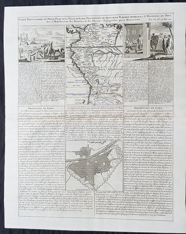
1719 Chatelain Antique Map, Views & Plans of Peru & Lima South America
- Title : Carte Particuliere du Perou, Plan de la Ville de Lima, Description de Quelques Plantes, Animaux, &....
- Size: 20in x 17 1/2in (510mm x 440mm)
- Condition: (A+) Fine Condition
- Date : 1719
- Ref #: 50632
Description:
This large original copper-plate engraved antique map & views of Peru & NW South America with a city plan of Lima was published by Henri Abraham Chatelain in 1719, in his famous Atlas Historique.
These are truly some of the best early engravings of this region done at the time that were copied by the likes of Prevost, Harrison & others in the 18th century, but not with the same eye for detail.
General Definitions:
Paper thickness and quality: - Heavy and stable
Paper color : - off white
Age of map color: -
Colors used: -
General color appearance: -
Paper size: - 20in x 17 1/2in (510mm x 440mm)
Plate size: - 17 1/2in x 15in (440mm x 380mm)
Margins: - Min 1in (25mm)
Imperfections:
Margins: - None
Plate area: - None
Verso: - None
Background:
Atahualpa (also Atahuallpa), the last Sapa Inca became emperor when he defeated and executed his older half-brother Huáscar in a civil war sparked by the death of their father, Inca Huayna Capac. In December 1532, a party of conquistadors led by Francisco Pizarro defeated and captured the Inca Emperor Atahualpa in the Battle of Cajamarca. The Spanish conquest of the Inca Empire was one of the most important campaigns in the Spanish colonization of the Americas. After years of preliminary exploration and military conflicts, it was the first step in a long campaign that took decades of fighting but ended in Spanish victory and colonization of the region known as the Viceroyalty of Peru with its capital at Lima, which became known as The City of Kings. The conquest of the Inca Empire led to spin-off campaigns throughout the viceroyalty as well as expeditions towards the Amazon Basin as in the case of Spanish efforts to quell Amerindian resistance. The last Inca resistance was suppressed when the Spaniards annihilated the Neo-Inca State in Vilcabamba in 1572.
The indigenous population dramatically collapsed due to exploitation, socioeconomic change and epidemic diseases introduced by the Spanish. Viceroy Francisco de Toledo reorganized the country in the 1570s with gold and silver mining as its main economic activity and Amerindian forced labor as its primary workforce. With the discovery of the great silver and gold lodes at Potosí (present-day Bolivia) and Huancavelica, the viceroyalty flourished as an important provider of mineral resources. Peruvian bullion provided revenue for the Spanish Crown and fueled a complex trade network that extended as far as Europe and the Philippines. Because of lack of available work force, African slaves were added to the labor population. The expansion of a colonial administrative apparatus and bureaucracy paralleled the economic reorganization. With the conquest started the spread of Christianity in South America; most people were forcefully converted to Catholicism, taking only a generation to convert the population. They built churches in every city and replaced some of the Inca temples with churches, such as the Coricancha in the city of Cusco. The church employed the Inquisition, making use of torture to ensure that newly converted Catholics did not stray to other religions or beliefs. Peruvian Catholicism follows the syncretism found in many Latin American countries, in which religious native rituals have been integrated with Christian celebrations. In this endeavor, the church came to play an important role in the acculturation of the natives, drawing them into the cultural orbit of the Spanish settlers.
By the 18th century, declining silver production and economic diversification greatly diminished royal income. In response, the Crown enacted the Bourbon Reforms, a series of edicts that increased taxes and partitioned the Viceroyalty. The new laws provoked Túpac Amaru IIs rebellion and other revolts, all of which were suppressed. As a result of these and other changes, the Spaniards and their creole successors came to monopolize control over the land, seizing many of the best lands abandoned by the massive native depopulation. However, the Spanish did not resist the Portuguese expansion of Brazil across the meridian. The Treaty of Tordesillas was rendered meaningless between 1580 and 1640 while Spain controlled Portugal. The need to ease communication and trade with Spain led to the split of the viceroyalty and the creation of new viceroyalties of New Granada and Rio de la Plata at the expense of the territories that formed the viceroyalty of Peru; this reduced the power, prominence and importance of Lima as the viceroyal capital and shifted the lucrative Andean trade to Buenos Aires and Bogotá, while the fall of the mining and textile production accelerated the progressive decay of the Viceroyalty of Peru.
Eventually, the viceroyalty would dissolve, as with much of the Spanish empire, when challenged by national independence movements at the beginning of the nineteenth century. These movements led to the formation of the majority of modern-day countries of South America in the territories that at one point or another had constituted the Viceroyalty of Peru. The conquest and colony brought a mix of cultures and ethnicities that did not exist before the Spanish conquered the Peruvian territory. Even though many of the Inca traditions were lost or diluted, new customs, traditions and knowledge were added, creating a rich mixed Peruvian culture. Two of the most important indigenous rebellions against the Spanish were that of Juan Santos Atahualpa in 1742, and Rebellion of Túpac Amaru II in 1780 around the highlands near Cuzco.
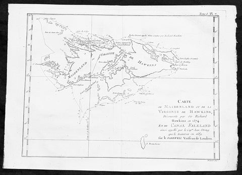
1747 Bellin Antique Map of the Falkland or Maldives Islands Argentina South America
- Title: Carte de Maidenland ou de la Virginie de Hawkins...Richard Hawkins 1574...Cap Jean Strong...1689
- Date: 1747
- Condition : (A+) Fine Condition
- Ref: 35488
- Size: 14in x 10in (360mm x 255mm)
Description:
This fine, original copper-plate engraved antique map of the Falkland Islands by Jacques Nicolas Bellin in 1750 was published in Antoine François Prevosts 15 volumes of Histoire Generale des Voyages written by Prevost & other authors between 1746-1790.
Although Fuegians from Patagonia may have visited the Falkland Islands in prehistoric times, the islands were uninhabited at the time of their discovery by Europeans. Claims of discovery date back to the 16th century, but no consensus exists on whether early explorers discovered the Falklands or other islands in the South Atlantic. The first recorded landing on the islands is attributed to English captain John Strong, who, en route to Peru\'s and Chile\'s littoral in 1690, discovered the Falkland Sound and noted the islands\' water and game.
The Falklands remained uninhabited until the 1764 establishment of Port Louis on East Falkland by French captain Louis Antoine de Bougainville, and the 1766 foundation of Port Egmont on Saunders Island by British captain John MacBride. Whether or not the settlements were aware of each other\'s existence is debated by historians. In 1766, France surrendered its claim on the Falklands to Spain, which renamed the French colony Puerto Soledad the following year. Problems began when Spain discovered and captured Port Egmont in 1770. War was narrowly avoided by its restitution to Britain in 1771.
Both the British and Spanish settlements coexisted in the archipelago until 1774, when Britain\'s new economic and strategic considerations led it to voluntarily withdraw from the islands, leaving a plaque claiming the Falklands for King George III. Spain\'s Viceroyalty of the Río de la Plata became the only governmental presence in the territory. West Falkland was left abandoned, and Puerto Soledad became mostly a prison camp.Amid the British invasions of the Río de la Plata during the Napoleonic Wars in Europe, the islands\' governor evacuated the archipelago in 1806; Spain\'s remaining colonial garrison followed suit in 1811, except for gauchos and fishermen who remained voluntarily.
General Definitions:
Paper thickness and quality: - Heavy and stable
Paper color : - off white
Age of map color: -
Colors used: -
General color appearance: -
Paper size: - 14in x 10in (355mm x 255mm)
Plate size: - 12in x 8in (305mm x 205mm)
Margins: - Min 1/2in (12mm)
Imperfections:
Margins: - None
Plate area: - None
Verso: - None
Background:
One of Antoine Francois Prevosts monumental undertakings was his history of exploration & discovery in 15 volumes titledHistoire Générale des Voyages written between 1746-1759 and was extended to 20 volumes after his death by various authors.
The 20 volumes cover the early explorations & discoveries on 3 continents: Africa (v. 1-5), Asia (v. 5-11), and America (v. 12-15) with material on the finding of the French, English, Dutch, and Portugese.
A number of notable cartographers and engravers contributed to the copper plate maps and views to the 20 volumes including Nicolas Bellin, Jan Schley, Chedel, Franc Aveline, Fessard, and many others.
The African volumes cover primarily coastal countries of West, Southern, and Eastern Africa, plus the Congo, Madagascar, Arabia and the Persian Gulf areas.
The Asian volumes cover China, Korea, Tibet, Japan, Philippines, and countries bordering the Indian Ocean.
Volume 11 includes Australia and Antarctica.
Volumes 12-15 cover voyages and discoveries in America, including the East Indies, South, Central and North America.
Volumes 16-20 include supplement volumes & tables along with continuation of voyages and discoveries in Russia, Northern Europe, America, Asia & Australia.
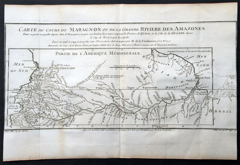
1750 Bellin & Condamine Antique Map The Course of the Amazon River South America
- Title : Carte Du Cours Du Maragnon ou De La Grande Riviere Des Amazones...1743 et 1744...par M de la Condamine
- Ref: 50686
- Size: 15in x 10in (380mm x 255mm)
- Date : 1750
- Condition: (A) Very Good Condition
Description:
This finely engraved original antique map of the course of the Amazon River - according to the discoveries of the French explorer Charles-Marie La Condamine - by Jacques Nicolas Bellin in 1750 was published in Antoine-François Prevost's monumental 20 volume edition of L`Histoire Generale des Voyages published by Pierre de Hondt, The Hague between 1747 & 1780.
Charles-Marie La Condamine (1701 - 1774) was a French mathematician and surveyor who took part in an expedition to South America to measure a degree of latitude.
La Condamine was born in Paris. He was trained for the military profession, but turned his attention to science and geographical exploration. After taking part in a scientific expedition in the Levant (1731), he became a member with Louis Godin and Pierre Bouguer of the expedition sent to Peru in 1735 to determine the length of a degree of the meridian in the neighborhood of the equator.
His associations with his principals were unhappy; the expedition was beset by many difficulties, and finally La Condamine separated from the rest and made his way from Quito down the Amazon, ultimately reaching Cayenne. His was the first scientific exploration of the Amazon. He returned to Paris in 1744 and published the results of his measurements and travels with a map of the Amazon in M' de l'Acadme des Sciences, 1745 (English translation 1745-1747). This included the first descriptions by a European of the Casiquiare canal and the curare arrow poison prepared by the Amerindians.
(Ref: Tooley; M&B)
General Description:
Paper thickness and quality: - Heavy and stable
Paper color: - off white
Age of map color: -
Colors used: -
General color appearance: -
Paper size: - 15in x 10in (380mm x 255mm)
Plate size: - 15in x 10in (380mm x 255mm)
Margins: - Min 0in (0mm)
Imperfections:
Margins: - Margins cropped to margins
Plate area: - Folds as issued
Verso: - None
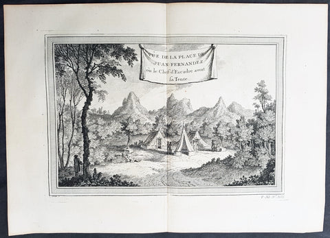
1750 Prevost Antique View of Juan Fernandez Island Chile, Alex. Selkirk & R. Crusoe
- Title: Vue de la Place de Juan Fernandez ou le Chef d Escadre avont sa Tente
- Date: 1750
- Condition : (A+) Fine Condition
- Ref: 25754
- Size: 14in x 10in (355mm x 255mm)
Description:
This fine original copper-plate engraved antique print was engraved by Jakob van Schley and was published in Antoine François Prevosts 15 volumes of Histoire Generale des Voyages written by Prevost & other authors between 1746-1790.
Alexander Selkirk (1676 - 1721) was a Scottish sailor who spent four years as a castaway when he was marooned on an uninhabited island, Juan Fernández Island off the coast of Chile. It is his travels that provided the inspiration for Daniel Defoe\'s novel Robinson Crusoe.
At an early period he was engaged in buccaneer expeditions to the South Seas and in 1703 joined in with the expedition of famed privateer and explorer William Dampier. While Dampier was captain of the St. George, Selkirk served on the galley Cinque Ports, the St. George\'s companion, as a sailing master serving under Thomas Stradling.
In October 1704, after the ships had parted ways because of a dispute between Stradling and Dampier, the Cinque Ports was brought by Stradling to the uninhabited archipelago of Juan Fernández off the coast of Chile for a mid-expedition restocking of supplies and fresh water. Selkirk had grave concerns by this time about the seaworthiness of this vessel (indeed, the Cinque Ports later foundered, losing most of its hands). He tried to convince some of his crewmates to desert with him, remaining on the island; he was counting on an impending visit by another ship. No one else agreed to come along with him. Stradling declared that he would grant him his wish and leave him alone on Juan Fernández. Selkirk promptly regretted his decision. He chased and called after the boat, to no avail. Selkirk lived the next four years and four months without any human company. All he had brought with him was a musket, gunpowder, carpenter\'s tools, a knife, a Bible, some clothing and rope.
His long-anticipated rescue occurred on 1 February 1709 by way of the Duke, a privateering ship piloted by the above-mentioned William Dampier. Selkirk was discovered by the Duke\'s captain, Woodes Rogers, who referred to him as Governor of the island. Now rescued, he was almost incoherent in his joy. The agile Selkirk, catching two or three goats a day, helped restore the health of Rogers\' men. Rogers eventually made Selkirk his mate, giving him independent command of one of his ships. Rogers\' A cruising voyage round the world: first to the South-Sea, thence to the East-Indies, and homewards by the Cape of Good Hope was published in 1712 and included an account of Selkirk\'s ordeal. (Ref: Tooley; M&B)
General Definitions:
Paper thickness and quality: - Heavy and stable
Paper color : - off white
Age of map color: -
Colors used: -
General color appearance: -
Paper size: - 14in x 10in (365mm x 250mm)
Plate size: - 12in x 8in (305mm x 205mm)
Margins: - Min 1/2in (12mm)
Imperfections:
Margins: - None
Plate area: - None
Verso: - None
Background:
One of Antoine Francois Prevosts monumental undertakings was his history of exploration & discovery in 15 volumes titledHistoire Générale des Voyages written between 1746-1759 and was extended to 20 volumes after his death by various authors.
The 20 volumes cover the early explorations & discoveries on 3 continents: Africa (v. 1-5), Asia (v. 5-11), and America (v. 12-15) with material on the finding of the French, English, Dutch, and Portugese.
A number of notable cartographers and engravers contributed to the copper plate maps and views to the 20 volumes including Nicolas Bellin, Jan Schley, Chedel, Franc Aveline, Fessard, and many others.
The African volumes cover primarily coastal countries of West, Southern, and Eastern Africa, plus the Congo, Madagascar, Arabia and the Persian Gulf areas.
The Asian volumes cover China, Korea, Tibet, Japan, Philippines, and countries bordering the Indian Ocean.
Volume 11 includes Australia and Antarctica.
Volumes 12-15 cover voyages and discoveries in America, including the East Indies, South, Central and North America.
Volumes 16-20 include supplement volumes & tables along with continuation of voyages and discoveries in Russia, Northern Europe, America, Asia & Australia.
Jakob van der Schley aka Jakob van Schley (1715 - 1779) was a Dutch draughtsman and engraver. He studied under Bernard Picart (1673-1733) whose style he subsequently copied. His main interests were engraving portraits and producing illustrations for \"La Vie de Marianne\" by Pierre Carlet de Chamblain de Marivaux (1688-1763) published in The Hague between 1735 and 1747.
He also engraved the frontispieces for a 15-volume edition of the complete works of Pierre de Brantôme (1540-1614), \"Oeuvres du seigneur de Brantôme\", published in The Hague in 1740.
He is also responsible for most of the plates in the Hague edition of Prévost\'s Histoire générale des voyages. (Ref: Tooley; M&B)
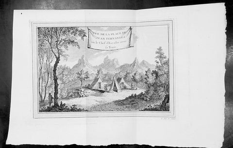
1750 Prevost Antique View of Juan Fernandez Island Chile, Alex. Selkirk & R. Crusoe
- Title: Vue de la Place de Juan Fernandez ou le Chef d Escadre avont sa Tente
- Date: 1750
- Condition : (A+) Fine Condition
- Ref: 34129
- Size: 14in x 10in (355mm x 255mm)
Description:
This fine original copper-plate engraved antique print was engraved by Jakob van Schley and was published in Antoine François Prevosts 15 volumes of Histoire Generale des Voyages written by Prevost & other authors between 1746-1790.
Alexander Selkirk (1676 - 1721) was a Scottish sailor who spent four years as a castaway when he was marooned on an uninhabited island, Juan Fernández Island off the coast of Chile. It is his travels that provided the inspiration for Daniel Defoe\'s novel Robinson Crusoe.
At an early period he was engaged in buccaneer expeditions to the South Seas and in 1703 joined in with the expedition of famed privateer and explorer William Dampier. While Dampier was captain of the St. George, Selkirk served on the galley Cinque Ports, the St. George\'s companion, as a sailing master serving under Thomas Stradling.
In October 1704, after the ships had parted ways because of a dispute between Stradling and Dampier, the Cinque Ports was brought by Stradling to the uninhabited archipelago of Juan Fernández off the coast of Chile for a mid-expedition restocking of supplies and fresh water. Selkirk had grave concerns by this time about the seaworthiness of this vessel (indeed, the Cinque Ports later foundered, losing most of its hands). He tried to convince some of his crewmates to desert with him, remaining on the island; he was counting on an impending visit by another ship. No one else agreed to come along with him. Stradling declared that he would grant him his wish and leave him alone on Juan Fernández. Selkirk promptly regretted his decision. He chased and called after the boat, to no avail. Selkirk lived the next four years and four months without any human company. All he had brought with him was a musket, gunpowder, carpenter\'s tools, a knife, a Bible, some clothing and rope.
His long-anticipated rescue occurred on 1 February 1709 by way of the Duke, a privateering ship piloted by the above-mentioned William Dampier. Selkirk was discovered by the Duke\'s captain, Woodes Rogers, who referred to him as Governor of the island. Now rescued, he was almost incoherent in his joy. The agile Selkirk, catching two or three goats a day, helped restore the health of Rogers\' men. Rogers eventually made Selkirk his mate, giving him independent command of one of his ships. Rogers\' A cruising voyage round the world: first to the South-Sea, thence to the East-Indies, and homewards by the Cape of Good Hope was published in 1712 and included an account of Selkirk\'s ordeal. (Ref: Tooley; M&B)
General Definitions:
Paper thickness and quality: - Heavy and stable
Paper color : - off white
Age of map color: -
Colors used: -
General color appearance: -
Paper size: - 14in x 10in (365mm x 250mm)
Plate size: - 12in x 8in (305mm x 205mm)
Margins: - Min 1/2in (12mm)
Imperfections:
Margins: - None
Plate area: - None
Verso: - None
Background:
One of Antoine Francois Prevosts monumental undertakings was his history of exploration & discovery in 15 volumes titledHistoire Générale des Voyages written between 1746-1759 and was extended to 20 volumes after his death by various authors.
The 20 volumes cover the early explorations & discoveries on 3 continents: Africa (v. 1-5), Asia (v. 5-11), and America (v. 12-15) with material on the finding of the French, English, Dutch, and Portugese.
A number of notable cartographers and engravers contributed to the copper plate maps and views to the 20 volumes including Nicolas Bellin, Jan Schley, Chedel, Franc Aveline, Fessard, and many others.
The African volumes cover primarily coastal countries of West, Southern, and Eastern Africa, plus the Congo, Madagascar, Arabia and the Persian Gulf areas.
The Asian volumes cover China, Korea, Tibet, Japan, Philippines, and countries bordering the Indian Ocean.
Volume 11 includes Australia and Antarctica.
Volumes 12-15 cover voyages and discoveries in America, including the East Indies, South, Central and North America.
Volumes 16-20 include supplement volumes & tables along with continuation of voyages and discoveries in Russia, Northern Europe, America, Asia & Australia.
Jakob van der Schley aka Jakob van Schley (1715 - 1779) was a Dutch draughtsman and engraver. He studied under Bernard Picart (1673-1733) whose style he subsequently copied. His main interests were engraving portraits and producing illustrations for \"La Vie de Marianne\" by Pierre Carlet de Chamblain de Marivaux (1688-1763) published in The Hague between 1735 and 1747.
He also engraved the frontispieces for a 15-volume edition of the complete works of Pierre de Brantôme (1540-1614), \"Oeuvres du seigneur de Brantôme\", published in The Hague in 1740.
He is also responsible for most of the plates in the Hague edition of Prévost\'s Histoire générale des voyages. (Ref: Tooley; M&B)
1753 Bellin Antique Map of The Island of Cayenne French Guyana, South America
- Title: Carte de L Isle De Caienne et de ses Environs...1753
- Date: 1753
- Condition : (A+) Fine Condition
- Ref: 92015
- Size: 15in x 11in (390mm x 275mm)
Description:
This fine, original copper-plate engraved antique map of the City Island of Cayenne in French Guyana, South America by Jacques Nicolas Bellin was engraved in 1753 - dated - and was published in Antoine François Prevosts 15 volumes of Histoire Generale des Voyages written by Prevost & other authors between 1746-1790.
Cayenne is the capital city of French Guiana, an overseas region and department of France located in South America. The city stands on a former island at the mouth of the Cayenne River on the Atlantic coast. The city\'s motto is fert aurum industria, which means \"work brings wealth.
Ignored by Spanish explorers, who found the region too hot and poor to be claimed, the region was not colonized until 1604, when a French settlement was founded. However, it was soon destroyed by the Portuguese, who were determined to enforce the provisions of the Treaty of Tordesillas. French colonists returned in 1643 and founded Cayenne, but they were forced to leave once more following Amerindian attacks. In 1664, France finally succeeded at establishing a permanent settlement at Cayenne. Over the next decade the colony changed hands between the French, Dutch, and English, before being restored to France. It was captured by an Anglo-Portuguese force at the invasion of Cayenne in 1809 and administered from Brazil until 1814, when it was returned to French control. It was used as a French penal colony from 1854 to 1938.
General Definitions:
Paper thickness and quality: - Heavy and stable
Paper color : - off white
Age of map color: -
Colors used: -
General color appearance: -
Paper size: - 13in x 10in (330mm x 255mm)
Plate size: - 12in x 9in (305mm x 230mm)
Margins: - Min 1/2in (12mm)
Imperfections:
Margins: - None
Plate area: - None
Verso: - None
1753 Bellin Antique Map of the Magellan Straits, South America
- Title : Carte Reduite du Detroit De Magellan...1753
- Ref #: 91218
- Size: 15in x 10in (380mm x 255mm)
- Date : 1753
- Condition: (A+) Fine Condition
Description:
This fine hand coloured original antique map of the Magellan Straits between the South American mainland and Tierra Del Fuego - with major points discovered and remarked in a 9 point legend - was engraved by Jacques Nicolas Bellin in 1753 - the date is engraved in the title cartouche - and was published in Antoine-François Prevost's monumental 20 volume edition of L`Histoire Generale des Voyages published by Pierre de Hondt, The Hague between 1747 & 1780. (Ref: Tooley; M&B)
General Description:
Paper thickness and quality: - Heavy and stable
Paper color: - off white
Age of map color: - Later
Colors used: - Yellow, green, red
General color appearance: - Authentic
Paper size: - 15in x 10in (380mm x 255mm)
Plate size: - 14in x 8in (355mm x 205mm)
Margins: - Min 1/2in (12mm)
Imperfections:
Margins: - Light stain bottom right corner
Plate area: - None
Verso: - None
1753 Bellin Antique Map Plan of the City of Cayenne French Guyana, South America
- Title: La Ville De Cayenne...1753
- Date: 1753
- Condition : (A+) Fine Condition
- Ref: 92016
- Size: 15in x 11in (390mm x 275mm)
Description:
This beautifully engraved original antique map a plan of the city of Cayenne capital of French Guyana, South America was engraved by Jacques Nicolas Bellin in 1753 - the date is engraved in the title cartouche - and was published by Jacques Nicolas Bellin for Antoine-François Prevosts 20 volume edition of L`Histoire Generale des Voyages published by Pierre de Hondt, The Hague in 1747. (Ref: Tooley; M&B)
General Description:
Paper thickness and quality: - Heavy and stable
Paper color: - white
Age of map color: -
Colors used: -
General color appearance: -
Paper size: - 15in x 11in (390mm x 275mm)
Plate size: - 11 1/2in x 9 1/2in (290mm x 245mm)
Margins: - min. 1in (25mm)
Imperfections:
Margins: - None
Plate area: - Folds as issued
Verso: - None
Condition : (A+) Fine Condition
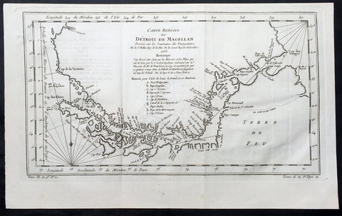
1753 Bellin Original Antique Map of Magellan Straits, Argentine Tierra Del Fuego
- Title : Carte Reduite du Detroit De Magellan...1753
- Ref #: 60961
- Size: 15in x 9 1/2in (380m x 240mm)
- Date : 1753
- Condition: (A+) Fine Condition
Description:
This fine, original copper-plate engraved antique map of the Magellan Straits between the South American mainland and Tierra Del Fuego map - with major points of discovery and remarks in a 9 legend points by Jacques Nicolas Bellin was engraved in 1753 - dated - and was published in Antoine-François Prevosts L Histoire Generale des VoyagesPierre de Hondt, The Hague.
General Definitions:
Paper thickness and quality: - Heavy and stable
Paper color : - off white
Age of map color: -
Colors used: -
General color appearance: -
Paper size: - 15in x 9 1/2in (380m x 240mm)
Plate size: - 14 1/2in x 8in (370mm x 205mm)
Margins: - Min 1/2in (12mm)
Imperfections:
Margins: - None
Plate area: - Folds as issued
Verso: - None
Background:
Antoine François Prevost d Exiles 1697 – 1763, usually known simply as the Abbé Prévost, was a French author and novelist.He was born at Hesdin, Artois, and first appears with the full name of Prevost d Exiles, in a letter to the booksellers of Amsterdam in 1731. His father, Lievin Prévost, was a lawyer, and several members of the family had embraced the ecclesiastical estate. Prevost was educated at the Jesuit school of Hesdin, and in 1713 became a novice of the order in Paris, pursuing his studies at the same time at the college in La Flèche.
At the end of 1716 he left the Jesuits to join the army, but soon tired of military life, and returned to Paris in 1719, apparently with the idea of resuming his novitiate. He is said to have travelled in the Netherlands about this time; in any case he returned to the army, this time with a commission. Some biographers have assumed that he suffered some of the misfortunes assigned to his hero Des Grieux. Whatever the truth, he joined the learned community of the Benedictines of St Maur, with whom he found refuge, he himself says, after the unlucky termination of a love affair. He took his vows at Jumièges in 1721 after a year\'s novitiate, and in 1726 took priests orders at St Germer de Flaix. He spent seven years in various houses of the order, teaching, preaching and studying. In 1728 he was sent to the Abbey of Saint-Germain-des-Pres, Paris, where he contributed to the Gallia Christiana, a work of historiographic documentation undertaken communally by the monks in continuation of the works of Denys de Sainte-Marthe, who had been a member of their order. His restless spirit made him seek from the Pope a transfer to the easier rule of Cluny; but he left the abbey without leave (1728), and, learning that his superiors had obtained a lettre de cachet against him, fled to England.
In London he acquired a wide knowledge of English history and literature, as can be seen in his writings. Before leaving the Benedictines Prévost had begun perhaps his most famous novel, Mémoires et aventures d’un homme de qualité qui s’est retiré du monde, the first four volumes of which were published in Paris in 1728, and two years later at Amsterdam. In 1729 he left England for the Netherlands, where he began to publish (Utrecht, 1731) a novel, the material of which, at least, had been gathered in London Le Philosophe anglais, ou Histoire de Monsieur Cleveland, fils naturel de Cromwell, ecrite par lui-même, et traduite de l anglais (Paris 1731-1739, 8 vols., but most of the existing sets are partly Paris and partly Utrecht). A spurious fifth volume (Utrecht, 1734) contained attacks on the Jesuits, and an English translation of the whole appeared in 1734.
Meanwhile, during his residence at the Hague, he engaged on a translation of De Thou\'s Historia, and, relying on the popularity of his first book, published at Amsterdam a Suite in three volumes, forming volumes v, vi, and vii of the original Mémoires et aventures d’un homme de qualite. The seventh volume contained the famous Manon Lescaut, separately published in Paris in 1731 as Histoire du Chevalier des Grieux et de Manon Lescaut. The book was eagerly read, chiefly in pirated copies, being forbidden in France. In 1733 he left the Hague for London in company of a lady whose character, according to Prevosts enemies, was doubtful. In London he edited a weekly gazette on the model of Joseph Addisons Spectator, Le Pour et contre, which he continued to produce in collaboration with the playwright Charles-Hugues Le Febvre de Saint-Marc, with short intervals, until 1740.
In the autumn of 1734 Prevost was reconciled with the Benedictines, and, returning to France, was received in the Benedictine monastery of La Croix-Saint-Leufroy in the diocese of Evreux to pass through a new, though brief, novitiate. In 1735 he was dispensed from residence in a monastery by becoming almoner to the Prince de Conti, and in 1754 obtained the priory of St Georges de Gesnes. He continued to produce novels and translations from the English, and, with the exception of a brief exile (1741–1742) spent in Brussels and Frankfurt, he resided for the most part at Chantilly until his death, which took place suddenly while he was walking in the neighbouring woods. The cause of his death, the rupture of an aneurysm, is all that is definitely known. Stories of crime and disaster were related of Prevost by his enemies, and diligently repeated, but appear to be apocryphal.
Prevosts other works include:
- Le Doyen de Killerine, Killerine, histoire morale composee sur les memoires d une illustre famille d Irlande (Paris, 1735; 2nd part, the Hague, 1739, 3rd, 4th and 5th parts, 1740)
- Tout pour l\'amour (1735), a translation of Drydens tragedy
- Histoire d une Grecque moderne (Amsterdam [Paris] 2 vols., 1740)
- l Histoire de Marguerite d Anjou (Amsterdam [Paris] 2 vols., 1740)
Memoires pour servir a l histoire de Malte (Amsterdam, 1741)
- Campagnes philosophiques, ou memoires ... contenant l histoire de la guerre d Irlande (Amsterdam, 1741)
- Histoire de Guillaume le Conquerant (Paris, 1742)
- Histoire generale des voyages (15 vols., Paris, 1746-1759), continued by other writers
- Manuel Lexique (Paris, 1750), continued by other writers
- Translations from Samuel Richardson:
Lettres anglaises ou Histoire de Miss Clarisse Harlovie (1751), from Richardson\'s Clarissa, and Nouvelles lettres anglaises, ou Histoire du chevalier Grandisson (Sir Charles Grandison, 1755).
- Mémoires pour servir a l\'histoire de la vertu (1762), from Mrs Sheridan\'s
Memoires of Miss Sidney Bidulph
- Histoire de la maison de Stuart (3 vols., 1740) from Hume\'s History of England to 1688
- Le Monde moral, ou Mémoires pour servir a l\'histoire du coeur humain (2 vols., Geneva, 1760)
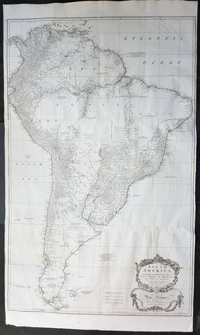
1755 Kitchin & Boulton Large Original Antique Map of South America
- Title : South America. Performed Under the Patronage of Louis Duke of Orleans First Prince of the Blood...Tho. Kitchin sculp. 1755
- Size: 53in x 30 1/2in (1.35m x 780mm)
- Ref #: 41163
- Date : 1755
- Condition: (A+) Fine Condition
Description:
This very large finely engraved original antique map of South America was engraved by the famous English cartographer Thomas Kitchin in 1755 - dated and signed at the foot of the map - after JB D Anville, was published in Malachy Postlethweyts Dictionary of Trade & Commerce
These large maps are hard to find in such good condition and make fantastic historical reference tools due to the high level of detail.
General Definitions:
Paper thickness and quality: - Heavy and stable
Paper color : - off white
Age of map color: -
Colors used: -
General color appearance: -
Paper size: - 53in x 30 1/2in (1.35m x 780mm)
Plate size: - 48in x 30 1/2in (1.22m x 780mm)
Margins: - Min 1/2in (12mm)
Imperfections:
Margins: - None
Plate area: - Folds as issued, light creasing along folds
Verso: - Folds as issued, light creasing along folds
Background:
A curious and uncommon joined three panel 1755 wall map of South America by Thomas Kitchin and published by the English publisher Malachy Postlethwayte. A derivative of D\'Anville\'s earlier map, Postlethwayte\'s map covers the entire continent from the Lesser Antilles and Panama to Cape Horn. Published in three separate panels, this map can be either joined as a single massive map as assembled, as above, in separate sections. D\'Anville\'s map, and by extension this revision of that map by Bolton and Postlethwayte, represents a serious attempt to compile all of the accurate scientific knowledge of the South American continent available at the time. While cartographically very similar to D\'Anville\'s map, Postlethwayte\'s work is a full re-engraving in which all text has been translated to english, a new cartouche of a rococo ethic incorporated, and Postlethwayte\'s own fascinating Anglo-centric commentary added. This primary cartographic development on this, the Postlethwayte variant of D\'Anville\'s map is the incorporation of data associated with the expedition of Charles Marie de La Condamine - which being published in 1748 Postlethawyte postulates was not available to D\'Anville.
Our survey of this map beings with the coast which Spanish and Portuguese navigators had mapped with considerable accuracy as early as the late 16th century. This, like most early maps of the area, contrasts a detailed mapping of the coast with a speculative discussion of the interior, particularly Patagonia and the Amazon Basin. The map offers a fairly accurate discussion of both the east and west coasts with exceptional detail in the populated Andean regions of Venezuela, Columbia, ecuador (Labeled Quito), and Peru. Cuzco, Lima, Quito, Valladolid, Arequipa, Trujillo and other important trading centers of the region are noted. In Portuguese controlled Brazil, Rio de Janeiro, San Salvador and San Sebastian are identified.
Much of South America\'s interior, particularly the inland river basins, dominated by the Paraguay River in the south, the Amazon River in the center, and the Orinoco in the north, were largely unexplored. Nonetheless, several corrections and updates appear. D\'Anville (also Bolton and Postlethwayte) have done away with the myth of Lake Parima (supposedly in southern Guyana), the site of the legendary city of Manoa or el Dorado, and instead correctly identify the vast flood plain located in this same region. The cities and tribes identified along the Amazon river mostly date to the journals of the harrowing 16th century Francisco Orellana voyage - a clear indication of how little information actually emerged from the Amazon Basin.
Further south, the cartographers have retained the mythical Laguna de Xarayes as the northern terminus of the Paraguay River. The Xarayes, a corruption of \'Xaraies\' meaning \'Masters of the River,\' were an indigenous people occupying what are today parts of Brazil\'s Matte Grosso and the Pantanal. When Spanish and Portuguese explorers first navigated up the Paraguay River, as always in search of el Dorado, they encountered the vast Pantanal flood plain at the height of its annual inundation. Understandably misinterpreting the flood plain as a gigantic inland sea, they named it after the local inhabitants, the Xaraies. The Laguna de los Xarayes almost immediately began to appear on early maps of the region and, at the same time, almost immediately took on a legendary aspect. Later missionaries and chroniclers, particularly Díaz de Guzmán, imagined an island in this lake and curiously identified it as an \'Island of Paradise,\'
...an island [of the Paraguay River] more than ten leagues [56 km] long, two or three [11-16 km] wide. A very mild land rich in a thousand types of wild fruit, among them grapes, pears and olives: the Indians created plantations throughout, and throughout the year sow and reap with no difference in winter or summer, ... the Indians of that island are of good will and are friends to the Spaniards; Orejón they call them, and they have their ears pierced with wheels of wood ... which occupy the entire hole. They live in round houses, not as a village, but each apart though keep up with each other in much peace and friendship. They called of old this island Land of Paradise for its abundance and wonderful qualities.
D\'Anville, to his credit, shows the \'Laguna\' and its island in a much reduced form compared to earlier cartographers acknowledges that its existence is dubious. Our map, clearly referring to the work of Díaz de Guzmán, identifies the island as the \'I. de Orejones.\'
Far to the south Patagonia is crisscrossed with a number of speculative rivers based upon assumptions from earlier cartographers. Postlethwayte includes annotations referencing the failure to discover one such pass between Julian Bay (Chile) and the Campana River. earlier in the century speculation on such a pass fueled the famous South Sea Company, one of the modern world\'s first stock bubbles, but when no such pass was discovered, the bubble burst. Another element that bears attention in this region is a curious note about an island on the Sauces River (Rio Negro, Argentina) that is supposedly inhabited by white people - possibly the survivors of a shipwreck?
Malachy Postlethwayt (c. 1707 - 1767) was a British economist and commercial expert famous for his publication of the commercial dictionary titled The Universal Dictionary of Trade and Commerce in 1751. The dictionary was a translation and adaptation of the Dictionnaire économique of the French Inspector General of the Manufactures for the King, Jacques Savary des Brûlons. Malachy claims to have spent nearly 20 years adapting and researching his important dictionary, which attained a popular following. The second edition of the Dictionary issued in 1752, was updated with a series of fine maps based upon D\'Anville\'s work, but updated by Postlethwayt to reflect his political and social views. Politically Postlethwayt was extremely conservative and highly patriotic though his views more often than not took the form of rants against the social and political enemies of the British Empire. In the mid-1740s Postlethwayt lobbied for the Royal Africa Company and was known for his pro-slavery advocacy. His belief that the slave trade had a place in the larger \"political arithmetic\" of empire, promoted through his many popular books and other publications, in time became the party line for the ruling class. Despite his misguided feelings about the Africa slave trade, Postlethwayt was an influential and thoughtful economist whose ideas influenced Adam Smith, Samuel von Pufendorf, Alexander Hamilton, and others. Postlethwayt also commonly spelled his name as Postlethawyte and Postlethwait.
Samuel Boulton (fl. 1775 - 1800) was a historian and cartographer active in the late 18th century. In general Boulton is an extremely elusive figure of which little is known. His most important work is his magnificent map of Africa published in conjunction with Robert Sayer and, later, Laurie and Whittle.
1755 Nicolas Bellin Original Antique Map of Brazil, Camarin to Cape St Marie
- Title : Suite du Bresil.
- Ref #: 61078
- Size: 10in x 7 1/2in (255mm x 190mm)
- Date : 1755
- Condition: (A+) Fine Condition
Description:
This fine, original copper-plate engraved antique map of Southern Brazil from from Camarin to Cape St Marie by Jacques Nicolas Bellin in 1755 was published in Antoine François Prevosts 15 volumes of Histoire Generale des Voyages written by Prevost & other authors between 1746-1790.
The land now called Brazil was claimed for the Portuguese Empire on 22 April 1500, with the arrival of the Portuguese fleet commanded by Pedro Álvares Cabral. The Portuguese encountered indigenous peoples divided into several tribes, most of whom spoke languages of the Tupi–Guarani family, and fought among themselves. Though the first settlement was founded in 1532, colonization effectively began in 1534, when King Dom João III of Portugal divided the territory into the fifteen private and autonomous Captaincy Colonies of Brazil.
However, the decentralized and unorganized tendencies of the captaincy colonies proved problematic, and in 1549 the Portuguese king restructured them into the Governorate General of Brazil, a single and centralized Portuguese colony in South America. In the first two centuries of colonization, Indigenous and European groups lived in constant war, establishing opportunistic alliances in order to gain advantages against each other. By the mid-16th century, cane sugar had become Brazil\'s most important exportation product, and slaves purchased in Sub-Saharan Africa, in the slave market of Western Africa (not only those from Portuguese allies of their colonies in Angola and Mozambique), had become its largest import, to cope with plantations of sugarcane, due to increasing international demand for Brazilian sugar
By the end of the 17th century, sugarcane exports began to decline, and the discovery of gold by bandeirantes in the 1690s would become the new backbone of the colony\'s economy, fostering a Brazilian Gold Rush which attracted thousands of new settlers to Brazil from Portugal and all Portuguese colonies around the world. This increased level of immigration in turn caused some conflicts between newcomers and old settlers.
Portuguese expeditions known as Bandeiras gradually advanced the Portugal colonial original frontiers in South America to approximately the current Brazilian borders. In this era other European powers tried to colonize parts of Brazil, in incursions that the Portuguese had to fight, notably the French in Rio during the 1560s, in Maranhão during the 1610s, and the Dutch in Bahia and Pernambuco, during the Dutch–Portuguese War, after the end of Iberian Union.
The Portuguese colonial administration in Brazil had two objectives that would ensure colonial order and the monopoly of Portugal\'s wealthiest and largest colony: to keep under control and eradicate all forms of slave rebellion and resistance, such as the Quilombo of Palmares, and to repress all movements for autonomy or independence, such as the Minas Conspiracy
General Definitions:
Paper thickness and quality: - Heavy and stable
Paper color : - off white
Age of map color: - Early
Colors used: - Green, Yellow,
General color appearance: - Authentic
Paper size: - 10in x 7 1/2in (255mm x 190mm)
Plate size: - 9 1/2in x 7in (240mm x 180mm)
Margins: - Min 1/2in (12mm)
Imperfections:
Margins: - None
Plate area: - None
Verso: - None
Background:
One of Antoine Francois Prevosts monumental undertakings was his history of exploration & discovery in 15 volumes titledHistoire Générale des Voyages written between 1746-1759 and was extended to 20 volumes after his death by various authors.
The 20 volumes cover the early explorations & discoveries on 3 continents: Africa (v. 1-5), Asia (v. 5-11), and America (v. 12-15) with material on the finding of the French, English, Dutch, and Portugese.
A number of notable cartographers and engravers contributed to the copper plate maps and views to the 20 volumes including Nicolas Bellin, Jan Schley, Chedel, Franc Aveline, Fessard, and many others.
The African volumes cover primarily coastal countries of West, Southern, and Eastern Africa, plus the Congo, Madagascar, Arabia and the Persian Gulf areas.
The Asian volumes cover China, Korea, Tibet, Japan, Philippines, and countries bordering the Indian Ocean.
Volume 11 includes Australia and Antarctica.
Volumes 12-15 cover voyages and discoveries in America, including the East Indies, South, Central and North America.
Volumes 16-20 include supplement volumes & tables along with continuation of voyages and discoveries in Russia, Northern Europe, America, Asia & Australia.
1755 Prevost & Schley Antique Print of Artifacts Recovered from Inca Burial Tomb
- Title: Puvrages qui se trouvent dans les Tombeaux des anciens Peruviens
- Date: 1755
- Condition : (A+) Fine Condition
- Ref: 34132
- Size: 15in x 10in (385mm x 255mm)
Description:
This fine, original copper-plate engraved antique print of artifacts found in an Inca Tomb in Peru by Jakob van Schley in 1755 - after De Bry - was published in Antoine François Prevosts 15 volumes of Histoire Generale des Voyages written by Prevost & other authors between 1746-1790.
The Inca Empire also known as the Incan Empire and the Inka Empire, was the largest empire in pre-Columbian America, and possibly the largest empire in the world in the early 16th century. Its political and administrative structure \"was the most sophisticated found among native peoples\" in the Americas.The administrative, political and military center of the empire was located in Cusco in modern-day Peru. The Inca civilization arose from the highlands of Peru sometime in the early 13th century. Its last stronghold was conquered by the Spanish in 1572.
From 1438 to 1533, the Incas incorporated a large portion of western South America, centered on the Andean Mountains, using conquest and peaceful assimilation, among other methods. At its largest, the empire joined Peru, large parts of modern Ecuador, western and south central Bolivia, northwest Argentina, north and central Chile and a small part of southwest Colombia into a state comparable to the historical empires of Eurasia. Its official language was Quechua.Many local forms of worship persisted in the empire, most of them concerning local sacred Huacas, but the Inca leadership encouraged the worship of Inti – their sun god – and imposed its sovereignty above other cults such as that of Pachamama. The Incas considered their king, the Sapa Inca, to be the \"son of the sun.\"
The Inca Empire was unique in that it lacked many features associated with civilization in the Old World. In the words of one scholar, \"The Incas lacked the use of wheeled vehicles. They lacked animals to ride and draft animals that could pull wagons and plows... [They] lacked the knowledge of iron and steel... Above all, they lacked a system of writing... Despite these supposed handicaps, the Incas were still able to construct one of the greatest imperial states in human history\". Notable features of the Inca Empire include its monumental architecture, especially stonework, extensive road network reaching all corners of the empire, finely-woven textiles, use of knotted strings (quipu) for record keeping and communication, agricultural innovations in a difficult environment, and the organization and management fostered or imposed on its people and their labor.
The Incan economy has been described in contradictory ways by scholars: as \"feudal, slave, socialist (here one may choose between socialist paradise or socialist tyranny)\". The Inca empire functioned largely without money and without markets. Instead, exchange of goods and services was based on reciprocity between individuals and among individuals, groups, and Inca rulers. \"Taxes\" consisted of a labor obligation of a person to the Empire. The Inca rulers (who theoretically owned all the means of production) reciprocated by granting access to land and goods and providing food and drink in celebratory feasts for their subjects.
General Definitions:
Paper thickness and quality: - Heavy and stable
Paper color : - off white
Age of map color: - Early
Colors used: - Yellow, green, red
General color appearance: - Authentic
Paper size: - 15in x 10in (385mm x 255mm)
Plate size: - 14in x 8 1/2in (355mm x 220mm)
Margins: - Min 1in (25mm)
Imperfections:
Margins: - None
Plate area: - Folds as issued
Verso: - None
Background:
One of Antoine Francois Prevosts monumental undertakings was his history of exploration & discovery in 15 volumes titledHistoire Générale des Voyages written between 1746-1759 and was extended to 20 volumes after his death by various authors.
The 20 volumes cover the early explorations & discoveries on 3 continents: Africa (v. 1-5), Asia (v. 5-11), and America (v. 12-15) with material on the finding of the French, English, Dutch, and Portugese.
A number of notable cartographers and engravers contributed to the copper plate maps and views to the 20 volumes including Nicolas Bellin, Jan Schley, Chedel, Franc Aveline, Fessard, and many others.
The African volumes cover primarily coastal countries of West, Southern, and Eastern Africa, plus the Congo, Madagascar, Arabia and the Persian Gulf areas.
The Asian volumes cover China, Korea, Tibet, Japan, Philippines, and countries bordering the Indian Ocean.
Volume 11 includes Australia and Antarctica.
Volumes 12-15 cover voyages and discoveries in America, including the East Indies, South, Central and North America.
Volumes 16-20 include supplement volumes & tables along with continuation of voyages and discoveries in Russia, Northern Europe, America, Asia & Australia.
Jakob van der Schley aka Jakob van Schley (1715 - 1779) was a Dutch draughtsman and engraver. He studied under Bernard Picart (1673-1733) whose style he subsequently copied. His main interests were engraving portraits and producing illustrations for \\\"La Vie de Marianne\\\" by Pierre Carlet de Chamblain de Marivaux (1688-1763) published in The Hague between 1735 and 1747.
He also engraved the frontispieces for a 15-volume edition of the complete works of Pierre de Brantôme (1540-1614), \\\"Oeuvres du seigneur de Brantôme\\\", published in The Hague in 1740.
He is also responsible for most of the plates in the Hague edition of Prévosts Histoire générale des voyages. (Ref: Tooley; M&B)
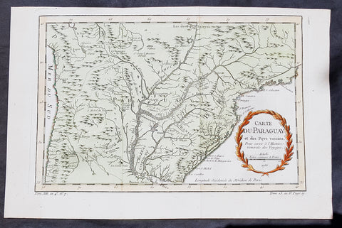
1756 Bellin Antique Map of Paraguay & Brazil, South America
- Title: Carte Du Paraguay...1756
-
Date: 1756
Condition : (A+) Fine Condition - Ref: 60939
- Size: 15in x 10in (380mm x 255mm)
Description:
This fine, original copper-plate engraved antique map of Paraguay South America, by Jacques Nicolas Bellin in 1756 was published in Antoine François Prevosts 15 volumes of Histoire Generale des Voyages written by Prevost & other authors between 1746-1790.
The first Europeansto explore the country were Spanish explorers in 1516. The Spanish explorer Juan de Salazar de Espinosa founded the settlement of Asunción on 15 August 1537. The city eventually became the center of a Spanish colonial province of Paraguay.
An attempt to create an autonomous Christian Indian nation was undertaken by Jesuit missions and settlements in this part of South America in the eighteenth century, which included portions of Uruguay, Argentina, and Brazil. They developed Jesuit reductions to bring Guarani populations together at Spanish missions and protect them from virtual slavery by Spanish settlers and Portuguese slave raiders, the Bandeirantes. In addition to seeking their conversion to Christianity. Catholicism in Paraguay was influenced by the indigenous peoples; the syncretic religion has absorbed native elements. The reducciones flourished in eastern Paraguay for about 150 years, until the expulsion of the Jesuits by the Spanish Crown in 1767. The ruins of two 18th-century Jesuit Missions of La Santísima Trinidad de Paraná and Jesús de Tavarangue have been designated as World Heritage Sites by UNESCO.
In western Paraguay Spanish settlement and Christianity were strongly resisted by the nomadic Guaycuru and other nomads from the 16th century onward. Most of these peoples were absorbed into the mestizo population in the 18th and 19th centuries.
General Definitions:
Paper thickness and quality: - Heavy and stable
Paper color : - off white
Age of map color: - Early
Colors used: - Yellow, green, red
General color appearance: - Authentic
Paper size: - 15in x 10in (380mm x 255mm)
Plate size: - 13in x 8 1/2in (330mm x 215mm)
Margins: - Min 1/2in (12mm)
Imperfections:
Margins: - None
Plate area: - Folds as issued
Verso: - None
Background:
One of Antoine Francois Prevosts monumental undertakings was his history of exploration & discovery in 15 volumes titledHistoire Générale des Voyages written between 1746-1759 and was extended to 20 volumes after his death by various authors.
The 20 volumes cover the early explorations & discoveries on 3 continents: Africa (v. 1-5), Asia (v. 5-11), and America (v. 12-15) with material on the finding of the French, English, Dutch, and Portugese.
A number of notable cartographers and engravers contributed to the copper plate maps and views to the 20 volumes including Nicolas Bellin, Jan Schley, Chedel, Franc Aveline, Fessard, and many others.
The African volumes cover primarily coastal countries of West, Southern, and Eastern Africa, plus the Congo, Madagascar, Arabia and the Persian Gulf areas.
The Asian volumes cover China, Korea, Tibet, Japan, Philippines, and countries bordering the Indian Ocean.
Volume 11 includes Australia and Antarctica.
Volumes 12-15 cover voyages and discoveries in America, including the East Indies, South, Central and North America.
Volumes 16-20 include supplement volumes & tables along with continuation of voyages and discoveries in Russia, Northern Europe, America, Asia & Australia.
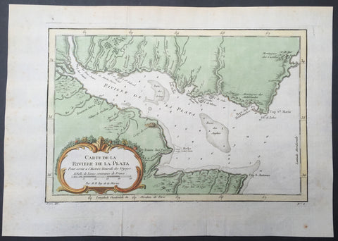
1757 Bellin Antique Map of Rio de la Plata, River Plate, Buenos Aires, Argentina
- Title : Carte de la Riviere de la Plata...
- Ref #: 61103
- Size: 10in x 7 1/2in (255mm x 190mm)
- Date : 1757
- Condition: (A+) Fine Condition
Description:
This fine, original copper-plate engraved antique map of the Río de la Plata of Argentina, by Jacques Nicolas Bellin in 1757 was published in Antoine François Prevosts 15 volumes of Histoire Generale des Voyageswritten by Prevost & other authors between 1746-1790.
The Río de la Plata River Plate in British English and La Plata River (occasionally Plata River) in other English-speaking countries — is the estuary formed by the confluence of the Uruguay and the Paraná rivers. It empties into the Atlantic Ocean, forming a funnel-shaped indentation on the southeastern coastline of South America. Depending on the geographer, the Río de la Plata may be considered a river, an estuary, a gulf or a marginal sea. For those who consider it a river—as is the case mostly in Argentina—it would be the widest river in the world, with a maximum width of about 220 kilometres.
The Río de la Plata was first explored by the Portuguese in 1512–13. The Spanish first explored it in 1516, when the navigator Juan Díaz de Solís traversed it during his search for a passage between the Atlantic and the Pacific Oceans, calling it the Mar Dulce, or \"freshwater sea.\" The Portuguese navigator Ferdinand Magellan briefly explored the estuary in 1520 before his expedition continued its circumnavigation, and in 1521 Cristóvão Jacques also explored the Plate River estuary and ascended the Parana River for the first time, entering it for about 23 leagues (around 140 km) to near the present city of Rosario.[12] The area was also visited by Francis Drake\'s fleet in early 1578, in the early stages of his circumnavigation.
Explorer Sebastian Cabot made a detailed study of the river and its tributaries and gave it its modern name. He explored the Paraná and Uruguay rivers between 1526 and 1529, ascending the Paraná as far as the present-day city of Asunción, and also explored up the Paraguay River. Cabot acquired silver trinkets trading with the Guaraní near today\'s Asunción, and these objects (together with legends of a \"Sierra de la Plata\" in the South American interior brought back by earlier explorers) inspired him to rename the river \"Río de la Plata\" (\"River of Silver\").
The first European colony was the city of Buenos Aires, founded by Pedro de Mendoza on 2 February 1536. This settlement, however, was quickly abandoned; the failure to establish a settlement on the estuary led to explorations upriver and the founding of Asunción in 1537. Buenos Aires was subsequently refounded by Juan de Garay on 11 June 1580.
The city of Buenos Aires sits along the southern coast of the Río de la Plata.
During the colonial era the Río de la Plata was made the center of the Governorate of the Río de la Plata, but the region\'s development was largely neglected by the Spanish Empire until the 1760s, when Portugal and Britain threatened to expand into the estuary. The governorate was elevated to form the Viceroyalty of the Río de la Plata in 1776. In 1806 and 1807 the river was the scene of an important British invasion that aimed to occupy the area.
General Definitions:
Paper thickness and quality: - Heavy and stable
Paper color : - off white
Age of map color: - Early
Colors used: - Green, yellow, orange
General color appearance: - Authentic
Paper size: - 14in x 10in (355mm x 255mm)
Plate size: - 12in x 8in (305mm x 205mm)
Margins: - Min 1/2in (12mm)
Imperfections:
Margins: - Light age toning in margins
Plate area: - Folds as issued
Verso: - None
Background:
One of Antoine Francois Prevosts monumental undertakings was his history of exploration & discovery in 15 volumes titledHistoire Générale des Voyages written between 1746-1759 and was extended to 20 volumes after his death by various authors.
The 20 volumes cover the early explorations & discoveries on 3 continents: Africa (v. 1-5), Asia (v. 5-11), and America (v. 12-15) with material on the finding of the French, English, Dutch, and Portugese.
A number of notable cartographers and engravers contributed to the copper plate maps and views to the 20 volumes including Nicolas Bellin, Jan Schley, Chedel, Franc Aveline, Fessard, and many others.
The African volumes cover primarily coastal countries of West, Southern, and Eastern Africa, plus the Congo, Madagascar, Arabia and the Persian Gulf areas.
The Asian volumes cover China, Korea, Tibet, Japan, Philippines, and countries bordering the Indian Ocean.
Volume 11 includes Australia and Antarctica.
Volumes 12-15 cover voyages and discoveries in America, including the East Indies, South, Central and North America.
Volumes 16-20 include supplement volumes & tables along with continuation of voyages and discoveries in Russia, Northern Europe, America, Asia & Australia.
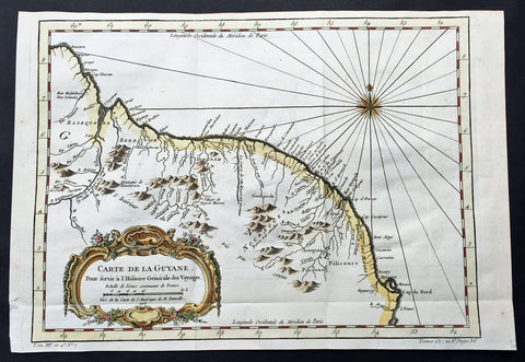
1757 Bellin Large Antique Map of Guyana, South America
- Title: Carte de la Guyana...1757
- Date: 1757
- Condition : (A+) Fine Condition
- Ref: 60940
- Size: 15in x 10in (380mm x 255mm)
Description:
This fine, original copper-plate engraved antique map of Guyana, South America by Jacques Nicolas Bellin was engraved in 1757 - dated - and was published in Antoine François Prevosts 15 volumes of Histoire Generale des Voyages written by Prevost & other authors between 1746-1790.
Guyana officially the Co-operative Republic of Guyana, is a sovereign state on the northern mainland of South America. It is, however, often considered part of the Caribbean region because of its strong cultural, historical, and political ties with other Anglo Caribbean countries and the Caribbean Community (CARICOM). Guyana is bordered by the Atlantic Ocean to the north, Brazil to the south and southwest, Suriname to the east and Venezuela to the west.
There are nine indigenous tribes residing in Guyana: the Wai Wai, Macushi, Patamona, Lokono, Kalina, Wapishana, Pemon, Akawaio and Warao. Historically the Lokono and Kalina tribes dominated Guyana. Although Christopher Columbus sighted Guyana during his third voyage (in 1498), and Sir Walter Raleigh wrote an account of its discovery in 1596, the Dutch were the first to establish colonies: Essequibo (1616), Berbice (1627), and Demerara (1752). After the British assumed control in 1796, the Dutch formally ceded the area in 1814. In 1831 the three separate colonies became a single British colony known as British Guiana.
General Definitions:
Paper thickness and quality: - Heavy and stable
Paper color : - off white
Age of map color: - Early
Colors used: - Green, yellow, orange
General color appearance: - Authentic
Paper size: - 15in x 10in (380mm x 255mm)
Plate size: - 13in x 9 1/2in (330mm x 245mm)
Margins: - Min 1/2in (12mm)
Imperfections:
Margins: - None
Plate area: - Folds as issued
Verso: - None
One of Antoine Francois Prevosts monumental undertakings was his history of exploration & discovery in 15 volumes titledHistoire Générale des Voyages written between 1746-1759 and was extended to 20 volumes after his death by various authors.
The 20 volumes cover the early explorations & discoveries on 3 continents: Africa (v. 1-5), Asia (v. 5-11), and America (v. 12-15) with material on the finding of the French, English, Dutch, and Portugese.
A number of notable cartographers and engravers contributed to the copper plate maps and views to the 20 volumes including Nicolas Bellin, Jan Schley, Chedel, Franc Aveline, Fessard, and many others.
The African volumes cover primarily coastal countries of West, Southern, and Eastern Africa, plus the Congo, Madagascar, Arabia and the Persian Gulf areas.
The Asian volumes cover China, Korea, Tibet, Japan, Philippines, and countries bordering the Indian Ocean.
Volume 11 includes Australia and Antarctica.
Volumes 12-15 cover voyages and discoveries in America, including the East Indies, South, Central and North America.
Volumes 16-20 include supplement volumes & tables along with continuation of voyages and discoveries in Russia, Northern Europe, America, Asia & Australia.
1757 Nicolas Bellin Antique Map, Plan of the City of Buenos Aires, Argentina
- Title : Plan De La Ville de Buenos - Ayres
- Ref #: 61102
- Size: 14in x 10in (355mm x 255mm)
- Date : 1757
- Condition: (A+) Fine Condition
Description:
This beautifully hand coloured original antique map* a plan of the Capital City of Argentina Buenos Aires by Jacques Nicolas Bellin was published in the 1757 French & Dutch edition of Antoine-François Prevosts 20 volume L`Histoire Generale des Voyages published by Pierre de Hondt in the Hague between 1747 & 1785.
Background: Seaman Juan Díaz de Solís, navigating in the name of Spain, was the first European to reach the Río de la Plata in 1516. His expedition was cut short when he was killed during an attack by the native Charrúa tribe in what is now Uruguay.
The city of Buenos Aires was first established as Ciudad de Nuestra Señora Santa María del Buen Ayre (literally "City of Our Lady Saint Mary of the Fair Winds") after Our Lady of Bonaria (Patroness Saint of Sardinia) on 2 February 1536 by a Spanish expedition led by Pedro de Mendoza. The settlement founded by Mendoza was located in what is today the San Telmo district of Buenos Aires, south of the city center.
More attacks by the indigenous people forced the settlers away, and in 1542 the site was abandoned. A second (and permanent) settlement was established in 11 June 1580 by Juan de Garay, who arrived by sailing down the Paraná River from Asunción (now the capital of Paraguay). He dubbed the settlement "Santísima Trinidad" and its port became "Puerto de Santa María de los Buenos Aires.
From its earliest days, Buenos Aires depended primarily on trade. During most of the 17th and 18th centuries, Spanish ships were menaced by pirates, so they developed a complex system where ships with military protection were dispatched to Central America, cross the land, from there to Lima, Peru and from it to the inner cities of the viceroyalty. Because of this, products took a very long time to arrive in Buenos Aires, and the taxes generated by the transport made them prohibitive. This scheme frustrated the traders of Buenos Aires, and a thriving contraband industry developed. This also instilled a deep resentment in porteños towards the Spanish authorities.
Sensing these feelings, Charles III of Spain progressively eased the trade restrictions and finally declared Buenos Aires an open port in the late 18th century. The capture of Porto Bello by British forces also fueled the need to foster commerce via the Atlantic route, to the detriment of Lima-based trade. One of his rulings was to split a region from the Viceroyalty of Perú and create instead the Viceroyalty of the Río de la Plata, with Buenos Aires as the capital. However, Charles's placating actions did not have the desired effect, and the porteños, some of them versed in the ideology of the French Revolution, became even more convinced of the need for independence from Spain. (Ref: Tooley; M&B)
General Description:
Paper thickness and quality: - Heavy and stable
Paper color: - off white
Age of map color: - Early
Colors used: - Yellow, green, red, brown.
General color appearance: - Authentic and fresh
Paper size: - 14in x 10in (355mm x 255mm)
Plate size: - 11 1/2in x 7 1/2in (290mm x 190mm)
Margins: - Min 1in (25mm)
Imperfections:
Margins: - Light age toning
Plate area: - Folds as issued
Verso: - None
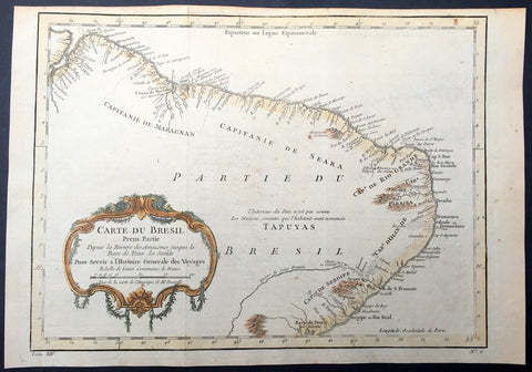
1757 Nicolas Bellin Original Antique Map of Brazil, South America
- Title : Carte Du Bresil.....
- Ref #: 61101
- Size: 15in x 10in (380mm x 255mm)
- Date : 1757
- Condition: (A+) Fine Condition
Description:
This fine, original copper-plate engraved antique map of Brazil, South America by Jacques Nicolas Bellin in 1757 was published in Antoine François Prevosts 15 volumes of Histoire Generale des Voyages written by Prevost & other authors between 1746-1790.
The land now called Brazil was claimed for the Portuguese Empire on 22 April 1500, with the arrival of the Portuguese fleet commanded by Pedro Álvares Cabral. The Portuguese encountered indigenous peoples divided into several tribes, most of whom spoke languages of the Tupi–Guarani family, and fought among themselves. Though the first settlement was founded in 1532, colonization effectively began in 1534, when King Dom João III of Portugal divided the territory into the fifteen private and autonomous Captaincy Colonies of Brazil.
However, the decentralized and unorganized tendencies of the captaincy colonies proved problematic, and in 1549 the Portuguese king restructured them into the Governorate General of Brazil, a single and centralized Portuguese colony in South America. In the first two centuries of colonization, Indigenous and European groups lived in constant war, establishing opportunistic alliances in order to gain advantages against each other. By the mid-16th century, cane sugar had become Brazil\'s most important exportation product, and slaves purchased in Sub-Saharan Africa, in the slave market of Western Africa (not only those from Portuguese allies of their colonies in Angola and Mozambique), had become its largest import, to cope with plantations of sugarcane, due to increasing international demand for Brazilian sugar.
By the end of the 17th century, sugarcane exports began to decline, and the discovery of gold by bandeirantes in the 1690s would become the new backbone of the colony\'s economy, fostering a Brazilian Gold Rush which attracted thousands of new settlers to Brazil from Portugal and all Portuguese colonies around the world. This increased level of immigration in turn caused some conflicts between newcomers and old settlers.
Portuguese expeditions known as Bandeiras gradually advanced the Portugal colonial original frontiers in South America to approximately the current Brazilian borders. In this era other European powers tried to colonize parts of Brazil, in incursions that the Portuguese had to fight, notably the French in Rio during the 1560s, in Maranhão during the 1610s, and the Dutch in Bahia and Pernambuco, during the Dutch–Portuguese War, after the end of Iberian Union.
The Portuguese colonial administration in Brazil had two objectives that would ensure colonial order and the monopoly of Portugal\'s wealthiest and largest colony: to keep under control and eradicate all forms of slave rebellion and resistance, such as the Quilombo of Palmares, and to repress all movements for autonomy or independence, such as the Minas Conspiracy.
General Definitions:
Paper thickness and quality: - Heavy and stable
Paper color : - off white
Age of map color: - Early
Colors used: - Green, yellow, orange
General color appearance: - Authentic
Paper size: - 15in x 10in (380mm x 255mm)
Plate size: - 13in x 9 1/2in (330mm x 245mm)
Margins: - Min 1/2in (12mm)
Imperfections:
Margins: - None
Plate area: - Folds as issued
Verso: - None
ackground:
One of Antoine Francois Prevosts monumental undertakings was his history of exploration & discovery in 15 volumes titledHistoire Générale des Voyages written between 1746-1759 and was extended to 20 volumes after his death by various authors.
The 20 volumes cover the early explorations & discoveries on 3 continents: Africa (v. 1-5), Asia (v. 5-11), and America (v. 12-15) with material on the finding of the French, English, Dutch, and Portugese.
A number of notable cartographers and engravers contributed to the copper plate maps and views to the 20 volumes including Nicolas Bellin, Jan Schley, Chedel, Franc Aveline, Fessard, and many others.
The African volumes cover primarily coastal countries of West, Southern, and Eastern Africa, plus the Congo, Madagascar, Arabia and the Persian Gulf areas.
The Asian volumes cover China, Korea, Tibet, Japan, Philippines, and countries bordering the Indian Ocean.
Volume 11 includes Australia and Antarctica.
Volumes 12-15 cover voyages and discoveries in America, including the East Indies, South, Central and North America.
Volumes 16-20 include supplement volumes & tables along with continuation of voyages and discoveries in Russia, Northern Europe, America, Asia & Australia.
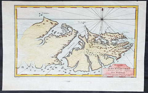
1760 Nicolas Bellin Antique Map of The Falkland Islands, South America
- Title : Carte des Îles Malouines
- Ref #: 93383
- Size: 15in x 9 1/2in (380mm x 235mm)
- Date : 1760
- Condition: (A+) Fine Condition
Description:
This original hand coloured copper-plate engraved antique map of the Falkland Islands by Jacques Nicolas Bellin in 1760 was published in Antoine François Prevosts 15 volumes of Histoire Generale des Voyages written by Prevost & other authors between 1746-1790.
One of Antoine Francois Prevosts monumental undertakings was his history of exploration & discovery in 15 volumes titled Histoire Générale des Voyages written between 1746-1759 and was extended to 20 volumes after his death by various authors.
The 20 volumes cover the early explorations & discoveries on 3 continents: Africa (v. 1-5), Asia (v. 5-11), and America (v. 12-15) with material on the finding of the French, English, Dutch, and Portugese.
A number of notable cartographers and engravers contributed to the copper plate maps and views to the 20 volumes including Nicolas Bellin, Jan Schley, Chedel, Franc Aveline, Fessard, and many others.
The African volumes cover primarily coastal countries of West, Southern, and Eastern Africa, plus the Congo, Madagascar, Arabia and the Persian Gulf areas.
The Asian volumes cover China, Korea, Tibet, Japan, Philippines, and countries bordering the Indian Ocean.
Volume 11 includes Australia and Antarctica.
Volumes 12-15 cover voyages and discoveries in America, including the East Indies, South, Central and North America.
Volumes 16-20 include supplement volumes & tables along with continuation of voyages and discoveries in Russia, Northern Europe, America, Asia & Australia.
General Definitions:
Paper thickness and quality: - Heavy and stable
Paper color : - off white
Age of map color: - Early
Colors used: - Yellow, green, blue, pink
General color appearance: - Authentic
Paper size: - 15in x 9 1/2in (380mm x 235mm)
Plate size: - 13in x 8in (330mm x 195mm)
Margins: - Min 1/2in (10mm)
Imperfections:
Margins: - None
Plate area: - Folds as issued
Verso: - None
Background:
Although Fuegians from Patagonia may have visited the Falkland Islands in prehistoric times, the islands were uninhabited when Europeans first discovered them. Claims of discovery date back to the 16th century, but no consensus exists on whether early explorers discovered the Falklands or other islands in the South Atlantic. The first recorded landing on the islands is attributed to English captain John Strong, who, en route to Perus and Chiles littoral in 1690, discovered the Falkland Sound and noted the islands water and game.
The Falklands remained uninhabited until the 1764 establishment of Port Louis on East Falkland by French captain Louis Antoine de Bougainville, and the 1766 foundation of Port Egmont on Saunders Island by British captain John MacBride. Whether or not the settlements were aware of each others existence is debated by historians. In 1766, France surrendered its claim on the Falklands to Spain, which renamed the French colony Puerto Soledad the following year. Problems began when Spain discovered and captured Port Egmont in 1770. War was narrowly avoided by its restitution to Britain in 1771.
Both the British and Spanish settlements coexisted in the archipelago until 1774, when Britains new economic and strategic considerations led it to voluntarily withdraw from the islands, leaving a plaque claiming the Falklands for King George III. Spains Viceroyalty of the Río de la Plata became the only governmental presence in the territory. West Falkland was left abandoned, and Puerto Soledad became mostly a prison camp. Amid the British invasions of the Río de la Plata during the Napoleonic Wars in Europe, the islands governor evacuated the archipelago in 1806; Spains remaining colonial garrison followed suit in 1811, except for gauchos and fishermen who remained voluntarily.
Thereafter, the archipelago was visited only by fishing ships; its political status was undisputed until 1820, when Colonel David Jewett, an American privateer working for the United Provinces of the Río de la Plata, informed anchored ships about Buenos Aires 1816 claim to Spains territories in the South Atlantic. Since the islands had no permanent inhabitants, in 1823 Buenos Aires granted German-born merchant Luis Vernet permission to conduct fishing activities and exploit feral cattle in the archipelago. Vernet settled at the ruins of Puerto Soledad in 1826, and accumulated resources on the islands until the venture was secure enough to bring settlers and form a permanent colony. Buenos Aires named Vernet military and civil commander of the islands in 1829, and he attempted to regulate sealing to stop the activities of foreign whalers and sealers. Vernets venture lasted until a dispute over fishing and hunting rights led to a raid by the American warship USS Lexington in 1831, when United States Navy commander Silas Duncan declared the dissolution of the islands government.
Buenos Aires attempted to retain influence over the settlement by installing a garrison, but a mutiny in 1832 was followed the next year by the arrival of British forces who reasserted Britains rule. The Argentine Confederation (headed by Buenos Aires Governor Juan Manuel de Rosas) protested against Britains actions and Argentine governments have continued since then to register official protests against Britain. The British troops departed after completing their mission, leaving the area without formal government. Vernets deputy, the Scotsman Matthew Brisbane, returned to the islands that year to restore the business, but his efforts ended after, amid unrest at Port Louis, gaucho Antonio Rivero led a group of dissatisfied individuals to murder Brisbane and the settlements senior leaders; survivors hid in a cave on a nearby island until the British returned and restored order. In 1840, the Falklands became a Crown colony, and Scottish settlers subsequently established an official pastoral community. Four years later, nearly everyone relocated to Port Jackson, considered a better location for government, and merchant Samuel Lafone began a venture to encourage British colonisation.
Stanley, as Port Jackson was soon renamed, officially became the seat of government in 1845. Early in its history, Stanley had a negative reputation due to cargo-shipping losses; only in emergencies would ships rounding Cape Horn stop at the port. Nevertheless, the Falklands geographic location proved ideal for ship repairs and the Wrecking Trade, the business of selling and buying shipwrecks and their cargoes. Aside from this trade, commercial interest in the archipelago was minimal due to the low-value hides of the feral cattle roaming the pastures. Economic growth began only after the Falkland Islands Company, which bought out Lafones failing enterprise in 1851, successfully introduced Cheviot sheep for wool farming, spurring other farms to follow suit. The high cost of importing materials, combined with the shortage of labour and consequent high wages, meant the ship repair trade became uncompetitive. After 1870, it declined as the replacement of sail ships by steamships was accelerated by the low cost of coal in South America; by 1914, with the opening of the Panama Canal, the trade effectively ended. In 1881, the Falkland Islands became financially independent of Britain. For more than a century, the Falkland Islands Company dominated the trade and employment of the archipelago; in addition, it owned most housing in Stanley, which greatly benefited from the wool trade with the UK.
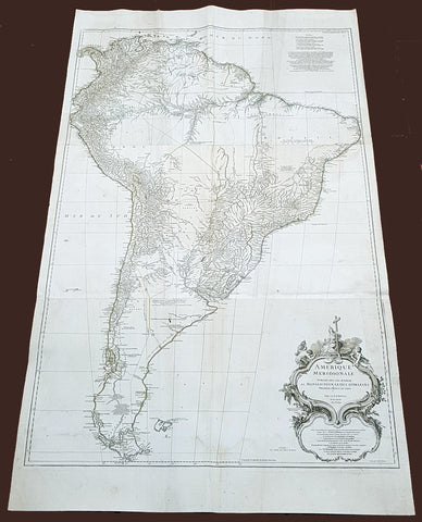
1768 D Anville Large Antique Map of South America
Antique Map
- Title : Amerique Meridionale Publiee Sous Les Auspices...Sr D Anville MDCCXLVIII
- Size: 55in x 32in (1.40m x 810mm)
- Condition: (A) Very Good Condition
- Date : 1768 (dated)
- Ref #: 92329
Description:
This very large original copper plate engraved antique map of South America was engraved in 1768 by William Delahaye - dated in the tile cartouche - and was published in Jean-Baptiste Bourguinon D Anvilles large elephant folio atlas Atlas Generale.
General Definitions:
Paper thickness and quality: - Heavy and stable
Paper color : - off white
Age of map color: -
Colors used: -
General color appearance: -
Paper size: - 55in x 32in (1.40m x 810mm)
Plate size: - 49in x 30 1/2in (1.30m x 770mm)
Margins: - Min 1in (25mm)
Imperfections:
Margins: - Creasing, light soiling
Plate area: - Creasing, light soiling
Verso: - Creasing, light soiling
Background:
In 1494, Portugal and Spain, the two great maritime European powers of that time, on the expectation of new lands being discovered in the west, signed the Treaty of Tordesillas, by which they agreed, with the support of the Pope, that all the land outside Europe should be an exclusive duopoly between the two countries.
The treaty established an imaginary line along a north-south meridian 370 leagues west of the Cape Verde Islands, roughly 46° 37W. In terms of the treaty, all land to the west of the line (known to comprise most of the South American soil) would belong to Spain, and all land to the east, to Portugal. As accurate measurements of longitude were impossible at that time, the line was not strictly enforced, resulting in a Portuguese expansion of Brazil across the meridian.
Beginning in the 1530s, the people and natural resources of South America were repeatedly exploited by foreign conquistadors, first from Spain and later from Portugal. These competing colonial nations claimed the land and resources as their own and divided it in colonies.
European infectious diseases (smallpox, influenza, measles, and typhus) – to which the native populations had no immune resistance – caused large-scale depopulation of the native population under Spanish control. Systems of forced labor, such as the haciendas and mining industrys mita also contributed to the depopulation. After this, African slaves, who had developed immunities to these diseases, were quickly brought in to replace them.
The Spaniards were committed to converting their native subjects to Christianity and were quick to purge any native cultural practices that hindered this end; however, many initial attempts at this were only partially successful, as native groups simply blended Catholicism with their established beliefs and practices. Furthermore, the Spaniards brought their language to the degree they did with their religion, although the Roman Catholic Churchs evangelization in Quechua, Aymara, and Guaraní actually contributed to the continuous use of these native languages albeit only in the oral form.
Eventually, the natives and the Spaniards interbred, forming a mestizo class. At the beginning, many mestizos of the Andean region were offspring of Amerindian mothers and Spanish fathers. After independence, most mestizos had native fathers and European or mestizo mothers.
Many native artworks were considered pagan idols and destroyed by Spanish explorers; this included many gold and silver sculptures and other artifacts found in South America, which were melted down before their transport to Spain or Portugal. Spaniards and Portuguese brought the western European architectural style to the continent, and helped to improve infrastructures like bridges, roads, and the sewer system of the cities they discovered or conquered. They also significantly increased economic and trade relations, not just between the old and new world but between the different South American regions and peoples. Finally, with the expansion of the Portuguese and Spanish languages, many cultures that were previously separated became united through that of Latin American.
Guyana was first a Dutch, and then a British colony, though there was a brief period during the Napoleonic Wars when it was colonized by the French. The country was once partitioned into three parts, each being controlled by one of the colonial powers until the country was finally taken over fully by the British.
The European Peninsular War (1807–1814), a theater of the Napoleonic Wars, changed the political situation of both the Spanish and Portuguese colonies. First, Napoleon invaded Portugal, but the House of Braganza avoided capture by escaping to Brazil. Napoleon also captured King Ferdinand VII of Spain, and appointed his own brother instead. This appointment provoked severe popular resistance, which created Juntas to rule in the name of the captured king.
Many cities in the Spanish colonies, however, considered themselves equally authorized to appoint local Juntas like those of Spain. This began the Spanish American wars of independence between the patriots, who promoted such autonomy, and the royalists, who supported Spanish authority over the Americas. The Juntas, in both Spain and the Americas, promoted the ideas of the Enlightenment. Five years after the beginning of the war, Ferdinand VII returned to the throne and began the Absolutist Restoration as the royalists got the upper hand in the conflict.
The independence of South America was secured by Simón Bolívar (Venezuela) and José de San Martín (Argentina), the two most important Libertadores. Bolívar led a great uprising in the north, then led his army southward towards Lima, the capital of the Viceroyalty of Peru. Meanwhile, San Martín led an army across the Andes Mountains, along with Chilean expatriates, and liberated Chile. He organized a fleet to reach Peru by sea, and sought the military support of various rebels from the Vice-royalty of Peru. The two armies finally met in Guayaquil, Ecuador, where they cornered the Royal Army of the Spanish Crown and forced its surrender.
In the Portuguese Kingdom of Brazil, Dom Pedro I (also Pedro IV of Portugal), son of the Portuguese King Dom João VI, proclaimed the independent Kingdom of Brazil in 1822, which later became the Empire of Brazil. Despite the Portuguese loyalties of garrisons in Bahia, Cisplatina and Pará, independence was diplomatically accepted by the crown in Portugal in 1825, on condition of a high compensation paid by Brazil mediatized by the United Kingdom.
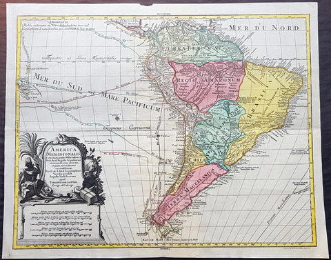
1772 Tobias Lotter Large Antique Map of South America, Drake, Magellan, Le Maire
- Title : America Meridionalis ...Tobiam Conr. Lotter...1772
- Date : 1772
- Size: 25 1/2in x 21in (650mm x 535mm)
- Ref #: 70819
- Condition: (A+) Fine Condition
Description:
This large original beautifully hand coloured copper plate engraved antique map of South America was engraved by Gustav Conrad Lotter in 1772 - dated at the foot of the map - and published by his father Tobias Conrad Lotter.
The map shows the routes of the voyages by various famous explorers to South America including: Magellan (1520), Drake (1577), le Maire & Schouten (1616), Sarmineto (1570) and others. The map also illustrates various river systems and other speculative information about the unexplored interior of the Continent. (Ref: Tooley, M&B)
General Definitions:
Paper thickness and quality: - Heavy and stable
Paper color : - off white
Age of map color: - Original
Colors used: - Blue, pink, red, green, yellow
General color appearance: - Authentic
Paper size: - 25 1/2in x 21in (650mm x 535mm)
Plate size: - 23 1/2in x 19 1/2in (595mm x 495mm)
Margins: - Min 1in (25mm)
Imperfections:
Margins: - None
Plate area: - None
Verso: - None
Background:
In 1494, Portugal and Spain, the two great maritime European powers of that time, on the expectation of new lands being discovered in the west, signed the Treaty of Tordesillas, by which they agreed, with the support of the Pope, that all the land outside Europe should be an exclusive duopoly between the two countries.
The treaty established an imaginary line along a north-south meridian 370 leagues west of the Cape Verde Islands, roughly 46° 37\\\\\\\\\\\\\\\\\\\\\\\\\\\\\\\\\\\\\\\\\\\\\\\\\\\\\\\\\\\\\\\' W. In terms of the treaty, all land to the west of the line (known to comprise most of the South American soil) would belong to Spain, and all land to the east, to Portugal. As accurate measurements of longitude were impossible at that time, the line was not strictly enforced, resulting in a Portuguese expansion of Brazil across the meridian.
Beginning in the 1530s, the people and natural resources of South America were repeatedly exploited by foreign conquistadors, first from Spain and later from Portugal. These competing colonial nations claimed the land and resources as their own and divided it in colonies.
European infectious diseases (smallpox, influenza, measles, and typhus) – to which the native populations had no immune resistance – caused large-scale depopulation of the native population under Spanish control. Systems of forced labor, such as the haciendas and mining industry\\\\\\\\\\\\\\\\\\\\\\\\\\\\\\\\\\\\\\\\\\\\\\\\\\\\\\\\\\\\\\\'s mita also contributed to the depopulation. After this, African slaves, who had developed immunities to these diseases, were quickly brought in to replace them.
The Spaniards were committed to converting their native subjects to Christianity and were quick to purge any native cultural practices that hindered this end; however, many initial attempts at this were only partially successful, as native groups simply blended Catholicism with their established beliefs and practices. Furthermore, the Spaniards brought their language to the degree they did with their religion, although the Roman Catholic Churchs evangelization in Quechua, Aymara, and Guaraní actually contributed to the continuous use of these native languages albeit only in the oral form.
Eventually, the natives and the Spaniards interbred, forming a mestizo class. At the beginning, many mestizos of the Andean region were offspring of Amerindian mothers and Spanish fathers. After independence, most mestizos had native fathers and European or mestizo mothers.
Many native artworks were considered pagan idols and destroyed by Spanish explorers; this included many gold and silver sculptures and other artifacts found in South America, which were melted down before their transport to Spain or Portugal. Spaniards and Portuguese brought the western European architectural style to the continent, and helped to improve infrastructures like bridges, roads, and the sewer system of the cities they discovered or conquered. They also significantly increased economic and trade relations, not just between the old and new world but between the different South American regions and peoples. Finally, with the expansion of the Portuguese and Spanish languages, many cultures that were previously separated became united through that of Latin American.
Guyana was first a Dutch, and then a British colony, though there was a brief period during the Napoleonic Wars when it was colonized by the French. The country was once partitioned into three parts, each being controlled by one of the colonial powers until the country was finally taken over fully by the British.
The European Peninsular War (1807–1814), a theater of the Napoleonic Wars, changed the political situation of both the Spanish and Portuguese colonies. First, Napoleon invaded Portugal, but the House of Braganza avoided capture by escaping to Brazil. Napoleon also captured King Ferdinand VII of Spain, and appointed his own brother instead. This appointment provoked severe popular resistance, which created Juntas to rule in the name of the captured king.
Many cities in the Spanish colonies, however, considered themselves equally authorized to appoint local Juntas like those of Spain. This began the Spanish American wars of independence between the patriots, who promoted such autonomy, and the royalists, who supported Spanish authority over the Americas. The Juntas, in both Spain and the Americas, promoted the ideas of the Enlightenment. Five years after the beginning of the war, Ferdinand VII returned to the throne and began the Absolutist Restoration as the royalists got the upper hand in the conflict.
The independence of South America was secured by Simón Bolívar (Venezuela) and José de San Martín (Argentina), the two most important Libertadores. Bolívar led a great uprising in the north, then led his army southward towards Lima, the capital of the Viceroyalty of Peru. Meanwhile, San Martín led an army across the Andes Mountains, along with Chilean expatriates, and liberated Chile. He organized a fleet to reach Peru by sea, and sought the military support of various rebels from the Vice-royalty of Peru. The two armies finally met in Guayaquil, Ecuador, where they cornered the Royal Army of the Spanish Crown and forced its surrender.
In the Portuguese Kingdom of Brazil, Dom Pedro I (also Pedro IV of Portugal), son of the Portuguese King Dom João VI, proclaimed the independent Kingdom of Brazil in 1822, which later became the Empire of Brazil. Despite the Portuguese loyalties of garrisons in Bahia, Cisplatina and Pará, independence was diplomatically accepted by the crown in Portugal in 1825, on condition of a high compensation paid by Brazil mediatized by the United Kingdom.
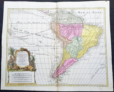
1772 Tobias Lotter Large Antique Map of South America, Magellan, Drake, Le Maire
- Title : America Meridionalis ...Tobiam Conr. Lotter...1772
- Date : 1772
- Size: 25 1/2in x 21in (650mm x 535mm)
- Ref #: 61139
- Condition: (A+) Fine Condition
Description:
This large original beautifully hand coloured copper plate engraved antique map of South America was engraved by Gustav Conrad Lotter in 1772 - dated at the foot of the map - and published by his father Tobias Conrad Lotter.
The map shows the routes of the voyages by various famous explorers to South America including: Magellan (1520), Drake (1577), le Maire & Schouten (1616), Sarmineto (1570) and others. The map also illustrates various river systems and other speculative information about the unexplored interior of the Continent. (Ref: Tooley, M&B)
General Definitions:
Paper thickness and quality: - Heavy and stable
Paper color : - off white
Age of map color: - Original
Colors used: - Blue, pink, red, green, yellow
General color appearance: - Authentic
Paper size: - 25 1/2in x 21in (650mm x 535mm)
Plate size: - 23 1/2in x 19 1/2in (595mm x 495mm)
Margins: - Min 1in (25mm)
Imperfections:
Margins: - None
Plate area: - None
Verso: - None
Background:
In 1494, Portugal and Spain, the two great maritime European powers of that time, on the expectation of new lands being discovered in the west, signed the Treaty of Tordesillas, by which they agreed, with the support of the Pope, that all the land outside Europe should be an exclusive duopoly between the two countries.
The treaty established an imaginary line along a north-south meridian 370 leagues west of the Cape Verde Islands, roughly 46° 37\\\\\\\\\\\\\\\\\\\\\\\\\\\\\\\\\\\\\\\\\\\\\\\\\\\\\\\\\\\\\\\' W. In terms of the treaty, all land to the west of the line (known to comprise most of the South American soil) would belong to Spain, and all land to the east, to Portugal. As accurate measurements of longitude were impossible at that time, the line was not strictly enforced, resulting in a Portuguese expansion of Brazil across the meridian.
Beginning in the 1530s, the people and natural resources of South America were repeatedly exploited by foreign conquistadors, first from Spain and later from Portugal. These competing colonial nations claimed the land and resources as their own and divided it in colonies.
European infectious diseases (smallpox, influenza, measles, and typhus) – to which the native populations had no immune resistance – caused large-scale depopulation of the native population under Spanish control. Systems of forced labor, such as the haciendas and mining industry\\\\\\\\\\\\\\\\\\\\\\\\\\\\\\\\\\\\\\\\\\\\\\\\\\\\\\\\\\\\\\\'s mita also contributed to the depopulation. After this, African slaves, who had developed immunities to these diseases, were quickly brought in to replace them.
The Spaniards were committed to converting their native subjects to Christianity and were quick to purge any native cultural practices that hindered this end; however, many initial attempts at this were only partially successful, as native groups simply blended Catholicism with their established beliefs and practices. Furthermore, the Spaniards brought their language to the degree they did with their religion, although the Roman Catholic Churchs evangelization in Quechua, Aymara, and Guaraní actually contributed to the continuous use of these native languages albeit only in the oral form.
Eventually, the natives and the Spaniards interbred, forming a mestizo class. At the beginning, many mestizos of the Andean region were offspring of Amerindian mothers and Spanish fathers. After independence, most mestizos had native fathers and European or mestizo mothers.
Many native artworks were considered pagan idols and destroyed by Spanish explorers; this included many gold and silver sculptures and other artifacts found in South America, which were melted down before their transport to Spain or Portugal. Spaniards and Portuguese brought the western European architectural style to the continent, and helped to improve infrastructures like bridges, roads, and the sewer system of the cities they discovered or conquered. They also significantly increased economic and trade relations, not just between the old and new world but between the different South American regions and peoples. Finally, with the expansion of the Portuguese and Spanish languages, many cultures that were previously separated became united through that of Latin American.
Guyana was first a Dutch, and then a British colony, though there was a brief period during the Napoleonic Wars when it was colonized by the French. The country was once partitioned into three parts, each being controlled by one of the colonial powers until the country was finally taken over fully by the British.
The European Peninsular War (1807–1814), a theater of the Napoleonic Wars, changed the political situation of both the Spanish and Portuguese colonies. First, Napoleon invaded Portugal, but the House of Braganza avoided capture by escaping to Brazil. Napoleon also captured King Ferdinand VII of Spain, and appointed his own brother instead. This appointment provoked severe popular resistance, which created Juntas to rule in the name of the captured king.
Many cities in the Spanish colonies, however, considered themselves equally authorized to appoint local Juntas like those of Spain. This began the Spanish American wars of independence between the patriots, who promoted such autonomy, and the royalists, who supported Spanish authority over the Americas. The Juntas, in both Spain and the Americas, promoted the ideas of the Enlightenment. Five years after the beginning of the war, Ferdinand VII returned to the throne and began the Absolutist Restoration as the royalists got the upper hand in the conflict.
The independence of South America was secured by Simón Bolívar (Venezuela) and José de San Martín (Argentina), the two most important Libertadores. Bolívar led a great uprising in the north, then led his army southward towards Lima, the capital of the Viceroyalty of Peru. Meanwhile, San Martín led an army across the Andes Mountains, along with Chilean expatriates, and liberated Chile. He organized a fleet to reach Peru by sea, and sought the military support of various rebels from the Vice-royalty of Peru. The two armies finally met in Guayaquil, Ecuador, where they cornered the Royal Army of the Spanish Crown and forced its surrender.
In the Portuguese Kingdom of Brazil, Dom Pedro I (also Pedro IV of Portugal), son of the Portuguese King Dom João VI, proclaimed the independent Kingdom of Brazil in 1822, which later became the Empire of Brazil. Despite the Portuguese loyalties of garrisons in Bahia, Cisplatina and Pará, independence was diplomatically accepted by the crown in Portugal in 1825, on condition of a high compensation paid by Brazil mediatized by the United Kingdom.
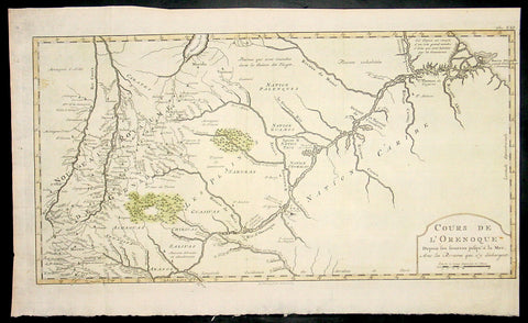
1773 Bellin Antique Map The Course of the Orinoco River South America - Rare
- Title : Cours De L Orenoque...1773
- Ref #: 92803
- Size: 18 1/2in x 11 1/2in (460mm x 295mm)
- Date : 1773
- Condition: (A+) Fine Condition
Description:
This fine, original copper-plate engraved antique map of the Orinoco River, South America, by Jacques Nicolas Bellin in 1750 was published in Antoine François Prevosts 15 volumes of Histoire Generale des Voyageswritten by Prevost & other authors between 1746-1790.
The mouth of the Orinoco River at the Atlantic Ocean was documented by Columbus on 1 August 1498, during his third voyage. Its source at the Cerro Delgado–Chalbaud, in the Parima range, was not explored until 1951, 453 years later. The source, near the Venezuelan–Brazilian border, at 1,047 metres (3,435 ft) above sea level (02°19′05″N 63°21′42″W), was explored in 1951 by a joint Venezuelan–French team.
The Orinoco Delta, and tributaries in the eastern llanos such as the Apure and Meta, were explored in the 16th century by German expeditions under Ambrosius Ehinger and his successors. In 1531 Diego de Ordaz, starting at the principal outlet in the delta, the Boca de Navios, sailed up the river to the Meta. Antonio de Berrio sailed down the Casanare to the Meta, and then down the Orinoco River and back to Coro. In 1595, after capturing de Berrio to obtain information while conducting an expedition to find the fabled city of El Dorado, the Englishman Sir Walter Raleigh sailed down the river, reaching the savannah country.
Alexander von Humboldt explored the basin in 1800, reporting on the pink river dolphins. He published extensively on the river\'s flora and fauna
General Definitions:
Paper thickness and quality: - Heavy and stable
Paper color : - off white
Age of map color: - Early
Colors used: - Yellow, green, red
General color appearance: - Authentic
Paper size: - 18 1/2in x 11 1/2in (460mm x 295mm)
Plate size: - 18in x 10in (455mm x 255mm)
Margins: - Min 1/2in (12mm)
Imperfections:
Margins: - None
Plate area: - None
Verso: - None
Background:
One of Antoine Francois Prevosts monumental undertakings was his history of exploration & discovery in 15 volumes titledHistoire Générale des Voyages written between 1746-1759 and was extended to 20 volumes after his death by various authors.
The 20 volumes cover the early explorations & discoveries on 3 continents: Africa (v. 1-5), Asia (v. 5-11), and America (v. 12-15) with material on the finding of the French, English, Dutch, and Portugese.
A number of notable cartographers and engravers contributed to the copper plate maps and views to the 20 volumes including Nicolas Bellin, Jan Schley, Chedel, Franc Aveline, Fessard, and many others.
The African volumes cover primarily coastal countries of West, Southern, and Eastern Africa, plus the Congo, Madagascar, Arabia and the Persian Gulf areas.
The Asian volumes cover China, Korea, Tibet, Japan, Philippines, and countries bordering the Indian Ocean.
Volume 11 includes Australia and Antarctica.
Volumes 12-15 cover voyages and discoveries in America, including the East Indies, South, Central and North America.
Volumes 16-20 include supplement volumes & tables along with continuation of voyages and discoveries in Russia, Northern Europe, America, Asia & Australia.
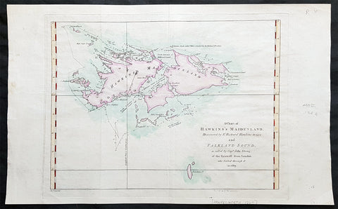
1773 Commodore John Byron 1st Ed Antique Map of The Falkland Islands Sth America
Antique Map
- Title : A chart of Hawkins s Maidenland, discovered by Sr. Richard Hawkins in 1574 and Falkland Sound, so called by Capn. John Strong of the Farewell from London who sailed through it in 1689.
- Ref #: 93384
- Size: 16 1/2in x 10n (405mm x 255mm)
- Date : 1773
- Condition: (A+) Fine Condition
Description:
This original hand coloured copper-plate engraved antique map of the Falkland Islands by Commodore John Byron was engraved by Isaac Noval and published in the 1773 first English edition of John Hawkesworth important book An account of the voyages undertaken by the order of His present Majesty for making discoveries in the Southern Hemisphere, and successively performed by Commodore Byron, Captain Wallis, Captain Carteret, and Captain Cook, in the Dolphin, the Swallow, and the Endeavor. Drawn up from the journals which were kept by the several commanders, and from the papers of Joseph Banks, Esq; by John Hawkesworth, LL.D. In three volumes. Illustrated with cuts, and a great variety of charts and maps relative to countries now first discovered, or hitherto but imperfectly known. London: printed for W. Strahan; and T. Cadell in the Strand, MDCCLXXIII.
John Hawkesworth (1715 - 1773) was commissioned by the British Admiralty to edit Captain James Cooks papers relative to his first voyage. For this work An Account of the Voyages undertaken ... for making discoveries in the Southern Hemisphere and performed by Commodore John Byron, Captain Wallis, Captain Carteret and Captain Cook, from 1702 to 1771, drawn up from the Journals ... (3 vols, 1773) Hawkesworth is said to have received from the publishers the sum of £6000. His descriptions of the manners and customs of the South Seas were, however, regarded by many critics as inexact and hurtful to the interests of morality, and the severity of their strictures is said to have hastened his death. He was buried in the parish church at Bromley, Kent, where he and his wife had kept a school.
General Definitions:
Paper thickness and quality: - Heavy and stable
Paper color : - off white
Age of map color: - Early
Colors used: - Yellow, green, blue, pink
General color appearance: - Authentic
Paper size: - 16 1/2in x 10n (405mm x 255mm)
Plate size: - 12 1/2in x 9 1/2in (310mm x 240mm)
Margins: - Min 1in (25mm)
Imperfections:
Margins: - None
Plate area: - Folds as issued
Verso: - None
Background:
Although Fuegians from Patagonia may have visited the Falkland Islands in prehistoric times, the islands were uninhabited when Europeans first discovered them. Claims of discovery date back to the 16th century, but no consensus exists on whether early explorers discovered the Falklands or other islands in the South Atlantic. The first recorded landing on the islands is attributed to English captain John Strong, who, en route to Perus and Chiles littoral in 1690, discovered the Falkland Sound and noted the islands water and game.
The Falklands remained uninhabited until the 1764 establishment of Port Louis on East Falkland by French captain Louis Antoine de Bougainville, and the 1766 foundation of Port Egmont on Saunders Island by British captain John MacBride. Whether or not the settlements were aware of each others existence is debated by historians. In 1766, France surrendered its claim on the Falklands to Spain, which renamed the French colony Puerto Soledad the following year. Problems began when Spain discovered and captured Port Egmont in 1770. War was narrowly avoided by its restitution to Britain in 1771.
Both the British and Spanish settlements coexisted in the archipelago until 1774, when Britains new economic and strategic considerations led it to voluntarily withdraw from the islands, leaving a plaque claiming the Falklands for King George III. Spains Viceroyalty of the Río de la Plata became the only governmental presence in the territory. West Falkland was left abandoned, and Puerto Soledad became mostly a prison camp. Amid the British invasions of the Río de la Plata during the Napoleonic Wars in Europe, the islands governor evacuated the archipelago in 1806; Spains remaining colonial garrison followed suit in 1811, except for gauchos and fishermen who remained voluntarily.
Thereafter, the archipelago was visited only by fishing ships; its political status was undisputed until 1820, when Colonel David Jewett, an American privateer working for the United Provinces of the Río de la Plata, informed anchored ships about Buenos Aires 1816 claim to Spains territories in the South Atlantic. Since the islands had no permanent inhabitants, in 1823 Buenos Aires granted German-born merchant Luis Vernet permission to conduct fishing activities and exploit feral cattle in the archipelago. Vernet settled at the ruins of Puerto Soledad in 1826, and accumulated resources on the islands until the venture was secure enough to bring settlers and form a permanent colony. Buenos Aires named Vernet military and civil commander of the islands in 1829, and he attempted to regulate sealing to stop the activities of foreign whalers and sealers. Vernets venture lasted until a dispute over fishing and hunting rights led to a raid by the American warship USS Lexington in 1831, when United States Navy commander Silas Duncan declared the dissolution of the islands government.
Buenos Aires attempted to retain influence over the settlement by installing a garrison, but a mutiny in 1832 was followed the next year by the arrival of British forces who reasserted Britains rule. The Argentine Confederation (headed by Buenos Aires Governor Juan Manuel de Rosas) protested against Britains actions and Argentine governments have continued since then to register official protests against Britain. The British troops departed after completing their mission, leaving the area without formal government. Vernets deputy, the Scotsman Matthew Brisbane, returned to the islands that year to restore the business, but his efforts ended after, amid unrest at Port Louis, gaucho Antonio Rivero led a group of dissatisfied individuals to murder Brisbane and the settlements senior leaders; survivors hid in a cave on a nearby island until the British returned and restored order. In 1840, the Falklands became a Crown colony, and Scottish settlers subsequently established an official pastoral community. Four years later, nearly everyone relocated to Port Jackson, considered a better location for government, and merchant Samuel Lafone began a venture to encourage British colonisation.
Stanley, as Port Jackson was soon renamed, officially became the seat of government in 1845. Early in its history, Stanley had a negative reputation due to cargo-shipping losses; only in emergencies would ships rounding Cape Horn stop at the port. Nevertheless, the Falklands geographic location proved ideal for ship repairs and the Wrecking Trade, the business of selling and buying shipwrecks and their cargoes. Aside from this trade, commercial interest in the archipelago was minimal due to the low-value hides of the feral cattle roaming the pastures. Economic growth began only after the Falkland Islands Company, which bought out Lafones failing enterprise in 1851, successfully introduced Cheviot sheep for wool farming, spurring other farms to follow suit. The high cost of importing materials, combined with the shortage of labour and consequent high wages, meant the ship repair trade became uncompetitive. After 1870, it declined as the replacement of sail ships by steamships was accelerated by the low cost of coal in South America; by 1914, with the opening of the Panama Canal, the trade effectively ended. In 1881, the Falkland Islands became financially independent of Britain. For more than a century, the Falkland Islands Company dominated the trade and employment of the archipelago; in addition, it owned most housing in Stanley, which greatly benefited from the wool trade with the UK.
Byron, John 1723 – 1786
Vice-Admiral John Byron (8 November 1723 – 10 April 1786) was a British Royal Navy officer and explorer. He earned the nickname Foul-Weather Jack in the press because of his frequent encounters with bad weather at sea. As a midshipman, he sailed in the squadron under George Anson on his voyage around the world, though Byron made it only to southern Chile, where his ship was wrecked. He returned to England with the captain of HMS Wager. He was governor of Newfoundland following Hugh Palliser, who left in 1768. He circumnavigated the world as a commodore with his own squadron in 1764–1766. He fought in battles in the Seven Years War and the American Revolution. He rose to Vice Admiral of the White before his death in 1786.
His grandsons include the poet George Gordon Byron and George Anson Byron, admiral and explorer, who were the 6th and 7th Baron Byron, respectively.
Byron was the second son of William Byron, 4th Baron Byron and Frances Berkeley, the daughter of William, 4th Baron Berkeley. After studying at Westminster School he joined the Royal Navy at the age of 14, making his first voyage aboard the HMS Romney in 1738–40.
In 1740, he accompanied George Anson on his voyage around the world as a midshipman aboard one of the several ships in the squadron. On 14 May 1741, HMS Wager under Captain Cheap (as Captain Dandy Kidd had died), was shipwrecked on the coast of Chile on what is now called Wager Island and Byron was one of the survivors. The survivors decided to split in two teams, one to make its way by boat to Rio de Janeiro on the Atlantic coast; the other, including John Byron and the Captain, to sail north along the Spanish colonial coast.
Captain Cheap at Wager Island had a party of 19 men after the deserters rejoined the camp. This included the surgeon Elliot and Lieutenant Hamilton who had been cast adrift with him plus midshipmen John Byron and Campbell who had been in the barge. They rowed up the coast but were punished by continuous rain, headwinds and waves that threatened the boats. One night while the men slept on shore, one of the boats was capsized while at anchor and was swept out to sea with its two boatkeepers. One of the men got ashore but the other drowned. As it was now impossible for them all to fit in the remaining boat, four marines were left ashore with muskets to fend for themselves. The winds prevented them from getting around the headland so they returned to pick up the marines only to find them gone. They returned to Wager Island in early February 1742. With one death on the journey, there were now 13 in the group.
Martín Olleta, a Chono cheftain, guided the men up the coast to the Spanish settlements of Chiloé Island so they set out again. Two men died; after burying the bodies, the six seamen rowed off in the boat never to be seen again while Cheap, Hamilton, Byron, Campbell and the dying Elliot were on shore looking for food. Olleta then agreed to take the remaining four on by canoe for their only remaining possession, a musket. It is likely the party travelled across Presidente Ríos Lake in inland Taitao Peninsula, a lake Chile regarded as officially discovered in 1945. Eventually they made it to be taken prisoner by the Spanish. The Spaniards treated them well and they were eventually taken to the inland capital of Santiago where they were released on parole. The Spaniards heard that Anson had been generous in the treatment of the prisoners he had taken and this kindness was returned.
Byron and the other three men stayed in Santiago till late 1744 and were offered passage on a French ship bound for Spain. Three accepted the passage. Campbell elected to take a mule across the Andes and joined the Spanish Admiral Pizarro in Montevideo on the Asia only to find Isaac Morris and the two seamen who had been abandoned in Freshwater Bay on the Atlantic coast. After time in prison in Spain, Campbell reached Britain in May 1746, followed by the other three two months later.
In England, the official court martial examined only the loss of the Wager in which Baynes, in nominal charge at the time, was acquitted of blame but reprimanded for omissions of duty. Disputes over what happened after the wreck were instead played out as Bulkeley and Cummins, Campbell, Morris, the cooper Young and later Byron published their own accounts, the last of which was the only one that in any way defended Cheap who had since died. Twenty-nine crew members plus seven marines made it back to England.
Byrons account of his adventures and the Wager Mutiny are recounted in The Narrative of the Honourable John Byron (1768). His book sold well enough to be printed in several editions.
Byron was appointed captain of HMS Siren in December 1746.
In 1760, during the Seven Years War, Byron commanded a squadron sent to destroy the fortifications at Louisbourg, Quebec, which had been captured by the British two years before. They wanted to ensure it could not be used by the French in Canada. In July of that year he defeated the French flotilla sent to relieve New France at the Battle of Restigouche.
In early 1764 the British Admiralty determined that it would require a permanent naval settlement off the South American coast, in order to resupply naval vessels seeking to enter the Pacific via Cape Horn. Captain Byron was selected to explore the South Atlantic for a suitable island upon which to establish such a settlement. The South American mainland was controlled by Spain, which was hostile to local expansion of British interests; to disguise Byrons mission it was announced that he had been appointed the new Navy Commander-in-Chief, East Indies. Byron set sail in June 1764, ostensibly to take up the East Indies post. For the voyage he was granted command of the 24-gun frigate HMS Dolphin and the 16-gun sloop HMS Tamar.
Byrons two-vessel flotilla crossed the Atlantic over the winter of 1764 and made its way slowly down the South American coast. The Admiralty had ordered Byron to first seek Pepys Island, reputedly discovered off the Patagonian coast by the corsair Ambrose Cowley in 1683. Byron reached the co-ordinates given by Cowley in January 1765, but there was no sign of the island and the search was swiftly abandoned. On 5 February Byron reached the Patagonian settlement of Port Desire where he resupplied his vessels from the storeship HMS Florida.
Between June 1764 and May 1766, Byron completed his own circumnavigation of the globe as captain of HMS Dolphin. This was the first such circumnavigation that was accomplished in less than 2 years. His actions nearly caused a war between Great Britain and Spain, as both countries had armed fleets ready to contest the sovereignty of the Falkland Islands. Later Byron encountered islands and extant residents of the Tuamotus and Tokelau Islands, and Nikunau in the southern Gilbert Islands; he also visited Tinian in the Northern Marianas Islands. A notable member of Byrons crew was Masters Mate Erasmus Gower whom Byron chose to take a significant part in the ceremony when he took possession of the Falkland Islands. Byron had examined Gower for his lieutenants examination in 1762 and was so impressed that he chose him to accompany him on his own circumnavigation (1764–65) and ensured that he was appointed as lieutenant to Commander Philip Carteret immediately afterwards in the next circumnavigation (1766–69).
In 1769 he was appointed governor of Newfoundland off the mainland of Canada, an office he held for the next three years.
He was promoted to rear admiral on 31 March 1775. In 1779, he served as Commander-in-chief of the Leeward Islands Station during the American War of Independence. After being severely injured during a storm on his way to the West Indies, Byron unsuccessfully attacked a French fleet under the Comte dEstaing at the Battle of Grenada in July 1779. He subsequently resigned his post and returned to England, where he suffered from poor health for the rest of his life.
Byron was briefly Commander-in-Chief, North American Station from 1 October 1779. He was made vice admiral of the white in September 1780.
John Byron died on 1 April 1786 at home in Bolton Row, London. His remains were buried in the Berkeley family vault situated beneath the chancel of the Church of St Mary the Virgin, Twickenham, on 10 April.
Johns life was a great inspiration for his grandson the poet George Gordon Byron, though they never met. The poet both drew from his grandfathers experiences in his writing, using his Narrative for the shipwreck scene in Don Juan, and wrote of the kinship he felt in having such a turbulent, unlucky life: he wrote in an epistle to his half-sister Augusta Leigh that he had no rest at sea, nor I on shore.
1773 Commodore John Byron 1st Ed Antique Map of The Falkland Islands Sth America
Antique Map
- Title : A chart of Hawkins s Maidenland, discovered by Sr. Richard Hawkins in 1574 and Falkland Sound, so called by Capn. John Strong of the Farewell from London who sailed through it in 1689.
- Ref #: 93385
- Size: 16 1/2in x 10n (405mm x 255mm)
- Date : 1773
- Condition: (A+) Fine Condition
Description:
This original hand coloured copper-plate engraved antique map of the Falkland Islands by Commodore John Byron was engraved by Isaac Noval and published in the 1773 first English edition of John Hawkesworth important book An account of the voyages undertaken by the order of His present Majesty for making discoveries in the Southern Hemisphere, and successively performed by Commodore Byron, Captain Wallis, Captain Carteret, and Captain Cook, in the Dolphin, the Swallow, and the Endeavor. Drawn up from the journals which were kept by the several commanders, and from the papers of Joseph Banks, Esq; by John Hawkesworth, LL.D. In three volumes. Illustrated with cuts, and a great variety of charts and maps relative to countries now first discovered, or hitherto but imperfectly known. London: printed for W. Strahan; and T. Cadell in the Strand, MDCCLXXIII.
John Hawkesworth (1715 - 1773) was commissioned by the British Admiralty to edit Captain James Cooks papers relative to his first voyage. For this work An Account of the Voyages undertaken ... for making discoveries in the Southern Hemisphere and performed by Commodore John Byron, Captain Wallis, Captain Carteret and Captain Cook, from 1702 to 1771, drawn up from the Journals ... (3 vols, 1773) Hawkesworth is said to have received from the publishers the sum of £6000. His descriptions of the manners and customs of the South Seas were, however, regarded by many critics as inexact and hurtful to the interests of morality, and the severity of their strictures is said to have hastened his death. He was buried in the parish church at Bromley, Kent, where he and his wife had kept a school.
General Definitions:
Paper thickness and quality: - Heavy and stable
Paper color : - off white
Age of map color: - Early
Colors used: - Yellow, green, blue, pink
General color appearance: - Authentic
Paper size: - 16 1/2in x 10n (405mm x 255mm)
Plate size: - 12 1/2in x 9 1/2in (310mm x 240mm)
Margins: - Min 1in (25mm)
Imperfections:
Margins: - None
Plate area: - Folds as issued
Verso: - None
Background:
Although Fuegians from Patagonia may have visited the Falkland Islands in prehistoric times, the islands were uninhabited when Europeans first discovered them. Claims of discovery date back to the 16th century, but no consensus exists on whether early explorers discovered the Falklands or other islands in the South Atlantic. The first recorded landing on the islands is attributed to English captain John Strong, who, en route to Perus and Chiles littoral in 1690, discovered the Falkland Sound and noted the islands water and game.
The Falklands remained uninhabited until the 1764 establishment of Port Louis on East Falkland by French captain Louis Antoine de Bougainville, and the 1766 foundation of Port Egmont on Saunders Island by British captain John MacBride. Whether or not the settlements were aware of each others existence is debated by historians. In 1766, France surrendered its claim on the Falklands to Spain, which renamed the French colony Puerto Soledad the following year. Problems began when Spain discovered and captured Port Egmont in 1770. War was narrowly avoided by its restitution to Britain in 1771.
Both the British and Spanish settlements coexisted in the archipelago until 1774, when Britains new economic and strategic considerations led it to voluntarily withdraw from the islands, leaving a plaque claiming the Falklands for King George III. Spains Viceroyalty of the Río de la Plata became the only governmental presence in the territory. West Falkland was left abandoned, and Puerto Soledad became mostly a prison camp. Amid the British invasions of the Río de la Plata during the Napoleonic Wars in Europe, the islands governor evacuated the archipelago in 1806; Spains remaining colonial garrison followed suit in 1811, except for gauchos and fishermen who remained voluntarily.
Thereafter, the archipelago was visited only by fishing ships; its political status was undisputed until 1820, when Colonel David Jewett, an American privateer working for the United Provinces of the Río de la Plata, informed anchored ships about Buenos Aires 1816 claim to Spains territories in the South Atlantic. Since the islands had no permanent inhabitants, in 1823 Buenos Aires granted German-born merchant Luis Vernet permission to conduct fishing activities and exploit feral cattle in the archipelago. Vernet settled at the ruins of Puerto Soledad in 1826, and accumulated resources on the islands until the venture was secure enough to bring settlers and form a permanent colony. Buenos Aires named Vernet military and civil commander of the islands in 1829, and he attempted to regulate sealing to stop the activities of foreign whalers and sealers. Vernets venture lasted until a dispute over fishing and hunting rights led to a raid by the American warship USS Lexington in 1831, when United States Navy commander Silas Duncan declared the dissolution of the islands government.
Buenos Aires attempted to retain influence over the settlement by installing a garrison, but a mutiny in 1832 was followed the next year by the arrival of British forces who reasserted Britains rule. The Argentine Confederation (headed by Buenos Aires Governor Juan Manuel de Rosas) protested against Britains actions and Argentine governments have continued since then to register official protests against Britain. The British troops departed after completing their mission, leaving the area without formal government. Vernets deputy, the Scotsman Matthew Brisbane, returned to the islands that year to restore the business, but his efforts ended after, amid unrest at Port Louis, gaucho Antonio Rivero led a group of dissatisfied individuals to murder Brisbane and the settlements senior leaders; survivors hid in a cave on a nearby island until the British returned and restored order. In 1840, the Falklands became a Crown colony, and Scottish settlers subsequently established an official pastoral community. Four years later, nearly everyone relocated to Port Jackson, considered a better location for government, and merchant Samuel Lafone began a venture to encourage British colonisation.
Stanley, as Port Jackson was soon renamed, officially became the seat of government in 1845. Early in its history, Stanley had a negative reputation due to cargo-shipping losses; only in emergencies would ships rounding Cape Horn stop at the port. Nevertheless, the Falklands geographic location proved ideal for ship repairs and the Wrecking Trade, the business of selling and buying shipwrecks and their cargoes. Aside from this trade, commercial interest in the archipelago was minimal due to the low-value hides of the feral cattle roaming the pastures. Economic growth began only after the Falkland Islands Company, which bought out Lafones failing enterprise in 1851, successfully introduced Cheviot sheep for wool farming, spurring other farms to follow suit. The high cost of importing materials, combined with the shortage of labour and consequent high wages, meant the ship repair trade became uncompetitive. After 1870, it declined as the replacement of sail ships by steamships was accelerated by the low cost of coal in South America; by 1914, with the opening of the Panama Canal, the trade effectively ended. In 1881, the Falkland Islands became financially independent of Britain. For more than a century, the Falkland Islands Company dominated the trade and employment of the archipelago; in addition, it owned most housing in Stanley, which greatly benefited from the wool trade with the UK.
Byron, John 1723 – 1786
Vice-Admiral John Byron (8 November 1723 – 10 April 1786) was a British Royal Navy officer and explorer. He earned the nickname Foul-Weather Jack in the press because of his frequent encounters with bad weather at sea. As a midshipman, he sailed in the squadron under George Anson on his voyage around the world, though Byron made it only to southern Chile, where his ship was wrecked. He returned to England with the captain of HMS Wager. He was governor of Newfoundland following Hugh Palliser, who left in 1768. He circumnavigated the world as a commodore with his own squadron in 1764–1766. He fought in battles in the Seven Years War and the American Revolution. He rose to Vice Admiral of the White before his death in 1786.
His grandsons include the poet George Gordon Byron and George Anson Byron, admiral and explorer, who were the 6th and 7th Baron Byron, respectively.
Byron was the second son of William Byron, 4th Baron Byron and Frances Berkeley, the daughter of William, 4th Baron Berkeley. After studying at Westminster School he joined the Royal Navy at the age of 14, making his first voyage aboard the HMS Romney in 1738–40.
In 1740, he accompanied George Anson on his voyage around the world as a midshipman aboard one of the several ships in the squadron. On 14 May 1741, HMS Wager under Captain Cheap (as Captain Dandy Kidd had died), was shipwrecked on the coast of Chile on what is now called Wager Island and Byron was one of the survivors. The survivors decided to split in two teams, one to make its way by boat to Rio de Janeiro on the Atlantic coast; the other, including John Byron and the Captain, to sail north along the Spanish colonial coast.
Captain Cheap at Wager Island had a party of 19 men after the deserters rejoined the camp. This included the surgeon Elliot and Lieutenant Hamilton who had been cast adrift with him plus midshipmen John Byron and Campbell who had been in the barge. They rowed up the coast but were punished by continuous rain, headwinds and waves that threatened the boats. One night while the men slept on shore, one of the boats was capsized while at anchor and was swept out to sea with its two boatkeepers. One of the men got ashore but the other drowned. As it was now impossible for them all to fit in the remaining boat, four marines were left ashore with muskets to fend for themselves. The winds prevented them from getting around the headland so they returned to pick up the marines only to find them gone. They returned to Wager Island in early February 1742. With one death on the journey, there were now 13 in the group.
Martín Olleta, a Chono cheftain, guided the men up the coast to the Spanish settlements of Chiloé Island so they set out again. Two men died; after burying the bodies, the six seamen rowed off in the boat never to be seen again while Cheap, Hamilton, Byron, Campbell and the dying Elliot were on shore looking for food. Olleta then agreed to take the remaining four on by canoe for their only remaining possession, a musket. It is likely the party travelled across Presidente Ríos Lake in inland Taitao Peninsula, a lake Chile regarded as officially discovered in 1945. Eventually they made it to be taken prisoner by the Spanish. The Spaniards treated them well and they were eventually taken to the inland capital of Santiago where they were released on parole. The Spaniards heard that Anson had been generous in the treatment of the prisoners he had taken and this kindness was returned.
Byron and the other three men stayed in Santiago till late 1744 and were offered passage on a French ship bound for Spain. Three accepted the passage. Campbell elected to take a mule across the Andes and joined the Spanish Admiral Pizarro in Montevideo on the Asia only to find Isaac Morris and the two seamen who had been abandoned in Freshwater Bay on the Atlantic coast. After time in prison in Spain, Campbell reached Britain in May 1746, followed by the other three two months later.
In England, the official court martial examined only the loss of the Wager in which Baynes, in nominal charge at the time, was acquitted of blame but reprimanded for omissions of duty. Disputes over what happened after the wreck were instead played out as Bulkeley and Cummins, Campbell, Morris, the cooper Young and later Byron published their own accounts, the last of which was the only one that in any way defended Cheap who had since died. Twenty-nine crew members plus seven marines made it back to England.
Byrons account of his adventures and the Wager Mutiny are recounted in The Narrative of the Honourable John Byron (1768). His book sold well enough to be printed in several editions.
Byron was appointed captain of HMS Siren in December 1746.
In 1760, during the Seven Years War, Byron commanded a squadron sent to destroy the fortifications at Louisbourg, Quebec, which had been captured by the British two years before. They wanted to ensure it could not be used by the French in Canada. In July of that year he defeated the French flotilla sent to relieve New France at the Battle of Restigouche.
In early 1764 the British Admiralty determined that it would require a permanent naval settlement off the South American coast, in order to resupply naval vessels seeking to enter the Pacific via Cape Horn. Captain Byron was selected to explore the South Atlantic for a suitable island upon which to establish such a settlement. The South American mainland was controlled by Spain, which was hostile to local expansion of British interests; to disguise Byrons mission it was announced that he had been appointed the new Navy Commander-in-Chief, East Indies. Byron set sail in June 1764, ostensibly to take up the East Indies post. For the voyage he was granted command of the 24-gun frigate HMS Dolphin and the 16-gun sloop HMS Tamar.
Byrons two-vessel flotilla crossed the Atlantic over the winter of 1764 and made its way slowly down the South American coast. The Admiralty had ordered Byron to first seek Pepys Island, reputedly discovered off the Patagonian coast by the corsair Ambrose Cowley in 1683. Byron reached the co-ordinates given by Cowley in January 1765, but there was no sign of the island and the search was swiftly abandoned. On 5 February Byron reached the Patagonian settlement of Port Desire where he resupplied his vessels from the storeship HMS Florida.
Between June 1764 and May 1766, Byron completed his own circumnavigation of the globe as captain of HMS Dolphin. This was the first such circumnavigation that was accomplished in less than 2 years. His actions nearly caused a war between Great Britain and Spain, as both countries had armed fleets ready to contest the sovereignty of the Falkland Islands. Later Byron encountered islands and extant residents of the Tuamotus and Tokelau Islands, and Nikunau in the southern Gilbert Islands; he also visited Tinian in the Northern Marianas Islands. A notable member of Byrons crew was Masters Mate Erasmus Gower whom Byron chose to take a significant part in the ceremony when he took possession of the Falkland Islands. Byron had examined Gower for his lieutenants examination in 1762 and was so impressed that he chose him to accompany him on his own circumnavigation (1764–65) and ensured that he was appointed as lieutenant to Commander Philip Carteret immediately afterwards in the next circumnavigation (1766–69).
In 1769 he was appointed governor of Newfoundland off the mainland of Canada, an office he held for the next three years.
He was promoted to rear admiral on 31 March 1775. In 1779, he served as Commander-in-chief of the Leeward Islands Station during the American War of Independence. After being severely injured during a storm on his way to the West Indies, Byron unsuccessfully attacked a French fleet under the Comte dEstaing at the Battle of Grenada in July 1779. He subsequently resigned his post and returned to England, where he suffered from poor health for the rest of his life.
Byron was briefly Commander-in-Chief, North American Station from 1 October 1779. He was made vice admiral of the white in September 1780.
John Byron died on 1 April 1786 at home in Bolton Row, London. His remains were buried in the Berkeley family vault situated beneath the chancel of the Church of St Mary the Virgin, Twickenham, on 10 April.
Johns life was a great inspiration for his grandson the poet George Gordon Byron, though they never met. The poet both drew from his grandfathers experiences in his writing, using his Narrative for the shipwreck scene in Don Juan, and wrote of the kinship he felt in having such a turbulent, unlucky life: he wrote in an epistle to his half-sister Augusta Leigh that he had no rest at sea, nor I on shore.
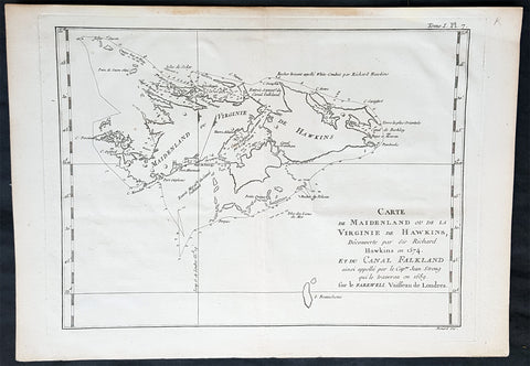
1774 Commodore John Byron Antique Map of The Falkland Islands South America
Antique Map
- Title : Carte de Maidenland ou de la Virginie de Hawkins...et du Canal Falklands...Jean Strong...1689.
- Ref #: 93381
- Size: 14 1/2in x 10in (370mm x 255mm)
- Date : 1774
- Condition: (A+) Fine Condition
Description:
This original copper-plate engraved antique map of the Falkland Islands by Commodore John Byron was engraved by Robert Benard and published in the 1774 first French edition of John Hawkesworth important book An account of the voyages undertaken by the order of His present Majesty for making discoveries in the Southern Hemisphere, and successively performed by Commodore Byron, Captain Wallis, Captain Carteret, and Captain Cook, in the Dolphin, the Swallow, and the Endeavor. Drawn up from the journals which were kept by the several commanders, and from the papers of Joseph Banks, Esq; by John Hawkesworth, LL.D. In three volumes. Illustrated with cuts, and a great variety of charts and maps relative to countries now first discovered, or hitherto but imperfectly known. London: printed for W. Strahan; and T. Cadell in the Strand, MDCCLXXIII.
John Hawkesworth (1715 - 1773) was commissioned by the British Admiralty to edit Captain James Cooks papers relative to his first voyage. For this work An Account of the Voyages undertaken ... for making discoveries in the Southern Hemisphere and performed by Commodore John Byron, Captain Wallis, Captain Carteret and Captain Cook, from 1702 to 1771, drawn up from the Journals ... (3 vols, 1773) Hawkesworth is said to have received from the publishers the sum of £6000. His descriptions of the manners and customs of the South Seas were, however, regarded by many critics as inexact and hurtful to the interests of morality, and the severity of their strictures is said to have hastened his death. He was buried in the parish church at Bromley, Kent, where he and his wife had kept a school.
Background:
Although Fuegians from Patagonia may have visited the Falkland Islands in prehistoric times, the islands were uninhabited when Europeans first discovered them. Claims of discovery date back to the 16th century, but no consensus exists on whether early explorers discovered the Falklands or other islands in the South Atlantic. The first recorded landing on the islands is attributed to English captain John Strong, who, en route to Perus and Chiles littoral in 1690, discovered the Falkland Sound and noted the islands water and game.
The Falklands remained uninhabited until the 1764 establishment of Port Louis on East Falkland by French captain Louis Antoine de Bougainville, and the 1766 foundation of Port Egmont on Saunders Island by British captain John MacBride. Whether or not the settlements were aware of each others existence is debated by historians. In 1766, France surrendered its claim on the Falklands to Spain, which renamed the French colony Puerto Soledad the following year. Problems began when Spain discovered and captured Port Egmont in 1770. War was narrowly avoided by its restitution to Britain in 1771.
Both the British and Spanish settlements coexisted in the archipelago until 1774, when Britains new economic and strategic considerations led it to voluntarily withdraw from the islands, leaving a plaque claiming the Falklands for King George III. Spains Viceroyalty of the Río de la Plata became the only governmental presence in the territory. West Falkland was left abandoned, and Puerto Soledad became mostly a prison camp. Amid the British invasions of the Río de la Plata during the Napoleonic Wars in Europe, the islands governor evacuated the archipelago in 1806; Spains remaining colonial garrison followed suit in 1811, except for gauchos and fishermen who remained voluntarily.
Thereafter, the archipelago was visited only by fishing ships; its political status was undisputed until 1820, when Colonel David Jewett, an American privateer working for the United Provinces of the Río de la Plata, informed anchored ships about Buenos Aires 1816 claim to Spains territories in the South Atlantic. Since the islands had no permanent inhabitants, in 1823 Buenos Aires granted German-born merchant Luis Vernet permission to conduct fishing activities and exploit feral cattle in the archipelago. Vernet settled at the ruins of Puerto Soledad in 1826, and accumulated resources on the islands until the venture was secure enough to bring settlers and form a permanent colony. Buenos Aires named Vernet military and civil commander of the islands in 1829, and he attempted to regulate sealing to stop the activities of foreign whalers and sealers. Vernets venture lasted until a dispute over fishing and hunting rights led to a raid by the American warship USS Lexington in 1831, when United States Navy commander Silas Duncan declared the dissolution of the islands government.
Buenos Aires attempted to retain influence over the settlement by installing a garrison, but a mutiny in 1832 was followed the next year by the arrival of British forces who reasserted Britains rule. The Argentine Confederation (headed by Buenos Aires Governor Juan Manuel de Rosas) protested against Britains actions and Argentine governments have continued since then to register official protests against Britain. The British troops departed after completing their mission, leaving the area without formal government. Vernets deputy, the Scotsman Matthew Brisbane, returned to the islands that year to restore the business, but his efforts ended after, amid unrest at Port Louis, gaucho Antonio Rivero led a group of dissatisfied individuals to murder Brisbane and the settlements senior leaders; survivors hid in a cave on a nearby island until the British returned and restored order. In 1840, the Falklands became a Crown colony, and Scottish settlers subsequently established an official pastoral community. Four years later, nearly everyone relocated to Port Jackson, considered a better location for government, and merchant Samuel Lafone began a venture to encourage British colonisation.
Stanley, as Port Jackson was soon renamed, officially became the seat of government in 1845. Early in its history, Stanley had a negative reputation due to cargo-shipping losses; only in emergencies would ships rounding Cape Horn stop at the port. Nevertheless, the Falklands geographic location proved ideal for ship repairs and the Wrecking Trade, the business of selling and buying shipwrecks and their cargoes. Aside from this trade, commercial interest in the archipelago was minimal due to the low-value hides of the feral cattle roaming the pastures. Economic growth began only after the Falkland Islands Company, which bought out Lafones failing enterprise in 1851, successfully introduced Cheviot sheep for wool farming, spurring other farms to follow suit. The high cost of importing materials, combined with the shortage of labour and consequent high wages, meant the ship repair trade became uncompetitive. After 1870, it declined as the replacement of sail ships by steamships was accelerated by the low cost of coal in South America; by 1914, with the opening of the Panama Canal, the trade effectively ended. In 1881, the Falkland Islands became financially independent of Britain. For more than a century, the Falkland Islands Company dominated the trade and employment of the archipelago; in addition, it owned most housing in Stanley, which greatly benefited from the wool trade with the UK.
General Definitions:
Paper thickness and quality: - Heavy and stable
Paper color : - off white
Age of map color: - Early
Colors used: - Yellow, green, blue, pink
General color appearance: - Authentic
Paper size: - 14 1/2in x 10in (370mm x 255mm)
Plate size: - 12 1/2in x 9 1/2in (310mm x 240mm)
Margins: - Min 1in (25mm)
Imperfections:
Margins: - None
Plate area: - Folds as issued
Verso: - None
Byron, John 1723 – 1786:
Vice-Admiral John Byron (8 November 1723 – 10 April 1786) was a British Royal Navy officer and explorer. He earned the nickname Foul-Weather Jack in the press because of his frequent encounters with bad weather at sea. As a midshipman, he sailed in the squadron under George Anson on his voyage around the world, though Byron made it only to southern Chile, where his ship was wrecked. He returned to England with the captain of HMS Wager. He was governor of Newfoundland following Hugh Palliser, who left in 1768. He circumnavigated the world as a commodore with his own squadron in 1764–1766. He fought in battles in the Seven Years War and the American Revolution. He rose to Vice Admiral of the White before his death in 1786.
His grandsons include the poet George Gordon Byron and George Anson Byron, admiral and explorer, who were the 6th and 7th Baron Byron, respectively.
Byron was the second son of William Byron, 4th Baron Byron and Frances Berkeley, the daughter of William, 4th Baron Berkeley. After studying at Westminster School he joined the Royal Navy at the age of 14, making his first voyage aboard the HMS Romney in 1738–40.
In 1740, he accompanied George Anson on his voyage around the world as a midshipman aboard one of the several ships in the squadron. On 14 May 1741, HMS Wager under Captain Cheap (as Captain Dandy Kidd had died), was shipwrecked on the coast of Chile on what is now called Wager Island and Byron was one of the survivors. The survivors decided to split in two teams, one to make its way by boat to Rio de Janeiro on the Atlantic coast; the other, including John Byron and the Captain, to sail north along the Spanish colonial coast.
Captain Cheap at Wager Island had a party of 19 men after the deserters rejoined the camp. This included the surgeon Elliot and Lieutenant Hamilton who had been cast adrift with him plus midshipmen John Byron and Campbell who had been in the barge. They rowed up the coast but were punished by continuous rain, headwinds and waves that threatened the boats. One night while the men slept on shore, one of the boats was capsized while at anchor and was swept out to sea with its two boatkeepers. One of the men got ashore but the other drowned. As it was now impossible for them all to fit in the remaining boat, four marines were left ashore with muskets to fend for themselves. The winds prevented them from getting around the headland so they returned to pick up the marines only to find them gone. They returned to Wager Island in early February 1742. With one death on the journey, there were now 13 in the group.
Martín Olleta, a Chono cheftain, guided the men up the coast to the Spanish settlements of Chiloé Island so they set out again. Two men died; after burying the bodies, the six seamen rowed off in the boat never to be seen again while Cheap, Hamilton, Byron, Campbell and the dying Elliot were on shore looking for food. Olleta then agreed to take the remaining four on by canoe for their only remaining possession, a musket. It is likely the party travelled across Presidente Ríos Lake in inland Taitao Peninsula, a lake Chile regarded as officially discovered in 1945. Eventually they made it to be taken prisoner by the Spanish. The Spaniards treated them well and they were eventually taken to the inland capital of Santiago where they were released on parole. The Spaniards heard that Anson had been generous in the treatment of the prisoners he had taken and this kindness was returned.
Byron and the other three men stayed in Santiago till late 1744 and were offered passage on a French ship bound for Spain. Three accepted the passage. Campbell elected to take a mule across the Andes and joined the Spanish Admiral Pizarro in Montevideo on the Asia only to find Isaac Morris and the two seamen who had been abandoned in Freshwater Bay on the Atlantic coast. After time in prison in Spain, Campbell reached Britain in May 1746, followed by the other three two months later.
In England, the official court martial examined only the loss of the Wager in which Baynes, in nominal charge at the time, was acquitted of blame but reprimanded for omissions of duty. Disputes over what happened after the wreck were instead played out as Bulkeley and Cummins, Campbell, Morris, the cooper Young and later Byron published their own accounts, the last of which was the only one that in any way defended Cheap who had since died. Twenty-nine crew members plus seven marines made it back to England.
Byrons account of his adventures and the Wager Mutiny are recounted in The Narrative of the Honourable John Byron (1768). His book sold well enough to be printed in several editions.
Byron was appointed captain of HMS Siren in December 1746.
In 1760, during the Seven Years War, Byron commanded a squadron sent to destroy the fortifications at Louisbourg, Quebec, which had been captured by the British two years before. They wanted to ensure it could not be used by the French in Canada. In July of that year he defeated the French flotilla sent to relieve New France at the Battle of Restigouche.
In early 1764 the British Admiralty determined that it would require a permanent naval settlement off the South American coast, in order to resupply naval vessels seeking to enter the Pacific via Cape Horn. Captain Byron was selected to explore the South Atlantic for a suitable island upon which to establish such a settlement. The South American mainland was controlled by Spain, which was hostile to local expansion of British interests; to disguise Byrons mission it was announced that he had been appointed the new Navy Commander-in-Chief, East Indies. Byron set sail in June 1764, ostensibly to take up the East Indies post. For the voyage he was granted command of the 24-gun frigate HMS Dolphin and the 16-gun sloop HMS Tamar.
Byrons two-vessel flotilla crossed the Atlantic over the winter of 1764 and made its way slowly down the South American coast. The Admiralty had ordered Byron to first seek Pepys Island, reputedly discovered off the Patagonian coast by the corsair Ambrose Cowley in 1683. Byron reached the co-ordinates given by Cowley in January 1765, but there was no sign of the island and the search was swiftly abandoned. On 5 February Byron reached the Patagonian settlement of Port Desire where he resupplied his vessels from the storeship HMS Florida.
Between June 1764 and May 1766, Byron completed his own circumnavigation of the globe as captain of HMS Dolphin. This was the first such circumnavigation that was accomplished in less than 2 years. His actions nearly caused a war between Great Britain and Spain, as both countries had armed fleets ready to contest the sovereignty of the Falkland Islands. Later Byron encountered islands and extant residents of the Tuamotus and Tokelau Islands, and Nikunau in the southern Gilbert Islands; he also visited Tinian in the Northern Marianas Islands. A notable member of Byrons crew was Masters Mate Erasmus Gower whom Byron chose to take a significant part in the ceremony when he took possession of the Falkland Islands. Byron had examined Gower for his lieutenants examination in 1762 and was so impressed that he chose him to accompany him on his own circumnavigation (1764–65) and ensured that he was appointed as lieutenant to Commander Philip Carteret immediately afterwards in the next circumnavigation (1766–69).
In 1769 he was appointed governor of Newfoundland off the mainland of Canada, an office he held for the next three years.
He was promoted to rear admiral on 31 March 1775. In 1779, he served as Commander-in-chief of the Leeward Islands Station during the American War of Independence. After being severely injured during a storm on his way to the West Indies, Byron unsuccessfully attacked a French fleet under the Comte dEstaing at the Battle of Grenada in July 1779. He subsequently resigned his post and returned to England, where he suffered from poor health for the rest of his life.
Byron was briefly Commander-in-Chief, North American Station from 1 October 1779. He was made vice admiral of the white in September 1780.
John Byron died on 1 April 1786 at home in Bolton Row, London. His remains were buried in the Berkeley family vault situated beneath the chancel of the Church of St Mary the Virgin, Twickenham, on 10 April.
Johns life was a great inspiration for his grandson the poet George Gordon Byron, though they never met. The poet both drew from his grandfathers experiences in his writing, using his Narrative for the shipwreck scene in Don Juan, and wrote of the kinship he felt in having such a turbulent, unlucky life: he wrote in an epistle to his half-sister Augusta Leigh that he had no rest at sea, nor I on shore.

1774 Cook & Hawkesworth Antique Atlas of Australia, New Zealand 52 Maps & Prints
Antique Map
- Title : Cartes et figures des voyages entrepris par ordre de sa Majesté Britannique, actuellement régnante ; pour faire des découvertes dans l'hémisphère méridional, et successivement exécutés par le Commodore Byron, le Capitaine Carteret, le Capitaine Wallis & le Capitaine Cook dans les vaisseaux. MDCCLXXIV (1774)
- Size: 4to (Quatro)
- Condition: (A) Very Good Condition
- Date : 1774
- Ref #: 35632
Description:
This original antique Atlas containing 52 maps and prints, as called for, from some of the foremost explorers of the mid 18th century, including Commodore Byron, Captain Carteret, Captain Wallis & Captain James Cook, was published as the 1st French edition of Cartes et figures des voyages entrepris par ordre de sa Majesté Britannique: (Maps and Figures of Travels undertaken by Order of his Present Reigning British Majesty) in 1774, published after only a year after the 1st English edition by John Hawkesworth.
The 52 prints and maps contained in this atlas chart in maps, prints and plans, the progression in the exploration of the South Seas of the 4 explorers. But there is of course, the standout amongst these 4 explorers and that is of course Captain James Cook.
At the time of the publication of this tome, Cook had returned from his first voyage of exploration to The South Pacific, becoming the first European to survey and chart the coastline of New Zealand and the east coast of Australia. But at this point Cook was not as famous as he was destined to become, after completing 2 more voyages of exploration, and in turn becoming the most famous explorer of his era.
The majority of this atlas contains the prints and maps dedicated to Cooks 1st Voyage of Discovery including the two famous maps, one of New Zealand and the other the East Coast of Australia. All voyages can be tracked from the first large folding map of the South Seas, at the beginning of the Atlas, that illustrates the tracks on Cook and the other 3 explorers.
In-4 binding in half-calf, spine with five bands with gilding boxes and title label complete with 52 folding & single plates
Spine & boards in poor condition with lack of leather and scratched covers, contents tights with plates in very good condition.
General Definitions:
Paper thickness and quality: - Heavy and stable
Paper color : - off white
Age of map color: -
Colors used: -
General color appearance: -
Paper size: - 4to (Quatro)
Plate size: - 4to (Quatro)
Margins: - 4to (Quatro)
Imperfections:
Margins: - Light age toning - Maps & Prints
Plate area: - Folds as issued - Maps & Prints
Verso: - Folds as issued - Maps & Prints
Background:
Capt. Cook First Voyage 1768 - 1771:
In 1768 Cook was chosen to lead an expedition to the South Seas to observe the Transit of Venus and to secretly search for the unknown Great Southern Continent (terra australis incognita).
Cook and his crew of nearly 100 men left Plymouth (August 1768) in the Endeavour and travelled via Madeira (September), Rio de Janiero (November-December) and Tierra del Fuego (January 1769) to Tahiti.
At Tierra del Fuego (January 1769) Cooks men went ashore and met the local people whom Cook thought perhaps as miserable a set of People as are this day upon Earth. Joseph Bankss party collected botanical specimens but his two servants, Thomas Richmond and George Dorlton, died of exposure in the snow and cold. Leaving Tierra del Fuego Endeavour rounded Cape Horn and sailed into the Pacific Ocean.
Sir Joseph Banks wrote about the homes of the Fuegans
..…huts or wigwams of the most unartificial construction imaginable, indeed no thing bearing the name of a hut could possibly be built with less trouble. They consisted of a few poles set up and meeting together at the top in a conical figure, these were covered on the weather side with a few boughs and a little grass, on the lee side about one eighth part of the circle was left open and against this opening was a fire made.......(Banks, Journal I, 224, 20th January 1769)
Samuel Wallis on the ship Dolphin discovered Tahiti in 1767. He recommended the island for the Transit of Venus observations and Cook arrived here in April 1769. Cook, like Wallis two years before him, anchored his ship in the shelter of Matavai Bay on the western side of the island.
In Matavai Bay Cook established a fortified base, Fort Venus, from which he was to complete his first task – the observation of the Transit of Venus (3rd June 1769). The fort also served as protection for all the important scientific and other equipment which had to be taken ashore as:
.......great and small chiefs and common men are firmly of opinion that if they can once get possession of an thing it immediately becomes their own…the chiefs employd in stealing what they could in the cabbin while their dependents took every thing that was loose about the ship…...(Joseph Banks).
Theft by some native peoples plagued Cooks voyages.
Cook and his crew experienced good relations with the Tahitians and returned to the islands on many occasions, attracted by the friendly people of this earthly paradise. On arrival Cook had set out the rules, including:
.....To endeavour by every fair means to cultivate a friendship with the Natives and to treat them with all imaginable humanity....
Just as Cook was planning to leave Tahiti two members of Endeavours crew decided to desert, having strongly attached themselves to two girls, but Cook recovered them.
Cook sailed around the neighbouring Society Islands and took on board the Tahitian priest, Tupaia, and his servant, Taiata. Endeavour left the Society Island in August 1769.
Tupaia acted as interpreter when they came into contact with other Polynesian peoples and helped Cook to make a map of the Pacific islands. This showed Cook the location of islands arranged according to their distance from Tahiti and indicated Tupaias and Polynesian knowledge of navigation and their skill as great mariners.
Cook sailed in search of the Southern Continent (August-October 1769) before turning west to New Zealand. The first encounters with the native Maori of New Zealand in October were violent, their warriors performing fierce dances, or hakas, in attempts to threaten and challenge the ships crew. Some of their warriors were killed when Cooks men had to defend themselves. Eventually relations improved and Cook was able to trade with the Maori for fresh supplies.
Exploring different bays and rivers along the way Cook circumnavigated New Zealand and was the first to accurately chart the whole of the coastline. He discovered that New Zealand consisted of two main islands, north (Te Ika a Maui) and south (Te Wai Pounamu) islands (October 1769-March 1770).
The artist Sydney Parkinson described three Maori who visited the Endeavour on 12th October 1769:
......Most of them had their hair tied up on the crown of their heads in a knot…Their faces were tataowed, or marked either all over, or on one side, in a very curious manner, some of them in fine spiral directions…
This Maori wears an ornamental comb, feathers in a top-knot, long pendants from his ears and a heitiki, or good luck amulet, around his neck.
At the northern end of the south island Cook anchored the ship in Ship Cove, Queen Charlotte Sound, which became a favourite stopping place on the following voyages. Parkinson noted:
......The manner in which the natives of this bay (Queen Charlotte Sound) catch their fish is as follows: - They have a cylindrical net, extended by several hoops at the bottom, and contracted at the top; within the net they stick some pieces of fish, then let it down from the side of the canoe and the fish, going in to feed, are caught with great ease.....(Parkinson, Journal, 114)
In Queen Charlottes Sound Cook visited one of the many Maori hippah, or fortified towns.
........The town was situated on a small rock divided from the main by a breach in a rock so small that a man might almost Jump over it; the sides were every where so steep as to render fortifications iven in their way almost totally useless, according there was nothing but a slight Palisade…in one part we observed a kind of wooden cross ornamented with feathers made exactly in the form of a crucifix cross…we were told that it was a monument to a dead man.......
Endeavour left New Zealand and sailed along the east coast of New Holland, or Australia, heading north (April-August 1770). Cook started to chart the east coast and on 29th April landed for the first time in what Cook called Stingray, later, Botany Bay.
The ship struck the Great Barrier Reef and was badly damaged (10 June). Repairs had to be carried out in Endeavour River. (June-August 1770). The first kangaroo to be sighted was recorded and shot.
The inhabitants of New Holland were very different from the people Cook had come across in other Pacific lands. They were darker skinned than the Maori and painted their bodies:
......They were all of them clean limnd, active and nimble. Cloaths they had none, not the least rag, those parts which nature willingly conceals being exposed to view compleatly uncovered......(Joseph Banks)
Tupaia could not make himself understood and at first the aborigines were very wary of the visitors and not at all interested in trading.
Joseph Banks recorded the fishing party observed at Botany Bay on 26 April 1770. He wrote:
......Their canoes… a piece of Bark tied together in Pleats at the ends and kept extended in the middle by small bows of wood was the whole embarkation, which carried one or two…people…paddling with paddles about 18 inches long, one of which they held in either hand.....(Banks, Journal II, 134)
Endeavour left Australia and sailed via the Possession Isle and Endeavour Strait for repairs at Batavia, Java (October-December 1770). Although the crew had been quite healthy and almost free from scurvy, the scourge of sailors, many caught dysentery and typhoid and over thirty died at Batavia or on the return journey home via Cape Town, South Africa (March-April 1771). The ship arrived off Kent, England (July 1771).
The voyage successfully recorded the Transit of Venus and largely discredited the belief in a Southern Continent. Cook charted the islands of New Zealand and the east coast of Australia and the scientists and artists made unique records of the peoples, flora and fauna of the different lands visited.
Vice-Admiral John Byron (1723-1786) was a British naval officer and explorer. He is known for his circumnavigation of the globe aboard the HMS Dolphin, completing one of the first British expeditions to achieve this feat. His account of the voyage, "The Narrative of the Honourable John Byron," influenced subsequent explorations. Byron's naval career included service in the Seven Years' War and the American Revolutionary War.
Rear-Admiral Philip Carteret (1733-1796) was a British naval officer and explorer. He is best known for his role as the captain of HMS Swallow during the first circumnavigation of the globe. Carteret's expedition, which took place from 1766 to 1769, aimed to explore and map uncharted regions of the Pacific Ocean. His discoveries included the Carteret Islands and the Pitcairn Islands. Carteret's voyage greatly contributed to the knowledge of Pacific geography and exploration during that time.
Samuel Wallis (1728-1795) was a British naval officer and explorer. He is renowned for leading the first recorded European expedition to visit Tahiti and for his significant contributions to the exploration of the Pacific Ocean. In 1766, Wallis commanded HMS Dolphin on a voyage funded by the British Admiralty. During the expedition, he discovered and named several islands, including Tahiti, which he encountered in June 1767. Wallis's visit to Tahiti marked the beginning of sustained European contact with the island and its inhabitants. His exploration efforts and subsequent reports greatly expanded European knowledge of the Pacific region. Wallis's achievements laid the foundation for future explorations and influenced subsequent voyages of exploration in the Pacific.
John Hawkesworth 1715 -1775
An English writer and journalist, Hawkesworth was commissioned by the British Admiralty to edit for publication the narratives of its officers circumnavigations. He was given full access to the journals of the commanders and the freedom to adapt and re-tell them in the first person. Cook was already on his way back from his second Pacific voyage, temporarily docked at Cape Town (South Africa), when he first saw the published volumes: he was mortified and furious to find that Hawkesworth claimed in the introduction that Cook had seen and blessed (with slight corrections) the resulting manuscript. (In his defense, Hawkesworth also had been a victim of misunderstanding.) Cook had trouble recognizing himself. Moreover, the work was full of errors and commentary introduced by Hawkesworth and, in Cooks view, too full of Banks, who had promoted himself and the publication. Still, the work was popular; the first edition sold out in several months.
Cook , Capt. James 1728-1779
James Cook was born on 27 October 1728 in Marton, England. His father was a poor farm labourer who had worked his way up to Overseer. James began as a farm labourer and grocer\\\'s assistant. He soon found employment on the Baltic sea in a Collier (coal transport ship) at the age of 18.
During the war with the French in 1755, James Cook enlisted as an Able Seaman on the Eagle. Within a month he was promoted, because of outstanding ability, to Masters Mate. Four years later he was promoted to Master. In command of his own ship, James Cook performed a crucial charting of the St. Lawrence River, which made possible the great amphibious assault upon Quebec City in 1759. In 1763 he was given command of the schooner Grenville to survey the eastern coasts of Canada over a four year period. These excellent charts were used up until the early part of the 20th century.
James Cook was selected to lead a 1768 expedition to observe the transit of Venus, and to explore new lands in the Pacific Ocean. In his first Pacific voyage, James Cook rounded Cape Horn in the Endeavour and reached Tahiti on 3 June 1769. After recovering a necessary scientific instrument stolen by the natives, the transit of Venus was successfully observed. The Endeavour then spent six months charting New Zealand. James Cook next explored and claimed possession of eastern Australia. Returning to England, on 12 June 1771, via New Guinea, Java and the Cape of Good Hope, the crew suffered an appalling 43% fatality rate. James Cook thus became very concerned about crew health on subsequent voyages. He instituted compulsory dietary reforms that were copied by many other ship captains.
The object of Captain Cook\\\'s second Pacific Ocean voyage was to confirm the existence of a theorized Great Southern Continent. His ship the Resolution, accompanied by the Adventure, departed Plymouth on 13 July 1772 and sailed around the Cape of Good Hope. Beset by ice, he was unable to reach Antarctica. Although its existence was suspected, James Cook demonstrated, by traversing large areas of the south Pacific, that it would have to be a frigid wasteland, and not an economically productive addition to the British empire. James Cook charted many of the South Pacific islands with the incredible accuracy of 3 miles. This accuracy was made possible by a new and highly accurate clock. The two ships returned to England, via Cape Horn, on 29 July 1775. The experimental diets and close attention to cleanliness had a miraculous effect: out of a crew of 118, only one man was lost to disease! Since public interest was high, the many paintings by the artists were widely displayed and published as engravings. James Cook was also awarded the Copley Gold Medal and elected as a fellow of the Royal Society.
The third great voyage is especially significant to the history of the west coast of North America. Captain Cook and his men were primarily searching for the Northwest Passage from the Pacific Ocean to the Atlantic Ocean. They departed Plymouth on 12 July 1776 in the Resolution and the Discovery.
The ships sailed around the Cape of Good Hope to reach the west coast of America in February of 1778. They continued north along the coast in haste to the Bering Sea and Bering Strait in an attempt to pass through the Arctic Ocean during the summer season. Foiled by ice, James Cook returned to Hawaii to prepare for another attempt at the Northwest Passage the next season. Soon after they had departed, a storm damaged the foremast of the Resolution and forced a return to Kealakekua Bay for repairs. Unfortunately, they had previously overstayed their welcome and relations became tense. The theft of a ship\\\'s cutter led Captain Cook to put ashore to demand the return of the boat. A fight broke out and James Cook was killed on 14 Feb 1779 by angry natives. Although his men made another attempt at the Northwest Passage, they were unsuccessful. The expedition did identify the possibilities of trade with the coastal American natives for otter seal furs, which could then be bartered for Chinese goods that were highly prized in England.
1774 Hawkesworth Antique Map of Magellan Straits, Bachelor River, Punta Arenas, Chile, Byron 1766
- Title : Baye d Elizabeth; Baye au dessons des Isles vis a vis la Rade d York; Côte depuis la Baye d York a la Baye et au Havre des Trois Isles; Baye St. David
- Size: 15 1/2in x 10in (395mm x 255mm)
- Ref #: 16027
- Date : 1774
- Condition: (A+) Fine Condition
Description:
This fine original copper-plate engraved antique map, four maps on the one sheet, of;
1. Elizabeth Bay.
2. York Bay.
3. York Bay-Three Island Bay
4.St. Davids Bay.
all located north of Carlos III island, on Punta Arenas in the Chilean Arctic - from Bachelor River north to York Bay - in the Straits of Magellan, Chile. This chart was compiled by Commodore John Byron, who visited the region in HMS Dolphin on his circumnavigation of the globe, between 1764-66, and was published in the 1774 French edition of John Hawkesworths An Account of the Voyages Undertaken by the Order of His Present Majesty for Making Discoveries in the Southern Hemisphere and Successively Performed by Commodore Byron, Captain Wallis, Captain Carteret, and Captain Cook, in the Dolphin, the Swallow, and the Endeavor, Drawn Up from the Journals Which Were Kept by the Several Commanders, and from the Papers of Joseph Banks, Esq. Paris 1774
General Definitions:
Paper thickness and quality: - Heavy and stable
Paper color : - off white
Age of map color: -
Colors used: -
General color appearance: -
Paper size: - 15 1/2in x 10in (395mm x 255mm)
Plate size: - 14in x 10in (360mm x 255mm)
Margins: - Min 1/2in (12mm)
Imperfections:
Margins: - None
Plate area: - None
Verso: - None
Background:
The Strait of Magellan
(Estrecho de Magallanes) is a navigable sea route separating mainland South America to the north and Tierra del Fuego to the south. The strait is the most important natural passage between the Atlantic and Pacific oceans.
Ferdinand Magellan a Portuguese explorer and navigator in the service of Charles I of Spain, became the first European to navigate the strait in 1520 during his circumnavigation of the globe.
Other early explorers included Francis Drake (1578). In February 1696 the first French expedition, under the command of M. de Gennes reached the Strait of Magellan. The expedition is described by the young French explorer, engineer and hydrographer François Froger in his A Relation of a Voyage (1699).
The strait was first carefully explored and thoroughly charted by Phillip Parker King, who commanded the British survey vessel HMS Adventure, and in consort with HMS Beagle spent five years surveying the complex coasts around the strait (1826–1830). A report on the survey was presented at two meetings of the Geographical Society of London in 1831.
Vice-Admiral The Hon. John Byron was a British Royal Navy officer and politician. He was known as Foul-weather Jack because of his frequent encounters with bad weather at sea. As a midshipman, he sailed in the squadron under George Anson on his voyage around the world, though Byron made it to southern Chile, and returned to England with the captain of HMS Wager. He was governor of Newfoundland following Hugh Palliser, who left in 1768. He circumnavigated the world as a commodore with his own squadron in 1764-1766. He fought in battles in The Seven Years War and the American Revolution. He rose to Vice Admiral of the White before his death in 1786.
In early 1764 the British Admiralty determined that it would require a permanent naval settlement off the South American coast, in order to resupply naval vessels seeking to enter the Pacific via Cape Horn. Captain Byron was selected to explore the South Atlantic for a suitable island upon which to establish such a settlement. The South American mainland was controlled by Spain, which was hostile to local expansion of British interests; to disguise Byrons mission it was announced that he had been appointed the new commander of the Navys East Indies Station. Byron set sail in June 1764, ostensibly to take up the East Indies post. For the voyage he was granted command of the 24-gun frigate HMS Dolphin and the 20-gun sloop HMS Tamar.
Byron\'s two-vessel flotilla crossed the Atlantic over the winter of 1764 and made its way slowly down the South American coast. The Admiralty had ordered Byron to first seek Pepys Island, reputedly discovered off the Patagonian coast by the corsair Ambrose Cowley in 1683. Byron reached the co-ordinates given by Cowley in January 1765, but there was no sign of the island and the search was swiftly abandoned. On 5 February Byron reached the Patagonian settlement of Port Desire where he resupplied his vessels from the storeship HMS Florida.
Between June 1764 and May 1766, Byron completed his own circumnavigation of the globe as captain of HMS Dolphin. This was the first such circumnavigation that was accomplished in less than 2 years. His actions nearly caused a war between Great Britain and Spain, as both countries had armed fleets ready to contest the sovereignty of the Falkland Islands. Later Byron encountered islands and extant residents of the Tuamotus and Tokelau Islands, and Nikunau in the southern Gilbert Islands; he also visited Tinian in the Northern Marianas Islands.
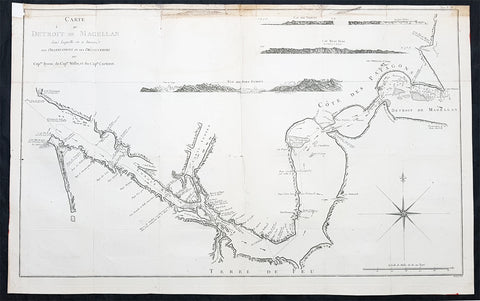
1774 Hawkesworth Large Antique Map Chart of The Magellan Straits, South America
Antique Map
- Title : Carte Du Detroit De Magellan dans laquelle on a Insere Les Observations et Les Decouvertes Du Capne Byron, du Capne Wallis, et du Capne Carteret
- Ref : 32219
- Size: 30 1/2in x 21 1/2in (775mm x 545mm)
- Date : 1774
- Condition: (A) Very Good Condition
Description:
This large, original copper-plate engraved, antique map, a chart of the Straits of Magellan, South America and the Patagonian & South Chilean shoreline was engraved by Robert Benard and published in the 1774 French edition of John Hawkesworths An Account of the Voyages Undertaken by the Order of His Present Majesty for Making Discoveries in the Southern Hemisphere and Successively Performed by Commodore Byron, Captain Wallis, Captain Carteret, and Captain Cook, in the Dolphin, the Swallow, and the Endeavor, Drawn Up from the Journals Which Were Kept by the Several Commanders, and from the Papers of Joseph Banks
A large scale chart with detailed shoreline topography, channels, soundings, shoals, harbors and small islands. There are also anchorages, capes & bays as well as 4 finely engraved landfall approach views of
1.Vue Du Port Famine
2. Cap Beau Tems
3.Cap Des Vierges
4. Rochers blanc. (white rocks).
The tracks and some details in this chart are attributed to the following navigators;
Commodore Byron, Captain Wallis and Captain Carteret.
General Definitions:
Paper thickness and quality: - Heavy and stable
Paper color : - off white
Age of map color: - Early
Colors used: - Yellow, green, brown
General color appearance: - Authentic
Paper size: - 30 1/2in x 21 1/2in (775mm x 545mm)
Plate size: - 30in x 20in (765mm x 510mm)
Margins: - Min 1/2in (12mm)
Imperfections:
Margins: - Soiling to top margin and border, repair to top left corner
Plate area: - Folds as issued
Verso: - Folds as issued
Background:
The Strait of Magellan
(Estrecho de Magallanes) is a navigable sea route separating mainland South America to the north and Tierra del Fuego to the south. The strait is the most important natural passage between the Atlantic and Pacific oceans.
Ferdinand Magellan a Portuguese explorer and navigator in the service of Charles I of Spain, became the first European to navigate the strait in 1520 during his circumnavigation of the globe.
Other early explorers included Francis Drake (1578). In February 1696 the first French expedition, under the command of M. de Gennes reached the Strait of Magellan. The expedition is described by the young French explorer, engineer and hydrographer François Froger in his A Relation of a Voyage (1699).
The strait was first carefully explored and thoroughly charted by Phillip Parker King, who commanded the British survey vessel HMS Adventure, and in consort with HMS Beagle spent five years surveying the complex coasts around the strait (1826–1830). A report on the survey was presented at two meetings of the Geographical Society of London in 1831.
The 3 Voyages, with Captains, ships & tracks who contributed to this map are;
1. 1764-66 - HMS Dolphin under Command of Commodore John Byron, completed the first circumnavigation of the globe under two years.
2. 1766-68 - HMS Dolphin under Command of Captain Samuel Wallis, completed another circumnavigation & was the first European to visit Tahiti & the Society Islands.
3. 1766-68 - HMS Swallow under Command of Captain Philip Carteret, who accompanied HMS Dolphin under the command of Samuel Wallis to circumnavigate the world.
John Hawkesworth an English writer and journalist, Hawkesworth was commissioned by the British Admiralty to edit for publication the narratives of its officers’ circumnavigations. He was given full access to the journals of the commanders and the freedom to adapt and re-tell them in the first person. Cook was already on his way back from his second Pacific voyage, temporarily docked at Cape Town (South Africa), when he first saw the published volumes: he was mortified and furious to find that Hawkesworth claimed in the introduction that Cook had seen and blessed (with slight corrections) the resulting manuscript. (In his defense, Hawkesworth also had been a victim of misunderstanding.) Cook had trouble recognizing himself. Moreover, the work was full of errors and commentary introduced by Hawkesworth and, in Cook’s view, too full of Banks, who had promoted himself and the publication. Still, the work was popular; the first edition sold out in several months.
Robert Bénard 1734 – 1777 was an 18th-century French engraver.
Specialized in the technique of engraving, Robert Ménard is mainly famous for having supplied a significant amount of plates (at least 1,800) to the Encyclopédie by Diderot & d Alembert from 1751.
Later, publisher Charles-Joseph Panckoucke reused many of his productions to illustrate the works of his catalog.

1774 Malachy Postlethwayt Antique 2 Volume Atlas 7 Large Cont Maps North America
Antique Map
- Title : The Universal Dictionary of Trade and Commercewith large Improvements Adapting the Same to the Present State of British Affairs in America since the last Treaty of Peace made in the year 1763....MDCCLXXIV
- Ref #: 93529
-
Condition: (A+) Fine Condition
- Size: Large Folio
- Date : 1774
Description:
These very large, heavy leather backed original antique dictionary & atlas volumes of early Global Economic Commerce by Malachy Postlethwayt was published in 1774.
The Universal Dictionary of Trade and Commerce in 2 volumes is the 4th edition published in London by W. Strahan, J and F. Rivington, et al., in 1774. The first edition was published between 1751 & 1755. Titles in red and black with engraved vignettes, engraved allegorical frontispiece to volume 1 (offset onto title) and contain 24 engraved folding maps sheets that when assembled make 7 complete very large maps. Occasional minor spotting, contemporary diced calf, re-backed preserving original contrasting morocco labels, extremities repaired.
The seven maps once assembled, to the left, are as follows with titles, cartographers dates and dimensions;:
1. A Correct Map of Europe by Thomas Kitchin after D Anville, 80cm x 70cm, 1774
2. Africa Performed by the Sr D Anville Samuel Bolton after D Anville, 103cm x 94cm, 1774
3. A New and Correct Map of the Coast of Africa, so called Slave Coast Map, Richard Seale 48cm x 38cm, 1774
4. North America Performed under the Patronage of Louis Duke of Orleans Richard Seale after D Anville, 88cm x 86cm, 1774
5. South America Thomas Kitchin after D Anville, 124cm x 75cm, 1774
6. First Part of Asia RW Seale, after D Anville, 83cm x 77cm, 1755
7. Second Part of Asia R W Seale, after D Anville, 96cm x 70cm, 1755
General Definitions:
Paper thickness and quality: - Heavy and stable
Paper color : - off white
Age of map color: -
Colors used: -
General color appearance: -
Paper size: - Please see above
Plate size: - Please see above
Margins: - Please see above
Imperfections:
Margins: - Please see above
Plate area: - Please see above
Verso: - Please see above
Background:
Postlethwayts most noted work, The Universal Dictionary of Trade and Commerce, appeared after he had devoted twenty years to its preparation. The first edition was published in London in instalments between 1751 and 1755, and then in subsequent editions as a two-volume set in 1757, 1766, and 1774. This dictionary was a translation, with large additions and improvements, from Jacques Savary des Bruslons Dictionnaire universal de commerce (1723–1730). Postlethwayts dictionary was a huge storehouse of economic facts, laws and theory and his departures from the French version reflected his greater interest in political problems; his more intense economic nationalism; and his exuberant belief in the economic usefulness of experimental philosophy
In the 1757 edition of the Universal Dictionary, Postlethwayt outlined his vision for the establishment of a British mercantile college to benefit those who intended to work as merchants, or in gathering public revenue, or in merchandizing. He proposed that theoretical training for business should occur in formal academies and involve the study of mercantile computations, foreign exchanges and the intrinsic value of foreign coins, double-entry accounting, languages, geography, and public revenues and related laws. Postlethwayts ideas appear to have been influential in developing the statutes and procedures of the Portuguese School of Commerce, established in Lisbon in 1759.
It is documented that Thomas Jefferson gave a copy of this dictonary to his son in law, Thomas Mann Randolph, and as a prolific reader we must assumed also read by Jefferson.
Postlethwayt, Malachy 1707-1767
Malachy Postlethwayt was a prolific English writer and publicist on matters of mercantilist economics in the 1740s and 1750s. Little is known about his upbringing or formal education, although he is believed to be the brother of James Postlethwayt (d. 1761), a writer on finance and demography. Malachy Postlethwayt was elected a fellow of the Society of Antiquaries of London in 1734. His writings are claimed by Edgar Johnson to have exerted a good deal of influence on the trend of British economic thought.
Postlethwayt was alleged to be propagandist for the mercantilist endeavours of the Royal Africa Company, whose interests were well served by his publications The African Trade, the Great Pillar and Supporter of the British Plantation Trade in North America (1745) and The National and Private Advantages of the African Trade Considered (1746). These works supported a strategy of British commercial and manufacturing expansion through trade with Africa and the colonies, and promoted the importance of slavery for British commerce and industry.
Postlethwayts most noted work, The Universal Dictionary of Trade and Commerce, appeared after he had devoted twenty years to its preparation. The first edition was published in London in instalments between 1751 and 1755, and then in subsequent editions as a two-volume set in 1757, 1766, and 1774. This dictionary was a translation, with large additions and improvements, from Jacques Savary des Bruslons Dictionnaire universal de commerce (1723–1730). Postlethwayts dictionary was a huge storehouse of economic facts, laws and theory and his departures from the French version reflected his greater interest in political problems; his more intense economic nationalism; and his exuberant belief in the economic usefulness of experimental philosophy
In the 1757 edition of the Universal Dictionary, Postlethwayt outlined his vision for the establishment of a British mercantile college to benefit those who intended to work as merchants, or in gathering public revenue, or in merchandizing. He proposed that theoretical training for business should occur in formal academies and involve the study of mercantile computations, foreign exchanges and the intrinsic value of foreign coins, double-entry accounting, languages, geography, and public revenues and related laws. Postlethwayts ideas appear to have been influential in developing the statutes and procedures of the Portuguese School of Commerce, established in Lisbon in 1759.
Postlethwayts most important contribution to economic literature is regarded by many to be Britains Commercial Interest Explained and Improved (1757), in which he outlines his concept of physical commerce and the policies England should follow to attain commercial parity with foreign rivals.
Whether Postlethwayts writings were his original thoughts and words is a matter for conjecture. His Universal Dictionary included ideas taken from fifty other past or contemporary writers and that it had scattered throughout it practically all of Richard Cantillons Essai sur la nature du commerce en général (Essay on the Nature of Commerce in General, 1755). Although Postlethwayt was alleged widely to be a plagiarist, this accusation is believed to be exaggerated.
Postlethwayt died suddenly on September 13, 1767, and was buried in the Old Street Churchyard, Clerkenwell, in London.
Postlethwayt also published:
- The African Trade the great Pillar and Support of the British Plantation Trade in America, &c., 1745.
- The Natural and Private Advantages of the African Trade considered, &c., 1746.
- Britains Commercial Interest Explained, Vol. I of his Universal Dictionary of Trade and Commerce, 1747.[5]
- Considerations on the making of Bar Iron with Pitt or Sea Coal Fire, &c. In a Letter to a Member of the House of Commons, London, 1747.
- Considerations on the Revival of the Royal-British Assiento, between his Catholic Majesty and the … South-Sea Company. With an … attempt to unite the African-Trade to that of the South-Sea Company, by Act of Parliament, London, 1749.
- The Merchants Public Counting House, or New Mercantile Institution, &c., London, 1750.
- A Short State of the Progress of the French Trade and Navigation, &c., London, 1756.
- Great Britains True System. … To which is prefixed an Introduction relative to the Forming a New Plan of British Politicks with respect to our Foreign Affairs, &c., London, 1757.
- Britains Commercial Interest explained and improved, in a Series of Dissertations on several important Branches of her Trade and Police. … Also … the Advantages which would accrue … from an Union with Ireland, 2 vols., London, 1757; 2nd edit., With … a clear View of the State of our Plantations in America, &c., London, 1759.
- In Honour to the Administration. The importance of the African Expedition considered, &c., London, 1758
Please note all items auctioned are genuine, we do not sell reproductions. A Certificate of Authenticity (COA) can be issued on request.

1774, 1777 & 1785 Capt James Cook 3 Atlas Volumes 1st Editions 204 Maps & Prints
- Title : 1. Figure du Banks 2. Premier Voyage De Cook 3. Troisieme Voyage De Cook
- Ref #: 93498, 93499, 93500
- Size: 4to (Quatro)
- Date : 1774; 1777; 1785
- Condition: (A+) Fine Condition
Description:
A unique and rare opportunity to acquire all three of Captain James Cooks 1st French edition Atlases (4to, Quatro), published to accompany the publication of his 3 voyages of discovery in 1774, 1777 & 1785. The atlases contain a total of 204 large folding, double page and single page maps and prints. It is very rare to find all three atlases complete and available together at the same time.
The contents of all three atlases are in fine condition, with a fresh, heavy impression and clean paper of all maps and prints.
As stated there are 204 maps and prints 51 in the 1st volume, 66 in the second volume and 87 in the second volume. Please view the images above, that include a few images of the 204 maps and prints as well as an itemized list of each volume.
General Definitions:
Paper thickness and quality: - Heavy and stable
Paper color : - off white
Age of map color: -
Colors used: -
General color appearance: -
Paper size: - 4to (Quatro)
Plate size: - 4to (Quatro)
Margins: - 4to (Quatro)
Imperfections:
Margins: - Some scuffing and wear to boards & spines
Plate area: - None
Verso: - None
Background:
Timeline First Voyage 1768 - 1771:
In 1768 Cook was chosen to lead an expedition to the South Seas to observe the Transit of Venus and to secretly search for the unknown Great Southern Continent (terra australis incognita).
Cook and his crew of nearly 100 men left Plymouth (August 1768) in the Endeavour and travelled via Madeira (September), Rio de Janiero (November-December) and Tierra del Fuego (January 1769) to Tahiti.
At Tierra del Fuego (January 1769) Cooks men went ashore and met the local people whom Cook thought perhaps as miserable a set of People as are this day upon Earth. Joseph Bankss party collected botanical specimens but his two servants, Thomas Richmond and George Dorlton, died of exposure in the snow and cold. Leaving Tierra del Fuego Endeavour rounded Cape Horn and sailed into the Pacific Ocean.
Sir Joseph Banks wrote about the homes of the Fuegans
..…huts or wigwams of the most unartificial construction imaginable, indeed no thing bearing the name of a hut could possibly be built with less trouble. They consisted of a few poles set up and meeting together at the top in a conical figure, these were covered on the weather side with a few boughs and a little grass, on the lee side about one eighth part of the circle was left open and against this opening was a fire made.......(Banks, Journal I, 224, 20th January 1769)
Samuel Wallis on the ship Dolphin discovered Tahiti in 1767. He recommended the island for the Transit of Venus observations and Cook arrived here in April 1769. Cook, like Wallis two years before him, anchored his ship in the shelter of Matavai Bay on the western side of the island.
In Matavai Bay Cook established a fortified base, Fort Venus, from which he was to complete his first task – the observation of the Transit of Venus (3rd June 1769). The fort also served as protection for all the important scientific and other equipment which had to be taken ashore as:
.......great and small chiefs and common men are firmly of opinion that if they can once get possession of an thing it immediately becomes their own…the chiefs employd in stealing what they could in the cabbin while their dependents took every thing that was loose about the ship…...(Joseph Banks).
Theft by some native peoples plagued Cooks voyages.
Cook and his crew experienced good relations with the Tahitians and returned to the islands on many occasions, attracted by the friendly people of this earthly paradise. On arrival Cook had set out the rules, including:
.....To endeavour by every fair means to cultivate a friendship with the Natives and to treat them with all imaginable humanity....
Just as Cook was planning to leave Tahiti two members of Endeavours crew decided to desert, having strongly attached themselves to two girls, but Cook recovered them.
Cook sailed around the neighbouring Society Islands and took on board the Tahitian priest, Tupaia, and his servant, Taiata. Endeavour left the Society Island in August 1769.
Tupaia acted as interpreter when they came into contact with other Polynesian peoples and helped Cook to make a map of the Pacific islands. This showed Cook the location of islands arranged according to their distance from Tahiti and indicated Tupaias and Polynesian knowledge of navigation and their skill as great mariners.
Cook sailed in search of the Southern Continent (August-October 1769) before turning west to New Zealand. The first encounters with the native Maori of New Zealand in October were violent, their warriors performing fierce dances, or hakas, in attempts to threaten and challenge the ships crew. Some of their warriors were killed when Cooks men had to defend themselves. Eventually relations improved and Cook was able to trade with the Maori for fresh supplies.
Exploring different bays and rivers along the way Cook circumnavigated New Zealand and was the first to accurately chart the whole of the coastline. He discovered that New Zealand consisted of two main islands, north (Te Ika a Maui) and south (Te Wai Pounamu) islands (October 1769-March 1770).
The artist Sydney Parkinson described three Maori who visited the Endeavour on 12th October 1769:
......Most of them had their hair tied up on the crown of their heads in a knot…Their faces were tataowed, or marked either all over, or on one side, in a very curious manner, some of them in fine spiral directions…
This Maori wears an ornamental comb, feathers in a top-knot, long pendants from his ears and a heitiki, or good luck amulet, around his neck.
At the northern end of the south island Cook anchored the ship in Ship Cove, Queen Charlotte Sound, which became a favourite stopping place on the following voyages. Parkinson noted:
......The manner in which the natives of this bay (Queen Charlotte Sound) catch their fish is as follows: - They have a cylindrical net, extended by several hoops at the bottom, and contracted at the top; within the net they stick some pieces of fish, then let it down from the side of the canoe and the fish, going in to feed, are caught with great ease.....(Parkinson, Journal, 114)
In Queen Charlottes Sound Cook visited one of the many Maori hippah, or fortified towns.
........The town was situated on a small rock divided from the main by a breach in a rock so small that a man might almost Jump over it; the sides were every where so steep as to render fortifications iven in their way almost totally useless, according there was nothing but a slight Palisade…in one part we observed a kind of wooden cross ornamented with feathers made exactly in the form of a crucifix cross…we were told that it was a monument to a dead man.......
Endeavour left New Zealand and sailed along the east coast of New Holland, or Australia, heading north (April-August 1770). Cook started to chart the east coast and on 29th April landed for the first time in what Cook called Stingray, later, Botany Bay.
The ship struck the Great Barrier Reef and was badly damaged (10 June). Repairs had to be carried out in Endeavour River. (June-August 1770). The first kangaroo to be sighted was recorded and shot.
The inhabitants of New Holland were very different from the people Cook had come across in other Pacific lands. They were darker skinned than the Maori and painted their bodies:
......They were all of them clean limnd, active and nimble. Cloaths they had none, not the least rag, those parts which nature willingly conceals being exposed to view compleatly uncovered......(Joseph Banks)
Tupaia could not make himself understood and at first the aborigines were very wary of the visitors and not at all interested in trading.
Joseph Banks recorded the fishing party observed at Botany Bay on 26 April 1770. He wrote:
......Their canoes… a piece of Bark tied together in Pleats at the ends and kept extended in the middle by small bows of wood was the whole embarkation, which carried one or two…people…paddling with paddles about 18 inches long, one of which they held in either hand.....(Banks, Journal II, 134)
Endeavour left Australia and sailed via the Possession Isle and Endeavour Strait for repairs at Batavia, Java (October-December 1770). Although the crew had been quite healthy and almost free from scurvy, the scourge of sailors, many caught dysentery and typhoid and over thirty died at Batavia or on the return journey home via Cape Town, South Africa (March-April 1771). The ship arrived off Kent, England (July 1771).
The voyage successfully recorded the Transit of Venus and largely discredited the belief in a Southern Continent. Cook charted the islands of New Zealand and the east coast of Australia and the scientists and artists made unique records of the peoples, flora and fauna of the different lands visited.
Timeline - Second Voyage 1772 - 1775
In July 1772 Resolution, commanded by Captain Cook, and Discovery, commanded by Lieutenant Furneaux, set sail from Britain, via Madiera (Jul-Aug) and Cape Town, South Africa (Oct-Nov), towards the Antarctic in search of the Great Southern Continent.
During January 1773 the ships took on fresh water, charts of the voyage being marked with:
......Here we watered our Ship with Ice the 1st. Time 26S 44W and Here we compleated our Water/26S 20W but became separated in thick fog: Here we parted company…. and The Resolutions Track after we parted Company on the 8 of February 1773......
The ships became the first known to have crossed the Antarctic Circle (17 January 1773). On 9th January Cook wrote:
.......we hoisted out three Boats and took up as much as yielded about 15 Tons of Fresh Water, the Adventure at the same time got about 8 or 9 and all this was done in 5 or 6 hours time; the pieces we took up and which had broke from the Main Island, were very hard and solid, and some of them too large to be handled so that we were obliged to break them with our Ice Azes before they could be taken into the Boats...... Cook, Journals II, 74.)
The ships met again in New Zealand (February-May 1773) and set off to explore the central Pacific, calling at Tahiti (August), where, from the island of Raiatea, they took aboard Omai who returned with the Adventure to England (7 September).
After visiting Amsterdam and Middelburg, two islands that Cook called the Friendly Islands (Tongan group) (October) the ships became separated and never met again. Both ships returned separately to New Zealand. (November) A boats crew from the Adventure were killed by Maori (17 December) and the ship sailed for Britain, arriving July 1774.
Cook on Resolution attempted another search for the Great Southern Continent (November 1773), crossing the Antarctic Circle on 20th December 1773. However, the ice and cold soon forced him to turn north again and he made another search in the central Pacific for the Great Southern Continent. In January 1774 he turned south again, crossing the Antarctic Circle for the second time. Captain Cooks Journal, 2nd January 1774.
Cook sailed north, arriving at Easter Island in March 1774. Cook was too ill to go ashore but a small party explored the southern part of the island. The artist William Hodges painted a group of the large statues of heads (moia) for which the island has become famous.
Cook then sailed to the Marquesas (March); Tahiti (April) and Raiatea (June); past the Cook Islands and Niue, or Savage Islands as Cook called them; Tonga (June); Vatoa, the only Fijian Island visited by Cook (July); New Hebrides (July-August); New Caledonia (September) and Norfolk Island (October); before returning to New Zealand (October 1774).
Not all the peoples of the islands visited by Cook were friendly and when his ship approached Niue the local people would not let his crew ashore. Cook wrote:
.......The Conduct and aspect of these Islanders occasioned my giving it the Name of Savage Island, it lies in the Latitude of 19 degrees 1 Longitude 169 degrees 37 West, is about 11 Leagues in circuit, of a tolerable height and seemingly covered with wood amongst which were some Cocoa-nutt trees......(Cook, Journals II, 435, 22 June 1774.)
En route for New Zealand, Cook sailed west and explored the islands which he called the New Hebrides, now known as Vanuatu, arriving on 17 July 1774. The people were Melanesian, not Polynesian, and spoke different languages and had different customs. Cook recorded:
........The Men go naked, it can hardly be said they cover their Natural parts, the Testicles are quite exposed, but they wrap a piece of cloth or leafe round the yard (nautical slang for the penis) which they tye up to the belly to a cord or bandage which they wear round the waist just under the Short ribs and over the belly and so tight that it was a wonder to us how they could endure it.......(Cook, Journals II, 464, 23 July 1774)
Cook sailed past or visited nearly all the islands in the group, including landfalls at Malekula, Tanna and Erromango. He later moved on to New Caledonia.
Cooks reception by the New Hebrideans was generally hostile. At Erromango during the landing on 4th August 1774 the marines had to open fire when the natives tried to seize the boat and started to fire missiles. Cook wrote:
....…I was very loath to fire upon such a Multitude and resolved to make the chief a lone fall a Victim to his own treachery…happy for many of these poor people not half our Musquets would go of otherwise many more must have fallen.......(Cook, Journals II, 479, 4th August 1774)
Some of Cooks crew were slightly injured but several natives were wounded and their leader killed. Back on the ship Cook had a gun fired to frighten off the islanders and decided to depart.
Cook left New Zealand to return to Britain via the Southern Ocean in November 1774 and arrived in Tierra del Fuego, South America, in December. Cook took on stores and spent the holiday in what he called Christmas Sound. He described the area:......except those little tufts of shrubbery, the whole country was a barren Tack (or Rock) doomed by Nature to everlasting sterility......(Cook, Ms Journal PRO Adm 55/108)
Cook left South America in early January 1775 and set off across the southern Atlantic for Cape Town, South Africa. On the way he tried to confirm the location of a number of islands charted by Alexander Dalrymple on an earlier voyage. On 17 January 1775 Cook arrived at the cold, bleak, glaciated island he called South Georgia and spent 3 days charting it before sailing on.
Cook headed east and in late January came across the South Sandwich Islands that he again charted and then sailed on to Cape Town, arriving in late March 1775. He then headed across the Atlantic via St. Helena and Ascension Island (May), the Azores (July) and landed at Portsmouth on 30th July 1775.
On his return Cook became a national hero. He was presented to the King, made a member of the Royal Society and received its Copley Medal for achievement. Cook was promoted to post-captain of Greenwich Hospital and wrote up his account of the voyage. This did not mean retirement for Cook who went on his third and final voyage the following year.
The second voyage was one of the greatest journeys of all time. During the three years the ships crews had remained healthy and only four of the Resolutions crew had died. Cook disproved the idea of the Great Southern Continent; had become the first recorded explorer to cross the Antarctic Circle; and had charted many Pacific islands for the first time.
Timeline - Third Voyage 1776 - 1780
In 1776 Cook sailed in a repaired Resolution (July) to search for the North West Passage and to return Omai to his home on Huahine in the Society Islands.
He sailed via the Canary Islands and was joined at Cape Town, South Africa, by the Discovery, commanded by Charles Clerke.
The Discovery was the smallest of Cooks ships and was manned by a crew of sixty-nine. The two ships were repaired and restocked with a large number of livestock and set off together for New Zealand ( December).
Cook sailed across the South Indian Ocean and confirmed the location of Desolation Island, later known as Kerguelen Island. Cook wrote of Christmas Harbour where he first anchored on 25th December 1776:
........I found the shore in a manner covered with Penguins and other birds and Seals…so fearless that we killed as ma(n)y as we chose for the sake of their fat or blubber to make Oil for our lamps and other uses… Here I displayd the British flag and named the harbour Christmas harbour as we entered it on that Festival........(Cook, Journals III, i, 29-32)
Cook sailed east, arriving at Van Diemens Land/Tasmania (January 1777) and Queen Charlottes Sound, New Zealand (February). The Maori were wary at first, expecting Cook to take revenge for the killing of members of the Adventures crew in 1773, but instead Cook befriended the leader of the attack.
The ships stayed for nearly two weeks in New Zealand, restocking with wild celery and scurvy grass and trading with the local Maori who set up a small village in Ship Cove. Cook set off around the islands of the south Pacific (February), visiting the Cook Islands (April); Tongan Islands (July); and Tahiti (August-December 1777)
In 1778 Cook visited the Hawaiian islands, or Sandwich Islands as he named them, for the first time. Cook wrote:
........We no sooner landed, that a trade was set on foot for hogs and potatoes, which the people gave us in exchange for nails and pieces of iron formed into some thing like chisels….At sun set I brought every body on board, having got during the day Nine tons of water….about sixty or eighty Pigs, a few Fowls, a quantity of potatoes and a few plantains and Tara roots.......(Cook, Journals III, i. 269 & 272)
In February 1778 Cook sailed from the Hawaiian Islands across the north Pacific to the Oregan coast of North America. He travelled up the coast in bad weather until he found a safe harbour, Nootka Sound, Vancouver Island, Canada. There he refitted the ships, explored the area and developed relations with the local people.
Cook described a village there, probably Yoquot:
….their houses or dwellings are situated close to the shore…Some of these buildings are raised on the side of a bank, theses have a flooring consisting of logs supported by post fixed in the ground….before these houses they make a platform about four feet broad…..so allows of a passage along the front of the building: They assend to this passage (along the front of the building) by steps, not unlike some at our landing places in the River Thames........(Cook, Journals III, i, 306)
Cook left Nootka Sound in April 1778 and sailed north along the Alaskan coast looking for inlets that might lead to the Northwest passage but was then forced to turn south. By July he had rounded the Alaskan Peninsula and was able to sail north again, visiting the Chukotskiy Peninsula, Russia, before heading out into the Bering Sea.
Cook described the summer huts, or yarangas, of the Chukchi people as:
.........pretty large, and circular and brought to a point at the top; the framing was of slight poles and bone, covered with the skins of Sea animals…About the habitations were erected several stages ten or twelve feet high, such as we had observed on some part of the American coast, they were built wholly of bones and seemed to be intended to dry skins, fish &ca. upon, out of reach of their dogs........(Cook, Journals III, I, 413)
After entering the Bering Sea on 11th August 1778, Cook crossed the Arctic Circle and went as far north as latitude 70 degrees 41 North before being forced back by the pack ice off Icy Cape, Alaska. On the ice all around the ships were large numbers of walruses. About a dozen of these huge animals were killed to replenish the supplies of fresh meat and to provide oil for the lamps.
Cook had to turn west and worked his way down the Russian coast, eventually heading south and east into Norton Sound, Alaska, in September 1778. He wrote of their very brief encounter with the inhabitants of Norton Sound:
....…a family of the Natives came near to the place where we were taking off wood…I saw no more than a Man, his wife and child…...(Cook, Journals III, I, 438)
After a short period spent searching for the Northwest Passage Cook realised that it was too late in the year to make any progress and so sailed for warmer winter quarters in the Hawaiian Islands, arriving there in December 1778.
After circumnavigating the big island of Hawaii for over a month the ships finally anchored in Kealakekua Bay on 16th January 1779. The Hawaiians in over 1000 canoes came out to welcome them, the arrival of the ships coinciding with celebrations to mark the religious festival of Makahiki to the god Lono. The Hawaiians seem to have treated Cook as a personification of the god and at first relations were good on this second visit. However, relationships became strained and Cook left the island on 4th February 1779.
When Cook left Hawaii his ships ran into gales which broke a mast, forcing him to return to Kealakekua Bay for repairs on 11th February. This time the native people were less friendly and stole the cutter of the Discovery. The next day, the 14th February 1779, Cook went ashore to take the Hawaiian king into custody pending the return of the cutter but a fight developed and Cook, four of his marines and a number of natives were killed. Cooks remains were buried at sea in Kealakekua Bay.
Charles Clerke took over command of the stunned expedition and explored the other Hawaiian islands before sailing north to search for the North-West Passage. The ships called at Kamchatka, Russia, (April-June) where they were welcomed by the governor, Behm, at Bolsheretsk. Behm took news of the expedition and Cooks death overland to St. Petersburg from where it reached Europe and Britain.
Having made another voyage into the Arctic in search of the Northwest Passage (June-July) the ships returned to Kamchatka in August. In November they set off sailing south along the east coast of Japan, between Taiwan and the Phillipines and arrived at Macao, China, in December.
In January 1780 the expeditions left for home, crossing the Indian Ocean, calling at Cape Town (April-May) and arriving back in Stromness, Orkney, in August but not returning to London until October 1780.
News of Cooks death reached Britain in January 1780, ahead of the return of Resolution and Discovery in October 1780. The voyage was written up and published and Cooks life gradually commemorated in articles, books, medals and monuments.
The achievements of the voyage were overshadowed by the deaths of both Cook and his second-in-command, Clerke. The main purpose of the voyage, the discovery of the Northwest Passage, was not realised but large tracts of the Pacific and Arctic coasts of America and Russia were charted.
Early attempts to summarise the life of Cook appeared in the popular press soon after news of his death reached Britain. Articles in journals such as the Westminster Magazine, published in January 1780, included Biographical Anecdotes of Capt. Cook, charting his life from his birth in Marton, North Yorkshire. The first published biography of Cook, Life of Captain James Cook, by Andrew Kippis, appeared a few years later in 1788.
1778 Capt Cook Antique Print Portrait of a Man of Terra del Fuego, Chile in 1774
- Title : Homme du Canal de Noel Dans La Terre De Feu
- Ref : 16354
- Size: 10in x 8in (255mm x 205mm)
- Date : 1778
- Condition: (A+) Fine Condition
Description:
This fine original copper-plate engraved antique print, portrait of a Man of Christmas Sound on the S.W. Coast of Terra del Fuego Chile, visited by Captain James Cook during his 2nd Voyage of Discovery to the South Seas in December 1774, was engraved by Robert Benard - after William Hodges - and was published in the 1778 French edition of Capt. James Cooks 2nd Voyage of Discovery to the South Seas A voyage towards the South Pole, and round the World. Performed in His Majestys ships the Resolution and Adventure, in the years 1772, 1773, 1774, and 1775..... Paris : Hotel de Thou ......1778
Cook Journal
.......followed the coast of Tierra del Fuego (Chile) at the end of December 1774 making for Cape Horn. The coast comprised of hundreds of small islands, some of which were charted and named but many were not. The Resolution was kept at a safe distance from the shore and soon passed the Grafton Islands, Noir Island, Tower Rocks and the Gilbert Islands (named after the Master). On the 19th they passed a large inlet, which is now called Cook Bay. Cook needed provisions and to check the state of the Resolution,so he found an inlet suitable for this purpose on the 20th. They stayed there for eight days over Christmas, which earned the inlet the name Christmas Sound..........
General Definitions:
Paper thickness and quality: - Heavy and stable
Paper color : - off white
Age of map color: -
Colors used: -
General color appearance: -
Paper size: - 10in x 8in (255mm x 205mm)
Plate size: - 9 1/2in x 7 1/4in (240mm x 185mm)
Margins: - Min 1/2in (12mm)
Imperfections:
Margins: - Light soiling in margins
Plate area: - None
Verso: - None
Background:
Tierra del Fuego Spanish for Land of Fire is an archipelago off the southernmost tip of the South American mainland, across the Strait of Magellan. The archipelago consists of the main island, Isla Grande de Tierra del Fuego, with an area of 48,100 km2 and a group of many islands, including Cape Horn and Diego Ramírez Islands. Tierra del Fuego is divided between Chile and Argentina, with the latter controlling the eastern half of the main island and the former the western half plus the islands south of Beagle Channel.
The name Tierra del Fuego derives from the Portuguese explorer Ferdinand Magellan sailing for the Spanish Crown, in 1520 he was the first European to visit these lands. He believed he was seeing the many fires (fuego in Spanish) of the Yaghan, which were visible from the sea, and that the Indians were waiting in the forests to ambush his armada.
In 1525 Francisco de Hoces was the first to speculate that Tierra del Fuego was one or more islands rather than part of what was then called Terra Australis. Francis Drake in 1578 and a Dutch VOC expedition in 1616 learned more about the geography. The latter expedition named Cape Horn.
William Hodges RA 1744 – 1797 was an English painter. He was a member of James Cooks second voyage to the Pacific Ocean, and is best known for the sketches and paintings of locations he visited on that voyage, including Table Bay, Tahiti, Easter Island, and the Antarctic.
Between 1772 and 1775 Hodges accompanied James Cook to the Pacific as the expeditions artist. Many of his sketches and wash paintings were adapted as engravings in the original published edition of Cooks journals from the voyage.
Most of the large-scale landscape oil paintings from his Pacific travels for which Hodges is best known were finished after his return to London; he received a salary from the Admiralty for the purposes of completing them. These paintings depicted a stronger light and shadow than had been usual in European landscape tradition. Contemporary art critics complained that his use of light and colour contrasts gave his paintings a rough and unfinished appearance.
Hodges also produced many valuable portrait sketches of Pacific islanders and scenes from the voyage involving members of the expedition..
Robert Bénard 1734 – 1777 was an 18th-century French engraver.
Specialized in the technique of engraving, Robert Ménard is mainly famous for having supplied a significant amount of plates (at least 1,800) to the Encyclopédie by Diderot & d\'Alembert from 1751.
Later, publisher Charles-Joseph Panckoucke reused many of his productions to illustrate the works of his catalog.
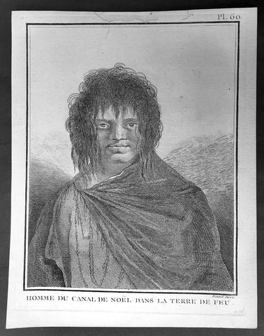
1778 Capt Cook Antique Print Portrait of a Man of Terra del Fuego, Chile in 1774
- Title : Homme du Canal de Noel Dans La Terre De Feu
- Ref : 31813
- Size: 10in x 8in (255mm x 205mm)
- Date : 1778
- Condition: (A+) Fine Condition
Description:
This fine original copper-plate engraved antique print, portrait of a Man of Christmas Sound on the S.W. Coast of Terra del Fuego Chile, visited by Captain James Cook during his 2nd Voyage of Discovery to the South Seas in December 1774, was engraved by Robert Benard - after William Hodges - and was published in the 1778 French edition of Capt. James Cooks 2nd Voyage of Discovery to the South Seas A voyage towards the South Pole, and round the World. Performed in His Majestys ships the Resolution and Adventure, in the years 1772, 1773, 1774, and 1775..... Paris : Hotel de Thou ......1778
Cook Journal
.......followed the coast of Tierra del Fuego (Chile) at the end of December 1774 making for Cape Horn. The coast comprised of hundreds of small islands, some of which were charted and named but many were not. The Resolution was kept at a safe distance from the shore and soon passed the Grafton Islands, Noir Island, Tower Rocks and the Gilbert Islands (named after the Master). On the 19th they passed a large inlet, which is now called Cook Bay. Cook needed provisions and to check the state of the Resolution,so he found an inlet suitable for this purpose on the 20th. They stayed there for eight days over Christmas, which earned the inlet the name Christmas Sound..........
General Definitions:
Paper thickness and quality: - Heavy and stable
Paper color : - off white
Age of map color: -
Colors used: -
General color appearance: -
Paper size: - 10in x 8in (255mm x 205mm)
Plate size: - 9 1/2in x 7 1/4in (240mm x 185mm)
Margins: - Min 1/2in (12mm)
Imperfections:
Margins: - Light soiling in margins
Plate area: - None
Verso: - None
Background:
Tierra del Fuego Spanish for Land of Fire is an archipelago off the southernmost tip of the South American mainland, across the Strait of Magellan. The archipelago consists of the main island, Isla Grande de Tierra del Fuego, with an area of 48,100 km2 and a group of many islands, including Cape Horn and Diego Ramírez Islands. Tierra del Fuego is divided between Chile and Argentina, with the latter controlling the eastern half of the main island and the former the western half plus the islands south of Beagle Channel.
The name Tierra del Fuego derives from the Portuguese explorer Ferdinand Magellan sailing for the Spanish Crown, in 1520 he was the first European to visit these lands. He believed he was seeing the many fires (fuego in Spanish) of the Yaghan, which were visible from the sea, and that the Indians were waiting in the forests to ambush his armada.
In 1525 Francisco de Hoces was the first to speculate that Tierra del Fuego was one or more islands rather than part of what was then called Terra Australis. Francis Drake in 1578 and a Dutch VOC expedition in 1616 learned more about the geography. The latter expedition named Cape Horn.
William Hodges RA 1744 – 1797 was an English painter. He was a member of James Cooks second voyage to the Pacific Ocean, and is best known for the sketches and paintings of locations he visited on that voyage, including Table Bay, Tahiti, Easter Island, and the Antarctic.
Between 1772 and 1775 Hodges accompanied James Cook to the Pacific as the expeditions artist. Many of his sketches and wash paintings were adapted as engravings in the original published edition of Cooks journals from the voyage.
Most of the large-scale landscape oil paintings from his Pacific travels for which Hodges is best known were finished after his return to London; he received a salary from the Admiralty for the purposes of completing them. These paintings depicted a stronger light and shadow than had been usual in European landscape tradition. Contemporary art critics complained that his use of light and colour contrasts gave his paintings a rough and unfinished appearance.
Hodges also produced many valuable portrait sketches of Pacific islanders and scenes from the voyage involving members of the expedition..
Robert Bénard 1734 – 1777 was an 18th-century French engraver.
Specialized in the technique of engraving, Robert Ménard is mainly famous for having supplied a significant amount of plates (at least 1,800) to the Encyclopédie by Diderot & d\'Alembert from 1751.
Later, publisher Charles-Joseph Panckoucke reused many of his productions to illustrate the works of his catalog.
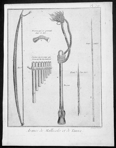
1778 Capt Cook Antique Print Weapons & Musical Instruments Vanuatu Islands, 1774
- Title : Armes de Mallicolo et de Tanna
- Ref : 91211
- Size: 10in x 8in (255mm x 205mm)
- Date : 1778
- Condition: (A+) Fine Condition
Description:
This fine original copper-plate engraved antique print of 6 different types of arms and musical instruments, from the Islands of Malakula (Mallicolo) & Tanna in the Vanuatu group of Islands in the South Pacific, visited by Captain James Cook during his 2nd Voyage of Discovery in the South Seas in September 1774, was engraved by Robert Benard - after William Hodges - and was published in the 1778 French edition of Capt. James Cooks 2nd Voyage of Discovery to the South Seas A voyage towards the South Pole, and round the World. Performed in His Majestys ships the Resolution and Adventure, in the years 1772, 1773, 1774, and 1775..... Paris : Hotel de Thou ......1778
The six objects engraved are;
1. Arc - Bow
2. Pierres qui seportent dans le nes - Stone used as a support
3. Syrinx ou roseaux quiserment un instrument - Multi tune flute
4. Massue - Club with rope attachment
5. peinte d un parl - Arrow head
6. Dart enier - Spear
Cook Journal July, 1774
Arrival at The New Hebrides
On 17th Cook saw land bearing SW and later on decided this was the Australia Del Espiritu Santo of Quiros or what M. D. Bougainville calls the Great Cyclades. The island was Maewo. The next day its northern end was rounded in a gale and the ship sailed south between it and the island called by Bougainville the Isle of Lepers - Omba.
On 20th they crossed Patteson Passage with a view of geting to the South to explore the lands which lies there, and sailed down the west coast of Pentecost Isle (Raga). To the south they saw the island of Ambrin and behind it Paama and Epi. On 22nd, approaching Mallicollo (Malekula) we perceived a creek which had the appearence of a good harbour. Cook sent Lieutt [Richard] Pickersgill and the Master [Joseph Gilbert] in two Armd boats to Sound and look for Anchorage. The following day a good many [natives] came round us, some came in Canoes and others swam off\\\'... four I took into the Cabbin and made them various presents. Later, after some misunder-standing some natives began to Shoot Arrows... a Musquet discharged in the air and a four pounder over their heads sent them all off in the utmost confusion; those in the Cabbin leaped out of the Windows... About 9 o\\\'Clock we landed in the face of about 4 or 500 Men who were assembled on the Shore, armd with Bows and Arrows, clubs and Spears, but they made not the least opposission, on the contrary one Man gave his Arms to a nother and Met us in the water with a green branch in his hand, which [he] exchanged for the one I held in my hand. Just before departing Cook remarked they have not so much as a name for a Dog, consequently can have none, for which reason we left them a Dog and a Bitch.
General Definitions:
Paper thickness and quality: - Heavy and stable
Paper color : - off white
Age of map color: -
Colors used: -
General color appearance: -
Paper size: - 10in x 8in (255mm x 205mm)
Plate size: - 9 1/2in x 7 1/4in (240mm x 185mm)
Margins: - Min 1/2in (12mm)
Imperfections:
Margins: - Light soiling in margins
Plate area: - None
Verso: - None
Background:
Malakula Island also spelled Malekula, is the second-largest island in the nation of Vanuatu, in the Pacific Ocean region of Melanesia.
Discovered by the Spanish expedition of Pedro Fernández de Quirós in 1606 and visited by Captain Cook in 1774.
Vanuatu officially the Republic of Vanuatu is a Pacific island nation located in the South Pacific Ocean. The archipelago, which is of volcanic origin, is 1,750 kilometres east of northern Australia, 540 kilometres northeast of New Caledonia, east of New Guinea, southeast of the Solomon Islands, and west of Fiji.
Vanuatu was first inhabited by Melanesian people. The first Europeans to visit the islands were a Spanish expedition led by Portuguese navigator Fernandes de Queirós, who arrived on the largest island in 1606. Since the Portuguese and Spanish monarchies had been unified under the king of Spain in 1580 (following the vacancy of the Portuguese throne, which lasted for sixty years, until 1640, when the Portuguese monarchy was restored), Queirós claimed the archipelago for Spain, as part of the colonial Spanish East Indies, and named it La Austrialia del Espiritu Santo.
The Vanuatu group of islands first had contact with Europeans in 1606, when the Portuguese explorer Pedro Fernandes de Queiros, sailing for the Spanish Crown, arrived on the largest island and called the group of islands La Austrialia del Espiritu Santo or The Southern Land of the Holy Spirit, believing he had arrived in Terra Australis or Australia. The Spanish established a short-lived settlement at Big Bay on the north side of the island. The name Espiritu Santo remains to this day.
Europeans did not return until 1768, when Louis Antoine de Bougainville rediscovered the islands on 22 May, naming them the Great Cyclades. In 1774, Captain Cook named the islands the New Hebrides, a name that would last until independence in 1980.
William Hodges RA 1744 – 1797 was an English painter. He was a member of James Cooks second voyage to the Pacific Ocean, and is best known for the sketches and paintings of locations he visited on that voyage, including Table Bay, Tahiti, Easter Island, and the Antarctic.
Between 1772 and 1775 Hodges accompanied James Cook to the Pacific as the expeditions artist. Many of his sketches and wash paintings were adapted as engravings in the original published edition of Cooks journals from the voyage.
Most of the large-scale landscape oil paintings from his Pacific travels for which Hodges is best known were finished after his return to London; he received a salary from the Admiralty for the purposes of completing them. These paintings depicted a stronger light and shadow than had been usual in European landscape tradition. Contemporary art critics complained that his use of light and colour contrasts gave his paintings a rough and unfinished appearance.
Hodges also produced many valuable portrait sketches of Pacific islanders and scenes from the voyage involving members of the expedition..
Robert Bénard 1734 – 1777 was an 18th-century French engraver.
Specialized in the technique of engraving, Robert Ménard is mainly famous for having supplied a significant amount of plates (at least 1,800) to the Encyclopédie by Diderot & d\'Alembert from 1751.
Later, publisher Charles-Joseph Panckoucke reused many of his productions to illustrate the works of his catalog.
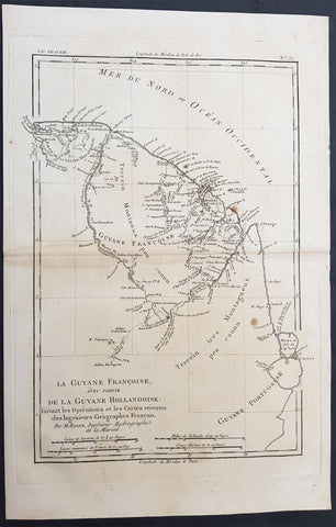
1780 Bonne Antique Map of French & Dutch Guyana, South America
- Title : La Guyane Francoise avec Partie De La Guyane Hollandoise... Par M. Bonne
- Ref #: 40849
- Size: 15in x 10in (385mm x 255mm)
- Date : 1780
- Condition: (A+) Fine Condition
Description:
This fine original antique map of French & Dutch Guyana, South America by Rigobert Bonne was published in the 1780 edition of Atlas des toutes les parties connues du globe terrestre by Guillaume Raynal. (Ref Tooley M&B)
General Description:
Paper thickness and quality: - Heavy and stable
Paper color: - White
Age of map color: -
Colors used: -
General color appearance: -
Paper size: - 15in x 10in (385mm x 255mm)
Plate size: - 13in x 9in (330mm x 230mm)
Margins: - Min 1in (25mm)
Imperfections:
Margins: - Light age toning
Plate area: - Light age toning
Verso: - Light age toning
Background:
In 1498 French Guiana was first visited by Europeans when Christopher Columbus sailed to the region on his third voyage and named it the \"Land of pariahs\".[citation needed] In 1608 the Grand Duchy of Tuscany did an expedition to the area in order to create an Italian colony for the commerce of Amazonian products to Renaissance Italy, but the sudden death of Ferdinando I de\' Medici, Grand Duke of Tuscany stopped it.
In 1624 France attempted to settle in the area, but was forced to abandon it in the face of hostility from the Portuguese, who viewed it as a violation of the Treaty of Tordesillas. However French settlers returned in 1630 and in 1643 managed to establish a settlement at Cayenne along with some small-scale plantations. This second attempt would again be abandoned following Amerindian attacks. In 1658 the Dutch West Indies Company seized French territory to establish the Dutch colony of Cayenne. The French returned once more in 1664, and founded a second settlement at Sinnamary (this was attacked by the Dutch in 1665).
In 1667 the English seized the area. Following the Treaty of Breda on 31 July 1667 the area was given back to France. The Dutch briefly occupied it for a period in 1676.
After the Treaty of Paris in 1763, which deprived France of almost all her possessions in the Americas other than Guiana and a few islands, Louis XV sent thousands of settlers to Guiana who were lured there with stories of plentiful gold and easy fortunes to be made. Instead they found a land filled with hostile natives and tropical diseases. One and a half years later only a few hundred survived. These fled to three small islands which could be seen off shore and named them the Iles de Salut (or \"Islands of Salvation\"). The largest was called Royal Island, another St. Joseph (after the patron saint of the expedition), and the smallest of the islands, surrounded by strong currents, Île du Diable (the infamous \"Devil\'s Island\"). When the survivors of this ill-fated expedition returned home, the terrible stories they told of the colony left a lasting impression in France.
In 1794, after the death of Robespierre, 193 of his followers were sent to French Guiana. In 1797 the republican general Pichegru and many deputies and journalists were also sent to the colony. When they arrived they found that only 54 of the 193 deportées sent out three years earlier were left; 11 had escaped, and the rest had died of tropical fevers and other diseases. Pichegru managed to escape to the United States and then returned to France where he was eventually executed for plotting against Napoleon.
Later on, slaves were brought out from Africa and plantations were established along the more disease-free rivers. Exports of sugar, hardwood, Cayenne pepper and other spices brought a certain prosperity to the colony for the first time. Cayenne, the capital, was surrounded by plantations, some of which had several thousand slaves.
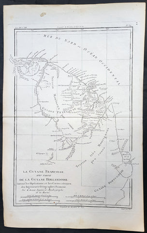
1780 Rigobert Bonne Antique Map Guyana, Suriname & French Guiana, South America
- Title : La Guyane Francoise avec Partie De La Guyane Hollandoise... Par M. Bonne
- Ref #: 31682
- Size: 15in x 10in (385mm x 255mm)
- Date : 1780
- Condition: (A+) Fine Condition
Description:
This fine original copper plate engraved antique map of Guyana, Suriname & French Guiana, South America by Rigobert Bonne was published in the 1780 edition of Atlas des toutes les parties connues du globe terrestre by Guillaume Raynal.
General Definitions:
Paper thickness and quality: - Heavy and stable
Paper color : - off white
Age of map color: -
Colors used: -
General color appearance: -
Paper size: - 15in x 10in (385mm x 255mm)
Plate size: - 13in x 9in (330mm x 230mm)
Margins: - Min 1/2in (12mm)
Imperfections:
Margins: - None
Plate area: - None
Verso: - None
Background:
Guyana officially the Co-operative Republic of Guyana, is a country on the northern mainland of South America. It is, however, often considered part of the Caribbean region because of its strong cultural, historical, and political ties with other Anglo-Caribbean countries and the Caribbean Community.
The region known as the Guianas consists of the large shield landmass north of the Amazon River and east of the Orinoco River known as the \"land of many waters. Originally inhabited by many indigenous groups, Guyana was settled by the Dutch before coming under British control in the late 18th century. It was governed as British Guiana, with a mostly plantation-style economy until the 1950s.
Suriname officially known as the Republic of Suriname is a country on the northeastern Atlantic coast of South America. It is bordered by the Atlantic Ocean to the north, French Guiana to the east, Guyana to the west and Brazil to the south.
Suriname was long inhabited by various indigenous people before being invaded and contested by European powers from the 16th century, eventually coming under Dutch rule in the late 17th century. During the Dutch colonial period, it was primarily a plantation economy dependent on African slaves and, following the abolition of slavery, indentured servants from Asia.
French Guiana is an overseas department and region of France, on the north Atlantic coast of South America in the Guyanas. It borders Brazil to the east and south and Suriname to the west.
Before European contact, the territory was originally inhabited by Native Americans, most speaking the Arawak language, of the Arawakan language family. The people identified as Lokono. The first French establishment is recorded in 1503, but France did not establish a durable presence until colonists founded Cayenne in 1643. Guiana was developed as a slave society, where planters imported Africans as enslaved laborers on large sugar and other plantations in such number as to increase the population. Slavery was abolished in the colonies at the time of the French Revolution. Guiana was designated as a French department in 1797. But, after France gave up its territory in North America, it developed Guiana as a penal colony, establishing a network of camps and penitentiaries along the coast where prisoners from metropolitan France were sentenced to forced labor.
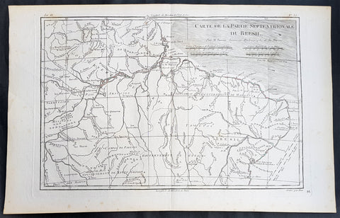
1780 Rigobert Bonne Antique Map of Northern Brazil, French Guiana, Amazon River
- Title : Carte De La Partie Septentrionale Du Bresil... Par M. Bonne
- Ref #: 31685
- Size: 16in x 10in (410mm x 255mm)
- Date : 1780
- Condition: (A+) Fine Condition
Description:
This fine original copper plate engraved antique map of Northern Brazil, French Guiana & The Amazon River by Rigobert Bonne was published in the 1780 edition of Atlas des toutes les parties connues du globe terrestre by Guillaume Raynal.
General Definitions:
Paper thickness and quality: - Heavy and stable
Paper color : - off white
Age of map color: -
Colors used: -
General color appearance: -
Paper size: - 16in x 10in (410mm x 255mm)
Plate size: - 13 1/2in x 9in (345mm x 230mm)
Margins: - Min 1/2in (12mm)
Imperfections:
Margins: - None
Plate area: - None
Verso: - None
Background:
Brazil is the largest country in both South America and Latin America. At 8.5 million square kilometers.
Brazil was inhabited by numerous tribal nations prior to the landing in 1500 of explorer Pedro Álvares Cabral, who claimed the area for the Portuguese Empire. Brazil remained a Portuguese colony until 1808, when the capital of the empire was transferred from Lisbon to Rio de Janeiro. In 1815, the colony was elevated to the rank of kingdom upon the formation of the United Kingdom of Portugal, Brazil and the Algarves. Independence was achieved in 1822 with the creation of the Empire of Brazil, a unitary state governed under a constitutional monarchy and a parliamentary system. The ratification of the first constitution in 1824 led to the formation of a bicameral legislature, now called the National Congress. The country became a presidential republic in 1889 following a military coup d état.
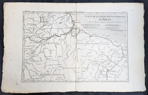
1780 Rigobert Bonne Antique Map of Northern Brazil, French Guiana, Amazon River
- Title : Carte De La Partie Septentrionale Du Bresil... Par M. Bonne
- Ref #: 40850
- Size: 17in x 11in (435mm x 280mm)
- Date : 1780
- Condition: (A+) Fine Condition
Description:
This fine original copper plate engraved antique map of Northern Brazil, French Guiana & The Amazon River by Rigobert Bonne was published in the 1780 edition of Atlas des toutes les parties connues du globe terrestre by Guillaume Raynal.
General Definitions:
Paper thickness and quality: - Heavy and stable
Paper color : - off white
Age of map color: -
Colors used: -
General color appearance: -
Paper size: - 17in x 11in (435mm x 280mm)
Plate size: - 13 1/2in x 9in (345mm x 230mm)
Margins: - Min 1/2in (12mm)
Imperfections:
Margins: - None
Plate area: - None
Verso: - None
Background:
Brazil is the largest country in both South America and Latin America. At 8.5 million square kilometers.
Brazil was inhabited by numerous tribal nations prior to the landing in 1500 of explorer Pedro Álvares Cabral, who claimed the area for the Portuguese Empire. Brazil remained a Portuguese colony until 1808, when the capital of the empire was transferred from Lisbon to Rio de Janeiro. In 1815, the colony was elevated to the rank of kingdom upon the formation of the United Kingdom of Portugal, Brazil and the Algarves. Independence was achieved in 1822 with the creation of the Empire of Brazil, a unitary state governed under a constitutional monarchy and a parliamentary system. The ratification of the first constitution in 1824 led to the formation of a bicameral legislature, now called the National Congress. The country became a presidential republic in 1889 following a military coup d état.