Products
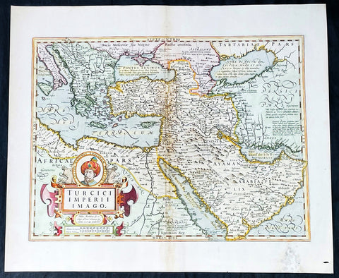
1628 Henricus Hondius Antique Map Ottoman Empire Saudi Arabia to Southern Europe
Antique Map
- Title : Turcici Imperii Imago
- Date : 1628
- Size: 22 1/2in x 18 1/2in (570mm x 470mm)
- Condition: (A-) Good Condition
- Ref: 35642
Description:
This beautifully engraved hand coloured original antique map of The Ottoman Empire in the mid 17th century from Saudi Arabia to southern Europe was published in the 1628 French edition of Mercator's atlas by Jan Jansson and Henricus Hondius.
These maps, published in the later editions of Mercators atlas, are derived from the original maps drawn and engraved by Gerald Mercator in the mid to late 16th century, published by his son Rumold as an atlas, after his death, in 1595. After two editions the plates were purchased by Jodocus Hondius in 1604 and continued to be published until the mid 1630's when the plates were re-engraved and updated by Jan Jansson and Henricus Hondius.
General Definitions:
Paper thickness and quality: - Heavy and stable
Paper color : - off white
Age of map color: - Original & later
Colors used: - Yellow, green, pink
General color appearance: - Authentic
Paper size: - 22 3/4in x 19 3/4in (580mm x 500mm)
Plate size: - 20in x 13 3/4in (500mm x 350mm)
Margins: - Min 1in (25mm)
Imperfections:
Margins: - Light soiling, small wormhole, light creasing
Plate area: - Small loss and creasing along centerfold
Verso: - Light soiling and creasing
Background:
The Ottoman Empire also historically known in Western Europe as the Turkish Empire or simply Turkey, was a state that controlled much of Southeast Europe, Western Asia and North Africa between the 14th and early 20th centuries. It was founded at the end of the 13th century in northwestern Anatolia in the town of Söğüt (modern-day Bilecik Province) by the Oghuz Turkish tribal leader Osman I. After 1354, the Ottomans crossed into Europe, and with the conquest of the Balkans, the Ottoman beylik was transformed into a transcontinental empire. The Ottomans ended the Byzantine Empire with the 1453 conquest of Constantinople by Mehmed the Conqueror.
During the 16th and 17th centuries, at the height of its power under the reign of Suleiman the Magnificent, the Ottoman Empire was a multinational, multilingual empire controlling most of Southeast Europe, parts of Central Europe, Western Asia, parts of Eastern Europe and the Caucasus, North Africa and the Horn of Africa. At the beginning of the 17th century, the empire contained 32 provinces and numerous vassal states. Some of these were later absorbed into the Ottoman Empire, while others were granted various types of autonomy during the course of centuries.
With Constantinople as its capital and control of lands around the Mediterranean basin, the Ottoman Empire was at the centre of interactions between the Eastern and Western worlds for six centuries. While the empire was once thought to have entered a period of decline following the death of Suleiman the Magnificent, this view is no longer supported by the majority of academic historians. The empire continued to maintain a flexible and strong economy, society and military throughout the 17th and much of the 18th century. However, during a long period of peace from 1740 to 1768, the Ottoman military system fell behind that of their European rivals, the Habsburg and Russian empires. The Ottomans consequently suffered severe military defeats in the late 18th and early 19th centuries, which prompted them to initiate a comprehensive process of reform and modernisation known as the Tanzimat. Thus, over the course of the 19th century, the Ottoman state became vastly more powerful and organised, despite suffering further territorial losses, especially in the Balkans, where a number of new states emerged. The empire allied with Germany in the early 20th century, hoping to escape from the diplomatic isolation which had contributed to its recent territorial losses, and thus joined World War I on the side of the Central Powers. While the Empire was able to largely hold its own during the conflict, it was struggling with internal dissent, especially with the Arab Revolt in its Arabian holdings. During this time, atrocities were committed by the Ottoman government against the Armenians, Assyrians and Pontic Greeks.
The Empire\'s defeat and the occupation of part of its territory by the Allied Powers in the aftermath of World War I resulted in its partitioning and the loss of its Middle Eastern territories, which were divided between the United Kingdom and France. The successful Turkish War of Independence against the occupying Allies led to the emergence of the Republic of Turkey in the Anatolian heartland and the abolition of the Ottoman monarchy.
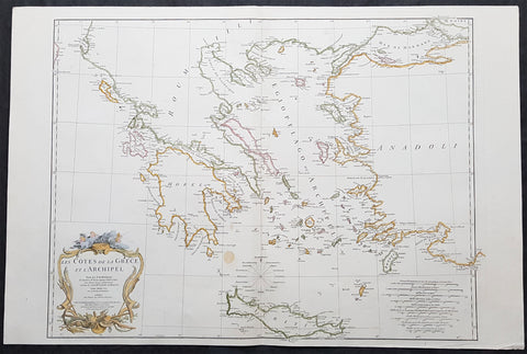
1756 J B D Anville Large Antique Map Greece, Crete, Corfu, Aegean Isles Turkey
- Title : Les Cotes De La Grece et L Archipel...MDCCLVI
- Size: 34in x 23in (865m x 585mm)
- Condition: (A) Very Good Condition
- Date : 1756
- Ref #: 21996
Description:
This large original copper-plate engraved antique map of Greece, Crete & the Greek Islands by Jean Baptiste Bourguignon D\'Anville was engraved in 1756 - dated in the tile cartouche - and was published in Jean-Baptiste Bourguinon D\'Anvilles large elephant folio atlas Atlas Generale. (Ref: Tooley, M&B)
General Definitions:
Paper thickness and quality: - Heavy and stable
Paper color : - off white
Age of map color: - Early
Colors used: - Yellow, pink, green, blue
General color appearance: - Authentic
Paper size: - 34in x 23in (865m x 585mm)
Plate size: - 29in x 22in (735mm x 560mm)
Margins: - Min 1/2in (12mm)
Imperfections:
Margins: - None
Plate area: - None
Verso: - None
Background:
While most of mainland Greece and the Aegean islands was under Ottoman control by the end of the 15th century, Cyprus and Crete remained Venetian territory and did not fall to the Ottomans until 1571 and 1670 respectively. The only part of the Greek-speaking world that escaped long-term Ottoman rule was the Ionian Islands, which remained Venetian until their capture by the First French Republic in 1797, then passed to the United Kingdom in 1809 until their unification with Greece in 1864.
While some Greeks in the Ionian Islands and Constantinople lived in prosperity, and Greeks of Constantinople (Phanariotes) achieved positions of power within the Ottoman administration, much of the population of mainland Greece suffered the economic consequences of the Ottoman conquest. Heavy taxes were enforced, and in later years the Ottoman Empire enacted a policy of creation of hereditary estates, effectively turning the rural Greek populations into serfs.
The Greek Orthodox Church and the Ecumenical Patriarchate of Constantinople were considered by the Ottoman governments as the ruling authorities of the entire Orthodox Christian population of the Ottoman Empire, whether ethnically Greek or not. Although the Ottoman state did not force non-Muslims to convert to Islam, Christians faced several types of discrimination intended to highlight their inferior status in the Ottoman Empire. Discrimination against Christians, particularly when combined with harsh treatment by local Ottoman authorities, led to conversions to Islam, if only superficially. In the 19th century, many crypto-Christians returned to their old religious allegiance.
The nature of Ottoman administration of Greece varied, though it was invariably arbitrary and often harsh. Some cities had governors appointed by the Sultan, while others (like Athens) were self-governed municipalities. Mountainous regions in the interior and many islands remained effectively autonomous from the central Ottoman state for many centuries.
When military conflicts broke out between the Ottoman Empire and other states, Greeks usually took up arms against the Ottomans, with few exceptions. Prior to the Greek Revolution of 1821, there had been a number of wars which saw Greeks fight against the Ottomans, such as the Greek participation in the Battle of Lepanto in 1571, the Epirus peasants\' revolts of 1600–1601 (led by the Orthodox bishop Dionysios Skylosophos), the Morean War of 1684–1699, and the Russian-instigated Orlov Revolt in 1770, which aimed at breaking up the Ottoman Empire in favor of Russian interests.[89][page needed] These uprisings were put down by the Ottomans with great bloodshed. On the other side, many Greeks were conscripted as Ottoman citizens to serve in the Ottoman army (and especially the Ottoman navy), while also the Ecumenical Patriarchate of Constantinople, responsible for the Orthodox, remained in general loyal to the empire.
The 16th and 17th centuries are regarded as something of a dark age in Greek history, with the prospect of overthrowing Ottoman rule appearing remote with only the Ionian islands remaining free of Turkish domination. Corfu withstood three major sieges in 1537, 1571 and 1716 all of which resulted in the repulsion of the Ottomans. However, in the 18th century, due to their mastery of shipping and commerce, a wealthy and dispersed Greek merchant class arose. These merchants came to dominate trade within the Ottoman Empire, establishing communities throughout the Mediterranean, the Balkans, and Western Europe. Though the Ottoman conquest had cut Greece off from significant European intellectual movements such as the Reformation and the Enlightenment, these ideas together with the ideals of the French Revolution and romantic nationalism began to penetrate the Greek world via the mercantile diaspora. In the late 18th century, Rigas Feraios, the first revolutionary to envision an independent Greek state, published a series of documents relating to Greek independence, including but not limited to a national anthem and the first detailed map of Greece, in Vienna, and was murdered by Ottoman agents in 1798.
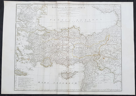
1764 J B D Anville Large Antique Map of Turkey, Cyprus, Syria, Black Sea
Antique Map
- Title : Asiae que Vulgo Minor Dicitur et Syria...Auctor D Anville...MDCCLXIV
- Ref : 92299
- Size: 30in x 21in (760mm x 535mm)
- Date : 1764
- Condition: (A) Very Good Condition
Description:
This large original copper plate engraved antique map of Turkey, Cyprus & Syria was engraved in 1764 - dated in the tile cartouche - and was published in Jean-Baptiste Bourguinon D Anvilles large elephant folio atlas Atlas Generale.
General Definitions:
Paper thickness and quality: - Heavy and stable
Paper color : - off white
Age of map color: - Original
Colors used: - Yellow, Green, pink
General color appearance: - Authentic
Paper size: - 30in x 21in (760mm x 535mm)
Plate size: - 25in x 20in (635mm x 515mm)
Margins: - Min 1/2in (12mm)
Imperfections:
Margins: - Creasing
Plate area: - Creasing
Verso: - Creasing
Background:
The Ottoman Empire also historically known in Western Europe as the Turkish Empire or simply Turkey, was a state that controlled much of Southeast Europe, Western Asia and North Africa between the 14th and early 20th centuries. It was founded at the end of the 13th century in northwestern Anatolia in the town of Söğüt (modern-day Bilecik Province) by the Oghuz Turkish tribal leader Osman I. After 1354, the Ottomans crossed into Europe, and with the conquest of the Balkans, the Ottoman beylik was transformed into a transcontinental empire. The Ottomans ended the Byzantine Empire with the 1453 conquest of Constantinople by Mehmed the Conqueror.
During the 16th and 17th centuries, at the height of its power under the reign of Suleiman the Magnificent, the Ottoman Empire was a multinational, multilingual empire controlling most of Southeast Europe, parts of Central Europe, Western Asia, parts of Eastern Europe and the Caucasus, North Africa and the Horn of Africa. At the beginning of the 17th century, the empire contained 32 provinces and numerous vassal states. Some of these were later absorbed into the Ottoman Empire, while others were granted various types of autonomy during the course of centuries.
With Constantinople as its capital and control of lands around the Mediterranean basin, the Ottoman Empire was at the centre of interactions between the Eastern and Western worlds for six centuries. While the empire was once thought to have entered a period of decline following the death of Suleiman the Magnificent, this view is no longer supported by the majority of academic historians. The empire continued to maintain a flexible and strong economy, society and military throughout the 17th and much of the 18th century. However, during a long period of peace from 1740 to 1768, the Ottoman military system fell behind that of their European rivals, the Habsburg and Russian empires. The Ottomans consequently suffered severe military defeats in the late 18th and early 19th centuries, which prompted them to initiate a comprehensive process of reform and modernisation known as the Tanzimat. Thus, over the course of the 19th century, the Ottoman state became vastly more powerful and organised, despite suffering further territorial losses, especially in the Balkans, where a number of new states emerged. The empire allied with Germany in the early 20th century, hoping to escape from the diplomatic isolation which had contributed to its recent territorial losses, and thus joined World War I on the side of the Central Powers. While the Empire was able to largely hold its own during the conflict, it was struggling with internal dissent, especially with the Arab Revolt in its Arabian holdings. During this time, atrocities were committed by the Ottoman government against the Armenians, Assyrians and Pontic Greeks.
The Empire\\\'s defeat and the occupation of part of its territory by the Allied Powers in the aftermath of World War I resulted in its partitioning and the loss of its Middle Eastern territories, which were divided between the United Kingdom and France. The successful Turkish War of Independence against the occupying Allies led to the emergence of the Republic of Turkey in the Anatolian heartland and the abolition of the Ottoman monarchy.

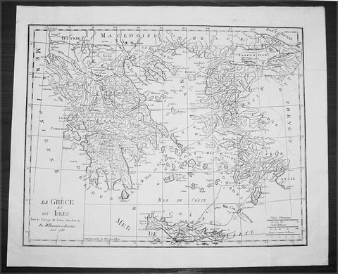
1769 J B D Anville Original Antique Map of Greece Crete Macedonia Turkey Cyprus
- Title : Carte Generale De La Grece
- Size: 16in x 11in (410mm x 260mm)
- Ref #: 32345
- Date : 1769
- Condition: (A+) Fine Condition
Description:
This fine large, original copper-plate engraved antique map was published by Jean Baptiste Bourguignon D\'Anville in the 1769 edition of his atlas Geographie Ancienne et Abregee. or Modern and Ancient Geography (Ref: M&B; Tooley)
General Definitions:
Paper thickness and quality: - Heavy and stable
Paper color : - off white
Age of map color: -
Colors used: -
General color appearance: -
Paper size: - 16in x 11in (410mm x 260mm)
Plate size: - 13in x 9 1/2in (330mm x 245mm)
Margins: - Min 1/2in (12mm)
Imperfections:
Margins: - None
Plate area: - None
Verso: - None
1788 Du Bocage Large Antique Map of Greece, Aegean, Western Turkey & Crete
- Title : La Grece et Ses Isles Pour le Voyage du Jeune Aanacharis Par M Barbier Du Bocage Aout 1788
- Date : 1788
- Condition: (A+) Fine Condition
- Ref: 16471
- Size: 19 1/4in x 16in (490mm x 410mm)
Description:
This fine large original antique map of Greece, The Aegean Islands and the West Coast of Turkey & Crete illustrating the Voyages of the Anacharsis the Younger was engraved in 1788 - dated - and was published by Jean Denis Barbie du Bocage in his Voyage Anacharsis (The Travels of Anacharsis the Younger in Greece) published between 1781 - 1788.
Voyage Anacharsis is an illustrative account of the travels of Anacharsis the Younger in Greece, during the middle of the fourth century before the Christian era.
Jean Denis Barbie du Bocage: (1760-1825) was a French geographer and cosmographer who studied under D' Anville and became one of the founders of the Geography Society of Paris. (Ref: Tooley; M&B)
General Description:
Paper thickness and quality: - Heavy & stable
Paper color: - White
Age of map color: -
Colors used: - General color appearance: -
Paper size: - 19 1/4in x 16in (490mm x 410mm)
Plate size: - 18 1/2in x 14 1/2in (470mm x 370mm)
Margins: - Min 1in (25mm)
Imperfections:
Margins: - None
Plate area: - Folds as issued
Verso: - None
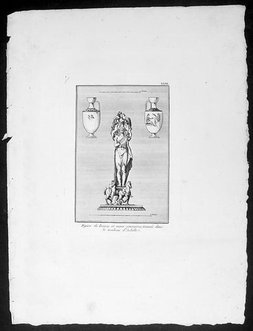
1802 J B Lechevalier Antique Print Bronze Figure, Vases in Achilles Tomb Turkey
- Title : Figure de bronze et vases cineraires, trouves dans le tombeau d Achille
- Date : 1802
- Condition: (A+) Fine Condition
- Ref: 70228
- Size: 14in x 10in (355mm x 255mm)
Description:
This original copper-plate engraved antique print of a Bronze Figure and a pair of Vases found in the Tomb of Achilles located in the ancient Greek city of Achilleion in the Troad region of Çanakkale, now in NW modern Turkey, was published in the 1802 edition of Jean-Baptiste Lechevaliers of Voyage de la Troade, fait dans les années 1785 et 1786
General Definitions:
Paper thickness and quality: - Heavy and stable
Paper color : - off white
Age of map color: -
Colors used: -
General color appearance: -
Paper size: - 14in x 10in (355mm x 255mm)
Plate size: - 7in x 5in (180mm x 130mm) each plate
Margins: - Min 1/2in (12mm)
Imperfections:
Margins: - Light soiling
Plate area: - None
Verso: - None
Background:
Achilleion was an ancient Greek city in the south-west of the Troad region of Anatolia. It has been located on a promontory known as Beşika Burnu (cradle promontory) about 8 km south of Sigeion. Beşika Burnu is 2 km south of the modern village of Yeniköy in the Ezine district of Çanakkale Province, Turkey. The site considered in classical antiquity to be the tomb of Achilles is a short distance inland at a tumulus known as Beşiktepe. Achilleion in the Troad is not to be confused with Achilleion near Smyrna and Achilleion in the territory of Tanagra.
The otherwise obscure polis of Achilleion was most famous in classical antiquity for its association with Achilles, after whom it was named (the place of Achilles). According to some sources, while passing by Ilion in 334 BC Alexander the Great sacrificed at the Tomb of Achilles. This story became famous, and in the mid-1st century BC it is mentioned by the politician and writer Cicero in his Pro Archia Poeta. In AD 216 the Emperor Caracalla emulated Alexander when, on passing Ilion on his way to a war against Parthia, he held funeral games around the tumulus. Following the abandonment of the settlement at Achilleion in the late Hellenistic period, writers began to associate the tomb with nearby Sigeion to the north.
The first mention of Achilleion is as a fortified settlement from which Mytilene conducted its attacks on Athenian controlled Sigeion to the north in the early 6th century BCE. It is not clear whether Achilleion had been settled earlier, but the ceramic record also begins at this point, suggesting that it had not. Recent excavations have established that the walls of the settlement also date to the first half of the 6th century BCE, further corroborating the literary accounts of Herodotus and Strabo regarding its origins. Achilleion remained under Mytilenaean control until Athens brought an end to the Mytilenaean revolt in 427 BCE and took over all the so-called Actaean cities in the Troad. Achilleion appears in the Athenian tribute lists for 425/4 and 422/1 BCE, indicating that it had joined the Delian League. The legend AX (ACH) which some bronze coins found in this region bear is thought to refer to Ach (illeion) and suggest that c. 350 - 300 BCE the city minted its own coins. King Lysimachus synoecized Ilion with many surrounding communities including Achilleion during his reign (306 - 281 BCE), effectively ending Achilleions political independence. The testimony of Demetrius of Scepsis, who hailed from a nearby town in the Troad, indicates that there was still a hamlet known as Achilleion on the site in the mid-2nd century BCE. It is to around this time that the latest ceramic finds from Achilleion date, suggesting that the site became uninhabited soon afterwards.
Jean-Baptiste Lechevalier was the secretary of the Ambassador of France in Constantinople. In the year 1788 he visited the plain of Troy, and was enthusiastically in favour of the theory that the site of Homers Troy was to be found at the village of Bunarbashi. His publication about Troy Voyage de la Troade.....was first published in 1799.
The Troad, also known as Troas, is the historical name of the Biga peninsula (Biga Yarımadası, Τρωάς) in the northwestern part of Anatolia, Turkey. This region now is part of the Çanakkale province of Turkey. Bounded by the Dardanelles to the northwest, by the Aegean Sea to the west and separated from the rest of Anatolia by the massif that forms Mount Ida, the Troad is drained by two main rivers, the Scamander (Karamenderes) and the Simois, which join at the area containing the ruins of Troy. Grenikos, Kebren, Simoeis, Rhesos, Rhodios, Heptaporos and Aisepos were seven rivers of the Troad and the names of the river gods that inhabited each river.
Troy (Ancient Greek: Τροία, Troia or Τροίας, Troias, Truva or Troya) was a city in the far northwest of the region known in late Classical antiquity as Asia Minor, now known as Anatolia in modern Turkey, just south of the southwest mouth of the Dardanelles strait and northwest of Mount Ida. The present-day location is known as Hisarlik. It was the setting of the Trojan War described in the Greek Epic Cycle, in particular in the Iliad, one of the two epic poems attributed to Homer. Metrical evidence from the Iliad and the Odyssey suggests that the name λιον (Ilion) formerly began with a digamma: Ϝίλιον (Wilion); this is also supported by the Hittite name for what is thought to be the same city, Wilusa.
A new capital called Ilium (from Greek: λιον, Ilion) was founded on the site in the reign of the Roman Emperor Augustus. It flourished until the establishment of Constantinople, became a bishopric and declined gradually in the Byzantine era, but is now a Latin Catholic titular see.
In 1865, English archaeologist Frank Calvert excavated trial trenches in a field he had bought from a local farmer at Hisarlik, and in 1868, Heinrich Schliemann, a wealthy German businessman and archaeologist, also began excavating in the area after a chance meeting with Calvert in Çanakkale. These excavations revealed several cities built in succession. Schliemann was at first skeptical about the identification of Hisarlik with Troy, but was persuaded by Calvert and took over Calverts excavations on the eastern half of the Hisarlik site, which was on Calvert\'s property. Troy VII has been identified with the city called Wilusa by the Hittites (the probable origin of the Greek λιον) and is generally (but not conclusively) identified with Homeric Troy.
Today, the hill at Hisarlik has given its name to a small village near the ruins, which supports the tourist trade visiting the Troia archaeological site. It lies within the province of Çanakkale, some 30 km south-west of the provincial capital, also called Çanakkale. The nearest village is Tevfikiye. The map here shows the adapted Scamander estuary with Ilium a little way inland across the Homeric plain. Due to Troys location near the Aegean Sea, the Sea of Marmara, and the Black Sea, it was a central hub for the military and trade(Ref: M&B; Tooley)
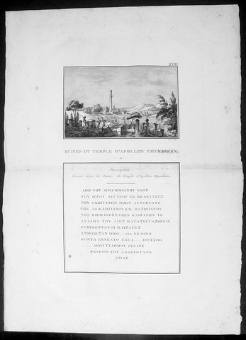
1802 J B Lechevalier Antique Print Temple Apollo Ruins Gülpınar Çanakkale Turkey
- Title : Ruines Du Temple D Apollon Thymbreen; Inscription Trouvee dans les Ruines du Temple d Apollon
- Date : 1802
- Condition: (A+) Fine Condition
- Ref: 70222
- Size: 19 1/4in x 14in (495mm x 355mm)
Description:
This original copper-plate engraved antique print view of the ruins of the Temple of Apollo in the ancient city of Hamaxitus in the Troad region of NW Turkey - with Greek inscription from the temple - was published in the 1802 edition of Jean-Baptiste Lechevaliers of Voyage de la Troade, fait dans les années 1785 et 1786
General Definitions:
Paper thickness and quality: - Heavy and stable
Paper color : - off white
Age of map color: -
Colors used: -
General color appearance: -
Paper size: - 20in x 14in (510mm x 360mm)
Plate size: - 15in x 9 1/2in (380mm x 240mm)
Margins: - Min 1/2in (12mm)
Imperfections:
Margins: - Light soiling
Plate area: - Light toning along centerfold
Verso: - Light soiling
Background:
Hamaxitus was an ancient Greek city in the south-west of the Troad region of Anatolia which was considered to mark the boundary between the Troad and Aeolis. Its surrounding territory was known in Greek as Ἁμαξιτία (Hamaxitia) and included the temple of Apollo Smintheus, the salt pans at Tragasai, and the Satnioeis river (modern Tuzla Çay). It has been located on a rise called Beşiktepe near the village of Gülpınar (previously Külahlı) in the Ayvacık district of Çanakkale Province, Turkey
Jean-Baptiste Lechevalier was the secretary of the Ambassador of France in Constantinople. In the year 1788 he visited the plain of Troy, and was enthusiastically in favour of the theory that the site of Homers Troy was to be found at the village of Bunarbashi. His publication about Troy Voyage de la Troade.....was first published in 1799.
The Troad, also known as Troas, is the historical name of the Biga peninsula (Biga Yarımadası, Τρωάς) in the northwestern part of Anatolia, Turkey. This region now is part of the Çanakkale province of Turkey. Bounded by the Dardanelles to the northwest, by the Aegean Sea to the west and separated from the rest of Anatolia by the massif that forms Mount Ida, the Troad is drained by two main rivers, the Scamander (Karamenderes) and the Simois, which join at the area containing the ruins of Troy. Grenikos, Kebren, Simoeis, Rhesos, Rhodios, Heptaporos and Aisepos were seven rivers of the Troad and the names of the river gods that inhabited each river.
Troy (Ancient Greek: Τροία, Troia or Τροίας, Troias, Truva or Troya) was a city in the far northwest of the region known in late Classical antiquity as Asia Minor, now known as Anatolia in modern Turkey, just south of the southwest mouth of the Dardanelles strait and northwest of Mount Ida. The present-day location is known as Hisarlik. It was the setting of the Trojan War described in the Greek Epic Cycle, in particular in the Iliad, one of the two epic poems attributed to Homer. Metrical evidence from the Iliad and the Odyssey suggests that the name λιον (Ilion) formerly began with a digamma: Ϝίλιον (Wilion); this is also supported by the Hittite name for what is thought to be the same city, Wilusa.
A new capital called Ilium (from Greek: λιον, Ilion) was founded on the site in the reign of the Roman Emperor Augustus. It flourished until the establishment of Constantinople, became a bishopric and declined gradually in the Byzantine era, but is now a Latin Catholic titular see.
In 1865, English archaeologist Frank Calvert excavated trial trenches in a field he had bought from a local farmer at Hisarlik, and in 1868, Heinrich Schliemann, a wealthy German businessman and archaeologist, also began excavating in the area after a chance meeting with Calvert in Çanakkale. These excavations revealed several cities built in succession. Schliemann was at first skeptical about the identification of Hisarlik with Troy, but was persuaded by Calvert and took over Calverts excavations on the eastern half of the Hisarlik site, which was on Calvert\'s property. Troy VII has been identified with the city called Wilusa by the Hittites (the probable origin of the Greek λιον) and is generally (but not conclusively) identified with Homeric Troy.
Today, the hill at Hisarlik has given its name to a small village near the ruins, which supports the tourist trade visiting the Troia archaeological site. It lies within the province of Çanakkale, some 30 km south-west of the provincial capital, also called Çanakkale. The nearest village is Tevfikiye. The map here shows the adapted Scamander estuary with Ilium a little way inland across the Homeric plain. Due to Troys location near the Aegean Sea, the Sea of Marmara, and the Black Sea, it was a central hub for the military and trade(Ref: M&B; Tooley)
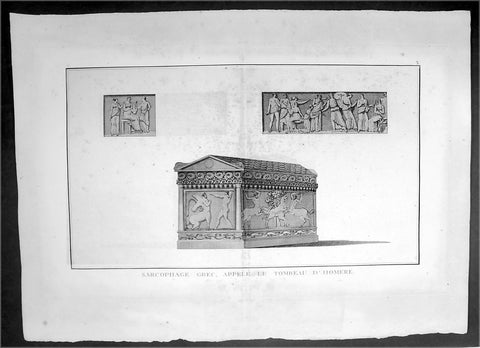
1802 J B Lechevalier Antique Print The Sarcophagus of the Greek Author, Homer
- Title : Sarcophage Grec, Appele Le Tombeau D Homere
- Date : 1802
- Condition: (A) Very Good Condition
- Ref: 70216
- Size: 19 1/4in x 14in (495mm x 355mm)
Description:
This original copper-plate engraved antique print of a Greek Sarcophagus, believe to be that of the ancient Greek Philosopher Homer, was published in the 1802 edition of Jean-Baptiste Lechevaliers of Voyage de la Troade, fait dans les années 1785 et 1786
General Definitions:
Paper thickness and quality: - Heavy and stable
Paper color : - off white
Age of map color: -
Colors used: -
General color appearance: -
Paper size: - 20in x 14in (510mm x 360mm)
Plate size: - 17 1/2in x 10 3/4in (445mm x 275mm)
Margins: - Min 1/2in (12mm)
Imperfections:
Margins: - Light soiling
Plate area: - Light toning along centerfold
Verso: - Light soiling
Background:
Homer is the legendary author of the Iliad and the Odyssey, two epic poems that are the central works of ancient Greek literature. The Iliad is set during the Trojan War, the ten-year siege of the city of Troy by a coalition of Greek kingdoms. It focuses on a quarrel between King Agamemnon and the warrior Achilles lasting a few weeks during the last year of the war. The Odyssey focuses on the journey home of Odysseus, king of Ithaca, around 20 years after the fall of Troy. Many accounts of Homer\'s life circulated in classical antiquity, the most widespread being that he was a blind bard from Ionia, a region of central coastal Anatolia in present-day Turkey. Modern scholars consider them legends.
The Homeric Question—concerning by whom, when, where and under what circumstances the Iliad and Odyssey were composed—continues to be debated. Broadly speaking, modern scholarly opinion falls into two groups. One holds that most of the Iliad and (according to some) the Odyssey are the works of a single poet of genius. The other considers the Homeric poems to be the result of a process of working and reworking by many contributors, and that Homer is best seen as a label for an entire tradition. It is generally accepted that the poems were composed at some point around the late eighth or early seventh century BC.
The poems are in Homeric Greek, also known as Epic Greek, a literary language which shows a mixture of features of the Ionic and Aeolic dialects from different centuries; the predominant influence is Eastern Ionic. Most researchers believe that the poems were originally transmitted orally. From antiquity until the present day, the influence of the Homeric epics on Western civilization has been great, inspiring many of its most famous works of literature, music, art and film. The Homeric epics were the greatest influence on ancient Greek culture and education; to Plato, Homer was simply the one who has taught Greece – ten Hellada pepaideuken
Jean-Baptiste Lechevalier was the secretary of the Ambassador of France in Constantinople. In the year 1788 he visited the plain of Troy, and was enthusiastically in favour of the theory that the site of Homers Troy was to be found at the village of Bunarbashi. His publication about Troy Voyage de la Troade.....was first published in 1799.
The Troad, also known as Troas, is the historical name of the Biga peninsula (Biga Yarımadası, Τρωάς) in the northwestern part of Anatolia, Turkey. This region now is part of the Çanakkale province of Turkey. Bounded by the Dardanelles to the northwest, by the Aegean Sea to the west and separated from the rest of Anatolia by the massif that forms Mount Ida, the Troad is drained by two main rivers, the Scamander (Karamenderes) and the Simois, which join at the area containing the ruins of Troy. Grenikos, Kebren, Simoeis, Rhesos, Rhodios, Heptaporos and Aisepos were seven rivers of the Troad and the names of the river gods that inhabited each river.
Troy (Ancient Greek: Τροία, Troia or Τροίας, Troias, Truva or Troya) was a city in the far northwest of the region known in late Classical antiquity as Asia Minor, now known as Anatolia in modern Turkey, just south of the southwest mouth of the Dardanelles strait and northwest of Mount Ida. The present-day location is known as Hisarlik. It was the setting of the Trojan War described in the Greek Epic Cycle, in particular in the Iliad, one of the two epic poems attributed to Homer. Metrical evidence from the Iliad and the Odyssey suggests that the name λιον (Ilion) formerly began with a digamma: Ϝίλιον (Wilion); this is also supported by the Hittite name for what is thought to be the same city, Wilusa.
A new capital called Ilium (from Greek: λιον, Ilion) was founded on the site in the reign of the Roman Emperor Augustus. It flourished until the establishment of Constantinople, became a bishopric and declined gradually in the Byzantine era, but is now a Latin Catholic titular see.
In 1865, English archaeologist Frank Calvert excavated trial trenches in a field he had bought from a local farmer at Hisarlik, and in 1868, Heinrich Schliemann, a wealthy German businessman and archaeologist, also began excavating in the area after a chance meeting with Calvert in Çanakkale. These excavations revealed several cities built in succession. Schliemann was at first skeptical about the identification of Hisarlik with Troy, but was persuaded by Calvert and took over Calverts excavations on the eastern half of the Hisarlik site, which was on Calvert\'s property. Troy VII has been identified with the city called Wilusa by the Hittites (the probable origin of the Greek λιον) and is generally (but not conclusively) identified with Homeric Troy.
Today, the hill at Hisarlik has given its name to a small village near the ruins, which supports the tourist trade visiting the Troia archaeological site. It lies within the province of Çanakkale, some 30 km south-west of the provincial capital, also called Çanakkale. The nearest village is Tevfikiye. The map here shows the adapted Scamander estuary with Ilium a little way inland across the Homeric plain. Due to Troys location near the Aegean Sea, the Sea of Marmara, and the Black Sea, it was a central hub for the military and trade(Ref: M&B; Tooley)
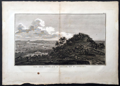
1802 J B Lechevalier Antique Print Tomb of Hector, Ophryneion in Troad, Turkey
- Title : Vue Des Tombeaux D Hector et D Aisyetes
- Date : 1802
- Size: 19 1/2in x 13 1/2in (495mm x 345mm)
- Ref: 70226
- Condition: (A+) Fine Condition
Description:
This original copper-plate engraved antique print a view of the Tombs of Hector & Aesyetes located in the ancient Greek city of Ophryneion in the Troad region of Çanakkale, now in NW modern Turkey, was published in the 1802 edition of Jean-Baptiste Lechevaliers of Voyage de la Troade, fait dans les années 1785 et 1786
General Definitions:
Paper thickness and quality: - Heavy and stable
Paper color : - off white
Age of map color: -
Colors used: -
General color appearance: -
Paper size: - 19 1/2in x 13 1/2in (495mm x 345mm)
Plate size: - 17 1/2in x 10 3/4in (445mm x 275mm)
Margins: - Min 1/2in (12mm)
Imperfections:
Margins: - Light soiling
Plate area: - Light toning along centerfold
Verso: - Light soiling
Background:
Ophryneion was an ancient Greek city in the northern Troad region of Anatolia. Its territory was bounded to the west by Rhoiteion and to the east by Dardanos. It was located about 1.5 km north-east of the village of İntepe (previously known as Erenköy) in Çanakkale Province, Turkey. The city was situated on the steep brow of a hill overlooking the Dardanelles, hence the origin of its Ancient Greek name ὀφρῦς (ophrus), meaning \'brow of a hill\', crag
In Greek mythology, Aesyetes was a Trojan hero and father of Alcathous. His tomb was the vantage point which Polites, son of Priam, used to scout the Greek camp during the Trojan War.
Aesyetes was also given as the father of Antenor by Cleomestra.
In Greek mythology and Roman mythology, Hector was a Trojan prince and the greatest fighter for Troy in the Trojan War. As the first-born son of King Priam and Queen Hecuba, who was a descendant of Dardanus and Tros, the founder of Troy, he was a prince of the royal house and the heir apparent to his fathers throne. He was married to Andromache, with whom he had an infant son, Scamandrius (whom the people of Troy called Astyanax). He acted as leader of the Trojans and their allies in the defence of Troy, killing 31,000 Greek fighters, offers Hyginus. During the European Middle Ages, Hector figures as one of the Nine Worthies noted by Jacques de Longuyon, known not only for his courage but also for his noble and courtly nature. Indeed, Homer places Hector as peace-loving, thoughtful as well as bold, a good son, husband and father, and without darker motives. James Redfield describes Hector as a martyr to loyalties, a witness to the things of this world, a hero ready to die for the precious imperfections of ordinary life.
The most valuable historical evidence for the Battle of Troy are treaties and letters mentioned in Hittite cuneiform texts of the same approximate era, which mention an unruly Western Anatolian warlord named Piyama-Radu (possibly Priam) and his successor Alaksandu (possibly Alexander, the nickname of Paris) both based in Wilusa (possibly Ilion/Ilios), as well as the god Apaliunas (possibly Apollo).
Other such pieces of evidence are names of Trojan heroes in Linear B tablets. Twenty out of fifty-eight men\'s names also known from Homer, including E-ko-to (Hector) are Trojan warriors and some, including Hector, are in a servile capacity. No such conclusion that they are the offspring of Trojan captive women is warranted. Generally the public has to be content with the knowledge that these names existed in Greek in Mycenaean times, although Page hypothesizes that Hector may very well be ... a familiar Greek form impressed on a similar-sounding foreign name.
When Pausanias visited Thebes in Boeotia, in the second century AD, he was shown Hector\'s tomb and was told that the bones had been transported to Thebes according to a Delphic oracle. Moses I. Finley observes this typical bit of fiction must mean that there was an old Theban hero Hector, a Greek, whose myths antedated the Homeric poems. Even after Homer had located Hector in Troy for all time, the Thebans held on to their hero, and the Delphic oracle provided the necessary sanction.
The pseudepigraphical writer Dares Phrygius states that Hector \"spoke with a slight lisp. His complexion was fair, his hair curly. His eyes would blink attractively. His movements were swift. His face, with its beard, was noble. He was handsome, fierce, and high-spirited, merciful to the citizens, and deserving of love
Jean-Baptiste Lechevalier was the secretary of the Ambassador of France in Constantinople. In the year 1788 he visited the plain of Troy, and was enthusiastically in favour of the theory that the site of Homers Troy was to be found at the village of Bunarbashi. His publication about Troy Voyage de la Troade.....was first published in 1799.
The Troad, also known as Troas, is the historical name of the Biga peninsula (Biga Yarımadası, Τρωάς) in the northwestern part of Anatolia, Turkey. This region now is part of the Çanakkale province of Turkey. Bounded by the Dardanelles to the northwest, by the Aegean Sea to the west and separated from the rest of Anatolia by the massif that forms Mount Ida, the Troad is drained by two main rivers, the Scamander (Karamenderes) and the Simois, which join at the area containing the ruins of Troy. Grenikos, Kebren, Simoeis, Rhesos, Rhodios, Heptaporos and Aisepos were seven rivers of the Troad and the names of the river gods that inhabited each river.
Troy (Ancient Greek: Τροία, Troia or Τροίας, Troias, Truva or Troya) was a city in the far northwest of the region known in late Classical antiquity as Asia Minor, now known as Anatolia in modern Turkey, just south of the southwest mouth of the Dardanelles strait and northwest of Mount Ida. The present-day location is known as Hisarlik. It was the setting of the Trojan War described in the Greek Epic Cycle, in particular in the Iliad, one of the two epic poems attributed to Homer. Metrical evidence from the Iliad and the Odyssey suggests that the name λιον (Ilion) formerly began with a digamma: Ϝίλιον (Wilion); this is also supported by the Hittite name for what is thought to be the same city, Wilusa.
A new capital called Ilium (from Greek: λιον, Ilion) was founded on the site in the reign of the Roman Emperor Augustus. It flourished until the establishment of Constantinople, became a bishopric and declined gradually in the Byzantine era, but is now a Latin Catholic titular see.
In 1865, English archaeologist Frank Calvert excavated trial trenches in a field he had bought from a local farmer at Hisarlik, and in 1868, Heinrich Schliemann, a wealthy German businessman and archaeologist, also began excavating in the area after a chance meeting with Calvert in Çanakkale. These excavations revealed several cities built in succession. Schliemann was at first skeptical about the identification of Hisarlik with Troy, but was persuaded by Calvert and took over Calverts excavations on the eastern half of the Hisarlik site, which was on Calvert\'s property. Troy VII has been identified with the city called Wilusa by the Hittites (the probable origin of the Greek λιον) and is generally (but not conclusively) identified with Homeric Troy.
Today, the hill at Hisarlik has given its name to a small village near the ruins, which supports the tourist trade visiting the Troia archaeological site. It lies within the province of Çanakkale, some 30 km south-west of the provincial capital, also called Çanakkale. The nearest village is Tevfikiye. The map here shows the adapted Scamander estuary with Ilium a little way inland across the Homeric plain. Due to Troys location near the Aegean Sea, the Sea of Marmara, and the Black Sea, it was a central hub for the military and trade(Ref: M&B; Tooley)
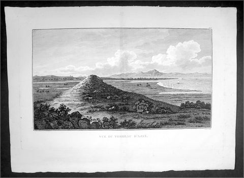
1802 J B Lechevalier Antique Print View of Tomb of Ajax Troy in Troad, NW Turkey
- Title : Vue Du Tombeau D'Ajax
- Date : 1802
- Condition: (A+) Fine Condition
- Ref: 70224
- Size: 19 1/4in x 14in (495mm x 355mm)
Description:
This original copper-plate engraved antique print view of the Tomb of Ajax the Great near in the ancient Greek city of Troy in the Troad region of NW Turkey was published in the 1802 edition of Jean-Baptiste Lechevaliers of Voyage de la Troade, fait dans les années 1785 et 1786
General Definitions:
Paper thickness and quality: - Heavy and stable
Paper color : - off white
Age of map color: -
Colors used: -
General color appearance: -
Paper size: - 20in x 14in (510mm x 360mm)
Plate size: - 17 1/2in x 11in (445mm x 280mm)
Margins: - Min 1/2in (12mm)
Imperfections:
Margins: - None
Plate area: - Light toning along centerfold
Verso: - None
Background:
Ajax or Aiasis a Greek hero, the son of King Telamon and Periboea, and the half-brother of Teucer. He plays an important role, and is portrayed as a towering figure and a warrior of great courage in Homers Iliad and in the Epic Cycle, a series of epic poems about the Trojan War. He is also referred to as Telamonian Ajax (Αἴας ὁ Τελαμώνιος, in Etruscan recorded as Aivas Tlamunus), Greater Ajax, or Ajax the Great, which distinguishes him from Ajax, son of Oileus (Ajax the Lesser).
Jean-Baptiste Lechevalier was the secretary of the Ambassador of France in Constantinople. In the year 1788 he visited the plain of Troy, and was enthusiastically in favour of the theory that the site of Homers Troy was to be found at the village of Bunarbashi. His publication about Troy Voyage de la Troade.....was first published in 1799.
The Troad, also known as Troas, is the historical name of the Biga peninsula (Biga Yarımadası, Τρωάς) in the northwestern part of Anatolia, Turkey. This region now is part of the Çanakkale province of Turkey. Bounded by the Dardanelles to the northwest, by the Aegean Sea to the west and separated from the rest of Anatolia by the massif that forms Mount Ida, the Troad is drained by two main rivers, the Scamander (Karamenderes) and the Simois, which join at the area containing the ruins of Troy. Grenikos, Kebren, Simoeis, Rhesos, Rhodios, Heptaporos and Aisepos were seven rivers of the Troad and the names of the river gods that inhabited each river.
Troy (Ancient Greek: Τροία, Troia or Τροίας, Troias, Truva or Troya) was a city in the far northwest of the region known in late Classical antiquity as Asia Minor, now known as Anatolia in modern Turkey, just south of the southwest mouth of the Dardanelles strait and northwest of Mount Ida. The present-day location is known as Hisarlik. It was the setting of the Trojan War described in the Greek Epic Cycle, in particular in the Iliad, one of the two epic poems attributed to Homer. Metrical evidence from the Iliad and the Odyssey suggests that the name λιον (Ilion) formerly began with a digamma: Ϝίλιον (Wilion); this is also supported by the Hittite name for what is thought to be the same city, Wilusa.
A new capital called Ilium (from Greek: λιον, Ilion) was founded on the site in the reign of the Roman Emperor Augustus. It flourished until the establishment of Constantinople, became a bishopric and declined gradually in the Byzantine era, but is now a Latin Catholic titular see.
In 1865, English archaeologist Frank Calvert excavated trial trenches in a field he had bought from a local farmer at Hisarlik, and in 1868, Heinrich Schliemann, a wealthy German businessman and archaeologist, also began excavating in the area after a chance meeting with Calvert in Çanakkale. These excavations revealed several cities built in succession. Schliemann was at first skeptical about the identification of Hisarlik with Troy, but was persuaded by Calvert and took over Calverts excavations on the eastern half of the Hisarlik site, which was on Calvert\'s property. Troy VII has been identified with the city called Wilusa by the Hittites (the probable origin of the Greek λιον) and is generally (but not conclusively) identified with Homeric Troy.
Today, the hill at Hisarlik has given its name to a small village near the ruins, which supports the tourist trade visiting the Troia archaeological site. It lies within the province of Çanakkale, some 30 km south-west of the provincial capital, also called Çanakkale. The nearest village is Tevfikiye. The map here shows the adapted Scamander estuary with Ilium a little way inland across the Homeric plain. Due to Troys location near the Aegean Sea, the Sea of Marmara, and the Black Sea, it was a central hub for the military and trade(Ref: M&B; Tooley)
1814 John Pinkerton Large Antique Map of Turkey in Europe - Greece to Hungary
- Title : Turkey in Europe....Drawn under the direction of Mr Pinkerton by L Herbert Neele Sculp. 352 Starnd.....London Published 1st Jan 1814 by Cadell & Davies Strand & Longman. Hurst. Rees.Orme & Brown. Paternaster Row
- Ref #: 16434
- Size: 31in x 22in (790mm x 560mm)
- Date : 1814
- Condition: (A+) Fine Condition
Description:
This large magnificent hand coloured original copper-plate engraved antique map of Turkey in Europe - Greece, Balkans, Romania, Bosnia, Albania, Serbia, Dalmatia - by John Pinkerton was engraved by Samuel Neele in 1814 - dated at the foot of the map - and published in Pinkertons large elephant folio Modern Atlas, published between 1809 - 14. (Ref: Tooley, M&B)
General Definitions:
Paper thickness and quality: - Heavy and stable
Paper color : - off white
Age of map color: - Original
Colors used: - Blue, pink, red, green, yellow
General color appearance: - Authentic
Paper size: - 31in x 22in (790mm x 560mm)
Plate size: - 31in x 22in (790mm x 560mm)
Margins: - Min 1in (25mm)
Imperfections:
Margins: - None
Plate area: - None
Verso: - None
Background:
The Ottoman Empire also historically known in Western Europe as the Turkish Empire or simply Turkey, was a state that controlled much of Southeast Europe, Western Asia and North Africa between the 14th and early 20th centuries. It was founded at the end of the 13th century in northwestern Anatolia in the town of Söğüt (modern-day Bilecik Province) by the Oghuz Turkish tribal leader Osman I. After 1354, the Ottomans crossed into Europe, and with the conquest of the Balkans, the Ottoman beylik was transformed into a transcontinental empire. The Ottomans ended the Byzantine Empire with the 1453 conquest of Constantinople by Mehmed the Conqueror.
During the 16th and 17th centuries, at the height of its power under the reign of Suleiman the Magnificent, the Ottoman Empire was a multinational, multilingual empire controlling most of Southeast Europe, parts of Central Europe, Western Asia, parts of Eastern Europe and the Caucasus, North Africa and the Horn of Africa. At the beginning of the 17th century, the empire contained 32 provinces and numerous vassal states. Some of these were later absorbed into the Ottoman Empire, while others were granted various types of autonomy during the course of centuries.
With Constantinople as its capital and control of lands around the Mediterranean basin, the Ottoman Empire was at the centre of interactions between the Eastern and Western worlds for six centuries. While the empire was once thought to have entered a period of decline following the death of Suleiman the Magnificent, this view is no longer supported by the majority of academic historians. The empire continued to maintain a flexible and strong economy, society and military throughout the 17th and much of the 18th century. However, during a long period of peace from 1740 to 1768, the Ottoman military system fell behind that of their European rivals, the Habsburg and Russian empires. The Ottomans consequently suffered severe military defeats in the late 18th and early 19th centuries, which prompted them to initiate a comprehensive process of reform and modernisation known as the Tanzimat. Thus, over the course of the 19th century, the Ottoman state became vastly more powerful and organised, despite suffering further territorial losses, especially in the Balkans, where a number of new states emerged. The empire allied with Germany in the early 20th century, hoping to escape from the diplomatic isolation which had contributed to its recent territorial losses, and thus joined World War I on the side of the Central Powers. While the Empire was able to largely hold its own during the conflict, it was struggling with internal dissent, especially with the Arab Revolt in its Arabian holdings. During this time, atrocities were committed by the Ottoman government against the Armenians, Assyrians and Pontic Greeks.
The Empires defeat and the occupation of part of its territory by the Allied Powers in the aftermath of World War I resulted in its partitioning and the loss of its Middle Eastern territories, which were divided between the United Kingdom and France. The successful Turkish War of Independence against the occupying Allies led to the emergence of the Republic of Turkey in the Anatolian heartland and the abolition of the Ottoman monarchy.
Pinkerton, John 1758 – 1826
Pinkerton was a Scottish antiquarian, cartographer, author, numismatist, historian, and early advocate of Germanic racial supremacy theory.
He was born in Edinburgh, as one of three sons to James Pinkerton. He lived in the neighbourhood of that city for some of his earliest childhood years, but later moved to Lanark. His studious youth brought him extensive knowledge of the Classics, and it is known that in his childhood years he enjoyed translating Roman authors such as Livy. He moved on to Edinburgh University, and after graduating, remained in the city to take up an apprenticeship in Law. However, his scholarly and literary inclinations led him to abandon the legal profession. It had been during his brief legal career though that he had begun writing, his Elegy on Craigmillar Castle being first published in 1776.
Pinkerton was a celebrated master of the Edinburgh school of cartography which lasted from roughly 1800 to 1830. Pinkerton, along with John Thomson & Co. and John Cary, redefined cartography by exchanging the elaborate cartouches and fantastical beasts used in the 18th century for more accurate detail. Pinkertons main work was the \\\"Pinkerton\\\'s Modern Atlas\\\" published from 1808 through 1815 with an American version by Dobson & Co. in 1818. Pinkerton maps are today greatly valued for their quality, size, colouration, and detail.
1817 John Thomson Large Antique Map Turkey in Europe Greece to Bosnia & Hungary
- Title : Turkish Dominions in Europe
- Date : 1817
- Size: 21in x 15in (535mm x 390mm)
- Condition: (A+) Fine Condition
- Ref: 16431
Description:
This large magnificent original hand coloured copper-plate engraved antique map of Turkey In Europe (Moldova, Bulgaria, Romania, Serbia, Bosnia, Croatia, Slovenia, Dalmatia & Greece) by John Thomson was published in the 1817 edition of Thomsons New General Atlas
General Definitions:
Paper thickness and quality: - Heavy and stable
Paper color : - off white
Age of map color: - Original
Colors used: - Yellow, green, blue, pink
General color appearance: - Authentic
Paper size: - 21in x 15in (535mm x 390mm)
Plate size: - 20in x 13 1/2in (510mm x 345mm)
Margins: - Min 1/2in (10mm)
Imperfections:
Margins: - None
Plate area: - None
Verso: - none
Background:
The Ottoman Empire also historically known in Western Europe as the Turkish Empire or simply Turkey, was a state that controlled much of Southeast Europe, Western Asia and North Africa between the 14th and early 20th centuries. It was founded at the end of the 13th century in northwestern Anatolia in the town of Söğüt (modern-day Bilecik Province) by the Oghuz Turkish tribal leader Osman I. After 1354, the Ottomans crossed into Europe, and with the conquest of the Balkans, the Ottoman beylik was transformed into a transcontinental empire. The Ottomans ended the Byzantine Empire with the 1453 conquest of Constantinople by Mehmed the Conqueror.
During the 16th and 17th centuries, at the height of its power under the reign of Suleiman the Magnificent, the Ottoman Empire was a multinational, multilingual empire controlling most of Southeast Europe, parts of Central Europe, Western Asia, parts of Eastern Europe and the Caucasus, North Africa and the Horn of Africa. At the beginning of the 17th century, the empire contained 32 provinces and numerous vassal states. Some of these were later absorbed into the Ottoman Empire, while others were granted various types of autonomy during the course of centuries.
With Constantinople as its capital and control of lands around the Mediterranean basin, the Ottoman Empire was at the centre of interactions between the Eastern and Western worlds for six centuries. While the empire was once thought to have entered a period of decline following the death of Suleiman the Magnificent, this view is no longer supported by the majority of academic historians. The empire continued to maintain a flexible and strong economy, society and military throughout the 17th and much of the 18th century. However, during a long period of peace from 1740 to 1768, the Ottoman military system fell behind that of their European rivals, the Habsburg and Russian empires. The Ottomans consequently suffered severe military defeats in the late 18th and early 19th centuries, which prompted them to initiate a comprehensive process of reform and modernisation known as the Tanzimat. Thus, over the course of the 19th century, the Ottoman state became vastly more powerful and organised, despite suffering further territorial losses, especially in the Balkans, where a number of new states emerged. The empire allied with Germany in the early 20th century, hoping to escape from the diplomatic isolation which had contributed to its recent territorial losses, and thus joined World War I on the side of the Central Powers. While the Empire was able to largely hold its own during the conflict, it was struggling with internal dissent, especially with the Arab Revolt in its Arabian holdings. During this time, atrocities were committed by the Ottoman government against the Armenians, Assyrians and Pontic Greeks.
The Empire\'s defeat and the occupation of part of its territory by the Allied Powers in the aftermath of World War I resulted in its partitioning and the loss of its Middle Eastern territories, which were divided between the United Kingdom and France. The successful Turkish War of Independence against the occupying Allies led to the emergence of the Republic of Turkey in the Anatolian heartland and the abolition of the Ottoman monarchy.