Products
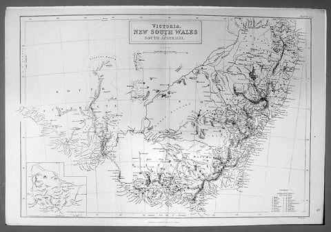
1844 Hughes Antique Australian Map of the States of Victoria & NSW
- Title : Victoria New South Wales and South Australia
- Ref #: 91204
- Size: 17in x 11 1/4in (430mm x 285mm)
- Date : 1844
- Condition: (A+) Fine Condition
Description:
This finely engraved original antique map of the Australian States of NSW, Vic & part of SA was engraved by William Hughes and published by A&C Black in 1844. (Ref: Tooley; M&B)
General Description:
Paper thickness and quality: - Light and stable
Paper color: - off white
Age of map color: -
Colors used: -
General color appearance: -
Paper size: - 17in x 11 1/4in (430mm x 285mm)
Plate size: - 17in x 11 1/4in (430mm x 285mm)
Margins: - Min 1/2in (12mm)
Imperfections:
Margins: - None
Plate area: - None
Verso: - None

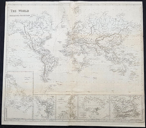
1844 Johnston Large Antique World Map Nation of Texas, Wilkes & Ross Antarctica
Antique Map
- Title : Chart of the World on Mercators Projection
- Ref #: 51011
- Condition: (A+) Fine Condition
- Size: 25in x 20in (635mm x 510mm)
- Date: 1844
Description:
This large original 1st edition, uncommon hand coloured antique lithograph world map was published by W & AK Johnston in his General Atlas, 1844.
A Pacific centered map emphasising the contemporary nation of Texas in North America, a few years prior to joining the union, along with the latest discoveries in Antarctica, or Southern Continent (as it was then known) by Charles Wilkes (1840) and James Ross (1841)
General Definitions:
Paper thickness and quality: - Heavy and stable
Paper color : - off white
Age of map color: - Original
Colors used: - Yellow, green, blue, pink
General color appearance: - Authentic
Paper size: - 25in x 20in (635mm x 510mm)
Plate size: - 25in x 20in (635mm x 510mm)
Margins: - Min 1/2in (12mm)
Imperfections:
Margins: - Light age toning
Plate area: - None
Verso: - None
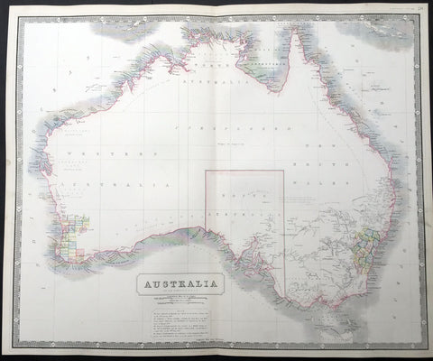
1844 W & AK Johnston Large Antique Map of Australia - South Australia Settlement
- Title : Australia
- Date : 1844
- Condition: (A+) Fine Condition
- Ref: 23806
- Size: 25in x 21in (635mm x 535mm)
Description:
This large fine hand coloured original steel-plate engraved antique map of Australia - with coloured outlines to the counties in NSW & WA - was published by W & AK Johnston in General Atlas,1844.
At the bottom of the map is a text box outlining the period of settlements in Australia from Botany Bay in 1788, WA 1829, SA 1836 & the colony of Victoria begun some 8 years earlier in 1838.
Johnston was one of the master publishers of fine engraved and lithographed maps during the 19th century, this large map is no exception. (Ref: Tooley; M&B)
General Description:
Paper thickness and quality: - Heavy and stable
Paper color: - off white
Age of map color: - Original
Colors used: - Red, green, yellow
General color appearance: - Authentic
Paper size: - 25in x 21in (635mm x 535mm)
Plate size: - 25in x 21in (635mm x 535mm)
Margins: - Min 1/2in (12mm)
Imperfections:
Margins: - Light age toning
Plate area: - None
Verso: - None
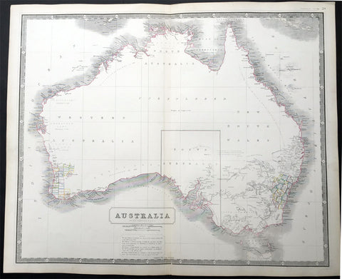
1844 W & AK Johnston Large Early Antique Map of Australia
Antique Map
- Title : Australia
- Date : 1844
- Condition: (A+) Fine Condition
- Ref: 30143
- Size: 25in x 21in (635mm x 535mm)
Description:
This large fine hand coloured original antique lithograph map of Australia - with coloured outlines to the counties in NSW & WA - was published by W & AK Johnston in General Atlas,1844.
At the bottom of the map is atext box outlining the period of settlements in Australia from Botany Bay in 1788, WA 1829, SA 1836 & the colony of Victoria begun some 8 years ealier in 1838.
Johnston was one of the master publishers of fine engraved and lithographed maps during the 19th century, this large map is no exception. (Ref: Tooley; M&B)
General Description:
Paper thickness and quality: - Heavy and stable
Paper color: - off white
Age of map color: - Original
Colors used: - Red, green, yellow
General color appearance: - Authentic
Paper size: - 25in x 21in (635mm x 535mm)
Plate size: - 25in x 21in (635mm x 535mm)
Margins: - Min 1/2in (12mm)
Imperfections:
Margins: - Light age toning
Plate area: - None
Verso: - None
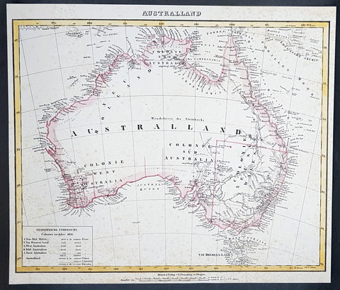
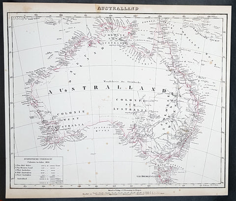
1845 Handtke & Flemming Large Antique Map of Australia - Population of 213,500
- Title : Australland...1841
- Date : 1845
- Condition: (A) Very Good Condition
- Ref: 31977
- Size: 16in x 14in (405mm x 355mm)
Description:
This hand coloured original steel-plate engraved antique highly detailed map of Australia, with a population census of the entire country in 1841, by Friedrich Handtke in 1845, was published in the Complete hand atlas of the recent description of the earth over all parts of the earth, Carl Flemming, Glougau.
General Definitions:
Paper thickness and quality: - Heavy and stable
Paper color : - off white
Age of map color: - Original
Colors used: - Yellow, red
General color appearance: - Authentic
Paper size: - 16in x 14in (405mm x 355mm)
Plate size: - 16in x 14in (405mm x 355mm)
Margins: - Min 1/2in (12mm)
Imperfections:
Margins: - Age toning & spotting
Plate area: - Age toning & spotting
Verso: - Age toning & spotting
Background:
Australia is a sovereign country comprising the mainland of the Australian continent, the island of Tasmania and numerous smaller islands. It is the largest country in Oceania and the world\'s sixth-largest country by total area. The neighbouring countries are Papua New Guinea, Indonesia and East Timor to the north; the Solomon Islands and Vanuatu to the north-east; and New Zealand to the south-east. The population of 25 million is highly urbanised and heavily concentrated on the eastern seaboard. Australias capital is Canberra, and its largest city is Sydney. The country\'s other major metropolitan areas are Melbourne, Brisbane, Perth and Adelaide.
Australia was inhabited by indigenous Australians for about 60,000 years before the first British settlement in the late 18th century. It is documented that Aborigines spoke languages that can be classified into about 250 groups. After the European discovery of the continent by Dutch explorers in 1606, who named it New Holland, Australia\'s eastern half was claimed by Great Britain in 1770 and initially settled through penal transportation to the colony of New South Wales from 26 January 1788, a date which became Australia\'s national day. The population grew steadily in subsequent decades, and by the 1850s most of the continent had been explored and an additional five self-governing crown colonies established. On 1 January 1901, the six colonies federated, forming the Commonwealth of Australia. Australia has since maintained a stable liberal democratic political system that functions as a federal parliamentary constitutional monarchy comprising six states and ten territories.
Being the oldest, flattest and driest inhabited continent, with the least fertile soils, Australia has a landmass of 7,617,930 square kilometres. A megadiverse country, its size gives it a wide variety of landscapes, with deserts in the centre, tropical rainforests in the north-east and mountain ranges in the south-east. A gold rush began in Australia in the early 1850s, which boosted the population of the country. Nevertheless, its population density, 2.8 inhabitants per square kilometre, remains among the lowest in the world. Australia generates its income from various sources including mining-related exports, telecommunications, banking and manufacturing. Indigenous Australian rock art is the oldest and richest in the world, dating as far back as 60,000 years and spread across hundreds of thousands of sites.
The first recorded European sighting of the Australian mainland, and the first recorded European landfall on the Australian continent (in 1606), are attributed to the Dutch. The first ship and crew to chart the Australian coast and meet with Aboriginal people was the Duyfken captained by Dutch navigator, Willem Janszoon. He sighted the coast of Cape York Peninsula in early 1606, and made landfall on 26 February at the Pennefather River near the modern town of Weipa on Cape York. The Dutch charted the whole of the western and northern coastlines and named the island continent New Holland during the 17th century, but made no attempt at settlement. William Dampier, an English explorer and privateer, landed on the north-west coast of New Holland in 1688 and again in 1699 on a return trip. In 1770, James Cook sailed along and mapped the east coast, which he named New South Wales and claimed for Great Britain.
With the loss of its American colonies in 1783, the British Government sent a fleet of ships, the First Fleet, under the command of Captain Arthur Phillip, to establish a new penal colony in New South Wales. A camp was set up and the flag raised at Sydney Cove, Port Jackson, on 26 January 1788, a date which became Australia\'s national day, Australia Day. A British settlement was established in Van Diemens Land, now known as Tasmania, in 1803, and it became a separate colony in 1825. The United Kingdom formally claimed the western part of Western Australia (the Swan River Colony) in 1828. Separate colonies were carved from parts of New South Wales: South Australia in 1836, Victoria in 1851, and Queensland in 1859. The Northern Territory was founded in 1911 when it was excised from South Australia. South Australia was founded as a free province—it was never a penal colony. Victoria and Western Australia were also founded free, but later accepted transported convicts. A campaign by the settlers of New South Wales led to the end of convict transportation to that colony; the last convict ship arrived in 1848.
1845 Handtke & Flemming Large Antique Map of Australia - Population of 213,500
- Title : Australland...1841
- Date : 1845
- Condition: (A+) Fine Condition
- Ref: 40972
- Size: 16in x 14in (405mm x 355mm)
Description:
This hand coloured original steel-plate engraved antique highly detailed map of Australia, with a population census of the entire country in 1841, by Friedrich Handtke in 1845, was published in the Complete hand atlas of the recent description of the earth over all parts of the earth, Carl Flemming, Glougau.
General Definitions:
Paper thickness and quality: - Heavy and stable
Paper color : - off white
Age of map color: - Original
Colors used: - Yellow, red
General color appearance: - Authentic
Paper size: - 16in x 14in (405mm x 355mm)
Plate size: - 16in x 14in (405mm x 355mm)
Margins: - Min 1/2in (12mm)
Imperfections:
Margins: - Light spotting
Plate area: - Light spotting
Verso: - Light spotting
Background:
Australia is a sovereign country comprising the mainland of the Australian continent, the island of Tasmania and numerous smaller islands. It is the largest country in Oceania and the world\'s sixth-largest country by total area. The neighbouring countries are Papua New Guinea, Indonesia and East Timor to the north; the Solomon Islands and Vanuatu to the north-east; and New Zealand to the south-east. The population of 25 million is highly urbanised and heavily concentrated on the eastern seaboard. Australias capital is Canberra, and its largest city is Sydney. The country\'s other major metropolitan areas are Melbourne, Brisbane, Perth and Adelaide.
Australia was inhabited by indigenous Australians for about 60,000 years before the first British settlement in the late 18th century. It is documented that Aborigines spoke languages that can be classified into about 250 groups. After the European discovery of the continent by Dutch explorers in 1606, who named it New Holland, Australia\'s eastern half was claimed by Great Britain in 1770 and initially settled through penal transportation to the colony of New South Wales from 26 January 1788, a date which became Australia\'s national day. The population grew steadily in subsequent decades, and by the 1850s most of the continent had been explored and an additional five self-governing crown colonies established. On 1 January 1901, the six colonies federated, forming the Commonwealth of Australia. Australia has since maintained a stable liberal democratic political system that functions as a federal parliamentary constitutional monarchy comprising six states and ten territories.
Being the oldest, flattest and driest inhabited continent, with the least fertile soils, Australia has a landmass of 7,617,930 square kilometres. A megadiverse country, its size gives it a wide variety of landscapes, with deserts in the centre, tropical rainforests in the north-east and mountain ranges in the south-east. A gold rush began in Australia in the early 1850s, which boosted the population of the country. Nevertheless, its population density, 2.8 inhabitants per square kilometre, remains among the lowest in the world. Australia generates its income from various sources including mining-related exports, telecommunications, banking and manufacturing. Indigenous Australian rock art is the oldest and richest in the world, dating as far back as 60,000 years and spread across hundreds of thousands of sites.
The first recorded European sighting of the Australian mainland, and the first recorded European landfall on the Australian continent (in 1606), are attributed to the Dutch. The first ship and crew to chart the Australian coast and meet with Aboriginal people was the Duyfken captained by Dutch navigator, Willem Janszoon. He sighted the coast of Cape York Peninsula in early 1606, and made landfall on 26 February at the Pennefather River near the modern town of Weipa on Cape York. The Dutch charted the whole of the western and northern coastlines and named the island continent New Holland during the 17th century, but made no attempt at settlement. William Dampier, an English explorer and privateer, landed on the north-west coast of New Holland in 1688 and again in 1699 on a return trip. In 1770, James Cook sailed along and mapped the east coast, which he named New South Wales and claimed for Great Britain.
With the loss of its American colonies in 1783, the British Government sent a fleet of ships, the First Fleet, under the command of Captain Arthur Phillip, to establish a new penal colony in New South Wales. A camp was set up and the flag raised at Sydney Cove, Port Jackson, on 26 January 1788, a date which became Australia\'s national day, Australia Day. A British settlement was established in Van Diemens Land, now known as Tasmania, in 1803, and it became a separate colony in 1825. The United Kingdom formally claimed the western part of Western Australia (the Swan River Colony) in 1828. Separate colonies were carved from parts of New South Wales: South Australia in 1836, Victoria in 1851, and Queensland in 1859. The Northern Territory was founded in 1911 when it was excised from South Australia. South Australia was founded as a free province—it was never a penal colony. Victoria and Western Australia were also founded free, but later accepted transported convicts. A campaign by the settlers of New South Wales led to the end of convict transportation to that colony; the last convict ship arrived in 1848.
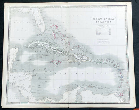
1845 Johnston Large Antique Map Florida, Caribbean, Cuba, Haiti, Central America
Antique Map
- Title : West India Islands
- Date : 1845
- Size: 25in x 21in (635mm x 535mm)
- Condition: (A+) Fine Condition
- Ref: 35619
Description:
This large original hand coloured steel plate engraved antique map of West Indian, Caribbean Islands, was published by W & AK Johnston in his General Atlas, 1845.
General Definitions:
Paper thickness and quality: - Heavy and stable
Paper color : - off white
Age of map color: - Original
Colors used: - Yellow, green, blue, pink
General color appearance: - Authentic
Paper size: - 25in x 21in (635mm x 535mm)
Plate size: - 25in x 21in (635mm x 535mm)
Margins: - Min 1/2in (12mm)
Imperfections:
Margins: - None
Plate area: - None
Verso: - None
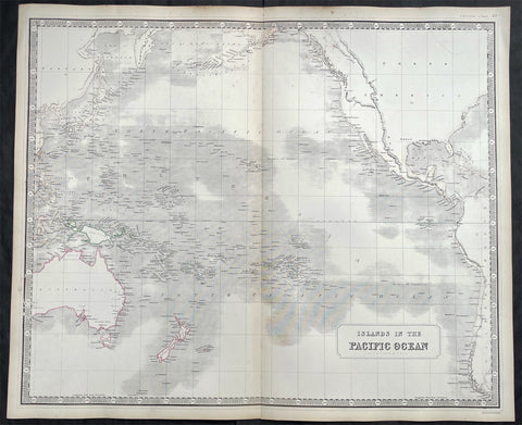
1845 Johnston Large Antique Map of Australia, New Zealand, North America Pacific
- Title : Islands in the Pacific Ocean
- Size: 25in x 21in (640mm x 535mm)
- Condition: (A+) Fine Condition
- Date : 1845
- Ref #: 23805
Description:
This large fine hand coloured original steel plate engraved antique map of Australia, New Zealand, North America and the Pacific Ocean by W & AK Johnston, was published in the 1845 edition of his large General Atlas.
General Definitions:
Paper thickness and quality: - Heavy and stable
Paper color : - off white
Age of map color: - Original
Colors used: - Yellow, Green, pink
General color appearance: - Authentic
Paper size: - 25in x 21in (640mm x 535mm)
Plate size: - 25in x 21in (640mm x 535mm)
Margins: - Min 1in (25mm)
Imperfections:
Margins: - Light age toning
Plate area: - None
Verso: - None
Background:
Australia is a sovereign country comprising the mainland of the Australian continent, the island of Tasmania and numerous smaller islands. It is the largest country in Oceania and the world\\\'s sixth-largest country by total area. The neighbouring countries are Papua New Guinea, Indonesia and East Timor to the north; the Solomon Islands and Vanuatu to the north-east; and New Zealand to the south-east. The population of 25 million is highly urbanised and heavily concentrated on the eastern seaboard. Australias capital is Canberra, and its largest city is Sydney. The country\\\'s other major metropolitan areas are Melbourne, Brisbane, Perth and Adelaide.
Australia was inhabited by indigenous Australians for about 60,000 years before the first British settlement in the late 18th century. It is documented that Aborigines spoke languages that can be classified into about 250 groups. After the European discovery of the continent by Dutch explorers in 1606, who named it New Holland, Australia\\\'s eastern half was claimed by Great Britain in 1770 and initially settled through penal transportation to the colony of New South Wales from 26 January 1788, a date which became Australia\\\'s national day. The population grew steadily in subsequent decades, and by the 1850s most of the continent had been explored and an additional five self-governing crown colonies established. On 1 January 1901, the six colonies federated, forming the Commonwealth of Australia. Australia has since maintained a stable liberal democratic political system that functions as a federal parliamentary constitutional monarchy comprising six states and ten territories.
Being the oldest, flattest and driest inhabited continent, with the least fertile soils, Australia has a landmass of 7,617,930 square kilometres. A megadiverse country, its size gives it a wide variety of landscapes, with deserts in the centre, tropical rainforests in the north-east and mountain ranges in the south-east. A gold rush began in Australia in the early 1850s, which boosted the population of the country. Nevertheless, its population density, 2.8 inhabitants per square kilometre, remains among the lowest in the world. Australia generates its income from various sources including mining-related exports, telecommunications, banking and manufacturing. Indigenous Australian rock art is the oldest and richest in the world, dating as far back as 60,000 years and spread across hundreds of thousands of sites.
The first recorded European sighting of the Australian mainland, and the first recorded European landfall on the Australian continent (in 1606), are attributed to the Dutch. The first ship and crew to chart the Australian coast and meet with Aboriginal people was the Duyfken captained by Dutch navigator, Willem Janszoon. He sighted the coast of Cape York Peninsula in early 1606, and made landfall on 26 February at the Pennefather River near the modern town of Weipa on Cape York. The Dutch charted the whole of the western and northern coastlines and named the island continent New Holland during the 17th century, but made no attempt at settlement. William Dampier, an English explorer and privateer, landed on the north-west coast of New Holland in 1688 and again in 1699 on a return trip. In 1770, James Cook sailed along and mapped the east coast, which he named New South Wales and claimed for Great Britain.
With the loss of its American colonies in 1783, the British Government sent a fleet of ships, the First Fleet, under the command of Captain Arthur Phillip, to establish a new penal colony in New South Wales. A camp was set up and the flag raised at Sydney Cove, Port Jackson, on 26 January 1788, a date which became Australia\\\'s national day, Australia Day. A British settlement was established in Van Diemens Land, now known as Tasmania, in 1803, and it became a separate colony in 1825. The United Kingdom formally claimed the western part of Western Australia (the Swan River Colony) in 1828. Separate colonies were carved from parts of New South Wales: South Australia in 1836, Victoria in 1851, and Queensland in 1859. The Northern Territory was founded in 1911 when it was excised from South Australia. South Australia was founded as a free province—it was never a penal colony. Victoria and Western Australia were also founded free, but later accepted transported convicts. A campaign by the settlers of New South Wales led to the end of convict transportation to that colony; the last convict ship arrived in 1848.
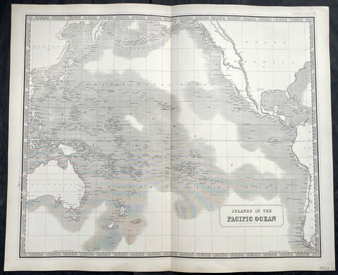
1845 Johnston Large Antique Map of Australia, New Zealand, North America Pacific
- Title : Islands in the Pacific Ocean
- Size: 25in x 21in (640mm x 535mm)
- Condition: (A+) Fine Condition
- Date : 1845
- Ref #: 40960
Description:
This large fine hand coloured original steel plate engraved antique map of Australia, New Zealand, North America and the Pacific Ocean by W & AK Johnston, was published in the 1845 edition of his large General Atlas.
General Definitions:
Paper thickness and quality: - Heavy and stable
Paper color : - off white
Age of map color: - Original
Colors used: - Yellow, Green, pink
General color appearance: - Authentic
Paper size: - 25in x 21in (640mm x 535mm)
Plate size: - 25in x 21in (640mm x 535mm)
Margins: - Min 1in (25mm)
Imperfections:
Margins: - Light age toning
Plate area: - None
Verso: - None
Background:
Australia is a sovereign country comprising the mainland of the Australian continent, the island of Tasmania and numerous smaller islands. It is the largest country in Oceania and the world\\\'s sixth-largest country by total area. The neighbouring countries are Papua New Guinea, Indonesia and East Timor to the north; the Solomon Islands and Vanuatu to the north-east; and New Zealand to the south-east. The population of 25 million is highly urbanised and heavily concentrated on the eastern seaboard. Australias capital is Canberra, and its largest city is Sydney. The country\\\'s other major metropolitan areas are Melbourne, Brisbane, Perth and Adelaide.
Australia was inhabited by indigenous Australians for about 60,000 years before the first British settlement in the late 18th century. It is documented that Aborigines spoke languages that can be classified into about 250 groups. After the European discovery of the continent by Dutch explorers in 1606, who named it New Holland, Australia\\\'s eastern half was claimed by Great Britain in 1770 and initially settled through penal transportation to the colony of New South Wales from 26 January 1788, a date which became Australia\\\'s national day. The population grew steadily in subsequent decades, and by the 1850s most of the continent had been explored and an additional five self-governing crown colonies established. On 1 January 1901, the six colonies federated, forming the Commonwealth of Australia. Australia has since maintained a stable liberal democratic political system that functions as a federal parliamentary constitutional monarchy comprising six states and ten territories.
Being the oldest, flattest and driest inhabited continent, with the least fertile soils, Australia has a landmass of 7,617,930 square kilometres. A megadiverse country, its size gives it a wide variety of landscapes, with deserts in the centre, tropical rainforests in the north-east and mountain ranges in the south-east. A gold rush began in Australia in the early 1850s, which boosted the population of the country. Nevertheless, its population density, 2.8 inhabitants per square kilometre, remains among the lowest in the world. Australia generates its income from various sources including mining-related exports, telecommunications, banking and manufacturing. Indigenous Australian rock art is the oldest and richest in the world, dating as far back as 60,000 years and spread across hundreds of thousands of sites.
The first recorded European sighting of the Australian mainland, and the first recorded European landfall on the Australian continent (in 1606), are attributed to the Dutch. The first ship and crew to chart the Australian coast and meet with Aboriginal people was the Duyfken captained by Dutch navigator, Willem Janszoon. He sighted the coast of Cape York Peninsula in early 1606, and made landfall on 26 February at the Pennefather River near the modern town of Weipa on Cape York. The Dutch charted the whole of the western and northern coastlines and named the island continent New Holland during the 17th century, but made no attempt at settlement. William Dampier, an English explorer and privateer, landed on the north-west coast of New Holland in 1688 and again in 1699 on a return trip. In 1770, James Cook sailed along and mapped the east coast, which he named New South Wales and claimed for Great Britain.
With the loss of its American colonies in 1783, the British Government sent a fleet of ships, the First Fleet, under the command of Captain Arthur Phillip, to establish a new penal colony in New South Wales. A camp was set up and the flag raised at Sydney Cove, Port Jackson, on 26 January 1788, a date which became Australia\\\'s national day, Australia Day. A British settlement was established in Van Diemens Land, now known as Tasmania, in 1803, and it became a separate colony in 1825. The United Kingdom formally claimed the western part of Western Australia (the Swan River Colony) in 1828. Separate colonies were carved from parts of New South Wales: South Australia in 1836, Victoria in 1851, and Queensland in 1859. The Northern Territory was founded in 1911 when it was excised from South Australia. South Australia was founded as a free province—it was never a penal colony. Victoria and Western Australia were also founded free, but later accepted transported convicts. A campaign by the settlers of New South Wales led to the end of convict transportation to that colony; the last convict ship arrived in 1848.
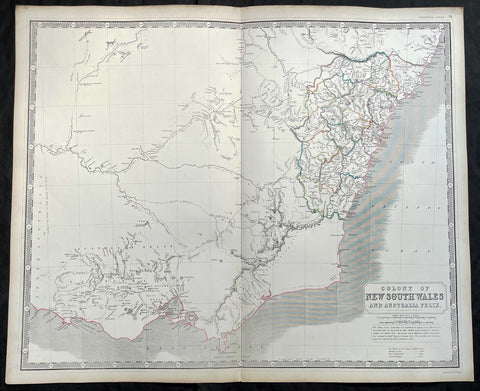
1845 Johnston Large Antique Map of New South Wales & Victoria, Australia Felix
Antique Map
- Title : Colony of New South Wales and Australia Felix
- Ref #: 35088
- Size: 25 1/2in x 21in (650mm x 535mm)
- Date : 1845
- Condition: (A+) Fine Condition
Description:
This large fine hand coloured original antique map of NSW & SE Australia stretching from the 10 year old Settlement of Melbourne in the south to the 31st parallel in the north, by W & AK Johnston, was published in the 1845 edition of the General Atlas.
A large, highly detailed regional map of New South Wales and Australia Felix the SE area which quickly became the state of Victoria. The map, with this title, lasted for only a few years, before both NSW and Victoria were quickly settled. The map provides a very early depiction of the region, pre-dating the discovery of gold.
Also of great interest are the exploration routes by Mitchell (1836) in Red, Tyer's & Townsend's (1840) in Yellow and Streletsky's (Strzelecki) (1840) in Blue.
The 18 counties of NSW are highlighted in beautiful hand colour with extensive detail of towns, tracks and rivers. Historical note included below the title.Decorative Piano Key border and a fine example, on thick heavy paper.
Johnston was one of the master publishers of fine engraved and lithographed maps during the 19th century - this map is no exception. (Ref: Tooley; M&B)
General Description:
Paper thickness and quality: - Heavy and stable
Paper color: - off white
Age of map color: - Original
Colors used: - Red, green, yellow
General color appearance: - Authentic
Paper size: - 25 1/2in x 21in (650mm x 535mm)
Plate size: - 25 1/2in x 21in (650mm x 535mm)
Margins: - Min 1/2in (12mm)
Imperfections:
Margins: - None
Plate area: - None
Verso: - None
1845 Sydney Hall Large Antique World Map insets Singapore, Hong Kong, Cape, TAS
- Title : 1845 Sydney Hall Large Antique World Map insets Singapore, Hong Kong, Cape, TAS
- Size: 22in x 19 1/2in (500mm x 470mm)
- Condition: (A) Good Condition
- Date : 1843
- Ref #: 32258-1
Description:
This large original steel-plate antique world map - with 5 inset maps of Hong Kong, Van Diemens Land, Calcutta, Singapore & the Colony Of Good Hope - by Sydney Hall was published by Longman & co. in 1845. (Ref: Tooley; M&B)
General Definitions:
Paper thickness and quality: - Light and stable
Paper color : - off white
Age of map color: -
Colors used: -
General color appearance: -
Paper size: - 22in x 19 1/2in (500mm x 470mm)
Plate size: - 22in x 19 1/2in (500mm x 470mm)
Margins: - Min 1/4in (6mm)
Imperfections:
Margins: - Small loss to top centerfold, into border
Plate area: - Folds as issued, light creasing
Verso: - Folds re-enforced with archival tape, light soiling
Background:
A highly detailed and attractive map of the world, with seven inset maps of British colonies: Hong Kong, Van Diemens Land, Calcutta, Singapore & the Colony Of Good Hope. A note on the Pitcairn Islands records their colonisation by the mutineers from the Bounty.
Also prominent in North America is an independent Texas along with an extended Mexico into the SW and California regions.
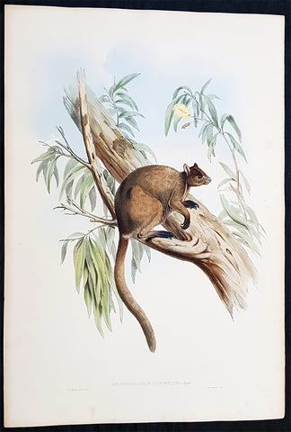
1845-63 John Gould Large Antique Print of Tree Kangaroo The Mammals of Australia
Antique Map
- Title : Dendrolagus Inustus, Mull....H C Richter del et lith....C Hullmandel Imp.
- Ref #: 93442
- Size: 22in x 15in (560mm x 385mm)
- Date : 1845–63
- Condition: (A+) Fine Condition
Description:
This large rare original hand coloured lithograph antique print of The Grizzled Tree Kangaroo, by the artist HC Richter was printed by Charles Joseph Hullmandel 1789 – 1850 in the famous Naturalists John Goulds The Mammals of Australiapublished between 1845–63.
General Definitions:
Paper thickness and quality: - Heavy and stable
Paper color : - off white
Age of map color: - Original
Colors used: - Blue, pink, red, green, yellow
General color appearance: - Authentic
Paper size: - 22in x 15in (560mm x 385mm)
Plate size: - 22in x 15in (560mm x 385mm)
Margins: - Min 1in (25mm)
Imperfections:
Margins: - Light age toning
Plate area: - None
Verso: - None
Background:
The Mammals of Australia is a three-volume work written and published by John Gould between 1845–63. It contains 182 illustrations by the author and its artist H. C. Richter. It was intended to be a complete survey of the novel species of mammals, such as the marsupials, discovered in the colonies of Australia.
The author, John Gould, best known for The Birds of Australia and other major works of ornithology, visited Australia in 1838. In his introduction, Gould says:.....It was not until I arrived in the country, and found myself surrounded by objects as strange as if I had been transported to another planet, that I conceived the idea of devoting a portion of my attention to the mammalian class of its extraordinary fauna......During his short stay he made observations on the natural history and employed his skills as a taxidermist to obtain specimens.
The publication of this major work by Gould followed his A Monograph of the Macropodidae or Family of Kangaroos in 1841. This work was the first comprehensive survey of Australian mammals, and gave an account of their classification and description. Gould also included the indigenous names for the species from the lists he made while in Australia. He used these names to make requests of the local peoples for his specimens, and recorded the regions where the names were used. This conserved a number of common names, such as dibbler (Parantechinus apicalis), which were later recommended by authorities.
The large lithographs reproduced the artwork of Richter, after the drawings and watercolours made in Australia by Gould and his wife, Elizabeth. (The contribution by Elizabeth Gould was uncredited). These were hand-coloured by a group of artists, led by Gabriel Bayfield, that required the completion of 26,572 plates. The illustrations produced during their visit to Australia were supplemented by the preserved specimens returned to England and detailed the characteristics of the species. These illustrations have become iconic images of the mammals of Australia. Among the best known of the illustrations from the work are the two of Thylacinus cynocephalus (Tasmanian tiger), copied since its publication and the most frequently reproduced, made more recognizable by Cascade Brewerys appropriation for its label in 1987. The government of Tasmania published a monochromatic reproduction of the same image in 1934, the author Louisa Anne Meredith also copied it for Tasmanian Friends and Foes (1881).
The Mammals of Australia was published by subscription in the format Imperial Folio; 13 parts in three volumes were issued from 1845 until 1863. To these the author added An Introduction to The Mammals of Australia (1863) in a separate work. This provided corrections and updates, a new preface, introduction, and a list of the mammals of the three volumes. The first two volumes were complete surveys of orders Marsupiata (marsupials), and, with Rodentia in the third, it formed the sum of known mammalian species of Australia. With the addition of those contained in the later Introduction the total of species described reached 166. The same work notes the exclusion of marine mammals such as whales from the volumes, but reprints a manuscript by Charles Coxen on the dugong.
Beyond the scientific value of this comprehensive survey, the document is cited in reference to its subjects conservation. Some of the species included in the work, such as Onychogalea lunata (crescent nailtail wallaby), have since succumbed to changes in land use since European colonisation.
The work was received with acclaim, but the high cost of production, especially of the coloured plates, reduced its accessibility. The original listed price was £41 for the complete set of volumes. The public curiosity for the unique fauna of Australia was met by this handsomely illustrated and comprehensive survey, and it spawned imitations in Australia. The curator of the Australian Museum, Gerard Krefft, produced the more affordable The Mammals of Australia (1871); intended for educational purposes and influenced by Goulds illustrations. Gracius Broinowskis abandoned work, Birds and Mammals of Australia (1884), so closely imitated the plates that an injunction was threatened by its publisher.
Gould, John FRS 1804 – 1881
Gould was an English ornithologist and bird artist. He published a number of monographs on birds, illustrated by plates that he produced with the assistance of his wife, Elizabeth Gould, and several other artists including Edward Lear, Henry Constantine Richter, Joseph Wolf and William Matthew Hart. He has been considered the father of bird study in Australia and the Gould League in Australia is named after him. His identification of the birds now nicknamed Darwins finches played a role in the inception of Darwins theory of evolution by natural selection. Goulds work is referenced in Charles Darwins book, On the Origin of Species.
Gould was born in Lyme Regis the first son of a gardener. He and the boy probably had a scanty education. Shortly afterwards his father obtained a position on an estate near Guildford, Surrey, and then in 1818 Gould became foreman in the Royal Gardens of Windsor. He was for some time under the care of J. T. Aiton, of the Royal Gardens of Windsor. The young Gould started training as a gardener, being employed under his father at Windsor from 1818 to 1824, and he was subsequently a gardener at Ripley Castle in Yorkshire. He became an expert in the art of taxidermy. In 1824 he set himself up in business in London as a taxidermist, and his skill helped him to become the first Curator and Preserver at the museum of the Zoological Society of London in 1827.
Goulds position brought him into contact with the countrys leading naturalists. This meant that he was often the first to see new collections of birds given to the Zoological Society of London. In 1830 a collection of birds arrived from the Himalayas, many not previously described. Gould published these birds in A Century of Birds from the Himalaya Mountains (1830–1832). The text was by Nicholas Aylward Vigors and the illustrations were drawn and lithographed by Goulds wife Elizabeth Coxen Gould. Most of Goulds work were rough sketches on paper from which other artists created the lithographic plates.
This work was followed by four more in the next seven years, including Birds of Europe in five volumes. It was completed in 1837; Gould wrote the text, and his clerk, Edwin Prince, did the editing. The plates were drawn and lithographed by Elizabeth Coxen Gould. A few of the illustrations were made by Edward Lear as part of his Illustrations of the Family of Psittacidae in 1832. Lear, however, was in financial difficulty, and he sold the entire set of lithographs to Gould. The books were published in a very large size, imperial folio, with magnificent coloured plates. Eventually 41 of these volumes were published, with about 3000 plates. They appeared in parts at £3 3s. a number, subscribed for in advance, and in spite of the heavy expense of preparing the plates, Gould succeeded in making his ventures pay, realising a fortune. This was a busy period for Gould who also published Icones Avium in two parts containing 18 leaves of bird studies on 54 cm plates as a supplement to his previous works. No further monographs were published as in 1838 he and his wife moved to Australia to work on the Birds of Australia. Shortly after their return to England, his wife died in 1841. Elizabeth Gould completed 84 plates for Birds of Australia before her death.
When Charles Darwin presented his mammal and bird specimens collected during the second voyage of HMS Beagle to the Zoological Society of London on 4 January 1837, the bird specimens were given to Gould for identification. He set aside his paying work and at the next meeting on 10 January reported that birds from the Galápagos Islands which Darwin had thought were blackbirds, gross-bills and finches were in fact a series of ground Finches which are so peculiar as to form an entirely new group, containing 12 species. This story made the newspapers. In March, Darwin met Gould again, learning that his Galápagos wren was another species of finch and the mockingbirds he had labelled by island were separate species rather than just varieties, with relatives on the South American mainland. Subsequently, Gould advised that the smaller southern Rhea specimen that had been rescued from a Christmas dinner was a separate species which he named Rhea darwinii, whose territory overlapped with the northern rheas. Darwin had not bothered to label his finches by island, but others on the expedition had taken more care. He now sought specimens collected by captain Robert FitzRoy and crewmen. From them he was able to establish that the species were unique to islands, an important step on the inception of his theory of evolution by natural selection. Goulds work on the birds was published between 1838 and 1842 in five numbers as Part 3 of Zoology of the Voyage of H.M.S. Beagle, edited by Charles Darwin. Elizabeth Gould illustrated all the plates for Part 3.
In 1838 the Goulds sailed to Australia, intending to study the birds of that country and be the first to produce a major work on the subject. They took with them the collector John Gilbert. They arrived in Tasmania in September, making the acquaintance of the governor Sir John Franklin and his wife. Gould and Gilbert collected on the island. In February 1839 Gould sailed to Sydney, leaving his pregnant wife with the Franklins. He travelled to his brother-in-laws station at Yarrundi, spending his time searching for bowerbirds in the Liverpool Range. In April he returned to Tasmania for the birth of his son. In May he sailed to Adelaide to meet Charles Sturt, who was preparing to lead an expedition to the Murray River. Gould collected in the Mount Lofty range, the Murray Scrubs and Kangaroo Island, returning again to Hobart in July. He then travelled with his wife to Yarrundi. They returned home to England in May 1840.
The result of the trip was The Birds of Australia (1840–48). It included a total of 600 plates in seven volumes; 328 of the species described were new to science and named by Gould. He also published A Monograph of the Macropodidae, or Family of Kangaroos (1841–1842) and the three volume work The Mammals of Australia (1849–1861).
Elizabeth died in 1841 after the birth of their eighth child, Sarah, and Goulds books subsequently used illustrations by a number of artists, including Henry Constantine Richter, William Matthew Hart and Joseph Wolf.
Throughout his professional life Gould had a strong interest in hummingbirds. He accumulated a collection of 320 species, which he exhibited at the Great Exhibition of 1851. Despite his interest, Gould had never seen a live hummingbird. In May 1857 he travelled to the United States with his second son, Charles. He arrived in New York too early in the season to see hummingbirds in that city, but on 21 May 1857, in Bartrams Gardens in Philadelphia, he finally saw his first live one, a ruby-throated hummingbird. He then continued to Washington D.C. where he saw large numbers in the gardens of the Capitol. Gould attempted to return to England with live specimens, but, as he was not aware of the conditions necessary to keep them, they only lived for two months at most.
Gould published: A Monograph of the Trochilidae or Humming Birds with 360 plates (1849–61); The Mammals of Australia (1845–63), Handbook to the Birds of Australia (1865), The Birds of Asia (1850–83), The Birds of Great Britain (1862–73) and The Birds of New Guinea and the adjacent Papuan Islands (1875–88).
The University of Glasgow, which owns a copy of Birds of Great Britain, describes John Gould as the greatest figure in bird illustration after Audubon, and auctioneers Sotherans describe the work as Goulds pride and joy.
Gould had already published some of the illustrations in Birds of Europe, but Birds of Great Britain represents a development of his aesthetic style in which he adds illustrations of nests and young on a large scale.
Sotherans Co. reports that Gould published the book himself, producing 750 copies, which remain sought after both as complete volumes, and as individual plates, currently varying in price from £450 – £850. The University of Glasgow records that the volumes were issued in London in 25 parts, to make the complete set, between 1863 and 1873, and each set contained 367 coloured lithographs.
Gould undertook an ornithological tour of Scandinavia in 1856, in preparation for the work, taking with him the artist Henry Wolf who drew 57 of the plates from Goulds preparatory sketches. According to The University of Glasgow Goulds skill was in rapidly producing rough sketches from nature (a majority of the sketches were drawn from newly killed specimens) capturing the distinctiveness of each species. Gould then oversaw the process whereby his artists worked his sketches up into the finished drawings, which were made into coloured lithographs by engraver William Hart.
There were problems: the stone engraving of the snowy owl in volume I was dropped and broken at an early stage in the printing. Later issues of this plate show evidence of this damage and consequently the early issue – printed before the accident – are considered more desirable.
The lithographs were hand coloured. In the introduction for the work, Gould states every sky with its varied tints and every feather of each bird were coloured by hand; and when it is considered that nearly two hundred and eighty thousand illustrations in the present work have been so treated, it will most likely cause some astonishment to those who give the subject a thought.
The work has gathered critical acclaim: according to Mullens and Swann, Birds of Great Britain is the most sumptuous and costly of British bird books, whilst Wood describes it as a magnificent work. Isabella Tree writes that it was seen – perhaps partly because its subject was British, as the culmination of [his] ... genius
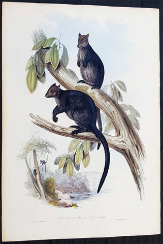
1845-63 John Gould Large Antique Print The Mammals of Australia - Tree Kangaroo
Antique Map
- Title : Dendrolagus Ursinus, Mull....H C Richter del et lith....C Hullmandel Imp.
- Ref #: 93441
- Size: 22in x 15in (560mm x 385mm)
- Date : 1845–63
- Condition: (A+) Fine Condition
Description:
This large rare original hand coloured lithograph antique print of The Ursine Tree Kangaroo, by the artist HC Richter was printed by Charles Joseph Hullmandel 1789 – 1850 in the famous Naturalists John Goulds The Mammals of Australiapublished between 1845–63.
General Definitions:
Paper thickness and quality: - Heavy and stable
Paper color : - off white
Age of map color: - Original
Colors used: - Blue, pink, red, green, yellow
General color appearance: - Authentic
Paper size: - 22in x 15in (560mm x 385mm)
Plate size: - 22in x 15in (560mm x 385mm)
Margins: - Min 1in (25mm)
Imperfections:
Margins: - Light age toning
Plate area: - None
Verso: - None
Background:
The Mammals of Australia is a three-volume work written and published by John Gould between 1845–63. It contains 182 illustrations by the author and its artist H. C. Richter. It was intended to be a complete survey of the novel species of mammals, such as the marsupials, discovered in the colonies of Australia.
The author, John Gould, best known for The Birds of Australia and other major works of ornithology, visited Australia in 1838. In his introduction, Gould says:.....It was not until I arrived in the country, and found myself surrounded by objects as strange as if I had been transported to another planet, that I conceived the idea of devoting a portion of my attention to the mammalian class of its extraordinary fauna......During his short stay he made observations on the natural history and employed his skills as a taxidermist to obtain specimens.
The publication of this major work by Gould followed his A Monograph of the Macropodidae or Family of Kangaroos in 1841. This work was the first comprehensive survey of Australian mammals, and gave an account of their classification and description. Gould also included the indigenous names for the species from the lists he made while in Australia. He used these names to make requests of the local peoples for his specimens, and recorded the regions where the names were used. This conserved a number of common names, such as dibbler (Parantechinus apicalis), which were later recommended by authorities.
The large lithographs reproduced the artwork of Richter, after the drawings and watercolours made in Australia by Gould and his wife, Elizabeth. (The contribution by Elizabeth Gould was uncredited). These were hand-coloured by a group of artists, led by Gabriel Bayfield, that required the completion of 26,572 plates. The illustrations produced during their visit to Australia were supplemented by the preserved specimens returned to England and detailed the characteristics of the species. These illustrations have become iconic images of the mammals of Australia. Among the best known of the illustrations from the work are the two of Thylacinus cynocephalus (Tasmanian tiger), copied since its publication and the most frequently reproduced, made more recognizable by Cascade Brewerys appropriation for its label in 1987. The government of Tasmania published a monochromatic reproduction of the same image in 1934, the author Louisa Anne Meredith also copied it for Tasmanian Friends and Foes (1881).
The Mammals of Australia was published by subscription in the format Imperial Folio; 13 parts in three volumes were issued from 1845 until 1863. To these the author added An Introduction to The Mammals of Australia (1863) in a separate work. This provided corrections and updates, a new preface, introduction, and a list of the mammals of the three volumes. The first two volumes were complete surveys of orders Marsupiata (marsupials), and, with Rodentia in the third, it formed the sum of known mammalian species of Australia. With the addition of those contained in the later Introduction the total of species described reached 166. The same work notes the exclusion of marine mammals such as whales from the volumes, but reprints a manuscript by Charles Coxen on the dugong.
Beyond the scientific value of this comprehensive survey, the document is cited in reference to its subjects conservation. Some of the species included in the work, such as Onychogalea lunata (crescent nailtail wallaby), have since succumbed to changes in land use since European colonisation.
The work was received with acclaim, but the high cost of production, especially of the coloured plates, reduced its accessibility. The original listed price was £41 for the complete set of volumes. The public curiosity for the unique fauna of Australia was met by this handsomely illustrated and comprehensive survey, and it spawned imitations in Australia. The curator of the Australian Museum, Gerard Krefft, produced the more affordable The Mammals of Australia (1871); intended for educational purposes and influenced by Goulds illustrations. Gracius Broinowskis abandoned work, Birds and Mammals of Australia (1884), so closely imitated the plates that an injunction was threatened by its publisher.
Gould, John FRS 1804 – 1881
Gould was an English ornithologist and bird artist. He published a number of monographs on birds, illustrated by plates that he produced with the assistance of his wife, Elizabeth Gould, and several other artists including Edward Lear, Henry Constantine Richter, Joseph Wolf and William Matthew Hart. He has been considered the father of bird study in Australia and the Gould League in Australia is named after him. His identification of the birds now nicknamed Darwins finches played a role in the inception of Darwins theory of evolution by natural selection. Goulds work is referenced in Charles Darwins book, On the Origin of Species.
Gould was born in Lyme Regis the first son of a gardener. He and the boy probably had a scanty education. Shortly afterwards his father obtained a position on an estate near Guildford, Surrey, and then in 1818 Gould became foreman in the Royal Gardens of Windsor. He was for some time under the care of J. T. Aiton, of the Royal Gardens of Windsor. The young Gould started training as a gardener, being employed under his father at Windsor from 1818 to 1824, and he was subsequently a gardener at Ripley Castle in Yorkshire. He became an expert in the art of taxidermy. In 1824 he set himself up in business in London as a taxidermist, and his skill helped him to become the first Curator and Preserver at the museum of the Zoological Society of London in 1827.
Goulds position brought him into contact with the countrys leading naturalists. This meant that he was often the first to see new collections of birds given to the Zoological Society of London. In 1830 a collection of birds arrived from the Himalayas, many not previously described. Gould published these birds in A Century of Birds from the Himalaya Mountains (1830–1832). The text was by Nicholas Aylward Vigors and the illustrations were drawn and lithographed by Goulds wife Elizabeth Coxen Gould. Most of Goulds work were rough sketches on paper from which other artists created the lithographic plates.
This work was followed by four more in the next seven years, including Birds of Europe in five volumes. It was completed in 1837; Gould wrote the text, and his clerk, Edwin Prince, did the editing. The plates were drawn and lithographed by Elizabeth Coxen Gould. A few of the illustrations were made by Edward Lear as part of his Illustrations of the Family of Psittacidae in 1832. Lear, however, was in financial difficulty, and he sold the entire set of lithographs to Gould. The books were published in a very large size, imperial folio, with magnificent coloured plates. Eventually 41 of these volumes were published, with about 3000 plates. They appeared in parts at £3 3s. a number, subscribed for in advance, and in spite of the heavy expense of preparing the plates, Gould succeeded in making his ventures pay, realising a fortune. This was a busy period for Gould who also published Icones Avium in two parts containing 18 leaves of bird studies on 54 cm plates as a supplement to his previous works. No further monographs were published as in 1838 he and his wife moved to Australia to work on the Birds of Australia. Shortly after their return to England, his wife died in 1841. Elizabeth Gould completed 84 plates for Birds of Australia before her death.
When Charles Darwin presented his mammal and bird specimens collected during the second voyage of HMS Beagle to the Zoological Society of London on 4 January 1837, the bird specimens were given to Gould for identification. He set aside his paying work and at the next meeting on 10 January reported that birds from the Galápagos Islands which Darwin had thought were blackbirds, gross-bills and finches were in fact a series of ground Finches which are so peculiar as to form an entirely new group, containing 12 species. This story made the newspapers. In March, Darwin met Gould again, learning that his Galápagos wren was another species of finch and the mockingbirds he had labelled by island were separate species rather than just varieties, with relatives on the South American mainland. Subsequently, Gould advised that the smaller southern Rhea specimen that had been rescued from a Christmas dinner was a separate species which he named Rhea darwinii, whose territory overlapped with the northern rheas. Darwin had not bothered to label his finches by island, but others on the expedition had taken more care. He now sought specimens collected by captain Robert FitzRoy and crewmen. From them he was able to establish that the species were unique to islands, an important step on the inception of his theory of evolution by natural selection. Goulds work on the birds was published between 1838 and 1842 in five numbers as Part 3 of Zoology of the Voyage of H.M.S. Beagle, edited by Charles Darwin. Elizabeth Gould illustrated all the plates for Part 3.
In 1838 the Goulds sailed to Australia, intending to study the birds of that country and be the first to produce a major work on the subject. They took with them the collector John Gilbert. They arrived in Tasmania in September, making the acquaintance of the governor Sir John Franklin and his wife. Gould and Gilbert collected on the island. In February 1839 Gould sailed to Sydney, leaving his pregnant wife with the Franklins. He travelled to his brother-in-laws station at Yarrundi, spending his time searching for bowerbirds in the Liverpool Range. In April he returned to Tasmania for the birth of his son. In May he sailed to Adelaide to meet Charles Sturt, who was preparing to lead an expedition to the Murray River. Gould collected in the Mount Lofty range, the Murray Scrubs and Kangaroo Island, returning again to Hobart in July. He then travelled with his wife to Yarrundi. They returned home to England in May 1840.
The result of the trip was The Birds of Australia (1840–48). It included a total of 600 plates in seven volumes; 328 of the species described were new to science and named by Gould. He also published A Monograph of the Macropodidae, or Family of Kangaroos (1841–1842) and the three volume work The Mammals of Australia (1849–1861).
Elizabeth died in 1841 after the birth of their eighth child, Sarah, and Goulds books subsequently used illustrations by a number of artists, including Henry Constantine Richter, William Matthew Hart and Joseph Wolf.
Throughout his professional life Gould had a strong interest in hummingbirds. He accumulated a collection of 320 species, which he exhibited at the Great Exhibition of 1851. Despite his interest, Gould had never seen a live hummingbird. In May 1857 he travelled to the United States with his second son, Charles. He arrived in New York too early in the season to see hummingbirds in that city, but on 21 May 1857, in Bartrams Gardens in Philadelphia, he finally saw his first live one, a ruby-throated hummingbird. He then continued to Washington D.C. where he saw large numbers in the gardens of the Capitol. Gould attempted to return to England with live specimens, but, as he was not aware of the conditions necessary to keep them, they only lived for two months at most.
Gould published: A Monograph of the Trochilidae or Humming Birds with 360 plates (1849–61); The Mammals of Australia (1845–63), Handbook to the Birds of Australia (1865), The Birds of Asia (1850–83), The Birds of Great Britain (1862–73) and The Birds of New Guinea and the adjacent Papuan Islands (1875–88).
The University of Glasgow, which owns a copy of Birds of Great Britain, describes John Gould as the greatest figure in bird illustration after Audubon, and auctioneers Sotherans describe the work as Goulds pride and joy.
Gould had already published some of the illustrations in Birds of Europe, but Birds of Great Britain represents a development of his aesthetic style in which he adds illustrations of nests and young on a large scale.
Sotherans Co. reports that Gould published the book himself, producing 750 copies, which remain sought after both as complete volumes, and as individual plates, currently varying in price from £450 – £850. The University of Glasgow records that the volumes were issued in London in 25 parts, to make the complete set, between 1863 and 1873, and each set contained 367 coloured lithographs.
Gould undertook an ornithological tour of Scandinavia in 1856, in preparation for the work, taking with him the artist Henry Wolf who drew 57 of the plates from Goulds preparatory sketches. According to The University of Glasgow Goulds skill was in rapidly producing rough sketches from nature (a majority of the sketches were drawn from newly killed specimens) capturing the distinctiveness of each species. Gould then oversaw the process whereby his artists worked his sketches up into the finished drawings, which were made into coloured lithographs by engraver William Hart.
There were problems: the stone engraving of the snowy owl in volume I was dropped and broken at an early stage in the printing. Later issues of this plate show evidence of this damage and consequently the early issue – printed before the accident – are considered more desirable.
The lithographs were hand coloured. In the introduction for the work, Gould states every sky with its varied tints and every feather of each bird were coloured by hand; and when it is considered that nearly two hundred and eighty thousand illustrations in the present work have been so treated, it will most likely cause some astonishment to those who give the subject a thought.
The work has gathered critical acclaim: according to Mullens and Swann, Birds of Great Britain is the most sumptuous and costly of British bird books, whilst Wood describes it as a magnificent work. Isabella Tree writes that it was seen – perhaps partly because its subject was British, as the culmination of [his] ... genius
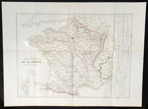
1846 Louis Dussieux Large Antique Map of The Political Boundaries of France
- Title : 1846 Louis Dussieux Large Antique Map of The Political Boundaries of France
- Size: 27 1/2in x 20 1/2in (700mm x 520mm)
- Condition: (A+) Fine Condition
- Date : 1846
- Ref #: 32414
Description:
This large hand coloured original copper plate engraved antique map was published by Louis Dussieux in the 1846 edition of Atlas Generale
General Definitions:
Paper thickness and quality: - Heavy and stable
Paper color : - off white
Age of map color: - Original
Colors used: - Pink
General color appearance: - Authentic
Paper size: - 27 1/2in x 20 1/2in (700mm x 520mm)
Plate size: - 27 1/2in x 20 1/2in (700mm x 520mm)
Margins: - Min 1in (25mm)
Imperfections:
Margins: - Folds as issued
Plate area: - Folds as issued
Verso: - Folds as issued
Dussieux, Louis 1815 - 1894
Dussieux was a French Geographer, prolific during the mid 19th century. After winning prizes in competitions of the Academy of Inscriptions and Belles Letters in 1839 and 1840, he was appointed recorder of military history and geography at the Saint - Cyr Special School in 1842 and became the professor of history in 1850. In 1843 he was appointed correspondent for the Historical Monuments Committee.
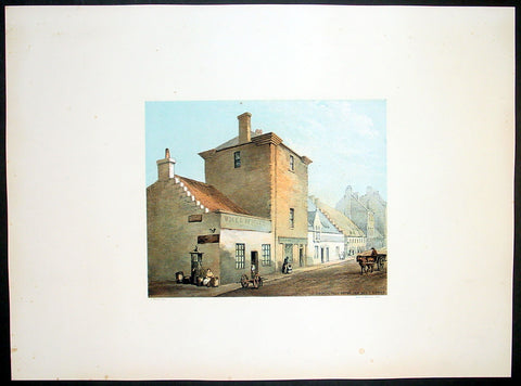
1849 Fairbairn Large Folio Antique Print Baronial Tower ,Main St Gorbals Glasgow
- Title : Old Baronial Hall Front View Main St Gorbals
- Date : 1849
- Condition: (A+) Fine Condition
- Ref: 40245
- Size: 22in x 16in (560mm x 405mm)
Description:
This beautifully coloured large folio original antique lithograph print, views of old Glasgow now long gone, by the Scottish artist Thomas Fairbairn (1821 - 1885) was published by Miller & Buchanan in the 1849 edition of Relic of Ancient Architecture and other Picturesque Scenes in Glasgow.
Subject Background:
This venerable pile, so long identified with the Barony of Gorbals, was erected between the years 1600 and 1608, by Sir George Elphinston, the son of a merchant in Glasgow, who had acquired the lands on the south side of the river known as "St. Ninian's Croft," from Boyd, the Protestant Archbishop of the See. With the view of forming a suitable residence, Sir George enclosed part of the croft for an orchard and garden, and built thereon the erections which so long formed the most prominent objects on the east side of the Main Street of Gorbals. Tradition informs us that he also erected a small Chapel adjoining, part of which still exists at the corner of Main Street and Rutherglen Loan. It was in this baronet's favour that the village of "Gorbels" was erected into a Burgh of Barony and Regality. Although this gentleman enjoyed great distinction in his lifetime, and rose to the rank of Lord Justice Clerk in the reign of Charles I., he afterwards became reduced in circumstances, and died miserably and in poverty about 1634. According to McUre, he was privately interred "in his own chapel, adjoining to his house." The property was then sold by the creditors of the deceased to Robert Douglas, Viscount Belhaven. This nobleman extended the mansion in Gorbals, and built a square Tower or "Fortulice," which is now almost the only part of the venerable buildings existing. Until within a few years ago, the Tower in question exhibited four turrets, which of course gave an imposing appearance to the structure. On the building adjoining the Tower may still be seen the family arms of Viscount Belhaven, pretty well cut in stone, the whole surmounted by the letters S. G. E., which are apparently meant for the initials of Sir George Elphinston. It is not at all improbable that this was not the original position of the arms referred to, but that at some period when alterations were made on the Tower, they had been removed from it, and placed so as to face the Main Street of the Barony. The Viscount, at his death, was succeeded by his nephew, Sir Robert Douglas of Blackerston, who sold the Gorbals Mansion House and lands in cumulo, some time prior to 1661, to the town of Glasgow, the Trades' House, and the Trustees for Hutchesons' Hospital. They were retained as a sort of co-partnery possession till 1790, when a division was made, and the central portion, containing the old buildings, fell to the lot of the city. The most important event connected with the Baronial Hall structure is found in the fact that at one time it formed the residence of Sir James Turner, Commander-in-Chief of the Forces in Scotland in the reign of Charles II., and who is understood to be the personage who supplied Sir Walter Scott with the portrait of Dugald Dalgetty. The terms on which Sir James obtained possession of the house are somewhat singular; for it appears by the minutes that on the 18th July, 1670, the Bailies and Council "ordains ane tack to be wrytten and subscryvit in favors of Sir James Turnor, of the toune's houss and tour in Gorballs, quhilk he presentlie possesses, and that dureing his lifetyme, for payment yearlie of three punds Scots, if the samyne be requyred." Sir James accordingly died in possession of the subjects; and from the records kept in the College, it would appear that at the sale of his effects, a part of his scanty library was purchased by the University of Glasgow. Amongst his books were several works upon the art of war; but the soldier of fortune had not overlooked productions of a more elevating and humanising kind, for Milton's "Paradise Lost" and various kindred tomes are found in his catalogue. Who were the successors of Sir James Turner, in the "toune's houss and tour," we have no way of knowing. At all events, as the locality was never an attractive one for the Glasgow merchants, the occupants must have gradually descended in the scale of quality. Before the close of the last century, and for some time afterwards, the principal room in the Tower, which was of a spacious kind, was used as a place of meeting by the magistrates, heritors and feuars of the parish of Gorbals; and here also the inhabitants mustered previous to performing the dutes of watching and warding, in days when a police force did not exist. Latterly, part of the old building was fitted up as a police-office, with adjoining cells. But it lost all its importance, excepting such as it retained from olden associations, when the official staff was removed to the present extensive police establishment in Portland Street. t was then given over to very humble uses - the ground floors to the street being let as whisky shops, and the upper flats having been split up into dwelling-houses for the lowest class of the people. The greater part of the structure built by Sir George Elphinston was taken down early in 1849 by order of the Dean of Guild Court, from its having exhibited symptoms of insecurity. It was then a fine remnant and wreck of the Scottish urban Manor House style, with its oriel windows, ornamental ceilings, and stout oaken staircases. The Tower, which remains, though sadly dilapidated externally and internally, still exhibits evidences of the aristocratic aspect it wore in the days of other years
Relic of Ancient Architecture and other Picturesque Scenes in Glasgow, was published large folio size in 1849, containing 19 large folio coloured lithograph prints and has long since been out of print. A praiseworthy motive induced Mr. James Bogle, at one time Lord Dean of Guild, and a member of an old and highly-respected Glasgow family, to engage Mr. Thomas Fairbairn to reproduce them, before they passed into oblivion, some "Relics of Ancient Architecture and Picturesque Scenes in Glasgow." The immediate cause of Mr. Bogle's resolve was the fall of a sugar-house in Alston Street, by which some six or seven lives were lost, and a resolution on the part of the Dean of Guild Court to make a general survey of the City with a view to the removal of old houses which, from age or other causes, were considered to be unfit for habitation. Mr. Bogle naturally thought that this was the proper time to reproduce in permanent form a fair presentment of many of the noted houses of old Glasgow.
Along with Mr. Fairbairn, the artist, Mr. Bogle made a tour of the City, and selected subjects for the drawings, nearly all of which are now gone, and those few that remain are so altered as to be almost irrecognisable.
A general wish having been expressed for a reproduction of the work, the publishers some time ago engaged Mr. Fairbairn (now alas! gone) to reproduce the original sketches, and also add a number of others of interest before the rapid growth of the City extinguishes or entirely defaces their subjects.
The drawings are now thirty in number, and have been reproduced by Messrs. Annan's new process of photo-engraving, which it will be observed, gives the effect of finely finished mezzo-tints.
The letterpress descriptions of the original edition are from the pen of the late Mr. James Pagan, Editor of the Glasgow Herald, and the descriptions of the new scenes have been supplied by his successor, the present Editor of that journal.
It ought to be stated that the descriptive portions, written by Mr. Pagan more than thirty years ago, have not been touched; so that readers should understand that they refer to the Glasgow of a former generation, and are all indicated in the Contents by an asterisk.
General Description:
Paper thickness and quality: - Heavy & stable
Paper color: - White
Age of map color: - Original
Colors used: - Red, green, blue, brown
General color appearance: - Authentic
Paper size: - 22in x 16in (560mm x 405mm)
Margins: - Min 4in (100mm)
Imperfections:
Margins: - None
Plate area: - None
Verso: - None
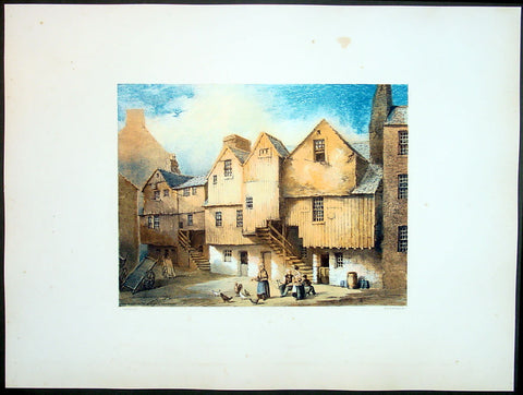
1849 Fairbairn Large Folio Antique Print of Old Tombs High Church Yard, Glasgow
- Title : Old Tombs High Church Yard
- Date : 1849
- Condition: (A+) Fine Condition
- Ref: 40244
- Size: 22in x 16in (560mm x 405mm)
Description:
This beautifully coloured large folio original antique lithograph print, views of old Glasgow now long gone, by the Scottish artist Thomas Fairbairn (1821 - 1885) was published by Miller & Buchanan in the 1849 edition of Relic of Ancient Architecture and other Picturesque Scenes in Glasgow.
Subject Background:
The subjects of this picture are representations of the memorials raised to departed worth by the affection or gratitude of our forefathers. We append a brief notice of each, but the only one of the four deserving of special allusion is that erected to the memory of Dr Peter Low, and now the property of the Faculty of Physicians and Surgeons in Glasgow. Dr. Low, who was some-time chirurgeon-in-ordinary to the French King, and also to King James VI., and his son the Prince, procured from the latter monarch a charter of erection in favour of the Faculty of Glasgow. The original charter is extant A fine old portrait of Dr. Low is preserved in the Faculty Hall, St.Enoch Square.
No. I.- The first on the left of the Plate.
Erected in 1630, by the Rev. John Dickson, who was married to Janet, daughter of the "Lord Bedlay." Afterwards it appears to have become the property of "Roberton of Bedlay," and latterly of Miss Lennox of Woodhead, who in 1818 disponed it to George Brown of Capelrigg, whose representatives are the present proprietors.
No. II.
"Here lyes ane Treu faithfull Brother, William Robertson, Merchand Burges of Glasgow. Decesit ye 24 June, 1617."
"W.R. AB."
This tomb appears afterwards to have belonged to Morehead of Bredisholm, although there is no entry in the Register to that effect. The present proprietor is not known.
No. III.
Monument to Dr PETER Low, Founder of the Faculty of Physicians and Surgeons, Glasgow.
INSCRIPTION.
Stay, Passenger, and view this Stone,
For under it lys such an one,
Who cur'd many while he liv'd,
So gracious he no man griev'd;
Yea, when his Physick's force oft fail'd,
His pleasant Purpose then prevail'd;
For of his God he got the Grace,
To live in Mirth and die in Peace.
Heaven has his soul, his corpse this Stone:
Sigh, passenger, and then be gone.
Ah! me. I gravel am and dust,
And to the grave deshend I must;
O! painted piece of liveing clay,
Man be not proud of thy short day.
This Burial Place was purchased by and is now the property of the Faculty of Physicians and Surgeons.
No. IV.
"Erected by Archd. Mure, Merchant, 1616, and descended to his daughter, Margaret Mure, who was married to James Hamilton. Afterwards it became the property of Provost John Gibson, in right of his wife, Christian Anderson, grand-child of the above James Hamilton and Margaret Mure. It afterwards became the property of William Anderson, merchant, in right of his wife, Christian Gibson, daughter of Provost John Gibson; and their only child, Christian Anderson, was the next successor. She dying unmarried, was succeeded by her cousin, Margaret Mather, relict of Archibald Anderson, brewer in Glasgow, who upon the 13th May, 1797, disponed this property to Thomas Buchanan, merchant in Glasgow; and upon the 13th March, 1806, it was conveyed by Jane Buchanan, his daughter, to James Buchanan,* merchant, Glasgow." - (From Register of Burial Grounds.)
* Late of Dowanhill, whose representatives are the present proprietors.
Relic of Ancient Architecture and other Picturesque Scenes in Glasgow, was published large folio size in 1849, containing 19 large folio coloured lithograph prints and has long since been out of print. A praiseworthy motive induced Mr. James Bogle, at one time Lord Dean of Guild, and a member of an old and highly-respected Glasgow family, to engage Mr. Thomas Fairbairn to reproduce them, before they passed into oblivion, some "Relics of Ancient Architecture and Picturesque Scenes in Glasgow." The immediate cause of Mr. Bogle's resolve was the fall of a sugar-house in Alston Street, by which some six or seven lives were lost, and a resolution on the part of the Dean of Guild Court to make a general survey of the City with a view to the removal of old houses which, from age or other causes, were considered to be unfit for habitation. Mr. Bogle naturally thought that this was the proper time to reproduce in permanent form a fair presentment of many of the noted houses of old Glasgow.
Along with Mr. Fairbairn, the artist, Mr. Bogle made a tour of the City, and selected subjects for the drawings, nearly all of which are now gone, and those few that remain are so altered as to be almost irrecognisable.
A general wish having been expressed for a reproduction of the work, the publishers some time ago engaged Mr. Fairbairn (now alas! gone) to reproduce the original sketches, and also add a number of others of interest before the rapid growth of the City extinguishes or entirely defaces their subjects.
The drawings are now thirty in number, and have been reproduced by Messrs. Annan's new process of photo-engraving, which it will be observed, gives the effect of finely finished mezzo-tints.
The letterpress descriptions of the original edition are from the pen of the late Mr. James Pagan, Editor of the Glasgow Herald, and the descriptions of the new scenes have been supplied by his successor, the present Editor of that journal.
It ought to be stated that the descriptive portions, written by Mr. Pagan more than thirty years ago, have not been touched; so that readers should understand that they refer to the Glasgow of a former generation, and are all indicated in the Contents by an asterisk.
General Description:
Paper thickness and quality: - Heavy & stable
Paper color: - White
Age of map color: - Original
Colors used: - Red, green, blue, brown
General color appearance: - Authentic
Paper size: - 22in x 16in (560mm x 405mm)
Margins: - Min 4in (100mm)
Imperfections:
Margins: - None
Plate area: - None
Verso: - None
1849 Fairbairn Large Folio Antqiue Print of Houses Saltmarket St Gorbals Glasgow
- Title : Old Wooden Houses in Close Saltmarket
- Date : 1849
- Condition: (A+) Fine Condition
- Ref: 40247
- Size: 22in x 16in (560mm x 405mm)
Description:
This beautifully coloured large folio original antique lithograph print, views of old Glasgow now long gone, by the Scottish artist Thomas Fairbairn (1821 - 1885) was published by Miller & Buchanan in the 1849 edition of Relic of Ancient Architecture and other Picturesque Scenes in Glasgow.
Subject Background:
The artist has here represented a style of dwelling-house architecture which is fast passing away, and will soon altogether cease to exist. Houses of this kind seem to have been originally erected from the cheapness of the materials, and for the purpose of economizing building-ground space. To attain the latter object, beams, as shown in the print, were projected from the first storey, and an out-shot and additional structure raised upon them, thus offering a great obstruction to ventilation, and affording an inconvenient, cold, and comfortless dwelling. When situated in a close, houses of this kind were generally occupied by working people, or by those who rented a small shop or bothy in the front street, and lodged themselves and families in one of these fragile-looking tenements behind. In some rare cases these wooden houses were tenanted by persons of a more substantial character, and we may mention, as the most prominent instance of which we have heard, that so recently as the close of last century the firm of Francis Reid & Sons, watchmakers, occupied a large wooden structure in the close opposite 77, both as their dwelling-house, work-shop, and sale-shop. These gentlemen were the first to give a stimulus to the watchmaking and jewellery business in Glasgow; and however humble their premises may have been, they did a large and lucrative business, and off-shoots from their concern branched into some of the principal establishments at present existing in Glasgow. We have no story to tell regarding the houses represented in the print; in their better days they were occupied by decent native tradesmen, but for a long succession of years they have been in the possession of the Irish, whose annals would furnish nothing attractive. Two hundred years ago wooden houses of this kind formed the majority of the Saltmarket closes ; but a great fire having broken out on 3rd November, 1677, the upper part of the street on both sides was destroyed as far as the Tron Church on the west, and two or three tenements in the Gallowgate on the east. From the rapidity with which these timber structures were mowed down by the flames on that occasion, the wisdom of replacing them with stone erections became apparent, and since then very few timber houses have been put down in the city, excepting in obscure back lanes, and on a very humble scale. As we have said, they will speedily disappear altogether, for the Dean of Guild Court will not permit a renewal of buildings in this style, when the present houses fall or are pulled down from natural decay. A stone inserted in the door-way of a one-storey house at the bottom of this close hears the inscription, "H. Br., J. H., 1727.".
Relic of Ancient Architecture and other Picturesque Scenes in Glasgow, was published large folio size in 1849, containing 19 large folio coloured lithograph prints and has long since been out of print. A praiseworthy motive induced Mr. James Bogle, at one time Lord Dean of Guild, and a member of an old and highly-respected Glasgow family, to engage Mr. Thomas Fairbairn to reproduce them, before they passed into oblivion, some "Relics of Ancient Architecture and Picturesque Scenes in Glasgow." The immediate cause of Mr. Bogle's resolve was the fall of a sugar-house in Alston Street, by which some six or seven lives were lost, and a resolution on the part of the Dean of Guild Court to make a general survey of the City with a view to the removal of old houses which, from age or other causes, were considered to be unfit for habitation. Mr. Bogle naturally thought that this was the proper time to reproduce in permanent form a fair presentment of many of the noted houses of old Glasgow.
Along with Mr. Fairbairn, the artist, Mr. Bogle made a tour of the City, and selected subjects for the drawings, nearly all of which are now gone, and those few that remain are so altered as to be almost irrecognisable.
A general wish having been expressed for a reproduction of the work, the publishers some time ago engaged Mr. Fairbairn (now alas! gone) to reproduce the original sketches, and also add a number of others of interest before the rapid growth of the City extinguishes or entirely defaces their subjects.
The drawings are now thirty in number, and have been reproduced by Messrs. Annan's new process of photo-engraving, which it will be observed, gives the effect of finely finished mezzo-tints.
The letterpress descriptions of the original edition are from the pen of the late Mr. James Pagan, Editor of the Glasgow Herald, and the descriptions of the new scenes have been supplied by his successor, the present Editor of that journal.
It ought to be stated that the descriptive portions, written by Mr. Pagan more than thirty years ago, have not been touched; so that readers should understand that they refer to the Glasgow of a former generation, and are all indicated in the Contents by an asterisk.
General Description:
Paper thickness and quality: - Heavy & stable
Paper color: - White
Age of map color: - Original
Colors used: - Red, green, blue, brown
General color appearance: - Authentic
Paper size: - 22in x 16in (560mm x 405mm)
Margins: - Min 4in (100mm)
Imperfections:
Margins: - None
Plate area: - None
Verso: - None
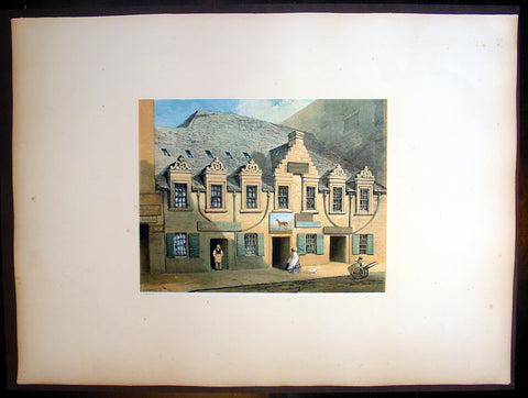
1849 Fairnbiarn Large Antique Print of Mansion Stockwell Street Glasgow Scotland
- Title : Old Mansion, Stockwell Street
- Date : 1849
- Condition: (A+) Fine Condition
- Ref: 40248
- Size: 22in x 16in (560mm x 405mm)
Description:
This beautifully coloured large folio original antique lithograph print of views of old Glasgow now long gone by the Scottish artist Thomas Fairbairn (1821 - 1885) was published by Miller & Buchanan in the 1849 edition of Relic of Ancient Architecture and other Picturesque Scenes in Glasgow.
Subject Background
This is one of the finest specimens extant of the dwelling-houses which the Glasgow citizens of the seventeenth century delighted to rear for the accommodation of themselves and families. No story of any peculiar interest attaches to the fabric in question. It simply illustrates a once favourite style of architecture which has now almost disappeared from amongst us. In a document, dated in 1639, this site is described as having been occupied by three small tenements which were then in rather a ruinous condition. They were surrounded by a "yaird," and considered quite in the suburbs. The subjects must have remained in a dilapidated condition for a long time. They were purchased in 1668 by John Caldwell, merchant in Glasgow, who immediately afterwards built the present tenement or tenements. It had a garden to the back, surrounded with a wall, and adorned with a summer-house. The subjects passed into the hands of Andrew Caldwell, son of the former, who sold them in 1698 to John Gray and William Knox, merchants in Glasgow, but apparently only in security for a debt. This was not paid, however, and a commission was granted to these gentlemen to dispose of the property absolutely, when it was acquired by Daniel Campbell, John Graham of Dugaldston, William Cross, William Wodropp, James Muir, and Matthew Campbell, merchants in Glasgow. This transaction took place on 3rd October, 1700. These gentlemen belonged to the mercantile aristocracy of the time; but the purpose for which they became joint-stock owners of this property is not now apparent. These parties sold their respective shares to Graham of Dugaldston in 1705, who in turn disposed of it, in 1709, to Andrew Cathcart, merchant in Glasgow. In a document, dated 13th January of that year, the subjects are thus described:-
"All and haill, the foresaid northmost of the saids two tenements of land, high and laigh, back and forwd, with the closs yaird at the back thereof, and stone dyke about the same, and summer-house within the same yaird, office-house, and haill pertinents of the samen, with the equal half of the said well Lyand betwixt the said two tenements, with free ish and entree yrto, and haill liberties and privileges yrof. And whilk northmost tenement, closs, yaird, office-houss, and pertinents erected and rebuilded by umqll John Cauldwell, merchant, father to the said Andrew, pertained of old to umqll Peter Johnston Tayloor, and consisted of three small tenements, yaird, and pertinents, and were acquired by the said umqll John Cauldwell from Kathrine Johnstoune and John Montgomerie, her husband, and were then bounded betwixt the lands of Adam Hish, being now the southmost of the saids two tenements. The lands of umqll Patrick Crawford and oyrs, and of the representatives of the said umqll Mitchell on the north. The lands of umqll William Thomson, John Andersone, elder, and Mr Archibald Denniston on the east, and the High Street on the west parts."
The purchaser above-named having held the property during a very lengthened period, including the time of the two great rebellions, it descended in 1754 to his grandson, William Cathcart, then merchant in Kingston, Jamaica. The representatives of this gentleman sold the property in 1771 to James Campbell, saddler in Glasgow, for the sum of £820. Campbell seems to have been unfortunate, for in the same year the Trustees for his creditors sold the subjects to George Anderson, merchant. About this time the house was much damaged by fire, but as it was insured in the Sun Fire Office, the Trustees retained the insurance money, and sold the property as it stood for the reduced price of £535. Anderson held it till his death, and the greater part was disposed of by his Trustees in 1827 to Mr Ritchie, Stockwell Street, whose family still hold the house. The price then paid was £1800. It has long ceased to be a dwelling-house, the lower portions or ground floors having been occupied as spirit vaults for an uninterrupted space of more than 80 years. They are used for this purpose still. A tradition has long prevailed that this house was occupied by some of Cromwell's officers when the Protector was in Glasgow. This, of course, could not have been the case, for the house was not built till eight years after the Restoration. The three small houses, however, which previously occupied the same site may, in all likelihood, have afforded accommodation to some of Cromwell's train.
Relic of Ancient Architecture and other Picturesque Scenes in Glasgow, was published large folio size in 1849, containing 19 large folio coloured lithograph prints and has long since been out of print. A praiseworthy motive induced Mr. James Bogle, at one time Lord Dean of Guild, and a member of an old and highly-respected Glasgow family, to engage Mr. Thomas Fairbairn to reproduce them, before they passed into oblivion, some "Relics of Ancient Architecture and Picturesque Scenes in Glasgow." The immediate cause of Mr. Bogle's resolve was the fall of a sugar-house in Alston Street, by which some six or seven lives were lost, and a resolution on the part of the Dean of Guild Court to make a general survey of the City with a view to the removal of old houses which, from age or other causes, were considered to be unfit for habitation. Mr. Bogle naturally thought that this was the proper time to reproduce in permanent form a fair presentment of many of the noted houses of old Glasgow
Along with Mr. Fairbairn, the artist, Mr. Bogle made a tour of the City, and selected subjects for the drawings, nearly all of which are now gone, and those few that remain are so altered as to be almost irrecognisable.
A general wish having been expressed for a reproduction of the work, the publishers some time ago engaged Mr. Fairbairn (now alas! gone) to reproduce the original sketches, and also add a number of others of interest before the rapid growth of the City extinguishes or entirely defaces their subjects.
The drawings are now thirty in number, and have been reproduced by Messrs. Annan's new process of photo-engraving, which it will be observed, gives the effect of finely finished mezzo-tints.
The letterpress descriptions of the original edition are from the pen of the late Mr. James Pagan, Editor of the Glasgow Herald, and the descriptions of the new scenes have been supplied by his successor, the present Editor of that journal.
It ought to be stated that the descriptive portions, written by Mr. Pagan more than thirty years ago, have not been touched; so that readers should understand that they refer to the Glasgow of a former generation, and are all indicated in the Contents by an asterisk.
General Description:
Paper thickness and quality: - Heavy & stable
Paper color: - White
Age of map color: - Original
Colors used: - Red, green, blue, brown
General color appearance: - Authentic
Paper size: - 22in x 16in (560mm x 405mm)
Margins: - Min 4in (100mm)
Imperfections:
Margins: - None
Plate area: - None
Verso: - None
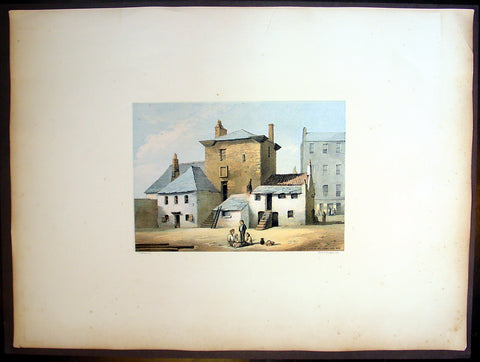
1849 Fairnbiarn Large Antique Print The Old Baronial Hall in the Gorbals Glasgow
- Title : Old Baronial Hall, Gorbals, Back View
- Date : 1849
- Condition: (A+) Fine Condition
- Ref: 40251
- Size: 22in x 16in (560mm x 405mm)
Description:
This beautifully coloured large folio original antique lithograph print, views of old Glasgow now long gone, by the Scottish artist Thomas Fairbairn (1821 - 1885) was published by Miller & Buchanan in the 1849 edition of Relic of Ancient Architecture and other Picturesque Scenes in Glasgow.
Subject Background
The Old Baronial Hall was built by Sir George Elphinstone and his wife Dame Agnes Boyd in 1601. Following his death in 1634 the building passed down through several owners including Robert Douglas, Viscount Belhaven (who added a distinctive square tower), Gorbals Town Council and Sir James Turner. By 1858 a part of The Old Barional Hall (with the neighbouring chapel) had been converted into a public house, the Old Gorbals Wine and Spirit Vaults. However, the ornate ceiling and cornicing and the statuettes on the walls are reminders of the building's former glories, as the home of one of Glasgow's most prominent men of affairs. The initials S G E and D A B on the ceiling were part of the original decoration and stood for Sir George Elphinstone and his wife Dame Agnes Boyd. It was demolished in the early 1870s.
The Gorbals is an area on the south bank of the River Clyde in the city of Glasgow, Scotland. By the late 19th century, it had become over-populated and adversely affected by local industrialisation. Many people lived here because their jobs provided this home and they could not afford their own. It became widely known as a dangerous slum and was subject to efforts at
redevelopment, which contributed to more problems such as homeless people and diseases spreading. In recent decades, some buildings have been demolished for a mixture of market and social housing; others are being refurbished and restored to a higher standard.
Relic of Ancient Architecture and other Picturesque Scenes in Glasgow, was published large folio size in 1849, containing 19 large folio coloured lithograph prints and has long since been out of print. A praiseworthy motive induced Mr. James Bogle, at one time Lord Dean of Guild, and a member of an old and highly-respected Glasgow family, to engage Mr. Thomas Fairbairn to reproduce them, before they passed into oblivion, some "Relics of Ancient Architecture and Picturesque Scenes in Glasgow." The immediate cause of Mr. Bogle's resolve was the fall of a sugar-house in Alston Street, by which some six or seven lives were lost, and a resolution on the part of the Dean of Guild Court to make a general survey of the City with a view to the removal of old houses which, from age or other causes, were considered to be unfit for habitation. Mr. Bogle naturally thought that this was the proper time to reproduce in permanent form a fair presentment of many of the noted houses of old Glasgow
Along with Mr. Fairbairn, the artist, Mr. Bogle made a tour of the City, and selected subjects for the drawings, nearly all of which are now gone, and those few that remain are so altered as to be almost irrecognisable.
A general wish having been expressed for a reproduction of the work, the publishers some time ago engaged Mr. Fairbairn (now alas! gone) to reproduce the original sketches, and also add a number of others of interest before the rapid growth of the City extinguishes or entirely defaces their subjects.
The drawings are now thirty in number, and have been reproduced by Messrs. Annan's new process of photo-engraving, which it will be observed, gives the effect of finely finished mezzo-tints.
The letterpress descriptions of the original edition are from the pen of the late Mr. James Pagan, Editor of the Glasgow Herald, and the descriptions of the new scenes have been supplied by his successor, the present Editor of that journal.
It ought to be stated that the descriptive portions, written by Mr. Pagan more than thirty years ago, have not been touched; so that readers should understand that they refer to the Glasgow of a former generation, and are all indicated in the Contents by an asterisk.
General Description:
Paper thickness and quality: - Heavy & stable
Paper color: - White
Age of map color: - Original
Colors used: - Red, green, blue, brown
General color appearance: - Authentic
Paper size: - 22in x 16in (560mm x 405mm)
Margins: - Min 4in (100mm)
Imperfections:
Margins: - None
Plate area: - None
Verso: - None
1850 John Gould Large Antique Bird Print of The Tibetan or Humes Ground-Tit
Antique Map
- Title : Podoces Humilis, Hume...J Gould & W Hart del et Lith....Walter Imp.
- Size: 21 1/2in x 14 1/2in (490mm x 370mm)
- Condition: (A+) Fine Condition
- Date : 1850
- Ref #: 23189
Description:
This finely engraved superbly hand coloured original antique bird print of Podoces Humilis or the Tibetan ground-tit or Humes ground-tit, was published by John Gould in the 1850 release of his illustrated ornithology book The Birds of Asia. Lithography by J Gould, HC Richter & W. Hart publication by Hullamdel, Walton & Walter
General Definitions:
Paper thickness and quality: - Heavy and stable
Paper color : - off white
Age of map color: - Original
Colors used: - Yellow, green, blue, pink
General color appearance: - Authentic
Paper size: - 21 1/2in x 14 1/2in (490mm x 370mm)
Plate size: - 21 1/2in x 14 1/2in (490mm x 370mm)
Margins: - Min 1/2in (12mm)
Imperfections:
Margins: - Very light age toning in margins
Plate area: - None
Verso: - None
Background:
One of the great bird artists of all time, John Gould created over 3,000 plates of birds in over 40 volumes.
Around 1830, while working as taxidermist for the Zoological Society of London, he received a shipment of exotic bird skins from the Himalayas. Soon after, he published A Century of Birds from the Himalaya Moutains.
The success of this work, along with the Birds of Europe (1832-37) and a Monograph of the Ramphastidae [Toucans] allowed him to travel to Australia and New Guinea. Among Gould\'s better known works are the Birds of Australia (1849-69), the Birds of Asia (1850-83), and Birds of Great Britain (1862-73).
Though Gould himself sketched most of his plates, other artists such as his wife Elizabeth, Edward Lear, Joseph Wolf, William Hart and Henry C. Richter finished them. Gould\'s plates are highly esteemed for their composition, accurate detail, and coloring. (Ref: Methuen)
1850 Scarce Chinese Twin Hemisphere World Map - 世界
- Title : 世界
- Size: 18in x 9 1/2in (460mm x 240mm)
- Condition: (A+) Fine Condition
- Date : 1850
- Ref #: 61129
Description:
This scarce, original antique Chinese Twin Hemisphere World Map - with global trade routes to and from China - was published ca 1850.
General Definitions:
Paper thickness and quality: - Heavy and stable
Paper color : - off white
Age of map color: - Original
Colors used: - Yellow, green, blue, pink
General color appearance: - Authentic
Paper size: - 18in x 9 1/2in (460mm x 240mm)
Plate size: - 18in x 9 1/2in (460mm x 240mm)
Margins: - Min 1/2in (12mm)
Imperfections:
Margins: - None
Plate area: - None
Verso: - None
Chinese Cartography
The earliest known maps to have survived in China date to the 4th century BC. In 1986, seven ancient Chinese maps were found in an archeological excavation of a Qin State tomb in what is now Fangmatan, in the vicinity of Tianshui City, Gansu province. Before this find, the earliest extant maps that were known came from the Mawangdui Han tomb excavation in 1973, which found three maps on silk dated to the 2nd century BC in the early Han Dynasty. The 4th century BC maps from the State of Qin were drawn with black ink on wooden blocks. These blocks fortunately survived in soaking conditions due to underground water that had seeped into the tomb; the quality of the wood had much to do with their survival. After two years of slow-drying techniques, the maps were fully restored.
The territory shown in the seven Qin maps overlap each other. The maps display tributary river systems of the Jialing River in Sichuan province, in a total measured area of 107 by 68 km. The maps featured rectangular symbols encasing character names for the locations of administrative counties. Rivers and roads are displayed with similar line symbols; this makes interpreting the map somewhat difficult, although the labels of rivers placed in order of stream flow are helpful to modern day cartographers.–93 These maps also feature locations where different types of timber can be gathered, while two of the maps state the distances in mileage to the timber sites. In light of this, these maps are perhaps the oldest economic maps in the world since they predate Strabo\\\'s economic maps.
In addition to the seven maps on wooden blocks found at Tomb 1 of Fangmatan, a fragment of a paper map was found on the chest of the occupant of Tomb 5 of Fangmatan in 1986. This tomb is dated to the early Western Han, so the map dates to the early 2nd century BC. The map shows topographic features such as mountains, waterways and roads, and is thought to cover the area of the preceding Qin Kingdom.
In China, the earliest known geographical Chinese writing dates back to the 5th century BC, during the beginning of the Warring States (481–221 BC). This was the Yu Gong or Tribute of Yu chapter of the Shu Jing or Book of Documents. The book describes the traditional nine provinces, their kinds of soil, their characteristic products and economic goods, their tributary goods, their trades and vocations, their state revenues and agricultural systems, and the various rivers and lakes listed and placed accordingly. The nine provinces in the time of this geographical work were very small in size compared to their modern Chinese counterparts. The Yu Gong\\\'s descriptions pertain to areas of the Yellow River, the lower valleys of the Yangtze, with the plain between them and the Shandong Peninsula, and to the west the most northern parts of the Wei River and the Han River were known (along with the southern parts of modern-day Shanxi province)
The oldest reference to a map in China comes from the 3rd century BC. This was the event of 227 BC where Crown Prince Dan of Yan had his assassin Jing Ke visit the court of the ruler of the State of Qin, who would become Qin Shi Huang (r. 221–210 BC). Jing Ke was to present the ruler of Qin with a district map painted on a silk scroll, rolled up and held in a case where he hid his assassin\\\'s dagger.Handing to him the map of the designated territory was the first diplomatic act of submitting that district to Qin rule.Instead he attempted to kill Qin, an assassination plot that failed. From then on maps are frequently mentioned in Chinese sources.
The three Han Dynasty maps found at Mawangdui differ from the earlier Qin State maps. While the Qin maps place the cardinal direction of north at the top of the map, the Han maps are orientated with the southern direction at the top. The Han maps are also more complex, since they cover a much larger area, employ a large number of well-designed map symbols, and include additional information on local military sites and the local population. The Han maps also note measured distances between certain places, but a formal graduated scale and rectangular grid system for maps would not be used—or at least described in full—until the 3rd century (see Pei Xiu below). Among the three maps found at Mawangdui was a small map representing the tomb area where it was found, a larger topographical map showing the Han\\\'s borders along the subordinate Kingdom of Changsha and the Nanyue kingdom (of northern Vietnam and parts of modern Guangdong and Guangxi), and a map which marks the positions of Han military garrisons that were employed in an attack against Nanyue in 181 BC.
An early text that mentioned maps was the Rites of Zhou.Although attributed to the era of the Zhou Dynasty, its first recorded appearance was in the libraries of Prince Liu De (c. 130 BC), and was compiled and commented on by Liu Xin in the 1st century AD. It outlined the use of maps that were made for governmental provinces and districts, principalities, frontier boundaries, and even pinpointed locations of ores and minerals for mining facilities.Upon the investiture of three of his sons as feudal princes in 117 BC, Emperor Wu of Han had maps of the entire empire submitted to him.
From the 1st century AD onwards, official Chinese historical texts contained a geographical section (Diliji), which was often an enormous compilation of changes in place-names and local administrative divisions controlled by the ruling dynasty, descriptions of mountain ranges, river systems, taxable products, etc. From the time of the 5th century BC Shu Jing forward, Chinese geographical writing provided more concrete information and less legendary element. This example can be seen in the 4th chapter of the Huainanzi (Book of the Master of Huainan), compiled under the editorship of Prince Liu An in 139 BC during the Han Dynasty (202 BC–202 AD). The chapter gave general descriptions of topography in a systematic fashion, given visual aids by the use of maps (di tu) due to the efforts of Liu An and his associate Zuo Wu. In Chang Chu\\\'s Hua Yang Guo Chi (Historical Geography of Szechuan) of 347, not only rivers, trade routes, and various tribes were described, but it also wrote of a \\\'Ba June Tu Jing\\\' (\\\'Map of Szechuan\\\'), which had been made much earlier in 150.
Local mapmaking such as the one of Szechuan mentioned above, became a widespread tradition of Chinese geographical works by the 6th century, as noted in the bibliography of the Sui Shu. It is during this time of the Southern and Northern Dynasties that the Liang Dynasty (502–557) cartographers also began carving maps into stone steles (alongside the maps already drawn and painted on paper and silk)
In the year 267,Pei Xiu (224–271) was appointed as the Minister of Works by Emperor Wu of Jin, the first emperor of the Jin Dynasty. Pei is best known for his work in cartography. Although map making and use of the grid existed in China before him, he was the first to mention a plotted geometrical grid and graduated scale displayed on the surface of maps to gain greater accuracy in the estimated distance between different locations. Pei outlined six principles that should be observed when creating maps, two of which included the rectangular grid and the graduated scale for measuring distance. Historians compare him to the Greek Ptolemy for his contributions in cartography. However, Howard Nelson states that, although the accounts of earlier cartographic works by the inventor and official Zhang Heng (78–139) are somewhat vague and sketchy, there is ample written evidence that Pei Xiu derived the use of the rectangular grid reference from the maps of Zhang Heng.
Later Chinese ideas about the quality of maps made during the Han Dynasty and before stem from the assessment given by Pei Xiu, which was not a positive one. Pei Xiu noted that the extant Han maps at his disposal were of little use since they featured too many inaccuracies and exaggerations in measured distance between locations. However, the Qin State maps and Mawangdui maps of the Han era were far superior in quality than those examined by Pei Xiu. It was not until the 20th century that Pei Xiu\\\'s 3rd century assessment of earlier maps\\\' dismal quality would be overturned and disproven. The Qin and Han maps did have a degree of accuracy in scale and pinpointed location, but the major improvement in Pei Xiu\\\'s work and that of his contemporaries was expressing topographical elevation on maps.
In the year 605, during the Sui Dynasty (581–618), the Commercial Commissioner Pei Ju (547–627) created a famous geometrically gridded map. In 610 Emperor Yang of Sui ordered government officials from throughout the empire to document in gazetteers the customs, products, and geographical features of their local areas and provinces, providing descriptive writing and drawing them all onto separate maps, which would be sent to the imperial secretariat in the capital city.
The Tang Dynasty (618–907) also had its fair share of cartographers, including the works of Xu Jingzong in 658, Wang Mingyuan in 661, and Wang Zhongsi in 747. Arguably the greatest geographer and cartographer of the Tang period was Jia Dan (730–805), whom Emperor Dezong of Tang entrusted in 785 to complete a map of China with her recently former inland colonies of Central Asia, the massive and detailed work completed in 801, called the Hai Nei Hua Yi Tu (Map of both Chinese and Barbarian Peoples within the (Four) Seas). The map was 30 ft long (9.1 m) and 33 ft high (10 m) in dimension, mapped out on a grid scale of 1-inch (25 mm) equaling 100 li (unit) (the Chinese equivalent of the mile/kilometer). Jia Dan is also known for having described the Persian Gulf region with great detail, along with lighthouses that were erected at the mouth of the Persian Gulf by the medieval Iranians in the Abbasid period (refer to article on Tang Dynasty for more).
During the Song Dynasty (960–1279) Emperor Taizu of Song ordered Lu Duosun in 971 to update and \\\'re-write all the Tu Jing in the world\\\', which would seem to be a daunting task for one individual, who was sent out throughout the provinces to collect texts and as much data as possible. With the aid of Song Zhun, the massive work was completed in 1010, with some 1566 chapters. The later Song Shi historical text stated (Wade-Giles spelling):
........Yuan Hsieh (d. +1220) was Director-General of governmental grain stores. In pursuance of his schemes for the relief of famines he issued orders that each pao (village) should prepare a map which would show the fields and mountains, the rivers and the roads in fullest detail. The maps of all the pao were joined together to make a map of the tu (larger district), and these in turn were joined with others to make a map of the hsiang and the hsien (still larger districts). If there was any trouble about the collection of taxes or the distribution of grain, or if the question of chasing robbers and bandits arose, the provincial officials could readily carry out their duties by the aid of the maps.....
Like the earlier Liang Dynasty stone-stele maps (mentioned above), there were large and intricately carved stone stele maps of the Song period. For example, the 3 ft (0.91 m) squared stone stele map of an anonymous artist in 1137, following the grid scale of 100 li squared for each grid square. :Plate LXXXI What is truly remarkable about this map is the incredibly precise detail of coastal outlines and river systems in China (refer to Needham\\\'s Volume 3, Plate LXXXI for an image). The map shows 500 settlements and a dozen rivers in China, and extends as far as Korea and India. On the reverse, a copy of a more ancient map uses grid coordinates in a scale of 1:1,500,000 and shows the coastline of China with great accuracy.
The famous 11th century scientist and polymath statesman Shen Kuo (1031–1095) was also a geographer and cartographer. His largest atlas included twenty three maps of China and foreign regions that were drawn at a uniform scale of 1:900,000. Shen also created a three-dimensional raised-relief map using sawdust, wood, beeswax, and wheat paste, while representing the topography and specific locations of a frontier region to the imperial court. Shen Kuo\\\'s contemporary, Su Song (1020–1101), was a cartographer who created detailed maps in order to resolve a territorial border dispute between the Song Dynasty and the Liao Dynasty.
The Da Ming hunyi tu map, dating from about 1390, is in multicolour. The horizontal scale is 1:820,000 and the vertical scale is 1:1,060,000.
In 1579, Luo Hongxian published the Guang Yutu atlas, including more than 40 maps, a grid system, and a systematic way of representing major landmarks such as mountains, rivers, roads and borders. The Guang Yutu incorporates the discoveries of naval explorer Zheng He\\\'s 15th century voyages along the coasts of China, Southeast Asia, India and Africa. The Mao Kun map published in 1628 is thought to be based on a strip map dated to the voyages of Zheng He.
From the 16th and 17th centuries, several examples survive of maps focused on cultural information. Gridlines are not used on either Yu Shi\\\'s Gujin xingsheng zhi tu (1555) or Zhang Huang\\\'s Tushu bian (1613); instead, illustrations and annotations show mythical places, exotic foreign peoples, administrative changes and the deeds of historic and legendary heroes. Also in the 17th century, an edition of a possible Tang Dynasty map shows clear topographical contour lines. Although topographic features were part of maps in China for centuries, a Fujian county official Ye Chunji (1532–1595) was the first to base county maps using on-site topographical surveying and observations.
The Korean made Kangnido based on two Chinese maps, which describes the Old World.
After the 1949 revolution, the Institute of Geography under the aegis of the Chinese Academy of Sciences became responsible for official cartography and emulated the Soviet model of geography throughout the 1950s. With its emphasis on fieldwork, sound knowledge of the physical environment and the interrelation between physical and economic geography, the Russian influence counterbalanced the many pre-liberation Western-trained Chinese geography specialists who were more interested in the historical and culture aspects of cartography. As a consequence, China\\\'s main geographical journal, the Dili Xuebao (地理学报) featured many articles by Soviet geographers. As Soviet influence waned in the 1960s, geographic activity continued as part of the process of modernisation until it came to a stop with the 1967 Cultural Revolution.
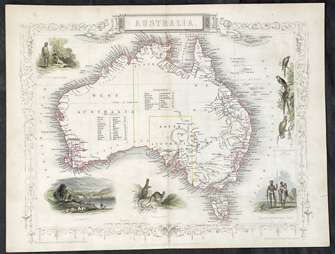
1851 John Tallis Antique Map of Australia
Antique Map
- Title : Australia
- Date : 1851
- Size: 14in x 11in (355mm x 280mm)
- Condition: (A+) Fine Condition
- Ref: 35511
Description:
This original hand coloured, steel plate engraved antique map of Australia with vignettes of Sydney Harbour, Aboriginals, Parrots and Kangaroos was engraved by John Rapkin and published by John Tallis in 1851.
General Definitions:
Paper thickness and quality: - Heavy and stable
Paper color : - off white
Age of map color: - Original
Colors used: - Blue
General color appearance: - Authentic
Paper size: - 14in x 11in (355mm x 280mm)
Plate size: - 14in x 11in (355mm x 280mm)
Margins: - Min 1/2in (12mm)
Imperfections:
Margins: - None
Plate area: - None
Verso: - None
Background:
The firm of Tallis & Company flourished from 1835 to 1860 with varying imprints. Their illustrated Atlas of 1850-51 was one of the last decorative atlases, all the maps being engraved on steel and all adorned with small vignettes. (Ref: Tooley; M&B)
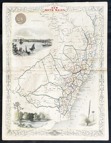
1851 John Tallis Antique Map of New South Wales, Australia
Antique Map
- Title : New South Wales
- Date : 1851
- Size: 14in x 11in (355mm x 280mm)
- Condition: (A+) Fine Condition
- Ref: 1554
Description:
This original hand coloured, steel plate engraved antique map of New South Wales, Australia with vignettes of Sydney Harbour and The Murray was engraved by John Rapkin and published by John Tallis in 1851.
General Definitions:
Paper thickness and quality: - Heavy and stable
Paper color : - off white
Age of map color: - Original
Colors used: - Blue
General color appearance: - Authentic
Paper size: - 14in x 11in (355mm x 280mm)
Plate size: - 14in x 11in (355mm x 280mm)
Margins: - Min 1/2in (12mm)
Imperfections:
Margins: - None
Plate area: - None
Verso: - None
Background:
The firm of Tallis & Company flourished from 1835 to 1860 with varying imprints. Their illustrated Atlas of 1850-51 was one of the last decorative atlases, all the maps being engraved on steel and all adorned with small vignettes. (Ref: Tooley; M&B)
1851 John Tallis Antique map of the Island of Jamaica
Antique Map
- Title : Jamaica
- Date : 1851
- Size: 15in x 11in (380mm x 280mm)
- Condition: (A+) Fine Condition
- Ref: 35616
Description:
This original hand coloured copper plate engraved antique map of Jamaica, with decorative vignettes of Kingston, Port Antonio, Port Royal, a sugar mill and a flying fish, was published by John Tallis in 1851.
General Definitions:
Paper thickness and quality: - Heavy and stable
Paper color : - off white
Age of map color: - Original
Colors used: - Yellow, green, blue, pink
General color appearance: - Authentic
Paper size: - 15in x 11in (380mm x 280mm)
Plate size: - 15in x 10in (380mm x 255mm)
Margins: - Min 1/2in (12mm)
Imperfections:
Margins: - None
Plate area: - Light crease left side of image
Verso: - None
1851 John Tallis Antique Map of Van Diemens Land or Tasmania, Australia
Antique Map
- Title : Van Diemens Land or Tasmania
- Date : 1851
- Size: 14in x 11in (355mm x 280mm)
- Condition: (A+) Fine Condition
- Ref: 35519
Description:
This original hand coloured, steel plate engraved antique map of Tasmania, Australia with vignettes of Hobart and Tasmanian Tiger was engraved by John Rapkin and published by John Tallis in 1851.
General Definitions:
Paper thickness and quality: - Heavy and stable
Paper color : - off white
Age of map color: - Original
Colors used: - Blue
General color appearance: - Authentic
Paper size: - 14in x 11in (355mm x 280mm)
Plate size: - 14in x 11in (355mm x 280mm)
Margins: - Min 1/2in (12mm)
Imperfections:
Margins: - None
Plate area: - None
Verso: - None
Background:
The firm of Tallis & Company flourished from 1835 to 1860 with varying imprints. Their illustrated Atlas of 1850-51 was one of the last decorative atlases, all the maps being engraved on steel and all adorned with small vignettes. (Ref: Tooley; M&B)
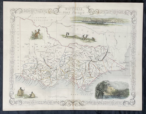
1851 John Tallis Antique Map of Victoria or Port Phillip, Australia
Antique Map
- Title : Victoria or Port Phillip
- Date : 1851
- Size: 14in x 11in (355mm x 280mm)
- Condition: (A+) Fine Condition
- Ref: 35503
Description:
This original hand coloured, steel plate engraved antique map of Victoria, Australia with vignettes of Glenelg River, Aboriginals and Kangaroos was engraved by John Rapkin and published by John Tallis in 1851.
General Definitions:
Paper thickness and quality: - Heavy and stable
Paper color : - off white
Age of map color: - Original
Colors used: - Blue
General color appearance: - Authentic
Paper size: - 14in x 11in (355mm x 280mm)
Plate size: - 14in x 11in (355mm x 280mm)
Margins: - Min 1/2in (12mm)
Imperfections:
Margins: - None
Plate area: - None
Verso: - None
Background:
The firm of Tallis & Company flourished from 1835 to 1860 with varying imprints. Their illustrated Atlas of 1850-51 was one of the last decorative atlases, all the maps being engraved on steel and all adorned with small vignettes. (Ref: Tooley; M&B)
1851 John Tallis Antique Map of Western Australia or the Swan River Colony
Antique Map
- Title : Western Australia Swan River
- Size: 14in x 10 1/2in (355mm x 265mm)
- Condition: (A+) Fine Condition
- Date : 1851
- Ref #: 93056
Description:
This original hand coloured steel plate engraved antique map of Western Australia, the Swan River Colony with vignettes of Perth from Kings Park, Swan River, Aboriginals and Sheep Farming by John Rapkin and published by John Tallis in 1851.
General Definitions:
Paper thickness and quality: - Heavy and stable
Paper color : - off white
Age of map color: - Original
Colors used: - Yellow, green, blue, pink
General color appearance: - Authentic
Paper size: - 14in x 10 1/2in (355mm x 265mm)
Plate size: - 14in x 10 1/2in (355mm x 265mm)
Margins: - Min 1/2in (12mm)
Imperfections:
Margins: - Very light age toning in margins
Plate area: - None
Verso: - None
1851 John Tallis Antique Map of Western Australia or The Swan River Settlement
Antique Map
- Title : Western Australia Swan River
- Date : 1851
- Size: 14in x 11in (355mm x 280mm)
- Condition: (A+) Fine Condition
- Ref: 35523
Description:
This original hand coloured, steel plate engraved antique map of Western Australia or The Swan River Settlement, Australia with vignettes of Perth, Fremantle, Aboriginals and settlers was engraved by John Rapkin and published by John Tallis in 1851.
General Definitions:
Paper thickness and quality: - Heavy and stable
Paper color : - off white
Age of map color: - Original
Colors used: - Blue
General color appearance: - Authentic
Paper size: - 14in x 11in (355mm x 280mm)
Plate size: - 14in x 11in (355mm x 280mm)
Margins: - Min 1/2in (12mm)
Imperfections:
Margins: - None
Plate area: - None
Verso: - None
Background:
The firm of Tallis & Company flourished from 1835 to 1860 with varying imprints. Their illustrated Atlas of 1850-51 was one of the last decorative atlases, all the maps being engraved on steel and all adorned with small vignettes. (Ref: Tooley; M&B)
1851 John Tallis Beautiful Antique Map of Van Diemens Land or Tasmania Australia
Antique Map
- Title : Van Diemens Land or Tasmania...John Tallis
- Size: 14in x 11in (355mm x 280mm)
- Condition: (A+) Fine Condition
- Date : 1851
- Ref #: 93054
Description:
This original steel plate engraved beautifully hand coloured antique map Van Diemens Land or Tasmania, Australia with vignettes of Hobart, Circular Head and Tasmanian Tiger, by John Rapkin and published by John Tallis in 1851.
General Definitions:
Paper thickness and quality: - Heavy and stable
Paper color : - off white
Age of map color: - Original & later
Colors used: - Blue, pink, red, green, yellow
General color appearance: - Authentic
Paper size: - 14in x 11in (355mm x 280mm)
Plate size: - 14in x 11in (355mm x 280mm)
Margins: - Min 1in (25mm)
Imperfections:
Margins: - None
Plate area: - None
Verso: - None
Background:
The first reported sighting of Tasmania by a European was on 24 November 1642 by Dutch explorer Abel Tasman, who landed at todays Blackman Bay. More than a century later, in 1772, a French expedition led by Marc-Joseph Marion du Fresne landed at (nearby but different) Blackmans Bay, and the following year Tobias Furneaux became the first Englishman to land in Tasmania when he arrived at Adventure Bay, which he named after his ship HMS Adventure. Captain James Cook also landed at Adventure Bay in 1777. Matthew Flinders and George Bass sailed through Bass Strait in 1798–99, determining for the first time that Tasmania was an island.
Sealers and whalers based themselves on Tasmanias islands from 1798, and in August 1803 New South Wales Governor Philip King sent Lieutenant John Bowen to establish a small military outpost on the eastern shore of the Derwent River in order to forestall any claims to the island by French explorers who had been exploring the southern Australian coastline. Bowen, who led a party of 49, including 21 male and three female convicts, named the camp Risdon. Several months later a second settlement was established by Captain David Collins, with 308 convicts, 5 kilometres (3.1 mi) to the south in Sullivans Cove on the western side of the Derwent, where fresh water was more plentiful. The latter settlement became known as Hobart Town or Hobarton, later shortened to Hobart, after the British Colonial Secretary of the time, Lord Hobart. The settlement at Risdon was later abandoned. Left on their own without further supplies, the Sullivans Cove settlement suffered severe food shortages and by 1806 its inhabitants were starving, with many resorting to scraping seaweed off rocks and scavenging washed-up whale blubber from the shore to survive.
A smaller colony was established at Port Dalrymple on the Tamar River in the islands north in October 1804 and several other convict-based settlements were established, including the particularly harsh penal colonies at Port Arthur in the southeast and Macquarie Harbour on the West Coast. Tasmania was eventually sent 75,000 convicts—four out of every ten people transported to Australia. By 1819 the Aboriginal and British population reached parity with about 5000 of each, although among the colonists men outnumbered women four to one. Wealthy middle-class free settlers began arriving in large numbers from 1820, lured by the promise of land grants and free convict labour. Settlement in the islands northwest corner was monopolised by the Van Diemens Land Company, which sent its first surveyors to the district in 1826. By 1830 one-third of Australias non-Indigenous population lived in Van Diemens Land and the island accounted for about half of all land under cultivation and exports.
Van Diemens Land—which thus far had existed as a territory within the colony of New South Wales—was proclaimed a separate colony, with its own judicial establishment and Legislative Council, on 3 December 1825. Transportation to the island ceased in 1853 and the colony was renamed Tasmania in 1856, partly to differentiate the burgeoning society of free settlers from the islands convict past.
The Legislative Council of Van Diemens Land drafted a new constitution which it passed in 1854. The following year the Privy Council approved the colony changing its name from Van Diemens Land to Tasmania, and in 1856 the newly elected bicameral parliament sat for the first time, establishing Tasmania as a self-governing colony of the British Empire.
The colony suffered from economic fluctuations, but for the most part was prosperous, experiencing steady growth. With few external threats and strong trade links with the Empire, Tasmania enjoyed many fruitful periods in the late 19th century, becoming a world-centre of shipbuilding. It raised a local defence force that eventually played a significant role in the Second Boer War in South Africa, and Tasmanian soldiers in that conflict won the first two Victoria Crosses awarded to Australians.
In 1901 the Colony of Tasmania united with the five other Australian colonies to form the Commonwealth of Australia. Tasmanians voted in favour of federation with the largest majority of all the Australian colonies.
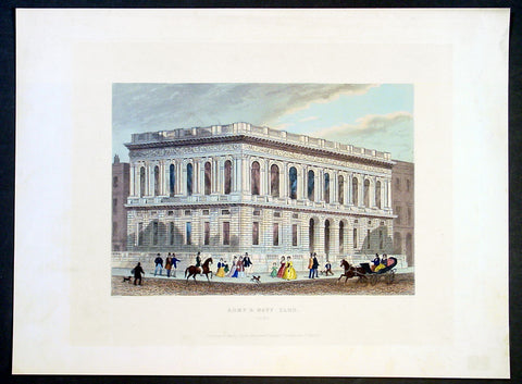
1851 Shepherd Antique Print of The Army & Navy Club, London
- Title : Army & Navy Club, Pall Mall
- Date : 1851
- Condition: (A+) Fine Condition
- Ref: 92679
- Size: 14 1/2in x 11in (370mm x 280mm)
Description:
This finely engraved beautifully hand coloured original antique print of the Army & Navy Club, or The Rag as it is known, in Pall Mall, London was engraved John Shepherd and published in the The World's Metropolis, or Mighty London, Illustrated by a Series of Views Beautifully Engraved on Steel, London 1851-1855.
Founded in August 1837, the year Queen Victoria acceded to the Throne, the Club was formed to meet the needs of the many army officers wanting to join a Service Club, most of which were already full. The great Duke of Wellington said he would become neither a patron nor a Member unless membership was also offered to officers of the Royal Navy and Royal Marines. Hence, the "Army Club" became the Army and Navy Club.
The Club's distinguished forebears include Lieutenant General Sir Edward Barnes, the first President who, as Adjutant General, fought, sword in hand, at the Battle of Waterloo, and Admiral Sir Philip Durham, one of Nelson's "Band of Brothers" who commanded HMS Defiance at the Battle of Trafalgar. Shortly after opening, the Club acquired its famous nickname, when Captain William (Billy) Higginson Duff, a colourful character with a brief and undistinguished military career was offended by the spartan nature of the fare offered to him on returning from a spree. He described the Club as a ‘Rag and Famish affair’ which was intended as a great insult, since the ‘Rag and Famish’ was a squalid gaming house ‘for broken down gamblers who played for coppers’. The Members were amused rather than insulted by this and formed a ‘Rag and Famish’ dining club. The name was gradually adopted as the Club’s nickname, eventually being reduced to ‘The Rag’. Captain Duff’s behaviour did not improve and he was later sentenced to six months in jail for assaulting a constable
General Description:
Paper thickness and quality: - Heavy & stable
Paper color: - White
Age of map color: - Original
Colors used: - Yellow, brown
General color appearance: - Authentic
Paper size: - 14 1/2in x 11in (370mm x 280mm)
Margins: - Min 1in (25mm)
Imperfections:
Margins: - None
Plate area: - None
Verso: - None
1851-1891 Original Antique Virginian American Civil War Documents F. Beckham, M D Ball, D Coffman
Antique Map
-
Title :
1. The Commonwealth of Virginia
2. Fairfax County Va April 15th 1861.
3. State of West Virginia Green brier co. June 11th 1866.
4. United States Stamp for Special Tax Internal Revenue. - Date : 1851-1891
- Size: Please view description below
- Condition: (A) Good Condition
- Ref: 27090
Description:
We have on offer a group of 4 original antique documents, three of which relate directly to Virginia and the American Civil War dated 1851,1861, 1866. The first two documents concern Fontaine Beckham & Mottrom Dulany Ball with the third relating to Daniel Coffman. These three are very interesting and scarce items.
The fourth document relates to the Internal Revenue Service in 1891. Details, descriptions and conditions below.
1. Printed court summons signed by Fontaine Beckham (1788-1859) as justice of the peace, Jefferson County, Virginia, 8 January 1851. Printed sheet completed in manuscript, signed 'F Beckham'.
Fontaine Beckham was mayor of Harpers Ferry during the raid by John Brown in 1859 with Beckham infamously shot and killed during the raid, making him possibly one of the first casualties of the American Civil War.
Condition: Mounted on red-velvet-covered thick card mount, sheet torn at lower right-hand corner not affecting text. Condition Good. - 7in x 53/4in (18 x 14.6 cm)
Fontaine Beckham (1788-1859) was mayor of Harpers Ferry, Virginia, and local agent for the Baltimore and Ohio Railroad. He was shot and killed in the famous raid on the small outpost by abolitionist John Brown, today seen as a major event in the build-up to the American Civil War.
...... Beckham was the most prominent man killed during John Brown's raid on Harpers Ferry, being the town's mayor, a county magistrate (in which capacity he signs this document), and a station agent for the B & O Railroad. Despite being a slave owner himself, Beckham was quite well-liked and considered by most to be a friend and benefactor of black men. He maintained a close friendship with his former slave Heyward Shepard, who also died during the raid.. After Shepard's death, some accounts state the mayor exposed himself to fire due to his clouded judgment. After Beckham's death, the infuriated town's people seized one of John Brown's imprisoned men, riddling his body with bullets. Yet Beckham's death also resulted in the only lasting freeing of slaves accomplished by the raid, as his will stipulated the freeing of five of his slaves......)
2. Manuscript receipt for the purchase of 'negro slaves Dennis and Belinda', Fairfax County, Virginia, signed by a member of a prominent local family, Mrs. M C(sic) Ball, dated 15 April 1861. We believe this to a transaction by Mary Ball, the mother of the first Governor of Alaska, Mottrom Dulany Ball, who at the time was have been fighting for the confederacy. The verso of the receipt is marked for Dulany, (as he was sometimes known) who would have been considered the head of the family after the death of his farther in 1859. Single bifolium of heavy woven paper, 10 lines, written on one side only, conjugate leaf docketed 'Dulany'
Condition: Damp-stained, creased from folding, loss to upper inner corner. Although stained the parchment is stable and heavy. Condition Good.
- 7 1/2in x 53/4in (18.2 x 13.8 cm)
Mottrom Dulany Ball, of Fairfax County, Fairfax Court House, and Alexandria, Virginia, was a musician, poet, teacher, lawyer, soldier and a founding father of the State of Alaska. Mottrom Dulany Ball, who was known variously as Mott, M.Dulany, or M.D., was born at Oak Mount, the home of his grandfather, Daniel French Dulany, in Fairfax County, Virginia on June 23, 1835.
Mott was the son of Spencer Mottrom Ball and Mary L. Dulany. Both parents were from prominent Virginia families. President George Washington is included among their many distinguished relatives. Mott’s early years were spent at his grandfather, Mottrom Ball’s, plantation, Woodberry, near Lewinsville, Fairfax County, Virginia. The elder Mottrom Ball was a physician who was educated at the University of Glasgow, in Scotland. TheBall family estate, Woodberry, consisted of 1,200 acres of land, rectangular in shape, extending north from the Lewinsville Presbyterian Church all the way to the to the Potomac River. 2, 3 The extensive plantation included a grist mill, Ball’s Mill, which stood on Scott’s Run. The location is today known as Swink’s Mill.4 Modern day Ball’s Hill Road traces the path of a farm road which ran through the center of Woodberry ending at the family home, Elmwood, on Ball’s Hill, also known as Prospect Hill, just south of Georgetown Pike.5 Politically, Mott’s father, Spencer Mottrom Ball, was an Anti-Jacksonian. As the name implies, this party was opposed to the authoritarian policies of President Andrew Jackson and his Democratic party. Several anti-Jacksonian factions came together to form the Whig party in 1834. Whigs supported the supremacy of Congress over the presidency.....)
3. Contemporary manuscript copy of two affidavits, one the same sheet, confirming Daniel Coffman to have been a loyal man during the rebelion [sic]', Greenbrier County, West Virginia, 1866.
Single sheet of lined paper written recto only, small embossed stamp depicting the Capitol Building and with text 'Congress' various inconsistencies in spelling.
Condition: Old folds, central fold just splitting at head, nicked along inner edge. Condition Good.
- 9in x 7in (23.5 x 17.8 cm)
First affidavit.
State of West Virginia Greenbrier Co. June 1866.
Personelly (sic) apparent before me a justice of the Peace John Sydenrtrleker (sic) and made oath that he knew Daniel Coffman to have been a loyal man during the rebellion and consider him the same use (sic) to this time Signed and sworn to before me in my township of fort spring this june 11th 1866...D Coffman JPS.....
Second affidavit.
State of West Virginia Greenbrier Co. June 1866.
Personell (sic) apparent before me a justice of the Peace H H Brackman and made oath that he knew Daniel Coffman to have been a loyal man during the rebellion and he invest (sic) himself the same now and I believe what he said to me
Signed and sworn to befor (sic) me in my township of fort spring...D Coffman JPS.....
The Coffman family have lived in Greenbrier county since the Rev Isaac Coffman 1741 - 1824, buried in the Coffman Cemetery, Ronceverte, West Virginia.
4. Internal Revenue receipt 'for special tax on the business of retail liquor dealer', paid by R. D. Burns of Lynchburg, Virginia, 9 December 1891 Engraved receipt in red and black, completed in manuscript.
Condition: Aged, small hole to lower left, upper right corner chipped. Condition Good. - 9 3/4in x 7 1/4in (24.5 x 18 cm)
General Definitions:
Please view description above
Imperfections:
Please view description above
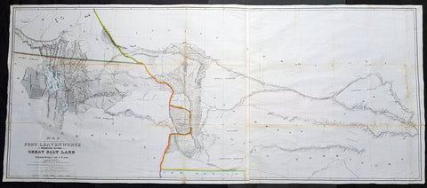
1852 Howard Stansbury Large Antique Map Forth Leavenworth, KS to Salt Lake, Utah
Antique Map
- Title : Map of a reconnaissance between Fort Leavenworth on the Missouri River, and the Great Salt Lake in the territory of Utah / made in 1849 and 1850 under the orders of Col. J.J. Abert, Chief of the Topographical Bureau, by Capt. Howard Stansbury of the Corps of Topographical Engineers, aided by Lieut. J.W. Gunnison, Corps Topographical Engineers, and Albert Carrington ; drawn by Lieut. Gunnison and Charles Preuss
- Size: 70in x 30in (1.78m x 760mm)
- Condition: (A) Very Good Condition
- Date : 1852
- Ref #: 93342
Description:
This large original antique lithograph map from Fort Leavenworth, Kansas to the Great Salt Lake, Utah by Howard Stansbury, in 1849-50, is one of the earliest concise and complete survey of the 900+ miles across unknown and hostile Indian territory. This is a milestone of American cartography showing detail of the territories of Nebraska, Colorado and Utah.
This large map along with another, of The Great Salt Lake in Utah, was drawn by Henry Gunnison & Charles and published by the publishing house Ackermann, New York City in 1852.
Stansbury was commissioned by Congress to survey the Great Salt Lake in the Utah Valley in 1849. Heading west using old known tracks and local knowledge, Stansbury along with his expedition, completed the task in 2 years presenting their report, along with two very large maps, to Congress in 1852.
General Definitions:
Paper thickness and quality: - Heavy and stable
Paper color : - off white
Age of map color: - Original
Colors used: - Blue
General color appearance: - Authentic
Paper size: - 70in x 30in (1.78m x 760mm)
Plate size: - 70in x 30in (1.78m x 760mm)
Margins: - Min 1/2in (12mm)
Imperfections:
Margins: - None
Plate area: - Folds as issued, small repair along a couple of folds, slight loss, light age toning
Verso: - Re-enforced along folds with transparent archival tape
Background:
In 1849 Stansbury was ordered to travel from Fort Leavenworth, Kansas to survey the Great Salt Lake in Utah, evaluate emigration trails along the way, especially the Oregon and Mormon trails and to scout for possible locations for a transcontinental railroad. The expedition consisted of 18 men including his second in command Lieutenant John Williams Gunnison. Over the following two years, the expedition explored the Great Salt Lake, Utah Lake and the Cache Valley of northern Utah all the way to Fort Hall in southern Idaho. Upon first arriving in Utah the Mormon leaders were worried that the expedition was part of an effort by the U.S government to oust the Mormon settlers. Stansbury held a meeting with Brigham Young where he assured the leader that the expedition was purely a scientific one. Young responded by assigning his personal secretary Albert Carrington to assist the expedition. Upon completing the mission in Utah, the expedition started back east to Leavenworth. Rather than follow the standard Oregon Trail route from Fort Bridger over South Pass through the Sweetwater River valley, Stansbury wanted to scout a more direct route east. Following the advice of Jim Bridger and local trappers and traders the expedition followed the Blacks Fork River east, crossed the Green River near the present day town of Green River, Wyoming and proceeded east along the Bitter Creek valley, crossing the Red Desert, and skirting the northern side of Elk Mountain across the Laramie Plains. They passed over the Laramie Mountains and made their way to Fort Laramie where they struck the Oregon Trail heading east. Stansbury's seminal 1852 map of the Great Salt Lake region in Utah is considered to be the first accurate survey of the Great Basin as well as a cornerstone achievement in the mapping of the American West. The first westerner to visit the Great Basin was most likely Silvestre Vélez de Escalante in the 1776, however, Escalante, who visited Utah Lake to the south, never truly laid eyes on Great Salt Lake. That honor would fall to unnamed trappers and mountain men travelling the region
Stansbury, Howard 1806 - 1863
Stansbury was an important surveyor, cartographer, and explorer who did his most important work in Utah during the middle part of the 19th century. Born in New York City, Stansbury trained to be a Civil Engineer. Shorty after getting married to Helen Moody of Detroit in 1827, Stansbury took a position with the United States Topographical Bureau. Under that organization he surveyed the James River in 1836, and the Illinois and Kaskaskia Rivers in 1837. In 1838, he oversaw the construction of a road from Milwaukee to the Mississippi River. Later in 1838, when the U.S Corps of Topographical Engineers was created, he joined as a first Lieutenant. With the Topographical Engineers he surveyed the Great Lakes, the harbor of Portsmouth, New Hampshire, and constructed Florida\\\'s Carysfort Reef Lighthouse. During the Mexican-American War he constructed fortification in the Dry Tortugas at the westernmost point on the Florida Keys. Upon achieving the rank of Captain, Stansbury received a commissioned to head a survey of the Great Basin that would ultimately become the crowning achievement of his career. His assignment was to survey the emigrant trails to California, including the Oregon Trail, as well as the Great Salt Lake, and report on the status of the growing Mormon Community in Salt Lake City. Working with J. W. Gunnison and Alfred Carrington, a Mormon scout, Stansbury produced a masterful survey of the region that had a lasting effect not only on the development of the Great Basin, but on the development of the west in general. Upon completion of his survey, Stansbury set out on the road to Washington, completing another important survey in the process. On the way, he fell off his horse, taking an injury from which he never fully recovered. Following the presentation of his report to Congress, Stansbury was charged with additional survey work around the Great Lakes. Upon the outbreak of the American Civil War, he was assigned to recruitment duties in Ohio and later Wisconsin. Shortly after starting work at this post he suffered an abrupt heart attack and passed away. He is buried in St. Paul, Minnesota.
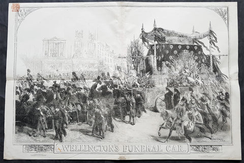
1852 ILN & J. Gilbert Large Antique Print of The Duke of Wellingtons Funeral Car
- Title : Wellingtons Funeral Car...J Gilbert....November 27 1852 - Supplement
- Size: 33in x 22in (840mm x 560mm)
- Condition: (A+) Fine Condition
- Date : 1852
- Ref #: 26373
Description:
This very large original wood-block engraved antique print of the Funeral Car of The Duke of Wellington by Sir John Gilbert, was published as a supplement to The Illustrated London News on the 27th of November 1852.
Sir John Gilbert RA 1817 – 1897 was an English artist, illustrator and engraver.
Gilbert was born in Blackheath, Surrey, and taught himself to paint. His only formal instruction was from George Lance. Skilled in several media, Gilbert gained the nickname, the Scott of painting. He was best known for the illustrations and woodcuts he produced for the Illustrated London News.
Gilbert was initially apprenticed to a firm of estate agents, but taught himself art by copying prints. He was unable to enter the Royal Academy Schools, but mastered watercolour, oils, and other media. From 1836 he exhibited at the Society of British Artists, and at the RA from 1838. The art patron Thomas Sheepshanks and the artist William Mulready suggested that he learn wood engraving. Starting with Punch, he moved on to the Illustrated London News. He produced an impressive number of wood-engravings for that publication and for The London Journal. He also produced very many illustrations for books, including nearly all the important English poets (including his illustrated Shakespeare with almost 750 drawings). He became president of the Royal Watercolour Society in 1871. He exhibited some 400 pictures in watercolour and oil exhibited at the various societies. In 1872 he was knighted. He became an RA in 1876, in the same year as Edward Poynter.
The Gilbert-Garret Competition for Sketching Clubs was started in 1870 at St. Martins School of Art, and named after its first president, John Gilbert.
Gilbert is buried at Brockley and Ladywell Cemeteries.
General Definitions:
Paper thickness and quality: - Heavy and stable
Paper color : - off white
Age of map color: -
Colors used: -
General color appearance: -
Paper size: - 33in x 22in (840mm x 560mm)
Plate size: - 33in x 22in (840mm x 560mm)
Margins: - Min 1/4in (5mm)
Imperfections:
Margins: - Re-joined along horizontal & vertical folds, no loss
Plate area: - Re-joined along horizontal & vertical folds, no loss
Verso: - Re-joined along horizontal & vertical folds, no loss
Background:
Arthur Wellesley, 1st Duke of Wellington, KG, GCB, GCH, PC, FRS 1769 – 1852) was an Anglo-Irish soldier and statesman who was one of the leading military and political figures of 19th-century Britain, serving twice as Prime Minister. His victory against Napoleon at the Battle of Waterloo in 1815 puts him in the first rank of Britain\'s military heroes.
Wellesley was born in Dublin, into the Protestant Ascendancy in Ireland. He was commissioned as an ensign in the British Army in 1787, serving in Ireland as aide-de-camp to two successive Lords Lieutenant of Ireland. He was also elected as a Member of Parliament in the Irish House of Commons. He was a colonel by 1796, and saw action in the Netherlands and in India, where he fought in the Fourth Anglo-Mysore War at the Battle of Seringapatam. He was appointed governor of Seringapatam and Mysore in 1799 and, as a newly appointed major-general (since 1802), won a decisive victory over the Maratha Confederacy at the Battle of Assaye in 1803.
Wellesley rose to prominence as a general during the Peninsular campaign of the Napoleonic Wars, and was promoted to the rank of field marshal after leading the allied forces to victory against the French Empire at the Battle of Vitoria in 1813. Following Napoleon\'s exile in 1814, he served as the ambassador to France and was granted a dukedom. During the Hundred Days in 1815, he commanded the allied army which, together with a Prussian army under Blücher, defeated Napoleon at Waterloo. Wellington\'s battle record is exemplary; he ultimately participated in some 60 battles during the course of his military career.
Wellington is famous for his adaptive defensive style of warfare, resulting in several victories against numerically superior forces while minimising his own losses. He is regarded as one of the greatest defensive commanders of all time, and many of his tactics and battle plans are still studied in military academies around the world.
After the end of his active military career, Wellington returned to politics. He was twice British prime minister as part of the Tory party: from 1828 to 1830, and for a little less than a month in 1834. He oversaw the passage of the Catholic Relief Act 1829, but opposed the Reform Act 1832. He continued as one of the leading figures in the House of Lords until his retirement and remained Commander-in-Chief of the British Army until his death.
Wellington died at Walmer Castle in Deal on 14 September 1852. This was his residence as Lord Warden of the Cinque Ports. Walmer Castle was said to have been his favourite residence. He was found to be unwell on that morning and was aided from his military campaign bed (the same one he used throughout his historic military career) and seated in his chair where he died. His death was recorded as being due to the after-effects of a stroke culminating in a series of seizures. He was aged 83.
Although in life he hated travelling by rail (after witnessing the death of William Huskisson, one of the first railway accident casualties), his body was then taken by train to London, where he was given a state funeral – one of only a handful of British subjects to be honoured in that way (other examples are Lord Nelson and Sir Winston Churchill) – and the last heraldic state funeral to be held in Britain. The funeral took place on 18 November 1852. At his funeral there was hardly any space to stand because of the number of people attending, and the effusive praise given him in Tennyson\'s Ode on the Death of the Duke of Wellington attests to his stature at the time of his death. He was buried in a sarcophagus of luxulyanite in St Pauls Cathedral next to Lord Nelson. A bronze memorial was sculpted by Alfred Stevens, and features two intricate supports: Truth tearing the tongue out of the mouth of False-hood, and Valour trampling Cowardice underfoot. Stevens did not live to see it placed in its home under one of the great arches of the Cathedral.
Wellington\'s casket was decorated with banners which were made for his funeral procession. Originally, there was one from Prussia, which was removed during World War I and never reinstated. In the procession, the Great Banner was carried by General Sir James Charles Chatterton of the 4th Dragoon Guards on the orders of Queen Victoria.
Most of the book A Biographical Sketch of the Military and Political Career of the Late Duke of Wellington by Weymouth newspaper proprietor Joseph Drew is a detailed contemporary account of his death, lying in state and funeral.
After his death, Irish and English newspapers disputed whether Wellington had been born an Irishman or an Englishman. In 2002, he was number 15 in the BBC\'s poll of the 100 Greatest Britons.
Owing to its links with Wellington, as the former commanding officer and colonel of the regiment, the title 33rd (The Duke of Wellington\'s) Regiment was granted to the 33rd Regiment of Foot, on 18 June 1853 (the 38th anniversary of the Battle of Waterloo) by Queen Victoria. Wellington\'s battle record is exemplary; he participated in some 60 battles during the course of his military career.
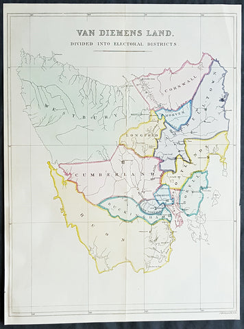
1852 John Arrowsmith Rare Antique Map The First Electoral Districts of Tasmania
- Title : Van Diemens Land Divided into Electoral Districts
- Size: 18 1/2in x 13 3/4in (470mm x 350mm)
- Condition: (A+) Fine Condition
- Date : 1852
- Ref #: 82040
Description:
This rare lithograph map of the electoral districts of Van Diemens Land (Tasmania) by John Arrowsmith was published in 1852 - 4 years prior to the first sitting of the state parliament in 1856 - for The Colonial Office Parliamentary Papers, London.
The rarity of this map cannot be overstated. Many of these maps by Arrowsmith were printed and published only for the British Colonial Office Parliamentary Papers and would have had very low numbers published and are very hard, if not impossible, to be be found for sale on the open market.
John Arrowsmith is considered one of the finest cartographers of the 19th century, famous for producing highly accurate and finely engraved maps in atlases, books & in sheet form, of all parts of the know world. Ironically he is less famous for producing many of the maps that accompanied the British Colonial Office Parliamentary Reports between 1817 to 1890, with two-thirds of the maps being produced by Arrowsmith. These maps were published solely for government review and not public sale. A few of these were subsequently published in Arrowsmiths Atlases and vice versa but a great number of them were not, making many of the maps published for the Parliamentary papers rare and rarely seen on the market. Many of them are not called for in Tooley, Clancy or other important reference material.
This is one of those maps, one of 27 we were fortunate to procure earlier this year. I have found very little historical sales data for these maps and so I have priced them based on what I feel is a fair market value for such a rare, scarce map.
General Definitions:
Paper thickness and quality: - Heavy and stable
Paper color : - off white
Age of map color: - Original
Colors used: - Blue, pink, yellow, green
General color appearance: - Authentic
Paper size: - 18 1/2in x 13 3/4in (470mm x 350mm)
Plate size: - 18 1/2in x 13 3/4in (470mm x 350mm)
Margins: - Min 1/2in (12mm)
Imperfections:
Margins: - None
Plate area: - Folds as issued
Verso: - Bottom left margin extended
Background:
The importance of John Arrowsmiths contribution to early Australian cartography cannot be stressed enough. He was responsible for producing many of the early exploration maps of Australia for the Colonial Offices & Government publications as well as the RGS.
Maps produced after the first settlement and into the 19th century came from varied sources, first published with the First Fleet Journals by Arthur Phillip, John Hunter and Watkin Tench. Numerous European publishing houses produced atlases which included maps of Australia. Many came out in several editions and were updated as new information became available. The Australian Colonies were administered by officials responsible to the British Colonial Office and all events of importance, often illustrated by maps, were published in the British Parliamentary Papers. There a rea prime source of maps from 1830 onwards, although one or two maps may be found in Parliamentary Papers prior to this time, such as one example of a rare map of the Swan River by Captain James Stirling.
During the 19th century, as the Australian colonies were progressively granted responsible government, Parliamentary Papers for each colony became an important source of maps. These maps sources have been a hidden and untapped resource. Another good source of early maps is published journals of the explorers; the explorers earliest maps often accompanied reports in the
Journal of the Royal Geographical Society in the UK. Parallel development of Australian scientific institutions along with an interest in exploration was a strong feature of 19th century Australia. The Royal Geographical Society of Australasia was established with branches in NSW, Victoria, South Australia and Queensland. A number of important maps were published as separate sheets, increasingly by Australian printers and engravers such as Carmichael, Sands & Kenny, and Higginbotham, Robinson & Harrison.
Australian atlases were produced and repeat editions of cadastral surveys and maritime chats became increasingly available. Specialist maps were published from official sources, including geological and mineral maps. Towards the end of the century a plethora of thematic maps were published through a verity of media such as advertisements for land sales, tourists maps and street directories.
Parliamentary Papers British Parliamentary Papers were a funnel for all significant colonial events in the 19th century. They included over one hundred maps with information on topography, exploration and lad survey published between 1817 and 1890., with two-thirds of the maps being produced by John Arrowsmith. Few maps are found after the early 1860s. The maps accompanying papers relevant to gold discovery (1851-55) are a particularly good resource, documenting an important time in the history of Australia. Perhaps the most neglected source of early Australian maps are those included in the Colonial Parliamentary Papers published locally after 1836. The NSW Parliamentary Papers published between 1836 and 1900 contain over 2700 maps on 129 topics, providing a unique record of events considered important by the colonial administration. Land ownership and land use dominate, followed by maps of services relevant to land use, such as railways, roads, water supply and sewerage. Public health issues are recorded in maps as are maps of gold& mineral leases reflected the expanding diversity of the economy. The first map published in the NSW Parliamentary Papers, of the site of the new Government House, was lithographed by W.R. Baker in 1836. The total number of maps over the same period from other colonies was less than 2000 but again each colonies priorities were reflected by in the subjects covered. Tasmania reflected mainly geological and early convict disciplinary maps; South Australia, land administration and pastoral development; Victoria, maps relating to the development; Victoria, maps relating to the colonies infrastructure, especially railway and harbour development; Queensland, railway and mineral leases; Western Australia, a broad range that included two important technological innovations that shortened the time, and therefore the cost, of printing maps. Firstly , John Osborn in 1859, developed the use of a transfer paper method in photolithography which reduced printing time from days to hours. Secondly, Alfred Selwyn in 1860 used a steam-driven power press to print seven colour geological maps.
Royal Geographical Society published its first journal in 1832. This journal was to become the leading scientific medium available for explorers to publish the first news of their discoveries. However, not all explorers were published here. Between 1832 and 1880, 25 maps recorded of inland Australia, illustrating the journeys of 27 explorers. John Arrowsmith compiled 22 of the 25 maps published by the RGS again illustrating the importance of Arrowsmith to the expansion of early colonial cartography in Australia.

1853 - 1857 Elephant Folio Album w/ 328 Antique Maps & Prints of The Crimea War - Unique
Antique Map
- Title : Crimean War Maps, Prints & Views
- Date : 1853 - 57
- Size: 24in x 18in (610mm x 455mm) Elephant Folio
- Condition: (A) Very Good Condition
- Ref: 35600
Description:
This is a unique and very comprehensive visual record of the Crimean War (1853 - 1856 & 57) in a huge Elephant Folio Album.
The album consists of 163 double pages with 328 original maps, prints and views of the War tipped in chronological order. These are mainly from the Illustrated London News, from the Wars beginning in 1853 to its end in 1856 through to the Coronation of Alexander II in 1857 and some of the first recipients of the Victoria Cross.
My impression is that the album was professionally organised and assembled possibly by a political or historical organisation of the time, in the mid 19th century.
This album is extremely large measuring 28 inches x 18 inches (62cm x 46cm) when closed and weighs approx. 14 Kg.
The Album contains; (in more detail directly below)
- 71 views of various battles during the conflict.
- 94 Portraits & prints of the leaders, generals, & personnel who were in charge and soldiers, sailors who participated in the war.
- 47 views of various cities and towns from the participating countries England, Russia, Crimea, Turkey etc.
- 63 prints of naval fleets, battleships, sea battles, landings & evacuations..
- 15 Maps of various regions and conflicts
- 25 victory scenes in Britain
- 39 prints of portraits and views of the Coronation of Alexander II
- 4 Pages of recipients from both Army & Navy, of the first Victoria Cross.
Battle Views (Battle of Kars, Kinburn, Sebastopol, Malakoff, Tchernaya, Sveaborg, Gheisk, Hango-Head, Narva, Balaclava, Inkerman, Charge of Light Cavalry Balaclava, Alma, Odessa, Crondstat, Citate, Oltenitza, Kalafat)
Prints of leaders, generals and soldiers (British, Russian, Turkish, Greek, French, Austrian, Peace Talks Paris, Congress of Vienna, Allied Naval Command, Marshall Pelissier, Wounded, Hospitals, Sir De Lacy Evans, Nicolas Emperor of Russia, Royal Marines, Lord Raglan, Napoleon III, Commanders of Allied Armies in the East, Sultan of Turkey, Marshal St Arnaud, French Cavalry, French Infantry, British Infantry, British Navy, Sir Charles Napier, Rear Admiral Corry, & Plumridge, British Cavalry & Artillery Officers, Scots Guards, Royal marines, British Cavalry, Coldstream Guards, Grenadier Guards, Omer Pacha, General Prim)
Views of cities & towns (Balaclava, Kars, Sebastopol, Sveaborg, Helsingborg, Kiel, Copenhagen, Crondstat, St Petersberg, Kerch, Inkermann, Eupatoria, Alma, Coast of Crimea, Varna Bay, Odessa and Coast, Constantinople, Oltenitza, Sinope)
Fleets, battleships & sea battles (HMS Wellington, Steamers, British Fleet, Baltic Fleet, Gun Boats, Nystad, Sebastopol, Spithead, Portsmouth, Flying Squadron, Trafalgar and Resolution, landing French Troops at Gallipoli, Duke of Wellingtons Flagship, Turkish Fleet in Biospheres, English & French Fleet in Besika Bay, HMS Neptune)
Maps (Crimea & Black Sea region, Russia-Turkey, Constantinople, Austria-Russia, Spithead review of Fleet, Sea of Azoff, Kerch, River Alma to Balaklava, Plan of Sebastopol, Seat of War in the Crimea, Sebastopol & Balaklava, Picturesque map of the seat of war, Battle of Alma, The Ottoman Empire)
Florence Nightingale (Treating wounded, visiting wounded Balaclava)
Victory Scenes in England (illuminations, Parades, Queen, Brighton, Hyde Park, Awarding Medals, The Guards, Fireworks, Landing in Kalamita Bay)
The Album is huge Elephant Folio measuring 24in x 18in (610mm x 455mm) and weighing about 13kg (29lbs) The contemporary half morocco boards are worn, rubbed and detached from the internals that on the whole are clean and tight with occasional spotting and repairs with no loss.
Also included with the album is the following loose prints, maps and newspaper clippings;
- 47 prints and views from ILN on the British Expedition into Abyssinia in 1868.
- 39 prints, views and maps from the ILN and The Graphic on the 1882 Anglo-Egyptian War.
- 60 Newspaper clipping from 1882 of The Times, Evening Standard, Daily News and other papers again on the Anglo Egyptian War.
General Definitions:
Paper thickness and quality: - Heavy and stable.
Paper color : - off white
Age of map color: -
Colors used: -
General color appearance: -
Paper size: - 24in x 18in (610mm x 455mm) each
Plate size: - 24in x 18in (610mm x 455mm) each
Margins: - Min 1in (25mm)
Imperfections:
External Boards: - Worn, slit spine, scuffing detached from internals
Internal pages: - Overall clean, some spotting, light offsetting to some pages, several small repairs without loss
Background: The Crimean War was fought from October 1853 to February 1856 between the Russian Empire and an ultimately victorious alliance of the Ottoman Empire, France, the United Kingdom, and Sardinia-Piedmont.
Geopolitical causes of the war included the decline of the Ottoman Empire (the "Eastern Question"), the expansion of the Russian Empire in the preceding Russo-Turkish Wars, and the British and French preference to preserve the Ottoman Empire to maintain the balance of power in the Concert of Europe. The flashpoint was a disagreement over the rights of Christian minorities in Palestine, then part of the Ottoman Empire, with the French promoting the rights of Roman Catholics, and Russia promoting those of the Eastern Orthodox Church.
The churches worked out their differences with the Ottomans and came to an agreement, but both the French Emperor Napoleon III and the Russian Tsar Nicholas I refused to back down. Nicholas issued an ultimatum that demanded the Orthodox subjects of the Ottoman Empire be placed under his protection. Britain attempted to mediate and arranged a compromise to which Nicholas agreed. When the Ottomans demanded changes to the agreement, Nicholas recanted and prepared for war.
In July 1853, Russian troops occupied the Danubian Principalities (now part of Romania but then under Ottoman suzerainty). On 16 October 1853, having obtained promises of support from France and Britain, the Ottomans declared war on Russia. Led by Omar Pasha, the Ottomans fought a strong defensive campaign and stopped the Russian advance at Silistra (now in Bulgaria). A separate action on the fort town of Kars, in the Ottoman Empire, led to a siege, and an Ottoman attempt to reinforce the garrison was destroyed by a Russian fleet at the Battle of Sinop in November 1853.
Fearing the growth of influence of the Russian Empire, the British and French fleets entered the Black Sea in January 1854. They moved north to Varna in June 1854 and arrived just in time for the Russians to abandon Silistra. In the Baltic, near the Russian capital of Saint Petersburg, an Anglo-French fleet instituted a naval blockade and bottled up the outnumbered Russian Baltic Fleet, causing economic damage to Russia by blockading trade while also forcing the Russians to keep a large army guarding St. Petersburg from a potential allied attack.
After a minor skirmish at Köstence (now Constanța), the allied commanders decided to attack Russia's main naval base in the Black Sea, Sevastopol, in Crimea. After extended preparations, allied forces landed on the peninsula in September 1854 and marched their way to a point south of Sevastopol after they had won the Battle of the Alma on 20 September 1854. The Russians counterattacked on 25 October in what became the Battle of Balaclava and were repulsed, but the British Army's forces were seriously depleted as a result. A second Russian counterattack at Inkerman ended in a stalemate.
By 1855, the Italian Kingdom of Sardinia sent an expeditionary force to Crimea, siding with France, Britain and the Ottoman Empire. The front settled into the Siege of Sevastopol, involving brutal conditions for troops on both sides. Smaller military actions took place in the Caucasus (1853–1855), the White Sea (July–August 1854) and the North Pacific (1854–1855).
Sevastopol finally fell after eleven months, after the French assaulted Fort Malakoff. Isolated and facing a bleak prospect of invasion by the West if the war continued, Russia sued for peace in March 1856. France and Britain welcomed the development, owing to the conflict's domestic unpopularity. The Treaty of Paris, signed on 30 March 1856, ended the war. It forbade Russia to base warships in the Black Sea. The Ottoman vassal states of Wallachia and Moldavia became largely independent. Christians in the Ottoman Empire gained a degree of official equality, and the Orthodox Church regained control of the Christian churches in dispute.
The Crimean War was one of the first conflicts in which military forces used modern technologies such as explosive naval shells, railways and telegraphs. The war was also one of the first to be documented extensively in written reports and in photographs. The war quickly became a symbol of logistical, medical and tactical failures and of mismanagement. The reaction in Britain led to a demand for the professionalisation of medicine, most famously achieved by Florence Nightingale, who gained worldwide attention for pioneering modern nursing while she treated the wounded.
The Crimean War marked a turning point for the Russian Empire. The war weakened the Imperial Russian Army, drained the treasury and undermined Russia's influence in Europe. The empire would take decades to recover. Russia's humiliation forced its educated elites to identify its problems and recognise the need for fundamental reforms. They saw rapid modernisation as the sole way to recover the empire's status as a European power. The war thus became a catalyst for reforms of Russia's social institutions, including the abolition of serfdom and overhauls in the justice system, local self-government, education and military service. (Ref: Tooley; M&B)
The Illustrated London News (ILN)
In 1842, Herbert Ingram, a young printer and newsagent from Nottingham, arrived in London. As a newsagent he noticed that when on the rare occasions that newspapers included woodcuts, their sales increased. He therefore came to the conclusion that it would be possible to make a good profit from a magazine that included a large number of illustrations.
Herbert Ingram discussed the proposal with his friend, Mark Lemon, the editor of Punch magazine. With Lemon as his chief adviser, the first edition of the Illustrated London News appeared on 14th May 1842. Costing sixpence, the magazine had sixteen pages and thirty-two woodcuts. The first edition included pictures of the war in Afghanistan, a train crash in France, a steamboat explosion in Canada and a fancy dress ball at Buckingham Palace.
Ingram was a staunch Liberal who favored social reform. He announced in the London Illustrated News that the concern of the magazine would be \\\"with the English poor\\\" and the \\\"three essential elements of discussion with us will be the poor laws, the factory laws, and the working of the mining system\\\". Later Herbert Ingram was to become MP for Boston and until his death in 1860 continued his campaign for social reform in the House of Commons.
The London Illustrated News was an immediate success and the first edition sold 26,000 copies. Within a few months it was selling over 65,000 copies a week. Special events were important to the success of the London Illustrated News. The magazine did very well during the Exhibition 1851 and over 150,000 copies were sold of the edition that reported the funeral of the Duke of Wellington. The Crimean War caused a further boast to sales and by 1863 it was selling over 300,000 copies a week. This was far higher than other journals. For example, newspapers such as the Daily News only sold 6,000 copies at this time, and even the largest selling newspaper, The Times only sold 70,000 copies. In the Christmas Number of The Illustrated London News, 1855, the first pictures in color were published.
In the year 1879, The ILLUSTRATED LONDON NEWS claimed to be the fastest woodcut-printing establishment in the world. The Ingram Rotary machine had been invented. It printed both sides of the paper at once and turned out 6,500 copies per hour. It required only four men to operate it, whereas thirty men and five machines were needed previously
 The ILN held a commanding position in the market place. It was seriously challenged by The GRAPHIC in 1870. Although it never reached the circulation of the ILN. it did take a good market share until the turn of the century.
Please note all items auctioned are genuine, we do not sell reproductions. A Certificate of Authenticity (COA) can be issued on request.
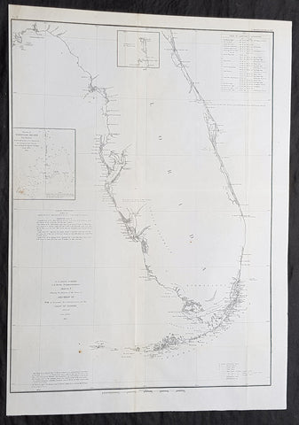
1854 A D Bache Large Rare Antique Map of Florida - US Coast Survey
- Title : US Coast Survey A D Bache Super. Sketch F Showing the Progress of the Survey in Section VI 1848-54...1854.
- Size: 25in x 18in (635mm x 460mm)
- Condition: (A+) Fine Condition
- Date : 1854
- Ref #: 93025
Description:
This large, rare, original antique lithograph early map of Florida and the progress of the surveys since 1848 by Alexander Dallas Bache (great-grandson of Benjamin Franklin) in 1854 - dated - was published by the official chart-maker of the United States, the office of The US Coast Survey.
The Office of the Coast Survey, founded in 1807 by President Thomas Jefferson and Secretary of Commerce Albert Gallatin, is the oldest scientific organization in the U.S. Federal Government. Jefferson created the Survey of the Coast, as it was then called, in response to a need for accurate navigational charts of the new nation\'s coasts and harbors.
General Definitions:
Paper thickness and quality: - Heavy and stable
Paper color : - off white
Age of map color: -
Colors used: -
General color appearance: -
Paper size: - 25in x 18in (635mm x 460mm)
Plate size: - 25in x 18in (635mm x 460mm)
Margins: - Min 1/2in (12mm)
Imperfections:
Margins: - None
Plate area: - Folds as issued
Verso: - Some folds re-enforced with archival tape
Background:
Florida was the first region of the continental United States to be visited and settled by Europeans. The earliest known European explorers came with the Spanish conquistador Juan Ponce de León. Ponce de León spotted and landed on the peninsula on April 2, 1513. He named the region Florida (land of flowers) The story that he was searching for the Fountain of Youth is mythical and only appeared long after his death.
In May 1539, Conquistador Hernando de Soto skirted the coast of Florida, searching for a deep harbor to land. He described seeing a thick wall of red mangroves spread mile after mile, some reaching as high as 70 feet (21 m), with intertwined and elevated roots making landing difficult. The Spanish introduced Christianity, cattle, horses, sheep, the Castilian language, and more to Florida. Spain established several settlements in Florida, with varying degrees of success. In 1559, Don Tristán de Luna y Arellano established a settlement at present-day Pensacola, making it the first attempted settlement in Florida, but it was mostly abandoned by 1561.
In 1565, the settlement of St. Augustine (San Agustín) was established under the leadership of admiral and governor Pedro Menéndez de Avilés, creating what would become one of the oldest, continuously-occupied European settlements in the continental U.S. and establishing the first generation of Floridanos and the Government of Florida. Spain maintained strategic control over the region by converting the local tribes to Christianity. The marriage between Luisa de Abrego, a free black domestic servant from Seville, and Miguel Rodríguez, a white Segovian, occurred in 1565 in St. Augustine. It is the first recorded Christian marriage in the continental United States.
Some Spanish married or had unions with Pensacola, Creek or African women, both slave and free, and their descendants created a mixed-race population of mestizos and mulattos. The Spanish encouraged slaves from the southern British colonies to come to Florida as a refuge, promising freedom in exchange for conversion to Catholicism. King Charles II of Spain issued a royal proclamation freeing all slaves who fled to Spanish Florida and accepted conversion and baptism. Most went to the area around St. Augustine, but escaped slaves also reached Pensacola. St. Augustine had mustered an all-black militia unit defending Spain as early as 1683.
The geographical area of Florida diminished with the establishment of English settlements to the north and French claims to the west. The English attacked St. Augustine, burning the city and its cathedral to the ground several times. Spain built the Castillo de San Marcos in 1672 and Fort Matanzas in 1742 to defend Floridas capital city from attacks, and to maintain its strategic position in the defense of the Captaincy General of Cuba and the Spanish West Indies.
Florida attracted numerous Africans and African Americans from adjacent British colonies who sought freedom from slavery. In 1738, Governor Manuel de Montiano established Fort Gracia Real de Santa Teresa de Mose near St. Augustine, a fortified town for escaped slaves to whom Montiano granted citizenship and freedom in return for their service in the Florida militia, and which became the first free black settlement legally sanctioned in North America.
In 1763, Spain traded Florida to the Kingdom of Great Britain for control of Havana, Cuba, which had been captured by the British during the Seven Years War. It was part of a large expansion of British territory following their victory in the Seven Years War. A large portion of the Floridano population left, taking along most of the remaining indigenous population to Cuba. The British soon constructed the Kings Road connecting St. Augustine to Georgia. The road crossed the St. Johns River at a narrow point called Wacca Pilatka, or the British name Cow Ford, ostensibly reflecting the fact that cattle were brought across the river there.
The British divided and consolidated the Florida provinces (Las Floridas) into East Florida and West Florida, a division the Spanish government kept after the brief British period. The British government gave land grants to officers and soldiers who had fought in the French and Indian War in order to encourage settlement. In order to induce settlers to move to Florida, reports of its natural wealth were published in England. A large number of British settlers who were described as being energetic and of good character moved to Florida, mostly coming from South Carolina, Georgia and England. There was also a group of settlers who came from the colony of Bermuda. This would be the first permanent English-speaking population in what is now Duval County, Baker County, St. Johns County and Nassau County. The British built good public roads and introduced the cultivation of sugar cane, indigo and fruits as well as the export of lumber.
The British governors were directed to call general assemblies as soon as possible in order to make laws for the Floridas, and in the meantime they were, with the advice of councils, to establish courts. This was the first introduction of the English-derived legal system which Florida still has today, including trial by jury, habeas corpus and county-based government. Neither East Florida nor West Florida sent any representatives to Philadelphia to draft the Declaration of Independence. Florida remained a Loyalist stronghold for the duration of the American Revolution.
Spain regained both East and West Florida after Britains defeat in the American Revolution and the subsequent Treaty of Versailles in 1783, and continued the provincial divisions until 1821.
Defense of Floridas northern border with the United States was minor during the second Spanish period. The region became a haven for escaped slaves and a base for Indian attacks against U.S. territories, and the U.S. pressed Spain for reform.
Americans of English descent and Americans of Scots-Irish descent began moving into northern Florida from the backwoods of Georgia and South Carolina. Though technically not allowed by the Spanish authorities and the Floridan government, they were never able to effectively police the border region and the backwoods settlers from the United States would continue to immigrate into Florida unchecked. These migrants, mixing with the already present British settlers who had remained in Florida since the British period, would be the progenitors of the population known as Florida Crackers.
These American settlers established a permanent foothold in the area and ignored Spanish authorities. The British settlers who had remained also resented Spanish rule, leading to a rebellion in 1810 and the establishment for ninety days of the so-called Free and Independent Republic of West Florida on September 23. After meetings beginning in June, rebels overcame the garrison at Baton Rouge (now in Louisiana), and unfurled the flag of the new republic: a single white star on a blue field. This flag would later become known as the Bonnie Blue Flag.
In 1810, parts of West Florida were annexed by proclamation of President James Madison, who claimed the region as part of the Louisiana Purchase. These parts were incorporated into the newly formed Territory of Orleans. The U.S. annexed the Mobile District of West Florida to the Mississippi Territory in 1812. Spain continued to dispute the area, though the United States gradually increased the area it occupied. In 1812, a group of settlers from Georgia, with de facto support from the U.S. federal government, attempted to overthrow the Floridan government in the province of East Florida. The settlers hoped to convince Floridans to join their cause and proclaim independence from Spain, but the settlers lost their tenuous support from the federal government and abandoned their cause by 1813.
Seminoles based in East Florida began raiding Georgia settlements, and offering havens for runaway slaves. The United States Army led increasingly frequent incursions into Spanish territory, including the 1817–1818 campaign against the Seminole Indians by Andrew Jackson that became known as the First Seminole War. The United States now effectively controlled East Florida. Control was necessary according to Secretary of State John Quincy Adams because Florida had become a derelict open to the occupancy of every enemy, civilized or savage, of the United States, and serving no other earthly purpose than as a post of annoyance to them.
Florida had become a burden to Spain, which could not afford to send settlers or garrisons. Madrid therefore decided to cede the territory to the United States through the Adams–Onís Treaty, which took effect in 1821. President James Monroe was authorized on March 3, 1821 to take possession of East Florida and West Florida for the United States and provide for initial governance. Andrew Jackson, on behalf of the U.S. federal government, served as a military commissioner with the powers of governor of the newly acquired territory for a brief period. On March 30, 1822, the U.S. Congress merged East Florida and part of West Florida into the Florida Territory.
By the early 1800s, Indian removal was a significant issue throughout the southeastern U.S. and also in Florida. In 1830, the U.S. Congress passed the Indian Removal Act and as settlement increased, pressure grew on the U.S. government to remove the Indians from Florida. Seminoles offered sanctuary to blacks, and these became known as the Black Seminoles, and clashes between whites and Indians grew with the influx of new settlers. In 1832, the Treaty of Paynes Landing promised to the Seminoles lands west of the Mississippi River if they agreed to leave Florida. Many Seminole left at this time.
Some Seminoles remained, and the U.S. Army arrived in Florida, leading to the Second Seminole War (1835–1842). Following the war, approximately 3,000 Seminole and 800 Black Seminole were removed to Indian Territory. A few hundred Seminole remained in Florida in the Everglades.
On March 3, 1845, only one day before the end of President John Tylers term in office, Florida became the 27th state to join the United States of America. The state was admitted as a slave state and ceased to be a sanctuary for runaway slaves. Initially its population grew slowly.
As European settlers continued to encroach on Seminole lands, and the United States intervened to move the remaining Seminoles to the West. The Third Seminole War (1855–58) resulted in the forced removal of most of the remaining Seminoles, although hundreds of Seminole Indians remained in the Everglades
American settlers began to establish cotton plantations in north Florida, which required numerous laborers, which they supplied by buying slaves in the domestic market. By 1860, Florida had only 140,424 people, of whom 44% were enslaved. There were fewer than 1,000 free African Americans before the American Civil War.
On January 10, 1861, nearly all delegates in the Florida Legislature approved an ordinance of secession, declaring Florida to be a sovereign and independent nation—an apparent reassertion to the preamble in Floridas Constitution of 1838, in which Florida agreed with Congress to be a Free and Independent State. Although not directly related to the issue of slavery, the ordinance declared Floridas secession from the Union, allowing it to become one of the founding members of the Confederate States, a looser union of states.
The Confederacy received little help from Florida; the 15,000 men it offered were generally sent elsewhere. Instead of men and manufactured goods, Florida did provide salt and, more importantly, beef to feed the Confederate armies. This was particularly important after 1864, when the Confederacy lost control of the Mississippi River, thereby losing access to Texas beef. The largest engagements in the state were the Battle of Olustee, on February 20, 1864, and the Battle of Natural Bridge, on March 6, 1865. Both were Confederate victories. The war ended in 1865.
Following the American Civil War, Floridas congressional representation was restored on June 25, 1868, albeit forcefully after Radical Reconstruction and the installation of unelected government officials under the final authority of federal military commanders. After the Reconstruction period ended in 1876, white Democrats regained power in the state legislature. In 1885, they created a new constitution, followed by statutes through 1889 that disfranchised most blacks and many poor whites.
Until the mid-20th century, Florida was the least populous state in the southern United States. In 1900, its population was only 528,542, of whom nearly 44% were African American, the same proportion as before the Civil War. The boll weevil devastated cotton crops.
Forty thousand blacks, roughly one-fifth of their 1900 population, left the state in the Great Migration. They left due to lynchings and racial violence, and for better opportunities. Disfranchisement for most African Americans in the state persisted until the Civil Rights Movement of the 1960s gained federal legislation in 1965 to enforce protection of their constitutional suffrage.
U.S. Coast Survey (Office of Coast Survey)
The Office of Coast Survey is the official chart-maker of the United States. Set up in 1807, it is one of the U.S. governments oldest scientific organizations. In 1878 it was given the name of Coast and Geodetic Survey (C&GS). In 1970 it became part of the National Oceanic and Atmospheric Administration (NOAA).
The agency was established in 1807 when President Thomas Jefferson signed the document entitled An act to provide for surveying the coasts of the United States. While the bills objective was specific—to produce nautical charts—it reflected larger issues of concern to the new nation: national boundaries, commerce, and defence.
The early years were difficult. Ferdinand Rudolph Hassler, who was eventually to become the agencys first superintendent, went to England to collect scientific instruments but was unable to return through the duration of the War of 1812. After his return, he worked on a survey of the New York Harbor in 1817, but Congress stepped in to suspend the work because of tensions between civilian and military control of the agency. After several years under the control of the U.S. Army, the Survey of the Coast was reestablished in 1832, and President Andrew Jackson appointed Hassler as superintendent.
The U.S. Coast Survey was a civilian agency but, from the beginning, members of the Navy and Army were detailed to service with the Survey, and Navy ships were also detailed to its use. In general, army officers worked on topographic surveys on the land and maps based on the surveys, while navy officers worked on hydrographic surveys in coastal waters.
Alexander Dallas Bache, great-grandson of Benjamin Franklin, was the second Coast Survey superintendent. Bache was a physicist, scientist, and surveyor who established the first magnetic observatory and served as the first president of the National Academy of Sciences. Under Bache, Coast Survey quickly applied its resources to the Union cause during the Civil War. In addition to setting up additional lithographic presses to produce the thousands of charts required by the Navy and other vessels, Bache made a critical decision to send Coast Survey parties to work with blockading squadrons and armies in the field, producing hundreds of maps and charts. Bache detailed these activities in his annual reports to Congress.
Coast Survey cartographer Edwin Hergesheimer created the map showing the density of the slave population in the Southern states.
Bache was also one of four members of the governments Blockade Strategy Board, planning strategy to essentially strangle the South, economically and militarily. On April 16, 1861, President Lincoln issued a proclamation declaring the blockade of ports from South Carolina to Texas. Baches Notes on the Coast provided valuable information for Union naval forces.
Maps were of paramount importance in wartime:
It is certain that accurate maps must form the basis of well-conducted military operations, and that the best time to procure them is not when an attack is impending, or when the army waits, but when there is no hindrance to, or pressure upon, the surveyors. That no coast can be effectively attacked, defended, or blockaded without accurate maps and charts, has been fully proved by the events of the last two years, if, indeed, such a proposition required practical proof.
— Alexander Dallas Bache, 1862 report.
Coast Survey attracted some of the best and brightest scientists and naturalists. It commissioned the naturalist Louis Agassiz to conduct the first scientific study of the Florida reef system. James McNeill Whistler, who went on to paint the iconic Whistlers Mother, was a Coast Survey engraver. The naturalist John Muir was a guide and artist on Survey of the 39th Parallel across the Great Basin of Nevada and Utah.
The agencys men and women (women professionals were hired as early as 1845) led scientific and engineering activities through the decades. In 1926, they started production of aeronautical charts. During the height of the Great Depression, Coast and Geodetic Survey organized surveying parties and field offices that employed over 10,000 people, including many out-of-work engineers.
In World War II, C&GS sent over 1,000 civilian members and more than half of its commissioned officers to serve as hydrographers, artillery surveyors, cartographers, army engineers, intelligence officers, and geophysicists in all theaters of the war. Civilians on the home front produced over 100 million maps and charts for the Allied Forces. Eleven members of the C&GS gave their lives during the war.
Alexander Dallas Bache 1806 – 1867 was an American physicist, scientist, and surveyor who erected coastal fortifications and conducted a detailed survey to map the mid-eastern United States coastline. Originally an army engineer, he later became Superintendent of the U.S. Coast Survey, and built it into the foremost scientific institution in the country before the Civil War.
Alexander Bache was born in Philadelphia, the son of Richard Bache, Jr., and Sophia Burrell Dallas Bache. He came from a prominent family as he was the nephew of Vice-President George M. Dallas and naval hero Alexander J. Dallas. He was the grandson of Secretary of the Treasury Alexander Dallas and was the great-grandson of Benjamin Franklin.
Bache was a professor of natural philosophy and chemistry at the University of Pennsylvania from 1828 to 1841 and again from 1842 to 1843. He spent 1836–1838 in Europe on behalf of the trustees of what became Girard College; he was named president of the college after his return. Abroad, he examined European education systems, and on his return he published a valuable report. From 1839 to 1842, he served as the first president of Central High School of Philadelphia, one of the oldest public high schools in the United States.
In 1843, on the death of Professor Ferdinand Rudolph Hassler, Bache was appointed superintendent of the United States Coast Survey. He convinced the United States Congress of the value of this work and, by means of the liberal aid it granted, he completed the mapping of the whole coast by a skillful division of labor and the erection of numerous observing stations. In addition, magnetic and meteorological data were collected. Bache served as head of the Coast Survey for 24 years (until his death).
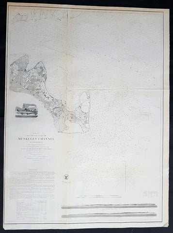
1854 A D Bache Large Rare Antique Map of Marthas Vineyard & Muskeget Channel, Massachusetts
- Title : Preliminary Chart of Muskeget Channel Massachusetts from a Trigonmetrical Survey . . . 1854
- Size: 29in x 21 1/2in (735mm x 545mm)
- Condition: (A+) Fine Condition
- Date : 1854
- Ref #: 93035
Description:
This large rare, original lithograph early antique map of Marthas Vineyard & the Muskeget Channel, Massachusetts - across to Falmouth Village - by Alexander Dallas Bache (great-grandson of Benjamin Franklin) in 1854 - dated - was published by the official chart-maker of the United States, the office of The US Coast Survey.
The Office of the Coast Survey, founded in 1807 by President Thomas Jefferson and Secretary of Commerce Albert Gallatin, is the oldest scientific organization in the U.S. Federal Government. Jefferson created the Survey of the Coast, as it was then called, in response to a need for accurate navigational charts of the new nation\'s coasts and harbors.
General Definitions:
Paper thickness and quality: - Heavy and stable
Paper color : - off white
Age of map color: -
Colors used: -
General color appearance: -
Paper size: - 29in x 21 1/2in (735mm x 545mm)
Plate size: - 29in x 21 1/2in (735mm x 545mm)
Margins: - Min 1/2in (12mm)
Imperfections:
Margins: - None
Plate area: - Folds as issued, light age toning
Verso: - Some folds re-enforced with archival tape
Background:
One of the better mid 19th century large format maps of Martha\'s Vineyard. This rare map depicts most of the island of Marthas Vineyard though does cut out its southwestern portion. Towns, villages, farms, and roads are all beautifully rendered. So too are nautical indications, oceanic depths, and undersea features. There are views of both Holmes\' Hole Harbor and the entrance to Muskeget Channel. There is also a Telescopic view of the Cape Poge lighthouse. This map was created under the direction of A. D. Bache, Superintendent of the Survey of the Coast of the United States and one of the most influential American cartographers of the 19th century.
U.S. Coast Survey (Office of Coast Survey)
The Office of Coast Survey is the official chart-maker of the United States. Set up in 1807, it is one of the U.S. governments oldest scientific organizations. In 1878 it was given the name of Coast and Geodetic Survey (C&GS). In 1970 it became part of the National Oceanic and Atmospheric Administration (NOAA).
The agency was established in 1807 when President Thomas Jefferson signed the document entitled An act to provide for surveying the coasts of the United States. While the bills objective was specific—to produce nautical charts—it reflected larger issues of concern to the new nation: national boundaries, commerce, and defence.
The early years were difficult. Ferdinand Rudolph Hassler, who was eventually to become the agencys first superintendent, went to England to collect scientific instruments but was unable to return through the duration of the War of 1812. After his return, he worked on a survey of the New York Harbor in 1817, but Congress stepped in to suspend the work because of tensions between civilian and military control of the agency. After several years under the control of the U.S. Army, the Survey of the Coast was reestablished in 1832, and President Andrew Jackson appointed Hassler as superintendent.
The U.S. Coast Survey was a civilian agency but, from the beginning, members of the Navy and Army were detailed to service with the Survey, and Navy ships were also detailed to its use. In general, army officers worked on topographic surveys on the land and maps based on the surveys, while navy officers worked on hydrographic surveys in coastal waters.
Alexander Dallas Bache, great-grandson of Benjamin Franklin, was the second Coast Survey superintendent. Bache was a physicist, scientist, and surveyor who established the first magnetic observatory and served as the first president of the National Academy of Sciences. Under Bache, Coast Survey quickly applied its resources to the Union cause during the Civil War. In addition to setting up additional lithographic presses to produce the thousands of charts required by the Navy and other vessels, Bache made a critical decision to send Coast Survey parties to work with blockading squadrons and armies in the field, producing hundreds of maps and charts. Bache detailed these activities in his annual reports to Congress.
Coast Survey cartographer Edwin Hergesheimer created the map showing the density of the slave population in the Southern states.
Bache was also one of four members of the governments Blockade Strategy Board, planning strategy to essentially strangle the South, economically and militarily. On April 16, 1861, President Lincoln issued a proclamation declaring the blockade of ports from South Carolina to Texas. Baches Notes on the Coast provided valuable information for Union naval forces.
Maps were of paramount importance in wartime:
It is certain that accurate maps must form the basis of well-conducted military operations, and that the best time to procure them is not when an attack is impending, or when the army waits, but when there is no hindrance to, or pressure upon, the surveyors. That no coast can be effectively attacked, defended, or blockaded without accurate maps and charts, has been fully proved by the events of the last two years, if, indeed, such a proposition required practical proof.
— Alexander Dallas Bache, 1862 report.
Coast Survey attracted some of the best and brightest scientists and naturalists. It commissioned the naturalist Louis Agassiz to conduct the first scientific study of the Florida reef system. James McNeill Whistler, who went on to paint the iconic Whistlers Mother, was a Coast Survey engraver. The naturalist John Muir was a guide and artist on Survey of the 39th Parallel across the Great Basin of Nevada and Utah.
The agencys men and women (women professionals were hired as early as 1845) led scientific and engineering activities through the decades. In 1926, they started production of aeronautical charts. During the height of the Great Depression, Coast and Geodetic Survey organized surveying parties and field offices that employed over 10,000 people, including many out-of-work engineers.
In World War II, C&GS sent over 1,000 civilian members and more than half of its commissioned officers to serve as hydrographers, artillery surveyors, cartographers, army engineers, intelligence officers, and geophysicists in all theaters of the war. Civilians on the home front produced over 100 million maps and charts for the Allied Forces. Eleven members of the C&GS gave their lives during the war.
Alexander Dallas Bache 1806 – 1867 was an American physicist, scientist, and surveyor who erected coastal fortifications and conducted a detailed survey to map the mid-eastern United States coastline. Originally an army engineer, he later became Superintendent of the U.S. Coast Survey, and built it into the foremost scientific institution in the country before the Civil War.
Alexander Bache was born in Philadelphia, the son of Richard Bache, Jr., and Sophia Burrell Dallas Bache. He came from a prominent family as he was the nephew of Vice-President George M. Dallas and naval hero Alexander J. Dallas. He was the grandson of Secretary of the Treasury Alexander Dallas and was the great-grandson of Benjamin Franklin.
Bache was a professor of natural philosophy and chemistry at the University of Pennsylvania from 1828 to 1841 and again from 1842 to 1843. He spent 1836–1838 in Europe on behalf of the trustees of what became Girard College; he was named president of the college after his return. Abroad, he examined European education systems, and on his return he published a valuable report. From 1839 to 1842, he served as the first president of Central High School of Philadelphia, one of the oldest public high schools in the United States.
In 1843, on the death of Professor Ferdinand Rudolph Hassler, Bache was appointed superintendent of the United States Coast Survey. He convinced the United States Congress of the value of this work and, by means of the liberal aid it granted, he completed the mapping of the whole coast by a skillful division of labor and the erection of numerous observing stations. In addition, magnetic and meteorological data were collected. Bache served as head of the Coast Survey for 24 years (until his death).
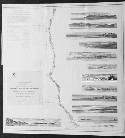
1854 A D Bache Large Rare Antique Map of San Francisco California to Umpqua River, Oregon
- Title : US Coast Survey A D Bache Super. Reconnaissance of the Western Coast of the United States Middle Sheet From San Francisco To Umpquah River . . . 1854
- Size: 24in x 22 1/2in (610mm x 570mm)
- Condition: (A+) Fine Condition
- Date : 1854
- Ref #: 93036
Description:
This large rare, original antique lithograph early map of the coastline from San Francisco, California and the Umpqua River, Oregon, by Alexander Dallas Bache (great-grandson of Benjamin Franklin) in 1854 - dated - was published by the official chart-maker of the United States, the office of The US Coast Survey.
The Office of the Coast Survey, founded in 1807 by President Thomas Jefferson and Secretary of Commerce Albert Gallatin, is the oldest scientific organization in the U.S. Federal Government. Jefferson created the Survey of the Coast, as it was then called, in response to a need for accurate navigational charts of the new nation\'s coasts and harbors.
Background:
A remarkable 1854 map by the United States Coast Survey. Covers the coastline of California and Oregon from San Francisco (depicted) northwards as far as the Umpqua (Umpquah) River. Offers soundings only along the coast line - suggesting the primitive state of the survey in this region. The highlight of this map are the twelve stunning coastal profile views that decorate the right hand side of the map. The upper left quadrant offers general information on tides and lighthouses as well as detailed sailing instructions for the region. This chart is the central sheet of a series of three charts that the Coast Survey issues to show its progress in the region. The positioning for this chart is the world of G. Davidson.
Profile views include Cape Arago, Cape Blanco, Robers River, Mark\'s Arch and Reef, Crescent City, Red Bluff, Cape Mendocino, Trinidad Head and City, Mendocino Cove, Pt. Arena, Pt. Reys, and the Entrance to San Francisco Bay.
Born in England, George Davidson (1825-1911) emigrated to the United States in 1832. After graduating from Girard College in Philadelphia, in 1845 he began a five-decade career with the United States Coast Survey. Much of his work was on the West Coast, where among many, many accomplishments he oversaw triangulation and geodetic work in the region, surveyed the Yolo and Los Angeles base lines, authored the Coast Pilot of California, Oregon and Washington and Coast Pilot of Alaska, and founded the Davidson Observatory in San Francisco. Following his retirement from the Coast Survey in 1895, at the age of 70 he became the first professor of geography at Berkeley, where he taught until retiring in 1905.
General Definitions:
Paper thickness and quality: - Heavy and stable
Paper color : - off white
Age of map color: -
Colors used: -
General color appearance: -
Paper size: - 24in x 22 1/2in (610mm x 570mm)
Plate size: - 24in x 22 1/2in (610mm x 570mm)
Margins: - Min 0in (0mm)
Imperfections:
Margins: - Bottom left half of margin cropped
Plate area: - Folds as issued
Verso: - Some folds re-enforced with archival tape
U.S. Coast Survey (Office of Coast Survey)
The Office of Coast Survey is the official chart-maker of the United States. Set up in 1807, it is one of the U.S. governments oldest scientific organizations. In 1878 it was given the name of Coast and Geodetic Survey (C&GS). In 1970 it became part of the National Oceanic and Atmospheric Administration (NOAA).
The agency was established in 1807 when President Thomas Jefferson signed the document entitled An act to provide for surveying the coasts of the United States. While the bills objective was specific—to produce nautical charts—it reflected larger issues of concern to the new nation: national boundaries, commerce, and defence.
The early years were difficult. Ferdinand Rudolph Hassler, who was eventually to become the agencys first superintendent, went to England to collect scientific instruments but was unable to return through the duration of the War of 1812. After his return, he worked on a survey of the New York Harbor in 1817, but Congress stepped in to suspend the work because of tensions between civilian and military control of the agency. After several years under the control of the U.S. Army, the Survey of the Coast was reestablished in 1832, and President Andrew Jackson appointed Hassler as superintendent.
The U.S. Coast Survey was a civilian agency but, from the beginning, members of the Navy and Army were detailed to service with the Survey, and Navy ships were also detailed to its use. In general, army officers worked on topographic surveys on the land and maps based on the surveys, while navy officers worked on hydrographic surveys in coastal waters.
Alexander Dallas Bache, great-grandson of Benjamin Franklin, was the second Coast Survey superintendent. Bache was a physicist, scientist, and surveyor who established the first magnetic observatory and served as the first president of the National Academy of Sciences. Under Bache, Coast Survey quickly applied its resources to the Union cause during the Civil War. In addition to setting up additional lithographic presses to produce the thousands of charts required by the Navy and other vessels, Bache made a critical decision to send Coast Survey parties to work with blockading squadrons and armies in the field, producing hundreds of maps and charts. Bache detailed these activities in his annual reports to Congress.
Coast Survey cartographer Edwin Hergesheimer created the map showing the density of the slave population in the Southern states.
Bache was also one of four members of the governments Blockade Strategy Board, planning strategy to essentially strangle the South, economically and militarily. On April 16, 1861, President Lincoln issued a proclamation declaring the blockade of ports from South Carolina to Texas. Baches Notes on the Coast provided valuable information for Union naval forces.
Maps were of paramount importance in wartime:
It is certain that accurate maps must form the basis of well-conducted military operations, and that the best time to procure them is not when an attack is impending, or when the army waits, but when there is no hindrance to, or pressure upon, the surveyors. That no coast can be effectively attacked, defended, or blockaded without accurate maps and charts, has been fully proved by the events of the last two years, if, indeed, such a proposition required practical proof.
— Alexander Dallas Bache, 1862 report.
Coast Survey attracted some of the best and brightest scientists and naturalists. It commissioned the naturalist Louis Agassiz to conduct the first scientific study of the Florida reef system. James McNeill Whistler, who went on to paint the iconic Whistlers Mother, was a Coast Survey engraver. The naturalist John Muir was a guide and artist on Survey of the 39th Parallel across the Great Basin of Nevada and Utah.
The agencys men and women (women professionals were hired as early as 1845) led scientific and engineering activities through the decades. In 1926, they started production of aeronautical charts. During the height of the Great Depression, Coast and Geodetic Survey organized surveying parties and field offices that employed over 10,000 people, including many out-of-work engineers.
In World War II, C&GS sent over 1,000 civilian members and more than half of its commissioned officers to serve as hydrographers, artillery surveyors, cartographers, army engineers, intelligence officers, and geophysicists in all theaters of the war. Civilians on the home front produced over 100 million maps and charts for the Allied Forces. Eleven members of the C&GS gave their lives during the war.
Alexander Dallas Bache 1806 – 1867 was an American physicist, scientist, and surveyor who erected coastal fortifications and conducted a detailed survey to map the mid-eastern United States coastline. Originally an army engineer, he later became Superintendent of the U.S. Coast Survey, and built it into the foremost scientific institution in the country before the Civil War.
Alexander Bache was born in Philadelphia, the son of Richard Bache, Jr., and Sophia Burrell Dallas Bache. He came from a prominent family as he was the nephew of Vice-President George M. Dallas and naval hero Alexander J. Dallas. He was the grandson of Secretary of the Treasury Alexander Dallas and was the great-grandson of Benjamin Franklin.
Bache was a professor of natural philosophy and chemistry at the University of Pennsylvania from 1828 to 1841 and again from 1842 to 1843. He spent 1836–1838 in Europe on behalf of the trustees of what became Girard College; he was named president of the college after his return. Abroad, he examined European education systems, and on his return he published a valuable report. From 1839 to 1842, he served as the first president of Central High School of Philadelphia, one of the oldest public high schools in the United States.
In 1843, on the death of Professor Ferdinand Rudolph Hassler, Bache was appointed superintendent of the United States Coast Survey. He convinced the United States Congress of the value of this work and, by means of the liberal aid it granted, he completed the mapping of the whole coast by a skillful division of labor and the erection of numerous observing stations. In addition, magnetic and meteorological data were collected. Bache served as head of the Coast Survey for 24 years (until his death).
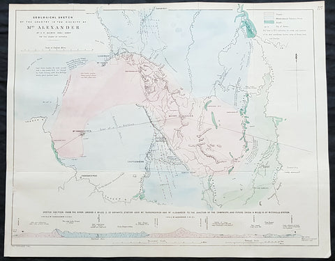
1854 Arrowsmith & Selwyn Rare Antique Goldfields Map Mt Alexander & Castlemaine, Victoria
- Title : Geological Sketch of the Country in the Vicinty of Mt Alexander By AR Selwyn Geol Surv. for the Colony of Victoria
- Size: 21 1/2in x 17in (540x 430mm)
- Condition: (A+) Fine Condition
- Date : 1854
- Ref #: 82048
Description:
This rare, large lithograph geological map of Mount Alexander, the town of Castlemaine & environs, NW of Melbourne, Australia by John Arrowsmith - after the Geological Surveyor of Victoria, Alfred Selwyn - was published in 1854 for The Colonial Office Parliamentary Papers, London.
A very important geological map pertaining to the local goldfields around Mt Alexander and Castlemaine. Being a prominent local landmark, the mountain has its name associated with the surrounding district once known as the Mount Alexander goldfields. The first European to climb the peak was Major Thomas Mitchell on 28 September 1836 during his journey of exploration through Australia Felix. Overlander Edward John Eyre camped the north-west slope of Mount Alexander on 8 February 1838. Alexander Tolmer established a gold escort route between Mount Alexander and Adelaide to serve South Australian gold miners in the early 1850s (the first arrived in Adelaide on 20 March 1852 with around 600 lb of gold, the second, with 1,620 lb on 4 May 1852; it also carried mail between diggers and their Adelaide families)
The rarity of this map cannot be overstated. Many of these maps by Arrowsmith were printed and published only for the British Colonial Office Parliamentary Papers and would have had very low numbers published and are very hard, if not impossible, to be be found for sale on the open market.
John Arrowsmith is considered one of the finest cartographers of the 19th century, famous for producing highly accurate and finely engraved maps in atlases, books & in sheet form, of all parts of the know world. Ironically he is less famous for producing many of the maps that accompanied the British Colonial Office Parliamentary Reports between 1817 to 1890, with two-thirds of the maps being produced by Arrowsmith. These maps were published solely for government review and not public sale. A few of these were subsequently published in Arrowsmiths Atlases and vice versa but a great number of them were not, making many of the maps published for the Parliamentary papers rare and rarely seen on the market. Many of them are not called for in Tooley, Clancy or other important reference material.
This is one of those maps, one of 27 we were fortunate to procure earlier this year. I have found very little historical sales data for these maps and so I have priced them based on what I feel is a fair market value for such a rare, scarce map.
General Definitions:
Paper thickness and quality: - Heavy and stable
Paper color : - off white
Age of map color: - Original
Colors used: - Green, pink, blue
General color appearance: - Authentic
Paper size: - 21 1/2in x 17in (540x 430mm)
Plate size: - 21 1/2in x 17in (540x 430mm)
Margins: - Min 1/2in (12mm)
Imperfections:
Margins: - None
Plate area: - Folds as issued
Verso: - None
Background:
The importance of John Arrowsmiths contribution to early Australian cartography cannot be stressed enough. He was responsible for producing many of the early exploration maps of Australia for the Colonial Offices & Government publications as well as the RGS.
Maps produced after the first settlement and into the 19th century came from varied sources, first published with the First Fleet Journals by Arthur Phillip, John Hunter and Watkin Tench. Numerous European publishing houses produced atlases which included maps of Australia. Many came out in several editions and were updated as new information became available. The Australian Colonies were administered by officials responsible to the British Colonial Office and all events of importance, often illustrated by maps, were published in the British Parliamentary Papers. There a rea prime source of maps from 1830 onwards, although one or two maps may be found in Parliamentary Papers prior to this time, such as one example of a rare map of the Swan River by Captain James Stirling.
During the 19th century, as the Australian colonies were progressively granted responsible government, Parliamentary Papers for each colony became an important source of maps. These maps sources have been a hidden and untapped resource. Another good source of early maps is published journals of the explorers; the explorers earliest maps often accompanied reports in the
Journal of the Royal Geographical Society in the UK. Parallel development of Australian scientific institutions along with an interest in exploration was a strong feature of 19th century Australia. The Royal Geographical Society of Australasia was established with branches in NSW, Victoria, South Australia and Queensland. A number of important maps were published as separate sheets, increasingly by Australian printers and engravers such as Carmichael, Sands & Kenny, and Higginbotham, Robinson & Harrison.
Australian atlases were produced and repeat editions of cadastral surveys and maritime chats became increasingly available. Specialist maps were published from official sources, including geological and mineral maps. Towards the end of the century a plethora of thematic maps were published through a verity of media such as advertisements for land sales, tourists maps and street directories.
Parliamentary Papers British Parliamentary Papers were a funnel for all significant colonial events in the 19th century. They included over one hundred maps with information on topography, exploration and lad survey published between 1817 and 1890., with two-thirds of the maps being produced by John Arrowsmith. Few maps are found after the early 1860s. The maps accompanying papers relevant to gold discovery (1851-55) are a particularly good resource, documenting an important time in the history of Australia. Perhaps the most neglected source of early Australian maps are those included in the Colonial Parliamentary Papers published locally after 1836. The NSW Parliamentary Papers published between 1836 and 1900 contain over 2700 maps on 129 topics, providing a unique record of events considered important by the colonial administration. Land ownership and land use dominate, followed by maps of services relevant to land use, such as railways, roads, water supply and sewerage. Public health issues are recorded in maps as are maps of gold& mineral leases reflected the expanding diversity of the economy. The first map published in the NSW Parliamentary Papers, of the site of the new Government House, was lithographed by W.R. Baker in 1836. The total number of maps over the same period from other colonies was less than 2000 but again each colonies priorities were reflected by in the subjects covered. Tasmania reflected mainly geological and early convict disciplinary maps; South Australia, land administration and pastoral development; Victoria, maps relating to the development; Victoria, maps relating to the colonies infrastructure, especially railway and harbour development; Queensland, railway and mineral leases; Western Australia, a broad range that included two important technological innovations that shortened the time, and therefore the cost, of printing maps. Firstly , John Osborn in 1859, developed the use of a transfer paper method in photolithography which reduced printing time from days to hours. Secondly, Alfred Selwyn in 1860 used a steam-driven power press to print seven colour geological maps.
Royal Geographical Society published its first journal in 1832. This journal was to become the leading scientific medium available for explorers to publish the first news of their discoveries. However, not all explorers were published here. Between 1832 and 1880, 25 maps recorded of inland Australia, illustrating the journeys of 27 explorers. John Arrowsmith compiled 22 of the 25 maps published by the RGS again illustrating the importance of Arrowsmith to the expansion of early colonial cartography in Australia.
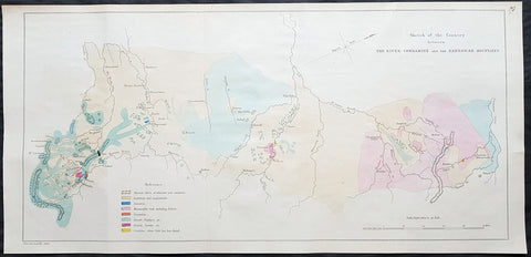
1854 Arrowsmith Rare Antique Geological Map from Queensland to NSW Australia
- Title : Sketch of the Country bewteen The River Condamine and the Nandawah Mounatins
- Size: 26in x 12 1/2in (660mm x 315mm)
- Condition: (A+) Fine Condition
- Date : 1854
- Ref #: 82047
Description:
This rare, large lithograph hand coloured geological map from the Condamine River, Queensland south to the Nandewar Range, Warrabah NSW, Australia by John Arrowsmith was published in 1854 for The Colonial Office Parliamentary Papers, London.
A very important geological map illustrating coal deposits near the Horton River NSW and gold deposits north through to Queensland.
The rarity of this map cannot be overstated. Many of these maps by Arrowsmith were printed and published only for the British Colonial Office Parliamentary Papers and would have had very low numbers published and are very hard, if not impossible, to be be found for sale on the open market.
John Arrowsmith is considered one of the finest cartographers of the 19th century, famous for producing highly accurate and finely engraved maps in atlases, books & in sheet form, of all parts of the know world. Ironically he is less famous for producing many of the maps that accompanied the British Colonial Office Parliamentary Reports between 1817 to 1890, with two-thirds of the maps being produced by Arrowsmith. These maps were published solely for government review and not public sale. A few of these were subsequently published in Arrowsmiths Atlases and vice versa but a great number of them were not, making many of the maps published for the Parliamentary papers rare and rarely seen on the market. Many of them are not called for in Tooley, Clancy or other important reference material.
This is one of those maps, one of 27 we were fortunate to procure earlier this year. I have found very little historical sales data for these maps and so I have priced them based on what I feel is a fair market value for such a rare, scarce map.
General Definitions:
Paper thickness and quality: - Heavy and stable
Paper color : - off white
Age of map color: - Original
Colors used: - Green, pink, blue, red, yellow
General color appearance: - Authentic
Paper size: - 26in x 12 1/2in (660mm x 315mm)
Plate size: - 26in x 12 1/2in (660mm x 315mm)
Margins: - Min 1/2in (12mm)
Imperfections:
Margins: - None
Plate area: - Folds as issued
Verso: - None
Background:
The importance of John Arrowsmiths contribution to early Australian cartography cannot be stressed enough. He was responsible for producing many of the early exploration maps of Australia for the Colonial Offices & Government publications as well as the RGS.
Maps produced after the first settlement and into the 19th century came from varied sources, first published with the First Fleet Journals by Arthur Phillip, John Hunter and Watkin Tench. Numerous European publishing houses produced atlases which included maps of Australia. Many came out in several editions and were updated as new information became available. The Australian Colonies were administered by officials responsible to the British Colonial Office and all events of importance, often illustrated by maps, were published in the British Parliamentary Papers. There a rea prime source of maps from 1830 onwards, although one or two maps may be found in Parliamentary Papers prior to this time, such as one example of a rare map of the Swan River by Captain James Stirling.
During the 19th century, as the Australian colonies were progressively granted responsible government, Parliamentary Papers for each colony became an important source of maps. These maps sources have been a hidden and untapped resource. Another good source of early maps is published journals of the explorers; the explorers earliest maps often accompanied reports in the
Journal of the Royal Geographical Society in the UK. Parallel development of Australian scientific institutions along with an interest in exploration was a strong feature of 19th century Australia. The Royal Geographical Society of Australasia was established with branches in NSW, Victoria, South Australia and Queensland. A number of important maps were published as separate sheets, increasingly by Australian printers and engravers such as Carmichael, Sands & Kenny, and Higginbotham, Robinson & Harrison.
Australian atlases were produced and repeat editions of cadastral surveys and maritime chats became increasingly available. Specialist maps were published from official sources, including geological and mineral maps. Towards the end of the century a plethora of thematic maps were published through a verity of media such as advertisements for land sales, tourists maps and street directories.
Parliamentary Papers British Parliamentary Papers were a funnel for all significant colonial events in the 19th century. They included over one hundred maps with information on topography, exploration and lad survey published between 1817 and 1890., with two-thirds of the maps being produced by John Arrowsmith. Few maps are found after the early 1860s. The maps accompanying papers relevant to gold discovery (1851-55) are a particularly good resource, documenting an important time in the history of Australia. Perhaps the most neglected source of early Australian maps are those included in the Colonial Parliamentary Papers published locally after 1836. The NSW Parliamentary Papers published between 1836 and 1900 contain over 2700 maps on 129 topics, providing a unique record of events considered important by the colonial administration. Land ownership and land use dominate, followed by maps of services relevant to land use, such as railways, roads, water supply and sewerage. Public health issues are recorded in maps as are maps of gold& mineral leases reflected the expanding diversity of the economy. The first map published in the NSW Parliamentary Papers, of the site of the new Government House, was lithographed by W.R. Baker in 1836. The total number of maps over the same period from other colonies was less than 2000 but again each colonies priorities were reflected by in the subjects covered. Tasmania reflected mainly geological and early convict disciplinary maps; South Australia, land administration and pastoral development; Victoria, maps relating to the development; Victoria, maps relating to the colonies infrastructure, especially railway and harbour development; Queensland, railway and mineral leases; Western Australia, a broad range that included two important technological innovations that shortened the time, and therefore the cost, of printing maps. Firstly , John Osborn in 1859, developed the use of a transfer paper method in photolithography which reduced printing time from days to hours. Secondly, Alfred Selwyn in 1860 used a steam-driven power press to print seven colour geological maps.
Royal Geographical Society published its first journal in 1832. This journal was to become the leading scientific medium available for explorers to publish the first news of their discoveries. However, not all explorers were published here. Between 1832 and 1880, 25 maps recorded of inland Australia, illustrating the journeys of 27 explorers. John Arrowsmith compiled 22 of the 25 maps published by the RGS again illustrating the importance of Arrowsmith to the expansion of early colonial cartography in Australia.
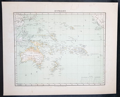
1854 Handtke & Flemming Antique Map of Australia, New Zealand, Pacific
- Title : Australien
- Date : 1854
- Condition: (A+) Fine Condition
- Ref: 32163
- Size: 17in x 14in (430mm x 355mm)
Description:
This hand coloured original steel-plate engraved antique highly detailed map of Australia, New Zealand, & The Pacific by Friedrich Handtke in 1854, was published in the Complete hand atlas of the recent description of the earth over all parts of the earth, Carl Flemming, Glougau.
General Definitions:
Paper thickness and quality: - Heavy and stable
Paper color : - off white
Age of map color: - Original
Colors used: - Yellow, red
General color appearance: - Authentic
Paper size: - 16in x 14in (405mm x 355mm)
Plate size: - 16in x 14in (405mm x 355mm)
Margins: - Min 1/2in (12mm)
Imperfections:
Margins: - Light spotting
Plate area: - Light spotting
Verso: - Light spotting
Background:
Australia is a sovereign country comprising the mainland of the Australian continent, the island of Tasmania and numerous smaller islands. It is the largest country in Oceania and the world\'s sixth-largest country by total area. The neighbouring countries are Papua New Guinea, Indonesia and East Timor to the north; the Solomon Islands and Vanuatu to the north-east; and New Zealand to the south-east. The population of 25 million is highly urbanised and heavily concentrated on the eastern seaboard. Australias capital is Canberra, and its largest city is Sydney. The country\'s other major metropolitan areas are Melbourne, Brisbane, Perth and Adelaide.
Australia was inhabited by indigenous Australians for about 60,000 years before the first British settlement in the late 18th century. It is documented that Aborigines spoke languages that can be classified into about 250 groups. After the European discovery of the continent by Dutch explorers in 1606, who named it New Holland, Australia\'s eastern half was claimed by Great Britain in 1770 and initially settled through penal transportation to the colony of New South Wales from 26 January 1788, a date which became Australia\'s national day. The population grew steadily in subsequent decades, and by the 1850s most of the continent had been explored and an additional five self-governing crown colonies established. On 1 January 1901, the six colonies federated, forming the Commonwealth of Australia. Australia has since maintained a stable liberal democratic political system that functions as a federal parliamentary constitutional monarchy comprising six states and ten territories.
Being the oldest, flattest and driest inhabited continent, with the least fertile soils, Australia has a landmass of 7,617,930 square kilometres. A megadiverse country, its size gives it a wide variety of landscapes, with deserts in the centre, tropical rainforests in the north-east and mountain ranges in the south-east. A gold rush began in Australia in the early 1850s, which boosted the population of the country. Nevertheless, its population density, 2.8 inhabitants per square kilometre, remains among the lowest in the world. Australia generates its income from various sources including mining-related exports, telecommunications, banking and manufacturing. Indigenous Australian rock art is the oldest and richest in the world, dating as far back as 60,000 years and spread across hundreds of thousands of sites.
The first recorded European sighting of the Australian mainland, and the first recorded European landfall on the Australian continent (in 1606), are attributed to the Dutch. The first ship and crew to chart the Australian coast and meet with Aboriginal people was the Duyfken captained by Dutch navigator, Willem Janszoon. He sighted the coast of Cape York Peninsula in early 1606, and made landfall on 26 February at the Pennefather River near the modern town of Weipa on Cape York. The Dutch charted the whole of the western and northern coastlines and named the island continent New Holland during the 17th century, but made no attempt at settlement. William Dampier, an English explorer and privateer, landed on the north-west coast of New Holland in 1688 and again in 1699 on a return trip. In 1770, James Cook sailed along and mapped the east coast, which he named New South Wales and claimed for Great Britain.
With the loss of its American colonies in 1783, the British Government sent a fleet of ships, the First Fleet, under the command of Captain Arthur Phillip, to establish a new penal colony in New South Wales. A camp was set up and the flag raised at Sydney Cove, Port Jackson, on 26 January 1788, a date which became Australia\'s national day, Australia Day. A British settlement was established in Van Diemens Land, now known as Tasmania, in 1803, and it became a separate colony in 1825. The United Kingdom formally claimed the western part of Western Australia (the Swan River Colony) in 1828. Separate colonies were carved from parts of New South Wales: South Australia in 1836, Victoria in 1851, and Queensland in 1859. The Northern Territory was founded in 1911 when it was excised from South Australia. South Australia was founded as a free province—it was never a penal colony. Victoria and Western Australia were also founded free, but later accepted transported convicts. A campaign by the settlers of New South Wales led to the end of convict transportation to that colony; the last convict ship arrived in 1848.
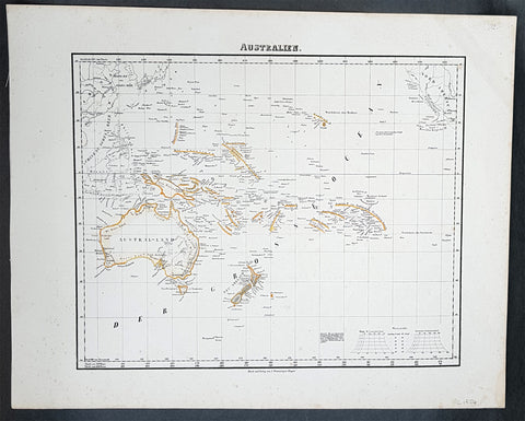
1854 Handtke & Flemming Antique Map of Australia, New Zealand, Pacific
- Title : Australien
- Date : 1854
- Condition: (A+) Fine Condition
- Ref: 31975
- Size: 17in x 14in (430mm x 355mm)
Description:
This hand coloured original steel-plate engraved antique highly detailed map of Australia, New Zealand, & The Pacific by Friedrich Handtke in 1854, was published in the Complete hand atlas of the recent description of the earth over all parts of the earth, Carl Flemming, Glougau.
General Definitions:
Paper thickness and quality: - Heavy and stable
Paper color : - off white
Age of map color: - Original
Colors used: - Yellow, red
General color appearance: - Authentic
Paper size: - 16in x 14in (405mm x 355mm)
Plate size: - 16in x 14in (405mm x 355mm)
Margins: - Min 1/2in (12mm)
Imperfections:
Margins: - Light spotting
Plate area: - Light spotting
Verso: - Light spotting
Background:
Australia is a sovereign country comprising the mainland of the Australian continent, the island of Tasmania and numerous smaller islands. It is the largest country in Oceania and the world\'s sixth-largest country by total area. The neighbouring countries are Papua New Guinea, Indonesia and East Timor to the north; the Solomon Islands and Vanuatu to the north-east; and New Zealand to the south-east. The population of 25 million is highly urbanised and heavily concentrated on the eastern seaboard. Australias capital is Canberra, and its largest city is Sydney. The country\'s other major metropolitan areas are Melbourne, Brisbane, Perth and Adelaide.
Australia was inhabited by indigenous Australians for about 60,000 years before the first British settlement in the late 18th century. It is documented that Aborigines spoke languages that can be classified into about 250 groups. After the European discovery of the continent by Dutch explorers in 1606, who named it New Holland, Australia\'s eastern half was claimed by Great Britain in 1770 and initially settled through penal transportation to the colony of New South Wales from 26 January 1788, a date which became Australia\'s national day. The population grew steadily in subsequent decades, and by the 1850s most of the continent had been explored and an additional five self-governing crown colonies established. On 1 January 1901, the six colonies federated, forming the Commonwealth of Australia. Australia has since maintained a stable liberal democratic political system that functions as a federal parliamentary constitutional monarchy comprising six states and ten territories.
Being the oldest, flattest and driest inhabited continent, with the least fertile soils, Australia has a landmass of 7,617,930 square kilometres. A megadiverse country, its size gives it a wide variety of landscapes, with deserts in the centre, tropical rainforests in the north-east and mountain ranges in the south-east. A gold rush began in Australia in the early 1850s, which boosted the population of the country. Nevertheless, its population density, 2.8 inhabitants per square kilometre, remains among the lowest in the world. Australia generates its income from various sources including mining-related exports, telecommunications, banking and manufacturing. Indigenous Australian rock art is the oldest and richest in the world, dating as far back as 60,000 years and spread across hundreds of thousands of sites.
The first recorded European sighting of the Australian mainland, and the first recorded European landfall on the Australian continent (in 1606), are attributed to the Dutch. The first ship and crew to chart the Australian coast and meet with Aboriginal people was the Duyfken captained by Dutch navigator, Willem Janszoon. He sighted the coast of Cape York Peninsula in early 1606, and made landfall on 26 February at the Pennefather River near the modern town of Weipa on Cape York. The Dutch charted the whole of the western and northern coastlines and named the island continent New Holland during the 17th century, but made no attempt at settlement. William Dampier, an English explorer and privateer, landed on the north-west coast of New Holland in 1688 and again in 1699 on a return trip. In 1770, James Cook sailed along and mapped the east coast, which he named New South Wales and claimed for Great Britain.
With the loss of its American colonies in 1783, the British Government sent a fleet of ships, the First Fleet, under the command of Captain Arthur Phillip, to establish a new penal colony in New South Wales. A camp was set up and the flag raised at Sydney Cove, Port Jackson, on 26 January 1788, a date which became Australia\'s national day, Australia Day. A British settlement was established in Van Diemens Land, now known as Tasmania, in 1803, and it became a separate colony in 1825. The United Kingdom formally claimed the western part of Western Australia (the Swan River Colony) in 1828. Separate colonies were carved from parts of New South Wales: South Australia in 1836, Victoria in 1851, and Queensland in 1859. The Northern Territory was founded in 1911 when it was excised from South Australia. South Australia was founded as a free province—it was never a penal colony. Victoria and Western Australia were also founded free, but later accepted transported convicts. A campaign by the settlers of New South Wales led to the end of convict transportation to that colony; the last convict ship arrived in 1848.
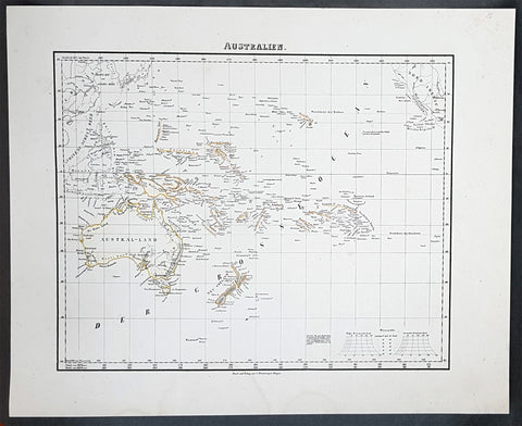
1854 Handtke & Flemming Antique Map of Australia, New Zealand, Pacific
- Title : Australien
- Date : 1854
- Condition: (A+) Fine Condition
- Ref: 31988
- Size: 17in x 14in (430mm x 355mm)
Description:
This hand coloured original steel-plate engraved antique highly detailed map of Australia, New Zealand, & The Pacific by Friedrich Handtke in 1854, was published in the Complete hand atlas of the recent description of the earth over all parts of the earth, Carl Flemming, Glougau.
General Definitions:
Paper thickness and quality: - Heavy and stable
Paper color : - off white
Age of map color: - Original
Colors used: - Yellow, red
General color appearance: - Authentic
Paper size: - 16in x 14in (405mm x 355mm)
Plate size: - 16in x 14in (405mm x 355mm)
Margins: - Min 1/2in (12mm)
Imperfections:
Margins: - Light spotting
Plate area: - Light spotting
Verso: - Light spotting
Background:
Australia is a sovereign country comprising the mainland of the Australian continent, the island of Tasmania and numerous smaller islands. It is the largest country in Oceania and the world\'s sixth-largest country by total area. The neighbouring countries are Papua New Guinea, Indonesia and East Timor to the north; the Solomon Islands and Vanuatu to the north-east; and New Zealand to the south-east. The population of 25 million is highly urbanised and heavily concentrated on the eastern seaboard. Australias capital is Canberra, and its largest city is Sydney. The country\'s other major metropolitan areas are Melbourne, Brisbane, Perth and Adelaide.
Australia was inhabited by indigenous Australians for about 60,000 years before the first British settlement in the late 18th century. It is documented that Aborigines spoke languages that can be classified into about 250 groups. After the European discovery of the continent by Dutch explorers in 1606, who named it New Holland, Australia\'s eastern half was claimed by Great Britain in 1770 and initially settled through penal transportation to the colony of New South Wales from 26 January 1788, a date which became Australia\'s national day. The population grew steadily in subsequent decades, and by the 1850s most of the continent had been explored and an additional five self-governing crown colonies established. On 1 January 1901, the six colonies federated, forming the Commonwealth of Australia. Australia has since maintained a stable liberal democratic political system that functions as a federal parliamentary constitutional monarchy comprising six states and ten territories.
Being the oldest, flattest and driest inhabited continent, with the least fertile soils, Australia has a landmass of 7,617,930 square kilometres. A megadiverse country, its size gives it a wide variety of landscapes, with deserts in the centre, tropical rainforests in the north-east and mountain ranges in the south-east. A gold rush began in Australia in the early 1850s, which boosted the population of the country. Nevertheless, its population density, 2.8 inhabitants per square kilometre, remains among the lowest in the world. Australia generates its income from various sources including mining-related exports, telecommunications, banking and manufacturing. Indigenous Australian rock art is the oldest and richest in the world, dating as far back as 60,000 years and spread across hundreds of thousands of sites.
The first recorded European sighting of the Australian mainland, and the first recorded European landfall on the Australian continent (in 1606), are attributed to the Dutch. The first ship and crew to chart the Australian coast and meet with Aboriginal people was the Duyfken captained by Dutch navigator, Willem Janszoon. He sighted the coast of Cape York Peninsula in early 1606, and made landfall on 26 February at the Pennefather River near the modern town of Weipa on Cape York. The Dutch charted the whole of the western and northern coastlines and named the island continent New Holland during the 17th century, but made no attempt at settlement. William Dampier, an English explorer and privateer, landed on the north-west coast of New Holland in 1688 and again in 1699 on a return trip. In 1770, James Cook sailed along and mapped the east coast, which he named New South Wales and claimed for Great Britain.
With the loss of its American colonies in 1783, the British Government sent a fleet of ships, the First Fleet, under the command of Captain Arthur Phillip, to establish a new penal colony in New South Wales. A camp was set up and the flag raised at Sydney Cove, Port Jackson, on 26 January 1788, a date which became Australia\'s national day, Australia Day. A British settlement was established in Van Diemens Land, now known as Tasmania, in 1803, and it became a separate colony in 1825. The United Kingdom formally claimed the western part of Western Australia (the Swan River Colony) in 1828. Separate colonies were carved from parts of New South Wales: South Australia in 1836, Victoria in 1851, and Queensland in 1859. The Northern Territory was founded in 1911 when it was excised from South Australia. South Australia was founded as a free province—it was never a penal colony. Victoria and Western Australia were also founded free, but later accepted transported convicts. A campaign by the settlers of New South Wales led to the end of convict transportation to that colony; the last convict ship arrived in 1848.
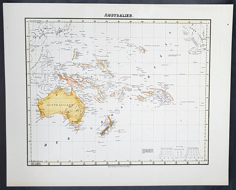
1854 Handtke & Flemming Antique Map of Australia, New Zealand, Pacific
- Title : Australien
- Date : 1854
- Condition: (A+) Fine Condition
- Ref: 40973
- Size: 17in x 14in (430mm x 355mm)
Description:
This hand coloured original steel-plate engraved antique highly detailed map of Australia, New Zealand, & The Pacific by Friedrich Handtke in 1854, was published in the Complete hand atlas of the recent description of the earth over all parts of the earth, Carl Flemming, Glougau.
General Definitions:
Paper thickness and quality: - Heavy and stable
Paper color : - off white
Age of map color: - Original
Colors used: - Yellow, red
General color appearance: - Authentic
Paper size: - 16in x 14in (405mm x 355mm)
Plate size: - 16in x 14in (405mm x 355mm)
Margins: - Min 1/2in (12mm)
Imperfections:
Margins: - Light spotting
Plate area: - Light spotting
Verso: - Light spotting
Background:
Australia is a sovereign country comprising the mainland of the Australian continent, the island of Tasmania and numerous smaller islands. It is the largest country in Oceania and the world\'s sixth-largest country by total area. The neighbouring countries are Papua New Guinea, Indonesia and East Timor to the north; the Solomon Islands and Vanuatu to the north-east; and New Zealand to the south-east. The population of 25 million is highly urbanised and heavily concentrated on the eastern seaboard. Australias capital is Canberra, and its largest city is Sydney. The country\'s other major metropolitan areas are Melbourne, Brisbane, Perth and Adelaide.
Australia was inhabited by indigenous Australians for about 60,000 years before the first British settlement in the late 18th century. It is documented that Aborigines spoke languages that can be classified into about 250 groups. After the European discovery of the continent by Dutch explorers in 1606, who named it New Holland, Australia\'s eastern half was claimed by Great Britain in 1770 and initially settled through penal transportation to the colony of New South Wales from 26 January 1788, a date which became Australia\'s national day. The population grew steadily in subsequent decades, and by the 1850s most of the continent had been explored and an additional five self-governing crown colonies established. On 1 January 1901, the six colonies federated, forming the Commonwealth of Australia. Australia has since maintained a stable liberal democratic political system that functions as a federal parliamentary constitutional monarchy comprising six states and ten territories.
Being the oldest, flattest and driest inhabited continent, with the least fertile soils, Australia has a landmass of 7,617,930 square kilometres. A megadiverse country, its size gives it a wide variety of landscapes, with deserts in the centre, tropical rainforests in the north-east and mountain ranges in the south-east. A gold rush began in Australia in the early 1850s, which boosted the population of the country. Nevertheless, its population density, 2.8 inhabitants per square kilometre, remains among the lowest in the world. Australia generates its income from various sources including mining-related exports, telecommunications, banking and manufacturing. Indigenous Australian rock art is the oldest and richest in the world, dating as far back as 60,000 years and spread across hundreds of thousands of sites.
The first recorded European sighting of the Australian mainland, and the first recorded European landfall on the Australian continent (in 1606), are attributed to the Dutch. The first ship and crew to chart the Australian coast and meet with Aboriginal people was the Duyfken captained by Dutch navigator, Willem Janszoon. He sighted the coast of Cape York Peninsula in early 1606, and made landfall on 26 February at the Pennefather River near the modern town of Weipa on Cape York. The Dutch charted the whole of the western and northern coastlines and named the island continent New Holland during the 17th century, but made no attempt at settlement. William Dampier, an English explorer and privateer, landed on the north-west coast of New Holland in 1688 and again in 1699 on a return trip. In 1770, James Cook sailed along and mapped the east coast, which he named New South Wales and claimed for Great Britain.
With the loss of its American colonies in 1783, the British Government sent a fleet of ships, the First Fleet, under the command of Captain Arthur Phillip, to establish a new penal colony in New South Wales. A camp was set up and the flag raised at Sydney Cove, Port Jackson, on 26 January 1788, a date which became Australia\'s national day, Australia Day. A British settlement was established in Van Diemens Land, now known as Tasmania, in 1803, and it became a separate colony in 1825. The United Kingdom formally claimed the western part of Western Australia (the Swan River Colony) in 1828. Separate colonies were carved from parts of New South Wales: South Australia in 1836, Victoria in 1851, and Queensland in 1859. The Northern Territory was founded in 1911 when it was excised from South Australia. South Australia was founded as a free province—it was never a penal colony. Victoria and Western Australia were also founded free, but later accepted transported convicts. A campaign by the settlers of New South Wales led to the end of convict transportation to that colony; the last convict ship arrived in 1848.
1854 Handtke & Flemming Huge 4 Sheet Antique Map of Spain, Portugal, Balearic Is
- Title : 1854 Handtke & Flemming Huge 4 Sheet Antique Map of Spain, Portugal, Balearic Is
- Date : 1854
- Condition: (A+) Fine Condition
- Ref: 32087
- Size: 32in x 26 1/2in (815mm x 675mm) joined
Description:
This hand coloured original steel-plate engraved antique very large 4 x sheet map of Spain & Portugal by Friedrich Handtke in 1854, was published in the Complete hand atlas of the recent description of the earth over all parts of the earth, Carl Flemming, Glougau.
General Definitions:
Paper thickness and quality: - Heavy and stable
Paper color : - off white
Age of map color: - Original
Colors used: - Yellow, green, blue, pink
General color appearance: - Authentic
Paper size: - 32in x 26 1/2in (815mm x 675mm) joined
Plate size: - 32in x 26 1/2in (815mm x 675mm) joined
Margins: - Min 1/2in (12mm)
Imperfections:
Margins: - Light age toning in margins
Plate area: - None
Verso: - None
Background:
Many of the original charts and maps drawn by the first Portuguese and Spanish navigators have survived for the very good reason that, on completion of their voyages, pilots were obliged to hand over their manuscript notes to the Casa da India (founded 1504) in Lisbon or to the equivalent Casa de Contrataci6n de las Indias (founded 1504) in Seville. The clear intention was to maintain secrecy over new discoveries and control over the distribution of cartographic material, not always successfully, as it happened; pilots and navigators seem to have changed allegiance with impunity and, in consequence, many of the earliest and most informative charts were compiled as far away as Genoa, Venice, Florence and Ancona, presumably from sources outside the Portuguese and Spanish Casas.It is apparent that few manuscripts reached the printing stage and, indeed, are so rare that any study of them must be regarded as a specialist subject. (Ref Tooley M&B)
1854 Handtke & Flemming Large Antique Map of New South Wales, Sydney, Australia
- Title : Neu Sud-Wales
- Date : 1854
- Condition: (A) Very Good Condition
- Ref: 31992
- Size: 17in x 14in (430mm x 355mm)
Description:
This beautifully hand coloured original steel-plate engraved antique map of New South Wales, with an inset of a plan of Sydney Town by Friedrich Handtke in 1854, was published in the Complete hand atlas of the recent description of the earth over all parts of the earth, Carl Flemming, Glougau.
General Definitions:
Paper thickness and quality: - Heavy and stable
Paper color : - off white
Age of map color: - Original
Colors used: - Yellow, green, blue, pink
General color appearance: - Authentic
Paper size: - 17in x 14in (430mm x 355mm)
Plate size: - 17in x 14in (430mm x 355mm)
Margins: - Min 1/2in (12mm)
Imperfections:
Margins: - Light age toning
Plate area: - Light age toning
Verso: - Light age toning
Background:
A golden age of a new kind began in New South Wales and Sydney in 1851 with the announcement of the discovery of payable gold at Ophir near Bathurst by Edward Hargraves. In that year New South Wales had about 200,000 people, a third of them within a days ride of Sydney, the rest scattered along the coast and through the pastoral districts, from the Port Phillip District in the south to Moreton Bay in the north. The gold rushes of the 1850s brought a huge influx of settlers, although initially the majority of them went to the richest gold fields at Ballarat and Bendigo, in the Port Phillip District, which in 1851 was separated to become the colony of Victoria.
Hill End, also near Bathurst N.S.W. was a locality that grew, boomed and faded with the N.S.W. Gold Rush. Called \'Bald Hills\' in 1850, \'Forbes in 1860 and finally Hill End in 1862, it was part of the Tambaroora district. At its peak, its population was 7,000. Completely reliant on mining, the town\'s decline was dramatic once the gold ran out. Hill End is famed for the unearthing of the Holtermann Specimen (correctly, the Beyers Holtermann Specimen), being the largest single mass of gold ever discovered in the world, a record that stands today. Found in 1872 at the Star Hope Mine, this single mass of quartz and gold weighed 630 lbs and when crushed produced an estimated 3,000 troy oz (205 lbs or 93 kg) of gold, thus holding more processed gold than from the largest nugget ever found, that being the Welcome Stranger from the Victorian Goldfields. Holtermann recognizing the significance of the find attempted to preserve it by buying it from the Company of which he was one of a number of directors. His efforts were in vain. It is reported that a larger mass was discovered a few days later in the same mine but was broken up underground.
Victoria soon had a larger population than New South Wales, and its upstart capital, Melbourne, outgrew Sydney. But the New South Wales gold fields also attracted a flood of prospectors, and by 1857 the colony had more than 300,000 people. Inland towns like Bathurst, Goulburn, Orange and Young flourished. Gold brought great wealth but also new social tensions. Multiethnic migrants came to New South Wales in large numbers for the first time. Young became the site of an infamous anti-Chinese miner riot in 1861 and the official Riot Act was read to the miners on 14 July – the only official reading in the history of New South Wales.[27] Despite some tension, the influx of migrants also brought fresh ideas from Europe and North America to New South Wales – Norwegians introduced Skiing in Australia to the hills above the Snowy Mountains gold rush town of Kiandra around 1861. A famous Australian son was also born to a Norwegian miner in 1867, when the bush balladeer Henry Lawson was born at the Grenfell goldfields.
In 1858, a new gold rush began in the far north, which led in 1859 to the separation of Queensland as a new colony. New South Wales thus attained its present borders, although what is now the Northern Territory remained part of the colony until 1863, when it was handed over to South Australia.
The separation and rapid growth of Victoria and Queensland mark the real beginning of New South Wales as a political and economic entity distinct from the other Australian colonies. Rivalry between New South Wales and Victoria was intense throughout the second half of the 19th century, and the two colonies developed in radically different directions. Once the easy gold ran out by about 1860, Victoria absorbed the surplus labour force from the gold fields in manufacturing, protected by high tariff walls. Victoria became the Australian stronghold of protectionism, liberalism and radicalism. New South Wales, which was less radically affected demographically by the gold rushes, remained more conservative, still dominated politically by the squatter class and its allies in the Sydney business community. New South Wales, as a trading and exporting colony, remained wedded to free trade.
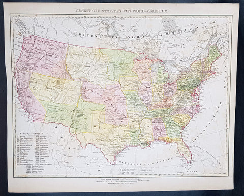
1854 Handtke & Flemming Large Antique Map of The United States of America - 32 States
- Title : Vereinigte Staaten Von Nord-America
- Ref #: 41103
- Size: 17in x 14in (430mm x 355mm)
- Date : 1854
- Condition: (A+) Fine Condition
Description:
This beautifully hand coloured original steel-plate engraved antique map of the United States in the mid 19th century, by Friedrich Handtke in 1854, was published in the Complete hand atlas of the recent description of the earth over all parts of the earth, Carl Flemming, Glougau.
At the bottom left of the map is an index of all states and territories. 32 States are listed with California the last, accepted into the union in 1850 and 5 territories are listed, Oregon, Missouri, Minnesota, Indian & Utah.
General Definitions:
Paper thickness and quality: - Heavy and stable
Paper color : - off white
Age of map color: - Original
Colors used: - Yellow, green, blue, pink
General color appearance: - Authentic
Paper size: - 17in x 14in (430mm x 355mm)
Plate size: - 17in x 14in (430mm x 355mm)
Margins: - Min 1/2in (12mm)
Imperfections:
Margins: - Light age toning
Plate area: - Light age toning
Verso: - Light age toning
Background:
After the conclusion of the Civil War three things happened that opened up the western states, migration, gold and the building of the railway from the Atlantic to the Pacific. This map shows a country prior to the civil war still defining itself with much of the country west of the Mississippi regions yet to be opened and defined.
Mexico became independent of Spain in 1821, and took over Spains northern possessions stretching from Texas to California. Caravans began delivering goods to Mexicos Santa Fe along the Santa Fe Trail, over the 870-mile journey which took 48 days from Kansas City, Missouri (then known as Westport). Santa Fe was also the trailhead for the El Camino Real (the Kings Highway), a trade route which carried American manufactured goods southward deep into Mexico and returned silver, furs, and mules northward (not to be confused with another Camino Real which connected the missions in California). A branch also ran eastward near the Gulf (also called the Old San Antonio Road). Santa Fe connected to California via the Old Spanish Trail.
The Spanish and Mexican governments attracted American settlers to Texas with generous terms. Stephen F. Austin became an empresario, receiving contracts from the Mexican officials to bring in immigrants. In doing so, he also became the de facto political and military commander of the area. Tensions rose, however, after an abortive attempt to establish the independent nation of Fredonia in 1826. William Travis, leading the war party, advocated for independence from Mexico, while the peace party led by Austin attempted to get more autonomy within the current relationship. When Mexican president Santa Anna shifted alliances and joined the conservative Centralist party, he declared himself dictator and ordered soldiers into Texas to curtail new immigration and unrest. However, immigration continued and 30,000 Anglos with 3,000 slaves were settled in Texas by 1835. In 1836, the Texas Revolution erupted. Following losses at the Alamo and Goliad, the Texians won the decisive Battle of San Jacinto to secure independence. At San Jacinto, Sam Houston, commander-in-chief of the Texian Army and future President of the Republic of Texas famously shouted Remember the Alamo! Remember Goliad. The U.S. Congress declined to annex Texas, stalemated by contentious arguments over slavery and regional power. Thus, the Republic of Texas remained an independent power for nearly a decade before it was annexed as the 28th state in 1845. The government of Mexico, however, viewed Texas as a runaway province and asserted its ownership.
Mexico refused to recognize the independence of Texas in 1836, but the U.S. and European powers did so. Mexico threatened war if Texas joined the U.S., which it did in 1845. American negotiators were turned away by a Mexican government in turmoil. When the Mexican army killed 16 American soldiers in disputed territory war was at hand. Whigs, such as Congressman Abraham Lincoln denounced the war, but it was quite popular outside New England.
The Mexican strategy was defensive; the American strategy was a three pronged offensive, using large numbers of volunteer soldiers. Overland forces seized New Mexico with little resistance and headed to California, which quickly fell to the American land and naval forces. From the main American base at New Orleans, General Zachary Taylor led forces into northern Mexico, winning a series of battles that ensued. The U.S. Navy transported General Winfield Scott to Veracruz. He then marched his 12,000-man force west to Mexico City, winning the final battle at Chapultepec. Talk of acquiring all of Mexico fell away when the army discovered the Mexican political and cultural values were so alien to Americas. As the Cincinnati Herald asked, what would the U.S. do with eight million Mexicans with their idol worship, heathen superstition, and degraded mongrel races?
The Treaty of Guadalupe Hidalgo of 1848 ceded the territories of California and New Mexico to the United States for $18.5 million (which included the assumption of claims against Mexico by settlers). The Gadsden Purchase in 1853 added southern Arizona, which was needed for a railroad route to California. In all Mexico ceded half a million square miles (1.3 million km2) and included the states-to-be of California, Utah, Arizona, Nevada, New Mexico, and parts of Colorado and Wyoming, in addition to Texas. Managing the new territories and dealing with the slavery issue caused intense controversy, particularly over the Wilmot Proviso, which would have outlawed slavery in the new territories. Congress never passed it, but rather temporarily resolved the issue of slavery in the West with the Compromise of 1850. California entered the Union in 1850 as a free state; the other areas remained territories for many years.
The new state grew rapidly as migrants poured into the fertile cotton lands of east Texas. German immigrants started to arrive in the early 1840s because of negative economic, social and political pressures in Germany. With their investments in cotton lands and slaves, planters established cotton plantations in the eastern districts. The central area of the state was developed more by subsistence farmers who seldom owned slaves.
Texas in its Wild West days attracted men who could shoot straight and possessed the zest for adventure, for masculine renown, patriotic service, martial glory and meaningful deaths.
In 1846 about 10,000 Californios (Hispanics) lived in California, primarily on cattle ranches in what is now the Los Angeles area. A few hundred foreigners were scattered in the northern districts, including some Americans. With the outbreak of war with Mexico in 1846 the U.S. sent in Frémont and a U.S. Army unit, as well as naval forces, and quickly took control. As the war was ending, gold was discovered in the north, and the word soon spread worldwide.
Thousands of Forty-Niners reached California, by sailing around South America (or taking a short-cut through disease-ridden Panama), or walked the California trail. The population soared to over 200,000 in 1852, mostly in the gold districts that stretched into the mountains east of San Francisco.
Housing in San Francisco was at a premium, and abandoned ships whose crews had headed for the mines were often converted to temporary lodging. In the gold fields themselves living conditions were primitive, though the mild climate proved attractive. Supplies were expensive and food poor, typical diets consisting mostly of pork, beans, and whiskey. These highly male, transient communities with no established institutions were prone to high levels of violence, drunkenness, profanity, and greed-driven behavior. Without courts or law officers in the mining communities to enforce claims and justice, miners developed their own ad hoc legal system, based on the mining codes used in other mining communities abroad. Each camp had its own rules and often handed out justice by popular vote, sometimes acting fairly and at times exercising vigilantism—with Indians, Mexicans, and Chinese generally receiving the harshest sentences.
The gold rush radically changed the California economy and brought in an array of professionals, including precious metal specialists, merchants, doctors, and attorneys, who added to the population of miners, saloon keepers, gamblers, and prostitutes. A San Francisco newspaper stated, The whole country... resounds to the sordid cry of gold! Gold! Gold! while the field is left half planted, the house half built, and everything neglected but the manufacture of shovels and pick axes. Over 250,000 miners found a total of more than $200 million in gold in the five years of the California Gold Rush. As thousands arrived, however, fewer and fewer miners struck their fortune, and most ended exhausted and broke.
Violent bandits often preyed upon the miners, such as the case of Jonathan R. Davis killing of eleven bandits single-handedly. Camps spread out north and south of the American River and eastward into the Sierras. In a few years, nearly all of the independent miners were displaced as mines were purchased and run by mining companies, who then hired low-paid salaried miners. As gold became harder to find and more difficult to extract, individual prospectors gave way to paid work gangs, specialized skills, and mining machinery. Bigger mines, however, caused greater environmental damage. In the mountains, shaft mining predominated, producing large amounts of waste. Beginning in 1852, at the end of the 49 gold rush, through 1883, hydraulic mining was used. Despite huge profits being made, it fell into the hands of a few capitalists, displaced numerous miners, vast amounts of waste entered river systems, and did heavy ecological damage to the environment. Hydraulic mining ended when public outcry over the destruction of farmlands led to the outlawing of this practice.
The mountainous areas of the triangle from New Mexico to California to South Dakota contained hundreds of hard rock mining sites, where prospectors discovered gold, silver, copper and other minerals (as well as some soft-rock coal). Temporary mining camps sprang up overnight; most became ghost towns when the ores were depleted. Prospectors spread out and hunted for gold and silver along the Rockies and in the southwest. Soon gold was discovered in Colorado, Utah, Arizona, New Mexico, Idaho, Montana, and South Dakota (by 1864).
The discovery of the Comstock Lode, containing vast amounts of silver, resulted in the Nevada boomtowns of Virginia City, Carson City, and Silver City. The wealth from silver, more than from gold, fueled the maturation of San Francisco in the 1860s and helped the rise of some of its wealthiest families, such as that of George Hearst.
To get to the rich new lands of the West Coast, there were two options: some sailed around the southern tip of South America during a six-month voyage, but 400,000 others walked there on an overland route of more than 2,000 miles (3,000 km); their wagon trains usually left from Missouri. They moved in large groups under an experienced wagonmaster, bringing their clothing, farm supplies, weapons, and animals. These wagon trains followed major rivers, crossed prairies and mountains, and typically ended in Oregon and California. Pioneers generally attempted to complete the journey during a single warm season, usually over the course of six months. By 1836, when the first migrant wagon train was organized in Independence, Missouri, a wagon trail had been cleared to Fort Hall, Idaho. Trails were cleared further and further west, eventually reaching all the way to the Willamette Valley in Oregon. This network of wagon trails leading to the Pacific Northwest was later called the Oregon Trail. The eastern half of the route was also used by travelers on the California Trail (from 1843), Mormon Trail (from 1847), and Bozeman Trail (from 1863) before they turned off to their separate destinations.
In the Wagon Train of 1843, some 700 to 1,000 emigrants headed for Oregon; missionary Marcus Whitman led the wagons on the last leg. In 1846, the Barlow Road was completed around Mount Hood, providing a rough but passable wagon trail from the Missouri River to the Willamette Valley: about 2,000 miles. Though the main direction of travel on the early wagon trails was westward, people also used the Oregon Trail to travel eastward. Some did so because they were discouraged and defeated. Some returned with bags of gold and silver. Most were returning to pick up their families and move them all back west. These gobacks were a major source of information and excitement about the wonders and promises—and dangers and disappointments—of the far West.
Not all emigrants made it to their destination. The dangers of the overland route were numerous: snakebites, wagon accidents, violence from other travelers, suicide, malnutrition, stampedes, Indian attacks, a variety of diseases (dysentery, typhoid, and cholera were among the most common), exposure, avalanches, etc. One particularly well-known example of the treacherous nature of the journey is the story of the ill-fated Donner Party, which became trapped in the Sierra Nevada mountains during the winter of 1846–1847 in which nearly half of the 90 people traveling with the group died from starvation and exposure, and some resorted to cannibalism to survive. Another story of cannibalism featured Alfred Packer and his trek to Colorado in 1874. There were also frequent attacks from bandits and highwaymen, such as the infamous Harpe brothers who patrolled the frontier routes and targeted migrant groups.
In Missouri and Illinois, animosity between the Mormon settlers and locals grew, which would mirror those in other states such as Utah years later. Violence finally erupted on October 24, 1838 when militias from both sides clashed and a mass killing of Mormons in Livingston County occurred 6 days later. An executive order was filed during these conflicts, and the Mormons were forced to scatter. Brigham Young, seeking to leave American jurisdiction to escape religious persecution in Illinois and Missouri, led the Mormons to the valley of the Great Salt Lake, owned at the time by Mexico but not controlled by them. A hundred rural Mormon settlements sprang up in what Young called Deseret, which he ruled as a theocracy. It later became Utah Territory. Youngs Salt Lake City settlement served as the hub of their network, which reached into neighboring territories as well. The communalism and advanced farming practices of the Mormons enabled them to succeed. They sold goods to wagon trains passing through and came to terms with local Indian tribes because Young decided it was cheaper to feed the Indians than fight them. Education became a high priority to protect the beleaguered group, reduce heresy and maintain group solidarity.
The great threat to the Mormons in Utah was the U.S. government, which took ownership of Utah in 1848, and pushed by the Protestant churches, rejected theocracy and polygamy. The Republican Party swore to destroy polygamy, which it saw as an affront to religious, cultural and moral values of a modern civilization. Confrontations verged on open warfare in the late 1850s as President Buchanan sent in troops. Although there were no military battles fought, and negotiations led to a stand down, violence still escalated and there were a number of casualties. After the Civil War the federal government systematically took control of Utah away from the Mormons, and drove the churchs leadership underground. Meanwhile, aggressive missionary work in the U.S. and Europe brought a flood of Mormon converts to Utah. Finally in 1890 the Church leadership announced polygamy was no longer a central tenet, and a compromise was reached, with Utah becoming a state and the Mormons dividing into Republicans and Democrats.
Constitutionally, Congress could not deal with slavery in the states but it did have jurisdiction in the western territories. California unanimously rejected slavery in 1850 and became a free state. New Mexico allowed slavery, but it was rarely seen there. Kansas was off limits to slavery by the Compromise of 1820. Free Soil elements feared that if slavery were allowed rich planters would buy up the best lands and work them with gangs of slaves, leaving little opportunity for free white men to own farms. Few Southern planters were actually interested in Kansas, but the idea that slavery was illegal there implied they had a second-class status that was intolerable to their sense of honor, and seemed to violate the principle of states rights. With the passage of the extremely controversial Kansas–Nebraska Act in 1854, Congress left the decision up to the voters on the ground in Kansas. Across the North a new major party was formed to fight slavery: the Republican Party, with numerous westerners in leadership positions, most notably Abraham Lincoln of Illinois. To influence the territorial decision, anti-slavery elements (also called Jayhawkers or Free-soilers) financed the migration of politically determined settlers. But pro-slavery advocates fought back with pro-slavery settlers from Missouri. Violence on both sides was the result; in all 56 men were killed by the time the violence abated in 1859. By 1860 the pro-slavery forces were in control—but Kansas had only two slaves. The antislavery forces took over by 1861, as Kansas became a free state. The episode demonstrated that a democratic compromise between North and South over slavery was impossible and served to hasten the Civil War.
Handtke, Friedrich 1815 - 1879
Handtke was a 19th century German cartographer who trained as a surveyor. After serving a year in the Prussian army, in 1838 he began work as head of the cartographic department at the publishing bookstore Carl Flemming in Glogau, Silesia. Of the 260 maps published by Flemming over 165 were drawn by Handtke.
Handtkes most important work was the Hand Atlas of the Prussian State of 1846 with 36 maps. He also published important maps of the Prussian state & a Map of Neuchâtel and Valendis & the nine provinces; East Prussia , West Prussia , Pomerania , Poznan , Silesia , Brandenburg , Saxony , Westphalia and the Rhine Province and the 25 administrative districts. One of Handtkes students was the German cartographer Paul Thumann .
Atlases published:
- Complete hand atlas of the recent description of the earth over all parts of the earth , Flemming, Glogau 1849.
- Hand Atlas of the Prussian State Flemming, Glogau 1846
- Royal Prussian Card. Province of Saxony, the duchy of Anhalt, the ducal. Saxon countries Weimar, Altenburg u. Gotha and the principals Schwarzburg and Reuss , Flemming, Glogau 1870/71
1854 John Arrowsmith Rare Antique Map, Early Town Plan of Gladstone, Queensland
- Title : Plan of the Town of Gladstone Port Curtis 1854 (Water is very scarce in this locality)
- Size: 22 1/4in x 16 3/4in (565mm x 425mm)
- Condition: (A+) Fine Condition
- Date : 1854
- Ref #: 82045
Description:
This large, rare & important map, a very early plan of the Queensland town of Gladstone by John Arrowsmith was engraved in 1854 - dated - and was published for The Colonial Office Parliamentary Papers, London.
The rarity of this map cannot be overstated. Many of these maps by Arrowsmith were printed and published only for the British Colonial Office Parliamentary Papers and would have numbered only in the 100s.
John Arrowsmith is considered one of the finest cartographers of the 19th century, famous for producing highly accurate and finely engraved maps in atlases, books & in sheet form, of all parts of the know world. Ironically he is less famous for producing many of the maps that accompanied the British Colonial Office Parliamentary Reports between 1817 to 1890, with two-thirds of the maps being produced by Arrowsmith. These maps were published solely for government review and not public sale. A few of these were subsequently published in Arrowsmiths Atlases and vice versa but a great number of them were not, making many of the maps published for the Parliamentary papers rare and rarely seen on the market. Many of them are not called for in Tooley, Clancy or other important reference material.
This is one of those maps, one of 27 we were fortunate to procure earlier this year. I have found very little historical sales data for these maps and so I have priced them based on what I feel is a fair market value for such a rare, scarce map.
Gladstone is a city in the Gladstone Region, Queensland, Australia. It is approximately 550 km (340 mi) by road north of Brisbane and 100 km south-east of Rockhampton. Situated between the Calliope and Boyne Rivers, Gladstone is home to Queensland\'s largest multi-commodity shipping port.
Before European settlement, the Gladstone region was home of the Toolooa (or Tulua), Meerooni and Baiali (or Byellee) Aboriginal tribes.
In May 1770, the HM Bark Endeavour, under the command of James Cook, sailed by the entrance to Gladstone Harbour under the cover of darkness. Matthew Flinders, during his 1801–1803 circumnavigation of Australia, became the first recorded European to sight the harbour in August 1802. He named the harbour Port Curtis, after Admiral Roger Curtis, a man who was of assistance to Flinders a year earlier at the Cape of Good Hope. John Oxley conducted further exploration of the harbour and surrounding countryside in November 1823. Oxley was dismissive of the region, noting the harbour was difficult to enter, the countryside was too dry, and the timber useless for construction purposes.
Nevertheless, in 1847 the British attempted to establish the new colony of North Australia at Port Curtis. Colonel George Barney was chosen to lead this experiment in colonisation and his expedition was eventful. On 25 January 1847, the Lord Auckland, carrying 87 soldiers and convicts, arrived off the southern entrance of Port Curtis and promptly ran aground on shoals off the southern tip of Facing Island. The settlers spent seven weeks on the island before being rescued by the supply ship Thomas Lowry and delivered the intended site of settlement, the region now known as Barney Point. On 30 January at a proclamation ceremony, Barney was sworn in as Lieutenant Governor of the colony of North Australia. The convict settlement lasted barely two months and cost the Imperial government ₤15,000. A change of government in Britain ordered the withdrawal of Barney and the settlers. However, interest in the region remained.
By 1853, Francis MacCabe was surveying the site of a new town on the shores of Port Curtis under the protection of several detachments of Native Police. Maurice O\'Connell was appointed government resident the following year, resulting in an influx of free settlers as land became available throughout the region. In 1863, the town became a Municipality with Richard Hetherington elected Gladstones first mayor. The fledgling town was named after the British Prime Minister William Ewart Gladstone and has a 19th-century marble statue on display in its town museum.
General Definitions:
Paper thickness and quality: - Heavy and stable
Paper color : - off white
Age of map color: - Original
Colors used: - Blue, pink, green
General color appearance: - Authentic
Paper size: - 22 1/4in x 16 3/4in (565mm x 425mm)
Plate size: - 22 1/4in x 16 3/4in (565mm x 425mm)
Margins: - Min 1/2in (12mm)
Imperfections:
Margins: - None
Plate area: - Folds as issued
Verso: - None
Background:
The importance of John Arrowsmiths contribution to early Australian cartography cannot be stressed enough. He was responsible for producing many of the early exploration maps of Australia for the Colonial Offices & Government publications as well as the RGS.
Maps produced after the first settlement and into the 19th century came from varied sources, first published with the First Fleet Journals by Arthur Phillip, John Hunter and Watkin Tench. Numerous European publishing houses produced atlases which included maps of Australia. Many came out in several editions and were updated as new information became available. The Australian Colonies were administered by officials responsible to the British Colonial Office and all events of importance, often illustrated by maps, were published in the British Parliamentary Papers. There a rea prime source of maps from 1830 onwards, although one or two maps may be found in Parliamentary Papers prior to this time, such as one example of a rare map of the Swan River by Captain James Stirling.
During the 19th century, as the Australian colonies were progressively granted responsible government, Parliamentary Papers for each colony became an important source of maps. These maps sources have been a hidden and untapped resource. Another good source of early maps is published journals of the explorers; the explorers earliest maps often accompanied reports in the
Journal of the Royal Geographical Society in the UK. Parallel development of Australian scientific institutions along with an interest in exploration was a strong feature of 19th century Australia. The Royal Geographical Society of Australasia was established with branches in NSW, Victoria, South Australia and Queensland. A number of important maps were published as separate sheets, increasingly by Australian printers and engravers such as Carmichael, Sands & Kenny, and Higginbotham, Robinson & Harrison.
Australian atlases were produced and repeat editions of cadastral surveys and maritime chats became increasingly available. Specialist maps were published from official sources, including geological and mineral maps. Towards the end of the century a plethora of thematic maps were published through a verity of media such as advertisements for land sales, tourists maps and street directories.
Parliamentary Papers British Parliamentary Papers were a funnel for all significant colonial events in the 19th century. They included over one hundred maps with information on topography, exploration and lad survey published between 1817 and 1890., with two-thirds of the maps being produced by John Arrowsmith. Few maps are found after the early 1860s. The maps accompanying papers relevant to gold discovery (1851-55) are a particularly good resource, documenting an important time in the history of Australia. Perhaps the most neglected source of early Australian maps are those included in the Colonial Parliamentary Papers published locally after 1836. The NSW Parliamentary Papers published between 1836 and 1900 contain over 2700 maps on 129 topics, providing a unique record of events considered important by the colonial administration. Land ownership and land use dominate, followed by maps of services relevant to land use, such as railways, roads, water supply and sewerage. Public health issues are recorded in maps as are maps of gold& mineral leases reflected the expanding diversity of the economy. The first map published in the NSW Parliamentary Papers, of the site of the new Government House, was lithographed by W.R. Baker in 1836. The total number of maps over the same period from other colonies was less than 2000 but again each colonies priorities were reflected by in the subjects covered. Tasmania reflected mainly geological and early convict disciplinary maps; South Australia, land administration and pastoral development; Victoria, maps relating to the development; Victoria, maps relating to the colonies infrastructure, especially railway and harbour development; Queensland, railway and mineral leases; Western Australia, a broad range that included two important technological innovations that shortened the time, and therefore the cost, of printing maps. Firstly , John Osborn in 1859, developed the use of a transfer paper method in photolithography which reduced printing time from days to hours. Secondly, Alfred Selwyn in 1860 used a steam-driven power press to print seven colour geological maps.
Royal Geographical Society published its first journal in 1832. This journal was to become the leading scientific medium available for explorers to publish the first news of their discoveries. However, not all explorers were published here. Between 1832 and 1880, 25 maps recorded of inland Australia, illustrating the journeys of 27 explorers. John Arrowsmith compiled 22 of the 25 maps published by the RGS again illustrating the importance of Arrowsmith to the expansion of early colonial cartography in Australia.