

Willem Blaeu (1571 - 1638) Joan Blaeu 1596-1673
Profile :
At the beginning of the seventeenth century Amsterdam was becoming one of the wealthiest trading cities in Europe, the base of the Dutch East India Company and a center of banking and the diamond trade, its people noted for their intellectual skills and splendid craftsmanship.
At this propitious time in the history of the Northern Provinces, Willem Janszoon Blaeu, who was born at Alkmaar in 1571 and trained in astronomy and the sciences by Tycho Brahe, the celebrated Danish astronomer, founded a business in Amsterdam in 1599 as a globe and instrument maker. It was not long before the business expanded, publishing maps, topographical works and books of sea charts as well as constructing globes. His most notable early work was a map of Holland (1604), a fine World Map (1605-06) and Het Licht der Zeevaerdt (The Light of Navigation), a marine atlas, which went through many editions in different languages and under a variety of titles. At the same time Blaeu was planning a major atlas intended to include the most up-to-date maps of the whole of the known world but progress on so vast a project was slow and not until he bought between 30 and 40 plates of the Mercator Atlas from Jodocus Hondius II to add to his own collection was he able to publish, in 1630, a 60-map volume with the title Atlantis Appendix. It was another five years before the first two volumes of his planned world atlas, Atlas Novus or the Theatrum Orbis Terrarum were issued. About this time he was appointed Hydrographer to the East India Company.
In 1638 Blaeu died and the business passed into the hands of his sons, Joan and Cornelis, who continued and expanded their father's ambitious plans. After the death of Cornelis, Joan directed the work alone and the whole series of 6 volumes was eventually completed about 1655. As soon as it was finished he began the preparation of the even larger work, the Atlas Major, which reached publication in 1662 in II volumes (later editions in 9-12 volumes) and contained nearly 6oo double-page maps and 3,000 pages of text. This was, and indeed remains, the most magnificent work of its kind ever produced; perhaps its geographical content was not as up-to-date or as accurate as its author could have wished, but any deficiencies in that direction were more than compensated for by the fine engraving and colouring, the elaborate cartouches and pictorial and heraldic detail and especially the splendid calligraphy.
In 1672 a disastrous fire destroyed Blaeu's printing house in the Gravenstraat and a year afterwards Joan Blaeu died. The firm's surviving stocks of plates and maps were gradually dispersed, some of the plates being bought by F. de Wit and Schenk and Valck, before final closure in about 1695.
It ought to be mentioned here that there is often confusion between the elder Blaeu and his rival Jan J ansson (Johannes Janssonius). Up to about 1619 Blaeu often signed his works Guilielmus Janssonius or Willems Jans Zoon but after that time he seems to have decided on Guilielmus or G. Blaeu.
Willem & Joan Blaeu (37)
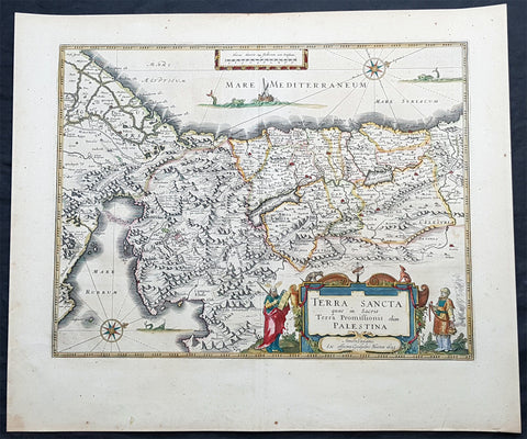
1629 Willem Blaeu Antique Map of the Holy Land Palestine Jerusalem Twleve Tribes
Antique Map
- Title : Terra Sancta quae in Sacris Terra Promissionis olim Palestina....Guiljesmi Blaeuw 1629
- Date : 1629
- Condition: (A+) Fine Condition
- Ref: 93509
- Size: 23 1/2in x 20in (590mm x 495mm)
Description:
This magnificent original copper plate engraved antique map of the Holy Land, Terra Sancta, Palestine was one of the very few dated maps printed by Willem Blaeu. The map was engraved by Jodocus Hondius the younger and published by Willem Blaeu in the 1643 French edition of Atlas Novus.
General Definitions:
Paper thickness and quality: - Heavy and stable
Paper color : - off white
Age of map color: - Original
Colors used: - Blue, pink, red, green, yellow
General color appearance: - Authentic
Paper size: - 23 1/2in x 20in (590mm x 495mm)
Plate size: - 20in x 15 1/4in (505mm x 384mm)
Margins: - Min 1in (25mm)
Imperfections:
Margins: - None
Plate area: - None
Verso: - None
Background:
This is one of the very few maps published in Blaeus Atlas that bears a date. It was actually made by Jodocus Hondius the younger in 1629, but was not printed until after the plate was purchased by Willem Blaeu (who added his imprint in the lower part of the cartouche)
At this time, many of the maps of Palestine were oriented to show the east at the top to focus on Jerusalem. Here, the orientation is inverted so that Blaeus map shows Palestine as it might have been viewed by Moses from the top of Mt Pisgah. The decorative features are Old Testament in inspiration: Moses holding the Tablets of the Law, stands to the left of the cartouche, Aaron to the right, while in the Mediterranean Jonah is about to be swallowed by the whale and in the Sinai is shown the route of the Exodus. In the Red Sea at Yam Suf, Pharaohs armies are shown drowning. The lands of the Twelve Tribes are shown straddling both banks of the Jordan and the city of Jerusalem can be seen occupying a place of honour in the upper centre of the map.
The geographical detail of the map is taken from an large inset on a large map of Palestine by the traveller Pieter Laicksteen and the mapmaker to Phillip II of Spain, Christian s Grooten, published at Antwerp in 1570. This inset map, its importance recognised by Hondius and by Blaeu, was unorthodox in its treatment of the outline of the Red Sea and its triangular outline for the Sinai peninsula - lone before either was finally admitted by mapmakers as more accurate than traditionally accepted versions.
The Blaeus retained this map for all editions of the firms atlas for more than thirty years from 1630, even though the rival publisher Johannes Jansson issued a more detailed seven sheet map of the region in his own atlas.
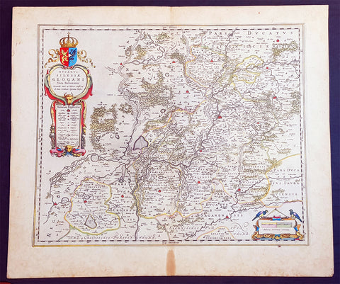
1634 Joan Blaeu Large Antique Map of Glogow, Lower Silesia, Poland
- Title : Ducatus Silesiae Glogani Vera Delineatio.
- Ref #: 93486
- Size: 23 1/2in x 20 1/2in (600mm x 520mm)
- Date : 1634
- Condition: (A+) Fine Condition
Description:
This beautifully hand coloured original copper-plate engraved antique, rare map of the Duchy of Glogow, in the ancient region of Silesia, Poland - centering on the city of Glogow - was published by Joan Blaeu in the 1634 French edition of Atlas Nouvs,.
General Definitions:
Paper thickness and quality: - Heavy and stable
Paper color : - off white
Age of map color: - Original
Colors used: - Yellow, green, blue, pink
General color appearance: - Authentic
Paper size: - 23 1/2in x 20 1/2in (600mm x 520mm)
Plate size: - 20in x 16 1/2in (510mm x 420mm)
Margins: - Min 1in (25mm)
Imperfections:
Margins: - Light age toning in margins
Plate area: - None
Verso: - None
Background:
The Duchy of Głogów was one of the Duchies of Silesia ruled by the Silesian Piasts. Its capital was Głogów in Lower Silesia.
In 1177, under the rule of Konrad Spindleshanks, the youngest son of High Duke Władysław II the Exile of Poland, the town of Głogów had already become the capital of a duchy in its own right. However, when Konrad died between 1180 and 1190, his duchy was again inherited by his elder brother Bolesław I the Tall, Duke of Wrocław. After the death of Bolesławs grandson Duke Henry II the Pious at the 1241 Battle of Legnica his sons in 1248 divided the Lower Silesian Duchy of Wrocław among themselves. Konrad I, a child when his father died, claimed his rights too and in 1251 and received the northern Głogów territory from his elder brother Bolesław II the Bald, then Duke of Legnica.
Under the rule of Konrads son Henry III the principality became smaller, as fragmentation and division continued, and other, smaller duchies were split from it like Ścinawa (Steinau, Stínava) and Żagań (Sagan, Zaháň) in 1273 as well as the duchies of Oleśnica (Oels, Olešnice) and Wołów (Wohlau, Volov) in 1312. After Henrys son Przemko II had died without heirs in 1331, King John the Blind was able to seize the duchy as a fiefdom of the Kingdom of Bohemia and granted it to the Piast Duke Henry I of Jawor six years later. As Henry I left no issue, King Johns son, Charles IV incorporated one half of Głogów into Crown of Bohemia, granting the remaining half to Duke Henry V of Iron of Żagań in 1349.
When in 1476 the Głogów line of the Piast dynasty became extinct with the death of Henry XI, fights over his succession broke out between his cousin Duke Jan II the Mad of Żagań and Elector Albert III Achilles of Brandenburg, the father of Henrys widow Barbara of Brandenburg. In consequence the duchys northern part of Krosno Odrzańskie (Crossen an der Oder) was incorporated by the Margraviate of Brandenburg in 1482. The truce however was broken by Duke Jan II, who continued his attacks on the neighbouring territories and in 1480 even invaded the royal Bohemian half of the Głogów duchy. This action finally brought the Bohemian antiking Matthias Corvinus to the scene, who in 1488 conquered Głogów, deposed Jan II and made his son János the duke.
Upon Matthias death in 1490 his territories were reacquired by Bohemian king Vladislaus II Jagiellon, who granted the fief of Głogów to his brothers John I Albert in 1491 and later Sigismund I the Old in 1499, both future kings of Poland. In 1506 the duchy finally became an immediate dominion of the Bohemian Crown, which, after Vladislaus son Louis II Jagiellon had died in 1526, were inherited by Archduke Ferdinand I of Austria and became part of the Habsburg Monarchy.
Głogów remained part of the Crown of Bohemia within the province of Silesia until the end of the First Silesian War in 1742 when, like the majority of Silesia, it became part of Frederick the Greats Kingdom of Prussia (which was definitively confirmed by the Treaty of Aachen in 1748). Even the Seven Years War did not change this status. In 1815 the Duchy (along with other Silesian duchies) ceased to exist due to radical administrative reform. All of Silesia was unified into a single administrative unit, Province of Silesia (Provinz Schlesien).
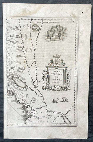
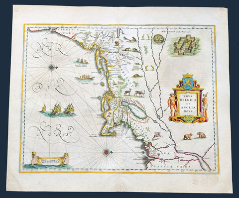
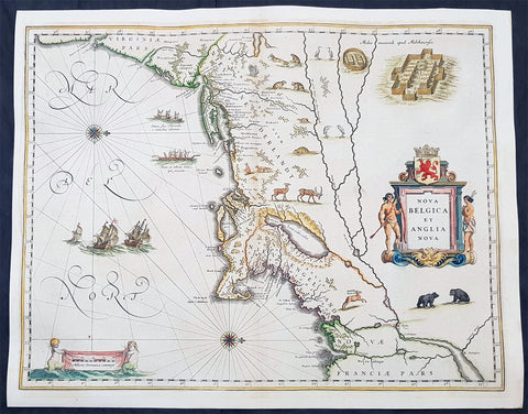
1635 Joan Blaeu Antique Half Page Map of New England, Nova Belgica et Anglia
Antique Map
- Title : Nova Belgica Et Anglia Nova
- Date : 1635
- Size: 18 1/2in x 12in (470mm x 305mm)
- Condition: (A) Good Condition
- Ref: 16385
Description:
This original copper-plate engraved antique half right hand page map of New England & NE America by Joan Blaeu was published in the 1635 German edition of Atlas Novus.
This is the right hand, cartouche title section of this important map.
General Definitions:
Paper thickness and quality: - Heavy and stable
Paper color : - off white
Age of map color: -
Colors used: -
General color appearance: -
Paper size: - 18 1/2in x 12in (470mm x 305mm)
Plate size: - 15 1/2in x 10in (395mm x 255mm)
Margins: - Min 1/2in (12mm)
Imperfections:
Margins: - Soiling, small worm hole top right margin
Plate area: - Light soiling, 4 small worm holes
Verso: - Light soiling
Background:
This important map was one of the most attractive of the Americas published at the time. It is noted for the fact that its primary source is the first manuscript figurative map of Adriaen Block from 1614. Indeed it is the first full representation of it in print. It is one of the earliest to name Nieu Amsterdam. Block, a Dutch fur trader, explored the area between Cape Cod and Manhattan, examining the bays and rivers along the way. This helped to create an accurate picture of the longitudinal scale of the coastline. His manuscript map is the first document to delineate an insular Manhattan; it also provides the earliest appearance of Manhates and Niev Nederland.
It has been noted that the time difference between 1614, the date of the manuscript, and Blaeus map whose first appearance is in 1635, appears long for such an important advance. It would seem highly feasible that Blaeu, who published many separately issued maps, would have wanted to produce one like this sooner. However, evidence points to the fact that it could not have been made before 1630. The Stokes Collection in New York possesses an example of the map on thicker paper without text on the reverse which could well be a proof issue of some kind.
There are features on Blaeus map that differ from the Block chart. Some of these could be accounted for by the fact that the surviving figurative map is not the original, and that the copyist omitted some place names that are referred to in the text of de Laets work. Block drew on Champlains map of 1612 for the depiction of the lake named after him, but it is here called Lacus Irocoisiensis. … The lack of interrelation between the Dutch or English colonies and the French, led for some time to the eastward displacement of this lake when its true position would be north of the Hudson River.
Some nomenclature has its origins in Blaeus second Paskaert of c.1630, and others, such as Manatthans, in de Laet. The colony of Nieu Pleimonth is identified. This and other English names along that part of the coast are largely derived from Smith\\\'s New England, 1616. Cape Cod is here improved over the Block manuscript by being reconnected to the mainland, the narrow strait having been removed. The coastline between here and Narragansett Bay, which can be clearly recognized, is not so accurate. Adriaen Blocx Eylandt leads us to the Versche Rivier, or Connecticut River, which Block ascended as far as was possible. t Lange Eyland is named; however, it is incorrectly too far east, being applied to what is possibly Fishers Island. De Groote bay marks Long Island Sound. The Hudson River is still not named as such, but is littered with Dutch settlements, and the failed Fort Nassau is here depicted renamed as Fort Orange. He does, however, improve on the direction of its flow. Blaeu separates the sources of the Hudson and Delaware Rivers which had been causing some confusion. Nieu Amsterdam is correctly marked as a fort at the tip of an island separated on the east side by Hellegat, or the East River. The coastline south of Sandy Hook also shows signs of improvement.
The whole map is adorned by deer, foxes, bears, egrets, rabbits, cranes and turkeys. Beavers, polecats and otters appear on a printed map for the first time. The Mohawk Indian village top right is derived from the de Bry-White engravings.
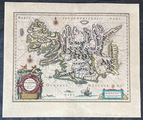
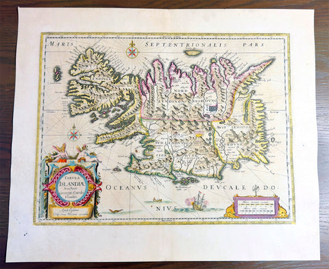
1635 Joan Blaeu Antique Map of Iceland - Joris Carolus
- Title :Tabula Islandia Auctore Georgio Carolo Flandro
- Ref #: 27017
- Size: 22 1/2in x 19in (570mm x 485mm)
- Date : 1647
- Condition: (A+) Fine Condition
Description:
This large original antique map of Iceland, by Willem Blaeu, was engraved by Jodocus Hondius after Joris Carolus, and was published by Willem Blaeus son, Joan, in the 1635 French edition of Atlas Nouvs
General Definitions:
Paper thickness and quality: - Heavy and stable
Paper color : - off white
Age of map color: - Original
Colors used: - Yellow, green, blue, pink
General color appearance: - Authentic
Paper size: - 22 1/2in x 19in (570mm x 485mm)
Plate size: - 20in x 15 1/4in (510mm x 395mm)
Margins: - Min 1in (25mm)
Imperfections:
Margins: - Original printers crease top left margin into border, uniform age toning
Plate area: - Uniform age toning
Verso: - Uniform age toning
Background:
This map of Iceland is perhaps the most familiar of all the outlines of the island ever published. The author is stated to be one Joris Carolus, a Dutch navigator from Enkhuizen, whose map was first engraved and prepared by Jodocus Hondius the younger in 1628, whose plates were bought by Willem Blaeu in 1629. Iceland bears the imprint of Willem Blaeu who issued it in his Appendix of 1630.
The Carolus map was copied by virtually all mapmakers throughout the rest of the 17th century and well into the 18th. Some of the information is derived from a map made famous by the Flemish cartographer Abraham Ortelius, the Islandia of Gudhbrandur Thorlaksson (1541 - 1627) Bishop of Holar, who had studied mathematics and astronomy as well as theology, while other information, such as place names, is derived from Gerard Mercator's map of 1595.
Willem Blaeu reprinted the map without change in his subsequent atlas editions, as did Joan after him, including the great atlas of 1662. In the southern southern part is shown the lively impression of Hekla in full eruption, described as mons perpetuo ardens while immediately to the west, the Bishopric of Skalholt is marked. To the south a note by Eiapialla hokel (Eyjafjallajokull) states that here may be found falcones albi or white falcons, presumably referring to the gyr falcon.
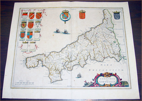
1637 Joan Blaeu Antique Map The English County of Cornwall
- Title : Cornubia sive Cornwallia
- Date : 1637
- Condition: (A) Very Good Condition
- Ref: 50606
- Size: 22in x 18 1/2in (560mm x 470mm)
Description:
This beautifully hand coloured original antique map of English county of Cornwall was published in the 1637 German edition of Joan Blaeu's Atlas Novus.
Background: Blaeu is one of the most revered map makers of all time and it is easy to see why in this beautiful original map.
The high level of the topographical detail, the quality of the paper, the artistic professionalism of the engraving and the beauty of the original hand colouring combine to produce a work of art that is both functional and of exceptional beauty. (Ref: Koeman; M&B)
Condition Report:
Paper thickness and quality: - Heavy and stable
Paper color: - off white
Age of map color: - Original
Colors used: - Yellow, pink, red, blue, green
General color appearance: - Authentic
Paper size: - 22in x 18 1/2in (560mm x 470mm)
Plate size: - 19 3/4in x 15 3/4in (500mm x 400mm)
Margins: - Min 1in (25mm)
Imperfections:
Margins: - Light spotting
Plate area: - Light spotting & browning
Verso: - Light spotting & browning
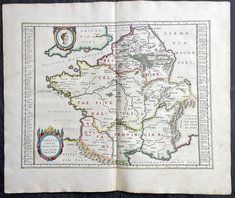
1638 Joan Blaeu & Abraham Ortelius Antique Map of France
Antique Map
- Title : Gallia Vetus...Abrah Ortelii
- Date : 1638
- Size: 23in x 20in (585mm x 510mm)
- Condition: (A+) Fine Condition
- Ref: 70606
Description:
This original beautifully hand coloured copper-plate engraved antique map of France, after Abraham Ortelius, was published by Joan Blaeu in the 1638 French edition of Atlas Nouvs,.
General Definitions:
Paper thickness and quality: - Heavy and stable
Paper color : - off white
Age of map color: - Original
Colors used: - Pink, blue, green, yellow
General color appearance: - Authentic
Paper size: - 23in x 20in (585mm x 510mm)
Plate size: - 19 1/2in x 15in (500mm x 380mm)
Margins: - Min 1in (25mm)
Imperfections:
Margins: - None
Plate area: - None
Verso: - None

1638 Joan Blaeu Antique Map of America - Americae nova Tabula
- Title : Americae nova Tabula Auct: Guiljesino Blaeuw
- Date : 1638
- Condition: (A) Very Good Condition
- Ref # : 50685
- Size : 23in x 18 1/2in (585mm x 450mm)
Description:
This magnificent, classic hand coloured original antique map of America 2nd State - the quintessential image of 17th America - was published in the 1638 French edition of Joan Blaeus Atlas Novus. This map is in wonderful condition with a few minor repairs as mentioned below.
General Condition:
Paper thickness and quality: - Heavy and stable
Paper color: - White
Age of map color: - Original color
Colors used: - Pink, green, yellow, blue, red
General color appearance: - Authentic & beautiful
Paper size: - 23in x 18 1/2in (585mm x 450mm)
Plate size: - 22in x 16 1/2in (555mm x 415mm)
Margins: - Min 1in (25mm)
Imperfections:
Margins: - Professional repair to centerfold, no loss.
Plate area: - Small professional repair to below Atlantic monster. Center-fold creases & re-joined at bottom, slight separation
Verso: - Creasing and restoration to center-fold, top & left margin, no loss
Background:
Originally issued by Joan Blaeus father, Willem, as early as 1617, this general map of the Americas was one of the longest lived plates in the atlas, having been used as an atlas map since 1630.
Here is the general seventeenth century European view of the Western Hemisphere: the delineation of the coasts and the nomenclature of the Pacific as well as the Atlantic coasts are basically Spanish in origin and follow the maps of the Fleming Abraham Ortelius and his countryman Cornelis Wytfliet. To these, Willem Blaeu inserted, on the east coast, the English names given by the Roanoke colonists in Virginia, and by Martin Frobisher, John Davis and Henry Hudson in the far north. In Florida and along the St Lawrence, Blaeu added the names given by the French settlers, almost the only memorials to their ill-fated venture in Florida during the latter part of the sixteenth century.
When Blaeu first made his map in the early years of the seventeenth century, Europeans still had no real knowledge of the nature of the Mississippi system. From the expedition journals of Hernando de Soto (1539 - 1543) they had inferred an extensive range of mountains trending eastwards to the north of the Gulf of Mexico in la Florida apparently precluding a great river system. The Great Lakes were as yet unknown although by the time Blaeu issued this map in its atlas form in the Huron region together with the hearsay accounts from Coral Indians were becoming well known through his 1632 map of the region. Evidently, this appears to have been unknown to Blaeu at the time, but surprisingly, he never incorporated the information on later printings of the map. The same applies to Manhattan and Long Island as well, despite the fact that only a short distance from Amsterdam, the Leiden academic Johannes D Late had published the first edition of his monumental work on the Americas which provided source material for any number of maps of the Americas throughout the remainder of the century and beyond.
In common with the other general continental maps in Blaeus atlas's, he has provided perspective plans or views of settlements in the Americas, including Havana, St Domingo, Cartagena, Mexico, Cusco, Potisi, I.la Moca in Chile, Rio Janeiro and Olianda in Pharnambucco, as well as the vignette illustrations of native figures taken from the accounts of John White (Virginia) or Hans Staden (Brazil) and others. (Ref: Burden; RGS; Koeman; Tooley)
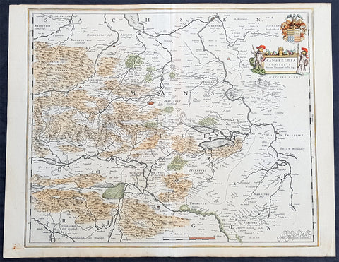
1638 Willem Blaeu Antique Map of Mansfeld Land, in SW Saxony-Anhalt, Germany
- Title : Mansfelda Comitatus
- Ref #: 70078
- Size: 22 1/2in x 17in (570mm x 430mm)
- Date : 1638
- Condition: (A+) Fine Condition
Description:
This beautifully hand coloured original copper-plate engraved antique map of the ancient region of Mansfeld Land located in the in southwestern region of Saxony-Anhalt, Germany - centering on the city of Mansfeld - by was published in the 1638 Latin edition edition of Willem Blaeus Atlas Novus.
General Definitions:
Paper thickness and quality: - Heavy and stable
Paper color : - off white
Age of map color: - Original
Colors used: - Blue, pink, red, green, yellow
General color appearance: - Authentic
Paper size: - 22 1/2in x 17in (570mm x 430mm)
Plate size: - 19 1/2in x 16 1/4in (495mm x 420mm)
Margins: - Min 1/2in (12mm)
Imperfections:
Margins: - Light age toning
Plate area: - None
Verso: - None
Background:
Mansfeld Land is a region in the southwestern corner of the German state of Saxony-Anhalt. The region derives its name from the counts of Mansfeld, who ruled this region for about 1,000 years.
The House of Mansfeld, whose members belonged to the Saxon nobility and served as counts in the Hassegau, was first documented in a 973 deed. The counts built Mansfeld Castle, whose foundations date back to the late 11th century, when one Hoyer of Mansfeld served as field marshal to Emperor Henry V. The first reference of the fortress coincides with the extinction of the elder line in 1229. The estates were inherited by the Lords of Querfurt, who also adopted the comital title, calling themselves Counts of Mansfeld from that time on.
The settlement of Mansfeld received town privileges in 1400, and grew through the development of copper and silver mining, an activity in which Hans Luder from Möhra, father to Martin Luther and Mansfeld citizen from 1484, was employed as a master smelter. Luthers family had arrived into a modest prosperity, he himself attended the local school between 1488 and 1496. The building known as Luther\'s School had to be torn down and rebuilt in 2000 due to structural problems. His parents house is preserved and today a museum. Luther also acted as an altar server at the St George parish church.
The Counts of Mansfeld had already lost Imperial immediacy in 1580. When the comital line finally became extinct in 1780, the estates around Mansfeld were incorporated into the Prussian Duchy of Magdeburg. The town retained the status of an independent city (Immediatstadt), it was temporarily part of the Napoleonic Kingdom of Westphalia and after the 1815 Congress of Vienna belonged to the Prussian Province of Saxony.
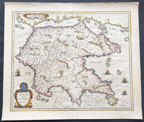
1640 Blaeu Antique Map of the Peloponnese or Morea Peninsula, Greece
- Title : Morea olim Peloponnesus..Guil. Blaeu exc.
- Date : 1640
- Condition: (A+) Fine Condition
- Ref: 70300
- Size: 22in x 19in (560mm x 485mm)
Description:
This beautifully engraved hand coloured original 1st edition antique map of the southern Greek peninsular of the Peloponnesusor Morea was published in the 1640 Latin edition of Joan Blaeu's Atlas Nouvs.
The peninsula has been inhabited since prehistoric times. Its modern name derives from ancient Greek mythology, specifically the legend of the hero Pelops who was said to have conquered the entire region. The namePeloponnesos means "Island of Pelops". During the Middle Ages, the peninsula was known as the Morea. According to folk etymology, this is because the Crusaders found it densely planted with mulberry trees (Greek: moreai) used by the flourishing silk industry.
Blaeu is one of the most revered map makers of all time and it is easy to see why in this beautiful original map. The high level of the topographical detail, the quality of the paper, the artistic professionalism of the engraving and the beauty of the original hand colouring combine to produce a work of art that is both functional and of exceptional beauty. (Ref: Koeman; M&B)
General Description:
Paper thickness and quality: - Heavy and stable
Paper color: - off white
Age of map color: - Original
Colors used: - Yellow, pink, red, blue, green
General color appearance: - Authentic
Paper size: - 22in x 19in (560mm x 485mm)
Plate size: - 22in x 19in (560mm x 485mm)
Margins: - Min 1in (25mm)
Imperfections:
Margins: - Bottom centerfold re-joined slight separation
Plate area: - Light brush marks across page
Verso: - Light brush marks across page
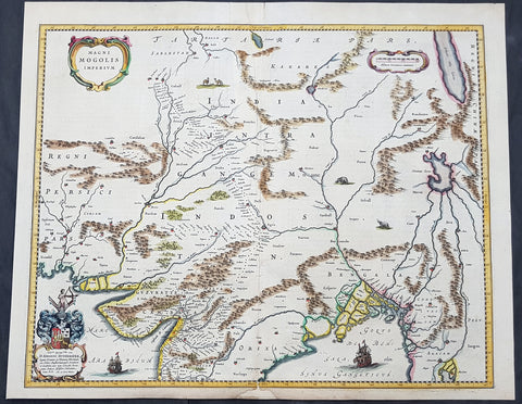
1640 Joan Blaeu Antique Map Mughal Empire of Northern India, Tibet, Nepal, Asia
- Title : Magni Mogolis Imperium
- Size: 22in x 18in (560mm x 465mm)
- Condition: (A) Very Good Condition
- Date : 1640
- Ref #: 42017
Description:
This original hand coloured copper plate engraved antique map of Mughal Empire of Northern India, Tibet, Nepal and central Asia was published by Joan Blaeu in the 1640 edition of Atlas Nouvs
General Definitions:
Paper thickness and quality: - Heavy and stable
Paper color : - off white
Age of map color: - Original
Colors used: - Blue, pink, red, green, yellow
General color appearance: - Authentic
Paper size: - 22in x 18in (560mm x 465mm)
Plate size: - 20 1/2in x 16 1/2in (515mm x 420mm)
Margins: - Min 1/2in (12mm)
Imperfections:
Margins: - Small section of bottom margin restored
Plate area: - Light creasing
Verso: - Centerfold re-enforced
Background:
This map centers on the Mughal capital of Agra, with the map covering, roughly, from Kabul to Orissa and Deccan, and from Persia to Bengal. It depicts the empire prior to the conquest of Orissa and Deccan, most likely during the reign of Shah Jahan, of Taj Mahal fame. Relief is shown pictorially. An elaborate title cartouche appears in the upper left quadrant. The map is embellished with images of tigers, elephants, caravans, and galleons.
There is much of interest. In particular, is the map detailed breakdown of the caravan network between Gujarat and Agra, between Agra and the desert outpost of Jaisalmer, and between Agra and the Silk Road center of Kabul. While the map does not show roads, for surely none as such existed at the time, it does show the network of towns, waystations and caravanserai built to support the bustling trade system.
The apocryphal Lake of Chiamay appears just north of the Bay of Bengal as the source of four important Southeast Asian river systems including the Irrawaddy, the Dharla, the Chao Phraya, and the Brahmaputra. The curious Lake of Chiamay (also called Chiam-may or Chian-may), roughly located in the area of Assam but sometimes as far north as Tibet and China, began to appear in maps of this region as early as the 16th century and persisted well into the mid 18th century. Its origins are unknown but may originate in a lost 16th century geography prepared by the Portuguese scholar Jao de Barros. It was speculated to be the source of five important Southeast Asian River systems and was mentioned in the journals of Sven Hedin. There are even records that the King of Siam led an invasionary force to take control of the lake in the 16th century. Nonetheless, the theory of Lake Chiamay was ultimately disproved and it disappeared from maps entirely by the 1760s.
There are two states of this map, the present example being the first state, first issued in 1638 by Henricus Hondius, and the second state a few years later in 1641 by Jan Jannson. With the exception of the signature imprint, the plates are identical. (Ref: Koeman; M&B)
1641 Joan Blaeu Antique Landmark Map New England & New Netherlands
Antique Map
- Title : Nova Belgica Et Anglia Nova
- Size: 22 1/2in x 19in (570mm x 480mm)
- Condition: (A+) Fine Condition
- Date : 1641
- Ref #: 61201
Description:
This beautiful, original hand coloured copper-plate engraved antique landmark map of the Dutch & British colonies of New England & NE America, centering on New York and Manhattan stretching from Virginia to Maine, by Joan Blaeu was published in the 1641 German edition of Atlas Novus.
This important landmark map of the American Northeast, presenting the regions settled by the Dutch (New Netherlands) and the English (New England). Oriented to the west, Blaeu's map covers the American coast from Virginia, past New York and Long Island to Cape Cod, New England, and Quebec. The map is the first of the region to depict the fur-bearing and food animals of the region accurately, and it does so in profusion. Between this imagery and the fleet of trade ships heading towards the coast, the decorative elements vividly emphasize the region's resource wealth.
This map is cartographically derived from data accumulated by Adriaen Block and other Dutch fur traders active in the early 17th century. Burden writes of the Block:
......This important map was one of the most attractive of the Americas at the time...... It is noted for the fact that its primary source is the first manuscript map of Adriaen Block, 1614. Indeed, it is the first full representation of it in print. It is one of the earliest to name Nieu Amsterdam. Block, a Dutch fur trader, explored the area between Cape Cod and Manhattan, examining the bays and rivers along the way. This helped to create an accurate picture of the longitudinal scale of the coastline. His manuscript map was the first document to delineate an insular Manhattan; it also provides the earliest appearance of Manhates and Nieu Nederland.
General Definitions:
Paper thickness and quality: - Heavy and stable
Paper color : - off white
Age of map color: - Original
Colors used: - Yellow, green, blue, pink
General color appearance: - Authentic
Paper size: - 22 1/2in x 19in (570mm x 480mm)
Plate size: - 19 1/2in x 15 1/2in (495mm x 395mm)
Margins: - Min 1in (25mm)
Imperfections:
Margins: - Light age toning in margins
Plate area: - None
Verso: - Old soiling bottom left of verso not affecting the image. Top, bottom of centerfold re-enforced on verso. Top left corner of margin re-enforced
Background:
This important map was one of the most attractive of the Americas published at the time. It is noted for the fact that its primary source is the first manuscript figurative map of Adriaen Block from 1614. Indeed it is the first full representation of it in print. It is one of the earliest to name Nieu Amsterdam. Block, a Dutch fur trader, explored the area between Cape Cod and Manhattan, examining the bays and rivers along the way. This helped to create an accurate picture of the longitudinal scale of the coastline. His manuscript map is the first document to delineate an insular Manhattan; it also provides the earliest appearance of Manhates and Niev Nederland.
It has been noted that the time difference between 1614, the date of the manuscript, and Blaeus map whose first appearance is in 1635, appears long for such an important advance. It would seem highly feasible that Blaeu, who published many separately issued maps, would have wanted to produce one like this sooner. However, evidence points to the fact that it could not have been made before 1630. The Stokes Collection in New York possesses an example of the map on thicker paper without text on the reverse which could well be a proof issue of some kind.
There are features on Blaeus map that differ from the Block chart. Some of these could be accounted for by the fact that the surviving figurative map is not the original, and that the copyist omitted some place names that are referred to in the text of de Laets work. Block drew on Champlains map of 1612 for the depiction of the lake named after him, but it is here called Lacus Irocoisiensis. … The lack of interrelation between the Dutch or English colonies and the French, led for some time to the eastward displacement of this lake when its true position would be north of the Hudson River.
Some nomenclature has its origins in Blaeus second Paskaert of c.1630, and others, such as Manatthans, in de Laet. The colony of Nieu Pleimonth is identified. This and other English names along that part of the coast are largely derived from Smiths New England, 1616. Cape Cod is here improved over the Block manuscript by being reconnected to the mainland, the narrow strait having been removed. The coastline between here and Narragansett Bay, which can be clearly recognized, is not so accurate. Adriaen Blocx Eylandt leads us to the Versche Rivier, or Connecticut River, which Block ascended as far as was possible. t Lange Eyland is named; however, it is incorrectly too far east, being applied to what is possibly Fishers Island. De Groote bay marks Long Island Sound. The Hudson River is still not named as such, but is littered with Dutch settlements, and the failed Fort Nassau is here depicted renamed as Fort Orange. He does, however, improve on the direction of its flow. Blaeu separates the sources of the Hudson and Delaware Rivers which had been causing some confusion. Nieu Amsterdam is correctly marked as a fort at the tip of an island separated on the east side by Hellegat, or the East River. The coastline south of Sandy Hook also shows signs of improvement.
The whole map is adorned by deer, foxes, bears, egrets, rabbits, cranes and turkeys. Beavers, polecats and otters appear on a printed map for the first time. The Mohawk Indian village top right is derived from the de Bry-White engravings.
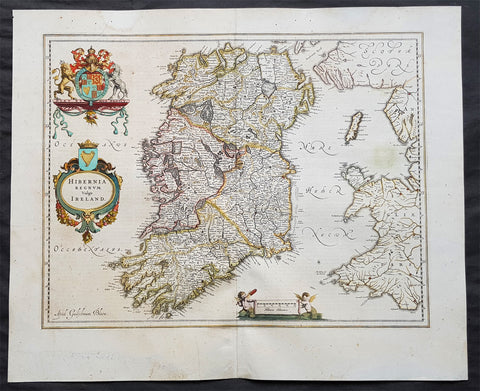
1642 Blaeu Large Old, Antique Map of Ireland - Hibernia Regnum
- Title: Hibernia Regnum Vulgo Ireland
- Size: 23 1/2in x 20in (600mm x 510mm)
- Ref # : 61159
- Date: 1642
- Condition: (A) Very Good Condition
Description:
This superbly hand coloured original antique map of Ireland - Hibernia - was published in the 1642 Dutch edition of Joan Blaeu's Atlas Novus.
Background:
This is Willem Blaeu's highly decorative general map of Ireland and is coloured to show in outline the ancient provinces of Connaught, Leinster, Munster and Ulster each of which together with the map of Carlow, was given a separate map in a section at the end of the atlas volume devoted to Scotland.
The map, which Blaeu first issued in 1635 (twenty years prior to the publication of the Scotland and Ireland volume) was based on that published by John Speed in 1611 in his Theatre of the Empire of Great Briatine. In its turn Speed's map was copied Hondius and Blaeu's great rival Jan Jansson. It was the latter version that Willem Blaeu used. His beautifully balanced design is complemented by the Royal arms and the relatively simple title cartouche at the left hand side. (Ref: Koeman; Tooley; M&B)
General Description:
Paper thickness and quality: - Heavy
Paper color: - White
Age of map color: - Original
Colors used: - Yellow, pink, red, blue, green
General color appearance: - Authentic
Paper size: - 23 1/2in x 19in (600mm x 485mm)
Plate size: - 19 3/4in x 15 1/4in (505mm x 385mm)
Margins: - Min 1in (25mm)
Imperfections:
Margins: - Light age toning
Plate area: - Light age toning
Verso: - Bottom section of centerfold re-joined, no loss
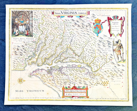
1642 Blaeu, Hondius & John Smith Antique Map of Virginia, America - Pocahontas
- Title : Nova Virginiae Tabula
- Date : 1642
- Condition: (A+) Fine Condition
- Ref: 35667
- Size: 20in x 16in (510mm x 410mm)
Description:
This superb original antique hand coloured map of Chesapeake Bay, Virginia was published in the 1642 Dutch edition of Mercators Atlas.
This map by Blaeu comes directly from John Smiths map of Virginia. Blaeu bought this plate from Joducus Hondius who had engraved it directly from John Smith map. It is the only map on the market that is unchanged from Smiths map.
Although this map bears the name of Willem Blaeu, it comes from the plate stock of the Amsterdam publisher Jodocus Hondius the younger in 1629. Blaeu then issued the map in his Atlantis Appendix and in most editions of the firms atlases thereafter.
The map is a version of the map by the Englishman Captain John Smith in 1612. His map was the first to depict with reasonable accuracy Chesapeake Bay with its tributaries and became the accepted prototype map for most subsequent maps of the colony published either in Britain or Europe during the remainder of the 17th century.
Captain Smiths maps acted as a promotional piece for the vast area of North America called Virginia and it exerted a great influence of the history of English colonisation in America.
John Smith (1579-1631) was the foremost English settler in Virginia. His many adventures included being captured several times, defeating an Indian chief in hand to hand combat as well as the celebrated incident in which Pocahontas saved him from Powhatan who is himself the subject of the portrait at the upper left hand corner of Blaeus map.
While the geographical detail of the map shows information accurate at the time of Smiths travels, earlier descriptions of Virginia are recalled. When Smiths map appeared in 1612, the engraver turned to an engraving by the German Theodor de Bry based on the drawings made by John White in the 1580s for the portrait of Powhatan, and the figure of an Indian in war paint at the right to represent the Susquehanna chief. All of these elements were combined by the Amsterdam engraver Dirk Grijp for the Dutch version of Smiths map as issued by the Hondius firm in 1618. Thus, when Blaeu purchased the plate it was already a decade old and it was issued unchanged except for his imprint and a few very small retouches until the 1660s. The Blaeu derivative was the most popular version of Captain Smith Map published during the seventeenth century.
General Definitions:
Paper thickness and quality: - Heavy and stable
Paper color : - off white
Age of map color: - Original
Colors used: - Yellow, green, blue, pink
General color appearance: - Authentic
Paper size: - 20in x 16in (510mm x 410mm)
Plate size: - 19in x 15in (495mm x 390mm)
Margins: - Min 1/2in (12mm)
Imperfections:
Margins: - Light age toning
Plate area: - Light age toning, light crease along centerfold
Verso: - None
Background:
This is one of the most important seventeenth century maps of the Chesapeake Bay region. The early settlement of Jamestown Iamestowne is noted along with a number of other place names, both in English and Native American. The map was derived from Capt. John Smith\'s map of 1612 and was the first to depict the bay and its tributaries with any accuracy.
Capt John Smith's fine survey work, as well as reports from indigenous American Indian tribes, and fanciful wishful thinking, combine to make this one of the most interesting maps of America to emerge in the 17th century. Philip D. Burden, the author of The Mapping of America, considers this map, Nova Virginiae Tabula, to be \'one of the most important maps of America ever produced and certainly one of the greatest influence.\' Oriented to the west, this map covers from Cape Henry to the Susquehanna River and inland as far as the Appellation Mountains. The Chesapeake Bay is shown in full as are many of its river estuaries, though topographically this map places a number of mountain ranges where there are in fact none.
To fully understand this map one must first realize that most Europeans believed the Pacific, or at least some great bay that led to the Pacific, lay just a few days travel inland. In the minds of most Europeans of the period, the trade potential for the Virginia colony was entirely dependent upon it being a practical access point to the riches of Asia. Thus the significance of large and mysterious body of water appearing in the land of the Massawomecks, in the upper right quadrant, becomes apparent. Of course, much of this land was entirely unexplored by the European settlers in Jamestown, shown here on the Powhatan River (James River), who relied heavily upon American Indian reports for much of their cartographic knowledge of the Virginia hinterlands. The Massawomecks themselves were a rival of the Powhatan and made their home near the headwaters of the Potomac. These, like many other indigenous groups of the region made only a brief and frequently violent appearance during the 17th century before entirely disappearing, mostly from disease and war, in the early 18th century.
In the upper left quadrant there is an image of the American Indian chief of the Powhatan sitting enthroned before a great fire in his long house. One of the more popular legends regarding John Smith was his capture and trial before the chief of the Powahatan. Smith was convinced that his liberation had something to do with the youthful daughter of Chief Powahatan, Pocahontas, taking a liking to him. Although this grew into a fictitious legend of its own, the truth is more likely that Powhatan saw Smith and his Englishmen as potential allies against the rival American Indian groups, such as the Massawomecks, that were pressing hard against his borders.
There are a number of different editions of this map and its publication by various map houses in various states made it the first widely distributed map of the Virginia colony and of John Smith\'s important map. There was, however, a scandal relating to its publication. The map was originally drawn and engraved in 1618 by Jodocus Hondius based upon the first edition of John Smith\'s 1612 map. When Jodocus died in 1629, he and his brother, Henricus Hondius, while collaborating on the Hondius Atlas Major, had established and maintained separate business for some 10 years. Jodocus\' death enabled the competing cartographer, Willem Blaeu to acquire a large number of Jodocus\' map plates, which he promptly published in 1630 as the Atlantis Appendix. Henricus, in the meantime, had been counting on Jodocus\' new plates to enhance his own, by then outdated, Hondius Atlas Major. A surviving contract dated March 2, 1630 reveals that Henricus Hondius and his partner Joannes Janssonius hired engravers to produce a number of new map plates copying the work of Jodocus – now in the hands of the Blaeu firm. This map was among the most important of that group and accounts for variants of this map being issued by competing Blaeu and Hondius firms.
The History of Virginia begins with documentation by the first Spanish explorers to reach the area in the 1500s, when it was occupied chiefly by Algonquian, Iroquoian, and Siouan peoples. After a failed English attempt to settle Virginia in the 1580s by Walter Raleigh permanent English settlement began in Virginia with Jamestown, Virginia, in 1607. The Virginia Company colony was looking for gold but failed and the colonists could barely feed themselves. The famine during the harsh winter of 1609 forced the colonists to eat leather from their clothes and boots and resort to cannibalism.[1] The colony nearly failed until tobacco emerged as a profitable export. It was grown on plantations, using primarily indentured servants for the intensive hand labor involved. After 1662, the colony turned black slavery into a hereditary racial caste. By 1750, the primary cultivators of the cash crop were West African slaves. While the plantations thrived because of the high demand for tobacco, most white settlers raised their families on subsistence farms. Warfare with the Virginia Indian nations had been a factor in the 17th century; after 1700 there was continued conflict with natives east of the Alleghenies, especially in the French and Indian War (1754-1763), when the tribes were allied with the French. The westernmost counties including Wise and Washington only became safe with the death of Bob Benge in 1794.
The Virginia Colony became the wealthiest and most populated British colony in North America, with an elected General Assembly. The colony was dominated by rich planters who were also in control of the established Anglican Church. Baptistand Methodist preachers brought the Great Awakening, welcoming black members and leading to many evangelical and racially integrated churches. Virginia planters had a major role in gaining independence and in the development of democratic-republican ideals of the United States. They were important in the Declaration of Independence, writing the Constitutional Convention (and preserving protection for the slave trade), and establishing the Bill of Rights. The state of Kentucky separated from Virginia in 1792. Four of the first five presidents were Virginians: George Washington, the "Father of his country"; and after 1800, "The Virginia Dynasty" of presidents for 24 years: Thomas Jefferson, James Madison, and James Monroe.
1642 Joan Blaeu Antique Map New England & NE America, Virginia New York to Maine
- Title : Nova Belgica Et Anglia Nova
- Size: 21in x 16 1/2in (530mm x 420mm)
- Condition: (A+) Fine Condition
- Date : 1642
- Ref #: 93080
Description:
This beautiful, original hand coloured copper-plate engraved antique map of New England & NE America, centering on New York and Manhattan stretching from Virginia to Maine, by Joan Blaeu was published in the 1642 edition of Atlas Novus
General Definitions:
Paper thickness and quality: - Heavy and stable
Paper color : - off white
Age of map color: - Original
Colors used: - Yellow, green, blue, pink
General color appearance: - Authentic
Paper size: - 21in x 16 1/2in (530mm x 420mm)
Plate size: - 19 1/2in x 15 1/2in (495mm x 395mm)
Margins: - Min 1/2in (12mm)
Imperfections:
Margins: - Light age toning, printers crease in left margin into border
Plate area: - None
Verso: - None
Background:
This important map was one of the most attractive of the Americas published at the time. It is noted for the fact that its primary source is the first manuscript figurative map of Adriaen Block from 1614. Indeed it is the first full representation of it in print. It is one of the earliest to name Nieu Amsterdam. Block, a Dutch fur trader, explored the area between Cape Cod and Manhattan, examining the bays and rivers along the way. This helped to create an accurate picture of the longitudinal scale of the coastline. His manuscript map is the first document to delineate an insular Manhattan; it also provides the earliest appearance of Manhates and Niev Nederland.
It has been noted that the time difference between 1614, the date of the manuscript, and Blaeus map whose first appearance is in 1635, appears long for such an important advance. It would seem highly feasible that Blaeu, who published many separately issued maps, would have wanted to produce one like this sooner. However, evidence points to the fact that it could not have been made before 1630. The Stokes Collection in New York possesses an example of the map on thicker paper without text on the reverse which could well be a proof issue of some kind.
There are features on Blaeus map that differ from the Block chart. Some of these could be accounted for by the fact that the surviving figurative map is not the original, and that the copyist omitted some place names that are referred to in the text of de Laets work. Block drew on Champlains map of 1612 for the depiction of the lake named after him, but it is here called Lacus Irocoisiensis. … The lack of interrelation between the Dutch or English colonies and the French, led for some time to the eastward displacement of this lake when its true position would be north of the Hudson River.
Some nomenclature has its origins in Blaeus second Paskaert of c.1630, and others, such as Manatthans, in de Laet. The colony of Nieu Pleimonth is identified. This and other English names along that part of the coast are largely derived from Smith\\\'s New England, 1616. Cape Cod is here improved over the Block manuscript by being reconnected to the mainland, the narrow strait having been removed. The coastline between here and Narragansett Bay, which can be clearly recognized, is not so accurate. Adriaen Blocx Eylandt leads us to the Versche Rivier, or Connecticut River, which Block ascended as far as was possible. t Lange Eyland is named; however, it is incorrectly too far east, being applied to what is possibly Fishers Island. De Groote bay marks Long Island Sound. The Hudson River is still not named as such, but is littered with Dutch settlements, and the failed Fort Nassau is here depicted renamed as Fort Orange. He does, however, improve on the direction of its flow. Blaeu separates the sources of the Hudson and Delaware Rivers which had been causing some confusion. Nieu Amsterdam is correctly marked as a fort at the tip of an island separated on the east side by Hellegat, or the East River. The coastline south of Sandy Hook also shows signs of improvement.
The whole map is adorned by deer, foxes, bears, egrets, rabbits, cranes and turkeys. Beavers, polecats and otters appear on a printed map for the first time. The Mohawk Indian village top right is derived from the de Bry-White engravings.
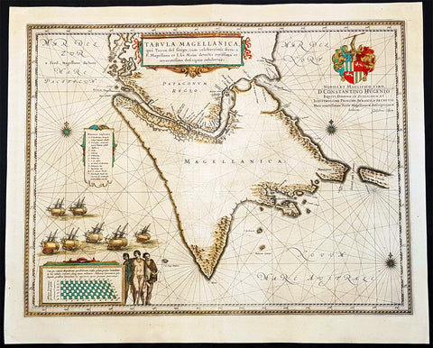
1642 Joan Blaeu Large Antique Map of Tierra Del Fuego & the Magellan Straits, South America
- Title : Tabula Magellanica qua Tierrae del Fuego
- Size: 23in x 19in (585mm x 485mm)
- Condition: (A+) Fine Condition
- Date : 1642
- Ref #: 93352
Description:
This original beautifully hand coloured copper-plate engraved antique map of the Tierra Del Fuego & the Magellan Straits at the very bottom of South America, was published in the 1642 Dutch edition of Joan Blaeus Atlas Nouvs.
General Definitions:
Paper thickness and quality: - Heavy and stable
Paper color : - off white
Age of map color: - Original
Colors used: - Yellow, green, blue, pink
General color appearance: - Authentic
Paper size: - 23in x 19in (585mm x 485mm)
Plate size: - 21in x 16 1/2in (535mm x 420mm)
Margins: - Min 1in (25mm)
Imperfections:
Margins: - Age toning
Plate area: - Age toning
Verso: - Age toning
Background:
Ferdinand Magellan became the first European to navigate the strait in 1520, during his global circumnavigation voyage. Because Magellan\'s ships entered it on November 1, All Saints\' Day, it was originally named Estrecho de Todos los Santos (Strait of All Saints). Later the Spanish king changed the name to Estrecho de Magallanes in honor of Magellan. Since its discovery the Spanish Empire and the Kingdom of Chile saw it as its southern boundary. The first Spanish colonization attempt was led by Pedro Sarmiento de Gamboa who founded Nombre de Jesús and Rey Don Felipe on its northern shores. The cities suffered severe food shortages, and years afterwards in 1587 the English navigator Sir Thomas Cavendish landed at the site of Rey Don Felipe and found only ruins of the settlement. He renamed the place Port Famine. Other early explorers included Francis Drake among others.
1644 Willem Blaeu Antique Map of Iceland - Beautiful Original Hand Colouring
Antique Map
- Title :Tabula Islandia Auctore Georgio Carolo Flandro
- Ref #: 35625
- Condition: (A) Very Good Condition
- Size: 23 1/2in x 20in (590mm x 510mm)
- Date: 1644
Description:
This original copper plate engraved antique map, with beautiful original hand colouring by Willem Blaeu, was engraved by Jodocus Hondius after Joris Carolus, and was published by Guillaume Blaeus in the 1644 Latin edition of Atlas Nouvs.
This is beautiful example of this early map of Iceland with fresh original hand colouring, on uniform aged paper with original margins.
General Definitions:
Paper thickness and quality: - Heavy and stable
Paper color : - off white
Age of map color: - Original
Colors used: - Yellow, green, blue, pink
General color appearance: - Authentic
Paper size: - 23 1/2in x 20in (590mm x 510mm)
Plate size: - 20in x 15 1/4in (510mm x 395mm)
Margins: - Min 1in (25mm)
Imperfections:
Margins: - Light scraping to L & R margins
Plate area: - Uniform aged toning
Verso: - Uniform aged toning
Background:
This map of Iceland is perhaps the most familiar of all the outlines of the island ever published. The author is stated to be one Joris Carolus, a Dutch navigator from Enkhuizen, whose map was first engraved and prepared by Jodocus Hondius the younger in 1628, whose plates were bought by Willem Blaeu in 1629. Iceland bears the imprint of Willem Blaeu who issued it in his Appendix of 1630.
The Carolus map was copied by virtually all mapmakers throughout the rest of the 17th century and well into the 18th. Some of the information is derived from a map made famous by the Flemish cartographer Abraham Ortelius, the Islandia of Gudhbrandur Thorlaksson (1541 - 1627) Bishop of Holar, who had studied mathematics and astronomy as well as theology, while other information, such as place names, is derived from Gerard Mercator's map of 1595.
Willem Blaeu reprinted the map without change in his subsequent atlas editions, as did Joan after him, including the great atlas of 1662. In the southern southern part is shown the lively impression of Hekla in full eruption, described as mons perpetuo ardens while immediately to the west, the Bishopric of Skalholt is marked. To the south a note by Eiapialla hokel (Eyjafjallajokull) states that here may be found falcones albi or white falcons, presumably referring to the gyr falcon.
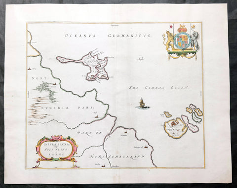
1645 Blaeu Old Antique Map Lindisfarne Holy Islands England - Lindisfarne
Antique Map
- Title : Insula Sacra Vulgo Holy Isand et Farne
- Ref #: 51010
- Size: 23 1/2in x 19in (600mm x 485mm)
- Date : 1645
- Condition: (A) Very Good Condition
Description:
This beautifully hand coloured original antique map of the Holy & Farne Islands off the east coast of Northumberland, England was published in the 1645 edition of Joan Blaeus Atlas Novus.
Blaeu's reference for the topographical data for this map derive from John Speeds maps of Great Britain from the 1611 Empire of Great Britaine - the beautiful decoration, though, is distinctly Blaeus.
Background: Blaeu is one of the most revered map makers of all time and it is easy to see why in this beautiful original map.
The high level of the topographical detail, the quality of the paper, the artistic professionalism of the engraving and the beauty of the original hand colouring combine to produce a work of art that is both functional and of exceptional beauty. (Ref: Koeman; M&B)
General Description:
Paper thickness and quality: - Heavy and stable
Paper color: - off white
Age of map color: - Original
Colors used: - Yellow, pink, red, blue, green
General color appearance: - Authentic
Paper size: - 23 1/2in x 19in (600mm x 485mm)
Plate size: - 20in x 15 1/2in (510mm x 395mm)
Margins: - Min 1in (25mm)
Imperfections:
Margins: - Light age toning
Plate area: - Light creasing along centerfold & adjacent
Verso: - Creasing and age toning along and adjacent to centerfold
Background:
Lindisfarne, also known as Holy Island, is a tidal island off the northeast coast of England, which constitutes the civil parish of Holy Island in Northumberland. Holy Island has a recorded history from the 6th century AD; it was an important centre of Celtic Christianity under Saints Aidan, Cuthbert, Eadfrith, and Eadberht of Lindisfarne. The island was originally home to a monastery, which was destroyed during the Viking invasions but re-established as a priory following the Norman Conquest of England. Other notable sites built on the island are St Mary the Virgin parish church (originally built in 635 CE and restored in 1860), Lindisfarne Castle, several lighthouses and other navigational markers, and a complex network of lime kilns.

1646 Joan Blaeu Antique Map of Ireland - Hibernia Regnum
- Title: Hibernia Regnum Vulgo Ireland
- Date: 1646
- Condition: (A+) Fine Condition
- Ref # : 50673
- Size: 23 1/2in x 20in (600mm x 510mm)
Description:
This superbly hand coloured original antique map of Ireland - Hibernia - was published in the 1646 Dutch edition of Joan Blaeu's Atlas Novus.
One of the best I have seen to date, the original colouring is superb and the paper is heavy and stable with original margins.
General Description:
Paper thickness and quality: - Heavy
Paper color: - White
Age of map color: - Original
Colors used: - Yellow, pink, red, blue, green
General color appearance: - Authentic
Paper size: - 23 1/2in x 20in (600mm x 510mm)
Plate size: - 19 3/4in x 15 1/4in (505mm x 385mm)
Margins: - Min 2in (50mm)
Imperfections:
Margins: - Very bottom of margin re-joined, not affecting image
Plate area: - None
Verso: - None
Background:
This is Willem Blaeu's highly decorative general map of Ireland and is coloured to show in outline the ancient provinces of Connaught, Leinster, Munster and Ulster each of which together with the map of Carlow, was given a separate map in a section at the end of the atlas volume devoted to Scotland.
The map, which Blaeu first issued in 1635 (twenty years prior to the publication of the Scotland and Ireland volume) was based on that published by John Speed in 1611 in his Theatre of the Empire of Great Briatine. In its turn Speed's map was copied Hondius and Blaeu's great rival Jan Jansson. It was the latter version that Willem Blaeu used. His beautifully balanced design is complemented by the Royal arms and the relatively simple title cartouche at the left hand side. (Ref: Koeman; Tooley; M&B)

1646 Joan Blaeu Large Antique Map of Scotland - Scotia Regnum
Antique Map
- Title : Scotia Regnum
- Ref #: 61001
- Size: 22 3/4in x 19 3/4in (580mm x 500mm)
- Date : 1646
- Condition: (A+) Fine Condition
Description:
This large beautifully hand coloured original antique map of Scotland was published in the 1646 Dutch edition of Joan Blaeu's Atlas Novus.
General Description:
Paper thickness and quality: - Heavy
Paper color: - White
Age of map color: - Original
Colors used: - Yellow, pink, red, blue, green
General color appearance: - Authentic
Paper size: - 22 3/4in x 19 3/4in (580mm x 500mm)
Plate size: - 20in x 15 1/4in (510mm x 385mm)
Margins: - Min 1in (25mm)
Imperfections:
Margins: - None
Plate area: - None
Verso: - None
Background: When the Blaeu's published Volume V - GB & Ireland - of Atlas Novus, Scotland became one of the best-mapped countries in the world. Volume V contained forty-eight plates showing forty-nine separate maps of Scotland (plus a map of Ptolemy British Isles and six maps of Ireland). The first two plates from the atlas show the entire country ancient and modern, whilst the remaining forty-six plates cover most Scotland in forty-seven regional maps. In total the regional maps locate some 20,000 different place names. A clue as to the reason for this extraordinary explosion of geographical information is to be found on thirty-six of the regional maps, which all carry engraved credits to Timothy Pont (1524-1606)
Pont was responsible for surveying the greater part of Scotland between 1583-1600, the resulting Pont Manuscript maps were never published but were put to good use some fifty to seventy years later by Robert Gordon and Joan Blaeu. (Ref: Koeman; Tooley; M&B)
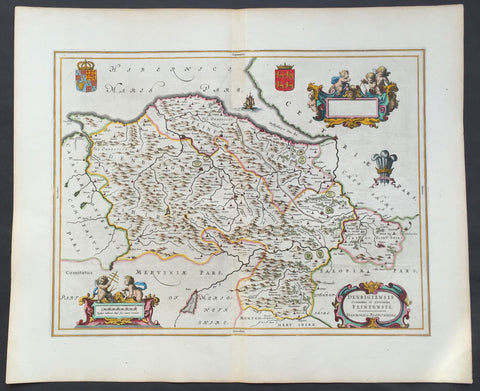
1647 Blaeu Antique Map of The Welsh Counties of Denbigh & Flintshire
- Title : Denbigiensis comitatus et Comitatus Flintensis - Denbigh et Flintshire
- Ref #: 31034
- Size: 24in x 20in (610mm x 510mm)
- Date : 1647
- Condition: (A+) Fine Condition
Description:
This beautifully hand coloured original antique map of the Welsh counties of Denbigh & Flintshire was published in the 1647 Dutch edition of Joan Blaeus Atlas Novus.
Blaeu's reference for the topographical data for this map derive from John Speeds maps of Great Britain from the 1611 Empire of Great Britaine - the beautiful decoration, though, is distinctly Blaeus.
Background: Blaeu is one of the most revered map makers of all time and it is easy to see why in this beautiful original map.
The high level of the topographical detail, the quality of the paper, the artistic professionalism of the engraving and the beauty of the original hand colouring combine to produce a work of art that is both functional and of exceptional beauty. (Ref: Koeman; M&B)
General Description:
Paper thickness and quality: - Heavy and stable
Paper color: - White
Age of map color: - Early
Colors used: - Yellow, pink, red, blue, green
General color appearance: - Authentic
Paper size: - 24in x 20in (610mm x 510mm)
Plate size: - 19 1/2in x 15in (495mm x 380mm)
Margins: - Min 1in (25mm)
Imperfections:
Margins: - None
Plate area: - None
Verso: - None

1647 Joan Blaeu Antique Map of Iceland - Beautiful Original Hand Colouring
- Title :Tabula Islandia Auctore Georgio Carolo Flandro
- Ref #: 17042
- Size: 23 1/2in x 19in (590mm x 485mm)
- Date : 1647
- Condition: (A+) Fine Condition
Description:
This is possibly one the best original hand coloured maps of Iceland by Blaeu, we have had the pleasure to offer.
This map, by Willem Blaeu, was engraved by Jodocus Hondius after Joris Carolus, and was published by Willem Blaeus son, Joan, in the 1647 German edition of Atlas Nouvs
General Definitions:
Paper thickness and quality: - Heavy and stable
Paper color : - off white
Age of map color: - Original
Colors used: - Yellow, green, blue, pink
General color appearance: - Authentic
Paper size: - 23 1/2in x 19in (590mm x 485mm)
Plate size: - 20in x 15 1/4in (510mm x 395mm)
Margins: - Min 1in (25mm)
Imperfections:
Margins: - Light age toning in left margin
Plate area: - Small stain top right of map
Verso: - None
Background:
This map of Iceland is perhaps the most familiar of all the outlines of the island ever published. The author is stated to be one Joris Carolus, a Dutch navigator from Enkhuizen, whose map was first engraved and prepared by Jodocus Hondius the younger in 1628, whose plates were bought by Willem Blaeu in 1629. Iceland bears the imprint of Willem Blaeu who issued it in his Appendix of 1630.
The Carolus map was copied by virtually all mapmakers throughout the rest of the 17th century and well into the 18th. Some of the information is derived from a map made famous by the Flemish cartographer Abraham Ortelius, the Islandia of Gudhbrandur Thorlaksson (1541 - 1627) Bishop of Holar, who had studied mathematics and astronomy as well as theology, while other information, such as place names, is derived from Gerard Mercator's map of 1595.
Willem Blaeu reprinted the map without change in his subsequent atlas editions, as did Joan after him, including the great atlas of 1662. In the southern southern part is shown the lively impression of Hekla in full eruption, described as mons perpetuo ardens while immediately to the west, the Bishopric of Skalholt is marked. To the south a note by Eiapialla hokel (Eyjafjallajokull) states that here may be found falcones albi or white falcons, presumably referring to the gyr falcon.
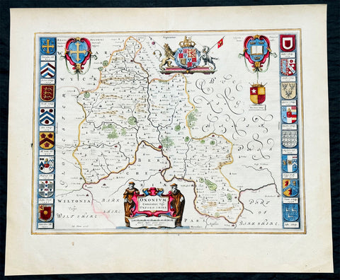
1647 Joan Blaeu Antique Map of the English County of Oxfordshire, Beautiful
Antique Map
- Title : Oxonium Comitatus, Vulgo Oxfordshire
-
Condition: (A+) Fine Condition
- Ref: 92846
- Size: 23 1/2in x 19 1/2in (600mm x 495mm)
- Date : 1647
Description:
This beautifully hand coloured original copper plate engraved antique map of the English county of Oxfordshire was published in the 1647 Dutch edition of Joan Blaeus Atlas Novus.
There is also the added bonus on the verso of the map with an early depiction of Stonehenge engraving to text.
Background:
This along with John Speeds map, is one of the most decorative of Oxfordshire. The basic cartographic information is derived from Speed's map, but presented with Blaeu typical elegance & decoration. These include coats-of-arms of the Oxford colleges along the sides, each expertly coloured, as well crests of nobility, the Royal coat-of-arms, and a title cartouche flanked by two Oxford scholars.
Blaeu is one of the most revered map makers of all time and it is easy to see why in this beautiful original map. The high level of the topographical detail, the quality of the paper, the artistic professionalism of the engraving and the beauty of the original hand colouring combine to produce a work of art that is both functional and of exceptional beauty. (Ref: Koeman; M&B)
General Description:
Paper thickness and quality: - Heavy and stable
Paper color: - off white
Age of map color: - Original
Colors used: - Yellow, pink, red, blue, green
General color appearance: - Authentic
Paper size: - 23 1/2in x 19 1/2in (600mm x 495mm)
Plate size: - 20in x 15 1/4in (510mm x 390mm)
Margins: - Min 1in (25mm)
Imperfections:
Margins: - None
Plate area: - None
Verso: - None

1649 Blaeu Antique Map View of Thérouanne, Tarwanna or Tervanna Northern France
- Title : Teroana morinorum metropolis olim, diruta a Carolo V. Anno 1553
- Ref #: Tav
- Size: 21 1/2in x 13in (545mm x 330mm)
- Date : 1649
- Condition: (A+) Fine Condition
Description:
This beautifully hand coloured original antique map a view of the city of Tarwanna or Tervanna (today the town of Thérouanne, France) the capital of the ancient Belgian tribe of the Morini, was published in the 1649 edition of John Blaeus Toonneel der Steeden (Views of Dutch Cities)
General Definitions:
Paper thickness and quality: - Heavy and stable
Paper color : - off white
Age of map color: - Original
Colors used: - Blue, pink, red, green, yellow
General color appearance: - Authentic
Paper size: - 21 1/2in x 13in (545mm x 330mm)
Plate size: - 10 1/2in x 7 1/2in (270mm x 190mm)
Margins: - Min 1in (25mm)
Imperfections:
Margins: - None
Plate area: - None
Verso: - None
Thérouanne is a commune in the Pas-de-Calais department in the Nord-Pas-de-Calais region of France. At the time of the Gauls, Tarwanna or Tervanna was the capital of the Belgian tribe of the Morini. After the Romans conquered Gaul, they too made the city the capital of the Civitas Morinorum district.
In the 7th century, probably around 639, Saint Audomar (Saint Omer) established the bishopric of Terwaan or Terenburg, the diocese of Thérouanne, which during the Middle Ages controlled a large part of the left bank of the river Scheldt. Territorially it was part of the county of Artois which belonged to the county of Flanders.
Thanks to that ecclesiastical control of some of the most prosperous cities north of the Alps, like Arras and Ypres, the bishopric was able to build a cathedral which was at the time the largest in France.
The town was captured by the Emperor Maximilian and Henry VIII from the French in 1513 after the battle of the Spurs. In 1553 Charles V besieged Thérouanne, then a French enclave in the Holy Roman Empire, in revenge for a defeat by the French at the siege of Metz. After he captured the city he ordered it to be razed, the roads to be broken up, and the area to be ploughed and salted Only a small commune which lay outside the city walls, then named Saint-Martin-Outre-Eaux, was left standing, and later (probably around 1800) took over the name Thérouanne. (Ref: Koeman; M&B)
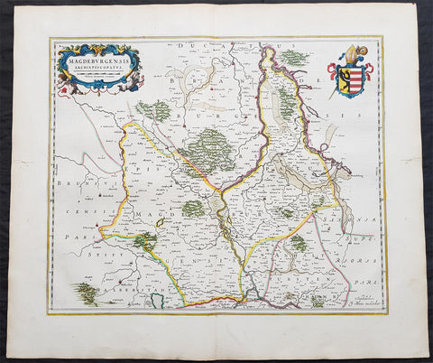
1650 Joan Blaeu Antique Map of Archbishopric of Madenburg Saxony-Anhalt, Germany
- Title : Magdeburgensis Archiepiscopatus
- Ref #: 40335
- Size: 24in x 21in (610mm x 535mm)
- Date : 1650
- Condition: (A+) Fine Condition
Description:
This beautifully hand coloured original copper-plate engraved antique map of the Archbishopric of Madenburg today located in the state of Saxony-Anhalt, Germany, on the Elbe River, was published in the 1650 Dutch edition of Joan Blaeus Atlas Novus.
General Definitions:
Paper thickness and quality: - Heavy and stable
Paper color : - off white
Age of map color: - Original
Colors used: - Blue, pink, red, green, yellow
General color appearance: - Authentic
Paper size: - 24in x 21in (610mm x 535mm)
Plate size: - 21in x 16 1/2in (535mm x 420mm)
Margins: - Min 1in (25mm)
Imperfections:
Margins: - Light age toning
Plate area: - None
Verso: - None
Background:
The Archbishopric of Magdeburg was a Roman Catholic archdiocese (969–1552) and Prince-Archbishopric (1180–1680) of the Holy Roman Empire centered on the city of Magdeburg on the Elbe River.
Planned since 955 and established in 968, the Roman Catholic archdiocese had de facto turned void since 1557, when the last papally confirmed prince-archbishop, the Lutheran Sigismund of Brandenburg came of age and ascended to the see and the Magdeburg cathedral chapter had adopted Lutheranism in 1567, with most parishioners having preceded in their conversion. All his successors were only administrators of the prince-archbishopric and Lutheran too, except of the Catholic layman Leopold William of Austria (1631–1635). In ecclesiastical respect the remaining Catholics and their parishes and abbeys in the former archdiocese were put under supervision of the Archdiocese of Cologne in 1648 and under the jurisdiction of the Apostolic Vicariate of the Northern Missions in 1670.
In political respect the Erzstift, the archiepiscopal and capitular temporalities, had gained imperial immediacy as prince-archbishopric in 1180. Its territory comprised only some parts of the archdiocesan area, such as the city of Magdeburg, the bulk of the Magdeburg Börde, and the Jerichow Land as an integral whole and exclaves comprising about the Saalkreis including Halle upon Saale, Oebisfelde and environs as well as Jüterbog and environs. The prince-archbishopric maintained its statehood as an elective monarchy until 1680. Then Brandenburg-Prussia acquired Magdeburg prince-archbishopric, and after being secularised, transformed it into the Duchy of Magdeburg, a hereditary monarchy in personal union with Brandenburg.
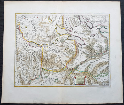
1650 Joan Blaeu Antique Map of The Cantons of Aargau & Zurich, Switzerland
Antique Map
- Title : Argow cum Parte Merid. Zurchgow
- Ref #: 40331
- Size: 24in x 21in (610mm x 535mm)
- Date : 1650
- Condition: (A+) Fine Condition
Description:
This beautifully hand coloured original antique map of the Cantons of Zurich & Aargau in North West Switzerland was published in the 1650 Dutch edition of Joan Blaeus Atlas Novusafter Gerard Mercator.
General Definitions:
Paper thickness and quality: - Heavy and stable
Paper color : - off white
Age of map color: - Original
Colors used: - Blue, pink, red, green, yellow
General color appearance: - Authentic
Paper size: - 24in x 21in (610mm x 535mm)
Plate size: - 21in x 16 1/2in (535mm x 420mm)
Margins: - Min 1in (25mm)
Imperfections:
Margins: - None
Plate area: - None
Verso: - None
Background:
The 26 cantons of Switzerland are the member states of the Swiss Confederation. The nucleus of the Swiss Confederacy in the form of the first three confederate allies used to be referred to as the Waldstätte. Two further major steps in the development of the Swiss cantonal system are referred to by the terms Acht Orte (Eight Cantons; between 1353 and 1481) and Dreizehn Orte (Thirteen Cantons,during 1513–1798); they were important intermediate periods of the Ancient Swiss Confederacy.
Each canton, formerly also Ort (from before 1450), or Stand (estate, from c. 1550), was a fully sovereign state with its own border controls, army, and currency from at least the Treaty of Westphalia (1648) until the establishment of the Swiss federal state in 1848; with a brief period of centralized government during the Helvetic Republic (1798–1803). With the Napoleonic period of the Helvetic Republic the term Kanton was also fully established in German-speaking region.
From 1833, there were 25 cantons, increasing to 26 after the secession of the canton of Jura from Bern in 1979.
The canton of Aargau is one of the more northerly cantons of Switzerland. It is situated by the lower course of the Aare, which is why the canton is called Aar-gau (meaning Aare province). It is one of the most densely populated regions of Switzerland.
The canton of Zürich is a Swiss canton in the northeastern part of the country. It is the most populated canton in the country. Its capital is the city of Zürich. The official language is German. The local Swiss German dialect, called Züritüütsch, is commonly spoken. In English the name of the canton and its capital is often written without an umlaut.
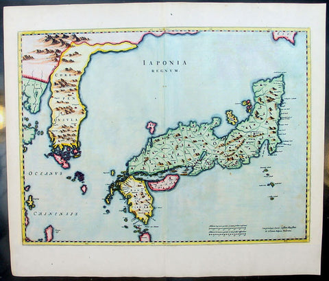
1655 Joan Blaeu Antique Map of Japan, Korea & parts of China - Beautiful
Antique Map
- Title : Japonia Regnum
- Date : 1655
- Condition: (A+) Fine Condition
- Ref: 92811
- Size: 24in x 21in (610mm x 535mm)
Description:
This fine beautifully hand coloured original antique map of Japan & Korea - the seventeenth and last of the maps provided by the Jesuit priest Martino Martini to Joan Blaeu - was published by Joan Blaeu in his 1665 edition of Atlas Simenis.
Martinis map was to provide the most accurate depiction of the general outlines of the principle islands of Japan - Honshu, Kyushu and Shikoku - for more than a century. The map was copied extensively by other mapmakers throughout the remainder of the seventeenth century and was replaced during the eighteenth century by maps that were in nearly all respects considerably inferior, albeit rather more flamboyant in design. Martinis first hand knowledge of the Chinese mainland enabled him to draw Korea correctly, for the first time on a printed map, as a peninsular even though little interior detail is shown. However what lay to the north of Japan was a mystery, not only Europeans, but also to the Japanese and Chinese as well. Even as early as 1613, William Adams, an Englishman living in Japan for many years, had written back to England recommending Japan as a base for "discouerie to the northward...never hath bin better menes to discouer". As with his general map of China, Martini here provides information on the internal administrative divisions in Japan; each of the feudal fiefdoms is shown, with the chief town in each, while some evidence of the activity of Jesuit missions, since the arrival of Francis Xavier in 1549, can be gathered from the town symbols surmounted by a small cross. This is one of the finest maps of Japan ever published, the engraving is strong, paper excellent and clean with beautiful original hand colour. (Ref: Koeman; M&B)
General Description:
Paper thickness and quality: - Heavy and stable
Paper color: - White
Age of map color: - Early color
Colors used: - Pink, green, yellow, blue
General color appearance: - Authentic & beautiful
Paper size: - 24in x 21in (610mm x 535mm)
Plate size: - 22 1/2in x 16 3/4in (570mm x 425mm)
Margins: - Min 1in (25mm)
Imperfections:
Margins: - Light age toning
Plate area: - None
Verso: - None

1658 Joan Blaeu Antique Heptarchy Map of Great Britain & Ireland - Magnificent
Antique Map
- Title : Britannia prout divisa suit temporibus Anglo-Saxonum præsertim durante illorum Heptarchia
- Date : 1658
- Size: 26in x 22in (660mm x 560mm)
- Condition: (A+) Fine Condition
- Ref: 35658
Description:
This beautifully engraved, hand coloured original copper plate engraved antique Heptarchy Map of Great Britain, during part of the Saxon Period (approx. 400 to 600AD) was published by Joan Blaeu in the only Spanish edition of Atlas Nouvs in 1658.
This is one of the best examples of the most beautiful maps ever published of the British Isles, I have seen for sometime. The map has magnificent fresh hand colouring, along with a deep heavy impression on clean heavy paper, with original margins.
General Definitions:
Paper thickness and quality: - Heavy and stable
Paper color : - off white
Age of map color: - Early
Colors used: - Yellow, green, blue, pink
General color appearance: - Authentic
Paper size: - 26in x 22in (660mm x 560mm)
Plate size: - 21in x 16 1/2in (530mm x 420mm)
Margins: - Min 2in (50mm)
Imperfections:
Margins: - None
Plate area: - None
Verso: - None
Background:
This map is based on the 1611 Heptarchy map published by John Speed. The side panels show historical scenes in Saxon history between 456 and 662 A.D.
The unknown engraver of this Blaeu Map has re-created each of the 14 scenes as an unmistakable Dutch miniature in the dramatic style of the greater paintings of the time. Blaeus map is considered by some, the finest of the three edition released by Speed, Blaeu and Jansson.
On the left panel are seven full length figures of the first aspiring Saxon Kings with their escutcheons, forces or townships; Hengist - Kent 456; Ella - South Saxon 478; Cherdin - West Saxon 519; Erkenwin - East Saxon 527; Ida - Northumberland 582; Uffa - East Anglia 546; Creda - Mercian 575. On the right there are scenes showing the conversion of Saxon Sovereigns to Christianity: Ethelbert (Kent 595) receiving religious instruction from St Augustine; Sebert (East Saxon 604) re-consecrating the temples of Diana & Apollo - now St Pauls, London, and St Peters, Westminster; Erpenwald (East Anglia, 624) embracing baptism by the armed extortion of King Edwin of Northumberland; Edwin (Northumberland, 627) stirred by a vision to receive the Faith; Kengils (West Saxon, 635) converted by the preaching of St Bernius; Peada (Mercia, 650) receiving the Faith by the persuasion of King Osway of Northumberland but also being murdered by his own mothers (some say his wife's) procurement; finally Ethelwolfe (South Saxon 662) being baptized at Oxford by St Berinus.
Blaeu is one of the most revered map makers of all time and it is easy to see why in this beautiful original map.
The high level of the topographical detail, the quality of the paper, the artistic professionalism of the engraving and the beauty of the original hand colouring combine to produce a work of art that is both functional and of exceptional beauty. (Ref: Shirley; Koeman; M&B; Tooley)
Splendid map of Anglo-Saxon Britain flanked by intricately rendered portraits of the kings through the 5th through 7th centuries. The monarchs to the left are those of the pre-Christian era, while those on the right are depicted receiving Christianity or being martyred for its sake.
This is often called the Heptarchy Map, as it presents England during the time following the Anglo Saxon conquest of southern England, approximately 500 to 850 A.D. known as the Heptarchy Era. (The word itself refers to the seven kingdoms that would eventually combine to form the Kingdom of England in the 10th century.)
To the left are the seven full length figures of the first aspiring Saxon Kings with their escutcheons, armies or townships;
1. Hengist - Kent 456AD
2. Ella - South Saxon 478AD
3. Cherdin - West Saxon 519AD
4. Erkenwin - East Saxon 527AD
5. Ida - Northumberland 582AD
6. Uffa - East Angle 546AD
7. Creda - Mercian 575AD
On the right there are scenes showing the conversion of Saxon sovereigns to Christianity:
1. Ethelbert - Kent 595AD receiving religious instruction from St Augustine
2. Sebert - East saxon604AD re-consecrating the temples of Diana and Apollo that later become St Pauls London and St Peters Westminster
3. Epenwald - East Angle 624AD embracing baptism by the armed exhortation of King Edwin of Northumberland
4. Edwin - Northumberland 627AD stirred by a vision to receive the faith
5. Kengils West Saxon 635AD converted by the preaching of St Berinus
6. Peada Mercia 650 receiving the Faith by the persuasion of King Osway of Northumberland but also being murdered by his own mothers, some say his wifes, procurement.
7. Ethenwolfe South Saxon 662AD being baptised at Oxford by St Berinus
(Ref: Tooley; M&B)
Please note all items auctioned are genuine, we do not sell reproductions. A Certificate of Authenticity (COA) can be issued on request.
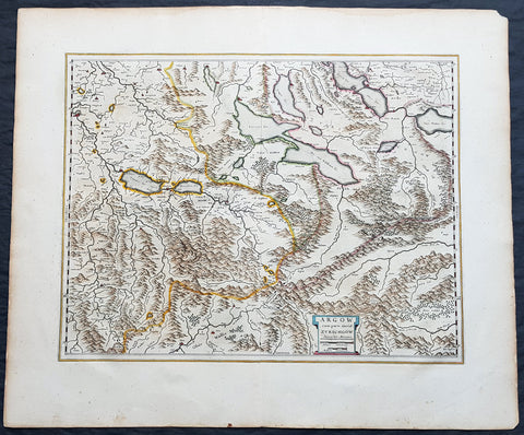
1659 Joan Blaeu Antique Map of The Cantons of Aargau & Zurich, Switzerland
Antique Map
- Title : Argow cum Parte Merid. Zurchgow
- Ref #: 30282
- Size: 24in x 21in (610mm x 535mm)
- Date : 1659
- Condition: (A+) Fine Condition
Description:
This beautifully hand coloured original antique map of the Cantons of Zurich & Aargau in North West Switzerland was published in the 1659 Spanish edition of Joan Blaeus Atlas Novusafter Gerard Mercator.
General Definitions:
Paper thickness and quality: - Heavy and stable
Paper color : - off white
Age of map color: - Original
Colors used: - Blue, pink, red, green, yellow
General color appearance: - Authentic
Paper size: - 24in x 21in (610mm x 535mm)
Plate size: - 21in x 16 1/2in (535mm x 420mm)
Margins: - Min 1in (25mm)
Imperfections:
Margins: - None
Plate area: - None
Verso: - None
Background:
The 26 cantons of Switzerland are the member states of the Swiss Confederation. The nucleus of the Swiss Confederacy in the form of the first three confederate allies used to be referred to as the Waldstätte. Two further major steps in the development of the Swiss cantonal system are referred to by the terms Acht Orte (Eight Cantons; between 1353 and 1481) and Dreizehn Orte (Thirteen Cantons,during 1513–1798); they were important intermediate periods of the Ancient Swiss Confederacy.
Each canton, formerly also Ort (from before 1450), or Stand (estate, from c. 1550), was a fully sovereign state with its own border controls, army, and currency from at least the Treaty of Westphalia (1648) until the establishment of the Swiss federal state in 1848; with a brief period of centralized government during the Helvetic Republic (1798–1803). With the Napoleonic period of the Helvetic Republic the term Kanton was also fully established in German-speaking region.
From 1833, there were 25 cantons, increasing to 26 after the secession of the canton of Jura from Bern in 1979.
The canton of Aargau is one of the more northerly cantons of Switzerland. It is situated by the lower course of the Aare, which is why the canton is called Aar-gau (meaning Aare province). It is one of the most densely populated regions of Switzerland.
The canton of Zürich is a Swiss canton in the northeastern part of the country. It is the most populated canton in the country. Its capital is the city of Zürich. The official language is German. The local Swiss German dialect, called Züritüütsch, is commonly spoken. In English the name of the canton and its capital is often written without an umlaut.
1659 Joan Blaeu Large Antique Map of Jersey and Guernsey British Channel Islands
Antique Map
- Title : Sarnia Insula Vulgo Garnsey: et Insula Caesarrea vernacule Jarsey
- Date : 1659
- Condition: (A+) Fine Condition
- Ref: 43170
- Size: 21in x 19in (535mm x 480mm)
Description:
This original large hand coloured copper plate engraved antique map of the Channel Islands Jersey and Guernsey and smaller islands was published in the 1659 Spanish edition of Joan Blaeu's Atlas Novus.
This map is in beautiful condition, large margins, strong sturdy clean paper and bright fresh original colouring.
Condition Report:
Paper thickness and quality: - Heavy and stable
Paper color: - off white
Age of map color: - Original
Colors used: - Yellow, pink, red, blue, green
General color appearance: - Authentic
Paper size: - 21in x 19in (535mm x 480mm)
Plate size: - 18 1/2in x 15 1/2in (480mm x 400mm)
Margins: - Min 1in (25mm)
Imperfections:
Margins: - None
Plate area: - Very light crease along centerfold
Verso: - None
Background: The Channel Islands (Norman: Îles d'la Manche, French: Îles Anglo-Normandes orÎles de la Manche) are an archipelago of British Crown Dependencies in the English Channel, off the French coast of Normandy. They include two separate bailiwicks: the Bailiwick of Jersey and the Bailiwick of Guernsey. They are considered the remnants of the Duchy of Normandy, and are not part of the United Kingdom. They have a total population of about 168,000 and their respective capitals, Saint Helier and Saint Peter Port, have populations of 33,500 and 16,488, respectively. The total area of the islands is 194 km.
Both Bailiwicks have been administered separately since the late 13th century; each has its own independent laws, elections, and representative bodies (although in modern times, politicians from the islands' legislatures are in regular contact). Any institution common to both is the exception rather than the rule.
Blaeu is one of the most revered map makers of all time and it is easy to see why in this beautiful original map. The high level of the topographical detail, the quality of the paper, the artistic professionalism of the engraving and the beauty of the original hand colouring combine to produce a work of art that is both functional and of exceptional beauty. (Ref: Koeman; M&B)
1662 Blaeu & Barlaeus Complete Set of 13 x Antique Maps of South America
Antique Map
- Titles:
1. Terra Firma
2. Venezuela
3. Guiana
4. Peru
5. Chili
6. Brasilia
7. Paraquaria
8. Tabula Magellanica
9. Preafecturae Paranambucae Prs Borealis
10. Praefecturae De Paraiba et Rio Grande
11. Praefectura De Ciriii vel Seregippe
12. Praefectura Paranambucae Pars Meridionalis
13. Sinus Omnium Sanctoru - Sizes: 24in x 20 1/2in (610mm x 520mm)ea
- Condition: (A) Very Good to Fine Condition
- Date: 1662
- Ref #: BlaeuSA 1662
Description:
This is a unique opportunity to acquire a complete set of the 13 maps of South America, including the 4 rare uniform Blaeu-Barleus maps of the Coast of Brazil, published by Joan Blaeu in his monumental & rare 1st 1662 Atlas, Latin edition of Atlas Major.
All paper in imprinted with a large Elephant watermark donating german paper from the 1660s.
The maps cover the full geographical area from North to South, South America from Panama to Tierra Firma. Please see the background section below for details of each map. All maps have wide original margins & colour on strong sturdy paper.
Joan Blaeus 11 volumes of Atlas Major, is considered by many to be the greatest atlas set ever published. It excels in comprehensiveness, engraving, color, and overall production. The first edition was published in Latin in 1662 and was subsequently published in French, Dutch, German, and Spanish over the next 10 years.
On the 23rd of February 1672, a fire broke out in central Amsterdam, that ended the reign of one of the greatest & most prolific publishers of printed maps and atlases in publishing history. The Blaeu family had reached its zenith 10 years previously, with the publication of its greatest achievement, the Atlas Major or Great Atlas, consisting of 11 volumes, with geographical detail reflecting many of the achievements of the Golden Age of the United Netherlands. Blaeus Atlas Major were the most expensive books printed in the 17th century.
General Definitions:
Paper thickness and quality: - Heavy and stable
Paper color : - off white
Age of map color: - Original
Colors used: - Blue, pink, red, green, yellow
General color appearance: - Authentic
Paper size: - 24in x 20 1/2in (610mm x 520mm)
Plate size: - Various, pls see below
Margins: - Min 1in (25mm) min
Imperfections:
Margins: - Pls see below
Plate area: - Pls see below
Verso: - Pls see below
Background:
1. Terra Firma - This regional map of the north eastern corner of South America belongs to the early group of plates printed by Willem Blaeu from 1630 onwards. It covers modern Colombia, part of Venezuela and Panama.
Plate: 19in x 14 1/2in.
Condition: Very light age toning
2. Venezuela - This map showing the area of modern Venezuela to the north of the Orinoco valley is another of the early plates of the 1630s. It extends from Lago dee Maracaibo in the west to the Island of Trinidad in the east and also shows the Dutch held Islands of Curacao, Aruba and Bonaire which served as a base of the Geotroyeerde West Indische Compaagnie (or Netherlands West Indian Company) since 1634.
Plate: 18 3/4in x 14 1/2in
Condition: Age toning, printers crease along centerfold, 8 small worm holes.
3. Guiana - This handsome map, another of the Blaeu maps of 1630, extendends from the Isla Margarita in the north-west to the coast of Northern Brazil near Sao Luis east of the Amazonas delta. The interior is dominated by a large island sea , the Parime Lacus, on whose north wesstern shores lies the fabled city of Manoa, de el Dorado, golden City of the Inca.
Plate: 19 1/4in x 14 1/2in
Condition: Light age toning
4. Peru - Here willem Blaeu, this map being part of Pacific Coast of South America from Ecuador (at the left hand side) as far south as the Atacama desert in the northern reaches of Chile.
Plate: 19 1/4in x 14 3/4in
Condition: Light age toning
5. Chili - This is another of Willem Blaeus early group f maps showing the coastal region of Central Chile from Copiapo in the north as far as a point to the south of the island of Chiloe.
Plate: 16 3/4in x 14in
Condition: Light age toning
6. Brasilia - Oriented west to the top of the plate, this general map of Brazil was an early product of Joan Blaeu himself, made after he had assumed full control of the publishing house following the death of his father a few years earlier.
This plate was made to replace the De Laet derivative which Willem had acquired from the Hondius plate stock in 1629 and is considerably more detailed than its earlier name sake.
Plate: 19 1/2in x 15 1/4in
Condition: Light age toning
7. Paraquaria - First map of Paraguay published first in this 1662 Atlas Major and so rare only published for 10 years or so.
Plate: 21 1/2in x 19 1/2in
Condition: Light age toning
8. Tabula Magellanica - Beautifully engraved map of the Magellan Straits first published in 1635
Plate: 19in x 16 1/2in
Condition: Light age toning
9. Preafecturae Paranambucae Prs Borealis
10. Praefecturae De Paraiba et Rio Grande
11. Praefectura De Ciriii vel Seregippe
12. Praefectura Paranambucae Pars Meridionalis
These 4 beautiful uniform maps are quite unlike any other maps found in Blaeu's Atlas Major.
Although they first appeared in the atlas for in 1662, these 4 maps first appeared in another earlier work published by Blaeu, the Rerum per octennium in Brasilia (1647) by the Remonstrant theologian Casper van Baerle (or Barlaeus) who died very soon afterwards in 1648.
Barlaeus great work, still one of the most valuable sources for Brazilian history, was published under the auspices of the Dutch governor in Brazil, Johan Maurits of Nassau Siegen, whose governorship from 1637 to 1644 Barlaeus describes in a eulogistic but nevertheless impartial account compiled from official sources.
The large pictorial vignettes of this group of maps illustrate much about local life and conditions of the time: in Preafecturae Paranambucae Prs Borealis & Praefecturae De Paraiba et Rio Grandea is shown processions of Indians from a mission, illustrated after paintings of the artist Frans Janszoon Post (1612 - 1680) who was with Johan Maurits in Brazil during the years 1637 - 1644. The buildings depicted have not been identified with any certainty but must have been in or near Pernambuco
Plates:
(9) 21in x 16 1/2in
(10) 21in x 16 1/2in
(11) 21in x 16 1/2in
(12) 17 1/2in x 16 1/2in
Conditions:
(9) Light age toning
(10) Light age toning
(11) Light age toning
(12) Light age toning
13. Sinus Omnium Sanctoru
Beautiful map of the Bahia De Todos Sanctos (All Saints Bay) in Brazil, with a large inset plan of the City of Sao Salvador.
Plate: 20in x 15 1/2in
Condition: Age toning
Caspar Barlaeus (1584 – 1648) was a Dutch polymath and Renaissance humanist, a theologian, poet, and historian.
Born Caspar (Kaspar) van Baerle in Antwerp, Barlaeus' parents fled the city when it was occupied by Spanish troops shortly after his birth. They settled in Zaltbommel, where his father eventually would become head of the Latin school. Caspar studied theology and philosophy at the University of Leiden. After his study, he preached for 1.5 years in the village of Nieuwe-Tonge, before returning to Leiden in 1612 as an under-regent of a college. From 1617 he also was professor in philosophy at the university. Because of his remonstrant sympathies, he was forced out of this job in 1619. He then studied and graduated in medicines (in Caen), but never practiced professionally.
From 1631, he was professor of philosophy and rhetoric at the Amsterdam Athenaeum, Athenaeum Illustre), which is commonly regarded as the predecessor of the University of Amsterdam; the Athenaeum had its seat in the fourteenth-century Agnietenkapel. In January 1632, Barlaeus, along with Gerard Vossius, held his inaugural speech at the Amsterdam Atheneum. Barlaeus later encouraged Martinus Hortensius to lecture –and give an inaugural speech- at the same Institution. One of his huge patrons was Amsterdam burgomaster Andries de Graeff, his neighbor at Oudezijds Achterburgwal.
Barlaeus suffered from mental illness including the delusion that he was made of glass (the Glass delusion) though Gill Speak refers to his glass delusion as ‘unsubstantiated’
Barlaeus published many volumes of poetry, particularly Latin poetry. He also wrote the eulogy that accompanies the 1622 portrait of cartographer Willem Blaeu.
Barlaeus was involved in various aspects of cartography and history. He translated Antonio de Herrera's Description of the West Indies in 1622. In 1627, Barlaeus provided the text for the atlas of Italy created by Jodocus Hondius. In 1647, he wrote an account of the Dutch colonial empire in Brazil, inspired by the leadership of John Maurice of Nassau (Johan Maurits) at Recife. The Rerum per octennium in Brasilia et alibi nuper gestarum sub praefectura, as it is called, contains numerous maps and plates of the region. The engravings of Brazilian northeastern locales, fleets, battles, and maps were for 160 years the main references to Brazilian landscapes available in Europe, and are well known by Brazilians today as the most important examples of pre-national art. Franciscus Plante wrote a similar work in the same year called Mauritias, and included the maps already published in Barlaeus' work. These were maps of Ceará, Pernambuco, Paraíba, and Pernambuco Borealá. Plante also incorporated a portrait of John Maurice that had already been included in Barlaeus' work.
In 1638, Barlaeus wrote Medicea Hospes, sive descriptio publicae gratulationis, qua ... Mariam de Medicis, excepit senatus populusque Amstelodamensis. Published by Willem Blaeu, it includes two large folding engraved views of the ceremonies on the occasion of the French queen mother Marie de Medici's triumphal entry into Amsterdam in 1638. Considered an important moment in Dutch history, Marie's visit lent de facto international recognition of the newly formed Dutch Republic. Marie de Medici actually traveled to the Netherlands as exile, but spectacular displays and water pageants took place in the city's harbor in celebration of her visit. There was a procession led by two mounted trumpeters; a large temporary structure erected on an artificial island in the Amstel River was built especially for the festival. This building was designed to display a series of dramatic tableaux in tribute to her once she set foot on the floating island and entered its pavilion.
Please note all items auctioned are genuine, we do not sell reproductions. A Certificate of Authenticity (COA) can be issued on request.
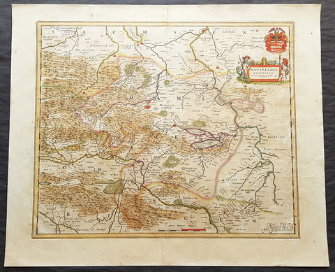
1662 Joan Blaeu Antique Map of Mansfeld Land, in SW Saxony-Anhalt, Germany
- Title : Mansfelda Comitatus Auctore Tilemanno Stella Sig.
- Ref #: 50180
- Size: 23 1/2in x 19 1/2in (600mm x 495mm)
- Date : 1662
- Condition: (A) Very Good Condition
Description:
This beautifully hand coloured original copper-plate engraved antique map of the ancient region of Mansfeld Land located in the in southwestern region of Saxony-Anhalt, Germany - centering on the city of Mansfeld - by was published in the 1662 Latin edition edition of Joan Blaeus Atlas Major.
General Definitions:
Paper thickness and quality: - Heavy and stable
Paper color : - off white
Age of map color: - Original
Colors used: - Blue, pink, red, green, yellow
General color appearance: - Authentic
Paper size: - 23 1/2in x 19 1/2in (600mm x 495mm)
Plate size: - 19 1/2in x 16 1/2in (495mm x 420mm)
Margins: - Min 1in (25mm)
Imperfections:
Margins: - Light age toning
Plate area: - Light age toning
Verso: - Light age toning
Background:
Mansfeld Land is a region in the southwestern corner of the German state of Saxony-Anhalt. The region derives its name from the counts of Mansfeld, who ruled this region for about 1,000 years.
The House of Mansfeld, whose members belonged to the Saxon nobility and served as counts in the Hassegau, was first documented in a 973 deed. The counts built Mansfeld Castle, whose foundations date back to the late 11th century, when one Hoyer of Mansfeld served as field marshal to Emperor Henry V. The first reference of the fortress coincides with the extinction of the elder line in 1229. The estates were inherited by the Lords of Querfurt, who also adopted the comital title, calling themselves Counts of Mansfeld from that time on.
The settlement of Mansfeld received town privileges in 1400, and grew through the development of copper and silver mining, an activity in which Hans Luder from Möhra, father to Martin Luther and Mansfeld citizen from 1484, was employed as a master smelter. Luthers family had arrived into a modest prosperity, he himself attended the local school between 1488 and 1496. The building known as Luther\'s School had to be torn down and rebuilt in 2000 due to structural problems. His parents house is preserved and today a museum. Luther also acted as an altar server at the St George parish church.
The Counts of Mansfeld had already lost Imperial immediacy in 1580. When the comital line finally became extinct in 1780, the estates around Mansfeld were incorporated into the Prussian Duchy of Magdeburg. The town retained the status of an independent city (Immediatstadt), it was temporarily part of the Napoleonic Kingdom of Westphalia and after the 1815 Congress of Vienna belonged to the Prussian Province of Saxony.
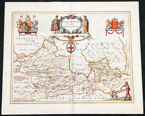
1662 Joan Blaeu Antique Map of the English County of Berkshire
Antique Map
- Title : Bercheria Vernaeule Barkshire
- Ref #: 27013
- Size: 22 1/4in x 18 1/2in (565mm x 470mm)
- Date : 1662
- Condition: (A) Very Good Condition
Description:
This original beautifully hand coloured antique map of the English County of Berkshire by Joan Blaeu was published in the 1662 edition of Atlas Major. (Ref: Tooley; M&B)
General Definitions:
Paper thickness and quality: - Heavy and stable
Paper color : - off white
Age of map color: - Original
Colors used: - Yellow, green, blue, pink
General color appearance: - Authentic
Paper size: - 22 1/4in x 18 1/2in (565mm x 470mm)
Plate size: - 19 3/4in x 15in (500mm x 380mm)
Margins: - Min 1/2in (10mm)
Imperfections:
Margins: - None
Plate area: - Small abrasion to right of map image
Verso: - Age toning
Please note all items auctioned are genuine, we do not sell reproductions. A Certificate of Authenticity (COA) can be issued on request.
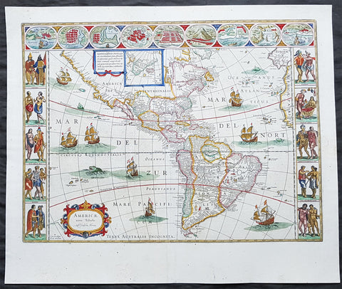
1662 Joan Blaeu Antique Map of the New World, America - Magnificent
- Title : Americae nova Tabula Auct: Guiljesino Blaeuw
- Size: 24in x 20in (610mm x 510mm)
- Condition: (A+) Fine Condition
- Date : 1662
- Ref #: 3007
Description:
This beautiful, original, hand coloured copper-plate engraved antique map, the quintessential 17th century image of America, The New World, was published in arguably the greatest atlas ever published, the 11th volume of Joan Blaeus 1662 edition of Atlas Major, or Great Atlas, Latin 1st edition.
This map was printed from a plate first produced by Joan Blaeus father, Willem in 1617 and was published in Atlas Major for only 10 years, prior to the disastrous 1672 fire that wiped out the Blaeu publishing house.
The original colouring is also extremely rare to find and this colouring is exceptional, along with heavy paper, a strong impression and original margins.
The New World, originally issued by Joan Blaeus father, Willem,. as early as 1617, this general map of the Americas was one of the longest lived plates in all the Blaeu\'s atlases, having been used as an atlas map from 1630.
Here is the general seventeenth century European view of the Western Hemisphere: the delineation of the coasts and the nomenclature of the Pacific as well as the Atlantic coasts are basically Spanish in origin and follow the maps of the Fleming Abraham Ortelius and his countryman Cornelis Wytfliet. To these, Willem Blaeu inserted, on the east coast, the English names given by the Roanoke colonists in Virginia, and by Martin Frobisher, John Davis and Henry Hudson in the far north. In Florida and along the St Lawrence, Blaeu added the names given by the French settlers, almost the only memorials to their ill-fated venture in Florida during the latter part of the sixteenth century.
When Blaeu first made his map in the early years of the seventeenth century, Europeans still had no real knowledge of the nature of the Mississippi system. From the expedition journals of Hernando de Soto (1539 - 1543) they had inferred an extensive range of mountains trending eastwards to the north of the Gulf of Mexico in la Florida apparently precluding a great river system. The Great Lakes were as yet unknown although by the time Blaeu issued this map in its atlas form in the Huron region together with the hearsay accounts from Coral Indians were becoming well known through his 1632 map of the region. Evidently, this appears to have been unknown to Blaeu at the time, but surprisingly, he never incorporated the information on later printings of the map. The same applies to Manhattan and Long Island as well, despite the fact that only a short distance from Amsterdam, the Leiden academic Johannes D Late had published the first edition of his monumental work on the Americas which provided source material for any number of maps of the Americas throughout the remainder of the century and beyond.
In common with the other general continental maps in Blaeus atlas\'s, he has provided perspective plans or views of settlements in the Americas, including Havana, St Domingo, Cartagena, Mexico, Cusco, Potisi, I.la Moca in Chile, Rio Janeiro and Olianda in Pharnambucco, as well as the vignette illustrations of native figures taken from the accounts of John White (Virginia) or Hans Staden (Brazil) and others. (Ref: Burden; RGS; Koeman; Tooley)
General Definitions:
Paper thickness and quality: - Heavy and stable
Paper color : - off white
Age of map color: - Original
Colors used: - Yellow, green, blue, pink
General color appearance: - Authentic
Paper size: - 24in x 20in (610mm x 510mm)
Plate size: - 21 1/2in x 16 1/4in (545mm x 415mm)
Margins: - Min 1in (25mm)
Imperfections:
Margins: - None
Plate area: - Light printer crease along left side of page
Verso: - Light age toning
Background:
Atlas Major or Great Atlas - During the early hours of the 23rd of February 1672, a fire broke out and engulfed a building on Gravenstraat, in the centre of Amsterdam. Such an event at the time was unremarkable, until it was recognised that the fire had brought to an end of one of the greatest publishing houses of all time. Dr Joan Blaeus family were responsible for printing and publishing some of the most important maps, atlases, religious and philosophical books, that are recognised even today, as remarkable. The fire was described in suitably vivid terms in the annual review publication, De Hollandtse Mercurius for 1672-1673
.............the disaster occurred at 3.30 on the morning of the 23rd of February because of the dryness of the timbers, or perhaps the carelessness of the apprentices; the magnificent establishment caught fire, and with it printing type, presses, plates and paper, were all burnt and sparks were sent flying as far as the Tol-heck (Toll Gate). One report put the financial cost of the damage at fl. 27, 000 for the buildings and some fl 355,000 for the plate-stock in the printing works and shop premises, to give total estimated losses of fl. 382, 000 (or about $25milUS in modern terms) together with some four or five thousand reams of paper, five or six thousand sheets, 88 thousand kg. printing type and so on...................
The fire precipitated the end of a publishing house established over 40 years before, and very probably contributed to the death of its proprietor, Alderman Dr Joan Blaeu, a year later, effectively ending the reign of one of the greatest producers of printed maps and atlases in publishing history. Only 10 years previously, in 1662, the house had reached its zenith with the publication of its greatest achievement, the Atlas Major or Great Atlas, containing 11 volumes with geographical detail reflecting many of the achievements of the Golden Ageof the United Netherlands.
Joan Blaeus 11 volume Atlas Major is considered by many to be the greatest atlas ever published, both in its own time and even today. It excels in comprehensiveness, engraving, color, and overall production. The first Latin edition was published in 1662 and was subsequently published in French, Dutch, German, and Spanish.
Most of the surviving copies of the Atlas Major are bound in what might be termed as Standard bindings, in other words, uniform cream-coloured vellum with gilt tooling and lettering. Wealthy clients for the atlas could commission a binder to bind their sets in morocco or even velvet, embellished with their crests of other decorative devices. Such bindings were carried out by the celebrated binder Albert Magnus, who flourished in Amsterdam from the 1660s to 1680. As it appears that Joan Blaeu had no bindery on his premises, it is very likely that Magnus also bound copies in the standard binding.
Colour was also a very important consideration. Although the atlas was published in black and white, and could be bought so (without hand colouring) many clients buying the atlas for display in their houses proffered their copies illuminated with rich hand colouring and sometime with gold high lightening. This of course was considerably more expensive, and there were in Amsterdam at the time artists who carried out such work. One of these was Dirk Janszoon van Santen who coloured and gilded maps and atlases to order, examples of which have survived and may be seen in institutional collections.
Blaeus atlas was the most expensive printed book in the 17th century. Blaeus catalogue of 1670, his Catalogue des Atlas, Theatre des Citez, quoted prices for the 12 volume French Text edition of the atlas at fl. 450 for a coloured set, and fl. 350 for a black and white set. This is the equivalent of paying around $70,000 today (although to purchase today at auction could be well over $250,000)
The original 11 volumes of Atlas Majorcontained the following contents:
v 1. Arctica --Europa, liber 1-2:. Norvegia. Dania. Sleswic
v. 2. Europa, liber 3-7: Suecia. Russia. Polonia. Regiones orientales ultra Germaniam circa Danubium. Graecia
v. 3. Europa, liber 8: Germania
v. 4. Europa, liber 9-10: Belgica regia
v. 5. Europa, liber 11: Anglia
v. 6. Europa, liber 12-13: Scotia. Hibernia
v. 7. Europa, liber 14-15: Gallia. Helvetia
v. 8. Europa, liber 16: Italia
v. 9. Europa, liber 17: Hispania. Africa
v. 10. Asia
v. 11. America.
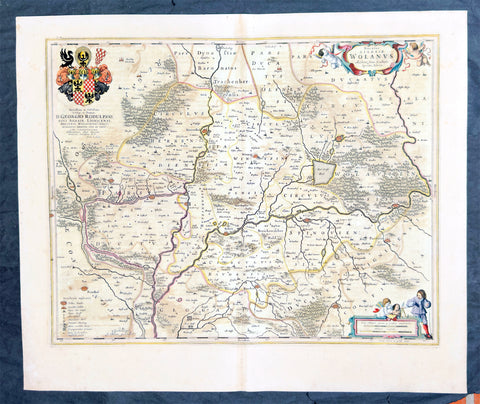
1662 Joan Blaeu Antique Map of Wołow County, Lower Silesia Voivodeship SW Poland
Antique Map
- Title : Ducatus Silesiae Wolanus Authore Jona Sculteto Sprotta Silesio
- Ref #: 93430
- Size: 24in x 20in (610mm x 510mm)
- Date : 1662
- Condition: (A) Very Good Condition
Description:
This beautifully hand coloured original copper-plate engraved antique, rare map of Wolow County, located at the time of publication in the Duchy of Głogow, in Lower Silesia, today SW Poland, was published in Joan Blaeu greatest publication, the first 1662 French edition of Atlas Major,.
As this map was only published over a 10 year period, as most of the plates were destroyed in the disasterous 1672 fire that wiped out the Blaeu publishing house, this map is extremely rare especially with original hand colour, such as this map.
General Definitions:
Paper thickness and quality: - Heavy and stable
Paper color : - off white
Age of map color: - Original
Colors used: - Yellow, green, blue, pink
General color appearance: - Authentic
Paper size: - 24in x 20in (610mm x 510mm)
Plate size: - 21in x 16 1/2in (535mm x 420mm)
Margins: - Min 1in (25mm)
Imperfections:
Margins: - Light soiling
Plate area: - Offsetting
Verso: - Offsetting
Background:
Wolow is a town in Lower Silesian Voivodeship in south-western Poland. It is the seat of Wołów County and Gmina Wołów. It lies approximately 38 kilometres north-west of the regional capital Wrocław.
The area around Wołów has been settled since prehistoric times. It became part of the emerging Polish state in the late 10th century under Mieszko I of Poland. The town was first mentioned in 1157 when a wooden castle founded by Senior Duke of Poland Władysław II the Exile is documented, which developed into a castle complex, which was again mentioned in 1202. Two villages developed near the castle, one of them called Wołowo. Probably in the second half of the 13th century the town was founded near Wołowo and partially on the soil of the second village. Wołów received Magdeburg town rights about 1285 at the time of German Ostsiedlung in the region; a Vogt is mentioned in 1288.
At that time Wołów belonged to the Duchy of Głogów, after 1312 to the Duchy of Oleśnica. With the duchy it came under the suzerainty of Bohemia in 1328. From 1473 dates the oldest known seal of the town, which already shows an ox, as do all later seals. Wołów was ruled by local Polish dukes until 1492, and soon after, in 1495, it came into the possession of the Czech Podiebrad family, then in 1517 it came into the hands the Hungarian magnate Johann Thurzó, before returning to Piast rule in 1523, by passing to the Duchy of Legnica. It remained there until the Piast dukes of Legnica-Brzeg-Wołów died out in 1675. As a result of the Thirty Years War, the towns population fell by half.
The Protestant Reformation was introduced to the town in 1522 by duke Frederick II. After the extinction of the local Piasts the duchy passed to the House of Habsburg, which opposed the Protestant denomination in the town, as part of the Counter-Reformation. In 1682 the towns parish church was closed and given to the Catholics. According to the Treaty of Altranstädt the church however was already returned to the Protestants in 1707 and stayed Protestant until 1945. The small Catholic minority in return received a Josephinian curacy.
In 1742 Wołów was annexed by Prussia. The duchy was divided into two districts and the town became county seat of one of the districts. The structure of the town was, until 1700, defined by craft, especially clothiers. As the seat of a duchy and a district administrative function however became more and more important. The industrialization played only a minor role and mostly affected smaller companies of the timber industry. In 1781 the city suffered a fire.
The town was part of Germany from 1871 to 1945. In January 1945 – just before town was taken by the Red Army – the Wehrmacht evacuated the German population westwards.

1662 Joan Blaeu Complete Set of 9 Antique Maps of North America from Atlas Major, 1st Edition
Antique Map
- Titles:
1. Extrema Americae....Terra Nova Francia;
2. Nova Belgica Et Anglia Nova;
3. Nova Virginiae Tabula;
4. Virginiae partis australis, et Floridae;
5. Nova Hispania;
6. Yucatan...Guatimala;
7. Insulae Americanae;
8. Canibales Insulae;
9. Mappa Aestivarum Insularum Alias Barmudas - Sizes: 24in x 20 1/2in (610mm x 520mm)ea
- Condition: (A+) Fine Condition
- Date: 1662
- Ref #: BlaeuNA 1662
Description:
This is a unique opportunity to acquire a complete set of 9 maps of North America published by Joan Blaeus in the monumental & rare 1st 1662 Latin edition of Atlas Major. The maps cover the geographical detail of Canada, North America, Mexico, The Caribbean & Central America. Please see the background section below for details of each map. All maps have wide original margins & colour on strong sturdy paper.
Joan Blaeus 11 volumes of Atlas Major, is considered by many to be the greatest atlas set ever published. It excels in comprehensiveness, engraving, color, and overall production. The first edition was published in Latin in 1662 and was subsequently published in French, Dutch, German, and Spanish over the next 10 years.
On the 23rd of February 1672, a fire broke out in central Amsterdam, that ended the reign of one of the greatest & most prolific publishers of printed maps and atlases in publishing history. The Blaeu family had reached its zenith 10 years previously, with the publication of its greatest achievement, the Atlas Major or Great Atlas, consisting of 11 volumes, with geographical detail reflecting many of the achievements of the Golden Age of the United Netherlands. Blaeus Atlas Major were the most expensive books printed in the 17th century.
General Definitions:
Paper thickness and quality: - Heavy and stable
Paper color : - off white
Age of map color: - Original
Colors used: - Blue, pink, red, green, yellow
General color appearance: - Authentic
Paper size: - 24in x 20 1/2in (610mm x 520mm)
Plate size: - Various, pls see below
Margins: - Min 1in (25mm) min
Imperfections:
Margins: - Pls see below
Plate area: - Pls see below
Verso: - Pls see below
Background:
1. Extrema Americae ( Eastern Canada) - Rare only published in Atlas Major. Derived mainly from the Samuel de Champlain Nouvelle France map of 1632, this map reflects the growing financial importance of the waters of New France to Europe.
Plate: 22 1/2in x 17 3/4in.
Condition: Age toning, text show-through & browning to image.
2. Nova Belgica Et Anglia Nova (New England) - NE America, centering on New York and Manhattan from Virginia to the St Lawrence River. This map is noted for the fact that its primary source is the first manuscript figurative map of Adriaen Block from 1614. Indeed it is the first full representation of it in print. It is one of the earliest to name Nieu Amsterdam. Block, a Dutch fur trader, explored the area between Cape Cod and Manhattan, examining the bays and rivers along the way.
Plate: 19 1/2in x 15 1/2in
Condition: Age toning, text show-through & browning to image.
3. Nova Virginiae Tabula (John Smiths Virginia & Chesapeake Bay) This map was printed from a plate engraved by Dirk Grijp from a previous plates by Henricus Hondius.
Plate: 19in x 15in
Condition: Light age toning
4. Virginiae partis australis, et Floridae Virginia, the Carolinas & Georgia.
Plate: 20in x 15in
Condition: Light age toning
5. Nova Hispania et Nova Galicia Western Mexico
Plate: 19 1/2in x 15 1/2in
Condition: Light age toning
6. Yucatan...Guatimala (Yucatan, Central America) Rare only published in Atlas Major.
Plate: 20 1/2in x 16 1/2in
Condition: Light age toning
7. Insulae Americana (GOM, Caribbean)
Plate: 20 1/2in x 15in
Condition: Light age toning
8. Canibales Insulae (Lesser Antilles Islands) Rare, printed only in Atlas Major
Plate: 21in x 16 1/2in
Condition: Age toning
9. Mappa Aestivarum Insularum Alias Barmudas Dictarum Bermuda. Like all 17th century maps of Bermuda this map is based ultimately on the survey made by John Norwood, of the Bermuda Company, in 1618 in the form as published by the English map-maker John Speed in 1627.
Plate: 21in x 16in
Condition: Light age toning
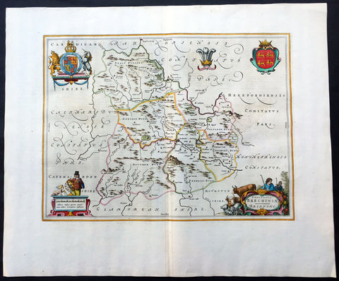
1664 Blaeu Large Antique Map of The Welsh County of Breknock
- Title : Comitatus Brechiniae Breknoke
- Ref #: 01-4244
- Size: 25 1/2in x 21 1/2in (650mm x 545mm)
- Date : 1664
- Condition: (A+) Fine Condition
Description:
This beautifully hand coloured original antique map of the Welsh county of Brecknock was published in the 1664 Dutch edition of Joan Blaeus Atlas Major.
Blaeus reference for the topographical data is from John Speeds maps from the 1611 Empire of Great Britaine - the beautiful decoration, though, is distinctly Blaeus.
This is a beautiful map with a deep impression, original margins, wonderful hand colouring and strong, stable paper. (Ref: Koeman; Tooley; M&B)
General Description:
Paper thickness and quality: - Heavy and stable
Paper color: - White
Age of map color: - Later
Colors used: - Yellow, pink, red, blue, green
General color appearance: - Authentic
Paper size: - 25 1/2in x 21 1/2in (650mm x 545mm)
Plate size: - 20in x 15in (510mm x 380mm)
Margins: - Min 2in (50mm)
Imperfections:
Margins: - None
Plate area: - None
Verso: - None
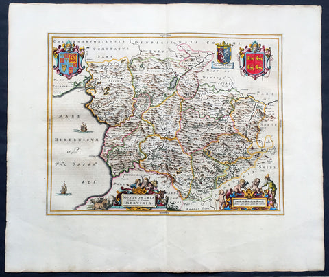
1664 Joan Blaeu Large Antqiue Map The Welsh County of Montgomery
Antique Map
-
Title : Montgomeria Comitatus et Comitatus Mervinia
- Date : 1664
- Condition: (A+) Fine Condition
- Ref: 01-4004
- Size: 25 1/2in x 21 1/2in (650mm x 545mm)
Description:
This beautifully hand coloured original antique map of the Welsh County of Montgomery was published in the 1664 Dutch edition of Joan Blaeus Atlas Major.
Blaeus reference for the topographical data is from John Speeds maps from the 1611 Empire of Great Britaine - the beautiful decoration, though, is distinctly Blaeus. (Ref: Koeman; Tooley; M&B)
General Description:
Paper thickness and quality: - Heavy and stable
Paper color: - White
Age of map color: - Early
Colors used: - Yellow, pink, red, blue, green
General color appearance: - Authentic
Paper size: - 25 1/2in x 21 1/2in (650mm x 545mm)
Plate size: - 20in x 16 1/2in (510mm x 420mm)
Margins: - Min 2in (50mm)
Imperfections:
Margins: - None
Plate area: - None
Verso: - None