

Willem Blaeu (1571 - 1638) Joan Blaeu 1596-1673
Profile :
At the beginning of the seventeenth century Amsterdam was becoming one of the wealthiest trading cities in Europe, the base of the Dutch East India Company and a center of banking and the diamond trade, its people noted for their intellectual skills and splendid craftsmanship.
At this propitious time in the history of the Northern Provinces, Willem Janszoon Blaeu, who was born at Alkmaar in 1571 and trained in astronomy and the sciences by Tycho Brahe, the celebrated Danish astronomer, founded a business in Amsterdam in 1599 as a globe and instrument maker. It was not long before the business expanded, publishing maps, topographical works and books of sea charts as well as constructing globes. His most notable early work was a map of Holland (1604), a fine World Map (1605-06) and Het Licht der Zeevaerdt (The Light of Navigation), a marine atlas, which went through many editions in different languages and under a variety of titles. At the same time Blaeu was planning a major atlas intended to include the most up-to-date maps of the whole of the known world but progress on so vast a project was slow and not until he bought between 30 and 40 plates of the Mercator Atlas from Jodocus Hondius II to add to his own collection was he able to publish, in 1630, a 60-map volume with the title Atlantis Appendix. It was another five years before the first two volumes of his planned world atlas, Atlas Novus or the Theatrum Orbis Terrarum were issued. About this time he was appointed Hydrographer to the East India Company.
In 1638 Blaeu died and the business passed into the hands of his sons, Joan and Cornelis, who continued and expanded their father's ambitious plans. After the death of Cornelis, Joan directed the work alone and the whole series of 6 volumes was eventually completed about 1655. As soon as it was finished he began the preparation of the even larger work, the Atlas Major, which reached publication in 1662 in II volumes (later editions in 9-12 volumes) and contained nearly 6oo double-page maps and 3,000 pages of text. This was, and indeed remains, the most magnificent work of its kind ever produced; perhaps its geographical content was not as up-to-date or as accurate as its author could have wished, but any deficiencies in that direction were more than compensated for by the fine engraving and colouring, the elaborate cartouches and pictorial and heraldic detail and especially the splendid calligraphy.
In 1672 a disastrous fire destroyed Blaeu's printing house in the Gravenstraat and a year afterwards Joan Blaeu died. The firm's surviving stocks of plates and maps were gradually dispersed, some of the plates being bought by F. de Wit and Schenk and Valck, before final closure in about 1695.
It ought to be mentioned here that there is often confusion between the elder Blaeu and his rival Jan J ansson (Johannes Janssonius). Up to about 1619 Blaeu often signed his works Guilielmus Janssonius or Willems Jans Zoon but after that time he seems to have decided on Guilielmus or G. Blaeu.
Willem & Joan Blaeu (2)
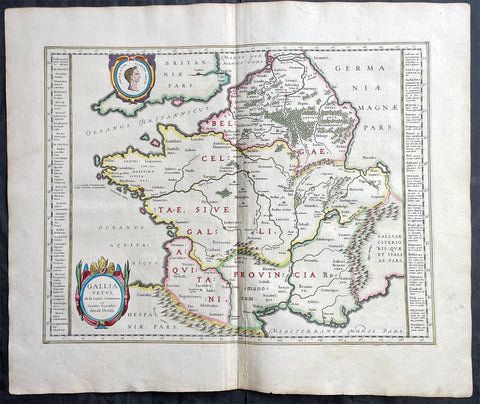
1638 Joan Blaeu & Abraham Ortelius Antique Map of France
Antique Map
- Title : Gallia Vetus...Abrah Ortelii
- Date : 1638
- Size: 23in x 20in (585mm x 510mm)
- Condition: (A+) Fine Condition
- Ref: 70606
Description:
This original beautifully hand coloured copper-plate engraved antique map of France, after Abraham Ortelius, was published by Joan Blaeu in the 1638 French edition of Atlas Nouvs,.
General Definitions:
Paper thickness and quality: - Heavy and stable
Paper color : - off white
Age of map color: - Original
Colors used: - Pink, blue, green, yellow
General color appearance: - Authentic
Paper size: - 23in x 20in (585mm x 510mm)
Plate size: - 19 1/2in x 15in (500mm x 380mm)
Margins: - Min 1in (25mm)
Imperfections:
Margins: - None
Plate area: - None
Verso: - None

1649 Blaeu Antique Map View of Thérouanne, Tarwanna or Tervanna Northern France
- Title : Teroana morinorum metropolis olim, diruta a Carolo V. Anno 1553
- Ref #: Tav
- Size: 21 1/2in x 13in (545mm x 330mm)
- Date : 1649
- Condition: (A+) Fine Condition
Description:
This beautifully hand coloured original antique map a view of the city of Tarwanna or Tervanna (today the town of Thérouanne, France) the capital of the ancient Belgian tribe of the Morini, was published in the 1649 edition of John Blaeus Toonneel der Steeden (Views of Dutch Cities)
General Definitions:
Paper thickness and quality: - Heavy and stable
Paper color : - off white
Age of map color: - Original
Colors used: - Blue, pink, red, green, yellow
General color appearance: - Authentic
Paper size: - 21 1/2in x 13in (545mm x 330mm)
Plate size: - 10 1/2in x 7 1/2in (270mm x 190mm)
Margins: - Min 1in (25mm)
Imperfections:
Margins: - None
Plate area: - None
Verso: - None
Thérouanne is a commune in the Pas-de-Calais department in the Nord-Pas-de-Calais region of France. At the time of the Gauls, Tarwanna or Tervanna was the capital of the Belgian tribe of the Morini. After the Romans conquered Gaul, they too made the city the capital of the Civitas Morinorum district.
In the 7th century, probably around 639, Saint Audomar (Saint Omer) established the bishopric of Terwaan or Terenburg, the diocese of Thérouanne, which during the Middle Ages controlled a large part of the left bank of the river Scheldt. Territorially it was part of the county of Artois which belonged to the county of Flanders.
Thanks to that ecclesiastical control of some of the most prosperous cities north of the Alps, like Arras and Ypres, the bishopric was able to build a cathedral which was at the time the largest in France.
The town was captured by the Emperor Maximilian and Henry VIII from the French in 1513 after the battle of the Spurs. In 1553 Charles V besieged Thérouanne, then a French enclave in the Holy Roman Empire, in revenge for a defeat by the French at the siege of Metz. After he captured the city he ordered it to be razed, the roads to be broken up, and the area to be ploughed and salted Only a small commune which lay outside the city walls, then named Saint-Martin-Outre-Eaux, was left standing, and later (probably around 1800) took over the name Thérouanne. (Ref: Koeman; M&B)