

Willem Blaeu (1571 - 1638) Joan Blaeu 1596-1673
Profile :
At the beginning of the seventeenth century Amsterdam was becoming one of the wealthiest trading cities in Europe, the base of the Dutch East India Company and a center of banking and the diamond trade, its people noted for their intellectual skills and splendid craftsmanship.
At this propitious time in the history of the Northern Provinces, Willem Janszoon Blaeu, who was born at Alkmaar in 1571 and trained in astronomy and the sciences by Tycho Brahe, the celebrated Danish astronomer, founded a business in Amsterdam in 1599 as a globe and instrument maker. It was not long before the business expanded, publishing maps, topographical works and books of sea charts as well as constructing globes. His most notable early work was a map of Holland (1604), a fine World Map (1605-06) and Het Licht der Zeevaerdt (The Light of Navigation), a marine atlas, which went through many editions in different languages and under a variety of titles. At the same time Blaeu was planning a major atlas intended to include the most up-to-date maps of the whole of the known world but progress on so vast a project was slow and not until he bought between 30 and 40 plates of the Mercator Atlas from Jodocus Hondius II to add to his own collection was he able to publish, in 1630, a 60-map volume with the title Atlantis Appendix. It was another five years before the first two volumes of his planned world atlas, Atlas Novus or the Theatrum Orbis Terrarum were issued. About this time he was appointed Hydrographer to the East India Company.
In 1638 Blaeu died and the business passed into the hands of his sons, Joan and Cornelis, who continued and expanded their father's ambitious plans. After the death of Cornelis, Joan directed the work alone and the whole series of 6 volumes was eventually completed about 1655. As soon as it was finished he began the preparation of the even larger work, the Atlas Major, which reached publication in 1662 in II volumes (later editions in 9-12 volumes) and contained nearly 6oo double-page maps and 3,000 pages of text. This was, and indeed remains, the most magnificent work of its kind ever produced; perhaps its geographical content was not as up-to-date or as accurate as its author could have wished, but any deficiencies in that direction were more than compensated for by the fine engraving and colouring, the elaborate cartouches and pictorial and heraldic detail and especially the splendid calligraphy.
In 1672 a disastrous fire destroyed Blaeu's printing house in the Gravenstraat and a year afterwards Joan Blaeu died. The firm's surviving stocks of plates and maps were gradually dispersed, some of the plates being bought by F. de Wit and Schenk and Valck, before final closure in about 1695.
It ought to be mentioned here that there is often confusion between the elder Blaeu and his rival Jan J ansson (Johannes Janssonius). Up to about 1619 Blaeu often signed his works Guilielmus Janssonius or Willems Jans Zoon but after that time he seems to have decided on Guilielmus or G. Blaeu.
Willem & Joan Blaeu (1)
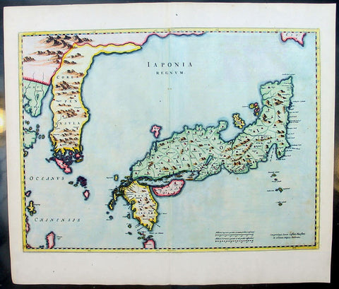
1655 Joan Blaeu Antique Map of Japan, Korea & parts of China - Beautiful
Antique Map
- Title : Japonia Regnum
- Date : 1655
- Condition: (A+) Fine Condition
- Ref: 92811
- Size: 24in x 21in (610mm x 535mm)
Description:
This fine beautifully hand coloured original antique map of Japan & Korea - the seventeenth and last of the maps provided by the Jesuit priest Martino Martini to Joan Blaeu - was published by Joan Blaeu in his 1665 edition of Atlas Simenis.
Martinis map was to provide the most accurate depiction of the general outlines of the principle islands of Japan - Honshu, Kyushu and Shikoku - for more than a century. The map was copied extensively by other mapmakers throughout the remainder of the seventeenth century and was replaced during the eighteenth century by maps that were in nearly all respects considerably inferior, albeit rather more flamboyant in design. Martinis first hand knowledge of the Chinese mainland enabled him to draw Korea correctly, for the first time on a printed map, as a peninsular even though little interior detail is shown. However what lay to the north of Japan was a mystery, not only Europeans, but also to the Japanese and Chinese as well. Even as early as 1613, William Adams, an Englishman living in Japan for many years, had written back to England recommending Japan as a base for "discouerie to the northward...never hath bin better menes to discouer". As with his general map of China, Martini here provides information on the internal administrative divisions in Japan; each of the feudal fiefdoms is shown, with the chief town in each, while some evidence of the activity of Jesuit missions, since the arrival of Francis Xavier in 1549, can be gathered from the town symbols surmounted by a small cross. This is one of the finest maps of Japan ever published, the engraving is strong, paper excellent and clean with beautiful original hand colour. (Ref: Koeman; M&B)
General Description:
Paper thickness and quality: - Heavy and stable
Paper color: - White
Age of map color: - Early color
Colors used: - Pink, green, yellow, blue
General color appearance: - Authentic & beautiful
Paper size: - 24in x 21in (610mm x 535mm)
Plate size: - 22 1/2in x 16 3/4in (570mm x 425mm)
Margins: - Min 1in (25mm)
Imperfections:
Margins: - Light age toning
Plate area: - None
Verso: - None