

Willem Blaeu (1571 - 1638) Joan Blaeu 1596-1673
Profile :
At the beginning of the seventeenth century Amsterdam was becoming one of the wealthiest trading cities in Europe, the base of the Dutch East India Company and a center of banking and the diamond trade, its people noted for their intellectual skills and splendid craftsmanship.
At this propitious time in the history of the Northern Provinces, Willem Janszoon Blaeu, who was born at Alkmaar in 1571 and trained in astronomy and the sciences by Tycho Brahe, the celebrated Danish astronomer, founded a business in Amsterdam in 1599 as a globe and instrument maker. It was not long before the business expanded, publishing maps, topographical works and books of sea charts as well as constructing globes. His most notable early work was a map of Holland (1604), a fine World Map (1605-06) and Het Licht der Zeevaerdt (The Light of Navigation), a marine atlas, which went through many editions in different languages and under a variety of titles. At the same time Blaeu was planning a major atlas intended to include the most up-to-date maps of the whole of the known world but progress on so vast a project was slow and not until he bought between 30 and 40 plates of the Mercator Atlas from Jodocus Hondius II to add to his own collection was he able to publish, in 1630, a 60-map volume with the title Atlantis Appendix. It was another five years before the first two volumes of his planned world atlas, Atlas Novus or the Theatrum Orbis Terrarum were issued. About this time he was appointed Hydrographer to the East India Company.
In 1638 Blaeu died and the business passed into the hands of his sons, Joan and Cornelis, who continued and expanded their father's ambitious plans. After the death of Cornelis, Joan directed the work alone and the whole series of 6 volumes was eventually completed about 1655. As soon as it was finished he began the preparation of the even larger work, the Atlas Major, which reached publication in 1662 in II volumes (later editions in 9-12 volumes) and contained nearly 6oo double-page maps and 3,000 pages of text. This was, and indeed remains, the most magnificent work of its kind ever produced; perhaps its geographical content was not as up-to-date or as accurate as its author could have wished, but any deficiencies in that direction were more than compensated for by the fine engraving and colouring, the elaborate cartouches and pictorial and heraldic detail and especially the splendid calligraphy.
In 1672 a disastrous fire destroyed Blaeu's printing house in the Gravenstraat and a year afterwards Joan Blaeu died. The firm's surviving stocks of plates and maps were gradually dispersed, some of the plates being bought by F. de Wit and Schenk and Valck, before final closure in about 1695.
It ought to be mentioned here that there is often confusion between the elder Blaeu and his rival Jan J ansson (Johannes Janssonius). Up to about 1619 Blaeu often signed his works Guilielmus Janssonius or Willems Jans Zoon but after that time he seems to have decided on Guilielmus or G. Blaeu.
Willem & Joan Blaeu (2)
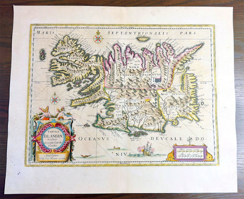
1644 Willem Blaeu Antique Map of Iceland - Beautiful Original Hand Colouring
Antique Map
- Title :Tabula Islandia Auctore Georgio Carolo Flandro
- Ref #: 35625
- Condition: (A) Very Good Condition
- Size: 23 1/2in x 20in (590mm x 510mm)
- Date: 1644
Description:
This original copper plate engraved antique map, with beautiful original hand colouring by Willem Blaeu, was engraved by Jodocus Hondius after Joris Carolus, and was published by Guillaume Blaeus in the 1644 Latin edition of Atlas Nouvs.
This is beautiful example of this early map of Iceland with fresh original hand colouring, on uniform aged paper with original margins.
General Definitions:
Paper thickness and quality: - Heavy and stable
Paper color : - off white
Age of map color: - Original
Colors used: - Yellow, green, blue, pink
General color appearance: - Authentic
Paper size: - 23 1/2in x 20in (590mm x 510mm)
Plate size: - 20in x 15 1/4in (510mm x 395mm)
Margins: - Min 1in (25mm)
Imperfections:
Margins: - Light scraping to L & R margins
Plate area: - Uniform aged toning
Verso: - Uniform aged toning
Background:
This map of Iceland is perhaps the most familiar of all the outlines of the island ever published. The author is stated to be one Joris Carolus, a Dutch navigator from Enkhuizen, whose map was first engraved and prepared by Jodocus Hondius the younger in 1628, whose plates were bought by Willem Blaeu in 1629. Iceland bears the imprint of Willem Blaeu who issued it in his Appendix of 1630.
The Carolus map was copied by virtually all mapmakers throughout the rest of the 17th century and well into the 18th. Some of the information is derived from a map made famous by the Flemish cartographer Abraham Ortelius, the Islandia of Gudhbrandur Thorlaksson (1541 - 1627) Bishop of Holar, who had studied mathematics and astronomy as well as theology, while other information, such as place names, is derived from Gerard Mercator's map of 1595.
Willem Blaeu reprinted the map without change in his subsequent atlas editions, as did Joan after him, including the great atlas of 1662. In the southern southern part is shown the lively impression of Hekla in full eruption, described as mons perpetuo ardens while immediately to the west, the Bishopric of Skalholt is marked. To the south a note by Eiapialla hokel (Eyjafjallajokull) states that here may be found falcones albi or white falcons, presumably referring to the gyr falcon.

1647 Joan Blaeu Antique Map of Iceland - Beautiful Original Hand Colouring
- Title :Tabula Islandia Auctore Georgio Carolo Flandro
- Ref #: 17042
- Size: 23 1/2in x 19in (590mm x 485mm)
- Date : 1647
- Condition: (A+) Fine Condition
Description:
This is possibly one the best original hand coloured maps of Iceland by Blaeu, we have had the pleasure to offer.
This map, by Willem Blaeu, was engraved by Jodocus Hondius after Joris Carolus, and was published by Willem Blaeus son, Joan, in the 1647 German edition of Atlas Nouvs
General Definitions:
Paper thickness and quality: - Heavy and stable
Paper color : - off white
Age of map color: - Original
Colors used: - Yellow, green, blue, pink
General color appearance: - Authentic
Paper size: - 23 1/2in x 19in (590mm x 485mm)
Plate size: - 20in x 15 1/4in (510mm x 395mm)
Margins: - Min 1in (25mm)
Imperfections:
Margins: - Light age toning in left margin
Plate area: - Small stain top right of map
Verso: - None
Background:
This map of Iceland is perhaps the most familiar of all the outlines of the island ever published. The author is stated to be one Joris Carolus, a Dutch navigator from Enkhuizen, whose map was first engraved and prepared by Jodocus Hondius the younger in 1628, whose plates were bought by Willem Blaeu in 1629. Iceland bears the imprint of Willem Blaeu who issued it in his Appendix of 1630.
The Carolus map was copied by virtually all mapmakers throughout the rest of the 17th century and well into the 18th. Some of the information is derived from a map made famous by the Flemish cartographer Abraham Ortelius, the Islandia of Gudhbrandur Thorlaksson (1541 - 1627) Bishop of Holar, who had studied mathematics and astronomy as well as theology, while other information, such as place names, is derived from Gerard Mercator's map of 1595.
Willem Blaeu reprinted the map without change in his subsequent atlas editions, as did Joan after him, including the great atlas of 1662. In the southern southern part is shown the lively impression of Hekla in full eruption, described as mons perpetuo ardens while immediately to the west, the Bishopric of Skalholt is marked. To the south a note by Eiapialla hokel (Eyjafjallajokull) states that here may be found falcones albi or white falcons, presumably referring to the gyr falcon.