Willem Blaeu (1571 - 1638)                                              Joan Blaeu 1596-1673

Profile :
At the beginning of the seventeenth century Amsterdam was becoming one of the wealthiest trading cities in Europe, the base of the Dutch East India Company and a center of banking and the diamond trade, its people noted for their intellectual skills and splendid craftsmanship.

At this propitious time in the history of the Northern Provinces, Willem Janszoon Blaeu, who was born at Alkmaar in 1571 and trained in astronomy and the sciences by Tycho Brahe, the celebrated Danish astronomer, founded a business in Amsterdam in 1599 as a globe and instrument maker. It was not long before the business expanded, publishing maps, topographical works and books of sea charts as well as constructing globes. His most notable early work was a map of Holland (1604), a fine World Map (1605-06) and Het Licht der Zeevaerdt (The Light of Navigation), a marine atlas, which went through many editions in different languages and under a variety of titles. At the same time Blaeu was planning a major atlas intended to include the most up-to-date maps of the whole of the known world but progress on so vast a project was slow and not until he bought between 30 and 40 plates of the Mercator Atlas from Jodocus Hondius II to add to his own collection was he able to publish, in 1630, a 60-map volume with the title Atlantis Appendix. It was another five years before the first two volumes of his planned world atlas, Atlas Novus or the Theatrum Orbis Terrarum were issued. About this time he was appointed Hydrographer to the East India Company.

In 1638 Blaeu died and the business passed into the hands of his sons, Joan and Cornelis, who continued and expanded their father's ambitious plans. After the death of Cornelis, Joan directed the work alone and the whole series of 6 volumes was eventually completed about 1655. As soon as it was finished he began the preparation of the even larger work, the Atlas Major, which reached publication in 1662 in II volumes (later editions in 9-12 volumes) and contained nearly 6oo double-page maps and 3,000 pages of text. This was, and indeed remains, the most magnificent work of its kind ever produced; perhaps its geographical content was not as up-to-date or as accurate as its author could have wished, but any deficiencies in that direction were more than compensated for by the fine engraving and colouring, the elaborate cartouches and pictorial and heraldic detail and especially the splendid calligraphy.

In 1672 a disastrous fire destroyed Blaeu's printing house in the Gravenstraat and a year afterwards Joan Blaeu died. The firm's surviving stocks of plates and maps were gradually dispersed, some of the plates being bought by F. de Wit and Schenk and Valck, before final closure in about 1695.
It ought to be mentioned here that there is often confusion between the elder Blaeu and his rival Jan J ansson (Johannes Janssonius). Up to about 1619 Blaeu often signed his works Guilielmus Janssonius or Willems Jans Zoon but after that time he seems to have decided on Guilielmus or G. Blaeu.

Willem & Joan Blaeu (3)

Sort by:
1645 Joan Blaeu Large Antique Map of The County of Stirling, Scotland, Falkirk

1645 Joan Blaeu Large Antique Map of The County of Stirling, Scotland, Falkirk

  • Title : Sterlinensis Praefcture...Sterlin-Shyr...Auct Timoth. Pont
  • Ref #:  93511
  • Size: 23in x 18 1/2in (585mm x 480mm)
  • Date : 1645
  • Condition: (A+) Fine Condition

Description:
This large original beautifully hand coloured copper plate engraved antique map of the Scottish County of Stirling, on the river Forth just north of Edinburgh, was published in the 1645 Latin edition of Joan Blaeus Atlas Novus..
This is a beautiful map with magnificent original hand colouring, on clean paper with a heavy impression.

When Blaeu published his volume of Great Britain & Ireland, Atlas Novus, Scotland became one of the best-mapped countries in the world. The atlas contained maps of forty-nine separate maps of Scotland (plus a map of Ptolemy GB and six maps of Ireland). The first two plates from the atlas show the entire country ancient and modern, whilst the remaining forty-six plates cover most Scotland in forty-seven regional maps. In total the regional maps locate some 20,000 different place names. A clue as to the reason for this extraordinary explosion of geographical information is to be found on thirty-six of the regional maps, which all carry engraved credits to Timothy Pont (1524-1606)
Pont was responsible for surveying the greater part of Scotland between 1583-1600, the resulting Pont Manuscript maps were never published but were put to good use some fifty to seventy years later by Robert Gordon and Joan Blaeu. (Ref: Koeman; Tooley; M&B)

General Definitions:
Paper thickness and quality: - Heavy and stable
Paper color : - off white
Age of map color: - Original
Colors used: - Blue, pink, red, green, yellow
General color appearance: - Authentic
Paper size: - 23in x 18 1/2in (585mm x 480mm)
Plate size: - 20in x 16 1/2in (510mm x 420mm)
Margins: - Min 1in (25mm)

Imperfections:
Margins: - None
Plate area: - None
Verso: - None

Background:
Stirlingshire or the County of Stirling is an historic county and registration county of Scotland. Its county town is Stirling. It borders Perthshire to the north, Clackmannanshire and West Lothian to the east, Lanarkshire to the south, and Dunbartonshire to the south-east and south-west.
In 1130, Stirling, one of the principal royal strongholds of the Kingdom of Scotland, was created a Royal burgh by King David I. On 11 September 1297, the forces of Andrew Moray and William Wallace defeated the combined English forces of John de Warenne, 6th Earl of Surrey, and Hugh de Cressingham near Stirling, on the River Forth, at the Battle of Stirling Bridge during the First War of Scottish Independence.
On 22 July 1298 the Battle of Falkirk saw the defeat of William Wallace by King Edward I of England.
On 24 June 1314 the Battle of Bannockburn at Bannockburn, (Blàr Allt a\' Bhonnaich in Scottish Gaelic) was a significant Scottish victory in the Wars of Scottish Independence. It was one of the decisive battles of the First War of Scottish Independence.
On 11 June 1488 the Battle of Sauchieburn was fought at the side of Sauchie Burn, a stream about two miles south of Stirling, Stirlingshire, Scotland.[4] The battle was fought between the followers of King James III of Scotland and a large group of rebellious Scottish nobles including Alexander Home, 1st Lord Home, nominally led by the king\'s 15-year-old son, Prince James, Duke of Rothesay (reigned 1488–1513).
In 1645 the Covenanter army under General William Baillie formed near Banton for their engagement with the Royalist forces under the command of Montrose at the Battle of Kilsyth, Kilsyth, on 15 August 1645; a major battle of the Wars of the Three Kingdoms.
The Battle of Falkirk Muir on 17 January 1746 saw the Jacobites under Charles Edward Stuart defeat a government army commanded by Lieutenant General Henry Hawley.

$325.00 USD
More Info
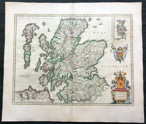
1646 Joan Blaeu Large Antique Map of Scotland - Scotia Regnum

1646 Joan Blaeu Large Antique Map of Scotland - Scotia Regnum

Description:
This large beautifully hand coloured original antique map of Scotland was published in the 1646 Dutch edition of Joan Blaeu's Atlas Novus.

General Description:
Paper thickness and quality: - Heavy
Paper color: - White
Age of map color: - Original
Colors used: - Yellow, pink, red, blue, green
General color appearance: - Authentic
Paper size: - 22 3/4in x 19 3/4in (580mm x 500mm)
Plate size: - 20in x 15 1/4in (510mm x 385mm)
Margins: - Min 1in (25mm)

Imperfections:
Margins: - None
Plate area: - None
Verso: - None

Background: When the Blaeu's  published Volume V - GB & Ireland - of Atlas Novus, Scotland became one of the best-mapped countries in the world. Volume V contained forty-eight plates showing forty-nine separate maps of Scotland (plus a map of Ptolemy British Isles and six maps of Ireland). The first two plates from the atlas show the entire country ancient and modern, whilst the remaining forty-six plates cover most Scotland in forty-seven regional maps. In total the regional maps locate some 20,000 different place names. A clue as to the reason for this extraordinary explosion of geographical information is to be found on thirty-six of the regional maps, which all carry engraved credits to Timothy Pont (1524-1606)
Pont was responsible for surveying the greater part of Scotland between 1583-1600, the resulting Pont Manuscript maps were never published but were put to good use some fifty to seventy years later by Robert Gordon and Joan Blaeu. (Ref: Koeman; Tooley; M&B)

$899.00 USD
More Info
1657 Joan Blaeu Antique Map of Kintyre Peninsula Western Scotland, Argyll & Bute

1657 Joan Blaeu Antique Map of Kintyre Peninsula Western Scotland, Argyll & Bute

Description:
This beautifully engraved hand coloured original antique map of the Kintyre Peninsula, located in the southwest of Argyll and Bute, Western Scotland was published in the 1657 Spanish edition of Joan Blaeu\'s Atlas Novus after the the famous Scottish Cartographer Timothy Pont (1524-1606)

When Blaeu published Volume five of his 1654 Atlas Novus of Scotland, became one of the best-mapped countries in the world. The volume contained forty-eight plates showing forty-nine separate maps of Scotland (plus a map of Ptolemy British Isles and six maps of Ireland). The first two plates from the atlas show the entire country ancient and modern, whilst the remaining forty-six plates cover most of Scotland in forty-seven regional maps. In total the regional maps locate some 20,000 different place names. A clue as to the reason for this extraordinary explosion of geographical information is to be found on thirty-six of the regional maps, which all carry engraved credits to Timothy Pont (1524-1606)
Pont was responsible for surveying the greater part of Scotland between 1583-1600, the resulting Pont Manuscript maps were never published but were put to good use some fifty to seventy years later by Robert Gordon and Joan Blaeu. (Ref: Koeman; Tooley; M&B)

General Definitions:
Paper thickness and quality: - Heavy and stable
Paper color : - off white
Age of map color: - Original
Colors used: - Blue, pink, red, green, yellow
General color appearance: - Authentic
Paper size: - 24in x 20 1/2in (610mm x 520mm)
Plate size: - 20in x 16 1/2in (510mm x 420mm)
Margins: - Min 1in (25mm)

Imperfections:
Margins: - Light age toning
Plate area: - Very light soiling
Verso: - Light showthrough

Background: 
Kintyre is a peninsula in western Scotland, in the southwest of Argyll and Bute. The peninsula stretches about 30 miles, from the Mull of Kintyre in the south to East Loch Tarbert in the north. The area immediately north of Kintyre is known as Knapdale.
In 1293, king John Balliol established shrieval authority by creating the post of sheriff of Kintyre. Shortly after, Robert de Bruys launched a civil war challenging John for the throne. By this point, Somerleds descendants had formed into three families - the MacRory, the MacDougalls, and the MacDonalds; the MacDougalls took John\'s side, while the MacDonalds and MacRory backed de Bruys. When de Bruys defeated John, he declared the MacDougall lands forfeit, and gave them to the MacDonalds.
The head of the MacDonald family married the heir of the MacRory family, thereby acquiring the remaining share of Somerleds realm, and transforming it into the Lordship of the Isles, which lasted for over a century. After 4 years and 3 children, however, he divorced Amy, and married Margaret, the daughter of Robert II, the Scottish king, who gave him the remaining parts of Kintyre, along with the whole of Knapdale, as a dowry.
In 1462, however, John, the then Lord of the Isles, plotted with the English king to conquer Scotland; civil war in England delayed the discovery of this for a decade. Upon the discovery, in 1475, there was a call for forfeiture, but a year John calmed the matter, by quitclaiming Ross (Easter, Wester, and Skye), Kintyre, and Knapdale, to Scotland.
At an unclear point before 1481, the sheriffdom of Kintyre became Tarbertshire, based at Tarbert at the northern edge of Kintyre; in that year, Tarbertshire was expanded to include Knapdale. However, comital authority remained absent following the quitclaim from the Lord of the Isles; following a law and order crisis in the region, king James IV of Scotland appointed Archibald Campbell, the Earl of Argyll as governor of Tarbert Castle, with implied authority over nearby castles such as Skipness.
Following the Scottish reformation, the MacDonalds (opponents) and Campbells (supporters) came into more direct dispute. In 1607, Following a series of hostile actions from the MacDonalds, King James VI ordered the lands they landlorded in Kintyre to be transferred to the Archibald Campbell, heir of the earlier Archibald. Under pressure from the Campbells, the sheriff court moved to Inveraray at the extreme northeast of Tarbertshire, near the heart of Campbell power; somewhat inevitably, in 1633 shrieval authority was annexed by the sheriff of Argyll.
Archibalds son, a dedicated supporter of the religious reformers, developed a plan to establish a large settlement, around the village of Kinlochkilkerran, at the south of Kintyre, composed of loyal Presbyterians from Lowland Scotland, in order to outnumber and undermine the local Catholic population, and reduce resistance to the states religious reforms. Under his son, Archibald, this became Campbeltown. Their actions also had the effect of diluting Gaelic culture, gradually replacing it with a lowlands one.
Comital powers were abolished by the Heritable Jurisdictions Act, leaving only the shrieval unit. In 1899, counties were formally created, on shrieval boundaries, by a Scottish Local Government Act; Kintyre therefore became part of the County of Argyll. Following late 20th century reforms, it is now within the wider region of Argyll and Bute.

Timothy Pont (c. 1565–1614) was a Scottish cartographer and topographer, the first to produce a detailed map of Scotland. Ponts maps are among the earliest surviving to show a European country in minute detail, from an actual survey.
He was the elder son of Robert Pont, a Presbyterian cleric and politician, by his first wife, Catherine, daughter of Masterton of Grange. He matriculated as student of St. Leonard\'s College, St. Andrews, in 1580, and obtained the degree of M.A. of St Andrews University in 1584. He spent the late 1580s and the 1590s travelling throughout Scotland, mapping the country. Between 1601 and 1610 he was the minister of Dunnet Parish Church in Caithness. He was continued 7 December 1610; but he resigned some time before 1614, when the name of William Smith appears as minister of the parish. On 25 July 1609 Pont was enrolled for a share of two thousand acres (8 km²) in connection with the scheme for the plantation of Ulster, the price being 400l.
Pont was an accomplished mathematician, and the first projector of a Scottish atlas. In connection with the project he made a complete survey of all the shires and islands of the kingdom, visiting remote districts, and making drawings on the spot. A contemporary described how Pont personally surveyed...and added such cursory observations on the monuments of antiquity...as were proper for the furnishing out of future descriptions. He died having almost completed his task.
The originals of his maps, which are preserved in the National Library of Scotland, Edinburgh, are characterised by neatness and accuracy. Ponts manuscript maps are key historical documents for their time, of importance in the fields of place-names, settlements, and other studies. Many of the maps have miniature drawings of major buildings (such as castles and abbeys), obviously sketched from life. Though on a small scale and not entirely accurate, these give an idea of the appearance of many buildings that have been altered or have disappeared completely.
James VI gave instructions that they should be purchased from his heirs and prepared for publication, but on account of the disorders of the time they were nearly forgotten. Sir John Scot of Scotstarvet prevailed on Robert Gordon of Straloch to undertake their revision with a view to publication. The task of revision was completed by Gordons son, James Gordon, parson of Rothiemay, and they were published in Joan Blaeus Atlas Novus, vol. v. Amsterdam, 1654 (reissued in 1662 in vol. vi). The ‘Topographical Account of the District of Cunninghame, Ayrshire, compiled about the Year 1600 by Mr. Timothy Pont,’ was published in 1850; and was reproduced under the title Cunninghame topographized, by Timothy Pont, A.M., 1604–1608; with Continuations and Illustrative Notices by the late James Dobie of Crummock, F.S.A. Scot., edited by his son, John Shedden Dobie, Glasgow, 1876. Robert Sibbald based much of his work on Ponts.

$275.00 USD
More Info