

Willem Blaeu (1571 - 1638) Joan Blaeu 1596-1673
Profile :
At the beginning of the seventeenth century Amsterdam was becoming one of the wealthiest trading cities in Europe, the base of the Dutch East India Company and a center of banking and the diamond trade, its people noted for their intellectual skills and splendid craftsmanship.
At this propitious time in the history of the Northern Provinces, Willem Janszoon Blaeu, who was born at Alkmaar in 1571 and trained in astronomy and the sciences by Tycho Brahe, the celebrated Danish astronomer, founded a business in Amsterdam in 1599 as a globe and instrument maker. It was not long before the business expanded, publishing maps, topographical works and books of sea charts as well as constructing globes. His most notable early work was a map of Holland (1604), a fine World Map (1605-06) and Het Licht der Zeevaerdt (The Light of Navigation), a marine atlas, which went through many editions in different languages and under a variety of titles. At the same time Blaeu was planning a major atlas intended to include the most up-to-date maps of the whole of the known world but progress on so vast a project was slow and not until he bought between 30 and 40 plates of the Mercator Atlas from Jodocus Hondius II to add to his own collection was he able to publish, in 1630, a 60-map volume with the title Atlantis Appendix. It was another five years before the first two volumes of his planned world atlas, Atlas Novus or the Theatrum Orbis Terrarum were issued. About this time he was appointed Hydrographer to the East India Company.
In 1638 Blaeu died and the business passed into the hands of his sons, Joan and Cornelis, who continued and expanded their father's ambitious plans. After the death of Cornelis, Joan directed the work alone and the whole series of 6 volumes was eventually completed about 1655. As soon as it was finished he began the preparation of the even larger work, the Atlas Major, which reached publication in 1662 in II volumes (later editions in 9-12 volumes) and contained nearly 6oo double-page maps and 3,000 pages of text. This was, and indeed remains, the most magnificent work of its kind ever produced; perhaps its geographical content was not as up-to-date or as accurate as its author could have wished, but any deficiencies in that direction were more than compensated for by the fine engraving and colouring, the elaborate cartouches and pictorial and heraldic detail and especially the splendid calligraphy.
In 1672 a disastrous fire destroyed Blaeu's printing house in the Gravenstraat and a year afterwards Joan Blaeu died. The firm's surviving stocks of plates and maps were gradually dispersed, some of the plates being bought by F. de Wit and Schenk and Valck, before final closure in about 1695.
It ought to be mentioned here that there is often confusion between the elder Blaeu and his rival Jan J ansson (Johannes Janssonius). Up to about 1619 Blaeu often signed his works Guilielmus Janssonius or Willems Jans Zoon but after that time he seems to have decided on Guilielmus or G. Blaeu.
Willem & Joan Blaeu (1)
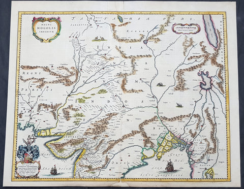
1640 Joan Blaeu Antique Map Mughal Empire of Northern India, Tibet, Nepal, Asia
- Title : Magni Mogolis Imperium
- Size: 22in x 18in (560mm x 465mm)
- Condition: (A) Very Good Condition
- Date : 1640
- Ref #: 42017
Description:
This original hand coloured copper plate engraved antique map of Mughal Empire of Northern India, Tibet, Nepal and central Asia was published by Joan Blaeu in the 1640 edition of Atlas Nouvs
General Definitions:
Paper thickness and quality: - Heavy and stable
Paper color : - off white
Age of map color: - Original
Colors used: - Blue, pink, red, green, yellow
General color appearance: - Authentic
Paper size: - 22in x 18in (560mm x 465mm)
Plate size: - 20 1/2in x 16 1/2in (515mm x 420mm)
Margins: - Min 1/2in (12mm)
Imperfections:
Margins: - Small section of bottom margin restored
Plate area: - Light creasing
Verso: - Centerfold re-enforced
Background:
This map centers on the Mughal capital of Agra, with the map covering, roughly, from Kabul to Orissa and Deccan, and from Persia to Bengal. It depicts the empire prior to the conquest of Orissa and Deccan, most likely during the reign of Shah Jahan, of Taj Mahal fame. Relief is shown pictorially. An elaborate title cartouche appears in the upper left quadrant. The map is embellished with images of tigers, elephants, caravans, and galleons.
There is much of interest. In particular, is the map detailed breakdown of the caravan network between Gujarat and Agra, between Agra and the desert outpost of Jaisalmer, and between Agra and the Silk Road center of Kabul. While the map does not show roads, for surely none as such existed at the time, it does show the network of towns, waystations and caravanserai built to support the bustling trade system.
The apocryphal Lake of Chiamay appears just north of the Bay of Bengal as the source of four important Southeast Asian river systems including the Irrawaddy, the Dharla, the Chao Phraya, and the Brahmaputra. The curious Lake of Chiamay (also called Chiam-may or Chian-may), roughly located in the area of Assam but sometimes as far north as Tibet and China, began to appear in maps of this region as early as the 16th century and persisted well into the mid 18th century. Its origins are unknown but may originate in a lost 16th century geography prepared by the Portuguese scholar Jao de Barros. It was speculated to be the source of five important Southeast Asian River systems and was mentioned in the journals of Sven Hedin. There are even records that the King of Siam led an invasionary force to take control of the lake in the 16th century. Nonetheless, the theory of Lake Chiamay was ultimately disproved and it disappeared from maps entirely by the 1760s.
There are two states of this map, the present example being the first state, first issued in 1638 by Henricus Hondius, and the second state a few years later in 1641 by Jan Jannson. With the exception of the signature imprint, the plates are identical. (Ref: Koeman; M&B)