Welcome to Classical Images!
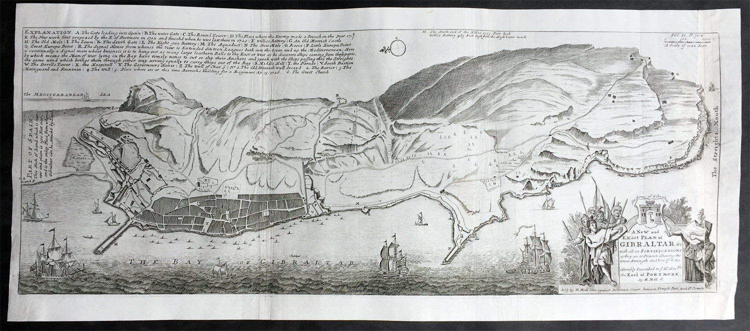
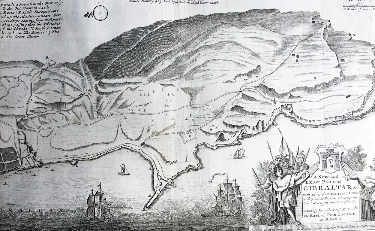
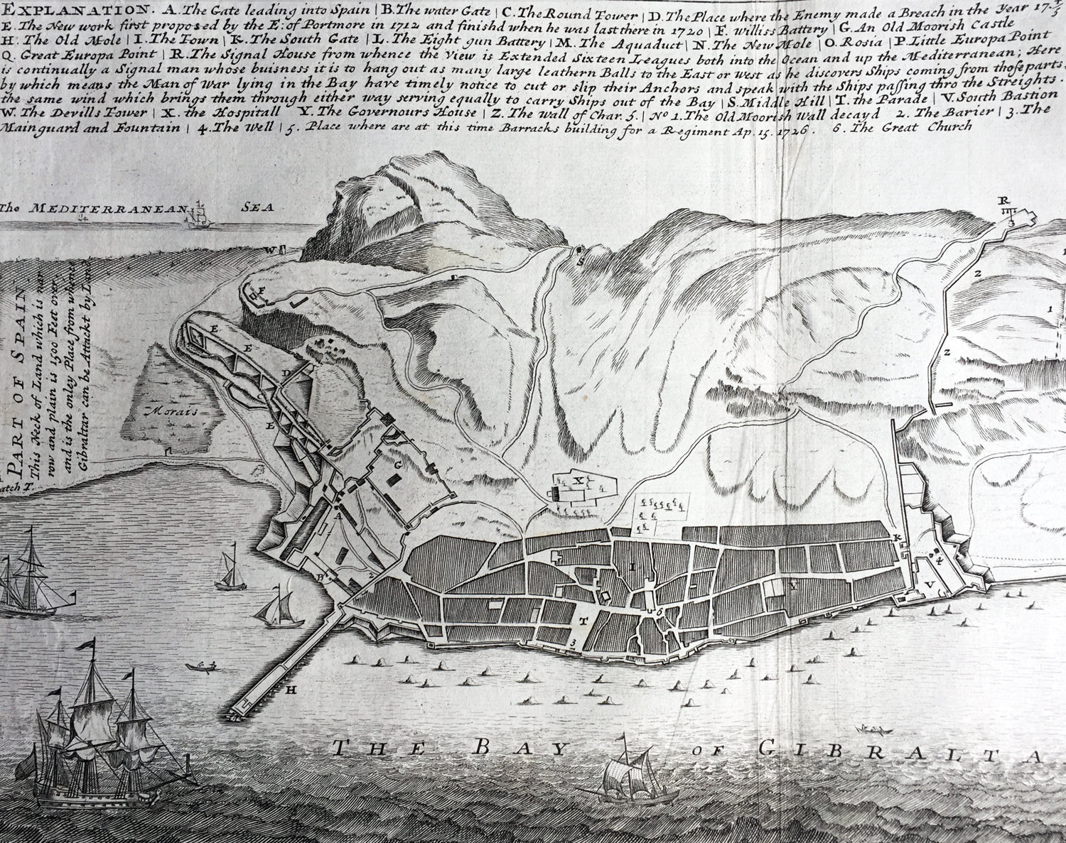
Description: This finely engraved original antique map and view of the second Spanish siege of Gibraltar by Herman Moll was published in 1727. Although undated, the legend at the top left of the map, gives an in-depth explanation to the map including no. 5 that refers to 'Place where at this time Barracks building for a Regiment Ap: 15. 1726. 6. The Great Church.', while the dedication is to David Colyear, 1st Earl of Portmore, Governor of Gibraltar. The plan was presumably engraved either in anticipation of, or during the second Spanish siege; Portmore was in England when the siege began, but sailed there with a relief force, arriving on 1st May, 1727. British command of the sea, coupled with the natural features of the Rock of Gibraltar on the landward side of the peninsula, combined to thwart Spanish ambition, and the siege petered to an end in 1728, with the garrison never seriously troubled. Background: Gibraltar became part of the Visigothic Kingdom of Hispania following the collapse of the Roman Empire and came under Muslim Moorish rule in 711 AD. It was permanently settled for the first time by the Moors and was renamed Jebel Tariq – the Mount of Tariq, later corrupted into Gibraltar. The Christian Crown of Castile annexed it in 1309, lost it again to the Moors in 1333 and finally regained it in 1462. Gibraltar became part of the unified Kingdom of Spain and remained under Spanish rule until 1704. It was captured during the War of the Spanish Succession by an Anglo-Dutch fleet in the name of Charles VI of Austria, the Habsburg contender to the Spanish throne. At the war's end, Spain ceded the territory to Britain under the terms of the Treaty of Utrecht of 1713.
Spain tried to regain control of Gibraltar, which Britain had declared a Crown colony, through military, diplomatic and economic pressure. Gibraltar was besieged and heavily bombarded during three wars between Britain and Spain but the attacks were repulsed on each occasion. By the end of the last siege, in the late 18th century, Gibraltar had faced fourteen sieges in 500 years. In the years after Trafalgar, Gibraltar became a major base in the Peninsular War. The colony grew rapidly during the 19th and early 20th centuries, becoming one of Britain's most important possessions in the Mediterranean. It was a key stopping point for vessels en route to India via the Suez Canal. A large British naval base was constructed there at great expense at the end of the 19th century and became the backbone of Gibraltar's economy.
British control of Gibraltar enabled the Allies to control the entrance to the Mediterranean during the Second World War. It was attacked on several occasions by German, Italian and Vichy French forces, though without causing much damage. The Spanish dictator General Francisco Franco declined to join a Nazi plan to occupy Gibraltar but revived Spain's claim to the territory after the war. As the territorial dispute intensified, Spain closed its border with Gibraltar between 1969 and 1985 and communications links were severed. Spain's position was supported by Latin American countries but was rejected by Britain and the Gibraltarians themselves, who vigorously asserted their right to self-determination. Discussions of Gibraltar's status have continued between Britain and Spain but have not reached any conclusion. Shortly after Gibraltar's recapture, King Henry IV of Castile declared it Crown property and reinstituted the special privileges which his predecessor had granted during the previous period of Christian rule. Four years after visiting Gibraltar in 1463, he was overthrown by the Spanish nobility and clergy. His half-brother Alfonso was declared king and rewarded Medina Sidonia for his support with the lordship of Gibraltar. The existing governor, a loyalist of the deposed Henry IV, refused to surrender Gibraltar to Medina Sidonia. After a fifteen-month siege from April 1466 to July 1467, Medina Sidonia took control of the town. He died the following year but his son Enrique was confirmed as lord of Gibraltar by the reinstated Henry IV in 1469. In 1474 the new Duke of Medina Sidonia sold Gibraltar to a group of Jewish conversos from Cordova and Seville led by Pedro de Herrera in exchange for maintaining the garrison of the town for two years, after which time the 4,350 conversos were expelled by the Duke. His status was further enhanced by Isabella I of Castile in 1478 with the granting of the Marquisate of Gibraltar. On 2 January 1492, after five years of war, the Moorish emirate in Spain came to an end with the Catholic Monarchs' capture of Granada. The Jews of Gibraltar were, like those elsewhere in the kingdom, expelled from Spain by order of the monarchs in March that year. Gibraltar was used by Medina Sidonia as a base for the Spanish capture of Melilla in North Africa in 1497. Two years later the Muslims of Granada were ordered to convert to Christianity or leave. Those that did not convert left for North Africa, some of them travelling via Gibraltar. Gibraltar became Crown property again in 1501 at the order of Isabella and the following year it received a new set of royal arms, which is still used by modern Gibraltar, replacing those of Medina Sidonia. In the Royal Warrant accompanying the arms, Isabella highlighted Gibraltar's importance as "the key between these our kingdoms in the Eastern and Western Seas [the Mediterranean and Atlantic]". The metaphor was represented on the royal arms by a golden key hanging from the front gate of a battlemented fortress. The warrant charged all future Spanish monarchs to "hold and retain the said City for themselves and in their own possession; and that no alienation of it, nor any part of it, nor its jurisdiction ... shall ever be made from the Crown of Castile." At this point in history, "Gibraltar" meant not just the peninsula but the entire surrounding area including the land on which the towns of La Línea de la Concepción, San Roque, Los Barrios and Algeciras now stand. To the east, Gibraltar was bounded by the Guadiaro River, and its northern boundaries lay in the vicinity of Castellar de la Frontera, Jimena de la Frontera, Alcalá de los Gazules, Medina-Sidonia and Tarifa. From the 16th century, the modern meaning of the name came to be adopted – specifically referring only to the town of Gibraltar and the peninsula on which it stands. Under Spanish Crown rule, the town of Gibraltar fell into severe decline. The end of Muslim rule in Spain and the Christian capture of the southern ports considerably decreased the peninsula's strategic value. It derived some minor economic value from tuna-fishing and wine-producing industries but its usefulness as a fortress was now limited. It was effectively reduced to the status of an unremarkable stronghold on a rocky promontory and Marbella replaced it as the principal Spanish port in the region. Gibraltar's inhospitable terrain made it an unpopular place to live. To boost the population, convicts from the kingdom of Granada were offered the possibility of serving their sentence in the Gibraltar garrison as an alternative to prison. Despite its apparent unattractiveness, Juan Alfonso de Guzmán, third Duke of Medina Sidonia, nonetheless sought to regain control of the town. In September 1506, following Isabella's death, he laid siege in the expectation that the gates would quickly be opened to his forces. This did not happen, and after a fruitless four-month blockade he gave up the attempt. Gibraltar received the title of "Most Loyal" from the Spanish crown in recognition of its faithfulness (Ref: M&B, Tooley)
General Description: Paper thickness and quality: - Heavy and stable Paper color: - off white Age of map color: - Colors used: - General color appearance: - Paper size: - 25in x 11in (635mm x 280mm) Plate size: - 25in x 11in (635mm x 280mm) Margins: - Min 1/4in (5mm) Imperfections: Margins: - None Plate area: - Small loss to the very right figure in the title cartouche not affecting the map, light creasing along folds as issued