
Herman Moll (1678 – 1732)
A Dutch emigre who came to London about 1680 following the Scanian Wars, he first worked as an engraver for Moses Pitt, later setting up his own business and becoming, after the turn of the century, the foremost map publisher in England.
As his fame grew he became a well known figure at in the group of Intelligencia who gathered at Jonathon's Coffee House in Exchange Alley or Change Alley. This narrow alleyway connecting shops and coffeehouses in an old neighbourhood of the City of London, served as a convenient shortcut from the Royal Exchange on Cornhill to the Post Office on Lombard Street. Shops once located in Exchange Alley included ship chandlers, makers of navigation instruments such as telescopes, and goldsmiths from Lombardy in Italy. The coffeehouses of Exchange Alley, especially Jonathan's and Garraway's, became an early venue for the lively trading of shares and commodities. Moll was able to obtain crucial information from the lively commercial scene in the area.
Moll was at the forefront of mapmaking during his working life and his maps reflect his ever inquisitive nature.
Herman Moll (8)
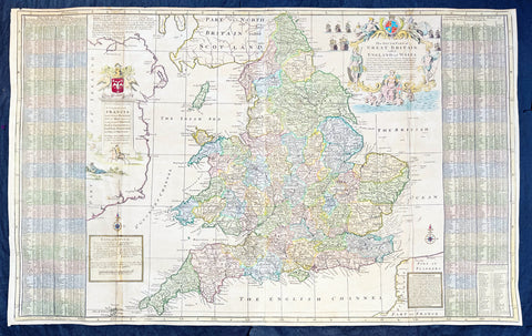
1710 Herman Moll Large Antique Map of England & Wales - Beautiful
Antique Map
- Title : The South Part of Great Britain called England & Wales...by Herman Moll 1710
- Size: 39in x 24in (1.0m x 610mm)
- Condition: (A) Very Good Condition
- Date : 1710
- Ref #: 80662
Description:
This large beautifully hand coloured original copper-plate engraved antique map of England & Wales was engraved in 1710 by Herman Moll - the date is engraved in the title cartouche - and was published by John Bowles of London.
Striking large format, one off published, map of England and Wales. The map is embellished with two large cartouches and an extensive table locating all ye Cities, Market Towns, Boroughs and whateve Places in South Britain have ye Election of Members of Parliament.
The map is elaborately colored by counties, with 5 sailing ships to the right of Northumberland. Includes a dedication to Right Honourable FRANCIS, Lord Viscount Rialton in the cartouche at the right side of the map.
General Definitions:
Paper thickness and quality: - Heavy and stable
Paper color : - off white
Age of map color: - Original
Colors used: - Yellow, green, blue, pink
General color appearance: - Authentic
Paper size: - 39in x 24in (1.0m x 610mm)
Plate size: - 38in x 23in (970mm x 585mm)
Margins: - Min 1/2in (12mm)
Imperfections:
Margins: - None
Plate area: - Light age toning along folds
Verso: - Repairs along folds
Background:
English Cartography: When considering the work of English map makers we tend, perhaps, to think too much in terms of county maps, dominated by the names of Saxton and Speed, but we should not underrate the contribution to the sum of geographical knowledge made in other spheres, such as the sea charts of Edward Wright, Robert Dudley and Greenvile Collins, the discoveries of James Cook, the road maps of Ogilby and Cary, the meteorological and magnetic charts compiled by Edmund Halley, to mention only a few.
In 1558 Queen Elizabeth came to the throne in the midst of a fast changing world. In 1563 a nineteen sheet map, copies of which survive only in manuscript form, was completed by Laurence Nowell, and no doubt, the issue of Mercators large-scale map of the British Isles in 1564 had an important influence on the thought of the period. A few years later a national survey was commissioned privately, although probably at the instigation of Lord Burghley, the Lord Treasurer, but subsequently was completed with royal encouragement. The outcome was Christopher Saxtons Atlas of EngIand and Wales, started about 1570 and published in 1579 - the first printed set of county maps and the first countrywide atlas on such a splendid scale produced anywhere. A Welsh antiquarian, Humphrey Lhuyd completed a set of surveys that were even more successful than Saxton in which he had produced fine manuscript maps of England and Wales which were used by Ortelius in editions of his Atlas from 1573 onwards.
The earliest maps of the 17th century, attributed to William Smith of the College of Heralds, covered only twelve counties based on Saxton/Norden and were presumably intended to be part of a complete new atlas. They were printed in the Low Countries in 1602-3 and were soon followed by maps for the Latin edition of Camdens Britannia dated 1607. In 1610-11 the first edition of John Speeds famous county Atlas The Theatre of the Empire of Great Britaine was published and immediately replaced Saxtons in popular appeal. Although Speed assembled much of his material from the earlier works of Saxton, Norden and others, a considerable part of the up-to-date information, especially relating to the inset town plans depicted on his maps, was obtained first hand. The maps undoubtedly owed much of their popularity to the splendid engravings of high quality made in the workshops in Amsterdam of Jodocus Hondius to whom Speed sent his manuscripts, the plates subsequently being returned to London for printing.
In 1645, Volume IV of the famous Blaeu World Atlas covering the counties of England and Wales was published in Amsterdam. These maps have always been esteemed as superb examples of engraving and design, the calligraphy being particularly splendid, but nevertheless they were nearly all based on Saxton and Speed and added little to geographical knowledge.
Not until the latter part of the century do we find an English map maker of originality with the capacity to put new ideas into practice. John Ogilby, one of the more colourful figures associated with cartography, started life as a dancing master and finished as Kings Cosmographer and Geographic Printer. After publishing a small number of county maps, somewhat on the lines of John Norden he issued in 1675 the Britannia, the first practical series of detailed maps of the post roads of England and Wales on a standard scale of 1,760 yards to the mile. Up to the end of the century and beyond, reprints and revisions of Saxtons and Speeds atlases continued to appear and the only other noteworthy county maps were Richard Blomes Britannia (1673), John Overtons Atlas (c. 1670) and Robert Mordens maps for an English translation of Camdens Britannia published in 1695.
Another noted cartographer of the day was Captain Greenvile Collins, and of his work in surveying the coasts of Great Britain culminating in the issue in 1693 of the Great Britains Coasting Pilot. Apart from these charts, English cartographers published during the century a number of world atlases. Speed was the first Englishman to produce a world atlas with the issue in 1627 of his A Prospect of the Most Famous Parts of the World. Other atlases appeared later in the century by Peter Heylin, John Seller, William Berry, Moses Pitt and Richard Blome, whilst Ogilby found time to issue maps of Africa, America and Asia. Far more important, from the purely scientific point of view, was the work of Edmund Halley, Astronomer Royal, who compiled and issued meteorological and magnetic charts in 1688 and 1701 respectively.
At the beginning of the eighteenth century the Dutch map trade was finally in decline, the French in the ascendant and the English to a great extent still dominated by Saxton and Speed except, as we have shown, in the spheres of sea charts and road maps. There were atlases by John Senex, the Bowles family, Emanuel and Thomas Bowen, Thomas Badeslade and the unique birds-eye perspective views of the counties, The British Monarchy by George Bickham. In 1750-60 Bowen and Kitchins The Large English Atlas containing maps on a rather larger scale than hitherto was published.
In 1759 the Society for the encouragement of Arts, Manufactures and Commerce offered an award of £100 for the best original surveys on this scale and by the end of the century about thirty counties had been re-surveyed. These maps, many of which formed, in later years, the basis for the first issues of county maps by the Ordnance Survey Office were not only decorative but a tremendous improvement geographically on earlier local maps. As a consequence, the skills and expertise of the new-style cartographers soon enabled them to cover the world as well as the domestic market. Thomas Jefferys was such a man; he was responsible for a number of the new 1 in. to 1 mile county surveys and he issued an edition of Saxtons much battered 200-year-old plates of the county maps, but he is better known for many fine maps of North America and the West Indies. His work was continued on the same lines by William Faden, trading as Faden and Jefferys. Other publishers such as Sayer and Bennett and their successors Laurie and Whittle published a prodigious range of maps, charts and atlases in the second half of the century. A major influence at this time was John Cary who, apart from organizing the first re-survey of post roads since Ogilby and subsequently printing the noted Travellers Companion, was a prolific publisher of atlases and maps of every kind of all parts of the world. After starting work with Cary, and taking part in the new road survey, Aaron Arrowsmith set up in his own business and went on to issue splendid large-scale maps of many parts of the world. Both Carys and Arrowsmiths plates were used by other publishers until far into the next century and, in turn, their work was taken up and developed by James Wyld (Elder and Younger) and Tallis and Co.
Later into the 19th century some of the better known cartographers and publishers were by Henry Teesdale (1829-30), Christopher and John Greenwood, surveyors, Thomas Moule, a writer on heraldry and antiques (1830-36) and John Walker (1837) but by about the middle of the century few small-scale publishers survived and their business passed into the hands of large commercial concerns such as Bartholomews of Edinburgh and Philips of London who continue to this day. (Ref: Shirley; Tooley; M&B)
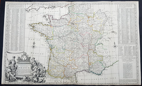
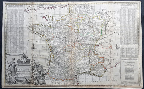
1720 Herman Moll Large Antique Map of France in Provinces - Pre Revolution
Antique Map
- Title : A New and Exact Map of France Divided into all its Provinces...by H Moll Geographer
- Ref #: 93416
- Size: 40in x 24 1/2in (1.010m x 625mm)
- Date : 1720
- Condition: (A+) Fine Condition
Description:
This very large beautifully hand coloured original copper-plate engraved antique map of France by Herman Moll was published in 1720 in the atlas The World Described, or a New and Correct Sett of Maps by John Bowles, Thomas Bowles, Philip Overton & John King of London.
In the 18th century many large-scale maps were published by the likes of John Senex and Herman Moll, this trend continued until the end of private mapping in the early 19th century when it was replaced by Ordnance Survey maps.
General Definitions:
Paper thickness and quality: - Heavy and stable
Paper color : - off white
Age of map color: - Early
Colors used: - Yellow, green, blue, pink
General color appearance: - Authentic
Paper size: - 40in x 24 1/2in (1.010m x 625mm)
Plate size: - 39 1/2in x 24in (1.00m x 620mm)
Margins: - Min 1/8in (3mm)
Imperfections:
Margins: - Bottom margin cropped to plate mark
Plate area: - Folds as issued
Verso: - Folds as issued
Background:
The Carolingian dynasty ruled France until 987, when Hugh Capet, Duke of France and Count of Paris, was crowned King of the Franks. His descendants—the Capetians, the House of Valois, and the House of Bourbon—progressively unified the country through wars and dynastic inheritance into the Kingdom of France, which was fully declared in 1190 by Philip II Augustus. The French nobility played a prominent role in most Crusades in order to restore Christian access to the Holy Land. French knights made up the bulk of the steady flow of reinforcements throughout the two-hundred-year span of the Crusades, in such a fashion that the Arabs uniformly referred to the crusaders as Franj caring little whether they really came from France. The French Crusaders also imported the French language into the Levant, making French the base of the lingua franca (litt. Frankish language) of the Crusader states. French knights also made up the majority in both the Hospital and the Temple orders. The latter, in particular, held numerous properties throughout France and by the 13th century were the principal bankers for the French crown, until Philip IV annihilated the order in 1307. The Albigensian Crusade was launched in 1209 to eliminate the heretical Cathars in the southwestern area of modern-day France. In the end, the Cathars were exterminated and the autonomous County of Toulouse was annexed into the crown lands of France. Later kings expanded their domain to cover over half of modern continental France, including most of the north, centre and west of France. Meanwhile, the royal authority became more and more assertive, centred on a hierarchically conceived society distinguishing nobility, clergy, and commoners.
From the 11th century, the House of Plantagenet, the rulers of the County of Anjou, succeeded in establishing its dominion over the surrounding provinces of Maine and Touraine, then progressively built an empire that spanned from England to the Pyrenees and covering half of modern France. Tensions between the kingdom of France and the Plantagenet empire would last a hundred years, until Philip Augustus of France conquered between 1202 and 1214 most of the continental possessions of the empire, leaving England and Aquitaine to the Plantagenets. Following the Battle of Bouvines, the Angevin court retreated to England, but persistent Capetian–Plantagenet rivalry would paved the way for another conflict.
Charles IV the Fair died without an heir in 1328. Under the rules of the Salic law the crown of France could not pass to a woman nor could the line of kingship pass through the female line. Accordingly, the crown passed to Philip of Valois, a cousin of Charles, rather than through the female line to Charles nephew, Edward of Plantagenet, who would soon become Edward III of England. During the reign of Philip of Valois, the French monarchy reached the height of its medieval power. Philips seat on the throne was contested by Edward III of England and in 1337, on the eve of the first wave of the Black Death, England and France went to war in what would become known as the Hundred Years War. The exact boundaries changed greatly with time, but French landholdings of the English Kings remained extensive for decades. With charismatic leaders, such as Joan of Arc and La Hire, strong French counterattacks won back English continental territories. Like the rest of Europe, France was struck by the Black Death; half of the 17 million population of France died.
The French Renaissance saw a spectacular cultural development and the first standardisation of the French language, which would become the official language of France and the language of Europes aristocracy. It also saw a long set of wars, known as the Italian Wars, between France and the House of Habsburg. French explorers, such as Jacques Cartier or Samuel de Champlain, claimed lands in the Americas for France, paving the way for the expansion of the First French colonial empire. The rise of Protestantism in Europe led France to a civil war known as the French Wars of Religion, where, in the most notorious incident, thousands of Huguenots were murdered in the St. Bartholomews Day massacre of 1572. The Wars of Religion were ended by Henry IVs Edict of Nantes, which granted some freedom of religion to the Huguenots. Spanish troops, the terror of Western Europe, assisted the Catholic side during the Wars of Religion in 1589–1594, and invaded northern France in 1597; after some skirmishing in the 1620s and 1630s, Spain and France returned to all-out war between 1635 and 1659. The war cost France 300,000 casualties.
Under Louis XIII, the energetic Cardinal Richelieu promoted the centralisation of the state and reinforced the royal power by disarming domestic power holders in the 1620s. He systematically destroyed castles of defiant lords and denounced the use of private violence (dueling, carrying weapons, and maintaining private army). By the end of 1620s, Richelieu established the royal monopoly of force as the doctrine. During Louis XIVs minority and the regency of Queen Anne and Cardinal Mazarin, a period of trouble known as the Fronde occurred in France. This rebellion was driven by the great feudal lords and sovereign courts as a reaction to the rise of royal absolute power in France.
The monarchy reached its peak during the 17th century and the reign of Louis XIV. By turning powerful feudal lords into courtiers at the Palace of Versailles, Louis XIVs personal power became unchallenged. Remembered for his numerous wars, he made France the leading European power. France became the most populous country in Europe and had tremendous influence over European politics, economy, and culture. French became the most-used language in diplomacy, science, literature and international affairs, and remained so until the 20th century. France obtained many overseas possessions in the Americas, Africa and Asia. Louis XIV also revoked the Edict of Nantes, forcing thousands of Huguenots into exile.
Under Louis XV, Louis XIVs great-grandson, France lost New France and most of its Indian possessions after its defeat in the Seven Years War (1756–63). Its European territory kept growing, however, with notable acquisitions such as Lorraine (1766) and Corsica (1770). An unpopular king, Louis XVs weak rule, his ill-advised financial, political and military decisions – as well as the debauchery of his court– discredited the monarchy, which arguably paved the way for the French Revolution 15 years after his death.
Louis XVI, Louis XVs grandson, actively supported the Americans, who were seeking their independence from Great Britain (realised in the Treaty of Paris (1783)). The financial crisis aggravated by Frances involvement in the American Revolutionary War was one of many contributing factors to the French Revolution. Much of the Enlightenment occurred in French intellectual circles, and major scientific breakthroughs and inventions, such as the discovery of oxygen (1778) and the first hot air balloon carrying passengers (1783), were achieved by French scientists. French explorers, such as Bougainville and Lapérouse, took part in the voyages of scientific exploration through maritime expeditions around the globe. The Enlightenment philosophy, in which reason is advocated as the primary source for legitimacy and authority, undermined the power of and support for the monarchy and helped pave the way for the French Revolution.
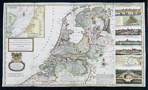
1720 Herman Moll Large Antique Map of The Netherlands - 7 x Town Plans Amsterdam
Antique Map
- Title : A New and Exact Map of the United Provinces, or Netherlands &c. According to the Newest and Most Exact Observations by Herman Moll Geographer
- Size: 41in x 25in (1.04m x 635mm)
- Condition: (A+) Fine Condition
- Date : 1720
- Ref #: 93007
Description:
This very large beautifully hand coloured original copper-plate engraved antique map of The Netherlands by Herman Moll was published in 1720 in the atlas The World Described, or a New and Correct Sett of Maps by John Bowles, Thomas Bowles, Philip Overton & John King of London.
In the 18th century many large-scale maps were published by the likes of John Senex and Herman Moll, this trend continued until the end of private mapping in the early 19th century when it was replaced by Ordnance Survey maps.
General Definitions:
Paper thickness and quality: - Heavy and stable
Paper color : - off white
Age of map color: - Original & later
Colors used: - Blue, pink, red, green, yellow
General color appearance: - Authentic
Paper size: - 41in x 25in (1.02m x 635mm)
Plate size: - 39 1/4in x 24 1/2in (1.00m x 610mm)
Margins: - Min 1/4in (5mm)
Imperfections:
Margins: - Light age toning
Plate area: - Folds as issued
Verso: - Backed onto contemporary paper
Background:
An attractive, large scale map of The Netherlands or the United Provinces by the highly regarded cartographer and engraver Herman Moll. on the right-hand side views of Amsterdam, Rotterdam, Middelburg, Utrecht, Groningen, Het Loo Palace and a plan of the ancient Roman Castle at the mouth of the Rhine river Arx Britannica (Huis Britten, Brittenberg). The upper left corner of the map has an inset map of the coasts, sands and banks of the North Sea, the stretch of water that lies between England and The Netherlands. Moll dedicates his map to ‘The Right Hon Charles Lord Viscount of Townsend &c one of his Majesty’s Principal Secretaries of State’
This magnificent map was printed by John Bowles of Cornhill, London and published in Moll’s 1719 New and Complete Atlas, but it may also have been separately issued earlier. Moll came to London probably from Bremen around 1678 and by 1688 he had his own shop in Vanley\'s Court in London\'s Blackfriars, between 1691 and 1710 at the corner of Spring Gardens and Charing Cross, when he moved to Beech Street where he remained until his death. In 1701 he published his first work A System of Geography. He was publishing atlases and separately issued maps, and from 1710 was also known as a maker of pocket globes. (Ref: Tooley, Koeman, M&B)
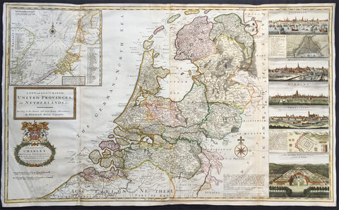
1720 Herman Moll Large Antique Map of The Netherlands - Holland, VII Provinces
- Title : A New and Exact Map of the United Provinces, or Netherlands &c. According to the Newest and Most Exact Observations by Herman Moll Geographer
- Ref #: 35090
- Size: 41in x 25in (1.04m x 635mm)
- Date : 1720
- Condition: (A+) Fine Condition
Description:
This very large beautifully hand coloured original antique map* of The Netherlands by Herman Moll was published in 1720 in the atlas The World Described, or a New and Correct Sett of Maps by John Bowles, Thomas Bowles, Philip Overton & John King of London.
In the 18th century many large-scale maps were published by the likes of John Senex and Herman Moll, this trend continued until the end of private mapping in the early 19th century when it was replaced by Ordnance Survey maps.
Background: An attractive, large scale map of The Netherlands or the United Provinces by the highly regarded cartographer and engraver Herman Moll. on the right-hand side views of Amsterdam, Rotterdam, Middelburg, Utrecht, Groningen, Het Loo Palace and a plan of the ancient Roman Castle at the mouth of the Rhine river Arx Britannica (Huis Britten, Brittenberg). The upper left corner of the map has an inset map of the coasts, sands and banks of the North Sea, the stretch of water that lies between England and The Netherlands. Moll dedicates his map to ‘The Right Hon Charles Lord Viscount of Townsend &c one of his Majesty’s Principal Secretaries of State’
This magnificent map was printed by John Bowles of Cornhill, London and published in Moll’s 1719 New and Complete Atlas, but it may also have been separately issued earlier. Moll came to London probably from Bremen around 1678 and by 1688 he had his own shop in Vanley's Court in London's Blackfriars, between 1691 and 1710 at the corner of Spring Gardens and Charing Cross, when he moved to Beech Street where he remained until his death. In 1701 he published his first work A System of Geography. He was publishing atlases and separately issued maps, and from 1710 was also known as a maker of pocket globes. (Ref: Tooley, Koeman, M&B)
General Description:
Paper thickness and quality: - Heavy and stable
Paper color: - off white
Age of map color: - Original & later
Colors used: - Pink, yellow, green
General color appearance: - Original
Paper size: - 41in x 25in (1.04m x 635mm)
Plate size: - 39 1/4in x 24 1/2in (1.00m x 625mm)
Margins: - Min 1/2in (10mm)
Imperfections:
Margins: - Light creasing
Plate area: - Re-joined folds as issued, small repair in top L&R folds, no loss
Verso: - Re-enforced along folds
1720 Herman Moll Large Antique Pre Revolutionary Map of France in Provinces
Antique Map
- Title : A New and Exact Map of France Divided into all its Provinces...by H Moll Geographer
- Size: 39 1/2in x 25in (1.00m x 630mm)
- Condition: (A) Very Good Condition
- Date : 1720
- Ref #: 43196
Description:
This very large beautifully hand coloured original copper-plate engraved antique map of France by Herman Moll was published in 1720 in the atlas The World Described, or a New and Correct Sett of Maps by John Bowles, Thomas Bowles, Philip Overton & John King of London.
In the 18th century many large-scale maps were published by the likes of John Senex and Herman Moll, this trend continued until the end of private mapping in the early 19th century when it was replaced by Ordnance Survey maps.
General Definitions:
Paper thickness and quality: - Heavy and stable
Paper color : - off white
Age of map color: - Original
Colors used: - Yellow, green, blue, pink
General color appearance: - Authentic
Paper size: - 39 1/2in x 25in (1.00m x 630mm)
Plate size: - 39 1/2in x 25in (1.00m x 630mm)
Margins: - Min 1/2in (12mm)
Imperfections:
Margins: - Age toning, bottom margin extended from plate-mark
Plate area: - Light age toning along folds
Verso: - Re-enforced along folds
Background:
The Carolingian dynasty ruled France until 987, when Hugh Capet, Duke of France and Count of Paris, was crowned King of the Franks. His descendants—the Capetians, the House of Valois, and the House of Bourbon—progressively unified the country through wars and dynastic inheritance into the Kingdom of France, which was fully declared in 1190 by Philip II Augustus. The French nobility played a prominent role in most Crusades in order to restore Christian access to the Holy Land. French knights made up the bulk of the steady flow of reinforcements throughout the two-hundred-year span of the Crusades, in such a fashion that the Arabs uniformly referred to the crusaders as Franj caring little whether they really came from France. The French Crusaders also imported the French language into the Levant, making French the base of the lingua franca (litt. Frankish language) of the Crusader states. French knights also made up the majority in both the Hospital and the Temple orders. The latter, in particular, held numerous properties throughout France and by the 13th century were the principal bankers for the French crown, until Philip IV annihilated the order in 1307. The Albigensian Crusade was launched in 1209 to eliminate the heretical Cathars in the southwestern area of modern-day France. In the end, the Cathars were exterminated and the autonomous County of Toulouse was annexed into the crown lands of France. Later kings expanded their domain to cover over half of modern continental France, including most of the north, centre and west of France. Meanwhile, the royal authority became more and more assertive, centred on a hierarchically conceived society distinguishing nobility, clergy, and commoners.
From the 11th century, the House of Plantagenet, the rulers of the County of Anjou, succeeded in establishing its dominion over the surrounding provinces of Maine and Touraine, then progressively built an empire that spanned from England to the Pyrenees and covering half of modern France. Tensions between the kingdom of France and the Plantagenet empire would last a hundred years, until Philip Augustus of France conquered between 1202 and 1214 most of the continental possessions of the empire, leaving England and Aquitaine to the Plantagenets. Following the Battle of Bouvines, the Angevin court retreated to England, but persistent Capetian–Plantagenet rivalry would paved the way for another conflict.
Charles IV the Fair died without an heir in 1328. Under the rules of the Salic law the crown of France could not pass to a woman nor could the line of kingship pass through the female line. Accordingly, the crown passed to Philip of Valois, a cousin of Charles, rather than through the female line to Charles nephew, Edward of Plantagenet, who would soon become Edward III of England. During the reign of Philip of Valois, the French monarchy reached the height of its medieval power. Philips seat on the throne was contested by Edward III of England and in 1337, on the eve of the first wave of the Black Death, England and France went to war in what would become known as the Hundred Years War. The exact boundaries changed greatly with time, but French landholdings of the English Kings remained extensive for decades. With charismatic leaders, such as Joan of Arc and La Hire, strong French counterattacks won back English continental territories. Like the rest of Europe, France was struck by the Black Death; half of the 17 million population of France died.
The French Renaissance saw a spectacular cultural development and the first standardisation of the French language, which would become the official language of France and the language of Europes aristocracy. It also saw a long set of wars, known as the Italian Wars, between France and the House of Habsburg. French explorers, such as Jacques Cartier or Samuel de Champlain, claimed lands in the Americas for France, paving the way for the expansion of the First French colonial empire. The rise of Protestantism in Europe led France to a civil war known as the French Wars of Religion, where, in the most notorious incident, thousands of Huguenots were murdered in the St. Bartholomews Day massacre of 1572. The Wars of Religion were ended by Henry IVs Edict of Nantes, which granted some freedom of religion to the Huguenots. Spanish troops, the terror of Western Europe, assisted the Catholic side during the Wars of Religion in 1589–1594, and invaded northern France in 1597; after some skirmishing in the 1620s and 1630s, Spain and France returned to all-out war between 1635 and 1659. The war cost France 300,000 casualties.
Under Louis XIII, the energetic Cardinal Richelieu promoted the centralisation of the state and reinforced the royal power by disarming domestic power holders in the 1620s. He systematically destroyed castles of defiant lords and denounced the use of private violence (dueling, carrying weapons, and maintaining private army). By the end of 1620s, Richelieu established the royal monopoly of force as the doctrine. During Louis XIVs minority and the regency of Queen Anne and Cardinal Mazarin, a period of trouble known as the Fronde occurred in France. This rebellion was driven by the great feudal lords and sovereign courts as a reaction to the rise of royal absolute power in France.
The monarchy reached its peak during the 17th century and the reign of Louis XIV. By turning powerful feudal lords into courtiers at the Palace of Versailles, Louis XIVs personal power became unchallenged. Remembered for his numerous wars, he made France the leading European power. France became the most populous country in Europe and had tremendous influence over European politics, economy, and culture. French became the most-used language in diplomacy, science, literature and international affairs, and remained so until the 20th century. France obtained many overseas possessions in the Americas, Africa and Asia. Louis XIV also revoked the Edict of Nantes, forcing thousands of Huguenots into exile.
Under Louis XV, Louis XIVs great-grandson, France lost New France and most of its Indian possessions after its defeat in the Seven Years War (1756–63). Its European territory kept growing, however, with notable acquisitions such as Lorraine (1766) and Corsica (1770). An unpopular king, Louis XVs weak rule, his ill-advised financial, political and military decisions – as well as the debauchery of his court– discredited the monarchy, which arguably paved the way for the French Revolution 15 years after his death.
Louis XVI, Louis XVs grandson, actively supported the Americans, who were seeking their independence from Great Britain (realised in the Treaty of Paris (1783)). The financial crisis aggravated by Frances involvement in the American Revolutionary War was one of many contributing factors to the French Revolution. Much of the Enlightenment occurred in French intellectual circles, and major scientific breakthroughs and inventions, such as the discovery of oxygen (1778) and the first hot air balloon carrying passengers (1783), were achieved by French scientists. French explorers, such as Bougainville and Lapérouse, took part in the voyages of scientific exploration through maritime expeditions around the globe. The Enlightenment philosophy, in which reason is advocated as the primary source for legitimacy and authority, undermined the power of and support for the monarchy and helped pave the way for the French Revolution.
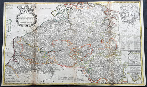
1720 Moll Large Antique Map of The Low Countries, Flanders Netherlands & Belgium
- Title : Les Provinces Des Pays-Bas Catholoiques ou. A Most excat map of Flanders or Austraian Netherlands.....Herman Moll Geogr.
- Size: 40 1/2in x 24in (1.030m x 610mm)
- Condition: (A) Very Good Condition
- Date : 1720
- Ref #: 61130
Description:
This very large beautifully hand coloured original copper-plate engraved antique map of the low country of Flanders region of The Netherlands & Belgium by Herman Moll was published in 1720 in the atlas The World Described, or a New and Correct Sett of Maps by John Bowles, Thomas Bowles, Philip Overton & John King of London.
In the 18th century many large-scale maps were published by the likes of John Senex and Herman Moll, this trend continued until the end of private mapping in the early 19th century when it was replaced by Ordnance Survey maps.
General Definitions:
Paper thickness and quality: - Heavy and stable
Paper color : - off white
Age of map color: - Original
Colors used: - Yellow, green, blue, pink
General color appearance: - Authentic
Paper size: - 40 1/2in x 24in (1.030m x 610mm)
Plate size: - 40in x 24in (1.00m x 610mm)
Margins: - Min 1/2in (12mm)
Imperfections:
Margins: - Age toning along top margin
Plate area: - Age toning along folds
Verso: - Re-enforced & age toning along folds
Background:
Flanders: In 1500, Charles V was born in Ghent. He inherited the Seventeen Provinces (1506), Spain (1516) with its colonies and in 1519 was elected Holy Roman Emperor. The Pragmatic Sanction of 1549, issued by Charles V, established the Low Countries as the Seventeen Provinces (or Spanish Netherlands in its broad sense) as an entity separate from the Holy Roman Empire and from France. In 1556 Charles V abdicated due to ill health (he suffered from crippling gout). Spain and the Seventeen Provinces went to his son, king Philip II of Spain.
Over the first half of the 16th century Antwerp grew to become the second-largest European city north of the Alps by 1560. Antwerp was the richest city in Europe at this time. According to Luc-Normand Tellier It is estimated that the port of Antwerp was earning the Spanish crown seven times more revenues than the Americas.
Meanwhile, Protestantism had reached the Low Countries. Among the wealthy traders of Antwerp, the Lutheran beliefs of the German Hanseatic traders found appeal, perhaps partly for economic reasons. The spread of Protestantism in this city was aided by the presence of an Augustinian cloister (founded 1514) in the St. Andries quarter. Luther, an Augustinian himself, had taught some of the monks, and his works were in print by 1518. The first Lutheran martyrs came from Antwerp. The Reformation resulted in consecutive but overlapping waves of reform: a Lutheran, followed by a militant Anabaptist, then a Mennonite, and finally a Calvinistic movement. These movements existed independently of each other.
Philip II, a devout Catholic and self-proclaimed protector of the Counter-Reformation, suppressed Calvinism in Flanders, Brabant and Holland (what is now approximately Belgian Limburg was part of the Bishopric of Liège and was Catholic de facto). In 1566, the wave of iconoclasm known as the Beeldenstorm was a prelude to religious war between Catholics and Protestants, especially the Anabaptists. The Beeldenstorm started in what is now French Flanders, with open-air sermons (Dutch: hagepreken) that spread through the Low Countries, first to Antwerp and Ghent, and from there further east and north. In total it lasted not even a month.
Subsequently, Philip II sent the Duke of Alba to the Provinces to repress the revolt. Alba recaptured the southern part of the Provinces, who signed the Union of Atrecht, which meant that they would accept the Spanish government on condition of more freedom. But the northern part of the provinces signed the Union of Utrecht and settled in 1581 the Republic of the Seven United Netherlands. Spanish troops quickly started fighting the rebels, but before the revolt could be completely defeated, a war between England and Spain had broken out, forcing Philips Spanish troops to halt their advance. Meanwhile, the Spanish armies had already conquered the important trading cities of Bruges and Ghent. Antwerp, which was then the most important port in the world, also had to be conquered. On 17 August 1585, Antwerp fell. This ended the Eighty Years War for the (from now on) Southern Netherlands. The United Provinces (the Northern Netherlands) fought on until 1648 – the Peace of Westphalia.
While Spain was at war with England, the rebels from the north, strengthened by refugees from the south, started a campaign to reclaim areas lost to Philip IIs Spanish troops. They managed to conquer a considerable part of Brabant (the later Noord-Brabant of the Netherlands), and the south bank of the Scheldt estuary (Zeelandic Flanders), before being stopped by Spanish troops. The front line at the end of this war stabilized and became the current border between present-day Belgium and the Netherlands. The Dutch (as they later became known) had managed to reclaim enough of Spanish-controlled Flanders to close off the river Scheldt, effectively cutting Antwerp off from its trade routes.
First the fall of Antwerp to the Spanish and later also the closing of the Scheldt were causes of a considerable emigration of Antverpians. Many of the Calvinist merchants of Antwerp and also of other Flemish cities left Flanders and emigrated to the north. A large number of them settled in Amsterdam, which was at the time a smaller port, of significance only in the Baltic trade. In the following years Amsterdam was rapidly transformed into one of the worlds most important ports. Because of the contribution of the Flemish exiles to this transformation, the exodus is sometimes described as creating a new Antwerp.
Flanders and Brabant, due to these events, went into a period of relative decline from the time of the Thirty Years War. In the Northern Netherlands however, the mass emigration from Flanders and Brabant became an important driving force behind the Dutch Golden Age.
Although arts remained at a relatively impressive level for another century with Peter Paul Rubens (1577–1640) and Anthony van Dyck, Flanders experienced a loss of its former economic and intellectual power under Spanish, Austrian, and French rule, with heavy taxation and rigid imperial political control compounding the effects of industrial stagnation and Spanish-Dutch and Franco-Austrian conflict. The Southern Netherlands suffered severely under the War of the Spanish Succession, but under the reign of Empress Maria-Theresia these lands economically flourished again. Influenced by the Enlightenment, the Austrian Emperor Joseph II was the first sovereign who had been in the Southern Netherlands since King Philip II of Spain left them in 1559.
In 1794 the French Republican Army started using Antwerp as the northernmost naval port of France, which country officially annexed Flanders the following year as the départements of Lys, Escaut, Deux-Nèthes, Meuse-Inférieure and Dyle. Obligatory (French) army service for all men aged 16–25 was one of the main reasons for the peoples uprising against the French in 1798, known as the Boerenkrijg (Peasants War), with the heaviest fighting in the Campine area.
After the defeat of Napoleon Bonaparte at the 1815 Battle of Waterloo in Waterloo, Brabant, sovereignty over the Austrian Netherlands – Belgium minus the East Cantons and Luxembourg – was given by the Congress of Vienna (1815) to the United Netherlands (Dutch: Verenigde Nederlanden), the state that briefly existed under Sovereign Prince William I of Orange Nassau, the latter King William I of the United Kingdom of the Netherlands, after the French Empire was driven out of the Dutch territories. The United Kingdom of the Netherlands was born. The Protestant King of the Netherlands, William I rapidly started the industrialisation of the southern parts of the Kingdom. The political system that was set up however, slowly but surely failed to forge a true union between the northern and the southern parts of the Kingdom. The southern bourgeoisie mainly was Roman Catholic, in contrast to the mainly Protestant north; large parts of the southern bourgeoisie also primarily spoke French rather than Dutch.
In 1815 the Dutch Senate was reinstated (Dutch: Eerste Kamer der Staaten Generaal). The nobility, mainly coming from the south, became more and more estranged from their northern colleagues. Resentment grew both between the Roman Catholics from the south and the Protestants from the north and among the powerful liberal bourgeoisie from the south and their more moderate colleagues from the north. On 25 August 1830 (after the showing of the opera La Muette de Portici of Daniel Auber in Brussels) the Belgian Revolution sparked off and became a fact. On 4 October 1830, the Provisional Government (Dutch: Voorlopig Bewind) proclaimed the independence, which was later confirmed by the National Congress that issued a new Liberal Constitution and declared the new state a Constitutional Monarchy, under the House of Saxe-Coburg. Flanders now became part of the Kingdom of Belgium, which was recognized by the major European Powers on 20 January 1831. The de facto dissidence was finally recognized by the United Kingdom of the Netherlands on 19 April 1839.
In 1830, the Belgian Revolution led to the splitting up of the two countries. Belgium was confirmed as an independent state by the Treaty of London of 1839, but deprived of the eastern half of Limburg (now Dutch Limburg), and the Eastern half of Luxembourg (now the Grand-Duchy of Luxembourg). Sovereignty over Zeelandic Flanders, south of the Westerscheldt river delta, was left with the Kingdom of the Netherlands, which was allowed to levy a toll on all traffic to Antwerp harbour until 1863.
The Belgian Revolution was not well supported in Flanders and even on 4 October 1830, when the Belgian independence was eventually declared, Flemish authorities refused to take orders from the new Belgian government in Brussels. Only after Flanders was subdued with the aid of a large French military force one month later, under the leadership of the Count de Pontécoulant, did Flanders become a true part of Belgium.
The French-speaking bourgeoisie showed very little respect for the Dutch-speaking part of the population. French became the only official language in Belgium and all secondary and higher education in the Dutch language was abolished.
In 1834, all people even remotely suspected of being Flemish minded or calling for the reunification of the Netherlands were prosecuted and their houses looted and burnt. Flanders, until then a very prosperous European region, was not considered worthwhile for investment and scholarship. A study in 1918 demonstrated that in the first 88 years of its existence, 80% of the Belgian GNP was invested in Wallonia. This led to a widespread poverty in Flanders, forcing roughly 300.000 Flemish to emigrate to Wallonia to start working there in the heavy industry.John SenexMoll
All of these events led to a silent uprising in Flanders against the French-speaking domination. But it was not until 1878 that Dutch was allowed to be used for official purposes in Flanders (see language legislation in Belgium), although French remained the only official language in Belgium.
In 1873, Dutch became the official language in public secondary schools. In 1898 Dutch and French were declared equal languages in laws and Royal orders. In 1930 the first Flemish university was opened. The first official translation of the Belgian constitution in Dutch was not published until 1967.

1720 Moll Large Antique Map of The Low Countries, Flanders Netherlands & Belgium
Antique Map
- Title : Les Provinces Des Pays-Bas Catholoiques ou. A Most excat map of Flanders or Austraian Netherlands.....Herman Moll Geogr.
- Size: 40 1/2in x 24in (1.030m x 610mm)
- Condition: (A) Very Good Condition
- Date : 1720
- Ref #: 61130
Description:
This very large beautifully hand coloured original copper-plate engraved antique map of the low country of Flanders region of The Netherlands & Belgium by Herman Moll was published in 1720 in the atlas The World Described, or a New and Correct Sett of Maps by John Bowles, Thomas Bowles, Philip Overton & John King of London.
In the 18th century many large-scale maps were published by the likes of John Senex and Herman Moll, this trend continued until the end of private mapping in the early 19th century when it was replaced by Ordnance Survey maps.
General Definitions:
Paper thickness and quality: - Heavy and stable
Paper color : - off white
Age of map color: - Original
Colors used: - Yellow, green, blue, pink
General color appearance: - Authentic
Paper size: - 40 1/2in x 24in (1.030m x 610mm)
Plate size: - 40in x 24in (1.00m x 610mm)
Margins: - Min 1/2in (12mm)
Imperfections:
Margins: - Age toning along top margin
Plate area: - Age toning along folds
Verso: - Re-enforced & age toning along folds
Background:
Flanders: In 1500, Charles V was born in Ghent. He inherited the Seventeen Provinces (1506), Spain (1516) with its colonies and in 1519 was elected Holy Roman Emperor. The Pragmatic Sanction of 1549, issued by Charles V, established the Low Countries as the Seventeen Provinces (or Spanish Netherlands in its broad sense) as an entity separate from the Holy Roman Empire and from France. In 1556 Charles V abdicated due to ill health (he suffered from crippling gout). Spain and the Seventeen Provinces went to his son, king Philip II of Spain.
Over the first half of the 16th century Antwerp grew to become the second-largest European city north of the Alps by 1560. Antwerp was the richest city in Europe at this time. According to Luc-Normand Tellier It is estimated that the port of Antwerp was earning the Spanish crown seven times more revenues than the Americas.
Meanwhile, Protestantism had reached the Low Countries. Among the wealthy traders of Antwerp, the Lutheran beliefs of the German Hanseatic traders found appeal, perhaps partly for economic reasons. The spread of Protestantism in this city was aided by the presence of an Augustinian cloister (founded 1514) in the St. Andries quarter. Luther, an Augustinian himself, had taught some of the monks, and his works were in print by 1518. The first Lutheran martyrs came from Antwerp. The Reformation resulted in consecutive but overlapping waves of reform: a Lutheran, followed by a militant Anabaptist, then a Mennonite, and finally a Calvinistic movement. These movements existed independently of each other.
Philip II, a devout Catholic and self-proclaimed protector of the Counter-Reformation, suppressed Calvinism in Flanders, Brabant and Holland (what is now approximately Belgian Limburg was part of the Bishopric of Liège and was Catholic de facto). In 1566, the wave of iconoclasm known as the Beeldenstorm was a prelude to religious war between Catholics and Protestants, especially the Anabaptists. The Beeldenstorm started in what is now French Flanders, with open-air sermons (Dutch: hagepreken) that spread through the Low Countries, first to Antwerp and Ghent, and from there further east and north. In total it lasted not even a month.
Subsequently, Philip II sent the Duke of Alba to the Provinces to repress the revolt. Alba recaptured the southern part of the Provinces, who signed the Union of Atrecht, which meant that they would accept the Spanish government on condition of more freedom. But the northern part of the provinces signed the Union of Utrecht and settled in 1581 the Republic of the Seven United Netherlands. Spanish troops quickly started fighting the rebels, but before the revolt could be completely defeated, a war between England and Spain had broken out, forcing Philips Spanish troops to halt their advance. Meanwhile, the Spanish armies had already conquered the important trading cities of Bruges and Ghent. Antwerp, which was then the most important port in the world, also had to be conquered. On 17 August 1585, Antwerp fell. This ended the Eighty Years War for the (from now on) Southern Netherlands. The United Provinces (the Northern Netherlands) fought on until 1648 – the Peace of Westphalia.
While Spain was at war with England, the rebels from the north, strengthened by refugees from the south, started a campaign to reclaim areas lost to Philip IIs Spanish troops. They managed to conquer a considerable part of Brabant (the later Noord-Brabant of the Netherlands), and the south bank of the Scheldt estuary (Zeelandic Flanders), before being stopped by Spanish troops. The front line at the end of this war stabilized and became the current border between present-day Belgium and the Netherlands. The Dutch (as they later became known) had managed to reclaim enough of Spanish-controlled Flanders to close off the river Scheldt, effectively cutting Antwerp off from its trade routes.
First the fall of Antwerp to the Spanish and later also the closing of the Scheldt were causes of a considerable emigration of Antverpians. Many of the Calvinist merchants of Antwerp and also of other Flemish cities left Flanders and emigrated to the north. A large number of them settled in Amsterdam, which was at the time a smaller port, of significance only in the Baltic trade. In the following years Amsterdam was rapidly transformed into one of the worlds most important ports. Because of the contribution of the Flemish exiles to this transformation, the exodus is sometimes described as creating a new Antwerp.
Flanders and Brabant, due to these events, went into a period of relative decline from the time of the Thirty Years War. In the Northern Netherlands however, the mass emigration from Flanders and Brabant became an important driving force behind the Dutch Golden Age.
Although arts remained at a relatively impressive level for another century with Peter Paul Rubens (1577–1640) and Anthony van Dyck, Flanders experienced a loss of its former economic and intellectual power under Spanish, Austrian, and French rule, with heavy taxation and rigid imperial political control compounding the effects of industrial stagnation and Spanish-Dutch and Franco-Austrian conflict. The Southern Netherlands suffered severely under the War of the Spanish Succession, but under the reign of Empress Maria-Theresia these lands economically flourished again. Influenced by the Enlightenment, the Austrian Emperor Joseph II was the first sovereign who had been in the Southern Netherlands since King Philip II of Spain left them in 1559.
In 1794 the French Republican Army started using Antwerp as the northernmost naval port of France, which country officially annexed Flanders the following year as the départements of Lys, Escaut, Deux-Nèthes, Meuse-Inférieure and Dyle. Obligatory (French) army service for all men aged 16–25 was one of the main reasons for the peoples uprising against the French in 1798, known as the Boerenkrijg (Peasants War), with the heaviest fighting in the Campine area.
After the defeat of Napoleon Bonaparte at the 1815 Battle of Waterloo in Waterloo, Brabant, sovereignty over the Austrian Netherlands – Belgium minus the East Cantons and Luxembourg – was given by the Congress of Vienna (1815) to the United Netherlands (Dutch: Verenigde Nederlanden), the state that briefly existed under Sovereign Prince William I of Orange Nassau, the latter King William I of the United Kingdom of the Netherlands, after the French Empire was driven out of the Dutch territories. The United Kingdom of the Netherlands was born. The Protestant King of the Netherlands, William I rapidly started the industrialisation of the southern parts of the Kingdom. The political system that was set up however, slowly but surely failed to forge a true union between the northern and the southern parts of the Kingdom. The southern bourgeoisie mainly was Roman Catholic, in contrast to the mainly Protestant north; large parts of the southern bourgeoisie also primarily spoke French rather than Dutch.
In 1815 the Dutch Senate was reinstated (Dutch: Eerste Kamer der Staaten Generaal). The nobility, mainly coming from the south, became more and more estranged from their northern colleagues. Resentment grew both between the Roman Catholics from the south and the Protestants from the north and among the powerful liberal bourgeoisie from the south and their more moderate colleagues from the north. On 25 August 1830 (after the showing of the opera La Muette de Portici of Daniel Auber in Brussels) the Belgian Revolution sparked off and became a fact. On 4 October 1830, the Provisional Government (Dutch: Voorlopig Bewind) proclaimed the independence, which was later confirmed by the National Congress that issued a new Liberal Constitution and declared the new state a Constitutional Monarchy, under the House of Saxe-Coburg. Flanders now became part of the Kingdom of Belgium, which was recognized by the major European Powers on 20 January 1831. The de facto dissidence was finally recognized by the United Kingdom of the Netherlands on 19 April 1839.
In 1830, the Belgian Revolution led to the splitting up of the two countries. Belgium was confirmed as an independent state by the Treaty of London of 1839, but deprived of the eastern half of Limburg (now Dutch Limburg), and the Eastern half of Luxembourg (now the Grand-Duchy of Luxembourg). Sovereignty over Zeelandic Flanders, south of the Westerscheldt river delta, was left with the Kingdom of the Netherlands, which was allowed to levy a toll on all traffic to Antwerp harbour until 1863.
The Belgian Revolution was not well supported in Flanders and even on 4 October 1830, when the Belgian independence was eventually declared, Flemish authorities refused to take orders from the new Belgian government in Brussels. Only after Flanders was subdued with the aid of a large French military force one month later, under the leadership of the Count de Pontécoulant, did Flanders become a true part of Belgium.
The French-speaking bourgeoisie showed very little respect for the Dutch-speaking part of the population. French became the only official language in Belgium and all secondary and higher education in the Dutch language was abolished.
In 1834, all people even remotely suspected of being Flemish minded or calling for the reunification of the Netherlands were prosecuted and their houses looted and burnt. Flanders, until then a very prosperous European region, was not considered worthwhile for investment and scholarship. A study in 1918 demonstrated that in the first 88 years of its existence, 80% of the Belgian GNP was invested in Wallonia. This led to a widespread poverty in Flanders, forcing roughly 300.000 Flemish to emigrate to Wallonia to start working there in the heavy industry.John SenexMoll
All of these events led to a silent uprising in Flanders against the French-speaking domination. But it was not until 1878 that Dutch was allowed to be used for official purposes in Flanders (see language legislation in Belgium), although French remained the only official language in Belgium.
In 1873, Dutch became the official language in public secondary schools. In 1898 Dutch and French were declared equal languages in laws and Royal orders. In 1930 the first Flemish university was opened. The first official translation of the Belgian constitution in Dutch was not published until 1967.
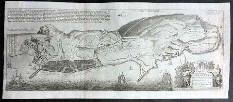
1728 Hermann Moll Large Antique Map and View of Gibraltar - 2nd Spanish Seige
- Title : A New and Exact plan of Gibraltar with all its fortifications as they are at present….
- Ref #: 40838
- Size: 25in x 11in (635mm x 280mm)
- Date : 1727
- Condition: (B) Good Condition
Description:
This finely engraved original antique map and view of the second Spanish siege of Gibraltar by Herman Moll was published in 1727.
Although undated, the legend at the top left of the map, gives an in-depth explanation to the map including no. 5 that refers to 'Place where at this time Barracks building for a Regiment Ap: 15. 1726. 6. The Great Church.', while the dedication is to David Colyear, 1st Earl of Portmore, Governor of Gibraltar. The plan was presumably engraved either in anticipation of, or during the second Spanish siege; Portmore was in England when the siege began, but sailed there with a relief force, arriving on 1st May, 1727. British command of the sea, coupled with the natural features of the Rock of Gibraltar on the landward side of the peninsula, combined to thwart Spanish ambition, and the siege petered to an end in 1728, with the garrison never seriously troubled.
Background: Gibraltar became part of the Visigothic Kingdom of Hispania following the collapse of the Roman Empire and came under Muslim Moorish rule in 711 AD. It was permanently settled for the first time by the Moors and was renamed Jebel Tariq – the Mount of Tariq, later corrupted into Gibraltar. The Christian Crown of Castile annexed it in 1309, lost it again to the Moors in 1333 and finally regained it in 1462. Gibraltar became part of the unified Kingdom of Spain and remained under Spanish rule until 1704. It was captured during the War of the Spanish Succession by an Anglo-Dutch fleet in the name of Charles VI of Austria, the Habsburg contender to the Spanish throne. At the war's end, Spain ceded the territory to Britain under the terms of the Treaty of Utrecht of 1713.
Spain tried to regain control of Gibraltar, which Britain had declared a Crown colony, through military, diplomatic and economic pressure. Gibraltar was besieged and heavily bombarded during three wars between Britain and Spain but the attacks were repulsed on each occasion. By the end of the last siege, in the late 18th century, Gibraltar had faced fourteen sieges in 500 years. In the years after Trafalgar, Gibraltar became a major base in the Peninsular War. The colony grew rapidly during the 19th and early 20th centuries, becoming one of Britain's most important possessions in the Mediterranean. It was a key stopping point for vessels en route to India via the Suez Canal. A large British naval base was constructed there at great expense at the end of the 19th century and became the backbone of Gibraltar's economy.
British control of Gibraltar enabled the Allies to control the entrance to the Mediterranean during the Second World War. It was attacked on several occasions by German, Italian and Vichy French forces, though without causing much damage. The Spanish dictator General Francisco Franco declined to join a Nazi plan to occupy Gibraltar but revived Spain's claim to the territory after the war. As the territorial dispute intensified, Spain closed its border with Gibraltar between 1969 and 1985 and communications links were severed. Spain's position was supported by Latin American countries but was rejected by Britain and the Gibraltarians themselves, who vigorously asserted their right to self-determination. Discussions of Gibraltar's status have continued between Britain and Spain but have not reached any conclusion.
Shortly after Gibraltar's recapture, King Henry IV of Castile declared it Crown property and reinstituted the special privileges which his predecessor had granted during the previous period of Christian rule. Four years after visiting Gibraltar in 1463, he was overthrown by the Spanish nobility and clergy. His half-brother Alfonso was declared king and rewarded Medina Sidonia for his support with the lordship of Gibraltar. The existing governor, a loyalist of the deposed Henry IV, refused to surrender Gibraltar to Medina Sidonia. After a fifteen-month siege from April 1466 to July 1467, Medina Sidonia took control of the town. He died the following year but his son Enrique was confirmed as lord of Gibraltar by the reinstated Henry IV in 1469. In 1474 the new Duke of Medina Sidonia sold Gibraltar to a group of Jewish conversos from Cordova and Seville led by Pedro de Herrera in exchange for maintaining the garrison of the town for two years, after which time the 4,350 conversos were expelled by the Duke. His status was further enhanced by Isabella I of Castile in 1478 with the granting of the Marquisate of Gibraltar.
On 2 January 1492, after five years of war, the Moorish emirate in Spain came to an end with the Catholic Monarchs' capture of Granada. The Jews of Gibraltar were, like those elsewhere in the kingdom, expelled from Spain by order of the monarchs in March that year. Gibraltar was used by Medina Sidonia as a base for the Spanish capture of Melilla in North Africa in 1497. Two years later the Muslims of Granada were ordered to convert to Christianity or leave. Those that did not convert left for North Africa, some of them travelling via Gibraltar.
Gibraltar became Crown property again in 1501 at the order of Isabella and the following year it received a new set of royal arms, which is still used by modern Gibraltar, replacing those of Medina Sidonia. In the Royal Warrant accompanying the arms, Isabella highlighted Gibraltar's importance as "the key between these our kingdoms in the Eastern and Western Seas [the Mediterranean and Atlantic]". The metaphor was represented on the royal arms by a golden key hanging from the front gate of a battlemented fortress. The warrant charged all future Spanish monarchs to "hold and retain the said City for themselves and in their own possession; and that no alienation of it, nor any part of it, nor its jurisdiction ... shall ever be made from the Crown of Castile."
At this point in history, "Gibraltar" meant not just the peninsula but the entire surrounding area including the land on which the towns of La Línea de la Concepción, San Roque, Los Barrios and Algeciras now stand. To the east, Gibraltar was bounded by the Guadiaro River, and its northern boundaries lay in the vicinity of Castellar de la Frontera, Jimena de la Frontera, Alcalá de los Gazules, Medina-Sidonia and Tarifa. From the 16th century, the modern meaning of the name came to be adopted – specifically referring only to the town of Gibraltar and the peninsula on which it stands.
Under Spanish Crown rule, the town of Gibraltar fell into severe decline. The end of Muslim rule in Spain and the Christian capture of the southern ports considerably decreased the peninsula's strategic value. It derived some minor economic value from tuna-fishing and wine-producing industries but its usefulness as a fortress was now limited. It was effectively reduced to the status of an unremarkable stronghold on a rocky promontory and Marbella replaced it as the principal Spanish port in the region.
Gibraltar's inhospitable terrain made it an unpopular place to live. To boost the population, convicts from the kingdom of Granada were offered the possibility of serving their sentence in the Gibraltar garrison as an alternative to prison. Despite its apparent unattractiveness, Juan Alfonso de Guzmán, third Duke of Medina Sidonia, nonetheless sought to regain control of the town. In September 1506, following Isabella's death, he laid siege in the expectation that the gates would quickly be opened to his forces. This did not happen, and after a fruitless four-month blockade he gave up the attempt. Gibraltar received the title of "Most Loyal" from the Spanish crown in recognition of its faithfulness (Ref: M&B, Tooley)
General Description:
Paper thickness and quality: - Heavy and stable
Paper color: - off white
Age of map color: -
Colors used: -
General color appearance: -
Paper size: - 25in x 11in (635mm x 280mm)
Plate size: - 25in x 11in (635mm x 280mm)
Margins: - Min 1/4in (5mm)
Imperfections:
Margins: - None
Plate area: - Small loss to the very right figure in the title cartouche not affecting the map, light creasing along folds as issued