Prints (370)
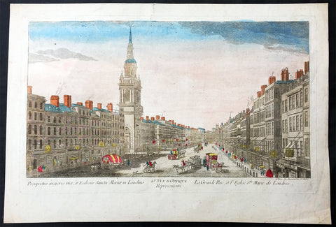
1760 Vue D Optic Large Antique Print View of Cheapside, London St Mary le Bow
- Title : Prospectus majoris viae, et Ecclesiae Sanctae Mariae in Londino; 25c Vue D Optique Representatnt; Le Grande Rue, et L Englise St Marie de Londres
- Ref : 43197
- Size: 18in x 13in (460mm x 330mm)
- Date : 1756
- Condition: (A) Very Good Condition
Description:
This hand coloured original antique print, a view of Cheapside and St Marys Le Bow, London was published as part of the Vues d’Optique in 1760.
St Mary-le-Bow is an historic church rebuilt after the Great Fire of 1666 by Sir Christopher Wren in the City of London on the main east–west thoroughfare, Cheapside. According to tradition a true Cockney must be born within earshot of the sound of Bow Bells (which refers to this church's bells rather than St Mary and Holy Trinity, Bow Road, in Bow, an outlying village until the 19th century.
Vues d'Optique or Perspective Views: Perspective views, or "vues d'optique," are a special type of popular print published in Europe during the 18th century. These prints provided a form of entertainment when viewed through a device called an "optical machine" or an "optique." The most characteristic feature of the perspective views is their emphasized linear perspective, done to further intensify the enhanced appearance of depth and illusionistic space in the prints when viewed through an optique. When displayed in the optique, the prints might transport the viewer into a far away place---an unknown city, or perhaps into the midst of a dramatic bit of contemporary history. Another attribute of these prints is their bright, often heavy hand coloring, applied boldly so as to show the tints when viewed through the lens.
A number of perspective prints depicted American scenes at the time of the Revolution for a European audience hungry for news of the events in the British colonies. As documents of American history and European printmaking, these are unusual and appealing eighteenth-century prints. (Ref: M&B; Tooley)
General Description:
Paper thickness and quality: - Heavy & stable
Paper color: - White
Age of map color: - Original
Colors used: - Blue, yellow, green, red
General color appearance: - Authentic & bright
Paper size: - 18in x 13in (460mm x 330mm)
Plate size: - 16 1/2in x 10in (420mm x 255mm)
Margins: - Min 1in (25mm)
Imperfections:
Margins: - Repair to top margin, no loss
Plate area: - None
Verso: - None
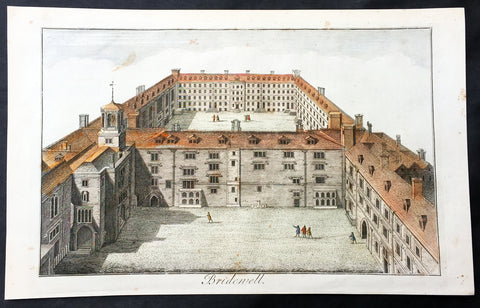
1756 Maitland Large Antique Print of Bridewell Palace, Prison London, England
- Title : Bridewell
- Ref : 26335
- Size: 15in x 9 1/2in (380mm x 245mm)
- Date : 1756
- Condition: (A+) Fine Condition
Description:
This fine hand coloured original antique print of Bridewell Palace as it was as a prison in the 18th century was engraved by Benjamin Cole and published in the 1756 edition of The History of London from its Foundation to the Present Time...', by William Maitland, Osborne & Shipton and Hodges, London.
Bridewell Palace in London was built as a residence of King Henry VIII and was one of his homes early in his reign for eight years. Given to the City of London Corporation by his son King Edward VI for use as an orphanage and place of correction for wayward women, Bridewell later became the first prison/poorhouse to have an appointed doctor.
It was built on the banks of the Fleet River in the City of London between Fleet Street and the River Thames in an area today known as 'Bridewell Court' off New Bridge Street. By 1556 part of it had become a jail known as Bridewell Prison. It was reinvented with lodgings and was closed in 1855 and the buildings demolished in 1863–1864. (Ref: Tooley; M&B)
General Description:
Paper thickness and quality: - Heavy and stable
Paper color: - off white
Age of map color: - Early
Colors used: - Red, yellow, green
General color appearance: - Authentic
Paper size: - 15in x 9 1/2in (380mm x 245mm)
Plate size: - 13 3/4in x 8 1/4in (350mm x 210mm)
Margins: - Min 1in (25mm)
Imperfections:
Margins: - None
Plate area: - None
Verso: - None
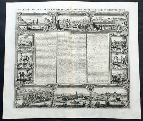
1719 Chatelain Large Antique Print North Africa City Views Algiers, Jijel, Tripoli & Tunis
- Title : Vue de Tunis d'Alger & de Gigeri avec quelques particularitez curieuses touchant les moeurs de leur habitans & de quelques autres peuples de Barbarie
- Ref #: 50646
- Size: 20in x 17 1/2in (510mm x 445mm)
- Date : 1719
- Condition: (A+) Fine Condition
Description:
This large finely engraved original antique print views of cities of The Barbary Coast of North Africa including Algiers and Jijel, both in Algeria, Tripoli in Libya and Tunis in Tunisia - as well as peoples & animals of the Barbary coast - was published by Henri Abraham Chatelain in 1719, in his famous Atlas Historique.
Henri Abraham Chatelain (1684 - 1743)
was a Huguenot pastor of Parisian origins. He lived consecutively in Paris, St. Martins, London (c. 1710), the Hague (c. 1721) and Amsterdam (c. 1728).
Chatelain was a skilled artist and knew combining a wealth of historical and geographical information with delicate engraving and an uncomplicated composition. Groundbreaking for its time, this work included studies of geography, history, ethnology, heraldry, and cosmography. His maps with his elegant engraving are a superb example from the golden age of French mapmaking.The publishing firm of Chatelain, Chatelain Frères and Chatelain & Fils is recorded in Amsterdam, from around 1700-1770, with Zacharias living "op den Dam" in 1730.
Henri Abraham Chatelain, his father Zacharie Chatelain (d.1723) and Zacharie Junior (1690-1754), worked as a partnership publishing the Atlas Historique, Ou Nouvelle Introduction à L'Histoire under several different Chatelain imprints, depending on the Chatelain family partnerships at the time of publication. The atlas was published in seven volumes between 1705 and 1720, with a second edition appearing in 1732. The volumes I-IV with a Third edition and volume I with a final edition in 1739.
Henri Abraham Chatelain, whose "Atlas Historique" was one of the most expansive Dutch encyclopedias of the age. First published in 1705, Chatelain's Atlas Historique was part of an immense seven-volume encyclopedia. Although the main focus of the text was geography, the work also included a wealth of historical, political, and genealogical information. The text was compiled by Nicholas Gueudeville and Garillon with a supplement by H.P. de Limiers and the maps were engraved by Chatelain, primarily after charts by De L'Isle. The atlas was published in Amsterdam between 1705 and 1721 and was later reissued by Zacharie Chatelain between 1732 and 1739.
Atlas Historique: First published in Amsterdam from 1705 to 1720, the various volumes were updated at various times up to 1739 when the fourth edition of vol.I appeared, stated as the "dernière edition, corrigée & augmentée."
The first four volumes seem to have undergone four printings with the later printings being the most desirable as they contain the maximum number of corrections and additions. The remaining three final volumes were first issued between 1719-1720 and revised in 1732.
An ambitious and beautifully-presented work, the Atlas Historique was intended for the general public, fascinated in the early eighteenth century by the recently conquered colonies and the new discoveries. Distant countries, such as the Americas, Africa, the Middle East, Mongolia, China, Japan, Indonesia, etc., take an important place in this work.
In addition to the maps, many of which are based on Guillaume De L'Isle, the plates are after the best travel accounts of the period, such as those of Dapper, Chardin, de Bruyn, Le Hay and other.
Other sections deal with the history of the european countries, and covers a wide range of subjects including genealogy, history, cosmography, topography, heraldry and chronology, costume of the world, all illustrated with numerous engraved maps, plates of local inhabitants and heraldic charts of the lineages of the ruling families of the time. The maps, prints and tables required to make up a complete set are listed in detail in each volume.
The accompanying text is in French and often is printed in two columns on the page with maps and other illustrations interspersed. Each map and table is numbered consecutively within its volume and all maps bear the privileges of the States of Holland and West-Friesland.
The encyclopaedic nature of the work as a whole is reflected in this six frontispiece. The pages are the work of the celerated mr. Romeijn de Hooghe. and are engraved by J.Goeree, T.Schynyoet and P.Sluyter.
New scholarship has suggested the compiler of the atlas, who is identified on the title as "Mr. C***" not to be Henri Abraham Châtelain, but Zacharie Châtelain. (See Van Waning's article in the Journal of the International Map Collectors' Society for persuasive evidence of the latter's authorship.) (Ref: M&B; Tooley)
General Description:
Paper thickness and quality: - Heavy and stable
Paper color: - White
Age of map color: -
Colors used: -
General color appearance: -
Paper size: - 20in x 17 1/2in (510mm x 445mm)
Plate size: - 17 1/2in x 15in (445mm x 380mm)
Margins: - min. 1in (25mm)
Imperfections:
Margins: - None
Plate area: - None
Verso: - None
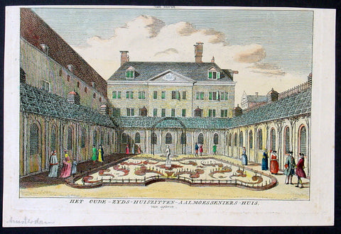
1765 Isaac Tirion Antique Print of an Alms House in Amsterdam, Holland
- Title : Het Oude-Zyds-Huiszitten-Aalmoesseniers-Huis, van agteren.
- Date : 1765
- Condition: (A+) Fine Condition
- Ref: Het1
- Size: 9in x 6in (230mm x 150mm)
Description:
This beautifully hand coloured original antique print of an Alms House in Amsterdam was published by Isaac Tirion in the 1765 edition ofTopografie van Nederland. (Ref: Tooley; M&B)
General Description:
Paper thickness and quality: - Heavy and stable
Paper color: - off white
Age of map color: - Early
Colors used: - Green, pink, yellow
General color appearance: - Authentic
Paper size: - 9in x 6in (230mm x 150mm)
Plate size: - 8 1/2in x 5 1/2in (215mm x 140mm)
Margins: - Min 1/4in (5mm)
Imperfections:
Margins: - None
Plate area: - None
Verso: - None
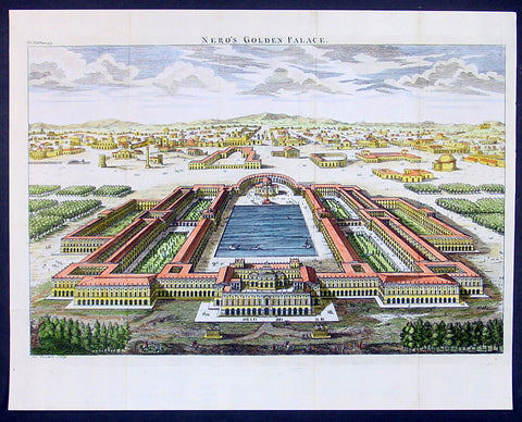
1650 Fuller Antique Print a View of Neros Palace Rome
- Title : Neros Golden Palace
- Ref : 24312
- Size: 17in X 13in (435mm x 330mm)
- Date : 1650
- Condition: (A+) Fine Condition
Description:
This finely engraved hand coloured original antique print a view of Neros Golden Palace in Rome was published in 1650 by Thomas Fuller in his unique book of the Holy Land A Pisagh-Sight of Palestine
Fuller, a loyalist during the English Civil War of the mid 17th century, wrote Pisagh-Sightduring a forced exile in Waltham.
The book was an early success and confirmed the genial divines contention the “the booksellers have always done well by me”. His earlier studies in poetry and history and his droll humor contribute to the geographical description in “Pisagh-Sight” while the cartography in the book is derived from that of Adrichom sixty years before.
The book contained 21 wonderfully engraved maps on the Holy Land and displayed unusual charm in their Vignettes and scenes. For all its lively and playful erudition, Pisagh-Sight is one of the great books on the topography of the Holy Land. (Ref: Nebenzahl; Tooley; M&B)
General Description:
Paper thickness and quality: - Heavy and stable
Paper color: - Off white
Age of map color: - Early
Colors used: - Yellow, pink, orange, green
General color appearance: - Authentic
Paper size: - 17in X 13in (435mm x 330mm)
Margins: - Min 1/2in (12mm)
Imperfections:
Margins: - None
Plate area: - Folds as issued
Verso: - None
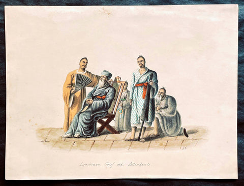
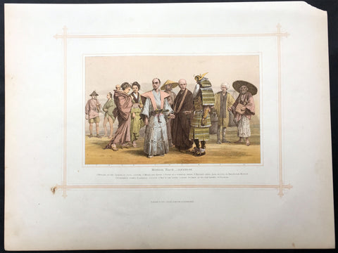
1818 C J McLeod Antique Print of Chief & Attendants of Ryukyu Isles of Japan
- Title : Lewchewan Chief and Attendants
- Ref #: 25103
- Size: 10in x 7 1/2in (255mm x 190mm)
- Date : 1818
- Condition: (A+) Fine Condition
Description:
This fine original antique hand coloured and pen ink outline drawing of a Chief and Attendants of the Japanese Island of Lew Chew or Ryukyu Islands was drawn by an artist signing his name as C.J. from the exquisite hand coloured prints by the surgeon John McLeod, published in the 1818 edition of Voyage of His Majesty's Ship Alceste.
Voyage of His Majesty's Ship Alceste, Along the Coast of Corea to the Island of Lewchew; with an Account of Her Subsequent Shipwreck, London, John Murray, printed by W. Clowes, 1818. The book is of the expedition (February 1816 - August 1817) of the British Naval ships the Alceste and the Lyra under the command of Captain Murray Maxwell to transport the Lord Amherst's Embassy to China and explore the relatively little known East China Sea and the Yellow Sea. The book contained extensive sections on visits to China, Korea, Lew Chew and St Helena. (Ref: M&B; Tooley)
General Description:
Paper thickness and quality: - Heavy & stable
Paper color: - White
Age of map color: - Original
Colors used: -Blue, yellow, red, purple
General color appearance: - Fresh
Paper size: - 10in x 7 1/2in (255mm x 190mm)
Margins: - Min 1/2in (10mm)
Imperfections:
Margins: - None
Plate area: - Very light toning
Verso: - Old glue residue on back margins not affecting the image
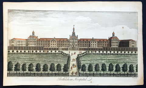
1756 Maitland Large Antique Print of Bethlehem or Bedlam Hospital, London
- Title : Bethlehem Hospital
- Ref : 26263
- Size: 16 1/4in x 10in (410mm x 250mm)
- Date : 1756
- Condition: (A+) Fine Condition
Description:
This large hand coloured original antique hand coloured antique print of Bethlehem Hospital, London was engarved by William Toms and published in 1756 edition of William Maitland's The History and Survey of London From Its Foundation to the Present Time.
Background: London’s Bethlem Royal Hospital, long called Bedlam, is one of the oldest mental institutions in the world. It was founded by Christians in 1247 to shelter and care for homeless people, but gradually began to focus on those considered ‘mad’. Patients did not often stay longer than 12 months. Ex-patients were called ‘Bedlamites’ and were licensed to beg on main routes between towns. Bedlam came under the control of the City of London in 1547. It was the only public mental institution in England until well into the 1800s.
Despite its large reputation, Bedlam remained small for centuries - there were no more than 24 patients in 1620. Its location near the walls of London (on land now occupied by Liverpool Street Station) and status as a public institution ensured a stream of visitors eager to view ‘madness’. In 1676 Bedlam moved to a new and larger building at Moorfields with a baroque facade by natural philosopher Robert Hooke that was designed to impress visitors. Commentators have noted visitors and artists often projected onto Bedlam their hopes and fears about ‘madness’.
Bedlam’s high profile saw it repeatedly criticised and mired in scandal. Some of its most outspoken patients were confined because their political enemies wanted to silence or discredit them. Government inquiries into the abuse of Bedlam patients inspired reforms in the 1700s and 1800s. ‘Bedlam’ came to describe any out-of-control situation.
The hospital moved again in 1815 to improve patient conditions. It was further away from the city centre, so patients had more space for indoor and outdoor activities. This was central to moral treatment. In 1930 it moved to its current home, a large campus in the London suburbs housing patients in small, separate, home-like buildings rather than a single fortress-like structure. Bethlem Royal Hospital is now a research and treatment centre, and its small museum holds a renowned collection of art made by people diagnosed with mental illness.
General Description:
Paper thickness and quality: - Heavy & stable
Paper color: - Off white
Age of map color: - Original
Colors used: - Red, yellow, black, gold
General color appearance: - Authentic
Paper size: - 16 1/4in x 10in (410mm x 250mm)
Plate size: - 15in x 8 1/2in (385mm x 210mm)
Margins: - Min 1/2in (12mm)
Imperfections:
Margins: - Light age toning
Plate area: - None
Verso: - None
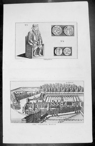
1773 Grose Large Antique Print View of The London Charter House
- Title : Description of The Charter House
- Ref : 26237
- Size: 15in x 9 1/2in (385mm x 235mm)
- Date : 1773
- Condition: (A+) Fine Condition
Description:
This large original antique print of the London Charter House situated in Smithfield London - accompanied with text page - was published by Francis Grose on the 1773 edition of The Antiquities of England and Wales.
The London Charterhouse is a historic complex of buildings in Smithfield, London dating back to the 14th century. It occupies land to the north of Charterhouse Square. The Charterhouse began as (and takes its name from) a Carthusian priory, founded in 1371 and dissolved in 1537.
Substantial fragments remain from this monastic period, but the site was largely rebuilt after 1545 as a large courtyard house. Thus, today it "conveys a vivid impression of the type of large rambling 16th century mansion that once existed all round London". The Charterhouse was further altered and extended after 1611, when it became an almshouseand school, endowed by Thomas Sutton. The almshouse (a home for gentlemen pensioners) still occupies the site today under the name the Charterhouse.
Francis Grose (1731 –1791) was an English antiquary, draughtsman, and lexicographer. He was born at his father's house in Broad Street, St-Peter-le-Poer, London.
Grose had early on shown a keen interest in drawing, having attempted sketches of medieval buildings as far back as 1749, and having taken formal instruction at a drawing school in the mid-1750s. He was not a particularly gifted draughtsman but he mixed in the London artistic milieu and began to exhibit, first at the Society of Artists in 1767–8 and then at the Royal Academy. His interest was in the field of medieval remains, which were beginning to exercise an increasing grip on the public imagination.
In 1772, he published the first part of The Antiquities of England and Wales, a work which he unashamedly aimed at the popular market. Essentially, it targeted those who wanted to know about antiquities but had neither time nor means to visit them in person, and contained small panoramas of medieval ruins, together with an informative text on a separate page. Sometimes the text was taken from books already published, or from information supplied by other antiquaries (both acknowledged); sometimes Grose collated material himself from which he could work up an article. From 1772 onwards, he also toured the country to visit and draw sites for inclusion in The Antiquities. The fourth and last volume came out in June 1776, and Grose almost immediately began work on a supplement.
General Description:
Paper thickness and quality: - Heavy & stable
Paper color: - Off white
Age of map color: -
Colors used: -
General color appearance: -
Paper size: - 15in x 9 1/2in (385mm x 235mm)
Margins: - Min 1/2in (12mm)
Imperfections:
Margins: - None
Plate area: - None
Verso: - None
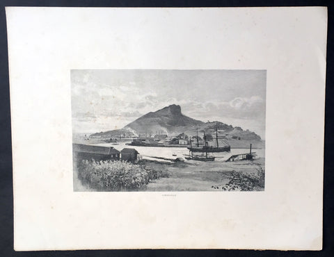
1886 Picturesque Australasia Large Antique Print View of Townsville, Queensland
- Title : Townsville
- Ref : 92149
- Size: 17in x 13in (430mm x 330mm)
- Date : 1886
- Condition: (A+) Fine Condition
Description:
This fine large original antique lithograph print was published in the extremely significant Australian & New Zealand publication The Picturesque Atlas of Australasia between 1886-88.
The Picturesque Atlas of Australasia was published in Sydney between 1886-88. Many of its over 700 wood-engraved illustrations were specially commissioned works by leading Australian artists. It was released in 42 separate editions usually bound into three large volumes and sold a remarkable 50,000 copies. (Ref: M&B; Tooley)
General Description:
Paper thickness and quality: - Light & stable
Paper color: - White
Age of map color: - Original
Colors used: - Pink, green, yellow, orange
General color appearance: - Authentic
Paper size: - 17in x 13in (430mm x 330mm)
Margins: - Min 1/2in (10mm)
Imperfections:
Margins: - None
Plate area: - None
Verso: - Light soiling
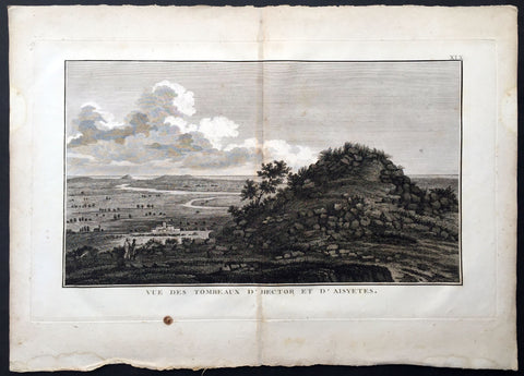
1802 J B Lechevalier Antique Print Tomb of Hector, Ophryneion in Troad, Turkey
- Title : Vue Des Tombeaux D Hector et D Aisyetes
- Date : 1802
- Size: 19 1/2in x 13 1/2in (495mm x 345mm)
- Ref: 70226
- Condition: (A+) Fine Condition
Description:
This original copper-plate engraved antique print a view of the Tombs of Hector & Aesyetes located in the ancient Greek city of Ophryneion in the Troad region of Çanakkale, now in NW modern Turkey, was published in the 1802 edition of Jean-Baptiste Lechevaliers of Voyage de la Troade, fait dans les années 1785 et 1786
General Definitions:
Paper thickness and quality: - Heavy and stable
Paper color : - off white
Age of map color: -
Colors used: -
General color appearance: -
Paper size: - 19 1/2in x 13 1/2in (495mm x 345mm)
Plate size: - 17 1/2in x 10 3/4in (445mm x 275mm)
Margins: - Min 1/2in (12mm)
Imperfections:
Margins: - Light soiling
Plate area: - Light toning along centerfold
Verso: - Light soiling
Background:
Ophryneion was an ancient Greek city in the northern Troad region of Anatolia. Its territory was bounded to the west by Rhoiteion and to the east by Dardanos. It was located about 1.5 km north-east of the village of İntepe (previously known as Erenköy) in Çanakkale Province, Turkey. The city was situated on the steep brow of a hill overlooking the Dardanelles, hence the origin of its Ancient Greek name ὀφρῦς (ophrus), meaning \'brow of a hill\', crag
In Greek mythology, Aesyetes was a Trojan hero and father of Alcathous. His tomb was the vantage point which Polites, son of Priam, used to scout the Greek camp during the Trojan War.
Aesyetes was also given as the father of Antenor by Cleomestra.
In Greek mythology and Roman mythology, Hector was a Trojan prince and the greatest fighter for Troy in the Trojan War. As the first-born son of King Priam and Queen Hecuba, who was a descendant of Dardanus and Tros, the founder of Troy, he was a prince of the royal house and the heir apparent to his fathers throne. He was married to Andromache, with whom he had an infant son, Scamandrius (whom the people of Troy called Astyanax). He acted as leader of the Trojans and their allies in the defence of Troy, killing 31,000 Greek fighters, offers Hyginus. During the European Middle Ages, Hector figures as one of the Nine Worthies noted by Jacques de Longuyon, known not only for his courage but also for his noble and courtly nature. Indeed, Homer places Hector as peace-loving, thoughtful as well as bold, a good son, husband and father, and without darker motives. James Redfield describes Hector as a martyr to loyalties, a witness to the things of this world, a hero ready to die for the precious imperfections of ordinary life.
The most valuable historical evidence for the Battle of Troy are treaties and letters mentioned in Hittite cuneiform texts of the same approximate era, which mention an unruly Western Anatolian warlord named Piyama-Radu (possibly Priam) and his successor Alaksandu (possibly Alexander, the nickname of Paris) both based in Wilusa (possibly Ilion/Ilios), as well as the god Apaliunas (possibly Apollo).
Other such pieces of evidence are names of Trojan heroes in Linear B tablets. Twenty out of fifty-eight men\'s names also known from Homer, including E-ko-to (Hector) are Trojan warriors and some, including Hector, are in a servile capacity. No such conclusion that they are the offspring of Trojan captive women is warranted. Generally the public has to be content with the knowledge that these names existed in Greek in Mycenaean times, although Page hypothesizes that Hector may very well be ... a familiar Greek form impressed on a similar-sounding foreign name.
When Pausanias visited Thebes in Boeotia, in the second century AD, he was shown Hector\'s tomb and was told that the bones had been transported to Thebes according to a Delphic oracle. Moses I. Finley observes this typical bit of fiction must mean that there was an old Theban hero Hector, a Greek, whose myths antedated the Homeric poems. Even after Homer had located Hector in Troy for all time, the Thebans held on to their hero, and the Delphic oracle provided the necessary sanction.
The pseudepigraphical writer Dares Phrygius states that Hector \"spoke with a slight lisp. His complexion was fair, his hair curly. His eyes would blink attractively. His movements were swift. His face, with its beard, was noble. He was handsome, fierce, and high-spirited, merciful to the citizens, and deserving of love
Jean-Baptiste Lechevalier was the secretary of the Ambassador of France in Constantinople. In the year 1788 he visited the plain of Troy, and was enthusiastically in favour of the theory that the site of Homers Troy was to be found at the village of Bunarbashi. His publication about Troy Voyage de la Troade.....was first published in 1799.
The Troad, also known as Troas, is the historical name of the Biga peninsula (Biga Yarımadası, Τρωάς) in the northwestern part of Anatolia, Turkey. This region now is part of the Çanakkale province of Turkey. Bounded by the Dardanelles to the northwest, by the Aegean Sea to the west and separated from the rest of Anatolia by the massif that forms Mount Ida, the Troad is drained by two main rivers, the Scamander (Karamenderes) and the Simois, which join at the area containing the ruins of Troy. Grenikos, Kebren, Simoeis, Rhesos, Rhodios, Heptaporos and Aisepos were seven rivers of the Troad and the names of the river gods that inhabited each river.
Troy (Ancient Greek: Τροία, Troia or Τροίας, Troias, Truva or Troya) was a city in the far northwest of the region known in late Classical antiquity as Asia Minor, now known as Anatolia in modern Turkey, just south of the southwest mouth of the Dardanelles strait and northwest of Mount Ida. The present-day location is known as Hisarlik. It was the setting of the Trojan War described in the Greek Epic Cycle, in particular in the Iliad, one of the two epic poems attributed to Homer. Metrical evidence from the Iliad and the Odyssey suggests that the name λιον (Ilion) formerly began with a digamma: Ϝίλιον (Wilion); this is also supported by the Hittite name for what is thought to be the same city, Wilusa.
A new capital called Ilium (from Greek: λιον, Ilion) was founded on the site in the reign of the Roman Emperor Augustus. It flourished until the establishment of Constantinople, became a bishopric and declined gradually in the Byzantine era, but is now a Latin Catholic titular see.
In 1865, English archaeologist Frank Calvert excavated trial trenches in a field he had bought from a local farmer at Hisarlik, and in 1868, Heinrich Schliemann, a wealthy German businessman and archaeologist, also began excavating in the area after a chance meeting with Calvert in Çanakkale. These excavations revealed several cities built in succession. Schliemann was at first skeptical about the identification of Hisarlik with Troy, but was persuaded by Calvert and took over Calverts excavations on the eastern half of the Hisarlik site, which was on Calvert\'s property. Troy VII has been identified with the city called Wilusa by the Hittites (the probable origin of the Greek λιον) and is generally (but not conclusively) identified with Homeric Troy.
Today, the hill at Hisarlik has given its name to a small village near the ruins, which supports the tourist trade visiting the Troia archaeological site. It lies within the province of Çanakkale, some 30 km south-west of the provincial capital, also called Çanakkale. The nearest village is Tevfikiye. The map here shows the adapted Scamander estuary with Ilium a little way inland across the Homeric plain. Due to Troys location near the Aegean Sea, the Sea of Marmara, and the Black Sea, it was a central hub for the military and trade(Ref: M&B; Tooley)
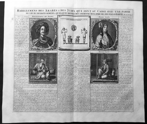
1719 Chatelain Large Antique Print The Costumes of Jews & Arabs in Cairo, Egypt
- Title : Description des Piramides D Egypte Tant au Dedans qu'au Dehors...
- Ref : 50647
- Size: 20in x 17 1/2in (510m x 440m)
- Date : 1719
- Condition: (A+) Fine Condition
Description:
This large original antique print including detailed French Text on the subject was published by Henri Abraham Chatelain in 1719, in his famous Atlas Historique.
Atlas Historique: First published in Amsterdam from 1705 to 1720, the various volumes were updated at various times up to 1739 when the fourth edition of vol.I appeared, stated as the "dernière edition, corrigée & augmentée."
The first four volumes seem to have undergone four printings with the later printings being the most desirable as they contain the maximum number of corrections and additions. The remaining three final volumes were first issued between 1719-1720 and revised in 1732.
An ambitious and beautifully-presented work, the Atlas Historique was intended for the general public, fascinated in the early eighteenth century by the recently conquered colonies and the new discoveries. Distant countries, such as the Americas, Africa, the Middle East, Mongolia, China, Japan, Indonesia, etc., take an important place in this work.
In addition to the maps, many of which are based on Guillaume De L'Isle, the plates are after the best travel accounts of the period, such as those of Dapper, Chardin, de Bruyn, Le Hay and other.
Other sections deal with the history of the european countries, and covers a wide range of subjects including genealogy, history, cosmography, topography, heraldry and chronology, costume of the world, all illustrated with numerous engraved maps, plates of local inhabitants and heraldic charts of the lineages of the ruling families of the time. The maps, prints and tables required to make up a complete set are listed in detail in each volume.
The accompanying text is in French and often is printed in two columns on the page with maps and other illustrations interspersed. Each map and table is numbered consecutively within its volume and all maps bear the privileges of the States of Holland and West-Friesland.
The encyclopaedic nature of the work as a whole is reflected in this six frontispiece. The pages are the work of the celerated mr. Romeijn de Hooghe. and are engraved by J.Goeree, T.Schynyoet and P.Sluyter.
New scholarship has suggested the compiler of the atlas, who is identified on the title as "Mr. C***" not to be Henri Abraham Châtelain, but Zacharie Châtelain. (See Van Waning's article in the Journal of the International Map Collectors' Society for persuasive evidence of the latter's authorship.
General Description:
Paper thickness and quality: - Heavy and stable
Paper color: - White
Age of map color: -
Colors used: -
General color appearance: -
Paper size: - 20in x 17 1/2in (510m x 440m)
Plate size: - 17 1/2in x 15in (440m x 380mm)
Margins: - min. 1in (25mm)
Imperfections:
Margins: - None
Plate area: - None
Verso: - None

1820 Fischer Large Antique Print View of the City & Harbour of Liverpool England
- Title : View of The Town and Harbour of Liverpool, from Seacombe....1820
- Ref : 92895
- Size: 16 1/2in x 10 1/2in (420mm x 270mm)
- Date : 1820
- Condition: (A+) Fine Condition
Description:
This large fine original antique print a view of the very important and busy town and port of Liverpool in Northern England at the turn of the 19th century was engraved in 1820 - dated at the foot of the print - and published by Henry Fisher & co.. (Ref: M&B; Tooley)
General Description:
Paper thickness and quality: - Heavy & stable
Paper color: - White
Age of map color: -
Colors used: -
General color appearance: -
Paper size: - 16 1/2in x 10 1/2in (420mm x 270mm)
Plate size: - 16 1/2in x 10 1/2in (420mm x 270mm)
Margins: - Min 1/2in (10mm)
Imperfections:
Margins: - None
Plate area: - Folds as issued
Verso: - None
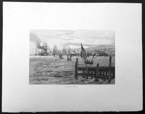
1886 Pic. Australasia Large Antique Print View of Wellington, New Zealand
- Title : Wellington Harbour
- Ref : 92196
- Size: 17in x 13in (430mm x 330mm)
- Date : 1886
- Condition: (A+) Fine Condition
Description:
This fine large original antique lithograph print was published in the extremely significant Australian & New Zealand publication The Picturesque Atlas of Australasia between 1886-88.
The Picturesque Atlas of Australasia was published in Sydney between 1886-88. Many of its over 700 wood-engraved illustrations were specially commissioned works by leading Australian artists. It was released in 42 separate editions usually bound into three large volumes and sold a remarkable 50,000 copies. (Ref: M&B; Tooley)
General Description:
Paper thickness and quality: - Light & stable
Paper color: - White
Age of map color: - Original
Colors used: - Pink, green, yellow, orange
General color appearance: - Authentic
Paper size: - 17in x 13in (430mm x 330mm)
Margins: - Min 1/2in (10mm)
Imperfections:
Margins: - None
Plate area: - None
Verso: - None
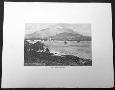
1886 Picturesque Australasia Large Antique Print View of Hobart, Tasmania
- Title : Hobart from Kangaroo Point
- Ref : 92112
- Size: 17in x 13in (430mm x 330mm)
- Date : 1886
- Condition: (A+) Fine Condition
Description:
This fine large original antique lithograph print was published in the extremely significant Australian & New Zealand publication The Picturesque Atlas of Australasia between 1886-88.
The Picturesque Atlas of Australasia was published in Sydney between 1886-88. Many of its over 700 wood-engraved illustrations were specially commissioned works by leading Australian artists. It was released in 42 separate editions usually bound into three large volumes and sold a remarkable 50,000 copies. (Ref: M&B; Tooley)
General Description:
Paper thickness and quality: - Light & stable
Paper color: - White
Age of map color: - Original
Colors used: - Pink, green, yellow, orange
General color appearance: - Authentic
Paper size: - 17in x 13in (430mm x 330mm)
Margins: - Min 1/2in (10mm)
Imperfections:
Margins: - None
Plate area: - None
Verso: - None
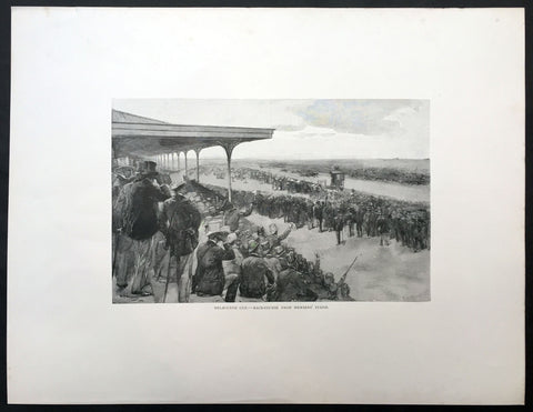
1886 Picturesque Atlas of Australasia Large Antique Print of The Melbourne Cup
- Title : Melbourne Cup - Race Course From Members Stand
- Ref #: 92164
- Size: 17 1/2in x 13 1/2in (440mm x 340mm)
- Date : 1886
- Condition: (A+) Fine Condition
Description:
This fine large original antique lithograph print was published in the extremely significant Australian & New Zealand publication The Picturesque Atlas of Australasia between 1886-88.
The Picturesque Atlas of Australasia was published in Sydney between 1886-88. Many of its over 700 wood-engraved illustrations were specially commissioned works by leading Australian artists. It was released in 42 separate editions usually bound into three large volumes and sold a remarkable 50,000 copies. (Ref: M&B; Tooley)
General Description:
Paper thickness and quality: - Light & stable
Paper color: - White
Age of map color: - Original
Colors used: - Pink, green, yellow, orange
General color appearance: - Authentic
Paper size: - 17 1/2in x 13 1/2in (440mm x 340mm)
Margins: - Min 2in (50mm)
Imperfections:
Margins: - None
Plate area: - None
Verso: - None
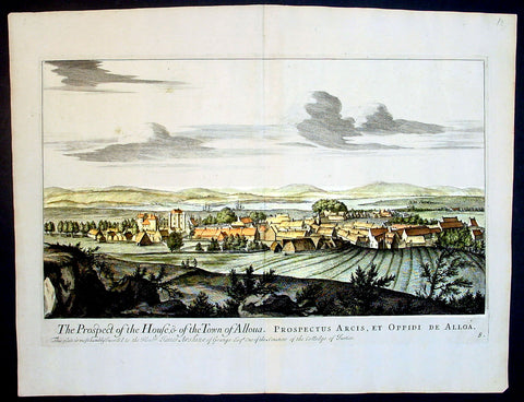
1693 Slezer Antique Print View of the Town of Alloa on Firth of Forth Scotland
- Title : The Prospect of the House & of the Town of Alloua
- Ref : 24947
- Size: 18 ½in x 14 ½in (470mm x 370mm)
- Date : 1693
- Condition: (A+) Fine Condition
Description:
This finely engraved original important antique print a view of the town of Alloa in Clackmannanshire in eastern Scotland on the Firth of Forth, was published in the first edition of John Slezer's 'Theatrum Scotiae', 1693.
This is an important and rare print as Slezer s Theatrum Scotiae is one of the earliest records of early Scottish towns. (Ref: Tooley; M&B)
General Description:
Paper thickness and quality: - Heavy and stable
Paper color: - off white
Age of map color: -
Colors used: -
General color appearance: -
Paper size: - 18 ½in x 14 ½in (470mm x 370mm)
Plate size: - 16 ½in x 11 in (420mm x 280mm)
Margins: - Min 1in (25mm)
Imperfections:
Margins: - None
Plate area: - None
Verso: - None
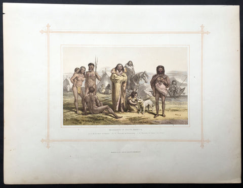
1880 Blackie & Son Antique Print South American Indians
- Title : Aborigines of South America
- Ref #: 80519
- Size: 15in x 11in (380mm x 280mm)
- Date : 1880
- Condition: (A+) Fine Condition
Description:
This beautifully coloured large original antique lithograph print was published by Blackie & Son of Glasgow in the 1880 edition of Geographical Atlas. (Ref: Tooley; M&B)
General Description:
Paper thickness and quality: - Heavy and stable
Paper colour: - off white
Age of map colour: - Original
Colours used: - Brown, blue, green
General colour appearance: - Authentic
Paper size: - 15in x 11in (380mm x 280mm)
Margins: - min 12in (25mm)
Imperfections:
Margins: - Light soiling
Plate area: - None
Verso: - None
1880 Blackie & Son Antique Print the Japanese Peoples
- Title : Mongol Race - Japanese
- Ref #: 80515
- Size: 15in x 11in (380mm x 280mm)
- Date : 1880
- Condition: (A+) Fine Condition
Description:
This beautifully coloured large original antique lithograph print was published by Blackie & Son of Glasgow in the 1880 edition of Geographical Atlas. (Ref: Tooley; M&B)
General Description:
Paper thickness and quality: - Heavy and stable
Paper colour: - off white
Age of map colour: - Original
Colours used: - Brown, blue, green
General colour appearance: - Authentic
Paper size: - 15in x 11in (380mm x 280mm)
Margins: - min 12in (25mm)
Imperfections:
Margins: - Light soiling
Plate area: - None
Verso: - None
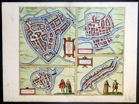
1575 Braun & Hogenberg Antique Print Sneek Dokkum Ylst Frisia Sloten Netherlands
- Title : Sneecha, vulgo Sneeck Frisiae Occidentalis Oppidum. - Doccum - Sloten - Ylsta
- Ref #: 30261
- Size: 21in x 16in (535mm x 410mm)
- Date : 1575
- Condition: (A+) Fine Condition
Description:
This fine beautifully hand coloured original antique map a birds-eye view of the towns of Sneek, Dokkum, Ylst and Sloten in Frisia, the Netherlands was published by Georg Braun & Frans Hogenberg for the 1575 atlas of town plans Civiates Orbis Terrarum Vol II (1572-1612) intended as a companion to Abraham Ortelius's master Atlas Theatrum Orbis Terrarum published in 1570.
Background of Civitates Orbis Terrarum
The first volume of the Civitates Orbis Terrarum was published in Cologne in 1572. The sixth and the final volume appeared in 1617.
This great city atlas, edited by Georg Braun and largely engraved by Franz Hogenberg, eventually contained 546 prospects, bird-eye views and map views of cities from all over the world. Braun (1541-1622), a cleric of Cologne, was the principal editor of the work, and was greatly assisted in his project by the close, and continued interest of Abraham Ortelius, whose Theatrum Orbis Terrarum of 1570 was, as a systematic and comprehensive collection of maps of uniform style, the first true atlas.
For a variety of reasons town plans were comparatively latecomers in the long history of cartography. Few cities in Europe in the middle ages had more than 20,00 inhabitants and even London in the late Elizabethan period had only 100-150,000 people which in itself was probably 10 times that of any other English city. The Nuremberg Chronicle in 1493 included one of the first town views of Jerusalem, thereafter, for most of the sixteenth century, German cartographers led the way in producing town plans in a modern sense. In 1544 Sebastian Munster issued in Basle his Cosmographia containing roughly sixty-six plans and views, some in the plan form, but many in the old panorama or birds eye view. (Ref: Tooley; M&B)
Condition Report:
Paper thickness and quality: - Heavy and stable
Paper color: - off white
Age of map color: - Early
Colors used: - Green, blue, red, yellow
General color appearance: - Authentic
Paper size: - 21in x 16in (535mm x 410mm)
Plate size: - 16 1/2in x 14in (420mm x 355mm)
Margins: - Min 1in (25mm)
Imperfections:
Margins: - Light soiling in margins
Plate area: - None
Verso: - None
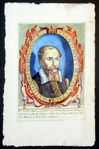
1632 Henricus David Large Antique Portrait of Cartographer Giovanni A Magini
- Title : Io. Antonius Maginus Pat. Mathemat. In Bonon. Gymn. Profess
- Date : 1632
- Condition: (A+) Fine Condition
- Ref: 92835
- Size: 17 1/2in x 11in (445mm x 280mm)
Description:
This fine beautifully hand coloured original antique portrait of the Italian Cartographer Giovanni Antonio Magini was engraved by Henricus David in 1632 - date is engraved below portrait.
Giovanni Antonio Magini (1555-1617) was an Italian mathematician, cartographer and Professor of Astronomy in Bologna. He is responsible for publishing an edition ofPtolemy's Geographia in 1596 that contained 27 maps of the ancient world drawn from the text of Claude Ptolemy, along with 27 contemporary or modern maps. His maps were used by Blaeu in 1640. (Ref: Tooley; M&B)
General Description:
Paper thickness and quality: - Heavy and stable
Paper color: - off white
Age of map color: - Original
Colors used: - Yellow, green, red, brown.
General color appearance: - Fresh
Paper size: - 17 1/2in x 11in (445mm x 280mm)
Plate size: - 12n x 8 1/2in (305mm x 215mm)
Margins: - Min 1in (25mm)
Imperfections:
Margins: - Light dis-colouration in top margin
Plate area: - None
Verso: - None
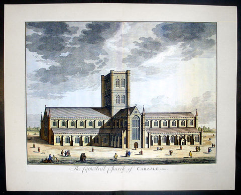
1724 Johannes Kip Large Antique Print a View of Carlisle Church in Cumbria, England
- Title : The Cathedral Church of Carlile
- Date : 1724
- Condition: (A+) Fine Condition
- Ref: 40406
- Size: 26 1/2in x 22in (670mm x 560mm)
Description: This large original copper-plate engraved antique print by Johannes (Jan) Kip, after Leonard Knyff, was published in the 1724 Joseph Smith edition of Britannia Illustrata or Nouveau Theatre de la Grande Bretagne. This beautifully engraved original antique print is testimony to the fine, detailed work produced by Jan Kip.
Britannia Illustrata was first issued in 1707 by David Mortier as a single volume containing 80 topographical etchings by Johannes Kip, after drawings by Leonard Knyff. Many are birds eye views of country seats, but there are also a number of interesting London views. The series was first reissued and expanded into two volumes in 1708-1713, and provided with a second French title Nouveau Theatre de la Grande Bretagne.
An expanded edition of Britannia Illustrata was re-published by Joseph Smith in 1724 under its French title, Nouveau Theatre..., containing many of the plates from the original edition by Mortier and also containing may new plates of places, churches, cathedrals and architecture of the landed gentry.
Background: Carlisle Cathedral bears the scars of 900 years spent in this most tumultuous of regions. The scarred exterior and tower, has the effect of making the cathedral look more like a Border castle than a church! The cathedral suffered badly in the Civil War, when Parliamentary troops under General Leslie almost destroyed the nave, leaving only two bays standing.
The original nave was built by secular canons in 1092 as a collegiate church. That early church was built, but by 1123 the Augustinian order had taken over. The choir aisles are late 13th century, but the body of the choir was not completed until a century later.
The transepts and tower date from the 15th century. The glories of Carlisle are the east window, one of the best examples of decorated tracery anywhere, and the delicately carved capitals in the choir, depicting the seasons. The east window is believed to be the work of Ivo de Ragheton, who was also responsible for the west front of York Minster.
The barrel-vaulted choir ceiling is painted in vivid blue with gold trim. Medieval paintings in the north and south aisles and the choir represent the lives of the Apostles and saints Anthony and Cuthbert. The choir stalls and misericords are decorated with wonderful carvings dating from the early 15th century.
This is a finely engraved print being testimony to the beautiful and detailed work produced by Kip whose eye for detail was one of the most acknowledged of his day.
Condition Report
Paper thickness and quality: - Heavy and stable
Paper colour: - off white
Age of map colour: - Early
Colours used: - Yellow, brown, green, red
General colour appearance: - Authentic
Paper size: - 24 1/2in x 19 1/2in (610mm x 495mm)
Plate size: - 23in x 18in (585mm x 470mm)
Margins: - min 1/4in (6mm)
Imperfections:
Margins: - None
Plate area: - None
Verso: - None
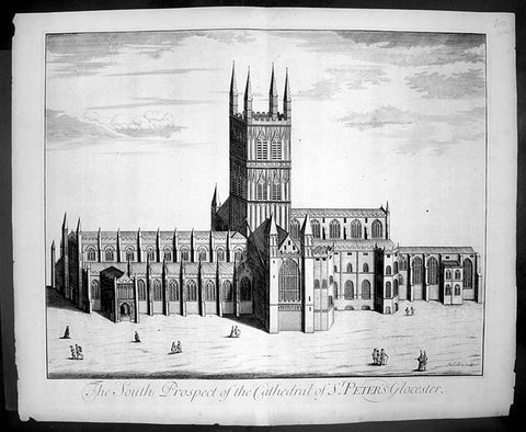
1724 Johannes Kip Large Antique Print of Gloucester Cathedral, England
- Title : The South Prospect of The Cathedral of St Peters Glocester
- Date : 1724
- Condition: (A+) Fine Condition
- Ref: 40415
- Size: 26 1/2in x 22in (670mm x 560mm)
Description: This large original copper-plate engraved antique print by Johannes (Jan) Kip, after Leonard Knyff, was published in the 1724 Joseph Smith edition of Britannia Illustrata or Nouveau Theatre de la Grande Bretagne. This beautifully engraved original antique print is testimony to the fine, detailed work produced by Jan Kip.
Britannia Illustrata was first issued in 1707 by David Mortier as a single volume containing 80 topographical etchings by Johannes Kip, after drawings by Leonard Knyff. Many are birds eye views of country seats, but there are also a number of interesting London views. The series was first reissued and expanded into two volumes in 1708-1713, and provided with a second French title Nouveau Theatre de la Grande Bretagne.
An expanded edition of Britannia Illustrata was re-published by Joseph Smith in 1724 under its French title, Nouveau Theatre..., containing many of the plates from the original edition by Mortier and also containing may new plates of places, churches, cathedrals and architecture of the landed gentry.
General Description:
Paper thickness and quality: - Heavy and stable
Paper colour: - off white
Age of map colour: -
Colours used: -
General colour appearance: -
Paper size: - 26 1/2in x 22in (670mm x 560mm)
Plate size: - 23in x 18in (585mm x 460mm)
Margins: - min 1in (25mm)
Imperfections:
Margins: - None
Plate area: - None
Verso: - None
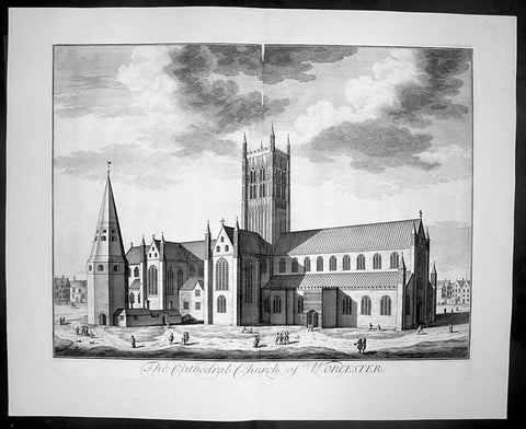
1724 Kip Large Folio Antique Print of Worcester Cathedral, England
- Title : The Cathedral Church of Worcester
- Date : 1724
- Condition: (A+) Fine Condition
- Ref: 40407
- Size: 26 1/2in x 22in (670mm x 560mm)
Description:
This finely engraved original large folio antique Cathedral print by Johannes Jan Kip, was engraved by James Collins was published in the 1724 by Joseph Smith monumental work Nouveau Theatre de la Grande Bretagne. This print also appeared in Britannia Illustrata by D. Mortier (brother of Pierre).
This is a finely engraved print being testimony to the beautiful and detailed work produced by Kip whose eye for detail was one of the most acknowledged of his day.
Background:
The history of Worcester goes back a long way. In 672, a council of the English Church was held, Worcester became the centre of five new dioceses formed. In the ninth century invasions from the Danes brought fighting to England, but Worcester being on the edge of the conflict escaped without much damage. In 983, Oswald founded a monastery at Worcester under the Benedictine rule, dedicated to St. Mary the Virgin. Wulfstan, in 1040 became a monk at Worcester and made such an impression, he became Bishop of Worcester in 1062. Wulfstan was the only Anglo-Saxon bishop to remain at his post after the Norman Conquest of 1066. In 1084, Wulfstan began rebuilding Worcester Cathedral, starting with the crypt, some of which still survives. He was canonised in 1203. Building work continued for some time, including rebuilding the two western bays of the nave in 1170 and around 1202 the central tower collapsed and there was a serious fire. In 1216, King John was buried at Worcester and he seems to have a devotion to St. Wulfstan. In 1224, Bishop William de Blois built the Lady Chapel, where he was buried when he died in 1236. In the fourteenth century the nave was completely rebuilt apart from the western bays. The central tower and the cloisters were completed built by 1374.
General Description:
Paper thickness and quality: - Heavy and stable
Paper colour: - off white
Age of map colour: -
Colours used: -
General colour appearance: -
Paper size: - 26 1/2in x 22in (670mm x 560mm)
Plate size: - 23in x 18in (585mm x 460mm)
Margins: - min 1in (25mm)
Imperfections:
Margins: - None
Plate area: - None
Verso: - None
1724 Johannes Kip Large Antique Print of St Marys Church The Strand London England
- Title : Admodum Reverendis Amplissimis...Templi St Maria in Vico dicto The Strand
- Date : 1724
- Condition: (A+) Fine Condition
- Ref: 40399
- Size: 26 1/2in x 22in (670mm x 560mm)
Description: This large original copper-plate engraved antique print by Johannes (Jan) Kip, after Leonard Knyff, was published in the 1724 Joseph Smith edition of Britannia Illustrata or Nouveau Theatre de la Grande Bretagne. This beautifully engraved original antique print is testimony to the fine, detailed work produced by Jan Kip.
Britannia Illustrata was first issued in 1707 by David Mortier as a single volume containing 80 topographical etchings by Johannes Kip, after drawings by Leonard Knyff. Many are birds eye views of country seats, but there are also a number of interesting London views. The series was first reissued and expanded into two volumes in 1708-1713, and provided with a second French title Nouveau Theatre de la Grande Bretagne.
An expanded edition of Britannia Illustrata was re-published by Joseph Smith in 1724 under its French title, Nouveau Theatre..., containing many of the plates from the original edition by Mortier and also containing may new plates of places, churches, cathedrals and architecture of the landed gentry.
Background:
The parish of St Mary le Strand may lay a good claim to being one of the oldest parishes in London. It stands dominating a roadway which since prehistory has been the main artery to the west from the City of London. In early Saxon times the Strand area was the very heart of London, for it seems that the City was effectively abandoned by the newly-arrived settlers. The Saxons predominantly inhabited "Lundenwic", an area stretching from Fleet Street to Whitehall and from the Thames to Covent Garden from the sixth to the ninth centuries. Christianity came to this settlement with St Mellitus and his followers in 604, and, despite their brief expulsion in the 620s, became firmly established. We do not know if any of the existing churches in the area date back that far but some, such as St Clement Danes, are known to have existed in later Saxon times.
There is no record of when St Mary le Strand was founded, but the first church, which was dedicated to the Nativity of the Blessed Virgin Mary, stood just south of the present church on a site now covered by Somerset House. Throughout the Middle Ages, the Bishops of Worcester were the Patrons of the parish and had their London residence on an adjoining site. For throughout the period from the Norman Conquest to the Reformation, the Strand was mainly the home of bishops and princes. Within the parish were the "inns" - large town houses with chapels, stables and accommodation for a large retinue - of the Bishops of Worcester, Llandaff, Coventry and Lichfield. A large part of the parish was absorbed by the building of a great house, the Palace of the Savoy, by Count Peter of Savoy, the uncle of Henry III, in the 1240s. A century later this became the home of John of Gaunt, Earl of Lancaster, and the palace became a centre of culture; among its residents was Geoffrey Chaucer, who was married in the palace chapel. Gaunt's unpopularity, as the king's chief minister, caused the palace to be burned in the Peasant's Revolt. Despite its long absence, the fame of the palace has lasted in the area and was recreated in the nineteenth century by the Savoy Hotel and Theatre.
The site where the present church stands was occupied in medieval times by Strand Cross. The origins of this are unclear. It was not a cross erected in memory of Queen Eleanor - as was Charing Cross - but seems to have dated back at least to Norman times. Perhaps it began as a market cross; by the early fourteenth century it had been rebuilt in a lavish manner, almost certainly following the design of the Eleanor Crosses. Strand Cross was a famous site and it is recorded that in the thirteenth century the local magistrates held their assizes in front of it.
Until the sixteenth century, the Strand was no more than a line of Bishops' palaces on the south side of the roadway stretching all the way to Whitehall. On the north side stood a wall which bounded the Convent - later Covent - Garden, while the churches further away, St Martin's and St Giles, stood "in-the-fields". All this was to change with the Reformation. The bishops' inns around the church were seized by Edward Lord Protector who set about building himself a renaissance palace in what was then the most fashionable part of town. Even with the extensive site that he had now obtained, further space was needed and towards the end of 1548 the Lord Protector's workmen fell upon St Mary's church and demolished it to provide stone for the new palace. Further stone was provided by the demolition of a cloister at St Paul's Cathedral known as Pardon Churchyard and the greater part of the Priory of St John at Clerkenwell. Even by the standards of the time, the demolition of so much sacred property was an outrage. Somerset was never to enjoy living in his new palace; just as it was nearing completion he was overthrown by his political enemies and executed at Tower Hill in 1551.
It is said that Somerset had intended to build a new parish church. If so, all thought of it passed away with his fall. Initially, the parishioners scattered but within a short time we find them gathered in the chapel of St John the Baptist in the Savoy. Here they would remain for the next 175 years. Now known at "St Mary le Savoy", the parishioners chose and paid for their own ministers. The most famous of these was Thomas Fuller, the church historian, who was appointed in 1642, fled during the Civil War and was restored to his living in 1660.
Following the execution of Somerset, his palace had passed to the possession of the Crown. Elizabeth I occasionally lodged there and it was from Somerset House that she set off to give thanks after the defeat of the Armada. Under the Stuarts, extensive improvements were made to the palace, the most impressive being the lavish Roman Catholic chapel built by Charles I's queen, Henrietta Maria.
The roadway in front of Somerset House, where Strand Cross had stood and where the present church was later to stand, was occupied in the early seventeenth century by a windmill used to pump water. In 1634 the first Hackney Carriage stand in England was established here by one Captain Bailey. Here also a maypole was erected which became the most famous maypole in London. Demolished by the Puritans, a new maypole was erected in 1661. Parts of this maypole remained until 1717, when they were removed and presented to Sir Isaac Newton as the base for a telescope.
In 1711, an Act of Parliament was passed for building 50 New Churches in the fast expanding suburbs of London. These were the so-called "Queen Ann Churches"; among them are Hawksmoor's Christ Church Spitalfields, St Anne's Limehouse, and St George's-in-the-East, Archer's St Paul's Depftord and James' St George's, Hanover Square. St Mary le Strand was quick to apply for a church to replace their demolished one and, as the site on the Strand was so prominent, the Commissioners for building the New Churches decided to make the Strand church the most lavish of the churches. Initially, it was intended that there should not be a spire but that a column celebrating the building of the New Churches should stand directly in front of the church.
General Description:
Paper thickness and quality: - Heavy and stable
Paper colour: - off white
Age of map colour: -
Colours used: -
General colour appearance: -
Paper size: - 26 1/2in x 22in (670mm x 560mm)
Plate size: - 23in x 18in (585mm x 460mm)
Margins: - min 1in (25mm)
Imperfections:
Margins: - None
Plate area: - None
Verso: - None
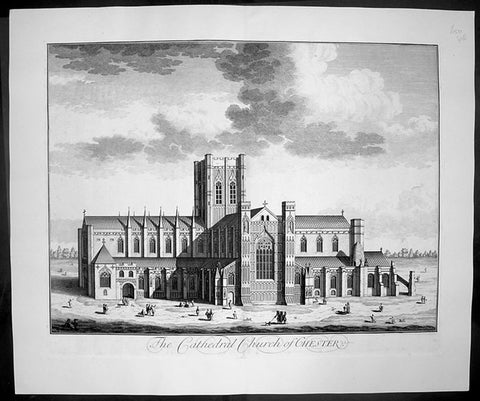
1724 Johannes Kip Large Antique Print of Chester Cathedral Church, Cheshire, England
- Title : The Cathedral Church of Chester
- Date : 1724
- Condition: (A+) Fine Condition
- Ref: 40412
- Size: 26 1/2in x 22in (670mm x 560mm)
Description: This large original copper-plate engraved antique print by Johannes (Jan) Kip, after Leonard Knyff, was published in the 1724 Joseph Smith edition of Britannia Illustrata or Nouveau Theatre de la Grande Bretagne. This beautifully engraved original antique print is testimony to the fine, detailed work produced by Jan Kip.
Britannia Illustrata was first issued in 1707 by David Mortier as a single volume containing 80 topographical etchings by Johannes Kip, after drawings by Leonard Knyff. Many are birds eye views of country seats, but there are also a number of interesting London views. The series was first reissued and expanded into two volumes in 1708-1713, and provided with a second French title Nouveau Theatre de la Grande Bretagne.
An expanded edition of Britannia Illustrata was re-published by Joseph Smith in 1724 under its French title, Nouveau Theatre..., containing many of the plates from the original edition by Mortier and also containing may new plates of places, churches, cathedrals and architecture of the landed gentry.
Background:
Standing on the site of a 10th century Saxon church, the present cathedral at Chester dates from the mid 13th century. Dedicated to St Werburgh, this Christian church was transformed into a Benedictine Abbey in 1092, colonised by a small group of monks from Normandy. Building of the new abbey church began immediately and took the best part of 150 years to complete but little evidence of the first church remains. The traditional sturdy Norman architecture was eventually replaced over the next two centuries by a more elegant Gothic style. Henry VIII dissolved the monastery in 1540 just as the monks of St Werburgh's Abbey were beginning to enjoy their new surroundings. A year later the abbey was given back as a cathedral, the last abbot of St Werburgh's becoming the first Dean of Chester Cathedral.
Over the next two hundred years the cathedral slipped into a bad state of disrepair but was eventually saved from total collapse by the efforts of Sir George Gilbert Scott. His 19th century restoration of Chester Cathedral, both externally and internally, not only put in place essential repairs but also enhanced the appearance of the great church immensely. Most of the stained glass comes from this period and highlights the abbey's dedication to St Werburgh, as well as the long history of the cathedral. On the northern aisle of the nave, at the side of one of the large windows, sits the 'Chester Imp'. A charming little figure in chains, carved by one of the medieval monks, to protect the church from evil spirits.
Most medieval cathedrals have beautifully carved stalls in the quire but the quality of oak carving at Chester Cathedral is quite exceptional. Each stall is topped with an elaborately carved canopy set above a row of small corbels, and below each seat a magnificently carved misericord. This area of the church is so richly carved with such a diverse array of religious artefacts, animals, birds and grotesque figures that it is quite overwhelming.
Apart from the main church many of the monastic buildings from the ancient Benedictine Abbey have been remarkably preserved. The original cloisters, although largely rebuilt during the first half of the 16th century and subsequently restored at the beginning of the 20th century, are a constant reminder of the important part they played in monastic life. All the bays of the undercroft, containing some wonderful vaulting, have been utilised to provide an exhibition centre, gift shop and workshop. The monks' dining room or refectory is still used regularly, as is the superb Chapter House. .
General Description:
Paper thickness and quality: - Heavy and stable
Paper colour: - off white
Age of map colour: -
Colours used: -
General colour appearance: -
Paper size: - 26 1/2in x 22in (670mm x 560mm)
Plate size: - 23in x 18in (585mm x 460mm)
Margins: - min 1in (25mm)
Imperfections:
Margins: - None
Plate area: - None
Verso: - None
1724 Johannes Kip Large Antique Print of Bath Cathedral, Somerset, England
- Title : The Cathedral Church of Bath
- Date : 1724
- Condition: (A+) Fine Condition
- Ref: 40401
- Size: 26 1/2in x 22in (670mm x 560mm)
Description:
This large original copper-plate engraved antique print by Johannes (Jan) Kip, after Leonard Knyff, was published in the 1724 Joseph Smith edition of Britannia Illustrata or Nouveau Theatre de la Grande Bretagne. This beautifully engraved original antique print is testimony to the fine, detailed work produced by Jan Kip.
Britannia Illustrata was first issued in 1707 by David Mortier as a single volume containing 80 topographical etchings by Johannes Kip, after drawings by Leonard Knyff. Many are birds eye views of country seats, but there are also a number of interesting London views. The series was first reissued and expanded into two volumes in 1708-1713, and provided with a second French title Nouveau Theatre de la Grande Bretagne.
An expanded edition of Britannia Illustrata was re-published by Joseph Smith in 1724 under its French title, Nouveau Theatre..., containing many of the plates from the original edition by Mortier and also containing may new plates of places, churches, cathedrals and architecture of the landed gentry.
Background:
Bath Abbey stands at the heart of the city of Bath; during the past twelve and a half centuries, three different churches have occupied this site:
An Anglo-Saxon Abbey Church dating from 757, pulled down by the Norman conquerors of England soon after 1066.
A massive Norman cathedral begun about 1090. It was larger than the monastery could afford to maintain and by the end of the 15th century was in ruins.
The present Abbey church founded in 1499, ruined after the dissolution of the monasteries in 1539 by order of Henry VIII.
General Description:
Paper thickness and quality: - Heavy and stable
Paper colour: - off white
Age of map colour: -
Colours used: -
General colour appearance: -
Paper size: - 26 1/2in x 22in (670mm x 560mm)
Plate size: - 23in x 18in (585mm x 460mm)
Margins: - min 1in (25mm)
Imperfections:
Margins: - None
Plate area: - None
Verso: - None
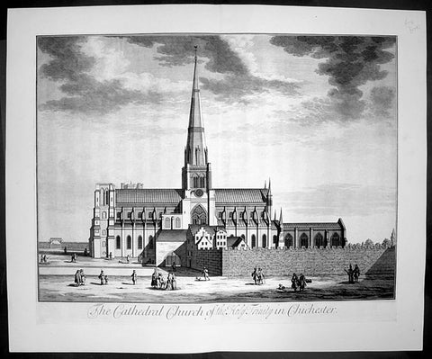
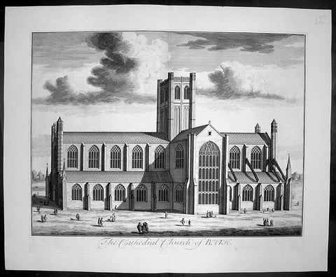
1724 Johannes Kip Large Antique Print The Holy Trinity Cathedral, Chichester, England
- Title : The Cathedral Church of the Holy Trinity in Chichester
- Date : 1724
- Condition: (A+) Fine Condition
- Ref: 40411
- Size: 26 1/2in x 22in (670mm x 560mm)
Description: This large original copper-plate engraved antique print by Johannes (Jan) Kip, after Leonard Knyff, was published in the 1724 Joseph Smith edition of Britannia Illustrata or Nouveau Theatre de la Grande Bretagne. This beautifully engraved original antique print is testimony to the fine, detailed work produced by Jan Kip.
Britannia Illustrata was first issued in 1707 by David Mortier as a single volume containing 80 topographical etchings by Johannes Kip, after drawings by Leonard Knyff. Many are birds eye views of country seats, but there are also a number of interesting London views. The series was first reissued and expanded into two volumes in 1708-1713, and provided with a second French title Nouveau Theatre de la Grande Bretagne.
An expanded edition of Britannia Illustrata was re-published by Joseph Smith in 1724 under its French title, Nouveau Theatre..., containing many of the plates from the original edition by Mortier and also containing may new plates of places, churches, cathedrals and architecture of the landed gentry.
Background:
The cathedral of the Holy Trinity at Chichester was founded in 1075, after the seat of the bishop was transferred to the town from nearby Selsey. It was consecrated in 1108, but a subsequent fire created a need for substantial rebuilding, which was not completed until 1184. The cathedral was reconsecrated in 1199. This was not the last stage in its development, by a long way. Richard de la Wyche, (Saint Richard of Chichester in the Anglican Communion), who was bishop from 1245 to 1253, was buried in the cathedral, where his shrine was a place of pilgrimage, until it was ordered destroyed in 1538, during the first stages of the English Reformation. Further damage to the cathedral had been done by fire after the second consecration, and much rebuilding was carried out in the Early English style. The original wooden ceiling had burnt out, and the sublimely simple present vaulting replaced it. The spire, which was originally built in the 14th century, was of poor-quality local stone, and collapsed suddenly in 1861, miraculously without loss of life. It was immediately rebuilt, by Sir Gilbert Scott, a noted scholarly architect.
The cathedral has many other unique features. Under the floor of the nave are the remains of a Roman mosaic pavement, which can be viewed through a glass window. Also in the interior are the grave of the composer Gustav Holst and the Gothic "Arundel tomb" referred to in a famous poem by Philip Larkin.
Despite its age, the cathedral contains several modern works of art, including tapestries by John Piper and Ursula Benker-Schirmer, a window by Marc Chagall, and a sculpture by Graham Sutherland.
General Description:
Paper thickness and quality: - Heavy and stable
Paper colour: - off white
Age of map colour: -
Colours used: -
General colour appearance: -
Paper size: - 26 1/2in x 22in (670mm x 560mm)
Plate size: - 23in x 18in (585mm x 460mm)
Margins: - min 1in (25mm)
Imperfections:
Margins: - None
Plate area: - None
Verso: - None
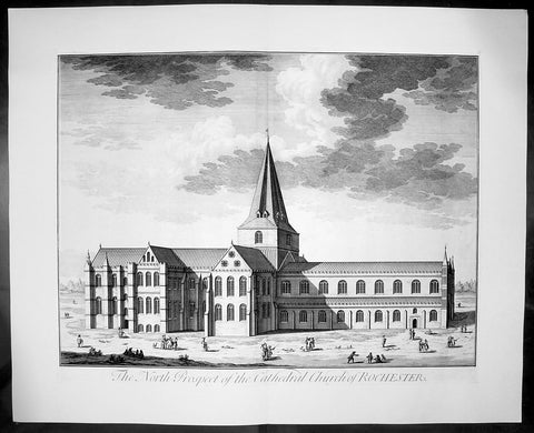
1724 Johannes Kip Large Antique Print of Rochester Cathedral, Kent, England
- Title : The North Prospect of the Cathedral Church of Rochester
- Date : 1724
- Condition: (A+) Fine Condition
- Ref: 40405
- Size: 26 1/2in x 22in (670mm x 560mm)
Description: This large original copper-plate engraved antique print by Johannes (Jan) Kip, after Leonard Knyff, was published in the 1724 Joseph Smith edition of Britannia Illustrata or Nouveau Theatre de la Grande Bretagne. This beautifully engraved original antique print is testimony to the fine, detailed work produced by Jan Kip.
Britannia Illustrata was first issued in 1707 by David Mortier as a single volume containing 80 topographical etchings by Johannes Kip, after drawings by Leonard Knyff. Many are birds eye views of country seats, but there are also a number of interesting London views. The series was first reissued and expanded into two volumes in 1708-1713, and provided with a second French title Nouveau Theatre de la Grande Bretagne.
An expanded edition of Britannia Illustrata was re-published by Joseph Smith in 1724 under its French title, Nouveau Theatre..., containing many of the plates from the original edition by Mortier and also containing may new plates of places, churches, cathedrals and architecture of the landed gentry.
Background:
Being the second oldest cathedral foundation in England, Rochester Cathedrals history goes back to AD604 when Augustine sent Bishop Justus to establish the house founded by King Ethelbert of Kent. Following several invasions by the Danes, the church was in a state of devastation by the time Bishop Gundulf was consecrated in 1077 but immediately he began a major building operation, and introduced a community of Benedictine monks in 1080.
The church suffered misfortune again in the mid 12th century with two serious fires, resulting in a further rebuilding programme. Since that time there has been continuous remodelling, refurbishments and restorations, mainly due to other historical events when the cathedral sustained damage. As a consequence of its very chequered history, Rochester Cathedral displays the varied building styles of each period, from the functional austerity of Gundulf's original structure, through the Romanesque, Gothic and Early English architectural periods, and continuing with renovation and restoration well into the 20th century following war damage.
The sturdy, squat Norman nave contrasts dramatically with the tall, narrow Gothic arches of the crossing. A superbly carved stone archway of the Decorated period (c1345), now enhanced with a solid oak door, leads to the chapter room and is a magnificent feat of craftsmanship. Quite unusually, the Lady Chapel is sited between the nave and the south transept as monastic outbuildings occupied the traditional location at the eastern end of the church when the chapel was added in the late 15th century. Beneath the quire transept is a beautifully preserved and vaulted crypt, with two bays surviving from the original Norman construction. There are also many fragments of medieval ceiling paintings to be found in this lower level sanctuary.
Though one of the smaller Norman cathedrals, Rochester was an important centre for pilgrimage during the 13th century, and even today attracts many visitors who are keen to learn more about its fascinating history. From a photographic perspective, a wonderful view of Rochester cathedral can be seen from the top of Rochester Castle, immediately opposite. We have visited both the Rochester Cathedral and Castle on many occasions, and still manage to uncover more information, or something interesting that we had previously overlooked. Earlier this year, we ventured for the first time into the cloister garth, discovering a substantial section of the ruined Chapter House. On the south side, the entrance arch to the monk's refectory survives and, looking behind it, the 13th century lavatorium and towel recess is still visible.
Johannes Kip was a draughtsman and engraver, who worked first in his native Amsterdam before moving to London at the end of the seventeenth century. He did portraits, views, and book illustrations. (Ref: Tooley; M&B)
General Description:
Paper thickness and quality: - Heavy and stable
Paper colour: - off white
Age of map colour: -
Colours used: -
General colour appearance: -
Paper size: - 26 1/2in x 22in (670mm x 560mm)
Plate size: - 23in x 18in (585mm x 460mm)
Margins: - min 1in (25mm)
Imperfections:
Margins: - None
Plate area: - None
Verso: - None
1849 Fairbairn Large Folio Antique Print of Old Tombs High Church Yard, Glasgow
- Title : Old Tombs High Church Yard
- Date : 1849
- Condition: (A+) Fine Condition
- Ref: 40244
- Size: 22in x 16in (560mm x 405mm)
Description:
This beautifully coloured large folio original antique lithograph print, views of old Glasgow now long gone, by the Scottish artist Thomas Fairbairn (1821 - 1885) was published by Miller & Buchanan in the 1849 edition of Relic of Ancient Architecture and other Picturesque Scenes in Glasgow.
Subject Background:
The subjects of this picture are representations of the memorials raised to departed worth by the affection or gratitude of our forefathers. We append a brief notice of each, but the only one of the four deserving of special allusion is that erected to the memory of Dr Peter Low, and now the property of the Faculty of Physicians and Surgeons in Glasgow. Dr. Low, who was some-time chirurgeon-in-ordinary to the French King, and also to King James VI., and his son the Prince, procured from the latter monarch a charter of erection in favour of the Faculty of Glasgow. The original charter is extant A fine old portrait of Dr. Low is preserved in the Faculty Hall, St.Enoch Square.
No. I.- The first on the left of the Plate.
Erected in 1630, by the Rev. John Dickson, who was married to Janet, daughter of the "Lord Bedlay." Afterwards it appears to have become the property of "Roberton of Bedlay," and latterly of Miss Lennox of Woodhead, who in 1818 disponed it to George Brown of Capelrigg, whose representatives are the present proprietors.
No. II.
"Here lyes ane Treu faithfull Brother, William Robertson, Merchand Burges of Glasgow. Decesit ye 24 June, 1617."
"W.R. AB."
This tomb appears afterwards to have belonged to Morehead of Bredisholm, although there is no entry in the Register to that effect. The present proprietor is not known.
No. III.
Monument to Dr PETER Low, Founder of the Faculty of Physicians and Surgeons, Glasgow.
INSCRIPTION.
Stay, Passenger, and view this Stone,
For under it lys such an one,
Who cur'd many while he liv'd,
So gracious he no man griev'd;
Yea, when his Physick's force oft fail'd,
His pleasant Purpose then prevail'd;
For of his God he got the Grace,
To live in Mirth and die in Peace.
Heaven has his soul, his corpse this Stone:
Sigh, passenger, and then be gone.
Ah! me. I gravel am and dust,
And to the grave deshend I must;
O! painted piece of liveing clay,
Man be not proud of thy short day.
This Burial Place was purchased by and is now the property of the Faculty of Physicians and Surgeons.
No. IV.
"Erected by Archd. Mure, Merchant, 1616, and descended to his daughter, Margaret Mure, who was married to James Hamilton. Afterwards it became the property of Provost John Gibson, in right of his wife, Christian Anderson, grand-child of the above James Hamilton and Margaret Mure. It afterwards became the property of William Anderson, merchant, in right of his wife, Christian Gibson, daughter of Provost John Gibson; and their only child, Christian Anderson, was the next successor. She dying unmarried, was succeeded by her cousin, Margaret Mather, relict of Archibald Anderson, brewer in Glasgow, who upon the 13th May, 1797, disponed this property to Thomas Buchanan, merchant in Glasgow; and upon the 13th March, 1806, it was conveyed by Jane Buchanan, his daughter, to James Buchanan,* merchant, Glasgow." - (From Register of Burial Grounds.)
* Late of Dowanhill, whose representatives are the present proprietors.
Relic of Ancient Architecture and other Picturesque Scenes in Glasgow, was published large folio size in 1849, containing 19 large folio coloured lithograph prints and has long since been out of print. A praiseworthy motive induced Mr. James Bogle, at one time Lord Dean of Guild, and a member of an old and highly-respected Glasgow family, to engage Mr. Thomas Fairbairn to reproduce them, before they passed into oblivion, some "Relics of Ancient Architecture and Picturesque Scenes in Glasgow." The immediate cause of Mr. Bogle's resolve was the fall of a sugar-house in Alston Street, by which some six or seven lives were lost, and a resolution on the part of the Dean of Guild Court to make a general survey of the City with a view to the removal of old houses which, from age or other causes, were considered to be unfit for habitation. Mr. Bogle naturally thought that this was the proper time to reproduce in permanent form a fair presentment of many of the noted houses of old Glasgow.
Along with Mr. Fairbairn, the artist, Mr. Bogle made a tour of the City, and selected subjects for the drawings, nearly all of which are now gone, and those few that remain are so altered as to be almost irrecognisable.
A general wish having been expressed for a reproduction of the work, the publishers some time ago engaged Mr. Fairbairn (now alas! gone) to reproduce the original sketches, and also add a number of others of interest before the rapid growth of the City extinguishes or entirely defaces their subjects.
The drawings are now thirty in number, and have been reproduced by Messrs. Annan's new process of photo-engraving, which it will be observed, gives the effect of finely finished mezzo-tints.
The letterpress descriptions of the original edition are from the pen of the late Mr. James Pagan, Editor of the Glasgow Herald, and the descriptions of the new scenes have been supplied by his successor, the present Editor of that journal.
It ought to be stated that the descriptive portions, written by Mr. Pagan more than thirty years ago, have not been touched; so that readers should understand that they refer to the Glasgow of a former generation, and are all indicated in the Contents by an asterisk.
General Description:
Paper thickness and quality: - Heavy & stable
Paper color: - White
Age of map color: - Original
Colors used: - Red, green, blue, brown
General color appearance: - Authentic
Paper size: - 22in x 16in (560mm x 405mm)
Margins: - Min 4in (100mm)
Imperfections:
Margins: - None
Plate area: - None
Verso: - None
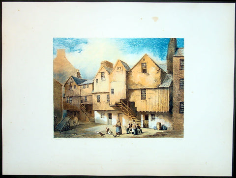
1849 Fairbairn Large Folio Antqiue Print of Houses Saltmarket St Gorbals Glasgow
- Title : Old Wooden Houses in Close Saltmarket
- Date : 1849
- Condition: (A+) Fine Condition
- Ref: 40247
- Size: 22in x 16in (560mm x 405mm)
Description:
This beautifully coloured large folio original antique lithograph print, views of old Glasgow now long gone, by the Scottish artist Thomas Fairbairn (1821 - 1885) was published by Miller & Buchanan in the 1849 edition of Relic of Ancient Architecture and other Picturesque Scenes in Glasgow.
Subject Background:
The artist has here represented a style of dwelling-house architecture which is fast passing away, and will soon altogether cease to exist. Houses of this kind seem to have been originally erected from the cheapness of the materials, and for the purpose of economizing building-ground space. To attain the latter object, beams, as shown in the print, were projected from the first storey, and an out-shot and additional structure raised upon them, thus offering a great obstruction to ventilation, and affording an inconvenient, cold, and comfortless dwelling. When situated in a close, houses of this kind were generally occupied by working people, or by those who rented a small shop or bothy in the front street, and lodged themselves and families in one of these fragile-looking tenements behind. In some rare cases these wooden houses were tenanted by persons of a more substantial character, and we may mention, as the most prominent instance of which we have heard, that so recently as the close of last century the firm of Francis Reid & Sons, watchmakers, occupied a large wooden structure in the close opposite 77, both as their dwelling-house, work-shop, and sale-shop. These gentlemen were the first to give a stimulus to the watchmaking and jewellery business in Glasgow; and however humble their premises may have been, they did a large and lucrative business, and off-shoots from their concern branched into some of the principal establishments at present existing in Glasgow. We have no story to tell regarding the houses represented in the print; in their better days they were occupied by decent native tradesmen, but for a long succession of years they have been in the possession of the Irish, whose annals would furnish nothing attractive. Two hundred years ago wooden houses of this kind formed the majority of the Saltmarket closes ; but a great fire having broken out on 3rd November, 1677, the upper part of the street on both sides was destroyed as far as the Tron Church on the west, and two or three tenements in the Gallowgate on the east. From the rapidity with which these timber structures were mowed down by the flames on that occasion, the wisdom of replacing them with stone erections became apparent, and since then very few timber houses have been put down in the city, excepting in obscure back lanes, and on a very humble scale. As we have said, they will speedily disappear altogether, for the Dean of Guild Court will not permit a renewal of buildings in this style, when the present houses fall or are pulled down from natural decay. A stone inserted in the door-way of a one-storey house at the bottom of this close hears the inscription, "H. Br., J. H., 1727.".
Relic of Ancient Architecture and other Picturesque Scenes in Glasgow, was published large folio size in 1849, containing 19 large folio coloured lithograph prints and has long since been out of print. A praiseworthy motive induced Mr. James Bogle, at one time Lord Dean of Guild, and a member of an old and highly-respected Glasgow family, to engage Mr. Thomas Fairbairn to reproduce them, before they passed into oblivion, some "Relics of Ancient Architecture and Picturesque Scenes in Glasgow." The immediate cause of Mr. Bogle's resolve was the fall of a sugar-house in Alston Street, by which some six or seven lives were lost, and a resolution on the part of the Dean of Guild Court to make a general survey of the City with a view to the removal of old houses which, from age or other causes, were considered to be unfit for habitation. Mr. Bogle naturally thought that this was the proper time to reproduce in permanent form a fair presentment of many of the noted houses of old Glasgow.
Along with Mr. Fairbairn, the artist, Mr. Bogle made a tour of the City, and selected subjects for the drawings, nearly all of which are now gone, and those few that remain are so altered as to be almost irrecognisable.
A general wish having been expressed for a reproduction of the work, the publishers some time ago engaged Mr. Fairbairn (now alas! gone) to reproduce the original sketches, and also add a number of others of interest before the rapid growth of the City extinguishes or entirely defaces their subjects.
The drawings are now thirty in number, and have been reproduced by Messrs. Annan's new process of photo-engraving, which it will be observed, gives the effect of finely finished mezzo-tints.
The letterpress descriptions of the original edition are from the pen of the late Mr. James Pagan, Editor of the Glasgow Herald, and the descriptions of the new scenes have been supplied by his successor, the present Editor of that journal.
It ought to be stated that the descriptive portions, written by Mr. Pagan more than thirty years ago, have not been touched; so that readers should understand that they refer to the Glasgow of a former generation, and are all indicated in the Contents by an asterisk.
General Description:
Paper thickness and quality: - Heavy & stable
Paper color: - White
Age of map color: - Original
Colors used: - Red, green, blue, brown
General color appearance: - Authentic
Paper size: - 22in x 16in (560mm x 405mm)
Margins: - Min 4in (100mm)
Imperfections:
Margins: - None
Plate area: - None
Verso: - None
1849 Fairbairn Large Folio Antique Print Baronial Tower ,Main St Gorbals Glasgow
- Title : Old Baronial Hall Front View Main St Gorbals
- Date : 1849
- Condition: (A+) Fine Condition
- Ref: 40245
- Size: 22in x 16in (560mm x 405mm)
Description:
This beautifully coloured large folio original antique lithograph print, views of old Glasgow now long gone, by the Scottish artist Thomas Fairbairn (1821 - 1885) was published by Miller & Buchanan in the 1849 edition of Relic of Ancient Architecture and other Picturesque Scenes in Glasgow.
Subject Background:
This venerable pile, so long identified with the Barony of Gorbals, was erected between the years 1600 and 1608, by Sir George Elphinston, the son of a merchant in Glasgow, who had acquired the lands on the south side of the river known as "St. Ninian's Croft," from Boyd, the Protestant Archbishop of the See. With the view of forming a suitable residence, Sir George enclosed part of the croft for an orchard and garden, and built thereon the erections which so long formed the most prominent objects on the east side of the Main Street of Gorbals. Tradition informs us that he also erected a small Chapel adjoining, part of which still exists at the corner of Main Street and Rutherglen Loan. It was in this baronet's favour that the village of "Gorbels" was erected into a Burgh of Barony and Regality. Although this gentleman enjoyed great distinction in his lifetime, and rose to the rank of Lord Justice Clerk in the reign of Charles I., he afterwards became reduced in circumstances, and died miserably and in poverty about 1634. According to McUre, he was privately interred "in his own chapel, adjoining to his house." The property was then sold by the creditors of the deceased to Robert Douglas, Viscount Belhaven. This nobleman extended the mansion in Gorbals, and built a square Tower or "Fortulice," which is now almost the only part of the venerable buildings existing. Until within a few years ago, the Tower in question exhibited four turrets, which of course gave an imposing appearance to the structure. On the building adjoining the Tower may still be seen the family arms of Viscount Belhaven, pretty well cut in stone, the whole surmounted by the letters S. G. E., which are apparently meant for the initials of Sir George Elphinston. It is not at all improbable that this was not the original position of the arms referred to, but that at some period when alterations were made on the Tower, they had been removed from it, and placed so as to face the Main Street of the Barony. The Viscount, at his death, was succeeded by his nephew, Sir Robert Douglas of Blackerston, who sold the Gorbals Mansion House and lands in cumulo, some time prior to 1661, to the town of Glasgow, the Trades' House, and the Trustees for Hutchesons' Hospital. They were retained as a sort of co-partnery possession till 1790, when a division was made, and the central portion, containing the old buildings, fell to the lot of the city. The most important event connected with the Baronial Hall structure is found in the fact that at one time it formed the residence of Sir James Turner, Commander-in-Chief of the Forces in Scotland in the reign of Charles II., and who is understood to be the personage who supplied Sir Walter Scott with the portrait of Dugald Dalgetty. The terms on which Sir James obtained possession of the house are somewhat singular; for it appears by the minutes that on the 18th July, 1670, the Bailies and Council "ordains ane tack to be wrytten and subscryvit in favors of Sir James Turnor, of the toune's houss and tour in Gorballs, quhilk he presentlie possesses, and that dureing his lifetyme, for payment yearlie of three punds Scots, if the samyne be requyred." Sir James accordingly died in possession of the subjects; and from the records kept in the College, it would appear that at the sale of his effects, a part of his scanty library was purchased by the University of Glasgow. Amongst his books were several works upon the art of war; but the soldier of fortune had not overlooked productions of a more elevating and humanising kind, for Milton's "Paradise Lost" and various kindred tomes are found in his catalogue. Who were the successors of Sir James Turner, in the "toune's houss and tour," we have no way of knowing. At all events, as the locality was never an attractive one for the Glasgow merchants, the occupants must have gradually descended in the scale of quality. Before the close of the last century, and for some time afterwards, the principal room in the Tower, which was of a spacious kind, was used as a place of meeting by the magistrates, heritors and feuars of the parish of Gorbals; and here also the inhabitants mustered previous to performing the dutes of watching and warding, in days when a police force did not exist. Latterly, part of the old building was fitted up as a police-office, with adjoining cells. But it lost all its importance, excepting such as it retained from olden associations, when the official staff was removed to the present extensive police establishment in Portland Street. t was then given over to very humble uses - the ground floors to the street being let as whisky shops, and the upper flats having been split up into dwelling-houses for the lowest class of the people. The greater part of the structure built by Sir George Elphinston was taken down early in 1849 by order of the Dean of Guild Court, from its having exhibited symptoms of insecurity. It was then a fine remnant and wreck of the Scottish urban Manor House style, with its oriel windows, ornamental ceilings, and stout oaken staircases. The Tower, which remains, though sadly dilapidated externally and internally, still exhibits evidences of the aristocratic aspect it wore in the days of other years
Relic of Ancient Architecture and other Picturesque Scenes in Glasgow, was published large folio size in 1849, containing 19 large folio coloured lithograph prints and has long since been out of print. A praiseworthy motive induced Mr. James Bogle, at one time Lord Dean of Guild, and a member of an old and highly-respected Glasgow family, to engage Mr. Thomas Fairbairn to reproduce them, before they passed into oblivion, some "Relics of Ancient Architecture and Picturesque Scenes in Glasgow." The immediate cause of Mr. Bogle's resolve was the fall of a sugar-house in Alston Street, by which some six or seven lives were lost, and a resolution on the part of the Dean of Guild Court to make a general survey of the City with a view to the removal of old houses which, from age or other causes, were considered to be unfit for habitation. Mr. Bogle naturally thought that this was the proper time to reproduce in permanent form a fair presentment of many of the noted houses of old Glasgow.
Along with Mr. Fairbairn, the artist, Mr. Bogle made a tour of the City, and selected subjects for the drawings, nearly all of which are now gone, and those few that remain are so altered as to be almost irrecognisable.
A general wish having been expressed for a reproduction of the work, the publishers some time ago engaged Mr. Fairbairn (now alas! gone) to reproduce the original sketches, and also add a number of others of interest before the rapid growth of the City extinguishes or entirely defaces their subjects.
The drawings are now thirty in number, and have been reproduced by Messrs. Annan's new process of photo-engraving, which it will be observed, gives the effect of finely finished mezzo-tints.
The letterpress descriptions of the original edition are from the pen of the late Mr. James Pagan, Editor of the Glasgow Herald, and the descriptions of the new scenes have been supplied by his successor, the present Editor of that journal.
It ought to be stated that the descriptive portions, written by Mr. Pagan more than thirty years ago, have not been touched; so that readers should understand that they refer to the Glasgow of a former generation, and are all indicated in the Contents by an asterisk.
General Description:
Paper thickness and quality: - Heavy & stable
Paper color: - White
Age of map color: - Original
Colors used: - Red, green, blue, brown
General color appearance: - Authentic
Paper size: - 22in x 16in (560mm x 405mm)
Margins: - Min 4in (100mm)
Imperfections:
Margins: - None
Plate area: - None
Verso: - None
1849 Fairnbiarn Large Antique Print The Old Baronial Hall in the Gorbals Glasgow
- Title : Old Baronial Hall, Gorbals, Back View
- Date : 1849
- Condition: (A+) Fine Condition
- Ref: 40251
- Size: 22in x 16in (560mm x 405mm)
Description:
This beautifully coloured large folio original antique lithograph print, views of old Glasgow now long gone, by the Scottish artist Thomas Fairbairn (1821 - 1885) was published by Miller & Buchanan in the 1849 edition of Relic of Ancient Architecture and other Picturesque Scenes in Glasgow.
Subject Background
The Old Baronial Hall was built by Sir George Elphinstone and his wife Dame Agnes Boyd in 1601. Following his death in 1634 the building passed down through several owners including Robert Douglas, Viscount Belhaven (who added a distinctive square tower), Gorbals Town Council and Sir James Turner. By 1858 a part of The Old Barional Hall (with the neighbouring chapel) had been converted into a public house, the Old Gorbals Wine and Spirit Vaults. However, the ornate ceiling and cornicing and the statuettes on the walls are reminders of the building's former glories, as the home of one of Glasgow's most prominent men of affairs. The initials S G E and D A B on the ceiling were part of the original decoration and stood for Sir George Elphinstone and his wife Dame Agnes Boyd. It was demolished in the early 1870s.
The Gorbals is an area on the south bank of the River Clyde in the city of Glasgow, Scotland. By the late 19th century, it had become over-populated and adversely affected by local industrialisation. Many people lived here because their jobs provided this home and they could not afford their own. It became widely known as a dangerous slum and was subject to efforts at
redevelopment, which contributed to more problems such as homeless people and diseases spreading. In recent decades, some buildings have been demolished for a mixture of market and social housing; others are being refurbished and restored to a higher standard.
Relic of Ancient Architecture and other Picturesque Scenes in Glasgow, was published large folio size in 1849, containing 19 large folio coloured lithograph prints and has long since been out of print. A praiseworthy motive induced Mr. James Bogle, at one time Lord Dean of Guild, and a member of an old and highly-respected Glasgow family, to engage Mr. Thomas Fairbairn to reproduce them, before they passed into oblivion, some "Relics of Ancient Architecture and Picturesque Scenes in Glasgow." The immediate cause of Mr. Bogle's resolve was the fall of a sugar-house in Alston Street, by which some six or seven lives were lost, and a resolution on the part of the Dean of Guild Court to make a general survey of the City with a view to the removal of old houses which, from age or other causes, were considered to be unfit for habitation. Mr. Bogle naturally thought that this was the proper time to reproduce in permanent form a fair presentment of many of the noted houses of old Glasgow
Along with Mr. Fairbairn, the artist, Mr. Bogle made a tour of the City, and selected subjects for the drawings, nearly all of which are now gone, and those few that remain are so altered as to be almost irrecognisable.
A general wish having been expressed for a reproduction of the work, the publishers some time ago engaged Mr. Fairbairn (now alas! gone) to reproduce the original sketches, and also add a number of others of interest before the rapid growth of the City extinguishes or entirely defaces their subjects.
The drawings are now thirty in number, and have been reproduced by Messrs. Annan's new process of photo-engraving, which it will be observed, gives the effect of finely finished mezzo-tints.
The letterpress descriptions of the original edition are from the pen of the late Mr. James Pagan, Editor of the Glasgow Herald, and the descriptions of the new scenes have been supplied by his successor, the present Editor of that journal.
It ought to be stated that the descriptive portions, written by Mr. Pagan more than thirty years ago, have not been touched; so that readers should understand that they refer to the Glasgow of a former generation, and are all indicated in the Contents by an asterisk.
General Description:
Paper thickness and quality: - Heavy & stable
Paper color: - White
Age of map color: - Original
Colors used: - Red, green, blue, brown
General color appearance: - Authentic
Paper size: - 22in x 16in (560mm x 405mm)
Margins: - Min 4in (100mm)
Imperfections:
Margins: - None
Plate area: - None
Verso: - None
1849 Fairnbiarn Large Antique Print of Mansion Stockwell Street Glasgow Scotland
- Title : Old Mansion, Stockwell Street
- Date : 1849
- Condition: (A+) Fine Condition
- Ref: 40248
- Size: 22in x 16in (560mm x 405mm)
Description:
This beautifully coloured large folio original antique lithograph print of views of old Glasgow now long gone by the Scottish artist Thomas Fairbairn (1821 - 1885) was published by Miller & Buchanan in the 1849 edition of Relic of Ancient Architecture and other Picturesque Scenes in Glasgow.
Subject Background
This is one of the finest specimens extant of the dwelling-houses which the Glasgow citizens of the seventeenth century delighted to rear for the accommodation of themselves and families. No story of any peculiar interest attaches to the fabric in question. It simply illustrates a once favourite style of architecture which has now almost disappeared from amongst us. In a document, dated in 1639, this site is described as having been occupied by three small tenements which were then in rather a ruinous condition. They were surrounded by a "yaird," and considered quite in the suburbs. The subjects must have remained in a dilapidated condition for a long time. They were purchased in 1668 by John Caldwell, merchant in Glasgow, who immediately afterwards built the present tenement or tenements. It had a garden to the back, surrounded with a wall, and adorned with a summer-house. The subjects passed into the hands of Andrew Caldwell, son of the former, who sold them in 1698 to John Gray and William Knox, merchants in Glasgow, but apparently only in security for a debt. This was not paid, however, and a commission was granted to these gentlemen to dispose of the property absolutely, when it was acquired by Daniel Campbell, John Graham of Dugaldston, William Cross, William Wodropp, James Muir, and Matthew Campbell, merchants in Glasgow. This transaction took place on 3rd October, 1700. These gentlemen belonged to the mercantile aristocracy of the time; but the purpose for which they became joint-stock owners of this property is not now apparent. These parties sold their respective shares to Graham of Dugaldston in 1705, who in turn disposed of it, in 1709, to Andrew Cathcart, merchant in Glasgow. In a document, dated 13th January of that year, the subjects are thus described:-
"All and haill, the foresaid northmost of the saids two tenements of land, high and laigh, back and forwd, with the closs yaird at the back thereof, and stone dyke about the same, and summer-house within the same yaird, office-house, and haill pertinents of the samen, with the equal half of the said well Lyand betwixt the said two tenements, with free ish and entree yrto, and haill liberties and privileges yrof. And whilk northmost tenement, closs, yaird, office-houss, and pertinents erected and rebuilded by umqll John Cauldwell, merchant, father to the said Andrew, pertained of old to umqll Peter Johnston Tayloor, and consisted of three small tenements, yaird, and pertinents, and were acquired by the said umqll John Cauldwell from Kathrine Johnstoune and John Montgomerie, her husband, and were then bounded betwixt the lands of Adam Hish, being now the southmost of the saids two tenements. The lands of umqll Patrick Crawford and oyrs, and of the representatives of the said umqll Mitchell on the north. The lands of umqll William Thomson, John Andersone, elder, and Mr Archibald Denniston on the east, and the High Street on the west parts."
The purchaser above-named having held the property during a very lengthened period, including the time of the two great rebellions, it descended in 1754 to his grandson, William Cathcart, then merchant in Kingston, Jamaica. The representatives of this gentleman sold the property in 1771 to James Campbell, saddler in Glasgow, for the sum of £820. Campbell seems to have been unfortunate, for in the same year the Trustees for his creditors sold the subjects to George Anderson, merchant. About this time the house was much damaged by fire, but as it was insured in the Sun Fire Office, the Trustees retained the insurance money, and sold the property as it stood for the reduced price of £535. Anderson held it till his death, and the greater part was disposed of by his Trustees in 1827 to Mr Ritchie, Stockwell Street, whose family still hold the house. The price then paid was £1800. It has long ceased to be a dwelling-house, the lower portions or ground floors having been occupied as spirit vaults for an uninterrupted space of more than 80 years. They are used for this purpose still. A tradition has long prevailed that this house was occupied by some of Cromwell's officers when the Protector was in Glasgow. This, of course, could not have been the case, for the house was not built till eight years after the Restoration. The three small houses, however, which previously occupied the same site may, in all likelihood, have afforded accommodation to some of Cromwell's train.
Relic of Ancient Architecture and other Picturesque Scenes in Glasgow, was published large folio size in 1849, containing 19 large folio coloured lithograph prints and has long since been out of print. A praiseworthy motive induced Mr. James Bogle, at one time Lord Dean of Guild, and a member of an old and highly-respected Glasgow family, to engage Mr. Thomas Fairbairn to reproduce them, before they passed into oblivion, some "Relics of Ancient Architecture and Picturesque Scenes in Glasgow." The immediate cause of Mr. Bogle's resolve was the fall of a sugar-house in Alston Street, by which some six or seven lives were lost, and a resolution on the part of the Dean of Guild Court to make a general survey of the City with a view to the removal of old houses which, from age or other causes, were considered to be unfit for habitation. Mr. Bogle naturally thought that this was the proper time to reproduce in permanent form a fair presentment of many of the noted houses of old Glasgow
Along with Mr. Fairbairn, the artist, Mr. Bogle made a tour of the City, and selected subjects for the drawings, nearly all of which are now gone, and those few that remain are so altered as to be almost irrecognisable.
A general wish having been expressed for a reproduction of the work, the publishers some time ago engaged Mr. Fairbairn (now alas! gone) to reproduce the original sketches, and also add a number of others of interest before the rapid growth of the City extinguishes or entirely defaces their subjects.
The drawings are now thirty in number, and have been reproduced by Messrs. Annan's new process of photo-engraving, which it will be observed, gives the effect of finely finished mezzo-tints.
The letterpress descriptions of the original edition are from the pen of the late Mr. James Pagan, Editor of the Glasgow Herald, and the descriptions of the new scenes have been supplied by his successor, the present Editor of that journal.
It ought to be stated that the descriptive portions, written by Mr. Pagan more than thirty years ago, have not been touched; so that readers should understand that they refer to the Glasgow of a former generation, and are all indicated in the Contents by an asterisk.
General Description:
Paper thickness and quality: - Heavy & stable
Paper color: - White
Age of map color: - Original
Colors used: - Red, green, blue, brown
General color appearance: - Authentic
Paper size: - 22in x 16in (560mm x 405mm)
Margins: - Min 4in (100mm)
Imperfections:
Margins: - None
Plate area: - None
Verso: - None
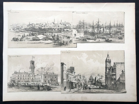
1888 Large Antique Print Views of Melbourne, Australia
- Title : Melbourne
- Date : 1888
- Condition: (A+) Fine Condition
- Ref: 33074
- Size: 14 1/2in x 11in (370mm x 280mm)
Description:
This fine original antique lithograph print four views Melbourne, The City, Harbour, Gov. House & Collins St, was published in ca 1888. (Ref: M&B; Tooley)
General Description:
Paper thickness and quality: - Heavy & stable
Paper color: - White
Age of map color: -
Colors used: -
General color appearance: -
Paper size: - 14 1/2in x 11in (370mm x 280mm)
Plate size: - 14 1/2in x 11in (370mm x 280mm)
Margins: - Min 1/2in (10mm)
Imperfections:
Margins: - Light soiling
Plate area: - None
Verso: - None
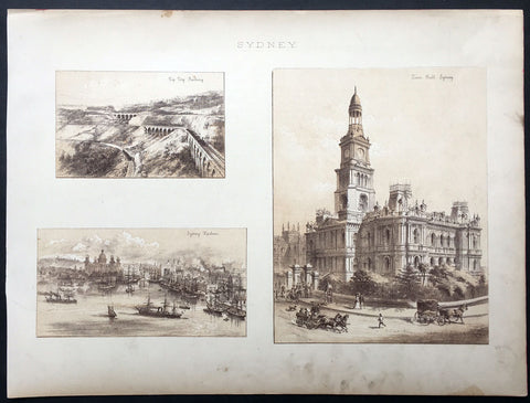
1888 Large Antique Print Views of Sydney Australia
- Title : Sydney
- Date : 1888
- Condition: (A+) Fine Condition
- Ref: 33075
- Size: 14 1/2in x 11in (370mm x 280mm)
Description:
This fine original antique lithograph print three views Sydney - The Zig Zag Railway, Sydney Harbour & the Sydney Town Hall - was published in ca 1888. (Ref: M&B; Tooley)
General Description:
Paper thickness and quality: - Heavy & stable
Paper color: - White
Age of map color: -
Colors used: -
General color appearance: -
Paper size: - 14 1/2in x 11in (370mm x 280mm)
Plate size: - 14 1/2in x 11in (370mm x 280mm)
Margins: - Min 1/2in (10mm)
Imperfections:
Margins: - Light soiling
Plate area: - None
Verso: - None
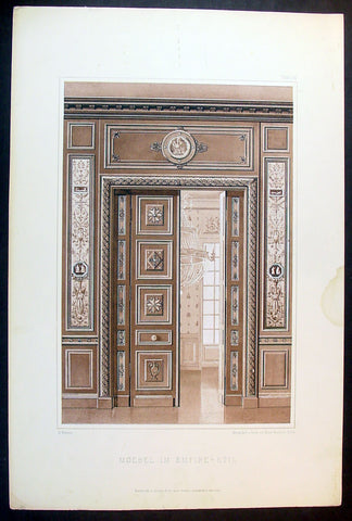
1889 Ernst Wasmuth Antique Print Lithograph of Neo-classical European Decoration
- Title : Moebel Im Empire-Stil
- Date : 1889
- Condition: (A+) Fine Condition
- Ref: 70536
- Size: 19in x 12 1/2in (485mm x 320mm)
Description:
This finely engraved coloured original antique lithograph print of neo-classical European decoration was published by Ernst Wasmuth in the 1889 edition of Farbige Decorationen, Berlin.
Farbige Decorationen, was published in two volumes between 1889 & 1896 . the volumes contained 121 coloured plates lithographed by Ernst Wasmuth, illustrating contemporary architectural and decoration.
Ernst Wasmuth - a very influential publisher who is famous for a book on the architect Frank Lloyd Wright entitled Studies and Executed Buildings of Frank Lloyd Wright, published in Germany in 1910. This two-volume work, which contains more than 100 lithographs of Wright’s designs, is commonly known as the Wasmuth Portfolio.(Ref: M&B; Tooley)
General Description:
Paper thickness and quality: - Heavy & stable
Paper color: - White
Age of map color: - Original
Colors used: - Brown
General color appearance: - Authentic
Paper size: - 19in x 12 1/2in (485mm x 320mm)
Margins: - Min 1in (25m)
Imperfections:
Margins: - None
Plate area: - None
Verso: - None
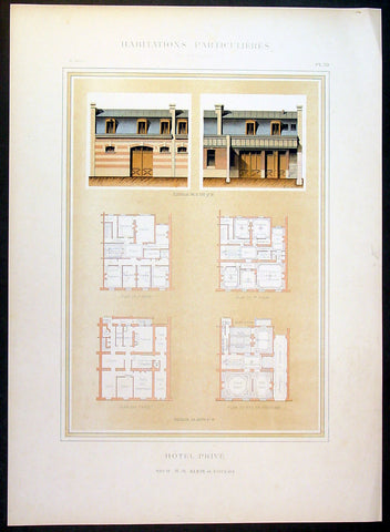
1888 Paul Planat Lithograph Antique Hotel Architectural Print, France
- Title : Habitations Particulieres
- Date : 1888
- Condition: (A+) Fine Condition
- Ref: 70543
- Size: 18in x 13 1/2in (460mm x 345mm)
Description:
This finely engraved original antique print of a French Hotel was published by Paul Planat (1839 - 1911) in the 1888 edition of Encyclopédie de l'architecture et de la construction.
Published between 1888 - 1892 this monumental 13 volume work on Architecture and construction by Planat was a leap forward in both the understanding and representation of architecture at the end of the 19th century. (Ref: M&B; Tooley)
General Description:
Paper thickness and quality: - Heavy & stable
Paper color: - White
Age of map color: - Original
Colors used: - Green, yellow, blue, brown
General color appearance: - Authentic
Paper size: - 18in x 13 1/2in (460mm x 345mm)
Margins: - Min 1in (25mm)
Imperfections:
Margins: - None
Plate area: - None
Verso: - None
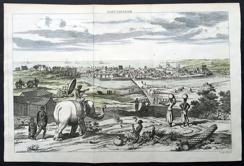
1732 Baldaeus Antique Print a View of Machilipatnam Andhra Pradesh, India
- Title : Masulipatam
- Date : 1732
- Condition: (A+) Fine Condition
- Ref: 25904
- Size: 15in x 10in (380mm x 255mm)
Description:
This fine beautifully hand coloured original antique print a view of the city of Masulipatam (Machilipatnam) on the Malibar Coast in India was published in the 1732 second English edition of Philip Baldaeus "A True and Exact Description of the Most Celebrated East-India Coasts of Malabar and Coromandel; and also of the Isle of Ceylon… London: Awnsham and John Churchill, 1732.
Machilipatnam is a city and the district headquarters of Krishna district, located in Coastal Andhra region of Andhra Pradesh, India. During British rule, the city was their first trading settlement on the Bay of Bengal coast, when it was also known as Masulipatnam or Masula, and as Bandar in folklore, located 72 km to the east of the state capital Vijayawada.
Second edition in English of Baldaeus’ account of his 17th-century travels in south India and Ceylon—one of the first Europeans to publish at length about the region published with 37 copper-engraved views and maps. Father Philippus Baldaeus, Baelde or Philip Balde (October 1632, Delft – 1672, Geervliet) was a Dutch minister. He went to Jaffna, Ceylon with an invading Dutch force during 17th Century. As the first European he documented the life, language and culture of Tamil people, living in the north of the island. It is a great historical record, similar to Mahawamsa, and it was immediately published in Dutch and German (with several beautiful pictures).
Baldaeus had a Flemish origin. His ancestors had left Ypres in 1584. Baldaeus lost both his parents, when he was four years old. His uncle Robertus Junius was a missionary on Dutch Formosa. After studying Oriental languages in Groningen (1649) and theology in Leiden (1650), and discussions with Arnoldus Montanus, he preached from 1655 at Batavia, Dutch East Indies, Jaffanapatnam and Point de Galle, either in Dutch or Portuguese (language). From 1657 he served under Rijklof van Goens, occupying the Coromandel and Negapatnam in 1658. Cornelis Speelman became its first governor. By 1660 the Dutch controlled the whole island except the kingdom of Kandy. When the Dutch occupied the coast of Malabar in 1661, Baldaeus took part. Around 1662 he returned to Ceylon and Baldaeus learned Sanskrit and studied Hinduism.
In 1666 he returned to the Dutch Republic and preached in Geervliet from 1669 until his death at the age of 39 or 40. He left behind a full and faithful account of the civil, religious, and domestic condition of the countries through which he travelled. In this, he introduced also an interesting account of the Hindu mythology, and some specimens of the Tamil language, including the translation of the Lord's Prayer: defective enough it is true, but remarkable as the first treatise, printed in Europe, on any Indian language. The title of the whole work is Description of the East Indian Countries of Malabar, Coromandel, Ceylon, etc. (in Dutch, 1671) The book is dedicated to the bailiff Cornelis de Witt. (Ref: M&B; Tooley)
General Description:
Paper thickness and quality: - Heavy & stable
Paper color: - White
Age of map color: - Early
Colors used: - Blue, green,
General color appearance: - Fresh
Paper size: - 15in x 10in (380mm x 255mm)
Plate size: - 14in x 9 1/2in (360mm x 240mm)
Margins: - Min 1/2in (12mm)
Imperfections:
Margins: - None
Plate area: - Folds as issued
Verso: - None
1862 Morel & Lemercier Large Antique French Lithograph Decoration Print
- Title : Paris A Morel & Co. Editeurs...Imp. Lemercier r de Seine 57 Paris
- Date : 1862
- Condition: (A+) Fine Condition
- Ref: 70548
- Size: 16 1/2in x 13 1/2in (460mm x 345mm)
Description:
This fine large original antique chromolithograph print of interior French decoration from the mid 19th century was published in the 1862 edition of Manuel de Peintures by A Morel & Co. Editeurs , Paris with the Chromolithograph by the famous French firm of Lemercier, Paris
General Description:
Paper thickness and quality: - Heavy & stable
Paper color: - White
Age of map color: - Original
Colors used: - Red, Green
General color appearance: - Authentic
Paper size: - 16 1/2in x 13 1/2in (460mm x 345mm)
Margins: - Min 1in (25mm)
Imperfections:
Margins: - None
Plate area: - None
Verso: - None
1862 Morel & Lemercier Large Antique French Lithograph Decoration Print
- Title : Paris A Morel & Co. Editeurs...Imp. Petit et Bisiaux Lemercier r de Seine 57 Paris
- Date : 1862
- Condition: (A+) Fine Condition
- Ref: 70549
- Size: 16 1/2in x 13 1/2in (460mm x 345mm)
Description:
This fine large original antique chromolithograph print of interior French decoration from the mid 19th century was published in the 1862 edition of Manuel de Peintures by A Morel & Co. Editeurs , Paris with the Chromolithograph by the famous French firm of Lemercier, Paris
General Description:
Paper thickness and quality: - Heavy & stable
Paper color: - White
Age of map color: - Original
Colors used: - Red, Green
General color appearance: - Authentic
Paper size: - 16 1/2in x 13 1/2in (460mm x 345mm)
Margins: - Min 1in (25mm)
Imperfections:
Margins: - Light spotting in bottom margin
Plate area: - None
Verso: - None
1862 Morel & Lemercier Large Antique French Lithograph Decoration Print
- Title : Paris A Morel & Co. Editeurs...Imp. Lemercier r de Seine 57 Paris
- Date : 1862
- Condition: (A+) Fine Condition
- Ref: 70540
- Size: 16 1/2in x 13 1/2in (460mm x 345mm)
Description:
This fine large original antique chromolithograph print of interior French decoration from the mid 19th century was published in the 1862 edition of Manuel de Peintures by A Morel & Co. Editeurs , Paris with the Chromolithograph by the famous French firm of Lemercier, Paris
General Description:
Paper thickness and quality: - Heavy & stable
Paper color: - White
Age of map color: - Original
Colors used: - Red, Green
General color appearance: - Authentic
Paper size: - 16 1/2in x 13 1/2in (460mm x 345mm)
Margins: - Min 1in (25mm)
Imperfections:
Margins: - None
Plate area: - None
Verso: - None
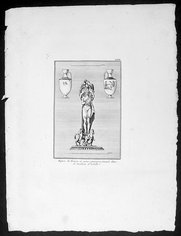
1802 J B Lechevalier Antique Print Bronze Figure, Vases in Achilles Tomb Turkey
- Title : Figure de bronze et vases cineraires, trouves dans le tombeau d Achille
- Date : 1802
- Condition: (A+) Fine Condition
- Ref: 70228
- Size: 14in x 10in (355mm x 255mm)
Description:
This original copper-plate engraved antique print of a Bronze Figure and a pair of Vases found in the Tomb of Achilles located in the ancient Greek city of Achilleion in the Troad region of Çanakkale, now in NW modern Turkey, was published in the 1802 edition of Jean-Baptiste Lechevaliers of Voyage de la Troade, fait dans les années 1785 et 1786
General Definitions:
Paper thickness and quality: - Heavy and stable
Paper color : - off white
Age of map color: -
Colors used: -
General color appearance: -
Paper size: - 14in x 10in (355mm x 255mm)
Plate size: - 7in x 5in (180mm x 130mm) each plate
Margins: - Min 1/2in (12mm)
Imperfections:
Margins: - Light soiling
Plate area: - None
Verso: - None
Background:
Achilleion was an ancient Greek city in the south-west of the Troad region of Anatolia. It has been located on a promontory known as Beşika Burnu (cradle promontory) about 8 km south of Sigeion. Beşika Burnu is 2 km south of the modern village of Yeniköy in the Ezine district of Çanakkale Province, Turkey. The site considered in classical antiquity to be the tomb of Achilles is a short distance inland at a tumulus known as Beşiktepe. Achilleion in the Troad is not to be confused with Achilleion near Smyrna and Achilleion in the territory of Tanagra.
The otherwise obscure polis of Achilleion was most famous in classical antiquity for its association with Achilles, after whom it was named (the place of Achilles). According to some sources, while passing by Ilion in 334 BC Alexander the Great sacrificed at the Tomb of Achilles. This story became famous, and in the mid-1st century BC it is mentioned by the politician and writer Cicero in his Pro Archia Poeta. In AD 216 the Emperor Caracalla emulated Alexander when, on passing Ilion on his way to a war against Parthia, he held funeral games around the tumulus. Following the abandonment of the settlement at Achilleion in the late Hellenistic period, writers began to associate the tomb with nearby Sigeion to the north.
The first mention of Achilleion is as a fortified settlement from which Mytilene conducted its attacks on Athenian controlled Sigeion to the north in the early 6th century BCE. It is not clear whether Achilleion had been settled earlier, but the ceramic record also begins at this point, suggesting that it had not. Recent excavations have established that the walls of the settlement also date to the first half of the 6th century BCE, further corroborating the literary accounts of Herodotus and Strabo regarding its origins. Achilleion remained under Mytilenaean control until Athens brought an end to the Mytilenaean revolt in 427 BCE and took over all the so-called Actaean cities in the Troad. Achilleion appears in the Athenian tribute lists for 425/4 and 422/1 BCE, indicating that it had joined the Delian League. The legend AX (ACH) which some bronze coins found in this region bear is thought to refer to Ach (illeion) and suggest that c. 350 - 300 BCE the city minted its own coins. King Lysimachus synoecized Ilion with many surrounding communities including Achilleion during his reign (306 - 281 BCE), effectively ending Achilleions political independence. The testimony of Demetrius of Scepsis, who hailed from a nearby town in the Troad, indicates that there was still a hamlet known as Achilleion on the site in the mid-2nd century BCE. It is to around this time that the latest ceramic finds from Achilleion date, suggesting that the site became uninhabited soon afterwards.
Jean-Baptiste Lechevalier was the secretary of the Ambassador of France in Constantinople. In the year 1788 he visited the plain of Troy, and was enthusiastically in favour of the theory that the site of Homers Troy was to be found at the village of Bunarbashi. His publication about Troy Voyage de la Troade.....was first published in 1799.
The Troad, also known as Troas, is the historical name of the Biga peninsula (Biga Yarımadası, Τρωάς) in the northwestern part of Anatolia, Turkey. This region now is part of the Çanakkale province of Turkey. Bounded by the Dardanelles to the northwest, by the Aegean Sea to the west and separated from the rest of Anatolia by the massif that forms Mount Ida, the Troad is drained by two main rivers, the Scamander (Karamenderes) and the Simois, which join at the area containing the ruins of Troy. Grenikos, Kebren, Simoeis, Rhesos, Rhodios, Heptaporos and Aisepos were seven rivers of the Troad and the names of the river gods that inhabited each river.
Troy (Ancient Greek: Τροία, Troia or Τροίας, Troias, Truva or Troya) was a city in the far northwest of the region known in late Classical antiquity as Asia Minor, now known as Anatolia in modern Turkey, just south of the southwest mouth of the Dardanelles strait and northwest of Mount Ida. The present-day location is known as Hisarlik. It was the setting of the Trojan War described in the Greek Epic Cycle, in particular in the Iliad, one of the two epic poems attributed to Homer. Metrical evidence from the Iliad and the Odyssey suggests that the name λιον (Ilion) formerly began with a digamma: Ϝίλιον (Wilion); this is also supported by the Hittite name for what is thought to be the same city, Wilusa.
A new capital called Ilium (from Greek: λιον, Ilion) was founded on the site in the reign of the Roman Emperor Augustus. It flourished until the establishment of Constantinople, became a bishopric and declined gradually in the Byzantine era, but is now a Latin Catholic titular see.
In 1865, English archaeologist Frank Calvert excavated trial trenches in a field he had bought from a local farmer at Hisarlik, and in 1868, Heinrich Schliemann, a wealthy German businessman and archaeologist, also began excavating in the area after a chance meeting with Calvert in Çanakkale. These excavations revealed several cities built in succession. Schliemann was at first skeptical about the identification of Hisarlik with Troy, but was persuaded by Calvert and took over Calverts excavations on the eastern half of the Hisarlik site, which was on Calvert\'s property. Troy VII has been identified with the city called Wilusa by the Hittites (the probable origin of the Greek λιον) and is generally (but not conclusively) identified with Homeric Troy.
Today, the hill at Hisarlik has given its name to a small village near the ruins, which supports the tourist trade visiting the Troia archaeological site. It lies within the province of Çanakkale, some 30 km south-west of the provincial capital, also called Çanakkale. The nearest village is Tevfikiye. The map here shows the adapted Scamander estuary with Ilium a little way inland across the Homeric plain. Due to Troys location near the Aegean Sea, the Sea of Marmara, and the Black Sea, it was a central hub for the military and trade(Ref: M&B; Tooley)
1802 Lechevalier Antique Print of Ancient Greek & Troy Coins - Apollo, Ganymede.
- Title : Plates XXXIV & XXXV
- Date : 1802
- Condition: (A+) Fine Condition
- Ref: 70231
- Size: 14in x 10in (355mm x 255mm)
Description:
This original copper-plate engraved antique prints of ancient Greek, Roman & Troy coins (details below) found in the ancient Greek province of Çanakkale, now in the NW of modern Turkey, was published in the 1802 edition of Jean-Baptiste Lechevaliers of Voyage de la Troade, fait dans les années 1785 et 1786
Each plate contains 3 coins;
Plate XXXIV
31. Tete d Julia Domna (The head of Julia Domna)
32. Un guerrier a cheval (A horse warrior)
33. Tete de Geta (Head of Geta)
Plate XXXV
34. Tete de femme voilee (Head of a woman)
35. Tete de Meduse, de face (Head & face of Medusa)
36. Tete de lauree d apollon (Head of Apollo)
General Definitions:
Paper thickness and quality: - Heavy and stable
Paper color : - off white
Age of map color: -
Colors used: -
General color appearance: -
Paper size: - 14in x 10in (355mm x 255mm)
Plate size: - 7in x 5in (180mm x 130mm) each plate
Margins: - Min 1/2in (12mm)
Imperfections:
Margins: - Light soiling
Plate area: - None
Verso: - None
Background:
Jean-Baptiste Lechevalier was the secretary of the Ambassador of France in Constantinople. In the year 1788 he visited the plain of Troy, and was enthusiastically in favour of the theory that the site of Homers Troy was to be found at the village of Bunarbashi. His publication about Troy Voyage de la Troade..... was first published in 1799.
The Troad, also known as Troas, is the historical name of the Biga peninsula (Biga Yarımadası, Τρωάς) in the northwestern part of Anatolia, Turkey. This region now is part of the Çanakkale province of Turkey. Bounded by the Dardanelles to the northwest, by the Aegean Sea to the west and separated from the rest of Anatolia by the massif that forms Mount Ida, the Troad is drained by two main rivers, the Scamander (Karamenderes) and the Simois, which join at the area containing the ruins of Troy. Grenikos, Kebren, Simoeis, Rhesos, Rhodios, Heptaporos and Aisepos were seven rivers of the Troad and the names of the river gods that inhabited each river.
Troy (Ancient Greek: Τροία, Troia or Τροίας, Troias, Truva or Troya) was a city in the far northwest of the region known in late Classical antiquity as Asia Minor, now known as Anatolia in modern Turkey, just south of the southwest mouth of the Dardanelles strait and northwest of Mount Ida. The present-day location is known as Hisarlik. It was the setting of the Trojan War described in the Greek Epic Cycle, in particular in the Iliad, one of the two epic poems attributed to Homer. Metrical evidence from the Iliad and the Odyssey suggests that the name λιον (Ilion) formerly began with a digamma: Ϝίλιον (Wilion); this is also supported by the Hittite name for what is thought to be the same city, Wilusa.
A new capital called Ilium (from Greek: λιον, Ilion) was founded on the site in the reign of the Roman Emperor Augustus. It flourished until the establishment of Constantinople, became a bishopric and declined gradually in the Byzantine era, but is now a Latin Catholic titular see.
In 1865, English archaeologist Frank Calvert excavated trial trenches in a field he had bought from a local farmer at Hisarlik, and in 1868, Heinrich Schliemann, a wealthy German businessman and archaeologist, also began excavating in the area after a chance meeting with Calvert in Çanakkale. These excavations revealed several cities built in succession. Schliemann was at first skeptical about the identification of Hisarlik with Troy, but was persuaded by Calvert and took over Calverts excavations on the eastern half of the Hisarlik site, which was on Calvert\'s property. Troy VII has been identified with the city called Wilusa by the Hittites (the probable origin of the Greek λιον) and is generally (but not conclusively) identified with Homeric Troy.
Today, the hill at Hisarlik has given its name to a small village near the ruins, which supports the tourist trade visiting the Troia archaeological site. It lies within the province of Çanakkale, some 30 km south-west of the provincial capital, also called Çanakkale. The nearest village is Tevfikiye. The map here shows the adapted Scamander estuary with Ilium a little way inland across the Homeric plain. Due to Troys location near the Aegean Sea, the Sea of Marmara, and the Black Sea, it was a central hub for the military and trade(Ref: M&B; Tooley)
1802 J B Lechevalier Antique Print of Ancient Greek Coins Jupiter, Diane, Apollo
- Title : Plates XXIV & XXV
- Date : 1802
- Condition: (A+) Fine Condition
- Ref: 70229
- Size: 14in x 10in (355mm x 255mm)
Description:
This original copper-plate engraved antique prints of ancient Greek coins (details below) found in the ancient Greek province of Çanakkale in the NW of modern Turkey, was published in the 1802 edition of Jean-Baptiste Lechevaliers of Voyage de la Troade, fait dans les années 1785 et 1786
Each plate contains 3 coins;
Plate XXIV
1. Apdeyc - Jupiter debout dans un Temple Distyle (Jupiter standing in a Distinct Temple)
2. Graecinus, Qvin Tert. - Une figure assise, dont on ne voit que la partie inserieure (A seated figure, whose only part is visible)
3. Tete d Ulysse - Barbue et couverte du Pileus (Head of Ulysses - Bearded and Covered Pileus)
Plate XXV
1. Tete d Appolon lauree (Head of Appolo laurel)
2. Tete de Diane ( Head of Diane)
3. Tete de femme (Head of a woman)
General Definitions:
Paper thickness and quality: - Heavy and stable
Paper color : - off white
Age of map color: -
Colors used: -
General color appearance: -
Paper size: - 14in x 10in (355mm x 255mm)
Plate size: - 7in x 5in (180mm x 130mm) each plate
Margins: - Min 1/2in (12mm)
Imperfections:
Margins: - Light soiling
Plate area: - None
Verso: - None
Background:
Jean-Baptiste Lechevalier was the secretary of the Ambassador of France in Constantinople. In the year 1788 he visited the plain of Troy, and was enthusiastically in favour of the theory that the site of Homers Troy was to be found at the village of Bunarbashi. His publication about Troy Voyage de la Troade.....was first published in 1799.
The Troad, also known as Troas, is the historical name of the Biga peninsula (Biga Yarımadası, Τρωάς) in the northwestern part of Anatolia, Turkey. This region now is part of the Çanakkale province of Turkey. Bounded by the Dardanelles to the northwest, by the Aegean Sea to the west and separated from the rest of Anatolia by the massif that forms Mount Ida, the Troad is drained by two main rivers, the Scamander (Karamenderes) and the Simois, which join at the area containing the ruins of Troy. Grenikos, Kebren, Simoeis, Rhesos, Rhodios, Heptaporos and Aisepos were seven rivers of the Troad and the names of the river gods that inhabited each river.
Troy (Ancient Greek: Τροία, Troia or Τροίας, Troias, Truva or Troya) was a city in the far northwest of the region known in late Classical antiquity as Asia Minor, now known as Anatolia in modern Turkey, just south of the southwest mouth of the Dardanelles strait and northwest of Mount Ida. The present-day location is known as Hisarlik. It was the setting of the Trojan War described in the Greek Epic Cycle, in particular in the Iliad, one of the two epic poems attributed to Homer. Metrical evidence from the Iliad and the Odyssey suggests that the name λιον (Ilion) formerly began with a digamma: Ϝίλιον (Wilion); this is also supported by the Hittite name for what is thought to be the same city, Wilusa.
A new capital called Ilium (from Greek: λιον, Ilion) was founded on the site in the reign of the Roman Emperor Augustus. It flourished until the establishment of Constantinople, became a bishopric and declined gradually in the Byzantine era, but is now a Latin Catholic titular see.
In 1865, English archaeologist Frank Calvert excavated trial trenches in a field he had bought from a local farmer at Hisarlik, and in 1868, Heinrich Schliemann, a wealthy German businessman and archaeologist, also began excavating in the area after a chance meeting with Calvert in Çanakkale. These excavations revealed several cities built in succession. Schliemann was at first skeptical about the identification of Hisarlik with Troy, but was persuaded by Calvert and took over Calverts excavations on the eastern half of the Hisarlik site, which was on Calvert\'s property. Troy VII has been identified with the city called Wilusa by the Hittites (the probable origin of the Greek λιον) and is generally (but not conclusively) identified with Homeric Troy.
Today, the hill at Hisarlik has given its name to a small village near the ruins, which supports the tourist trade visiting the Troia archaeological site. It lies within the province of Çanakkale, some 30 km south-west of the provincial capital, also called Çanakkale. The nearest village is Tevfikiye. The map here shows the adapted Scamander estuary with Ilium a little way inland across the Homeric plain. Due to Troys location near the Aegean Sea, the Sea of Marmara, and the Black Sea, it was a central hub for the military and trade(Ref: M&B; Tooley)
1802 J B Lechevalier Antique Print Ancient Greek Coins - Minerva Mytilene Pallas
- Title : Plates XXVI & XXVII
- Date : 1802
- Condition: (A+) Fine Condition
- Ref: 70235
- Size: 14in x 10in (355mm x 255mm)
Description:
This original copper-plate engraved antique prints of ancient Greek coins (details below) found in the ancient Greek province of Çanakkale in the NW of modern Turkey, was published in the 1802 edition of Jean-Baptiste Lechevaliers of Voyage de la Troade, fait dans les années 1785 et 1786
Each plate contains 3 coins;
Plate XXVI
7. Le Tete de Minerve (The head of Minerva)
8. Tete Casquee de Minerve, fondatrice d Athenes (Head Helmet of Minerva, founder of Athens)
9. Mytilene dans l ile de Lesbos, patrie de Pattacus (Mytilene in the island of Lesbos, homeland of Pattacus)
Plate XXVII
10. Tete a deux faces, l une barbue et couronnee de laurier (Head with two faces, l bearded and laurel wreath)
11. Tete de Palas ( Head of Pallas)
12. Tete de Pallas (Head of a Pallas)
General Definitions:
Paper thickness and quality: - Heavy and stable
Paper color : - off white
Age of map color: -
Colors used: -
General color appearance: -
Paper size: - 14in x 10in (355mm x 255mm)
Plate size: - 7in x 5in (180mm x 130mm) each plate
Margins: - Min 1/2in (12mm)
Imperfections:
Margins: - Light soiling
Plate area: - None
Verso: - None
Background:
Jean-Baptiste Lechevalier was the secretary of the Ambassador of France in Constantinople. In the year 1788 he visited the plain of Troy, and was enthusiastically in favour of the theory that the site of Homers Troy was to be found at the village of Bunarbashi. His publication about Troy Voyage de la Troade.....was first published in 1799.
The Troad, also known as Troas, is the historical name of the Biga peninsula (Biga Yarımadası, Τρωάς) in the northwestern part of Anatolia, Turkey. This region now is part of the Çanakkale province of Turkey. Bounded by the Dardanelles to the northwest, by the Aegean Sea to the west and separated from the rest of Anatolia by the massif that forms Mount Ida, the Troad is drained by two main rivers, the Scamander (Karamenderes) and the Simois, which join at the area containing the ruins of Troy. Grenikos, Kebren, Simoeis, Rhesos, Rhodios, Heptaporos and Aisepos were seven rivers of the Troad and the names of the river gods that inhabited each river.
Troy (Ancient Greek: Τροία, Troia or Τροίας, Troias, Truva or Troya) was a city in the far northwest of the region known in late Classical antiquity as Asia Minor, now known as Anatolia in modern Turkey, just south of the southwest mouth of the Dardanelles strait and northwest of Mount Ida. The present-day location is known as Hisarlik. It was the setting of the Trojan War described in the Greek Epic Cycle, in particular in the Iliad, one of the two epic poems attributed to Homer. Metrical evidence from the Iliad and the Odyssey suggests that the name λιον (Ilion) formerly began with a digamma: Ϝίλιον (Wilion); this is also supported by the Hittite name for what is thought to be the same city, Wilusa.
A new capital called Ilium (from Greek: λιον, Ilion) was founded on the site in the reign of the Roman Emperor Augustus. It flourished until the establishment of Constantinople, became a bishopric and declined gradually in the Byzantine era, but is now a Latin Catholic titular see.
In 1865, English archaeologist Frank Calvert excavated trial trenches in a field he had bought from a local farmer at Hisarlik, and in 1868, Heinrich Schliemann, a wealthy German businessman and archaeologist, also began excavating in the area after a chance meeting with Calvert in Çanakkale. These excavations revealed several cities built in succession. Schliemann was at first skeptical about the identification of Hisarlik with Troy, but was persuaded by Calvert and took over Calverts excavations on the eastern half of the Hisarlik site, which was on Calvert\'s property. Troy VII has been identified with the city called Wilusa by the Hittites (the probable origin of the Greek λιον) and is generally (but not conclusively) identified with Homeric Troy.
Today, the hill at Hisarlik has given its name to a small village near the ruins, which supports the tourist trade visiting the Troia archaeological site. It lies within the province of Çanakkale, some 30 km south-west of the provincial capital, also called Çanakkale. The nearest village is Tevfikiye. The map here shows the adapted Scamander estuary with Ilium a little way inland across the Homeric plain. Due to Troys location near the Aegean Sea, the Sea of Marmara, and the Black Sea, it was a central hub for the military and trade(Ref: M&B; Tooley)
1802 J B Lechevalier Antique Print Ancient Greek Coins - Geta Gallien Apollo
- Title : Plates XXVIII & XXIX
- Date : 1802
- Condition: (A+) Fine Condition
- Ref: 70234
- Size: 14in x 10in (355mm x 255mm)
Description:
This original copper-plate engraved antique prints of ancient Greek coins (details below) found in the ancient Greek province of Çanakkale in the NW of modern Turkey, was published in the 1802 edition of Jean-Baptiste Lechevaliers of Voyage de la Troade, fait dans les années 1785 et 1786
Each plate contains 3 coins;
Plate XXVIII
13. Septimus Geta Caes - Tete de Geta (The head of Geta)
14. Tete de Gallien (Head of Gallien)
15. Tete de Commode (Head of Commode)
Plate XXIX
16. Tete de Antonin le Pieux (Head of Antoninus Pius)
17. Tete de femme, tourrelee ( Head of a woman)
18. Tete d Apollon (Head of Apollo)
General Definitions:
Paper thickness and quality: - Heavy and stable
Paper color : - off white
Age of map color: -
Colors used: -
General color appearance: -
Paper size: - 14in x 10in (355mm x 255mm)
Plate size: - 7in x 5in (180mm x 130mm) each plate
Margins: - Min 1/2in (12mm)
Imperfections:
Margins: - Light soiling
Plate area: - None
Verso: - None
Background:
Jean-Baptiste Lechevalier was the secretary of the Ambassador of France in Constantinople. In the year 1788 he visited the plain of Troy, and was enthusiastically in favour of the theory that the site of Homers Troy was to be found at the village of Bunarbashi. His publication about Troy Voyage de la Troade.....was first published in 1799.
The Troad, also known as Troas, is the historical name of the Biga peninsula (Biga Yarımadası, Τρωάς) in the northwestern part of Anatolia, Turkey. This region now is part of the Çanakkale province of Turkey. Bounded by the Dardanelles to the northwest, by the Aegean Sea to the west and separated from the rest of Anatolia by the massif that forms Mount Ida, the Troad is drained by two main rivers, the Scamander (Karamenderes) and the Simois, which join at the area containing the ruins of Troy. Grenikos, Kebren, Simoeis, Rhesos, Rhodios, Heptaporos and Aisepos were seven rivers of the Troad and the names of the river gods that inhabited each river.
Troy (Ancient Greek: Τροία, Troia or Τροίας, Troias, Truva or Troya) was a city in the far northwest of the region known in late Classical antiquity as Asia Minor, now known as Anatolia in modern Turkey, just south of the southwest mouth of the Dardanelles strait and northwest of Mount Ida. The present-day location is known as Hisarlik. It was the setting of the Trojan War described in the Greek Epic Cycle, in particular in the Iliad, one of the two epic poems attributed to Homer. Metrical evidence from the Iliad and the Odyssey suggests that the name λιον (Ilion) formerly began with a digamma: Ϝίλιον (Wilion); this is also supported by the Hittite name for what is thought to be the same city, Wilusa.
A new capital called Ilium (from Greek: λιον, Ilion) was founded on the site in the reign of the Roman Emperor Augustus. It flourished until the establishment of Constantinople, became a bishopric and declined gradually in the Byzantine era, but is now a Latin Catholic titular see.
In 1865, English archaeologist Frank Calvert excavated trial trenches in a field he had bought from a local farmer at Hisarlik, and in 1868, Heinrich Schliemann, a wealthy German businessman and archaeologist, also began excavating in the area after a chance meeting with Calvert in Çanakkale. These excavations revealed several cities built in succession. Schliemann was at first skeptical about the identification of Hisarlik with Troy, but was persuaded by Calvert and took over Calverts excavations on the eastern half of the Hisarlik site, which was on Calvert\'s property. Troy VII has been identified with the city called Wilusa by the Hittites (the probable origin of the Greek λιον) and is generally (but not conclusively) identified with Homeric Troy.
Today, the hill at Hisarlik has given its name to a small village near the ruins, which supports the tourist trade visiting the Troia archaeological site. It lies within the province of Çanakkale, some 30 km south-west of the provincial capital, also called Çanakkale. The nearest village is Tevfikiye. The map here shows the adapted Scamander estuary with Ilium a little way inland across the Homeric plain. Due to Troys location near the Aegean Sea, the Sea of Marmara, and the Black Sea, it was a central hub for the military and trade(Ref: M&B; Tooley)
1802 J B Lechevalier Antique Print Ancient Greek Coins - Hadrian, Maxime, Troy
- Title : Plates XXX & XXXI
- Date : 1802
- Condition: (A+) Fine Condition
- Ref: 70233
- Size: 14in x 10in (355mm x 255mm)
Description:
This original copper-plate engraved antique prints of ancient Greek, Roman & Troy coins (details below) found in the ancient Greek province of Çanakkale, now in the NW of modern Turkey, was published in the 1802 edition of Jean-Baptiste Lechevaliers of Voyage de la Troade, fait dans les années 1785 et 1786
Each plate contains 3 coins;
Plate XXX
19. Tete d Hadrian (The head of Hadrian)
20. Tete de Maximin (Head of Maximin)
21. Tete de Maxime (Head of Maxime)
Plate XXXI
22. Tete de Marc Aurele (Head of Marcus Arelius)
23. Col. Avg Troad (Coin of Troy)
24. Tete d Antonin (Head of Antonin)
General Definitions:
Paper thickness and quality: - Heavy and stable
Paper color : - off white
Age of map color: -
Colors used: -
General color appearance: -
Paper size: - 14in x 10in (355mm x 255mm)
Plate size: - 7in x 5in (180mm x 130mm) each plate
Margins: - Min 1/2in (12mm)
Imperfections:
Margins: - Light soiling
Plate area: - None
Verso: - None
Background:
Jean-Baptiste Lechevalier was the secretary of the Ambassador of France in Constantinople. In the year 1788 he visited the plain of Troy, and was enthusiastically in favour of the theory that the site of Homers Troy was to be found at the village of Bunarbashi. His publication about Troy Voyage de la Troade.....was first published in 1799.
The Troad, also known as Troas, is the historical name of the Biga peninsula (Biga Yarımadası, Τρωάς) in the northwestern part of Anatolia, Turkey. This region now is part of the Çanakkale province of Turkey. Bounded by the Dardanelles to the northwest, by the Aegean Sea to the west and separated from the rest of Anatolia by the massif that forms Mount Ida, the Troad is drained by two main rivers, the Scamander (Karamenderes) and the Simois, which join at the area containing the ruins of Troy. Grenikos, Kebren, Simoeis, Rhesos, Rhodios, Heptaporos and Aisepos were seven rivers of the Troad and the names of the river gods that inhabited each river.
Troy (Ancient Greek: Τροία, Troia or Τροίας, Troias, Truva or Troya) was a city in the far northwest of the region known in late Classical antiquity as Asia Minor, now known as Anatolia in modern Turkey, just south of the southwest mouth of the Dardanelles strait and northwest of Mount Ida. The present-day location is known as Hisarlik. It was the setting of the Trojan War described in the Greek Epic Cycle, in particular in the Iliad, one of the two epic poems attributed to Homer. Metrical evidence from the Iliad and the Odyssey suggests that the name λιον (Ilion) formerly began with a digamma: Ϝίλιον (Wilion); this is also supported by the Hittite name for what is thought to be the same city, Wilusa.
A new capital called Ilium (from Greek: λιον, Ilion) was founded on the site in the reign of the Roman Emperor Augustus. It flourished until the establishment of Constantinople, became a bishopric and declined gradually in the Byzantine era, but is now a Latin Catholic titular see.
In 1865, English archaeologist Frank Calvert excavated trial trenches in a field he had bought from a local farmer at Hisarlik, and in 1868, Heinrich Schliemann, a wealthy German businessman and archaeologist, also began excavating in the area after a chance meeting with Calvert in Çanakkale. These excavations revealed several cities built in succession. Schliemann was at first skeptical about the identification of Hisarlik with Troy, but was persuaded by Calvert and took over Calverts excavations on the eastern half of the Hisarlik site, which was on Calvert\'s property. Troy VII has been identified with the city called Wilusa by the Hittites (the probable origin of the Greek λιον) and is generally (but not conclusively) identified with Homeric Troy.
Today, the hill at Hisarlik has given its name to a small village near the ruins, which supports the tourist trade visiting the Troia archaeological site. It lies within the province of Çanakkale, some 30 km south-west of the provincial capital, also called Çanakkale. The nearest village is Tevfikiye. The map here shows the adapted Scamander estuary with Ilium a little way inland across the Homeric plain. Due to Troys location near the Aegean Sea, the Sea of Marmara, and the Black Sea, it was a central hub for the military and trade(Ref: M&B; Tooley)
1802 J B Lechevalier Antique Print Ancient Greek Coins, Alexander Severe Minerva
- Title : Plates XXXII & XXXIII
- Date : 1802
- Condition: (A+) Fine Condition
- Ref: 70232
- Size: 14in x 10in (355mm x 255mm)
Description:
This original copper-plate engraved antique prints of ancient Greek, Roman & Troy coins (details below) found in the ancient Greek province of Çanakkale, now in the NW of modern Turkey, was published in the 1802 edition of Jean-Baptiste Lechevaliers of Voyage de la Troade, fait dans les années 1785 et 1786
Each plate contains 3 coins;
Plate XXXII
25. Tete d Alexandre Severe (The head of Alexander Severe)
26. Un cheval marin aile (A sailor wing horse)
27. Tete de Marc-Aurele (Head of Marcus Arelius)
Plate XXXIII
28. Minerve - Iliade tenant de la droite une lance sur l epaule (Minerva - Iliad holding on the right a spear on the shoulder)
29. Tete de Minerve (Head of Minerva)
30. Tete de Minerve casquee (Head of Minerva helmet)
General Definitions:
Paper thickness and quality: - Heavy and stable
Paper color : - off white
Age of map color: -
Colors used: -
General color appearance: -
Paper size: - 14in x 10in (355mm x 255mm)
Plate size: - 7in x 5in (180mm x 130mm) each plate
Margins: - Min 1/2in (12mm)
Imperfections:
Margins: - Light soiling
Plate area: - None
Verso: - None
Background:
Jean-Baptiste Lechevalier was the secretary of the Ambassador of France in Constantinople. In the year 1788 he visited the plain of Troy, and was enthusiastically in favour of the theory that the site of Homers Troy was to be found at the village of Bunarbashi. His publication about Troy Voyage de la Troade.....was first published in 1799.
The Troad, also known as Troas, is the historical name of the Biga peninsula (Biga Yarımadası, Τρωάς) in the northwestern part of Anatolia, Turkey. This region now is part of the Çanakkale province of Turkey. Bounded by the Dardanelles to the northwest, by the Aegean Sea to the west and separated from the rest of Anatolia by the massif that forms Mount Ida, the Troad is drained by two main rivers, the Scamander (Karamenderes) and the Simois, which join at the area containing the ruins of Troy. Grenikos, Kebren, Simoeis, Rhesos, Rhodios, Heptaporos and Aisepos were seven rivers of the Troad and the names of the river gods that inhabited each river.
Troy (Ancient Greek: Τροία, Troia or Τροίας, Troias, Truva or Troya) was a city in the far northwest of the region known in late Classical antiquity as Asia Minor, now known as Anatolia in modern Turkey, just south of the southwest mouth of the Dardanelles strait and northwest of Mount Ida. The present-day location is known as Hisarlik. It was the setting of the Trojan War described in the Greek Epic Cycle, in particular in the Iliad, one of the two epic poems attributed to Homer. Metrical evidence from the Iliad and the Odyssey suggests that the name λιον (Ilion) formerly began with a digamma: Ϝίλιον (Wilion); this is also supported by the Hittite name for what is thought to be the same city, Wilusa.
A new capital called Ilium (from Greek: λιον, Ilion) was founded on the site in the reign of the Roman Emperor Augustus. It flourished until the establishment of Constantinople, became a bishopric and declined gradually in the Byzantine era, but is now a Latin Catholic titular see.
In 1865, English archaeologist Frank Calvert excavated trial trenches in a field he had bought from a local farmer at Hisarlik, and in 1868, Heinrich Schliemann, a wealthy German businessman and archaeologist, also began excavating in the area after a chance meeting with Calvert in Çanakkale. These excavations revealed several cities built in succession. Schliemann was at first skeptical about the identification of Hisarlik with Troy, but was persuaded by Calvert and took over Calverts excavations on the eastern half of the Hisarlik site, which was on Calvert\'s property. Troy VII has been identified with the city called Wilusa by the Hittites (the probable origin of the Greek λιον) and is generally (but not conclusively) identified with Homeric Troy.
Today, the hill at Hisarlik has given its name to a small village near the ruins, which supports the tourist trade visiting the Troia archaeological site. It lies within the province of Çanakkale, some 30 km south-west of the provincial capital, also called Çanakkale. The nearest village is Tevfikiye. The map here shows the adapted Scamander estuary with Ilium a little way inland across the Homeric plain. Due to Troys location near the Aegean Sea, the Sea of Marmara, and the Black Sea, it was a central hub for the military and trade(Ref: M&B; Tooley)