Prints (1)
1808 Samuel Neele Large Antique Map of Belgium & Southern Netherlands
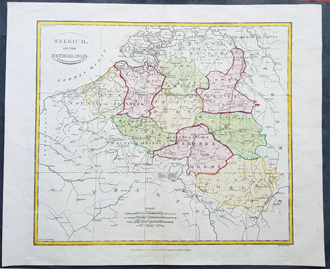
- Title : Belgium or the Netherlands divided into Departments
- Date : 1808
- Condition: (A+) Fine Condition
- Ref: 24329-1
- Size: 20in x 16in (510mm x 405mm)
Description:
This beautifully hand coloured original antique map of Belgium & the southern Netherlands was engraved by John Neele in 1808 - the date is engraved at the foot of the map - and published in the 1810 edition of The Modern Royal Atlas. (Ref: Tooley; M&B)
General Definitions:
Paper thickness and quality: - Heavy and stable
Paper color : - off white
Age of map color: - Original
Colors used: - Yellow, Green, pink
General color appearance: - Authentic
Paper size: - 20in x 16in (510mm x 405mm)
Plate size: - 16½in x 15in (420mm x 380mm)
Margins: - Min 1in (25mm)
Imperfections:
Margins: - Light creasing
Plate area: - Light creasing, light wear along bottom centerfold
Verso: - None
Background:
The name Belgium is derived from Gallia Belgica, a Roman province in the northernmost part of Gaul that before Roman invasion in 100 BC, was inhabited by the Belgae, a mix of Celtic and Germanic peoples. A gradual immigration by Germanic Frankish tribes during the 5th century brought the area under the rule of the Merovingian kings. A gradual shift of power during the 8th century led the kingdom of the Franks to evolve into the Carolingian Empire.
The Treaty of Verdun in 843 divided the region into Middle and West Francia and therefore into a set of more or less independent fiefdoms which, during the Middle Ages, were vassals either of the King of France or of the Holy Roman Emperor.
Many of these fiefdoms were united in the Burgundian Netherlands of the 14th and 15th centuries. Emperor Charles V extended the personal union of the Seventeen Provinces in the 1540s, making it far more than a personal union by the Pragmatic Sanction of 1549 and increased his influence over the Prince-Bishopric of Liège.
The Eighty Years\' War (1568–1648) divided the Low Countries into the northern United Provinces (Belgica Foederata in Latin, the Federated Netherlands) and the Southern Netherlands (Belgica Regia, the Royal Netherlands). The latter were ruled successively by the Spanish (Spanish Netherlands) and the Austrian Habsburgs (Austrian Netherlands) and comprised most of modern Belgium. This was the theatre of most Franco-Spanish and Franco-Austrian wars during the 17th and 18th centuries.
Following the campaigns of 1794 in the French Revolutionary Wars, the Low Countries—including territories that were never nominally under Habsburg rule, such as the Prince-Bishopric of Liège—were annexed by the French First Republic, ending Austrian rule in the region. The reunification of the Low Countries as the United Kingdom of the Netherlands occurred at the dissolution of the First French Empire in 1815, after the defeat of Napoleon.
Neele, Samuel John 1758–1824
Samuel John Neele was a cartographer, copper-plate engraver and printer with business in the Strand, London.
Also father of Henry Neele the English poet and literary scholar.