Welcome to Classical Images!
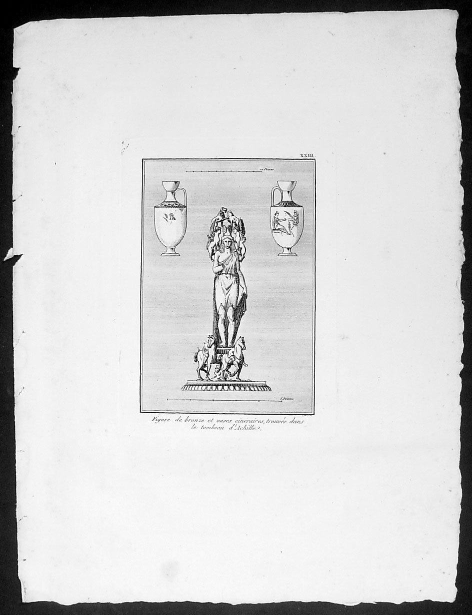
Description:This original copper-plate engraved antique print of a Bronze Figure and a pair of Vases found in the Tomb of Achilles located in the ancient Greek city of Achilleion in the Troad region of Çanakkale, now in NW modern Turkey, was published in the 1802 edition of Jean-Baptiste Lechevaliers of Voyage de la Troade, fait dans les années 1785 et 1786
General Definitions:Paper thickness and quality: - Heavy and stablePaper color : - off whiteAge of map color: -Colors used: -General color appearance: -Paper size: - 14in x 10in (355mm x 255mm)Plate size: - 7in x 5in (180mm x 130mm) each plateMargins: - Min 1/2in (12mm)
Imperfections:Margins: - Light soilingPlate area: - NoneVerso: - None
Background: Achilleion was an ancient Greek city in the south-west of the Troad region of Anatolia. It has been located on a promontory known as Beşika Burnu (cradle promontory) about 8 km south of Sigeion. Beşika Burnu is 2 km south of the modern village of Yeniköy in the Ezine district of Çanakkale Province, Turkey. The site considered in classical antiquity to be the tomb of Achilles is a short distance inland at a tumulus known as Beşiktepe. Achilleion in the Troad is not to be confused with Achilleion near Smyrna and Achilleion in the territory of Tanagra.The otherwise obscure polis of Achilleion was most famous in classical antiquity for its association with Achilles, after whom it was named (the place of Achilles). According to some sources, while passing by Ilion in 334 BC Alexander the Great sacrificed at the Tomb of Achilles. This story became famous, and in the mid-1st century BC it is mentioned by the politician and writer Cicero in his Pro Archia Poeta. In AD 216 the Emperor Caracalla emulated Alexander when, on passing Ilion on his way to a war against Parthia, he held funeral games around the tumulus. Following the abandonment of the settlement at Achilleion in the late Hellenistic period, writers began to associate the tomb with nearby Sigeion to the north.The first mention of Achilleion is as a fortified settlement from which Mytilene conducted its attacks on Athenian controlled Sigeion to the north in the early 6th century BCE. It is not clear whether Achilleion had been settled earlier, but the ceramic record also begins at this point, suggesting that it had not. Recent excavations have established that the walls of the settlement also date to the first half of the 6th century BCE, further corroborating the literary accounts of Herodotus and Strabo regarding its origins. Achilleion remained under Mytilenaean control until Athens brought an end to the Mytilenaean revolt in 427 BCE and took over all the so-called Actaean cities in the Troad. Achilleion appears in the Athenian tribute lists for 425/4 and 422/1 BCE, indicating that it had joined the Delian League. The legend AX (ACH) which some bronze coins found in this region bear is thought to refer to Ach (illeion) and suggest that c. 350 - 300 BCE the city minted its own coins. King Lysimachus synoecized Ilion with many surrounding communities including Achilleion during his reign (306 - 281 BCE), effectively ending Achilleions political independence. The testimony of Demetrius of Scepsis, who hailed from a nearby town in the Troad, indicates that there was still a hamlet known as Achilleion on the site in the mid-2nd century BCE. It is to around this time that the latest ceramic finds from Achilleion date, suggesting that the site became uninhabited soon afterwards.Jean-Baptiste Lechevalier was the secretary of the Ambassador of France in Constantinople. In the year 1788 he visited the plain of Troy, and was enthusiastically in favour of the theory that the site of Homers Troy was to be found at the village of Bunarbashi. His publication about Troy Voyage de la Troade.....was first published in 1799.The Troad, also known as Troas, is the historical name of the Biga peninsula (Biga Yarımadası, Τρωάς) in the northwestern part of Anatolia, Turkey. This region now is part of the Çanakkale province of Turkey. Bounded by the Dardanelles to the northwest, by the Aegean Sea to the west and separated from the rest of Anatolia by the massif that forms Mount Ida, the Troad is drained by two main rivers, the Scamander (Karamenderes) and the Simois, which join at the area containing the ruins of Troy. Grenikos, Kebren, Simoeis, Rhesos, Rhodios, Heptaporos and Aisepos were seven rivers of the Troad and the names of the river gods that inhabited each river.Troy (Ancient Greek: Τροία, Troia or Τροίας, Troias, Truva or Troya) was a city in the far northwest of the region known in late Classical antiquity as Asia Minor, now known as Anatolia in modern Turkey, just south of the southwest mouth of the Dardanelles strait and northwest of Mount Ida. The present-day location is known as Hisarlik. It was the setting of the Trojan War described in the Greek Epic Cycle, in particular in the Iliad, one of the two epic poems attributed to Homer. Metrical evidence from the Iliad and the Odyssey suggests that the name λιον (Ilion) formerly began with a digamma: Ϝίλιον (Wilion); this is also supported by the Hittite name for what is thought to be the same city, Wilusa.A new capital called Ilium (from Greek: λιον, Ilion) was founded on the site in the reign of the Roman Emperor Augustus. It flourished until the establishment of Constantinople, became a bishopric and declined gradually in the Byzantine era, but is now a Latin Catholic titular see.In 1865, English archaeologist Frank Calvert excavated trial trenches in a field he had bought from a local farmer at Hisarlik, and in 1868, Heinrich Schliemann, a wealthy German businessman and archaeologist, also began excavating in the area after a chance meeting with Calvert in Çanakkale. These excavations revealed several cities built in succession. Schliemann was at first skeptical about the identification of Hisarlik with Troy, but was persuaded by Calvert and took over Calverts excavations on the eastern half of the Hisarlik site, which was on Calvert\'s property. Troy VII has been identified with the city called Wilusa by the Hittites (the probable origin of the Greek λιον) and is generally (but not conclusively) identified with Homeric Troy.Today, the hill at Hisarlik has given its name to a small village near the ruins, which supports the tourist trade visiting the Troia archaeological site. It lies within the province of Çanakkale, some 30 km south-west of the provincial capital, also called Çanakkale. The nearest village is Tevfikiye. The map here shows the adapted Scamander estuary with Ilium a little way inland across the Homeric plain. Due to Troys location near the Aegean Sea, the Sea of Marmara, and the Black Sea, it was a central hub for the military and trade(Ref: M&B; Tooley)