Europe (304)
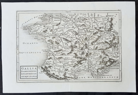
1750 Christop. Cellarius Original Antique Map of France - Gallia
- Title : Gallia Narbonensis Lugdvnensis et Acvitania
- Size: 15in x 10 1/2in (380mm x 265mm)
- Ref #: 31353
- Date : 1750
- Condition: (A+) Fine Condition
Description:
This finely engraved original antique map of France by Christoph. Cellarius was published in the 1750 edition of Geographica Antiqua.
General Definitions:
Paper thickness and quality: - Heavy and stable
Paper color : - off white
Age of map color: -
Colors used: -
General color appearance: -
Paper size: - 15in x 10 1/2in (380mm x 265mm)
Plate size: - 12 1/2in x 8 1/2in (320mm x 215mm)
Margins: - Min 1in (25mm)
Imperfections:
Margins: - None
Plate area: - None
Verso: - None
Background:
Geographica was one of the most popular geographical publications of the 17th and 18th centuries, lasting well into the 19th century. (Ref: Tooley; M&B)
Cellarius, Christopher, 1638-1707
Christopher Cellarius (Keller) was professor of Oriental languages at Halle university and the author of numerous books including his most famous work the atlas Geographica Antiquafirst published in 1686 and being reissued with updated plates until the early 19th century.
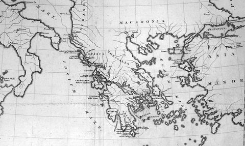
1802 Lechevalier Antique Map of Italy Greece & Turkey Troy
- Title : Carte Du Golphe Adriatique et De L Archipel pour servir ou Voyage de la Troade
- Ref #: 70207
- Size: 20in x 19in (510mm x 485mm)
- Date : 1802
- Condition: (A+) Fine Condition
Description:
This large original antique map of the voyage of Jean-Baptiste Lechevalier from Italy to the Greece and Turkey - specifically the Biga Peninsular home of the ancient city of Troy in NW Turkey - was published in the Atlas of Charts & Views that accompanied the 1802 edition of Jean-Baptiste Lechevalier's (1752 - 1836) Voyage de la Troade, fait dans les années 1785 et 1786.
Jean-Baptiste Lechevalier was the secretary of the Ambassador of France in Constantinople. In the year 1788 he visited the plain of Troy, and was enthusiastically in favour of the theory that the site of Homer's Troy was to be found at the village of Bunarbashi. His title, "Voyage de la Troade" was first published in 1799.
The Troad, also known as Troas, is the historical name of the Biga peninsula (Biga Yarımadası, Τρωάς) in the northwestern part of Anatolia, Turkey. This region now is part of the Çanakkale province of Turkey. Bounded by the Dardanelles to the northwest, by the Aegean Sea to the west and separated from the rest of Anatolia by the massif that forms Mount Ida, the Troad is drained by two main rivers, the Scamander (Karamenderes) and the Simois, which join at the area containing the ruins of Troy. Grenikos, Kebren, Simoeis, Rhesos, Rhodios, Heptaporos and Aisepos were seven rivers of the Troad and the names of the river gods that inhabited each river.(Ref: M&B; Tooley)
General Description:
Paper thickness and quality: - Heavy & stable
Paper color: - White
Age of map color: -
Colors used: -
General color appearance: -
Paper size: - 20in x 19in (510mm x 485mm)
Plate size: - 19in x 18in (485mm x 460mm)
Margins: - Min 1in (25mm)
Imperfections:
Margins: - Light age toning
Plate area: - Light age toning along fold as issued
Verso: - Light age toning
1765 Homann Large Antique Map of The Zurich Canton, Switzerland - Tigurini
Antique Map
- Title : Canton Zurich sive Illustratis Helvetiorum Respublica Tigurina...1765
- Ref #: 50175
- Size: 23 1/2in x 20in (595mm x 510mm)
- Date : 1765
- Condition: (B) Good Condition
Description:
This large original hand coloured copper plate engraved antique map of the Zurich Canton of Switzerland, the hoome of the Tigurini Tribe of Helvetii, by the Homann firm was engraved in 1765 - dated.
General Definitions:
Paper thickness and quality: - Heavy and stable
Paper color : - off white
Age of map color: - Original
Colors used: - Yellow, orange
General color appearance: - Authentic
Paper size: - 23 1/2in x 20in (595mm x 510mm)
Plate size: - 22in x 19in (560mm x 485mm)
Margins: - Min 1/2in (12mm)
Imperfections:
Margins: - Small repair to top and left margins
Plate area: - None
Verso: - Soiling and re-enforced to the left of the verso
Background:
The Tigurini were a clan or tribe forming one out of four pagi (provinces) of the Helvetii.[1][2] The Tigurini were the most important group of the Helvetii, mentioned by both Caesar and Poseidonius, settling in the area of what is now the Swiss canton of Vaud, corresponding to the bearers of the late La Tène culture in western Switzerland. Their name has a meaning of lords, rulers (cognate with Irish tigern lord). The other Helvetian tribes included the Verbigeni and the Tougeni (sometimes identified with the Teutones), besides one tribe that has remained unnamed.
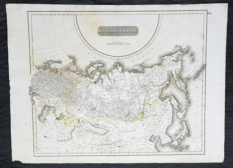
1814 John Thomson Large Antique Map of The Russian Empire
- Title : Russian Empire ...John Thomson....1814
- Size: 28 1/2in x 21in (720mm x 530mm)
- Condition: (A) Very Good Condition
- Date : 1814
- Ref #: 31910
Description:
This large beautifully hand coloured original antique map of The Russian Empire by John Thomson in 1814 - dated at the foot of the map - was published in the large 1817 edition of A New General Atlas of the World. (Ref Tooley M&B)
General Definitions:
Paper thickness and quality: - Heavy and stable
Paper color : - off white
Age of map color: - Original
Colors used: - Yellow, Green, pink
General color appearance: - Light
Paper size: - 28 1/2in x 21in (720mm x 530mm)
Plate size: - 24in x 20in (610mm x 510mm)
Margins: - Min 1in (25mm)
Imperfections:
Margins: - None
Plate area: - None
Verso: - Light soiling
Background:
It is scarcely necessary to look at a map of Russia - with which we must include Siberia - to visualize the daunting task facing Russian map makers. Indeed, considering the vastness of their territory and the lack of skilled cartographers, it is surprising that relatively good maps were available for engraving and printing in most of the well known sixteenth and seventeenth century atlases. Generally, maps of that time were based on material brought back from Moscow by visitors from the West.
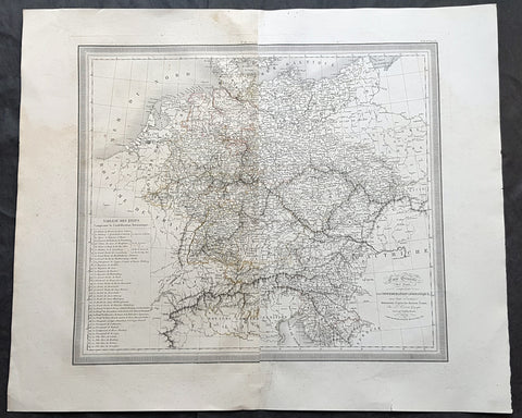
1824 Louis Vivien Large Antique Map of the Confederation of German States
- Title : Carte Generale de Etats compesantL Confederation Germanique...1824
- Size: 27 1/2in x 23in (700mm x 585mm)
- Condition: (A+) Fine Condition
- Date : 1824
- Ref #: 40713
Description:
This finely engraved original large antique map of the confederation of German states and central Europe, by Louis Vivien in his Elephant Folio atlas, Atlas Universal
General Definitions:
Paper thickness and quality: - Heavy and stable
Paper color : - off white
Age of map color: - Original
Colors used: - Blue, pink, yellow, green
General color appearance: - Authentic
Paper size: - 27 1/2in x 23in (700mm x 585mm)
Plate size: - 22in x 19in (560mm x 480mm)
Margins: - Min 2in (50mm)
Imperfections:
Margins: - Light soiling
Plate area: - None
Verso: - None
Background:
The German Confederation was an association of 39 German-speaking states in Central Europe (adding the mainly non-German speaking Kingdom of Bohemia and Duchy of Carniola), created by the Congress of Vienna in 1815 to coordinate the economies of separate German-speaking countries and to replace the former Holy Roman Empire, which had been dissolved in 1806. The German Confederation excluded German-speaking lands in the eastern portion of the Kingdom of Prussia (East Prussia, West Prussia and Posen), the German cantons of Switzerland, and Alsace within France which was majority German speaking.
The Confederation was weakened by rivalry between the Kingdom of Prussia and the Austrian Empire, revolution, and the inability of the multiple members to compromise. In 1848, revolutions by liberals and nationalists attempted to establish a unified German state with a progressive liberal constitution under the Frankfurt Convention. The ruling body, the Confederate Diet, was dissolved on 12 July 1848, but was re-established in 1850 after failed efforts to replace it.
The Confederation was finally dissolved after the Prussian victory in the Seven Weeks War over Austria in 1866. The dispute over which had the inherent right to rule German lands ended in favour of Prussia, leading to the creation of the North German Confederation under Prussian leadership in 1867, to which the eastern portions of the Kingdom of Prussia were added. A number of South German states remained independent until they joined the North German Confederation, which was renamed and proclaimed as the German Empire in 1871 for the now unified Germany with the Prussian king as emperor (Kaiser) after the victory over French Emperor Napoleon III in the Franco-Prussian War of 1870.
Most historians have judged the Confederation to have been weak and ineffective, as well as an obstacle to the creation of a German nation-state. However, the Confederation was designed to be weak, as it served the interests of the European Great Powers, especially member states Austria and Prussia.
Vivien, Louis 1802 - 1896
Louis Vivien , or Vivien de Saint-Martin was a French geographer who was born in Saint-Martin-de-Fontenay and died in Versailles, France in 1896.
He settled in Paris under the Restoration, and became known with his publication of the Electoral and Administrative Map in 1823 and his comprehensive Universal Atlas in 1825, collaborating with Jacques Bibliomappe -Charles Bailleul from 1828. Vivien was foremost a geographer but was also a publisher of works in other fields, including historical books on the General History of the French Revolution and the History of Napoleon. He also translated various English works, such as the novels of Walter Scott .
He also wrote the New Annals of Travels between 1845 and 1854 and briefly the French Athenaeum between 1847 & 1848. He contributed to numerous periodicals such as Le Constitutionnel, Revue contemporaine, Revue germanique & La Presse. He also wrote L Année géographique between 1863 and 1875 before passing the baton to G. Maunoir and Henri Duveyrier.
He is mainly known though, for his three cartographical works, A History of Geographical Discoveries, A New Dictionary of Universal Geography and the Universal Atlas of Geography. The first of these publications he completed after the 1848 Revolution with the latter two completed by Louis Rousselet and Franz Schrader.
Vivien was Honorary President of the Geographical Society, of which he was one of the founder members. He also laureate of the Academy of Inscriptions and Belles-Lettres as well as a member of the Asian Society , the Society of Ethnology along with a large number of learned societies and European academies.
Main works of Vivien de Saint-Martin
- General History of the French Revolution, the Empire, the Restoration, the Monarchy of 1830, up to and including 1841 (4 volumes in 2 volumes), Paris, Pourrat Brothers, 1841-1842.
- History of Napoleon and the Empire (2 volumes), Paris, Pourrat brothers, 1844.
- History of geographical discoveries of European nations in various parts of the world (2 volumes), Paris, Arthus-Bertrand, 1845-1846.
- Research on primitive populations and the oldest traditions of the Caucasus , Paris, Arthus-Bertrand, 1847.
- Studies of Ancient Geography and Asian Ethnography (2 volumes), Paris, Arthus-Bertrand, 1850-1852.
- Historical and geographical description of Asia Minor (2 volumes), Paris, Arthus-Bertrand, 1852.
- Study on the Greek and Latin Geography of India , Paris, Imperial Printing, 1858.
- Study on the geography and the primitive populations of north-west India, according to the Vedic hymns , Paris, Imprimerie impériale, 1860.
- North Africa in Greek and Roman antiquity, historical and geographical study , Paris, Imprimerie impériale, 1863.
- History of geography and geographical discoveries from the earliest times to the present day , Paris, Hachette, 1873.
- With Franz Schrader : Universal Atlas of Geography built from the original sources and the most recent documents , Paris, Hachette, 1876-1915.
- With Louis Rousselet : New dictionary of universal geography (9 volumes), Paris, Hachette, 1879-1900.
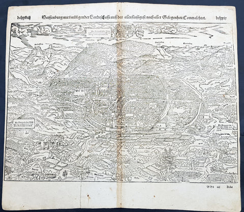
1598 Sebastian Munster Antique Map Birds Eye View of Weissenburg Bavaria Germany
- Title : Die Statt Wyssenburg
- Date : 1598
- Condition: (A+) Fine Condition
- Ref # : 30351
- Size : 15in x 13in (380mm x 340mm)
Description:
This fine original wood block engraved antique map a birds eye view of the German city of Weißenburg (Weissenburg) in Bavaria in Middle Franconia - identified by the cities Coate of Arms with double headed eagle atop of a castle - was published in the German Section of Sebastian Munsters 1598 edition of Cosmographia, Das ist: Beschreibung der gantzen Welt, Darinnen Aller Monarchien Keyserthumben, Königreichen, Fürstenthumben, Graff- und Herrschafften, Länderen, Stätten und Gemeinden.Ursprung (Cosmographia, that is: description of the whole world, in it all monarchies Keyser thumben, kingdoms, prince thumben, graff and herrschafften, countries, places and municipalities.)
Weißenburg in Bayern (formerly also Weißenburg im Nordgau) is a town in Middle Franconia, Germany. It is the capital of the district Weißenburg-Gunzenhausen. Weissenburg is located in central Bavaria, in the south of the administrative region Mittelfranken.
The history of Weißenburg is generally traced back to the Roman fort that was built in the area towards the end of the first century. The settlement, which included Thermae, lay on the border of the Roman Empire and on the Tabula Peutingeriana from the 4th century it had the name Biriciana. Germanic tribes destroyed the fort and settled in what is still the city centre. The first mention of the name Weißenburg is in a deed dating from 867. The city became the seat of a royal residence during the reign of the Franks and according to legend, Charlemagne stayed there to supervise the construction of Fossa Carolina.
The city became a Free Imperial City in 1296 and continued to grow until the Reformation. Following the example of Nuremberg the city joined the Protestant side but it suffered heavily in the ensuing wars. However, the rights of the city as a Free Imperial City and an Imperial Estate were restored in the final peace treaty and some growth resumed. Despite its insignificant size and economic importance, the city, like the other 50-odd free imperial cities, was virtually independent.
Weissenburg lost its independence in 1802 and became part of the Bavarian kingdom in 1806. It was however saved from insignificance with the construction of a railway between Nuremberg and Augsburg which goes through the city and which supported industrialisation. Following World War II over 6,000 refugees and people expelled from the territories which Germany lost settled in the city and have since played an important role in its industry and culture.
The many stages in the history of Weissenburg can still be seen today. There are many ruins from the Roman times. One of the finest is the remains of a Roman bath which was excavated in 1977 and has been turned into a museum. The city wall from the Middle Ages has survived almost intact with its towers and in the Gothic Town Hall the city\'s elected members have held their meetings from 1476.
General Definitions:
Paper thickness and quality: - Heavy and stable
Paper color : - off white
Age of map color: -
Colors used: -
General color appearance: -
Paper size: - 16in x 13in (410mm x 330mm)
Plate size: - 16in x 13in (410mm x 330mm)
Margins: - Min 1in (25mm)
Imperfections:
Margins: - Repair to bottom margin, no loss
Plate area: - Age toning along centerfold
Verso: - Light soiling
Background:
Cosmographia, Das ist: Beschreibung der gantzen Welt, Darinnen Aller Monarchien Keyserthumben, Königreichen, Fürstenthumben, Graff- und Herrschafften, Länderen, Stätten und Gemeinden.Ursprung, Regiment, Reichthumb, Gewalt und.Beschaffenheit. Dessgleichen Aller deren, beyder Ständen, Regenten: Keysern, Königen, Bäpsten, Bischoffen.Genealogien und Stammbäumen.zusammen getragen. by Sebastian Münster was first published in 1544 and is the earliest German-language description of the world. It had numerous editions in different languages including Latin, French (translated by François de Belleforest), Italian, English, and Czech. The last German edition was published in 1628, long after Munsters death. The Cosmographia was one of the most successful and popular books of the 16th century. It passed through 24 editions in 100 years. This success was due to the notable woodcuts (some by Hans Holbein the Younger, Urs Graf, Hans Rudolph Manuel Deutsch, and David Kandel). It was most important in reviving geography in 16th-century Europe. Among the notable maps within Cosmographia is the map Tabula novarum insularum, which is credited as the first map to show the American continents as geographically discrete.
Munsters earlier geographic works were Germania descriptio (1530) and Mappa Europae (1536). In 1540, he published a Latin edition of Ptolemys Geographia with illustrations.
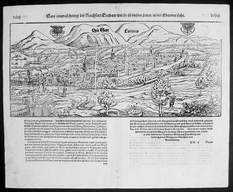
1574 Munster Large Antique Print - View of The German City of Landau, Bavaria
- Title : Die Statt Landaw
- Ref #: 22668
- Size: 16in x 13in (410mm x 330mm)
- Date : 1574
- Condition: (A+) Fine Condition
Description:
This large finely engraved original antique print a view of the Bavarian City of Landau NE of Munich was engraved in 1547 - the date is engraved at the foot of the image - and was published by Sebastian Munster in the 1574 edition of Cosmographia.
Landau or Landau in der Pfalz (pop. 41,821) is an autonomous (kreisfrei) city surrounded by the Südliche Weinstraße ("Southern Wine Route") district of southern Rhineland-Palatinate, Germany. It is a university town (since 1990), a long-standing cultural centre, and a market and shopping town, surrounded by vineyards and wine-growing villages of the Palatinate wine region. Landau lies east of the Palatinate forest, Europe's largest contiguous forest, direct on the German Wine Route.
Background: For a variety of reasons town plans were comparatively latecomers in the long history of cartography. Few cities in Europe in the middle ages had more than 20,00 inhabitants and even London in the late Elizabethan period had only 100-150,000 people which in itself was probably 10 times that of any other English city. The Nuremberg Chronicle in 1493 included one of the first town views of Jerusalem, thereafter, for most of the sixteenth century, German cartographers led the way in producing town plans in a modern sense. In 1544 Sebastian Munster issued in Basle hisCosmographia containing roughly sixty-six plans and views, some in the plan form, but many in the old panorama or birds eye view.
Sebastian Münster (1488-1552) was a German cartographer, cosmographer, and Hebrew scholar whose work Cosmographia (1544; "Cosmography") was the earliest German description of the world and a major work in the revival of geographic thought in 16th-century Europe. It had numerous editions in different languages including Latin, French, Italian, English, and even Czech. Altogether, about 40 editions of the Cosmographiaappeared between 1544 and 1628 and was one of the most successful and popular books of the 16th century. Münster was a major influence in popular thinking in Europe for the next 200 years.
This success was due not only to the level of descriptive detail but also to the fascinating full page maps & views as well as smaller woodcuts that were included in the text. Many of the woodcuts were executed by famous engravers of the time including Hans Holbein the Younger, Urs Graf, Hans Rudolph Manuel Deutsch, and David Kandel.
Aside from the well-known maps present in the Cosmographia, the text is thickly sprinkled with vigorous views: portraits of kings and princes, costumes and occupations, habits and customs, flora and fauna, monsters, wonders, and horrors about the known -- and unknown -- world, and was undoubtedly one of the most widely read books of its time.
Münster acquired the material for his book in three ways. Firstly he researched all available literary sources across Germany, Switzerland and other parts of Europe. Secondly he obtained original manuscript material from locals all over Europe for description of the countryside, cities, villages, towns, rivers and local history. Finally, he obtained further material first hand on his travels (primarily in south-west Germany, Switzerland, and Alsace).
In 1588 Sebastian Petri re-released Cosomgraphia and re-issued many of Munsters maps and views in the "copperplate style". The maps in this release were more sophisticated than with earlier publications ofCosomgraphia and were based on the 1570 release of Abraham Ortelius monumental work Theatrum Orbis Terrarum.(Ref: Tooley; M&B)
General Description:
Paper thickness and quality: - Light and stable
Paper color: - off white
Age of map color: -
Colors used: -
General color appearance: -
Paper size: - 16in x 13in (410mm x 330mm)
Plate size: - 16in x 13in (410mm x 330mm)
Margins: - 1/2in (12mm)
Imperfections:
Margins: - None
Plate area: -None
Verso: - None
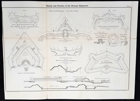
1856 Cap Richard Delafield Large Antique Schematics German Fortifications
Antique Map
- Title : Theory and Practise of the German Engineers
- Date : 1856
- Condition: (A+) Fine Condition
- Ref: 90144
- Size: 24 1/2in x 18in (615mm x 475mm)
Description:
This large original lithograph print, schematics of parts of the German Forts in such cities as Coblenz, Posen, Mainz, Luxemburg, Landau & others - during the time of the Crimean War - was engraved by John T Bowen & co. of Philadelphia and was published in the 1856 edition of Captain Richard Delafields Report on the Art of War in Europe in 1854, 1855, and 1856.
In early 1855, Captain Richard Delafield was appointed by the Secretary of War, Jefferson Davis, a head of the board of officers, later called The Delafield Commission, and sent to Europe to study the European military. The board included Captain George B. McClellan and Major Alfred Mordecai. They inspected the state of the military in Great Britain, Germany, the Austrian Empire, France, Belgium, and Russia, and served as military observers during the Crimean War. After his return in April 1856, Delafield submitted a report which was later published as a book by Congress, Report on the Art of War in Europe in 1854, 1855, and 1856. The book was suppressed during the American Civil War due to fears that it would be instructive to Confederate engineers as it contained multiple drawings and descriptions of military fortifications.
General Definitions:
Paper thickness and quality: - Light and stable
Paper color : - off white
Age of map color: -
Colors used: -
General color appearance: -
Paper size: - 24 1/2in x 18in (615mm x 475mm)
Plate size: - 24 1/2in x 18in (615mm x 475mm)
Margins: - Min 1/2in (12mm)
Imperfections:
Margins: - None
Plate area: - Light age toning along folds, as issued
Verso: - Folds re-enforced with archival tape
Background:
Under the term of the 1815 Peace of Paris, France was obliged to pay for the construction of a line of fortresses to protect the German Confederation against any future aggression by France. All fortresses were located outside Austria and Prussia — the two biggest, bickering powers of the Confederation.
Section C. Defensive System of the Germanic Confederation of the protocol drawn up at Paris on 3 November 1815, declared Mainz, Luxemburg, and Landau to be fortresses belonging to the Confederation of Germany, and stipulated that a fourth should be constructed on the Upper Rhine. In conformity with this act, a portion of the funds, which France was compelled to pay by way of indemnity for the cost of placing her on a peaceable footing, was thus appropriated: £200,000 were set aside for completing the works at Mainz; £800,000 were assigned to Prussia, to be applied upon its fortresses on the Lower Rhine; another £800,000 were reserved for constructing the new federal fortress on the Upper Rhine; and Bavaria was allowed £600,000 towards erecting another strong place on the Rhine, at Germersheim or some other point.
By 1835 the works about Mainz were completed; the twin fortresses of Koblenz and Ehrenbreitstein, and Cologne had been abundantly strengthened on the side of Prussia; and, on the Bavarian side, the fortress of Germersheim was in a state to defend the passage on the Upper Rhine. The western frontier of Germany had, in this way, been provided with a formidable line of defences against possible hostile actions by their neighbours. The eastern side of Germany has been additionally fortified by the erection of a strong citadel at Posen; and the southern was to be still further protected by the formidable works in course of construction at Brixen in the Tyrol.
The fortress of Ulm became a major strategic fortress able to accommodate 100,000 men and their equipment. Since the Kingdom of Württemberg had no engineering corps King William I appointed Moritz Karl Ernst von Prittwitz, a Prussian major, as the supervisor to oversee the building the fortresses. His plans included the provisions for the prospective development of the city Ulm. Major Theodor von Hildebrandt was appointed to oversee the building of fortresses around Neu-Ulm on the Bavarian side of the Danube
Delafield, Richard Major General 1798 - 1873 - Delafield was a United States Army officer for 52 years. He served as superintendent of the United States Military Academy for 12 years. At the start of the American Civil War, then Colonel Delafield helped equip and send volunteers from New York to the Union Army. He also was in command of defences around New York harbor from 1861 to April 1864. On April 22, 1864, he was promoted to Brigadier General in the Regular Army of the United States and Chief of Engineers. On March 8, 1866, President Andrew Johnson nominated Delafield for appointment to the grade of brevet major general in the Regular Army, to rank from March 13, 1865, and the United States Senate confirmed the appointment on May 4, 1866, reconfirmed due to a technicality on July 14, 1866. He retired from the US Army on August 8, 1866. He later served on two commissions relating to improvements to Boston Harbor and to lighthouses. He also served as a regent of the Smithsonian Institution.
Delafield served as assistant engineer in the construction of Hampton Roads defences from 1819–1824 and was in charge of fortifications and surveys in the Mississippi River delta area in 1824-1832. While superintendent of repair work on the Cumberland Road east of the Ohio River, he designed and built Dunlaps Creek Bridge in Brownsville, Pennsylvania, the first cast-iron tubular-arch bridge in the United States. Commissioned a major of engineers in July 1838, he was appointed superintendent of the Military Academy after the fire of 1838 and served till 1845. He designed the new buildings and the new cadet uniform that first displayed the castle insignia. He superintended the construction of coast defences for New York Harbor from 1846 to 1855.
In the beginning of 1855, Delafield was appointed by the Secretary of War, Jefferson Davis a head of the board of officers, later called The Delafield Commission, and sent to Europe to study the European military. The board included Captain George B. McClellan and Major Alfred Mordecai. They inspected the state of the military in Great Britain, Germany, the Austrian Empire, France, Belgium, and Russia, and served as military observers during the Crimean War. After his return in April 1856, Delafield submitted a report which was later published as a book by Congress, Report on the Art of War in Europe in 1854, 1855, and 1856. The book was suppressed during the American Civil War due to fears that it would be instructive to Confederate engineers as it contained multiple drawings and descriptions of military fortifications.
Delafield served as superintendent of the Military Academy again in 1856-1861. In January 1861, he was succeeded by Captain Pierre G. T. Beauregard, who was dismissed shortly after Beauregards home state of Louisiana seceded from the Union, and Delafield returned as superintendent serving until March 1, 1861. In the beginning of the Civil War he advised the governor of New York Edwin D. Morgan during the volunteer force creation. Then, in 1861–1864, he was put in charge of New York Harbor defences, including Governors Island and Fort at Sandy Hook. On May 19, 1864, he was commissioned a brigadier-general after replacing Joseph Gilbert Totten, who had died, as the Chief of Engineers, United States Army Corps of Engineers, on April 22, 1864. He stayed in charge of the Bureau of Engineers of the War Department until his retirement on August 8, 1866. On March 8, 1866, President Andrew Johnson nominated Delafield for appointment to the grade of brevet major general in the Regular Army of the United States, to rank from March 13, 1865, and the United States Senate confirmed the appointment on May 4, 1866 and reconfirmed it due to a technicality on July 14, 1866.After retirement Delafield served as a regent of the Smithsonian Institution and a member of the Lighthouse Board. He died in Washington, D.C. on November 5, 1873.
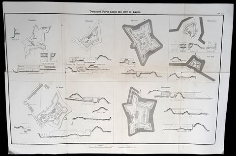
1856 Capt Delafield Large Antique Schematics Forts City of Lyons, France
Antique Map
- Title : Detached Forts about the City of Lyons
- Date : 1856
- Condition: (A) Very Good Condition
- Ref: 90123
- Size: 29in x 20in (735mm x 515mm)
Description:
This large original lithograph print, schematics of various forts in and around the French city of Lyons - during the time of the Crimean War and just prior to the American Civil War - was engraved by John T Bowen & co. of Philadelphia and was published in the 1856 edition of Captain Richard Delafields Report on the Art of War in Europe in 1854, 1855, and 1856.
In early 1855, Captain Richard Delafield was appointed by the Secretary of War, Jefferson Davis, a head of the board of officers, later called The Delafield Commission, and sent to Europe to study the European military. The board included Captain George B. McClellan and Major Alfred Mordecai. They inspected the state of the military in Great Britain, Germany, the Austrian Empire, France, Belgium, and Russia, and served as military observers during the Crimean War. After his return in April 1856, Delafield submitted a report which was later published as a book by Congress, Report on the Art of War in Europe in 1854, 1855, and 1856. The book was suppressed during the American Civil War due to fears that it would be instructive to Confederate engineers as it contained multiple drawings and descriptions of military fortifications.
General Definitions:
Paper thickness and quality: - Light and stable
Paper color : - off white
Age of map color: -
Colors used: -
General color appearance: -
Paper size: - 29in x 20in (735mm x 515mm)
Plate size: - 29in x 20in (735mm x 515mm)
Margins: - Min 1/2in (12mm)
Imperfections:
Margins: - None
Plate area: - Folds as issued
Verso: - Folds re-enforced with archival tape
Background:
The ceintures de Lyon (Belts of Lyon) were a series of fortifications built between 1830 and 1890 around the city of Lyon, France to protect the city from foreign invasion.
The belts comprised two defensive barriers that included forts, lunettes, ramparts, batteries, and other defensive structures. Many of these structures proved to be ineffective in war due to advancement in weapon technology and the evolution of attack strategies at the time. Some of the fortifications of the ceintures de Lyon have been destroyed, though many remain today.
In 1830 the maréchal de camp, Hubert Rohault de Fleury, commenced a project designed by military engineer Baron Haxo. With a budget of 10,000,000 francs (approximately €67,000,000 as of 2015) allocated for Lyon between 1831 and 1839, this first project included the restoration of the fortifications between Croix Rousse and Fourvière; the construction of two forts on the plateau of Caluire (Fort de Montessuy and Fort de Caluire, connected by the Enceinte de Caluire), facing the Dombes; closing access to the Presquîle by the construction of a south-facing building; building two forts – Fort de la Duchère and Fort de Grange Blanche – to protect access routes towards Paris and Auvergne.
The fortification of the city is divided into three sectors: The north was protected by the wall of Croix-Rousse and the structures between the Rhône and the Saône. The command was situated at fort de Montessuy. The west was covered by the hillfort of Fourvière and the associated forts of Vaise at Sainte-Foy. The command was situated at fort Saint-Irénée. The east was defended by the Redoute du Haut-Rhône and Fort de la Vitriolerie on the left bank of the Rhône. The command was situated at Fort Lamothe.
The work required almost 20,000 workers, which were locally sourced in an attempt to avoid insurrection such as the ongoing unrest of the Lyon silk workers (Canuts) over increased capitalism. Work began in 1831 to build seven structures, each structure requiring between 400 and 500 workers. The scope of this project included the construction of Fort de Montessuy and Fort de Caluire to the north; Fort des Brotteaux, Fort Montluc and Fort du Colombier to the east; the Redoute de la Part-Dieu to the west; and Fort Saint-Irénée, to protect the entire area.
In January 1831, an uprising began at a work site in Charpennes, however it was quickly stopped by the army. Other insurrections took place the same year, a series of Canut revolts, which succeeded in rallying soldiers on the side of the Canuts, resulting in the death of captain Viquesnel, aide-de-camp of Fleury, and the temporary withdrawal of the 20,000 soldiers who eventually retook the city in December 1831.
In 1832, three other structures were built to reinforce the defenses to the east: The Redoute de la Tête dor, Fort La Motte, and the Redoute des Hirondelles. A treaty was signed between the city of Lyon and the War Department, which stipulated that the city had to cede the land necessary for the construction of military buildings to the War Department, while the forts themselves would still belong to the city if the military decided to abandon them. It is thanks to this treaty that the forts of Croix Rousse, Fourvière, Loyasse, Vaise, and Saint-Jean would later be returned to the city.
Construction resumed in 1840. First the Fort de la Vitriolerie in 1840, then Fort de Sainte-Foy-lès-Lyon and the Lunette des Charpennes in 1842, Fort de la Duchère in 1844, the Redoute du Petit Sainte-Foy-lès-Lyon in 1852, and finally the Redoute du haut-Rhône in 1854.
A law was voted in on 10 July 1851, which defined the methods of destruction of these buildings or construction on their land. By 1854, 19 structures including 10 forts had been built around Lyon, creating a nearly 14-kilometre (8.7 mi) fortified perimeter.
Delafield, Richard Major General 1798 - 1873 - Delafield was a United States Army officer for 52 years. He served as superintendent of the United States Military Academy for 12 years. At the start of the American Civil War, then Colonel Delafield helped equip and send volunteers from New York to the Union Army. He also was in command of defences around New York harbor from 1861 to April 1864. On April 22, 1864, he was promoted to Brigadier General in the Regular Army of the United States and Chief of Engineers. On March 8, 1866, President Andrew Johnson nominated Delafield for appointment to the grade of brevet major general in the Regular Army, to rank from March 13, 1865, and the United States Senate confirmed the appointment on May 4, 1866, reconfirmed due to a technicality on July 14, 1866. He retired from the US Army on August 8, 1866. He later served on two commissions relating to improvements to Boston Harbor and to lighthouses. He also served as a regent of the Smithsonian Institution.
Delafield served as assistant engineer in the construction of Hampton Roads defences from 1819–1824 and was in charge of fortifications and surveys in the Mississippi River delta area in 1824-1832. While superintendent of repair work on the Cumberland Road east of the Ohio River, he designed and built Dunlaps Creek Bridge in Brownsville, Pennsylvania, the first cast-iron tubular-arch bridge in the United States. Commissioned a major of engineers in July 1838, he was appointed superintendent of the Military Academy after the fire of 1838 and served till 1845. He designed the new buildings and the new cadet uniform that first displayed the castle insignia. He superintended the construction of coast defences for New York Harbor from 1846 to 1855.
In the beginning of 1855, Delafield was appointed by the Secretary of War, Jefferson Davis a head of the board of officers, later called The Delafield Commission, and sent to Europe to study the European military. The board included Captain George B. McClellan and Major Alfred Mordecai. They inspected the state of the military in Great Britain, Germany, the Austrian Empire, France, Belgium, and Russia, and served as military observers during the Crimean War. After his return in April 1856, Delafield submitted a report which was later published as a book by Congress, Report on the Art of War in Europe in 1854, 1855, and 1856. The book was suppressed during the American Civil War due to fears that it would be instructive to Confederate engineers as it contained multiple drawings and descriptions of military fortifications.
Delafield served as superintendent of the Military Academy again in 1856-1861. In January 1861, he was succeeded by Captain Pierre G. T. Beauregard, who was dismissed shortly after Beauregards home state of Louisiana seceded from the Union, and Delafield returned as superintendent serving until March 1, 1861. In the beginning of the Civil War he advised the governor of New York Edwin D. Morgan during the volunteer force creation. Then, in 1861–1864, he was put in charge of New York Harbor defences, including Governors Island and Fort at Sandy Hook. On May 19, 1864, he was commissioned a brigadier-general after replacing Joseph Gilbert Totten, who had died, as the Chief of Engineers, United States Army Corps of Engineers, on April 22, 1864. He stayed in charge of the Bureau of Engineers of the War Department until his retirement on August 8, 1866. On March 8, 1866, President Andrew Johnson nominated Delafield for appointment to the grade of brevet major general in the Regular Army of the United States, to rank from March 13, 1865, and the United States Senate confirmed the appointment on May 4, 1866 and reconfirmed it due to a technicality on July 14, 1866.After retirement Delafield served as a regent of the Smithsonian Institution and a member of the Lighthouse Board. He died in Washington, D.C. on November 5, 1873.

1856 Captain Richard Delafield Antique Maps of Genoa & Venice Italy - Art of War
Antique Map
- Title : Harbour Defences plate 19; Defences of Naval Depot and City of Genoa; Defence of Naval Depot and City of Venice
- Ref #: 90119
- Size: 22in x 9 1/2in (560mm x 240mm)
- Date : 1856
- Condition: (A) Very Good Condition
Description:
This large original lithograph map of Genoa & Venice Italy was engraved by John T Bowen & co. Philadelphia, was published in the 1856 edition of Captain Richard Delafields Report on the Art of War in Europe in 1854, 1855, and 1856.
General Definitions:
Paper thickness and quality: - Heavy and stable
Paper color : - off white
Age of map color: -
Colors used: -
General color appearance: -
Paper size: - 22in x 9 1/2in (560mm x 240mm)
Plate size: - 22in x 9 1/2in (560mm x 240mm)
Margins: - Min 1in (25mm)
Imperfections:
Margins: - None
Plate area: - Left fold rejoined, light age toning
Verso: - Left margin rejoined with archival tape
Background:
In the beginning of 1855, Captain Richard Delafield was appointed by the Secretary of War, Jefferson Davis, a head of the board of officers, later called The Delafield Commission, and sent to Europe to study the European military. The board included Captain George B. McClellan and Major Alfred Mordecai. They inspected the state of the military in Great Britain, Germany, the Austrian Empire, France, Belgium, and Russia, and served as military observers during the Crimean War. After his return in April 1856, Delafield submitted a report which was later published as a book by Congress, Report on the Art of War in Europe in 1854, 1855, and 1856. The book was suppressed during the American Civil War due to fears that it would be instructive to Confederate engineers as it contained multiple drawings and descriptions of military fortifications.
Delafield, Richard Major General 1798 - 1873
Delafield was a United States Army officer for 52 years. He served as superintendent of the United States Military Academy for 12 years. At the start of the American Civil War, then Colonel Delafield helped equip and send volunteers from New York to the Union Army. He also was in command of defences around New York harbor from 1861 to April 1864. On April 22, 1864, he was promoted to Brigadier General in the Regular Army of the United States and Chief of Engineers. On March 8, 1866, President Andrew Johnson nominated Delafield for appointment to the grade of brevet major general in the Regular Army, to rank from March 13, 1865, and the United States Senate confirmed the appointment on May 4, 1866, reconfirmed due to a technicality on July 14, 1866. He retired from the US Army on August 8, 1866. He later served on two commissions relating to improvements to Boston Harbor and to lighthouses. He also served as a regent of the Smithsonian Institution.
Delafield served as assistant engineer in the construction of Hampton Roads defences from 1819–1824 and was in charge of fortifications and surveys in the Mississippi River delta area in 1824-1832. While superintendent of repair work on the Cumberland Road east of the Ohio River, he designed and built Dunlaps Creek Bridge in Brownsville, Pennsylvania, the first cast-iron tubular-arch bridge in the United States. Commissioned a major of engineers in July 1838, he was appointed superintendent of the Military Academy after the fire of 1838 and served till 1845. He designed the new buildings and the new cadet uniform that first displayed the castle insignia. He superintended the construction of coast defences for New York Harbor from 1846 to 1855.
In the beginning of 1855, Delafield was appointed by the Secretary of War, Jefferson Davis a head of the board of officers, later called The Delafield Commission, and sent to Europe to study the European military. The board included Captain George B. McClellan and Major Alfred Mordecai. They inspected the state of the military in Great Britain, Germany, the Austrian Empire, France, Belgium, and Russia, and served as military observers during the Crimean War. After his return in April 1856, Delafield submitted a report which was later published as a book by Congress, Report on the Art of War in Europe in 1854, 1855, and 1856. The book was suppressed during the American Civil War due to fears that it would be instructive to Confederate engineers as it contained multiple drawings and descriptions of military fortifications.
Delafield served as superintendent of the Military Academy again in 1856-1861. In January 1861, he was succeeded by Captain Pierre G. T. Beauregard, who was dismissed shortly after Beauregards home state of Louisiana seceded from the Union, and Delafield returned as superintendent serving until March 1, 1861. In the beginning of the Civil War he advised the governor of New York Edwin D. Morgan during the volunteer force creation. Then, in 1861–1864, he was put in charge of New York Harbor defences, including Governors Island and Fort at Sandy Hook. On May 19, 1864, he was commissioned a brigadier-general after replacing Joseph Gilbert Totten, who had died, as the Chief of Engineers, United States Army Corps of Engineers, on April 22, 1864. He stayed in charge of the Bureau of Engineers of the War Department until his retirement on August 8, 1866. On March 8, 1866, President Andrew Johnson nominated Delafield for appointment to the grade of brevet major general in the Regular Army of the United States, to rank from March 13, 1865, and the United States Senate confirmed the appointment on May 4, 1866 and reconfirmed it due to a technicality on July 14, 1866.After retirement Delafield served as a regent of the Smithsonian Institution and a member of the Lighthouse Board. He died in Washington, D.C. on November 5, 1873.
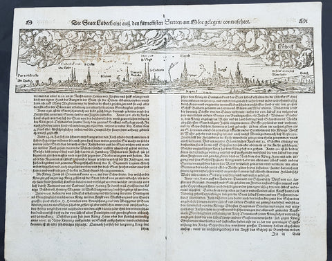
1574 Sebastian Munster Antique Map Birds Eye View of the City of Lubeck, Germany
- Title : Die Statt Lubeck
- Date : 1574
- Condition: (A+) Fine Condition
- Ref # : 22708
- Size : 15in x 13in (380mm x 340mm)
Description:
This fine original wood block engraved antique map a birds eye view of the German city of Lubeck, in the northern German state Schleswig-Holstein was published in the German Section of Sebastian Munsters 1574 edition of Cosmographia, Das ist: Beschreibung der gantzen Welt, Darinnen Aller Monarchien Keyserthumben, Königreichen, Fürstenthumben, Graff- und Herrschafften, Länderen, Stätten und Gemeinden.Ursprung (Cosmographia, that is: description of the whole world, in it all monarchies Keyser thumben, kingdoms, prince thumben, graff and herrschafften, countries, places and municipalities.)
Lübeck is a city in Schleswig-Holstein, northern Germany, and one of the major ports of Germany, on the river Trave.
In the 14th century Lübeck became the Queen of the Hanseatic League, being by far the largest and most powerful member of that medieval trade organization. In 1375 Emperor Charles IV named Lübeck one of the five Glories of the Empire, a title shared with Venice, Rome, Pisa and Florence. Several conflicts about trading privileges resulted in fighting between Lübeck (with the Hanseatic League) and Denmark and Norway – with varying outcome. While Lübeck and the Hanseatic League prevailed in conflicts in 1435 and 1512, Lübeck lost when it became involved in the Count\'s Feud, a civil war that raged in Denmark from 1534 to 1536. Lübeck also joined the pro-Lutheran Schmalkaldic League of the mid-16th century.
After its defeat in the Count\'s Feud, Lübeck\'s power slowly declined. The city remained neutral in the Thirty Years\' War of 1618–1648, but the combination of the devastation from the decades-long war and the new transatlantic orientation of European trade caused the Hanseatic League – and thus Lübeck with it – to decline in importance. However, even after the de facto disbanding of the Hanseatic League in 1669, Lübeck still remained an important trading town on the Baltic Sea.
General Definitions:
Paper thickness and quality: - Heavy and stable
Paper color : - off white
Age of map color: -
Colors used: -
General color appearance: -
Paper size: - 16in x 13in (410mm x 330mm)
Plate size: - 16in x 13in (410mm x 330mm)
Margins: - Min 1in (25mm)
Imperfections:
Margins: - None
Plate area: - Folds as issued
Verso: - None
Background:
Cosmographia, Das ist: Beschreibung der gantzen Welt, Darinnen Aller Monarchien Keyserthumben, Königreichen, Fürstenthumben, Graff- und Herrschafften, Länderen, Stätten und Gemeinden.Ursprung, Regiment, Reichthumb, Gewalt und.Beschaffenheit. Dessgleichen Aller deren, beyder Ständen, Regenten: Keysern, Königen, Bäpsten, Bischoffen.Genealogien und Stammbäumen.zusammen getragen. by Sebastian Münster was first published in 1544 and is the earliest German-language description of the world. It had numerous editions in different languages including Latin, French (translated by François de Belleforest), Italian, English, and Czech. The last German edition was published in 1628, long after Munsters death. The Cosmographia was one of the most successful and popular books of the 16th century. It passed through 24 editions in 100 years. This success was due to the notable woodcuts (some by Hans Holbein the Younger, Urs Graf, Hans Rudolph Manuel Deutsch, and David Kandel). It was most important in reviving geography in 16th-century Europe. Among the notable maps within Cosmographia is the map Tabula novarum insularum, which is credited as the first map to show the American continents as geographically discrete.
Munsters earlier geographic works were Germania descriptio (1530) and Mappa Europae (1536). In 1540, he published a Latin edition of Ptolemys Geographia with illustrations.
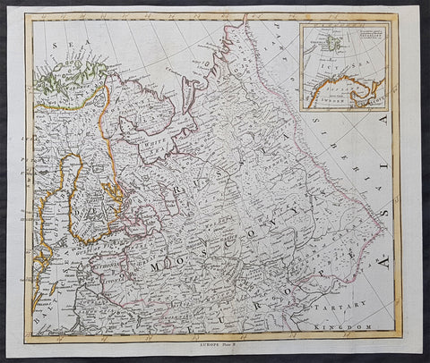
1765 T. Bowen & M Postlethweyt Antique Map of European Russia, Baltics, Lapland
- Title : Europe Plate II
- Date : 1765
- Size: 17 1/2in x 14 1/2in (445mm x 370mm)
- Condition: (A+) Fine Condition
- Ref: 01-1584
Description:
This wonderful large detailed original copper plate engraved antique map of European Russia, parts of Lapland, Sweden, Latvia & Lithuania by Thomas Bowen was published in the 1765 edition of Malachy Postlethweyts monumental 2 Volume tomes on Universal Dictionary of Trade & Commerce concentrating on various states of trade, including slavery, between England and America published between 1751 & 1774.
General Definitions:
Paper thickness and quality: - Heavy and stable
Paper color : - off white
Age of map color: - Original
Colors used: - Blue, orange, green
General color appearance: - Authentic
Paper size: - 17 1/2in x 14 1/2in (445mm x 370mm)
Plate size: - 17in x 14in (430mm x 355mm)
Margins: - Min 1/2in (8mm)
Imperfections:
Margins: - None
Plate area: - Light creasing
Verso: - None
Background:
It is scarcely necessary to look at a map of Russia - with which we must include Siberia - to visualize the daunting task facing Russian map makers. Indeed, considering the vastness of their territory and the lack of skilled cartographers, it is surprising that relatively good maps were available for engraving and printing in most of the well known sixteenth and seventeenth century atlases. Generally, maps of that time were based on material brought back from Moscow by visitors from the West.
Postlethweyt, Malachy 1707 – 1767
Malachy Postlethweyts Dictionary of Trade & Commerce:
A monumental dictionary of trade and commerce. It is based in part on the Dictionnaire universel de Commerce (Paris: 1723-30) of Jacques Savary de Bruslon, under whose name it is often catalogued, but has been adapted by Postlethwayt for a British audience, with substantial enlargements and improvements, and entirely new material relating to England and her colonies. Postlethwayt devoted twenty years to the preparation of the dictionary, which was first published in 1751-55 & includes a description of British affairs in North America since the peace of 1763.
As with his other works, the dictionary demonstrates Postlethway’s deep commitment to the expansion and strengthening of English trade. Included are entries for geographical locations (Africa, Antilles, Canada, Japan, Louisiana, &c.), products (brandy, cardamom, codfish, diamonds, sugar, &c.), trading companies (Dutch East India Company, English African Company, &c.), treaties of commerce, and a vast range of other information of value to merchants (bankruptcy, currency, bills of exchange, brokerage, exportation, landed interest, privateering, &c.). The Dictionary is also important for containing almost the whole substance of Richard Cantillon’s Essay on Commerce, its first appearance in print.
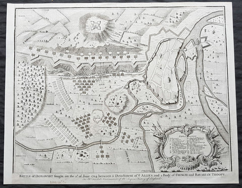
1745 Nicolas Tindal Large Antique Map The Battle of Schellenberg, Germany 1704
- Title : Battle of Donawert fought on the 2nd of June 1704 between a detachment of ye Allies and a body of French and Bavarian Troops
- Size: 20in x 16in (510mm x 410mm)
- Condition: (A+) Fine Condition
- Date : 1745
- Ref #: 22160
Description:
This large original antique copper-plate engraved military map of the Battle of Schellenberg, also known as the Battle of Donauwörth in the Donau-Ries district of Swabia, in Bavaria, Germany - during the Spanish War of Succession - was engraved by John Basire and published in the 1745 edition of Nicholas Tindals Continuation of Mr. Rapins History of England.
General Definitions:
Paper thickness and quality: - Heavy and stable
Paper color : - off white
Age of map color: -
Colors used: -
General color appearance: -
Paper size: - 20in x 16in (510mm x 410mm)
Plate size: - 20in x 16in (510mm x 410mm)
Margins: - Min 1/2in (10mm)
Imperfections:
Margins: - None
Plate area: - Folds as issued
Verso: - None
The Battle of Schellenberg, also known as the Battle of Donauwörth, was fought on 2 July 1704 during the War of the Spanish Succession. The engagement was part of the Duke of Marlboroughs campaign to save the Habsburg capital of Vienna from a threatened advance by King Louis XIVs Franco-Bavarian forces ranged in southern Germany. Marlborough had commenced his 400 km march from Bedburg, near Cologne, on 19 May; within five weeks he had linked his forces with those of the Margrave of Baden, before continuing on to the river Danube. Once in southern Germany, the Allies task was to induce Max Emanuel, the Elector of Bavaria, to abandon his allegiance to Louis XIV and rejoin the Grand Alliance; but to force the issue, the Allies first needed to secure a fortified bridgehead and magazine on the Danube, through which their supplies could cross to the south of the river into the heart of the Electors lands. For this purpose, Marlborough selected the town of Donauwörth.
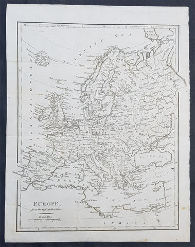
1797 John Cary Original Antique Map of Europe
- Title : Europe from the Best Authorities
- Size: 12 1/2in x 10in (315mm x 255mm)
- Ref #: 92766
- Date : 1797
- Condition: (A+) Fine Condition
General Definitions:
Paper thickness and quality: - Heavy and stable
Paper color : - off white
Age of map color: -
Colors used: -
General color appearance: -
Paper size: - 12 1/2in x 10in (315mm x 255mm)
Plate size: - 12 1/2in x 10in (315mm x 255mm)
Margins: - Min 1/2in (12mm)
Imperfections:
Margins: - None
Plate area: - Folds as issued
Verso: - None
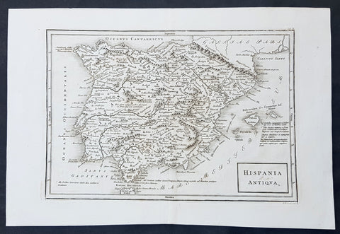
1750 C. Cellarius & RW Seale Original Antique Map of Spain & Balearic Islands
- Title : Hispania Antiqua
- Size: 15in x 10in (380mm x 255mm)
- Ref #: 31354
- Date : 1750
- Condition: (A+) Fine Condition
Description:
This finely engraved original copper-plate engraved antique map of Spain by Christopher Cellarius was engraved by RW Seale and published in the 1750 edition of Geographica Antiqua.
Richard William Seale was a prolific engraver of the mid 18th century responsible between 1744-47 for Maps of Continents and Maps for Mr Tindals Continuation of Rapins History of England in 1745. (Ref: M&B; Tooley)
General Definitions:
Paper thickness and quality: - Heavy and stable
Paper color : - off white
Age of map color: -
Colors used: -
General color appearance: -
Paper size: - 15in x 10in (380mm x 255mm)
Plate size: - 12in x 8 1/2in (305mm x 215mm)
Margins: - Min 1/2in (12mm)
Imperfections:
Margins: - None
Plate area: - None
Verso: - None
Background:
Geographica was one of the most popular geographical publications of the 17th and 18th centuries, that lasted into the 19th century, a fine map (Ref: Tooley; M&B)
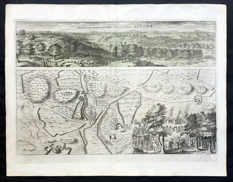
1709 Dahlbergh & Aveelen Antique Map & View of Finsta in Stockholm, Sweden
- Title : Finsta
- Ref #: 70449
- Size: 16 1/2in x 12 1/2in (420mm x 315mm)
- Date : 1709
- Condition: (A+) Fine Condition
Description:
This large original copper-plate engraved antique map & view of Finsta in Stockholm, Sweden by Johannes van den Aveelen was published in the 1709 edition of Erik Dahlbergh's Suecia Antiqua et Hodierna (Ancient and Modern Sweden).
Finsta is a locality situated in Norrtälje Municipality, Stockholm County, Sweden
Background: Suecia Antiqua et Hodierna (ancient and modern Sweden) is a collection of engravings collected by Erik Dahlbergh during the middle of the 17th century. Suecia Antiqua et Hodierna can be described as a grand vision of Sweden during its period as a great power. Dahlberg's direct source of inspiration was the topographical publications issued by the Swiss publisher Matthäus Merian.
In 1661 Dahlberg was granted a royal privilege enabling him to realize his plans, which kept him occupied for a good decade, and a work that would not be printed until after his death. In its final state Suecia Antiqua et Hodierna comprised three volumes containing 353 plates.
Jan van den Aveele or Aveelen (1650 - 1727) was a Dutch etcher and copper engraver. With compatriot Willem Swidde, he made engravings for Suecia Antiqua et Hodierna ("Ancient and Modern Sweden") including depictions of public buildings and city scapes in Stockholm and other Swedish cities. (Ref Tooley M&B)
General Description:
Paper thickness and quality: - Heavy and stable
Paper color: - off white
Age of map color: -
Colors used: -
General color appearance: -
Paper size: - 16 1/2in x 12 1/2in (420mm x 315mm)
Plate size: - 13in x 10in (330mm x 255mm)
Margins: - Min 1/2in (12mm)
Imperfections:
Margins: - None
Plate area: - None
Verso: - None
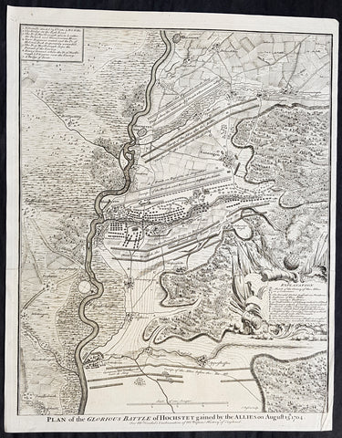
1745 Nicolas Tindal Antique Map The Battle of Blenheim, Germany in 1704
Antique Map
- Title : Plan of the Glorious Battle of Hochstet gained by the Allies on August 13.th 1704.
- Size: 21in x 17in (530mm x 430mm)
- Ref #: 22178
- Date : 1745
- Condition: (A+) Fine Condition
Description:
This original copper-plate engraved antique map, plan of the The Battle of Blenheim or Hochstadt, fought in Bavaria, Germany in August 1704 - during the Spanish War of Succession (1701-13) - was engraved by John Basire and was published in the 1745 edition of Nicholas Tindals Continuation of Mr. Rapins History of England.
General Definitions:
Paper thickness and quality: - Heavy and stable
Paper color : - off white
Age of map color: -
Colors used: -
General color appearance: -
Paper size: - 21in x 17in (530mm x 430mm)
Plate size: - 21in x 17in (530mm x 430mm)
Margins: - Min 1/2in (12mm)
Imperfections:
Margins: - None
Plate area: - Folds as issued
Verso: - None
Background:
The Battle of Blenheim (German: Zweite Schlacht bei Höchstädt; French Bataille de Höchstädt), fought on 13 August 1704, was a major battle of the War of the Spanish Succession. The overwhelming Allied victory ensured the safety of Vienna from the Franco-Bavarian army, thus preventing the collapse of the Grand Alliance.
Louis XIV of France sought to knock the Holy Roman Emperor, Leopold out of the war by seizing Vienna, the Habsburg capital, and gain a favourable peace settlement. The dangers to Vienna were considerable: the Elector of Bavaria and Marshal Marsins forces in Bavaria threatened from the west, and Marshal Vendômes large army in northern Italy posed a serious danger with a potential offensive through the Brenner Pass. Vienna was also under pressure from Rákóczis Hungarian revolt from its eastern approaches. Realising the danger, the Duke of Marlborough resolved to alleviate the peril to Vienna by marching his forces south from Bedburg to help maintain Emperor Leopold within the Grand Alliance.
A combination of deception and skilled administration – designed to conceal his true destination from friend and foe alike – enabled Marlborough to march 400 kilometres (250 miles) unhindered from the Low Countries to the River Danube in five weeks. After securing Donauwörth on the Danube, Marlborough sought to engage the Electors and Marsins army before Marshal Tallard could bring reinforcements through the Black Forest. However, with the Franco-Bavarian commanders reluctant to fight until their numbers were deemed sufficient, the Duke enacted a policy of plundering in Bavaria designed to force the issue. The tactic proved unsuccessful, but when Tallard arrived to bolster the Electors army, and Prince Eugene arrived with reinforcements for the Allies, the two armies finally met on the banks of the Danube in and around the small village of Blindheim, from which the English Blenheim is derived.
Blenheim was one of the battles that altered the course of the war, which until then was leaning for Louis coalition, and ended French plans of knocking the Emperor out of the war. France suffered as many as 38,000 casualties including the commander-in-chief, Marshal Tallard, who was taken captive to England. Before the 1704 campaign ended, the Allies had taken Landau, and the towns of Trier and Trarbach on the Moselle in preparation for the following years campaign into France itself. The offensive never materialised as the Grand Alliances army had to depart the Moselle to defend Liège from a French counteroffensive. The war would rage on for another decade.
Tindal, Nicolas 1687 – 1774
Nicolas Tindal was the translator and continuer of the History of England published by Paul de Rapin (1661-1725) in 1724. De Rapins publication chronicles the History of Britain from the invasion of the Romans to the death of Charles I. Very few comprehensive histories of England existed at the time and Tindal added his three-volume Continuation, of the Kingdom, from the reigns of James II to George II.
Tindal\\\'s translation of de Rapins History, was first published in 1727. Tindal enlarged the volumes in their second edition (1732) to contain notes, genealogical tables and maps of his own composition. In 1745 Tindal published Tindal’s Continuation of Mr. Rapin’s History of England. Included with this edition was an atlas containing 45 maps, battle and town plans from the Spanish War of Succession (1701-13) that were engraved by Richard William Seale and John Basire.
These maps represent battles that took place during the War of Spanish Succession, concluded by the Treaties of Utrecht. The war resulted from a dispute over who should inherit Spain and its possessions after its Habsburg rulers in 1700. The last Habsburg king of Spain, Charles II (d. 1700) had left the throne to his closest relative in female line: Philippe de France, duke of Anjou, grandson of Louis XIV (Felipe V of Spain). The closest relatives in male line, the Habsburgs of Austria, disputed this claim, and many European nations did not want to see French princes reigning over both kingdoms. The Utrecht treaties recognized Felipe V of Spain, but transferred the Spanish possessions in the Netherlands and Italy to Austria and to Savoy. To reach the goal of separating the crowns of France and Spain, the treaties required Felipe V to relinquish all claims to the French throne, and the remaining French princes to relinquish all claims to the Spanish throne.
The War of the Spanish Succession, was also known as Marlboroughs Wars, that was fought in Europe and the Mediterranean, and were the last and the bloodiest of the Wars between England and France under Louis XIV, and the first in which Britain played a major military role in European military affairs.
Paul de Rapin 1661-1725 was born in Castes and educated at the Protestant academy of Saumur. In 1685 after the death of his father he moved to England but after being unable to find employment moved to Holland and enlisted in French volunteers at Utrecht commanded by his cousin Daniel de Rapin. He accompanied the prince of Orange to England in 1688 and participated in the Irish campaigns of the siege of Carrickfergus, Battle of the Boyne and Limerick. Rapin resigned to become tutor to the Earl of Portlands son. He settled in Holland where he began work on The History of England. It was published in Holland in 1724 in 8 volumes. The work was an attempt to be exhaustive in the spirit of the eighteenth century philosophies by treating the subject from prehistoric times up to the date of publication.

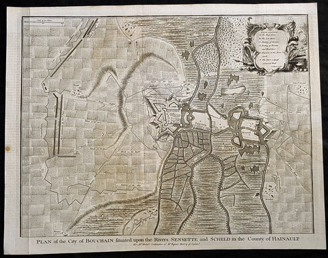
1745 Tindal Antique Map Battle Plan of Siege of Bouchain, Calais, France in 1711
Antique Map
- Title : Plan of the City of Bouchain Situated upon the Rivers Sensette and Scheld in the County of Hainault
- Size: 19 1/2in x 15 1/2in (495mm x 395mm)
- Ref #: 22156-1
- Date : 1745
- Condition: (A+) Fine Condition
Description:
This original copper-plate engraved antique map, battle plan & birds eye view of the French city of Bouchain on the Schedlt River, in the Pas-de-Calais dept. in northern France - during the Spanish War of Succession (1701-13) - was engraved by John Basire and was published in the 1745 edition of Nicholas Tindals Continuation of Mr. Rapin\'s History of England.
General Definitions:
Paper thickness and quality: - Heavy and stable
Paper color : - off white
Age of map color: -
Colors used: -
General color appearance: -
Paper size: - 19 1/2in x 15 1/2in (495mm x 395mm)
Plate size: - 19 1/2in x 15 1/2in (495mm x 395mm)
Margins: - Min 1/2in (12mm)
Imperfections:
Margins: - None
Plate area: - Folds as issued
Verso: - None
Background:
The Siege of Bouchain (9 August – 12 September 1711), following the Passage of the Lines of Ne Plus Ultra (5 August 1711), was a siege of the War of the Spanish Succession, and the last major victory of John Churchill, 1st Duke of Marlborough. Marlborough broke through the French defensive lines and took Bouchain after a siege of 34 days. Its capture left Cambrai the only French-held fortress between the allied army and Paris.
Throughout the early summer of 1711 Marlborough\'s army, having taken the important fortress of Douai the previous year, manoeuvred indecisively in northern France, blocked by the French Lines of Ne Plus Ultra – a massive series of fieldworks stretching from the Channel coast to the Ardennes at Namur. The allied army had been weakened by the withdrawal of Prince Eugene\'s army to cover the upper Rhine, as the deposed Elector of Bavaria attempted to take advantage of the disruption caused by the death of the Emperor Joseph. On 6 July, Marlborough captured the small fortress of Arleux, just to the north of the Lines, west of Bouchain, both to deny its use to the French as a sally-port, and to secure the water supply to Douai, which could be cut off by damming the canal that supplied the town. The Duke was then wrong-footed by Villars as the French army crossed the Lines on 22/23 July and retook Arleux, with the allied army too far to the west to intervene in time, and the defences were levelled before the French retreated back across the Lines. Marlborough, initially furious, soon retook the initiative by marching his army as if to assault the Lines near Arras, and carrying out a detailed personal reconnaissance there on 4 August in full view of Villars\' covering army. That night the army struck camp, leaving their campfires burning to deceive the French, and marched eastwards to Arleux. At midnight a force from Douai under Cadogan crossed the unguarded French lines, and by 8 am the advance guard of the main army was also crossing over. Villars, arriving on the scene with a few hundred cavalry, realised he had been outmanoeuvred, and though he attempted to offer battle in front of Bourlon Wood, Marlborough declined to attack, the Marshal\'s position being even stronger than the one in which he had given Marlborough\'s army such a mauling two years earlier at Malplaquet. He thus drew off and attempted to hinder Marlborough\'s siege of Bouchain which followed.
To defend the town Bouchain\'s governor, de Ravignau, had some 5,000 men against Marlborough\'s besieging army of 30,000, and the advantage of one of the strongest fortresses left to France, surrounded by the marshy land of the confluence of the rivers Scheldt and Sensée. In addition, Villars\' strong army had taken up position to the west of the allied camp, and had managed to open a tenuous link to the besieged garrison. Marlborough responded by using earthwork gun batteries to counter Villars, used a crack assault force managed by 18 August to once more cut the Marshal\'s communication with Bouchain, and established a fieldwork-protected corridor from the siege camp to his main supply port at Marchiennes on the Scarpe. Frequent raids by Villars on both the supply convoys on the Scarpe, and towards Douai, failed to interrupt the siege, and the garrison marched out to become prisoners of war on 13 September 1711.
Bouchain was Marlborough\'s last campaign. On the last day of the year he was stripped of his position as Captain-General, and of all his other offices. Command of the army on the continent for the campaign of 1712 was given to the Duke of Ormonde, and strict limitations were placed on his freedom of movement. Particularly he was prohibited from engaging the French in battle, as Anglo-French peace talks were well advanced, and the opportunity of seizing Cambrai and marching on Paris, opened by Marlborough\'s gains the year before, was abandoned. Before the year was out, the British army would withdraw from the alliance, leaving the remaining allies, under Eugene of Savoy to be defeated at Denain.
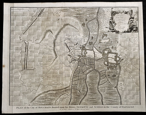
1745 Tindal Antique Map Battle Plan of Siege of Bouchain, Calais, France in 1711
Antique Map
- Title : Plan of the City of Bouchain Situated upon the Rivers Sensette and Scheld in the County of Hainault
- Size: 19 1/2in x 15 1/2in (495mm x 395mm)
- Ref #: 22156-1
- Date : 1745
- Condition: (A+) Fine Condition
Description:
This original copper-plate engraved antique map, battle plan & birds eye view of the French city of Bouchain on the Schedlt River, in the Pas-de-Calais dept. in northern France - during the Spanish War of Succession (1701-13) - was engraved by John Basire and was published in the 1745 edition of Nicholas Tindals Continuation of Mr. Rapin\'s History of England.
General Definitions:
Paper thickness and quality: - Heavy and stable
Paper color : - off white
Age of map color: - Early
Colors used: - Pink, blue, green, yellow
General color appearance: - Authentic
Paper size: - 19 1/2in x 15 1/2in (495mm x 395mm)
Plate size: - 19 1/2in x 15 1/2in (495mm x 395mm)
Margins: - Min 1/2in (12mm)
Imperfections:
Margins: - None
Plate area: - Folds as issued
Verso: - None
Background:
The Siege of Bouchain (9 August – 12 September 1711), following the Passage of the Lines of Ne Plus Ultra (5 August 1711), was a siege of the War of the Spanish Succession, and the last major victory of John Churchill, 1st Duke of Marlborough. Marlborough broke through the French defensive lines and took Bouchain after a siege of 34 days. Its capture left Cambrai the only French-held fortress between the allied army and Paris.
Throughout the early summer of 1711 Marlborough\'s army, having taken the important fortress of Douai the previous year, manoeuvred indecisively in northern France, blocked by the French Lines of Ne Plus Ultra – a massive series of fieldworks stretching from the Channel coast to the Ardennes at Namur. The allied army had been weakened by the withdrawal of Prince Eugene\'s army to cover the upper Rhine, as the deposed Elector of Bavaria attempted to take advantage of the disruption caused by the death of the Emperor Joseph. On 6 July, Marlborough captured the small fortress of Arleux, just to the north of the Lines, west of Bouchain, both to deny its use to the French as a sally-port, and to secure the water supply to Douai, which could be cut off by damming the canal that supplied the town. The Duke was then wrong-footed by Villars as the French army crossed the Lines on 22/23 July and retook Arleux, with the allied army too far to the west to intervene in time, and the defences were levelled before the French retreated back across the Lines. Marlborough, initially furious, soon retook the initiative by marching his army as if to assault the Lines near Arras, and carrying out a detailed personal reconnaissance there on 4 August in full view of Villars\' covering army. That night the army struck camp, leaving their campfires burning to deceive the French, and marched eastwards to Arleux. At midnight a force from Douai under Cadogan crossed the unguarded French lines, and by 8 am the advance guard of the main army was also crossing over. Villars, arriving on the scene with a few hundred cavalry, realised he had been outmanoeuvred, and though he attempted to offer battle in front of Bourlon Wood, Marlborough declined to attack, the Marshal\'s position being even stronger than the one in which he had given Marlborough\'s army such a mauling two years earlier at Malplaquet. He thus drew off and attempted to hinder Marlborough\'s siege of Bouchain which followed.
To defend the town Bouchain\'s governor, de Ravignau, had some 5,000 men against Marlborough\'s besieging army of 30,000, and the advantage of one of the strongest fortresses left to France, surrounded by the marshy land of the confluence of the rivers Scheldt and Sensée. In addition, Villars\' strong army had taken up position to the west of the allied camp, and had managed to open a tenuous link to the besieged garrison. Marlborough responded by using earthwork gun batteries to counter Villars, used a crack assault force managed by 18 August to once more cut the Marshal\'s communication with Bouchain, and established a fieldwork-protected corridor from the siege camp to his main supply port at Marchiennes on the Scarpe. Frequent raids by Villars on both the supply convoys on the Scarpe, and towards Douai, failed to interrupt the siege, and the garrison marched out to become prisoners of war on 13 September 1711.
Bouchain was Marlborough\'s last campaign. On the last day of the year he was stripped of his position as Captain-General, and of all his other offices. Command of the army on the continent for the campaign of 1712 was given to the Duke of Ormonde, and strict limitations were placed on his freedom of movement. Particularly he was prohibited from engaging the French in battle, as Anglo-French peace talks were well advanced, and the opportunity of seizing Cambrai and marching on Paris, opened by Marlborough\'s gains the year before, was abandoned. Before the year was out, the British army would withdraw from the alliance, leaving the remaining allies, under Eugene of Savoy to be defeated at Denain.
1745 Tindal Antique Map Battle Plan of Siege of Bouchain, Calais, France in 1711
Antique Map
- Title : Plan of the City of Bouchain Situated upon the Rivers Sensette and Scheld in the County of Hainault
- Size: 19 1/2in x 15 1/2in (495mm x 395mm)
- Ref #: 22198
- Date : 1745
- Condition: (A+) Fine Condition
Description:
This original copper-plate engraved antique map, battle plan & birds eye view of the French city of Bouchain on the Schedlt River, in the Pas-de-Calais dept. in northern France - during the Spanish War of Succession (1701-13) - was engraved by John Basire and was published in the 1745 edition of Nicholas Tindals Continuation of Mr. Rapin\'s History of England.
General Definitions:
Paper thickness and quality: - Heavy and stable
Paper color : - off white
Age of map color: -
Colors used: -
General color appearance: -
Paper size: - 19 1/2in x 15 1/2in (495mm x 395mm)
Plate size: - 19 1/2in x 15 1/2in (495mm x 395mm)
Margins: - Min 1/2in (12mm)
Imperfections:
Margins: - None
Plate area: - Folds as issued
Verso: - None
Background:
The Siege of Bouchain (9 August – 12 September 1711), following the Passage of the Lines of Ne Plus Ultra (5 August 1711), was a siege of the War of the Spanish Succession, and the last major victory of John Churchill, 1st Duke of Marlborough. Marlborough broke through the French defensive lines and took Bouchain after a siege of 34 days. Its capture left Cambrai the only French-held fortress between the allied army and Paris.
Throughout the early summer of 1711 Marlborough\'s army, having taken the important fortress of Douai the previous year, manoeuvred indecisively in northern France, blocked by the French Lines of Ne Plus Ultra – a massive series of fieldworks stretching from the Channel coast to the Ardennes at Namur. The allied army had been weakened by the withdrawal of Prince Eugene\'s army to cover the upper Rhine, as the deposed Elector of Bavaria attempted to take advantage of the disruption caused by the death of the Emperor Joseph. On 6 July, Marlborough captured the small fortress of Arleux, just to the north of the Lines, west of Bouchain, both to deny its use to the French as a sally-port, and to secure the water supply to Douai, which could be cut off by damming the canal that supplied the town. The Duke was then wrong-footed by Villars as the French army crossed the Lines on 22/23 July and retook Arleux, with the allied army too far to the west to intervene in time, and the defences were levelled before the French retreated back across the Lines. Marlborough, initially furious, soon retook the initiative by marching his army as if to assault the Lines near Arras, and carrying out a detailed personal reconnaissance there on 4 August in full view of Villars\' covering army. That night the army struck camp, leaving their campfires burning to deceive the French, and marched eastwards to Arleux. At midnight a force from Douai under Cadogan crossed the unguarded French lines, and by 8 am the advance guard of the main army was also crossing over. Villars, arriving on the scene with a few hundred cavalry, realised he had been outmanoeuvred, and though he attempted to offer battle in front of Bourlon Wood, Marlborough declined to attack, the Marshal\'s position being even stronger than the one in which he had given Marlborough\'s army such a mauling two years earlier at Malplaquet. He thus drew off and attempted to hinder Marlborough\'s siege of Bouchain which followed.
To defend the town Bouchain\'s governor, de Ravignau, had some 5,000 men against Marlborough\'s besieging army of 30,000, and the advantage of one of the strongest fortresses left to France, surrounded by the marshy land of the confluence of the rivers Scheldt and Sensée. In addition, Villars\' strong army had taken up position to the west of the allied camp, and had managed to open a tenuous link to the besieged garrison. Marlborough responded by using earthwork gun batteries to counter Villars, used a crack assault force managed by 18 August to once more cut the Marshal\'s communication with Bouchain, and established a fieldwork-protected corridor from the siege camp to his main supply port at Marchiennes on the Scarpe. Frequent raids by Villars on both the supply convoys on the Scarpe, and towards Douai, failed to interrupt the siege, and the garrison marched out to become prisoners of war on 13 September 1711.
Bouchain was Marlborough\'s last campaign. On the last day of the year he was stripped of his position as Captain-General, and of all his other offices. Command of the army on the continent for the campaign of 1712 was given to the Duke of Ormonde, and strict limitations were placed on his freedom of movement. Particularly he was prohibited from engaging the French in battle, as Anglo-French peace talks were well advanced, and the opportunity of seizing Cambrai and marching on Paris, opened by Marlborough\'s gains the year before, was abandoned. Before the year was out, the British army would withdraw from the alliance, leaving the remaining allies, under Eugene of Savoy to be defeated at Denain.
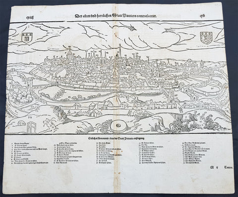
1598 Munster Antique Map Birds Eye View of the city of Poitiers in Poitou France
- Title : Die Statt Puttiers
- Date : 1598
- Condition: (A) Very Good Condition
- Ref # : 30381
- Size : 15in x 13in (380mm x 340mm)
Description:
This fine original wood block engraved antique map a birds eye view of the French city of Poitiers on the Clain River in the Vienne Dept of central western France, was published in the French Section of Sebastian Munsters 1598 edition of Cosmographia, Das ist: Beschreibung der gantzen Welt, Darinnen Aller Monarchien Keyserthumben, Königreichen, Fürstenthumben, Graff- und Herrschafften, Länderen, Stätten und Gemeinden.Ursprung (Cosmographia, that is: description of the whole world, in it all monarchies Keyser thumben, kingdoms, prince thumben, graff and herrschafften, countries, places and municipalities.)
Poitiers is a city on the Clain river in west-central France. It is a commune and the capital of the Vienne department and also of the Poitou.
The type of political organisation existing in Poitiers during the late medieval or early modern period can be glimpsed through a speech given on 14 July 1595 by Maurice Roatin, the town\'s mayor. He compared it to the Roman state, which combined three types of government: monarchy (rule by one person), aristocracy (rule by a few), and democracy (rule by the many). He said the Roman consulate corresponded to Poitiers\' mayor, the Roman senate to the town\'s peers and échevins, and the democratic element in Rome corresponded to the fact that most important matters can not be decided except by the advice of the Mois et Cent (broad council).1 The mayor appears to have been an advocate of a mixed constitution; not all Frenchmen in 1595 would have agreed with him, at least in public; many spoke in favour of absolute monarchy. The democratic element was not as strong as the mayor\'s words may seem to imply: in fact, Poitiers was similar to other French cities, Paris, Nantes, Marseille, Limoges, La Rochelle, Dijon, in that the town\'s governing body (corps de ville) was highly exclusive and oligarchical: a small number of professional and family groups controlled most of the city offices. In Poitiers many of these positions were granted for the lifetime of the office holder.
The city government in Poitiers based its claims to legitimacy on the theory of government where the mayor and échevins held jurisdiction of the citys affairs in fief from the king: that is, they swore allegiance and promised support for him, and in return he granted them local authority. This gave them the advantage of being able to claim that any townsperson who challenged their authority was being disloyal to the king. Every year the mayor and the 24 échevins would swear an oath of allegiance between the hands of the king or his representative, usually the lieutenant général or the sénéchaussée. For example, in 1567, when Maixent Poitevin was mayor, king Henry III came for a visit, and, although some townspeople grumbled about the licentious behaviour of his entourage, Henry smoothed things over with a warm speech acknowledging their allegiance and thanking them for it.
In this era, the mayor of Poitiers was preceded by sergeants wherever he went, consulted deliberative bodies, carried out their decisions, heard civil and criminal suits in first instance, tried to ensure that the food supply would be adequate, visited markets.
In the 16th century, Poitiers impressed visitors because of its large size, and important features, including royal courts, university, prolific printing shops, wealthy religious institutions, cathedral, numerous parishes, markets, impressive domestic architecture, extensive fortifications, and castle.
16th-century Poitiers is closely associated with the life of François Rabelais and with the community of Bitards.
The town saw less activity during the Renaissance. Few changes were made in the urban landscape, except for laying way for the rue de la Tranchée. Bridges were built where the inhabitants had used gués. A few hôtels particuliers were built at that time, such as the hôtels Jean Baucé, Fumé and Berthelot. Poets Joachim du Bellay and Pierre Ronsard met at the University of Poitiers, before leaving for Paris.
During the 17th century, many people emigrated from Poitiers and the Poitou to the French settlements in the new world and thus many Acadians or Cajuns living in North America today can trace ancestry back to this region.
General Definitions:
Paper thickness and quality: - Heavy and stable
Paper color : - off white
Age of map color: -
Colors used: -
General color appearance: -
Paper size: - 15in x 13 1/4in (380mm x 340mm)
Plate size: - 15in x 13 1/4in (380mm x 340mm)
Margins: - Min 1/4in (3mm)
Imperfections:
Margins: - L&R margins cropped into border
Plate area: - Light toning along centerfold
Verso: - Light toning along centerfold
Background:
Cosmographia, Das ist: Beschreibung der gantzen Welt, Darinnen Aller Monarchien Keyserthumben, Königreichen, Fürstenthumben, Graff- und Herrschafften, Länderen, Stätten und Gemeinden.Ursprung, Regiment, Reichthumb, Gewalt und.Beschaffenheit. Dessgleichen Aller deren, beyder Ständen, Regenten: Keysern, Königen, Bäpsten, Bischoffen.Genealogien und Stammbäumen.zusammen getragen. by Sebastian Münster was first published in 1544 and is the earliest German-language description of the world. It had numerous editions in different languages including Latin, French (translated by François de Belleforest), Italian, English, and Czech. The last German edition was published in 1628, long after Munsters death. The Cosmographia was one of the most successful and popular books of the 16th century. It passed through 24 editions in 100 years. This success was due to the notable woodcuts (some by Hans Holbein the Younger, Urs Graf, Hans Rudolph Manuel Deutsch, and David Kandel). It was most important in reviving geography in 16th-century Europe. Among the notable maps within Cosmographia is the map Tabula novarum insularum, which is credited as the first map to show the American continents as geographically discrete.
Munsters earlier geographic works were Germania descriptio (1530) and Mappa Europae (1536). In 1540, he published a Latin edition of Ptolemys Geographia with illustrations.
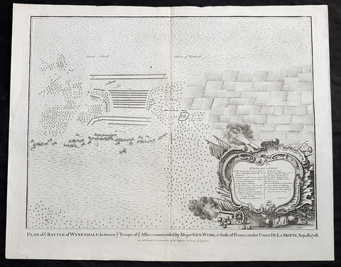
1745 Nicolas Tindal Original Antique Map Battle of Wijnendale Flanders Belgium in 1708
Antique Map
- Title : Plan of the Battle of Wynendale, between ye Troops of ye Allies commanded by Major Gen. Webb & those of France under count de la Motte Sep. 28, 1708
- Size: 19 1/2in x 15 1/2in (495mm x 395mm)
- Ref #: 22165
- Date : 1745
- Condition: (A+) Fine Condition
Description:
This original copper-plate engraved antique map, plan of the The Battle of Wijnendale, Flanders, Belgium in 1708 - during the Spanish War of Succession (1701-13) - was engraved by John Basire and was published in the 1745 edition of Nicholas Tindals Continuation of Mr. Rapin\'s History of England.
General Definitions:
Paper thickness and quality: - Heavy and stable
Paper color : - off white
Age of map color: -
Colors used: -
General color appearance: -
Paper size: - 19 1/2in x 15 1/2in (495mm x 395mm)
Plate size: - 19 1/2in x 15 1/2in (495mm x 395mm)
Margins: - Min 1/2in (12mm)
Imperfections:
Margins: - None
Plate area: - None
Verso: - None
Background:
The Battle of Wijnendale was a battle in the War of the Spanish Succession fought on 28 September 1708 near Wijnendale, Flanders, between an allied force protecting a convoy for the Siege of Lille (1708) and forces of Bourbon France and Spain. It ended in a victory for the allies, leading to the taking of Lille.
After their great victory in the Battle of Oudenaarde (11 July 1708), Marlborough and Prince Eugene of Savoy decided to besiege Lille. But Lille was very well defended by modern fortifications designed by Vauban and a garrison of 16,000 men. The allied siege didn\'t go as well as planned and a lack of ammunition was imminent. To make things worst, the supply lines from the east were cut by the French, so the only remaining line of supply was by ship from England to the port of Ostend, some 75 km from Lille.
Marlborough ordered the necessary goods to be shipped to Ostend and a large convoy of 700 slow wagons was organised there to travel further over land to Lille. The convoy was protected by 6,000 infantry and 1,500 cavalry under command of general-major John Richmond Webb.
The commander of the French garrison of Bruges, Count de la Mothe, was informed of the convoy and gathered a force of 22,000 to 24,000 men towards Wijnendale to intercept the convoy.
Webb was aware of the advancing French army and knew a confrontation was unavoidable. He drew up a plan to compensate for his numerical disadvantage. Using the wooded landscape around Wijnendale, he chose an open spot, flanked on both sides by woods and hedges. He placed his troops in two long lines, closing off this open space. Later a third line was formed with reinforcements coming from Oudenburg. Meanwhile, behind these lines, the convoy continued slowly towards Lille.
While Webb was deploying his troops, Prussian general Carl von Lottum, with only 150 cavalry harassed the approaching French army, gaining valuable time, and preventing de la Mothe to gather knowledge of the terrain and the plans of the allies.
Having arrived at the open space, de la Mothe, expecting an easy victory, deployed his army as expected. Between 4 and 5 pm the French artillery opened fire. When de la Mothe saw the effects on the enemy were limited, he ordered his infantry forward. The large French force was hampered by the narrow terrain and suffered badly from the fire of the allied first line, which held its ground. Then Webb ordered the Prussian, Hanoverian and Dutch regiments who were hidden in the woods on both flanks, to open fire. Despite suffering heavy casualties, de la Mothe ordered a second attack, which initially pushed the allied first line back. But with the help of the second line and the continuous fire from the flanks, the French were stopped and forced to withdraw and leave the battlefield.
When the battle was as good as won, allied cavalry under command of William Cadogan arrived at the battlefield. He was sent from Lille by Marlborough, who was worried about the convoy.
The toll of this two-hour battle was heavy: 3,000 to 4,000 French and Spanish soldiers were killed or wounded. The allies lost 900 dead and wounded.
The convoy reached Lille intact on 29 September, allowing the siege to continue. Three weeks later, on 22 October, the city was taken.
For political reasons, Marlborough gave in his initial dispatch the credit for the victory to William Cadogan, also a Whig. But Webb subsequently received full credit and the thanks of Parliament for the action, and the following year he was promoted to Lieutenant-General. From this point onwards Webb became the centre of Tory agitation against Marlborough.
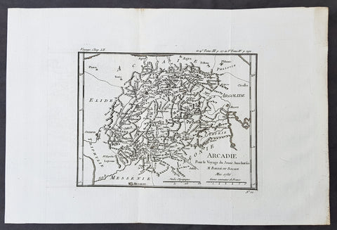
1782 Du Bocage & Barthelemy Antique Map of Arcadia Peloponnese, Greece - Tripoli
- Title : l Arcadie, Pour le Voyage du Jeune Anacharsis......1786
- Size: 15in x 10in (380mm x 255mm)
- Ref #: 16448
- Date : 1786
- Condition: (A+) Fine Condition
Description:
This original copper-plate engraved map by Jean Denis Barbie du Bocage was engraved in 1786 - dated in the title - and was published in the 1787 edition of Jean-Jacques Barthelemy famous Voyage du jeune Anarcharsis en Grece or Travels of Anacharsis the younger in Greecein 4 volumes.
General Definitions:
Paper thickness and quality: - Heavy and stable
Paper color : - off white
Age of map color: -
Colors used: -
General color appearance: -
Paper size: - 15in x 10in (380mm x 255mm)
Plate size: - 12in x 8 1/2in (305mm x 215mm)
Margins: - Min 1in (25mm)
Imperfections:
Margins: - None
Plate area: - Folds as issued
Verso: - None
Background:
Jean-Jacques Barthelemy 1716 – 1795 was a French writer and numismatist.
Barthelemy was the author of a number of learned works on antiquarian subjects, but the great work on which his fame rests is Travels of Anacharsis the younger in Greece (French: Voyage du jeune Anarcharsis en Grece, 4 vols., 1787). He had begun it in 1757 and had been working on it for thirty years. The hero, a young Scythian descended from the famous philosopher Anacharsis, is supposed to repair to Greece for instruction in his early youth, and after making the tour of her republics, colonies and islands, to return to his native country and write this book in his old age, after the Macedonian hero had overturned the Persian empire. In the manner of modern travellers, he gives an account of the customs, government, and antiquities of the country he is supposed to have visited. A copious introduction supplies whatever may be wanting in respect to historical details, while various dissertations on the music of the Greeks, on the literature of the Athenians, and on the economy, pursuits, ruling passions, manners, and customs of the surrounding states supply ample information on the subjects of which they treat.
Modern scholarship has superseded most of the details in the Voyage, but the author himself did not imagine his book to be a register of accurately ascertained facts. Rather, he intended to afford to his countrymen, in an interesting form, some knowledge of Greek civilisation. The Charicles, or Illustrations of the Private Life of the Ancient Greeks of Wilhelm Adolf Becker is an attempt in a similar direction
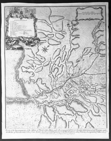
1745 Tindal Antique Map of Spanish & Austrian Armies in Catalonia Spain in 1711
- Title : Plan of the Incampment of the Allies at Prats Del Rey. under the command of Count Staremberg and of ye Enemy under the Duke of Vendsome: wher ye two Armies lay from ye 17th of September to ye 25th of December 1711 N.S. when ye Enemy decamped and ye Allies the 27th.
- Size: 19 1/2in x 15 1/2in (495mm x 395mm)
- Ref #: 15657
- Date : 1745
- Condition: (A+) Fine Condition
Description:
This original copper-plate engraved antique map, a battle plan of the encampments of the Spanish army under Louis-Joseph, duke de Vendome & the Austrian Army under Count Guido Starhemberg in Prado Del Rey in Catalonia, Spain - during the Spanish War of Succession (1701-13) - was engraved by John Basire and was published in the 1745 edition of Nicholas Tindals Continuation of Mr. Rapins History of England.
General Definitions:
Paper thickness and quality: - Heavy and stable
Paper color : - off white
Age of map color: -
Colors used: -
General color appearance: -
Paper size: - 19 1/2in x 15 1/2in (495mm x 395mm)
Plate size: - 19 1/2in x 15 1/2in (495mm x 395mm)
Margins: - Min 1/2in (12mm)
Imperfections:
Margins: - None
Plate area: - Folds as issued
Verso: - None
Background:
Duke Louis-Joseph de Vendome , 1654 — 1712 was one of King Louis XIV’s leading generals during the War of the Spanish Succession (1701–14).
Vendome was the son of Louis de Vendome, Duke de Mercoeur, by his marriage to Cardinal Jules Mazarin’s niece, Laure Mancini. Vendôme entered the French Army in 1672 and had risen to the rank of lieutenant general by the outbreak of the War of the Grand Alliance (1689–97) between France and the other major powers. He distinguished himself in the victory over the Allies at Steenkirke (1692) and was made commander in Catalonia in 1695; two years later he captured Barcelona.
The dispute over the succession to the Spanish throne brought France and Spain to war with the British, the Austrians, and the Dutch in 1701. Appointed to the command in northern Italy in 1702, Vendôme fought the Austrian commander, Prince Eugene of Savoy, in the bloody but indecisive Battle of Luzzara on August 15. He took Vercelli in 1704 and defeated Prince Eugene at Cassano in August 1705. In May 1706 Vendôme was transferred to the Flanders front, where the British commander John Churchill, 1st Duke of Marlborough, had just won an overwhelming victory at Ramillies. Vendôme made limited gains until he was severely defeated by Marlborough and Prince Eugene at Oudenaarde on July 11, 1708. Vendôme subsequently failed to relieve besieged Lille (in northern France), which fell to the Allies in October. Recalled by Louis XIV, he was temporarily disgraced.
Guido Wald Rüdiger, count of Starhemberg1657 – 1737 was an Austrian military officer.
He was a cousin of Ernst Rudiger von Starhemberg (1638-1701), the famous commander of Vienna during the Turkish siege of 1683, and acted as his aide-de-camp during that siege. Guido followed his cousin, and later Prince Eugene of Savoy, in battles against the Turks.
In the War of the Spanish Succession, Starhemberg fought in Italy and Spain. Between 1706 and 1708 he was the commander-in-chief of the imperial army in Hungary, leading military operations against the insurgents of Francis II Rákóczi. In 1708, he was appointed Supreme Commander of the Austrians in Spain.
Together with James Stanhope he succeeded in conquering Madrid in 1710, after previously gaining victories at Almenar and Saragossa. In December, however, he was forced to leave the city by the lack of support by its inhabitants for the Habsburg pretender. After the subsequent defeats at the Battle of Brihuega and the Battle of Villaviciosa (1710), he had to pull back to Catalonia, where he was made viceroy when Archduke Charles returned to Austria.
After the Peace of Utrecht (1713), archduke Charles, now Emperor Charles VI, ordered him to abandon Catalonia. He pulled back with his troops to Genoa on English ships.
When he died in 1737, he was Governor of Slavonia
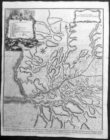
1745 Tindal Antique Map of Spanish & Austrian Armies in Catalonia Spain in 1711
- Title : Plan of the Incampment of the Allies at Prats Del Rey. under the command of Count Staremberg and of ye Enemy under the Duke of Vendsome: wher ye two Armies lay from ye 17th of September to ye 25th of December 1711 N.S. when ye Enemy decamped and ye Allies the 27th.
- Size: 19 1/2in x 15 1/2in (495mm x 395mm)
- Ref #: 15687
- Date : 1745
- Condition: (A+) Fine Condition
Description:
This original copper-plate engraved antique map, a battle plan of the encampments of the Spanish army under Louis-Joseph, duke de Vendome & the Austrian Army under Count Guido Starhemberg in Prado Del Rey in Catalonia, Spain - during the Spanish War of Succession (1701-13) - was engraved by John Basire and was published in the 1745 edition of Nicholas Tindals Continuation of Mr. Rapins History of England.
General Definitions:
Paper thickness and quality: - Heavy and stable
Paper color : - off white
Age of map color: -
Colors used: -
General color appearance: -
Paper size: - 19 1/2in x 15 1/2in (495mm x 395mm)
Plate size: - 19 1/2in x 15 1/2in (495mm x 395mm)
Margins: - Min 1/2in (12mm)
Imperfections:
Margins: - None
Plate area: - Folds as issued
Verso: - None
Background:
Duke Louis-Joseph de Vendome , 1654 — 1712 was one of King Louis XIV’s leading generals during the War of the Spanish Succession (1701–14).
Vendome was the son of Louis de Vendome, Duke de Mercoeur, by his marriage to Cardinal Jules Mazarin’s niece, Laure Mancini. Vendôme entered the French Army in 1672 and had risen to the rank of lieutenant general by the outbreak of the War of the Grand Alliance (1689–97) between France and the other major powers. He distinguished himself in the victory over the Allies at Steenkirke (1692) and was made commander in Catalonia in 1695; two years later he captured Barcelona.
The dispute over the succession to the Spanish throne brought France and Spain to war with the British, the Austrians, and the Dutch in 1701. Appointed to the command in northern Italy in 1702, Vendôme fought the Austrian commander, Prince Eugene of Savoy, in the bloody but indecisive Battle of Luzzara on August 15. He took Vercelli in 1704 and defeated Prince Eugene at Cassano in August 1705. In May 1706 Vendôme was transferred to the Flanders front, where the British commander John Churchill, 1st Duke of Marlborough, had just won an overwhelming victory at Ramillies. Vendôme made limited gains until he was severely defeated by Marlborough and Prince Eugene at Oudenaarde on July 11, 1708. Vendôme subsequently failed to relieve besieged Lille (in northern France), which fell to the Allies in October. Recalled by Louis XIV, he was temporarily disgraced.
Guido Wald Rüdiger, count of Starhemberg1657 – 1737 was an Austrian military officer.
He was a cousin of Ernst Rudiger von Starhemberg (1638-1701), the famous commander of Vienna during the Turkish siege of 1683, and acted as his aide-de-camp during that siege. Guido followed his cousin, and later Prince Eugene of Savoy, in battles against the Turks.
In the War of the Spanish Succession, Starhemberg fought in Italy and Spain. Between 1706 and 1708 he was the commander-in-chief of the imperial army in Hungary, leading military operations against the insurgents of Francis II Rákóczi. In 1708, he was appointed Supreme Commander of the Austrians in Spain.
Together with James Stanhope he succeeded in conquering Madrid in 1710, after previously gaining victories at Almenar and Saragossa. In December, however, he was forced to leave the city by the lack of support by its inhabitants for the Habsburg pretender. After the subsequent defeats at the Battle of Brihuega and the Battle of Villaviciosa (1710), he had to pull back to Catalonia, where he was made viceroy when Archduke Charles returned to Austria.
After the Peace of Utrecht (1713), archduke Charles, now Emperor Charles VI, ordered him to abandon Catalonia. He pulled back with his troops to Genoa on English ships.
When he died in 1737, he was Governor of Slavonia
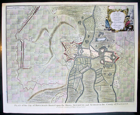
1745 Tindal Antique Map Battle Plan of Siege of Bouchain, Calais, France in 1711
- Title : Plan of the City of Bouchain Situated upon the Rivers Sensette and Scheld in the County of Hainault
- Size: 19 1/2in x 15 1/2in (495mm x 395mm)
- Ref #: 22198
- Date : 1745
- Condition: (A+) Fine Condition
Description:
This beautifully hand coloured original copper-plate engraved antique map, battle plan & birds eye view of the French city of Bouchain on the Schedlt River, in the Pas-de-Calais dept. in northern France - during the Spanish War of Succession (1701-13) - was engraved by John Basire and was published in the 1745 edition of Nicholas Tindals Continuation of Mr. Rapin\'s History of England.
General Definitions:
Paper thickness and quality: - Heavy and stable
Paper color : - off white
Age of map color: - Early
Colors used: - Pink, blue, green, yellow
General color appearance: - Authentic
Paper size: - 19 1/2in x 15 1/2in (495mm x 395mm)
Plate size: - 19 1/2in x 15 1/2in (495mm x 395mm)
Margins: - Min 1/2in (12mm)
Imperfections:
Margins: - None
Plate area: - Folds as issued
Verso: - None
Background:
The Siege of Bouchain (9 August – 12 September 1711), following the Passage of the Lines of Ne Plus Ultra (5 August 1711), was a siege of the War of the Spanish Succession, and the last major victory of John Churchill, 1st Duke of Marlborough. Marlborough broke through the French defensive lines and took Bouchain after a siege of 34 days. Its capture left Cambrai the only French-held fortress between the allied army and Paris.
Throughout the early summer of 1711 Marlborough\'s army, having taken the important fortress of Douai the previous year, manoeuvred indecisively in northern France, blocked by the French Lines of Ne Plus Ultra – a massive series of fieldworks stretching from the Channel coast to the Ardennes at Namur. The allied army had been weakened by the withdrawal of Prince Eugene\'s army to cover the upper Rhine, as the deposed Elector of Bavaria attempted to take advantage of the disruption caused by the death of the Emperor Joseph. On 6 July, Marlborough captured the small fortress of Arleux, just to the north of the Lines, west of Bouchain, both to deny its use to the French as a sally-port, and to secure the water supply to Douai, which could be cut off by damming the canal that supplied the town. The Duke was then wrong-footed by Villars as the French army crossed the Lines on 22/23 July and retook Arleux, with the allied army too far to the west to intervene in time, and the defences were levelled before the French retreated back across the Lines. Marlborough, initially furious, soon retook the initiative by marching his army as if to assault the Lines near Arras, and carrying out a detailed personal reconnaissance there on 4 August in full view of Villars\' covering army. That night the army struck camp, leaving their campfires burning to deceive the French, and marched eastwards to Arleux. At midnight a force from Douai under Cadogan crossed the unguarded French lines, and by 8 am the advance guard of the main army was also crossing over. Villars, arriving on the scene with a few hundred cavalry, realised he had been outmanoeuvred, and though he attempted to offer battle in front of Bourlon Wood, Marlborough declined to attack, the Marshal\'s position being even stronger than the one in which he had given Marlborough\'s army such a mauling two years earlier at Malplaquet. He thus drew off and attempted to hinder Marlborough\'s siege of Bouchain which followed.
To defend the town Bouchain\'s governor, de Ravignau, had some 5,000 men against Marlborough\'s besieging army of 30,000, and the advantage of one of the strongest fortresses left to France, surrounded by the marshy land of the confluence of the rivers Scheldt and Sensée. In addition, Villars\' strong army had taken up position to the west of the allied camp, and had managed to open a tenuous link to the besieged garrison. Marlborough responded by using earthwork gun batteries to counter Villars, used a crack assault force managed by 18 August to once more cut the Marshal\'s communication with Bouchain, and established a fieldwork-protected corridor from the siege camp to his main supply port at Marchiennes on the Scarpe. Frequent raids by Villars on both the supply convoys on the Scarpe, and towards Douai, failed to interrupt the siege, and the garrison marched out to become prisoners of war on 13 September 1711.
Bouchain was Marlborough\'s last campaign. On the last day of the year he was stripped of his position as Captain-General, and of all his other offices. Command of the army on the continent for the campaign of 1712 was given to the Duke of Ormonde, and strict limitations were placed on his freedom of movement. Particularly he was prohibited from engaging the French in battle, as Anglo-French peace talks were well advanced, and the opportunity of seizing Cambrai and marching on Paris, opened by Marlborough\'s gains the year before, was abandoned. Before the year was out, the British army would withdraw from the alliance, leaving the remaining allies, under Eugene of Savoy to be defeated at Denain.
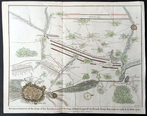
1745 N Tindal Original Antique Map Siege of Douai, Flanders, North France in 1710
- Title : Intrenchment of the Army of the Allies to cover the Siege of Douay against the French Army that came to raise it in June 1710.
- Size: 19 1/2in x 15 1/2in (495mm x 395mm)
- Ref #: 22212
- Date : 1745
- Condition: (A+) Fine Condition
Description:
This original copper-plate engraved antique map, plan of the Siege of Douai, Flanders in Northern France - during the Spanish War of Succession (1701-13) - was engraved by John Basire and was published in the 1745 edition of Nicholas Tindals Continuation of Mr. Rapin\'s History of England.
General Definitions:
Paper thickness and quality: - Heavy and stable
Paper color : - off white
Age of map color: - Early
Colors used: - Green, pink, blue
General color appearance: - Authentic
Paper size: - 19 1/2in x 15 1/2in (495mm x 395mm)
Plate size: - 19 1/2in x 15 1/2in (495mm x 395mm)
Margins: - Min 1/2in (12mm)
Imperfections:
Margins: - None
Plate area: - None
Verso: - None
Background:
A large battle plan showing both siege and works against a fortified Douai, Flanders and the detailed dispositions and battle lines of Lord Marlborough\'s army against the French, and thier attempt to lift the siege in June 1710.
Successive sieges from 1710 to 1712 during the Spanish War of Succession (1701-13), almost completely destroyed Douai by the British Army. By 1713, the town was fully integrated into France. Douai became the seat of the Parliament of Flanders.
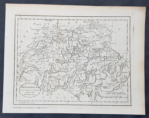
1770 John Cary Original Antique Map of Switzerland
- Title : Switzerland with its Subjects & Allies from the Best Authorities
- Size: 10 1/2in x 8 1/2in (265mm x 215mm)
- Ref #: 70188
- Date : 1770
- Condition: (A+) Fine Condition
Description:
This fine original copper-plate engraved antique map by Thomas Kitchen was published in the 1770 edition of the atlas for William Guthries Geographical Grammar
General Definitions:
Paper thickness and quality: - Heavy and stable
Paper color : - off white
Age of map color: -
Colors used: -
General color appearance: -
Paper size: - 10 1/2in x 8 1/2in (265mm x 215mm)
Plate size: - 10 1/2in x 8 1/2in (265mm x 215mm)
Margins: - Min 1/2in (12mm)
Imperfections:
Margins: - None
Plate area: - Folds as issued
Verso: - None
1740 Wolff & Corvinus Antique Arch Plan Officers Quarters, Royal Arsenal, Berlin
Antique Map
- Title : Das von dem Tit. H. Commendanten der Residentz Berlin, durch den Tit. H. Philipp Gerlach Senior Capitain und Ingenieur gebaute Commendaten Hauß mit der vorderen faciata und allen dreyen Grund-Rissen
- Ref #: 93449
- Size: 19 1/2in x 15in (495mm x 390mm)
- Date : 1740
- Condition: (A+) Fine Condition
Description:
This large rare, original copper-plate engraved antique architectural print, view & plan of officers quarters at the Royal Arsenal in Berlin - plate No.17 of 19 - by Johann August Corvinus 1683 - 1738, after Andreas Mayers 1716 - 1782, was published in Eigentliche Abbildung des Prächtigen Königl. Lust Schlosses Charlottenburg, eine Meile von Berlin, sambt dem darhinden im Walde gelegenen schönen Lust Garten
(Set of 16 numbered plates, the first with the title, with plans and views of the buildings and gardens at Charlottenburg, the palace of the King of Prussia on the outskirts of Berlin.) by Jeremias Wolff Erben in 1740.
General Definitions:
Paper thickness and quality: - Heavy and stable
Paper color : - off white
Age of map color: -
Colors used: -
General color appearance: -
Paper size: - 19in x 12 1/2in (490mm x 335mm)
Plate size: - 14 1/2in x 10 1/2in (370mm x 260mm)
Margins: - Min 1in (25mm)
Imperfections:
Margins: - None
Plate area: - None
Verso: - None
Background:
Berlin straddles the banks of the River Spree, which flows into the River Havel (a tributary of the River Elbe) in the western borough of Spandau. Among the citys main topographical features are the many lakes in the western and southeastern boroughs formed by the Spree, Havel, and Dahme rivers (the largest of which is Lake Müggelsee). Due to its location in the European Plain, Berlin is influenced by a temperate seasonal climate. About one-third of the citys area is composed of forests, parks, gardens, rivers, canals and lakes. The city lies in the Central German dialect area, the Berlin dialect being a variant of the Lusatian-New Marchian dialects.
First documented in the 13th century and situated at the crossing of two important historic trade routes, Berlin became the capital of the Margraviate of Brandenburg (1417–1701), the Kingdom of Prussia (1701–1918), the German Empire (1871–1918), the Weimar Republic (1919–1933), and the Third Reich (1933–1945). Berlin in the 1920s was the third-largest municipality in the world. After World War II and its subsequent occupation by the victorious countries, the city was divided; West Berlin became a de facto West German exclave, surrounded by the Berlin Wall (1961–1989) and East German territory. East Berlin was declared capital of East Germany, while Bonn became the West German capital. Following German reunification in 1990, Berlin once again became the capital of all of Germany.
The Thirty Years War between 1618 and 1648 devastated Berlin. One third of its houses were damaged or destroyed, and the city lost half of its population. Frederick William, known as the Great Elector, who had succeeded his father George William as ruler in 1640, initiated a policy of promoting immigration and religious tolerance. With the Edict of Potsdam in 1685, Frederick William offered asylum to the French Huguenots.
By 1700, approximately 30 percent of Berlins residents were French, because of the Huguenot immigration. Many other immigrants came from Bohemia, Poland, and Salzburg.
Since 1618, the Margraviate of Brandenburg had been in personal union with the Duchy of Prussia. In 1701, the dual state formed the Kingdom of Prussia, as Frederick III, Elector of Brandenburg, crowned himself as king Frederick I in Prussia. Berlin became the capital of the new Kingdom, replacing Königsberg. This was a successful attempt to centralise the capital in the very far-flung state, and it was the first time the city began to grow. In 1709, Berlin merged with the four cities of Cölln, Friedrichswerder, Friedrichstadt and Dorotheenstadt under the name Berlin, Haupt- und Residenzstadt Berlin.
In 1740, Frederick II, known as Frederick the Great (1740–1786), came to power. Under the rule of Frederick II, Berlin became a center of the Enlightenment, but also, was briefly occupied during the Seven Years War by the Russian army. Following Frances victory in the War of the Fourth Coalition, Napoleon Bonaparte marched into Berlin in 1806, but granted self-government to the city. In 1815, the city became part of the new Province of Brandenburg.
The Industrial Revolution transformed Berlin during the 19th century; the citys economy and population expanded dramatically, and it became the main railway hub and economic centre of Germany. Additional suburbs soon developed and increased the area and population of Berlin. In 1861, neighbouring suburbs including Wedding, Moabit and several others were incorporated into Berlin. In 1871, Berlin became capital of the newly founded German Empire. In 1881, it became a city district separate from Brandenburg.
Wolff, Jeremais 1663 - 1724
Wolff was an German engraver and publisher. Born in Augsburg, he originally trained as a clock and automat maker, later changing course and opening a small copperplate engraving shop. His success was impressive and became one of the largest European art, print & map publishers in the first half of the 18th century. Wolff employed some of the best engravers of the time and although not an engraver himself, only Wolffs name was recorded on the engravings. Many of his engravers went uncredited for their work. In 1710 Wolff was one of the founder member of the Empire State Academy of Arts in Augsburg.
After his death in 1724, Wolffs publishing business was inherited by his sons and son-in-law, Johann Balthasar Probst (1673–1750) a notable engraver at the time. The firm continued on in Augsburg under the name Jeremias Wolff Erben.
Together with the Nuremberg copperplate engraver Paul Decker , Wolff published a series of engravings showing the war successes of Prince Eugene of Savoy in Italy , southern Germany and the Spanish Netherlands, during the War of the Spanish Succession . The prints are exhibited in the Museum of Military History, in Vienna .
1740 Wolff & Corvinus Antique Arch Print of Charlottenburg Palace Stables Berlin
Antique Map
- Title : Ist ein von Hr. Andreas Schlütter Seel. inventirt und aufgebauer Schöner Marstall Datierung
- Ref #: 93447
- Size: 19in x 12 1/2in (490mm x 335mm)
- Date : 1740
- Condition: (A+) Fine Condition
Description:
This large rare, original copper-plate engraved antique architectural print, view of the facade of the Charlottenburg Palace stables in Berlin - plate No.15 of 16 - by Johann August Corvinus 1683 - 1738, after Andreas Mayers 1716 - 1782, was published in Eigentliche Abbildung des Prächtigen Königl. Lust Schlosses Charlottenburg, eine Meile von Berlin, sambt dem darhinden im Walde gelegenen schönen Lust Garten
(Set of 16 numbered plates, the first with the title, with plans and views of the buildings and gardens at Charlottenburg, the palace of the King of Prussia on the outskirts of Berlin.) by Jeremias Wolff Erben in 1740.
General Definitions:
Paper thickness and quality: - Heavy and stable
Paper color : - off white
Age of map color: -
Colors used: -
General color appearance: -
Paper size: - 19in x 12 1/2in (490mm x 335mm)
Plate size: - 14 1/2in x 10 1/2in (370mm x 260mm)
Margins: - Min 1in (25mm)
Imperfections:
Margins: - None
Plate area: - None
Verso: - None
Background:
Berlin straddles the banks of the River Spree, which flows into the River Havel (a tributary of the River Elbe) in the western borough of Spandau. Among the citys main topographical features are the many lakes in the western and southeastern boroughs formed by the Spree, Havel, and Dahme rivers (the largest of which is Lake Müggelsee). Due to its location in the European Plain, Berlin is influenced by a temperate seasonal climate. About one-third of the citys area is composed of forests, parks, gardens, rivers, canals and lakes. The city lies in the Central German dialect area, the Berlin dialect being a variant of the Lusatian-New Marchian dialects.
First documented in the 13th century and situated at the crossing of two important historic trade routes, Berlin became the capital of the Margraviate of Brandenburg (1417–1701), the Kingdom of Prussia (1701–1918), the German Empire (1871–1918), the Weimar Republic (1919–1933), and the Third Reich (1933–1945). Berlin in the 1920s was the third-largest municipality in the world. After World War II and its subsequent occupation by the victorious countries, the city was divided; West Berlin became a de facto West German exclave, surrounded by the Berlin Wall (1961–1989) and East German territory. East Berlin was declared capital of East Germany, while Bonn became the West German capital. Following German reunification in 1990, Berlin once again became the capital of all of Germany.
The Thirty Years War between 1618 and 1648 devastated Berlin. One third of its houses were damaged or destroyed, and the city lost half of its population. Frederick William, known as the Great Elector, who had succeeded his father George William as ruler in 1640, initiated a policy of promoting immigration and religious tolerance. With the Edict of Potsdam in 1685, Frederick William offered asylum to the French Huguenots.
By 1700, approximately 30 percent of Berlins residents were French, because of the Huguenot immigration. Many other immigrants came from Bohemia, Poland, and Salzburg.
Since 1618, the Margraviate of Brandenburg had been in personal union with the Duchy of Prussia. In 1701, the dual state formed the Kingdom of Prussia, as Frederick III, Elector of Brandenburg, crowned himself as king Frederick I in Prussia. Berlin became the capital of the new Kingdom, replacing Königsberg. This was a successful attempt to centralise the capital in the very far-flung state, and it was the first time the city began to grow. In 1709, Berlin merged with the four cities of Cölln, Friedrichswerder, Friedrichstadt and Dorotheenstadt under the name Berlin, Haupt- und Residenzstadt Berlin.
In 1740, Frederick II, known as Frederick the Great (1740–1786), came to power. Under the rule of Frederick II, Berlin became a center of the Enlightenment, but also, was briefly occupied during the Seven Years War by the Russian army. Following Frances victory in the War of the Fourth Coalition, Napoleon Bonaparte marched into Berlin in 1806, but granted self-government to the city. In 1815, the city became part of the new Province of Brandenburg.
The Industrial Revolution transformed Berlin during the 19th century; the citys economy and population expanded dramatically, and it became the main railway hub and economic centre of Germany. Additional suburbs soon developed and increased the area and population of Berlin. In 1861, neighbouring suburbs including Wedding, Moabit and several others were incorporated into Berlin. In 1871, Berlin became capital of the newly founded German Empire. In 1881, it became a city district separate from Brandenburg.
Wolff, Jeremais 1663 - 1724
Wolff was an German engraver and publisher. Born in Augsburg, he originally trained as a clock and automat maker, later changing course and opening a small copperplate engraving shop. His success was impressive and became one of the largest European art, print & map publishers in the first half of the 18th century. Wolff employed some of the best engravers of the time and although not an engraver himself, only Wolffs name was recorded on the engravings. Many of his engravers went uncredited for their work. In 1710 Wolff was one of the founder member of the Empire State Academy of Arts in Augsburg.
After his death in 1724, Wolffs publishing business was inherited by his sons and son-in-law, Johann Balthasar Probst (1673–1750) a notable engraver at the time. The firm continued on in Augsburg under the name Jeremias Wolff Erben.
Together with the Nuremberg copperplate engraver Paul Decker , Wolff published a series of engravings showing the war successes of Prince Eugene of Savoy in Italy , southern Germany and the Spanish Netherlands, during the War of the Spanish Succession . The prints are exhibited in the Museum of Military History, in Vienna .
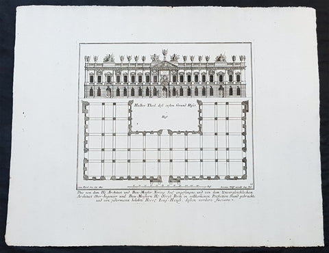
1740 Wolff & Corvinus Antique Arch Print of The Royal Arsenal in Berlin Germany
Antique Map
- Title : Das von dem H. Architect und Bau-Meister Nering Seel. angefangne, und von dem unvergleichlichen Architect Ober-Ingenier und Bau-Meistern H. Obrist Both in vollkommenen Perfection Stand gebrachte und von jedermann belobte Herr. Zeug-Haus, dessen vordere faciata
- Ref #: 93454
- Size: 19in x 12 1/2in (490mm x 335mm)
- Date : 1740
- Condition: (A+) Fine Condition
Description:
This large rare, original copper-plate engraved antique architectural print, view & plan of The Royal Arsenal in Berlin Houses - plate No.13 of 16 - by Johann August Corvinus 1683 - 1738, after Andreas Mayers 1716 - 1782, was published in Eigentliche Abbildung des Prächtigen Königl. Lust Schlosses Charlottenburg, eine Meile von Berlin, sambt dem darhinden im Walde gelegenen schönen Lust Garten
(Set of 16 numbered plates, the first with the title, with plans and views of the buildings and gardens at Charlottenburg, the palace of the King of Prussia on the outskirts of Berlin.) by Jeremias Wolff Erben in 1740.
General Definitions:
Paper thickness and quality: - Heavy and stable
Paper color : - off white
Age of map color: -
Colors used: -
General color appearance: -
Paper size: - 19in x 12 1/2in (490mm x 335mm)
Plate size: - 14 1/2in x 10 1/2in (370mm x 260mm)
Margins: - Min 1in (25mm)
Imperfections:
Margins: - None
Plate area: - None
Verso: - None
Background:
Berlin straddles the banks of the River Spree, which flows into the River Havel (a tributary of the River Elbe) in the western borough of Spandau. Among the citys main topographical features are the many lakes in the western and southeastern boroughs formed by the Spree, Havel, and Dahme rivers (the largest of which is Lake Müggelsee). Due to its location in the European Plain, Berlin is influenced by a temperate seasonal climate. About one-third of the citys area is composed of forests, parks, gardens, rivers, canals and lakes. The city lies in the Central German dialect area, the Berlin dialect being a variant of the Lusatian-New Marchian dialects.
First documented in the 13th century and situated at the crossing of two important historic trade routes, Berlin became the capital of the Margraviate of Brandenburg (1417–1701), the Kingdom of Prussia (1701–1918), the German Empire (1871–1918), the Weimar Republic (1919–1933), and the Third Reich (1933–1945). Berlin in the 1920s was the third-largest municipality in the world. After World War II and its subsequent occupation by the victorious countries, the city was divided; West Berlin became a de facto West German exclave, surrounded by the Berlin Wall (1961–1989) and East German territory. East Berlin was declared capital of East Germany, while Bonn became the West German capital. Following German reunification in 1990, Berlin once again became the capital of all of Germany.
The Thirty Years War between 1618 and 1648 devastated Berlin. One third of its houses were damaged or destroyed, and the city lost half of its population. Frederick William, known as the Great Elector, who had succeeded his father George William as ruler in 1640, initiated a policy of promoting immigration and religious tolerance. With the Edict of Potsdam in 1685, Frederick William offered asylum to the French Huguenots.
By 1700, approximately 30 percent of Berlins residents were French, because of the Huguenot immigration. Many other immigrants came from Bohemia, Poland, and Salzburg.
Since 1618, the Margraviate of Brandenburg had been in personal union with the Duchy of Prussia. In 1701, the dual state formed the Kingdom of Prussia, as Frederick III, Elector of Brandenburg, crowned himself as king Frederick I in Prussia. Berlin became the capital of the new Kingdom, replacing Königsberg. This was a successful attempt to centralise the capital in the very far-flung state, and it was the first time the city began to grow. In 1709, Berlin merged with the four cities of Cölln, Friedrichswerder, Friedrichstadt and Dorotheenstadt under the name Berlin, Haupt- und Residenzstadt Berlin.
In 1740, Frederick II, known as Frederick the Great (1740–1786), came to power. Under the rule of Frederick II, Berlin became a center of the Enlightenment, but also, was briefly occupied during the Seven Years War by the Russian army. Following Frances victory in the War of the Fourth Coalition, Napoleon Bonaparte marched into Berlin in 1806, but granted self-government to the city. In 1815, the city became part of the new Province of Brandenburg.
The Industrial Revolution transformed Berlin during the 19th century; the citys economy and population expanded dramatically, and it became the main railway hub and economic centre of Germany. Additional suburbs soon developed and increased the area and population of Berlin. In 1861, neighbouring suburbs including Wedding, Moabit and several others were incorporated into Berlin. In 1871, Berlin became capital of the newly founded German Empire. In 1881, it became a city district separate from Brandenburg.
Wolff, Jeremais 1663 - 1724
Wolff was an German engraver and publisher. Born in Augsburg, he originally trained as a clock and automat maker, later changing course and opening a small copperplate engraving shop. His success was impressive and became one of the largest European art, print & map publishers in the first half of the 18th century. Wolff employed some of the best engravers of the time and although not an engraver himself, only Wolffs name was recorded on the engravings. Many of his engravers went uncredited for their work. In 1710 Wolff was one of the founder member of the Empire State Academy of Arts in Augsburg.
After his death in 1724, Wolffs publishing business was inherited by his sons and son-in-law, Johann Balthasar Probst (1673–1750) a notable engraver at the time. The firm continued on in Augsburg under the name Jeremias Wolff Erben.
Together with the Nuremberg copperplate engraver Paul Decker , Wolff published a series of engravings showing the war successes of Prince Eugene of Savoy in Italy , southern Germany and the Spanish Netherlands, during the War of the Spanish Succession . The prints are exhibited in the Museum of Military History, in Vienna .
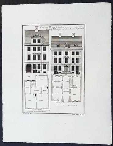
1740 Wolff & Corvinus Antique Arch Print Plans of Residential Houses in Berlin
Antique Map
- Title : Zwey von Hr. von Grünenberg inventirte und gebaute Burgerl. Wohnhäusser mit ihren Faciaten u. Grundrissen
- Ref #: 93450
- Size: 19in x 12 1/2in (490mm x 335mm)
- Date : 1740
- Condition: (A+) Fine Condition
Description:
This large rare, original copper-plate engraved antique architectural print plans of Berlin Houses - plate No. 12 of 16 - by Johann August Corvinus 1683 - 1738, after Andreas Mayers 1716 - 1782, was published in Eigentliche Abbildung des Prächtigen Königl. Lust Schlosses Charlottenburg, eine Meile von Berlin, sambt dem darhinden im Walde gelegenen schönen Lust Garten
(Set of 16 numbered plates, the first with the title, with plans and views of the buildings and gardens at Charlottenburg, the palace of the King of Prussia on the outskirts of Berlin.) by Jeremias Wolff Erben in 1740.
General Definitions:
Paper thickness and quality: - Heavy and stable
Paper color : - off white
Age of map color: -
Colors used: -
General color appearance: -
Paper size: - 19in x 12 1/2in (490mm x 335mm)
Plate size: - 14 1/2in x 10 1/2in (370mm x 260mm)
Margins: - Min 1in (25mm)
Imperfections:
Margins: - None
Plate area: - None
Verso: - None
Background:
Berlin straddles the banks of the River Spree, which flows into the River Havel (a tributary of the River Elbe) in the western borough of Spandau. Among the citys main topographical features are the many lakes in the western and southeastern boroughs formed by the Spree, Havel, and Dahme rivers (the largest of which is Lake Müggelsee). Due to its location in the European Plain, Berlin is influenced by a temperate seasonal climate. About one-third of the citys area is composed of forests, parks, gardens, rivers, canals and lakes. The city lies in the Central German dialect area, the Berlin dialect being a variant of the Lusatian-New Marchian dialects.
First documented in the 13th century and situated at the crossing of two important historic trade routes, Berlin became the capital of the Margraviate of Brandenburg (1417–1701), the Kingdom of Prussia (1701–1918), the German Empire (1871–1918), the Weimar Republic (1919–1933), and the Third Reich (1933–1945). Berlin in the 1920s was the third-largest municipality in the world. After World War II and its subsequent occupation by the victorious countries, the city was divided; West Berlin became a de facto West German exclave, surrounded by the Berlin Wall (1961–1989) and East German territory. East Berlin was declared capital of East Germany, while Bonn became the West German capital. Following German reunification in 1990, Berlin once again became the capital of all of Germany.
The Thirty Years War between 1618 and 1648 devastated Berlin. One third of its houses were damaged or destroyed, and the city lost half of its population. Frederick William, known as the Great Elector, who had succeeded his father George William as ruler in 1640, initiated a policy of promoting immigration and religious tolerance. With the Edict of Potsdam in 1685, Frederick William offered asylum to the French Huguenots.
By 1700, approximately 30 percent of Berlins residents were French, because of the Huguenot immigration. Many other immigrants came from Bohemia, Poland, and Salzburg.
Since 1618, the Margraviate of Brandenburg had been in personal union with the Duchy of Prussia. In 1701, the dual state formed the Kingdom of Prussia, as Frederick III, Elector of Brandenburg, crowned himself as king Frederick I in Prussia. Berlin became the capital of the new Kingdom, replacing Königsberg. This was a successful attempt to centralise the capital in the very far-flung state, and it was the first time the city began to grow. In 1709, Berlin merged with the four cities of Cölln, Friedrichswerder, Friedrichstadt and Dorotheenstadt under the name Berlin, Haupt- und Residenzstadt Berlin.
In 1740, Frederick II, known as Frederick the Great (1740–1786), came to power. Under the rule of Frederick II, Berlin became a center of the Enlightenment, but also, was briefly occupied during the Seven Years War by the Russian army. Following Frances victory in the War of the Fourth Coalition, Napoleon Bonaparte marched into Berlin in 1806, but granted self-government to the city. In 1815, the city became part of the new Province of Brandenburg.
The Industrial Revolution transformed Berlin during the 19th century; the citys economy and population expanded dramatically, and it became the main railway hub and economic centre of Germany. Additional suburbs soon developed and increased the area and population of Berlin. In 1861, neighbouring suburbs including Wedding, Moabit and several others were incorporated into Berlin. In 1871, Berlin became capital of the newly founded German Empire. In 1881, it became a city district separate from Brandenburg.
Wolff, Jeremais 1663 - 1724
Wolff was an German engraver and publisher. Born in Augsburg, he originally trained as a clock and automat maker, later changing course and opening a small copperplate engraving shop. His success was impressive and became one of the largest European art, print & map publishers in the first half of the 18th century. Wolff employed some of the best engravers of the time and although not an engraver himself, only Wolffs name was recorded on the engravings. Many of his engravers went uncredited for their work. In 1710 Wolff was one of the founder member of the Empire State Academy of Arts in Augsburg.
After his death in 1724, Wolffs publishing business was inherited by his sons and son-in-law, Johann Balthasar Probst (1673–1750) a notable engraver at the time. The firm continued on in Augsburg under the name Jeremias Wolff Erben.
Together with the Nuremberg copperplate engraver Paul Decker , Wolff published a series of engravings showing the war successes of Prince Eugene of Savoy in Italy , southern Germany and the Spanish Netherlands, during the War of the Spanish Succession . The prints are exhibited in the Museum of Military History, in Vienna .
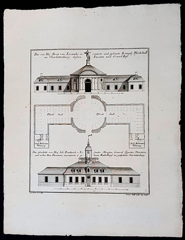
1740 Wolff & Corvinus Antique Arch Print of Charlottenburg Palace Stables Berlin
Antique Map
- Title : Der von Hr. Obrist von Eosander inventirte und gebaute Königl. Pferdt Stall zu Charlottenburg, dessen Faciata und Grund Riss. - Das gleichfals von Hr. Joh. Friederich v. Eosander Obristen General Quartier Meistern, und ersten Bau Directorn inventierte und gebaute Rath Hauss zu gedachten Charlottenburg
- Ref #: 93453
- Size: 19in x 12 1/2in (490mm x 335mm)
- Date : 1740
- Condition: (A+) Fine Condition
Description:
This large rare, original copper-plate engraved antique architectural print of the Royal Horse Stables at Charlottenburg Palace, Berlin - plate No. 11 of 16 - by Johann August Corvinus 1683 - 1738, after Andreas Mayers 1716 - 1782, was published in Eigentliche Abbildung des Prächtigen Königl. Lust Schlosses Charlottenburg, eine Meile von Berlin, sambt dem darhinden im Walde gelegenen schönen Lust Garten
(Set of 16 numbered plates, the first with the title, with plans and views of the buildings and gardens at Charlottenburg, the palace of the King of Prussia on the outskirts of Berlin.) by Jeremias Wolff Erben in 1740.
General Definitions:
Paper thickness and quality: - Heavy and stable
Paper color : - off white
Age of map color: -
Colors used: -
General color appearance: -
Paper size: - 19in x 12 1/2in (490mm x 335mm)
Plate size: - 14 1/2in x 10 1/2in (370mm x 260mm)
Margins: - Min 1in (25mm)
Imperfections:
Margins: - None
Plate area: - None
Verso: - None
Background:
Berlin straddles the banks of the River Spree, which flows into the River Havel (a tributary of the River Elbe) in the western borough of Spandau. Among the citys main topographical features are the many lakes in the western and southeastern boroughs formed by the Spree, Havel, and Dahme rivers (the largest of which is Lake Müggelsee). Due to its location in the European Plain, Berlin is influenced by a temperate seasonal climate. About one-third of the citys area is composed of forests, parks, gardens, rivers, canals and lakes. The city lies in the Central German dialect area, the Berlin dialect being a variant of the Lusatian-New Marchian dialects.
First documented in the 13th century and situated at the crossing of two important historic trade routes, Berlin became the capital of the Margraviate of Brandenburg (1417–1701), the Kingdom of Prussia (1701–1918), the German Empire (1871–1918), the Weimar Republic (1919–1933), and the Third Reich (1933–1945). Berlin in the 1920s was the third-largest municipality in the world. After World War II and its subsequent occupation by the victorious countries, the city was divided; West Berlin became a de facto West German exclave, surrounded by the Berlin Wall (1961–1989) and East German territory. East Berlin was declared capital of East Germany, while Bonn became the West German capital. Following German reunification in 1990, Berlin once again became the capital of all of Germany.
The Thirty Years War between 1618 and 1648 devastated Berlin. One third of its houses were damaged or destroyed, and the city lost half of its population. Frederick William, known as the Great Elector, who had succeeded his father George William as ruler in 1640, initiated a policy of promoting immigration and religious tolerance. With the Edict of Potsdam in 1685, Frederick William offered asylum to the French Huguenots.
By 1700, approximately 30 percent of Berlins residents were French, because of the Huguenot immigration. Many other immigrants came from Bohemia, Poland, and Salzburg.
Since 1618, the Margraviate of Brandenburg had been in personal union with the Duchy of Prussia. In 1701, the dual state formed the Kingdom of Prussia, as Frederick III, Elector of Brandenburg, crowned himself as king Frederick I in Prussia. Berlin became the capital of the new Kingdom, replacing Königsberg. This was a successful attempt to centralise the capital in the very far-flung state, and it was the first time the city began to grow. In 1709, Berlin merged with the four cities of Cölln, Friedrichswerder, Friedrichstadt and Dorotheenstadt under the name Berlin, Haupt- und Residenzstadt Berlin.
In 1740, Frederick II, known as Frederick the Great (1740–1786), came to power. Under the rule of Frederick II, Berlin became a center of the Enlightenment, but also, was briefly occupied during the Seven Years War by the Russian army. Following Frances victory in the War of the Fourth Coalition, Napoleon Bonaparte marched into Berlin in 1806, but granted self-government to the city. In 1815, the city became part of the new Province of Brandenburg.
The Industrial Revolution transformed Berlin during the 19th century; the citys economy and population expanded dramatically, and it became the main railway hub and economic centre of Germany. Additional suburbs soon developed and increased the area and population of Berlin. In 1861, neighbouring suburbs including Wedding, Moabit and several others were incorporated into Berlin. In 1871, Berlin became capital of the newly founded German Empire. In 1881, it became a city district separate from Brandenburg.
Wolff, Jeremais 1663 - 1724
Wolff was an German engraver and publisher. Born in Augsburg, he originally trained as a clock and automat maker, later changing course and opening a small copperplate engraving shop. His success was impressive and became one of the largest European art, print & map publishers in the first half of the 18th century. Wolff employed some of the best engravers of the time and although not an engraver himself, only Wolffs name was recorded on the engravings. Many of his engravers went uncredited for their work. In 1710 Wolff was one of the founder member of the Empire State Academy of Arts in Augsburg.
After his death in 1724, Wolffs publishing business was inherited by his sons and son-in-law, Johann Balthasar Probst (1673–1750) a notable engraver at the time. The firm continued on in Augsburg under the name Jeremias Wolff Erben.
Together with the Nuremberg copperplate engraver Paul Decker , Wolff published a series of engravings showing the war successes of Prince Eugene of Savoy in Italy , southern Germany and the Spanish Netherlands, during the War of the Spanish Succession . The prints are exhibited in the Museum of Military History, in Vienna .
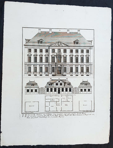
1740 Wolff & Corvinus Antique Arch Print of Berlin Mansions by A. von Schlütter
Antique Map
- Title : A. Ist ein von H. Andreas von Schlütter Seel. inventirt- und auff gebautes Landt-Hauss. B. Ist ein von dem renomirten Bau-Werck- und Raths Zimmer-Meister Joh. Mich. Kemmeter, in Riegel oder Holtz auff gebautes Land-Hauß oder so genandte Meyerey
- Ref #: 93445
- Size: 19in x 12 1/2in (490mm x 335mm)
- Date : 1740
- Condition: (A+) Fine Condition
Description:
This large rare, original copper-plate engraved antique architectural print of 18th century Mansions in Berlin designed by Andreas von Schlütter - plate No. 9 of 16 - by Johann August Corvinus 1683 - 1738, after Andreas Mayers 1716 - 1782, was published in Eigentliche Abbildung des Prächtigen Königl. Lust Schlosses Charlottenburg, eine Meile von Berlin, sambt dem darhinden im Walde gelegenen schönen Lust Garten
(Set of 16 numbered plates, the first with the title, with plans and views of the buildings and gardens at Charlottenburg, the palace of the King of Prussia on the outskirts of Berlin.) by Jeremias Wolff Erben in 1740.
General Definitions:
Paper thickness and quality: - Heavy and stable
Paper color : - off white
Age of map color: -
Colors used: -
General color appearance: -
Paper size: - 19in x 12 1/2in (490mm x 335mm)
Plate size: - 14 1/2in x 10 1/2in (370mm x 260mm)
Margins: - Min 1in (25mm)
Imperfections:
Margins: - None
Plate area: - None
Verso: - None
Background:
Berlin straddles the banks of the River Spree, which flows into the River Havel (a tributary of the River Elbe) in the western borough of Spandau. Among the citys main topographical features are the many lakes in the western and southeastern boroughs formed by the Spree, Havel, and Dahme rivers (the largest of which is Lake Müggelsee). Due to its location in the European Plain, Berlin is influenced by a temperate seasonal climate. About one-third of the citys area is composed of forests, parks, gardens, rivers, canals and lakes. The city lies in the Central German dialect area, the Berlin dialect being a variant of the Lusatian-New Marchian dialects.
First documented in the 13th century and situated at the crossing of two important historic trade routes, Berlin became the capital of the Margraviate of Brandenburg (1417–1701), the Kingdom of Prussia (1701–1918), the German Empire (1871–1918), the Weimar Republic (1919–1933), and the Third Reich (1933–1945). Berlin in the 1920s was the third-largest municipality in the world. After World War II and its subsequent occupation by the victorious countries, the city was divided; West Berlin became a de facto West German exclave, surrounded by the Berlin Wall (1961–1989) and East German territory. East Berlin was declared capital of East Germany, while Bonn became the West German capital. Following German reunification in 1990, Berlin once again became the capital of all of Germany.
The Thirty Years War between 1618 and 1648 devastated Berlin. One third of its houses were damaged or destroyed, and the city lost half of its population. Frederick William, known as the Great Elector, who had succeeded his father George William as ruler in 1640, initiated a policy of promoting immigration and religious tolerance. With the Edict of Potsdam in 1685, Frederick William offered asylum to the French Huguenots.
By 1700, approximately 30 percent of Berlins residents were French, because of the Huguenot immigration. Many other immigrants came from Bohemia, Poland, and Salzburg.
Since 1618, the Margraviate of Brandenburg had been in personal union with the Duchy of Prussia. In 1701, the dual state formed the Kingdom of Prussia, as Frederick III, Elector of Brandenburg, crowned himself as king Frederick I in Prussia. Berlin became the capital of the new Kingdom, replacing Königsberg. This was a successful attempt to centralise the capital in the very far-flung state, and it was the first time the city began to grow. In 1709, Berlin merged with the four cities of Cölln, Friedrichswerder, Friedrichstadt and Dorotheenstadt under the name Berlin, Haupt- und Residenzstadt Berlin.
In 1740, Frederick II, known as Frederick the Great (1740–1786), came to power. Under the rule of Frederick II, Berlin became a center of the Enlightenment, but also, was briefly occupied during the Seven Years War by the Russian army. Following Frances victory in the War of the Fourth Coalition, Napoleon Bonaparte marched into Berlin in 1806, but granted self-government to the city. In 1815, the city became part of the new Province of Brandenburg.
The Industrial Revolution transformed Berlin during the 19th century; the citys economy and population expanded dramatically, and it became the main railway hub and economic centre of Germany. Additional suburbs soon developed and increased the area and population of Berlin. In 1861, neighbouring suburbs including Wedding, Moabit and several others were incorporated into Berlin. In 1871, Berlin became capital of the newly founded German Empire. In 1881, it became a city district separate from Brandenburg.
Wolff, Jeremais 1663 - 1724
Wolff was an German engraver and publisher. Born in Augsburg, he originally trained as a clock and automat maker, later changing course and opening a small copperplate engraving shop. His success was impressive and became one of the largest European art, print & map publishers in the first half of the 18th century. Wolff employed some of the best engravers of the time and although not an engraver himself, only Wolffs name was recorded on the engravings. Many of his engravers went uncredited for their work. In 1710 Wolff was one of the founder member of the Empire State Academy of Arts in Augsburg.
After his death in 1724, Wolffs publishing business was inherited by his sons and son-in-law, Johann Balthasar Probst (1673–1750) a notable engraver at the time. The firm continued on in Augsburg under the name Jeremias Wolff Erben.
Together with the Nuremberg copperplate engraver Paul Decker , Wolff published a series of engravings showing the war successes of Prince Eugene of Savoy in Italy , southern Germany and the Spanish Netherlands, during the War of the Spanish Succession . The prints are exhibited in the Museum of Military History, in Vienna .
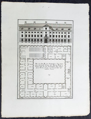
1740 Wolff & Corvinus Antique Arch Print of a Poorhouse near Stralau Gate Berlin
Antique Map
- Title : Das von dem H. von Grünenberg Seel. inventirte sogenandte Armen- oder Waysen-Hauss zu Berlin, nache bey dem Stralauischen Thor gelegen, ....
- Ref #: 93455
- Size: 19in x 12 1/2in (490mm x 335mm)
- Date : 1740
- Condition: (A+) Fine Condition
Description:
This large rare, original copper-plate engraved antique architectural print of the Poorhouse near the old Stralau Gate (Stralauer Tor) in Berlin - plate No. 8 of 16 - by Johann August Corvinus 1683 - 1738, after Andreas Mayers 1716 - 1782, was published in Eigentliche Abbildung des Prächtigen Königl. Lust Schlosses Charlottenburg, eine Meile von Berlin, sambt dem darhinden im Walde gelegenen schönen Lust Garten
(Set of 16 numbered plates, the first with the title, with plans and views of the buildings and gardens at Charlottenburg, the palace of the King of Prussia on the outskirts of Berlin.) by Jeremias Wolff Erben in 1740.
General Definitions:
Paper thickness and quality: - Heavy and stable
Paper color : - off white
Age of map color: -
Colors used: -
General color appearance: -
Paper size: - 19in x 12 1/2in (490mm x 335mm)
Plate size: - 14 1/2in x 10 1/2in (370mm x 260mm)
Margins: - Min 1in (25mm)
Imperfections:
Margins: - None
Plate area: - None
Verso: - None
Background:
Berlin straddles the banks of the River Spree, which flows into the River Havel (a tributary of the River Elbe) in the western borough of Spandau. Among the citys main topographical features are the many lakes in the western and southeastern boroughs formed by the Spree, Havel, and Dahme rivers (the largest of which is Lake Müggelsee). Due to its location in the European Plain, Berlin is influenced by a temperate seasonal climate. About one-third of the citys area is composed of forests, parks, gardens, rivers, canals and lakes. The city lies in the Central German dialect area, the Berlin dialect being a variant of the Lusatian-New Marchian dialects.
First documented in the 13th century and situated at the crossing of two important historic trade routes, Berlin became the capital of the Margraviate of Brandenburg (1417–1701), the Kingdom of Prussia (1701–1918), the German Empire (1871–1918), the Weimar Republic (1919–1933), and the Third Reich (1933–1945). Berlin in the 1920s was the third-largest municipality in the world. After World War II and its subsequent occupation by the victorious countries, the city was divided; West Berlin became a de facto West German exclave, surrounded by the Berlin Wall (1961–1989) and East German territory. East Berlin was declared capital of East Germany, while Bonn became the West German capital. Following German reunification in 1990, Berlin once again became the capital of all of Germany.
The Thirty Years War between 1618 and 1648 devastated Berlin. One third of its houses were damaged or destroyed, and the city lost half of its population. Frederick William, known as the Great Elector, who had succeeded his father George William as ruler in 1640, initiated a policy of promoting immigration and religious tolerance. With the Edict of Potsdam in 1685, Frederick William offered asylum to the French Huguenots.
By 1700, approximately 30 percent of Berlins residents were French, because of the Huguenot immigration. Many other immigrants came from Bohemia, Poland, and Salzburg.
Since 1618, the Margraviate of Brandenburg had been in personal union with the Duchy of Prussia. In 1701, the dual state formed the Kingdom of Prussia, as Frederick III, Elector of Brandenburg, crowned himself as king Frederick I in Prussia. Berlin became the capital of the new Kingdom, replacing Königsberg. This was a successful attempt to centralise the capital in the very far-flung state, and it was the first time the city began to grow. In 1709, Berlin merged with the four cities of Cölln, Friedrichswerder, Friedrichstadt and Dorotheenstadt under the name Berlin, Haupt- und Residenzstadt Berlin.
In 1740, Frederick II, known as Frederick the Great (1740–1786), came to power. Under the rule of Frederick II, Berlin became a center of the Enlightenment, but also, was briefly occupied during the Seven Years War by the Russian army. Following Frances victory in the War of the Fourth Coalition, Napoleon Bonaparte marched into Berlin in 1806, but granted self-government to the city. In 1815, the city became part of the new Province of Brandenburg.
The Industrial Revolution transformed Berlin during the 19th century; the citys economy and population expanded dramatically, and it became the main railway hub and economic centre of Germany. Additional suburbs soon developed and increased the area and population of Berlin. In 1861, neighbouring suburbs including Wedding, Moabit and several others were incorporated into Berlin. In 1871, Berlin became capital of the newly founded German Empire. In 1881, it became a city district separate from Brandenburg.
Wolff, Jeremais 1663 - 1724
Wolff was an German engraver and publisher. Born in Augsburg, he originally trained as a clock and automat maker, later changing course and opening a small copperplate engraving shop. His success was impressive and became one of the largest European art, print & map publishers in the first half of the 18th century. Wolff employed some of the best engravers of the time and although not an engraver himself, only Wolffs name was recorded on the engravings. Many of his engravers went uncredited for their work. In 1710 Wolff was one of the founder member of the Empire State Academy of Arts in Augsburg.
After his death in 1724, Wolffs publishing business was inherited by his sons and son-in-law, Johann Balthasar Probst (1673–1750) a notable engraver at the time. The firm continued on in Augsburg under the name Jeremias Wolff Erben.
Together with the Nuremberg copperplate engraver Paul Decker , Wolff published a series of engravings showing the war successes of Prince Eugene of Savoy in Italy , southern Germany and the Spanish Netherlands, during the War of the Spanish Succession . The prints are exhibited in the Museum of Military History, in Vienna .
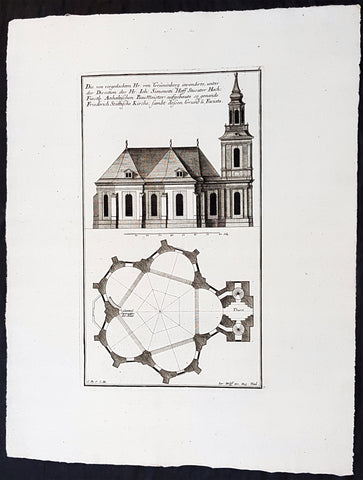
1740 Wolff & Corvinus Antique Arch. Print Jerusalem Church Friedrichstadt.Berlin
Antique Map
- Title : Die von vorgedachten Hr. von Grünenberg invendierte, unter der Direction des Hr. Ioh. Simonetti Hoff Stucator Hoch-Fürstl. Anhaltischen BauMeister aufgebaute so genande Friderich Stättische Kirche sampt dessen Grund u. Faciata.
- Ref #: 93458
- Size: 19in x 12 1/2in (490mm x 335mm)
- Date : 1740
- Condition: (A+) Fine Condition
Description:
This large rare, original copper-plate engraved antique architectural print of the Parochialkirche (literally the Reformed parochial church) in the Mitte suburb of Berlin - plate No. 7 of 16 - by Johann August Corvinus 1683 - 1738, after Andreas Mayers 1716 - 1782, was published in Eigentliche Abbildung des Prächtigen Königl. Lust Schlosses Charlottenburg, eine Meile von Berlin, sambt dem darhinden im Walde gelegenen schönen Lust Garten
(Set of 16 numbered plates, the first with the title, with plans and views of the buildings and gardens at Charlottenburg, the palace of the King of Prussia on the outskirts of Berlin.) by Jeremias Wolff Erben in 1740.
General Definitions:
Paper thickness and quality: - Heavy and stable
Paper color : - off white
Age of map color: -
Colors used: -
General color appearance: -
Paper size: - 19in x 12 1/2in (490mm x 335mm)
Plate size: - 14 1/2in x 10 1/2in (370mm x 260mm)
Margins: - Min 1in (25mm)
Imperfections:
Margins: - None
Plate area: - None
Verso: - None
Background:
Berlin straddles the banks of the River Spree, which flows into the River Havel (a tributary of the River Elbe) in the western borough of Spandau. Among the citys main topographical features are the many lakes in the western and southeastern boroughs formed by the Spree, Havel, and Dahme rivers (the largest of which is Lake Müggelsee). Due to its location in the European Plain, Berlin is influenced by a temperate seasonal climate. About one-third of the citys area is composed of forests, parks, gardens, rivers, canals and lakes. The city lies in the Central German dialect area, the Berlin dialect being a variant of the Lusatian-New Marchian dialects.
First documented in the 13th century and situated at the crossing of two important historic trade routes, Berlin became the capital of the Margraviate of Brandenburg (1417–1701), the Kingdom of Prussia (1701–1918), the German Empire (1871–1918), the Weimar Republic (1919–1933), and the Third Reich (1933–1945). Berlin in the 1920s was the third-largest municipality in the world. After World War II and its subsequent occupation by the victorious countries, the city was divided; West Berlin became a de facto West German exclave, surrounded by the Berlin Wall (1961–1989) and East German territory. East Berlin was declared capital of East Germany, while Bonn became the West German capital. Following German reunification in 1990, Berlin once again became the capital of all of Germany.
The Thirty Years War between 1618 and 1648 devastated Berlin. One third of its houses were damaged or destroyed, and the city lost half of its population. Frederick William, known as the Great Elector, who had succeeded his father George William as ruler in 1640, initiated a policy of promoting immigration and religious tolerance. With the Edict of Potsdam in 1685, Frederick William offered asylum to the French Huguenots.
By 1700, approximately 30 percent of Berlins residents were French, because of the Huguenot immigration. Many other immigrants came from Bohemia, Poland, and Salzburg.
Since 1618, the Margraviate of Brandenburg had been in personal union with the Duchy of Prussia. In 1701, the dual state formed the Kingdom of Prussia, as Frederick III, Elector of Brandenburg, crowned himself as king Frederick I in Prussia. Berlin became the capital of the new Kingdom, replacing Königsberg. This was a successful attempt to centralise the capital in the very far-flung state, and it was the first time the city began to grow. In 1709, Berlin merged with the four cities of Cölln, Friedrichswerder, Friedrichstadt and Dorotheenstadt under the name Berlin, Haupt- und Residenzstadt Berlin.
In 1740, Frederick II, known as Frederick the Great (1740–1786), came to power. Under the rule of Frederick II, Berlin became a center of the Enlightenment, but also, was briefly occupied during the Seven Years War by the Russian army. Following Frances victory in the War of the Fourth Coalition, Napoleon Bonaparte marched into Berlin in 1806, but granted self-government to the city. In 1815, the city became part of the new Province of Brandenburg.
The Industrial Revolution transformed Berlin during the 19th century; the citys economy and population expanded dramatically, and it became the main railway hub and economic centre of Germany. Additional suburbs soon developed and increased the area and population of Berlin. In 1861, neighbouring suburbs including Wedding, Moabit and several others were incorporated into Berlin. In 1871, Berlin became capital of the newly founded German Empire. In 1881, it became a city district separate from Brandenburg.
Wolff, Jeremais 1663 - 1724
Wolff was an German engraver and publisher. Born in Augsburg, he originally trained as a clock and automat maker, later changing course and opening a small copperplate engraving shop. His success was impressive and became one of the largest European art, print & map publishers in the first half of the 18th century. Wolff employed some of the best engravers of the time and although not an engraver himself, only Wolffs name was recorded on the engravings. Many of his engravers went uncredited for their work. In 1710 Wolff was one of the founder member of the Empire State Academy of Arts in Augsburg.
After his death in 1724, Wolffs publishing business was inherited by his sons and son-in-law, Johann Balthasar Probst (1673–1750) a notable engraver at the time. The firm continued on in Augsburg under the name Jeremias Wolff Erben.
Together with the Nuremberg copperplate engraver Paul Decker , Wolff published a series of engravings showing the war successes of Prince Eugene of Savoy in Italy , southern Germany and the Spanish Netherlands, during the War of the Spanish Succession . The prints are exhibited in the Museum of Military History, in Vienna .
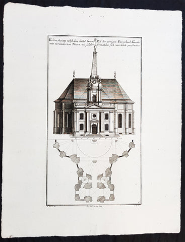
1740 Wolff & Corvinus Antique Arch. Print of the Parochialkirche in Mitte Berlin
Antique Map
- Title : Vordere faciata nebst dem halben Grund Riß der vorigen Parochial-Kirche mit verändertem Thurn wie solcher dermahlen sich würklich presentiert. Frontriß, darunter der halbe Grundriß.
- Ref #: 93459
- Size: 19in x 12 1/2in (490mm x 335mm)
- Date : 1740
- Condition: (A+) Fine Condition
Description:
This large rare, original copper-plate engraved antique architectural print of the Parochialkirche (literally the Reformed parochial church) in the Mitte suburb of Berlin - plate No. 6 of 16 - by Johann August Corvinus 1683 - 1738, after Andreas Mayers 1716 - 1782, was published in Eigentliche Abbildung des Prächtigen Königl. Lust Schlosses Charlottenburg, eine Meile von Berlin, sambt dem darhinden im Walde gelegenen schönen Lust Garten.
(Set of 16 numbered plates, the first with the title, with plans and views of the buildings and gardens at Charlottenburg, the palace of the King of Prussia on the outskirts of Berlin.) by Jeremias Wolff Erben in 1740.
General Definitions:
Paper thickness and quality: - Heavy and stable
Paper color : - off white
Age of map color: -
Colors used: -
General color appearance: -
Paper size: - 19in x 12 1/2in (490mm x 335mm)
Plate size: - 14 1/2in x 10 1/2in (370mm x 260mm)
Margins: - Min 1in (25mm)
Imperfections:
Margins: - None
Plate area: - None
Verso: - None
Background:
Berlin straddles the banks of the River Spree, which flows into the River Havel (a tributary of the River Elbe) in the western borough of Spandau. Among the citys main topographical features are the many lakes in the western and southeastern boroughs formed by the Spree, Havel, and Dahme rivers (the largest of which is Lake Müggelsee). Due to its location in the European Plain, Berlin is influenced by a temperate seasonal climate. About one-third of the citys area is composed of forests, parks, gardens, rivers, canals and lakes. The city lies in the Central German dialect area, the Berlin dialect being a variant of the Lusatian-New Marchian dialects.
First documented in the 13th century and situated at the crossing of two important historic trade routes, Berlin became the capital of the Margraviate of Brandenburg (1417–1701), the Kingdom of Prussia (1701–1918), the German Empire (1871–1918), the Weimar Republic (1919–1933), and the Third Reich (1933–1945). Berlin in the 1920s was the third-largest municipality in the world. After World War II and its subsequent occupation by the victorious countries, the city was divided; West Berlin became a de facto West German exclave, surrounded by the Berlin Wall (1961–1989) and East German territory. East Berlin was declared capital of East Germany, while Bonn became the West German capital. Following German reunification in 1990, Berlin once again became the capital of all of Germany.
The Thirty Years War between 1618 and 1648 devastated Berlin. One third of its houses were damaged or destroyed, and the city lost half of its population. Frederick William, known as the Great Elector, who had succeeded his father George William as ruler in 1640, initiated a policy of promoting immigration and religious tolerance. With the Edict of Potsdam in 1685, Frederick William offered asylum to the French Huguenots.
By 1700, approximately 30 percent of Berlins residents were French, because of the Huguenot immigration. Many other immigrants came from Bohemia, Poland, and Salzburg.
Since 1618, the Margraviate of Brandenburg had been in personal union with the Duchy of Prussia. In 1701, the dual state formed the Kingdom of Prussia, as Frederick III, Elector of Brandenburg, crowned himself as king Frederick I in Prussia. Berlin became the capital of the new Kingdom, replacing Königsberg. This was a successful attempt to centralise the capital in the very far-flung state, and it was the first time the city began to grow. In 1709, Berlin merged with the four cities of Cölln, Friedrichswerder, Friedrichstadt and Dorotheenstadt under the name Berlin, Haupt- und Residenzstadt Berlin.
In 1740, Frederick II, known as Frederick the Great (1740–1786), came to power. Under the rule of Frederick II, Berlin became a center of the Enlightenment, but also, was briefly occupied during the Seven Years War by the Russian army. Following Frances victory in the War of the Fourth Coalition, Napoleon Bonaparte marched into Berlin in 1806, but granted self-government to the city. In 1815, the city became part of the new Province of Brandenburg.
The Industrial Revolution transformed Berlin during the 19th century; the citys economy and population expanded dramatically, and it became the main railway hub and economic centre of Germany. Additional suburbs soon developed and increased the area and population of Berlin. In 1861, neighbouring suburbs including Wedding, Moabit and several others were incorporated into Berlin. In 1871, Berlin became capital of the newly founded German Empire. In 1881, it became a city district separate from Brandenburg.
Wolff, Jeremais 1663 - 1724
Wolff was an German engraver and publisher. Born in Augsburg, he originally trained as a clock and automat maker, later changing course and opening a small copperplate engraving shop. His success was impressive and became one of the largest European art, print & map publishers in the first half of the 18th century. Wolff employed some of the best engravers of the time and although not an engraver himself, only Wolffs name was recorded on the engravings. Many of his engravers went uncredited for their work. In 1710 Wolff was one of the founder member of the Empire State Academy of Arts in Augsburg.
After his death in 1724, Wolffs publishing business was inherited by his sons and son-in-law, Johann Balthasar Probst (1673–1750) a notable engraver at the time. The firm continued on in Augsburg under the name Jeremias Wolff Erben.
Together with the Nuremberg copperplate engraver Paul Decker , Wolff published a series of engravings showing the war successes of Prince Eugene of Savoy in Italy , southern Germany and the Spanish Netherlands, during the War of the Spanish Succession . The prints are exhibited in the Museum of Military History, in Vienna .
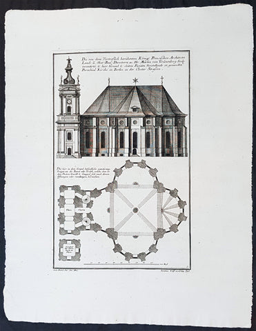
1740 Wolff & Corvinus Antique Architectural Print Parochialkirche, Mitte, Berlin
Antique Map
- Title : Die Von dem Vortreslich beruhmten Konigl. Preusichen Architect Land u. Ober Bau Directorn etc. Hr. Martin von Grunenberg Seel. inventirte, u. hier Grund u. Seiten Faciata Vorstellende so genandte Parochial Kirche in Berlin in der Closter Strassen
- Ref #: 93451
- Size: 19in x 12 1/2in (490mm x 335mm)
- Date : 1740
- Condition: (A+) Fine Condition
Description:
This large rare, original copper-plate engraved antique architectural print of the Parochialkirche (literally the Reformed parochial church) in the Mitte suburb of Berlin - plate No. 5 of 16 - by Johann August Corvinus 1683 - 1738, after Andreas Mayers 1716 - 1782, was published in Eigentliche Abbildung des Prächtigen Königl. Lust Schlosses Charlottenburg, eine Meile von Berlin, sambt dem darhinden im Walde gelegenen schönen Lust Garten
(Set of 16 numbered plates, the first with the title, with plans and views of the buildings and gardens at Charlottenburg, the palace of the King of Prussia on the outskirts of Berlin.) by Jeremias Wolff Erben in 1740.
General Definitions:
Paper thickness and quality: - Heavy and stable
Paper color : - off white
Age of map color: -
Colors used: -
General color appearance: -
Paper size: - 19in x 12 1/2in (490mm x 335mm)
Plate size: - 14 1/2in x 10 1/2in (370mm x 260mm)
Margins: - Min 1in (25mm)
Imperfections:
Margins: - None
Plate area: - None
Verso: - None
Background:
Berlin straddles the banks of the River Spree, which flows into the River Havel (a tributary of the River Elbe) in the western borough of Spandau. Among the citys main topographical features are the many lakes in the western and southeastern boroughs formed by the Spree, Havel, and Dahme rivers (the largest of which is Lake Müggelsee). Due to its location in the European Plain, Berlin is influenced by a temperate seasonal climate. About one-third of the citys area is composed of forests, parks, gardens, rivers, canals and lakes. The city lies in the Central German dialect area, the Berlin dialect being a variant of the Lusatian-New Marchian dialects.
First documented in the 13th century and situated at the crossing of two important historic trade routes, Berlin became the capital of the Margraviate of Brandenburg (1417–1701), the Kingdom of Prussia (1701–1918), the German Empire (1871–1918), the Weimar Republic (1919–1933), and the Third Reich (1933–1945). Berlin in the 1920s was the third-largest municipality in the world. After World War II and its subsequent occupation by the victorious countries, the city was divided; West Berlin became a de facto West German exclave, surrounded by the Berlin Wall (1961–1989) and East German territory. East Berlin was declared capital of East Germany, while Bonn became the West German capital. Following German reunification in 1990, Berlin once again became the capital of all of Germany.
The Thirty Years War between 1618 and 1648 devastated Berlin. One third of its houses were damaged or destroyed, and the city lost half of its population. Frederick William, known as the Great Elector, who had succeeded his father George William as ruler in 1640, initiated a policy of promoting immigration and religious tolerance. With the Edict of Potsdam in 1685, Frederick William offered asylum to the French Huguenots.
By 1700, approximately 30 percent of Berlins residents were French, because of the Huguenot immigration. Many other immigrants came from Bohemia, Poland, and Salzburg.
Since 1618, the Margraviate of Brandenburg had been in personal union with the Duchy of Prussia. In 1701, the dual state formed the Kingdom of Prussia, as Frederick III, Elector of Brandenburg, crowned himself as king Frederick I in Prussia. Berlin became the capital of the new Kingdom, replacing Königsberg. This was a successful attempt to centralise the capital in the very far-flung state, and it was the first time the city began to grow. In 1709, Berlin merged with the four cities of Cölln, Friedrichswerder, Friedrichstadt and Dorotheenstadt under the name Berlin, Haupt- und Residenzstadt Berlin.
In 1740, Frederick II, known as Frederick the Great (1740–1786), came to power. Under the rule of Frederick II, Berlin became a center of the Enlightenment, but also, was briefly occupied during the Seven Years War by the Russian army. Following Frances victory in the War of the Fourth Coalition, Napoleon Bonaparte marched into Berlin in 1806, but granted self-government to the city. In 1815, the city became part of the new Province of Brandenburg.
The Industrial Revolution transformed Berlin during the 19th century; the citys economy and population expanded dramatically, and it became the main railway hub and economic centre of Germany. Additional suburbs soon developed and increased the area and population of Berlin. In 1861, neighbouring suburbs including Wedding, Moabit and several others were incorporated into Berlin. In 1871, Berlin became capital of the newly founded German Empire. In 1881, it became a city district separate from Brandenburg.
Wolff, Jeremais 1663 - 1724
Wolff was an German engraver and publisher. Born in Augsburg, he originally trained as a clock and automat maker, later changing course and opening a small copperplate engraving shop. His success was impressive and became one of the largest European art, print & map publishers in the first half of the 18th century. Wolff employed some of the best engravers of the time and although not an engraver himself, only Wolffs name was recorded on the engravings. Many of his engravers went uncredited for their work. In 1710 Wolff was one of the founder member of the Empire State Academy of Arts in Augsburg.
After his death in 1724, Wolffs publishing business was inherited by his sons and son-in-law, Johann Balthasar Probst (1673–1750) a notable engraver at the time. The firm continued on in Augsburg under the name Jeremias Wolff Erben.
Together with the Nuremberg copperplate engraver Paul Decker , Wolff published a series of engravings showing the war successes of Prince Eugene of Savoy in Italy , southern Germany and the Spanish Netherlands, during the War of the Spanish Succession . The prints are exhibited in the Museum of Military History, in Vienna .
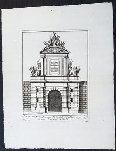
1740 Wolff & Corvinus Antique Architectural Print of Berlin Gate, Leipziger Tor
Antique Map
- Title : Das von dem Herrn Baumeister Nering Seel. ausgefuhrte so genandte Leipziger Statt Thor in Berlin
- Ref #: 93452
- Size: 19in x 12 1/2in (490mm x 335mm)
- Date : 1740
- Condition: (A+) Fine Condition
Description:
This large fine, original copper-plate engraved antique architectural print of buildings & gardens in 17th & 18th century Berlin - plate No. 3 of 16 - by Johann August Corvinus 1683 - 1738, after Andreas Mayers 1716 - 1782, was published in Eigentliche Abbildung des Prächtigen Königl. Lust Schlosses Charlottenburg, eine Meile von Berlin, sambt dem darhinden im Walde gelegenen schönen Lust Garten
(Set of 16 numbered plates, the first with the title, with plans and views of the buildings and gardens at Charlottenburg, the palace of the King of Prussia on the outskirts of Berlin.) by Jeremias Wolff Erben in 1740.
General Definitions:
Paper thickness and quality: - Heavy and stable
Paper color : - off white
Age of map color: -
Colors used: -
General color appearance: -
Paper size: - 19in x 12 1/2in (490mm x 335mm)
Plate size: - 14 1/2in x 10 1/2in (370mm x 260mm)
Margins: - Min 1in (25mm)
Imperfections:
Margins: - None
Plate area: - None
Verso: - None
Background:
Berlin straddles the banks of the River Spree, which flows into the River Havel (a tributary of the River Elbe) in the western borough of Spandau. Among the citys main topographical features are the many lakes in the western and southeastern boroughs formed by the Spree, Havel, and Dahme rivers (the largest of which is Lake Müggelsee). Due to its location in the European Plain, Berlin is influenced by a temperate seasonal climate. About one-third of the citys area is composed of forests, parks, gardens, rivers, canals and lakes. The city lies in the Central German dialect area, the Berlin dialect being a variant of the Lusatian-New Marchian dialects.
First documented in the 13th century and situated at the crossing of two important historic trade routes, Berlin became the capital of the Margraviate of Brandenburg (1417–1701), the Kingdom of Prussia (1701–1918), the German Empire (1871–1918), the Weimar Republic (1919–1933), and the Third Reich (1933–1945). Berlin in the 1920s was the third-largest municipality in the world. After World War II and its subsequent occupation by the victorious countries, the city was divided; West Berlin became a de facto West German exclave, surrounded by the Berlin Wall (1961–1989) and East German territory. East Berlin was declared capital of East Germany, while Bonn became the West German capital. Following German reunification in 1990, Berlin once again became the capital of all of Germany.
The Thirty Years War between 1618 and 1648 devastated Berlin. One third of its houses were damaged or destroyed, and the city lost half of its population. Frederick William, known as the Great Elector, who had succeeded his father George William as ruler in 1640, initiated a policy of promoting immigration and religious tolerance. With the Edict of Potsdam in 1685, Frederick William offered asylum to the French Huguenots.
By 1700, approximately 30 percent of Berlins residents were French, because of the Huguenot immigration. Many other immigrants came from Bohemia, Poland, and Salzburg.
Since 1618, the Margraviate of Brandenburg had been in personal union with the Duchy of Prussia. In 1701, the dual state formed the Kingdom of Prussia, as Frederick III, Elector of Brandenburg, crowned himself as king Frederick I in Prussia. Berlin became the capital of the new Kingdom, replacing Königsberg. This was a successful attempt to centralise the capital in the very far-flung state, and it was the first time the city began to grow. In 1709, Berlin merged with the four cities of Cölln, Friedrichswerder, Friedrichstadt and Dorotheenstadt under the name Berlin, Haupt- und Residenzstadt Berlin.
In 1740, Frederick II, known as Frederick the Great (1740–1786), came to power. Under the rule of Frederick II, Berlin became a center of the Enlightenment, but also, was briefly occupied during the Seven Years War by the Russian army. Following Frances victory in the War of the Fourth Coalition, Napoleon Bonaparte marched into Berlin in 1806, but granted self-government to the city. In 1815, the city became part of the new Province of Brandenburg.
The Industrial Revolution transformed Berlin during the 19th century; the citys economy and population expanded dramatically, and it became the main railway hub and economic centre of Germany. Additional suburbs soon developed and increased the area and population of Berlin. In 1861, neighbouring suburbs including Wedding, Moabit and several others were incorporated into Berlin. In 1871, Berlin became capital of the newly founded German Empire. In 1881, it became a city district separate from Brandenburg.
Wolff, Jeremais 1663 - 1724
Wolff was an German engraver and publisher. Born in Augsburg, he originally trained as a clock and automat maker, later changing course and opening a small copperplate engraving shop. His success was impressive and became one of the largest European art, print & map publishers in the first half of the 18th century. Wolff employed some of the best engravers of the time and although not an engraver himself, only Wolffs name was recorded on the engravings. Many of his engravers went uncredited for their work. In 1710 Wolff was one of the founder member of the Empire State Academy of Arts in Augsburg.
After his death in 1724, Wolffs publishing business was inherited by his sons and son-in-law, Johann Balthasar Probst (1673–1750) a notable engraver at the time. The firm continued on in Augsburg under the name Jeremias Wolff Erben.
Together with the Nuremberg copperplate engraver Paul Decker , Wolff published a series of engravings showing the war successes of Prince Eugene of Savoy in Italy , southern Germany and the Spanish Netherlands, during the War of the Spanish Succession . The prints are exhibited in the Museum of Military History, in Vienna .
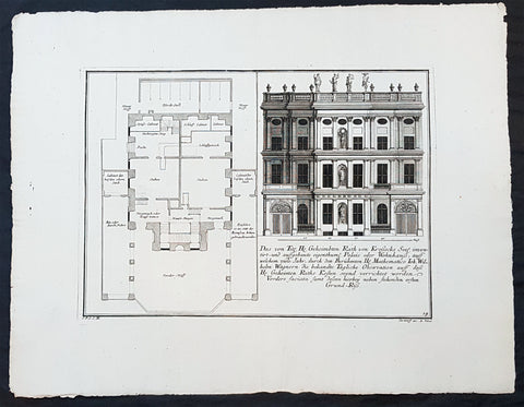
1740 Wolff & Corvinus Antique Architectural Print Buildings, Gardens Berlin - No. 14
Antique Map
- Title : Das von Title Hr. Geheimbten Rath von Krossecks Seel. inventirt - und aussgebaute
- Ref #: 93448
- Size: 19in x 12 1/2in (490mm x 335mm)
- Date : 1740
- Condition: (A+) Fine Condition
Description:
This large fine, original copper-plate engraved antique architectural print of buildings & gardens in the Charlottenburg suburb of Berlin & Charlottenburg Palace, - plate No. 14 of 16 - by Johann August Corvinus 1683 - 1738, after Andreas Mayers 1716 - 1782, was published in Eigentliche Abbildung des Prächtigen Königl. Lust Schlosses Charlottenburg, eine Meile von Berlin, sambt dem darhinden im Walde gelegenen schönen Lust Garten
(Set of 16 numbered plates, the first with the title, with plans and views of the buildings and gardens at Charlottenburg, the palace of the King of Prussia on the outskirts of Berlin.) by Jeremias Wolff Erben in 1740.
General Definitions:
Paper thickness and quality: - Heavy and stable
Paper color : - off white
Age of map color: -
Colors used: -
General color appearance: -
Paper size: - 19in x 12 1/2in (490mm x 335mm)
Plate size: - 14 1/2in x 10 1/2in (370mm x 260mm)
Margins: - Min 1in (25mm)
Imperfections:
Margins: - None
Plate area: - None
Verso: - None
Background:
Charlottenburg is an affluent locality of Berlin within the borough of Charlottenburg-Wilmersdorf. Established as a town in 1705 and named after late Sophia Charlotte of Hanover, Queen consort of Prussia, it is best known for Charlottenburg Palace, the largest surviving royal palace in Berlin, and the adjacent museums.
Charlottenburg is located in Berlins inner city, west of the Großer Tiergarten park. Its historic core, the former village green of Alt Lietzow, is situated on the southern shore of the Spree River running through the Berlin glacial valley. The Straße des 17. Juni road, former Charlottenburger Chaussee, which runs eastwards from Charlottenburg Gate through the Tiergarten park to Brandenburg Gate, connects Charlottenburg with the historic centre of Berlin-Mitte.
In the north and west, the Berlin Ringbahn and the Bundesautobahn 100 (Stadtring) mark the border with the Charlottenburg-Nord and Westend suburbs. Adjacent in the south is the territory of Wilmersdorf. Charlottenburg also borders on the district of Halensee in the southwest, as well as on Moabit, Hansaviertel and Tiergarten (all part of the Mitte borough) in the east and on Schöneberg in the southeast.
In 1695, Sophia Charlotte of Hanover received Lietzow from her husband, Elector Frederick III of Brandenburg, in exchange for her estates in Caputh and Langerwisch near Potsdam. Frederick had a summer residence built there for Sophie Charlotte by the architect Johann Arnold Nering between 1695 and 1699. After he had crowned himself Frederick I, King in Prussia, the Lützenburg castle was extended into a stately building with a cour dhonneur. The Swedish master builder Johann Friedrich Eosander supervised this work. Sophie Charlotte died in February 1705; shortly afterwards the settlement facing the palace was called Charlottenburg - the palace itself became Schloss Charlottenburg - and chartered as a town on April 5, 1705. The king served as the towns mayor until the historic village of Lietzow was incorporated into Charlottenburg in 1720.
Fredericks successor as king, Frederick William I of Prussia, rarely stayed at the palace, which depressed the small town of Charlottenburg. Frederick William even tried to revoke the towns privileges. With the coronation of his successor Frederick II in 1740 the towns significance increased, as regular celebrations again took place at the palace. Between 1740 and 1747 Georg Wenzeslaus von Knobelsdorff built the eastern New Wing as Fredericks residence. Later, Frederick II preferred the palace of Sanssouci, which he had partly designed himself.
When Frederick II died in 1786, his nephew Frederick William II succeeded him, and Charlottenburg became the favourite royal residence, and remained so for his son and successor Frederick William III (reigned 1797-1840). After the defeat of the Prussian army at Jena in 1806, the French occupied Berlin. Napoleon took over the palace, while his troops made a camp nearby. Charlottenburg became part of the new Prussian Province of Brandenburg in 1815 after the Napoleonic Wars.
In the late 18th century, Charlottenburgs development did not depend only on the crown. The town became a recreational area for the expanding city of Berlin. Its first true inn opened in the 1770s, in the street then called Berliner Straße (now Otto-Suhr-Allee), and many other inns and beer gardens were to follow, popular for weekend parties especially. Berliners seeking leisure and entertainment came by boat, by carriage and later by horse-drawn trams, above all to a large amusement park at the shore of the Spree river called Flora, that went into bankruptcy in 1904.
From the 1860s on the wealthy Bourgeoisie of Berlin discovered Charlottenburg as a residential area, among the first were Gerson von Bleichröder and Ernst Werner von Siemens, who had a villa built in the Berliner Straße in 1862. At the same time industrial companies like Siemens & Halske and Schering erected large factories in the north-east, at the border with the Moabit district of Berlin. In 1877 Charlottenburg received town privileges and until World War I saw an enormous increase of population with 100,000 inhabitants as of 1893 and a population of 306,000 in 1920, being the second largest city within the Province of Brandenburg, after Berlin. In the course of industrialization in the 19th century, much of Charlottenburg was incorporated in a network of streets laid out in the Hobrecht-Plan in an area that came to be known architecturally as the Wilhelmine Ring.
Wolff, Jeremais 1663 - 1724
Wolff was an German engraver and publisher. Born in Augsburg, he originally trained as a clock and automat maker, later changing course and opening a small copperplate engraving shop. His success was impressive and became one of the largest European art, print & map publishers in the first half of the 18th century. Wolff employed some of the best engravers of the time and although not an engraver himself, only Wolffs name was recorded on the engravings. Many of his engravers went uncredited for their work. In 1710 Wolff was one of the founder member of the Empire State Academy of Arts in Augsburg.
After his death in 1724, Wolffs publishing business was inherited by his sons and son-in-law, Johann Balthasar Probst (1673–1750) a notable engraver at the time. The firm continued on in Augsburg under the name Jeremias Wolff Erben.
Together with the Nuremberg copperplate engraver Paul Decker , Wolff published a series of engravings showing the war successes of Prince Eugene of Savoy in Italy , southern Germany and the Spanish Netherlands, during the War of the Spanish Succession . The prints are exhibited in the Museum of Military History, in Vienna .
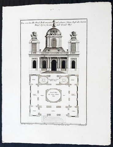
1740 Wolff & Corvinus Antique Architectural Print Charlottenburg Palace, Gardens
Antique Map
- Title : Haupt Hof Grund Riss dess Marstalls...Jeremais Wolff exc Aug. Vind
- Ref #: 93446
- Size: 19in x 12 1/2in (490mm x 335mm)
- Date : 1740
- Condition: (A+) Fine Condition
Description:
This large fine, original copper-plate engraved antique architectural print of buildings in the Charlottenburg suburb of Berlin & Charlottenburg Palace, - plate No. 4 of 16 - by Johann August Corvinus 1683 - 1738, after Andreas Mayers 1716 - 1782, was published in Eigentliche Abbildung des Prächtigen Königl. Lust Schlosses Charlottenburg, eine Meile von Berlin, sambt dem darhinden im Walde gelegenen schönen Lust Garten
(Set of 16 numbered plates, the first with the title, with plans and views of the buildings and gardens at Charlottenburg, the palace of the King of Prussia on the outskirts of Berlin.) by Jeremias Wolff Erben in 1740.
General Definitions:
Paper thickness and quality: - Heavy and stable
Paper color : - off white
Age of map color: -
Colors used: -
General color appearance: -
Paper size: - 19in x 12 1/2in (490mm x 335mm)
Plate size: - 15 1/2in x 10in (385mm x 255mm)
Margins: - Min 1in (25mm)
Imperfections:
Margins: - None
Plate area: - None
Verso: - None
Background:
Charlottenburg is an affluent locality of Berlin within the borough of Charlottenburg-Wilmersdorf. Established as a town in 1705 and named after late Sophia Charlotte of Hanover, Queen consort of Prussia, it is best known for Charlottenburg Palace, the largest surviving royal palace in Berlin, and the adjacent museums.
Charlottenburg is located in Berlins inner city, west of the Großer Tiergarten park. Its historic core, the former village green of Alt Lietzow, is situated on the southern shore of the Spree River running through the Berlin glacial valley. The Straße des 17. Juni road, former Charlottenburger Chaussee, which runs eastwards from Charlottenburg Gate through the Tiergarten park to Brandenburg Gate, connects Charlottenburg with the historic centre of Berlin-Mitte.
In the north and west, the Berlin Ringbahn and the Bundesautobahn 100 (Stadtring) mark the border with the Charlottenburg-Nord and Westend suburbs. Adjacent in the south is the territory of Wilmersdorf. Charlottenburg also borders on the district of Halensee in the southwest, as well as on Moabit, Hansaviertel and Tiergarten (all part of the Mitte borough) in the east and on Schöneberg in the southeast.
In 1695, Sophia Charlotte of Hanover received Lietzow from her husband, Elector Frederick III of Brandenburg, in exchange for her estates in Caputh and Langerwisch near Potsdam. Frederick had a summer residence built there for Sophie Charlotte by the architect Johann Arnold Nering between 1695 and 1699. After he had crowned himself Frederick I, King in Prussia, the Lützenburg castle was extended into a stately building with a cour dhonneur. The Swedish master builder Johann Friedrich Eosander supervised this work. Sophie Charlotte died in February 1705; shortly afterwards the settlement facing the palace was called Charlottenburg - the palace itself became Schloss Charlottenburg - and chartered as a town on April 5, 1705. The king served as the towns mayor until the historic village of Lietzow was incorporated into Charlottenburg in 1720.
Fredericks successor as king, Frederick William I of Prussia, rarely stayed at the palace, which depressed the small town of Charlottenburg. Frederick William even tried to revoke the towns privileges. With the coronation of his successor Frederick II in 1740 the towns significance increased, as regular celebrations again took place at the palace. Between 1740 and 1747 Georg Wenzeslaus von Knobelsdorff built the eastern New Wing as Fredericks residence. Later, Frederick II preferred the palace of Sanssouci, which he had partly designed himself.
When Frederick II died in 1786, his nephew Frederick William II succeeded him, and Charlottenburg became the favourite royal residence, and remained so for his son and successor Frederick William III (reigned 1797-1840). After the defeat of the Prussian army at Jena in 1806, the French occupied Berlin. Napoleon took over the palace, while his troops made a camp nearby. Charlottenburg became part of the new Prussian Province of Brandenburg in 1815 after the Napoleonic Wars.
In the late 18th century, Charlottenburgs development did not depend only on the crown. The town became a recreational area for the expanding city of Berlin. Its first true inn opened in the 1770s, in the street then called Berliner Straße (now Otto-Suhr-Allee), and many other inns and beer gardens were to follow, popular for weekend parties especially. Berliners seeking leisure and entertainment came by boat, by carriage and later by horse-drawn trams, above all to a large amusement park at the shore of the Spree river called Flora, that went into bankruptcy in 1904.
From the 1860s on the wealthy Bourgeoisie of Berlin discovered Charlottenburg as a residential area, among the first were Gerson von Bleichröder and Ernst Werner von Siemens, who had a villa built in the Berliner Straße in 1862. At the same time industrial companies like Siemens & Halske and Schering erected large factories in the north-east, at the border with the Moabit district of Berlin. In 1877 Charlottenburg received town privileges and until World War I saw an enormous increase of population with 100,000 inhabitants as of 1893 and a population of 306,000 in 1920, being the second largest city within the Province of Brandenburg, after Berlin. In the course of industrialization in the 19th century, much of Charlottenburg was incorporated in a network of streets laid out in the Hobrecht-Plan in an area that came to be known architecturally as the Wilhelmine Ring.
Wolff, Jeremais 1663 - 1724
Wolff was an German engraver and publisher. Born in Augsburg, he originally trained as a clock and automat maker, later changing course and opening a small copperplate engraving shop. His success was impressive and became one of the largest European art, print & map publishers in the first half of the 18th century. Wolff employed some of the best engravers of the time and although not an engraver himself, only Wolffs name was recorded on the engravings. Many of his engravers went uncredited for their work. In 1710 Wolff was one of the founder member of the Empire State Academy of Arts in Augsburg.
After his death in 1724, Wolffs publishing business was inherited by his sons and son-in-law, Johann Balthasar Probst (1673–1750) a notable engraver at the time. The firm continued on in Augsburg under the name Jeremias Wolff Erben.
Together with the Nuremberg copperplate engraver Paul Decker , Wolff published a series of engravings showing the war successes of Prince Eugene of Savoy in Italy , southern Germany and the Spanish Netherlands, during the War of the Spanish Succession . The prints are exhibited in the Museum of Military History, in Vienna .
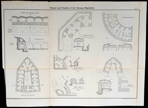
1856 Cap Richard Delafield Large Antique Schematics German Fortifications
Antique Map
- Title : Theory and Practise of the German Engineers
- Condition: (A+) Fine Condition
- Ref: 90194
- Size: 24 1/2in x 18in (615mm x 475mm)
Description:
This large original lithograph print, schematics of parts of the German Forts in such cities as Coblenz, Posen, Mainz, Luxemburg, Landau & others - during the time of the Crimean War - was engraved by John T Bowen & co. of Philadelphia and was published in the 1856 edition of Captain Richard Delafields Report on the Art of War in Europe in 1854, 1855, and 1856.
In early 1855, Captain Richard Delafield was appointed by the Secretary of War, Jefferson Davis, a head of the board of officers, later called The Delafield Commission, and sent to Europe to study the European military. The board included Captain George B. McClellan and Major Alfred Mordecai. They inspected the state of the military in Great Britain, Germany, the Austrian Empire, France, Belgium, and Russia, and served as military observers during the Crimean War. After his return in April 1856, Delafield submitted a report which was later published as a book by Congress, Report on the Art of War in Europe in 1854, 1855, and 1856. The book was suppressed during the American Civil War due to fears that it would be instructive to Confederate engineers as it contained multiple drawings and descriptions of military fortifications.
General Definitions:
Paper thickness and quality: - Light and stable
Paper color : - off white
Age of map color: -
Colors used: -
General color appearance: -
Paper size: - 24 1/2in x 18in (615mm x 475mm)
Plate size: - 24 1/2in x 18in (615mm x 475mm)
Margins: - Min 1/2in (12mm)
Imperfections:
Margins: - None
Plate area: - Folds as issued
Verso: - Folds re-enforced with archival tape
Background:
Under the term of the 1815 Peace of Paris, France was obliged to pay for the construction of a line of fortresses to protect the German Confederation against any future aggression by France. All fortresses were located outside Austria and Prussia — the two biggest, bickering powers of the Confederation.
Section C. Defensive System of the Germanic Confederation of the protocol drawn up at Paris on 3 November 1815, declared Mainz, Luxemburg, and Landau to be fortresses belonging to the Confederation of Germany, and stipulated that a fourth should be constructed on the Upper Rhine. In conformity with this act, a portion of the funds, which France was compelled to pay by way of indemnity for the cost of placing her on a peaceable footing, was thus appropriated: £200,000 were set aside for completing the works at Mainz; £800,000 were assigned to Prussia, to be applied upon its fortresses on the Lower Rhine; another £800,000 were reserved for constructing the new federal fortress on the Upper Rhine; and Bavaria was allowed £600,000 towards erecting another strong place on the Rhine, at Germersheim or some other point.
By 1835 the works about Mainz were completed; the twin fortresses of Koblenz and Ehrenbreitstein, and Cologne had been abundantly strengthened on the side of Prussia; and, on the Bavarian side, the fortress of Germersheim was in a state to defend the passage on the Upper Rhine. The western frontier of Germany had, in this way, been provided with a formidable line of defences against possible hostile actions by their neighbours. The eastern side of Germany has been additionally fortified by the erection of a strong citadel at Posen; and the southern was to be still further protected by the formidable works in course of construction at Brixen in the Tyrol.
The fortress of Ulm became a major strategic fortress able to accommodate 100,000 men and their equipment. Since the Kingdom of Württemberg had no engineering corps King William I appointed Moritz Karl Ernst von Prittwitz, a Prussian major, as the supervisor to oversee the building the fortresses. His plans included the provisions for the prospective development of the city Ulm. Major Theodor von Hildebrandt was appointed to oversee the building of fortresses around Neu-Ulm on the Bavarian side of the Danube.
Delafield, Richard Major General 1798 - 1873
Delafield was a United States Army officer for 52 years. He served as superintendent of the United States Military Academy for 12 years. At the start of the American Civil War, then Colonel Delafield helped equip and send volunteers from New York to the Union Army. He also was in command of defences around New York harbor from 1861 to April 1864. On April 22, 1864, he was promoted to Brigadier General in the Regular Army of the United States and Chief of Engineers. On March 8, 1866, President Andrew Johnson nominated Delafield for appointment to the grade of brevet major general in the Regular Army, to rank from March 13, 1865, and the United States Senate confirmed the appointment on May 4, 1866, reconfirmed due to a technicality on July 14, 1866. He retired from the US Army on August 8, 1866. He later served on two commissions relating to improvements to Boston Harbor and to lighthouses. He also served as a regent of the Smithsonian Institution.
Delafield served as assistant engineer in the construction of Hampton Roads defences from 1819–1824 and was in charge of fortifications and surveys in the Mississippi River delta area in 1824-1832. While superintendent of repair work on the Cumberland Road east of the Ohio River, he designed and built Dunlaps Creek Bridge in Brownsville, Pennsylvania, the first cast-iron tubular-arch bridge in the United States. Commissioned a major of engineers in July 1838, he was appointed superintendent of the Military Academy after the fire of 1838 and served till 1845. He designed the new buildings and the new cadet uniform that first displayed the castle insignia. He superintended the construction of coast defences for New York Harbor from 1846 to 1855.
In the beginning of 1855, Delafield was appointed by the Secretary of War, Jefferson Davis a head of the board of officers, later called The Delafield Commission, and sent to Europe to study the European military. The board included Captain George B. McClellan and Major Alfred Mordecai. They inspected the state of the military in Great Britain, Germany, the Austrian Empire, France, Belgium, and Russia, and served as military observers during the Crimean War. After his return in April 1856, Delafield submitted a report which was later published as a book by Congress, Report on the Art of War in Europe in 1854, 1855, and 1856. The book was suppressed during the American Civil War due to fears that it would be instructive to Confederate engineers as it contained multiple drawings and descriptions of military fortifications.
Delafield served as superintendent of the Military Academy again in 1856-1861. In January 1861, he was succeeded by Captain Pierre G. T. Beauregard, who was dismissed shortly after Beauregards home state of Louisiana seceded from the Union, and Delafield returned as superintendent serving until March 1, 1861. In the beginning of the Civil War he advised the governor of New York Edwin D. Morgan during the volunteer force creation. Then, in 1861–1864, he was put in charge of New York Harbor defences, including Governors Island and Fort at Sandy Hook. On May 19, 1864, he was commissioned a brigadier-general after replacing Joseph Gilbert Totten, who had died, as the Chief of Engineers, United States Army Corps of Engineers, on April 22, 1864. He stayed in charge of the Bureau of Engineers of the War Department until his retirement on August 8, 1866. On March 8, 1866, President Andrew Johnson nominated Delafield for appointment to the grade of brevet major general in the Regular Army of the United States, to rank from March 13, 1865, and the United States Senate confirmed the appointment on May 4, 1866 and reconfirmed it due to a technicality on July 14, 1866.After retirement Delafield served as a regent of the Smithsonian Institution and a member of the Lighthouse Board. He died in Washington, D.C. on November 5, 1873.
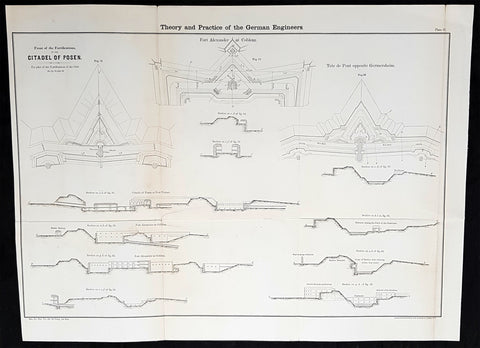
1856 Cap Richard Delafield Large Antique Schematics German Fortifications
Antique Map
- Title : Theory and Practise of the German Engineers
- Condition: (A+) Fine Condition
- Ref: 90140
- Size: 24 1/2in x 18in (615mm x 475mm)
Description:
This large original lithograph print, schematics of parts of the German Forts in such cities as Coblenz, Posen, Mainz, Luxemburg, Landau & others - during the time of the Crimean War - was engraved by John T Bowen & co. of Philadelphia and was published in the 1856 edition of Captain Richard Delafields Report on the Art of War in Europe in 1854, 1855, and 1856.
In early 1855, Captain Richard Delafield was appointed by the Secretary of War, Jefferson Davis, a head of the board of officers, later called The Delafield Commission, and sent to Europe to study the European military. The board included Captain George B. McClellan and Major Alfred Mordecai. They inspected the state of the military in Great Britain, Germany, the Austrian Empire, France, Belgium, and Russia, and served as military observers during the Crimean War. After his return in April 1856, Delafield submitted a report which was later published as a book by Congress, Report on the Art of War in Europe in 1854, 1855, and 1856. The book was suppressed during the American Civil War due to fears that it would be instructive to Confederate engineers as it contained multiple drawings and descriptions of military fortifications.
General Definitions:
Paper thickness and quality: - Light and stable
Paper color : - off white
Age of map color: -
Colors used: -
General color appearance: -
Paper size: - 24 1/2in x 18in (615mm x 475mm)
Plate size: - 24 1/2in x 18in (615mm x 475mm)
Margins: - Min 1/2in (12mm)
Imperfections:
Margins: - None
Plate area: - Folds as issued
Verso: - Folds re-enforced with archival tape
Background:
Under the term of the 1815 Peace of Paris, France was obliged to pay for the construction of a line of fortresses to protect the German Confederation against any future aggression by France. All fortresses were located outside Austria and Prussia — the two biggest, bickering powers of the Confederation.
Section C. Defensive System of the Germanic Confederation of the protocol drawn up at Paris on 3 November 1815, declared Mainz, Luxemburg, and Landau to be fortresses belonging to the Confederation of Germany, and stipulated that a fourth should be constructed on the Upper Rhine. In conformity with this act, a portion of the funds, which France was compelled to pay by way of indemnity for the cost of placing her on a peaceable footing, was thus appropriated: £200,000 were set aside for completing the works at Mainz; £800,000 were assigned to Prussia, to be applied upon its fortresses on the Lower Rhine; another £800,000 were reserved for constructing the new federal fortress on the Upper Rhine; and Bavaria was allowed £600,000 towards erecting another strong place on the Rhine, at Germersheim or some other point.
By 1835 the works about Mainz were completed; the twin fortresses of Koblenz and Ehrenbreitstein, and Cologne had been abundantly strengthened on the side of Prussia; and, on the Bavarian side, the fortress of Germersheim was in a state to defend the passage on the Upper Rhine. The western frontier of Germany had, in this way, been provided with a formidable line of defences against possible hostile actions by their neighbours. The eastern side of Germany has been additionally fortified by the erection of a strong citadel at Posen; and the southern was to be still further protected by the formidable works in course of construction at Brixen in the Tyrol.
The fortress of Ulm became a major strategic fortress able to accommodate 100,000 men and their equipment. Since the Kingdom of Württemberg had no engineering corps King William I appointed Moritz Karl Ernst von Prittwitz, a Prussian major, as the supervisor to oversee the building the fortresses. His plans included the provisions for the prospective development of the city Ulm. Major Theodor von Hildebrandt was appointed to oversee the building of fortresses around Neu-Ulm on the Bavarian side of the Danube.
Delafield, Richard Major General 1798 - 1873
Delafield was a United States Army officer for 52 years. He served as superintendent of the United States Military Academy for 12 years. At the start of the American Civil War, then Colonel Delafield helped equip and send volunteers from New York to the Union Army. He also was in command of defences around New York harbor from 1861 to April 1864. On April 22, 1864, he was promoted to Brigadier General in the Regular Army of the United States and Chief of Engineers. On March 8, 1866, President Andrew Johnson nominated Delafield for appointment to the grade of brevet major general in the Regular Army, to rank from March 13, 1865, and the United States Senate confirmed the appointment on May 4, 1866, reconfirmed due to a technicality on July 14, 1866. He retired from the US Army on August 8, 1866. He later served on two commissions relating to improvements to Boston Harbor and to lighthouses. He also served as a regent of the Smithsonian Institution.
Delafield served as assistant engineer in the construction of Hampton Roads defences from 1819–1824 and was in charge of fortifications and surveys in the Mississippi River delta area in 1824-1832. While superintendent of repair work on the Cumberland Road east of the Ohio River, he designed and built Dunlaps Creek Bridge in Brownsville, Pennsylvania, the first cast-iron tubular-arch bridge in the United States. Commissioned a major of engineers in July 1838, he was appointed superintendent of the Military Academy after the fire of 1838 and served till 1845. He designed the new buildings and the new cadet uniform that first displayed the castle insignia. He superintended the construction of coast defences for New York Harbor from 1846 to 1855.
In the beginning of 1855, Delafield was appointed by the Secretary of War, Jefferson Davis a head of the board of officers, later called The Delafield Commission, and sent to Europe to study the European military. The board included Captain George B. McClellan and Major Alfred Mordecai. They inspected the state of the military in Great Britain, Germany, the Austrian Empire, France, Belgium, and Russia, and served as military observers during the Crimean War. After his return in April 1856, Delafield submitted a report which was later published as a book by Congress, Report on the Art of War in Europe in 1854, 1855, and 1856. The book was suppressed during the American Civil War due to fears that it would be instructive to Confederate engineers as it contained multiple drawings and descriptions of military fortifications.
Delafield served as superintendent of the Military Academy again in 1856-1861. In January 1861, he was succeeded by Captain Pierre G. T. Beauregard, who was dismissed shortly after Beauregards home state of Louisiana seceded from the Union, and Delafield returned as superintendent serving until March 1, 1861. In the beginning of the Civil War he advised the governor of New York Edwin D. Morgan during the volunteer force creation. Then, in 1861–1864, he was put in charge of New York Harbor defences, including Governors Island and Fort at Sandy Hook. On May 19, 1864, he was commissioned a brigadier-general after replacing Joseph Gilbert Totten, who had died, as the Chief of Engineers, United States Army Corps of Engineers, on April 22, 1864. He stayed in charge of the Bureau of Engineers of the War Department until his retirement on August 8, 1866. On March 8, 1866, President Andrew Johnson nominated Delafield for appointment to the grade of brevet major general in the Regular Army of the United States, to rank from March 13, 1865, and the United States Senate confirmed the appointment on May 4, 1866 and reconfirmed it due to a technicality on July 14, 1866.After retirement Delafield served as a regent of the Smithsonian Institution and a member of the Lighthouse Board. He died in Washington, D.C. on November 5, 1873.
1856 Capt Delafield Large Antique Schematics of the 2nd Lancers Barracks, Berlin
Antique Map
- Title : Barrack of the Lancers of the Guard at Berlin...Barrack of the Second Regiment of the Lancers of the Guard at Berlin
- Date : 1856
- Condition: (A+) Fine Condition
- Ref: 90143
- Size: 20 1/2in x 16in (510mm x 410mm)
Description:
This large original lithograph print, schematics of the 2nd German Lancer Regiment Barracks in Berlin - during the time of the Crimean War and just prior to the American Civil War - was engraved by John T Bowen & co. of Philadelphia and was published in the 1856 edition of Captain Richard Delafields Report on the Art of War in Europe in 1854, 1855, and 1856.
In early 1855, Captain Richard Delafield was appointed by the Secretary of War, Jefferson Davis, a head of the board of officers, later called The Delafield Commission, and sent to Europe to study the European military. The board included Captain George B. McClellan and Major Alfred Mordecai. They inspected the state of the military in Great Britain, Germany, the Austrian Empire, France, Belgium, and Russia, and served as military observers during the Crimean War. After his return in April 1856, Delafield submitted a report which was later published as a book by Congress, Report on the Art of War in Europe in 1854, 1855, and 1856. The book was suppressed during the American Civil War due to fears that it would be instructive to Confederate engineers as it contained multiple drawings and descriptions of military fortifications.
General Definitions:
Paper thickness and quality: - Light and stable
Paper color : - off white
Age of map color: -
Colors used: -
General color appearance: -
Paper size: - 20 1/2in x 16in (510mm x 410mm)
Plate size: - 20 1/2in x 16in (510mm x 410mm)
Margins: - Min 1/2in (12mm)
Imperfections:
Margins: - None
Plate area: - Folds as issued
Verso: - Folds re-enforced with archival tape
Background:
A lancer was a type of cavalryman who fought with a lance. Lances were used in mounted warfare by the Assyrians as early as 700 BC and subsequently by Greek, Persian, Gallic, Chinese, and Roman horsemen. The weapon was widely used in Asia and Europe during the Middle Ages and the Renaissance by armoured cavalry, before being adopted by light cavalry, particularly in Eastern Europe. In a modern context, a lancer regiment usually denotes an armoured unit.
The lancer (called ułan in Polish and Uhlan in German) had become a common sight in almost every European, Ottoman, and Indian army during this time, but, with the exception of the Ottoman troops, they increasingly discarded the heavy armour to give greater freedom of movement in combat. The Polish winged lancers were amongst the last to abandon the armour in Europe. There was debate over the value of the lance in mounted combat during the 18th century and most armies had few lancer units by the beginning of the 19th century. However, during the Napoleonic Wars, lancers were to be seen in many of the combatant nations as their value in shock tactics became clear. During the wars, the Poles became a ready source of recruitment for several armies, willingly or unwillingly. Polish lancers served with distinction in the Austrian, Prussian, Russian and French armies, most famously in Napoleons French Imperial Guard as the 1er Regiment de Chevau-Legers-Lanciers de la Garde Impériale.
At the Battle of Waterloo, French lances were nearly three meters (about nine feet, ten inches) long, weighed three kilograms (about six pounds, ten ounces), and had a steel point on a wooden staff, according to historian Alessandro Barbero. He adds that they were terrifyingly efficient. Commander of the French 1st Corps, 4th Division General Durutte, who saw the battle from the high ground in front of Papelotte, would write later, I had never before realized the great superiority of the lance over the sword.
In the Siege of Los Angeles (1846), during the war between Mexico and the United States, a company of Californio lancers temporarily recaptured the town, expelling a company of U.S. Marines.
Although having substantial impact in the charge, lancers could be vulnerable to other cavalry at close quarters, where the lance proved a clumsy and easily deflected weapon when employed against sabres. By the late 19th century, many cavalry regiments in the British and other European armies were composed of troopers with lances, as primary weapons, in the front rank and horsemen with sabres only in the second: the lances for the initial shock and sabres for the subsequent mêlée.
Delafield, Richard Major General 1798 - 1873
Delafield was a United States Army officer for 52 years. He served as superintendent of the United States Military Academy for 12 years. At the start of the American Civil War, then Colonel Delafield helped equip and send volunteers from New York to the Union Army. He also was in command of defences around New York harbor from 1861 to April 1864. On April 22, 1864, he was promoted to Brigadier General in the Regular Army of the United States and Chief of Engineers. On March 8, 1866, President Andrew Johnson nominated Delafield for appointment to the grade of brevet major general in the Regular Army, to rank from March 13, 1865, and the United States Senate confirmed the appointment on May 4, 1866, reconfirmed due to a technicality on July 14, 1866. He retired from the US Army on August 8, 1866. He later served on two commissions relating to improvements to Boston Harbor and to lighthouses. He also served as a regent of the Smithsonian Institution.
Delafield served as assistant engineer in the construction of Hampton Roads defences from 1819–1824 and was in charge of fortifications and surveys in the Mississippi River delta area in 1824-1832. While superintendent of repair work on the Cumberland Road east of the Ohio River, he designed and built Dunlaps Creek Bridge in Brownsville, Pennsylvania, the first cast-iron tubular-arch bridge in the United States. Commissioned a major of engineers in July 1838, he was appointed superintendent of the Military Academy after the fire of 1838 and served till 1845. He designed the new buildings and the new cadet uniform that first displayed the castle insignia. He superintended the construction of coast defences for New York Harbor from 1846 to 1855.
In the beginning of 1855, Delafield was appointed by the Secretary of War, Jefferson Davis a head of the board of officers, later called The Delafield Commission, and sent to Europe to study the European military. The board included Captain George B. McClellan and Major Alfred Mordecai. They inspected the state of the military in Great Britain, Germany, the Austrian Empire, France, Belgium, and Russia, and served as military observers during the Crimean War. After his return in April 1856, Delafield submitted a report which was later published as a book by Congress, Report on the Art of War in Europe in 1854, 1855, and 1856. The book was suppressed during the American Civil War due to fears that it would be instructive to Confederate engineers as it contained multiple drawings and descriptions of military fortifications.
Delafield served as superintendent of the Military Academy again in 1856-1861. In January 1861, he was succeeded by Captain Pierre G. T. Beauregard, who was dismissed shortly after Beauregards home state of Louisiana seceded from the Union, and Delafield returned as superintendent serving until March 1, 1861. In the beginning of the Civil War he advised the governor of New York Edwin D. Morgan during the volunteer force creation. Then, in 1861–1864, he was put in charge of New York Harbor defences, including Governors Island and Fort at Sandy Hook. On May 19, 1864, he was commissioned a brigadier-general after replacing Joseph Gilbert Totten, who had died, as the Chief of Engineers, United States Army Corps of Engineers, on April 22, 1864. He stayed in charge of the Bureau of Engineers of the War Department until his retirement on August 8, 1866. On March 8, 1866, President Andrew Johnson nominated Delafield for appointment to the grade of brevet major general in the Regular Army of the United States, to rank from March 13, 1865, and the United States Senate confirmed the appointment on May 4, 1866 and reconfirmed it due to a technicality on July 14, 1866.After retirement Delafield served as a regent of the Smithsonian Institution and a member of the Lighthouse Board. He died in Washington, D.C. on November 5, 1873.
1856 Capt Delafield Large Antique Schematics of the 2nd Lancers Barracks, Berlin
Antique Map
- Title : Barrack of the Lancers of the Guard at Berlin...Barrack of the Second Regiment of the Lancers of the Guard at Berlin
- Date : 1856
- Condition: (A+) Fine Condition
- Ref: 90152
- Size: 21in x 17in (530mm x 430mm)
Description:
This large original lithograph print, schematics of the 2nd German Lancer Regiment Barracks in Berlin - during the time of the Crimean War and just prior to the American Civil War - was engraved by John T Bowen & co. of Philadelphia and was published in the 1856 edition of Captain Richard Delafields Report on the Art of War in Europe in 1854, 1855, and 1856.
In early 1855, Captain Richard Delafield was appointed by the Secretary of War, Jefferson Davis, a head of the board of officers, later called The Delafield Commission, and sent to Europe to study the European military. The board included Captain George B. McClellan and Major Alfred Mordecai. They inspected the state of the military in Great Britain, Germany, the Austrian Empire, France, Belgium, and Russia, and served as military observers during the Crimean War. After his return in April 1856, Delafield submitted a report which was later published as a book by Congress, Report on the Art of War in Europe in 1854, 1855, and 1856. The book was suppressed during the American Civil War due to fears that it would be instructive to Confederate engineers as it contained multiple drawings and descriptions of military fortifications.
General Definitions:
Paper thickness and quality: - Light and stable
Paper color : - off white
Age of map color: -
Colors used: -
General color appearance: -
Paper size: - 21in x 17in (530mm x 430mm)
Plate size: - 21in x 17in (530mm x 430mm)
Margins: - Min 1/2in (12mm)
Imperfections:
Margins: - None
Plate area: - Folds as issued
Verso: - Folds re-enforced with archival tape
Background:
A lancer was a type of cavalryman who fought with a lance. Lances were used in mounted warfare by the Assyrians as early as 700 BC and subsequently by Greek, Persian, Gallic, Chinese, and Roman horsemen. The weapon was widely used in Asia and Europe during the Middle Ages and the Renaissance by armoured cavalry, before being adopted by light cavalry, particularly in Eastern Europe. In a modern context, a lancer regiment usually denotes an armoured unit.
The lancer (called ułan in Polish and Uhlan in German) had become a common sight in almost every European, Ottoman, and Indian army during this time, but, with the exception of the Ottoman troops, they increasingly discarded the heavy armour to give greater freedom of movement in combat. The Polish winged lancers were amongst the last to abandon the armour in Europe. There was debate over the value of the lance in mounted combat during the 18th century and most armies had few lancer units by the beginning of the 19th century. However, during the Napoleonic Wars, lancers were to be seen in many of the combatant nations as their value in shock tactics became clear. During the wars, the Poles became a ready source of recruitment for several armies, willingly or unwillingly. Polish lancers served with distinction in the Austrian, Prussian, Russian and French armies, most famously in Napoleons French Imperial Guard as the 1er Regiment de Chevau-Legers-Lanciers de la Garde Impériale.
At the Battle of Waterloo, French lances were nearly three meters (about nine feet, ten inches) long, weighed three kilograms (about six pounds, ten ounces), and had a steel point on a wooden staff, according to historian Alessandro Barbero. He adds that they were terrifyingly efficient. Commander of the French 1st Corps, 4th Division General Durutte, who saw the battle from the high ground in front of Papelotte, would write later, I had never before realized the great superiority of the lance over the sword.
In the Siege of Los Angeles (1846), during the war between Mexico and the United States, a company of Californio lancers temporarily recaptured the town, expelling a company of U.S. Marines.
Although having substantial impact in the charge, lancers could be vulnerable to other cavalry at close quarters, where the lance proved a clumsy and easily deflected weapon when employed against sabres. By the late 19th century, many cavalry regiments in the British and other European armies were composed of troopers with lances, as primary weapons, in the front rank and horsemen with sabres only in the second: the lances for the initial shock and sabres for the subsequent mêlée.
Delafield, Richard Major General 1798 - 1873
Delafield was a United States Army officer for 52 years. He served as superintendent of the United States Military Academy for 12 years. At the start of the American Civil War, then Colonel Delafield helped equip and send volunteers from New York to the Union Army. He also was in command of defences around New York harbor from 1861 to April 1864. On April 22, 1864, he was promoted to Brigadier General in the Regular Army of the United States and Chief of Engineers. On March 8, 1866, President Andrew Johnson nominated Delafield for appointment to the grade of brevet major general in the Regular Army, to rank from March 13, 1865, and the United States Senate confirmed the appointment on May 4, 1866, reconfirmed due to a technicality on July 14, 1866. He retired from the US Army on August 8, 1866. He later served on two commissions relating to improvements to Boston Harbor and to lighthouses. He also served as a regent of the Smithsonian Institution.
Delafield served as assistant engineer in the construction of Hampton Roads defences from 1819–1824 and was in charge of fortifications and surveys in the Mississippi River delta area in 1824-1832. While superintendent of repair work on the Cumberland Road east of the Ohio River, he designed and built Dunlaps Creek Bridge in Brownsville, Pennsylvania, the first cast-iron tubular-arch bridge in the United States. Commissioned a major of engineers in July 1838, he was appointed superintendent of the Military Academy after the fire of 1838 and served till 1845. He designed the new buildings and the new cadet uniform that first displayed the castle insignia. He superintended the construction of coast defences for New York Harbor from 1846 to 1855.
In the beginning of 1855, Delafield was appointed by the Secretary of War, Jefferson Davis a head of the board of officers, later called The Delafield Commission, and sent to Europe to study the European military. The board included Captain George B. McClellan and Major Alfred Mordecai. They inspected the state of the military in Great Britain, Germany, the Austrian Empire, France, Belgium, and Russia, and served as military observers during the Crimean War. After his return in April 1856, Delafield submitted a report which was later published as a book by Congress, Report on the Art of War in Europe in 1854, 1855, and 1856. The book was suppressed during the American Civil War due to fears that it would be instructive to Confederate engineers as it contained multiple drawings and descriptions of military fortifications.
Delafield served as superintendent of the Military Academy again in 1856-1861. In January 1861, he was succeeded by Captain Pierre G. T. Beauregard, who was dismissed shortly after Beauregards home state of Louisiana seceded from the Union, and Delafield returned as superintendent serving until March 1, 1861. In the beginning of the Civil War he advised the governor of New York Edwin D. Morgan during the volunteer force creation. Then, in 1861–1864, he was put in charge of New York Harbor defences, including Governors Island and Fort at Sandy Hook. On May 19, 1864, he was commissioned a brigadier-general after replacing Joseph Gilbert Totten, who had died, as the Chief of Engineers, United States Army Corps of Engineers, on April 22, 1864. He stayed in charge of the Bureau of Engineers of the War Department until his retirement on August 8, 1866. On March 8, 1866, President Andrew Johnson nominated Delafield for appointment to the grade of brevet major general in the Regular Army of the United States, to rank from March 13, 1865, and the United States Senate confirmed the appointment on May 4, 1866 and reconfirmed it due to a technicality on July 14, 1866.After retirement Delafield served as a regent of the Smithsonian Institution and a member of the Lighthouse Board. He died in Washington, D.C. on November 5, 1873.
1856 Capt Delafield Large Antique Schematics French Infantry Barracks & Quarters
Antique Map
- Title : Theory and Practice of the French Engineers....Quaters for Infantry..Plan of the Bob Proof Building for lodging 5 Companies presenting together an effective force of about 500 men.
- Date : 1856
- Condition: (A+) Fine Condition
- Ref: 90126
- Size: 26in x 20in (660mm x 500mm)
Description:
This large original lithograph print, schematics of barracks and quarters for infantry in France - during the time of the Crimean War and just prior to the American Civil War - was engraved by John T Bowen & co. of Philadelphia and was published in the 1856 edition of Captain Richard Delafields Report on the Art of War in Europe in 1854, 1855, and 1856.
In early 1855, Captain Richard Delafield was appointed by the Secretary of War, Jefferson Davis, a head of the board of officers, later called The Delafield Commission, and sent to Europe to study the European military. The board included Captain George B. McClellan and Major Alfred Mordecai. They inspected the state of the military in Great Britain, Germany, the Austrian Empire, France, Belgium, and Russia, and served as military observers during the Crimean War. After his return in April 1856, Delafield submitted a report which was later published as a book by Congress, Report on the Art of War in Europe in 1854, 1855, and 1856. The book was suppressed during the American Civil War due to fears that it would be instructive to Confederate engineers as it contained multiple drawings and descriptions of military fortifications.
General Definitions:
Paper thickness and quality: - Light and stable
Paper color : - off white
Age of map color: -
Colors used: -
General color appearance: -
Paper size: - 26in x 20in (660mm x 500mm)
Plate size: - 26in x 20in (660mm x 500mm)
Margins: - Min 1/2in (12mm)
Imperfections:
Margins: - None
Plate area: - Folds as issued
Verso: - Folds re-enforced with archival tape
Background:
The arrival of explosive shells in the 19th century led to yet another stage in the evolution of fortification. Star forts did not fare well against the effects of high explosive and the intricate arrangements of bastions, flanking batteries and the carefully constructed lines of fire for the defending cannon could be rapidly disrupted by explosive shells.
Worse, the large open ditches surrounding forts of this type were an integral part of the defensive scheme, as was the covered way at the edge of the counter scarp. The ditch was extremely vulnerable to bombardment with explosive shells.
In response, military engineers evolved the polygonal style of fortification. The ditch became deep and vertically sided, cut directly into the native rock or soil, laid out as a series of straight lines creating the central fortified area that gives this style of fortification its name.
Wide enough to be an impassable barrier for attacking troops, but narrow enough to be a difficult target for enemy shellfire, the ditch was swept by fire from defensive blockhouses set in the ditch as well as firing positions cut into the outer face of the ditch itself.
The profile of the fort became very low indeed, surrounded outside the ditch covered by caponiers by a gently sloping open area so as to eliminate possible cover for enemy forces, while the fort itself provided a minimal target for enemy fire. The entrypoint became a sunken gatehouse in the inner face of the ditch, reached by a curving ramp that gave access to the gate via a rolling bridge that could be withdrawn into the gatehouse.
Much of the fort moved underground. Deep passages and tunnels now connected the blockhouses and firing points in the ditch to the fort proper, with magazines and machine rooms deep under the surface. The guns, however, were often mounted in open emplacements and protected only by a parapet; both in order to keep a lower profile and also because experience with guns in closed casemates had seen them put out of action by rubble as their own casemates were collapsed around them.
Gone were citadels surrounding towns: forts were to be moved to the outside of the cities some 12 km to keep the enemy at a distance so their artillery could not bombard the city center. From now on a ring of forts were to be built at a spacing that would allow them to effectively cover the intervals between them.
The new forts abandoned the principle of the bastion, which had also been made obsolete by advances in arms. The outline was a much simplified polygon, surrounded by a ditch. These forts, built in masonry and shaped stone, were designed to shelter their garrison against bombardment. One organizing feature of the new system involved the construction of two defensive curtains: an outer line of forts, backed by an inner ring or line at critical points of terrain or junctions (see, for example, Séré de Rivières system in France).
Traditional fortification however continued to be applied by European armies engaged in warfare in colonies established in Africa against lightly armed attackers from amongst the indigenous population. A relatively small number of defenders in a fort impervious to primitive weaponry could hold out against high odds, the only constraint being the supply of ammunition.
Delafield, Richard Major General 1798 - 1873 - Delafield was a United States Army officer for 52 years. He served as superintendent of the United States Military Academy for 12 years. At the start of the American Civil War, then Colonel Delafield helped equip and send volunteers from New York to the Union Army. He also was in command of defences around New York harbor from 1861 to April 1864. On April 22, 1864, he was promoted to Brigadier General in the Regular Army of the United States and Chief of Engineers. On March 8, 1866, President Andrew Johnson nominated Delafield for appointment to the grade of brevet major general in the Regular Army, to rank from March 13, 1865, and the United States Senate confirmed the appointment on May 4, 1866, reconfirmed due to a technicality on July 14, 1866. He retired from the US Army on August 8, 1866. He later served on two commissions relating to improvements to Boston Harbor and to lighthouses. He also served as a regent of the Smithsonian Institution.
Delafield served as assistant engineer in the construction of Hampton Roads defences from 1819–1824 and was in charge of fortifications and surveys in the Mississippi River delta area in 1824-1832. While superintendent of repair work on the Cumberland Road east of the Ohio River, he designed and built Dunlaps Creek Bridge in Brownsville, Pennsylvania, the first cast-iron tubular-arch bridge in the United States. Commissioned a major of engineers in July 1838, he was appointed superintendent of the Military Academy after the fire of 1838 and served till 1845. He designed the new buildings and the new cadet uniform that first displayed the castle insignia. He superintended the construction of coast defences for New York Harbor from 1846 to 1855.
In the beginning of 1855, Delafield was appointed by the Secretary of War, Jefferson Davis a head of the board of officers, later called The Delafield Commission, and sent to Europe to study the European military. The board included Captain George B. McClellan and Major Alfred Mordecai. They inspected the state of the military in Great Britain, Germany, the Austrian Empire, France, Belgium, and Russia, and served as military observers during the Crimean War. After his return in April 1856, Delafield submitted a report which was later published as a book by Congress, Report on the Art of War in Europe in 1854, 1855, and 1856. The book was suppressed during the American Civil War due to fears that it would be instructive to Confederate engineers as it contained multiple drawings and descriptions of military fortifications.
Delafield served as superintendent of the Military Academy again in 1856-1861. In January 1861, he was succeeded by Captain Pierre G. T. Beauregard, who was dismissed shortly after Beauregards home state of Louisiana seceded from the Union, and Delafield returned as superintendent serving until March 1, 1861. In the beginning of the Civil War he advised the governor of New York Edwin D. Morgan during the volunteer force creation. Then, in 1861–1864, he was put in charge of New York Harbor defences, including Governors Island and Fort at Sandy Hook. On May 19, 1864, he was commissioned a brigadier-general after replacing Joseph Gilbert Totten, who had died, as the Chief of Engineers, United States Army Corps of Engineers, on April 22, 1864. He stayed in charge of the Bureau of Engineers of the War Department until his retirement on August 8, 1866. On March 8, 1866, President Andrew Johnson nominated Delafield for appointment to the grade of brevet major general in the Regular Army of the United States, to rank from March 13, 1865, and the United States Senate confirmed the appointment on May 4, 1866 and reconfirmed it due to a technicality on July 14, 1866.After retirement Delafield served as a regent of the Smithsonian Institution and a member of the Lighthouse Board. He died in Washington, D.C. on November 5, 1873.
1856 Capt Delafield Large Antique Schematics Internal Calvary Barracks, Quarters
Antique Map
- Title : Cavalry Barracks - Furniture of the Quarters...
- Date : 1856
- Condition: (A+) Fine Condition
- Ref: 90191
- Size: 26in x 20in (660mm x 500mm)
Description:
This large original lithograph print, schematics of the internals of cavalry barracks and quarters - during the time of the Crimean War and just prior to the American Civil War - was engraved by John T Bowen & co. of Philadelphia and was published in the 1856 edition of Captain Richard Delafields Report on the Art of War in Europe in 1854, 1855, and 1856.
In early 1855, Captain Richard Delafield was appointed by the Secretary of War, Jefferson Davis, a head of the board of officers, later called The Delafield Commission, and sent to Europe to study the European military. The board included Captain George B. McClellan and Major Alfred Mordecai. They inspected the state of the military in Great Britain, Germany, the Austrian Empire, France, Belgium, and Russia, and served as military observers during the Crimean War. After his return in April 1856, Delafield submitted a report which was later published as a book by Congress, Report on the Art of War in Europe in 1854, 1855, and 1856. The book was suppressed during the American Civil War due to fears that it would be instructive to Confederate engineers as it contained multiple drawings and descriptions of military fortifications.
General Definitions:
Paper thickness and quality: - Light and stable
Paper color : - off white
Age of map color: -
Colors used: -
General color appearance: -
Paper size: - 26in x 20in (660mm x 500mm)
Plate size: - 26in x 20in (660mm x 500mm)
Margins: - Min 1/2in (12mm)
Imperfections:
Margins: - None
Plate area: - Folds as issued
Verso: - Folds re-enforced with archival tape
Background:
The arrival of explosive shells in the 19th century led to yet another stage in the evolution of fortification. Star forts did not fare well against the effects of high explosive and the intricate arrangements of bastions, flanking batteries and the carefully constructed lines of fire for the defending cannon could be rapidly disrupted by explosive shells.
Worse, the large open ditches surrounding forts of this type were an integral part of the defensive scheme, as was the covered way at the edge of the counter scarp. The ditch was extremely vulnerable to bombardment with explosive shells.
In response, military engineers evolved the polygonal style of fortification. The ditch became deep and vertically sided, cut directly into the native rock or soil, laid out as a series of straight lines creating the central fortified area that gives this style of fortification its name.
Wide enough to be an impassable barrier for attacking troops, but narrow enough to be a difficult target for enemy shellfire, the ditch was swept by fire from defensive blockhouses set in the ditch as well as firing positions cut into the outer face of the ditch itself.
The profile of the fort became very low indeed, surrounded outside the ditch covered by caponiers by a gently sloping open area so as to eliminate possible cover for enemy forces, while the fort itself provided a minimal target for enemy fire. The entrypoint became a sunken gatehouse in the inner face of the ditch, reached by a curving ramp that gave access to the gate via a rolling bridge that could be withdrawn into the gatehouse.
Much of the fort moved underground. Deep passages and tunnels now connected the blockhouses and firing points in the ditch to the fort proper, with magazines and machine rooms deep under the surface. The guns, however, were often mounted in open emplacements and protected only by a parapet; both in order to keep a lower profile and also because experience with guns in closed casemates had seen them put out of action by rubble as their own casemates were collapsed around them.
Gone were citadels surrounding towns: forts were to be moved to the outside of the cities some 12 km to keep the enemy at a distance so their artillery could not bombard the city center. From now on a ring of forts were to be built at a spacing that would allow them to effectively cover the intervals between them.
The new forts abandoned the principle of the bastion, which had also been made obsolete by advances in arms. The outline was a much simplified polygon, surrounded by a ditch. These forts, built in masonry and shaped stone, were designed to shelter their garrison against bombardment. One organizing feature of the new system involved the construction of two defensive curtains: an outer line of forts, backed by an inner ring or line at critical points of terrain or junctions (see, for example, Séré de Rivières system in France).
Traditional fortification however continued to be applied by European armies engaged in warfare in colonies established in Africa against lightly armed attackers from amongst the indigenous population. A relatively small number of defenders in a fort impervious to primitive weaponry could hold out against high odds, the only constraint being the supply of ammunition.
Delafield, Richard Major General 1798 - 1873 - Delafield was a United States Army officer for 52 years. He served as superintendent of the United States Military Academy for 12 years. At the start of the American Civil War, then Colonel Delafield helped equip and send volunteers from New York to the Union Army. He also was in command of defences around New York harbor from 1861 to April 1864. On April 22, 1864, he was promoted to Brigadier General in the Regular Army of the United States and Chief of Engineers. On March 8, 1866, President Andrew Johnson nominated Delafield for appointment to the grade of brevet major general in the Regular Army, to rank from March 13, 1865, and the United States Senate confirmed the appointment on May 4, 1866, reconfirmed due to a technicality on July 14, 1866. He retired from the US Army on August 8, 1866. He later served on two commissions relating to improvements to Boston Harbor and to lighthouses. He also served as a regent of the Smithsonian Institution.
Delafield served as assistant engineer in the construction of Hampton Roads defences from 1819–1824 and was in charge of fortifications and surveys in the Mississippi River delta area in 1824-1832. While superintendent of repair work on the Cumberland Road east of the Ohio River, he designed and built Dunlaps Creek Bridge in Brownsville, Pennsylvania, the first cast-iron tubular-arch bridge in the United States. Commissioned a major of engineers in July 1838, he was appointed superintendent of the Military Academy after the fire of 1838 and served till 1845. He designed the new buildings and the new cadet uniform that first displayed the castle insignia. He superintended the construction of coast defences for New York Harbor from 1846 to 1855.
In the beginning of 1855, Delafield was appointed by the Secretary of War, Jefferson Davis a head of the board of officers, later called The Delafield Commission, and sent to Europe to study the European military. The board included Captain George B. McClellan and Major Alfred Mordecai. They inspected the state of the military in Great Britain, Germany, the Austrian Empire, France, Belgium, and Russia, and served as military observers during the Crimean War. After his return in April 1856, Delafield submitted a report which was later published as a book by Congress, Report on the Art of War in Europe in 1854, 1855, and 1856. The book was suppressed during the American Civil War due to fears that it would be instructive to Confederate engineers as it contained multiple drawings and descriptions of military fortifications.
Delafield served as superintendent of the Military Academy again in 1856-1861. In January 1861, he was succeeded by Captain Pierre G. T. Beauregard, who was dismissed shortly after Beauregards home state of Louisiana seceded from the Union, and Delafield returned as superintendent serving until March 1, 1861. In the beginning of the Civil War he advised the governor of New York Edwin D. Morgan during the volunteer force creation. Then, in 1861–1864, he was put in charge of New York Harbor defences, including Governors Island and Fort at Sandy Hook. On May 19, 1864, he was commissioned a brigadier-general after replacing Joseph Gilbert Totten, who had died, as the Chief of Engineers, United States Army Corps of Engineers, on April 22, 1864. He stayed in charge of the Bureau of Engineers of the War Department until his retirement on August 8, 1866. On March 8, 1866, President Andrew Johnson nominated Delafield for appointment to the grade of brevet major general in the Regular Army of the United States, to rank from March 13, 1865, and the United States Senate confirmed the appointment on May 4, 1866 and reconfirmed it due to a technicality on July 14, 1866.After retirement Delafield served as a regent of the Smithsonian Institution and a member of the Lighthouse Board. He died in Washington, D.C. on November 5, 1873.
1856 Capt Delafield Large Antique Schematics of Calvary Barracks Rifles, Pistols
Antique Map
- Title : Cavalry Barracks - Furniture of the Company Quarters...
- Date : 1856
- Condition: (A+) Fine Condition
- Ref: 90133
- Size: 26in x 20in (660mm x 500mm)
Description:
This large original lithograph print, schematics of the internals of cavalry barracks and quarters (guns, boots, pistols etc) - during the time of the Crimean War and just prior to the American Civil War - was engraved by John T Bowen & co. of Philadelphia and was published in the 1856 edition of Captain Richard Delafields Report on the Art of War in Europe in 1854, 1855, and 1856.
In early 1855, Captain Richard Delafield was appointed by the Secretary of War, Jefferson Davis, a head of the board of officers, later called The Delafield Commission, and sent to Europe to study the European military. The board included Captain George B. McClellan and Major Alfred Mordecai. They inspected the state of the military in Great Britain, Germany, the Austrian Empire, France, Belgium, and Russia, and served as military observers during the Crimean War. After his return in April 1856, Delafield submitted a report which was later published as a book by Congress, Report on the Art of War in Europe in 1854, 1855, and 1856. The book was suppressed during the American Civil War due to fears that it would be instructive to Confederate engineers as it contained multiple drawings and descriptions of military fortifications.
General Definitions:
Paper thickness and quality: - Light and stable
Paper color : - off white
Age of map color: -
Colors used: -
General color appearance: -
Paper size: - 26in x 20in (660mm x 500mm)
Plate size: - 26in x 20in (660mm x 500mm)
Margins: - Min 1/2in (12mm)
Imperfections:
Margins: - None
Plate area: - Folds as issued
Verso: - Folds re-enforced with archival tape
Background:
The arrival of explosive shells in the 19th century led to yet another stage in the evolution of fortification. Star forts did not fare well against the effects of high explosive and the intricate arrangements of bastions, flanking batteries and the carefully constructed lines of fire for the defending cannon could be rapidly disrupted by explosive shells.
Worse, the large open ditches surrounding forts of this type were an integral part of the defensive scheme, as was the covered way at the edge of the counter scarp. The ditch was extremely vulnerable to bombardment with explosive shells.
In response, military engineers evolved the polygonal style of fortification. The ditch became deep and vertically sided, cut directly into the native rock or soil, laid out as a series of straight lines creating the central fortified area that gives this style of fortification its name.
Wide enough to be an impassable barrier for attacking troops, but narrow enough to be a difficult target for enemy shellfire, the ditch was swept by fire from defensive blockhouses set in the ditch as well as firing positions cut into the outer face of the ditch itself.
The profile of the fort became very low indeed, surrounded outside the ditch covered by caponiers by a gently sloping open area so as to eliminate possible cover for enemy forces, while the fort itself provided a minimal target for enemy fire. The entrypoint became a sunken gatehouse in the inner face of the ditch, reached by a curving ramp that gave access to the gate via a rolling bridge that could be withdrawn into the gatehouse.
Much of the fort moved underground. Deep passages and tunnels now connected the blockhouses and firing points in the ditch to the fort proper, with magazines and machine rooms deep under the surface. The guns, however, were often mounted in open emplacements and protected only by a parapet; both in order to keep a lower profile and also because experience with guns in closed casemates had seen them put out of action by rubble as their own casemates were collapsed around them.
Gone were citadels surrounding towns: forts were to be moved to the outside of the cities some 12 km to keep the enemy at a distance so their artillery could not bombard the city center. From now on a ring of forts were to be built at a spacing that would allow them to effectively cover the intervals between them.
The new forts abandoned the principle of the bastion, which had also been made obsolete by advances in arms. The outline was a much simplified polygon, surrounded by a ditch. These forts, built in masonry and shaped stone, were designed to shelter their garrison against bombardment. One organizing feature of the new system involved the construction of two defensive curtains: an outer line of forts, backed by an inner ring or line at critical points of terrain or junctions (see, for example, Séré de Rivières system in France).
Traditional fortification however continued to be applied by European armies engaged in warfare in colonies established in Africa against lightly armed attackers from amongst the indigenous population. A relatively small number of defenders in a fort impervious to primitive weaponry could hold out against high odds, the only constraint being the supply of ammunition.
Delafield, Richard Major General 1798 - 1873 - Delafield was a United States Army officer for 52 years. He served as superintendent of the United States Military Academy for 12 years. At the start of the American Civil War, then Colonel Delafield helped equip and send volunteers from New York to the Union Army. He also was in command of defences around New York harbor from 1861 to April 1864. On April 22, 1864, he was promoted to Brigadier General in the Regular Army of the United States and Chief of Engineers. On March 8, 1866, President Andrew Johnson nominated Delafield for appointment to the grade of brevet major general in the Regular Army, to rank from March 13, 1865, and the United States Senate confirmed the appointment on May 4, 1866, reconfirmed due to a technicality on July 14, 1866. He retired from the US Army on August 8, 1866. He later served on two commissions relating to improvements to Boston Harbor and to lighthouses. He also served as a regent of the Smithsonian Institution.
Delafield served as assistant engineer in the construction of Hampton Roads defences from 1819–1824 and was in charge of fortifications and surveys in the Mississippi River delta area in 1824-1832. While superintendent of repair work on the Cumberland Road east of the Ohio River, he designed and built Dunlaps Creek Bridge in Brownsville, Pennsylvania, the first cast-iron tubular-arch bridge in the United States. Commissioned a major of engineers in July 1838, he was appointed superintendent of the Military Academy after the fire of 1838 and served till 1845. He designed the new buildings and the new cadet uniform that first displayed the castle insignia. He superintended the construction of coast defences for New York Harbor from 1846 to 1855.
In the beginning of 1855, Delafield was appointed by the Secretary of War, Jefferson Davis a head of the board of officers, later called The Delafield Commission, and sent to Europe to study the European military. The board included Captain George B. McClellan and Major Alfred Mordecai. They inspected the state of the military in Great Britain, Germany, the Austrian Empire, France, Belgium, and Russia, and served as military observers during the Crimean War. After his return in April 1856, Delafield submitted a report which was later published as a book by Congress, Report on the Art of War in Europe in 1854, 1855, and 1856. The book was suppressed during the American Civil War due to fears that it would be instructive to Confederate engineers as it contained multiple drawings and descriptions of military fortifications.
Delafield served as superintendent of the Military Academy again in 1856-1861. In January 1861, he was succeeded by Captain Pierre G. T. Beauregard, who was dismissed shortly after Beauregards home state of Louisiana seceded from the Union, and Delafield returned as superintendent serving until March 1, 1861. In the beginning of the Civil War he advised the governor of New York Edwin D. Morgan during the volunteer force creation. Then, in 1861–1864, he was put in charge of New York Harbor defences, including Governors Island and Fort at Sandy Hook. On May 19, 1864, he was commissioned a brigadier-general after replacing Joseph Gilbert Totten, who had died, as the Chief of Engineers, United States Army Corps of Engineers, on April 22, 1864. He stayed in charge of the Bureau of Engineers of the War Department until his retirement on August 8, 1866. On March 8, 1866, President Andrew Johnson nominated Delafield for appointment to the grade of brevet major general in the Regular Army of the United States, to rank from March 13, 1865, and the United States Senate confirmed the appointment on May 4, 1866 and reconfirmed it due to a technicality on July 14, 1866.After retirement Delafield served as a regent of the Smithsonian Institution and a member of the Lighthouse Board. He died in Washington, D.C. on November 5, 1873.