Europe (374)
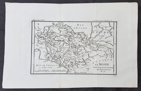
1787 Du Bocage & Barthelemy Antique Map of Boeotia, Greece - City of Thebes
- Title : La Beothie...1787
- Size: 15in x 10in (380mm x 255mm)
- Ref #: 16454
- Date : 1787
- Condition: (A+) Fine Condition
Description:
This original copper-plate engraved map by Jean Denis Barbie du Bocage was engraved in 1787 - dated in the title - and was published in the 1787 edition of Jean-Jacques Barthelemy famous Voyage du jeune Anarcharsis en Grece or Travels of Anacharsis the younger in Greece in 4 volumes.
General Definitions:
Paper thickness and quality: - Heavy and stable
Paper color : - off white
Age of map color: -
Colors used: -
General color appearance: -
Paper size: - 15in x 10in (380mm x 255mm)
Plate size: - 10 1/2in x 7in (270mm x 180mm)
Margins: - Min 1in (25mm)
Imperfections:
Margins: - None
Plate area: - Folds as issued
Verso: - None
Background:
Jean-Jacques Barthelemy 1716 – 1795 was a French writer and numismatist.
Barthelemy was the author of a number of learned works on antiquarian subjects, but the great work on which his fame rests is Travels of Anacharsis the younger in Greece (French: Voyage du jeune Anarcharsis en Grece, 4 vols., 1787). He had begun it in 1757 and had been working on it for thirty years. The hero, a young Scythian descended from the famous philosopher Anacharsis, is supposed to repair to Greece for instruction in his early youth, and after making the tour of her republics, colonies and islands, to return to his native country and write this book in his old age, after the Macedonian hero had overturned the Persian empire. In the manner of modern travellers, he gives an account of the customs, government, and antiquities of the country he is supposed to have visited. A copious introduction supplies whatever may be wanting in respect to historical details, while various dissertations on the music of the Greeks, on the literature of the Athenians, and on the economy, pursuits, ruling passions, manners, and customs of the surrounding states supply ample information on the subjects of which they treat.
Modern scholarship has superseded most of the details in the Voyage, but the author himself did not imagine his book to be a register of accurately ascertained facts. Rather, he intended to afford to his countrymen, in an interesting form, some knowledge of Greek civilisation. The Charicles, or Illustrations of the Private Life of the Ancient Greeks of Wilhelm Adolf Becker is an attempt in a similar direction
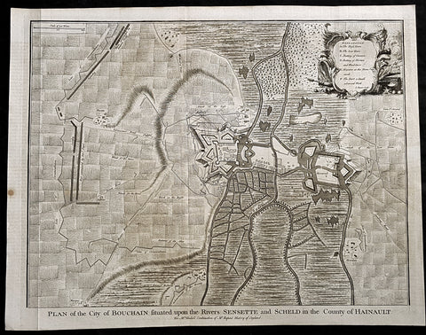
1745 Tindal Antique Map Battle Plan of Siege of Bouchain, Calais, France in 1711
- Title : Plan of the City of Bouchain Situated upon the Rivers Sensette and Scheld in the County of Hainault
- Size: 19 1/2in x 15 1/2in (495mm x 395mm)
- Ref #: 22198
- Date : 1745
- Condition: (A+) Fine Condition
Description:
This original copper-plate engraved antique map, battle plan & birds eye view of the French city of Bouchain on the Schedlt River, in the Pas-de-Calais dept. in northern France - during the Spanish War of Succession (1701-13) - was engraved by John Basire and was published in the 1745 edition of Nicholas Tindals Continuation of Mr. Rapin\'s History of England.
General Definitions:
Paper thickness and quality: - Heavy and stable
Paper color : - off white
Age of map color: -
Colors used: -
General color appearance: -
Paper size: - 19 1/2in x 15 1/2in (495mm x 395mm)
Plate size: - 19 1/2in x 15 1/2in (495mm x 395mm)
Margins: - Min 1/2in (12mm)
Imperfections:
Margins: - None
Plate area: - Folds as issued
Verso: - None
Background:
The Siege of Bouchain (9 August – 12 September 1711), following the Passage of the Lines of Ne Plus Ultra (5 August 1711), was a siege of the War of the Spanish Succession, and the last major victory of John Churchill, 1st Duke of Marlborough. Marlborough broke through the French defensive lines and took Bouchain after a siege of 34 days. Its capture left Cambrai the only French-held fortress between the allied army and Paris.
Throughout the early summer of 1711 Marlborough\'s army, having taken the important fortress of Douai the previous year, manoeuvred indecisively in northern France, blocked by the French Lines of Ne Plus Ultra – a massive series of fieldworks stretching from the Channel coast to the Ardennes at Namur. The allied army had been weakened by the withdrawal of Prince Eugene\'s army to cover the upper Rhine, as the deposed Elector of Bavaria attempted to take advantage of the disruption caused by the death of the Emperor Joseph. On 6 July, Marlborough captured the small fortress of Arleux, just to the north of the Lines, west of Bouchain, both to deny its use to the French as a sally-port, and to secure the water supply to Douai, which could be cut off by damming the canal that supplied the town. The Duke was then wrong-footed by Villars as the French army crossed the Lines on 22/23 July and retook Arleux, with the allied army too far to the west to intervene in time, and the defences were levelled before the French retreated back across the Lines. Marlborough, initially furious, soon retook the initiative by marching his army as if to assault the Lines near Arras, and carrying out a detailed personal reconnaissance there on 4 August in full view of Villars\' covering army. That night the army struck camp, leaving their campfires burning to deceive the French, and marched eastwards to Arleux. At midnight a force from Douai under Cadogan crossed the unguarded French lines, and by 8 am the advance guard of the main army was also crossing over. Villars, arriving on the scene with a few hundred cavalry, realised he had been outmanoeuvred, and though he attempted to offer battle in front of Bourlon Wood, Marlborough declined to attack, the Marshal\'s position being even stronger than the one in which he had given Marlborough\'s army such a mauling two years earlier at Malplaquet. He thus drew off and attempted to hinder Marlborough\'s siege of Bouchain which followed.
To defend the town Bouchain\'s governor, de Ravignau, had some 5,000 men against Marlborough\'s besieging army of 30,000, and the advantage of one of the strongest fortresses left to France, surrounded by the marshy land of the confluence of the rivers Scheldt and Sensée. In addition, Villars\' strong army had taken up position to the west of the allied camp, and had managed to open a tenuous link to the besieged garrison. Marlborough responded by using earthwork gun batteries to counter Villars, used a crack assault force managed by 18 August to once more cut the Marshal\'s communication with Bouchain, and established a fieldwork-protected corridor from the siege camp to his main supply port at Marchiennes on the Scarpe. Frequent raids by Villars on both the supply convoys on the Scarpe, and towards Douai, failed to interrupt the siege, and the garrison marched out to become prisoners of war on 13 September 1711.
Bouchain was Marlborough\'s last campaign. On the last day of the year he was stripped of his position as Captain-General, and of all his other offices. Command of the army on the continent for the campaign of 1712 was given to the Duke of Ormonde, and strict limitations were placed on his freedom of movement. Particularly he was prohibited from engaging the French in battle, as Anglo-French peace talks were well advanced, and the opportunity of seizing Cambrai and marching on Paris, opened by Marlborough\'s gains the year before, was abandoned. Before the year was out, the British army would withdraw from the alliance, leaving the remaining allies, under Eugene of Savoy to be defeated at Denain.
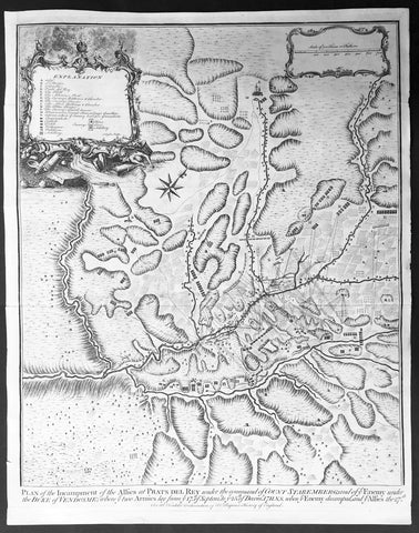
1745 Tindal Antique Map of Spanish & Austrian Armies in Catalonia Spain in 1711
- Title : Plan of the Incampment of the Allies at Prats Del Rey. under the command of Count Staremberg and of ye Enemy under the Duke of Vendsome: wher ye two Armies lay from ye 17th of September to ye 25th of December 1711 N.S. when ye Enemy decamped and ye Allies the 27th.
- Size: 19 1/2in x 15 1/2in (495mm x 395mm)
- Ref #: 15657
- Date : 1745
- Condition: (A+) Fine Condition
Description:
This original copper-plate engraved antique map, a battle plan of the encampments of the Spanish army under Louis-Joseph, duke de Vendome & the Austrian Army under Count Guido Starhemberg in Prado Del Rey in Catalonia, Spain - during the Spanish War of Succession (1701-13) - was engraved by John Basire and was published in the 1745 edition of Nicholas Tindals Continuation of Mr. Rapins History of England.
General Definitions:
Paper thickness and quality: - Heavy and stable
Paper color : - off white
Age of map color: -
Colors used: -
General color appearance: -
Paper size: - 19 1/2in x 15 1/2in (495mm x 395mm)
Plate size: - 19 1/2in x 15 1/2in (495mm x 395mm)
Margins: - Min 1/2in (12mm)
Imperfections:
Margins: - None
Plate area: - Folds as issued
Verso: - None
Background:
Duke Louis-Joseph de Vendome , 1654 — 1712 was one of King Louis XIV’s leading generals during the War of the Spanish Succession (1701–14).
Vendome was the son of Louis de Vendome, Duke de Mercoeur, by his marriage to Cardinal Jules Mazarin’s niece, Laure Mancini. Vendôme entered the French Army in 1672 and had risen to the rank of lieutenant general by the outbreak of the War of the Grand Alliance (1689–97) between France and the other major powers. He distinguished himself in the victory over the Allies at Steenkirke (1692) and was made commander in Catalonia in 1695; two years later he captured Barcelona.
The dispute over the succession to the Spanish throne brought France and Spain to war with the British, the Austrians, and the Dutch in 1701. Appointed to the command in northern Italy in 1702, Vendôme fought the Austrian commander, Prince Eugene of Savoy, in the bloody but indecisive Battle of Luzzara on August 15. He took Vercelli in 1704 and defeated Prince Eugene at Cassano in August 1705. In May 1706 Vendôme was transferred to the Flanders front, where the British commander John Churchill, 1st Duke of Marlborough, had just won an overwhelming victory at Ramillies. Vendôme made limited gains until he was severely defeated by Marlborough and Prince Eugene at Oudenaarde on July 11, 1708. Vendôme subsequently failed to relieve besieged Lille (in northern France), which fell to the Allies in October. Recalled by Louis XIV, he was temporarily disgraced.
Guido Wald Rüdiger, count of Starhemberg1657 – 1737 was an Austrian military officer.
He was a cousin of Ernst Rudiger von Starhemberg (1638-1701), the famous commander of Vienna during the Turkish siege of 1683, and acted as his aide-de-camp during that siege. Guido followed his cousin, and later Prince Eugene of Savoy, in battles against the Turks.
In the War of the Spanish Succession, Starhemberg fought in Italy and Spain. Between 1706 and 1708 he was the commander-in-chief of the imperial army in Hungary, leading military operations against the insurgents of Francis II Rákóczi. In 1708, he was appointed Supreme Commander of the Austrians in Spain.
Together with James Stanhope he succeeded in conquering Madrid in 1710, after previously gaining victories at Almenar and Saragossa. In December, however, he was forced to leave the city by the lack of support by its inhabitants for the Habsburg pretender. After the subsequent defeats at the Battle of Brihuega and the Battle of Villaviciosa (1710), he had to pull back to Catalonia, where he was made viceroy when Archduke Charles returned to Austria.
After the Peace of Utrecht (1713), archduke Charles, now Emperor Charles VI, ordered him to abandon Catalonia. He pulled back with his troops to Genoa on English ships.
When he died in 1737, he was Governor of Slavonia
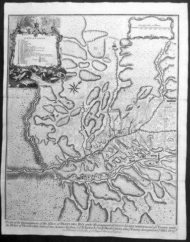
1745 Tindal Antique Map of Spanish & Austrian Armies in Catalonia Spain in 1711
- Title : Plan of the Incampment of the Allies at Prats Del Rey. under the command of Count Staremberg and of ye Enemy under the Duke of Vendsome: wher ye two Armies lay from ye 17th of September to ye 25th of December 1711 N.S. when ye Enemy decamped and ye Allies the 27th.
- Size: 19 1/2in x 15 1/2in (495mm x 395mm)
- Ref #: 15687
- Date : 1745
- Condition: (A+) Fine Condition
Description:
This original copper-plate engraved antique map, a battle plan of the encampments of the Spanish army under Louis-Joseph, duke de Vendome & the Austrian Army under Count Guido Starhemberg in Prado Del Rey in Catalonia, Spain - during the Spanish War of Succession (1701-13) - was engraved by John Basire and was published in the 1745 edition of Nicholas Tindals Continuation of Mr. Rapins History of England.
General Definitions:
Paper thickness and quality: - Heavy and stable
Paper color : - off white
Age of map color: -
Colors used: -
General color appearance: -
Paper size: - 19 1/2in x 15 1/2in (495mm x 395mm)
Plate size: - 19 1/2in x 15 1/2in (495mm x 395mm)
Margins: - Min 1/2in (12mm)
Imperfections:
Margins: - None
Plate area: - Folds as issued
Verso: - None
Background:
Duke Louis-Joseph de Vendome , 1654 — 1712 was one of King Louis XIV’s leading generals during the War of the Spanish Succession (1701–14).
Vendome was the son of Louis de Vendome, Duke de Mercoeur, by his marriage to Cardinal Jules Mazarin’s niece, Laure Mancini. Vendôme entered the French Army in 1672 and had risen to the rank of lieutenant general by the outbreak of the War of the Grand Alliance (1689–97) between France and the other major powers. He distinguished himself in the victory over the Allies at Steenkirke (1692) and was made commander in Catalonia in 1695; two years later he captured Barcelona.
The dispute over the succession to the Spanish throne brought France and Spain to war with the British, the Austrians, and the Dutch in 1701. Appointed to the command in northern Italy in 1702, Vendôme fought the Austrian commander, Prince Eugene of Savoy, in the bloody but indecisive Battle of Luzzara on August 15. He took Vercelli in 1704 and defeated Prince Eugene at Cassano in August 1705. In May 1706 Vendôme was transferred to the Flanders front, where the British commander John Churchill, 1st Duke of Marlborough, had just won an overwhelming victory at Ramillies. Vendôme made limited gains until he was severely defeated by Marlborough and Prince Eugene at Oudenaarde on July 11, 1708. Vendôme subsequently failed to relieve besieged Lille (in northern France), which fell to the Allies in October. Recalled by Louis XIV, he was temporarily disgraced.
Guido Wald Rüdiger, count of Starhemberg1657 – 1737 was an Austrian military officer.
He was a cousin of Ernst Rudiger von Starhemberg (1638-1701), the famous commander of Vienna during the Turkish siege of 1683, and acted as his aide-de-camp during that siege. Guido followed his cousin, and later Prince Eugene of Savoy, in battles against the Turks.
In the War of the Spanish Succession, Starhemberg fought in Italy and Spain. Between 1706 and 1708 he was the commander-in-chief of the imperial army in Hungary, leading military operations against the insurgents of Francis II Rákóczi. In 1708, he was appointed Supreme Commander of the Austrians in Spain.
Together with James Stanhope he succeeded in conquering Madrid in 1710, after previously gaining victories at Almenar and Saragossa. In December, however, he was forced to leave the city by the lack of support by its inhabitants for the Habsburg pretender. After the subsequent defeats at the Battle of Brihuega and the Battle of Villaviciosa (1710), he had to pull back to Catalonia, where he was made viceroy when Archduke Charles returned to Austria.
After the Peace of Utrecht (1713), archduke Charles, now Emperor Charles VI, ordered him to abandon Catalonia. He pulled back with his troops to Genoa on English ships.
When he died in 1737, he was Governor of Slavonia
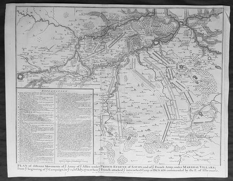
1745 Nicolas Tindal Original Antique Map Battle Plan of Denain, France in 1712
- Title : Plan of the movements of ye Armies of ye Allies under Prince Eugene of Savoy and of ye French Army under Marshal Villars; from ye beginning of ye campaign to ye 24th July 1712, when ye French attacked ye intrenchement Camp at Denain commanded by the E. of Albemarle
- Size: 19 1/2in x 15 1/2in (495mm x 395mm)
- Ref #: 15689
- Date : 1745
- Condition: (A+) Fine Condition
Description:
This original copper-plate engraved antique map, battle plan of the Battle of Denain - during the Spanish War of Succession (1701-13) - centering on the cities of Douai & Bouchain in northern France, was published in the 1745 edition of Nicholas Tindals Continuation of Mr. Rapin\'s History of England.
General Definitions:
Paper thickness and quality: - Heavy and stable
Paper color : - off white
Age of map color: -
Colors used: -
General color appearance: -
Paper size: - 19 1/2in x 15 1/2in (495mm x 395mm)
Plate size: - 19 1/2in x 15 1/2in (495mm x 395mm)
Margins: - Min 1/2in (12mm)
Imperfections:
Margins: - None
Plate area: - None
Verso: - None
Background:
The Battle of Denain was fought on 24 July 1712, as part of the War of the Spanish Succession. It resulted in a French victory under Marshal Villars against Dutch and Austrian forces under Prince Eugene of Savoy.
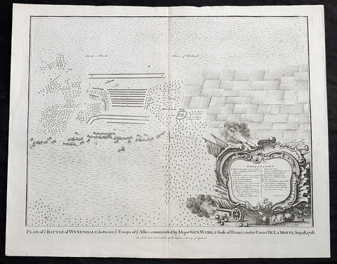
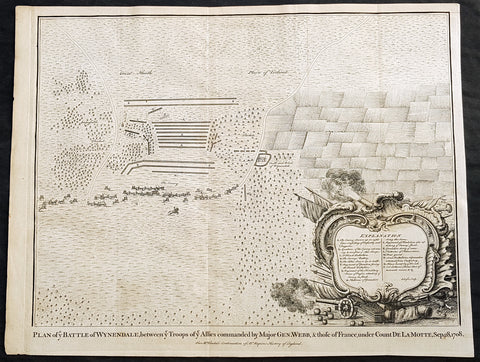
1745 Nicolas Tindal Original Antique Map Battle of Wijnendale Flanders Belgium in 1708
- Title : Plan of the Battle of Wynendale, between ye Troops of ye Allies commanded by Major Gen. Webb & those of France under count de la Motte Sep. 28, 1708
- Size: 19 1/2in x 15 1/2in (495mm x 395mm)
- Ref #: 22165
- Date : 1745
- Condition: (A+) Fine Condition
Description:
This original copper-plate engraved antique map, plan of the The Battle of Wijnendale, Flanders, Belgium in 1708 - during the Spanish War of Succession (1701-13) - was engraved by John Basire and was published in the 1745 edition of Nicholas Tindals Continuation of Mr. Rapin\'s History of England.
General Definitions:
Paper thickness and quality: - Heavy and stable
Paper color : - off white
Age of map color: -
Colors used: -
General color appearance: -
Paper size: - 19 1/2in x 15 1/2in (495mm x 395mm)
Plate size: - 19 1/2in x 15 1/2in (495mm x 395mm)
Margins: - Min 1/2in (12mm)
Imperfections:
Margins: - None
Plate area: - None
Verso: - None
Background:
The Battle of Wijnendale was a battle in the War of the Spanish Succession fought on 28 September 1708 near Wijnendale, Flanders, between an allied force protecting a convoy for the Siege of Lille (1708) and forces of Bourbon France and Spain. It ended in a victory for the allies, leading to the taking of Lille.
After their great victory in the Battle of Oudenaarde (11 July 1708), Marlborough and Prince Eugene of Savoy decided to besiege Lille. But Lille was very well defended by modern fortifications designed by Vauban and a garrison of 16,000 men. The allied siege didn\'t go as well as planned and a lack of ammunition was imminent. To make things worst, the supply lines from the east were cut by the French, so the only remaining line of supply was by ship from England to the port of Ostend, some 75 km from Lille.
Marlborough ordered the necessary goods to be shipped to Ostend and a large convoy of 700 slow wagons was organised there to travel further over land to Lille. The convoy was protected by 6,000 infantry and 1,500 cavalry under command of general-major John Richmond Webb.
The commander of the French garrison of Bruges, Count de la Mothe, was informed of the convoy and gathered a force of 22,000 to 24,000 men towards Wijnendale to intercept the convoy.
Webb was aware of the advancing French army and knew a confrontation was unavoidable. He drew up a plan to compensate for his numerical disadvantage. Using the wooded landscape around Wijnendale, he chose an open spot, flanked on both sides by woods and hedges. He placed his troops in two long lines, closing off this open space. Later a third line was formed with reinforcements coming from Oudenburg. Meanwhile, behind these lines, the convoy continued slowly towards Lille.
While Webb was deploying his troops, Prussian general Carl von Lottum, with only 150 cavalry harassed the approaching French army, gaining valuable time, and preventing de la Mothe to gather knowledge of the terrain and the plans of the allies.
Having arrived at the open space, de la Mothe, expecting an easy victory, deployed his army as expected. Between 4 and 5 pm the French artillery opened fire. When de la Mothe saw the effects on the enemy were limited, he ordered his infantry forward. The large French force was hampered by the narrow terrain and suffered badly from the fire of the allied first line, which held its ground. Then Webb ordered the Prussian, Hanoverian and Dutch regiments who were hidden in the woods on both flanks, to open fire. Despite suffering heavy casualties, de la Mothe ordered a second attack, which initially pushed the allied first line back. But with the help of the second line and the continuous fire from the flanks, the French were stopped and forced to withdraw and leave the battlefield.
When the battle was as good as won, allied cavalry under command of William Cadogan arrived at the battlefield. He was sent from Lille by Marlborough, who was worried about the convoy.
The toll of this two-hour battle was heavy: 3,000 to 4,000 French and Spanish soldiers were killed or wounded. The allies lost 900 dead and wounded.
The convoy reached Lille intact on 29 September, allowing the siege to continue. Three weeks later, on 22 October, the city was taken.
For political reasons, Marlborough gave in his initial dispatch the credit for the victory to William Cadogan, also a Whig. But Webb subsequently received full credit and the thanks of Parliament for the action, and the following year he was promoted to Lieutenant-General. From this point onwards Webb became the centre of Tory agitation against Marlborough.
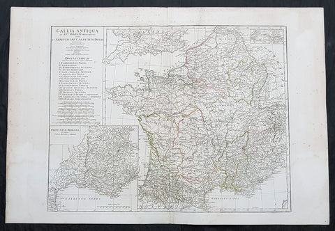
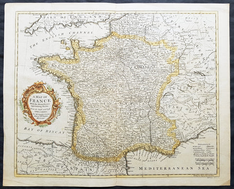
1760 J B D Anville Large Antique Map of Roman France
- Title : Gallia Antiqua ex Aevi Romani......D Anville...MDCCLX
- Size: 30in x 21in (760mm x 535mm)
- Condition: (A) Very Good Condition
- Date : 1760 (dated)
- Ref #: 92296
Description:
This large original copper plate engraved antique map of Roman France was engraved in 1760 - dated in the tile cartouche - and was published in Jean-Baptiste Bourguinon D Anvilles large elephant folio atlas Atlas Generale.
General Definitions:
Paper thickness and quality: - Heavy and stable
Paper color : - off white
Age of map color: - Original
Colors used: - Yellow, Green, pink
General color appearance: - Authentic
Paper size: - 30in x 21in (760mm x 535mm)
Plate size: - 23 1/2in x 18 1/4in (595mm x 465mm)
Margins: - Min 1/2in (12mm)
Imperfections:
Margins: - Creasing, light age toning
Plate area: - Creasing
Verso: - Creasing, light age toning
Background:
In 600 BC, Ionian Greeks, originating from Phocaea, founded the colony of Massalia (present-day Marseille), on the shores of the Mediterranean Sea. This makes it Frances oldest city. At the same time, some Gallic Celtic tribes penetrated parts of the current territory of France, and this occupation spread to the rest of France between the 5th and 3rd century BC.
The concept of Gaul emerged at that time; it corresponds to the territories of Celtic settlement ranging between the Rhine, the Atlantic Ocean, the Pyrenees and the Mediterranean. The borders of modern France are roughly the same as those of ancient Gaul, which was inhabited by Celtic Gauls. Gaul was then a prosperous country, of which the southernmost part was heavily subject to Greek and Roman cultural and economic influences.
Around 390 BC the Gallic chieftain Brennus and his troops made their way to Italy through the Alps, defeated the Romans in the Battle of the Allia, and besieged and ransomed Rome. The Gallic invasion left Rome weakened, and the Gauls continued to harass the region until 345 BC when they entered into a formal peace treaty with Rome. But the Romans and the Gauls would remain adversaries for the next centuries, and the Gauls would continue to be a threat in Italy.
Around 125 BC, the south of Gaul was conquered by the Romans, who called this region Provincia Nostra (Our Province), which over time evolved into the name Provence in French. Julius Caesar conquered the remainder of Gaul and overcame a revolt carried out by the Gallic chieftain Vercingetorix in 52 BC. According to Plutarch and the writings of scholar Brendan Woods, the Gallic Wars resulted in 800 conquered cities, 300 subdued tribes, one million men sold into slavery, and another three million dead in battle.
Gaul was divided by Augustus into Roman provinces. Many cities were founded during the Gallo-Roman period, including Lugdunum (present-day Lyon), which is considered the capital of the Gauls. These cities were built in traditional Roman style, with a forum, a theatre, a circus, an amphitheatre and thermal baths. The Gauls mixed with Roman settlers and eventually adopted Roman culture and Roman speech (Latin, from which the French language evolved). The Roman polytheism merged with the Gallic paganism into the same syncretism.
From the 250s to the 280s AD, Roman Gaul suffered a serious crisis with its fortified borders being attacked on several occasions by barbarians. Nevertheless, the situation improved in the first half of the 4th century, which was a period of revival and prosperity for Roman Gaul. In 312, Emperor Constantin I converted to Christianity. Subsequently, Christians, who had been persecuted until then, increased rapidly across the entire Roman Empire. But, from the beginning of the 5th century, the Barbarian Invasions resumed. Teutonic tribes invaded the region from present-day Germany, the Visigoths settling in the southwest, the Burgundians along the Rhine River Valley, and the Franks (from whom the French take their name) in the north.
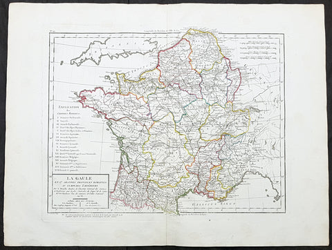
1797 Edme Mentelle & Pierre Tardieu Large Antique Map of France
- Title : La Gaule en 17 Grandes Provinces Romaines au Temps des Empereurs...
- Size: 23in x 17in (590mm x 435mm)
- Condition: (A+) Fine Condition
- Date : 1797
- Ref #: 26677
Description:
This large original hand coloured antique map of France by Edme Mentelle was engraved by Pierre Tardieu and was published in the 1797 edition of Mentelles Atlas Universal. (Ref: Tooley; M&B)
General Definitions:
Paper thickness and quality: - Heavy and stable
Paper color : - off white
Age of map color: - Original
Colors used: - Yellow, green, blue, pink
General color appearance: - Authentic
Paper size: - 23in x 17in (590mm x 435mm)
Plate size: - 17 1/2in x 14in (435mm x 355mm)
Margins: - Min 1in (25mm)
Imperfections:
Margins: - None
Plate area: - None
Verso: - None
Mentelle, Edme 1730 - 1816
Mentelle was a French geographer.
Student of Jean-Baptiste Louis Crévier at the Collège de Beauvais (at the time a constituent college of the University of Paris), he found employment with the Ferme générale.
The poems and comedic plays he published early in his career were not successful. He turned to the study of geography and taught geography at the École Militaire during the 1760s. During the 1780s he taught geography to the royal household and in 1786 designed a globe, which is still on display in the Dauphins apartments at the Palace of Versailles.
A supporter of the French Revolution, he taught at the Écoles centrales and at the École Normale Supérieure. He was elected to the Institut de France in 1795.
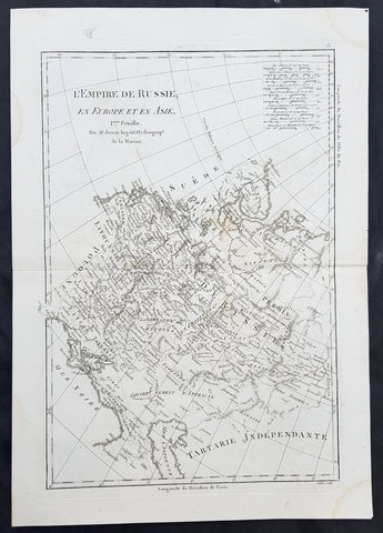
1780 Rigobert Bonne Original Antique Map of Western, European Russia, Poland
- Title : L Empire de Russie en Europe et an Asie...M Bonne
- Size: 15in x 10in (380mm x 255mm)
- Ref #: 40527
- Date : 1780
- Condition: (A+) Fine Condition
Description:
This original copper-plate engraved map was published in 1780 edition of Atllas des toutes les parties connues du globe terrestre by Rigobert Bonne & Guillaume Raynal.
General Definitions:
Paper thickness and quality: - Heavy and stable
Paper color : - off white
Age of map color: -
Colors used: -
General color appearance: -
Paper size: - 15in x 10in (380mm x 255mm)
Plate size: - 13in x 9in (330mm x 230mm)
Margins: - Min 1in (25mm)
Imperfections:
Margins: - None
Plate area: - None
Verso: - None
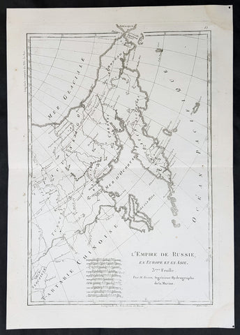
1780 Rigobert Bonne Original Antique Map of Eastern Russia, China
- Title : L Empire de Russie en Europe et an Asie...M Bonne
- Size: 15in x 10in (380mm x 255mm)
- Ref #: 40528
- Date : 1780
- Condition: (A+) Fine Condition
Description:
This original copper-plate engraved map was published in 1780 edition of Atllas des toutes les parties connues du globe terrestre by Rigobert Bonne & Guillaume Raynal.
General Definitions:
Paper thickness and quality: - Heavy and stable
Paper color : - off white
Age of map color: -
Colors used: -
General color appearance: -
Paper size: - 15in x 10in (380mm x 255mm)
Plate size: - 13in x 9in (330mm x 230mm)
Margins: - Min 1in (25mm)
Imperfections:
Margins: - None
Plate area: - None
Verso: - None
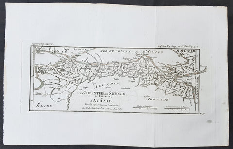
1786 Du Bocage & Barthelemy Antique Map Gulf of Corinth, Patra, Achaea Greece
- Title : La Corinthie, La Sicyonie, La Phliasie et L Achaie...1786
- Size: 15in x 10in (380mm x 255mm)
- Ref #: 16452
- Date : 1786
- Condition: (A+) Fine Condition
Description:
This original copper-plate engraved map by Jean Denis Barbie du Bocage was engraved in 1785 - dated in the title - and was published in the 1787 edition of Jean-Jacques Barthelemy famous Voyage du jeune Anarcharsis en Grece or Travels of Anacharsis the younger in Greece in 4 volumes.
General Definitions:
Paper thickness and quality: - Heavy and stable
Paper color : - off white
Age of map color: -
Colors used: -
General color appearance: -
Paper size: - 15in x 10in (380mm x 255mm)
Plate size: - 13in x 5 1/2in (330mm x 140mm)
Margins: - Min 1in (25mm)
Imperfections:
Margins: - None
Plate area: - Folds as issued
Verso: - None
Background:
Jean-Jacques Barthelemy 1716 – 1795 was a French writer and numismatist.
Barthelemy was the author of a number of learned works on antiquarian subjects, but the great work on which his fame rests is Travels of Anacharsis the younger in Greece (French: Voyage du jeune Anarcharsis en Grece, 4 vols., 1787). He had begun it in 1757 and had been working on it for thirty years. The hero, a young Scythian descended from the famous philosopher Anacharsis, is supposed to repair to Greece for instruction in his early youth, and after making the tour of her republics, colonies and islands, to return to his native country and write this book in his old age, after the Macedonian hero had overturned the Persian empire. In the manner of modern travellers, he gives an account of the customs, government, and antiquities of the country he is supposed to have visited. A copious introduction supplies whatever may be wanting in respect to historical details, while various dissertations on the music of the Greeks, on the literature of the Athenians, and on the economy, pursuits, ruling passions, manners, and customs of the surrounding states supply ample information on the subjects of which they treat.
Modern scholarship has superseded most of the details in the Voyage, but the author himself did not imagine his book to be a register of accurately ascertained facts. Rather, he intended to afford to his countrymen, in an interesting form, some knowledge of Greek civilisation. The Charicles, or Illustrations of the Private Life of the Ancient Greeks of Wilhelm Adolf Becker is an attempt in a similar direction
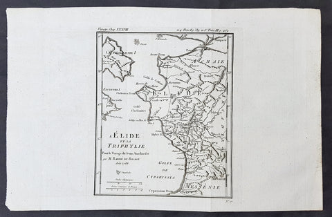
1786 Du Bocage & Barthelemy Antique Map of Elis Peloponnesos, Greece - Olympia
- Title : L Elide et La Triphylie....1786
- Size: 15in x 10in (380mm x 255mm)
- Ref #: 16451
- Date : 1786
- Condition: (A+) Fine Condition
Description:
This original copper-plate engraved map by Jean Denis Barbie du Bocage was engraved in 1785 - dated in the title - and was published in the 1787 edition of Jean-Jacques Barthelemy famous Voyage du jeune Anarcharsis en Grece or Travels of Anacharsis the younger in Greecein 4 volumes.
General Definitions:
Paper thickness and quality: - Heavy and stable
Paper color : - off white
Age of map color: -
Colors used: -
General color appearance: -
Paper size: - 15in x 10in (380mm x 255mm)
Plate size: - 8 1/2in x 7 1/2in (215mm x 190mm)
Margins: - Min 1in (25mm)
Imperfections:
Margins: - None
Plate area: - Folds as issued
Verso: - None
Background:
Jean-Jacques Barthelemy 1716 – 1795 was a French writer and numismatist.
Barthelemy was the author of a number of learned works on antiquarian subjects, but the great work on which his fame rests is Travels of Anacharsis the younger in Greece (French: Voyage du jeune Anarcharsis en Grece, 4 vols., 1787). He had begun it in 1757 and had been working on it for thirty years. The hero, a young Scythian descended from the famous philosopher Anacharsis, is supposed to repair to Greece for instruction in his early youth, and after making the tour of her republics, colonies and islands, to return to his native country and write this book in his old age, after the Macedonian hero had overturned the Persian empire. In the manner of modern travellers, he gives an account of the customs, government, and antiquities of the country he is supposed to have visited. A copious introduction supplies whatever may be wanting in respect to historical details, while various dissertations on the music of the Greeks, on the literature of the Athenians, and on the economy, pursuits, ruling passions, manners, and customs of the surrounding states supply ample information on the subjects of which they treat.
Modern scholarship has superseded most of the details in the Voyage, but the author himself did not imagine his book to be a register of accurately ascertained facts. Rather, he intended to afford to his countrymen, in an interesting form, some knowledge of Greek civilisation. The Charicles, or Illustrations of the Private Life of the Ancient Greeks of Wilhelm Adolf Becker is an attempt in a similar direction
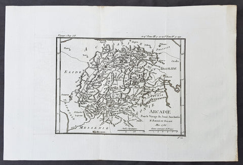
1782 Du Bocage & Barthelemy Antique Map of Arcadia Peloponnese, Greece - Tripoli
- Title : l Arcadie, Pour le Voyage du Jeune Anacharsis......1786
- Size: 15in x 10in (380mm x 255mm)
- Ref #: 16448
- Date : 1786
- Condition: (A+) Fine Condition
Description:
This original copper-plate engraved map by Jean Denis Barbie du Bocage was engraved in 1786 - dated in the title - and was published in the 1787 edition of Jean-Jacques Barthelemy famous Voyage du jeune Anarcharsis en Grece or Travels of Anacharsis the younger in Greecein 4 volumes.
General Definitions:
Paper thickness and quality: - Heavy and stable
Paper color : - off white
Age of map color: -
Colors used: -
General color appearance: -
Paper size: - 15in x 10in (380mm x 255mm)
Plate size: - 12in x 8 1/2in (305mm x 215mm)
Margins: - Min 1in (25mm)
Imperfections:
Margins: - None
Plate area: - Folds as issued
Verso: - None
Background:
Jean-Jacques Barthelemy 1716 – 1795 was a French writer and numismatist.
Barthelemy was the author of a number of learned works on antiquarian subjects, but the great work on which his fame rests is Travels of Anacharsis the younger in Greece (French: Voyage du jeune Anarcharsis en Grece, 4 vols., 1787). He had begun it in 1757 and had been working on it for thirty years. The hero, a young Scythian descended from the famous philosopher Anacharsis, is supposed to repair to Greece for instruction in his early youth, and after making the tour of her republics, colonies and islands, to return to his native country and write this book in his old age, after the Macedonian hero had overturned the Persian empire. In the manner of modern travellers, he gives an account of the customs, government, and antiquities of the country he is supposed to have visited. A copious introduction supplies whatever may be wanting in respect to historical details, while various dissertations on the music of the Greeks, on the literature of the Athenians, and on the economy, pursuits, ruling passions, manners, and customs of the surrounding states supply ample information on the subjects of which they treat.
Modern scholarship has superseded most of the details in the Voyage, but the author himself did not imagine his book to be a register of accurately ascertained facts. Rather, he intended to afford to his countrymen, in an interesting form, some knowledge of Greek civilisation. The Charicles, or Illustrations of the Private Life of the Ancient Greeks of Wilhelm Adolf Becker is an attempt in a similar direction

1784 Du Bocage & Barthelemy Antique Map of Plato's Academy in Athens, Greece
- Title : L Helles-Pont...1782
- Size: 15in x 10in (380mm x 255mm)
- Ref #: 16462
- Date : 1784
- Condition: (A+) Fine Condition
Description:
This original copper-plate engraved map by Jean Denis Barbie du Bocage was engraved in 1784 - dated in the title - and was published in the 1787 edition of Jean-Jacques Barthelemy famous Voyage du jeune Anarcharsis en Grece or Travels of Anacharsis the younger in Greecein 4 volumes.
General Definitions:
Paper thickness and quality: - Heavy and stable
Paper color : - off white
Age of map color: -
Colors used: -
General color appearance: -
Paper size: - 15in x 10in (380mm x 255mm)
Plate size: - 8 1/2in x 7 1/2in (215mm x 185mm)
Margins: - Min 1in (25mm)
Imperfections:
Margins: - None
Plate area: - Folds as issued
Verso: - None
Background:
Jean-Jacques Barthelemy 1716 – 1795 was a French writer and numismatist.
Barthelemy was the author of a number of learned works on antiquarian subjects, but the great work on which his fame rests is Travels of Anacharsis the younger in Greece (French: Voyage du jeune Anarcharsis en Grece, 4 vols., 1787). He had begun it in 1757 and had been working on it for thirty years. The hero, a young Scythian descended from the famous philosopher Anacharsis, is supposed to repair to Greece for instruction in his early youth, and after making the tour of her republics, colonies and islands, to return to his native country and write this book in his old age, after the Macedonian hero had overturned the Persian empire. In the manner of modern travellers, he gives an account of the customs, government, and antiquities of the country he is supposed to have visited. A copious introduction supplies whatever may be wanting in respect to historical details, while various dissertations on the music of the Greeks, on the literature of the Athenians, and on the economy, pursuits, ruling passions, manners, and customs of the surrounding states supply ample information on the subjects of which they treat.
Modern scholarship has superseded most of the details in the Voyage, but the author himself did not imagine his book to be a register of accurately ascertained facts. Rather, he intended to afford to his countrymen, in an interesting form, some knowledge of Greek civilisation. The Charicles, or Illustrations of the Private Life of the Ancient Greeks of Wilhelm Adolf Becker is an attempt in a similar direction
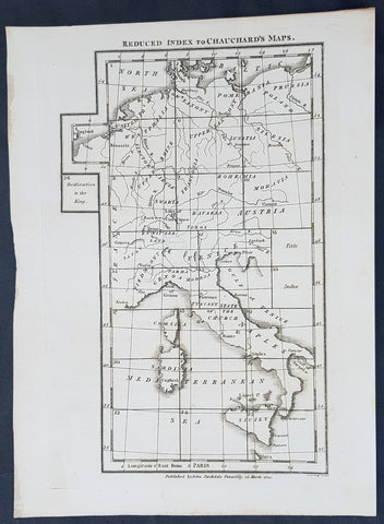
1800 Stockdale Original Antique Index Map of Capt Chauchards Maps Italy, Germany
- Title : Reduced Index to Chauchards Maps
- Size: 11 1/2in x 9in (290mm x 230mm)
- Ref #: 31148
- Date : 1800
- Condition: (A+) Fine Condition
Description:
This original copper-plate engraved antique index map to the 26 page map A general map of the empire of Germany, Holland, the Netherlands, Switzerland, the Grisons, Italy, Sicily, Corsica and Sardinia by Captain Chauchard published by John Stockdale in 1800 - dated. (Ref: Tooley; M&B)
General Definitions:
Paper thickness and quality: - Heavy and stable
Paper color : - off white
Age of map color: -
Colors used: -
General color appearance: -
Paper size: - 11 1/2in x 9in (290mm x 230mm)
Plate size: - 10 1/2in x 7in (265mm x 180mm)
Margins: - Min 1/2in (12mm)
Imperfections:
Margins: - None
Plate area: - None
Verso: - None
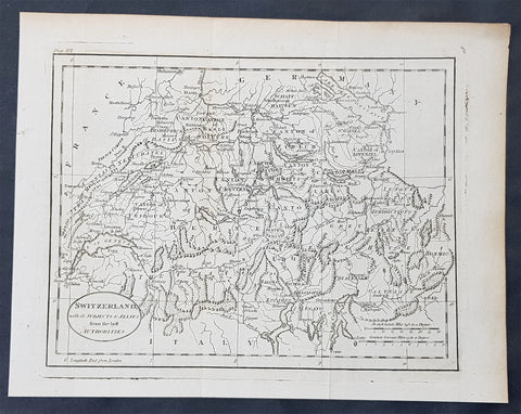
1770 John Cary Original Antique Map of Switzerland
- Title : Switzerland with its Subjects & Allies from the Best Authorities
- Size: 10 1/2in x 8 1/2in (265mm x 215mm)
- Ref #: 70188
- Date : 1770
- Condition: (A+) Fine Condition
Description:
This fine original copper-plate engraved antique map by Thomas Kitchen was published in the 1770 edition of the atlas for William Guthries Geographical Grammar
General Definitions:
Paper thickness and quality: - Heavy and stable
Paper color : - off white
Age of map color: -
Colors used: -
General color appearance: -
Paper size: - 10 1/2in x 8 1/2in (265mm x 215mm)
Plate size: - 10 1/2in x 8 1/2in (265mm x 215mm)
Margins: - Min 1/2in (12mm)
Imperfections:
Margins: - None
Plate area: - Folds as issued
Verso: - None
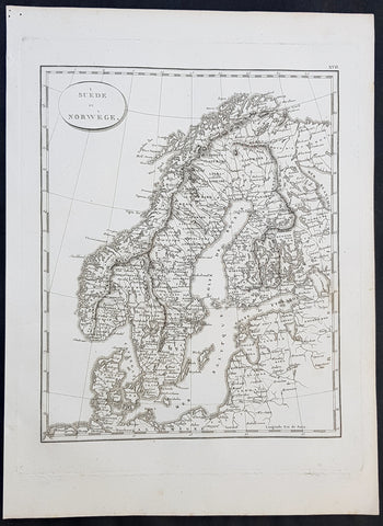
1804 Jean N Buache Original Antique Map of Scandinavia, Sweden Norway & Baltics
- Title : A Suede et Norwege
- Size: 13in x 9 1/2in (330mm x 245mm)
- Ref #: 34191
- Date : 1804
- Condition: (A+) Fine Condition
Description:
This fine original copper-plate engraved antique map was published in the 1804 edition of Jean Nicolas Buache Atlas Geographie Moderne.
The maps in this atlas were illustrated by Jean Nicolas Buache - nephew to Phillipe Buache who was son-in-law to Nicolas Delisle - after maps published by the Scottish publisher John Pinkerton.
General Definitions:
Paper thickness and quality: - Heavy and stable
Paper color : - off white
Age of map color: -
Colors used: -
General color appearance: -
Paper size: - 13in x 9 1/2in (330mm x 245mm)
Plate size: - 11in x 9in (280mm x 230mm)
Margins: - Min 1/2in (12mm)
Imperfections:
Margins: - Light soiling in margins
Plate area: - None
Verso: - None
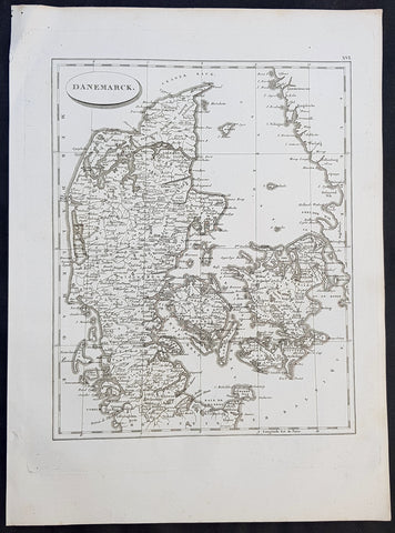
1804 Jean N Buache Original Antique Map of Denmark
- Title : Danemarck
- Size: 13in x 9 1/2in (330mm x 245mm)
- Ref #: 34190
- Date : 1804
- Condition: (A+) Fine Condition
Description:
This fine original copper-plate engraved antique map was published in the 1804 edition of Jean Nicolas Buache Atlas Geographie Moderne.
The maps in this atlas were illustrated by Jean Nicolas Buache - nephew to Phillipe Buache who was son-in-law to Nicolas Delisle - after maps published by the Scottish publisher John Pinkerton.
General Definitions:
Paper thickness and quality: - Heavy and stable
Paper color : - off white
Age of map color: -
Colors used: -
General color appearance: -
Paper size: - 13in x 9 1/2in (330mm x 245mm)
Plate size: - 11in x 9in (280mm x 230mm)
Margins: - Min 1/2in (12mm)
Imperfections:
Margins: - Light soiling in margins
Plate area: - None
Verso: - None
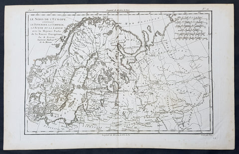
1780 Bonne Original Antique Map of Scandinavia, Baltic States & European Russia
- Title : Le Nord De L Europe contenant Le Danemark La Norwege, La Suede et la Laponie avec la Majeure Partie de la Russie Europeenne Par M Bonne
- Size: 16in x 11in (405mm x 2805mm)
- Ref #: 31671
- Date : 1780
- Condition: (A+) Fine Condition
Description:
This fine original copper-plate engraved antique map of Scandinavia, The Baltic States & European Russia was published in 1780 edition of Atlas des toutes les parties connues du globe terrestre by Rigobert Bonne & Guillaume Raynal.
General Definitions:
Paper thickness and quality: - Heavy and stable
Paper color : - off white
Age of map color: -
Colors used: -
General color appearance: -
Paper size: - 16in x 11in (405mm x 2805mm)
Plate size: - 14in x 10in (355mm x 255mm)
Margins: - Min 1/2in (12mm)
Imperfections:
Margins: - None
Plate area: - None
Verso: - None
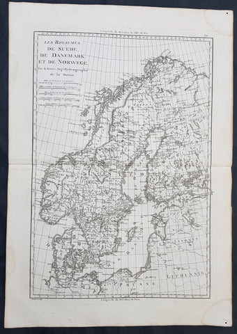
1780 Rigobert Bonne Original Antique Map of Scandinavia Sweden, Norway & Denmark
- Title : Les Royaumes De Suede De Denmark et de Norwege
- Size: 16in x 11in (405mm x 2805mm)
- Ref #: 40525
- Date : 1780
- Condition: (A+) Fine Condition
Description:
This fine original copper-plate engraved antique map of Scandinavia, Sweden, Norwaty and Denmark was published in 1780 edition of Atlas des toutes les parties connues du globe terrestre by Rigobert Bonne & Guillaume Raynal.
General Definitions:
Paper thickness and quality: - Heavy and stable
Paper color : - off white
Age of map color: -
Colors used: -
General color appearance: -
Paper size: - 16in x 11in (405mm x 2805mm)
Plate size: - 14in x 10in (355mm x 255mm)
Margins: - Min 1/2in (12mm)
Imperfections:
Margins: - None
Plate area: - None
Verso: - None
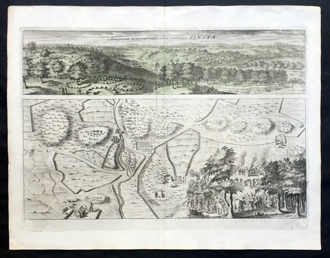
1709 Dahlbergh & Aveelen Antique Map & View of Finsta in Stockholm, Sweden
- Title : Finsta
- Ref #: 70449
- Size: 16 1/2in x 12 1/2in (420mm x 315mm)
- Date : 1709
- Condition: (A+) Fine Condition
Description:
This large original copper-plate engraved antique map & view of Finsta in Stockholm, Sweden by Johannes van den Aveelen was published in the 1709 edition of Erik Dahlbergh's Suecia Antiqua et Hodierna (Ancient and Modern Sweden).
Finsta is a locality situated in Norrtälje Municipality, Stockholm County, Sweden
Background: Suecia Antiqua et Hodierna (ancient and modern Sweden) is a collection of engravings collected by Erik Dahlbergh during the middle of the 17th century. Suecia Antiqua et Hodierna can be described as a grand vision of Sweden during its period as a great power. Dahlberg's direct source of inspiration was the topographical publications issued by the Swiss publisher Matthäus Merian.
In 1661 Dahlberg was granted a royal privilege enabling him to realize his plans, which kept him occupied for a good decade, and a work that would not be printed until after his death. In its final state Suecia Antiqua et Hodierna comprised three volumes containing 353 plates.
Jan van den Aveele or Aveelen (1650 - 1727) was a Dutch etcher and copper engraver. With compatriot Willem Swidde, he made engravings for Suecia Antiqua et Hodierna ("Ancient and Modern Sweden") including depictions of public buildings and city scapes in Stockholm and other Swedish cities. (Ref Tooley M&B)
General Description:
Paper thickness and quality: - Heavy and stable
Paper color: - off white
Age of map color: -
Colors used: -
General color appearance: -
Paper size: - 16 1/2in x 12 1/2in (420mm x 315mm)
Plate size: - 13in x 10in (330mm x 255mm)
Margins: - Min 1/2in (12mm)
Imperfections:
Margins: - None
Plate area: - None
Verso: - None
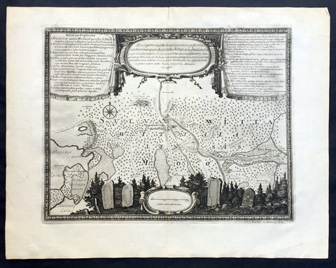
1709 Dahlbergh & Aveelen Antique Map of Vittalia, Smaland Region of Sweden
- Title : Situs pervetusta....Vittaliae
- Ref #: 70448
- Size: 16 1/2in x 12 1/2in (420mm x 315mm)
- Date : 1709
- Condition: (A+) Fine Condition
Description:
This large original copper-plate engraved antique map of of the ancient region of Vittalia, Smaland in Southern Sweden by Johannes van den Aveelen was published in the 1709 - dated at the foot of the map - edition of Erik Dahlbergh's Suecia Antiqua et Hodierna (Ancient and Modern Sweden). Erik Dahlbergh.
Smaland is a province in southern Sweden. Smaland borders Scania, Blekinge, Halland, Västergötland, Östergötland and the island Öland in the Baltic Sea.
Background: Suecia Antiqua et Hodierna (ancient and modern Sweden) is a collection of engravings collected by Erik Dahlbergh during the middle of the 17th century. Suecia Antiqua et Hodierna can be described as a grand vision of Sweden during its period as a great power. Dahlberg's direct source of inspiration was the topographical publications issued by the Swiss publisher Matthäus Merian.
In 1661 Dahlberg was granted a royal privilege enabling him to realize his plans, which kept him occupied for a good decade, and a work that would not be printed until after his death. In its final state Suecia Antiqua et Hodierna comprised three volumes containing 353 plates.
Jan van den Aveele or Aveelen (1650 - 1727) was a Dutch etcher and copper engraver. With compatriot Willem Swidde, he made engravings for Suecia Antiqua et Hodierna ("Ancient and Modern Sweden") including depictions of public buildings and city scapes in Stockholm and other Swedish cities. (Ref Tooley M&B)
General Description:
Paper thickness and quality: - Heavy and stable
Paper color: - off white
Age of map color: -
Colors used: -
General color appearance: -
Paper size: - 16 1/2in x 12 1/2in (420mm x 315mm)
Plate size: - 13in x 10in (330mm x 255mm)
Margins: - Min 1/2in (12mm)
Imperfections:
Margins: - None
Plate area: - None
Verso: - None
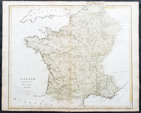
1808 Dr Playfair Large Old, Antique Map of France - Gallia
- Title : Gallia Drawn & Engraved Dr Playfairs Geography
- Ref #: 31155
- Size: 23 1/2in x 19in (595mm x 485mm)
- Date : 1808
- Condition: (A+) Fine Condition
Description:
This large original antique copper-plate engraved map of France was engraved in 1808 by B Smith - dated at the foot of the map - and was published in the 1808 edition of Dr Playfair's General Atlas. (Ref Tooley M&B)
General Description:
Paper thickness and quality: - Heavy and stable
Paper color: - off white
Age of map color: - Early
Colors used: - Green, yellow
General color appearance: - Authentic
Paper size: - 23 1/2in x 19in (595mm x 485mm)
Plate size: - 23 1/2in x 19in (595mm x 485mm)
Margins: - Min 1/2in (12mm)
Imperfections:
Margins: - Light age toning in margins
Plate area: - None
Verso: - None
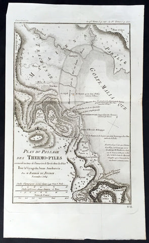
1784 Du Bocage Large Antique Map of Thermopylae Pass, Greece
- Title : Plan Du Passage Des Thermo-Pyles...Barbie Du Bocage 1784
- Ref #: 16470
- Size: 15 3/4in x 9 1/2in (400mm x 240mm)
- Date : 1784
- Condition: (A+) Fine Condition
Description:
This fine large original antique map or plan of the Thermopylae Pass Greece, was engraved in 1784 - dated - and was published by Jean Denis Barbie du Bocage in his Voyage Anacharsis (The Travels of Anacharsis the Younger in Greece)published between 1781 - 1788.
Voyage Anacharsis is an illustrative account of the travels of Anacharsis the Younger in Greece, during the middle of the fourth century before the Christian era.
General Description:
Paper thickness and quality: - Heavy & stable
Paper color: - White
Age of map color: -
Colors used: -
General color appearance: -
Paper size: - 15 3/4in x 9 1/2in (400mm x 240mm)
Plate size: - 13in x 9in (335mm x 230mm)
Margins: - Min 1/2in (12mm)
Imperfections:
Margins: - None
Plate area: - Folds as issued
Verso: - None
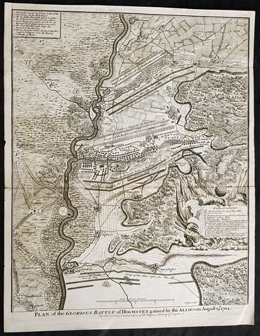
1745 Nicolas Tindal Antique Map The Battle of Blenheim, Germany in 1704
- Title : Plan of the Glorious Battle of Hochstet gained by the Allies on August 13.th 1704.
- Size: 21in x 17in (530mm x 430mm)
- Ref #: 15692-1
- Date : 1745
- Condition: (A+) Fine Condition
Description:
This original copper-plate engraved antique map, plan of the The Battle of Blenheim or Hochstadt, fought in Bavaria, Germany in August 1704 - during the Spanish War of Succession (1701-13) - was engraved by John Basire and was published in the 1745 edition of Nicholas Tindals Continuation of Mr. Rapins History of England.
General Definitions:
Paper thickness and quality: - Heavy and stable
Paper color : - off white
Age of map color: -
Colors used: -
General color appearance: -
Paper size: - 21in x 17in (530mm x 430mm)
Plate size: - 21in x 17in (530mm x 430mm)
Margins: - Min 1/2in (12mm)
Imperfections:
Margins: - None
Plate area: - Folds as issued
Verso: - None
Background:
The Battle of Blenheim (German: Zweite Schlacht bei Höchstädt; French Bataille de Höchstädt), fought on 13 August 1704, was a major battle of the War of the Spanish Succession. The overwhelming Allied victory ensured the safety of Vienna from the Franco-Bavarian army, thus preventing the collapse of the Grand Alliance.
Louis XIV of France sought to knock the Holy Roman Emperor, Leopold out of the war by seizing Vienna, the Habsburg capital, and gain a favourable peace settlement. The dangers to Vienna were considerable: the Elector of Bavaria and Marshal Marsins forces in Bavaria threatened from the west, and Marshal Vendômes large army in northern Italy posed a serious danger with a potential offensive through the Brenner Pass. Vienna was also under pressure from Rákóczis Hungarian revolt from its eastern approaches. Realising the danger, the Duke of Marlborough resolved to alleviate the peril to Vienna by marching his forces south from Bedburg to help maintain Emperor Leopold within the Grand Alliance.
A combination of deception and skilled administration – designed to conceal his true destination from friend and foe alike – enabled Marlborough to march 400 kilometres (250 miles) unhindered from the Low Countries to the River Danube in five weeks. After securing Donauwörth on the Danube, Marlborough sought to engage the Electors and Marsins army before Marshal Tallard could bring reinforcements through the Black Forest. However, with the Franco-Bavarian commanders reluctant to fight until their numbers were deemed sufficient, the Duke enacted a policy of plundering in Bavaria designed to force the issue. The tactic proved unsuccessful, but when Tallard arrived to bolster the Electors army, and Prince Eugene arrived with reinforcements for the Allies, the two armies finally met on the banks of the Danube in and around the small village of Blindheim, from which the English Blenheim is derived.
Blenheim was one of the battles that altered the course of the war, which until then was leaning for Louis coalition, and ended French plans of knocking the Emperor out of the war. France suffered as many as 38,000 casualties including the commander-in-chief, Marshal Tallard, who was taken captive to England. Before the 1704 campaign ended, the Allies had taken Landau, and the towns of Trier and Trarbach on the Moselle in preparation for the following years campaign into France itself. The offensive never materialised as the Grand Alliances army had to depart the Moselle to defend Liège from a French counteroffensive. The war would rage on for another decade.
Tindal, Nicolas 1687 – 1774
Nicolas Tindal was the translator and continuer of the History of England published by Paul de Rapin (1661-1725) in 1724. De Rapins publication chronicles the History of Britain from the invasion of the Romans to the death of Charles I. Very few comprehensive histories of England existed at the time and Tindal added his three-volume Continuation, of the Kingdom, from the reigns of James II to George II.
Tindal\\\'s translation of de Rapins History, was first published in 1727. Tindal enlarged the volumes in their second edition (1732) to contain notes, genealogical tables and maps of his own composition. In 1745 Tindal published Tindal’s Continuation of Mr. Rapin’s History of England. Included with this edition was an atlas containing 45 maps, battle and town plans from the Spanish War of Succession (1701-13) that were engraved by Richard William Seale and John Basire.
These maps represent battles that took place during the War of Spanish Succession, concluded by the Treaties of Utrecht. The war resulted from a dispute over who should inherit Spain and its possessions after its Habsburg rulers in 1700. The last Habsburg king of Spain, Charles II (d. 1700) had left the throne to his closest relative in female line: Philippe de France, duke of Anjou, grandson of Louis XIV (Felipe V of Spain). The closest relatives in male line, the Habsburgs of Austria, disputed this claim, and many European nations did not want to see French princes reigning over both kingdoms. The Utrecht treaties recognized Felipe V of Spain, but transferred the Spanish possessions in the Netherlands and Italy to Austria and to Savoy. To reach the goal of separating the crowns of France and Spain, the treaties required Felipe V to relinquish all claims to the French throne, and the remaining French princes to relinquish all claims to the Spanish throne.
The War of the Spanish Succession, was also known as Marlboroughs Wars, that was fought in Europe and the Mediterranean, and were the last and the bloodiest of the Wars between England and France under Louis XIV, and the first in which Britain played a major military role in European military affairs.
Paul de Rapin 1661-1725 was born in Castes and educated at the Protestant academy of Saumur. In 1685 after the death of his father he moved to England but after being unable to find employment moved to Holland and enlisted in French volunteers at Utrecht commanded by his cousin Daniel de Rapin. He accompanied the prince of Orange to England in 1688 and participated in the Irish campaigns of the siege of Carrickfergus, Battle of the Boyne and Limerick. Rapin resigned to become tutor to the Earl of Portlands son. He settled in Holland where he began work on The History of England. It was published in Holland in 1724 in 8 volumes. The work was an attempt to be exhaustive in the spirit of the eighteenth century philosophies by treating the subject from prehistoric times up to the date of publication.
1745 Nicolas Tindal Original Antique Map Battle of Wijnendale Flanders Belgium in 1708
- Title : Plan of the Battle of Wynendale, between ye Troops of ye Allies commanded by Major Gen. Webb & those of France under count de la Motte Sep. 28, 1708
- Size: 19 1/2in x 15 1/2in (495mm x 395mm)
- Ref #: 15662
- Date : 1745
- Condition: (A+) Fine Condition
Description:
This original copper-plate engraved antique map, plan of the The Battle of Wijnendale, Flanders, Belgium in 1708 - during the Spanish War of Succession (1701-13) - was engraved by John Basire and was published in the 1745 edition of Nicholas Tindals Continuation of Mr. Rapin\'s History of England.
General Definitions:
Paper thickness and quality: - Heavy and stable
Paper color : - off white
Age of map color: -
Colors used: -
General color appearance: -
Paper size: - 19 1/2in x 15 1/2in (495mm x 395mm)
Plate size: - 19 1/2in x 15 1/2in (495mm x 395mm)
Margins: - Min 1/2in (12mm)
Imperfections:
Margins: - None
Plate area: - None
Verso: - None
Background:
The Battle of Wijnendale was a battle in the War of the Spanish Succession fought on 28 September 1708 near Wijnendale, Flanders, between an allied force protecting a convoy for the Siege of Lille (1708) and forces of Bourbon France and Spain. It ended in a victory for the allies, leading to the taking of Lille.
After their great victory in the Battle of Oudenaarde (11 July 1708), Marlborough and Prince Eugene of Savoy decided to besiege Lille. But Lille was very well defended by modern fortifications designed by Vauban and a garrison of 16,000 men. The allied siege didn\'t go as well as planned and a lack of ammunition was imminent. To make things worst, the supply lines from the east were cut by the French, so the only remaining line of supply was by ship from England to the port of Ostend, some 75 km from Lille.
Marlborough ordered the necessary goods to be shipped to Ostend and a large convoy of 700 slow wagons was organised there to travel further over land to Lille. The convoy was protected by 6,000 infantry and 1,500 cavalry under command of general-major John Richmond Webb.
The commander of the French garrison of Bruges, Count de la Mothe, was informed of the convoy and gathered a force of 22,000 to 24,000 men towards Wijnendale to intercept the convoy.
Webb was aware of the advancing French army and knew a confrontation was unavoidable. He drew up a plan to compensate for his numerical disadvantage. Using the wooded landscape around Wijnendale, he chose an open spot, flanked on both sides by woods and hedges. He placed his troops in two long lines, closing off this open space. Later a third line was formed with reinforcements coming from Oudenburg. Meanwhile, behind these lines, the convoy continued slowly towards Lille.
While Webb was deploying his troops, Prussian general Carl von Lottum, with only 150 cavalry harassed the approaching French army, gaining valuable time, and preventing de la Mothe to gather knowledge of the terrain and the plans of the allies.
Having arrived at the open space, de la Mothe, expecting an easy victory, deployed his army as expected. Between 4 and 5 pm the French artillery opened fire. When de la Mothe saw the effects on the enemy were limited, he ordered his infantry forward. The large French force was hampered by the narrow terrain and suffered badly from the fire of the allied first line, which held its ground. Then Webb ordered the Prussian, Hanoverian and Dutch regiments who were hidden in the woods on both flanks, to open fire. Despite suffering heavy casualties, de la Mothe ordered a second attack, which initially pushed the allied first line back. But with the help of the second line and the continuous fire from the flanks, the French were stopped and forced to withdraw and leave the battlefield.
When the battle was as good as won, allied cavalry under command of William Cadogan arrived at the battlefield. He was sent from Lille by Marlborough, who was worried about the convoy.
The toll of this two-hour battle was heavy: 3,000 to 4,000 French and Spanish soldiers were killed or wounded. The allies lost 900 dead and wounded.
The convoy reached Lille intact on 29 September, allowing the siege to continue. Three weeks later, on 22 October, the city was taken.
For political reasons, Marlborough gave in his initial dispatch the credit for the victory to William Cadogan, also a Whig. But Webb subsequently received full credit and the thanks of Parliament for the action, and the following year he was promoted to Lieutenant-General. From this point onwards Webb became the centre of Tory agitation against Marlborough.
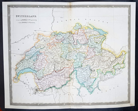
1834 Henry Teesdale Large Antique Map Switzerland divided in Cantons - Beautiful
- Title : 1834 Henry Teesdale Large Antique Map Switzerland divided in Cantons - Beautiful
- Date : 1834
- Condition: (A+) Fine Condition
- Ref: 50286
- Size: 17in x 14in (430mm x 355mm)
Description:
This beautifully hand coloured original steel-plate engraved antique map of Switzerland was engraved by John Dower in 1834 - dated at the foot of the map - and was published in the 1835 edition of Henry Teesdale\'s A New General Atlas of the World.
As with all the maps published by Teesdale this one is of the highest quality on strong clean & sturdy paper with beautiful original hand colouring. (Ref: M&B; Tooley)
General Definitions:
Paper thickness and quality: - Heavy and stable
Paper color : - off white
Age of map color: - Original
Colors used: - Blue, red, yellow, green
General color appearance: - Authentic
Paper size: - 17in x 14in (430mm x 355mm)
Plate size: - 17in x 14in (430mm x 355mm)
Margins: - Min 1/2in (12mm)
Imperfections:
Margins: - None
Plate area: - None
Verso: - None
Background:
The establishment of the Old Swiss Confederacy dates to the late medieval period, resulting from a series of military successes against Austria and Burgundy. Swiss independence from the Holy Roman Empire was formally recognized in the Peace of Westphalia in 1648. The country has a history of armed neutrality going back to the Reformation; it has not been in a state of war internationally since 1815 and did not join the United Nations until 2002. Nevertheless, it pursues an active foreign policy and is frequently involved in peace-building processes around the world. In addition to being the birthplace of the Red Cross, Switzerland is home to numerous international organisations, including the second largest UN office. On the European level, it is a founding member of the European Free Trade Association, but notably not part of the European Union, the European Economic Area or the Eurozone. However, it participates in the Schengen Area and the European Single Market through bilateral treaties.
Spanning the intersection of Germanic and Romance Europe, Switzerland comprises four main linguistic and cultural regions: German, French, Italian and Romansh. Although the majority of the population are German speaking, Swiss national identity is rooted in a common historical background, shared values such as federalism and direct democracy, and Alpine symbolism. Due to its linguistic diversity, Switzerland is known by a variety of native names: Schweiz, Suisse, Svizzera and Svizra. On coins and stamps, the Latin name – frequently shortened to Helvetia – is used instead of the four national languages.
Teesdale & co., Henry fl 1828-1843
Teesdale was a prominent London publisher and founding fellow of the Royal Geographical Society. He produced large-scale maps and charts and a number of fine atlases in the early part of the nineteenth century. He employed the most skilled draftsmen and engravers and his maps are renowned for precise detail and fine coloring

1788 Du Bocage & Barthelemy Antique Map of Thessaly region of Greece
- Title : La thessalie...1788
- Size: 15in x 10in (380mm x 255mm)
- Ref #: 16454
- Date : 1788
- Condition: (A+) Fine Condition
Description:
This original copper-plate engraved map by Jean Denis Barbie du Bocage was engraved in 1788 - dated in the title - and was published in the 1788 edition of Jean-Jacques Barthelemy famous Voyage du jeune Anarcharsis en Grece or Travels of Anacharsis the younger in Greecein 4 volumes.
General Definitions:
Paper thickness and quality: - Heavy and stable
Paper color : - off white
Age of map color: -
Colors used: -
General color appearance: -
Paper size: - 15in x 10in (380mm x 255mm)
Plate size: - 12in x 8 1/2in (305mm x 215mm)
Margins: - Min 1in (25mm)
Imperfections:
Margins: - None
Plate area: - Folds as issued
Verso: - None
Background:
Jean-Jacques Barthelemy 1716 – 1795 was a French writer and numismatist.
Barthelemy was the author of a number of learned works on antiquarian subjects, but the great work on which his fame rests is Travels of Anacharsis the younger in Greece (French: Voyage du jeune Anarcharsis en Grece, 4 vols., 1787). He had begun it in 1757 and had been working on it for thirty years. The hero, a young Scythian descended from the famous philosopher Anacharsis, is supposed to repair to Greece for instruction in his early youth, and after making the tour of her republics, colonies and islands, to return to his native country and write this book in his old age, after the Macedonian hero had overturned the Persian empire. In the manner of modern travellers, he gives an account of the customs, government, and antiquities of the country he is supposed to have visited. A copious introduction supplies whatever may be wanting in respect to historical details, while various dissertations on the music of the Greeks, on the literature of the Athenians, and on the economy, pursuits, ruling passions, manners, and customs of the surrounding states supply ample information on the subjects of which they treat.
Modern scholarship has superseded most of the details in the Voyage, but the author himself did not imagine his book to be a register of accurately ascertained facts. Rather, he intended to afford to his countrymen, in an interesting form, some knowledge of Greek civilisation. The Charicles, or Illustrations of the Private Life of the Ancient Greeks of Wilhelm Adolf Becker is an attempt in a similar direction
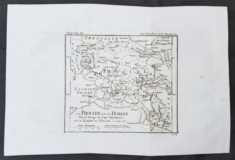
1785 Du Bocage & Barthelemy Antique Map of Phocis, Greece - Oracle of Delphi
- Title : La Phocide et La Doride...1787
- Size: 15in x 10in (380mm x 255mm)
- Ref #: 16457
- Date : 1787
- Condition: (A+) Fine Condition
Description:
This original copper-plate engraved map by Jean Denis Barbie du Bocage was engraved in 1787 - dated in the title - and was published in the 1787 edition of Jean-Jacques Barthelemy famous Voyage du jeune Anarcharsis en Grece or Travels of Anacharsis the younger in Greece in 4 volumes.
General Definitions:
Paper thickness and quality: - Heavy and stable
Paper color : - off white
Age of map color: -
Colors used: -
General color appearance: -
Paper size: - 15in x 10in (380mm x 255mm)
Plate size: - 8in x 7in (205mm x 180mm)
Margins: - Min 1in (25mm)
Imperfections:
Margins: - None
Plate area: - Folds as issued
Verso: - None
Background:
Jean-Jacques Barthelemy 1716 – 1795 was a French writer and numismatist.
Barthelemy was the author of a number of learned works on antiquarian subjects, but the great work on which his fame rests is Travels of Anacharsis the younger in Greece (French: Voyage du jeune Anarcharsis en Grece, 4 vols., 1787). He had begun it in 1757 and had been working on it for thirty years. The hero, a young Scythian descended from the famous philosopher Anacharsis, is supposed to repair to Greece for instruction in his early youth, and after making the tour of her republics, colonies and islands, to return to his native country and write this book in his old age, after the Macedonian hero had overturned the Persian empire. In the manner of modern travellers, he gives an account of the customs, government, and antiquities of the country he is supposed to have visited. A copious introduction supplies whatever may be wanting in respect to historical details, while various dissertations on the music of the Greeks, on the literature of the Athenians, and on the economy, pursuits, ruling passions, manners, and customs of the surrounding states supply ample information on the subjects of which they treat.
Modern scholarship has superseded most of the details in the Voyage, but the author himself did not imagine his book to be a register of accurately ascertained facts. Rather, he intended to afford to his countrymen, in an interesting form, some knowledge of Greek civilisation. The Charicles, or Illustrations of the Private Life of the Ancient Greeks of Wilhelm Adolf Becker is an attempt in a similar direction
1745 Tindal Antique Map of France during the Spanish War of Succession 1701-13
- Title : Plan of the Battle of Oudenard fought July 11th 1708
- Size: 19 1/2in x 15 1/2in (495mm x 395mm)
- Ref #: 15661
- Date : 1745
- Condition: (A+) Fine Condition
Description:
This original copper-plate engraved antique map, a battle plan of the Battle of Oudenard or Oudenaarde, in Flemish Belgium, in 1708 between Britain & its allies and France and its allies - during the Spanish War of Succession (1701-13) - was engraved by John Basire and was published in the 1745 edition of Nicholas Tindals Continuation of Mr. Rapin\'s History of England.
General Definitions:
Paper thickness and quality: - Heavy and stable
Paper color : - off white
Age of map color: -
Colors used: -
General color appearance: -
Paper size: - 19 1/2in x 15 1/2in (495mm x 395mm)
Plate size: - 19 1/2in x 15 1/2in (495mm x 395mm)
Margins: - Min 1/2in (12mm)
Imperfections:
Margins: - None
Plate area: - Folds as issued
Verso: - None
Background:
The Battle of Oudenarde (or Oudenaarde) was a battle in the War of the Spanish Succession fought on 11 July 1708 between the forces of Great Britain, the Dutch Republic and the Holy Roman Empire on the one side and those of France on the other. It took place at Oudenaarde (now in Belgium) and was a great victory for the allies.
Great Britain, the Netherlands, and the Holy Roman Empire were horrified at the thought of a union between Spain and France which caused them to ally against France, beginning the War of the Spanish Succession. The commander of the allied armies was John Churchill, 1st Duke of Marlborough, whose chief deputy was the commander of the Empire\'s army Prince Eugène of Savoy, who was his close friend.
Meanwhile, the two French army commanders were very quarrelsome. Louis Joseph, duc de Vendôme was a seasoned, experienced soldier. The Duke of Burgundy had considerably less experience and owed his position to the fact he was the grandson of the King, Louis XIV of France.
Marlborough\'s army consisted of about 80,000 men (113 infantry battalions and 180 cavalry squadrons) just south of Brussels. Eugène\'s forces were assembled at Coblenz. These two areas were somewhat far apart, while the French army\'s 85,000 soldiers (139 battalions and 204 squadrons) were concentrated near Mons.
At this time, the French commanders began quarrelling. Vendôme wanted to attack the city of Huy, which could draw Marlborough in pursuit. The eventual plan adopted, however, (under orders from Louis XIV) was to attack Flanders. The army moved eastward, until they reached the city of Braine-l\'Alleud, which was about 25 km south of Brussels, and also threatened the nearby city of Leuven. Marlborough placed his forces a few miles south of Leuven, in order to cover both threatened cities.
The French army then remained inactive for more than a month. This apparently allowed the extremely behind schedule Eugène to bring his army from the Rhine River. On 5 July, however, the French unexpectedly moved west, taking the cities of Bruges and Ghent (although about 300 British soldiers held out in Ghent for a few days). This extremely demoralized Marlborough and his army, and he did not recover until Eugène was at his side.
The French army had the entire length of the Scheldt River from the French border to the newly taken city of Ghent. Only one British fortress remained: Oudenaarde. If they took that city, Marlborough\'s army would be cut off from the coast, causing them to lose communications with England.
Marlborough detected this objective, and also correctly guessed the method by which the French troops would attempt to take it. They would march down the east bank of the Scheldt (closer to Marlborough\'s troops), while leaving a large covering force between the two opposing armies. The French army marched on 8 July, toward the city of Lessines. However, Marlborough made one of the most inspired forced marches in history, taking the city on 10 July. This forced the French commanders to attempt simply to march across the Scheldt and thereby take the city of Oudenaarde.
Again Marlborough ordered a forced march. This time, though, he ordered 11,000 troops to hold the main crossing point across the Scheldt, under the command of his Quartermaster General, William Cadogan. Cadogan\'s force built 5 additional pontoon bridges to allow Marlborough to get his 80,000-strong army across the river, until French foragers discovered the allied presence around 09:00 AM.
Cadogan, a superb Irish cavalry commander, ordered some dragoons, under Danish General Jørgen Rantzau, to take prisoners from the French advance guard. Many of those troops escaped and alerted Lieutenant General Charles-Armand de Gontaut, duc de Biron, who commanded the vanguard, of the presence of Allied troops on the west bank.
When de Biron advanced, he was disagreeably surprised by the large number of Allied cavalry already across the river, along with the approaching Allied infantry. Although he was ordered to attack by Vendôme, he hesitated upon seeing the reinforced line of 20 battalions (including the four that had been left to guard the pontoon bridges). Biron\'s own forces comprised only 7 battalions and 20 squadrons. He had been given reliable advice that cavalry could not negotiate the marshy terrain in the area and decided not to attempt a crossing. At this time, Eugène, along with 20 squadrons of Prussian cavalry, moved across the river and occupied crucial positions.
While Biron\'s troops were manoeuvring, the leading British infantry brigade had arrived, under the inexperienced but gifted John Campbell, 2nd Duke of Argyll. Cadogan, with authority from Marlborough, attacked Biron\'s 7 battalions (of Swiss mercenaries) with his soldiers (mainly cavalry). The isolated Swiss mercenaries were immediately pushed back and the Allied force destroyed Biron\'s squadrons, until they reached a large mass of French cavalry, at which point they were forced to retire, outnumbered. The force which performed this action was Rantzau\'s cavalry, with the future King George II of England among them.
Burgundy, making another mistake, decided to attack (over protests by Vendôme). The French right wing began to attack the Allied positions near Eine, while the left wing (for an unknown reason) remained stationary near Huise. A very strong position was held by the Allied left wing. 28 cavalry squadrons protected the right flank of Cadogan\'s infantry, which would receive the attack (which proceeded at about 4:00 p.m.).
Burgundy ordered the assault, which landed on Prussian cavalry squadrons under Dubislav Gneomar von Natzmer. Although hard fighting ensued, the attack was dispersed. Then, Vendôme made a dubious decision and led an attack of twelve regiments, fighting hand-to-hand with a half-pike. This meant that while one commander (Burgundy) was in his headquarters, with no view of the battle, the other was fighting, with no possibility of control.
Most historians agree that the weakened Allied right flank would have been destroyed, had the French left wing attacked. Vendôme realized this, asking Burgundy for permission to attack with the left wing. Burgundy sent a messenger with a refusal but the messenger failed to deliver the message. The situation worsened with Vendôme believing that an attack would support his troops, who were lengthening their line, threatening to envelop the Allied left flank. As Argyll\'s regiments approached, they lengthened the Allied line but too slowly and not great enough in extent, to prevent the French from threatening such an envelopment.
Marlborough moved his headquarters to the left flank, giving Eugène command of the right flank (which still checked the left wing of the French army). While the right was under pressure, Marlborough made a brilliant command decision: he placed 18 newly arrived Hessian and Hanoverian battalions in the left flank, while replacing 20 of Prussian General Carl von Lottum\'s battalions, moving them to Eugène\'s support. This moved fresh troops to the critical left, while reinforcing the right flank (and resting Lottum\'s troops). Marlborough then began formulating a new plan of double encirclement. He had the entire Dutch Army, under Field Marshal Count Hendrik Overkirk, an experienced military officer. His force was unable to cross the collapsed pontoon bridges near Oudenaarde, forcing him to use the stone bridges in the city, delaying him for an hour. Marlborough went ahead with his plan, having Eugène\'s cavalry charge towards Burgundy\'s headquarters. The French Household Cavalry, the Maison du Roi, were able to turn them back and Marlborough, with only the 18 Hessian and Hanoverian battalions, was unable to do much other than keep the French right in check. At about 20:30, Overkirk\'s troops had arrived and flanked the French right wing. This was in conjunction with a dual attack by Marlborough and Eugène. Overkirk\'s manoeuvre was successful, with much of the French army being routed or captured but there was not enough daylight to complete the manoeuvre.
The French army retired to Ghent, with its commanders quarreling; only darkness and a few broken pontoon bridges saved the army from destruction. For unknown reasons, about half of the French army was kept in reserve, without participating at all. There was a great mass of French cavalry and infantry in some raised ground north of the Norken River and many of Burgundy\'s troops remained inactive. There were many bad decisions in the French army. The cavalry had remained in reserve, mainly because of the advice that the ground was impassable. The entire left wing (the troops under Burgundy and the large mass north of the Norken) was kept in reserve. They could easily have destroyed the rather weak right wing of the Allied army. Had a concerted attack been carried out, with Vendôme attacking with his main body to envelop the Allied right, while Burgundy attacked with the left (before Overkirk and the rest of Argyll\'s troops arrived), the French army could have easily won. The French army lost about 14–15,000 soldiers (about 8,000 of whom were prisoners) and 25 guns, while the Allies lost fewer than 3,000.
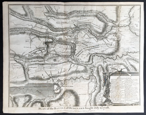
1745 Tindal Antique Battle Map of Oudenaarde, Belgium in 1708 - Britain & France
- Title : Plan of the Battle of Oudenard fought July 11th 1708
- Size: 19 1/2in x 15 1/2in (495mm x 395mm)
- Ref #: 15661
- Date : 1745
- Condition: (A+) Fine Condition
Description:
This original copper-plate engraved antique map, a battle plan of the Battle of Oudenard or Oudenaarde, in Flemish Belgium, in 1708 between Britain & its allies and France and its allies - during the Spanish War of Succession (1701-13) - was engraved by John Basire and was published in the 1745 edition of Nicholas Tindals Continuation of Mr. Rapin\'s History of England.
General Definitions:
Paper thickness and quality: - Heavy and stable
Paper color : - off white
Age of map color: -
Colors used: -
General color appearance: -
Paper size: - 19 1/2in x 15 1/2in (495mm x 395mm)
Plate size: - 19 1/2in x 15 1/2in (495mm x 395mm)
Margins: - Min 1/2in (12mm)
Imperfections:
Margins: - None
Plate area: - Folds as issued
Verso: - None
Background:
The Battle of Oudenarde (or Oudenaarde) was a battle in the War of the Spanish Succession fought on 11 July 1708 between the forces of Great Britain, the Dutch Republic and the Holy Roman Empire on the one side and those of France on the other. It took place at Oudenaarde (now in Belgium) and was a great victory for the allies.
Great Britain, the Netherlands, and the Holy Roman Empire were horrified at the thought of a union between Spain and France which caused them to ally against France, beginning the War of the Spanish Succession. The commander of the allied armies was John Churchill, 1st Duke of Marlborough, whose chief deputy was the commander of the Empire\'s army Prince Eugène of Savoy, who was his close friend.
Meanwhile, the two French army commanders were very quarrelsome. Louis Joseph, duc de Vendôme was a seasoned, experienced soldier. The Duke of Burgundy had considerably less experience and owed his position to the fact he was the grandson of the King, Louis XIV of France.
Marlborough\'s army consisted of about 80,000 men (113 infantry battalions and 180 cavalry squadrons) just south of Brussels. Eugène\'s forces were assembled at Coblenz. These two areas were somewhat far apart, while the French army\'s 85,000 soldiers (139 battalions and 204 squadrons) were concentrated near Mons.
At this time, the French commanders began quarrelling. Vendôme wanted to attack the city of Huy, which could draw Marlborough in pursuit. The eventual plan adopted, however, (under orders from Louis XIV) was to attack Flanders. The army moved eastward, until they reached the city of Braine-l\'Alleud, which was about 25 km south of Brussels, and also threatened the nearby city of Leuven. Marlborough placed his forces a few miles south of Leuven, in order to cover both threatened cities.
The French army then remained inactive for more than a month. This apparently allowed the extremely behind schedule Eugène to bring his army from the Rhine River. On 5 July, however, the French unexpectedly moved west, taking the cities of Bruges and Ghent (although about 300 British soldiers held out in Ghent for a few days). This extremely demoralized Marlborough and his army, and he did not recover until Eugène was at his side.
The French army had the entire length of the Scheldt River from the French border to the newly taken city of Ghent. Only one British fortress remained: Oudenaarde. If they took that city, Marlborough\'s army would be cut off from the coast, causing them to lose communications with England.
Marlborough detected this objective, and also correctly guessed the method by which the French troops would attempt to take it. They would march down the east bank of the Scheldt (closer to Marlborough\'s troops), while leaving a large covering force between the two opposing armies. The French army marched on 8 July, toward the city of Lessines. However, Marlborough made one of the most inspired forced marches in history, taking the city on 10 July. This forced the French commanders to attempt simply to march across the Scheldt and thereby take the city of Oudenaarde.
Again Marlborough ordered a forced march. This time, though, he ordered 11,000 troops to hold the main crossing point across the Scheldt, under the command of his Quartermaster General, William Cadogan. Cadogan\'s force built 5 additional pontoon bridges to allow Marlborough to get his 80,000-strong army across the river, until French foragers discovered the allied presence around 09:00 AM.
Cadogan, a superb Irish cavalry commander, ordered some dragoons, under Danish General Jørgen Rantzau, to take prisoners from the French advance guard. Many of those troops escaped and alerted Lieutenant General Charles-Armand de Gontaut, duc de Biron, who commanded the vanguard, of the presence of Allied troops on the west bank.
When de Biron advanced, he was disagreeably surprised by the large number of Allied cavalry already across the river, along with the approaching Allied infantry. Although he was ordered to attack by Vendôme, he hesitated upon seeing the reinforced line of 20 battalions (including the four that had been left to guard the pontoon bridges). Biron\'s own forces comprised only 7 battalions and 20 squadrons. He had been given reliable advice that cavalry could not negotiate the marshy terrain in the area and decided not to attempt a crossing. At this time, Eugène, along with 20 squadrons of Prussian cavalry, moved across the river and occupied crucial positions.
While Biron\'s troops were manoeuvring, the leading British infantry brigade had arrived, under the inexperienced but gifted John Campbell, 2nd Duke of Argyll. Cadogan, with authority from Marlborough, attacked Biron\'s 7 battalions (of Swiss mercenaries) with his soldiers (mainly cavalry). The isolated Swiss mercenaries were immediately pushed back and the Allied force destroyed Biron\'s squadrons, until they reached a large mass of French cavalry, at which point they were forced to retire, outnumbered. The force which performed this action was Rantzau\'s cavalry, with the future King George II of England among them.
Burgundy, making another mistake, decided to attack (over protests by Vendôme). The French right wing began to attack the Allied positions near Eine, while the left wing (for an unknown reason) remained stationary near Huise. A very strong position was held by the Allied left wing. 28 cavalry squadrons protected the right flank of Cadogan\'s infantry, which would receive the attack (which proceeded at about 4:00 p.m.).
Burgundy ordered the assault, which landed on Prussian cavalry squadrons under Dubislav Gneomar von Natzmer. Although hard fighting ensued, the attack was dispersed. Then, Vendôme made a dubious decision and led an attack of twelve regiments, fighting hand-to-hand with a half-pike. This meant that while one commander (Burgundy) was in his headquarters, with no view of the battle, the other was fighting, with no possibility of control.
Most historians agree that the weakened Allied right flank would have been destroyed, had the French left wing attacked. Vendôme realized this, asking Burgundy for permission to attack with the left wing. Burgundy sent a messenger with a refusal but the messenger failed to deliver the message. The situation worsened with Vendôme believing that an attack would support his troops, who were lengthening their line, threatening to envelop the Allied left flank. As Argyll\'s regiments approached, they lengthened the Allied line but too slowly and not great enough in extent, to prevent the French from threatening such an envelopment.
Marlborough moved his headquarters to the left flank, giving Eugène command of the right flank (which still checked the left wing of the French army). While the right was under pressure, Marlborough made a brilliant command decision: he placed 18 newly arrived Hessian and Hanoverian battalions in the left flank, while replacing 20 of Prussian General Carl von Lottum\'s battalions, moving them to Eugène\'s support. This moved fresh troops to the critical left, while reinforcing the right flank (and resting Lottum\'s troops). Marlborough then began formulating a new plan of double encirclement. He had the entire Dutch Army, under Field Marshal Count Hendrik Overkirk, an experienced military officer. His force was unable to cross the collapsed pontoon bridges near Oudenaarde, forcing him to use the stone bridges in the city, delaying him for an hour. Marlborough went ahead with his plan, having Eugène\'s cavalry charge towards Burgundy\'s headquarters. The French Household Cavalry, the Maison du Roi, were able to turn them back and Marlborough, with only the 18 Hessian and Hanoverian battalions, was unable to do much other than keep the French right in check. At about 20:30, Overkirk\'s troops had arrived and flanked the French right wing. This was in conjunction with a dual attack by Marlborough and Eugène. Overkirk\'s manoeuvre was successful, with much of the French army being routed or captured but there was not enough daylight to complete the manoeuvre.
The French army retired to Ghent, with its commanders quarreling; only darkness and a few broken pontoon bridges saved the army from destruction. For unknown reasons, about half of the French army was kept in reserve, without participating at all. There was a great mass of French cavalry and infantry in some raised ground north of the Norken River and many of Burgundy\'s troops remained inactive. There were many bad decisions in the French army. The cavalry had remained in reserve, mainly because of the advice that the ground was impassable. The entire left wing (the troops under Burgundy and the large mass north of the Norken) was kept in reserve. They could easily have destroyed the rather weak right wing of the Allied army. Had a concerted attack been carried out, with Vendôme attacking with his main body to envelop the Allied right, while Burgundy attacked with the left (before Overkirk and the rest of Argyll\'s troops arrived), the French army could have easily won. The French army lost about 14–15,000 soldiers (about 8,000 of whom were prisoners) and 25 guns, while the Allies lost fewer than 3,000.
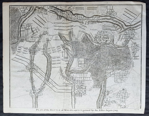
1745 Nicolas Tindal Original Antique Map Battle of Malplaquet, Northern France in 1709
- Title : Plan of the Battle of Malplaquet gained by the Allies Sep. 11 1709.
- Size: 19 1/2in x 15 1/2in (495mm x 395mm)
- Ref #: 15659
- Date : 1745
- Condition: (A+) Fine Condition
Description:
This original copper-plate engraved antique map, plan of the Battle of Malplaquet, northern France in 1709 - during the Spanish War of Succession (1701-13) - was engrvaed by John Basire and was published in the 1745 edition of Nicholas Tindals Continuation of Mr. Rapin\'s History of England.
General Definitions:
Paper thickness and quality: - Heavy and stable
Paper color : - off white
Age of map color: -
Colors used: -
General color appearance: -
Paper size: - 19 1/2in x 15 1/2in (495mm x 395mm)
Plate size: - 19 1/2in x 15 1/2in (495mm x 395mm)
Margins: - Min 1/2in (12mm)
Imperfections:
Margins: - None
Plate area: - None
Verso: - None
Background:
The Battle of Malplaquet, fought on 11 September 1709, was one of the main battles of the War of the Spanish Succession. Led by the Duke of Marlborough, the army of the Grand Alliance attacked and defeated the French army near Malplaquet under the command of Marshal Villars. The heavy losses suffered by the Allies caused the battle to be considered a Pyrrhic victory.

1783 Du Bocage Antique Map of Sparta and Surrounding Area, Greece
- Title : Essai Sur la Topographie De Sparte Et De Ses Environs.... 1783.
- Ref #: 16447
- Size: 15 1/2in x 9 1/2in (400mm x 240mm)
- Date : 1783
- Condition: (A+) Fine Condition
Description:
This fine large original antique map of Sparta and surrounding area, Greece - was engraved in 1783 - dated - and was published by Jean Denis Barbie du Bocage in his Voyage Anacharsis (The Travels of Anacharsis the Younger in Greece)published between 1781 - 1788.
Voyage Anacharsis is an illustrative account of the travels of Anacharsis the Younger in Greece, during the middle of the fourth century before the Christian era.
Jean Denis Barbie du Bocage (1760 - 1825)and his son Jean-Guillaume Barbie du Bocage (1795 - 1848) were French cartographers and cosmographers active in Paris during late 18th and early 19th centuries. The elder Barbie du Bocage, Jean Denis, was trained as a cartographer and engraver in the workshops of mapmaking legend J. B. B. d'Anville. At some point Jean Denis held the post of Royal Librarian of France and it was through is associations with d'Anville that the d'Anville collection of nearly 9000 maps was acquired by French Ministry of Foreign Affairs. The younger Barbie du Bocage, Jean-Guillaume, acquired a position shortly afterwards at the Ministry of Foreign Affairs and, in time, became its head, with the title of Geographe du Ministere des Affaires Etrangeres. (Ref: Tooley; M&B)
General Description:
Paper thickness and quality: - Heavy & stable
Paper color: - White
Age of map color: -
Colors used: -
General color appearance: -
Paper size: - 15 1/2in x 9 1/2in (400mm x 240mm)
Plate size: - 12 1/2in x 8in (310mm x 200mm)
Margins: - Min 1/2in (12mm)
Imperfections:
Margins: - None
Plate area: - Folds as issued
Verso: - None
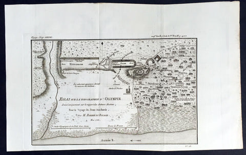
1780 Du Bocage Large Antique Map Plan of Olympia, Greece
- Title : Essai Sur La Topographe d Olympie...1780
- Ref #: 16450
- Size: 15 3/4in x 9 1/2in (400mm x 240mm)
- Date : 1780
- Condition: (A+) Fine Condition
Description:
This fine large original antique map a plan of Olympia, Greece - 1st site of the Olympic Games - was engraved in 1780 - dated - and was published by Jean Denis Barbie du Bocage in hisVoyage Anacharsis (The Travels of Anacharsis the Younger in Greece) published between 1781 - 1788.
Voyage Anacharsis is an illustrative account of the travels of Anacharsis the Younger in Greece, during the middle of the fourth century before the Christian era.
General Description:
Paper thickness and quality: - Heavy & stable
Paper color: - White
Age of map color: -
Colors used: -
General color appearance: -
Paper size: - 15 3/4in x 9 1/2in (400mm x 240mm)
Plate size: - 12 1/2in x 8in (310mm x 200mm)
Margins: - Min 1/2in (12mm)
Imperfections:
Margins: - None
Plate area: - Folds as issued
Verso: - None
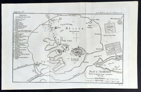
1784 Du Bocage Large Antique Map Plan of The City of Athens, Greece
- Title : Plan D Athenes...1784
- Ref #: 16460
- Size: 15 3/4in x 9 1/2in (400mm x 240mm)
- Date : 1784
- Condition: (A+) Fine Condition
Description:
This fine large original antique map a plan of Athens, Greece was engraved in 1784 - dated - and was published by Jean Denis Barbie du Bocage in his Voyage Anacharsis (The Travels of Anacharsis the Younger in Greece) publishedbetween 1781 - 1788.
Voyage Anacharsis is an illustrative account of the travels of Anacharsis the Younger in Greece, during the middle of the fourth century before the Christian era.
General Description:
Paper thickness and quality: - Heavy & stable
Paper color: - White
Age of map color: -
Colors used: -
General color appearance: -
Paper size: - 15 3/4in x 9 1/2in (400mm x 240mm)
Plate size: - 13 1/2in x 9in (350mm x 230mm)
Margins: - Min 1/2in (12mm)
Imperfections:
Margins: - None
Plate area: - Folds as issued
Verso: - None

1784 Du Bocage Large Antique Map of The Bosphorus Straits, Turkey
- Title : Plan Du Bosphore de Thrace...1784
- Ref #: 16466
- Size: 15 3/4in x 9 1/2in (400mm x 240mm)
- Date : 1784
- Condition: (A+) Fine Condition
Description:
This fine large original antique map Bosphorus Straits, Turkey was engraved in 1784 - dated - and was published by Jean Denis Barbie du Bocage in his Voyage Anacharsis (The Travels of Anacharsis the Younger in Greece) publishedbetween 1781 - 1788.
Voyage Anacharsis is an illustrative account of the travels of Anacharsis the Younger in Greece, during the middle of the fourth century before the Christian era.
General Description:
Paper thickness and quality: - Heavy & stable
Paper color: - White
Age of map color: -
Colors used: -
General color appearance: -
Paper size: - 15 3/4in x 9 1/2in (400mm x 240mm)
Plate size: - 12 1/2in x 8 1/2in (320mm x 220mm)
Margins: - Min 1/2in (12mm)
Imperfections:
Margins: - None
Plate area: - Folds as issued
Verso: - None
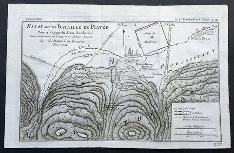
1784 Du Bocage Large Antique Map of The Battle of Platea City of Plataea Boeotia
- Title : Essai sur la Bataille de Platee...1784
- Ref #: 16469
- Size: 15 3/4in x 9 1/2in (400mm x 240mm)
- Date : 1784
- Condition: (A+) Fine Condition
Description:
This fine large original antique map or plan of the Battle of Platea, Greece near the city of Plataea in Boeotia, was engraved in 1784 - dated - and was published by Jean Denis Barbie du Bocage in his Voyage Anacharsis (The Travels of Anacharsis the Younger in Greece) publishedbetween 1781 - 1788.
Voyage Anacharsis is an illustrative account of the travels of Anacharsis the Younger in Greece, during the middle of the fourth century before the Christian era.
General Description:
Paper thickness and quality: - Heavy & stable
Paper color: - White
Age of map color: -
Colors used: -
General color appearance: -
Paper size: - 15 3/4in x 9 1/2in (400mm x 240mm)
Plate size: - 14 1/2in x 9in (360mm x 230mm)
Margins: - Min 1/2in (12mm)
Imperfections:
Margins: - None
Plate area: - Folds as issued
Verso: - None

1785 Du Bocage Large Antique Map of The Environs of Athens to Piraeus, Greece
- Title : Plan Des Environs D Athenes...1785
- Ref #: 16464
- Size: 15 3/4in x 9 1/2in (400mm x 240mm)
- Date : 1785
- Condition: (A+) Fine Condition
Description:
This fine large original antique map or plan of The Environs of Athens, Greece to Piraeus, was engraved in 1785 - dated - and was published by Jean Denis Barbie du Bocage in his Voyage Anacharsis (The Travels of Anacharsis the Younger in Greece) published between 1781 - 1788.
Voyage Anacharsis is an illustrative account of the travels of Anacharsis the Younger in Greece, during the middle of the fourth century before the Christian era.
General Description:
Paper thickness and quality: - Heavy & stable
Paper color: - White
Age of map color: -
Colors used: -
General color appearance: -
Paper size: - 15 3/4in x 9 1/2in (400mm x 240mm)
Plate size: - 8 1/2in x 7in (215mm x 180mm)
Margins: - Min 1in (25mm)
Imperfections:
Margins: - None
Plate area: - Folds as issued
Verso: - None