Europe (304)
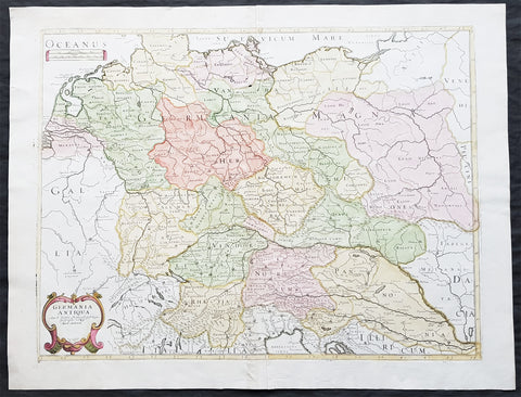
1689 Nicolas Sanson Large Antique Map of Germania & Central Europe
- Title : Germania Antiqua Aut N Sanson.....1689
- Ref #: 26191
- Size: 24in x 18 1/2in (610mm x 470mm)
- Date : 1689
- Condition: (A+) Fine Condition
Description:
This fine original hand coloured copper-plate engraved antique map of Germania & central Europe stretching from Poland to Italy to Denmark, by Nicolas Sanson, was engraved in 1689 - dated in the cartouche - and was published by Pierre Mariette in Cartes Generales de Toutes les Parties du Monde
General Definitions:
Paper thickness and quality: - Heavy and stable
Paper color : - off white
Age of map color: - Original & later
Colors used: - Yellow, green, blue, pink
General color appearance: - Authentic
Paper size: - 24in x 18 1/2in (610mm x 470mm)
Plate size: - 21 1/2in x 16in (545mm x 405mm)
Margins: - Min 1in (25mm)
Imperfections:
Margins: - None
Plate area: - None
Verso: - None
Background:
Germania was the Roman term for the geographical region in north-central Europe inhabited mainly by Germanic peoples.
It extended from the Danube in the south to the Baltic Sea, and from the Rhine in the west to the Vistula. The Roman portions formed two provinces of the Empire, Germania Inferior to the north (present-day southern Netherlands, Belgium, and western Germany), and Germania Superior to the south (Switzerland, southwestern Germany, and eastern France).
Germania was inhabited mostly by Germanic tribes, but also Celts, Balts, Scythians and later on Early Slavs. The population mix changed over time by assimilation, and especially by migration. The ancient Greeks were the first to mention the tribes in the area. Later, Julius Caesar wrote about warlike Germanic tribesmen and their threat to Roman Gaul, and there were military clashes between the Romans and the indigenous tribes. Tacitus wrote the most complete account of Germania that still survives.
The origin of the term Germania is uncertain, but was known by Caesars time, and may be Gaulish in origin.
Germania was inhabited by different tribes, most of them Germanic but also some Celtic, proto-Slavic, Baltic and Scythian peoples. The tribal and ethnic makeup changed over the centuries as a result of assimilation and, most importantly, migrations. The Germanic people spoke several different dialects.
Classical records show little about the people who inhabited the north of Europe before the 2nd century BC. In the 5th century BC, the Greeks were aware of a group they called Celts (Keltoi). Herodotus also mentioned the Scythians but no other tribes. At around 320 BC, Pytheas of Massalia sailed around Britain and along the northern coast of Europe, and what he found on his journeys was so strange that later writers refused to believe him. He may have been the first Mediterranean to distinguish the Germanic people from the Celts. Contact between German tribes and the Roman Empire did take place and was not always hostile. Recent excavations of the Waldgirmes Forum show signs that a civilian Roman town was established there, which has been interpreted to mean that Romans and Germanic tribesmen were living in peace, at least for a while.
Caesar described the cultural differences between the Germanic tribesmen, the Romans, and the Gauls in his book Commentarii de Bello Gallico, where he recalls his defeat of the Suebi tribes at the Battle of Vosges. He describes them at length at the beginning of Book IV and the middle of Book VI. He states that the Gauls, although warlike, had a functional society and could be civilized, but that the Germanic tribesmen were far more savage and were a threat to Roman Gaul and Rome itself. Caesar said the Germanic tribes were nomadic, with no notable settlements and a primitive culture. He used this as one of his justifications for why they had to be conquered. His accounts of barbaric northern tribes could be described as an expression of the superiority of Rome, including Roman Gaul.
Caesars accounts portray the Roman fear of the Germanic tribes and the threat they posed. The perceived menace of the Germanic tribesmen proved accurate. The most complete account of Germania that has been preserved from Roman times is Tacitus Germania.
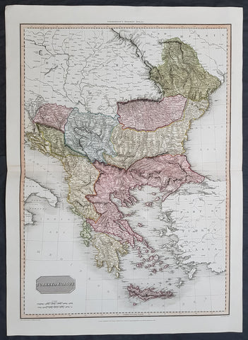
1814 John Pinkerton Large Antique Map of Turkey in Europe - Greece to Hungary
- Title : Turkey in Europe....Drawn under the direction of Mr Pinkerton by L Herbert Neele Sculp. 352 Starnd.....London Published 1st Jan 1814 by Cadell & Davies Strand & Longman. Hurst. Rees.Orme & Brown. Paternaster Row
- Ref #: 16434
- Size: 31in x 22in (790mm x 560mm)
- Date : 1814
- Condition: (A+) Fine Condition
Description:
This large magnificent hand coloured original copper-plate engraved antique map of Turkey in Europe - Greece, Balkans, Romania, Bosnia, Albania, Serbia, Dalmatia - by John Pinkerton was engraved by Samuel Neele in 1814 - dated at the foot of the map - and published in Pinkertons large elephant folio Modern Atlas, published between 1809 - 14. (Ref: Tooley, M&B)
General Definitions:
Paper thickness and quality: - Heavy and stable
Paper color : - off white
Age of map color: - Original
Colors used: - Blue, pink, red, green, yellow
General color appearance: - Authentic
Paper size: - 31in x 22in (790mm x 560mm)
Plate size: - 31in x 22in (790mm x 560mm)
Margins: - Min 1in (25mm)
Imperfections:
Margins: - None
Plate area: - None
Verso: - None
Background:
The Ottoman Empire also historically known in Western Europe as the Turkish Empire or simply Turkey, was a state that controlled much of Southeast Europe, Western Asia and North Africa between the 14th and early 20th centuries. It was founded at the end of the 13th century in northwestern Anatolia in the town of Söğüt (modern-day Bilecik Province) by the Oghuz Turkish tribal leader Osman I. After 1354, the Ottomans crossed into Europe, and with the conquest of the Balkans, the Ottoman beylik was transformed into a transcontinental empire. The Ottomans ended the Byzantine Empire with the 1453 conquest of Constantinople by Mehmed the Conqueror.
During the 16th and 17th centuries, at the height of its power under the reign of Suleiman the Magnificent, the Ottoman Empire was a multinational, multilingual empire controlling most of Southeast Europe, parts of Central Europe, Western Asia, parts of Eastern Europe and the Caucasus, North Africa and the Horn of Africa. At the beginning of the 17th century, the empire contained 32 provinces and numerous vassal states. Some of these were later absorbed into the Ottoman Empire, while others were granted various types of autonomy during the course of centuries.
With Constantinople as its capital and control of lands around the Mediterranean basin, the Ottoman Empire was at the centre of interactions between the Eastern and Western worlds for six centuries. While the empire was once thought to have entered a period of decline following the death of Suleiman the Magnificent, this view is no longer supported by the majority of academic historians. The empire continued to maintain a flexible and strong economy, society and military throughout the 17th and much of the 18th century. However, during a long period of peace from 1740 to 1768, the Ottoman military system fell behind that of their European rivals, the Habsburg and Russian empires. The Ottomans consequently suffered severe military defeats in the late 18th and early 19th centuries, which prompted them to initiate a comprehensive process of reform and modernisation known as the Tanzimat. Thus, over the course of the 19th century, the Ottoman state became vastly more powerful and organised, despite suffering further territorial losses, especially in the Balkans, where a number of new states emerged. The empire allied with Germany in the early 20th century, hoping to escape from the diplomatic isolation which had contributed to its recent territorial losses, and thus joined World War I on the side of the Central Powers. While the Empire was able to largely hold its own during the conflict, it was struggling with internal dissent, especially with the Arab Revolt in its Arabian holdings. During this time, atrocities were committed by the Ottoman government against the Armenians, Assyrians and Pontic Greeks.
The Empires defeat and the occupation of part of its territory by the Allied Powers in the aftermath of World War I resulted in its partitioning and the loss of its Middle Eastern territories, which were divided between the United Kingdom and France. The successful Turkish War of Independence against the occupying Allies led to the emergence of the Republic of Turkey in the Anatolian heartland and the abolition of the Ottoman monarchy.
Pinkerton, John 1758 – 1826
Pinkerton was a Scottish antiquarian, cartographer, author, numismatist, historian, and early advocate of Germanic racial supremacy theory.
He was born in Edinburgh, as one of three sons to James Pinkerton. He lived in the neighbourhood of that city for some of his earliest childhood years, but later moved to Lanark. His studious youth brought him extensive knowledge of the Classics, and it is known that in his childhood years he enjoyed translating Roman authors such as Livy. He moved on to Edinburgh University, and after graduating, remained in the city to take up an apprenticeship in Law. However, his scholarly and literary inclinations led him to abandon the legal profession. It had been during his brief legal career though that he had begun writing, his Elegy on Craigmillar Castle being first published in 1776.
Pinkerton was a celebrated master of the Edinburgh school of cartography which lasted from roughly 1800 to 1830. Pinkerton, along with John Thomson & Co. and John Cary, redefined cartography by exchanging the elaborate cartouches and fantastical beasts used in the 18th century for more accurate detail. Pinkertons main work was the \\\"Pinkerton\\\'s Modern Atlas\\\" published from 1808 through 1815 with an American version by Dobson & Co. in 1818. Pinkerton maps are today greatly valued for their quality, size, colouration, and detail.
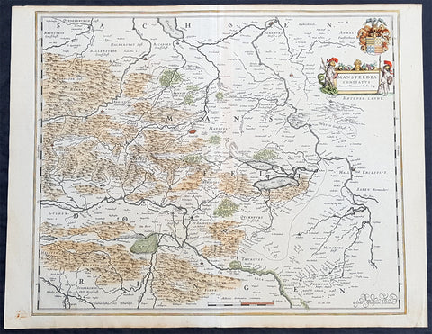
1638 Willem Blaeu Antique Map of Mansfeld Land, in SW Saxony-Anhalt, Germany
- Title : Mansfelda Comitatus
- Ref #: 70078
- Size: 22 1/2in x 17in (570mm x 430mm)
- Date : 1638
- Condition: (A+) Fine Condition
Description:
This beautifully hand coloured original copper-plate engraved antique map of the ancient region of Mansfeld Land located in the in southwestern region of Saxony-Anhalt, Germany - centering on the city of Mansfeld - by was published in the 1638 Latin edition edition of Willem Blaeus Atlas Novus.
General Definitions:
Paper thickness and quality: - Heavy and stable
Paper color : - off white
Age of map color: - Original
Colors used: - Blue, pink, red, green, yellow
General color appearance: - Authentic
Paper size: - 22 1/2in x 17in (570mm x 430mm)
Plate size: - 19 1/2in x 16 1/4in (495mm x 420mm)
Margins: - Min 1/2in (12mm)
Imperfections:
Margins: - Light age toning
Plate area: - None
Verso: - None
Background:
Mansfeld Land is a region in the southwestern corner of the German state of Saxony-Anhalt. The region derives its name from the counts of Mansfeld, who ruled this region for about 1,000 years.
The House of Mansfeld, whose members belonged to the Saxon nobility and served as counts in the Hassegau, was first documented in a 973 deed. The counts built Mansfeld Castle, whose foundations date back to the late 11th century, when one Hoyer of Mansfeld served as field marshal to Emperor Henry V. The first reference of the fortress coincides with the extinction of the elder line in 1229. The estates were inherited by the Lords of Querfurt, who also adopted the comital title, calling themselves Counts of Mansfeld from that time on.
The settlement of Mansfeld received town privileges in 1400, and grew through the development of copper and silver mining, an activity in which Hans Luder from Möhra, father to Martin Luther and Mansfeld citizen from 1484, was employed as a master smelter. Luthers family had arrived into a modest prosperity, he himself attended the local school between 1488 and 1496. The building known as Luther\'s School had to be torn down and rebuilt in 2000 due to structural problems. His parents house is preserved and today a museum. Luther also acted as an altar server at the St George parish church.
The Counts of Mansfeld had already lost Imperial immediacy in 1580. When the comital line finally became extinct in 1780, the estates around Mansfeld were incorporated into the Prussian Duchy of Magdeburg. The town retained the status of an independent city (Immediatstadt), it was temporarily part of the Napoleonic Kingdom of Westphalia and after the 1815 Congress of Vienna belonged to the Prussian Province of Saxony.
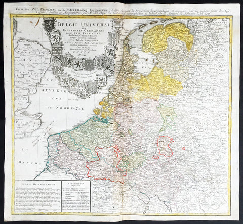
1748 Homann, Mayer Large Old, Antique Map of The Netherlands, Belgium, Holland
- Title : Belgii Universi seu Inferioris Germaniae quam XVII Provinciae Austriaco, Gallico et Batavo sceptro parentes constituunt nova Tabula Geographica a Tobia Majero Math. Cult. ad leges legitimae delineationis revocata Cura et studio Homanniorum Heredum A. 1748
- Ref #: 16422
- Size: 21 1/2in x 20in (545mm x 510mm)
- Date : 1748
- Condition: (A) Very Good Condition
Description:
This large beautifully hand coloured original antique map* of Holland, The Netherlands and Belgium was engraved in 1748 byJohann Tobias Mayer - dated in Title - and was published by Homann firm in 1750.
Background: A beautifully detailed 1748 Homann Heirs map of Belgium and the Netherlands (Holland). Includes Belgium proper as well as the seven states of the Belgian Federation – what is today Holland or the Netherlands. Also includes parts of England and extends into eastern Germany past the Rhine River.
Title elaborate cartouche in the upper left quadrant, filling the North Sea, features the armorial shields of the Belgian Counties as well as those of the seven states of the federation: Geldern, Holland, Zeeland, Utrecht, Friesland, Ober Issel, and Groningen.
This map was drawn by Johann Tobias Mayer for inclusion the 1752 Homann Heirs Maior Atlas Scholasticus ex Triginta Sex Generalibus et Specialibus…. Most early Homann atlases were 'made to order' or compiled of individual maps at the request of the buyer. However, this rare atlas, composed of 37 maps and charts, was issued as a 'suggested collection' of essential Homann Heirs maps. (Ref: Tooley; M&B)
General Description:
Paper thickness and quality: - Heavy and stable
Paper color: - off white
Age of map color: - Original
Colors used: - Yellow, green, blue, pink
General color appearance: - Authentic
Paper size: - 21 1/2in x 20in (545mm x 510mm)
Plate size: - 21in x 19 1/2in (535mm x 495mm)
Margins: - Min 1/2in (12mm)
Imperfections:
Margins: - None
Plate area: - Light creasing along centrefold
Verso: - Re-enforced along centrefold
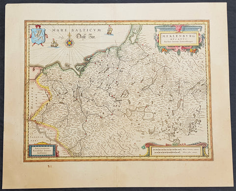
1646 Jan Jansson Antique Map of Mecklenburg NE Germany Rostock, Wizmar, Parchim
- Title : Meklenburg Ducatus
- Ref #: 50185
- Size: 11 1/2in x 8in (290mm x 205mm)
- Date : 1646
- Condition: (A+) Fine Condition
Description:
This beautifully hand coloured original copper-plate engraved antique map of the Mecklenburg, north eastern Germany by Jan Jansson was published in the 1646 Latin edition of Mercators Atlas by Jan Jansson and Henricus Hondius. (Ref: Tooley, Koeman)
General Definitions:
Paper thickness and quality: - Heavy and stable
Paper color : - off white
Age of map color: - Original
Colors used: - Yellow, green, blue, pink
General color appearance: - Authentic
Paper size: - 22in x 18in (560mm x 460mm)
Plate size: - 19in x 14 1/2in (480mm x 370mm)
Margins: - Min 2in (50mm)
Imperfections:
Margins: - None
Plate area: - None
Verso: - None
Background:
Mecklenburg is a historical region in northern Germany comprising the western and larger part of the federal-state Mecklenburg-Vorpommern. The largest cities of the region are Rostock, Schwerin, Neubrandenburg, Wismar and Güstrow.
The name Mecklenburg derives from a castle named Mikilenburg (Old Saxon: big castle, hence its translation into New Latin and Greek: Megalopolis), located between the cities of Schwerin and Wismar. In Slavic language it was known as Veligrad, which also means big castle. It was the ancestral seat of the House of Mecklenburg; for a time the area was divided into Mecklenburg-Schwerin and Mecklenburg-Strelitz among the same dynasty.
Linguistically Mecklenburgers retain and use many features of Low German vocabulary or phonology.
Mecklenburg is the site of many prehistoric dolmen tombs. Its earliest organised inhabitants may have had Celtic origins. By no later than 100 BC the area had been populated by pre-Christian Germanic peoples.
The traditional symbol of Mecklenburg, the grinning steers head (Low German: Ossenkopp, lit.: oxen\'s head, with osse being a synonym for steer and bull in Middle Low German), with an attached hide, and a crown above, may have originated from this period. It represents what early peoples would have worn, i.e. a steers\'s head as a helmet, with the hide hanging down the back to protect the neck from the sun, and overall as a way to instill fear in the enemy.
From the 7th through the 12th centuries, the area of Mecklenburg was taken over by Western Slavic peoples, most notably the Obotrites and other tribes that Frankish sources referred to as Wends. The 11th century founder of the Mecklenburgian dynasty of Dukes and later Grand Dukes, which lasted until 1918, was Nyklot of the Obotrites.
In the late 12th century, Henry the Lion, Duke of the Saxons, conquered the region, subjugated its local lords, and Christianized its people, in a precursor to the Northern Crusades. From 12th to 14th century, large numbers of Germans and Flemings settled the area (Ostsiedlung), importing German law and improved agricultural techniques. The Wends who survived all warfare and devastation of the centuries before, including invasions of and expeditions into Saxony, Denmark and Liutizic areas as well as internal conflicts, were assimilated in the centuries thereafter. However, elements of certain names and words used in Mecklenburg speak to the lingering Slavic influence. An example would be the city of Schwerin, which was originally called Zuarin in Slavic. Another example is the town of Bresegard, the \'gard\' portion of the town name deriving from the Slavic word \'grad\', meaning city or town.
Since the 12th century, the territory remained stable and relatively independent of its neighbours; one of the few German territories for which this is true. During the reformation the Duke in Schwerin would convert to Protestantism and so would follow the Duchy of Mecklenburg.
Like many German territories, Mecklenburg was sometimes partitioned and re-partitioned among different members of the ruling dynasty. In 1621 it was divided into the two duchies of Mecklenburg-Schwerin and Mecklenburg-Güstrow. With the extinction of the Güstrow line in 1701, the Güstrow lands were redivided, part going to the Duke of Mecklenburg-Schwerin, and part going to the new line of Mecklenburg-Strelitz.
In 1815, the two Mecklenburgian duchies were raised to Grand Duchies, the Grand Duchy of Mecklenburg-Schwerin and the Grand Duchy of Mecklenburg-Strelitz, and subsequently existed separately as such in Germany under enlightened but absolute rule (constitutions being granted on the eve of World War I) until the revolution of 1918. Life in Mecklenburg could be quite harsh. Practices such as having to ask for permission from the Grand Duke to get married, or having to apply for permission to emigrate, would linger late into the history of Mecklenburg (i.e. 1918), long after such practices had been abandoned in other German areas. Even as late as the later half of the 19th century the Grand Duke personally owned half of the countryside. The last Duke abdicated in 1918, as monarchies fell throughout Europe. The Duke\'s ruling house reigned in Mecklenburg uninterrupted (except for two years) from its incorporation into the Holy Roman Empire until 1918. From 1918 to 1933, the duchies were free states in the Weimar Republic.
Traditionally Mecklenburg has always been one of the poorer German areas, and later the poorer of the provinces, or Länder, within a unified Germany. The reasons for this may be varied, but one factor stands out: agriculturally the land is poor and can not produce at the same level as other parts of Germany. The two Mecklenburgs made attempts at being independent states after 1918, but eventually this failed as their dependence on the rest of the German lands became apparent.
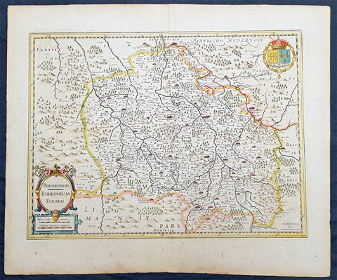
1636 Jan Jansson Antique Map of The Bourbon or Bourbonnais Region Central France
- Title : Boubonoius; Borbonium Ducatus
- Ref #: 41641
- Size: 21 1/2in x 17 1/2in (490mm x 340mm)
- Date : 1636
- Condition: (A) Very Good Condition
Description:
This beautifully hand coloured original copper-plate engraved antique map of The Bourbon or Bourbonnais Region of central France was published in the rare 1636 English edition of Mercators Atlas by Jan Jansson and Henricus Hondius.
There was only one English edition of Mercators Atlas published in 1636 by Jansson & Hondius. These maps - with English text on the verso - are now understandably scarce.
The text running for two pages on the back of the map generally describes the region or country name, history (as it was), temperature, seasons, soil and agricultural productivity. Also described is the topography, wildlife, local inhabitants their culture and religion, as well as a description of major European and local towns and cities. This text makes extremely enjoyable reading and a very good insight not only into the area described but the general European attitudes towards alien countries and cultures.
General Definitions:
Paper thickness and quality: - Heavy and stable
Paper color : - off white
Age of map color: - Original
Colors used: - Yellow, green, blue, pink
General color appearance: - Authentic
Paper size: - 21 1/2in x 17 1/2in (490mm x 340mm)
Plate size: - 20in x 15in (510mm x 380mm)
Margins: - Min 1in (25mm)
Imperfections:
Margins: - Uniform age toning
Plate area: - Uniform age toning
Verso: - Uniform age toning
Background:
Bourbonnais was a historic province in the centre of France that corresponded to the modern département of Allier, along with part of the département of Cher. Its capital was Moulins.
The title of the ruler of Bourbonnais between 913 and 1327, was Sire de Bourbon (or Seigneur de Bourbon). The first lord of Bourbonnais known by name was Adhémar (or Aymon I of Bourbon). Aymon\'s father was Aymar (894-953), sire of Souvigny, his only son with Ermengarde.Aymar lived during the reign of Charles the Simple who, in 913, gave him fiefs on the Allier River in which would become Bourbonnais. He acquired the castle of Bourbon (today Bourbon-l\'Archambault). Almost all early lords took the name d\'Archambaud, after the palace, but later the family became known as the \"House of Bourbon\".
The first House of Bourbon ended in 1196, with the death of Archambault VII, who had only one heir, Mathilde of Bourbon. She married Guy II of Dampierre, who added Montlucon to the possessions of the lords of Bourbon. The second house of Bourbon started in 1218, with Archambault VIII, son of Guy II and Mahaut, and brother of William II of Dampierre. He was followed by his son Archambaut IX, who died in Cyprus in 1249, during a crusade. The House of Burgundy then acquired Bourbonnais.
In 1272, Beatrice of Burgundy (1258-1310), Lady of Bourbon, married Robert de France (1256-1318), Count of Clermont, son of king Louis IX (Saint-Louis). Thus began the long-lasting House of Bourbon, which would provide the kings of France from Henry IV to Louis-Phillipe in 1848, when France abolished its monarchy.
The Bourbons had concluded an alliance with the royal power. They put their forces at the service of the king, thus benefitting from the geographic position of Bourbonnais, located between the royal fidemesne and the duchies of Aquitaine and Auvergne. This alliance, as well as the marriage of Béatrix de Bourgogne and Robert de France, aided the rise and prosperity of the province. In 1327, King Charles (le Bel) elevated Boubonnais to the status of a duchy. (Ref: Koeman; M&B; Tooley)
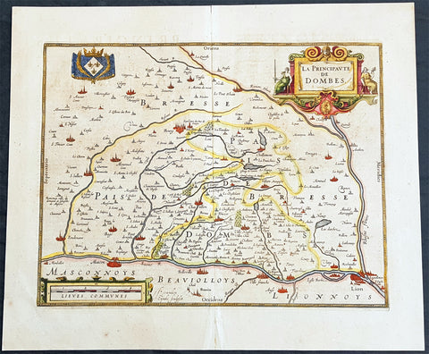
1638 Henricus Hondius Antique Map of the Principality of Dombes, Ain, SE France
- Title : La Principaute De Dombes
- Ref #: 50239
- Size: 22in x 19in (560mm x 480mm)
- Date : 1638
- Condition: (A+) Fine Condition
Description:
This beautifully hand coloured original copper-plate engraved antique map of the Principality of Dombes of south-eastern France - now a part of the Ain Dept. centering on the cities of Mascon & Lyon on the Saone and Rhone Rivers - was published in the 1638 Latin edition of Mercators Atlas published by Henricus Hondius.& Jan Jansson.
General Definitions:
Paper thickness and quality: - Heavy and stable
Paper color : - off white
Age of map color: - Original
Colors used: - Yellow, green, blue, pink
General color appearance: - Authentic
Paper size: - 22in x 19in (560mm x 480mm)
Plate size: - 18in x 14in (460mm x 360mm)
Margins: - Min 1in (25mm)
Imperfections:
Margins: - None
Plate area: - None
Verso: - Age toning
Background:
The Dombes is an area in south-eastern France, once an independent municipality, formerly part of the province of Burgundy, and now a district comprised in the department of Ain, and bounded on the west by the Saône River, by the Rhône, on the east by the Ain and on the north by the district of Bresse.
The Dombes once formed part of the kingdom of Arles. In the 11th century, when the kingdom began to break up, the northern part of the Dombes came under the power of the lords of Bâgé, and in 1218, by the marriage of Marguerite de Baugé with Humbert IV of Beaujeu, passed to the lords of Beaujeu. The southern portion was held in succession by the lords of Villars and of Thoire. Its lords took advantage of the excommunication of Frederick II, Holy Roman Emperor to assert their complete independence of the Holy Roman Empire.
In 1400, Louis II, Duke of Bourbon, acquired the northern part of the Dombes, together with the lordship of Beaujeu, and two years later bought the southern part from the sires de Thoire, forming the whole into a new sovereign principality of the Dombes, with Trévoux as its capital.
The principality was confiscated by King Francis I of France in 1523, along with the other possessions of the Constable de Bourbon, was granted in 1527 to the queen-mother, Louise of Savoy, and after her death was held successively by kings Francis I, Henry II and Francis II, and by Catherine de\' Medici. In 1561 it was granted to Louis, duc de Montpensier, by whose descendants it was held till, in 1682, Anne Marie Louise of Orléans, the duchess of Montpensier, gave it to Louis XIV\'s bastard, the Duke of Maine, as part of the price for the release of her lover Lauzun.
The eldest son of the duke of Maine, Louis-Auguste de Bourbon (1700–1755), prince of Dombes, served in the army of Prince Eugene of Savoy against the Turks (1717), took part in the War of the Polish Succession (1733–1734), and in that of the Austrian Succession (1742-1747). He was made colonel-general of the Swiss regiment, governor of Languedoc and master of the hounds of France. He was succeeded, as prince of Dombes, by his brother the count of Eu, who in 1762 surrendered the principality to the crown. The little principality of Dombes showed in some respects signs of a vigorous life; the princes mint and printing works at Trévoux were long famous, and the college at Thoissey was well endowed and influential.
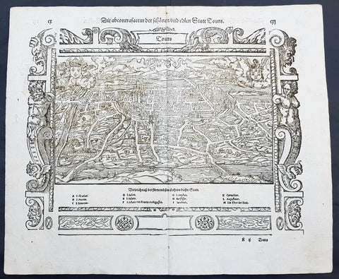
1574 Munster Large Antique Print View of The French City of Tours
- Title : Die Statt Tours
- Ref #: 22614
- Size: 16in x 13in (410mm x 330mm)
- Date : 1574
- Condition: (A+) Fine Condition
Description:
This large finely engraved original antique print a view of the French city of Tours was published by Sebastian Munster in the 1574 edition of Cosmographia.
Tours is a city located in the centre-west of France. It is the administrative centre of the Indre-et-Loire department and the largest city in the Centre-Val de Loire region of France (although it is not the capital, which is the region's second-largest city, Orléans). Tours stands on the lower reaches of the River Loire, between Orléans and the Atlantic coast. The surrounding district, the traditional province of Touraine, is known for its wines, for the alleged perfection (as perceived by some speakers) of its local spoken French, and for the Battle of Tours (732).
Background: For a variety of reasons town plans were comparatively latecomers in the long history of cartography. Few cities in Europe in the middle ages had more than 20,00 inhabitants and even London in the late Elizabethan period had only 100-150,000 people which in itself was probably 10 times that of any other English city. The Nuremberg Chronicle in 1493 included one of the first town views of Jerusalem, thereafter, for most of the sixteenth century, German cartographers led the way in producing town plans in a modern sense. In 1544 Sebastian Munster issued in Basle hisCosmographia containing roughly sixty-six plans and views, some in the plan form, but many in the old panorama or birds eye view.
Sebastian Münster (1488-1552) was a German cartographer, cosmographer, and Hebrew scholar whose work Cosmographia (1544; "Cosmography") was the earliest German description of the world and a major work in the revival of geographic thought in 16th-century Europe. It had numerous editions in different languages including Latin, French, Italian, English, and even Czech. Altogether, about 40 editions of the Cosmographiaappeared between 1544 and 1628 and was one of the most successful and popular books of the 16th century. Münster was a major influence in popular thinking in Europe for the next 200 years.
This success was due not only to the level of descriptive detail but also to the fascinating full page maps & views as well as smaller woodcuts that were included in the text. Many of the woodcuts were executed by famous engravers of the time including Hans Holbein the Younger, Urs Graf, Hans Rudolph Manuel Deutsch, and David Kandel.
Aside from the well-known maps present in the Cosmographia, the text is thickly sprinkled with vigorous views: portraits of kings and princes, costumes and occupations, habits and customs, flora and fauna, monsters, wonders, and horrors about the known -- and unknown -- world, and was undoubtedly one of the most widely read books of its time.
Münster acquired the material for his book in three ways. Firstly he researched all available literary sources across Germany, Switzerland and other parts of Europe. Secondly he obtained original manuscript material from locals all over Europe for description of the countryside, cities, villages, towns, rivers and local history. Finally, he obtained further material first hand on his travels (primarily in south-west Germany, Switzerland, and Alsace).
In 1588 Sebastian Petri re-released Cosomgraphia and re-issued many of Munsters maps and views in the "copperplate style". The maps in this release were more sophisticated than with earlier publications ofCosomgraphia and were based on the 1570 release of Abraham Ortelius monumental work Theatrum Orbis Terrarum.(Ref: Tooley; M&B)
General Description:
Paper thickness and quality: - Light and stable
Paper color: - off white
Age of map color: -
Colors used: -
General color appearance: -
Paper size: - 16in x 13in (410mm x 330mm)
Plate size: - 16in x 13in (410mm x 330mm)
Margins: - 1/2in (12mm)
Imperfections:
Margins: - None
Plate area: -None
Verso: - None
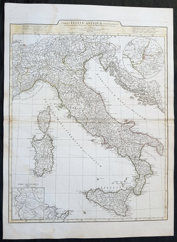
1764 J B D Anville Large Original Antique Map of Italy inset plan of Rome
- Title : Tabula Italiae Antiqua Geographica...MDCCLXIV
- Date : 1764
- Size: 29in x 21in (740mm x 535mm)
- Ref #: 92297
- Condition: (A+) Fine Condition
Description:
This large finely engraved and highly detailed original antique map of Italy by Jean Baptiste Bourguignon D\'Anville was engraved in 1764 - dated in the tile cartouche - and was published in Jean-Baptiste Bourguinon D\'Anville\'s large elephant folio atlas Atlas Generale.
General Definitions:
Paper thickness and quality: - Heavy and stable
Paper color : - off white
Age of map color: - Original
Colors used: - Yellow, green, pink, blue
General color appearance: - Authentic
Paper size: - 29in x 21in (740mm x 535mm)
Plate size: - 25in x 20in (635mm x 510mm)
Margins: - Min 1/2in (12mm)
Imperfections:
Margins: - Age toning along centerfold
Plate area: - Age toning along centerfold
Verso: - Age toning along centerfold
Background:
Since classical times, ancient Phoenicians, Carthaginians and Greeks established settlements in the south of Italy, with Etruscans and Celts inhabiting the centre and the north of Italy respectively and various ancient Italian tribes and Italic peoples dispersed throughout the Italian Peninsula and insular Italy. The Italic tribe known as the Latins formed the Roman Kingdom, which eventually became a republic that conquered and assimilated other nearby civilisations. Ultimately the Roman Empire emerged as the dominant power in the Mediterranean basin, conquering much of the ancient world and becoming the leading cultural, political and religious centre of Western civilisation. The legacy of the Roman Empire is widespread and can be observed in the global distribution of civilian law, republican governments, Christianity and the Latin script.
During the Early Middle Ages Italy suffered sociopolitical collapse amid calamitous barbarian invasions, but by the 11th century, numerous rival city-states and maritime republics, mainly in the northern and central regions of Italy, rose to great prosperity through shipping, commerce and banking, laying down the groundwork for modern capitalism.These mostly independent statelets, acting as Europe\'s main spice trade hubs with Asia and the Near East, often enjoyed a greater degree of democracy and wealth in comparison to the larger feudal monarchies that were consolidating throughout Europe at the time, though much of central Italy remained under the control of the theocratic Papal States, while Southern Italy remained largely feudal until the 19th century, partially as a result of a succession of Byzantine, Arab, Norman and Spanish conquests of the region.
The Renaissance began in Italy and spread to the rest of Europe, bringing a renewed interest in humanism, science, exploration and art. Italian culture flourished at this time, producing famous scholars, artists and polymaths such as Leonardo da Vinci, Galileo, Michelangelo and Machiavelli. Italian explorers such as Marco Polo, Christopher Columbus, Amerigo Vespucci and Giovanni da Verrazzano discovered new routes to the Far East and the New World, helping to usher in the European Age of Discovery. Nevertheless, Italy\'s commercial and political power significantly waned with the opening of the Atlantic trade route and the route to the Indian Ocean via the Cape of Good Hope, both of which bypassed the Mediterranean. Furthermore, the Italian city-states constantly engaged one another in bloody warfare, culminating in the Italian Wars of the 15th and 16th centuries that left them exhausted, with no one emerging as a dominant power. The weakened Italian sovereigns soon fell victim to conquest by European powers such as France, Spain and Austria.
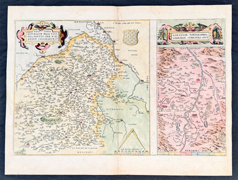
1575 Abraham Ortelius Antique Maps of Loire Valley, River & Alliers River France
- Title : Regionis Biturigum Exactiss Descriptio per D. Ioannem Calamaeum. Limaniae Topographia Gabriele Symeoneo Auct. [The region of Berry exactly described by Jean Chameau. The topography around of Lyons by Gabriel Symeon]
- Size: 22in x 18 1/2in (560mm x 470mm)
- Condition: (A+) Fine Condition
- Date : 1575
- Ref #: 30021
Description:
These original copper-plate engraved hand coloured antique maps, the first of the Loire River & Valley and the second of the Alliers River, was published by Abraham Ortelius in the 1575 French edition of Theatrum Orbis Terrarum.
These are two rare regional Abraham Ortelius maps on a single folio sheet. The Left Map, centered on Bourges, depicts the Loire Valley region from Gian to St. Sebastian in the south and from Le Blanc east as far as Nevers. Several important cities are noted, including Argenton, Neuers (Nevers), Bourges, Le Blang en Berry, Romarantin, Vierzon, Chasteau Neuf, and others. The right map follows the flow of the Alliers River from Randan to Gondole. Important cities, including Beauregard, Cleremont, among several others are noted. Each map features a decorative cartouche and details their respective regions in wonderful detail with attention to forests, cities, rivers and villages.
General Definitions:
Paper thickness and quality: - Heavy and stable
Paper color : - off white
Age of map color: - Later
Colors used: - Green, blue, pink, yellow
General color appearance: - Authentic
Paper size: - 22in x 18 1/2in (560mm x 470mm)
Plate size: - 19 1/2in x 12 1/2in (490mm x 310mm)
Margins: - Min 1in (25mm)
Imperfections:
Margins: - Light soiling
Plate area: - None
Verso: - Soiling
Background:
The Loire Valley spanning 280 kilometres , is located in the middle stretch of the Loire River in central France, in both the administrative regions Pays de la Loire and Centre-Val de Loire. The area of the Loire Valley comprises about 800 square kilometres. It is referred to as the Cradle of the French and the Garden of France due to the abundance of vineyards, fruit orchards (such as cherries), and artichoke, and asparagus fields, which line the banks of the river. Notable for its historic towns, architecture, and wines, the valley has been inhabited since the Middle Palaeolithic period.
The Allier is a river in central France. It is a left tributary of the Loire. Its source is in the Massif Central, in the Lozère department, east of Mende. It flows generally north. It joins the Loire west of the city of Nevers.
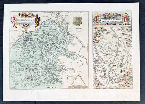
1575 Abraham Ortelius Antique Maps of Loire Valley, River & Alliers River France
- Title : Regionis Biturigum Exactiss Descriptio per D. Ioannem Calamaeum. Limaniae Topographia Gabriele Symeoneo Auct. [The region of Berry exactly described by Jean Chameau. The topography around of Lyons by Gabriel Symeon]
- Size: 21in x 19 1/2in (535mm x 495mm)
- Condition: (A+) Fine Condition
- Date : 1575
- Ref #: 50228-1
Description:
These original copper-plate engraved hand coloured antique maps, the first of the Loire River & Valley and the second of the Alliers River, was published by Abraham Ortelius in the 1575 French edition of Theatrum Orbis Terrarum.
These are two rare regional Abraham Ortelius maps on a single folio sheet. The Left Map, centered on Bourges, depicts the Loire Valley region from Gian to St. Sebastian in the south and from Le Blanc east as far as Nevers. Several important cities are noted, including Argenton, Neuers (Nevers), Bourges, Le Blang en Berry, Romarantin, Vierzon, Chasteau Neuf, and others. The right map follows the flow of the Alliers River from Randan to Gondole. Important cities, including Beauregard, Cleremont, among several others are noted. Each map features a decorative cartouche and details their respective regions in wonderful detail with attention to forests, cities, rivers and villages.
General Definitions:
Paper thickness and quality: - Heavy and stable
Paper color : - off white
Age of map color: - Later
Colors used: - Green, blue, pink, yellow
General color appearance: - Authentic
Paper size: - 21in x 19 1/2in (535mm x 495mm)
Plate size: - 19 1/2in x 12 1/2in (490mm x 310mm)
Margins: - Min 1/8in (2mm)
Imperfections:
Margins: - None
Plate area: - None
Verso: - None
Background:
The Loire Valley spanning 280 kilometres , is located in the middle stretch of the Loire River in central France, in both the administrative regions Pays de la Loire and Centre-Val de Loire. The area of the Loire Valley comprises about 800 square kilometres. It is referred to as the Cradle of the French and the Garden of France due to the abundance of vineyards, fruit orchards (such as cherries), and artichoke, and asparagus fields, which line the banks of the river. Notable for its historic towns, architecture, and wines, the valley has been inhabited since the Middle Palaeolithic period.
The Allier is a river in central France. It is a left tributary of the Loire. Its source is in the Massif Central, in the Lozère department, east of Mende. It flows generally north. It joins the Loire west of the city of Nevers.
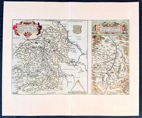
1612 Abraham Ortelius Antique Maps of Loire Valley, River & Alliers River France
- Title : Regionis Biturigum Exactiss Descriptio per D. Ioannem Calamaeum. Limaniae Topographia Gabriele Symeoneo Auct. [The region of Berry exactly described by Jean Chameau. The topography around of Lyons by Gabriel Symeon]
- Size: 22in x 18 1/2in (560mm x 470mm)
- Condition: (A+) Fine Condition
- Date : 1612
- Ref #: 50228
Description:
This original copper-plate engraved hand coloured antique map, the first of the Loire River & Valley and the second of the Alliers River, was published by Abraham Ortelius in the 1612 Latin edition of Theatrum Orbis Terrarum.
These are two rare regional Abraham Ortelius maps on a single folio sheet. The Left Map, centered on Bourges, depicts the Loire Valley region from Gian to St. Sebastian in the south and from Le Blanc east as far as Nevers. Several important cities are noted, including Argenton, Neuers (Nevers), Bourges, Le Blang en Berry, Romarantin, Vierzon, Chasteau Neuf, and others. The right map follows the flow of the Alliers River from Randan to Gondole. Important cities, including Beauregard, Cleremont, among several others are noted. Each map features a decorative cartouche and details their respective regions in wonderful detail with attention to forests, cities, rivers and villages.
General Definitions:
Paper thickness and quality: - Heavy and stable
Paper color : - off white
Age of map color: -
Colors used: -
General color appearance: -
Paper size: - 22in x 18 1/2in (560mm x 470mm)
Plate size: - 19 1/2in x 12 1/2in (490mm x 310mm)
Margins: - Min 1in (25mm)
Imperfections:
Margins: - None
Plate area: - None
Verso: - None
Background:
The Loire Valley spanning 280 kilometres , is located in the middle stretch of the Loire River in central France, in both the administrative regions Pays de la Loire and Centre-Val de Loire. The area of the Loire Valley comprises about 800 square kilometres. It is referred to as the Cradle of the French and the Garden of France due to the abundance of vineyards, fruit orchards (such as cherries), and artichoke, and asparagus fields, which line the banks of the river. Notable for its historic towns, architecture, and wines, the valley has been inhabited since the Middle Palaeolithic period.
The Allier is a river in central France. It is a left tributary of the Loire. Its source is in the Massif Central, in the Lozère department, east of Mende. It flows generally north. It joins the Loire west of the city of Nevers.
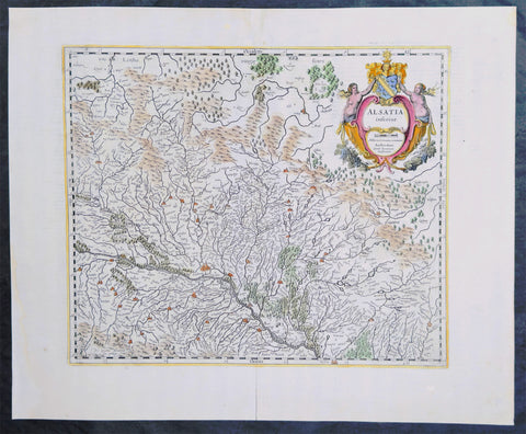
1638 Gerard Mercator & Henricus Hondius Antique Map of Alsace Region, France
- Title : Alsatia inferior..Per Gerardam Mercatorem Cum privilegio
- Size: 21in x 17in (530mm x 430mm)
- Condition: (A+) Fine Condition
- Date : 1638
- Ref #: 92839
Description:
This original copper plate engraved antique map of the French region of Alsace by Gerard Mercator was published by Henricus Hondius in the early 1638 German edition of Gerard Mercators Atlas.
These maps, published in the early editions of Mercators atlas, are the original maps drawn and engraved by Gerald Mercator in the mid to late 16th century, published by his son Rumold as an atlas, after his death, in 1595. After two editions the plates were purchased by Jodocus Hondius in 1604, and continued to be published until the end of the 1630s by Henricus Hondius, when some of the plates were re-engraved and updated with the help of Jan Jansson.
General Definitions:
Paper thickness and quality: - Heavy and stable
Paper color : - off white
Age of map color: - Early
Colors used: - Green, blue, red, yellow
General color appearance: - Authentic
Paper size: - 21in x 17in (530mm x 430mm)
Plate size: - 18 1/2in x 14in (475mm x 350mm)
Margins: - Min 1/2in (12mm)
Imperfections:
Margins: - Light age toning
Plate area: - None
Verso: - None
Background:
Alsace is a cultural and historical region in eastern France, on the west bank of the upper Rhine next to Germany and Switzerland.
As in much of Europe, the prosperity of Alsace came to an end in the 14th century by a series of harsh winters, bad harvests, and the Black Death. These hardships were blamed on Jews, leading to the pogroms of 1336 and 1339. In 1349, Jews of Alsace were accused of poisoning the wells with plague, leading to the massacre of thousands of Jews during the Strasbourg pogrom. Jews were subsequently forbidden to settle in the town. An additional natural disaster was the Rhine rift earthquake of 1356, one of Europes worst which made ruins of Basel. Prosperity returned to Alsace under Habsburg administration during the Renaissance.
Holy Roman Empire central power had begun to decline following years of imperial adventures in Italian lands, often ceding hegemony in Western Europe to France, which had long since centralized power. France began an aggressive policy of expanding eastward, first to the rivers Rhône and Meuse, and when those borders were reached, aiming for the Rhine. In 1299, the French proposed a marriage alliance between Philip IV of Frances sister Blanche and Albert I of Germanys son Rudolf, with Alsace to be the dowry; however, the deal never came off. In 1307, the town of Belfort was first chartered by the Counts of Montbéliard. During the next century, France was to be militarily shattered by the Hundred Years War, which prevented for a time any further tendencies in this direction. After the conclusion of the war, France was again free to pursue its desire to reach the Rhine and in 1444 a French army appeared in Lorraine and Alsace. It took up winter quarters, demanded the submission of Metz and Strasbourg and launched an attack on Basel.
In 1469, following the Treaty of St. Omer [fr], Upper Alsace was sold by Archduke Sigismund of Austria to Charles the Bold, Duke of Burgundy. Although Charles was the nominal landlord, taxes were paid to Frederick III, Holy Roman Emperor. The latter was able to use this tax and a dynastic marriage to his advantage to gain back full control of Upper Alsace (apart from the free towns, but including Belfort) in 1477 when it became part of the demesne of the Habsburg family, who were also rulers of the empire. The town of Mulhouse joined the Swiss Confederation in 1515, where it was to remain until 1798.
By the time of the Protestant Reformation in the 16th century, Strasbourg was a prosperous community, and its inhabitants accepted Protestantism in 1523. Martin Bucer was a prominent Protestant reformer in the region. His efforts were countered by the Roman Catholic Habsburgs who tried to eradicate heresy in Upper Alsace. As a result, Alsace was transformed into a mosaic of Catholic and Protestant territories. On the other hand, Mömpelgard (Montbéliard) to the southwest of Alsace, belonging to the Counts of Württemberg since 1397, remained a Protestant enclave in France until 1793.
This situation prevailed until 1639, when most of Alsace was conquered by France to keep it out of the hands of the Spanish Habsburgs, who by secret treaty in 1617 had gained a clear road to their valuable and rebellious possessions in the Spanish Netherlands, the Spanish Road. Beset by enemies and seeking to gain a free hand in Hungary, the Habsburgs sold their Sundgau territory (mostly in Upper Alsace) to France in 1646, which had occupied it, for the sum of 1.2 million Thalers. When hostilities were concluded in 1648 with the Treaty of Westphalia, most of Alsace was recognized as part of France, although some towns remained independent. The treaty stipulations regarding Alsace were complex. Although the French king gained sovereignty, existing rights and customs of the inhabitants were largely preserved. France continued to maintain its customs border along the Vosges mountains where it had been, leaving Alsace more economically oriented to neighbouring German-speaking lands. The German language remained in use in local administration, in schools, and at the (Lutheran) University of Strasbourg, which continued to draw students from other German-speaking lands. The 1685 Edict of Fontainebleau, by which the French king ordered the suppression of French Protestantism, was not applied in Alsace. France did endeavour to promote Catholicism. Strasbourg Cathedral, for example, which had been Lutheran from 1524 to 1681, was returned to the Catholic Church. However, compared to the rest of France, Alsace enjoyed a climate of religious tolerance.
France consolidated its hold with the 1679 Treaties of Nijmegen, which brought most remaining towns under its control. France seized Strasbourg in 1681 in an unprovoked action. These territorial changes were recognised in the 1697 Treaty of Ryswick that ended the War of the Grand Alliance.
The year 1789 brought the French Revolution and with it the first division of Alsace into the départements of Haut- and Bas-Rhin. Alsatians played an active role in the French Revolution. On 21 July 1789, after receiving news of the Storming of the Bastille in Paris, a crowd of people stormed the Strasbourg city hall, forcing the city administrators to flee and putting symbolically an end to the feudal system in Alsace. In 1792, Rouget de Lisle composed in Strasbourg the Revolutionary marching song La Marseillaise (as Marching song for the Army of the Rhine), which later became the anthem of France. La Marseillaise was played for the first time in April of that year in front of the mayor of Strasbourg Philippe-Frédéric de Dietrich. Some of the most famous generals of the French Revolution also came from Alsace, notably Kellermann, the victor of Valmy, Kléber, who led the armies of the French Republic in Vendée and Westermann, who also fought in the Vendée.
At the same time, some Alsatians were in opposition to the Jacobins and sympathetic to the restoration of the monarchy pursued by the invading forces of Austria and Prussia who sought to crush the nascent revolutionary republic. Many of the residents of the Sundgau made pilgrimages to places like Mariastein Abbey, near Basel, in Switzerland, for baptisms and weddings. When the French Revolutionary Army of the Rhine was victorious, tens of thousands fled east before it. When they were later permitted to return (in some cases not until 1799), it was often to find that their lands and homes had been confiscated. These conditions led to emigration by hundreds of families to newly vacant lands in the Russian Empire in 1803–4 and again in 1808. A poignant retelling of this event based on what Goethe had personally witnessed can be found in his long poem Hermann and Dorothea.
In response to the hundred day restoration of Napoleon I of France in 1815, Alsace along with other frontier provinces of France was occupied by foreign forces from 1815 to 1818, including over 280,000 soldiers and 90,000 horses in Bas-Rhin alone. This had grave effects on trade and the economy of the region since former overland trade routes were switched to newly opened Mediterranean and Atlantic seaports.
The population grew rapidly, from 800,000 in 1814 to 914,000 in 1830 and 1,067,000 in 1846. The combination of economic and demographic factors led to hunger, housing shortages and a lack of work for young people. Thus, it is not surprising that people left Alsace, not only for Paris – where the Alsatian community grew in numbers, with famous members such as Baron Haussmann – but also for more distant places like Russia and the Austrian Empire, to take advantage of the new opportunities offered there: Austria had conquered lands in Eastern Europe from the Ottoman Empire and offered generous terms to colonists as a way of consolidating its hold on the new territories. Many Alsatians also began to sail to the United States, settling in many areas from 1820 to 1850. In 1843 and 1844, sailing ships bringing immigrant families from Alsace arrived at the port of New York. Some settled in Texas and Illinois, many to farm or to seek success in commercial ventures: for example, the sailing ships Sully (in May 1843) and Iowa (in June 1844) brought families who set up homes in northern Illinois and northern Indiana. Some Alsatian immigrants were noted for their roles in 19th-century American economic development. Others ventured to Canada to settle in southwestern Ontario, notably Waterloo County.
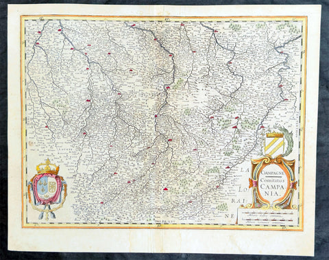
1628 Gerard Mercator & Henricus Hondius Antique Map, Champagne Region of France
- Title : Champagne...Comitatus Campania
- Size: 21in x 17in (530mm x 430mm)
- Condition: (A) Very Good Condition
- Date : 1628
- Ref #: 26134
Description:
This original copper plate engraved antique map of the French region of Champagne by Gerard Mercator was published by Henricus Hondius in the early 1628 French edition of Gerard Mercators Atlas.
These maps, published in the early editions of Mercators atlas, are the original maps drawn and engraved by Gerald Mercator in the mid to late 16th century, published by his son Rumold as an atlas, after his death, in 1595. After two editions the plates were purchased by Jodocus Hondius in 1604, and continued to be published until the end of the 1630s by Henricus Hondius, when some of the plates were re-engraved and updated with the help of Jan Jansson.
General Definitions:
Paper thickness and quality: - Heavy and stable
Paper color : - off white
Age of map color: - Early
Colors used: - Green, yellow, blue, orange
General color appearance: - Authentic
Paper size: - 21in x 17in (530mm x 430mm)
Plate size: - 18 1/2in x 14in (475mm x 350mm)
Margins: - Min 1/2in (12mm)
Imperfections:
Margins: - Light age toning
Plate area: - Light toning
Verso: - Light age toning
1628 Gerard Mercator & Henricus Hondius Antique Map, Champagne Region of France
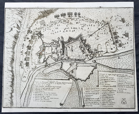
1675 Merian Antique Map Birds Eye View Siege of Szczecin, Stettin Poland in 1659
Antique Map
- Title : Abzeichnung der Belägerung der Statt Stettin in Pommeren wie dieselbe von denen Kayserlichen vom 29.Sept. biß auf den 15. Novemb. Anno 1659 angegriffen und bestritten worden
- Ref #: 93491
- Size: 15 1/2in x 13in (395mm x 340mm)
- Date : 1675
- Condition: (A+) Fine Condition
Description:
This original copper-plate engraved antique map a birds-eye view of the siege of Szczecin or Stettin, Poland in 1659 - with illustrations of military positions surrounding the city - by Matthaus Merian was published in the 1675 edition of Theatrum Europaeum
During the Thirty Years War, Stettin refused to accept German imperial armies, instead the Pomeranian dukes allied with Sweden. After the Treaty of Stettin (1630) manifested Swedish occupation, Stettin was fortified by the Swedish Empire. After the death of the last Pomeranian duke, Boguslaw XIV, Stettin was awarded to Sweden with the western part of the duchy in the Peace of Westphalia (1648), but remained part of the Holy Roman Empire. The Swedish-Brandenburgian border was settled in the Treaty of Stettin (1653). The King of Sweden became Duke of Pomerania and as such held a seat in the Imperial Diet of the Holy Roman Empire. The city was cut off from its main trading area, and was besieged in several wars with Brandenburg which shattered the citys economy, which fell in prolonged economic decline.
In 1654 the last Pomeranian duke Boguslaw XIV was buried in the Ducal Castle.
General Definitions:
Paper thickness and quality: - Heavy and stable
Paper color : - off white
Age of map color: -
Colors used: -
General color appearance: -
Paper size: - 15 1/2in x 13in (395mm x 340mm)
Plate size: - 15 1/2in x 13in (395mm x 340mm)
Margins: - Min 1/8in (2mm)
Imperfections:
Margins: - Left margin cropped close to border
Plate area: - None
Verso: - None
Background:
Szczecin/Stettin is the capital and largest city of the West Pomeranian Voivodeship in northwestern Poland. Located near the Baltic Sea and the German border, it is a major seaport and Polands seventh-largest city.
Szczecin is located on the river Oder, south of the Szczecin Lagoon and the Bay of Pomerania. The city is situated along the southwestern shore of Dąbie Lake, on both sides of the Oder and on several large islands between the western and eastern branches of the river. Szczecin is adjacent to the town of Police and is the urban centre of the Szczecin agglomeration, an extended metropolitan area that includes communities in the German states of Brandenburg and Mecklenburg-Vorpommern.
The cities recorded history began in the 8th century as a Lechitic Pomeranian stronghold, built at the site of the Ducal castle. In the 12th century, when Szczecin had become one of Pomeranias main urban centres, it lost its independence to Piast Poland, the Duchy of Saxony, the Holy Roman Empire and Denmark. At the same time, the House of Griffins established themselves as local rulers and the population was Christianized. After the Treaty of Stettin in 1630, the town came under the control of the Swedish Empire and became in 1648 the Capital of Swedish Pomerania until 1720, when it was acquired by the Kingdom of Prussia and then the German Empire. Following World War II Stettin became part of Poland in accordance with the Potsdam Agreement, resulting in the almost complete expulsion of the pre-war German population.
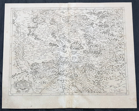
1628 Gerard Mercator Antique Map the Southern Lorraine Region of France
Antique Map
- Title : La Partie Meridionale de Lorraine...Per Geradum Mercatorem Cum Privilegio
- Size: 21in x 17in (530mm x 430mm)
- Condition: (A) Very Good Condition
- Date : 1628
- Ref #: 26142
Description:
This original copper plate engraved antique map ancient region of southern Lorraine, France by Gerard Mercator was published by Henricus Hondius in the early 1628 French edition of Gerard Mercators Atlas.
These maps, published in the early editions of Mercators atlas, are the original maps drawn and engraved by Gerald Mercator in the mid to late 16th century, published by his son Rumold as an atlas, after his death, in 1595. After two editions the plates were purchased by Jodocus Hondius in 1604 and continued to be published until the mid 1630\\\'s when the plates were re-engraved and updated by Jan Jansson and Henricus Hondius.
General Definitions:
Paper thickness and quality: - Heavy and stable
Paper color : - off white
Age of map color: -
Colors used: -
General color appearance: -
Paper size: - 21in x 17in (530mm x 430mm)
Plate size: - 20in x 15in (510mm x 380mm)
Margins: - Min 1/2in (12mm)
Imperfections:
Margins: - Age toning
Plate area: - Age toning
Verso: - Age toning
Lorraine is a cultural and historical region in north-eastern France, now located in the administrative region of Grand Est. Lorraines name stems from the medieval kingdom of Lotharingia, which in turn was named for either Emperor Lothair I or King Lothair II. It later was ruled as the Duchy of Lorraine before the Kingdom of France annexed it in 1766.
1816 John Thomson Large Antique Map of Southern India & Northern Sri Lanka
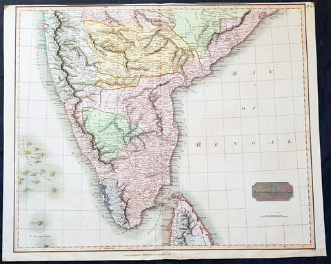
- Title : Southern Hindostan....Drawn & Engraved for Thomsons New General Atlas, 1816
- Date : 1816
- Size: 25in x 20 1/2in (635mm x 520mm)
- Condition: (A+) Fine Condition
- Ref: 41004
Description:
This large magnificent original hand coloured copper-plate engraved antique map of South India & northern Sri Lanka by John Thomson was engraved by Samuel Neele in 1816 - dated at the foot of the map - and was published in the 1817 edition of Thomsons New General Atlas
General Definitions:
Paper thickness and quality: - Heavy and stable
Paper color : - off white
Age of map color: - Original
Colors used: - Yellow, green, blue, pink
General color appearance: - Authentic
Paper size: - 25in x 20 1/2in (635mm x 520mm)
Plate size: - 25in x 20 1/2in (635mm x 520mm)
Margins: - Min 1/2in (15mm)
Imperfections:
Margins: - Top margin soiling and cropped to plate-mark
Plate area: - None
Verso: - None
Background:
The cartography of India begins with early charts for navigation and constructional plans for buildings. Indian traditions influenced Tibetan and Islamic traditions, and in turn, were influenced by the British cartographers who solidified modern concepts into India\'s map making
A prominent foreign geographer and cartographer was Hellenistic geographer Ptolemy (90–168) who researched at the library in Alexandria to produce a detailed eight-volume record of world geography. During the Middle Ages, India sees some exploration by Chinese and Muslim geographers, while European maps of India remain very sketchy. A prominent medieval cartographer was Persian geographer Abu Rayhan Biruni (973–1048) who visited India and studied the country\'s geography extensively.
European maps become more accurate with the Age of Exploration and Portuguese India from the 16th century. The first modern maps were produced by Survey of India, established in 1767 by the British East India Company. Survey of India remains in continued existence as the official mapping authority of the Republic of India.
1695 De Rossi Large Old, Antique Map of The Champagne Region of France
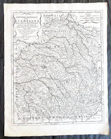
- Title : Governo generale della Ciampagna diviso nelle sue Parti Principali; da Giaco. Cantelli da Vignola geografo del Sermo Sigr. Duca di Moda.; e dato in luce da Domenico de Rossi erede di Gio. Giaco. de Rossi dalle sue Stampe in Roma alla Pace, con Privil. del S.P. e licenza de Sup. l'Anno 1695
- Ref #: 50224
- Size: 24in x 18 1/2in (610mm x 470mm)
- Date : 1695
- Condition: (A+) Fine Condition
Description:
This very large, beautifully engraved original antique map of the Champagne Region of France by Giovanni Giacomo de Rossi, (1627-1691) in 1695 - dated in title - and was published by Domenico de Rossi in his monumental Atlas Mercurio Geografico overo Guida Geografica in tutte le parti del Mondo.
Background: A fine example of De Rossi's atlas map, similar to Coronelli's maps of the same period, with engraved decorative title. The atlas included 150 engraved outline hand colored maps with decorative title cartouche, on 181 sheets. Maps are dated between 1669 and 1715, issued by Giov. Giac. de Rossi and Domenico de Rossi, they are mainly derived from Cantelli da Vignola's maps, an important seventeenth-century cartographer who pioneered the Italian style of fine bold engraving that would eventually be embraced and expanded upon by Vincenzo Coronelli, and Nicolas Sanson (1600 – 1667) a French cartographer, termed by some the creator of French geography.
Many of the maps were engraved by Baudrand, Franciscus Donia, G.B. Falda, Jean Lhuilier, Vin Mariotti, Gasparo Pietro Santa, Salomon Rogiers, & Giorgio Widman, Lubin, Titi, Ameti, Magini and Mattei.
Giovanni Giacomo De Rossi (1627 - 1691) was an Italian printer and publisher active in 17th century Rome. Giovanni inherited the important Rome based printing business originally founded by his father, Giuseppe de Rossi (1570-1639). By the mid-17th century the Rossi firm was considered the most active and important press in Rome. (Ref Tooley M&B)
General Description:
Paper thickness and quality: - Heavy and stable
Paper color: - off white
Age of map color: -
Colors used: -
General color appearance: -
Paper size: - 24in x 18 1/2in (610mm x 470mm)
Plate size: - 20 3/4in x 16 3/4in (525mm x 425mm)
Margins: - Min 1in (25mm)
Imperfections:
Margins: - None
Plate area: - None
Verso: - None
1728 Hermann Moll Large Antique Map and View of Gibraltar - 2nd Spanish Seige
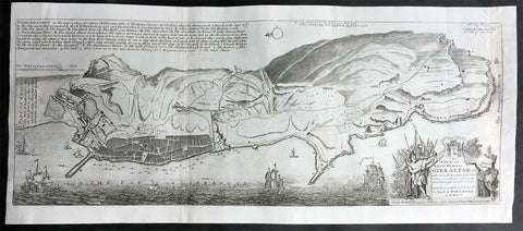
- Title : A New and Exact plan of Gibraltar with all its fortifications as they are at present….
- Ref #: 40838
- Size: 25in x 11in (635mm x 280mm)
- Date : 1727
- Condition: (B) Good Condition
Description:
This finely engraved original antique map and view of the second Spanish siege of Gibraltar by Herman Moll was published in 1727.
Although undated, the legend at the top left of the map, gives an in-depth explanation to the map including no. 5 that refers to 'Place where at this time Barracks building for a Regiment Ap: 15. 1726. 6. The Great Church.', while the dedication is to David Colyear, 1st Earl of Portmore, Governor of Gibraltar. The plan was presumably engraved either in anticipation of, or during the second Spanish siege; Portmore was in England when the siege began, but sailed there with a relief force, arriving on 1st May, 1727. British command of the sea, coupled with the natural features of the Rock of Gibraltar on the landward side of the peninsula, combined to thwart Spanish ambition, and the siege petered to an end in 1728, with the garrison never seriously troubled.
Background: Gibraltar became part of the Visigothic Kingdom of Hispania following the collapse of the Roman Empire and came under Muslim Moorish rule in 711 AD. It was permanently settled for the first time by the Moors and was renamed Jebel Tariq – the Mount of Tariq, later corrupted into Gibraltar. The Christian Crown of Castile annexed it in 1309, lost it again to the Moors in 1333 and finally regained it in 1462. Gibraltar became part of the unified Kingdom of Spain and remained under Spanish rule until 1704. It was captured during the War of the Spanish Succession by an Anglo-Dutch fleet in the name of Charles VI of Austria, the Habsburg contender to the Spanish throne. At the war's end, Spain ceded the territory to Britain under the terms of the Treaty of Utrecht of 1713.
Spain tried to regain control of Gibraltar, which Britain had declared a Crown colony, through military, diplomatic and economic pressure. Gibraltar was besieged and heavily bombarded during three wars between Britain and Spain but the attacks were repulsed on each occasion. By the end of the last siege, in the late 18th century, Gibraltar had faced fourteen sieges in 500 years. In the years after Trafalgar, Gibraltar became a major base in the Peninsular War. The colony grew rapidly during the 19th and early 20th centuries, becoming one of Britain's most important possessions in the Mediterranean. It was a key stopping point for vessels en route to India via the Suez Canal. A large British naval base was constructed there at great expense at the end of the 19th century and became the backbone of Gibraltar's economy.
British control of Gibraltar enabled the Allies to control the entrance to the Mediterranean during the Second World War. It was attacked on several occasions by German, Italian and Vichy French forces, though without causing much damage. The Spanish dictator General Francisco Franco declined to join a Nazi plan to occupy Gibraltar but revived Spain's claim to the territory after the war. As the territorial dispute intensified, Spain closed its border with Gibraltar between 1969 and 1985 and communications links were severed. Spain's position was supported by Latin American countries but was rejected by Britain and the Gibraltarians themselves, who vigorously asserted their right to self-determination. Discussions of Gibraltar's status have continued between Britain and Spain but have not reached any conclusion.
Shortly after Gibraltar's recapture, King Henry IV of Castile declared it Crown property and reinstituted the special privileges which his predecessor had granted during the previous period of Christian rule. Four years after visiting Gibraltar in 1463, he was overthrown by the Spanish nobility and clergy. His half-brother Alfonso was declared king and rewarded Medina Sidonia for his support with the lordship of Gibraltar. The existing governor, a loyalist of the deposed Henry IV, refused to surrender Gibraltar to Medina Sidonia. After a fifteen-month siege from April 1466 to July 1467, Medina Sidonia took control of the town. He died the following year but his son Enrique was confirmed as lord of Gibraltar by the reinstated Henry IV in 1469. In 1474 the new Duke of Medina Sidonia sold Gibraltar to a group of Jewish conversos from Cordova and Seville led by Pedro de Herrera in exchange for maintaining the garrison of the town for two years, after which time the 4,350 conversos were expelled by the Duke. His status was further enhanced by Isabella I of Castile in 1478 with the granting of the Marquisate of Gibraltar.
On 2 January 1492, after five years of war, the Moorish emirate in Spain came to an end with the Catholic Monarchs' capture of Granada. The Jews of Gibraltar were, like those elsewhere in the kingdom, expelled from Spain by order of the monarchs in March that year. Gibraltar was used by Medina Sidonia as a base for the Spanish capture of Melilla in North Africa in 1497. Two years later the Muslims of Granada were ordered to convert to Christianity or leave. Those that did not convert left for North Africa, some of them travelling via Gibraltar.
Gibraltar became Crown property again in 1501 at the order of Isabella and the following year it received a new set of royal arms, which is still used by modern Gibraltar, replacing those of Medina Sidonia. In the Royal Warrant accompanying the arms, Isabella highlighted Gibraltar's importance as "the key between these our kingdoms in the Eastern and Western Seas [the Mediterranean and Atlantic]". The metaphor was represented on the royal arms by a golden key hanging from the front gate of a battlemented fortress. The warrant charged all future Spanish monarchs to "hold and retain the said City for themselves and in their own possession; and that no alienation of it, nor any part of it, nor its jurisdiction ... shall ever be made from the Crown of Castile."
At this point in history, "Gibraltar" meant not just the peninsula but the entire surrounding area including the land on which the towns of La Línea de la Concepción, San Roque, Los Barrios and Algeciras now stand. To the east, Gibraltar was bounded by the Guadiaro River, and its northern boundaries lay in the vicinity of Castellar de la Frontera, Jimena de la Frontera, Alcalá de los Gazules, Medina-Sidonia and Tarifa. From the 16th century, the modern meaning of the name came to be adopted – specifically referring only to the town of Gibraltar and the peninsula on which it stands.
Under Spanish Crown rule, the town of Gibraltar fell into severe decline. The end of Muslim rule in Spain and the Christian capture of the southern ports considerably decreased the peninsula's strategic value. It derived some minor economic value from tuna-fishing and wine-producing industries but its usefulness as a fortress was now limited. It was effectively reduced to the status of an unremarkable stronghold on a rocky promontory and Marbella replaced it as the principal Spanish port in the region.
Gibraltar's inhospitable terrain made it an unpopular place to live. To boost the population, convicts from the kingdom of Granada were offered the possibility of serving their sentence in the Gibraltar garrison as an alternative to prison. Despite its apparent unattractiveness, Juan Alfonso de Guzmán, third Duke of Medina Sidonia, nonetheless sought to regain control of the town. In September 1506, following Isabella's death, he laid siege in the expectation that the gates would quickly be opened to his forces. This did not happen, and after a fruitless four-month blockade he gave up the attempt. Gibraltar received the title of "Most Loyal" from the Spanish crown in recognition of its faithfulness (Ref: M&B, Tooley)
General Description:
Paper thickness and quality: - Heavy and stable
Paper color: - off white
Age of map color: -
Colors used: -
General color appearance: -
Paper size: - 25in x 11in (635mm x 280mm)
Plate size: - 25in x 11in (635mm x 280mm)
Margins: - Min 1/4in (5mm)
Imperfections:
Margins: - None
Plate area: - Small loss to the very right figure in the title cartouche not affecting the map, light creasing along folds as issued

1647 Olivarius Vredius Antique Map of Roman Europe Flanders, Germany, France
- Title : Francorum Primae Sedes...Incisum Bruges a Joe F Jois...Olivario Vredio...1647
- Ref #: 60040
- Size: 16 1/2in x 14in (420mm x 355mm)
- Date : 1647
- Condition: (A+) Fine Condition
Description:
This fine scarce beautifully engraved original antique map of central & western Roman Europe centering on what is today Belgium, the Southern Netherlands, Northern France and Western Germany - was engraved in 1647 - dated - and published by Olivarius Vredius (Olivier de Wree)in the 1652 edition of Historiae Comitum Flandriae
Historiae Comitum Flandriae was an important historical work on the origin and early history of Flanders by the well-known historian Olivarius Vredius - Olivier de Wree - (1596-1652) from Bruges. Vredius belongs to the most prominent representatives of late-Belgian humanism and his historical works are still considered to be of high value. (Ref: M&B; Tooley)
General Description:
Paper thickness and quality: - Heavy & stable
Paper color: - White
Age of map color: -
Colors used: -
General color appearance: -
Paper size: - 16 1/2in x 14in (420mm x 355mm)
Plate size: - 12 1/2in x 11in (320mm x 280mm)
Margins: - Min 1in (25mm)
Imperfections:
Margins: - None
Plate area: - Light blue underlining some names, light creasing
Verso: - None
1638 Joducus Hondius Antique Map of the Lorraine Region of NE France - Grand Est
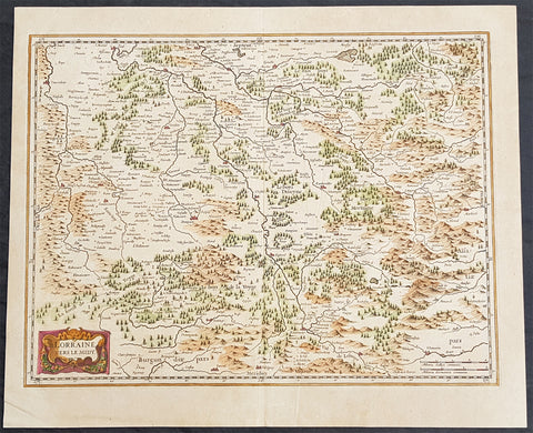
- Title : Lorraine Vers Le Midy
- Ref #: 50250
- Size: 21 1/2in x 17 1/2in (545mm x 445mm)
- Date : 1638
- Condition: (A) Very Good Condition
Description:
This beautifully hand coloured original antique map of the ancient Lorraine region of France - centering on the Moselle River with the city of Nancy to the north Faucogney-et-la-Mer to the south & the Meuse River to the west - by Gerard Mercator was published by Jodocus Hondius in the 1638 edition of Mercators Atlas.
General Definitions:
Paper thickness and quality: - Heavy and stable
Paper color : - off white
Age of map color: - Original
Colors used: - Yellow, green, blue, pink
General color appearance: - Authentic
Paper size: - 21 1/2in x 17 1/2in (545mm x 445mm)
Plate size: - 19 1/2in x 15 1/2in (500mm x 395mm)
Margins: - Min 1/2in (12mm)
Imperfections:
Margins: - Light age toning
Plate area: - None
Verso: - Light age toning
Background:
Lorraine is a cultural and historical region in north-eastern France, now located in the administrative region of Grand Est. Lorraines name stems from the medieval kingdom of Lotharingia, which in turn was named for either Emperor Lothair I or King Lothair II. It later was ruled as the Duchy of Lorraine before the Kingdom of France annexed it in 1766.
1639 Henricus Hondius Original Antique Map of the German State of Thuringia
Antique Map
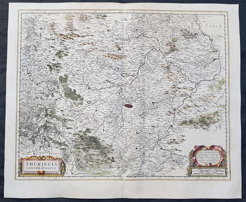
- Title : Thuringia Lantgraviatus
- Date : 1639
- Size: 22 1/2in x 19in (570mm x 485mm)
- Ref #: 23434
- Condition: (A) Very Good Condition
Description:
This fine original antique map of the German State of Thuringia or Thüringen in central Germany was published by Henricus Hondius in the 1639 edition of Mercators Atlas.
The map centers on the city of Erfurt and alos includes major cities of Gotha, Weimar, Schwartzburg, Halle, Jena, Mulhausen and others
General Definitions:
Paper thickness and quality: - Heavy and stable
Paper color : - off white
Age of map color: - Original
Colors used: - Yellow, green, blue, pink
General color appearance: - Authentic
Paper size: - 22 1/2in x 19in (570mm x 485mm)
Plate size: - 20 1/2in x 16 1/2in (520mm x 420mm)
Margins: - Min 1in (25mm)
Imperfections:
Margins: - None
Plate area: - Light creasing along centerfold,
Verso: - Small repair to bottom left margin
Background:
Named after the Thuringii tribe who occupied it around AD 300, Thuringia came under Frankish domination in the 6th century.
Thuringia became a landgraviate in 1130 AD. After the extinction of the reigning Ludowingian line of counts and landgraves in 1247 and the War of the Thuringian Succession (1247–1264), the western half became independent under the name of \"Hesse\", never to become a part of Thuringia again. Most of the remaining Thuringia came under the rule of the Wettin dynasty of the nearby Margraviate of Meissen, the nucleus of the later Electorate and Kingdom of Saxony. With the division of the house of Wettin in 1485, Thuringia went to the senior Ernestine branch of the family, which subsequently subdivided the area into a number of smaller states, according to the Saxon tradition of dividing inheritance amongst male heirs. These were the \"Saxon duchies\", consisting, among others, of the states of Saxe-Weimar, Saxe-Eisenach, Saxe-Jena, Saxe-Meiningen, Saxe-Altenburg, Saxe-Coburg, and Saxe-Gotha; Thuringia became merely a geographical concept.
Thuringia generally accepted the Protestant Reformation, and Roman Catholicism was suppressed as early as 1520; priests who remained loyal to it were driven away and churches and monasteries were largely destroyed, especially during the German Peasants\' War of 1525. In Mühlhausen and elsewhere, the Anabaptists found many adherents. Thomas Müntzer, a leader of some non-peaceful groups of this sect, was active in this city. Within the borders of modern Thuringia the Roman Catholic faith only survived in the Eichsfeld district, which was ruled by the Archbishop of Mainz, and to a small degree in Erfurt and its immediate vicinity.
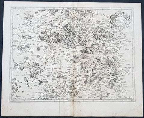
1628 Gerard Mercator Antique Map Lotharingia Region - Netherlands Germany France
Antique Map
- Title : Lotharingia Ducatus...Per Geradum Mercatorem Cum Privilegio
- Size: 21in x 17in (530mm x 430mm)
- Condition: (A) Very Good Condition
- Date : 1628
- Ref #: 26141
Description:
This original copper plate engraved antique map of the historical region of Lotharingia region of present-day Netherlands, Belgium, Luxembourg, North Rhine-Westphalia (Germany), Rhineland-Palatinate (Germany), Saarland (Germany), and Lorraine (France) by Gerard Mercator was published by Henricus Hondius in the early 1628 French edition of Gerard Mercators Atlas.
These maps, published in the early editions of Mercators atlas, are the original maps drawn and engraved by Gerald Mercator in the mid to late 16th century, published by his son Rumold as an atlas, after his death, in 1595. After two editions the plates were purchased by Jodocus Hondius in 1604 and continued to be published until the mid 1630\\\'s when the plates were re-engraved and updated by Jan Jansson and Henricus Hondius.
General Definitions:
Paper thickness and quality: - Heavy and stable
Paper color : - off white
Age of map color: -
Colors used: -
General color appearance: -
Paper size: - 21in x 17in (530mm x 430mm)
Plate size: - 20in x 15in (510mm x 380mm)
Margins: - Min 1/2in (12mm)
Imperfections:
Margins: - Age toning
Plate area: - Age toning
Verso: - Age toning
Lotharingia was a medieval successor kingdom of the Carolingian Empire, comprising the present-day Netherlands, Belgium, Luxembourg, North Rhine-Westphalia (Germany), Rhineland-Palatinate (Germany), Saarland (Germany), and Lorraine (France). It was named after King Lothair II who received this territory after the kingdom of Middle Francia of his father Lothair I was divided among his sons in 855.
Lotharingia was born out of the tripartite division in 855 of the kingdom of Middle Francia, which itself was formed after the threefold division of the Carolingian Empire by the Treaty of Verdun of 843. Conflict between East and West Francia over Lotharingia was based on the fact that these were the old Frankish homelands of Austrasia, so possession of them was of great prestige.
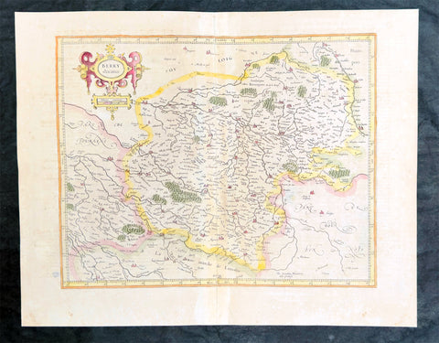
1628 Gerard Mercator Antique Map of the Berry Province of central France
Antique Map
- Title : Berry Ducatus...Per Geradum Mercatorem Cum Privilegio
- Size: 21in x 17in (530mm x 430mm)
- Condition: (A) Very Good Condition
- Date : 1628
- Ref #: 26137
Description:
This original copper plate engraved antique map of the Berry Province of central France by Gerard Mercator was published by Henricus Hondius in the early 1628 French edition of Gerard Mercators Atlas.
These maps, published in the early editions of Mercators atlas, are the original maps drawn and engraved by Gerald Mercator in the mid to late 16th century, published by his son Rumold as an atlas, after his death, in 1595. After two editions the plates were purchased by Jodocus Hondius in 1604 and continued to be published until the mid 1630\\\'s when the plates were re-engraved and updated by Jan Jansson and Henricus Hondius.
General Definitions:
Paper thickness and quality: - Heavy and stable
Paper color : - off white
Age of map color: - Early
Colors used: - Yellow, green, blue, pink
General color appearance: - Authentic
Paper size: - 21in x 17in (530mm x 430mm)
Plate size: - 20in x 15in (510mm x 380mm)
Margins: - Min 1/2in (12mm)
Imperfections:
Margins: - Age toning
Plate area: - Age toning
Verso: - Age toning
Berry is a region located in the center of France. It was a province of France until départements replaced the provinces on 4 March 1790, when Berry became divided between the départements of Cher (High Berry) and Indre (Low Berry).
The Berry region now consists of the départements of Cher, Indre and parts of Creuse. The city Bourges functioned as the capital of Berry. Berry is notable as the birthplace of several kings and other members of the French royal family, and was the birthplace of the famous knight Baldwin Chauderon, who fought in the First Crusade. In the Middle Ages, Berry became the centre of the Duchy of Berry. It is also known for an illuminated manuscript produced in the 14th–15th century called Les Très Riches Heures du Duc de Berry.
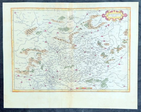
1628 Gerard Mercator Antique Map of The Burgundy Region of France
- Title : Burgundia Ducatus
- Size: 21in x 17in (530mm x 430mm)
- Condition: (A) Very Good Condition
- Date : 1628
- Ref #: 26143
Description:
This original copper plate engraved antique map of of the historical region of the Free County of Burgundy (Franche Comte de Bourgogne) of eastern France by Gerard Mercator was published by Henricus Hondius in the early 1628 French edition of Gerard Mercators Atlas.
These maps, published in the early editions of Mercators atlas, are the original maps drawn and engraved by Gerald Mercator in the mid to late 16th century, published by his son Rumold as an atlas, after his death, in 1595. After two editions the plates were purchased by Jodocus Hondius in 1604 and continued to be published until the mid 1630\\\'s when the plates were re-engraved and updated by Jan Jansson and Henricus Hondius.
General Definitions:
Paper thickness and quality: - Heavy and stable
Paper color : - off white
Age of map color: - Later
Colors used: - Green, yellow, red, orange, blue
General color appearance: - Authentic
Paper size: - 21in x 17in (530mm x 430mm)
Plate size: - 20in x 15in (510mm x 380mm)
Margins: - Min 1/2in (12mm)
Imperfections:
Margins: - Age toning, light creasing
Plate area: - Age toning, light creasing
Verso: - Age toning, light creasing
Background:
Burgundy is a historical territory and a former administrative region of France. It takes its name from the Burgundians, an East Germanic people who moved westwards beyond the Rhine during the late Roman period.
Historically, Burgundy has referred to numerous political entities, including kingdoms and duchies spanning territory from the Mediterranean to the Low Countries.
The first recorded inhabitants of the area that became Burgundy were Celts, who were eventually incorporated in the Roman Empire as Gallo-Romans.
During the 4th century, the Burgundians, a Germanic people, who may have originated in Bornholm (on the Baltic Sea), settled in the western Alps. They founded the Kingdom of the Burgundians, which was conquered in the 6th century by another Germanic tribe, the Franks.
Later, the region was divided between the Duchy of Burgundy (to the west) and the Free County of Burgundy (to the east). The Duchy of Burgundy is the better-known of the two, later becoming the French province of Burgundy, while the County of Burgundy became the French province of Franche-Comté, literally meaning free county.
Burgundys modern existence is rooted in the dissolution of the Frankish Empire. In the 880s, there were four Burgundies, which were the Kingdom of Upper and Lower Burgundy, the duchy and the county.
During the Middle Ages, Burgundy was home to some of the most important Western churches and monasteries, including those of Cluny, Cîteaux, and Vézelay. Cluny, founded in 910, exerted a strong influence in Europe for centuries. The first Cistercian abbey was founded in 1098 in Cîteaux. Over the next century, hundreds of Cistercian abbeys were founded throughout Europe, in a large part due to the charisma and influence of Bernard of Clairvaux. The Abbey of Fontenay, a UNESCO World Heritage site, is today the best-preserved Cistercian abbey in Burgundy. The Abbey of Vezelay, also a UNESCO site, is still a starting point for pilgrimages to Santiago de Compostela. Cluny was almost totally destroyed during the French Revolution.
During the Hundred Years War, King John II of France gave the duchy to his youngest son, Philip the Bold. The duchy soon became a major rival to the crown. The court in Dijon outshone the French court both economically and culturally. In 1477, at the battle of Nancy during the Burgundian Wars, the last duke Charles the Bold was killed in battle, and the Duchy itself was annexed by France and became a province. However the northern part of the empire was taken by the Austrian Habsburgs.
With the French Revolution in the end of the 18th century, the administrative units of the provinces disappeared, but were reconstituted as regions during the Fifth Republic in the 1970s. The modern-day administrative region comprises most of the former duchy.
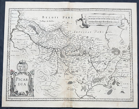
1628 Jan Jansson Antique Map of the Picardy or Picardie Region of France
- Title : Picardia
- Size: 22in x 17in (560mm x 430mm)
- Condition: (A) Very Good Condition
- Date : 1628
- Ref #: 26133
Description:
This original copper plate engraved antique map of the French region of Picardy or Picardie by Jan Jansson was published in the early 1628 French edition of Janssons Atlas.
General Definitions:
Paper thickness and quality: - Heavy and stable
Paper color : - off white
Age of map color: -
Colors used: -
General color appearance: -
Paper size: - 22in x 17in (560mm x 430mm)
Plate size: - 20in x 15in (510mm x 380mm)
Margins: - Min 1/2in (12mm)
Imperfections:
Margins: - Age toning
Plate area: - Age toning
Verso: - Age toning
Background:
Picardy is a historical territory and a former administrative region of Northern France and now part of the new region Nord-Pas-de-Calais-Picardie.
From the 5th century the area was part of the Frankish Empire, and in the feudal period it encompassed the six countships of Boulogne, Montreuil, Ponthieu, Amiénois,Vermandois, and Laonnois. According to the 843 Treaty of Verdun the region became part of West Francia, the later Kingdom of France.
The name Picardy (which may have referred to a Frankish tribe of picards or pike-bearers) was not used until the 12th or 13th century. During this time, the name applied to all lands where the Picard language was spoken, which included all the territories from Paris to the Netherlands. In the Latin Quarter of Paris, people identified a Picard Nation (Nation Picarde) of students at Sorbonne University, most of whom actually came from Flanders. During the Hundred Years\\\\\\\' War, Picardy was the centre of the Jacquerie peasant revolt in 1358.
From 1419 onwards, the Picardy counties (Boulogne, Ponthieu, Amiens, Vermandois) were gradually acquired by the Burgundian duke Philip the Good, confirmed by King Charles VII of France at the 1435 Congress of Arras. In 1477, King Louis XI of France led an army and occupied key towns in Picardy. By the end of 1477, Louis would control all of Picardy and most of Artois.
In the 16th century, the government (military region) of Picardy was created. This became a new administrative region of France, separate from what was historically defined as Picardy. The new Picardy included the Somme département, the northern half of the Aisne département, and a small fringe in the north of the Oise département.
In 1557, Picardy was invaded by Hapbsburg forces under the command of Emmanuel Philibert, Duke of Savoy. After a seventeen-day siege, St. Quentin would be ransacked while Noyon would be burned by the Habsburg army.
In the 17th century, an infectious disease similar to English sweat originated from the region and spread across France. It was called Suette des picards or Picardy sweat.
Sugar beet was introduced by Napoleon I during the Napoleonic Wars in the 19th century, in order to counter the United Kingdom, which had seized the sugar islands possessed by France in the Caribbean. The sugar industry has continued to play a prominent role in the economy of the region.
One of the most significant historical events to occur in Picardy was the series of battles fought along the Somme during World War I. From September 1914 to August 1918, four major battles, including the Battle of the Somme, were fought by British, French, and German forces in the fields of Northern Picardy. (Ref: Koeman; M&B; Tooley)
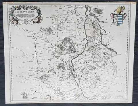
1650 Joan Blaeu Antique Map Archbishopic of Madenburg in Saxony-Anhalt, Germany
- Title : Magdeburgensis Archiepiscopatus...Amstelaedami J Blaeu excudebat
- Size: 21in x 17in (530mm x 430mm)
- Condition: (A+) Fine Condition
- Date : 1650
- Ref #: 70075
Description:
This beautifully hand coloured original copper-plate engraved antique map of the Archbishopric of Madenburg today located in the state of Saxony-Anhalt, Germany, on the Elbe River, was published in the 1650 edition of Joan Blaeus Atlas Novus.
General Definitions:
Paper thickness and quality: - Heavy and stable
Paper color : - off white
Age of map color: - Original
Colors used: - Yellow, Green, pink
General color appearance: - Authentic
Paper size: - 21in x 17in (530mm x 430mm)
Plate size: - 21in x 17in (530mm x 430mm)
Margins: - Min 1/4in (6mm)
Imperfections:
Margins: - Top margin cropped to plate-mark
Plate area: - None
Verso: - None
Background:
The Archbishopric of Magdeburg was a Roman Catholic archdiocese (969–1552) and Prince-Archbishopric (1180–1680) of the Holy Roman Empire centered on the city of Magdeburg on the Elbe River.
Planned since 955 and established in 968, the Roman Catholic archdiocese had de facto turned void since 1557, when the last papally confirmed prince-archbishop, the Lutheran Sigismund of Brandenburg came of age and ascended to the see and the Magdeburg cathedral chapter had adopted Lutheranism in 1567, with most parishioners having preceded in their conversion. All his successors were only administrators of the prince-archbishopric and Lutheran too, except of the Catholic layman Leopold William of Austria (1631–1635). In ecclesiastical respect the remaining Catholics and their parishes and abbeys in the former archdiocese were put under supervision of the Archdiocese of Cologne in 1648 and under the jurisdiction of the Apostolic Vicariate of the Northern Missions in 1670.
In political respect the Erzstift, the archiepiscopal and capitular temporalities, had gained imperial immediacy as prince-archbishopric in 1180. Its territory comprised only some parts of the archdiocesan area, such as the city of Magdeburg, the bulk of the Magdeburg Börde, and the Jerichow Land as an integral whole and exclaves comprising about the Saalkreis including Halle upon Saale, Oebisfelde and environs as well as Jüterbog and environs. The prince-archbishopric maintained its statehood as an elective monarchy until 1680. Then Brandenburg-Prussia acquired Magdeburg prince-archbishopric, and after being secularised, transformed it into the Duchy of Magdeburg, a hereditary monarchy in personal union with Brandenburg.
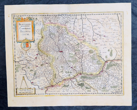
1638 Gerard Mercator & Henricus Hondius Antique Map of Beauvais Region, France
- Title : Beauvaisis Comitatus Belovacium
- Size: 21in x 17in (530mm x 430mm)
- Condition: (A) Very Good Condition
- Date : 1638
- Ref #: 50178
Description:
This original copper plate engraved antique map of the Beauvais region of Northern France - centering on the city of Beauvais & the Oise River running through the cities of Noyon, Compiègne, Creil by Gerard Mercator was published by Henricus Hondius in the early 1638 Latin edition of Gerard Mercators Atlas.
These maps, published in the early editions of Mercators atlas, are the original maps drawn and engraved by Gerald Mercator in the mid to late 16th century, published by his son Rumold as an atlas, after his death, in 1595. After two editions the plates were purchased by Jodocus Hondius in 1604, and continued to be published until the end of the 1630s by Henricus Hondius, when some of the plates were re-engraved and updated with the help of Jan Jansson.
General Definitions:
Paper thickness and quality: - Heavy and stable
Paper color : - off white
Age of map color: - Original
Colors used: - Blue, pink, red, green, yellow
General color appearance: - Authentic
Paper size: - 21in x 17in (530mm x 430mm)
Plate size: - 18 1/2in x 14in (475mm x 350mm)
Margins: - Min 1/2in (12mm)
Imperfections:
Margins: - Light age toning
Plate area: - Light age toning
Verso: - Light age toning
Background:
Beauvais is a city and commune in northern France. It serves as the capital of the Oise département, in the Hauts-de-France region. Beauvais is located approximately 75 kilometres from Paris.
Beauvais was known to the Romans by the Gallo-Roman name of Caesaromagus (magos is Common Celtic for field). The post-Renaissance Latin rendering is Bellovacum from the Belgic tribe the Bellovaci, whose capital it was. In the ninth century it became a countship, which about 1013 passed to the bishops of Beauvais, who became peers of France from the twelfth century. At the coronations of kings the Bishop of Beauvais wore the royal mantle and went, with the Bishop of Langres, to raise the king from his throne to present him to the people.
De Bello Gallico II 13 reports that as Julius Caesar was approaching a fortified town called Bratuspantium in the land of the Bellovaci, its inhabitants surrendered to him when he was about 5 Roman miles away. Its name is Gaulish for place where judgements are made, from *bratu-spantion. Some say that Bratuspantium is Beauvais. Others theorize that it is Vendeuil-Caply or Bailleul sur Thérain.
From 1004 to 1037, the Count of Beauvais was Odo II, Count of Blois.
In a charter dated 1056/1060, Eudo of Brittany granted land in pago Belvacensi (Beauvais, Picardy) to the Abbey of Angers Saint-Aubin
In 1346 the town had to defend itself against the English, who again besieged it in 1433. The siege which it endured in 1472 at the hands of the Duke of Burgundy, was rendered famous by the heroism of the towns women, under the leadership of Jeanne Hachette, whose memory is still celebrated by a procession on 27 June (the feast of Sainte Angadrême), during which women take precedence over men.
An interesting hoard of coins from the High Middle Ages became known as the Beauvais Hoard, because some of the British and European coins found with the lot were from the French abbey located in Beauvais. The hoard, which contained a variety of rare and extremely rare Anglo-Norman pennies, English and foreign coins, was reputed to have been found in or near Paris.
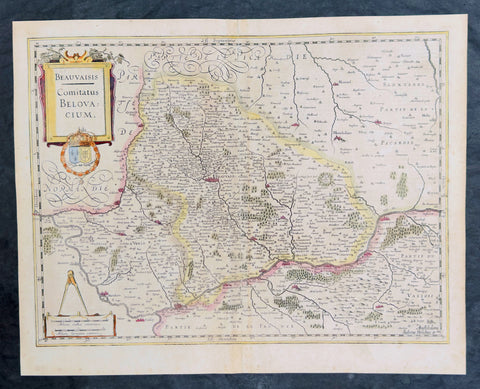
1628 Gerard Mercator & Henricus Hondius Antique Map of Beauvais Region, France
- Title : Beauvaisis Comitatus Belovacium
- Size: 21in x 17in (530mm x 430mm)
- Condition: (A) Very Good Condition
- Date : 1628
- Ref #: 26136
Description:
This original copper plate engraved antique map of the Beauvais region of Northern France - centering on the city of Beauvais & the Oise River running through the cities of Noyon, Compiègne, Creil by Gerard Mercator was published by Henricus Hondius in the early 1628 French edition of Gerard Mercators Atlas.
These maps, published in the early editions of Mercators atlas, are the original maps drawn and engraved by Gerald Mercator in the mid to late 16th century, published by his son Rumold as an atlas, after his death, in 1595. After two editions the plates were purchased by Jodocus Hondius in 1604, and continued to be published until the end of the 1630s by Henricus Hondius, when some of the plates were re-engraved and updated with the help of Jan Jansson.
General Definitions:
Paper thickness and quality: - Heavy and stable
Paper color : - off white
Age of map color: - Early
Colors used: - Greeen, yellow, blue, pink
General color appearance: - Authentic
Paper size: - 21in x 17in (530mm x 430mm)
Plate size: - 18 1/2in x 14in (475mm x 350mm)
Margins: - Min 1/2in (12mm)
Imperfections:
Margins: - Light age toning
Plate area: - Light toning along centerfold
Verso: - Light age toning
Background:
Beauvais is a city and commune in northern France. It serves as the capital of the Oise département, in the Hauts-de-France region. Beauvais is located approximately 75 kilometres from Paris.
Beauvais was known to the Romans by the Gallo-Roman name of Caesaromagus (magos is Common Celtic for field). The post-Renaissance Latin rendering is Bellovacum from the Belgic tribe the Bellovaci, whose capital it was. In the ninth century it became a countship, which about 1013 passed to the bishops of Beauvais, who became peers of France from the twelfth century. At the coronations of kings the Bishop of Beauvais wore the royal mantle and went, with the Bishop of Langres, to raise the king from his throne to present him to the people.
De Bello Gallico II 13 reports that as Julius Caesar was approaching a fortified town called Bratuspantium in the land of the Bellovaci, its inhabitants surrendered to him when he was about 5 Roman miles away. Its name is Gaulish for place where judgements are made, from *bratu-spantion. Some say that Bratuspantium is Beauvais. Others theorize that it is Vendeuil-Caply or Bailleul sur Thérain.
From 1004 to 1037, the Count of Beauvais was Odo II, Count of Blois.
In a charter dated 1056/1060, Eudo of Brittany granted land in pago Belvacensi (Beauvais, Picardy) to the Abbey of Angers Saint-Aubin
In 1346 the town had to defend itself against the English, who again besieged it in 1433. The siege which it endured in 1472 at the hands of the Duke of Burgundy, was rendered famous by the heroism of the towns women, under the leadership of Jeanne Hachette, whose memory is still celebrated by a procession on 27 June (the feast of Sainte Angadrême), during which women take precedence over men.
An interesting hoard of coins from the High Middle Ages became known as the Beauvais Hoard, because some of the British and European coins found with the lot were from the French abbey located in Beauvais. The hoard, which contained a variety of rare and extremely rare Anglo-Norman pennies, English and foreign coins, was reputed to have been found in or near Paris.
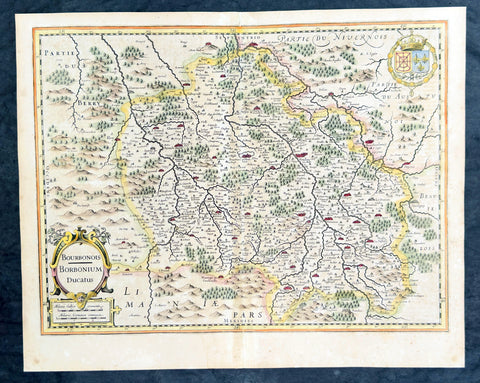
1628 Gerard Mercator & Henricus Hondius Antique Map Bourbonnais Region of France
- Title : Boubonoius; Borbonium Ducatus....
- Size: 21in x 17in (530mm x 430mm)
- Condition: (A) Very Good Condition
- Date : 1628
- Ref #: 26138
Description:
This original copper plate engraved antique map of the Bourbon or Bourbonnais Region of central France by Gerard Mercator was published by Henricus Hondius in the early 1628 French edition of Gerard Mercators Atlas.
These maps, published in the early editions of Mercators atlas, are the original maps drawn and engraved by Gerald Mercator in the mid to late 16th century, published by his son Rumold as an atlas, after his death, in 1595. After two editions the plates were purchased by Jodocus Hondius in 1604, and continued to be published until the end of the 1630s by Henricus Hondius, when some of the plates were re-engraved and updated with the help of Jan Jansson.
General Definitions:
Paper thickness and quality: - Heavy and stable
Paper color : - off white
Age of map color: - Early
Colors used: - Green, yellow, blue, red, orange
General color appearance: - Authentic
Paper size: - 21in x 17in (530mm x 430mm)
Plate size: - 18 1/2in x 14in (475mm x 350mm)
Margins: - Min 1/2in (12mm)
Imperfections:
Margins: - Light age toning
Plate area: - Light toning along centerfold
Verso: - Light age toning
Background:
Bourbonnais was a historic province in the centre of France that corresponded to the modern département of Allier, along with part of the département of Cher. Its capital was Moulins.
The title of the ruler of Bourbonnais between 913 and 1327, was Sire de Bourbon (or Seigneur de Bourbon). The first lord of Bourbonnais known by name was Adhémar (or Aymon I of Bourbon). Aymon\\\'s father was Aymar (894-953), sire of Souvigny, his only son with Ermengarde.Aymar lived during the reign of Charles the Simple who, in 913, gave him fiefs on the Allier River in which would become Bourbonnais. He acquired the castle of Bourbon (today Bourbon-l\\\'Archambault). Almost all early lords took the name d\\\'Archambaud, after the palace, but later the family became known as the \\\"House of Bourbon\\\".
The first House of Bourbon ended in 1196, with the death of Archambault VII, who had only one heir, Mathilde of Bourbon. She married Guy II of Dampierre, who added Montlucon to the possessions of the lords of Bourbon. The second house of Bourbon started in 1218, with Archambault VIII, son of Guy II and Mahaut, and brother of William II of Dampierre. He was followed by his son Archambaut IX, who died in Cyprus in 1249, during a crusade. The House of Burgundy then acquired Bourbonnais.
In 1272, Beatrice of Burgundy (1258-1310), Lady of Bourbon, married Robert de France (1256-1318), Count of Clermont, son of king Louis IX (Saint-Louis). Thus began the long-lasting House of Bourbon, which would provide the kings of France from Henry IV to Louis-Phillipe in 1848, when France abolished its monarchy.
The Bourbons had concluded an alliance with the royal power. They put their forces at the service of the king, thus benefitting from the geographic position of Bourbonnais, located between the royal fidemesne and the duchies of Aquitaine and Auvergne. This alliance, as well as the marriage of Béatrix de Bourgogne and Robert de France, aided the rise and prosperity of the province. In 1327, King Charles (le Bel) elevated Boubonnais to the status of a duchy. (Ref: Koeman; M&B; Tooley)
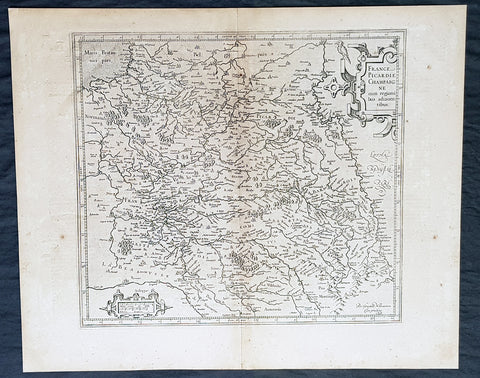
1628 Gerard Mercator & Henricus Hondius Antique Map the Picardy Region of France
- Title : France Picardie Champagne cum regionibus adiacentibus
- Size: 21in x 17in (530mm x 430mm)
- Condition: (A) Very Good Condition
- Date : 1628
- Ref #: 26131
Description:
This original copper plate engraved antique map of the French region of Picardy or Picardie by Gerard Mercator was published by Henricus Hondius in the early 1628 French edition of Gerard Mercators Atlas.
These maps, published in the early editions of Mercators atlas, are the original maps drawn and engraved by Gerald Mercator in the mid to late 16th century, published by his son Rumold as an atlas, after his death, in 1595. After two editions the plates were purchased by Jodocus Hondius in 1604, and continued to be published until the end of the 1630s by Henricus Hondius, when some of the plates were re-engraved and updated with the help of Jan Jansson.
General Definitions:
Paper thickness and quality: - Heavy and stable
Paper color : - off white
Age of map color: -
Colors used: -
General color appearance: -
Paper size: - 21in x 17in (530mm x 430mm)
Plate size: - 18 1/2in x 14in (475mm x 350mm)
Margins: - Min 1/2in (12mm)
Imperfections:
Margins: - Light age toning
Plate area: - Light toning along centerfold
Verso: - Light age toning
Background:
Picardy is a historical territory and a former administrative region of Northern France and now part of the new region Nord-Pas-de-Calais-Picardie.
From the 5th century the area was part of the Frankish Empire, and in the feudal period it encompassed the six countships of Boulogne, Montreuil, Ponthieu, Amiénois,Vermandois, and Laonnois. According to the 843 Treaty of Verdun the region became part of West Francia, the later Kingdom of France.
The name Picardy (which may have referred to a Frankish tribe of picards or pike-bearers) was not used until the 12th or 13th century. During this time, the name applied to all lands where the Picard language was spoken, which included all the territories from Paris to the Netherlands. In the Latin Quarter of Paris, people identified a Picard Nation (Nation Picarde) of students at Sorbonne University, most of whom actually came from Flanders. During the Hundred Years\\\' War, Picardy was the centre of the Jacquerie peasant revolt in 1358.
From 1419 onwards, the Picardy counties (Boulogne, Ponthieu, Amiens, Vermandois) were gradually acquired by the Burgundian duke Philip the Good, confirmed by King Charles VII of France at the 1435 Congress of Arras. In 1477, King Louis XI of France led an army and occupied key towns in Picardy. By the end of 1477, Louis would control all of Picardy and most of Artois.
In the 16th century, the government (military region) of Picardy was created. This became a new administrative region of France, separate from what was historically defined as Picardy. The new Picardy included the Somme département, the northern half of the Aisne département, and a small fringe in the north of the Oise département.
In 1557, Picardy was invaded by Hapbsburg forces under the command of Emmanuel Philibert, Duke of Savoy. After a seventeen-day siege, St. Quentin would be ransacked while Noyon would be burned by the Habsburg army.
In the 17th century, an infectious disease similar to English sweat originated from the region and spread across France. It was called Suette des picards or Picardy sweat.
Sugar beet was introduced by Napoleon I during the Napoleonic Wars in the 19th century, in order to counter the United Kingdom, which had seized the sugar islands possessed by France in the Caribbean. The sugar industry has continued to play a prominent role in the economy of the region.
One of the most significant historical events to occur in Picardy was the series of battles fought along the Somme during World War I. From September 1914 to August 1918, four major battles, including the Battle of the Somme, were fought by British, French, and German forces in the fields of Northern Picardy. (Ref: Koeman; M&B; Tooley)
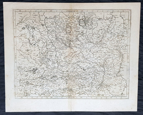
1628 Gerard Mercator & Henricus Hondius Antique Map of Westphalia, Germany
- Title : Tabula Seconde Westphalia...Per Geradum Mercatorem Cum Privilego...1627
- Size: 21in x 17in (530mm x 430mm)
- Condition: (A) Very Good Condition
- Date : 1628
- Ref #: 26109
Description:
This original copper plate engraved antique map of the Westphalia region of North Rhine-Westphalia, Germany, by Gerard Mercator was published by Henricus Hondius in the early 1628 French edition of Gerard Mercators Atlas.
These maps, published in the early editions of Mercators atlas, are the original maps drawn and engraved by Gerald Mercator in the mid to late 16th century, published by his son Rumold as an atlas, after his death, in 1595. After two editions the plates were purchased by Jodocus Hondius in 1604 and continued to be published until the mid 1630s by Henricus, when some of the plates were re-engraved and updated by Jan Jansson and Henricus Hondius.
General Definitions:
Paper thickness and quality: - Heavy and stable
Paper color : - off white
Age of map color: -
Colors used: -
General color appearance: -
Paper size: - 21in x 17in (530mm x 430mm)
Plate size: - 18 1/2in x 14in (475mm x 350mm)
Margins: - Min 1/2in (12mm)
Imperfections:
Margins: - Light age toning
Plate area: - Light toning along centerfold
Verso: - Light age toning
Background:
While the Northern Rhineland, Westphalia and Lippe are different historic territories of todays North Rhine-Westphalia, the old border between the former Rhine Province and the Province of Westphalia is also a language border. While in Westphalia and Lippe, people tend to speak West Low German dialects and especially the Westphalian variant of the Low German language, Central German and Low Franconian dialects are being spoken in the Northern Rhineland.
Westphalia is known for the 1648 Peace of Westphalia which ended the Thirty Years War, as the two treaties were signed in Münster and Osnabrück.
It is one of the regions that were part of all incarnations of the German state since the Early Middle Ages: the Holy Roman Empire, the Confederation of the Rhine, the German Confederation, the North German Confederation, the German Empire, the Weimar Republic and National Socialist Germany. After World War II it was a part of the British occupation zone which merged with the American zone to become the Bizone in 1947 and again merged with the French zone to become the Trizone in 1948. The current Federal Republic of Germany was founded on these territories making Westphalia a part of West Germany. It is a part of united Germany since 1990.
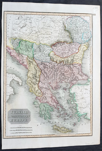
1817 John Thomson Large Antique Map Turkey in Europe Greece to Bosnia & Hungary
- Title : Turkish Dominions in Europe
- Date : 1817
- Size: 21in x 15in (535mm x 390mm)
- Condition: (A+) Fine Condition
- Ref: 16431
Description:
This large magnificent original hand coloured copper-plate engraved antique map of Turkey In Europe (Moldova, Bulgaria, Romania, Serbia, Bosnia, Croatia, Slovenia, Dalmatia & Greece) by John Thomson was published in the 1817 edition of Thomsons New General Atlas
General Definitions:
Paper thickness and quality: - Heavy and stable
Paper color : - off white
Age of map color: - Original
Colors used: - Yellow, green, blue, pink
General color appearance: - Authentic
Paper size: - 21in x 15in (535mm x 390mm)
Plate size: - 20in x 13 1/2in (510mm x 345mm)
Margins: - Min 1/2in (10mm)
Imperfections:
Margins: - None
Plate area: - None
Verso: - none
Background:
The Ottoman Empire also historically known in Western Europe as the Turkish Empire or simply Turkey, was a state that controlled much of Southeast Europe, Western Asia and North Africa between the 14th and early 20th centuries. It was founded at the end of the 13th century in northwestern Anatolia in the town of Söğüt (modern-day Bilecik Province) by the Oghuz Turkish tribal leader Osman I. After 1354, the Ottomans crossed into Europe, and with the conquest of the Balkans, the Ottoman beylik was transformed into a transcontinental empire. The Ottomans ended the Byzantine Empire with the 1453 conquest of Constantinople by Mehmed the Conqueror.
During the 16th and 17th centuries, at the height of its power under the reign of Suleiman the Magnificent, the Ottoman Empire was a multinational, multilingual empire controlling most of Southeast Europe, parts of Central Europe, Western Asia, parts of Eastern Europe and the Caucasus, North Africa and the Horn of Africa. At the beginning of the 17th century, the empire contained 32 provinces and numerous vassal states. Some of these were later absorbed into the Ottoman Empire, while others were granted various types of autonomy during the course of centuries.
With Constantinople as its capital and control of lands around the Mediterranean basin, the Ottoman Empire was at the centre of interactions between the Eastern and Western worlds for six centuries. While the empire was once thought to have entered a period of decline following the death of Suleiman the Magnificent, this view is no longer supported by the majority of academic historians. The empire continued to maintain a flexible and strong economy, society and military throughout the 17th and much of the 18th century. However, during a long period of peace from 1740 to 1768, the Ottoman military system fell behind that of their European rivals, the Habsburg and Russian empires. The Ottomans consequently suffered severe military defeats in the late 18th and early 19th centuries, which prompted them to initiate a comprehensive process of reform and modernisation known as the Tanzimat. Thus, over the course of the 19th century, the Ottoman state became vastly more powerful and organised, despite suffering further territorial losses, especially in the Balkans, where a number of new states emerged. The empire allied with Germany in the early 20th century, hoping to escape from the diplomatic isolation which had contributed to its recent territorial losses, and thus joined World War I on the side of the Central Powers. While the Empire was able to largely hold its own during the conflict, it was struggling with internal dissent, especially with the Arab Revolt in its Arabian holdings. During this time, atrocities were committed by the Ottoman government against the Armenians, Assyrians and Pontic Greeks.
The Empire\'s defeat and the occupation of part of its territory by the Allied Powers in the aftermath of World War I resulted in its partitioning and the loss of its Middle Eastern territories, which were divided between the United Kingdom and France. The successful Turkish War of Independence against the occupying Allies led to the emergence of the Republic of Turkey in the Anatolian heartland and the abolition of the Ottoman monarchy.
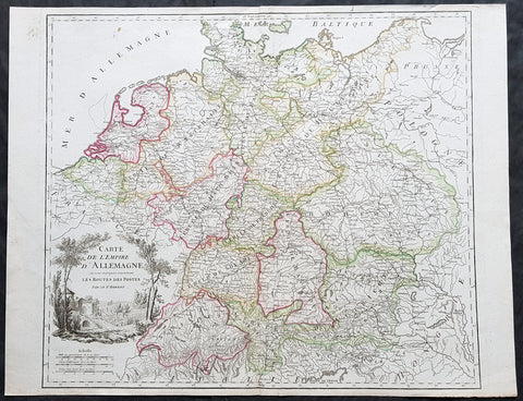
1757 Robert De Vaugondy Large Antique Map of the German States, Bohemia, Austria
- Title : Carte De L Empire D Allemagne..Les Routes Des Postes
- Size: 26in x 19 1/2in (660mm x 495mm)
- Condition: (A+) Fine Condition
- Date : 1757
- Ref #: 41567
Description:
This large magnificent hand coloured original copper-plate engraved antique map of various individual states of Germany including Austria, Bohemia, Switzerland & The Netherlands by Robert De Vaugondy was published in the 1757 edition of De Vaugondys famous The Atlas Universel
General Definitions:
Paper thickness and quality: - Heavy and stable
Paper color : - off white
Age of map color: - Original & later
Colors used: - Blue, pink, red, green, yellow
General color appearance: - Authentic
Paper size: - 26in x 19 1/2in (660mm x 495mm)
Plate size: - 22 1/2in x 19 1/2in (570mm x 495mm)
Margins: - Min 1/4in (5mm)
Imperfections:
Margins: - None
Plate area: - None
Verso: - None
Background:
In the 18th century, the Holy Roman Empire consisted of approximately 1,800 territories. The elaborate legal system initiated by a series of Imperial Reforms (approximately 1450–1555) created the Imperial Estates and provided for considerable local autonomy among ecclesiastical, secular, and hereditary states, reflected in Imperial Diet. The House of Habsburg held the imperial crown from 1438 until the death of Charles VI in 1740. Having no male heirs, he had convinced the Electors to retain Habsburg hegemony in the office of the emperor by agreeing to the Pragmatic Sanction. This was finally settled through the War of Austrian Succession; in the Treaty of Aix-la-Chapelle, Charles VI\'s daughter Maria Theresa ruled the Empire as Empress Consort when her husband, Francis I, became Holy Roman Emperor. From 1740, the dualism between the Austrian Habsburg Monarchy and the Kingdom of Prussia dominated the German history.
In 1772, then again in 1793 and 1795, the two dominant German states of Prussia and Austria, along with the Russian Empire, agreed to the Partitions of Poland; dividing among themselves the lands of the Polish–Lithuanian Commonwealth. As a result of the partitions, millions of Polish speaking inhabitants fell under the rule of the two German monarchies. However, the annexed territories though incorporated into the Kingdom of Prussia and the Habsburg Realm, were not legally considered as a part of the Holy Roman Empire. During the period of the French Revolutionary Wars, along with the arrival of the Napoleonic era and the subsequent final meeting of the Imperial Diet, most of the secular Free Imperial Cities were annexed by dynastic territories; the ecclesiastical territories were secularised and annexed. In 1806 the Imperium was dissolved; many German states, particularly the Rhineland states, fell under the influence of France. Until 1815, France, Russia, Prussia and the Habsburgs (Austria) competed for hegemony in the German states during the Napoleonic Wars
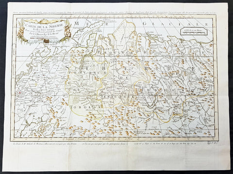
1754 Bellin & Delisle Original Antique Map of Siberia, Russia - after Delisle & Kirilov
- Title : Carte De La Siberie...S Bellin
- Date : 1755
- Ref # : 25538
- Size : 18 3/4in x 14in (480mm x 360mm)
- Condition: (A+) Fine Condition
Description:
This fine large, original copper-plate engraved antique map of Siberia, Eastern Russia by Jacques Nicolas Bellin in 1754 - after Joseph Nicolas Delisle - was published in Antoine François Prevosts 15 volumes of Histoire Generale des Voyages written by Prevost & other authors between 1746-1790.
This detailed map of Siberia, extends from the White & Caspian Seas in the west to Irkuckoi Province, Jakutky on the Lena River and regions just to the east. Centered on the Jenisi River.
The map also notes the trip taken by JN Delisle from Moscow to Beryozovo, in the Khanty-Mansi Autonomous Okrug region to observe the transit of Venus in 1740.
This map by Bellin was taken from JN Delsile, brother of Guillaume Delisle, responsible along with Russian Ivan Kirilov in surveying & publishing the first complete atlas of Russia, Atlas Russicus in 1745.
Jacques Nicolas Delisle was invited by Peter the Great to survey the vast empire of Imperial Russia. Initially accompanied by his step-brother Louis, in 1726 the two Parisians journeyed to Russia (now under the reign of Catherine I) to start their surveys.
At first, Delisle also worked with Ivan Kirilov, with whom he co-founded the St Petersburg Academy of Sciences. However, the two men did not always see eye to eye, and Kirilov went on to produce an incomplete atlas which was published in 1734, before the French team had finished their surveys. Kirilov died in 1737, eight years before the eventual publication of Delisle\'s atlas.
The Atlas Russicus is effectively in two parts: the first covering European Russia in 13 numbered maps (scale 1; 1.527.000), the second covering Siberia in six maps. scale (1: 3.360.000). On map 19 Ostium fluvii Amur the extreme point of Alaska and the Aleutian islands.
It is scarcely necessary to look at a map of Russia - with which we must include Siberia - to visualize the daunting task facing Russian map makers. Indeed, considering the vastness of their territory and the lack of skilled cartographers, it is surprising that relatively good maps were available for engraving and printing in most of the well known sixteenth and seventeenth century atlases. Generally, maps of that time were based on material brought back from Moscow by visitors from the West.
General Definitions:
Paper thickness and quality: - Heavy and stable
Paper color : - off white
Age of map color: - Early
Colors used: - Green, Yellow,
General color appearance: - Authentic
Paper size: - 18 3/4in x 14in (480mm x 360mm)
Plate size: - 18 1/2in x 11 3/4in (470mm x 300mm)
Margins: - Min 1/2in (6mm)
Imperfections:
Margins: - None
Plate area: - Folds as issued
Verso: - None
Background:
One of Antoine Francois Prevosts monumental undertakings was his history of exploration & discovery in 15 volumes titledHistoire Générale des Voyages written between 1746-1759 and was extended to 20 volumes after his death by various authors.
The 20 volumes cover the early explorations & discoveries on 3 continents: Africa (v. 1-5), Asia (v. 5-11), and America (v. 12-15) with material on the finding of the French, English, Dutch, and Portugese.
A number of notable cartographers and engravers contributed to the copper plate maps and views to the 20 volumes including Nicolas Bellin, Jan Schley, Chedel, Franc Aveline, Fessard, and many others.
The African volumes cover primarily coastal countries of West, Southern, and Eastern Africa, plus the Congo, Madagascar, Arabia and the Persian Gulf areas.
The Asian volumes cover China, Korea, Tibet, Japan, Philippines, and countries bordering the Indian Ocean.
Volume 11 includes Australia and Antarctica.
Volumes 12-15 cover voyages and discoveries in America, including the East Indies, South, Central and North America.
Volumes 16-20 include supplement volumes & tables along with continuation of voyages and discoveries in Russia, Northern Europe, America, Asia & Australia.
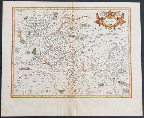
1628 Henricus Hondius Antique Map of the Duchy of Anjou, Maine-et-Loire, France
- Title : Aniov
- Date : 1628
- Size: 21in x 17in (535mm x 430mm)
- Ref #: 26135
- Condition: (A) Very Good Condition
Description:
This beautifully hand coloured original copper-plate engraved antique map of the French region of the historical province of Anjou (today a greater part of the Maine-et-Loire dept.) centering on the city of Angers & the Loire River was published in the 1628 French edition of Mercators Atlas by Henricus Hondius and Jan Jansson.
General Definitions:
Paper thickness and quality: - Heavy and stable
Paper color : - off white
Age of map color: - Original
Colors used: - Yellow, green, blue, pink
General color appearance: - Authentic
Paper size: - 21in x 17in (535mm x 430mm)
Plate size: - 18in x 14in (460mm x 360mm)
Margins: - Min 1/2in (12mm)
Imperfections:
Margins: - None
Plate area: - Age toning along centerfold
Verso: - Age toning along centerfold
Background:
Anjou is a historical province of France straddling the lower Loire River. Its capital was Angers and it was roughly coextensive with the diocese of Angers. It bordered Brittany to the west, Maine to the north, Touraine to the east and Poitou to the south. The adjectival form of Anjou is Angevin and inhabitants of Anjou are known as Angevins. During the Middle Ages, the county of Anjou was a prominent fief of the French crown.
The region takes its name from the Celtic tribe of the Andecavi, who submitted to Roman rule following the Gallic Wars. Under the Romans, the chief fortified settlement of the Andecavi became the city of Juliomagus, the future Angers. The territory of the Andecavi was organized as a civitas (called the civitas Andegavensis or civitas Andegavorum).
Under the Franks, the city of Juliomagus took the name of the ancient tribe and became Angers. Under the Merovingians, the history of Anjou is obscure. It is not recorded as a county (comitatus) until the time of the Carolingians. In the late ninth and early tenth centuries the viscounts (representatives of the counts) usurped comital authority and made Anjou an autonomous hereditary principality. The first dynasty of counts of Anjou, the House of Ingelger, ruled continuously down to 1205. In 1131, Count Fulk V became the King of Jerusalem; then in 1154, his grandson, Henry \'Curtmantle\' became King of England. The territories ruled by Henry and his successors, which stretched from Ireland to the Pyrenees, are often called the Angevin Empire. This empire was broken up by the French king Philip II, who confiscated the dynasty\'s French lands, including Anjou in 1205.
The county of Anjou was united to the royal domain between 1205 and 1246, when it was turned into an apanage for the king\'s brother, Charles I of Anjou. This second Angevin dynasty, a branch of the Capetian dynasty, established itself on the throne of Naples and Hungary. Anjou itself was united to the royal domain again in 1328, but was detached in 1360 as the Duchy of Anjou for the king\'s son, Louis I of Anjou. The third Angevin dynasty, a branch of the House of Valois, also ruled for a time the Kingdom of Naples. The dukes had the same autonomy as the earlier counts, but the duchy was increasingly administered in the same fashion as the royal domain and the royal government often exercised the ducal power while the dukes were away. When the Valois line failed and Anjou was incorporated into the royal domain again in 1480, there was little change on the ground. Anjou remained a province of crown until the French Revolution (1790), when the provinces were reorganized.
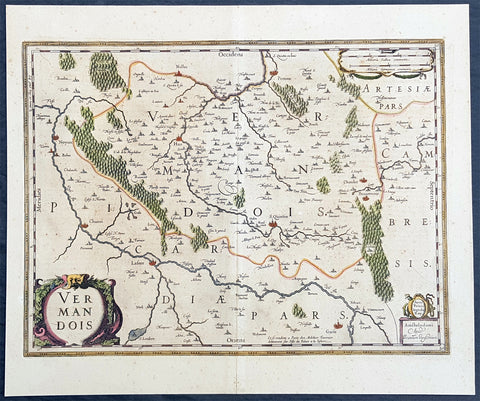
1646 Jan Jansson Antique Map the County of Vermandois, Picardy, Northern France
- Title : Vermandois
- Ref #: 50236
- Size: 21 1/2in x 18in (545mm x 460mm)
- Date : 1638
- Condition: (A+) Fine Condition
Description:
This beautifully hand coloured original copper-plate engraved antique map of the ancient county of Vermandois now located in the Picardy region of northern France, centering on the city of St Quentin by Jan Jansson was published in the 1638 Latin edition of Mercators Atlas by Jan Jansson and Henricus Hondius. (Ref: Tooley, Koeman)
General Definitions:
Paper thickness and quality: - Heavy and stable
Paper color : - off white
Age of map color: - Original
Colors used: - Yellow, green, blue, pink
General color appearance: - Authentic
Paper size: - 22in x 18in (560mm x 460mm)
Plate size: - 19in x 14 1/2in (480mm x 370mm)
Margins: - Min 2in (50mm)
Imperfections:
Margins: - Light age toning
Plate area: - Light age toning
Verso: - Light age toning
Background:
Vermandois was a French county that appeared in the Merovingian period. Its name derives from that of an ancient tribe, the Viromandui. In the 10th century, it was organised around two castellan domains: St Quentin (Aisne) and Péronne (Somme). In today\'s times, the Vermandois county would fall in the Picardy region of northern France.
Pepin I of Vermandois, the earliest of its hereditary counts, was descended in direct male line from the emperor Charlemagne. More famous was his grandson Herbert II (902–943), who considerably increased the territorial power of the house of Vermandois, and kept the lawful king of France, the unlucky Charles the Simple, prisoner for six years. Herbert II was son of Herbert I, lord of Péronne and St Quentin, who was killed in 902 by an assassin in the pay of Baldwin II, Count of Flanders. His successors, Albert I, Herbert III, Albert II, Otto and Herbert IV, were not as historically significant.
In 1077, the last count of the first house of Vermandois, Herbert IV, received the county of Valois through his wife. His son Eudes (II) the Insane was disinherited by the council of the Barons of France. He was lord of Saint-Simon through his wife, and the county was given to his sister Adela, whose first husband was Hugh the Great, the brother of King Philip I of France. Hugh was one of the leaders of the First Crusade, and died in 1102 at Tarsus in Cilicia. The eldest son of Hugh and Adela was count Raoul I (c. 1120–1152), who married Petronilla of Aquitaine, sister of the queen, Eleanor, and had by her three children: Raoul (Rudolph) II, the Leper (count from 1152–1167); Isabelle, who possessed from 1167 to 1183 the counties of Vermandois, Valois and Amiens conjointly with her husband, Philip, Count of Flanders; and Eleanor. By the terms of a treaty concluded in 1186 with the king, Philip Augustus, the count of Flanders kept the county of Vermandois until his death, in 1191. At this date, a new arrangement gave Eleanor (d. 1213) a life interest in the eastern part of Vermandois, together with the title of countess of St Quentin, and the king entered immediately into possession of Péronne and its dependencies
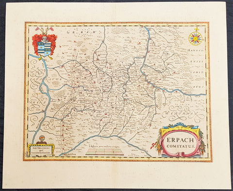
1646 Jan Jansson Antique Map Erbach Hesse & Baden-Württemberg Heidelberg Germany
- Title : Erpach Comitatus
- Ref #: 50182
- Size: 22in x 18in (560mm x 460mm)
- Date : 1646
- Condition: (A+) Fine Condition
Description:
This beautifully hand coloured original copper-plate engraved antique map of the Erbach im Odenwald area in the Baden-Württemberg & Hesse regions of southern Germany, framed by the Neckar River in the south, Rhine River to the west and the Main river to the east (major towns and cities of Heidelberg, Gensheim, Worms, Miltenberg and Oldenburg) by Jan Jansson was published in the 1646 Latin edition of Mercators Atlas by Jan Jansson and Henricus Hondius. (Ref: Tooley, Koeman)
General Definitions:
Paper thickness and quality: - Heavy and stable
Paper color : - off white
Age of map color: - Original
Colors used: - Yellow, green, blue, pink
General color appearance: - Authentic
Paper size: - 22in x 18in (560mm x 460mm)
Plate size: - 19in x 14 1/2in (480mm x 370mm)
Margins: - Min 2in (50mm)
Imperfections:
Margins: - None
Plate area: - None
Verso: - None
Background:
Erbach is a town and the district seat of the Odenwaldkreis (district) in Hesse, Germany.
Baden-Württemberg is a state in southwest Germany, east of the Rhine, which forms the border with France.
Hesseis a federal state (Land) of the Federal Republic of Germany
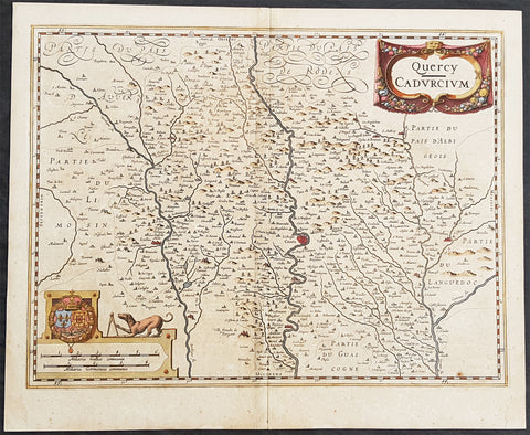
1628 Henricus Hondius Antique Map The Province of Quercy, Lot, Cahors, SW France
- Title : Quercy - Cadurcium
- Ref #: 26140
- Size: 21 1/2in x 17 1/2in (490mm x 340mm)
- Date : 1628
- Condition: (A) Very Good Condition
Description:
This beautifully hand coloured original copper-plate engraved antique map of the ancient province of Quercy located in southwest France - centering on the city of Cahors & the River Lot - was published in the 1628 French edition of Mercators Atlas by Henricus Hondius and Jan Jansson.
General Definitions:
Paper thickness and quality: - Heavy and stable
Paper color : - off white
Age of map color: - Original
Colors used: - Yellow, green, blue, pink
General color appearance: - Authentic
Paper size: - 21 1/2in x 17 1/2in (490mm x 340mm)
Plate size: - 20in x 15in (510mm x 380mm)
Margins: - Min 1/2in (12mm)
Imperfections:
Margins: - Light age toning
Plate area: - Age toning along centerfold
Verso: - Age toning along centerfold
Background:
Quercy is a former province of France located in the countrys southwest, bounded on the north by Limousin, on the west by Périgord and Agenais, on the south by Gascony and Languedoc, and on the east by Rouergue and Auvergne.
Under the Romans Quercy was part of Aquitania prima, and Christianity was introduced during the 4th century. Early in the 6th century it fell under the authority of the Franks, and in the 7th century became part of the autonomous Duchy of Aquitaine. At the end of the 10th century its rulers were the powerful counts of Toulouse. During the wars between England and France in the reign of Henry II, the English placed garrisons in the county, and by the 1259 Treaty of Paris lower Quercy was ceded to England. The monarchs of both England and France confirmed and added to the privileges of the towns and the district, each thus hoping to attach the inhabitants to his own interest. In 1360, by the Treaty of Bretigny, the whole county passed to England, but in 1440 the English were finally expelled. In the 16th century Quercy was a stronghold of the Protestants, and the scene of a savage religious warfare. The civil wars of the reign of Louis XIII largely took place around Montauban.
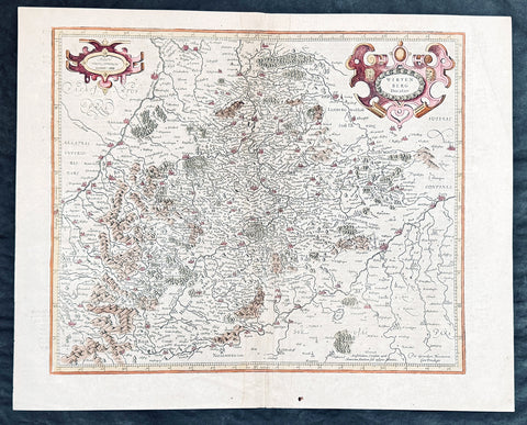
1628 Gerard Mercator & Henricus Hondius Antique Map of Duchy Wurttemberg Germany
- Title : Wirtenberg Ducatus...Per Geradum Mercatorem Cum Privilego
- Size: 21in x 17in (530mm x 430mm)
- Condition: (A+) Fine Condition
- Date : 1628
- Ref #: 26116
Description:
This original copper plate engraved hand coloured antique map of the Wurttemberg region in todays Baden-Württemberg state in southern Germany, by Gerard Mercator was published by Henricus Hondius in the early 1628 French edition of Gerard Mercators Atlas.
These maps, published in the early editions of Mercators atlas, are the original maps drawn and engraved by Gerald Mercator in the mid to late 16th century, published by his son Rumold as an atlas, after his death, in 1595. After two editions the plates were purchased by Jodocus Hondius in 1604 and continued to be published until the mid 1630\'s when the plates were re-engraved and updated by Jan Jansson and Henricus Hondius.
General Definitions:
Paper thickness and quality: - Heavy and stable
Paper color : - off white
Age of map color: - Later
Colors used: - Green, yellow, brown, blue, pink
General color appearance: - Authentic
Paper size: - 21in x 17in (530mm x 430mm)
Plate size: - 18 1/2in x 14in (475mm x 350mm)
Margins: - Min 1/2in (12mm)
Imperfections:
Margins: - Light age toning
Plate area: - Light toning along centerfold
Verso: - Light age toning
Background:
Württemberg is a historical German territory roughly corresponding to the cultural and linguistic region of Swabia. Together with Baden and Hohenzollern, two other historical territories, it now forms the Federal State of Baden-Württemberg. Württemberg was formerly also spelled Würtemberg and Wirtemberg.
The Duchy of Württemberg was a duchy located in the south-western part of the Holy Roman Empire. It was a member of the Holy Roman Empire from 1495 to 1806. The dukedoms long survival for nearly four centuries was mainly due to its size, being larger than its immediate neighbors. During the Protestant Reformation, Württemberg faced great pressure from the Holy Roman Empire to remain a member. Württemberg resisted repeated French invasions in the 17th and 18th centuries. Württemberg was directly in the path of French and Austrian armies who were engaged in the long rivalry between the House of Bourbon and the House of Habsburg. In 1803, Napoleon raised the duchy to be the Electorate of Württemberg of the Holy Roman Empire. On 1 January 1806, the last Elector assumed the title of King of Württemberg. Later this year, on 6 August 1806, the last Emperor, Francis II, abolished (de facto) the Holy Roman Empire.
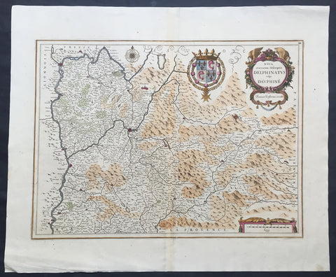
1638 Jansson Old, Antique Map of the Dauphine Region of France, Grenoble
- Title : Nova et acurrata Descriptio Delphinatus vulgo Dauphine
- Ref #: 50244
- Size: 24in x 20in (610mm x 510mm)
- Date : 1638
- Condition: (A+) Fine Condition
Description:
This fine large beautifully hand coloured original antique map* of the Dauphine region of southern France - centering on the city of Grenoble - with the Rhone River to the west and north with Savoy & Piedmont to the east was published by Jan Jansson in the 1638 edition ofAtlas Novus. (Ref Tooley M&B)
General Description:
Paper thickness and quality: - Heavy and stable
Paper color: - off white
Age of map color: - Original
Colors used: - Green, red, orange, yellow, blue
General color appearance: - Authentic
Paper size: - 24in x 20in (610mm x 510mm)
Plate size: - 20 1/2in x 15 1/4in (520mm x 390mm)
Margins: - Min 1in (25mm)
Imperfections:
Margins: - None
Plate area: - None
Verso: - None
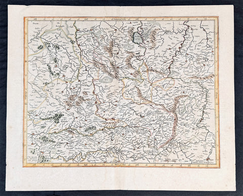
1628 Gerard Mercator & Henricus Hondius Antique Map of Westphalia, Germany
- Title : Tabula Seconde Westphalia...Per Geradum Mercatorem Cum Privilego...1627
- Size: 21in x 17in (530mm x 430mm)
- Condition: (A) Very Good Condition
- Date : 1628
- Ref #: 26109
Description:
This original copper plate engraved hand coloured antique map of the Westphalia region of North Rhine-Westphalia, Germany, by Gerard Mercator was published by Henricus Hondius in the early 1628 French edition of Gerard Mercators Atlas.
These maps, published in the early editions of Mercators atlas, are the original maps drawn and engraved by Gerald Mercator in the mid to late 16th century, published by his son Rumold as an atlas, after his death, in 1595. After two editions the plates were purchased by Jodocus Hondius in 1604 and continued to be published until the mid 1630s by Henricus, when some of the plates were re-engraved and updated by Jan Jansson and Henricus Hondius.
General Definitions:
Paper thickness and quality: - Heavy and stable
Paper color : - off white
Age of map color: - Later
Colors used: - Green, blue, pink, yellow
General color appearance: - Authentic
Paper size: - 21in x 17in (530mm x 430mm)
Plate size: - 18 1/2in x 14in (475mm x 350mm)
Margins: - Min 1/2in (12mm)
Imperfections:
Margins: - Light age toning
Plate area: - Light toning along centerfold
Verso: - Light age toning
Background:
While the Northern Rhineland, Westphalia and Lippe are different historic territories of todays North Rhine-Westphalia, the old border between the former Rhine Province and the Province of Westphalia is also a language border. While in Westphalia and Lippe, people tend to speak West Low German dialects and especially the Westphalian variant of the Low German language, Central German and Low Franconian dialects are being spoken in the Northern Rhineland.
Westphalia is known for the 1648 Peace of Westphalia which ended the Thirty Years War, as the two treaties were signed in Münster and Osnabrück.
It is one of the regions that were part of all incarnations of the German state since the Early Middle Ages: the Holy Roman Empire, the Confederation of the Rhine, the German Confederation, the North German Confederation, the German Empire, the Weimar Republic and National Socialist Germany. After World War II it was a part of the British occupation zone which merged with the American zone to become the Bizone in 1947 and again merged with the French zone to become the Trizone in 1948. The current Federal Republic of Germany was founded on these territories making Westphalia a part of West Germany. It is a part of united Germany since 1990.
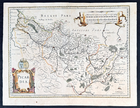
1628 Jan Jansson Antique Map of the Picardy Region of France
- Title : Picardia
- Size: 22in x 17in (560mm x 430mm)
- Condition: (B) Good Condition
- Date : 1628
- Ref #: 50241
Description:
This original copper plate engraved hand coloured antique map of the French region of Picardy or Picardie by Jan Jansson was published in the early 1628 Latin edition of Janssons Atlas.
General Definitions:
Paper thickness and quality: - Heavy and stable
Paper color : - off white
Age of map color: - later
Colors used: - Green, blue, pink, yellow
General color appearance: - Authentic
Paper size: - 22in x 17in (560mm x 430mm)
Plate size: - 20in x 15in (510mm x 380mm)
Margins: - Min 1/2in (12mm)
Imperfections:
Margins: - Age toning
Plate area: - Age toning
Verso: - Age toning
Background:
Picardy is a historical territory and a former administrative region of Northern France and now part of the new region Nord-Pas-de-Calais-Picardie.
From the 5th century the area was part of the Frankish Empire, and in the feudal period it encompassed the six countships of Boulogne, Montreuil, Ponthieu, Amiénois,Vermandois, and Laonnois. According to the 843 Treaty of Verdun the region became part of West Francia, the later Kingdom of France.
The name Picardy (which may have referred to a Frankish tribe of picards or pike-bearers) was not used until the 12th or 13th century. During this time, the name applied to all lands where the Picard language was spoken, which included all the territories from Paris to the Netherlands. In the Latin Quarter of Paris, people identified a Picard Nation (Nation Picarde) of students at Sorbonne University, most of whom actually came from Flanders. During the Hundred Years\\\\\\\' War, Picardy was the centre of the Jacquerie peasant revolt in 1358.
From 1419 onwards, the Picardy counties (Boulogne, Ponthieu, Amiens, Vermandois) were gradually acquired by the Burgundian duke Philip the Good, confirmed by King Charles VII of France at the 1435 Congress of Arras. In 1477, King Louis XI of France led an army and occupied key towns in Picardy. By the end of 1477, Louis would control all of Picardy and most of Artois.
In the 16th century, the government (military region) of Picardy was created. This became a new administrative region of France, separate from what was historically defined as Picardy. The new Picardy included the Somme département, the northern half of the Aisne département, and a small fringe in the north of the Oise département.
In 1557, Picardy was invaded by Hapbsburg forces under the command of Emmanuel Philibert, Duke of Savoy. After a seventeen-day siege, St. Quentin would be ransacked while Noyon would be burned by the Habsburg army.
In the 17th century, an infectious disease similar to English sweat originated from the region and spread across France. It was called Suette des picards or Picardy sweat.
Sugar beet was introduced by Napoleon I during the Napoleonic Wars in the 19th century, in order to counter the United Kingdom, which had seized the sugar islands possessed by France in the Caribbean. The sugar industry has continued to play a prominent role in the economy of the region.
One of the most significant historical events to occur in Picardy was the series of battles fought along the Somme during World War I. From September 1914 to August 1918, four major battles, including the Battle of the Somme, were fought by British, French, and German forces in the fields of Northern Picardy. (Ref: Koeman; M&B; Tooley)
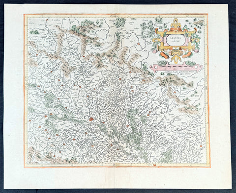
1628 Gerard Mercator & Henricus Hondius Antique Map the Alsace Region of France
- Title : Alsatia inferior..Per Gerardam Mercatorem Cum privilegio
- Size: 21in x 17in (530mm x 430mm)
- Condition: (A) Very Good Condition
- Date : 1628
- Ref #: 26113
Description:
This original copper plate engraved hand coloured antique map of the French region of Alsace by Gerard Mercator was published by Henricus Hondius in the early 1628 French edition of Gerard Mercators Atlas.
These maps, published in the early editions of Mercators atlas, are the original maps drawn and engraved by Gerald Mercator in the mid to late 16th century, published by his son Rumold as an atlas, after his death, in 1595. After two editions the plates were purchased by Jodocus Hondius in 1604, and continued to be published until the end of the 1630s by Henricus Hondius, when some of the plates were re-engraved and updated with the help of Jan Jansson.
General Definitions:
Paper thickness and quality: - Heavy and stable
Paper color : - off white
Age of map color: - Later
Colors used: - Green, blue, pink, yellow
General color appearance: - Authentic
Paper size: - 21in x 17in (530mm x 430mm)
Plate size: - 18 1/2in x 14in (475mm x 350mm)
Margins: - Min 1/2in (12mm)
Imperfections:
Margins: - Light age toning
Plate area: - Light toning along centerfold
Verso: - Light age toning
Background:
Alsace is a cultural and historical region in eastern France, on the west bank of the upper Rhine next to Germany and Switzerland.
As in much of Europe, the prosperity of Alsace came to an end in the 14th century by a series of harsh winters, bad harvests, and the Black Death. These hardships were blamed on Jews, leading to the pogroms of 1336 and 1339. In 1349, Jews of Alsace were accused of poisoning the wells with plague, leading to the massacre of thousands of Jews during the Strasbourg pogrom. Jews were subsequently forbidden to settle in the town. An additional natural disaster was the Rhine rift earthquake of 1356, one of Europes worst which made ruins of Basel. Prosperity returned to Alsace under Habsburg administration during the Renaissance.
Holy Roman Empire central power had begun to decline following years of imperial adventures in Italian lands, often ceding hegemony in Western Europe to France, which had long since centralized power. France began an aggressive policy of expanding eastward, first to the rivers Rhône and Meuse, and when those borders were reached, aiming for the Rhine. In 1299, the French proposed a marriage alliance between Philip IV of Frances sister Blanche and Albert I of Germanys son Rudolf, with Alsace to be the dowry; however, the deal never came off. In 1307, the town of Belfort was first chartered by the Counts of Montbéliard. During the next century, France was to be militarily shattered by the Hundred Years War, which prevented for a time any further tendencies in this direction. After the conclusion of the war, France was again free to pursue its desire to reach the Rhine and in 1444 a French army appeared in Lorraine and Alsace. It took up winter quarters, demanded the submission of Metz and Strasbourg and launched an attack on Basel.
In 1469, following the Treaty of St. Omer [fr], Upper Alsace was sold by Archduke Sigismund of Austria to Charles the Bold, Duke of Burgundy. Although Charles was the nominal landlord, taxes were paid to Frederick III, Holy Roman Emperor. The latter was able to use this tax and a dynastic marriage to his advantage to gain back full control of Upper Alsace (apart from the free towns, but including Belfort) in 1477 when it became part of the demesne of the Habsburg family, who were also rulers of the empire. The town of Mulhouse joined the Swiss Confederation in 1515, where it was to remain until 1798.
By the time of the Protestant Reformation in the 16th century, Strasbourg was a prosperous community, and its inhabitants accepted Protestantism in 1523. Martin Bucer was a prominent Protestant reformer in the region. His efforts were countered by the Roman Catholic Habsburgs who tried to eradicate heresy in Upper Alsace. As a result, Alsace was transformed into a mosaic of Catholic and Protestant territories. On the other hand, Mömpelgard (Montbéliard) to the southwest of Alsace, belonging to the Counts of Württemberg since 1397, remained a Protestant enclave in France until 1793.
This situation prevailed until 1639, when most of Alsace was conquered by France to keep it out of the hands of the Spanish Habsburgs, who by secret treaty in 1617 had gained a clear road to their valuable and rebellious possessions in the Spanish Netherlands, the Spanish Road. Beset by enemies and seeking to gain a free hand in Hungary, the Habsburgs sold their Sundgau territory (mostly in Upper Alsace) to France in 1646, which had occupied it, for the sum of 1.2 million Thalers. When hostilities were concluded in 1648 with the Treaty of Westphalia, most of Alsace was recognized as part of France, although some towns remained independent. The treaty stipulations regarding Alsace were complex. Although the French king gained sovereignty, existing rights and customs of the inhabitants were largely preserved. France continued to maintain its customs border along the Vosges mountains where it had been, leaving Alsace more economically oriented to neighbouring German-speaking lands. The German language remained in use in local administration, in schools, and at the (Lutheran) University of Strasbourg, which continued to draw students from other German-speaking lands. The 1685 Edict of Fontainebleau, by which the French king ordered the suppression of French Protestantism, was not applied in Alsace. France did endeavour to promote Catholicism. Strasbourg Cathedral, for example, which had been Lutheran from 1524 to 1681, was returned to the Catholic Church. However, compared to the rest of France, Alsace enjoyed a climate of religious tolerance.
France consolidated its hold with the 1679 Treaties of Nijmegen, which brought most remaining towns under its control. France seized Strasbourg in 1681 in an unprovoked action. These territorial changes were recognised in the 1697 Treaty of Ryswick that ended the War of the Grand Alliance.
The year 1789 brought the French Revolution and with it the first division of Alsace into the départements of Haut- and Bas-Rhin. Alsatians played an active role in the French Revolution. On 21 July 1789, after receiving news of the Storming of the Bastille in Paris, a crowd of people stormed the Strasbourg city hall, forcing the city administrators to flee and putting symbolically an end to the feudal system in Alsace. In 1792, Rouget de Lisle composed in Strasbourg the Revolutionary marching song La Marseillaise (as Marching song for the Army of the Rhine), which later became the anthem of France. La Marseillaise was played for the first time in April of that year in front of the mayor of Strasbourg Philippe-Frédéric de Dietrich. Some of the most famous generals of the French Revolution also came from Alsace, notably Kellermann, the victor of Valmy, Kléber, who led the armies of the French Republic in Vendée and Westermann, who also fought in the Vendée.
At the same time, some Alsatians were in opposition to the Jacobins and sympathetic to the restoration of the monarchy pursued by the invading forces of Austria and Prussia who sought to crush the nascent revolutionary republic. Many of the residents of the Sundgau made pilgrimages to places like Mariastein Abbey, near Basel, in Switzerland, for baptisms and weddings. When the French Revolutionary Army of the Rhine was victorious, tens of thousands fled east before it. When they were later permitted to return (in some cases not until 1799), it was often to find that their lands and homes had been confiscated. These conditions led to emigration by hundreds of families to newly vacant lands in the Russian Empire in 1803–4 and again in 1808. A poignant retelling of this event based on what Goethe had personally witnessed can be found in his long poem Hermann and Dorothea.
In response to the hundred day restoration of Napoleon I of France in 1815, Alsace along with other frontier provinces of France was occupied by foreign forces from 1815 to 1818, including over 280,000 soldiers and 90,000 horses in Bas-Rhin alone. This had grave effects on trade and the economy of the region since former overland trade routes were switched to newly opened Mediterranean and Atlantic seaports.
The population grew rapidly, from 800,000 in 1814 to 914,000 in 1830 and 1,067,000 in 1846. The combination of economic and demographic factors led to hunger, housing shortages and a lack of work for young people. Thus, it is not surprising that people left Alsace, not only for Paris – where the Alsatian community grew in numbers, with famous members such as Baron Haussmann – but also for more distant places like Russia and the Austrian Empire, to take advantage of the new opportunities offered there: Austria had conquered lands in Eastern Europe from the Ottoman Empire and offered generous terms to colonists as a way of consolidating its hold on the new territories. Many Alsatians also began to sail to the United States, settling in many areas from 1820 to 1850. In 1843 and 1844, sailing ships bringing immigrant families from Alsace arrived at the port of New York. Some settled in Texas and Illinois, many to farm or to seek success in commercial ventures: for example, the sailing ships Sully (in May 1843) and Iowa (in June 1844) brought families who set up homes in northern Illinois and northern Indiana. Some Alsatian immigrants were noted for their roles in 19th-century American economic development. Others ventured to Canada to settle in southwestern Ontario, notably Waterloo County.
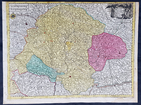
1744 Georg Mattaus Seutter Antique Map Hungarian Empire, Transylvania, Sclavonia
Antique Map
- Title : Regni Hungariae........a Matth. Seutteri...T C Lotter, Geogr.
- Ref #: 93399
- Size: 11in x 8 1/2in (280mm x 215mm)
- Date : 1744
- Condition: (A) Very Good Condition
Description:
This beautifully hand coloured original copper-plate engraved antique map of the Hungarian Empire was engraved by Tobias Lotter and was published in the 1744 edition of GM Seutters Atlas Minor Prae cipua Orbis Terrarum Imperia Regna et Provincias...., Augsburg, Germany.
General Definitions:
Paper thickness and quality: - Heavy and stable
Paper color : - off white
Age of map color: - Original
Colors used: - Yellow, green, blue, pink
General color appearance: - Authentic
Paper size: - 11in x 8 1/2in (280mm x 215mm)
Plate size: - 10 1/2in x 8in (265mm x 205mm)
Margins: - Min 1/4in (5mm)
Imperfections:
Margins: - Top margin cropped into border
Plate area: - None
Verso: - None
Background:
Atlas Minor was a series of beautiful maps of all parts of the world. Georg Matthäus Seutter was one of the most and important of the German cartographers of the 18th century, being appointed as the Geographer to the Imperial Court. His son, Albrecht Carl, joined Matthäus and eventually inherited the business. The maps from Atlas Minor were drawn by the two Seutters and engraved by Tobias Conrad Lotte. These maps are highly detailed and engraved with a bold hand with equally strong original hand color in the body of the map as was the 18th century German style. The cartouches were left uncolored in order to emphasize the elaborately detailed illustrations for which German maps are especially prized. These are some of the most decorative and interesting maps of the eighteenth century.

1744 Georg Mattaus Seutter Antique Map of Germany, Central & NW Europe
Antique Map
- Title : Imperium Romano Germanicum........a Matth. Seutteri...T C Lotter, Geogr.
- Ref #: 93398
- Size: 11in x 8 1/2in (280mm x 215mm)
- Date : 1744
- Condition: (A+) Fine Condition
Description:
This beautifully hand coloured original copper-plate engraved antique map of Germany and NW Europe was engraved by Tobias Lotter and was published in the 1744 edition of GM Seutters Atlas Minor Prae cipua Orbis Terrarum Imperia Regna et Provincias...., Augsburg, Germany.
General Definitions:
Paper thickness and quality: - Heavy and stable
Paper color : - off white
Age of map color: - Original
Colors used: - Yellow, green, blue, pink
General color appearance: - Authentic
Paper size: - 11in x 8 1/2in (280mm x 215mm)
Plate size: - 10 1/2in x 8in (265mm x 205mm)
Margins: - Min 1/4in (5mm)
Imperfections:
Margins: - Light age toning
Plate area: - Light age toning
Verso: - None
Background:
Atlas Minor was a series of beautiful maps of all parts of the world. Georg Matthäus Seutter was one of the most and important of the German cartographers of the 18th century, being appointed as the Geographer to the Imperial Court. His son, Albrecht Carl, joined Matthäus and eventually inherited the business. The maps from Atlas Minor were drawn by the two Seutters and engraved by Tobias Conrad Lotte. These maps are highly detailed and engraved with a bold hand with equally strong original hand color in the body of the map as was the 18th century German style. The cartouches were left uncolored in order to emphasize the elaborately detailed illustrations for which German maps are especially prized. These are some of the most decorative and interesting maps of the eighteenth century.
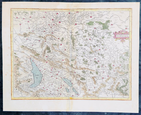
1628 Gerard Mercator Antique Map the Franche Comte de Bourgogne Region of France
- Title : La Haute Bourgoigne...Per Geradum Mercatorem Cum Privilegio
- Size: 21in x 17in (530mm x 430mm)
- Condition: (A) Very Good Condition
- Date : 1628
- Ref #: 26144
Description:
This original hand coloured copper plate engraved antique map of of the historical region of the Free County of Burgundy (Franche Comte de Bourgogne) of eastern France by Gerard Mercator was published by Henricus Hondius in the early 1628 French edition of Gerard Mercators Atlas.
These maps, published in the early editions of Mercators atlas, are the original maps drawn and engraved by Gerald Mercator in the mid to late 16th century, published by his son Rumold as an atlas, after his death, in 1595. After two editions the plates were purchased by Jodocus Hondius in 1604 and continued to be published until the mid 1630\\\'s when the plates were re-engraved and updated by Jan Jansson and Henricus Hondius.
General Definitions:
Paper thickness and quality: - Heavy and stable
Paper color : - off white
Age of map color: - Later
Colors used: - Green, yellow, red, orange
General color appearance: - Authentic
Paper size: - 21in x 17in (530mm x 430mm)
Plate size: - 20in x 15in (510mm x 380mm)
Margins: - Min 1/2in (12mm)
Imperfections:
Margins: - Age toning
Plate area: - Age toning
Verso: - Age toning, centerfold re-joined
Background:
The Free County of Burgundy (French: Franche Comté de Bourgogne; German: Freigrafschaft Burgund) was a medieval county (from 982 to 1678) of the Holy Roman Empire, within the modern region of Bourgogne-Franche-Comté, whose very name is still reminiscent of the title of its count: Freigraf (\\\'free count\\\', denoting imperial immediacy, or franc comte in French, hence the term franc(he) comté for his feudal principality). It should not be confused with the more westerly Duchy of Burgundy, a fiefdom of Francia since 843.
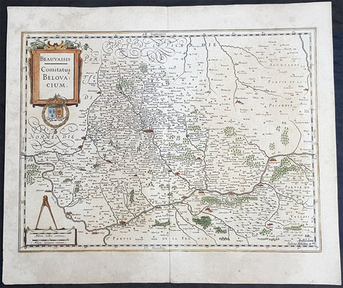
1628 Henricus Hondius Antique Map Beauvais Region of Northern France, Oise River
- Title : Beauvaisis Comitatus Belovacium
- Size: 22in x 18 1/2in (560mm x 470mm)
- Condition: (A) Very Good Condition
- Date : 1628
- Ref #: 50230
Description:
This original hand coloured copper plate engraved antique map of the Beauvais region of Northern France - centering on the city of Beauvais & the Oise River running through the cities of Noyon, Compiègne, Creil, by Henricus Hondius was published by Henricus Hondius & Jan Jansson in the 1628 French edition of Gerard Mercators Atlas.
General Definitions:
Paper thickness and quality: - Heavy and stable
Paper color : - off white
Age of map color: - Original
Colors used: - Blue, pink, red, green, yellow
General color appearance: - Authentic
Paper size: - 22in x 18 1/2in (560mm x 470mm)
Plate size: - 20in x 15in (510mm x 380mm)
Margins: - Min 1in (25mm)
Imperfections:
Margins: - Age toning
Plate area: - Age toning
Verso: - Age toning
Background:
Beauvais is a city and commune in northern France. It serves as the capital of the Oise département, in the Hauts-de-France region. Beauvais is located approximately 75 kilometres from Paris.
Beauvais was known to the Romans by the Gallo-Roman name of Caesaromagus (magos is Common Celtic for field). The post-Renaissance Latin rendering is Bellovacum from the Belgic tribe the Bellovaci, whose capital it was. In the ninth century it became a countship, which about 1013 passed to the bishops of Beauvais, who became peers of France from the twelfth century. At the coronations of kings the Bishop of Beauvais wore the royal mantle and went, with the Bishop of Langres, to raise the king from his throne to present him to the people.
De Bello Gallico II 13 reports that as Julius Caesar was approaching a fortified town called Bratuspantium in the land of the Bellovaci, its inhabitants surrendered to him when he was about 5 Roman miles away. Its name is Gaulish for place where judgements are made, from *bratu-spantion. Some say that Bratuspantium is Beauvais. Others theorize that it is Vendeuil-Caply or Bailleul sur Thérain.
From 1004 to 1037, the Count of Beauvais was Odo II, Count of Blois.
In a charter dated 1056/1060, Eudo of Brittany granted land in pago Belvacensi (Beauvais, Picardy) to the Abbey of Angers Saint-Aubin
In 1346 the town had to defend itself against the English, who again besieged it in 1433. The siege which it endured in 1472 at the hands of the Duke of Burgundy, was rendered famous by the heroism of the towns women, under the leadership of Jeanne Hachette, whose memory is still celebrated by a procession on 27 June (the feast of Sainte Angadrême), during which women take precedence over men.
An interesting hoard of coins from the High Middle Ages became known as the Beauvais Hoard, because some of the British and European coins found with the lot were from the French abbey located in Beauvais. The hoard, which contained a variety of rare and extremely rare Anglo-Norman pennies, English and foreign coins, was reputed to have been found in or near Paris.
Please note all items auctioned are genuine, we do not sell reproductions. A Certificate of Authenticity (COA) can be issued on request.