Europe (304)
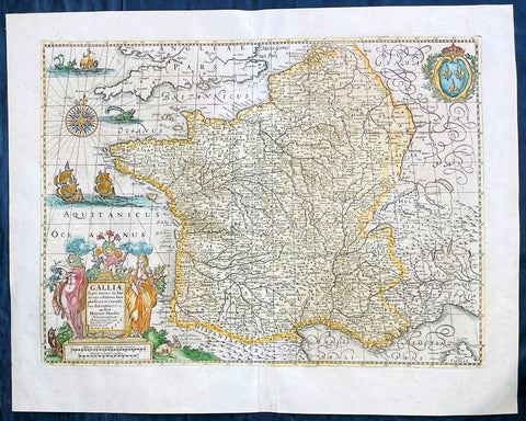
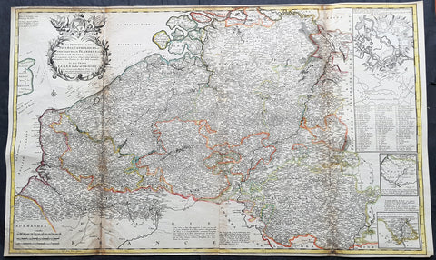
1639 Henricus Hondius Antique Map of France
Antique Map
- Title : Galliae supera omnes in hac...auctore Henrico Hondio
- Date : 1639
- Size: 22 1/2in x 18in (570mm x 455mm)
- Condition: (A+) Fine Condition
- Ref: 17039
Description:
This original hand coloured copper plate engraved antique map of France was published by Henricus Hondius & Jan Jansson in the 1639 French edition of Gerard Mercators Atlas.
General Definitions:
Paper thickness and quality: - Heavy and stable
Paper color : - off white
Age of map color: - Original
Colors used: - Pink, blue, green, yellow
General color appearance: - Authentic
Paper size: - 22 1/2in x 18in (570mm x 455mm)
Plate size: - 19 1/2in x 14 1/2in (500mm x 375mm)
Margins: - Min 1in (25mm)
Imperfections:
Margins: - None
Plate area: - None
Verso: - None
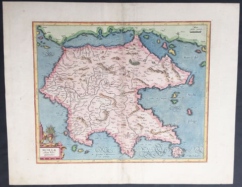
1623 Mercator Hondius Antique Map of Morea - the Greek Peloponnesus, Greece
- Title : Morea olim Piloponnesus
- Ref #: 35489
- Size: 21 1/2in x 17in (545mm x 430mm)
- Date : 1623
- Condition: (A+) Fine Condition
Description:
This beautifully hand coloured original antique map of Morea - the Greek Peloponnesus - was published in the 1623 ofMercators Atlas published by Henricus Hondius and Jan Jansson.
These maps, published in the later editions of Mercators atlas, are derived from the original maps drawn and engraved by Gerard Mercator in the mid to late 16th century, published by his son Rumold as an atlas, after his death, in 1595. After two editions the plates were purchased by Jodocus Hondius in 1604 and continued to be published until the mid 1630's when the plates were re-engraved and updated by Jan Jansson and Henricus Hondius.
Condition Report
Paper thickness and quality: - Heavy and stable
Paper color: - off white
Age of map color: - Original
Colors used: - Red, yellow, green
General color appearance: - Authentic
Paper size: - 21 1/2in x 17in (545mm x 430mm)
Plate size: - 16 1/2in x 13 1/2in (420mm x 345mm)
Margins: - Min 1in (25mm)
Imperfections:
Margins: - Light age toning
Plate area: - Light wear along centerfold
Verso: - Light colour bleed
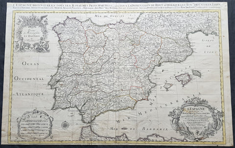
1696 Alexis Jaillot Large Antique Map of Spain, Portugal & Balearic Islands
Antique Map
- Title : L Espagne divisee en tous ses Royaumes et Principautes...Chez H Jaillot....1696
- Size: 36 1/2in x 23in (930mm x 585mm)
- Condition: (B) Good Condition
- Date : 1696
- Ref #: 35001
Description:
This very large, hand coloured original antique map of Spain & Portugal, by Alexis Hubert Jaillot - after Nicolas Sanson - was engraved in 1696 - the date is engraved in the title cartouche.
General Definitions:
Paper thickness and quality: - Heavy and stable
Paper color : - off white
Age of map color: - Original
Colors used: - Yellow, green, blue, pink
General color appearance: - Authentic
Paper size: - 36 1/2in x 23in (930mm x 585mm)
Plate size: - 35in x 23in (845mm x 600mm)
Margins: - Min 1/2in (12mm)
Imperfections:
Margins: - Soiling and creasing in margins
Plate area: - Light uplift along folds, soiling & creasing to bottom of map
Verso: - Soiling, creasing, old neutralised tape residue
Background:
In 1469, the crowns of the Christian kingdoms of Castile and Aragon were united by the marriage of Isabella I of Castile and Ferdinand II of Aragon. 1478 commenced the completion of the conquest of the Canary Islands and in 1492, the combined forces of Castile and Aragon captured the Emirate of Granada from its last ruler Muhammad XII, ending the last remnant of a 781-year presence of Islamic rule in Iberia. That same year, Spains Jews were ordered to convert to Catholicism or face expulsion from Spanish territories during the Spanish Inquisition. As many as 200,000 Jews were expelled from Spain. This was followed by expulsions in 1493 in Aragonese Sicily and Portugal in 1497. The Treaty of Granada guaranteed religious tolerance towards Muslims, for a few years before Islam was outlawed in 1502 in the Kingdom of Castile and 1527 in the Kingdom of Aragon, leading to Spains Muslim population becoming nominally Christian Moriscos. A few decades after the Morisco rebellion of Granada known as the War of the Alpujarras, a significant proportion of Spains formerly-Muslim population was expelled, settling primarily in North Africa. From 1609–14, over 300,000 Moriscos were sent on ships to North Africa and other locations, and, of this figure, around 50,000 died resisting the expulsion, and 60,000 died on the journey.
The year 1492 also marked the arrival of Christopher Columbus in the New World, during a voyage funded by Isabella. Columbuss first voyage crossed the Atlantic and reached the Caribbean Islands, beginning the European exploration and conquest of the Americas, although Columbus remained convinced that he had reached the Orient. Large numbers of indigenous Americans died in battle against the Spaniards during the conquest, while others died from various other causes. Some scholars consider the initial period of the Spanish conquest— from Columbuss first landing in the Bahamas until the middle of the sixteenth century—as marking the most egregious case of genocide in the history of mankind. The death toll may have reached some 70 million indigenous people (out of 80 million) in this period.
The colonisation of the Americas started with conquistadores like Hernán Cortés and Francisco Pizarro. Miscegenation was the rule between the native and the Spanish cultures and people. Juan Sebastian Elcano completed the first voyage around the world in human history, the Magellan-Elcano circumnavigation. Florida was colonised by Pedro Menéndez de Avilés when he founded St. Augustine, Florida and then defeated an attempt led by the French Captain Jean Ribault to establish a French foothold in Spanish Florida territory. St. Augustine became a strategic defensive base for Spanish ships full of gold and silver sailing to Spain. Andrés de Urdaneta discovered the tornaviaje or return route from the Philippines to Mexico, making possible the Manila galleon trading route. The Spanish once again encountered Islam, but this time in Southeast Asia and in order to incorporate the Philippines, Spanish expeditions organised from newly Christianised Mexico had invaded the Philippine territories of the Sultanate of Brunei. The Spanish considered the war with the Muslims of Brunei and the Philippines, a repeat of the Reconquista. The Spanish explorer Blas Ruiz intervened in Cambodias succession and installed Crown Prince Barom Reachea II as puppet.
As Renaissance New Monarchs, Isabella and Ferdinand centralised royal power at the expense of local nobility, and the word España, whose root is the ancient name Hispania, began to be commonly used to designate the whole of the two kingdoms. With their wide-ranging political, legal, religious and military reforms, Spain emerged as the first world power. The death of their son Prince John caused the Crown to pass to Charles I (the Emperor Charles V), son of Juana la Loca.
The unification of the crowns of Aragon and Castile by the marriage of their sovereigns laid the basis for modern Spain and the Spanish Empire, although each kingdom of Spain remained a separate country socially, politically, legally, and in currency and language.
There were two big revolts against the new Habsburg monarch and the more authoritarian and imperial-style crown: Revolt of the Comuneros in Castile and Revolt of the Brotherhoods in Majorca and Valencia. After years of combat, Comuneros Juan López de Padilla, Juan Bravo and Francisco Maldonado were executed and María Pacheco went into exile. Germana de Foix also finished with the revolt in the Mediterranean.
Habsburg Spain was Europes leading power throughout the 16th century and most of the 17th century, a position reinforced by trade and wealth from colonial possessions and became the worlds leading maritime power. It reached its apogee during the reigns of the first two Spanish Habsburgs—Charles I (1516–1556) and Philip II (1556–1598). This period saw the Italian Wars, the Schmalkaldic War, the Dutch Revolt, the War of the Portuguese Succession, clashes with the Ottomans, intervention in the French Wars of Religion and the Anglo-Spanish War.
Through exploration and conquest or royal marriage alliances and inheritance, the Spanish Empire expanded to include vast areas in the Americas, islands in the Asia-Pacific area, areas of Italy, cities in Northern Africa, as well as parts of what are now France, Germany, Belgium, Luxembourg, and the Netherlands. The first circumnavigation of the world was carried out in 1519–1521. It was the first empire on which it was said that the sun never set. This was an Age of Discovery, with daring explorations by sea and by land, the opening-up of new trade routes across oceans, conquests and the beginnings of European colonialism. Spanish explorers brought back precious metals, spices, luxuries, and previously unknown plants, and played a leading part in transforming the European understanding of the globe. The cultural efflorescence witnessed during this period is now referred to as the Spanish Golden Age. The expansion of the empire caused immense upheaval in the Americas as the collapse of societies and empires and new diseases from Europe devastated American indigenous populations. The rise of humanism, the Counter-Reformation and new geographical discoveries and conquests raised issues that were addressed by the intellectual movement now known as the School of Salamanca, which developed the first modern theories of what are now known as international law and human rights. Juan Luis Vives was another prominent humanist during this period.
Spains 16th century maritime supremacy was demonstrated by the victory over the Ottomans at Lepanto in 1571, and then after the setback of the Spanish Armada in 1588, in a series of victories against England in the Anglo-Spanish War of 1585–1604. However, during the middle decades of the 17th century Spains maritime power went into a long decline with mounting defeats against the United Provinces and then England; that by the 1660s it was struggling grimly to defend its overseas possessions from pirates and privateers.
The Protestant Reformation dragged the kingdom ever more deeply into the mire of religiously charged wars. The result was a country forced into ever expanding military efforts across Europe and in the Mediterranean. By the middle decades of a war- and plague-ridden 17th-century Europe, the Spanish Habsburgs had enmeshed the country in continent-wide religious-political conflicts. These conflicts drained it of resources and undermined the economy generally. Spain managed to hold on to most of the scattered Habsburg empire, and help the imperial forces of the Holy Roman Empire reverse a large part of the advances made by Protestant forces, but it was finally forced to recognise the separation of Portugal and the United Provinces, and eventually suffered some serious military reverses to France in the latter stages of the immensely destructive, Europe-wide Thirty Years War. In the latter half of the 17th century, Spain went into a gradual decline, during which it surrendered several small territories to France and England; however, it maintained and enlarged its vast overseas empire, which remained intact until the beginning of the 19th century.
The decline culminated in a controversy over succession to the throne which consumed the first years of the 18th century. The War of the Spanish Succession was a wide-ranging international conflict combined with a civil war, and was to cost the kingdom its European possessions and its position as one of the leading powers on the Continent. During this war, a new dynasty originating in France, the Bourbons, was installed. Long united only by the Crown, a true Spanish state was established when the first Bourbon king, Philip V, united the crowns of Castile and Aragon into a single state, abolishing many of the old regional privileges and laws.
The 18th century saw a gradual recovery and an increase in prosperity through much of the empire. The new Bourbon monarchy drew on the French system of modernising the administration and the economy. Enlightenment ideas began to gain ground among some of the kingdoms elite and monarchy. Bourbon reformers created formal disciplined militias across the Atlantic. Spain needed every hand it could take during the seemingly endless wars of the eighteenth century—the Spanish War of Succession or Queen Annes War (1702–13), the War of Jenkins Ear (1739–42) which became the War of the Austrian Succession (1740–48), the Seven Years War (1756–63) and the Anglo-Spanish War (1779–83)—and its new disciplined militias served around the Atlantic as needed.
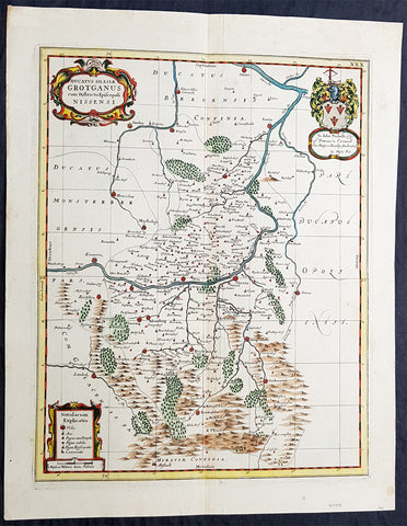
1681 J Jansson & Moses Pitt Rare Antique Map Duchy of Grottkau & Nysa Silesia, Poland
Antique Map
- Title : Ducatus Silesiae Grotganus cum Districtu Episcopali Nissensi
- Ref #: 93485
- Size: 23in x 18in (590mm x 460mm)
- Date : 1681
- Condition: (A+) Fine Condition
Description:
This original rare (not called for in Koeman) hand coloured copper plate engraved antique map of the Duchy of Grottkau and the Diocese of Nysa (Grottkau, Neisse, Brieg and the surrounding area) in the ancient region of Silesia, now in Western Poland by Jan Jansson was published by Moses Pitt in the 1681 edition of Atlas of the World
Moses Pitt 1639–1697 was a bookseller and printer known for the production of his Atlas of the world, a project supported by the Royal Society, and in particular by Christopher Wren. He is also known as the author of The Cry of the Oppressed (1691), an account of the conditions in which imprisoned debtors lived in debtors jails in England.
His work was characterised by its learned content and included authors such as Robert Boyle and Gilbert Burnet. His Atlas was initially intended to be 12 volumes and he continued to undertake other work for the Royal Society. However rising costs, estimated by Pitt at £1000 per volume, contributed to his eventual bankruptcy and only four volumes were ever produced. The second volume had as frontispiece a noted engraved portrait of Queen Catherine of Braganza, by Edward Le Davis.
In Ireland William Molyneux collaborated with Roderic OFlaherty to collect material for the Atlas. While Pitts financial crisis lead to cancellation of the project, much valuable work on early Irish history was collected. Molyneux and OFlaherty struck a friendship and Molyneux assisted when the latters treatise Ogygia was published in London in 1685.
As a result of the Atlas project, Pitt was declared bankrupt. He was taken to the Fleet Prison, and remained there, or in the Kings Bench Prison, for seven years. In 1691, he published The Cry of the Oppressed: Being a True and Tragical Account of the Unparalleld Sufferings of Multitudes of Poor Imprisond Debtors In Most of the Gaols in England, a moving appeal on behalf of prisoners for debt across the country. (Ref: Tooley; M&B)
General Definitions:
Paper thickness and quality: - Heavy and stable
Paper color : - off white
Age of map color: - Original
Colors used: - Blue, pink, red, green, yellow
General color appearance: - Authentic
Paper size: - 23in x 18in (590mm x 460mm)
Plate size: - 20in x 15 3/4in (510mm x 385mm)
Margins: - Min 1in (25mm)
Imperfections:
Margins: - None
Plate area: - None
Verso: - None
Background:
Silesia is a historical region of Central Europe mostly in Poland, with small parts in the Czech Republic and Germany. Its area is approximately 40,000 km2, and the population is estimated at around 8,000,000 inhabitants. Silesia is split into two main sub-regions of Lower Silesia in the west and Upper Silesia in the east. Silesia has a diverse culture, including architecture, costumes, cuisine, traditions, and the Silesian language.
Silesia is along the Oder River, with the Sudeten Mountains extending across the southern border. The region possesses many historical landmarks and UNESCO World Heritage Sites. It is also rich in mineral and natural resources, and includes several important industrial areas. Silesias largest city and historical capital is Wrocław. The biggest metropolitan area is the Upper Silesian metropolitan area, the centre of which is Katowice. Parts of the Czech city of Ostrava and the German city of Görlitz fall within the borders of Silesia.
Silesias borders and national affiliation have changed over time, both when it was a hereditary possession of noble houses and after the rise of modern nation-states. The varied history with changing aristocratic possessions resulted in an abundance of castles, especially in the Jelenia Góra valley. The first known states to hold power in Silesia were probably those of Greater Moravia at the end of the 9th century and Bohemia early in the 10th century. In the 10th century, Silesia was incorporated into the early Polish state, and after its division in the 12th century became a Piast duchy. In the 14th century, it became a constituent part of the Bohemian Crown Lands under the Holy Roman Empire, which passed to the Austrian Habsburg Monarchy in 1526. As a result of the Silesian Wars, the region was annexed by Prussia in 1742.
After World War I, the easternmost part of Upper Silesia was granted to Poland by the Entente Powers after insurrections by Poles and the Upper Silesian plebiscite. The remaining former Austrian parts of Silesia were partitioned to Czechoslovakia, forming part of Czechoslovakias Sudetenland region, and are today part of the Czech Republic. In 1945, after World War II, the bulk of Silesia was transferred to Polish jurisdiction by the Potsdam Agreement between the victorious Allies and became part of Poland, whose Communist government expelled the majority of Silesias previous population. The small Lusatian strip west of the Oder–Neisse line, which had belonged to Silesia since 1815, remained in Germany.

1720 Moll Large Antique Map of The Low Countries, Flanders Netherlands & Belgium
Antique Map
- Title : Les Provinces Des Pays-Bas Catholoiques ou. A Most excat map of Flanders or Austraian Netherlands.....Herman Moll Geogr.
- Size: 40 1/2in x 24in (1.030m x 610mm)
- Condition: (A) Very Good Condition
- Date : 1720
- Ref #: 61130
Description:
This very large beautifully hand coloured original copper-plate engraved antique map of the low country of Flanders region of The Netherlands & Belgium by Herman Moll was published in 1720 in the atlas The World Described, or a New and Correct Sett of Maps by John Bowles, Thomas Bowles, Philip Overton & John King of London.
In the 18th century many large-scale maps were published by the likes of John Senex and Herman Moll, this trend continued until the end of private mapping in the early 19th century when it was replaced by Ordnance Survey maps.
General Definitions:
Paper thickness and quality: - Heavy and stable
Paper color : - off white
Age of map color: - Original
Colors used: - Yellow, green, blue, pink
General color appearance: - Authentic
Paper size: - 40 1/2in x 24in (1.030m x 610mm)
Plate size: - 40in x 24in (1.00m x 610mm)
Margins: - Min 1/2in (12mm)
Imperfections:
Margins: - Age toning along top margin
Plate area: - Age toning along folds
Verso: - Re-enforced & age toning along folds
Background:
Flanders: In 1500, Charles V was born in Ghent. He inherited the Seventeen Provinces (1506), Spain (1516) with its colonies and in 1519 was elected Holy Roman Emperor. The Pragmatic Sanction of 1549, issued by Charles V, established the Low Countries as the Seventeen Provinces (or Spanish Netherlands in its broad sense) as an entity separate from the Holy Roman Empire and from France. In 1556 Charles V abdicated due to ill health (he suffered from crippling gout). Spain and the Seventeen Provinces went to his son, king Philip II of Spain.
Over the first half of the 16th century Antwerp grew to become the second-largest European city north of the Alps by 1560. Antwerp was the richest city in Europe at this time. According to Luc-Normand Tellier It is estimated that the port of Antwerp was earning the Spanish crown seven times more revenues than the Americas.
Meanwhile, Protestantism had reached the Low Countries. Among the wealthy traders of Antwerp, the Lutheran beliefs of the German Hanseatic traders found appeal, perhaps partly for economic reasons. The spread of Protestantism in this city was aided by the presence of an Augustinian cloister (founded 1514) in the St. Andries quarter. Luther, an Augustinian himself, had taught some of the monks, and his works were in print by 1518. The first Lutheran martyrs came from Antwerp. The Reformation resulted in consecutive but overlapping waves of reform: a Lutheran, followed by a militant Anabaptist, then a Mennonite, and finally a Calvinistic movement. These movements existed independently of each other.
Philip II, a devout Catholic and self-proclaimed protector of the Counter-Reformation, suppressed Calvinism in Flanders, Brabant and Holland (what is now approximately Belgian Limburg was part of the Bishopric of Liège and was Catholic de facto). In 1566, the wave of iconoclasm known as the Beeldenstorm was a prelude to religious war between Catholics and Protestants, especially the Anabaptists. The Beeldenstorm started in what is now French Flanders, with open-air sermons (Dutch: hagepreken) that spread through the Low Countries, first to Antwerp and Ghent, and from there further east and north. In total it lasted not even a month.
Subsequently, Philip II sent the Duke of Alba to the Provinces to repress the revolt. Alba recaptured the southern part of the Provinces, who signed the Union of Atrecht, which meant that they would accept the Spanish government on condition of more freedom. But the northern part of the provinces signed the Union of Utrecht and settled in 1581 the Republic of the Seven United Netherlands. Spanish troops quickly started fighting the rebels, but before the revolt could be completely defeated, a war between England and Spain had broken out, forcing Philips Spanish troops to halt their advance. Meanwhile, the Spanish armies had already conquered the important trading cities of Bruges and Ghent. Antwerp, which was then the most important port in the world, also had to be conquered. On 17 August 1585, Antwerp fell. This ended the Eighty Years War for the (from now on) Southern Netherlands. The United Provinces (the Northern Netherlands) fought on until 1648 – the Peace of Westphalia.
While Spain was at war with England, the rebels from the north, strengthened by refugees from the south, started a campaign to reclaim areas lost to Philip IIs Spanish troops. They managed to conquer a considerable part of Brabant (the later Noord-Brabant of the Netherlands), and the south bank of the Scheldt estuary (Zeelandic Flanders), before being stopped by Spanish troops. The front line at the end of this war stabilized and became the current border between present-day Belgium and the Netherlands. The Dutch (as they later became known) had managed to reclaim enough of Spanish-controlled Flanders to close off the river Scheldt, effectively cutting Antwerp off from its trade routes.
First the fall of Antwerp to the Spanish and later also the closing of the Scheldt were causes of a considerable emigration of Antverpians. Many of the Calvinist merchants of Antwerp and also of other Flemish cities left Flanders and emigrated to the north. A large number of them settled in Amsterdam, which was at the time a smaller port, of significance only in the Baltic trade. In the following years Amsterdam was rapidly transformed into one of the worlds most important ports. Because of the contribution of the Flemish exiles to this transformation, the exodus is sometimes described as creating a new Antwerp.
Flanders and Brabant, due to these events, went into a period of relative decline from the time of the Thirty Years War. In the Northern Netherlands however, the mass emigration from Flanders and Brabant became an important driving force behind the Dutch Golden Age.
Although arts remained at a relatively impressive level for another century with Peter Paul Rubens (1577–1640) and Anthony van Dyck, Flanders experienced a loss of its former economic and intellectual power under Spanish, Austrian, and French rule, with heavy taxation and rigid imperial political control compounding the effects of industrial stagnation and Spanish-Dutch and Franco-Austrian conflict. The Southern Netherlands suffered severely under the War of the Spanish Succession, but under the reign of Empress Maria-Theresia these lands economically flourished again. Influenced by the Enlightenment, the Austrian Emperor Joseph II was the first sovereign who had been in the Southern Netherlands since King Philip II of Spain left them in 1559.
In 1794 the French Republican Army started using Antwerp as the northernmost naval port of France, which country officially annexed Flanders the following year as the départements of Lys, Escaut, Deux-Nèthes, Meuse-Inférieure and Dyle. Obligatory (French) army service for all men aged 16–25 was one of the main reasons for the peoples uprising against the French in 1798, known as the Boerenkrijg (Peasants War), with the heaviest fighting in the Campine area.
After the defeat of Napoleon Bonaparte at the 1815 Battle of Waterloo in Waterloo, Brabant, sovereignty over the Austrian Netherlands – Belgium minus the East Cantons and Luxembourg – was given by the Congress of Vienna (1815) to the United Netherlands (Dutch: Verenigde Nederlanden), the state that briefly existed under Sovereign Prince William I of Orange Nassau, the latter King William I of the United Kingdom of the Netherlands, after the French Empire was driven out of the Dutch territories. The United Kingdom of the Netherlands was born. The Protestant King of the Netherlands, William I rapidly started the industrialisation of the southern parts of the Kingdom. The political system that was set up however, slowly but surely failed to forge a true union between the northern and the southern parts of the Kingdom. The southern bourgeoisie mainly was Roman Catholic, in contrast to the mainly Protestant north; large parts of the southern bourgeoisie also primarily spoke French rather than Dutch.
In 1815 the Dutch Senate was reinstated (Dutch: Eerste Kamer der Staaten Generaal). The nobility, mainly coming from the south, became more and more estranged from their northern colleagues. Resentment grew both between the Roman Catholics from the south and the Protestants from the north and among the powerful liberal bourgeoisie from the south and their more moderate colleagues from the north. On 25 August 1830 (after the showing of the opera La Muette de Portici of Daniel Auber in Brussels) the Belgian Revolution sparked off and became a fact. On 4 October 1830, the Provisional Government (Dutch: Voorlopig Bewind) proclaimed the independence, which was later confirmed by the National Congress that issued a new Liberal Constitution and declared the new state a Constitutional Monarchy, under the House of Saxe-Coburg. Flanders now became part of the Kingdom of Belgium, which was recognized by the major European Powers on 20 January 1831. The de facto dissidence was finally recognized by the United Kingdom of the Netherlands on 19 April 1839.
In 1830, the Belgian Revolution led to the splitting up of the two countries. Belgium was confirmed as an independent state by the Treaty of London of 1839, but deprived of the eastern half of Limburg (now Dutch Limburg), and the Eastern half of Luxembourg (now the Grand-Duchy of Luxembourg). Sovereignty over Zeelandic Flanders, south of the Westerscheldt river delta, was left with the Kingdom of the Netherlands, which was allowed to levy a toll on all traffic to Antwerp harbour until 1863.
The Belgian Revolution was not well supported in Flanders and even on 4 October 1830, when the Belgian independence was eventually declared, Flemish authorities refused to take orders from the new Belgian government in Brussels. Only after Flanders was subdued with the aid of a large French military force one month later, under the leadership of the Count de Pontécoulant, did Flanders become a true part of Belgium.
The French-speaking bourgeoisie showed very little respect for the Dutch-speaking part of the population. French became the only official language in Belgium and all secondary and higher education in the Dutch language was abolished.
In 1834, all people even remotely suspected of being Flemish minded or calling for the reunification of the Netherlands were prosecuted and their houses looted and burnt. Flanders, until then a very prosperous European region, was not considered worthwhile for investment and scholarship. A study in 1918 demonstrated that in the first 88 years of its existence, 80% of the Belgian GNP was invested in Wallonia. This led to a widespread poverty in Flanders, forcing roughly 300.000 Flemish to emigrate to Wallonia to start working there in the heavy industry.John SenexMoll
All of these events led to a silent uprising in Flanders against the French-speaking domination. But it was not until 1878 that Dutch was allowed to be used for official purposes in Flanders (see language legislation in Belgium), although French remained the only official language in Belgium.
In 1873, Dutch became the official language in public secondary schools. In 1898 Dutch and French were declared equal languages in laws and Royal orders. In 1930 the first Flemish university was opened. The first official translation of the Belgian constitution in Dutch was not published until 1967.
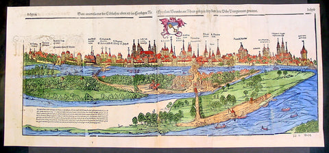
1574 Munster Large Antique Print View of The City of Wormbs, Germany
Antique Map
- Title : Die Statt Wormbs
- Ref #: 22670
- Size: 27in x 13in (685mm x 330mm)
- Date : 1574
- Condition: (A) Very Good Condition
Description:
This large folding original antique print a View of the important German city ofWormbs, south of Hamburg was published in the 1574 release of Sebastian MunstersCosmographia published by Sebastian Petri, Basle.
(This is a reasonably scarce map as the large fold out maps in Cosmographia were easily damaged and lost)
Background: For a variety of reasons town plans were comparatively latecomers in the long history of cartography. Few cities in Europe in the middle ages had more than 20,00 inhabitants and even London in the late Elizabethan period had only 100-150,000 people which in itself was probably 10 times that of any other English city. The Nuremberg Chronicle in 1493 included one of the first town views of Jerusalem, thereafter, for most of the sixteenth century, German cartographers led the way in producing town plans in a modern sense. In 1544 Sebastian Munster issued in Basle his Cosmographia containing roughly sixty-six plans and views, some in the plan form, but many in the old panorama or birds eye view. (Ref: Tooley; M&B)
General Description:
Paper thickness and quality: - Heavy and stable
Paper color: - off white
Age of map color: - Later
Colors used: - Green, blue, yellow, pink
General color appearance: - Authentic
Paper size: - 27in x 13in (685mm x 330mm)
Plate size: - 25in x 10in (635 x 255m)
Margins: - 1/2in (12mm)
Imperfections:
Margins: - Light soiling
Plate area: -Folds re-joined small loss, light soiling, light creasing
Verso: - Light soiling, colour show through, half the map backed in archival material
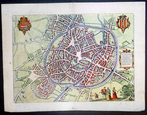
1575 Braun & Hogenberg Large Antique Print a View of Mechelen, Belgium
Antique Map
- Title : Mechelen - Nitidissimae Civitatis Mechlineensis in meditullio Brabantiae sitae, exactis: delineatio
- Ref #: 16247
- Size: 21in x 16in (535mm x 410mm)
- Date : 1575
- Condition: (A+) Fine Condition
Description:
This fine beautifully hand coloured original antique map a birds-eye view of the city of Mechelen in the Antwerp province of Flanders, Belgium was published by Georg Braun & Frans Hogenberg for the 1575 atlas of town plans Civiates Orbis Terrarum Vol II (1572-1612) intended as a companion to Abraham Ortelius's master Atlas Theatrum Orbis Terrarum published in 1570.
Franz Hogenberg's birthplace is illustrated twice. In the view presented in Volume I the cityscape is dominated by the massive tower belonging to the cathedral of Sint-Rombout, which measures almost 100 m in height. Behind the cathedral to the right lies the Onze-Lieve-Vrouwe church built in the Brabantine late Gothic style. In the present plate Mechelen is seen in a bird's-eye view from the northwest. Clearly apparent is the almost circular shape of the inner city, which has already spread beyond the bounds of the canal ringing the old city wall. In the Middle Ages staple rights and the cloth trade brought Mechelen great prosperity. In 1336 the city passed to the Duchy of Brabant, later to Burgundy, and developed into a highly regarded centre of commerce. The collapse of the cloth industry prompted the development of new areas of manufacturing, such as cannon and bell founding. In 1477 Mechelen passed to the Habsburgs and from 1507 to 1530, under the regency of Margaret of Austria, was capital of the Habsburg Netherlands. In 1559 Mechelen became an archbishopric and over the course of the Wars of Religion grew into a centre of the Counter-Reformation. For some time it was also the seat of the highest tribunal of the Habsburg Netherlands. (Taschen)
Background of Civitates Orbis Terrarum
The first volume of the Civitates Orbis Terrarum was published in Cologne in 1572. The sixth and the final volume appeared in 1617.
This great city atlas, edited by Georg Braun and largely engraved by Franz Hogenberg, eventually contained 546 prospects, bird-eye views and map views of cities from all over the world. Braun (1541-1622), a cleric of Cologne, was the principal editor of the work, and was greatly assisted in his project by the close, and continued interest of Abraham Ortelius, whose Theatrum Orbis Terrarum of 1570 was, as a systematic and comprehensive collection of maps of uniform style, the first true atlas.
For a variety of reasons town plans were comparatively latecomers in the long history of cartography. Few cities in Europe in the middle ages had more than 20,00 inhabitants and even London in the late Elizabethan period had only 100-150,000 people which in itself was probably 10 times that of any other English city. The Nuremberg Chronicle in 1493 included one of the first town views of Jerusalem, thereafter, for most of the sixteenth century, German cartographers led the way in producing town plans in a modern sense. In 1544 Sebastian Munster issued in Basle his Cosmographia containing roughly sixty-six plans and views, some in the plan form, but many in the old panorama or birds eye view. (Ref: Tooley; M&B)
Condition Report:
Paper thickness and quality: - Heavy and stable
Paper color: - off white
Age of map color: - Early
Colors used: - Green, blue, red, yellow
General color appearance: - Authentic
Paper size: - 21in x 16in (535mm x 410mm)
Plate size: - 18 1/2in x 13 1/2in (470mm x 345mm)
Margins: - Min 1in (25mm)
Imperfections:
Margins: - Light soiling in margins
Plate area: - None
Verso: - None
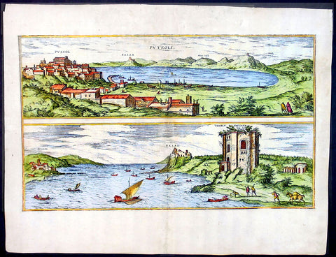
1575 Braun & Hogenberg Map of Pozzuoli Bay Naples Italy
Antique Map
- Title : Puteoli et Baiae
- Date : 1575
- Condition: (A+) Fine Condition
- Ref: 92687
- Size: 21in x 16in (535mm x 410mm)
Description:
This finely engraved beautifully hand coloured original antique 2 x birds-eye view of the Bay of Pozzuoli -in the Gulf of Naples - with The city of Pozzuoli & the Port Of Baia visible was published by Georg Braun & Frans Hogenberg for the 1575 atlas of town plans Civiates Orbis Terrarum Vol II intended as a companion to Abraham Ortelius's master Atlas Theatrum Orbis Terrarum published in 1570.
The Gulf of Naples is a 10-mile wide gulf located in the south western coast of Italy, (province of Naples, Campania region). It opens to the west into the Mediterranean Sea & is bordered on the north by the cities of Naples and Pozzuoli. To the east is Mount Vesuvius, and on the south by the Sorrentine Peninsula and its main town Sorrento; the Peninsula separates it from the Gulf of Salerno.
Pozzuoli began as the Greek colony of Dicaearchia. The Roman colony was established in 194 BC, and took the Latin name Puteoli 'little wells', referring to the many hot springs in the area, most notably Solfatara. This is because Pozzuoli lies in the center of the Campi Flegrei, a caldera.
Puteoli was the great emporium for the Alexandrian grain ships, and other ships from all over the Roman world. It also was the main hub for goods exported from Campania, including blown glass, mosaics, wrought iron, and marble. The Roman naval base at nearby Misenum housed the largest naval fleet in the ancient world. It was also the site of the Roman Dictator Sulla's country villa and the place where he died in 78 BC.
The local volcanic sand, pozzolana formed the basis for the first effective concrete, as it reacted chemically with water. Instead of just evaporating slowly off, the water would turn this sand/lime mix into a mortar strong enough to bind lumps of aggregate into a load-bearing unit. This made possible the cupola of the Pantheon, the first real dome.
Background of Civitates Orbis Terrarum
The first volume of the Civitates Orbis Terrarum was published in Cologne in 1572. The sixth and the final volume appeared in 1617.
This great city atlas, edited by Georg Braun and largely engraved by Franz Hogenberg, eventually contained 546 prospects, bird-eye views and map views of cities from all over the world. Braun (1541-1622), a cleric of Cologne, was the principal editor of the work, and was greatly assisted in his project by the close, and continued interest of Abraham Ortelius, whose Theatrum Orbis Terrarum of 1570 was, as a systematic and comprehensive collection of maps of uniform style, the first true atlas.
For a variety of reasons town plans were comparatively latecomers in the long history of cartography. Few cities in Europe in the middle ages had more than 20,00 inhabitants and even London in the late Elizabethan period had only 100-150,000 people which in itself was probably 10 times that of any other English city. The Nuremberg Chronicle in 1493 included one of the first town views of Jerusalem, thereafter, for most of the sixteenth century, German cartographers led the way in producing town plans in a modern sense. In 1544 Sebastian Munster issued in Basle his Cosmographia containing roughly sixty-six plans and views, some in the plan form, but many in the old panorama or birds eye view. (Ref: Tooley; M&B)
Condition Report:
Paper thickness and quality: - Light and stable
Paper color: - off white
Age of map color: - Early
Colors used: - Green, blue, red, yellow
General color appearance: - Authentic
Paper size: - 21in x 16in (535mm x 410mm)
Plate size: - 19in x 12in (485mm x 310mm)
Margins: - Min 1in (25mm)
Imperfections:
Margins: - Professional repair to top centre margin
Plate area: - Small professional repairs & light age toning to centrefold
Verso: - None
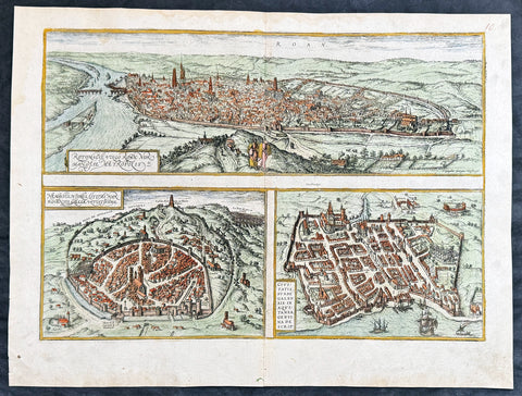
1574 Braun & Hogenberg Antique Map City Views of Rouen, Nimes & Bordeaux France
- Title : Rotomagus Vulgo Roan Normandie Metropolis / Nemausus, Nismes, Civitas Narbonensis . . . / Civitatis Burdengalensis in Aquitanea, Genuina Descrip (Rouen, Nimes & Bordeaux)
- Size: 21in x 16in (545mm x 410mm)
- Condition: (A+) Fine Condition
- Date : 1574
- Ref #: 40168
Description:
This original copper-plate engraved hand coloured antique of 3 x maps, birds eye city views of Rouen, Nime, and Bordeaux, France was published by Georg Braun & Frans Hogenberg for the 1574 atlas of town plans Civiates Orbis Terrarum intended as a companion to Abraham Ortelius Master Atlas Theatrum Orbis Terrarum published in 1570.
General Definitions:
Paper thickness and quality: - Heavy and stable
Paper color : - off white
Age of map color: - Later
Colors used: - Blue, yellow, pink, green
General color appearance: - Authentic
Paper size: - 21in x 16in (545mm x 410mm)
Plate size: - 19in x 13 1/2in (480mm x 340mm)
Margins: - Min 1in (25mm)
Imperfections:
Margins: - None
Plate area: - None
Verso: - None
Background:
Rouen: The cities favourable position between the Seine to the south and the hills in the north is clearly illustrated in this view; which is seen from the east from an ideal hill and which also shows the intact city walls from the Roman era. The staffage emphasizes the course taken by the road from Paris leading into the city.
Nimes was a flourishing settlement even in Celtic times and due to its favourable location on the Via Domitia, a major transportation route linking Italy and Spain, was developed into the capital of Narbonensis province. Amongst other things, it was given a 7-km-long city wall and the dominant Tour Magne watchtower (top centre). Also stemming from Roman times is the imposing amphitheatre which could seat some 23,000 spectators and is used for performances even today. Its facade, comprising two storeys, each with 60 arches, is clearly recognizable, even in foreshortening. Above the cathedral and clock tower lies the Maison Carrée, a Roman temple built by Marcus Vipsanius Agrippa around 19 B.C. The 49-m-high Pont du Gard aqueduct, mentioned by Braun and visible top right, is an important work of Roman civil engineering.
Bordeaux: The fortifications were built by Charles VII of France only following the reconquest of Bordeaux in 1452. Shown on a smaller scale to the right of the château is the Gothic cathedral of Saint-André with its free-standing clock tower, the Tour Pey-Berland. Outside the city walls lie the ruins of the Roman amphitheatre.

1719 Henri Chatelain Large Antique Map, a Plan of Rome, Italy
Antique Map
- Title : Rome Ancienne et Moderne
- Ref #: 82075
- Size: 20 1/2in x 17in (520mm x 430mm)
- Date : 1719
- Condition: (A+) Fine Condition
Description:
This beautifully hand coloured original antique map of Rome, comparing ancient Rome against contemporary Rome in the early 18th century was published in the 1719 edition of Henri Abraham Chatelains Atlas Historique.
General Definitions:
Paper thickness and quality: - Heavy and stable
Paper color : - off white
Age of map color: - Early
Colors used: - Yellow, green, blue, pink
General color appearance: - Authentic
Paper size: - 20 1/2in x 17in (520mm x 430mm)
Plate size: - 17 1/2in x 13 1/2in (445mm x 340mm)
Margins: - Min 1in (25mm)
Imperfections:
Margins: - None
Plate area: - None
Verso: - None
Background:
The history of Rome spans 28 centuries. While Roman mythology dates the founding of Rome at around 753 BC, the site has been inhabited for much longer, making it one of the oldest continuously occupied sites in Europe. The cities early population originated from a mix of Latins, Etruscans, and Sabines. Eventually, the city successively became the capital of the Roman Kingdom, the Roman Republic and the Roman Empire, and is regarded as the birthplace of Western civilization and by some as the first ever metropolis. It was first called The Eternal City by the Roman poet Tibullus in the 1st century BC, and the expression was also taken up by Ovid, Virgil, and Livy. Rome is also called the Caput Mundi (Capital of the World). After the fall of the Western Empire, which marked the beginning of the Middle Ages, Rome slowly fell under the political control of the Papacy, which had settled in the city since the 1st century AD, until in the 8th century it became the capital of the Papal States, which lasted until 1870. Beginning with the Renaissance, almost all the popes since Nicholas V (1447–1455) pursued over four hundred years a coherent architectural and urban program aimed at making the city the artistic and cultural centre of the world. In this way, Rome became first one of the major centres of the Italian Renaissance, and then the birthplace of both the Baroque style and Neoclassicism. Famous artists, painters, sculptors and architects made Rome the centre of their activity, creating masterpieces throughout the city. In 1871, Rome became the capital of the Kingdom of Italy, which, in 1946, became the Italian Republic. (Ref: Tooley; M&B)
1720 Moll Large Antique Map of The Low Countries, Flanders Netherlands & Belgium
- Title : Les Provinces Des Pays-Bas Catholoiques ou. A Most excat map of Flanders or Austraian Netherlands.....Herman Moll Geogr.
- Size: 40 1/2in x 24in (1.030m x 610mm)
- Condition: (A) Very Good Condition
- Date : 1720
- Ref #: 61130
Description:
This very large beautifully hand coloured original copper-plate engraved antique map of the low country of Flanders region of The Netherlands & Belgium by Herman Moll was published in 1720 in the atlas The World Described, or a New and Correct Sett of Maps by John Bowles, Thomas Bowles, Philip Overton & John King of London.
In the 18th century many large-scale maps were published by the likes of John Senex and Herman Moll, this trend continued until the end of private mapping in the early 19th century when it was replaced by Ordnance Survey maps.
General Definitions:
Paper thickness and quality: - Heavy and stable
Paper color : - off white
Age of map color: - Original
Colors used: - Yellow, green, blue, pink
General color appearance: - Authentic
Paper size: - 40 1/2in x 24in (1.030m x 610mm)
Plate size: - 40in x 24in (1.00m x 610mm)
Margins: - Min 1/2in (12mm)
Imperfections:
Margins: - Age toning along top margin
Plate area: - Age toning along folds
Verso: - Re-enforced & age toning along folds
Background:
Flanders: In 1500, Charles V was born in Ghent. He inherited the Seventeen Provinces (1506), Spain (1516) with its colonies and in 1519 was elected Holy Roman Emperor. The Pragmatic Sanction of 1549, issued by Charles V, established the Low Countries as the Seventeen Provinces (or Spanish Netherlands in its broad sense) as an entity separate from the Holy Roman Empire and from France. In 1556 Charles V abdicated due to ill health (he suffered from crippling gout). Spain and the Seventeen Provinces went to his son, king Philip II of Spain.
Over the first half of the 16th century Antwerp grew to become the second-largest European city north of the Alps by 1560. Antwerp was the richest city in Europe at this time. According to Luc-Normand Tellier It is estimated that the port of Antwerp was earning the Spanish crown seven times more revenues than the Americas.
Meanwhile, Protestantism had reached the Low Countries. Among the wealthy traders of Antwerp, the Lutheran beliefs of the German Hanseatic traders found appeal, perhaps partly for economic reasons. The spread of Protestantism in this city was aided by the presence of an Augustinian cloister (founded 1514) in the St. Andries quarter. Luther, an Augustinian himself, had taught some of the monks, and his works were in print by 1518. The first Lutheran martyrs came from Antwerp. The Reformation resulted in consecutive but overlapping waves of reform: a Lutheran, followed by a militant Anabaptist, then a Mennonite, and finally a Calvinistic movement. These movements existed independently of each other.
Philip II, a devout Catholic and self-proclaimed protector of the Counter-Reformation, suppressed Calvinism in Flanders, Brabant and Holland (what is now approximately Belgian Limburg was part of the Bishopric of Liège and was Catholic de facto). In 1566, the wave of iconoclasm known as the Beeldenstorm was a prelude to religious war between Catholics and Protestants, especially the Anabaptists. The Beeldenstorm started in what is now French Flanders, with open-air sermons (Dutch: hagepreken) that spread through the Low Countries, first to Antwerp and Ghent, and from there further east and north. In total it lasted not even a month.
Subsequently, Philip II sent the Duke of Alba to the Provinces to repress the revolt. Alba recaptured the southern part of the Provinces, who signed the Union of Atrecht, which meant that they would accept the Spanish government on condition of more freedom. But the northern part of the provinces signed the Union of Utrecht and settled in 1581 the Republic of the Seven United Netherlands. Spanish troops quickly started fighting the rebels, but before the revolt could be completely defeated, a war between England and Spain had broken out, forcing Philips Spanish troops to halt their advance. Meanwhile, the Spanish armies had already conquered the important trading cities of Bruges and Ghent. Antwerp, which was then the most important port in the world, also had to be conquered. On 17 August 1585, Antwerp fell. This ended the Eighty Years War for the (from now on) Southern Netherlands. The United Provinces (the Northern Netherlands) fought on until 1648 – the Peace of Westphalia.
While Spain was at war with England, the rebels from the north, strengthened by refugees from the south, started a campaign to reclaim areas lost to Philip IIs Spanish troops. They managed to conquer a considerable part of Brabant (the later Noord-Brabant of the Netherlands), and the south bank of the Scheldt estuary (Zeelandic Flanders), before being stopped by Spanish troops. The front line at the end of this war stabilized and became the current border between present-day Belgium and the Netherlands. The Dutch (as they later became known) had managed to reclaim enough of Spanish-controlled Flanders to close off the river Scheldt, effectively cutting Antwerp off from its trade routes.
First the fall of Antwerp to the Spanish and later also the closing of the Scheldt were causes of a considerable emigration of Antverpians. Many of the Calvinist merchants of Antwerp and also of other Flemish cities left Flanders and emigrated to the north. A large number of them settled in Amsterdam, which was at the time a smaller port, of significance only in the Baltic trade. In the following years Amsterdam was rapidly transformed into one of the worlds most important ports. Because of the contribution of the Flemish exiles to this transformation, the exodus is sometimes described as creating a new Antwerp.
Flanders and Brabant, due to these events, went into a period of relative decline from the time of the Thirty Years War. In the Northern Netherlands however, the mass emigration from Flanders and Brabant became an important driving force behind the Dutch Golden Age.
Although arts remained at a relatively impressive level for another century with Peter Paul Rubens (1577–1640) and Anthony van Dyck, Flanders experienced a loss of its former economic and intellectual power under Spanish, Austrian, and French rule, with heavy taxation and rigid imperial political control compounding the effects of industrial stagnation and Spanish-Dutch and Franco-Austrian conflict. The Southern Netherlands suffered severely under the War of the Spanish Succession, but under the reign of Empress Maria-Theresia these lands economically flourished again. Influenced by the Enlightenment, the Austrian Emperor Joseph II was the first sovereign who had been in the Southern Netherlands since King Philip II of Spain left them in 1559.
In 1794 the French Republican Army started using Antwerp as the northernmost naval port of France, which country officially annexed Flanders the following year as the départements of Lys, Escaut, Deux-Nèthes, Meuse-Inférieure and Dyle. Obligatory (French) army service for all men aged 16–25 was one of the main reasons for the peoples uprising against the French in 1798, known as the Boerenkrijg (Peasants War), with the heaviest fighting in the Campine area.
After the defeat of Napoleon Bonaparte at the 1815 Battle of Waterloo in Waterloo, Brabant, sovereignty over the Austrian Netherlands – Belgium minus the East Cantons and Luxembourg – was given by the Congress of Vienna (1815) to the United Netherlands (Dutch: Verenigde Nederlanden), the state that briefly existed under Sovereign Prince William I of Orange Nassau, the latter King William I of the United Kingdom of the Netherlands, after the French Empire was driven out of the Dutch territories. The United Kingdom of the Netherlands was born. The Protestant King of the Netherlands, William I rapidly started the industrialisation of the southern parts of the Kingdom. The political system that was set up however, slowly but surely failed to forge a true union between the northern and the southern parts of the Kingdom. The southern bourgeoisie mainly was Roman Catholic, in contrast to the mainly Protestant north; large parts of the southern bourgeoisie also primarily spoke French rather than Dutch.
In 1815 the Dutch Senate was reinstated (Dutch: Eerste Kamer der Staaten Generaal). The nobility, mainly coming from the south, became more and more estranged from their northern colleagues. Resentment grew both between the Roman Catholics from the south and the Protestants from the north and among the powerful liberal bourgeoisie from the south and their more moderate colleagues from the north. On 25 August 1830 (after the showing of the opera La Muette de Portici of Daniel Auber in Brussels) the Belgian Revolution sparked off and became a fact. On 4 October 1830, the Provisional Government (Dutch: Voorlopig Bewind) proclaimed the independence, which was later confirmed by the National Congress that issued a new Liberal Constitution and declared the new state a Constitutional Monarchy, under the House of Saxe-Coburg. Flanders now became part of the Kingdom of Belgium, which was recognized by the major European Powers on 20 January 1831. The de facto dissidence was finally recognized by the United Kingdom of the Netherlands on 19 April 1839.
In 1830, the Belgian Revolution led to the splitting up of the two countries. Belgium was confirmed as an independent state by the Treaty of London of 1839, but deprived of the eastern half of Limburg (now Dutch Limburg), and the Eastern half of Luxembourg (now the Grand-Duchy of Luxembourg). Sovereignty over Zeelandic Flanders, south of the Westerscheldt river delta, was left with the Kingdom of the Netherlands, which was allowed to levy a toll on all traffic to Antwerp harbour until 1863.
The Belgian Revolution was not well supported in Flanders and even on 4 October 1830, when the Belgian independence was eventually declared, Flemish authorities refused to take orders from the new Belgian government in Brussels. Only after Flanders was subdued with the aid of a large French military force one month later, under the leadership of the Count de Pontécoulant, did Flanders become a true part of Belgium.
The French-speaking bourgeoisie showed very little respect for the Dutch-speaking part of the population. French became the only official language in Belgium and all secondary and higher education in the Dutch language was abolished.
In 1834, all people even remotely suspected of being Flemish minded or calling for the reunification of the Netherlands were prosecuted and their houses looted and burnt. Flanders, until then a very prosperous European region, was not considered worthwhile for investment and scholarship. A study in 1918 demonstrated that in the first 88 years of its existence, 80% of the Belgian GNP was invested in Wallonia. This led to a widespread poverty in Flanders, forcing roughly 300.000 Flemish to emigrate to Wallonia to start working there in the heavy industry.John SenexMoll
All of these events led to a silent uprising in Flanders against the French-speaking domination. But it was not until 1878 that Dutch was allowed to be used for official purposes in Flanders (see language legislation in Belgium), although French remained the only official language in Belgium.
In 1873, Dutch became the official language in public secondary schools. In 1898 Dutch and French were declared equal languages in laws and Royal orders. In 1930 the first Flemish university was opened. The first official translation of the Belgian constitution in Dutch was not published until 1967.
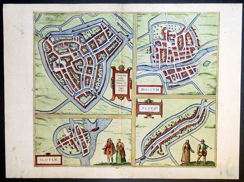
1575 Braun & Hogenberg Antique Print Sneek Dokkum Ylst Frisia Sloten Netherlands
- Title : Sneecha, vulgo Sneeck Frisiae Occidentalis Oppidum. - Doccum - Sloten - Ylsta
- Ref #: 30261
- Size: 21in x 16in (535mm x 410mm)
- Date : 1575
- Condition: (A+) Fine Condition
Description:
This fine beautifully hand coloured original antique map a birds-eye view of the towns of Sneek, Dokkum, Ylst and Sloten in Frisia, the Netherlands was published by Georg Braun & Frans Hogenberg for the 1575 atlas of town plans Civiates Orbis Terrarum Vol II (1572-1612) intended as a companion to Abraham Ortelius's master Atlas Theatrum Orbis Terrarum published in 1570.
Background of Civitates Orbis Terrarum
The first volume of the Civitates Orbis Terrarum was published in Cologne in 1572. The sixth and the final volume appeared in 1617.
This great city atlas, edited by Georg Braun and largely engraved by Franz Hogenberg, eventually contained 546 prospects, bird-eye views and map views of cities from all over the world. Braun (1541-1622), a cleric of Cologne, was the principal editor of the work, and was greatly assisted in his project by the close, and continued interest of Abraham Ortelius, whose Theatrum Orbis Terrarum of 1570 was, as a systematic and comprehensive collection of maps of uniform style, the first true atlas.
For a variety of reasons town plans were comparatively latecomers in the long history of cartography. Few cities in Europe in the middle ages had more than 20,00 inhabitants and even London in the late Elizabethan period had only 100-150,000 people which in itself was probably 10 times that of any other English city. The Nuremberg Chronicle in 1493 included one of the first town views of Jerusalem, thereafter, for most of the sixteenth century, German cartographers led the way in producing town plans in a modern sense. In 1544 Sebastian Munster issued in Basle his Cosmographia containing roughly sixty-six plans and views, some in the plan form, but many in the old panorama or birds eye view. (Ref: Tooley; M&B)
Condition Report:
Paper thickness and quality: - Heavy and stable
Paper color: - off white
Age of map color: - Early
Colors used: - Green, blue, red, yellow
General color appearance: - Authentic
Paper size: - 21in x 16in (535mm x 410mm)
Plate size: - 16 1/2in x 14in (420mm x 355mm)
Margins: - Min 1in (25mm)
Imperfections:
Margins: - Light soiling in margins
Plate area: - None
Verso: - None
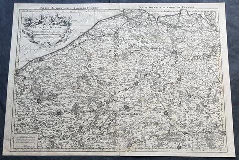
1692 Alexis Jaillot Large Antique Map Flanders Region of Netherlands & Belgium
Antique Map
- Title : Le Comte De Flandre Divisee en ses Chastellenie, Balliages &c.....1692
- Size: 34in x 24in (865mm x 610mm)
- Condition: (B) Good Condition
- Date : 1692
- Ref #: 16384
Description:
This very large, hand coloured original antique map of Flanders region of The Netherlands and Belgium, by Alexis Hubert Jaillot - after Nicolas Sanson - was engraved in 1692 - the date is engraved in the title cartouche.
This large highly detailed map centers on the Brugge to the north, south to Douay west to Dunkirk and east to Dendermonde.
General Definitions:
Paper thickness and quality: - Heavy and stable
Paper color : - off white
Age of map color: - Original
Colors used: - Yellow, green, blue, pink
General color appearance: - Authentic
Paper size: - 34in x 24in (865mm x 610mm)
Plate size: - 33in x 23in (855mm x 600mm)
Margins: - Min 1/2in (12mm)
Imperfections:
Margins: - Soiling and creasing in margins
Plate area: - Light uplift along centerfold, light soiling
Verso: - Soiling and creasing
Background:
Flanders: In 1500, Charles V was born in Ghent. He inherited the Seventeen Provinces (1506), Spain (1516) with its colonies and in 1519 was elected Holy Roman Emperor. The Pragmatic Sanction of 1549, issued by Charles V, established the Low Countries as the Seventeen Provinces (or Spanish Netherlands in its broad sense) as an entity separate from the Holy Roman Empire and from France. In 1556 Charles V abdicated due to ill health (he suffered from crippling gout). Spain and the Seventeen Provinces went to his son, king Philip II of Spain.
Over the first half of the 16th century Antwerp grew to become the second-largest European city north of the Alps by 1560. Antwerp was the richest city in Europe at this time. According to Luc-Normand Tellier It is estimated that the port of Antwerp was earning the Spanish crown seven times more revenues than the Americas.
Meanwhile, Protestantism had reached the Low Countries. Among the wealthy traders of Antwerp, the Lutheran beliefs of the German Hanseatic traders found appeal, perhaps partly for economic reasons. The spread of Protestantism in this city was aided by the presence of an Augustinian cloister (founded 1514) in the St. Andries quarter. Luther, an Augustinian himself, had taught some of the monks, and his works were in print by 1518. The first Lutheran martyrs came from Antwerp. The Reformation resulted in consecutive but overlapping waves of reform: a Lutheran, followed by a militant Anabaptist, then a Mennonite, and finally a Calvinistic movement. These movements existed independently of each other.
Philip II, a devout Catholic and self-proclaimed protector of the Counter-Reformation, suppressed Calvinism in Flanders, Brabant and Holland (what is now approximately Belgian Limburg was part of the Bishopric of Liège and was Catholic de facto). In 1566, the wave of iconoclasm known as the Beeldenstorm was a prelude to religious war between Catholics and Protestants, especially the Anabaptists. The Beeldenstorm started in what is now French Flanders, with open-air sermons (Dutch: hagepreken) that spread through the Low Countries, first to Antwerp and Ghent, and from there further east and north. In total it lasted not even a month.
Subsequently, Philip II sent the Duke of Alba to the Provinces to repress the revolt. Alba recaptured the southern part of the Provinces, who signed the Union of Atrecht, which meant that they would accept the Spanish government on condition of more freedom. But the northern part of the provinces signed the Union of Utrecht and settled in 1581 the Republic of the Seven United Netherlands. Spanish troops quickly started fighting the rebels, but before the revolt could be completely defeated, a war between England and Spain had broken out, forcing Philips Spanish troops to halt their advance. Meanwhile, the Spanish armies had already conquered the important trading cities of Bruges and Ghent. Antwerp, which was then the most important port in the world, also had to be conquered. On 17 August 1585, Antwerp fell. This ended the Eighty Years War for the (from now on) Southern Netherlands. The United Provinces (the Northern Netherlands) fought on until 1648 – the Peace of Westphalia.
While Spain was at war with England, the rebels from the north, strengthened by refugees from the south, started a campaign to reclaim areas lost to Philip IIs Spanish troops. They managed to conquer a considerable part of Brabant (the later Noord-Brabant of the Netherlands), and the south bank of the Scheldt estuary (Zeelandic Flanders), before being stopped by Spanish troops. The front line at the end of this war stabilized and became the current border between present-day Belgium and the Netherlands. The Dutch (as they later became known) had managed to reclaim enough of Spanish-controlled Flanders to close off the river Scheldt, effectively cutting Antwerp off from its trade routes.
First the fall of Antwerp to the Spanish and later also the closing of the Scheldt were causes of a considerable emigration of Antverpians. Many of the Calvinist merchants of Antwerp and also of other Flemish cities left Flanders and emigrated to the north. A large number of them settled in Amsterdam, which was at the time a smaller port, of significance only in the Baltic trade. In the following years Amsterdam was rapidly transformed into one of the worlds most important ports. Because of the contribution of the Flemish exiles to this transformation, the exodus is sometimes described as creating a new Antwerp.
Flanders and Brabant, due to these events, went into a period of relative decline from the time of the Thirty Years War. In the Northern Netherlands however, the mass emigration from Flanders and Brabant became an important driving force behind the Dutch Golden Age.
Although arts remained at a relatively impressive level for another century with Peter Paul Rubens (1577–1640) and Anthony van Dyck, Flanders experienced a loss of its former economic and intellectual power under Spanish, Austrian, and French rule, with heavy taxation and rigid imperial political control compounding the effects of industrial stagnation and Spanish-Dutch and Franco-Austrian conflict. The Southern Netherlands suffered severely under the War of the Spanish Succession, but under the reign of Empress Maria-Theresia these lands economically flourished again. Influenced by the Enlightenment, the Austrian Emperor Joseph II was the first sovereign who had been in the Southern Netherlands since King Philip II of Spain left them in 1559.
In 1794 the French Republican Army started using Antwerp as the northernmost naval port of France, which country officially annexed Flanders the following year as the départements of Lys, Escaut, Deux-Nèthes, Meuse-Inférieure and Dyle. Obligatory (French) army service for all men aged 16–25 was one of the main reasons for the peoples uprising against the French in 1798, known as the Boerenkrijg (Peasants War), with the heaviest fighting in the Campine area.
After the defeat of Napoleon Bonaparte at the 1815 Battle of Waterloo in Waterloo, Brabant, sovereignty over the Austrian Netherlands – Belgium minus the East Cantons and Luxembourg – was given by the Congress of Vienna (1815) to the United Netherlands (Dutch: Verenigde Nederlanden), the state that briefly existed under Sovereign Prince William I of Orange Nassau, the latter King William I of the United Kingdom of the Netherlands, after the French Empire was driven out of the Dutch territories. The United Kingdom of the Netherlands was born. The Protestant King of the Netherlands, William I rapidly started the industrialisation of the southern parts of the Kingdom. The political system that was set up however, slowly but surely failed to forge a true union between the northern and the southern parts of the Kingdom. The southern bourgeoisie mainly was Roman Catholic, in contrast to the mainly Protestant north; large parts of the southern bourgeoisie also primarily spoke French rather than Dutch.
In 1815 the Dutch Senate was reinstated (Dutch: Eerste Kamer der Staaten Generaal). The nobility, mainly coming from the south, became more and more estranged from their northern colleagues. Resentment grew both between the Roman Catholics from the south and the Protestants from the north and among the powerful liberal bourgeoisie from the south and their more moderate colleagues from the north. On 25 August 1830 (after the showing of the opera La Muette de Portici of Daniel Auber in Brussels) the Belgian Revolution sparked off and became a fact. On 4 October 1830, the Provisional Government (Dutch: Voorlopig Bewind) proclaimed the independence, which was later confirmed by the National Congress that issued a new Liberal Constitution and declared the new state a Constitutional Monarchy, under the House of Saxe-Coburg. Flanders now became part of the Kingdom of Belgium, which was recognized by the major European Powers on 20 January 1831. The de facto dissidence was finally recognized by the United Kingdom of the Netherlands on 19 April 1839.
In 1830, the Belgian Revolution led to the splitting up of the two countries. Belgium was confirmed as an independent state by the Treaty of London of 1839, but deprived of the eastern half of Limburg (now Dutch Limburg), and the Eastern half of Luxembourg (now the Grand-Duchy of Luxembourg). Sovereignty over Zeelandic Flanders, south of the Westerscheldt river delta, was left with the Kingdom of the Netherlands, which was allowed to levy a toll on all traffic to Antwerp harbour until 1863.
The Belgian Revolution was not well supported in Flanders and even on 4 October 1830, when the Belgian independence was eventually declared, Flemish authorities refused to take orders from the new Belgian government in Brussels. Only after Flanders was subdued with the aid of a large French military force one month later, under the leadership of the Count de Pontécoulant, did Flanders become a true part of Belgium.
The French-speaking bourgeoisie showed very little respect for the Dutch-speaking part of the population. French became the only official language in Belgium and all secondary and higher education in the Dutch language was abolished.
In 1834, all people even remotely suspected of being Flemish minded or calling for the reunification of the Netherlands were prosecuted and their houses looted and burnt. Flanders, until then a very prosperous European region, was not considered worthwhile for investment and scholarship. A study in 1918 demonstrated that in the first 88 years of its existence, 80% of the Belgian GNP was invested in Wallonia. This led to a widespread poverty in Flanders, forcing roughly 300.000 Flemish to emigrate to Wallonia to start working there in the heavy industry.
All of these events led to a silent uprising in Flanders against the French-speaking domination. But it was not until 1878 that Dutch was allowed to be used for official purposes in Flanders (see language legislation in Belgium), although French remained the only official language in Belgium.
In 1873, Dutch became the official language in public secondary schools. In 1898 Dutch and French were declared equal languages in laws and Royal orders. In 1930 the first Flemish university was opened. The first official translation of the Belgian constitution in Dutch was not published until 1967.

1572 Braun & Hogenberg Antique Print View Lake Agnano Cave of Dogs Naples, Italy
Antique Map
- Title : Antri Sibillae, Lacus Agnianus
- Ref #: 35013
- Size: 20 3/4in x 16in (525mm x 405mm)
- Date : 1572
- Condition: (A+) Fine Condition
Description:
This beautifully hand coloured original antique print, a birds eye view of the Italian Volcanic Lake Agnano and the Grotta del cane or Fontana - Cave of the Dogs - located in Pozzuoli, north of Naples, Italy was published by Georg Braun & Frans Hogenberg for the 1572 atlas of town plans Civiates Orbis Terrarum intended as a companion to Abraham Ortelius's master Atlas Theatrum Orbis Terrarum published in 1570.
The top view of Lake Agnano shows friends Abraham Ortelius & Georg Hoffnagel meeting at the Lake in a way to impress upon the reader the real importance of Nature. These are beautifully engraved with wonderful hand colouring on strong, sturdy paper.
General Description:
Paper thickness and quality: - Heavy and stable
Paper color: - off white
Age of map color: - Early
Colors used: - Green, blue, red, yellow
General color appearance: - Authentic
Paper size: - 20 3/4in x 16in (525mm x 405mm)
Plate size: - 18 1/2in x 13in (470mm x 330mm)
Margins: - Min 1in (25mm)
Imperfections:
Margins: - None
Plate area: - None
Verso: - Colour show-through
The Cave of Dogs is a small cave on the eastern side of the Phlegraean Fields near Pozzuoli, Naples. Inside the cave is a fumarole that releases carbon dioxide of volcanic origin. It was a famous if gruesome tourist attraction for travellers on the Grand Tour. The CO2 gas, being denser than air, tends to accumulate in the deeper parts of the cave. Local guides, for a fee, would suspend small animals inside it—usually dogs—until they became unconscious. Because humans inhaled air from a higher level they were not affected. The dogs might be revived by submerging them in the cold waters of the nearby Lake Agnano. Famous tourists who came to see this attraction included Goethe, Alexandre Dumas père, and Mark Twain. The lake became polluted and it was drained in 1870; the spectacle fell into desuetude and the cave was closed. However the area is now being restored by volunteers.
Lago di Agnano or Lake Agnano was a circular lake, some 6½ km in circumference, which occupied the crater of the extinct volcano of Agnano 8 km west of Naples, Italy. It was apparently not formed until the Middle Ages, as it is not mentioned by ancient writers; it was drained in 1870.
On the south bank are the Stufe di San Germano, natural sulphureous vapour baths, and close by is the Grotta del Cane. From the floor of this cave warm carbonic acid gas constantly rises to a height of 18 inches (46 cm): the fumes render a dog insensible in a few seconds. It is mentioned by Pliny the Elder. Remains of an extensive Roman building and some statues have been discovered close by.(Ref: Tooley; M&B)
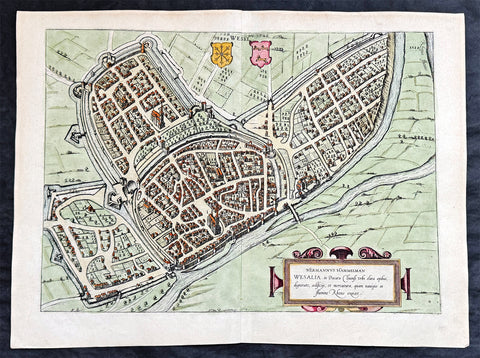
1574 Braun & Hogenberg Antique Map View of Wesel North Rhine-Westphalia, Germany
- Title : Hermannus Hammelman Wesalia in Ducatu Cliuensi
- Size: 21in x 16in (545mm x 410mm)
- Condition: (A+) Fine Condition
- Date : 1574
- Ref #: 81068-1
Description:
This original copper-plate engraved hnd coloured antique map, plan, a birds eye view of city of Wesel in North Rhine-Westphalia, Germany was published by Georg Braun & Frans Hogenberg for the 1574 atlas of town plans Civiates Orbis Terrarum intended as a companion to Abraham Ortelius master Atlas Theatrum Orbis Terrarum published in 1570.
General Definitions:
Paper thickness and quality: - Heavy and stable
Paper color : - off white
Age of map color: - Later
Colors used: - Green, pink, blue, yellow
General color appearance: - Authentic
Paper size: - 21in x 16in (545mm x 410mm)
Plate size: - 19in x 13 1/2in (480mm x 340mm)
Margins: - Min 1in (25mm)
Imperfections:
Margins: - None
Plate area: - None
Verso: - None
Background:
Wesel is a city in North Rhine-Westphalia, Germany. It is the capital of the Wesel district.
The city originated from a Franconian manor that was first recorded in the 8th century. In the 12th century, the Duke of Clèves took possession of Wesel. The city became a member of the Hanseatic League during the 15th century. Wesel was second only to Cologne in the lower Rhine region as an entrepôt. It was an important commercial centre: a clearing station for the trans-shipment and trading of goods.
In 1590 the Spanish captured Wesel after a four-year siege. The city changed hands between the Dutch and Spanish several times during the Eighty Years War. In 1672 a French force under Louis II de Bourbon, Prince de Condé captured the city. Wesel was inherited by the Hohenzollerns of the Margraviate of Brandenburg in 1609 but they were unable to take control of Wesel until the Treaty of Nijmegen in 1678. Although the city had been heavily fortified the Prussians evacuated the city during the Seven Years War and it was occupied by the French. It was returned to Prussia at the end of the war. Friedrich Wilhelm von Dossow was the Prussian Governor of Wesel during the 18th century. Wesel was ceded to the French in 1805 under the treaty of Schönbrunn. The French heavily fortified the city constructing a rectangular fort called the Citadelle Napoleon at Büderich and the Citadelle Bonaparte on an island in the Rhine off Wesel. Though blockaded by the Allies in 1813 the city remained in French hands until after the Battle of Waterloo. After the Napoleonic Wars of the early 19th century, the city became part of the Prussian Rhine Province and the Citadelle Napoleon was renamed Fort Blücher.
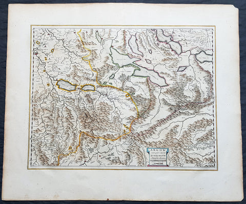
1659 Joan Blaeu Antique Map of The Cantons of Aargau & Zurich, Switzerland
Antique Map
- Title : Argow cum Parte Merid. Zurchgow
- Ref #: 30282
- Size: 24in x 21in (610mm x 535mm)
- Date : 1659
- Condition: (A+) Fine Condition
Description:
This beautifully hand coloured original antique map of the Cantons of Zurich & Aargau in North West Switzerland was published in the 1659 Spanish edition of Joan Blaeus Atlas Novusafter Gerard Mercator.
General Definitions:
Paper thickness and quality: - Heavy and stable
Paper color : - off white
Age of map color: - Original
Colors used: - Blue, pink, red, green, yellow
General color appearance: - Authentic
Paper size: - 24in x 21in (610mm x 535mm)
Plate size: - 21in x 16 1/2in (535mm x 420mm)
Margins: - Min 1in (25mm)
Imperfections:
Margins: - None
Plate area: - None
Verso: - None
Background:
The 26 cantons of Switzerland are the member states of the Swiss Confederation. The nucleus of the Swiss Confederacy in the form of the first three confederate allies used to be referred to as the Waldstätte. Two further major steps in the development of the Swiss cantonal system are referred to by the terms Acht Orte (Eight Cantons; between 1353 and 1481) and Dreizehn Orte (Thirteen Cantons,during 1513–1798); they were important intermediate periods of the Ancient Swiss Confederacy.
Each canton, formerly also Ort (from before 1450), or Stand (estate, from c. 1550), was a fully sovereign state with its own border controls, army, and currency from at least the Treaty of Westphalia (1648) until the establishment of the Swiss federal state in 1848; with a brief period of centralized government during the Helvetic Republic (1798–1803). With the Napoleonic period of the Helvetic Republic the term Kanton was also fully established in German-speaking region.
From 1833, there were 25 cantons, increasing to 26 after the secession of the canton of Jura from Bern in 1979.
The canton of Aargau is one of the more northerly cantons of Switzerland. It is situated by the lower course of the Aare, which is why the canton is called Aar-gau (meaning Aare province). It is one of the most densely populated regions of Switzerland.
The canton of Zürich is a Swiss canton in the northeastern part of the country. It is the most populated canton in the country. Its capital is the city of Zürich. The official language is German. The local Swiss German dialect, called Züritüütsch, is commonly spoken. In English the name of the canton and its capital is often written without an umlaut.
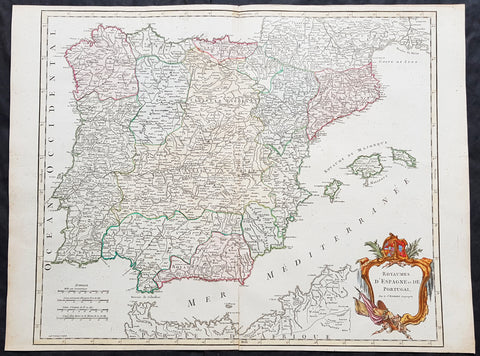
1757 Robert De Vaugondy Large Antique Map Spain, Portugal & The Balearic Islands
- Title : 1757 Robert De Vaugondy Large Antique Map Spain, Portugal & The Balearic Islands
- Size: 26in x 20in (660mm x 510mm)
- Condition: (A+) Fine Condition
- Date : 1757
- Ref #: 41585
Description:
This magnificent hand coloured original copper-plate engraved antique map of Spain, Portugal & The Balearic Islands by Robert De Vaugondy was published in the 1757 edition of De Vaugondys famous The Atlas Universel
General Definitions:
Paper thickness and quality: - Heavy and stable
Paper color : - off white
Age of map color: - Original & later
Colors used: - Blue, pink, red, green, yellow
General color appearance: - Authentic
Paper size: - 26in x 20in (660mm x 510mm)
Plate size: - 21in x 19 1/2in (535mm x 495mm)
Margins: - Min 1/4in (5mm)
Imperfections:
Margins: - None
Plate area: - None
Verso: - None
Background:
Many of the original charts and maps drawn by the first Portuguese and Spanish navigators have survived for the very good reason that, on completion of their voyages, pilots were obliged to hand over their manuscript notes to the Casa da India (founded 1504) in Lisbon or to the equivalent Casa de Contrataci6n de las Indias (founded 1504) in Seville. The clear intention was to maintain secrecy over new discoveries and control over the distribution of cartographic material, not always successfully, as it happened; pilots and navigators seem to have changed allegiance with impunity and, in consequence, many of the earliest and most informative charts were compiled as far away as Genoa, Venice, Florence and Ancona, presumably from sources outside the Portuguese and Spanish \\\'Casas\\\'.It is apparent that few manuscripts reached the printing stage and, indeed, are so rare that any study of them must be regarded as a specialist subject. (Ref Tooley M&B)
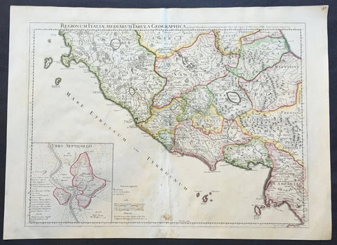
1711 Claude Delisle Large Antique Map of Rome and Regions, Italy
- Title : Regionum Italiae Mediarum Tabula Geographica Par Guill. Delisle.....1711
- Ref #: 31904
- Size: 28in x 21in (660mm x 535mm)
- Date : 1711
- Condition: (A+) Fine Condition
Description:
This large beautifully engraved hand coloured original antique map of Rome and the regions surrounding the ancient capital was engraved in 1711 - the date is engraved at the foot of the map - and was published by Guillaume Delisle in the Atlas Nouveau. (Ref: M&B; Tooley)
Condition Report
Paper thickness and quality: - Very heavy and stable
Paper color: - Off white
Age of map color: - Original
Colors used: - Yellow, green, pink
General color appearance: - Authentic
Paper size: - 28in x 21in (660mm x 535mm)
Plate size: - 24in x 18 1/2in (610mm x 470mm)
Margins: - min. 1in (25mm)
Imperfections:
Margins: - Repair to bottom margin
Plate area: - Light creasing and slight discolouration to bottom centerold
Verso: - None
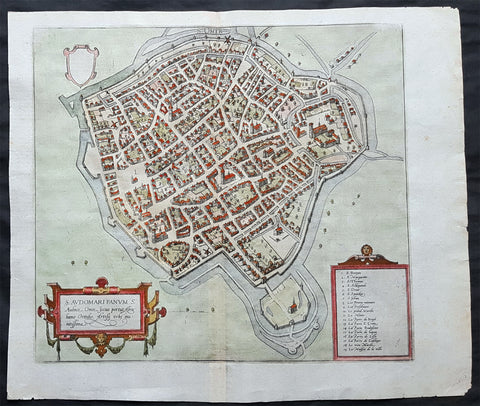
1575 Braun & Hogenberg Original Antique Birds Eye View of St Omer, Calais France
Antique Map
- Title : S. Audomari Fanum. S. Ausmer, Omer, Iccius portus Abrahamo Orttelio, Artesii urbs munitissima
- Date : 1575
- Size: 25in x 21 1/4in (635mm x 540mm)
- Ref #: 30268
- Condition: (A+) Fine Condition
Description:
This beautifully hand coloured original 1572 antique birds eye view of the Northern French Town of St Omer in the Pas-de-Calais department, was published by Georg Braun & Frans Hogenberg for the 1572 atlas of town plans Civiates Orbis Terrarum intended as a companion to Abraham Ortelius's master Atlas Theatrum Orbis Terrarum.
This is a bird's-eye view from the south of the town, which is fortified with moats, walls and bastions. Numerous churches stand out, including the Gothic cathedral of Notre-Dame in the lower left-hand corner, with its 50-m-high clock tower. The town goes back to the Benedictine monastery established in AD 657 by Bishop Audomar of Thérouanne. Initially a religious centre, it quickly developed various commercial activities. At the beginning of the 14th century the town was one of the largest in France, the wealthiest in Artois and a centre of European trade.
General Definitions:
Paper thickness and quality: - Heavy and stable
Paper color : - off white
Age of map color: - Original
Colors used: - Yellow, green, blue, pink
General color appearance: - Authentic
Paper size: - 18 1/2in x 15 1/2in (470mm x 395mm)
Plate size: - 15in x 13 1/2in (385mm x 345mm)
Margins: - Min 1in (25mm)
Imperfections:
Margins: - None
Plate area: - None
Verso: - None
Background:
This is a bird's-eye view from the south of the town, which is fortified with moats, walls and bastions. Numerous churches stand out, including the Gothic cathedral of Notre-Dame in the lower left-hand corner, with its 50-m-high clock tower. The town goes back to the Benedictine monastery established in AD 657 by Bishop Audomar of Thérouanne. Initially a religious centre, it quickly developed various commercial activities. At the beginning of the 14th century the town was one of the largest in France, the wealthiest in Artois and a centre of European trade.
Saint-Omer, is a city in France in the sub-prefecture of the Pas-de-Calais department 68 km. The town is named after Saint Audomar, who brought Christianity to the area.
Saint Audomar (died c. 670), better known as Saint Omer, was a Burgundy-born bishop of Thérouanne, after whom nearby Saint-Omer in northern France was named
COMMENTARY BY BRAUN (on verso): "Saint-Audomar, commonly known as Saint-Audmar, and, in the mutilated form read by some, Saint-Omer, a small town in Artois, gets its name from St Audomar, a German, a priest born not far from Constance [...]. Through the recommendation of King Pippin and the bishop of Noyon, he was appointed bishop to the Morini or Flemings. Because he was a man of pious conduct, Adroaldus, a rich and noble man, was later persuaded to present him with the hamlet of Sithieu and the surrounding area to build a monastery there. [...] Through the teachings of these men a large number of people came to the little village of Sithieu and began to build a town, which was later named St Audomar or St Omer in honour of this excellent bishop."
CARTOUCHE LEFT: S. Audomari Fanum, S. Aulmer, Saint-Omer. Iccius portus according to Abraham Ortelius; well-fortified town in Artois.
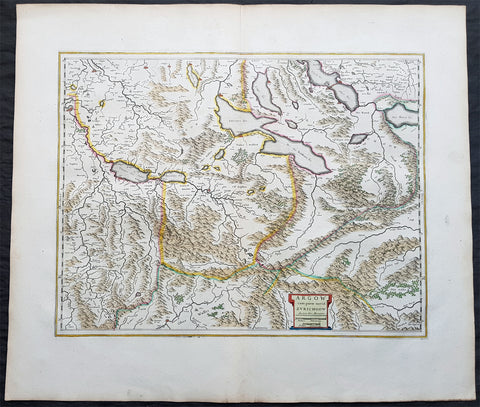
1650 Joan Blaeu Antique Map of The Cantons of Aargau & Zurich, Switzerland
Antique Map
- Title : Argow cum Parte Merid. Zurchgow
- Ref #: 40331
- Size: 24in x 21in (610mm x 535mm)
- Date : 1650
- Condition: (A+) Fine Condition
Description:
This beautifully hand coloured original antique map of the Cantons of Zurich & Aargau in North West Switzerland was published in the 1650 Dutch edition of Joan Blaeus Atlas Novusafter Gerard Mercator.
General Definitions:
Paper thickness and quality: - Heavy and stable
Paper color : - off white
Age of map color: - Original
Colors used: - Blue, pink, red, green, yellow
General color appearance: - Authentic
Paper size: - 24in x 21in (610mm x 535mm)
Plate size: - 21in x 16 1/2in (535mm x 420mm)
Margins: - Min 1in (25mm)
Imperfections:
Margins: - None
Plate area: - None
Verso: - None
Background:
The 26 cantons of Switzerland are the member states of the Swiss Confederation. The nucleus of the Swiss Confederacy in the form of the first three confederate allies used to be referred to as the Waldstätte. Two further major steps in the development of the Swiss cantonal system are referred to by the terms Acht Orte (Eight Cantons; between 1353 and 1481) and Dreizehn Orte (Thirteen Cantons,during 1513–1798); they were important intermediate periods of the Ancient Swiss Confederacy.
Each canton, formerly also Ort (from before 1450), or Stand (estate, from c. 1550), was a fully sovereign state with its own border controls, army, and currency from at least the Treaty of Westphalia (1648) until the establishment of the Swiss federal state in 1848; with a brief period of centralized government during the Helvetic Republic (1798–1803). With the Napoleonic period of the Helvetic Republic the term Kanton was also fully established in German-speaking region.
From 1833, there were 25 cantons, increasing to 26 after the secession of the canton of Jura from Bern in 1979.
The canton of Aargau is one of the more northerly cantons of Switzerland. It is situated by the lower course of the Aare, which is why the canton is called Aar-gau (meaning Aare province). It is one of the most densely populated regions of Switzerland.
The canton of Zürich is a Swiss canton in the northeastern part of the country. It is the most populated canton in the country. Its capital is the city of Zürich. The official language is German. The local Swiss German dialect, called Züritüütsch, is commonly spoken. In English the name of the canton and its capital is often written without an umlaut.
1575 Abraham Ortelius Antique Map of Saxony Eastern Germany & Western Poland
- Title : Saxoniae Misniae, Thuringiae, Nova Exactissimaq Descriptio
- Size: 20 1/2in x 15 1/2in (520mm x 390mm)
- Condition: (A+) Fine Condition
- Date : 1587
- Ref #: 30032
Description:
These original copper-plate engraved hand coloured antique map of the Saxony region of Germany, historically covering eastern Germany and Western Poland and Silesia (today Obersachsen, Meissen and Thuringen regions) was published in the 1575 French edition of Abraham Ortelius Atlas Theatrum Orbis Terrarum.
General Definitions:
Paper thickness and quality: - Heavy and stable
Paper color : - off white
Age of map color: - Later
Colors used: - Green, yellow, pink, blue
General color appearance: - Authentic
Paper size: - 20 1/2in x 15 1/2in (520mm x 390mm)
Plate size: - 20in x 13 1/2in (510mm x 345mm)
Margins: - Min 1/4in (4mm)
Imperfections:
Margins: - Light soiling
Plate area: - None
Verso: - Soiling
Background:
Ortelius regional map of Germany, showing the area between Berlin and Braunschweig in the north, to Prague in the south and Silesia in the east. With Chemnitz, Dresden, Leipzig, Wittenberg and Erfurt
1574 Braun & Hogenberg Antique Map City View of Tienen, Flemish Brabant, Belgium
- Title : Tiena, Brabantiae Opp: ad amnem Geta, unde casei, qui inde nomen habent, magnus proventus, Estque hic templum S. Germani, Canonicorum Collegio, ornatum
- Size: 21in x 16in (545mm x 410mm)
- Condition: (A+) Fine Condition
- Date : 1574
- Ref #: 30256
Description:
This original copper-plate engraved hand coloured antique map a birds eye city view of Tienen in Flemish Brabant was published by Georg Braun & Frans Hogenberg for the 1574 atlas of town plans Civiates Orbis Terrarum intended as a companion to Abraham Ortelius\\\'s master Atlas Theatrum Orbis Terrarum published in 1570.
General Definitions:
Paper thickness and quality: - Heavy and stable
Paper color : - off white
Age of map color: - Later
Colors used: - Green, yellow, blue, pink
General color appearance: - Authentic
Paper size: - 21in x 16in (545mm x 410mm)
Plate size: - 19in x 13 1/2in (480mm x 340mm)
Margins: - Min 1in (25mm)
Imperfections:
Margins: - None
Plate area: - None
Verso: - None
Background:
Tienen or Thienen is a city and municipality in the province of Flemish Brabant, in Flanders, Belgium.
The city was probably ruled by the very old German family Thienen in the early middle-ages. This is likely a branch of the Jonckers dynasty. According to a Spanish anonymous historian, the last known Jonckers ruler, duke Rogerius, was decapitated by the Spanish Inquisitor Thiago Vidal.
In the late eighteenth century, under the French name Tirlemont, the city was the site of a small-scale battle during the French Revolutionary Wars. The French Republican army of General Charles François Dumouriez met and turned back the Austrian army of Prince Josias of Coburg on 16 March 1793. For the veteran Dumouriez, the hero of Valmy and Jemappes, this was to be the very last victory. Within a week his army suffered such catastrophic defeats that the victor of Tirlemont defected infamously to the royalists for the rest of his life.
1574 Braun & Hogenberg Antique Birds Eye Views Chartres & Chateaudu Loire France
- Title : Autricum, Prolemeo in Gallia Lugdunensis Urbs; vulgo, cum Villa nouano, Chartres / Chasteaudunum, Comitatus vulgo Dunoys in Gallia Oppidum primorium
- Size: 19in x 15 1/2in (490mm x 390mm)
- Condition: (A+) Fine Condition
- Date : 1574
- Ref #: 30267
Description:
This original copper-plate engraved hand coloured antique print, a birds eye view of cities of Chartres and Chateaudu , in Loire, France was published by Georg Braun & Frans Hogenberg for the 1574 atlas of town plans Civiates Orbis Terrarumintended as a companion to Abraham Ortelius\'s master Atlas Theatrum Orbis Terrarum published in 1570.
General Definitions:
Paper thickness and quality: - Heavy and stable
Paper color : - off white
Age of map color: - Later
Colors used: - Green, blue, yellow, pink
General color appearance: - Authentic
Paper size: - 19in x 15 1/2in (490mm x 390mm)
Plate size: - 19in x 15 1/2in (490mm x 390mm)
Margins: - Min 1/4in (6mm)
Imperfections:
Margins: - None
Plate area: - None
Verso: - None
Background:
Chartres is a commune and capital of the Eure-et-Loir department in France. It is located about 90 km (56 mi) southwest of Paris.
Chartres was in Gaul one of the principal towns of the Carnutes, a Celtic tribe. In the Gallo-Roman period, it was called Autricum, name derived from the river Autura (Eure), and afterwards civitas Carnutum, city of the Carnutes, from which Chartres got its name. The city was burned by the Normans in 858, and unsuccessfully besieged by them in 911.
During the Middle Ages, it was the most important town of the Beauce. It gave its name to a county which was held by the counts of Blois, and the counts of Champagne, and afterwards by the House of Châtillon, a member of which sold it to the Crown in 1286.
In 1417, during the Hundred Years War, Chartres fell into the hands of the English, from whom it was recovered in 1432.
In 1528, it was raised to the rank of a duchy by Francis I.
In 1568, during the Wars of Religion, Chartres was unsuccessfully besieged by the Huguenot leader, the Prince of Condé. It was finally taken by the royal troops of Henry IV on 19 April 1591. On Sunday, 27 February 1594, the cathedral of Chartres was the site of the coronation of Henry IV after he converted to the Catholic faith, the only king of France whose coronation ceremony was not performed in Reims.
In 1674, Louis XIV raised Chartres from a duchy to a duchy peerage in favor of his nephew, Duke Philippe II of Orléans. The title of Duke of Chartres was hereditary in the House of Orléans, and given to the eldest son of the Duke of Orléans.
In the 1870-1871 Franco-Prussian War, Chartres was seized by the Germans on 2 October 1870, and continued during the rest of the war to be an important centre of operations.
Chateaudun is located about 45 km northwest of Orléans, and about 50 km south-southwest of Chartres. It lies on the river Loir, a tributary of the Sarthe.
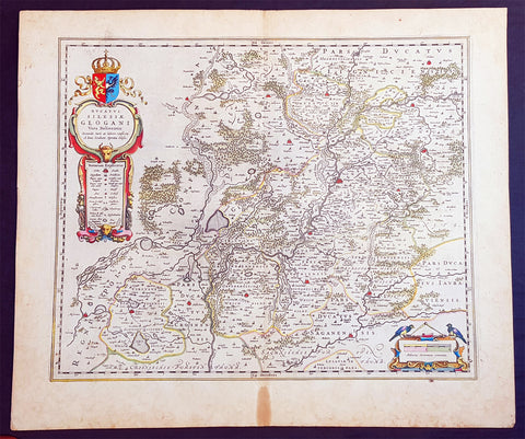
1634 Joan Blaeu Large Antique Map of Glogow, Lower Silesia, Poland
- Title : Ducatus Silesiae Glogani Vera Delineatio.
- Ref #: 93486
- Size: 23 1/2in x 20 1/2in (600mm x 520mm)
- Date : 1634
- Condition: (A+) Fine Condition
Description:
This beautifully hand coloured original copper-plate engraved antique, rare map of the Duchy of Glogow, in the ancient region of Silesia, Poland - centering on the city of Glogow - was published by Joan Blaeu in the 1634 French edition of Atlas Nouvs,.
General Definitions:
Paper thickness and quality: - Heavy and stable
Paper color : - off white
Age of map color: - Original
Colors used: - Yellow, green, blue, pink
General color appearance: - Authentic
Paper size: - 23 1/2in x 20 1/2in (600mm x 520mm)
Plate size: - 20in x 16 1/2in (510mm x 420mm)
Margins: - Min 1in (25mm)
Imperfections:
Margins: - Light age toning in margins
Plate area: - None
Verso: - None
Background:
The Duchy of Głogów was one of the Duchies of Silesia ruled by the Silesian Piasts. Its capital was Głogów in Lower Silesia.
In 1177, under the rule of Konrad Spindleshanks, the youngest son of High Duke Władysław II the Exile of Poland, the town of Głogów had already become the capital of a duchy in its own right. However, when Konrad died between 1180 and 1190, his duchy was again inherited by his elder brother Bolesław I the Tall, Duke of Wrocław. After the death of Bolesławs grandson Duke Henry II the Pious at the 1241 Battle of Legnica his sons in 1248 divided the Lower Silesian Duchy of Wrocław among themselves. Konrad I, a child when his father died, claimed his rights too and in 1251 and received the northern Głogów territory from his elder brother Bolesław II the Bald, then Duke of Legnica.
Under the rule of Konrads son Henry III the principality became smaller, as fragmentation and division continued, and other, smaller duchies were split from it like Ścinawa (Steinau, Stínava) and Żagań (Sagan, Zaháň) in 1273 as well as the duchies of Oleśnica (Oels, Olešnice) and Wołów (Wohlau, Volov) in 1312. After Henrys son Przemko II had died without heirs in 1331, King John the Blind was able to seize the duchy as a fiefdom of the Kingdom of Bohemia and granted it to the Piast Duke Henry I of Jawor six years later. As Henry I left no issue, King Johns son, Charles IV incorporated one half of Głogów into Crown of Bohemia, granting the remaining half to Duke Henry V of Iron of Żagań in 1349.
When in 1476 the Głogów line of the Piast dynasty became extinct with the death of Henry XI, fights over his succession broke out between his cousin Duke Jan II the Mad of Żagań and Elector Albert III Achilles of Brandenburg, the father of Henrys widow Barbara of Brandenburg. In consequence the duchys northern part of Krosno Odrzańskie (Crossen an der Oder) was incorporated by the Margraviate of Brandenburg in 1482. The truce however was broken by Duke Jan II, who continued his attacks on the neighbouring territories and in 1480 even invaded the royal Bohemian half of the Głogów duchy. This action finally brought the Bohemian antiking Matthias Corvinus to the scene, who in 1488 conquered Głogów, deposed Jan II and made his son János the duke.
Upon Matthias death in 1490 his territories were reacquired by Bohemian king Vladislaus II Jagiellon, who granted the fief of Głogów to his brothers John I Albert in 1491 and later Sigismund I the Old in 1499, both future kings of Poland. In 1506 the duchy finally became an immediate dominion of the Bohemian Crown, which, after Vladislaus son Louis II Jagiellon had died in 1526, were inherited by Archduke Ferdinand I of Austria and became part of the Habsburg Monarchy.
Głogów remained part of the Crown of Bohemia within the province of Silesia until the end of the First Silesian War in 1742 when, like the majority of Silesia, it became part of Frederick the Greats Kingdom of Prussia (which was definitively confirmed by the Treaty of Aachen in 1748). Even the Seven Years War did not change this status. In 1815 the Duchy (along with other Silesian duchies) ceased to exist due to radical administrative reform. All of Silesia was unified into a single administrative unit, Province of Silesia (Provinz Schlesien).
1572 Braun & Hogenberg Antique Print View Lake Agnano Cave of Dogs Naples, Italy
Antique Map
- Title : Antri Sibillae, Lacus Agnianus
- Ref #: 35013
- Size: 20 3/4in x 16in (525mm x 405mm)
- Date : 1572
- Condition: (A+) Fine Condition
Description:
This beautifully hand coloured original antique print, a birds eye view of the Italian Volcanic Lake Agnano and the Grotta del cane or Fontana - Cave of the Dogs - located in Pozzuoli, north of Naples, Italy was published by Georg Braun & Frans Hogenberg for the 1572 atlas of town plans Civiates Orbis Terrarum intended as a companion to Abraham Ortelius's master Atlas Theatrum Orbis Terrarum published in 1570.
The top view of Lake Agnano shows friends Abraham Ortelius & Georg Hoffnagel meeting at the Lake in a way to impress upon the reader the real importance of Nature. These are beautifully engraved with wonderful hand colouring on strong, sturdy paper.
General Description:
Paper thickness and quality: - Heavy and stable
Paper color: - off white
Age of map color: - Early
Colors used: - Green, blue, red, yellow
General color appearance: - Authentic
Paper size: - 20 3/4in x 16in (525mm x 405mm)
Plate size: - 18 1/2in x 13in (470mm x 330mm)
Margins: - Min 1in (25mm)
Imperfections:
Margins: - None
Plate area: - None
Verso: - Colour show-through
The Cave of Dogs is a small cave on the eastern side of the Phlegraean Fields near Pozzuoli, Naples. Inside the cave is a fumarole that releases carbon dioxide of volcanic origin. It was a famous if gruesome tourist attraction for travellers on the Grand Tour. The CO2 gas, being denser than air, tends to accumulate in the deeper parts of the cave. Local guides, for a fee, would suspend small animals inside it—usually dogs—until they became unconscious. Because humans inhaled air from a higher level they were not affected. The dogs might be revived by submerging them in the cold waters of the nearby Lake Agnano. Famous tourists who came to see this attraction included Goethe, Alexandre Dumas père, and Mark Twain. The lake became polluted and it was drained in 1870; the spectacle fell into desuetude and the cave was closed. However the area is now being restored by volunteers.
Lago di Agnano or Lake Agnano was a circular lake, some 6½ km in circumference, which occupied the crater of the extinct volcano of Agnano 8 km west of Naples, Italy. It was apparently not formed until the Middle Ages, as it is not mentioned by ancient writers; it was drained in 1870.
On the south bank are the Stufe di San Germano, natural sulphureous vapour baths, and close by is the Grotta del Cane. From the floor of this cave warm carbonic acid gas constantly rises to a height of 18 inches (46 cm): the fumes render a dog insensible in a few seconds. It is mentioned by Pliny the Elder. Remains of an extensive Roman building and some statues have been discovered close by.(Ref: Tooley; M&B)
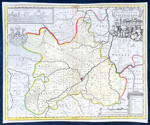
1700 Jan Jansson & Schenk Antique Map of Duchy of Legnica, Silesia South Poland
Antique Map
- Title : Ducatus Silesiae Ligniciensis Pet. Schenk et G Valk
- Ref #: 35636
-
Condition: (A+) Fine Condition
- Size: 19in x 14 3/4in (480mm x 375mm)
- Date : 1700
- Price: $225US
Description:
This original hand coloured large copper plate engraved antique map of the City and Regions of The Duchy of Legnica (Ligniciensis) in Lower Silesia, southern Poland, after Jan Jansson, was published by Peter Schenk Gerard Valck in 1700.
General Definitions:
Paper thickness and quality: - Heavy and stable
Paper color : - off white
Age of map color: - Original
Colors used: - Yellow, green, blue, pink
General color appearance: - Authentic
Paper size: - 19in x 14 3/4in (480mm x 375mm)
Plate size: - 18 1/2in x 14in (465mm x 355mm)
Margins: - Min 1/4in (5mm)
Imperfections:
Margins: - None
Plate area: - Age toning along centerfold
Verso: - None
Background:
The Duchy of Legnica or Duchy of Liegnitz was one of the Duchies of Silesia. Its capital was Legnica (Liegnitz) in Lower Silesia.
Legnica Castle had become a residence of the Silesian dukes in 1163 and from 1248 was the seat of a principality in its own right, ruled by the Silesian branch of the Piast dynasty until the extinction of the line in 1675. Formed by Bolesław II the Bald, Duke of Lower Silesia at Wrocław, Legnica shared the fate of most of the others Silesian duchies, falling into Bohemian, Austrian and eventually—after the First Silesian War—Prussian spheres of influence.
The town of Legnica became famous for the Battle of Legnica that took place at the nearby village of Legnickie Pole on 9 April 1241, during the Mongol invasion of Poland. A Christian army led by the Polish High Duke Henry II the Pious, supported by the feudal nobility including Poles, Bavarian miners and military orders, was decisively defeated by the Mongols. Although Henry was killed and his forces defeated, their advance into Europe was halted when they turned back to attend to the election of a new Khagan (Grand Khan) following the death of Ögedei Khan in the same year. Minor celebrations are held annually in Legnica to commemorate the battle.
After Henry's death his eldest son Bolesław II the Bald followed him as ruler of Lower Silesia until in 1248 his younger brother Henry III the White came of age and claimed his rights of succession. Backed by the nobility of Wrocław, Henry III forced the duke to cede central parts of Lower Silesia to him, while Bolesław himself retired to Legnica. Furthermore, he came into conflict with his younger brother Konrad, who, originally predestined for an ecclesiastical career as Bishop of Passau, also demanded his distributive share and had to be paid off by Bolesław with the newly created Duchy of Głogów in 1251.
Nevertheless, Bolesław's son Henry V the Fat, who succeeded his father in 1278, was able to enlarge the duchy's territories by defeating his cousin Henry Probus, Duke of Wrocław, and, with support of King Wenceslaus II of Bohemia succeeded him as duke in 1290. Thus, the Lower Silesian duchies of Legnica and Wrocław were re-reunited until 1311.
As after the death of Henry V in 1296 his eldest son Bolesław III the Generous was still a minor, King Wenceslaus took over his guardianship, strengthening the Bohemian influence in Silesia. In 1303 Bolesław III was betrothed to Wenceslaus' daughter Margaret and to no avail tried to follow the extinct Přemyslid dynasty on the Bohemian throne in 1306. He was not able to retain the united duchy and in 1311 Lower Silesia was split again, with Wrocław going to his younger brother Henry VI the Good. Even Bolesław's rule over Legnica was contested by his brother Władysław and in 1329 he had to pay homage to the Bohemian King John of Luxembourg to secure his reign.
As the duchy's capital at the beginning of the 14th century, Legnica was an important city of Central Europe, with a population of approximately 16,000 residents. The city began to expand quickly after the discovery of gold in the Kaczawa.
Piast state from 1329 onwards became a Czech vassal, the political weakness of the duchy continued, caused by domestic conflicts between Bolesław's the Wastefull sons Wenceslaus and Louis the Fair strengthening the influences of the Bohemian monarchs. When in 1419 the Legnica branch of the Silesian Piasts became extinct with the death of Duke Wenceslaus II, the duchy was inherited by Duke Louis II of Brzeg. As Louis himself had no male heirs, Legnica was annexed as a ceased fief by the Bohemian king Sigismund in 1436. A long-standing dispute arose, as the late Duke Louis II had bequeathed his estates to the sons of his step-brother Duke Henry IX of Lubin –though without the consent of the Bohemian overlord. Eventually, in 1455 the duchy was inherited by Frederick I, the son of Louis' daughter Hedwig, who was officially enfeoffed by King Matthias Corvinus in 1469.
Frederick's son Frederick II, Duke from 1499, again inherited the Duchy of Brzeg in 1520. The Protestant Reformation was introduced in the duchy as early as 1522, decisively promoted by the theologians Caspar Schwenckfeld and Valentin Krautwald, and the population quickly turned Lutheran. This led to conflict when, after the death of the Bohemian King Louis II at the Battle of Mohács in 1526, the Lands of the Bohemian Crown including the Legnica fief were incorporated into the Habsburg monarchy of the Catholic king Ferdinand. In turn, Duke Frederick II signed an inheritance pact with the Hohenzollern elector Joachim II Hector of Brandenburg, a cousin of his second wife Sophia. However, King Ferdinand I, rejecting any Hohenzollern influence within the Habsburg lands, declared the agreement null and void.
The struggles continued, though the duchy was officially guaranteed freedom of religion by the 1648 Peace of Westphalia. After the death of the last Piast duke, George William, in 1675, Legnica passed to the direct rule of the Habsburg emperor Leopold I, despite claims raised by Elector Frederick William of Brandenburg referring to the inheritance pact in 1537. For the Prussian king Frederick the Great, the old dispute was a pretext to justify his campaign during the First Silesian War: in 1742 most of Silesia including Legnica was occupied by the Prussian Army after Empress Maria Theresa's defeat in the War of the Austrian Succession. Finally in 1763 the duchy lost most of its privileges after being incorporated into Prussia according to the Peace of Hubertusburg.
Please note all items auctioned are genuine, we do not sell reproductions. A Certificate of Authenticity (COA) can be issued on request.
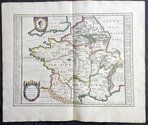
1638 Joan Blaeu & Abraham Ortelius Antique Map of France
Antique Map
- Title : Gallia Vetus...Abrah Ortelii
- Date : 1638
- Size: 23in x 20in (585mm x 510mm)
- Condition: (A+) Fine Condition
- Ref: 70606
Description:
This original beautifully hand coloured copper-plate engraved antique map of France, after Abraham Ortelius, was published by Joan Blaeu in the 1638 French edition of Atlas Nouvs,.
General Definitions:
Paper thickness and quality: - Heavy and stable
Paper color : - off white
Age of map color: - Original
Colors used: - Pink, blue, green, yellow
General color appearance: - Authentic
Paper size: - 23in x 20in (585mm x 510mm)
Plate size: - 19 1/2in x 15in (500mm x 380mm)
Margins: - Min 1in (25mm)
Imperfections:
Margins: - None
Plate area: - None
Verso: - None
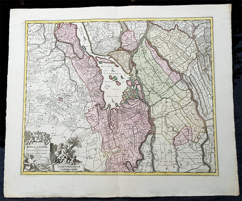
1670 Nicolas Visscher Large Antique Map of South Holland Dordrecht, Gouda, Breda
Antique Map
- Title : Hollandiae Pars Merionalior Vulgo Zuyd-Holland Auctore Nic. Visscher
- Ref #: 93481
- Size: 26 1/2in x 21in (675mm x 515mm)
- Date : 1670
- Condition: (A+) Fine Condition
Description:
This original large beautifully hand coloured copper plate engraved antique map of South Holland, from the city of Gouda in the North to Breda in the South and centering on the city of Dordrecht, was published by Nicolas Visscher in 1670.
General Definitions:
Paper thickness and quality: - Heavy and stable
Paper color : - off white
Age of map color: - Original
Colors used: - Green, yellow, brown, pink
General color appearance: - Authentic
Paper size: - 26 1/2in x 21in (675mm x 515mm)
Plate size: - 22 1/2in x 18in (565mm x 460mm)
Margins: - Min 1in (25mm)
Imperfections:
Margins: - None
Plate area: - None
Verso: - None
Background:
The first city in South Holland to receive city rights was Dordrecht, which did so in 1220. The city retained a dominant position in the area until it was struck by a series of floods in the late 14th century. The same century also saw a series of civil wars, the Hook and Cod wars, concerning the succession of count William IV. Both his daughter Jacqueline and his brother John, the latter supported by Philip the Good, Duke of Burgundy, claimed the throne. The conflict ended in 1490, with John victorious.
Overall, the area of South Holland remained largely agrarian throughout the late Middle Ages. This changed around 1500, when Holland became Europes most urbanised area. During the Eighty Years War, the area of South Holland was the scene of the Capture of Brielle, the Siege of Leiden and the assassination of William the Silent.
The United Netherlands declared their independence in 1581, and Holland quickly emerged as the countrys dominant province, with important trading cities such as Leiden, Delft, Gouda and Dordrecht. In 1575, the Netherlands first university was founded in Leiden by William the Silent. The Hague, which had originated around the castle of the counts of Holland, became its new political centre. Both the States of Holland and the States General seated in the Binnenhof. The Dutch Golden Age blossomed in the 17th century. The south of Holland, back then often referred to as the Zuiderkwartier (literally South Quarter), was the birthplace and residence of many scientists such as Antoni van Leeuwenhoek and Christiaan Huygens, philosophers such as Baruch Spinoza and Pierre Bayle, as well as painters such as Johannes Vermeer, Rembrandt van Rijn and Jan Steen.
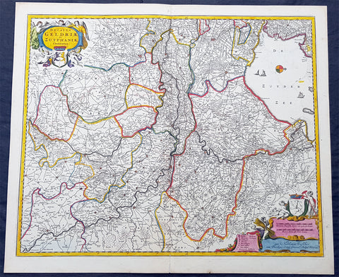
1690 N. Visscher Large Antique Map Northern Holland Guelders & Zutphen Amsterdam
Antique Map
- Title : Ducatus Geldriae et Zutphaniae Comitatus...per Nicolaum Visscher
- Ref #: 93482
- Size: 24in x 20 1/2in (610mm x 520mm)
- Date : 1690
- Condition: (A+) Fine Condition
Description:
This large rare hand coloured original antique map of the Duchy of Guelders and the County of Zutphen was published by Nicholas Visscher II in the 1690 edition of Atlas minor sive totius orbis terrarum contracta delinea ex conatibus Nico. Visscher.
A rare and decorative map of Geldern oriented to the west, covering an area from Amsterdam to the west to Vreden in the east and from Montfoort in the south to Campden in the north.
General Definitions:
Paper thickness and quality: - Heavy and stable
Paper color : - off white
Age of map color: - Original
Colors used: - Yellow, green, blue, pink
General color appearance: - Authentic
Paper size: - 24in x 20 1/2in (610mm x 520mm)
Plate size: - 22 1/2in x 18 1/2in (565mm x 470mm)
Margins: - Min 1/2in (12mm)
Imperfections:
Margins: - None
Plate area: - None
Verso: - None
Background:
Guelders or Gueldres is a historical county, later duchy of the Holy Roman Empire, located in the Low Countries.
The County of Zutphen, located in modern-day Gelderland, a province of the Netherlands, was formed in the eleventh century as a fief of the Bishop of Utrecht. It was ruled by the Counts of Zutphen between 1018 and 1182, and then formed a personal union with Guelders. Later, it became one of the 4 quarters of Guelders. The name Graafschap (county) is still used for the Achterhoek, the region east of Zutphen, and for the football club De Graafschap from this region.
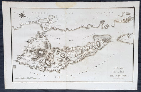
1802 J B Lechevalier & Pierre Tardieu Large Antique Map of Corfu, Greece
- Title : Plan De L Ile De Corfou
- Date : 1802
- Condition: (A+) Fine Condition
- Ref: 50669-1
- Size: 21in x 14in (535mm x 355mm)
Description:
This original copper-plate engraved antique map of the Greek Island of Corfu was engraved by Pierre Tardieu and was published in the 1802 edition of Jean-Baptiste Lechevaliers of Voyage de la Troade, fait dans les années 1785 et 1786
General Definitions:
Paper thickness and quality: - Heavy and stable
Paper color : - off white
Age of map color: -
Colors used: -
General color appearance: -
Paper size: - 21in x 14in (535mm x 355mm)
Plate size: - 20 1/2in x 13in (520mm x 335mm)
Margins: - Min 1/2in (12mm)
Imperfections:
Margins: - Light soiling
Plate area: - Light soiling
Verso: - Light soiling
Background:
Corfu or Kerkyra is a Greek island in the Ionian Sea. It is the second largest of the Ionian Islands and, including its small satellite islands, forms the north-westernmost part of Greece. The island is part of the Corfu regional unit, and is administered as a single municipality, which also includes the smaller islands of Ereikoussa, Mathraki and Othonoi. The municipality has an area of 610,9 km2, the island proper 592,8 km2. The principal city of the island and seat of the municipality (pop. 32,095) is also named Corfu. Corfu is home to the Ionian University.
The island is bound up with the history of Greece from the beginnings of Greek mythology. Its history is full of battles and conquests. Ancient Korkyra took part in the Battle of Sybota which was a catalyst for the Peloponnesian War, and, according to Thucydides, the largest naval battle between Greek city states until that time. Thucydides also reports that Korkyra was one of the three great naval powers of fifth century BC Greece, along with Athens and Corinth. Medieval castles punctuating strategic locations across the island are a legacy of struggles in the Middle Ages against invasions by pirates and the Ottomans. Two of these castles enclose its capital, which is the only city in Greece to be surrounded in such a way. As a result, Corfu\'s capital has been officially declared a Kastropolis (castle city) by the Greek government. From medieval times and into the 17th century, the island, having successfully repulsed the Ottomans during several sieges, was recognised as a bulwark of the European States against the Ottoman Empire and became one of the most fortified places in Europe. The fortifications of the island were used by the Venetians to defend against Ottoman intrusion into the Adriatic. Corfu eventually fell under British rule following the Napoleonic Wars. Corfu was eventually ceded by the British Empire along with the remaining islands of the United States of the Ionian Islands, and unification with modern Greece was concluded in 1864 under the Treaty of London.
Jean-Baptiste Lechevalier was the secretary of the Ambassador of France in Constantinople. In the year 1788 he visited the plain of Troy, and was enthusiastically in favour of the theory that the site of Homers Troy was to be found at the village of Bunarbashi. His publication about Troy Voyage de la Troade.....was first published in 1799.
The Troad, also known as Troas, is the historical name of the Biga peninsula (Biga Yarımadası, Τρωάς) in the northwestern part of Anatolia, Turkey. This region now is part of the Çanakkale province of Turkey. Bounded by the Dardanelles to the northwest, by the Aegean Sea to the west and separated from the rest of Anatolia by the massif that forms Mount Ida, the Troad is drained by two main rivers, the Scamander (Karamenderes) and the Simois, which join at the area containing the ruins of Troy. Grenikos, Kebren, Simoeis, Rhesos, Rhodios, Heptaporos and Aisepos were seven rivers of the Troad and the names of the river gods that inhabited each river.
Troy (Ancient Greek: Τροία, Troia or Τροίας, Troias, Truva or Troya) was a city in the far northwest of the region known in late Classical antiquity as Asia Minor, now known as Anatolia in modern Turkey, just south of the southwest mouth of the Dardanelles strait and northwest of Mount Ida. The present-day location is known as Hisarlik. It was the setting of the Trojan War described in the Greek Epic Cycle, in particular in the Iliad, one of the two epic poems attributed to Homer. Metrical evidence from the Iliad and the Odyssey suggests that the name λιον (Ilion) formerly began with a digamma: Ϝίλιον (Wilion); this is also supported by the Hittite name for what is thought to be the same city, Wilusa.
A new capital called Ilium (from Greek: λιον, Ilion) was founded on the site in the reign of the Roman Emperor Augustus. It flourished until the establishment of Constantinople, became a bishopric and declined gradually in the Byzantine era, but is now a Latin Catholic titular see.
In 1865, English archaeologist Frank Calvert excavated trial trenches in a field he had bought from a local farmer at Hisarlik, and in 1868, Heinrich Schliemann, a wealthy German businessman and archaeologist, also began excavating in the area after a chance meeting with Calvert in Çanakkale. These excavations revealed several cities built in succession. Schliemann was at first skeptical about the identification of Hisarlik with Troy, but was persuaded by Calvert and took over Calverts excavations on the eastern half of the Hisarlik site, which was on Calvert\'s property. Troy VII has been identified with the city called Wilusa by the Hittites (the probable origin of the Greek λιον) and is generally (but not conclusively) identified with Homeric Troy.
Today, the hill at Hisarlik has given its name to a small village near the ruins, which supports the tourist trade visiting the Troia archaeological site. It lies within the province of Çanakkale, some 30 km south-west of the provincial capital, also called Çanakkale. The nearest village is Tevfikiye. The map here shows the adapted Scamander estuary with Ilium a little way inland across the Homeric plain. Due to Troys location near the Aegean Sea, the Sea of Marmara, and the Black Sea, it was a central hub for the military and trade(Ref: M&B; Tooley)
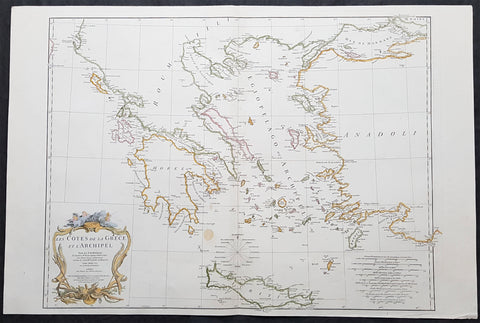
1756 J B D Anville Large Antique Map Greece, Crete, Corfu, Aegean Isles Turkey
- Title : Les Cotes De La Grece et L Archipel...MDCCLVI
- Size: 34in x 23in (865m x 585mm)
- Condition: (A) Very Good Condition
- Date : 1756
- Ref #: 21996
Description:
This large original copper-plate engraved antique map of Greece, Crete & the Greek Islands by Jean Baptiste Bourguignon D\'Anville was engraved in 1756 - dated in the tile cartouche - and was published in Jean-Baptiste Bourguinon D\'Anvilles large elephant folio atlas Atlas Generale. (Ref: Tooley, M&B)
General Definitions:
Paper thickness and quality: - Heavy and stable
Paper color : - off white
Age of map color: - Early
Colors used: - Yellow, pink, green, blue
General color appearance: - Authentic
Paper size: - 34in x 23in (865m x 585mm)
Plate size: - 29in x 22in (735mm x 560mm)
Margins: - Min 1/2in (12mm)
Imperfections:
Margins: - None
Plate area: - None
Verso: - None
Background:
While most of mainland Greece and the Aegean islands was under Ottoman control by the end of the 15th century, Cyprus and Crete remained Venetian territory and did not fall to the Ottomans until 1571 and 1670 respectively. The only part of the Greek-speaking world that escaped long-term Ottoman rule was the Ionian Islands, which remained Venetian until their capture by the First French Republic in 1797, then passed to the United Kingdom in 1809 until their unification with Greece in 1864.
While some Greeks in the Ionian Islands and Constantinople lived in prosperity, and Greeks of Constantinople (Phanariotes) achieved positions of power within the Ottoman administration, much of the population of mainland Greece suffered the economic consequences of the Ottoman conquest. Heavy taxes were enforced, and in later years the Ottoman Empire enacted a policy of creation of hereditary estates, effectively turning the rural Greek populations into serfs.
The Greek Orthodox Church and the Ecumenical Patriarchate of Constantinople were considered by the Ottoman governments as the ruling authorities of the entire Orthodox Christian population of the Ottoman Empire, whether ethnically Greek or not. Although the Ottoman state did not force non-Muslims to convert to Islam, Christians faced several types of discrimination intended to highlight their inferior status in the Ottoman Empire. Discrimination against Christians, particularly when combined with harsh treatment by local Ottoman authorities, led to conversions to Islam, if only superficially. In the 19th century, many crypto-Christians returned to their old religious allegiance.
The nature of Ottoman administration of Greece varied, though it was invariably arbitrary and often harsh. Some cities had governors appointed by the Sultan, while others (like Athens) were self-governed municipalities. Mountainous regions in the interior and many islands remained effectively autonomous from the central Ottoman state for many centuries.
When military conflicts broke out between the Ottoman Empire and other states, Greeks usually took up arms against the Ottomans, with few exceptions. Prior to the Greek Revolution of 1821, there had been a number of wars which saw Greeks fight against the Ottomans, such as the Greek participation in the Battle of Lepanto in 1571, the Epirus peasants\' revolts of 1600–1601 (led by the Orthodox bishop Dionysios Skylosophos), the Morean War of 1684–1699, and the Russian-instigated Orlov Revolt in 1770, which aimed at breaking up the Ottoman Empire in favor of Russian interests.[89][page needed] These uprisings were put down by the Ottomans with great bloodshed. On the other side, many Greeks were conscripted as Ottoman citizens to serve in the Ottoman army (and especially the Ottoman navy), while also the Ecumenical Patriarchate of Constantinople, responsible for the Orthodox, remained in general loyal to the empire.
The 16th and 17th centuries are regarded as something of a dark age in Greek history, with the prospect of overthrowing Ottoman rule appearing remote with only the Ionian islands remaining free of Turkish domination. Corfu withstood three major sieges in 1537, 1571 and 1716 all of which resulted in the repulsion of the Ottomans. However, in the 18th century, due to their mastery of shipping and commerce, a wealthy and dispersed Greek merchant class arose. These merchants came to dominate trade within the Ottoman Empire, establishing communities throughout the Mediterranean, the Balkans, and Western Europe. Though the Ottoman conquest had cut Greece off from significant European intellectual movements such as the Reformation and the Enlightenment, these ideas together with the ideals of the French Revolution and romantic nationalism began to penetrate the Greek world via the mercantile diaspora. In the late 18th century, Rigas Feraios, the first revolutionary to envision an independent Greek state, published a series of documents relating to Greek independence, including but not limited to a national anthem and the first detailed map of Greece, in Vienna, and was murdered by Ottoman agents in 1798.
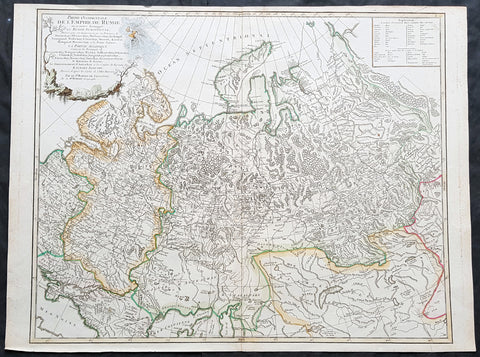
1757 Robert De Vaugondy Large Antique Map of the Russian Empire - Poland to Asia
- Title : Partie Occidentale De L Empire De Russie...Sr Robert De Vaugondy
- Size: 26in x 20in (660mm x 510mm)
- Condition: (A+) Fine Condition
- Date : 1757
- Ref #: 41592
Description:
This large magnificent hand coloured original copper-plate engraved antique map of The Russian Empire - stretching from Poland to Central Asia - by Robert De Vaugondy was published in the 1757 edition of De Vaugondys famous The Atlas Universel
General Definitions:
Paper thickness and quality: - Heavy and stable
Paper color : - off white
Age of map color: - Original & later
Colors used: - Blue, pink, red, green, yellow
General color appearance: - Authentic
Paper size: - 23 1/2in x 19 1/2in (600mm x 495mm)
Plate size: - 23in x 19 1/2in (585mm x 495mm)
Margins: - Min 1/4in (5mm)
Imperfections:
Margins: - None
Plate area: - None
Verso: - None
It is scarcely necessary to look at a map of Russia - with which we must include Siberia - to visualize the daunting task facing Russian map makers. Indeed, considering the vastness of their territory and the lack of skilled cartographers, it is surprising that relatively good maps were available for engraving and printing in most of the well known sixteenth and seventeenth century atlases. Generally, maps of that time were based on material brought back from Moscow by visitors from the West. (Ref Tooley M&B)
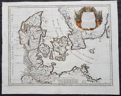
1677 De Rossi Large Original Antique Map of Denmark & Sweden, Schleswig Holstein
- Title : Regno di Danimarca Diuiso nelle Sue due Iutlandie Cioe settentrionale in quattro Diocesi Et Australe, e` il Ducato di...Gio Giacomo De Rossi....L Anno 1677
- Date : 1677
- Size: 22 1/2in x 18in (575mm x 460mm)
- Ref #: 50610
- Condition: (A) Very Good Condition
Description:
A beautiful and quite scarce original 1677 antique map of Denmark and southern Sweden, was engraved in 1677 - dated in the title - and was published in the 1692 edition of de Rossi's world atlas Mercurio Geografico
General Definitions:
Paper thickness and quality: - Heavy and stable
Paper color : - off white
Age of map color: - Early
Colors used: - Yellow, green, blue, pink
General color appearance: - Authentic
Paper size: - 22 1/2in x 18in (575mm x 460mm)
Plate size: - 20 1/2in x 16in (420mm x 405mm)
Margins: - Min 1in (25mm)
Imperfections:
Margins: - Professional repairs to top & bottom margins
Plate area: - Professional repairs to centerfold
Verso: - Repairs as noted
Background:
Before the fifteenth century the people of Southern Europe had little geographical knowledge of the Scandinavian World except from sketchy detail shown in the Catalan Atlas (1375) and on a number of " portolani" embracing Denmark and the southern tip of Norway. It was not until 1427 that a manuscript map prepared about that time by Claudius Clavus (b.1388) a Dane who spent some time in Rome, made available to scholars a tolerable outline of the northern countries and Greenland. That was to remain the best map available for the rest of the century and it was used as the basis for maps of Scandinavia in early printed editions of Ptolemy. Others by Nicolaus Cusanus (1491) and Ehrhard Etzlaub (c. 1492) followed but, needless to say, these are extremely rare; even the later maps by Olaus Magnus and Marcus Jordan, where they have survived at all , are known only by a very few examples. In fact, apart from the rare appearance of an early Ptolemy map, the oldest of Scandinavia which a collector is likely to find are those of Munster's Cosmograhy first published in 1544. In the following centuries the few maps and charts complied in Scandinavia were usually published in Amsterdam, Antwerp, Paris or Nuremberg, the most important maps often being incorporated in the major Dutch, French & German Atlases. (Ref: Tooley; M&B)
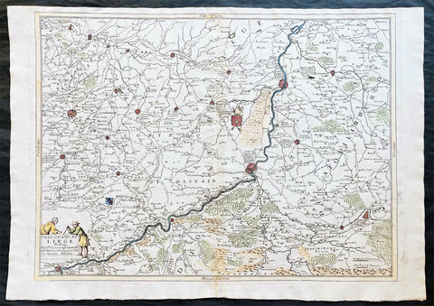
1691 Coronelli Large Antique Map of The Liege Region of Belgium - Maastricht
- Title : Vescovato di Leige
- Ref #: 16271
- Size: 27in x 19 1/2in (685mm x 495mm)
- Date : 1691
- Condition: (A+) Fine Condition
Description
This large, fine, scarce & beautifully hand coloured original antique map of the Liege Region of Belgium - centering on the Meusa River and the cities of Liege, Maastricht, Namur & Tienen - was published by Vincenzo Maria Coronelli (1650-1718) in 1691.
Coronelli was one of the finest engravers & cartographers of any era, producing some of the most stunning work ever seen. This is evident in this beautiful map. He was a master craftsman with an eye for detail. You can feel the uncompromising accuracy & passion in his work when you study his maps & globes. (Ref: Shirley; Tooley; M&B)
General Description:
Paper thickness and quality: - Heavy and stable
Paper color: - white
Age of map color: - Early
Colors used: - Green, yellow, pink, blue
General color appearance: - Authentic
Paper size: - 27in x 19 1/2in (685mm x 495mm)
Plate size: - 24 1/2in x 19in (620mm x 485mm)
Margins: - min. 1/2in (10mm)
Imperfections:
Margins: - None
Plate area: - Light age toning along centerfold
Verso: - 3 small repairs along centerfold

1802 J B Lechevalier & Pierre Tardieu Large Antique Map of Corfu, Greece
- Title : Plan De L Ile De Corfou
- Date : 1802
- Condition: (A+) Fine Condition
- Ref: 70208
- Size: 21in x 14in (535mm x 355mm)
Description:
This original copper-plate engraved antique map of the Greek Island of Corfu was engraved by Pierre Tardieu and was published in the 1802 edition of Jean-Baptiste Lechevaliers of Voyage de la Troade, fait dans les années 1785 et 1786
General Definitions:
Paper thickness and quality: - Heavy and stable
Paper color : - off white
Age of map color: -
Colors used: -
General color appearance: -
Paper size: - 21in x 14in (535mm x 355mm)
Plate size: - 20 1/2in x 13in (520mm x 335mm)
Margins: - Min 1/2in (12mm)
Imperfections:
Margins: - Light soiling
Plate area: - Light soiling
Verso: - Light soiling
Background:
Corfu or Kerkyra is a Greek island in the Ionian Sea. It is the second largest of the Ionian Islands and, including its small satellite islands, forms the north-westernmost part of Greece. The island is part of the Corfu regional unit, and is administered as a single municipality, which also includes the smaller islands of Ereikoussa, Mathraki and Othonoi. The municipality has an area of 610,9 km2, the island proper 592,8 km2. The principal city of the island and seat of the municipality (pop. 32,095) is also named Corfu. Corfu is home to the Ionian University.
The island is bound up with the history of Greece from the beginnings of Greek mythology. Its history is full of battles and conquests. Ancient Korkyra took part in the Battle of Sybota which was a catalyst for the Peloponnesian War, and, according to Thucydides, the largest naval battle between Greek city states until that time. Thucydides also reports that Korkyra was one of the three great naval powers of fifth century BC Greece, along with Athens and Corinth. Medieval castles punctuating strategic locations across the island are a legacy of struggles in the Middle Ages against invasions by pirates and the Ottomans. Two of these castles enclose its capital, which is the only city in Greece to be surrounded in such a way. As a result, Corfu\'s capital has been officially declared a Kastropolis (castle city) by the Greek government. From medieval times and into the 17th century, the island, having successfully repulsed the Ottomans during several sieges, was recognised as a bulwark of the European States against the Ottoman Empire and became one of the most fortified places in Europe. The fortifications of the island were used by the Venetians to defend against Ottoman intrusion into the Adriatic. Corfu eventually fell under British rule following the Napoleonic Wars. Corfu was eventually ceded by the British Empire along with the remaining islands of the United States of the Ionian Islands, and unification with modern Greece was concluded in 1864 under the Treaty of London.
Jean-Baptiste Lechevalier was the secretary of the Ambassador of France in Constantinople. In the year 1788 he visited the plain of Troy, and was enthusiastically in favour of the theory that the site of Homers Troy was to be found at the village of Bunarbashi. His publication about Troy Voyage de la Troade.....was first published in 1799.
The Troad, also known as Troas, is the historical name of the Biga peninsula (Biga Yarımadası, Τρωάς) in the northwestern part of Anatolia, Turkey. This region now is part of the Çanakkale province of Turkey. Bounded by the Dardanelles to the northwest, by the Aegean Sea to the west and separated from the rest of Anatolia by the massif that forms Mount Ida, the Troad is drained by two main rivers, the Scamander (Karamenderes) and the Simois, which join at the area containing the ruins of Troy. Grenikos, Kebren, Simoeis, Rhesos, Rhodios, Heptaporos and Aisepos were seven rivers of the Troad and the names of the river gods that inhabited each river.
Troy (Ancient Greek: Τροία, Troia or Τροίας, Troias, Truva or Troya) was a city in the far northwest of the region known in late Classical antiquity as Asia Minor, now known as Anatolia in modern Turkey, just south of the southwest mouth of the Dardanelles strait and northwest of Mount Ida. The present-day location is known as Hisarlik. It was the setting of the Trojan War described in the Greek Epic Cycle, in particular in the Iliad, one of the two epic poems attributed to Homer. Metrical evidence from the Iliad and the Odyssey suggests that the name λιον (Ilion) formerly began with a digamma: Ϝίλιον (Wilion); this is also supported by the Hittite name for what is thought to be the same city, Wilusa.
A new capital called Ilium (from Greek: λιον, Ilion) was founded on the site in the reign of the Roman Emperor Augustus. It flourished until the establishment of Constantinople, became a bishopric and declined gradually in the Byzantine era, but is now a Latin Catholic titular see.
In 1865, English archaeologist Frank Calvert excavated trial trenches in a field he had bought from a local farmer at Hisarlik, and in 1868, Heinrich Schliemann, a wealthy German businessman and archaeologist, also began excavating in the area after a chance meeting with Calvert in Çanakkale. These excavations revealed several cities built in succession. Schliemann was at first skeptical about the identification of Hisarlik with Troy, but was persuaded by Calvert and took over Calverts excavations on the eastern half of the Hisarlik site, which was on Calvert\'s property. Troy VII has been identified with the city called Wilusa by the Hittites (the probable origin of the Greek λιον) and is generally (but not conclusively) identified with Homeric Troy.
Today, the hill at Hisarlik has given its name to a small village near the ruins, which supports the tourist trade visiting the Troia archaeological site. It lies within the province of Çanakkale, some 30 km south-west of the provincial capital, also called Çanakkale. The nearest village is Tevfikiye. The map here shows the adapted Scamander estuary with Ilium a little way inland across the Homeric plain. Due to Troys location near the Aegean Sea, the Sea of Marmara, and the Black Sea, it was a central hub for the military and trade(Ref: M&B; Tooley)
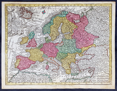
1744 Georg Mattaus Seutter Antique Map of Europe
Antique Map
- Title : Europa a Matth. Seutteri...T C Lotter, Geogr.
- Ref #: 93388
- Size: 11in x 8 1/2in (280mm x 215mm)
- Date : 1744
- Condition: (A+) Fine Condition
Description:
These beautifully hand coloured original copper-plate engraved antique map was engraved by Tobias Lotter and published in the 1744 edition of GM Seutters Atlas Minor Prae cipua Orbis Terrarum Imperia Regna et Provincias...., Augsburg, Germany.
General Definitions:
Paper thickness and quality: - Heavy and stable
Paper color : - off white
Age of map color: - Early
Colors used: - Yellow, green, blue, pink
General color appearance: - Authentic
Paper size: - 11in x 8 1/2in (280mm x 215mm)
Plate size: - 10 1/2in x 8in (265mm x 205mm)
Margins: - Min 1/4in (5mm)
Imperfections:
Margins: - None
Plate area: - None
Verso: - None
Background:
Atlas Minor was a series of beautiful maps of all parts of the world. Georg Matthäus Seutter was one of the most and important of the German cartographers of the 18th century, being appointed as the Geographer to the Imperial Court. His son, Albrecht Carl, joined Matthäus and eventually inherited the business. The maps from Atlas Minor were drawn by the two Seutters and engraved by Tobias Conrad Lotte. These maps are highly detailed and engraved with a bold hand with equally strong original hand color in the body of the map as was the 18th century German style. The cartouches were left uncolored in order to emphasize the elaborately detailed illustrations for which German maps are especially prized. These are some of the most decorative and interesting maps of the eighteenth century.
1782 G F Frentzel Large Rare Antique Map of Lubsza Forest Brzeg, Opole SW Poland
Antique Map
- Title : Plan Von Dem zum Koniglichen Briegischen Forfst Amt gehorigen Leubuscher Forst RevierSo Auf hoher Ordre Sr Excellence und Einer Konig Prussia Hochlob Breslauischen Krieges und Domainen Cammer special vermessen und in diese Proportion gebracht worden In denen Jahren 1782 et 1783
- Ref #: 93489
- Size: 21in x 16in (530mm x 415mm)
- Date : 1782-83
- Condition: (A+) Fine Condition
Description:
This incredibly rare detailed original hand coloured copper plate engraved antique map, a survey of the forest near Lubsza in the county of Brzeg in the Opole Province in SW Poland between 1782 & 1783 was engraved by the Leipzig engraver Georg Friedrich Jonas Frentzel.
General Definitions:
Paper thickness and quality: - Heavy and stable
Paper color : - off white
Age of map color: - Original
Colors used: - Green, yellow, brown, pink
General color appearance: - Authentic
Paper size: - 21in x 16in (530mm x 415mm)
Plate size: - 21in x 16in (530mm x 415mm)
Margins: - Min 1/8in (2mm)
Imperfections:
Margins: - Left margin cropped close to border
Plate area: - None
Verso: - None
Background:
Lubsza is a village in Brzeg, Opole Voivodeship, in south-western Poland. It is the seat of the gmina (administrative district) called Gmina Lubsza. It lies approximately 7 kilometres north-east of Brzeg and 41 km north-west of the regional capital Opole. Before 1945 the area was part of Germany
Frentzel, Georg Friedrich Jonas 1754 - 1799
Frentzel was a master-engraver from Leipzig in Germany, specialising in copper engraving. His work was known for its critical level of detail, cumulating in one of the finest revolutionary maps of Boston in 1776 Carte von dem Hafen und der Stadt Boston
1744 Georg Mattaus Seutter Antique Map of The Russian Empire, China, Japan
- Title : Imperium Russiae Magnae........a Matth. Seutteri...T C Lotter, Geogr.
- Ref #: 93401
- Size: 11in x 8 1/2in (280mm x 215mm)
- Date : 1744
- Condition: (A+) Fine Condition
Description:
This beautifully hand coloured original copper-plate engraved antique map of The Russian Empire was engraved by Tobias Lotter and was published in the 1744 edition of GM Seutters Atlas Minor Prae cipua Orbis Terrarum Imperia Regna et Provincias...., Augsburg, Germany.
General Definitions:
Paper thickness and quality: - Heavy and stable
Paper color : - off white
Age of map color: - Original
Colors used: - Yellow, green, blue, pink
General color appearance: - Authentic
Paper size: - 11in x 8 1/2in (280mm x 215mm)
Plate size: - 10 1/2in x 8in (265mm x 205mm)
Margins: - Min 1/4in (5mm)
Imperfections:
Margins: - None
Plate area: - None
Verso: - None
Background:
Atlas Minor was a series of beautiful maps of all parts of the world. Georg Matthäus Seutter was one of the most and important of the German cartographers of the 18th century, being appointed as the Geographer to the Imperial Court. His son, Albrecht Carl, joined Matthäus and eventually inherited the business. The maps from Atlas Minor were drawn by the two Seutters and engraved by Tobias Conrad Lotte. These maps are highly detailed and engraved with a bold hand with equally strong original hand color in the body of the map as was the 18th century German style. The cartouches were left uncolored in order to emphasize the elaborately detailed illustrations for which German maps are especially prized. These are some of the most decorative and interesting maps of the eighteenth century.
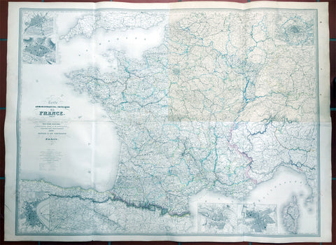
1857 Dufour Very Large Scarce Old, Antique Map of France - 4ft x 6ft
- Title : Carte Administrative et Physique de la France indiquant Les Canaan Les Riviers Navigable les routes, le Chemis de fer avec leurs stations Dresee par A.H. Dufour Gravee Par CH Dyonnet 1857
- Ref #: 61029
- Size: 62in x 46in (1.5m x 1.15m)
- Date : 1857
- Condition: (A) Very Good Condition
Description:
This scarce very large elephant folio 4 sheet - joined - hand coloured original map of France was engraved by Charles Dyonnet in 1857 - dated in the title - for Adolphe Hippolyte Dufour's monumental elephant folio Atlas Physique, Historique et Politique Geographie Moderne published by Pauline Et La Chevalier, Paris.
This uncommon elephant folio map is huge measuring overall 62in x 46in (1.5m x 1.15m) and is incredibly detailed. The map covers the whole of France including Corsica and parts of Spain, Germany and Switzerland.
The first sheet (top left in image) represents north-western France and includes two insets of Nantes and Rouen. The second sheet (top right) represents north-eastern France with an inset of Paris and its environs. The bottom right sheet depicts the south-eastern portions of France and includes two insets, one featuring Marseille and the other featuring Lyon. The last sheet on the bottom left is of southwest France.
An inset on Bordeaux is included and throughout illustrates roads, canals, railways, rivers, cities and other topographical features are noted.
Adolphe Hippolyte Dufour (1795 - 1865), also known as Auguste-Henri Dufour, was a Paris based map and atlas publisher active in the middle to late 19th century. Dufour claimed to be a student of another French cartographer, Emile Lapie. He is known to have worked with numerous other cartographers, publishers and engravers of the period including Charles Dyonnet and Duvotenay. His corpus includes numerous maps and atlases, the most striking of which is probably his monumental elephant folio Atlas Universel physique, historique et politique geographie ancienne et moderne. Dufour's student and successor was Alexandre Vuillemin.
Charles Dyonnet (fl. c. 1822 - c. 1880) was an extremely active Paris based engraver working in the mid to late 19th century. From his offices at 220 Rue St. Jacques, Paris, Dyonnet engraved numerous maps for many of the most prominent 19th French cartographic publishers including Vuillemin, Dufour, Fremin and Duvotenay. From 1850-1861, he held the coveted position of "Graveur du Dépot de la Marine," and in this position engraved numerous French naval and military maps. Dyonnet had a detail oriented and aesthetically minded hand and is responsible from some of the most beautiful French maps to emerge during the 19th century. (Ref: M&B; Tooley)
General Description:
Paper thickness and quality: - Heavy & stable
Paper color: - White
Age of map color: - Original
Colors used: - Yellow, red, green, blue
General color appearance: - Authentic
Paper size: - 62in x 46in (1.5m x 1.15m)
Paper size: - 62in x 46in (1.5m x 1.15m)
Margins: - Min 1in (24mm)
Imperfections:
Margins: - None
Plate area: - Top NE sheet age toning
Verso: - Soiling
1780 Large Delisle Antique Map of Nothern Greece, Macedonia, Thracia, Turkey
- Title : Graeciae Pars Septentrionalis Par Guill. Delisle.....1780
- Ref #: 20404
- Size: 30in x 22in (765mm x 560mm)
- Date : 1780
- Condition: (A) Very Good Condition
Description:
This large beautifully engraved hand coloured original antique map of Northern Greece, Macedonia, Thracia by Guillaume Delisle was engraved by Philip Bauche and published in 1780 - the date is engraved in the scale cartouche (Ref: M&B; Tooley)
Condition Report
Paper thickness and quality: - Very heavy and stable
Paper color: - Off white
Age of map color: - Original
Colors used: - Yellow, green, pink
General color appearance: - Authentic
Paper size: - 30in x 22in (765mm x 560mm)
Plate size: - 26in x 18 1/2in (660mm x 470mm)
Margins: - min. 1in (25mm)
Imperfections:
Margins: - Light browning to bottom left & right margin corners. Three reapirs to margins, no loss
Plate area: - None
Verso: - None

1841 Ferdinando Artaria Early Antique Map of The Lost City of Pompeii, Italy
Antique Map
- Title : Plan de Pompei. Pianta della Città di Pompei Cheserve di corredo alla nuovissima Guida d'Italia.
- Ref #: 61202
- Condition: (A+) Fine Condition
- Size: 20 1/2in x 12 1/2in (510mm x 320mm)
- Date: 1841
Description
This original copper-plate antique map of the lost city of Pompeii by Ferdinando Artaria in 1841.
The map depicts the famously devastated city from the Villa of Diomede to the amphitheater. Colors differentiate between public buildings, private buildings, buildings in ruins, and areas that had not yet been excavated. Numbers identify over 110 locations throughout the city, including The Forum, Basilica, Amphitheater, and Giulio Felice house which are identified by name.
General Definitions:
Paper thickness and quality: - Heavy and stable
Paper color : - off white
Age of map color: - Original
Colors used: - Green, yellow, pink
General color appearance: - Authentic
Paper size: - 20 1/2in x 12 1/2in (510mm x 320mm)
Plate size: - 20 1/2in x 12 1/2in (510mm x 320mm)
Margins: - Min 1/2in (12mm)
Imperfections:
Margins: - Folds as issued
Plate area: - Folds as issued
Verso: - Folds as issued
Ferdinando Artaria (1781 - June 25, 1843) was an Italian publisher and seller of maps, music, and prints. Artaria opened his first shop around 1805. He soon began collaborating with Giuseppe Werz (1764 - 1827), who introduced lithographic techniques from Bavaria to Italy in 1808. Artaria opened his own lithography works in 1817 and the name changed to Ferdinando Artaria e Figlio in 1837. This business was the first to publish aquatints made from daguerrotypes. After Artaria died, his son Pasquale ran the business. He sold it to his brother-in-law Francesco Scacchi (1807 - 1900) in 1852, who changed the name of the firm to Ditta Artaria di Gerdinando Sacchi e figli' in 1872. After Scacchi's death, his sons Edoardo and Alberto ran the business until 1921, when it was acquired by the 'BOttega di Poesia' publishing house.
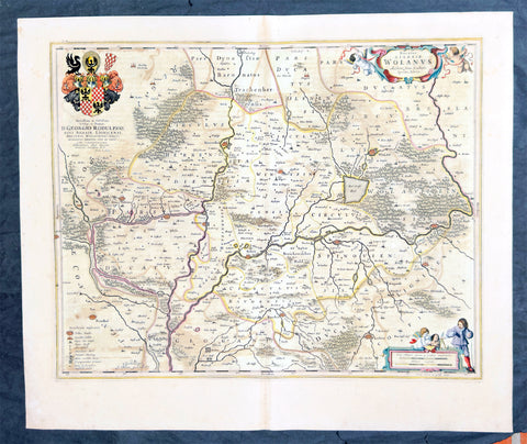
1662 Joan Blaeu Antique Map of Wołow County, Lower Silesia Voivodeship SW Poland
Antique Map
- Title : Ducatus Silesiae Wolanus Authore Jona Sculteto Sprotta Silesio
- Ref #: 93430
- Size: 24in x 20in (610mm x 510mm)
- Date : 1662
- Condition: (A) Very Good Condition
Description:
This beautifully hand coloured original copper-plate engraved antique, rare map of Wolow County, located at the time of publication in the Duchy of Głogow, in Lower Silesia, today SW Poland, was published in Joan Blaeu greatest publication, the first 1662 French edition of Atlas Major,.
As this map was only published over a 10 year period, as most of the plates were destroyed in the disasterous 1672 fire that wiped out the Blaeu publishing house, this map is extremely rare especially with original hand colour, such as this map.
General Definitions:
Paper thickness and quality: - Heavy and stable
Paper color : - off white
Age of map color: - Original
Colors used: - Yellow, green, blue, pink
General color appearance: - Authentic
Paper size: - 24in x 20in (610mm x 510mm)
Plate size: - 21in x 16 1/2in (535mm x 420mm)
Margins: - Min 1in (25mm)
Imperfections:
Margins: - Light soiling
Plate area: - Offsetting
Verso: - Offsetting
Background:
Wolow is a town in Lower Silesian Voivodeship in south-western Poland. It is the seat of Wołów County and Gmina Wołów. It lies approximately 38 kilometres north-west of the regional capital Wrocław.
The area around Wołów has been settled since prehistoric times. It became part of the emerging Polish state in the late 10th century under Mieszko I of Poland. The town was first mentioned in 1157 when a wooden castle founded by Senior Duke of Poland Władysław II the Exile is documented, which developed into a castle complex, which was again mentioned in 1202. Two villages developed near the castle, one of them called Wołowo. Probably in the second half of the 13th century the town was founded near Wołowo and partially on the soil of the second village. Wołów received Magdeburg town rights about 1285 at the time of German Ostsiedlung in the region; a Vogt is mentioned in 1288.
At that time Wołów belonged to the Duchy of Głogów, after 1312 to the Duchy of Oleśnica. With the duchy it came under the suzerainty of Bohemia in 1328. From 1473 dates the oldest known seal of the town, which already shows an ox, as do all later seals. Wołów was ruled by local Polish dukes until 1492, and soon after, in 1495, it came into the possession of the Czech Podiebrad family, then in 1517 it came into the hands the Hungarian magnate Johann Thurzó, before returning to Piast rule in 1523, by passing to the Duchy of Legnica. It remained there until the Piast dukes of Legnica-Brzeg-Wołów died out in 1675. As a result of the Thirty Years War, the towns population fell by half.
The Protestant Reformation was introduced to the town in 1522 by duke Frederick II. After the extinction of the local Piasts the duchy passed to the House of Habsburg, which opposed the Protestant denomination in the town, as part of the Counter-Reformation. In 1682 the towns parish church was closed and given to the Catholics. According to the Treaty of Altranstädt the church however was already returned to the Protestants in 1707 and stayed Protestant until 1945. The small Catholic minority in return received a Josephinian curacy.
In 1742 Wołów was annexed by Prussia. The duchy was divided into two districts and the town became county seat of one of the districts. The structure of the town was, until 1700, defined by craft, especially clothiers. As the seat of a duchy and a district administrative function however became more and more important. The industrialization played only a minor role and mostly affected smaller companies of the timber industry. In 1781 the city suffered a fire.
The town was part of Germany from 1871 to 1945. In January 1945 – just before town was taken by the Red Army – the Wehrmacht evacuated the German population westwards.
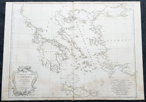
1756 D Anville Large Antique Map of Greece & The Aegean Islands & Crete
- Title : Les Cotes de la Grece et L Archipel par le D Anville...MDCCLVI (1756)
- Size: 31in x 24in (790mm x 610mm)
- Condition: (A) Very Good Condition
- Date : 1756
- Ref #: 92313
Description:
This large hand coloured original copper-plate engraved antique map of the Aegean Islands of Greece, south to Crete by Jean Baptiste Bourguignon D Anville was engraved in 1756 - dated in the tile cartouche - and was published in Jean-Baptiste Bourguinon D Anvilles large elephant folio atlas Atlas Generale. (Ref: Tooley, M&B)
General Definitions:
Paper thickness and quality: - Heavy and stable
Paper color : - off white
Age of map color: -
Colors used: -
General color appearance: -
Paper size: - 31in x 24in (790mm x 610mm)
Plate size: - 29in x 24in (770mm x 610mm)
Margins: - Min 1/2in (12mm)
Imperfections:
Margins: - Soiling in margins
Plate area: - Soiling bottom of image
Verso: - Soiling
Background:
The Aegean Islands are the group of islands in the Aegean Sea, with mainland Greece to the west and north and Turkey to the east; the island of Crete delimits the sea to the south, those of Rhodes, Karpathos and Kasos to the southeast. The ancient Greek name of the Aegean Sea, Archipelago (ἀρχιπέλαγος, archipelagos) was later applied to the islands it contains and is now used more generally, to refer to any island group.
The vast majority of the Aegean Islands belong to Greece, being split among nine administrative regions. The only sizable possessions of Turkey in the Aegean Sea are Imbros (Gökçeada) and Tenedos (Bozcaada), in the northeastern part of the Sea. Various smaller islets off Turkeys western coast are also under Turkish sovereignty.
1619 Jan Jansson Antique Map Loire & Rhone Rivers, Auvergne-Rhône-Alpes, France
- Title : Lionnois, Forest et Beaviolois
- Ref #: 50247
- Size: 24in x 20in (610mm x 510mm)
- Date : 1619
- Condition: (A+) Fine Condition
Description:
This beautifully hand coloured original copper-plate engraved antique map of The Auvergne-Rhône-Alpes region of France - centering on the Loire & Rhone Rivers and the cities of Lyon, Vienne & Macon - by Jan Jansson - was published in the 1619 edition of Mercators Atlas by Jan Jansson and Henricus Hondius.
General Definitions:
Paper thickness and quality: - Heavy and stable
Paper color : - off white
Age of map color: - Original
Colors used: - Yellow, green, blue, pink
General color appearance: - Authentic
Paper size: - 24in x 20in (610mm x 500mm)
Plate size: - 20in x 15in (535mm x 380mm)
Margins: - Min 1in (25mm)
Imperfections:
Margins: - None
Plate area: - None
Verso: - None
Background:
Lyon is the third-largest city and second-largest urban area of France. It is located in the country\'s east-central part at the confluence of the rivers Rhône and Saône.
Fernand Braudel remarked, Historians of Lyon are not sufficiently aware of the bi-polarity between Paris and Lyon, which is a constant structure in French development...from the late Middle Ages to the Industrial Revolution. In the late 15th century, the fairs introduced by Italian merchants made Lyon the economic counting house of France. Even the Bourse (treasury), built in 1749, resembled a public bazaar where accounts were settled in the open air. When international banking moved to Genoa, then Amsterdam, Lyon remained the banking centre of France.
During the Renaissance, the cities development was driven by the silk trade, which strengthened its ties to Italy. Italian influence on Lyons architecture is still visible among historic buildings. In the later 1400s and 1500s Lyon was also a key centre of literary activity and book publishing, both of French writers (such as Maurice Scève, Antoine Heroet, and Louise Labé) and of Italians in exile (such as Luigi Alamanni and Gian Giorgio Trissino).
In 1572, Lyon was a scene of mass violence by Catholics against Protestant Huguenots in the St. Bartholomew\'s Day Massacre. Two centuries later, Lyon was again convulsed by violence when, during the French Revolution, the citizenry rose up against the National Convention and supported the Girondins. The city was besieged by Revolutionary armies for over two months before surrendering in October 1793. Many buildings were destroyed, especially around the Place Bellecour, while Jean-Marie Collot d\'Herbois and Joseph Fouché administered the execution of more than 2,000 people. The Convention ordered that its name be changed to Liberated City and a plaque was erected that proclaimed Lyons made war on Liberty; Lyons no longer exists. A decade later, Napoleon ordered the reconstruction of all the buildings demolished during this period.
The Convention was not the only target within Lyon during the 1789-1799 French Revolution. After the National Convention faded into history, the French Directory appeared and days after the September 4, 1797, Coup of 18 Fructidor, a Directory\'s commissioner was assassinated in Lyon.
The city became an important industrial town during the 19th century. In 1831 and 1834, the canuts (silk workers) of Lyon staged two major uprisings for better working conditions and pay. In 1862, the first of Lyon\'s extensive network of funicular railways began operation.
1650 Joan Blaeu Antique Map of Archbishopric of Madenburg Saxony-Anhalt, Germany
- Title : Magdeburgensis Archiepiscopatus
- Ref #: 40335
- Size: 24in x 21in (610mm x 535mm)
- Date : 1650
- Condition: (A+) Fine Condition
Description:
This beautifully hand coloured original copper-plate engraved antique map of the Archbishopric of Madenburg today located in the state of Saxony-Anhalt, Germany, on the Elbe River, was published in the 1650 Dutch edition of Joan Blaeus Atlas Novus.
General Definitions:
Paper thickness and quality: - Heavy and stable
Paper color : - off white
Age of map color: - Original
Colors used: - Blue, pink, red, green, yellow
General color appearance: - Authentic
Paper size: - 24in x 21in (610mm x 535mm)
Plate size: - 21in x 16 1/2in (535mm x 420mm)
Margins: - Min 1in (25mm)
Imperfections:
Margins: - Light age toning
Plate area: - None
Verso: - None
Background:
The Archbishopric of Magdeburg was a Roman Catholic archdiocese (969–1552) and Prince-Archbishopric (1180–1680) of the Holy Roman Empire centered on the city of Magdeburg on the Elbe River.
Planned since 955 and established in 968, the Roman Catholic archdiocese had de facto turned void since 1557, when the last papally confirmed prince-archbishop, the Lutheran Sigismund of Brandenburg came of age and ascended to the see and the Magdeburg cathedral chapter had adopted Lutheranism in 1567, with most parishioners having preceded in their conversion. All his successors were only administrators of the prince-archbishopric and Lutheran too, except of the Catholic layman Leopold William of Austria (1631–1635). In ecclesiastical respect the remaining Catholics and their parishes and abbeys in the former archdiocese were put under supervision of the Archdiocese of Cologne in 1648 and under the jurisdiction of the Apostolic Vicariate of the Northern Missions in 1670.
In political respect the Erzstift, the archiepiscopal and capitular temporalities, had gained imperial immediacy as prince-archbishopric in 1180. Its territory comprised only some parts of the archdiocesan area, such as the city of Magdeburg, the bulk of the Magdeburg Börde, and the Jerichow Land as an integral whole and exclaves comprising about the Saalkreis including Halle upon Saale, Oebisfelde and environs as well as Jüterbog and environs. The prince-archbishopric maintained its statehood as an elective monarchy until 1680. Then Brandenburg-Prussia acquired Magdeburg prince-archbishopric, and after being secularised, transformed it into the Duchy of Magdeburg, a hereditary monarchy in personal union with Brandenburg.
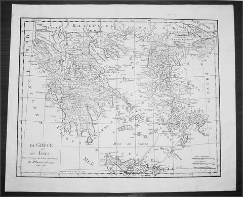
1788 Du Bocage Large Antique Map of Greece, Aegean, Western Turkey & Crete
- Title : La Grece et Ses Isles Pour le Voyage du Jeune Aanacharis Par M Barbier Du Bocage Aout 1788
- Date : 1788
- Condition: (A+) Fine Condition
- Ref: 16471
- Size: 19 1/4in x 16in (490mm x 410mm)
Description:
This fine large original antique map of Greece, The Aegean Islands and the West Coast of Turkey & Crete illustrating the Voyages of the Anacharsis the Younger was engraved in 1788 - dated - and was published by Jean Denis Barbie du Bocage in his Voyage Anacharsis (The Travels of Anacharsis the Younger in Greece) published between 1781 - 1788.
Voyage Anacharsis is an illustrative account of the travels of Anacharsis the Younger in Greece, during the middle of the fourth century before the Christian era.
Jean Denis Barbie du Bocage: (1760-1825) was a French geographer and cosmographer who studied under D' Anville and became one of the founders of the Geography Society of Paris. (Ref: Tooley; M&B)
General Description:
Paper thickness and quality: - Heavy & stable
Paper color: - White
Age of map color: -
Colors used: - General color appearance: -
Paper size: - 19 1/4in x 16in (490mm x 410mm)
Plate size: - 18 1/2in x 14 1/2in (470mm x 370mm)
Margins: - Min 1in (25mm)
Imperfections:
Margins: - None
Plate area: - Folds as issued
Verso: - None
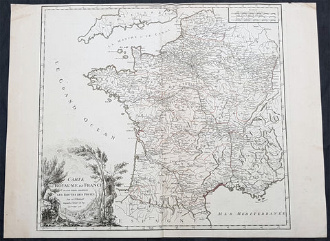
1758 Robert De Vaugondy Large Antique Map of France and Postal Roads
- Title : Carte Du Royame de France ou sont tracees exactement Les Routes Des Postes...1758
- Size: 25 1/2in x 19 1/2in (650mm x 495mm)
- Condition: (A) Very Good Condition
- Date : 1758
- Ref #: 15819
Description:
This large original hand coloured, antique map of France and the postal roads of the day was engraved in 1758 - the date is engraved in the title cartouche - and published by Robert Du Vaugondy in his Atlas Universal, Paris 1757.
General Definitions:
Paper thickness and quality: - Heavy and stable
Paper color : - off white
Age of map color: - Original
Colors used: - Yellow, green, pink
General color appearance: - Authentic
Paper size: - 25 1/2in x 19 1/2in (650mm x 495mm)
Plate size: - 21in x 19 1/2in (535mm x 495mm)
Margins: - Min 1/4in (5mm)
Imperfections:
Margins: - Light age toning
Plate area: - None
Verso: - None
Background:
The Carolingian dynasty ruled France until 987, when Hugh Capet, Duke of France and Count of Paris, was crowned King of the Franks. His descendants—the Capetians, the House of Valois, and the House of Bourbon—progressively unified the country through wars and dynastic inheritance into the Kingdom of France, which was fully declared in 1190 by Philip II Augustus. The French nobility played a prominent role in most Crusades in order to restore Christian access to the Holy Land. French knights made up the bulk of the steady flow of reinforcements throughout the two-hundred-year span of the Crusades, in such a fashion that the Arabs uniformly referred to the crusaders as Franj caring little whether they really came from France. The French Crusaders also imported the French language into the Levant, making French the base of the lingua franca (litt. Frankish language) of the Crusader states. French knights also made up the majority in both the Hospital and the Temple orders. The latter, in particular, held numerous properties throughout France and by the 13th century were the principal bankers for the French crown, until Philip IV annihilated the order in 1307. The Albigensian Crusade was launched in 1209 to eliminate the heretical Cathars in the southwestern area of modern-day France. In the end, the Cathars were exterminated and the autonomous County of Toulouse was annexed into the crown lands of France. Later kings expanded their domain to cover over half of modern continental France, including most of the north, centre and west of France. Meanwhile, the royal authority became more and more assertive, centred on a hierarchically conceived society distinguishing nobility, clergy, and commoners.
From the 11th century, the House of Plantagenet, the rulers of the County of Anjou, succeeded in establishing its dominion over the surrounding provinces of Maine and Touraine, then progressively built an empire that spanned from England to the Pyrenees and covering half of modern France. Tensions between the kingdom of France and the Plantagenet empire would last a hundred years, until Philip Augustus of France conquered between 1202 and 1214 most of the continental possessions of the empire, leaving England and Aquitaine to the Plantagenets. Following the Battle of Bouvines, the Angevin court retreated to England, but persistent Capetian–Plantagenet rivalry would paved the way for another conflict.
Charles IV the Fair died without an heir in 1328. Under the rules of the Salic law the crown of France could not pass to a woman nor could the line of kingship pass through the female line. Accordingly, the crown passed to Philip of Valois, a cousin of Charles, rather than through the female line to Charles nephew, Edward of Plantagenet, who would soon become Edward III of England. During the reign of Philip of Valois, the French monarchy reached the height of its medieval power. Philips seat on the throne was contested by Edward III of England and in 1337, on the eve of the first wave of the Black Death, England and France went to war in what would become known as the Hundred Years War. The exact boundaries changed greatly with time, but French landholdings of the English Kings remained extensive for decades. With charismatic leaders, such as Joan of Arc and La Hire, strong French counterattacks won back English continental territories. Like the rest of Europe, France was struck by the Black Death; half of the 17 million population of France died.
The French Renaissance saw a spectacular cultural development and the first standardisation of the French language, which would become the official language of France and the language of Europes aristocracy. It also saw a long set of wars, known as the Italian Wars, between France and the House of Habsburg. French explorers, such as Jacques Cartier or Samuel de Champlain, claimed lands in the Americas for France, paving the way for the expansion of the First French colonial empire. The rise of Protestantism in Europe led France to a civil war known as the French Wars of Religion, where, in the most notorious incident, thousands of Huguenots were murdered in the St. Bartholomews Day massacre of 1572. The Wars of Religion were ended by Henry IVs Edict of Nantes, which granted some freedom of religion to the Huguenots. Spanish troops, the terror of Western Europe, assisted the Catholic side during the Wars of Religion in 1589–1594, and invaded northern France in 1597; after some skirmishing in the 1620s and 1630s, Spain and France returned to all-out war between 1635 and 1659. The war cost France 300,000 casualties.
Under Louis XIII, the energetic Cardinal Richelieu promoted the centralisation of the state and reinforced the royal power by disarming domestic power holders in the 1620s. He systematically destroyed castles of defiant lords and denounced the use of private violence (dueling, carrying weapons, and maintaining private army). By the end of 1620s, Richelieu established the royal monopoly of force as the doctrine. During Louis XIVs minority and the regency of Queen Anne and Cardinal Mazarin, a period of trouble known as the Fronde occurred in France. This rebellion was driven by the great feudal lords and sovereign courts as a reaction to the rise of royal absolute power in France.
The monarchy reached its peak during the 17th century and the reign of Louis XIV. By turning powerful feudal lords into courtiers at the Palace of Versailles, Louis XIVs personal power became unchallenged. Remembered for his numerous wars, he made France the leading European power. France became the most populous country in Europe and had tremendous influence over European politics, economy, and culture. French became the most-used language in diplomacy, science, literature and international affairs, and remained so until the 20th century. France obtained many overseas possessions in the Americas, Africa and Asia. Louis XIV also revoked the Edict of Nantes, forcing thousands of Huguenots into exile.
Under Louis XV, Louis XIVs great-grandson, France lost New France and most of its Indian possessions after its defeat in the Seven Years War (1756–63). Its European territory kept growing, however, with notable acquisitions such as Lorraine (1766) and Corsica (1770). An unpopular king, Louis XVs weak rule, his ill-advised financial, political and military decisions – as well as the debauchery of his court– discredited the monarchy, which arguably paved the way for the French Revolution 15 years after his death.
Louis XVI, Louis XVs grandson, actively supported the Americans, who were seeking their independence from Great Britain (realised in the Treaty of Paris (1783)). The financial crisis aggravated by Frances involvement in the American Revolutionary War was one of many contributing factors to the French Revolution. Much of the Enlightenment occurred in French intellectual circles, and major scientific breakthroughs and inventions, such as the discovery of oxygen (1778) and the first hot air balloon carrying passengers (1783), were achieved by French scientists. French explorers, such as Bougainville and Lapérouse, took part in the voyages of scientific exploration through maritime expeditions around the globe. The Enlightenment philosophy, in which reason is advocated as the primary source for legitimacy and authority, undermined the power of and support for the monarchy and helped pave the way for the French Revolution.
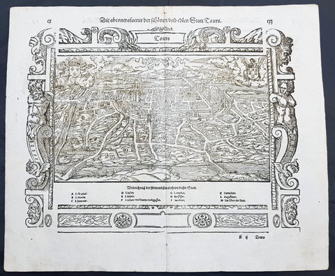
1574 Sebastian Munster Antique Map Birds Eye View of the City of Tours, France
- Title : Die Statt Tours
- Ref #: 22614
- Size: 16in x 13in (410mm x 330mm)
- Date : 1574
- Condition: (A+) Fine Condition
Description:
This fine original wood block engraved antique map a birds eye view of the French city of Tours, France was published in the French Section of Sebastian Munsters 1574 edition of Cosmographia, Das ist: Beschreibung der gantzen Welt, Darinnen Aller Monarchien Keyserthumben, Königreichen, Fürstenthumben, Graff- und Herrschafften, Länderen, Stätten und Gemeinden.Ursprung (Cosmographia, that is: description of the whole world, in it all monarchies Keyser thumben, kingdoms, prince thumben, graff and herrschafften, countries, places and municipalities.)
Tours is a city in the centre-west of France. It is the administrative centre of the Indre-et-Loire department and the largest city in the Centre-Val de Loire region of France
General Definitions:
Paper thickness and quality: - Heavy and stable
Paper color : - off white
Age of map color: -
Colors used: -
General color appearance: -
Paper size: - 16in x 13in (410mm x 330mm)
Plate size: - 16in x 13in (410mm x 330mm)
Margins: - Min 1in (25mm)
Imperfections:
Margins: - None
Plate area: - None
Verso: - None
Background:
Cosmographia, Das ist: Beschreibung der gantzen Welt, Darinnen Aller Monarchien Keyserthumben, Königreichen, Fürstenthumben, Graff- und Herrschafften, Länderen, Stätten und Gemeinden.Ursprung, Regiment, Reichthumb, Gewalt und.Beschaffenheit. Dessgleichen Aller deren, beyder Ständen, Regenten: Keysern, Königen, Bäpsten, Bischoffen.Genealogien und Stammbäumen.zusammen getragen. by Sebastian Münster was first published in 1544 and is the earliest German-language description of the world. It had numerous editions in different languages including Latin, French (translated by François de Belleforest), Italian, English, and Czech. The last German edition was published in 1628, long after Munsters death. The Cosmographia was one of the most successful and popular books of the 16th century. It passed through 24 editions in 100 years. This success was due to the notable woodcuts (some by Hans Holbein the Younger, Urs Graf, Hans Rudolph Manuel Deutsch, and David Kandel). It was most important in reviving geography in 16th-century Europe. Among the notable maps within Cosmographia is the map Tabula novarum insularum, which is credited as the first map to show the American continents as geographically discrete.
Munsters earlier geographic works were Germania descriptio (1530) and Mappa Europae (1536). In 1540, he published a Latin edition of Ptolemys Geographia with illustrations.