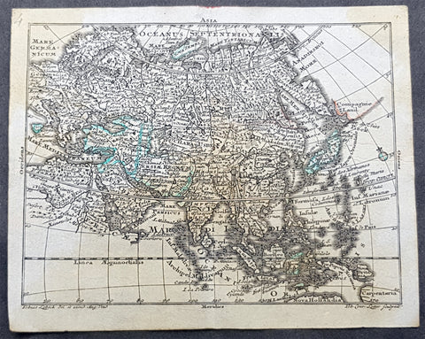
Asia (93)
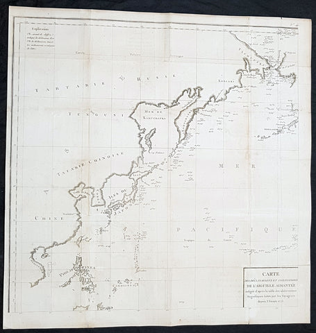
1775 La Perouse Antique Map of NW Pacific, Bering Straits to China, Philippines
Antique Map
- Title : Carte des Declinaisons et inclinaisons de l\'Aiguille Aimantee redigee d apres la table des observations Magnetiques faites par les Voyageurs depuis l Annee 1775
- Size: 24in x 24in (520mm x 520mm)
- Condition: (A+) Fine Condition
- Date : 1775
- Ref #: 32192
Description:
This large original copper plate engraved antique NW Pacific - from the Bering Straits to China & The Philippines - by Jean-François de Galaup, Comte de la Pérouse was engraved in 1775 and published in Count de Buffons monumental publication Histoire Naturelle
General Definitions:
Paper thickness and quality: - Heavy and stable
Paper color : - off white
Age of map color: -
Colors used: -
General color appearance: -
Paper size: - 24in x 24in (520mm x 520mm)
Plate size: - 24in x 24in (520mm x 520mm)
Margins: - Min 1/2in (12mm)
Imperfections:
Margins: - None
Plate area: - Folds as issued, light toning along folds
Verso: - None
Background:
This map is one of 8 charts which records the first detailed & documented the earths magnetism. Compiled from the reports of La Perouse last voyage in the Pacific.
An uncommon chart designed to display magnetic variation in the Pacific, published in Count de Buffons Histoire Naturelle, in the mineralogy volumes. As this section was not as popular as the bird volumes it is believed that only 250 copies of this edition were printed.
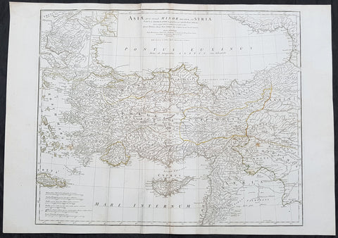
1764 J B D Anville Large Antique Map of Turkey, Cyprus, Syria, Black Sea
Antique Map
- Title : Asiae que Vulgo Minor Dicitur et Syria...Auctor D Anville...MDCCLXIV
- Ref : 92299
- Size: 30in x 21in (760mm x 535mm)
- Date : 1764
- Condition: (A) Very Good Condition
Description:
This large original copper plate engraved antique map of Turkey, Cyprus & Syria was engraved in 1764 - dated in the tile cartouche - and was published in Jean-Baptiste Bourguinon D Anvilles large elephant folio atlas Atlas Generale.
General Definitions:
Paper thickness and quality: - Heavy and stable
Paper color : - off white
Age of map color: - Original
Colors used: - Yellow, Green, pink
General color appearance: - Authentic
Paper size: - 30in x 21in (760mm x 535mm)
Plate size: - 25in x 20in (635mm x 515mm)
Margins: - Min 1/2in (12mm)
Imperfections:
Margins: - Creasing
Plate area: - Creasing
Verso: - Creasing
Background:
The Ottoman Empire also historically known in Western Europe as the Turkish Empire or simply Turkey, was a state that controlled much of Southeast Europe, Western Asia and North Africa between the 14th and early 20th centuries. It was founded at the end of the 13th century in northwestern Anatolia in the town of Söğüt (modern-day Bilecik Province) by the Oghuz Turkish tribal leader Osman I. After 1354, the Ottomans crossed into Europe, and with the conquest of the Balkans, the Ottoman beylik was transformed into a transcontinental empire. The Ottomans ended the Byzantine Empire with the 1453 conquest of Constantinople by Mehmed the Conqueror.
During the 16th and 17th centuries, at the height of its power under the reign of Suleiman the Magnificent, the Ottoman Empire was a multinational, multilingual empire controlling most of Southeast Europe, parts of Central Europe, Western Asia, parts of Eastern Europe and the Caucasus, North Africa and the Horn of Africa. At the beginning of the 17th century, the empire contained 32 provinces and numerous vassal states. Some of these were later absorbed into the Ottoman Empire, while others were granted various types of autonomy during the course of centuries.
With Constantinople as its capital and control of lands around the Mediterranean basin, the Ottoman Empire was at the centre of interactions between the Eastern and Western worlds for six centuries. While the empire was once thought to have entered a period of decline following the death of Suleiman the Magnificent, this view is no longer supported by the majority of academic historians. The empire continued to maintain a flexible and strong economy, society and military throughout the 17th and much of the 18th century. However, during a long period of peace from 1740 to 1768, the Ottoman military system fell behind that of their European rivals, the Habsburg and Russian empires. The Ottomans consequently suffered severe military defeats in the late 18th and early 19th centuries, which prompted them to initiate a comprehensive process of reform and modernisation known as the Tanzimat. Thus, over the course of the 19th century, the Ottoman state became vastly more powerful and organised, despite suffering further territorial losses, especially in the Balkans, where a number of new states emerged. The empire allied with Germany in the early 20th century, hoping to escape from the diplomatic isolation which had contributed to its recent territorial losses, and thus joined World War I on the side of the Central Powers. While the Empire was able to largely hold its own during the conflict, it was struggling with internal dissent, especially with the Arab Revolt in its Arabian holdings. During this time, atrocities were committed by the Ottoman government against the Armenians, Assyrians and Pontic Greeks.
The Empire\\\'s defeat and the occupation of part of its territory by the Allied Powers in the aftermath of World War I resulted in its partitioning and the loss of its Middle Eastern territories, which were divided between the United Kingdom and France. The successful Turkish War of Independence against the occupying Allies led to the emergence of the Republic of Turkey in the Anatolian heartland and the abolition of the Ottoman monarchy.
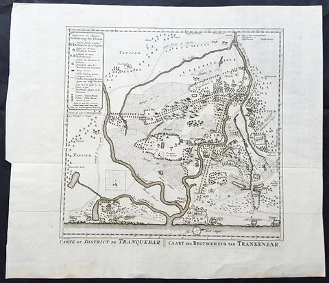
1755 Antoine Prevost Antique Map of Tharangambadi, Nagapattinam District, Tamil Nadu, India
- Title : Carte du District de Tranquebar: Caart des Regtsgebieds van Trankenbar
- Ref #: 61070
- Size: 17in x 15in (430mm x 380mm)
- Date : 1755
- Condition: (A+) Fine Condition
Description:
This large original copper-plate engraved antique map a plan of the city, fort & environs of Tharangambadi, formerly Tranquebar, in Tamil Nadu, India - with separate page Index of Buildings and important landmarks - by Jakob van Schley in 1755, was published in the Dutch edition of Antoine François Prevosts 15 volumes of Histoire Generale des Voyages written by Prevost & other authors between 1746-1790.
General Definitions:
Paper thickness and quality: - Heavy and stable
Paper color : - off white
Age of map color: -
Colors used: -
General color appearance: -
Paper size: - 17in x 15in (430mm x 380mm)
Plate size: - 13in x 13in (305mm x 305mm)
Margins: - Min 1in (25mm)
Imperfections:
Margins: - None
Plate area: - Folds as issued
Verso: - None
Background:
Tharangambadi, formerly Tranquebar, is a town in the Nagapattinam district of the Indian state of Tamil Nadu. It lies 15 kilometres north of Karaikal, near the mouth of a distributary of the Kaveri River. It was a Danish colony from 1620 to 1845, and in Danish it is still known as Trankebar.
The place dates back to 14th century. Masilamani nathar (Shiva) temple was built in 1306, in a land given by Maravarman Kulasekara Pandyan I. As of now, this temple is the oldest monument. Until 1620, when the Danes came, the place was under Thanjavur Nayak kingdom. Danish admiral Ove Gjedde felt the place would be a potential trading centre, made a deal with Raghunatha Nayak and built a fort, which is known as Fort Dansborg. Nevertheless, a jesuit Catholic church was already in place before that, catering for the Indo-Portuguese community. The Catholic church was probably demolished to build the fort. This fort was the residence and headquarters of the governor and other officials for about 150 years.
Among the first Protestant missionaries to set foot in India were two Lutherans from Germany, Bartholomäus Ziegenbalg and Heinrich Pluetschau, who began work in 1705 in the Danish settlement of Tranquebar. Ziegenbalg translated the Old and New Testaments into Tamil, imported a printing press, and printed the New Testament in Tamil in 1714.
The local people were forced to learn the broken Portuguese that was the lingua franca between Indians and Europeans at the time, and later on translated the Bible into the local Tamil language. They also established a printing press, which within a hundred years of its establishment in 1712 had printed 300 books in Tamil. At first they only made little progress in their religious efforts, but gradually the mission spread to Madras, Cuddalore and Tanjore. Today Bishop of Tranquebar is the official title of a bishop in theTamil Evangelical Lutheran Church (TELC) in South India which was founded in 1919 as a result of the German Lutheran Leipzig Mission and Church of Sweden Mission. The seat of the Bishop, the Cathedral and its Church House (\\\"Tranquebar House\\\") is in Tiruchirappalli.
The Zion church was consecrated in 1701, which is the oldest Protestant church in India. In 1718, The New Jerusalem Church was constructed. Moravian Brethren missionaries from Herrnhut, Saxony established the Brethren\\\'s Garden at Porayar near Tranquebar and operated it as a missionary centre for a number of years. An Italian Catholic FatherConstanzo Beschi, who worked in the colony from 1711 to 1740, found himself in conflict with the Lutheran pioneers at Tranquebar, against whom he wrote several polemical works.
Tranquebar was occupied by the British in February 1808 during the Napoleonic Wars but was restored to Denmark following the Treaty of Kiel in 1814 and The Norwegian Declaration of Independence. Along with the Danish settlement of Serampore in Bengal, it was sold to the British in 1845. Tranquebar was then still a busy port, but it later lost its importance after a railway was opened to Nagapattinam.
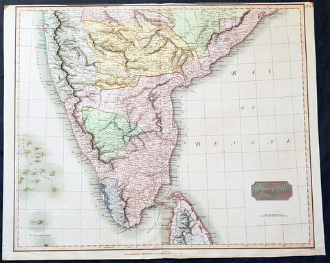
1816 John Thomson Large Antique Map of Southern India & Northern Sri Lanka
- Title : Southern Hindostan....Drawn & Engraved for Thomsons New General Atlas, 1816
- Date : 1816
- Size: 25in x 20 1/2in (635mm x 520mm)
- Condition: (A+) Fine Condition
- Ref: 41004
Description:
This large magnificent original hand coloured copper-plate engraved antique map of South India & northern Sri Lanka by John Thomson was engraved by Samuel Neele in 1816 - dated at the foot of the map - and was published in the 1817 edition of Thomsons New General Atlas
General Definitions:
Paper thickness and quality: - Heavy and stable
Paper color : - off white
Age of map color: - Original
Colors used: - Yellow, green, blue, pink
General color appearance: - Authentic
Paper size: - 25in x 20 1/2in (635mm x 520mm)
Plate size: - 25in x 20 1/2in (635mm x 520mm)
Margins: - Min 1/2in (15mm)
Imperfections:
Margins: - Top margin soiling and cropped to plate-mark
Plate area: - None
Verso: - None
Background:
The cartography of India begins with early charts for navigation and constructional plans for buildings. Indian traditions influenced Tibetan and Islamic traditions, and in turn, were influenced by the British cartographers who solidified modern concepts into India\'s map making
A prominent foreign geographer and cartographer was Hellenistic geographer Ptolemy (90–168) who researched at the library in Alexandria to produce a detailed eight-volume record of world geography. During the Middle Ages, India sees some exploration by Chinese and Muslim geographers, while European maps of India remain very sketchy. A prominent medieval cartographer was Persian geographer Abu Rayhan Biruni (973–1048) who visited India and studied the country\'s geography extensively.
European maps become more accurate with the Age of Exploration and Portuguese India from the 16th century. The first modern maps were produced by Survey of India, established in 1767 by the British East India Company. Survey of India remains in continued existence as the official mapping authority of the Republic of India.
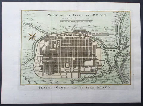
1757 Prevost & Schley Antique Map City of Koyto or Meaco Japan Old Imperial City
- Title : Plan de Ville de Meaco
- Ref # : 61061
- Size: 14in x 10in (355mm x 255mm)
- Date : 1757
- Condition: (A+) Fine Condition
Description:
This fine, original copper-plate engraved antique map a plan of the Japanese city of Koyto or Meaco by Jakob van Schley in 1757 was published in Antoine François Prevosts 15 volumes of Histoire Generale des Voyages written by Prevost & other authors between 1746-1790.
Kyoto is a city located in the central part of the island of Honshu, Japan. It has a population close to 1.5 million. Formerly the Imperial capital of Japan for more than one thousand years, it is now the capital city of Kyoto Prefecture located in the Kansai region.
During the 8th century, when powerful Buddhist clergy became involved in the affairs of the Imperial government, Emperor Kanmu chose to relocate the capital in order to distance it from the clerical establishment in Nara. His last choice for the site was the village of Uda, in the Kadono district of Yamashiro Province.
The new city, Heian-kyo a scaled replica of the then Tang capital Chang\'an, became the seat of Japan\'s imperial court in 794, beginning the Heian period of Japanese history. Although military rulers established their governments either in Kyoto (Muromachi shogunate) or in other cities such as Kamakura (Kamakura shogunate) and Edo (Tokugawa shogunate), Kyoto remained Japan\'s capital until the transfer of the imperial court to Tokyo in 1869 at the time of the Imperial Restoration.
The city suffered extensive destruction in the Onin War of 1467–1477, and did not really recover until the mid-16th century. During the Onin War, the shugo collapsed, and power was divided among the military families. Battles between samurai factions spilled into the streets, and came to involve the court nobility (kuge) and religious factions as well. Nobles\' mansions were transformed into fortresses, deep trenches dug throughout the city for defense and as firebreaks, and numerous buildings burned. The city has not seen such widespread destruction since.
In the late 16th century, Toyotomi Hideyoshi reconstructed the city by building new streets to double the number of north-south streets in central Kyoto, creating rectangle blocks superseding ancient square blocks. Hideyoshi also built earthwork walls called odoi encircling the city. Teramachi Street in central Kyoto is a Buddhist temple quarter where Hideyoshi gathered temples in the city. Throughout the Edo period, the economy of the city flourished as one of three major cities in Japan, the others being Osaka and Edo.
General Definitions:
Paper thickness and quality: - Heavy and stable
Paper color : - off white
Age of map color: - Early
Colors used: - Yellow, green, orange
General color appearance: - Authentic
Paper size: - 15in x 10in (380mm x 255mm) Plate size: - 13in x 9 1/2in (330mm x 240mm)
Plate size: - 12 1/2in x 8 1/2in (320mm x 215mm)
Margins: - Min 1/2in (12mm)
Imperfections:
Margins: - None
Plate area: - None
Verso: - None
Background:
One of Antoine Francois Prevosts monumental undertakings was his history of exploration & discovery in 15 volumes titledHistoire Générale des Voyages written between 1746-1759 and was extended to 20 volumes after his death by various authors.
The 20 volumes cover the early explorations & discoveries on 3 continents: Africa (v. 1-5), Asia (v. 5-11), and America (v. 12-15) with material on the finding of the French, English, Dutch, and Portugese.
A number of notable cartographers and engravers contributed to the copper plate maps and views to the 20 volumes including Nicolas Bellin, Jan Schley, Chedel, Franc Aveline, Fessard, and many others.
The African volumes cover primarily coastal countries of West, Southern, and Eastern Africa, plus the Congo, Madagascar, Arabia and the Persian Gulf areas.
The Asian volumes cover China, Korea, Tibet, Japan, Philippines, and countries bordering the Indian Ocean.
Volume 11 includes Australia and Antarctica.
Volumes 12-15 cover voyages and discoveries in America, including the East Indies, South, Central and North America.
Volumes 16-20 include supplement volumes & tables along with continuation of voyages and discoveries in Russia, Northern Europe, America, Asia & Australia.
Jakob van der Schley aka Jakob van Schley (1715 - 1779) was a Dutch draughtsman and engraver. He studied under Bernard Picart (1673-1733) whose style he subsequently copied. His main interests were engraving portraits and producing illustrations for \\\"La Vie de Marianne\\\" by Pierre Carlet de Chamblain de Marivaux (1688-1763) published in The Hague between 1735 and 1747.
He also engraved the frontispieces for a 15-volume edition of the complete works of Pierre de Brantôme (1540-1614), \\\"Oeuvres du seigneur de Brantôme\\\", published in The Hague in 1740.
He is also responsible for most of the plates in the Hague edition of Prévosts Histoire générale des voyages. (Ref: Tooley; M&B)
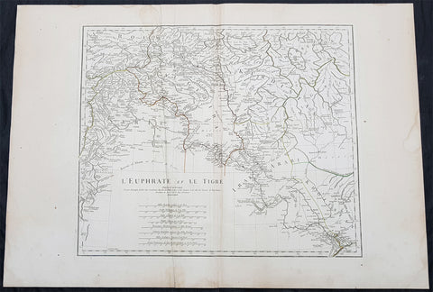
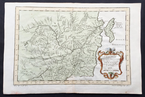
1779 J B D Anville Large Antique Map of the Tigris–Euphrates River System Iraq
Antique Map
- Title : L Euphrate et Le Tigre Par Le Sr D Anville..MDCCLXXIX
- Size: 30in x 21in (760mm x 535mm)
- Condition: (A) Very Good Condition
- Date : 1779
- Ref #: 92300
Description:
This large original copper plate engraved antique map of the Tigris–Euphrates river system was engraved in 1779 - dated in the tile cartouche - and was published in Jean-Baptiste Bourguinon D Anvilles large elephant folio atlas Atlas Generale.
General Definitions:
Paper thickness and quality: - Heavy and stable
Paper color : - off white
Age of map color: - Original
Colors used: - Yellow, Green, pink
General color appearance: - Authentic
Paper size: - 30in x 21in (760mm x 535mm)
Plate size: - 21in x 17 1/2in (535mm x 430mm)
Margins: - Min 1/2in (12mm)
Imperfections:
Margins: - Creasing, light age toning
Plate area: - Creasing
Verso: - Creasing, light age toning
Background:
The Tigris and Euphrates, with their tributaries, form a major river system in Western Asia. From sources originating in eastern Turkey, they flow by/through Syria through Iraq into the Persian Gulf. The system is part of the Palearctic Tigris–Euphrates ecoregion, which includes Iraq and parts of Turkey, Syria, Iran, Saudi Arabia, Kuwait, and Jordan.
From their sources and upper courses in the mountains of eastern Anatolia, the rivers descend through valleys and gorges to the uplands of Syria and northern Iraq and then to the alluvial plain of central Iraq. The rivers flow in a south-easterly direction through the central plain and combine at Al-Qurnah to form the Shatt al-Arab and discharge into the Persian Gulf.
The region has historical importance as part of the Fertile Crescent region, in which civilization is believed to have first emerged.
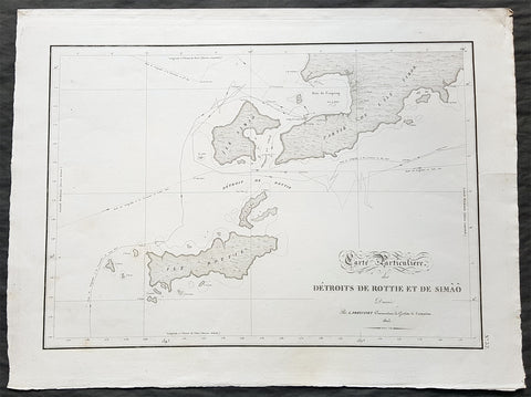
1803 Louis Freycinet Antique Map of The Islands of Timor, Samau & Rote Indonesia
- Title : Carte Particuliere des Detroits De Rottie et de Simao...L Freycienet...le Casuarina 1803..Lambert Sculp.
- Ref #: 42014
- Size: 22 1/2in x 16 1/2in (570mm x 420mm)
- Date : 1803
- Condition: (A+) Fine Condition
Description:
This magnificent large original copper-plate engraved antique map of the islands of Samau, Rote and the southern part of Timor, including the bay and town of Kupang, by Lieutenant Louis Freycinet, in command of the ship Casuarina in 1803, was engraved by Anton Lambart and was published in the 1807 1st edition of François Pérons, Voyage de découvertes aux terres australes (‘Voyage of Discovery to the Southern Lands in three volumes, Paris, 1807–1816.
Also illustrates the tracks of the ships Geographe, the Naturaliste from the earlier voyages in 1801, and the Casuarina tracks of 1803.
General Definitions:
Paper thickness and quality: - Heavy and stable
Paper color : - off white
Age of map color: - Original
Colors used: - Yellow, green, blue, pink
General color appearance: - Authentic
Paper size: - 22 1/2in x 16 1/2in (570mm x 420mm)
Plate size: - 21 1/2in x 15in (545mm x 380mm)
Margins: - Min 1in (25mm)
Imperfections:
Margins: - None
Plate area: - None
Verso: - None
Background:
Nicolas Thomas Baudin 1754 – 1803 was a French explorer, cartographer, naturalist and hydrographer.
The Baudin expedition of 1800 to 1803 was a French expedition to map the coast of New Holland (Australia). The expedition started with two ships, Géographe, captained by Baudin, and Naturaliste captained by Jacques Hamelin, and was accompanied by nine zoologists and botanists, including Jean-Baptiste Leschenault de la Tour, François Péron and Charles-Alexandre Lesueur as well as the geographer Pierre Faure.
Napoléon Bonaparte, as First Consul, formally approved the expedition to the coasts of New Holland, after receiving a delegation consisting of Baudin and eminent members of the Institut National des Sciences et Arts on 25 March 1800. The explicit purpose of the voyage was to be ‘bservation and research relating to Geography and Natural History.
The Baudin expedition departed Le Havre, France, on 19 October 1800. Because of delays in receiving his instructions and problems encountered in Isle de France (now Mauritius) they did not reach Cape Leeuwin on the south-west corner of the continent until May 1801. Upon rounding Cape Naturaliste, they entered Geographe Bay. During their exploration here they lost a longboat and a sailor, Assistant Helmsman Timothée Vasse. They then sailed north, but the ships became separated and did not meet again until they reached Timor. On their journeys the Géographe and the Naturaliste surveyed large stretches of the north-western coast. The expedition was severely affected by dysentery and fever, but sailed from Timor on 13 November 1801, back down the north-west and west coast, then across the Great Australian Bight, reaching Tasmania on 13 January 1802. They charted the whole length of Tasmanias east coast and there were extensive interactions with the Indigenous Tasmanians, with whom they had peaceful relationships. They notably produced precious ethnological studies of Indigenous Tasmanians.
The expedition then began surveying the south coast of Australia, but then Captain Jacques Felix Emmanuel Hamelin in Naturaliste decided to make for Port Jackson (Sydney) as he was running short of food and water, and in need of anchors. En route, in April 1802, Hamelin explored the area of Western Port, Victoria, and gave names to places, a number of which have survived, for example, Ile des Français is now called French Island.
Meanwhile, Baudin in the Géographe continued westward, and in April 1802 encountered the British ship Investigator commanded by Matthew Flinders, also engaged in charting the coastline, at Encounter Bay in what is now South Australia. Flinders informed Baudin of his discovery of Kangaroo Island, St. Vincents and Spencers Gulfs. Baudin sailed on to the Nuyts Archipelago, the point reached by \'t Gulden Zeepaert in 1627 before heading for Port Jackson as well for supplies.
In late 1802 the expedition was at Port Jackson, where the government sold 60 casks of flour and 25 casks of salt meat to Baudin to resupply his two vessels. The supplies permitted the Naturaliste to return to France and Géographe to continue her explorations of the Australian coast. Naturaliste took with her the Colonys staff surgeon, Mr. James Thomson, whom Governor Philip Gidley King had given permission to return to England.
Before resuming the voyage Baudin purchased a 30 ton schooner, which he named the Casuarina, a smaller vessel which could conduct close inshore survey work. He sent the larger Naturaliste under Hamelin back to France with all the specimens that had been collected by Baudin and his crew. As the voyage had progressed Louis de Freycinet, now a Lieutenant, had shown his talents as an officer and a hydrographer and so was given command of the Casuarina. The expedition then headed for Tasmania and conducted further charting of Bass Strait before sailing west, following the west coast northward, and after another visit to Timor, undertook further exploration along the north coast of Australia. Plagued by contrary winds, ill health, and because the quadrupeds and emus were very sick, it was decided on 7 July 1803 to return to France. On the return voyage, the ships stopped in Mauritius, where Baudin died of tuberculosis on 16 September 1803. The expedition finally reached France on 24 March 1804.
The scientific expedition was considered a great success, with more than 2500 new species discovered.
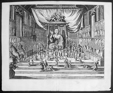
1669 Montanus Antique Print Sanjūsangen-dō 三十三間堂 Buddhist Temple Kyoto, Japan
- Title : Temple ou il y a 1000 Idoles: Temple met Duysend Beelden
- Date : 1669
- Condition: (A+) Fine Condition
- Ref # : 23413
- Size : 14 1/2in x 9in (360mm x 230mm)
Description:
This original copper-plate engraved antique print of Sanjūsangen-dō (三十三間堂) a Buddhist temple in Higashiyama District of Kyoto, Japan (with 1000 Kannon statues) during the Edo period, by Arnoldus Montanus was published in the 1669 edition of Gedenkwaerdige Gesantschappen der Oost-Indische Maetschappy int Vereenigde Nederland, aen de Kaisaren van Japan. Getrokken uit de Geschriften en Reiseaentekeninge der zelver Gesanten (Atlas Japannensis being remarkable addresses by way of Embassy from the East India Company of the United Provinces, to the Emperor of Japan)
General Definitions:
Paper thickness and quality: - Heavy and stable
Paper color : - off white
Age of map color: -
Colors used: -
General color appearance: -
Paper size: - 15in x 12in (380mm x 305mm)
Plate size: - 13in x 10in (330mm x 255mm)
Margins: - Min 1in (20mm)
Imperfections:
Margins: - None
Plate area: - None
Verso: - None
Background:
Sanjūsangen-dō (三十三間堂, lit. thirty-three ken (length) hall) is a Buddhist temple in Higashiyama District of Kyoto, Japan. Officially known as Rengeō-in (蓮華王院), or Hall of the Lotus King, Sanjūsangen-dō belongs to and is run by the Myōhō-in temple, a part of the Tendai school of Buddhism. The temple name literally means Hall with thirty three spaces between columns, describing the architecture of the long main hall of the temple.
Taira no Kiyomori completed the temple under order of Emperor Go-Shirakawa in 1164. The temple complex suffered a fire in 1249 and only the main hall was rebuilt in 1266. In January, the temple has an event known as the Rite of the Willow (柳枝のお加持), where worshippers are touched on the head with a sacred willow branch to cure and prevent headaches. A popular archery tournament known as the Tōshiya (通し矢) has also been held here, beside the West veranda, since the Edo period. The duel between the famous warrior Miyamoto Musashi and Yoshioka Denshichirō, leader of the Yoshioka-ryū, is popularly believed to have been fought just outside Sanjūsangen-dō in 1604.
The main deity of the temple is Sahasrabhuja-arya-avalokiteśvara or the Thousand Armed Kannon. The statue of the main deity was created by the Kamakura sculptor Tankei and is a National Treasure of Japan. The temple also contains one thousand life-size statues of the Thousand Armed Kannon which stand on both the right and left sides of the main statue in 10 rows and 50 columns. Of these, 124 statues are from the original temple, rescued from the fire of 1249, while the remaining 876 statues were constructed in the 13th century. The statues are made of Japanese cypress clad in gold leaf. The temple is 120 - meter long[1]. Around the 1000 Kannon statues stand 28 statues of guardian deities. There are also two famous statues of Fūjin and Raijin.
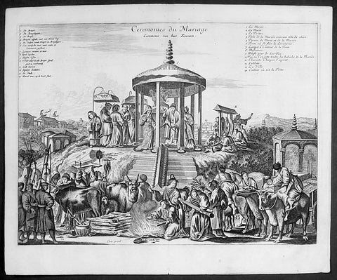
1669 Arnoldus Montanus Large Antique Print of a Japanese Marriage Ceremony 結婚式
- Title : Ceremonies du Mariage
- Date : 1669
- Condition: (A+) Fine Condition
- Ref # : 23411-1
- Size : 14 1/2in x 9in (360mm x 230mm)
Description:
This original copper-plate engraved antique print of a Japanese Marriage Ceremony during the early Edo period of Japanese history, by Arnoldus Montanus was published in the 1669 edition of Gedenkwaerdige Gesantschappen der Oost-Indische Maetschappy int Vereenigde Nederland, aen de Kaisaren van Japan. Getrokken uit de Geschriften en Reiseaentekeninge der zelver Gesanten (Atlas Japannensis being remarkable addresses by way of Embassy from the East India Company of the United Provinces, to the Emperor of Japan)
General Definitions:
Paper thickness and quality: - Heavy and stable
Paper color : - off white
Age of map color: -
Colors used: -
General color appearance: -
Paper size: - 15in x 12in (380mm x 305mm)
Plate size: - 13in x 10in (330mm x 255mm)
Margins: - Min 1in (20mm)
Imperfections:
Margins: - None
Plate area: - None
Verso: - None
Background:
Marriage in the Edo period (1600–1868)
In pre-modern Japan, marriage was inextricable from the ie (家, family or household), the basic unit of society with a collective continuity independent of any individual life. Members of the household were expected to subordinate all their own interests to that of the ie, with respect for an ideal of filial piety and social hierarchy that borrowed much from Confucianism. The choice to remain single was the greatest crime a man could commit, according to Baron Hozumi.
Marriages were duly arranged by the head of the household, who represented it publicly and was legally responsible for its members, and any preference by either principal in a marital arrangement was considered improper. Property was regarded to belong to the ie rather than to individuals, and inheritance was strictly agnatic primogeniture. A woman (女) married the household (家) of her husband, hence the logograms for yome (嫁, wife) and yomeiri (嫁入り, marriage, lit. wife entering).
In the absence of sons, some households would adopt a male heir (養子, or yōshi) to maintain the dynasty, a practice which continues in corporate Japan. Nearly all adoptions are of adult men. Marriage was restricted to households of equal social standing (分限), which made selection a crucial, painstaking process. Although Confucian ethics encouraged people to marry outside their own group, limiting the search to a local community remained the easiest way to ensure an honorable match. Approximately one-in-five marriages in pre-modern Japan occurred between households that were already related.
Outcast communities such as the Burakumin could not marry outside of their caste, and marriage discrimination continued even after an 1871 edict abolished the caste system, well into the twentieth century. Marriage between a Japanese and non-Japanese person was not officially permitted until 14 March 1873, a date now commemorated as White Day. Marriage with a foreigner required the Japanese national to surrender his or her social standing.
The purposes of marriage in the medieval and Edo periods was to form alliances between families, to relieve the family of its female dependents, to perpetuate the family line, and, especially for the lower classes, to add new members to the family\'s workforce. The seventeenth-century treatise Onna Daigaku (Greater Learning for Women) instructed wives honor their parents-in-law before their own parents, and to be courteous, humble, and conciliatory towards their husbands.
Husbands were also encouraged to place the needs of their parents and children before those of their wives. One British observer remarked, If you love your wife you spoil your mother\'s servant. The tension between a housewife and her mother-in-law has been a keynote of Japanese drama ever since.
Romantic love (愛情, aijō) played little part in medieval marriages, as emotional attachment was considered inconsistent with filial piety. A proverb said, Those who come together in passion stay together in tears. For men, sexual gratification was seen as separate from conjugal relations with ones wife, where the purpose was procreation. The genre called Ukiyo-e (浮世絵, lit. floating world pictures) celebrated the luxury and hedonism of the era, typically with depictions of beautiful courtesans and geisha of the pleasure districts. Concubinage and prostitution were common, public, relatively respectable, until the social upheaval of the Meiji Restoration put an end to feudal society in Japan.
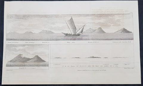
1779 Thomas Forrest Antique Print Views Maluku, Moluccas Spice Islands Indonesia
Antique Map
- Title : Ternate; Tidor; Motir; Tartar Galley; Macquian; Northmost of the Giaritchas; Macquian;
- Ref : 31727
- Size: 22in x 13 1/2in (560mm x 345mm)
- Date : 1779
- Condition: (A) Very Good Condition
Description:
This large scarce original copper plate engraved antique print a view of the Indonesian Spice Islands and Thomas Forrests ship the Tartar by Thomas Forrest was published in the 1779 edition of A Voyage to New Guinea and the Moluccas from Balambangan … during the years 1774–5–6
General Definitions:
Paper thickness and quality: - Heavy and stable
Paper color : - off white
Age of map color: -
Colors used: -
General color appearance: -
Paper size: - 22in x 13 1/2in (560mm x 345mm)
Plate size: - 22in x 13 1/2in (560mm x 345mm)
Margins: - Min 1/2in (12mm)
Imperfections:
Margins: - Left margin extended
Plate area: - Small loss to image on left border, light offsetting
Verso: - Folds as issued, light offsetting
Background:
This large print that includes Thomas Forrests ship The Tartar, a garay boat from Sulu of about ten tons burden, with two English officers and a crew of eighteen locals, shows views of the Spice or Maluku (Moluccas) Islands of Ternate, Tidore, Makian & Kajoa
Forrest, Thomas 1729 - 1802
Forrest was a Scottish navigator who worked for the British East India Company.
He appears to have served for some time in the Royal Navy, and to have been a midshipman in 1745. Passages in his own writings show that he was employed in Indian waters from 1753 almost continuously. He implies that during part of the Seven Years War he was on the Elizabeth, in the squadron under Admiral Charles Steevens; but this cannot be verified from the pay-book.
In 1762 Forrest had command of a Company ship. In 1770 he was engaged in forming the new settlement at Balambangan which had been recommended by Alexander Dalrymple, and in 1774 he led an exploring mission in the direction of New Guinea. He sailed on 9 December in the Tartar, a garay boat from Sulu of about ten tons burden, with two English officers and a crew of eighteen Malays. In this, accompanied during part of the time by two small boats, he pushed his explorations as far as Geelvink Bay in New Guinea, examining the Sulu Archipelago, the south coast of Mindanao, Mandiolo, Batchian, and particularly Waigeo, of which his was the first good chart. Forrest reached Dorei Harbour,[1] and returned to Achin (present-day Aceh) in March 1776.
In December 1782 Forrest was tasked by governor-general Warren Hastings to gain intelligence of the French fleet, which had left the coast of India and had eluded Sir Edward Hughes the English commander-in-chief. The British surmised that the French were headed for Mauritius; Forrest spotted the ships near Achin and returned the information to Vizagapatam just ahead of the French return. In the following June he sailed again to survey the Andaman Islands, but falling to leeward of them, passed through the Preparis Channel to the Tenasserim coast, which he examined southwards as far as Quedah. In 1790 he made a more thorough examination of the same coast and of its offshore islands, which lay in a long row, leaving a 125-mile-long sheltered passage between them and the mainland. He christened that stretch Forrest Strait.
Forrest is said to have died in India about 1802.
A detailed account of Forrests 1774 voyage was published in 1779 under the title, A Voyage to New Guinea and the Moluccas from Balambangan … during the years 1774–5–6; the volume included a portrait of the author. In 1782 Forrest published at Calcutta A Treatise on the Monsoons in East India, a new edition of which was published in London in 1783.
An account of the first survey voyage came out in 1789 under the title, A Journal of the Esther Brig, Capt. Thomas Forrest, from Bengal to Quedah, in 1783, later edited by Dalrymple, with publishing costs borne by the East India Company. An account of the second survey voyage was published in 1792 as A Voyage from Calcutta to the Mergui Archipelago, with which were included some minor essays and descriptive accounts, as well as a reprint of the Treatise on the Monsoons. This volume is dedicated to William Aldersey, president of the board of trade in Bengal, who was described as Forrests cousin.
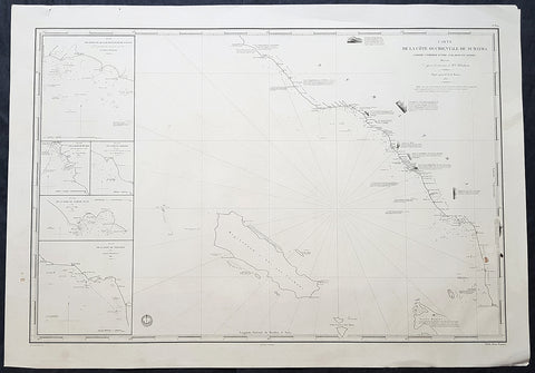
1837 Depot De Marine Large Antique Map Sea Chart of Aceh, Sumatra, Indonesia
- Title : Carte de la Cote Occidentale De Sumatra..1837
- Size: 38in x 26 1/2in (330mm x 255mm)
- Condition: (A+) Fine Condition
- Date : 1837
- Ref #: 30142
Description:
This very large highly detailed original antique map, Sea Chart of the South west coast of Aceh on the North-West tip of the Island of Sumatra, Indonesia was engraved in 1837 - the date is engraved in the title - and was published by The French Admiralty - Depot General de la Marine.
At the time of publication Baron Duperre was head of the French Admiralty. This sea chart would have been one of the actual charts used by the French navy during the many voyages of discovery launched by the French in the 18th & 19th centuries.
The map stretches from the town of Singkil on the south coast to the town of Meulaboh in the north. Off the coast is the Island of Simeulue. Inset are 5 inset maps of ports and harbours along the SW Aceh coastline.
1. Qualh-Battoo et De Soosoo (Susu)
2. Baie De Muckie
3. De Labon et Hadje (Labuan)
4. Baie Tampat Tuan (Tapak Tuan)
5. Baie De Troumon (Trumon)
General Definitions:
Paper thickness and quality: - Heavy and stable
Paper color : - off white
Age of map color: -
Colors used: -
General color appearance: -
Paper size: - 38in x 26 1/2in (330mm x 255mm)
Plate size: - 38in x 26 1/2in (330mm x 255mm)
Margins: - Min 1/2in (12mm)
Imperfections:
Margins: - None
Plate area: - None
Verso: - None
Background:
Aceh is a province of Indonesia. The territory is located at the northern end of Sumatra. Its capital is Banda Aceh. It is close to the Andaman and Nicobar Islands of India and separated from them by the Andaman Sea. Its population has the highest percentage of Muslims in Indonesia, who mostly live according to Sharia customs and laws.
The Sultanate of Aceh was established by Sultan Ali Mughayat Syah in 1511.
In 1584–88 the Bishop of Malacca, D. João Ribeiro Gaio, based on information provided by a former captive called Diogo Gil, wrote the Roteiro das Cousas do Achem (Lisboa 1997) – a description of the Sultanate.
Later, during its golden era, in the 17th century, its territory and political influence expanded as far as Satun in southern Thailand, Johor in Malay Peninsula, and Siak in what is today the province of Riau. As was the case with most non-Javan pre-colonial states, Acehnese power expanded outward by sea rather than inland. As it expanded down the Sumatran coast, its main competitors were Johor and Portuguese Malacca on the other side of the Straits of Malacca. It was this seaborne trade focus that saw Aceh rely on rice imports from north Java rather than develop self sufficiency in rice production.
After the Portuguese occupation of Malacca in 1511, many Islamic traders passing the Malacca Straits shifted their trade to Banda Aceh and increased the Acehnese rulers\' wealth. During the reign of Sultan Iskandar Muda in the 17th century, Aceh\'s influence extended to most of Sumatra and the Malay Peninsula. Aceh allied itself with the Ottoman Empire and the Dutch East India Company in their struggle against the Portuguese and the Johor Sultanate. Acehnese military power waned gradually thereafter, and Aceh ceded its territory of Pariaman in Sumatra to the Dutch in the 18th century.
By the early nineteenth century, however, Aceh had become an increasingly influential power due to its strategic location for controlling regional trade. In the 1820s it was the producer of over half the world\'s supply of black pepper. The pepper trade produced new wealth for the Sultanate and for the rulers of many smaller nearby ports that had been under Aceh\'s control, but were now able to assert more independence. These changes initially threatened Acehs integrity, but a new sultan Tuanku Ibrahim, who controlled the kingdom from 1838 to 1870, reasserted power over nearby ports.
Under the Anglo-Dutch Treaty of 1824 the British ceded their colonial possessions on Sumatra to the Dutch. In the treaty, the British described Aceh as one of their possessions, although they had no actual control over the Sultanate. Initially, under the agreement the Dutch agreed to respect Aceh\'s independence. In 1871, however, the British dropped previous opposition to a Dutch invasion of Aceh, possibly to prevent France or the United States from gaining a foothold in the region. Although neither the Dutch nor the British knew the specifics, there had been rumors since the 1850s that Aceh had been in communication with the rulers of France and of the Ottoman Empire
Depot des cartes et plans de la Marine
The Naval Hydrographic and Oceanographic Service is a French public establishment of an administrative nature, administered by the Ministry of Defence. It is the successor to the Dépôt des cartes et plans de la Marine, founded in 1720 which became the Naval Hydrographic Service in 1886 and the Naval and Oceanographic Service in 1971.
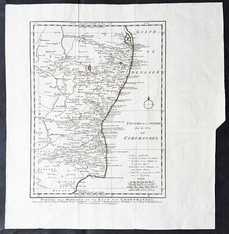
1755 Antoine Prevost Antique Map of Carnatic Wars on the Coromandel Coast, India
- Title : Theatre de la Guerre sur la Cote de Coromandel (Theater of War on the Coromandel Coast)
- Ref #: 61076
- Size: 17in x 15in (430mm x 380mm)
- Date : 1755
- Condition: (A+) Fine Condition
Description:
This large original copper-plate engraved antique map of the Coromandel Coast, India during the Carnatic Wars, by Jakob van Schley in 1755, was published in the Dutch edition of Antoine François Prevosts 15 volumes of Histoire Generale des Voyages written by Prevost & other authors between 1746-1790.
General Definitions:
Paper thickness and quality: - Heavy and stable
Paper color : - off white
Age of map color: -
Colors used: -
General color appearance: -
Paper size: - 17in x 15in (430mm x 380mm)
Plate size: - 13in x 13in (305mm x 305mm)
Margins: - Min 1in (25mm)
Imperfections:
Margins: - None
Plate area: - Folds as issued
Verso: - None
Background:
The Carnatic Wars (also spelled Karnatic Wars) were a series of military conflicts in the middle of the 18th century in India. The conflicts involved numerous nominally independent rulers and their vassals, struggles for succession and territory, and included a diplomatic and military struggle between the French East India Company and the British East India Company. They were mainly fought on the territories in India which were dominated by the Nizam of Hyderabad up to the Godavari delta. As a result of these military contests, the British East India Company established its dominance among the European trading companies within India. The French company was pushed to a corner and was confined primarily to Pondichéry. The East India company\'s dominance eventually led to control by the British Company over most of India and eventually to the establishment of the British Raj.
In the 18th century, the coastal Carnatic region was a dependency of Hyderabad. Three Carnatic Wars were fought between 1746 and 1763.
The Coromandel Coast is the southeastern coast region of the Indian subcontinent, bounded by the Utkal Plains to the north, the Bay of Bengal to the east, the Kaveri delta to the south, and the Eastern Ghats to the west, extending over an area of about 22,800 square kilometres. Its definition can also include the northwestern coast of the island of Sri Lanka.
By late 1530 the Coromandel Coast was home to three Portuguese settlements at Nagapattinam, São Tomé de Meliapore, and Pulicat. In the 17th and 18th centuries, the Coromandel Coast was the scene of rivalries among European powers for control of the India trade. The British established themselves at Fort St George (Madras) and Masulipatnam, the Dutch at Pulicat, Sadras and Covelong, the French at Pondicherry, Karaikal and Nizampatnam, the Danish in Dansborg at Tharangambadi.
The Coromandel Coast supplied Indian Muslim eunuchs to the Thai palace and court of Siam. The Thai at times asked eunuchs from China to visit the court in Thailand and advise them on court ritual since they held them in high regard.
Eventually the British won out, although France retained the tiny enclaves of Pondichéry and Karaikal until 1954. Chinese lacquer goods, including boxes, screens, and chests, became known as Coromandel goods in the 18th century, because many Chinese exports were consolidated at the Coromandel ports.
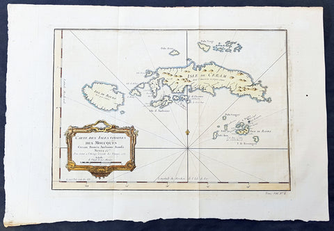
1750 Bellin Original Antique Map The Maluku or Moluccas, Spice Islands Indonesia
- Title : Carte Des Isles Voisines Des Moluques Ceram, Bouro, Amboine, Banda, Neyra....1750
- Ref #: 34099
- Size: 16in x 10 1/2in (390mm x 265mm)
- Date : 1750
- Condition: (A+) Fine Condition
Description:
This fine, original copper-plate engraved antique map of the Maluku or Moluccas Islands (Spice Islands) Indonesia by Jacques Nicolas Bellin in 1750 was published in Antoine François Prevosts 15 volumes of Histoire Generale des Voyages written by Prevost & other authors between 1746-1790.
The Maluku Islands or the Moluccas are an archipelago within Banda Sea, Indonesia. Geographically they are located east of Sulawesi, west of New Guinea, and north and east of Timor.
The islands were known as the Spice Islands due to the nutmeg, mace and cloves that were originally exclusively found there, and the presence of these sparked colonial interest from Europe in the 16th century.
The most significant lasting effects of the Portuguese colonisation was the disruption and reorganization of the Southeast Asian trade, and in eastern Indonesia—including Maluku—the introduction of Christianity. The Portuguese had conquered the city state of Malacca in the early 16th century and their influence was most strongly felt in Maluku and other parts of eastern Indonesia. After the Portuguese annexed Malacca in August 1511, one Portuguese diary noted \'it is thirty years since they became Moors - giving a sense of the competition then taking place between Islamic and European influences in the region.
Afonso de Albuquerque learned of the route to the Banda Islands and other \'Spice Islands\', and sent an exploratory expedition of three vessels under the command of António de Abreu, Simão Afonso Bisigudo and Francisco Serrão. On the return trip, Francisco Serrão was shipwrecked at Hitu island (northern Ambon) in 1512. There he established ties with the local ruler who was impressed with his martial skills. The rulers of the competing island states of Ternate and Tidore also sought Portuguese assistance and the newcomers were welcomed in the area as buyers of supplies and spices during a lull in the regional trade due to the temporary disruption of Javanese and Malay sailings to the area following the 1511 conflict in Malacca. The spice trade soon revived but the Portuguese would not be able to fully monopolize nor disrupt this trade.
Allying himself with Ternate\'s ruler, Serrão constructed a fortress on that tiny island and served as the head of a mercenary band of Portuguese seamen under the service of one of the two local feuding sultans who controlled most of the spice trade. Both Serrão and Ferdinand Magellan, however, perished before they could meet one another.
The Portuguese first landed in Ambon in 1513, but it only became the new centre for their activities in Maluku following the expulsion from Ternate. European power in the region was weak and Ternate became an expanding, fiercely Islamic and anti-European state under the rule of Sultan Baab Ullah (r. 1570–1583) and his son Sultan Said.
Following Portuguese missionary work, there have been large Christian communities in eastern Indonesia through to contemporary times, which has contributed to a sense of shared interest with Europeans, particularly among the Ambonese. By the 1560s there were 10,000 Catholics in the area, mostly on Ambon, and by the 1590s there were 50,000 to 60,000. The central and southern parts of Maluku are populated by a majority of Christians.
The Dutch arrived in 1599 and competed with the Portuguese in the area for trade.
General Definitions:
Paper thickness and quality: - Heavy and stable
Paper color : - off white
Age of map color: - Early
Colors used: - Green, yellow, red
General color appearance: - Authentic
Paper size: - 16in x 10 1/2in (390mm x 265mm)
Plate size: - 12 1/2in x 9in (320mm x 230mm)
Margins: - Min 1/2in (6mm)
Imperfections:
Margins: - Light age toning
Plate area: - Folds as issued
Verso: - None
Background:
One of Antoine Francois Prevosts monumental undertakings was his history of exploration & discovery in 15 volumes titledHistoire Générale des Voyages written between 1746-1759 and was extended to 20 volumes after his death by various authors.
The 20 volumes cover the early explorations & discoveries on 3 continents: Africa (v. 1-5), Asia (v. 5-11), and America (v. 12-15) with material on the finding of the French, English, Dutch, and Portugese.
A number of notable cartographers and engravers contributed to the copper plate maps and views to the 20 volumes including Nicolas Bellin, Jan Schley, Chedel, Franc Aveline, Fessard, and many others.
The African volumes cover primarily coastal countries of West, Southern, and Eastern Africa, plus the Congo, Madagascar, Arabia and the Persian Gulf areas.
The Asian volumes cover China, Korea, Tibet, Japan, Philippines, and countries bordering the Indian Ocean.
Volume 11 includes Australia and Antarctica.
Volumes 12-15 cover voyages and discoveries in America, including the East Indies, South, Central and North America.
Volumes 16-20 include supplement volumes & tables along with continuation of voyages and discoveries in Russia, Northern Europe, America, Asia & Australia.
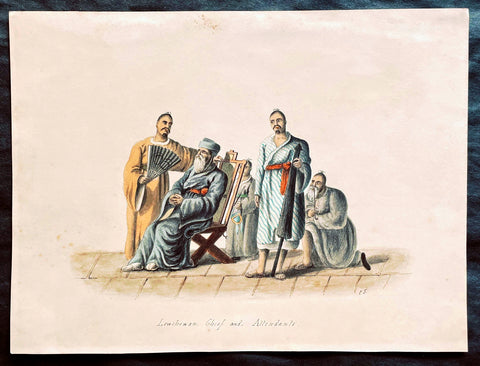
1818 C J McLeod Antique Print of Chief & Attendants of Ryukyu Isles of Japan
- Title : Lewchewan Chief and Attendants
- Ref #: 25103
- Size: 10in x 7 1/2in (255mm x 190mm)
- Date : 1818
- Condition: (A+) Fine Condition
Description:
This fine original antique hand coloured and pen ink outline drawing of a Chief and Attendants of the Japanese Island of Lew Chew or Ryukyu Islands was drawn by an artist signing his name as C.J. from the exquisite hand coloured prints by the surgeon John McLeod, published in the 1818 edition of Voyage of His Majesty's Ship Alceste.
Voyage of His Majesty's Ship Alceste, Along the Coast of Corea to the Island of Lewchew; with an Account of Her Subsequent Shipwreck, London, John Murray, printed by W. Clowes, 1818. The book is of the expedition (February 1816 - August 1817) of the British Naval ships the Alceste and the Lyra under the command of Captain Murray Maxwell to transport the Lord Amherst's Embassy to China and explore the relatively little known East China Sea and the Yellow Sea. The book contained extensive sections on visits to China, Korea, Lew Chew and St Helena. (Ref: M&B; Tooley)
General Description:
Paper thickness and quality: - Heavy & stable
Paper color: - White
Age of map color: - Original
Colors used: -Blue, yellow, red, purple
General color appearance: - Fresh
Paper size: - 10in x 7 1/2in (255mm x 190mm)
Margins: - Min 1/2in (10mm)
Imperfections:
Margins: - None
Plate area: - Very light toning
Verso: - Old glue residue on back margins not affecting the image
1760 Bellin Antique Map of Manchurian Empire, Mongolia, China, Sakhalin Islands
- Title: Carte De la Tartarie Orientale...P.P Jesuits
- Date: 17560
- Condition : (A+) Fine Condition
- Ref: 60927
- Size: 15in x 10in (380mm x 255mm)
Description:
This fine, original copper-plate engraved antique map of old Manchurian Empire - now NE China, Mongolia & Russia stretching from Beijing to the Sakhalin Islands by Jacques Nicolas Bellin in 1760 was published in Antoine François Prevosts 15 volumes of Histoire Generale des Voyages written by Prevost & other authors between 1746-1790.
General Definitions:
Paper thickness and quality: - Heavy and stable
Paper color : - off white
Age of map color: - Early
Colors used: - Green, yellow, red
General color appearance: - Authentic
Paper size: - 15in x 10in (380mm x 255mm)
Plate size: - 13in x 9in (330mm x 230mm)
Margins: - Min 1/2in (6mm)
Imperfections:
Margins: - None
Plate area: - Folds as issued
Verso: - None
Background:
One of Antoine Francois Prevosts monumental undertakings was his history of exploration & discovery in 15 volumes titledHistoire Générale des Voyages written between 1746-1759 and was extended to 20 volumes after his death by various authors.
The 20 volumes cover the early explorations & discoveries on 3 continents: Africa (v. 1-5), Asia (v. 5-11), and America (v. 12-15) with material on the finding of the French, English, Dutch, and Portugese.
A number of notable cartographers and engravers contributed to the copper plate maps and views to the 20 volumes including Nicolas Bellin, Jan Schley, Chedel, Franc Aveline, Fessard, and many others.
The African volumes cover primarily coastal countries of West, Southern, and Eastern Africa, plus the Congo, Madagascar, Arabia and the Persian Gulf areas.
The Asian volumes cover China, Korea, Tibet, Japan, Philippines, and countries bordering the Indian Ocean.
Volume 11 includes Australia and Antarctica.
Volumes 12-15 cover voyages and discoveries in America, including the East Indies, South, Central and North America.
Volumes 16-20 include supplement volumes & tables along with continuation of voyages and discoveries in Russia, Northern Europe, America, Asia & Australia.
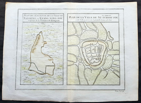
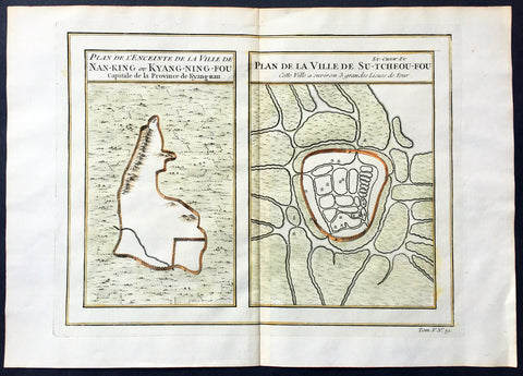
1755 Prevost & Schley Antique Map, View of Nanking or Nanjing in Jiangsu, China
- Title: Plan De L Enceinte de la Ville De Nan-King ou Kyang-Ning-Fou Capitale de la Province de Kyang-nan; Plan de la Ville De Su-Tcheou-Fou
- Date: 1755
- Condition : (A+) Fine Condition
- Ref: 15844
- Size: 13 1/2in x 10in (345mm x 255mm)
Description:
This fine, original copper-plate engraved antique map a birds-eye view of the walled cities of Nanjing & Zhenzhou, in the Jiangsu Province of China by Jakob van Schley in 1755 was published in Antoine François Prevosts 15 volumes of Histoire Generale des Voyageswritten by Prevost & other authors between 1746-1790.
Nanjing formerly romanized as Nanking and Nankin, is the capital of Jiangsu province of the People\'s Republic of China and the second largest city in the East China region, with an administrative area of 6,600 km2 (2,500 sq mi) and a total population of 8,270,500.
Situated in the Yangtze River Delta region, Nanjing has a prominent place in Chinese history and culture, having served as the capital of various Chinese dynasties, kingdoms and republican governments dating from the 3rd century to 1949, and has thus long been a major center of culture, education, research, politics, economy, transport networks and tourism, being the home to one of the world\'s largest inland ports.
Nanjing, one of the nation\'s most important cities for over a thousand years, is recognized as one of the Four Great Ancient Capitals of China. It has been one of the world\'s largest cities, enjoying peace and prosperity despite wars and disasters. Nanjing served as the capital of Eastern Wu, one of the three major states in the Three Kingdoms period (211–280); the Eastern Jin and each of the Southern Dynasties (Liu Song, Southern Qi, Liang and Chen), which successively ruled southern China from 317–589; the Southern Tang, one of the Ten Kingdoms (937–76); the Ming dynasty when, for the first time, all of China was ruled from the city (1368–1421);[15] and the Republic of China (1927–37, 1945–49) prior to its flight to Taiwan during the Chinese Civil War. The city also served as the seat of the rebel Taiping Heavenly Kingdom (1851–64) and the Japanese puppet regime of Wang Jingwei (1940–45) during the Second Sino-Japanese War. It suffered appalling atrocities in both conflicts, including the Nanjing Massacre.
General Definitions:
Paper thickness and quality: - Heavy and stable
Paper color : - off white
Age of map color: - Early
Colors used: - Yellow, green, orange
General color appearance: - Authentic
Paper size: - 13 1/2in x 10in (345mm x 255mm)
Plate size: - 11 1/2in x 9in (295mm x 230mm)
Margins: - Min 1/2in (12mm)
Imperfections:
Margins: - None
Plate area: - None
Verso: - None
Background:
One of Antoine Francois Prevosts monumental undertakings was his history of exploration & discovery in 15 volumes titledHistoire Générale des Voyages written between 1746-1759 and was extended to 20 volumes after his death by various authors.
The 20 volumes cover the early explorations & discoveries on 3 continents: Africa (v. 1-5), Asia (v. 5-11), and America (v. 12-15) with material on the finding of the French, English, Dutch, and Portugese.
A number of notable cartographers and engravers contributed to the copper plate maps and views to the 20 volumes including Nicolas Bellin, Jan Schley, Chedel, Franc Aveline, Fessard, and many others.
The African volumes cover primarily coastal countries of West, Southern, and Eastern Africa, plus the Congo, Madagascar, Arabia and the Persian Gulf areas.
The Asian volumes cover China, Korea, Tibet, Japan, Philippines, and countries bordering the Indian Ocean.
Volume 11 includes Australia and Antarctica.
Volumes 12-15 cover voyages and discoveries in America, including the East Indies, South, Central and North America.
Volumes 16-20 include supplement volumes & tables along with continuation of voyages and discoveries in Russia, Northern Europe, America, Asia & Australia.
Jakob van der Schley aka Jakob van Schley (1715 - 1779) was a Dutch draughtsman and engraver. He studied under Bernard Picart (1673-1733) whose style he subsequently copied. His main interests were engraving portraits and producing illustrations for \\\"La Vie de Marianne\\\" by Pierre Carlet de Chamblain de Marivaux (1688-1763) published in The Hague between 1735 and 1747.
He also engraved the frontispieces for a 15-volume edition of the complete works of Pierre de Brantôme (1540-1614), Oeuvres du seigneur de Brantôme, published in The Hague in 1740.
He is also responsible for most of the plates in the Hague edition of Prévosts Histoire générale des voyages. (Ref: Tooley; M&B)
1747 Tobias Lotter Antique Miniature Map of Asia, Gulf of Carpentaria, Australia
Antique Map
- Title : Asia
- Size: 5 1/2in x 4 1/2in (140mm x 115mm)
- Condition: (A) Very Good Condition
- Date : 1747
- Ref #: 93110
Description:
This original copper plate engraved antique miniature map of Asia by Tobias Lotter was published in the 1747 edition of Atlas Geographicus Portatilis XXIX mappis orbis habitabilis regna exhibens.
General Definitions:
Paper thickness and quality: - Heavy and stable
Paper color : - off white
Age of map color: - Original
Colors used: - Green
General color appearance: - Authentic
Paper size: - 5 1/2in x 4 1/2in (140mm x 115mm)
Plate size: - 5 1/2in x 4 1/2in (140mm x 115mm)
Margins: - Min 1/4in (5mm)
Imperfections:
Margins: - Light age toning
Plate area: - Light age toning
Verso: - Light age toning
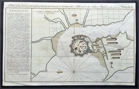
1760 Bowen Antique Map, Plan Fort & Town of Vijaydurg, Maharashtra State, India
- Title : A plan of the town and fortress of Gariah belonging to Angriah the admiral to the Sahou Rajah
- Size: 18 1/4in x 12in (465mm x 305mm)
- Condition: (A+) Fine Condition
- Date : 1760
- Ref #: 21950
Description:
This beautifully hand coloured original copper-plate engraved antique map, a plan of the fort and town of Gheriah, Girye or Gheriya, today called Vijaydurg in Maharashtra state in NW India (485 kms from Mumbai) was published by Emmanual Bowen in 1760.
The map contains many numbered & lettered references to particular areas of interest within the fort, town and surrounds.
General Definitions:
Paper thickness and quality: - Heavy and stable
Paper color : - off white
Age of map color: -
Colors used: -
General color appearance: -
Paper size: - 18 1/4in x 12in (465mm x 305mm)
Plate size: - 18 1/4in x 12in (465mm x 305mm)
Margins: - Min 1/2in (12mm)
Imperfections:
Margins: - Light creasing
Plate area: - Folds as issued
Verso: - Folds as issued
Background:
Vijaydurg is said to be the oldest fort in Sindhudurg coast. In the Pre-Independence era it was also known as Eastern Gibraltar. This is because the fort was almost unconquerable. Under the leadership of Kanhoji Angre, it withstood many naval attacks by the British and the Dutch. Kanhoji Angre died on 4 July 1729 and the Angres control of the fort ended in 1756 after the Peshwa-British Alliance defeated the Angres clan. In 1818 Vijaydurg was completely in the hand of the British Empire.
Kanhoji Angre 1669 – 1729 was a chief of the Maratha Navy in 18th century India. In historical records, he is also known as Conajee Angria or Sarkhel Angré (Sarkhel is a title equal to Admiral of a fleet).
Kanhoji fought against the British, Dutch and Portuguese naval interests on the coasts of India during the 18th century. As a result, his European enemies labeled him a pirate. Despite the attempts of the British and Portuguese to subdue Angre, he remained undefeated until his death.
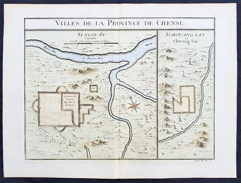
Copy of 1755 Prevost & Schley Antique Map of Xi an & Guanzhong in Shaanxi Province China
- Title: Villes De La Province De Chensi (Si-ngan-fu Capitale / Tchouang Lan ou Chwang lan)
- Date: 1755
- Condition : (A+) Fine Condition
- Ref: 25726
- Size: 15in x 10in (380mm x 255mm)
Description:
This fine, original copper-plate engraved antique map a birds-eye view of the walled city of Xi an & the historical region of the Guanzhong Plain in the Shaanxi Province of Northern China by Jakob van Schley in 1755 was published in Antoine François Prevosts 15 volumes of Histoire Generale des Voyageswritten by Prevost & other authors between 1746-1790.
Shaanxi is a province of the People\'s Republic of China. Officially part of the Northwest China region.
Shaanxi is considered one of the cradles of Chinese civilization. Thirteen feudal dynasties established their capitals in the province during a span of more than 1,100 years, from the Zhou Dynasty to the Tang Dynasty.
The province\'s principal city and current capital, Xi\'an, is one of the four great ancient capitals of China and is the eastern terminus of the Silk Road, which leads to Europe, the Arabian Peninsula and Africa.
Under the Han Dynasty, the Northern Silk Road was expanded to advance exploration and military purposes to the west. This Northern Silk Road is the northernmost of the Silk Roads and is about 2,600 kilometres (1,600 mi) in length. It connected the ancient Chinese capital of Xi an to the west over the Wushao Ling Pass to Wuwei and emerging in Kashgar before linking to ancient Parthia.
Under the Ming dynasty, Shaanxi was incorporated into Gansu but was again separated in the Qing dynasty.
One of the most devastating earthquakes in history occurred near Hua Shan, in south-eastern part of Shaanxi Province on January 23, 1556, killing an estimated 830,000 people (see 1556 Shaanxi earthquake).
Xi an is the capital of Shaanxi province in China. It is a sub-provincial city located in the center of the Guanzhong Plain in Northwestern China. One of the oldest cities in China, Xi\'an is the oldest of the Four Great Ancient Capitals, having held the position under several of the most important dynasties in Chinese history, including Western Zhou, Qin, Western Han, Sui, and Tang. Xi\'an is the starting point of the Silk Road and home to the Terracotta Army of Emperor Qin Shi Huang.
Guanzhong Plain, is a historical region of China corresponding to the lower valley of the Wei River. It is called Guanzhong or \'within the passes\', as opposed to \'Guandong\' or \'east of the pass\', i.e., the North China Plain. The North China Plain is bordered on the west by mountains. The Yellow River cuts through the mountains at the Hangu Pass or Tongguan separating Guanzhong from Guandong.
General Definitions:
Paper thickness and quality: - Heavy and stable
Paper color : - off white
Age of map color: - Early
Colors used: - Yellow, green, orange
General color appearance: - Authentic
Paper size: - 15in x 10in (380mm x 255mm)
Plate size: - 11in x 9in (280mm x 230mm)
Margins: - Min 1/2in (12mm)
Imperfections:
Margins: - None
Plate area: - None
Verso: - None
Background:
One of Antoine Francois Prevosts monumental undertakings was his history of exploration & discovery in 15 volumes titledHistoire Générale des Voyages written between 1746-1759 and was extended to 20 volumes after his death by various authors.
The 20 volumes cover the early explorations & discoveries on 3 continents: Africa (v. 1-5), Asia (v. 5-11), and America (v. 12-15) with material on the finding of the French, English, Dutch, and Portugese.
A number of notable cartographers and engravers contributed to the copper plate maps and views to the 20 volumes including Nicolas Bellin, Jan Schley, Chedel, Franc Aveline, Fessard, and many others.
The African volumes cover primarily coastal countries of West, Southern, and Eastern Africa, plus the Congo, Madagascar, Arabia and the Persian Gulf areas.
The Asian volumes cover China, Korea, Tibet, Japan, Philippines, and countries bordering the Indian Ocean.
Volume 11 includes Australia and Antarctica.
Volumes 12-15 cover voyages and discoveries in America, including the East Indies, South, Central and North America.
Volumes 16-20 include supplement volumes & tables along with continuation of voyages and discoveries in Russia, Northern Europe, America, Asia & Australia.
Jakob van der Schley aka Jakob van Schley (1715 - 1779) was a Dutch draughtsman and engraver. He studied under Bernard Picart (1673-1733) whose style he subsequently copied. His main interests were engraving portraits and producing illustrations for \\\"La Vie de Marianne\\\" by Pierre Carlet de Chamblain de Marivaux (1688-1763) published in The Hague between 1735 and 1747.
He also engraved the frontispieces for a 15-volume edition of the complete works of Pierre de Brantôme (1540-1614), \\\"Oeuvres du seigneur de Brantôme\\\", published in The Hague in 1740.
He is also responsible for most of the plates in the Hague edition of Prévosts Histoire générale des voyages. (Ref: Tooley; M&B)
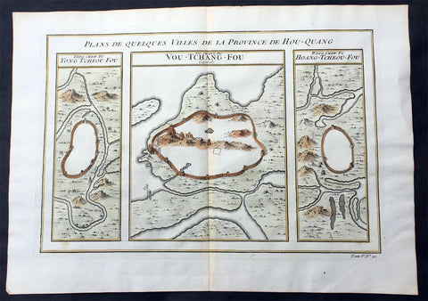
1755 Prevost Antique Map of Wuhan in Hubei, China - Huangzhou & Hoang-Tcheou-Fou
- Title: Plans De Quelques VIlles De La Province de Hou-Quang; Yong Tcheou Fou; Vou-Tchang-Fou; Hoang-Tcheou-Fou
- Date: 1755
- Size: 14in x 10in (355mm x 255mm)
- Ref: 25540
- Condition : (A+) Fine Condition
Description:
This fine, original copper-plate engraved antique map a birds-eye view of three walled cities of the central Chinese province of Hubei, Huangzhou, Wuhan & Hoang-Tcheou-Fou, on the Yangtze River, by Jakob van Schley in 1755 was published in Antoine François Prevosts 15 volumes of Histoire Generale des Voyageswritten by Prevost & other authors between 1746-1790.
Hubei or Hou-Quang is a province located in central China. Hubei means north of the lake, referring to its position north of Dongting Lake. The provincial capital is Wuhan, a major transportation thoroughfare and the political, cultural, and economic hub of Central China.
Hubei is an ancient name associated with the eastern part of the province since the Qin dynasty, after the powerful State of Chu that existed here during the Eastern Zhou dynasty. It borders Henan to the north, Anhui to the east, Jiangxito the southeast, Hunan to the south, Chongqing to the west, and Shaanxi to the northwest. The high-profile Three Gorges Dam is located at Yichang, in the west of the province.
Below is a description of each city & excerts from Jean Baptiste Du Haldes Description Geographique, Historique, Chronologique, Politique, et Physique de l\'Empire de la Chine published in 1735 of each city.
1. Yong tcheou fou - Huangzhou District is an urban district of Huanggang, Hubei, China. Huangzhou was previously a separate city which administered a prefecture in its own right.
The Seventh City, Yong tcheou fou.
This city, the most Southern of the Province, is surrounded with Mountains, whose Verdure renders a very agreeable Prospect, and is situate on the Banks of a River, which not far from thence runs into the Siang kiang. The Water of this River is so clear and limpid, that in the deepest Places you may count the Stones and Flints that are at the Bottom : There grows plenty of Bamboos in some part of this District and in others the Lien hoa, with yellow Flowers : There are eight Cities in its Jurisdiction, one of the Second Order, and seven of the Third.
Besides these principal Cities, there are two of the Second Order, which are not subject to any Fou, or City of the First Order, and have each a Jurisdiction over other Cities : The first is called Tsin tcheou, and is on the Frontiers of the Province of Koei tcheou, it has in its District three Cities of the Third Order : The second is called Tching Tcheou, a very large and populous City, built between two Rivers ; five Cities of the Third Order are subject to it, all situated on the Frontiers of the City of Quang Tong : Tho\' this City is full of Mountains, yet they do not hinder its Cultivation.
2. Vou-Tchang-Fou - Wuhan - is the capital of Hubei province, China, and is the most populous city in Central China. It lies in the eastern Jianghan Plain at the intersection of the middle reaches of the Yangtze and Han rivers.
With a 3,500-year-long history, Wuhan is one of the most ancient and civilized metropolitan cities in China. During the Han dynasty, Hanyang became a fairly busy port. In the winter of 208/9, one of the most famous battles in Chinese history and a central event in the Romance of the Three Kingdoms—the Battle of Red Cliffs—took place in the vicinity of the cliffs near Wuhan. Around that time, walls were built to protect Hanyang (AD 206) and Wuchang (AD 223). The latter event marks the foundation of Wuhan. In AD 223, the Yellow Crane Tower was constructed on the Wuchang side of the Yangtze River. Cui Hao, a celebrated poet of the Tang dynasty, visited the building in the early 8th century; his poem made it the most celebrated building in southern China. The city has long been renowned as a center for the arts (especially poetry) and for intellectual studies. Under the Mongol rulers (Yuan dynasty), Wuchang was promoted to the status of provincial capital; by the dawn of the 18th century, Hankou had become one of China\'s top four most important towns of trade.
The First City, and Capital of the Province, Vou chang fou
This is both the Capital of the Province, and the North Part of it, called Hou pe, where resides the Tsong tou of both Parts of this Province , it has under its particular Jurisdiction one City of the Second , Order, and nine of the Third.
Vou chang is almost in the Centre of the Empire, and situate in a Place which may most easily communicate with the rest of the Provinces. This City joined to Han yang, from which it is separated only by the Breadth of the River Yang tse kiang, and the little River Han forms a Place the best Peopled, and of the greatest Resort in China ; one may compare the Extent of this City to Paris, and Han Tang to Lyons, or Rouen: Add to this, an incredible Number of Barks of all Sizes, which lie some in one River, some in the other, for the length of French Leagues, to the number of eight or ten thousand Vessels, among which there are hundreds every way as large as the most part of those that lie at Nantz. Certainly, if one considers nothing else but this Forest of Masts which are upon the fine River Yang tse Kiang, about a League broad in this Place, tho\' it is 150 Leagues from the Sea, and deep enough for the greatest Vessels, it will justly raise our Wonder; but when one gains the Top of any Ascent, and discovers such a vast Extent of Ground covered with Houses, we should scarcely believe our won eyes, or at least must think it the finest Sight in the World.
One may judge, by the Number of Rivers and Lakes with which this Province is watered, how fruitful it is, and how easily the Trading with the rest of the Empire, by means of the great River Yang tse Kiang, must needs inrich it.
What is farther worthy of Observation, is the fine Cristal which is dug out of the Mountains, the plentiful Crops of the best Tea, and the extraordinary Demand for Bamboo Paper, which is manufactured here.
3. Hoang tcheou fou - The Eighth City.
The Situation of this City is on the Banks of the River Yang tse kiang ; its small distance from the Capital, and the Number of Lakes which surround it, render it a most agreeable Place for Habitation ; it is extremely well peopled, and for Trade gives place to few other Cities. There come there daily a surprising Number of Barks, loaded with all forts of Merchandize.
The whole District is admirably well cultivated, I and agreeably diversified by the Rivers and Brooks that Water it, as well as by the Mountains which bound it on the North ; some of these Mountains are covered with Trees, which are of great service to the Inhabitants ; there are also Fountains, which have the Property of giving Tea a delicious Taste.
There are taken in the River near the City great Numbers of Tortoises, some great, some small, which the Nobility keep in their Gardens for Diversion, and also at their Pleasure-Houses. They make excellent Arrack, which is very strong, and takes Fire in an Instant, and hath no bad Smell ; there are also very good Chestnuts, and very large. Its District: contains nine Cities, one of the Second Order, and eight of the Third. The South Part of the Province of Hou quang.
General Definitions:
Paper thickness and quality: - Heavy and stable
Paper color : - off white
Age of map color: - Early
Colors used: - Yellow, green, orange
General color appearance: - Authentic
Paper size: - 14in x 10in (355mm x 255mm)
Plate size: - 12in x 8in (305mm x 205mm)
Margins: - Min 1/2in (12mm)
Imperfections:
Margins: - None
Plate area: - None
Verso: - None
Background:
One of Antoine Francois Prevosts monumental undertakings was his history of exploration & discovery in 15 volumes titledHistoire Générale des Voyages written between 1746-1759 and was extended to 20 volumes after his death by various authors.
The 20 volumes cover the early explorations & discoveries on 3 continents: Africa (v. 1-5), Asia (v. 5-11), and America (v. 12-15) with material on the finding of the French, English, Dutch, and Portugese.
A number of notable cartographers and engravers contributed to the copper plate maps and views to the 20 volumes including Nicolas Bellin, Jan Schley, Chedel, Franc Aveline, Fessard, and many others.
The African volumes cover primarily coastal countries of West, Southern, and Eastern Africa, plus the Congo, Madagascar, Arabia and the Persian Gulf areas.
The Asian volumes cover China, Korea, Tibet, Japan, Philippines, and countries bordering the Indian Ocean.
Volume 11 includes Australia and Antarctica.
Volumes 12-15 cover voyages and discoveries in America, including the East Indies, South, Central and North America.
Volumes 16-20 include supplement volumes & tables along with continuation of voyages and discoveries in Russia, Northern Europe, America, Asia & Australia.
Jakob van der Schley aka Jakob van Schley (1715 - 1779) was a Dutch draughtsman and engraver. He studied under Bernard Picart (1673-1733) whose style he subsequently copied. His main interests were engraving portraits and producing illustrations for \\\"La Vie de Marianne\\\" by Pierre Carlet de Chamblain de Marivaux (1688-1763) published in The Hague between 1735 and 1747.
He also engraved the frontispieces for a 15-volume edition of the complete works of Pierre de Brantôme (1540-1614), \\\"Oeuvres du seigneur de Brantôme\\\", published in The Hague in 1740.
He is also responsible for most of the plates in the Hague edition of Prévosts Histoire générale des voyages. (Ref: Tooley; M&B)
1755 Prevost & Schley Antique Map, View of Nanking or Nanjing in Jiangsu, China
- Title: Plan De L Enceinte de la Ville De Nan-King ou Kyang-Ning-Fou Capitale de la Province de Kyang-nan; Plan de la Ville De Su-Tcheou-Fou
- Date: 1755
- Size: 13 1/2in x 10in (345mm x 255mm)
- Ref: 25695
- Condition : (A+) Fine Condition
Description:
This fine, original copper-plate engraved antique map a birds-eye view of the walled cities of Nanjing & Zhenzhou, in the Jiangsu Province of China by Jakob van Schley in 1755 was published in Antoine François Prevosts 15 volumes of Histoire Generale des Voyageswritten by Prevost & other authors between 1746-1790.
Nanjing formerly romanized as Nanking and Nankin, is the capital of Jiangsu province of the People\'s Republic of China and the second largest city in the East China region, with an administrative area of 6,600 km2 (2,500 sq mi) and a total population of 8,270,500.
Situated in the Yangtze River Delta region, Nanjing has a prominent place in Chinese history and culture, having served as the capital of various Chinese dynasties, kingdoms and republican governments dating from the 3rd century to 1949, and has thus long been a major center of culture, education, research, politics, economy, transport networks and tourism, being the home to one of the world\'s largest inland ports.
Nanjing, one of the nation\'s most important cities for over a thousand years, is recognized as one of the Four Great Ancient Capitals of China. It has been one of the world\'s largest cities, enjoying peace and prosperity despite wars and disasters. Nanjing served as the capital of Eastern Wu, one of the three major states in the Three Kingdoms period (211–280); the Eastern Jin and each of the Southern Dynasties (Liu Song, Southern Qi, Liang and Chen), which successively ruled southern China from 317–589; the Southern Tang, one of the Ten Kingdoms (937–76); the Ming dynasty when, for the first time, all of China was ruled from the city (1368–1421);[15] and the Republic of China (1927–37, 1945–49) prior to its flight to Taiwan during the Chinese Civil War. The city also served as the seat of the rebel Taiping Heavenly Kingdom (1851–64) and the Japanese puppet regime of Wang Jingwei (1940–45) during the Second Sino-Japanese War. It suffered appalling atrocities in both conflicts, including the Nanjing Massacre.
General Definitions:
Paper thickness and quality: - Heavy and stable
Paper color : - off white
Age of map color: - Early
Colors used: - Yellow, green, orange
General color appearance: - Authentic
Paper size: - 13 1/2in x 10in (345mm x 255mm)
Plate size: - 11 1/2in x 9in (295mm x 230mm)
Margins: - Min 1/2in (12mm)
Imperfections:
Margins: - None
Plate area: - None
Verso: - None
Background:
One of Antoine Francois Prevosts monumental undertakings was his history of exploration & discovery in 15 volumes titledHistoire Générale des Voyages written between 1746-1759 and was extended to 20 volumes after his death by various authors.
The 20 volumes cover the early explorations & discoveries on 3 continents: Africa (v. 1-5), Asia (v. 5-11), and America (v. 12-15) with material on the finding of the French, English, Dutch, and Portugese.
A number of notable cartographers and engravers contributed to the copper plate maps and views to the 20 volumes including Nicolas Bellin, Jan Schley, Chedel, Franc Aveline, Fessard, and many others.
The African volumes cover primarily coastal countries of West, Southern, and Eastern Africa, plus the Congo, Madagascar, Arabia and the Persian Gulf areas.
The Asian volumes cover China, Korea, Tibet, Japan, Philippines, and countries bordering the Indian Ocean.
Volume 11 includes Australia and Antarctica.
Volumes 12-15 cover voyages and discoveries in America, including the East Indies, South, Central and North America.
Volumes 16-20 include supplement volumes & tables along with continuation of voyages and discoveries in Russia, Northern Europe, America, Asia & Australia.
Jakob van der Schley aka Jakob van Schley (1715 - 1779) was a Dutch draughtsman and engraver. He studied under Bernard Picart (1673-1733) whose style he subsequently copied. His main interests were engraving portraits and producing illustrations for \\\"La Vie de Marianne\\\" by Pierre Carlet de Chamblain de Marivaux (1688-1763) published in The Hague between 1735 and 1747.
He also engraved the frontispieces for a 15-volume edition of the complete works of Pierre de Brantôme (1540-1614), \\\"Oeuvres du seigneur de Brantôme\\\", published in The Hague in 1740.
He is also responsible for most of the plates in the Hague edition of Prévosts Histoire générale des voyages. (Ref: Tooley; M&B)
1755 Prevost Antique Map Lanzhou & Zhangye in Gansu - Guiyang in Guizhou, China
- Title: Lan-Tcheou ou Lan-Chew dans la Province Chensi…/Can Tcheou ou Kan-Chew dans la Province de Chensi…/Tchin-Ywen-Fou ou Chin-Ywen-Fu dans la Province de Koei-Tcheou ou Quey-Chew
- Date: 1755
- Size: 13 1/2in x 10in (345mm x 255mm)
- Ref: 25725
- Condition : (A+) Fine Condition
Description:
This fine, original copper-plate engraved antique map a birds-eye view of the walled cities of Lanzhou & Zhangye in the Gansu province of Northern China and the city of Guiyang in the Guizhou province of Southwest China by Jakob van Schley in 1755 was published in Antoine François Prevosts 15 volumes of Histoire Generale des Voyageswritten by Prevost & other authors between 1746-1790.
Lanzhou is the capital and largest city of Gansu Province in Northwest China. The prefecture-level city, located on the banks of the Yellow River
Originally in the territory of the Western Qiang peoples, Lanzhou became part of the territory of the State of Qin in the 6th century BC.
In 81 BC, under the Han dynasty (206 BC–220 AD), it was taken from the Huns\' Huandi Chanyu and made the seat of Jincheng commandery (jùn), and later of the Jincheng county (xian), later renamed Yunwu. The city used to be called the Golden City, and since at least the first millennium BC it was a major link on the ancient Northern Silk Road, and also an important historic Yellow River crossing site. To protect the city, the Great Wall of China was extended as far as Yumen. Parts of the Great Wall still exist within the built-up area.
After the fall of the Han dynasty, Lanzhou became the capital of a succession of tribal states. In the 4th century it was briefly the capital of the independent state of Liang. The Northern Wei dynasty (386–534) reestablished Jincheng commandery, renaming the county Zicheng. Mixed with different cultural heritages, the area at present-day Gansu province, from the 5th to the 11th century, became a center for Buddhist study. Under the Sui Dynasty(581–618) the city became the seat of Lanzhou prefecture for the first time, retaining this name under the Tang dynasty (618–907). In 763 the area was overrun by the Tibetan Empire and in 843 was conquered by the Tang. Later it fell into the hands of the Western Xia dynasty (which flourished in Qinghai from the 11th to 13th century) and was subsequently absorbed by the Song dynasty (960–1126) in 1041. The name Lanzhou was reestablished, and the county renamed Lanzhuan.
After 1127 it fell into the hands of the Jin dynasty, and after 1235 it came into the possession of the Mongol Empire.
Under the Ming dynasty (1368–1644) the prefecture was demoted to a county and placed under the administration of Lintao superior prefecture, but in 1477 Lanzhou was reestablished as a political unit.
The city acquired its current name in 1656, during the Qing dynasty. When Gansu was made a separate province in 1666, Lanzhou became its capital.
In 1739 the seat of Lintao was transferred to Lanzhou, which was later made a superior prefecture called Lanzhou.
Lanzhou was badly damaged during the Dungan revolt in 1864–1875. In the 1920s and 1930s it became a center of Sovietinfluence in northwestern China. During the Second Sino-Japanese War (1937–1945) Lanzhou, linked with Xi\'an by highway in 1935, became the terminus of the 3,200 km (2,000 mi) Chinese–Soviet highway, used as a route for Soviet supplies destined for the Xi\'an area. This highway remained the primary traffic route of northwestern China until the completion of the railway from Lanzhou to Ürümqi, Xinjiang. During the war Lanzhou was heavily bombed by the Japanese.
During the 1937 Japanese invasion of China, the Guominjun Muslim Generals Ma Hongkui and Ma Bufang protected Lanzhou with their cavalry troops, putting up such resistance that the Japanese never captured Lanzhou. The city is the seat of a currently vacant Roman Catholic diocese and was previously the center of a vicariate apostolic(Vicariate Apostolic of Northern Kan-Su)
Zhangye , formerly romanized as Changyeh or known as Kanchow, is a prefecture-level city in central Gansu Province in the People\'s Republic of China. It borders Inner Mongolia on the north and Qinghai on the south. Its central district is Ganzhou, formerly a city of the Western Xia and one of the most important outposts of western China.
Zhangye lies in the center of the Hexi Corridor. The area is on the frontier of China Proper, protecting it from the nomads of the northwest and permitting its armies access to the Tarim Basin. During the Han Dynasty, Chinese armies were often engaged against the Xiongnuin this area. It was also an important outpost on the Silk Road.[citation needed]Before being overrun by the Mongols, it was dominated by the Western Xia, and before by the Uyghurs from at least the early 10th century. Its relation to the larger Uyghur state of Qocho is obscure, but it may have been a vassal.
The Mongol Emperor Kublai Khan is said to have been born in the Dafo Temple, Zhangye, now the site of the longest wooden reclining Buddha in China.[citation needed] Marco Polo\'s journal states that he spent a year in the town during his journey to China.
The pine forests of the Babao Mountains (part of the Qilian range) formerly regulated the flow of the Ruo or Hei Shui, Ganzhou\'s primary river. By ensuring that the meltwaters lasted throughout the summer, they avoided both early flood and later drought for the valley\'s farmers. Despite reports that they should thus be protected in perpetuity, an imperial official in charge of erecting the poles for China\'s telegraph network ordered them cleared in the 1880s. Almost immediately, the region became prone to flooding in the summer and draught in the autumn, arousing local resentment.
Christian missionaries arrived in 1879, after Suzhou was found to be too hostile for their settlement.
Guiyang is the capital of Guizhou province of Southwest China. It is located in the center of the province, situated on the east of the Yunnan–Guizhou Plateau, and on the north bank of the Nanming River, a branch of the Wu River.
Guiyang was a 7th-century military outpost under the Sui and Tang, when the area around it was known as Juzhou. It grew into a city named Shunyuan under the Mongolian Yuandynasty sometime between their 1279 southwestern campaignsand 1283. By the time Guizhoubecame a full province in 1413, its capital at Guiyang was also known as Guizhou. It became a prefectural seat under the Mingand Qing. Guiyang grew rapidly during the development of the southwest that occurred after the Japanese invasion of China during World War II.
General Definitions:
Paper thickness and quality: - Heavy and stable
Paper color : - off white
Age of map color: - Early
Colors used: - Yellow, green, orange
General color appearance: - Authentic
Paper size: - 13 1/2in x 10in (345mm x 255mm)
Plate size: - 11 1/2in x 8 1/2in (295mm x 215mm)
Margins: - Min 1/2in (12mm)
Imperfections:
Margins: - None
Plate area: - None
Verso: - None
Background:
One of Antoine Francois Prevosts monumental undertakings was his history of exploration & discovery in 15 volumes titledHistoire Générale des Voyages written between 1746-1759 and was extended to 20 volumes after his death by various authors.
The 20 volumes cover the early explorations & discoveries on 3 continents: Africa (v. 1-5), Asia (v. 5-11), and America (v. 12-15) with material on the finding of the French, English, Dutch, and Portugese.
A number of notable cartographers and engravers contributed to the copper plate maps and views to the 20 volumes including Nicolas Bellin, Jan Schley, Chedel, Franc Aveline, Fessard, and many others.
The African volumes cover primarily coastal countries of West, Southern, and Eastern Africa, plus the Congo, Madagascar, Arabia and the Persian Gulf areas.
The Asian volumes cover China, Korea, Tibet, Japan, Philippines, and countries bordering the Indian Ocean.
Volume 11 includes Australia and Antarctica.
Volumes 12-15 cover voyages and discoveries in America, including the East Indies, South, Central and North America.
Volumes 16-20 include supplement volumes & tables along with continuation of voyages and discoveries in Russia, Northern Europe, America, Asia & Australia.
Jakob van der Schley aka Jakob van Schley (1715 - 1779) was a Dutch draughtsman and engraver. He studied under Bernard Picart (1673-1733) whose style he subsequently copied. His main interests were engraving portraits and producing illustrations for \\\"La Vie de Marianne\\\" by Pierre Carlet de Chamblain de Marivaux (1688-1763) published in The Hague between 1735 and 1747.
He also engraved the frontispieces for a 15-volume edition of the complete works of Pierre de Brantôme (1540-1614), \\\"Oeuvres du seigneur de Brantôme\\\", published in The Hague in 1740.
He is also responsible for most of the plates in the Hague edition of Prévosts Histoire générale des voyages. (Ref: Tooley; M&B)
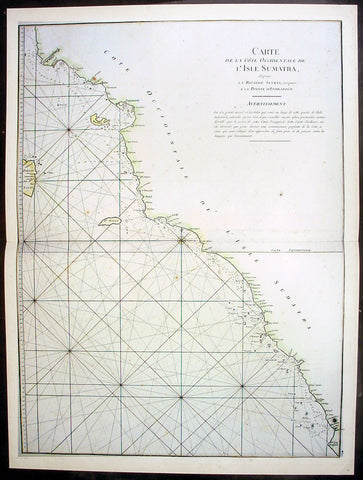
1745 Mannevillette Large Antique Map Sumatra Coastline of Indonesia
- Title : Carte De La Cote Occidentale De L Isle Sumatra
- Ref #: 33662
- Size: 27 1/2in x 20 1/2in (700mm x 520mm)
- Date : 1745
- Condition: (A+) Fine Condition
Description:
This large hand coloured original antique map a sea chart of the west coast of Sumatra, Indonesia - centering on the city of Padang stretching south to Indrapura and north to Aceh - was published in the enlarged version of Le Neptune Oriental by Jean Baptiste De Mannevillette in 1745. (Ref: Tooley; M&B)
General Description:
Paper thickness and quality: - Heavy and stable
Paper color: - off white
Age of map color: - Early
Colors used: - Yellow, green, red, brown.
General color appearance: - Authentic and fresh
Paper size: - 27 1/2in x 20 1/2in (700mm x 520mm)
Plate size: - 26 1/2n x 20in (675mm x 510mm)
Margins: - Min ½in (12mm)
Imperfections:
Margins: - None
Plate area: - None
Verso: - None

1745 Mannevillette Large Antique Map of Sumatra Coastline of Indonesia
- Title : Carte De La Cote Occidentale De L Isle Sumatra
- Ref #: 33661
- Size: 27 1/2in x 20 1/2in (700mm x 520mm)
- Date : 1745
- Condition: (A+) Fine Condition
Description:
This large hand coloured original antique map a coastal sea chart of the south west coast of Sumatra, Indonesia - centering on the city of Bengkulu stretching south to Tanjungkarang-Telukbetung and north to Mukomuko - was published in the enlarged version of Le Neptune Oriental by Jean Baptiste De Mannevillette in 1745.
Born in Le Havre of a seafaring family d`Apres de Mannevillette had a long and distinguished career as a navigator and one of the first French hydrographers. After studying mathematics in Paris, he gained early experience of the sea in a voyage at the age of nineteen to the Caribbean. During many subsequent voyages he assembled a collection of material for a projected hydrographical atlas which, with the support of the Academie des Sciences, was published in Paris in 1745 under the title Le Neptune Oriental. In spite of the popularity of the first issue, it failed to satisfy the author and he spent nearly thirty years, often with the assistance of his friend, Alexander Dalrymple, the English hydrographer, in the preparation of a revised and enlarged edition which eventually was issued in 1775.(Ref: Tooley; M&B)
General Description:
Paper thickness and quality: - Heavy and stable
Paper color: - off white
Age of map color: - Early
Colors used: - Yellow, green, red, brown.
General color appearance: - Authentic and fresh
Paper size: - 27 1/2in x 20 1/2in (700mm x 520mm)
Plate size: - 26 1/2n x 20in (675mm x 510mm)
Margins: - Min ½in (12mm)
Imperfections:
Margins: - Light age toning
Plate area: - None
Verso: - None
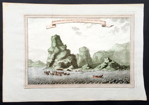
1750 Prevost & Nieuhoff Antique Print View of the Zoushan Archip. Zhejiang China
- Title: Montagne Des Cinq Tetes De Cheval Pres De Chau Cheu Fu
- Date: 1747
- Condition : (A+) Fine Condition
- Ref: 15850
- Size: 14in x 10in (355mm x 255mm)
Description:
This fine original copper-plate engraved antique print a view of the Islands of Zoushan in the in north-eastern Zhejiang Province of eastern China was engraved by Jakob van Schley - after Johannes Nieuhoff - and was published in Antoine François Prevosts 15 volumes of Histoire Generale des Voyageswritten by Prevost & other authors between 1746-1790.
Johannes Nieuhoff (1618-72) was a Dutch diplomat and adventurer, who was perhaps the most widely traveled individual of the seventeenth-century. His experiences included important expeditions to various locations in Brazil, Africa, India, Indonesia, and China. From 1655-57, Nieuhoff made an epic 2,400 trek through China, from Canton to Beijing.
During his Chinese expedition he made numerous drawings of the sites he encountered, including the port town of Chau Cheu Fu in the southern province of Guandong, which was the basis for the present print. Nieuhoff’s important written account, along with engravings of his drawings was first published as Legatio batavica ad magnum Tartariæ chamum Sungteium, modernum Sinæ imperatorem (Amsterdam, 1668). His illustrations proved to be highly influential, as they did much to spawn the genre of chinoiserie in European art and design.
General Definitions:
Paper thickness and quality: - Heavy and stable
Paper color : - off white
Age of map color: - Ewarly
Colors used: - Green, yellow, pink
General color appearance: - Authentic
Paper size: - 14in x 10in (365mm x 250mm)
Plate size: - 12in x 8in (305mm x 205mm)
Margins: - Min 1/2in (12mm)
Imperfections:
Margins: - None
Plate area: - Folds as issued
Verso: - None
Background:
One of Antoine Francois Prevosts monumental undertakings was his history of exploration & discovery in 15 volumes titledHistoire Générale des Voyages written between 1746-1759 and was extended to 20 volumes after his death by various authors.
The 20 volumes cover the early explorations & discoveries on 3 continents: Africa (v. 1-5), Asia (v. 5-11), and America (v. 12-15) with material on the finding of the French, English, Dutch, and Portugese.
A number of notable cartographers and engravers contributed to the copper plate maps and views to the 20 volumes including Nicolas Bellin, Jan Schley, Chedel, Franc Aveline, Fessard, and many others.
The African volumes cover primarily coastal countries of West, Southern, and Eastern Africa, plus the Congo, Madagascar, Arabia and the Persian Gulf areas.
The Asian volumes cover China, Korea, Tibet, Japan, Philippines, and countries bordering the Indian Ocean.
Volume 11 includes Australia and Antarctica.
Volumes 12-15 cover voyages and discoveries in America, including the East Indies, South, Central and North America.
Volumes 16-20 include supplement volumes & tables along with continuation of voyages and discoveries in Russia, Northern Europe, America, Asia & Australia.
Jakob van der Schley aka Jakob van Schley (1715 - 1779) was a Dutch draughtsman and engraver. He studied under Bernard Picart (1673-1733) whose style he subsequently copied. His main interests were engraving portraits and producing illustrations for \"La Vie de Marianne\" by Pierre Carlet de Chamblain de Marivaux (1688-1763) published in The Hague between 1735 and 1747.
He also engraved the frontispieces for a 15-volume edition of the complete works of Pierre de Brantôme (1540-1614), \"Oeuvres du seigneur de Brantôme\", published in The Hague in 1740.
He is also responsible for most of the plates in the Hague edition of Prévost\'s Histoire générale des voyages. (Ref: Tooley; M&B)

1755 Prevost & Schley Antique City Map of Hangzhou in Zhejiang Province, China
- Title: Plan De la Ville de Hang-Tcheou-Fou ou Hang chew Fu Capitale de la Province de Che-Kiang
- Date: 1755
- Condition : (A+) Fine Condition
- Ref: 25812
- Size: 15in x 10in (385mm x 255mm)
Description:
This fine, original copper-plate engraved antique map a plan of the city of Hangzhou (here Hang Chew Fu) in the Zhejiang province of China by Jakob van Schley in 1755 - after Jean-Baptiste Du Halde - was published in Antoine François Prevosts 15 volumes of Histoire Generale des Voyages written by Prevost & other authors between 1746-1789.
Jean-Baptiste Du Halde, born in Paris on 1 February 1674 and died 18 August 1743, was a French Jesuit historian specializing in China. He did not travel to China, but collected seventeen Jesuit missionaries\\\' reports and provided an encyclopedic survey of the history, culture and society of China and Chinese Tartary, that is, Manchuria.
General Definitions:
Paper thickness and quality: - Heavy and stable
Paper color : - off white
Age of map color: - Original
Colors used: - Yellow, green, blue, pink
General color appearance: - Authentic
Paper size: - 10in x 7 1/2in (255mm x 190mm)
Plate size: - 10in x 7 1/2in (255mm x 190mm)
Margins: - Min 1/2in (12mm)
Imperfections:
Margins: - None
Plate area: - None
Verso: - None
Background:
Hangzhou romanization Hang-chou, conventional Hangchow, city and capital of Zhejiang sheng (province), China. The city is located in the northern part of the province on the north bank of the Qiantang River estuary at the head of Hangzhou Bay. It has water communications with the interior of Zhejiang to the south, is the southern terminus of the Grand Canal, and is linked to the network of canals and waterways that cover the Yangtze River (Chang Jiang) delta area to the north. The city stands at the eastern foot of a scenic range of hills, the Tianmu (“Eye of Heaven”) Mountains, and on the shore of the famous Xi (West) Lake, celebrated in poetry and paintings for its beauty and a favourite imperial retreat.
The county of Qiantang was first established at this site under the Qin dynasty (221–207 BCE) but did not start developing until the 4th and 5th centuries CE, when the Yangtze River delta area began to be settled. A prefecture named Hangzhou was created there in 589, during the Sui dynasty (581–618), which is the source of the city’s name. It became a major local centre with the completion of the Jiangnan Canal (then the southern section of the Grand Canal) in 609. During the Ten Kingdoms (Shiguo) period (907–960), Hangzhou was the capital of the state of Wu-Yue. In the later Song period (960–1279), northern China fell to the Jin (Juchen) dynasty (1115–1234); from 1127 the Song rulers were confined to southern China, and they made Hangzhou (then known as Lin’an) their capital. A centre of commerce, it was visited in the late 13th century by the Venetian traveler Marco Polo, who called it Kinsai, or Quinsay; it then had an estimated population of 1 million to 1.5 million.
Although it never again reached the peak of importance that it had achieved as capital of the Nan (Southern) Song, Hangzhou remained important. Under the Ming (1368–1644) and Qing (1644–1911/12) dynasties, it was a superior prefecture, in addition to being the provincial capital of Zhejiang. It became immensely wealthy, being at the centre of a fertile rice-growing area as well as being the site of the most important silk industries in China. It also was famous as a centre of culture, producing numerous writers, painters, and poets. Its importance as a port dwindled, however, as Hangzhou Bay gradually silted up and as its outport, Ganpu, became useless. From the 14th century its trade gradually shifted to Ningbo to the southeast on the southern shore of the bay and, in the 19th century, to the new city of Shanghai, some 100 miles (160 km) to the northeast at the mouth of the Yangtze. In 1861, during the Taiping Rebellion (1850–64), the city fell to the rebels and suffered severe damage.
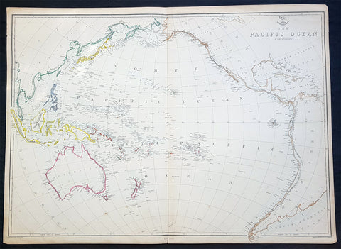
1860 Edward Weller Large Antique Map of The Pacific - Australia to California
Antique Map
- Title : The Pacific Ocean
- Ref #: 70063
- Size: 26 1/2in x 19in (675mm x 490mm)
- Date : 1860
- Condition: (A+) Fine Condition
Description:
This original steel plate engraved hand coloured antique map by Edward Weller was published in the 1860 edition of The Dispatch Atlas; a compilation of maps Weller had already published in The Weekly Dispatch.
General Definitions:
Paper thickness and quality: - Heavy and stable
Paper color : - off white
Age of map color: - Original
Colors used: - Yellow, Green, pink
General color appearance: - Authentic
Paper size: - 26 1/2in x 19in (675mm x 490mm)
Plate size: - 26 1/2in x 19in (675mm x 490mm)
Margins: - Min 1/2in (10mm)
Imperfections:
Margins: - None
Plate area: - None
Verso: - None
Weller, Edward 1819 – 1884
Weller was a London-based engraver, cartographer and publisher, working from offices in Red Lion Square and later, Bloomsbury. Amongst his considerable portfolio were various atlases, many of which focussed on the educational publishing market. Having established his credentials as an engraver of finely detailed works, he sold maps to be published in a number of regular magazines and pamphlets, perhaps the best known being The Dispatch Atlas; a compilation of maps Weller had already published in The Weekly Dispatch. Although Weller usually engraved the maps himself, he did work in partnership with others, particularly John Dower for this 1858 and 1863 volume. Weller also published The Crown Atlas in 1871.
The Dispatch Atlas featured well over one hundred superbly detailed steel plate engraved maps, usually with simplistic, single colour outline hand colouring, and a distinctive header style. Most English counties featured, some of which were divided onto separate sheets, affording space to engrave in even greater detail. The maps of North and South Devonshire for example include such details as individual property names, as do those of the Northern and Southern parts of Hampshire.
After Wellers death in 1884, many of these astonishingly detailed plates were sold on to other map makers, including George Washington Bacon, who, whilst retaining the level of detail, expanded the printing area of each plate, adding more precise and varied hand colouring in keeping with the final decades of the century.
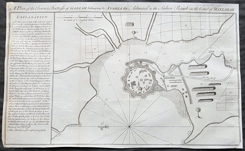
1760 Bowen Antique Map, Plan Fort & Town of Vijaydurg, Maharashtra State, India
- Title : A plan of the town and fortress of Gariah belonging to Angriah the admiral to the Sahou Rajah
- Size: 18 1/4in x 12in (465mm x 305mm)
- Condition: (A+) Fine Condition
- Date : 1760
- Ref #: 40986-2
Description:
This original copper-plate engraved antique map, a plan of the fort and town of Gheriah, Girye or Gheriya, today called Vijaydurg in Maharashtra state in NW India (485 kms from Mumbai) was published by Emmanual Bowen in 1760.
The map contains many numbered & lettered references to particular areas of interest within the fort, town and surrounds.
General Definitions:
Paper thickness and quality: - Heavy and stable
Paper color : - off white
Age of map color: -
Colors used: -
General color appearance: -
Paper size: - 18 1/4in x 12in (465mm x 305mm)
Plate size: - 18 1/4in x 12in (465mm x 305mm)
Margins: - Min 1/2in (12mm)
Imperfections:
Margins: - Light creasing
Plate area: - Folds as issued
Verso: - Folds as issued
Background:
Vijaydurg is said to be the oldest fort in Sindhudurg coast. In the Pre-Independence era it was also known as Eastern Gibraltar. This is because the fort was almost unconquerable. Under the leadership of Kanhoji Angre, it withstood many naval attacks by the British and the Dutch. Kanhoji Angre died on 4 July 1729 and the Angres control of the fort ended in 1756 after the Peshwa-British Alliance defeated the Angres clan. In 1818 Vijaydurg was completely in the hand of the British Empire.
Kanhoji Angre 1669 – 1729 was a chief of the Maratha Navy in 18th century India. In historical records, he is also known as Conajee Angria or Sarkhel Angré (Sarkhel is a title equal to Admiral of a fleet).
Kanhoji fought against the British, Dutch and Portuguese naval interests on the coasts of India during the 18th century. As a result, his European enemies labeled him a pirate. Despite the attempts of the British and Portuguese to subdue Angre, he remained undefeated until his death.
1750 Prevost & Nieuhoff Antique Print View of the Zoushan Archip. Zhejiang China
- Title: Montagne Des Cinq Tetes De Cheval Pres De Chau Cheu Fu
- Date: 1747
- Condition : (A+) Fine Condition
- Ref: 34138
- Size: 14in x 10in (355mm x 255mm)
Description:
This fine original copper-plate engraved antique print a view of the Islands of Zoushan in the in north-eastern Zhejiang Province of eastern China was engraved by Jakob van Schley - after Johannes Nieuhoff - and was published in Antoine François Prevosts 15 volumes of Histoire Generale des Voyageswritten by Prevost & other authors between 1746-1790.
Johannes Nieuhoff (1618-72) was a Dutch diplomat and adventurer, who was perhaps the most widely traveled individual of the seventeenth-century. His experiences included important expeditions to various locations in Brazil, Africa, India, Indonesia, and China. From 1655-57, Nieuhoff made an epic 2,400 trek through China, from Canton to Beijing.
During his Chinese expedition he made numerous drawings of the sites he encountered, including the port town of Chau Cheu Fu in the southern province of Guandong, which was the basis for the present print. Nieuhoff’s important written account, along with engravings of his drawings was first published as Legatio batavica ad magnum Tartariæ chamum Sungteium, modernum Sinæ imperatorem (Amsterdam, 1668). His illustrations proved to be highly influential, as they did much to spawn the genre of chinoiserie in European art and design.
General Definitions:
Paper thickness and quality: - Heavy and stable
Paper color : - off white
Age of map color: -
Colors used: -
General color appearance: -
Paper size: - 14in x 10in (365mm x 250mm)
Plate size: - 12in x 8in (305mm x 205mm)
Margins: - Min 1/2in (12mm)
Imperfections:
Margins: - None
Plate area: - Folds as issued
Verso: - None
Background:
One of Antoine Francois Prevosts monumental undertakings was his history of exploration & discovery in 15 volumes titledHistoire Générale des Voyages written between 1746-1759 and was extended to 20 volumes after his death by various authors.
The 20 volumes cover the early explorations & discoveries on 3 continents: Africa (v. 1-5), Asia (v. 5-11), and America (v. 12-15) with material on the finding of the French, English, Dutch, and Portugese.
A number of notable cartographers and engravers contributed to the copper plate maps and views to the 20 volumes including Nicolas Bellin, Jan Schley, Chedel, Franc Aveline, Fessard, and many others.
The African volumes cover primarily coastal countries of West, Southern, and Eastern Africa, plus the Congo, Madagascar, Arabia and the Persian Gulf areas.
The Asian volumes cover China, Korea, Tibet, Japan, Philippines, and countries bordering the Indian Ocean.
Volume 11 includes Australia and Antarctica.
Volumes 12-15 cover voyages and discoveries in America, including the East Indies, South, Central and North America.
Volumes 16-20 include supplement volumes & tables along with continuation of voyages and discoveries in Russia, Northern Europe, America, Asia & Australia.
Jakob van der Schley aka Jakob van Schley (1715 - 1779) was a Dutch draughtsman and engraver. He studied under Bernard Picart (1673-1733) whose style he subsequently copied. His main interests were engraving portraits and producing illustrations for \"La Vie de Marianne\" by Pierre Carlet de Chamblain de Marivaux (1688-1763) published in The Hague between 1735 and 1747.
He also engraved the frontispieces for a 15-volume edition of the complete works of Pierre de Brantôme (1540-1614), \"Oeuvres du seigneur de Brantôme\", published in The Hague in 1740.
He is also responsible for most of the plates in the Hague edition of Prévost\'s Histoire générale des voyages. (Ref: Tooley; M&B)
1780 R. Bonne Original Antique Map of Mogul Empire, India, Tibet, Tibet & Ganges
- Title : Carte de la Partie superieure D L Inde en Daca du Gange...M Bonne
- Size: 15in x 10in (380mm x 255mm)
- Ref #: 31661
- Date : 1780
- Condition: (A+) Fine Condition
Description:
This original copper-plate engraved map was published in 1780 edition of Atllas des toutes les parties connues du globe terrestre by Rigobert Bonne & Guillaume Raynal.
General Definitions:
Paper thickness and quality: - Heavy and stable
Paper color : - off white
Age of map color: -
Colors used: -
General color appearance: -
Paper size: - 15in x 10in (380mm x 255mm)
Plate size: - 13in x 9in (330mm x 230mm)
Margins: - Min 1in (25mm)
Imperfections:
Margins: - None
Plate area: - None
Verso: - None
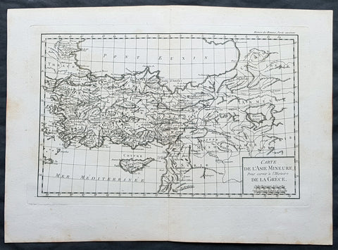
1769 J B D Anville Original Antique Map of Turkey, Cyprus, Asia Minor, Syria
- Title : Carte De L Asie Minerure Pour Servir a L Histoire De La Grece
- Size: 16in x 11in (410mm x 260mm)
- Ref #: 32346
- Date : 1769
- Condition: (A+) Fine Condition
Description:
This fine large, original copper-plate engraved antique map was published by Jean Baptiste Bourguignon D\'Anville in the 1769 edition of his atlas Geographie Ancienne et Abregee. or Modern and Ancient Geography (Ref: M&B; Tooley)
General Definitions:
Paper thickness and quality: - Heavy and stable
Paper color : - off white
Age of map color: -
Colors used: -
General color appearance: -
Paper size: - 16in x 11in (410mm x 260mm)
Plate size: - 13in x 9 1/2in (330mm x 245mm)
Margins: - Min 1/2in (12mm)
Imperfections:
Margins: - None
Plate area: - None
Verso: - None
1755 Prevost & Schley Antique Print Dharmapala the Defender Buddhist Gods Pagoda
- Title: Pagodes ou Statues Du Temple
- Date: 1755
- Condition : (A+) Fine Condition
- Ref: 25935
- Size: 15in x 10in (385mm x 255mm)
Description:
This fine, original copper-plate engraved antique print of Dharmapala the defender Buddhist God & Goddess in a Pagoda Temple by Jakob van Schley in 1755 was published in Antoine François Prevosts 15 volumes of Histoire Generale des Voyages written by Prevost & other authors between 1746-1790.
A protector of Buddhist dharma is called a Dharmapala in Buddhism. They are typically divinities, usually depicted with wrathful iconography in the Mahayana and tantric traditions of Buddhism. The wrath depicts their believed willingness to defend and guard Buddhist followers from dangers and enemies. The Astasena, or eight nonhuman super beings, for example are one of the list of dharmapalas. The Astasena dharmapala include, state Buswell and Lopez, Garuda, Deva, Naga, Yaksa, Gandharva, Asura, Kimnara and Mahoraga.
In Vajrayana iconography and thangka depictions, dharmapālas are fearsome beings, often with many heads, many hands, or many feet. Dharmapālas often have blue, black or red skin, and a fierce expression with protruding fangs. Though dharmapālas have a terrifying appearance and countenance, they are all bodhisattvas or buddhas, meaning that they are embodiments of compassion that act in a wrathful way for the benefit of sentient beings.
The devotional worship of dharmapalas in the Tibetan tradition is traceable to early 8th-century
General Definitions:
Paper thickness and quality: - Heavy and stable
Paper color : - off white
Age of map color: -
Colors used: -
General color appearance: -
Paper size: - 15in x 10in (385mm x 255mm)
Plate size: - 14in x 8 1/2in (355mm x 220mm)
Margins: - Min 1in (25mm)
Imperfections:
Margins: - None
Plate area: - None
Verso: - None
Background:
One of Antoine Francois Prevosts monumental undertakings was his history of exploration & discovery in 15 volumes titledHistoire Générale des Voyages written between 1746-1759 and was extended to 20 volumes after his death by various authors.
The 20 volumes cover the early explorations & discoveries on 3 continents: Africa (v. 1-5), Asia (v. 5-11), and America (v. 12-15) with material on the finding of the French, English, Dutch, and Portugese.
A number of notable cartographers and engravers contributed to the copper plate maps and views to the 20 volumes including Nicolas Bellin, Jan Schley, Chedel, Franc Aveline, Fessard, and many others.
The African volumes cover primarily coastal countries of West, Southern, and Eastern Africa, plus the Congo, Madagascar, Arabia and the Persian Gulf areas.
The Asian volumes cover China, Korea, Tibet, Japan, Philippines, and countries bordering the Indian Ocean.
Volume 11 includes Australia and Antarctica.
Volumes 12-15 cover voyages and discoveries in America, including the East Indies, South, Central and North America.
Volumes 16-20 include supplement volumes & tables along with continuation of voyages and discoveries in Russia, Northern Europe, America, Asia & Australia.
Jakob van der Schley aka Jakob van Schley (1715 - 1779) was a Dutch draughtsman and engraver. He studied under Bernard Picart (1673-1733) whose style he subsequently copied. His main interests were engraving portraits and producing illustrations for \\\"La Vie de Marianne\\\" by Pierre Carlet de Chamblain de Marivaux (1688-1763) published in The Hague between 1735 and 1747.
He also engraved the frontispieces for a 15-volume edition of the complete works of Pierre de Brantôme (1540-1614), \\\"Oeuvres du seigneur de Brantôme\\\", published in The Hague in 1740.
He is also responsible for most of the plates in the Hague edition of Prévosts Histoire générale des voyages. (Ref: Tooley; M&B)
1752 Bellin Antique Map of the Island of Sulawesi, formerly Celebes, Indonesia
- Title: Carte De L'Isle Celebes ou Macassar...S Bellin
- Date: 1752
- Condition : (A+) Fine Condition
- Ref: 60919
- Size: 10in x 7 1/2in (255m x 190mm)
Description:
This fine, original copper-plate engraved antique map of the Indonesian Island of Sulawesi, formerly known as Celebes, by Jacques Nicolas Bellin in 1752 was published in Antoine François Prevosts 15 volumes of Histoire Generale des Voyages written by Prevost & other authors between 1746-1790.
Sulawesi, formerly known as Celebes, is one of the four Greater Sunda Islands, and the world\'s eleventh-largest island, it is situated east of Borneo, west of the Maluku Islands, and south of Mindanao and the Sulu Archipelago. Within Indonesia, only Sumatra, Borneo and Papua are larger in territory, and only Java and Sumatra have larger populations.
Starting in the 13th century, access to prestige trade goods and to sources of iron started to alter long-standing cultural patterns and to permit ambitious individuals to build larger political units. It is not known why these two ingredients appeared together; one was perhaps the product of the other.
In 1367, several identified polities, located on the island, were mentioned in the Javanese manuscript Nagarakretagama dated from the Majapahit period. Canto 14 mentioned polities including Gowa, Makassar, Luwu and Banggai. It seems that by the 14th century, polities in the island were connected in an archipelagic maritime trading network, centered in the Majapahit port in East Java. By 1400, a number of nascent agricultural principalities had arisen in the western Cenrana valley, as well as on the south coast and on the west coast near modern Parepare.
The first Europeans to visit the island (which they believed to be an archipelago due to its contorted shape) were the Portuguese sailors Simão de Abreu, in 1523, and Gomes de Sequeira (among others) in 1525, sent from the Moluccas in search of gold, which the islands had the reputation of producing. A Portuguese base was installed in Makassar in the first decades of the 16th century, lasting until 1665, when it was taken by the Dutch. The Dutch had arrived in Sulawesi in 1605 and were quickly followed by the English, who established a factory in Makassar. From 1660, the Dutch were at war with Gowa, the major Makasar west coast power. In 1669, Admiral Speelman forced the ruler, Sultan Hasanuddin, to sign the Treaty of Bongaya, which handed control of trade to the Dutch East India Company. The Dutch were aided in their conquest by the Bugis warlord Arung Palakka, ruler of the Bugis kingdom of Bone. The Dutch built a fort at Ujung Pandang, while Arung Palakka became the regional overlord and Bone the dominant kingdom. Political and cultural development seems to have slowed as a result of the status quo.
General Definitions:
Paper thickness and quality: - Heavy and stable
Paper color : - off white
Age of map color: - Early
Colors used: - Green, Yellow,
General color appearance: - Authentic
Paper size: - 10in x 7 1/2in (255m x 190mm)
Plate size: - 9in x 6 1/2in (230mm x 160mm)
Margins: - Min 1/2in (6mm)
Imperfections:
Margins: - None
Plate area: - None
Verso: - None
Background:
One of Antoine Francois Prevosts monumental undertakings was his history of exploration & discovery in 15 volumes titledHistoire Générale des Voyages written between 1746-1759 and was extended to 20 volumes after his death by various authors.
The 20 volumes cover the early explorations & discoveries on 3 continents: Africa (v. 1-5), Asia (v. 5-11), and America (v. 12-15) with material on the finding of the French, English, Dutch, and Portugese.
A number of notable cartographers and engravers contributed to the copper plate maps and views to the 20 volumes including Nicolas Bellin, Jan Schley, Chedel, Franc Aveline, Fessard, and many others.
The African volumes cover primarily coastal countries of West, Southern, and Eastern Africa, plus the Congo, Madagascar, Arabia and the Persian Gulf areas.
The Asian volumes cover China, Korea, Tibet, Japan, Philippines, and countries bordering the Indian Ocean.
Volume 11 includes Australia and Antarctica.
Volumes 12-15 cover voyages and discoveries in America, including the East Indies, South, Central and North America.
Volumes 16-20 include supplement volumes & tables along with continuation of voyages and discoveries in Russia, Northern Europe, America, Asia & Australia.
1755 Prevost Antique Plans Cities of Jinhua & Pinghu in Zhejiang Province, China
- Title: Vusihyen; Hou-Tcheou-Fou
- Date: 1747
- Condition : (A+) Fine Condition
- Ref: 01-9784
- Size: 10in x 8in (255mm x 205mm)
Description:
This fine, original copper-plate engraved antique map, plans of the cities of Jinhua & Pinghu in the eastern Chinese province of Zhejiang by Jakob van Schley in 1755 - after Jean-Baptiste Du Halde - was published in Antoine François Prevosts 15 volumes of Histoire Generale des Voyages written by Prevost & other authors between 1746-1789.
Jean-Baptiste Du Halde, born in Paris on 1 February 1674 and died 18 August 1743, was a French Jesuit historian specializing in China. He did not travel to China, but collected seventeen Jesuit missionaries\\\' reports and provided an encyclopedic survey of the history, culture and society of China and Chinese Tartary, that is, Manchuria.
General Definitions:
Paper thickness and quality: - Heavy and stable
Paper color : - off white
Age of map color: - Original
Colors used: - Yellow, green, blue, pink
General color appearance: - Authentic
Paper size: - 10in x 7 1/2in (255mm x 190mm)
Plate size: - 10in x 7 1/2in (255mm x 190mm)
Margins: - Min 1/2in (12mm)
Imperfections:
Margins: - None
Plate area: - None
Verso: - None
Background:
Zhejiang formerly romanized as Chekiang, is an eastern coastal province of China. Zhejiang is bordered by the Jiangsu province and the Shanghai municipality to the north, the Anhui province to the northwest, the Jiangxi province to the west, and the Fujian province to the south. To the east is the East China Sea, beyond which lies the Ryukyu Islands of Japan.
Zhejiang was finally conquered by the Mongols in the late 13th century who later established the short lived Yuan Dynasty.
The Ming dynasty, which drove out the Mongols in 1368, finally established the present day province of Zhejiang with its borders having little changes since this establishment.
As in other coastal provinces, number of fortresses were constructed along the Zhejiang coast during the early Ming to defend the land against pirate incursions. Some of them have been preserved or restored, such as Pucheng in the south of the province (Cangnan County).
Under the late Ming dynasty and the Qing dynasty that followed it, Zhejiang\'s ports were important centers of international trade.
In 1727 the to-min or \'idle people\' of Cheh Kiang province (a Ningpo name still existing), the yoh-hu or \'music people\' of Shanxi province, the si-min or \'small people\' of Kiang Su (Jiangsu) province, and the Tanka people or \'egg-people\' of Canton (to this day the boat population there), were all freed from their social disabilities, and allowed to count as free men. Cheh Kiang is another romanization for Zhejiang. The Duomin are a caste of outcasts in this province.
During the First Opium War, the British navy defeated Eight Banners forces at Ningboand Dinghai. Under the terms of the Treaty of Nanking, signed in 1843, Ningbo became one of the five Chinese treaty ports opened to virtually unrestricted foreign trade. Much of Zhejiang came under the control of the Taiping Heavenly Kingdom during the Taiping Rebellion, which resulted in a considerable loss of life in the north-western and central parts of the province, sparing the rest of Zhejiang from the disastrous depopulation that occurred. In 1876, Wenzhou became Zhejiang\'s second treaty port. Jianghuai Mandarin speakers later came to settle in these depopulated regions of northern Zhejiang.
Jinhua is a prefecture-level city in central Zhejiang province in eastern China. It borders the provincial capital of Hangzhou to the northwest, Quzhou to the southwest, Lishui to the south, Taizhou to the east, and Shaoxing to the northeast.
The history of Jinhua dates back to the 2nd century BC, when it was a county subordinate to Shaoxing. It was given the name Jinhua under the Sui dynasty in AD 598 and later became the seat of a prefecture. The present city and its walls date to the time of the Mongol emperors in 1352.
The most famous native of Jinhua is Huang Chuping, a Daoist holy man of the 4th century and reputed immortal whose descendants still live in the area. Wuyang Shan (Reclining Sheep Mountain) is said to be a sheep which was turned to stone by Huang, a trick which he learned through his years of diligently studying Daoism.
Economically Jinhua has always prospered from its position as the regional collecting and processing center for agricultural and forestry products (chiefly rice and bamboo). It is currently the second most important grain producing area in Zhejiang. In 1985 Jinhua was promoted to City status, and now is responsible for administering four cities, four counties and a district. Animals raised there include dairy cattle, meat hogs (for the production of Jinhua ham, a famous local product for 900 years) and honeybees. Jinhua\'s industrial sector has developed more recently, producing machinery, metallurgy, pharmaceuticals, building supplies and electrical and electronic equipment.
The Tang dynasty painter Guan Xiu (Kuan-hsiu) was born in Jinhua. He is known for his paintings of Buddhist holy men.
There are numerous scenic and historical sites in the Jinhua region, including many places associated with the Immortal Huang, and a palace of the Dukes of the Taiping Heavenly Kingdom.
Pinghu is a county-level city in northeast Zhejiang Province, just outside Shanghai. It sits next to the East China Sea and the north shore of Hangzhou Bay. Prior to the Ming Dynasty, Pinghu was part of Haiyan County. In 1430 Pinghu County was established. In 1991 Pinghu became a county-level city under the administration of the prefecture-level city of Jiaxing.
Zhapu, the site of a deepwater harbor, was the principal site of China\'s foreign trade with Korea and Japan during the 18th and 19th century.
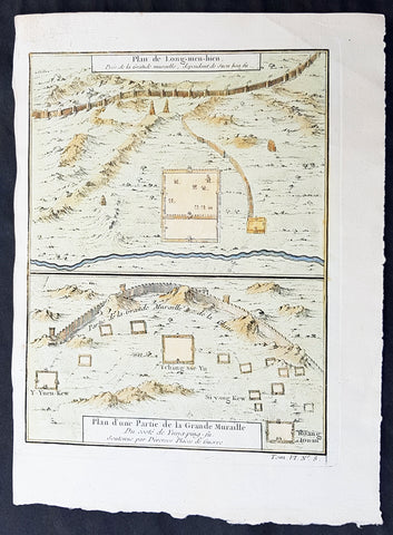
1755 Prevost & Schley Antique Map Hebei Province, China, The Great Wall & Forts
- Title: Plan de Long-men-hien Pres de la Grande Muraille, dependant de Duen hoa fu; Plan d une Partie de la Grande Muraille. Du coste de Yung-ping-fu. Soutenue par Diverses Plaees de Guerre
- Date: 1755
- Condition : (A+) Fine Condition
- Ref: 34140
- Size: 10in x 7 1/2in (255mm x 190mm)
Description:
This fine, original copper-plate engraved antique map a plans of parts of the Great Wall of China in what is today the north part of the Hebei Province of China - then called Pecheli - by Jakob van Schley in 1755 - after Jean-Baptiste Du Halde - was published in Antoine François Prevosts 15 volumes of Histoire Generale des Voyages written by Prevost & other authors between 1746-1789.
Jean-Baptiste Du Halde, born in Paris on 1 February 1674 and died 18 August 1743, was a French Jesuit historian specializing in China. He did not travel to China, but collected seventeen Jesuit missionaries\\\' reports and provided an encyclopedic survey of the history, culture and society of China and Chinese Tartary, that is, Manchuria.
General Definitions:
Paper thickness and quality: - Heavy and stable
Paper color : - off white
Age of map color: - Early
Colors used: - Yellow, green, blue
General color appearance: - Authentic
Paper size: - 10in x 7 1/2in (255mm x 190mm)
Plate size: - 10in x 7 1/2in (255mm x 190mm)
Margins: - Min 1/2in (12mm)
Imperfections:
Margins: - None
Plate area: - None
Verso: - None
Background:
Hebei is a province of Northern China. Its one-character abbreviation is Jì, named after Ji Province, a Han Dynasty province (zhou) that included what is now southern Hebei. The name Hebei literally means north of the river referring to its location entirely to the north of the Huang He Yellow River.
During the Tang Dynasty (618–907), the area was formally designated Hebei (north of the Yellow River) for the first time. During the earlier part of the Five Dynasties and Ten Kingdoms period, Hebei was fragmented among several regimes, though it was eventually unified by Li Cunxu, who established the Later Tang (923–936). The next dynasty, the Later Jin under Shi Jingtang, posthumously known as Emperor Gaozu of Later Jin, ceded much of modern-day northern Hebei to the Khitan Liao Dynasty in the north; this territory, called the Sixteen Prefectures of Yanyun, became a major weakness in the Chinese defense against the Khitans for the next century, since it lay within the Great Wall.
During the Northern Song Dynasty (960–1127), the sixteen ceded prefectures continued to be an area of hot contention between Song China and the Liao Dynasty. The Southern Song Dynasty that came after abandoned all of North China, including Hebei, to the Jurchen Jin Dynasty after the Jingkang Incident in 1127 of the Jin–Song wars.
The Mongol Yuan Dynasty divided China into provinces but did not establish Hebei as a province. Rather, the area was directly administrated by the Secretariat at capital Dadu. The Ming Dynasty ruled Hebei as Beizhili meaning Northern Directly Ruled, because the area contained and was directly ruled by the imperial capital, Beijing; the Northern designation was used because there was a southern counterpart covering present-day Jiangsu and Anhui. When the Manchu Qing Dynasty came to power in 1644, they abolished the southern counterpart, and Hebei became known as Zhili, or simply Directly Ruled. During the Qing Dynasty, the northern borders of Zhili extended deep into what is now Inner Mongolia, and overlapped in jurisdiction with the leagues of Inner Mongolia.
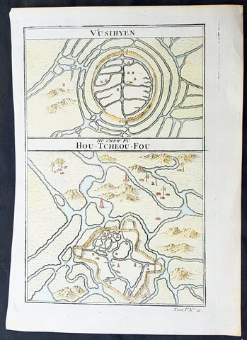
1755 Prevost Antique Plans Cities of Jinhua & Pinghu in Zhejiang Province, China
- Title: Vusihyen; Hou-Tcheou-Fou
- Date: 1755
- Size: 10in x 7 1/2in (255mm x 190mm)
- Ref: 15830
- Condition : (A+) Fine Condition
Description:
This fine, original copper-plate engraved antique map, plans of the cities of Jinhua & Pinghu in the eastern Chinese province of Zhejiang by Jakob van Schley in 1755 - after Jean-Baptiste Du Halde - was published in Antoine François Prevosts 15 volumes of Histoire Generale des Voyages written by Prevost & other authors between 1746-1789.
Jean-Baptiste Du Halde, born in Paris on 1 February 1674 and died 18 August 1743, was a French Jesuit historian specializing in China. He did not travel to China, but collected seventeen Jesuit missionaries\\\' reports and provided an encyclopedic survey of the history, culture and society of China and Chinese Tartary, that is, Manchuria.
General Definitions:
Paper thickness and quality: - Heavy and stable
Paper color : - off white
Age of map color: - Original
Colors used: - Yellow, green, blue, pink
General color appearance: - Authentic
Paper size: - 10in x 7 1/2in (255mm x 190mm)
Plate size: - 10in x 7 1/2in (255mm x 190mm)
Margins: - Min 1/2in (12mm)
Imperfections:
Margins: - None
Plate area: - None
Verso: - None
Background:
Zhejiang formerly romanized as Chekiang, is an eastern coastal province of China. Zhejiang is bordered by the Jiangsu province and the Shanghai municipality to the north, the Anhui province to the northwest, the Jiangxi province to the west, and the Fujian province to the south. To the east is the East China Sea, beyond which lies the Ryukyu Islands of Japan.
Zhejiang was finally conquered by the Mongols in the late 13th century who later established the short lived Yuan Dynasty.
The Ming dynasty, which drove out the Mongols in 1368, finally established the present day province of Zhejiang with its borders having little changes since this establishment.
As in other coastal provinces, number of fortresses were constructed along the Zhejiang coast during the early Ming to defend the land against pirate incursions. Some of them have been preserved or restored, such as Pucheng in the south of the province (Cangnan County).
Under the late Ming dynasty and the Qing dynasty that followed it, Zhejiang\'s ports were important centers of international trade.
In 1727 the to-min or \'idle people\' of Cheh Kiang province (a Ningpo name still existing), the yoh-hu or \'music people\' of Shanxi province, the si-min or \'small people\' of Kiang Su (Jiangsu) province, and the Tanka people or \'egg-people\' of Canton (to this day the boat population there), were all freed from their social disabilities, and allowed to count as free men. Cheh Kiang is another romanization for Zhejiang. The Duomin are a caste of outcasts in this province.
During the First Opium War, the British navy defeated Eight Banners forces at Ningboand Dinghai. Under the terms of the Treaty of Nanking, signed in 1843, Ningbo became one of the five Chinese treaty ports opened to virtually unrestricted foreign trade. Much of Zhejiang came under the control of the Taiping Heavenly Kingdom during the Taiping Rebellion, which resulted in a considerable loss of life in the north-western and central parts of the province, sparing the rest of Zhejiang from the disastrous depopulation that occurred. In 1876, Wenzhou became Zhejiang\'s second treaty port. Jianghuai Mandarin speakers later came to settle in these depopulated regions of northern Zhejiang.
Jinhua is a prefecture-level city in central Zhejiang province in eastern China. It borders the provincial capital of Hangzhou to the northwest, Quzhou to the southwest, Lishui to the south, Taizhou to the east, and Shaoxing to the northeast.
The history of Jinhua dates back to the 2nd century BC, when it was a county subordinate to Shaoxing. It was given the name Jinhua under the Sui dynasty in AD 598 and later became the seat of a prefecture. The present city and its walls date to the time of the Mongol emperors in 1352.
The most famous native of Jinhua is Huang Chuping, a Daoist holy man of the 4th century and reputed immortal whose descendants still live in the area. Wuyang Shan (Reclining Sheep Mountain) is said to be a sheep which was turned to stone by Huang, a trick which he learned through his years of diligently studying Daoism.
Economically Jinhua has always prospered from its position as the regional collecting and processing center for agricultural and forestry products (chiefly rice and bamboo). It is currently the second most important grain producing area in Zhejiang. In 1985 Jinhua was promoted to City status, and now is responsible for administering four cities, four counties and a district. Animals raised there include dairy cattle, meat hogs (for the production of Jinhua ham, a famous local product for 900 years) and honeybees. Jinhua\'s industrial sector has developed more recently, producing machinery, metallurgy, pharmaceuticals, building supplies and electrical and electronic equipment.
The Tang dynasty painter Guan Xiu (Kuan-hsiu) was born in Jinhua. He is known for his paintings of Buddhist holy men.
There are numerous scenic and historical sites in the Jinhua region, including many places associated with the Immortal Huang, and a palace of the Dukes of the Taiping Heavenly Kingdom.
Pinghu is a county-level city in northeast Zhejiang Province, just outside Shanghai. It sits next to the East China Sea and the north shore of Hangzhou Bay. Prior to the Ming Dynasty, Pinghu was part of Haiyan County. In 1430 Pinghu County was established. In 1991 Pinghu became a county-level city under the administration of the prefecture-level city of Jiaxing.
Zhapu, the site of a deepwater harbor, was the principal site of China\'s foreign trade with Korea and Japan during the 18th and 19th century.
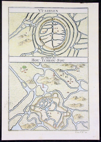
1755 Prevost Antique Plans Cities of Jinhua & Pinghu in Zhejiang Province, China
- Title: Vusihyen; Hou-Tcheou-Fou
- Date: 1755
- Size: 10in x 7 1/2in (255mm x 190mm)
- Ref: 15831
- Condition : (A+) Fine Condition
Description:
This fine, original copper-plate engraved antique map, plans of the cities of Jinhua & Pinghu in the eastern Chinese province of Zhejiang by Jakob van Schley in 1755 - after Jean-Baptiste Du Halde - was published in Antoine François Prevosts 15 volumes of Histoire Generale des Voyages written by Prevost & other authors between 1746-1789.
Jean-Baptiste Du Halde, born in Paris on 1 February 1674 and died 18 August 1743, was a French Jesuit historian specializing in China. He did not travel to China, but collected seventeen Jesuit missionaries\\\' reports and provided an encyclopedic survey of the history, culture and society of China and Chinese Tartary, that is, Manchuria.
General Definitions:
Paper thickness and quality: - Heavy and stable
Paper color : - off white
Age of map color: - Original
Colors used: - Yellow, green, blue, pink
General color appearance: - Authentic
Paper size: - 10in x 7 1/2in (255mm x 190mm)
Plate size: - 10in x 7 1/2in (255mm x 190mm)
Margins: - Min 1/2in (12mm)
Imperfections:
Margins: - None
Plate area: - None
Verso: - None
Background:
Zhejiang formerly romanized as Chekiang, is an eastern coastal province of China. Zhejiang is bordered by the Jiangsu province and the Shanghai municipality to the north, the Anhui province to the northwest, the Jiangxi province to the west, and the Fujian province to the south. To the east is the East China Sea, beyond which lies the Ryukyu Islands of Japan.
Zhejiang was finally conquered by the Mongols in the late 13th century who later established the short lived Yuan Dynasty.
The Ming dynasty, which drove out the Mongols in 1368, finally established the present day province of Zhejiang with its borders having little changes since this establishment.
As in other coastal provinces, number of fortresses were constructed along the Zhejiang coast during the early Ming to defend the land against pirate incursions. Some of them have been preserved or restored, such as Pucheng in the south of the province (Cangnan County).
Under the late Ming dynasty and the Qing dynasty that followed it, Zhejiang\'s ports were important centers of international trade.
In 1727 the to-min or \'idle people\' of Cheh Kiang province (a Ningpo name still existing), the yoh-hu or \'music people\' of Shanxi province, the si-min or \'small people\' of Kiang Su (Jiangsu) province, and the Tanka people or \'egg-people\' of Canton (to this day the boat population there), were all freed from their social disabilities, and allowed to count as free men. Cheh Kiang is another romanization for Zhejiang. The Duomin are a caste of outcasts in this province.
During the First Opium War, the British navy defeated Eight Banners forces at Ningboand Dinghai. Under the terms of the Treaty of Nanking, signed in 1843, Ningbo became one of the five Chinese treaty ports opened to virtually unrestricted foreign trade. Much of Zhejiang came under the control of the Taiping Heavenly Kingdom during the Taiping Rebellion, which resulted in a considerable loss of life in the north-western and central parts of the province, sparing the rest of Zhejiang from the disastrous depopulation that occurred. In 1876, Wenzhou became Zhejiang\'s second treaty port. Jianghuai Mandarin speakers later came to settle in these depopulated regions of northern Zhejiang.
Jinhua is a prefecture-level city in central Zhejiang province in eastern China. It borders the provincial capital of Hangzhou to the northwest, Quzhou to the southwest, Lishui to the south, Taizhou to the east, and Shaoxing to the northeast.
The history of Jinhua dates back to the 2nd century BC, when it was a county subordinate to Shaoxing. It was given the name Jinhua under the Sui dynasty in AD 598 and later became the seat of a prefecture. The present city and its walls date to the time of the Mongol emperors in 1352.
The most famous native of Jinhua is Huang Chuping, a Daoist holy man of the 4th century and reputed immortal whose descendants still live in the area. Wuyang Shan (Reclining Sheep Mountain) is said to be a sheep which was turned to stone by Huang, a trick which he learned through his years of diligently studying Daoism.
Economically Jinhua has always prospered from its position as the regional collecting and processing center for agricultural and forestry products (chiefly rice and bamboo). It is currently the second most important grain producing area in Zhejiang. In 1985 Jinhua was promoted to City status, and now is responsible for administering four cities, four counties and a district. Animals raised there include dairy cattle, meat hogs (for the production of Jinhua ham, a famous local product for 900 years) and honeybees. Jinhua\'s industrial sector has developed more recently, producing machinery, metallurgy, pharmaceuticals, building supplies and electrical and electronic equipment.
The Tang dynasty painter Guan Xiu (Kuan-hsiu) was born in Jinhua. He is known for his paintings of Buddhist holy men.
There are numerous scenic and historical sites in the Jinhua region, including many places associated with the Immortal Huang, and a palace of the Dukes of the Taiping Heavenly Kingdom.
Pinghu is a county-level city in northeast Zhejiang Province, just outside Shanghai. It sits next to the East China Sea and the north shore of Hangzhou Bay. Prior to the Ming Dynasty, Pinghu was part of Haiyan County. In 1430 Pinghu County was established. In 1991 Pinghu became a county-level city under the administration of the prefecture-level city of Jiaxing.
Zhapu, the site of a deepwater harbor, was the principal site of China\'s foreign trade with Korea and Japan during the 18th and 19th century.
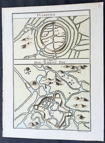
1755 Prevost Antique Plans Cities of Jinhua & Pinghu in Zhejiang Province, China
- Title: Vusihyen; Hou-Tcheou-Fou
- Date: 1755
- Size: 10in x 7 1/2in (255mm x 190mm)
- Ref: 23400
- Condition : (A+) Fine Condition
Description:
This fine, original copper-plate engraved antique map, plans of the cities of Jinhua & Pinghu in the eastern Chinese province of Zhejiang by Jakob van Schley in 1755 - after Jean-Baptiste Du Halde - was published in Antoine François Prevosts 15 volumes of Histoire Generale des Voyages written by Prevost & other authors between 1746-1789.
Jean-Baptiste Du Halde, born in Paris on 1 February 1674 and died 18 August 1743, was a French Jesuit historian specializing in China. He did not travel to China, but collected seventeen Jesuit missionaries\\\' reports and provided an encyclopedic survey of the history, culture and society of China and Chinese Tartary, that is, Manchuria.
General Definitions:
Paper thickness and quality: - Heavy and stable
Paper color : - off white
Age of map color: - Original
Colors used: - Yellow, green, blue, pink
General color appearance: - Authentic
Paper size: - 10in x 7 1/2in (255mm x 190mm)
Plate size: - 10in x 7 1/2in (255mm x 190mm)
Margins: - Min 1/2in (12mm)
Imperfections:
Margins: - None
Plate area: - None
Verso: - None
Background:
Zhejiang formerly romanized as Chekiang, is an eastern coastal province of China. Zhejiang is bordered by the Jiangsu province and the Shanghai municipality to the north, the Anhui province to the northwest, the Jiangxi province to the west, and the Fujian province to the south. To the east is the East China Sea, beyond which lies the Ryukyu Islands of Japan.
Zhejiang was finally conquered by the Mongols in the late 13th century who later established the short lived Yuan Dynasty.
The Ming dynasty, which drove out the Mongols in 1368, finally established the present day province of Zhejiang with its borders having little changes since this establishment.
As in other coastal provinces, number of fortresses were constructed along the Zhejiang coast during the early Ming to defend the land against pirate incursions. Some of them have been preserved or restored, such as Pucheng in the south of the province (Cangnan County).
Under the late Ming dynasty and the Qing dynasty that followed it, Zhejiang\'s ports were important centers of international trade.
In 1727 the to-min or \'idle people\' of Cheh Kiang province (a Ningpo name still existing), the yoh-hu or \'music people\' of Shanxi province, the si-min or \'small people\' of Kiang Su (Jiangsu) province, and the Tanka people or \'egg-people\' of Canton (to this day the boat population there), were all freed from their social disabilities, and allowed to count as free men. Cheh Kiang is another romanization for Zhejiang. The Duomin are a caste of outcasts in this province.
During the First Opium War, the British navy defeated Eight Banners forces at Ningboand Dinghai. Under the terms of the Treaty of Nanking, signed in 1843, Ningbo became one of the five Chinese treaty ports opened to virtually unrestricted foreign trade. Much of Zhejiang came under the control of the Taiping Heavenly Kingdom during the Taiping Rebellion, which resulted in a considerable loss of life in the north-western and central parts of the province, sparing the rest of Zhejiang from the disastrous depopulation that occurred. In 1876, Wenzhou became Zhejiang\'s second treaty port. Jianghuai Mandarin speakers later came to settle in these depopulated regions of northern Zhejiang.
Jinhua is a prefecture-level city in central Zhejiang province in eastern China. It borders the provincial capital of Hangzhou to the northwest, Quzhou to the southwest, Lishui to the south, Taizhou to the east, and Shaoxing to the northeast.
The history of Jinhua dates back to the 2nd century BC, when it was a county subordinate to Shaoxing. It was given the name Jinhua under the Sui dynasty in AD 598 and later became the seat of a prefecture. The present city and its walls date to the time of the Mongol emperors in 1352.
The most famous native of Jinhua is Huang Chuping, a Daoist holy man of the 4th century and reputed immortal whose descendants still live in the area. Wuyang Shan (Reclining Sheep Mountain) is said to be a sheep which was turned to stone by Huang, a trick which he learned through his years of diligently studying Daoism.
Economically Jinhua has always prospered from its position as the regional collecting and processing center for agricultural and forestry products (chiefly rice and bamboo). It is currently the second most important grain producing area in Zhejiang. In 1985 Jinhua was promoted to City status, and now is responsible for administering four cities, four counties and a district. Animals raised there include dairy cattle, meat hogs (for the production of Jinhua ham, a famous local product for 900 years) and honeybees. Jinhua\'s industrial sector has developed more recently, producing machinery, metallurgy, pharmaceuticals, building supplies and electrical and electronic equipment.
The Tang dynasty painter Guan Xiu (Kuan-hsiu) was born in Jinhua. He is known for his paintings of Buddhist holy men.
There are numerous scenic and historical sites in the Jinhua region, including many places associated with the Immortal Huang, and a palace of the Dukes of the Taiping Heavenly Kingdom.
Pinghu is a county-level city in northeast Zhejiang Province, just outside Shanghai. It sits next to the East China Sea and the north shore of Hangzhou Bay. Prior to the Ming Dynasty, Pinghu was part of Haiyan County. In 1430 Pinghu County was established. In 1991 Pinghu became a county-level city under the administration of the prefecture-level city of Jiaxing.
Zhapu, the site of a deepwater harbor, was the principal site of China\'s foreign trade with Korea and Japan during the 18th and 19th century.
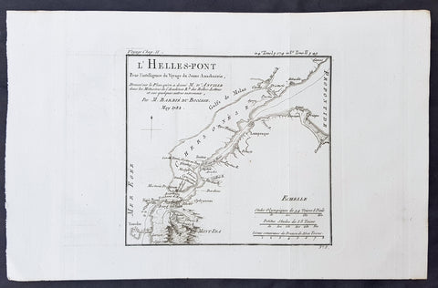
1782 Du Bocage & Barthelemy Antique Map of The Dardanelles, Turkey - Hellespont
- Title : L Helles-Pont...1782
- Size: 15in x 10in (380mm x 255mm)
- Ref #: 16467
- Date : 1782
- Condition: (A+) Fine Condition
Description:
This original copper-plate engraved map by Jean Denis Barbie du Bocage was engraved in 1782 - dated in the title - and was published in the 1787 edition of Jean-Jacques Barthelemy famous Voyage du jeune Anarcharsis en Grece or Travels of Anacharsis the younger in Greecein 4 volumes.
General Definitions:
Paper thickness and quality: - Heavy and stable
Paper color : - off white
Age of map color: -
Colors used: -
General color appearance: -
Paper size: - 15in x 10in (380mm x 255mm)
Plate size: - 8 1/2in x 7 1/2in (215mm x 185mm)
Margins: - Min 1in (25mm)
Imperfections:
Margins: - None
Plate area: - Folds as issued
Verso: - None
Background:
Jean-Jacques Barthelemy 1716 – 1795 was a French writer and numismatist.
Barthelemy was the author of a number of learned works on antiquarian subjects, but the great work on which his fame rests is Travels of Anacharsis the younger in Greece (French: Voyage du jeune Anarcharsis en Grece, 4 vols., 1787). He had begun it in 1757 and had been working on it for thirty years. The hero, a young Scythian descended from the famous philosopher Anacharsis, is supposed to repair to Greece for instruction in his early youth, and after making the tour of her republics, colonies and islands, to return to his native country and write this book in his old age, after the Macedonian hero had overturned the Persian empire. In the manner of modern travellers, he gives an account of the customs, government, and antiquities of the country he is supposed to have visited. A copious introduction supplies whatever may be wanting in respect to historical details, while various dissertations on the music of the Greeks, on the literature of the Athenians, and on the economy, pursuits, ruling passions, manners, and customs of the surrounding states supply ample information on the subjects of which they treat.
Modern scholarship has superseded most of the details in the Voyage, but the author himself did not imagine his book to be a register of accurately ascertained facts. Rather, he intended to afford to his countrymen, in an interesting form, some knowledge of Greek civilisation. The Charicles, or Illustrations of the Private Life of the Ancient Greeks of Wilhelm Adolf Becker is an attempt in a similar direction
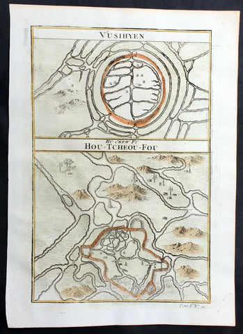
1755 Prevost Antique Plans Cities of Jinhua & Pinghu in Zhejiang Province, China
- Title: Vusihyen; Hou-Tcheou-Fou
- Date: 1755
- Size: 10in x 7 1/2in (255mm x 190mm)
- Ref: 25777
- Condition : (A+) Fine Condition
Description:
This fine, original copper-plate engraved antique map, plans of the cities of Jinhua & Pinghu in the eastern Chinese province of Zhejiang by Jakob van Schley in 1755 - after Jean-Baptiste Du Halde - was published in Antoine François Prevosts 15 volumes of Histoire Generale des Voyages written by Prevost & other authors between 1746-1789.
Jean-Baptiste Du Halde, born in Paris on 1 February 1674 and died 18 August 1743, was a French Jesuit historian specializing in China. He did not travel to China, but collected seventeen Jesuit missionaries\\\' reports and provided an encyclopedic survey of the history, culture and society of China and Chinese Tartary, that is, Manchuria.
General Definitions:
Paper thickness and quality: - Heavy and stable
Paper color : - off white
Age of map color: - Original
Colors used: - Yellow, green, blue, pink
General color appearance: - Authentic
Paper size: - 10in x 7 1/2in (255mm x 190mm)
Plate size: - 10in x 7 1/2in (255mm x 190mm)
Margins: - Min 1/2in (12mm)
Imperfections:
Margins: - None
Plate area: - None
Verso: - None
Background:
Zhejiang formerly romanized as Chekiang, is an eastern coastal province of China. Zhejiang is bordered by the Jiangsu province and the Shanghai municipality to the north, the Anhui province to the northwest, the Jiangxi province to the west, and the Fujian province to the south. To the east is the East China Sea, beyond which lies the Ryukyu Islands of Japan.
Zhejiang was finally conquered by the Mongols in the late 13th century who later established the short lived Yuan Dynasty.
The Ming dynasty, which drove out the Mongols in 1368, finally established the present day province of Zhejiang with its borders having little changes since this establishment.
As in other coastal provinces, number of fortresses were constructed along the Zhejiang coast during the early Ming to defend the land against pirate incursions. Some of them have been preserved or restored, such as Pucheng in the south of the province (Cangnan County).
Under the late Ming dynasty and the Qing dynasty that followed it, Zhejiang\'s ports were important centers of international trade.
In 1727 the to-min or \'idle people\' of Cheh Kiang province (a Ningpo name still existing), the yoh-hu or \'music people\' of Shanxi province, the si-min or \'small people\' of Kiang Su (Jiangsu) province, and the Tanka people or \'egg-people\' of Canton (to this day the boat population there), were all freed from their social disabilities, and allowed to count as free men. Cheh Kiang is another romanization for Zhejiang. The Duomin are a caste of outcasts in this province.
During the First Opium War, the British navy defeated Eight Banners forces at Ningboand Dinghai. Under the terms of the Treaty of Nanking, signed in 1843, Ningbo became one of the five Chinese treaty ports opened to virtually unrestricted foreign trade. Much of Zhejiang came under the control of the Taiping Heavenly Kingdom during the Taiping Rebellion, which resulted in a considerable loss of life in the north-western and central parts of the province, sparing the rest of Zhejiang from the disastrous depopulation that occurred. In 1876, Wenzhou became Zhejiang\'s second treaty port. Jianghuai Mandarin speakers later came to settle in these depopulated regions of northern Zhejiang.
Jinhua is a prefecture-level city in central Zhejiang province in eastern China. It borders the provincial capital of Hangzhou to the northwest, Quzhou to the southwest, Lishui to the south, Taizhou to the east, and Shaoxing to the northeast.
The history of Jinhua dates back to the 2nd century BC, when it was a county subordinate to Shaoxing. It was given the name Jinhua under the Sui dynasty in AD 598 and later became the seat of a prefecture. The present city and its walls date to the time of the Mongol emperors in 1352.
The most famous native of Jinhua is Huang Chuping, a Daoist holy man of the 4th century and reputed immortal whose descendants still live in the area. Wuyang Shan (Reclining Sheep Mountain) is said to be a sheep which was turned to stone by Huang, a trick which he learned through his years of diligently studying Daoism.
Economically Jinhua has always prospered from its position as the regional collecting and processing center for agricultural and forestry products (chiefly rice and bamboo). It is currently the second most important grain producing area in Zhejiang. In 1985 Jinhua was promoted to City status, and now is responsible for administering four cities, four counties and a district. Animals raised there include dairy cattle, meat hogs (for the production of Jinhua ham, a famous local product for 900 years) and honeybees. Jinhua\'s industrial sector has developed more recently, producing machinery, metallurgy, pharmaceuticals, building supplies and electrical and electronic equipment.
The Tang dynasty painter Guan Xiu (Kuan-hsiu) was born in Jinhua. He is known for his paintings of Buddhist holy men.
There are numerous scenic and historical sites in the Jinhua region, including many places associated with the Immortal Huang, and a palace of the Dukes of the Taiping Heavenly Kingdom.
Pinghu is a county-level city in northeast Zhejiang Province, just outside Shanghai. It sits next to the East China Sea and the north shore of Hangzhou Bay. Prior to the Ming Dynasty, Pinghu was part of Haiyan County. In 1430 Pinghu County was established. In 1991 Pinghu became a county-level city under the administration of the prefecture-level city of Jiaxing.
Zhapu, the site of a deepwater harbor, was the principal site of China\'s foreign trade with Korea and Japan during the 18th and 19th century.
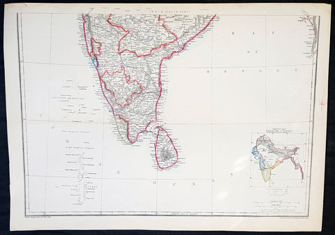
1857 Edward Weller Large Antique Map of Southern India & Sri Lanka, Ceylon
Antique Map
- Title : India (South Part)
- Ref #: 40996
- Size: 18in x 13in (470mm x 330mm)
- Date : 1857
- Condition: (A+) Fine Condition
Description:
This original lithograph hand coloured antique map by Edward Weller was engraved by Day & Co. and was published in the 1857 edition of The Dispatch Atlas; a compilation of maps Weller had already published in The Weekly Dispatch.
General Definitions:
Paper thickness and quality: - Heavy and stable
Paper color : - off white
Age of map color: - Original
Colors used: - Yellow, Green, pink
General color appearance: - Authentic
Paper size: - 18in x 13in (470mm x 330mm)
Plate size: - 18in x 13in (470mm x 330mm)
Margins: - Min 1/2in (10mm)
Imperfections:
Margins: - None
Plate area: - None
Verso: - None
Weller, Edward 1819 – 1884
Weller was a London-based engraver, cartographer and publisher, working from offices in Red Lion Square and later, Bloomsbury. Amongst his considerable portfolio were various atlases, many of which focussed on the educational publishing market. Having established his credentials as an engraver of finely detailed works, he sold maps to be published in a number of regular magazines and pamphlets, perhaps the best known being The Dispatch Atlas; a compilation of maps Weller had already published in The Weekly Dispatch. Although Weller usually engraved the maps himself, he did work in partnership with others, particularly John Dower for this 1858 and 1863 volume. Weller also published The Crown Atlas in 1871.
The Dispatch Atlas featured well over one hundred superbly detailed steel plate engraved maps, usually with simplistic, single colour outline hand colouring, and a distinctive header style. Most English counties featured, some of which were divided onto separate sheets, affording space to engrave in even greater detail. The maps of North and South Devonshire for example include such details as individual property names, as do those of the Northern and Southern parts of Hampshire.
After Wellers death in 1884, many of these astonishingly detailed plates were sold on to other map makers, including George Washington Bacon, who, whilst retaining the level of detail, expanded the printing area of each plate, adding more precise and varied hand colouring in keeping with the final decades of the century.
1857 Edward Weller Large Antique Map of Hyderabad & Nagpur Regions of India
Antique Map
- Title : India Nagpoor, Hyderabad
- Ref #: 70490
- Size: 18in x 13in (470mm x 330mm)
- Date : 1857
- Condition: (A+) Fine Condition
Description:
This original lithograph hand coloured antique map by Edward Weller was engraved by Day & Co. and was published in the 1857 edition of The Dispatch Atlas; a compilation of maps Weller had already published in The Weekly Dispatch.
General Definitions:
Paper thickness and quality: - Heavy and stable
Paper color : - off white
Age of map color: - Original
Colors used: - Yellow, Green, pink
General color appearance: - Authentic
Paper size: - 18in x 13in (470mm x 330mm)
Plate size: - 18in x 13in (470mm x 330mm)
Margins: - Min 1/2in (10mm)
Imperfections:
Margins: - None
Plate area: - None
Verso: - None
Edward Weller 1819 - 1884; was a London-based engraver, cartographer and publisher, working from offices in Red Lion Square and later, Bloomsbury. Amongst his considerable portfolio were various atlases, many of which focussed on the educational publishing market. Having established his credentials as an engraver of finely detailed works, he sold maps to be published in a number of regular magazines and pamphlets, perhaps the best known being The Dispatch Atlas; a compilation of maps Weller had already published in The Weekly Dispatch. Although Weller usually engraved the maps himself, he did work in partnership with others, particularly John Dower for this 1858 and 1863 volume. Weller also published The Crown Atlas in 1871.
The Dispatch Atlas featured well over one hundred superbly detailed steel plate engraved maps, usually with simplistic, single colour outline hand colouring, and a distinctive header style. Most English counties featured, some of which were divided onto separate sheets, affording space to engrave in even greater detail. The maps of North and South Devonshire for example include such details as individual property names, as do those of the Northern and Southern parts of Hampshire.
After Wellers death in 1884, many of these astonishingly detailed plates were sold on to other map makers, including George Washington Bacon, who, whilst retaining the level of detail, expanded the printing area of each plate, adding more precise and varied hand colouring in keeping with the final decades of the century.
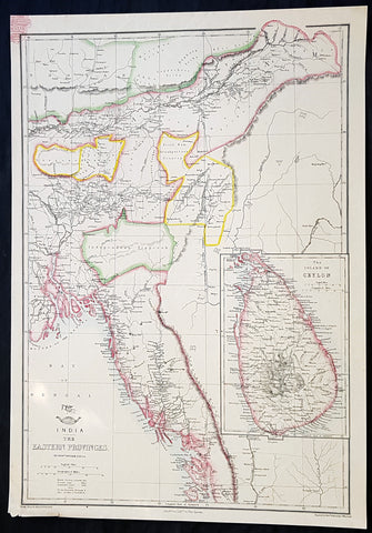
1858 Edward Weller Large Antique Map of Bangladesh, Assam, Sri lanka Ceylon
Antique Map
- Title : India The Eastern Provinces by Edward Weller
- Ref #: 70495
- Size: 18in x 13in (470mm x 330mm)
- Date : 1858
- Condition: (A+) Fine Condition
Description:
This original lithograph hand coloured antique map by Edward Weller was engraved by Day & Co. and was published in the 1858 edition of The Dispatch Atlas; a compilation of maps Weller had already published in The Weekly Dispatch.
General Definitions:
Paper thickness and quality: - Heavy and stable
Paper color : - off white
Age of map color: - Original
Colors used: - Yellow, Green, pink
General color appearance: - Authentic
Paper size: - 18in x 13in (470mm x 330mm)
Plate size: - 18in x 13in (470mm x 330mm)
Margins: - Min 1/2in (10mm)
Imperfections:
Margins: - None
Plate area: - None
Verso: - None
Weller, Edward 1819 – 1884
Weller was a London-based engraver, cartographer and publisher, working from offices in Red Lion Square and later, Bloomsbury. Amongst his considerable portfolio were various atlases, many of which focussed on the educational publishing market. Having established his credentials as an engraver of finely detailed works, he sold maps to be published in a number of regular magazines and pamphlets, perhaps the best known being The Dispatch Atlas; a compilation of maps Weller had already published in The Weekly Dispatch. Although Weller usually engraved the maps himself, he did work in partnership with others, particularly John Dower for this 1858 and 1863 volume. Weller also published The Crown Atlas in 1871.
The Dispatch Atlas featured well over one hundred superbly detailed steel plate engraved maps, usually with simplistic, single colour outline hand colouring, and a distinctive header style. Most English counties featured, some of which were divided onto separate sheets, affording space to engrave in even greater detail. The maps of North and South Devonshire for example include such details as individual property names, as do those of the Northern and Southern parts of Hampshire.
After Wellers death in 1884, many of these astonishingly detailed plates were sold on to other map makers, including George Washington Bacon, who, whilst retaining the level of detail, expanded the printing area of each plate, adding more precise and varied hand colouring in keeping with the final decades of the century.
1781 Du Bocage & Barthelemy Original Antique Map of The Black Sea, Anacharsis Yr
- Title : Carte Du Palus Meotide et du Pont Euxin Pour le Voyage du Jeune Anacharsis....MDCCLXXXI
- Size: 15in x 10in (380mm x 255mm)
- Ref #: 16467
- Date : 1781
- Condition: (A+) Fine Condition
Description:
This original copper-plate engraved map by Jean Denis Barbie du Bocage was engraved in 1781 - dated in the title - and was published in the 1787 edition of Jean-Jacques Barthelemy famous Voyage du jeune Anarcharsis en Grece or Travels of Anacharsis the younger in Greece in 4 volumes.
General Definitions:
Paper thickness and quality: - Heavy and stable
Paper color : - off white
Age of map color: -
Colors used: -
General color appearance: -
Paper size: - 15in x 10in (380mm x 255mm)
Plate size: - 11in x 8 1/2in (280mm x 215mm)
Margins: - Min 1in (25mm)
Imperfections:
Margins: - None
Plate area: - Folds as issued
Verso: - None
Background:
Jean-Jacques Barthelemy 1716 – 1795 was a French writer and numismatist.
Barthelemy was the author of a number of learned works on antiquarian subjects, but the great work on which his fame rests is Travels of Anacharsis the younger in Greece (French: Voyage du jeune Anarcharsis en Grece, 4 vols., 1787). He had begun it in 1757 and had been working on it for thirty years. The hero, a young Scythian descended from the famous philosopher Anacharsis, is supposed to repair to Greece for instruction in his early youth, and after making the tour of her republics, colonies and islands, to return to his native country and write this book in his old age, after the Macedonian hero had overturned the Persian empire. In the manner of modern travellers, he gives an account of the customs, government, and antiquities of the country he is supposed to have visited. A copious introduction supplies whatever may be wanting in respect to historical details, while various dissertations on the music of the Greeks, on the literature of the Athenians, and on the economy, pursuits, ruling passions, manners, and customs of the surrounding states supply ample information on the subjects of which they treat.
Modern scholarship has superseded most of the details in the Voyage, but the author himself did not imagine his book to be a register of accurately ascertained facts. Rather, he intended to afford to his countrymen, in an interesting form, some knowledge of Greek civilisation. The Charicles, or Illustrations of the Private Life of the Ancient Greeks of Wilhelm Adolf Becker is an attempt in a similar direction
1750 Prevost Original Antique Print of 3 Statues or Deities in a Chinese Pagoda
- Title: Pagodes ou Statue
- Date: 1750
- Condition : (A+) Fine Condition
- Ref: 25951
- Size: 14in x 10in (355mm x 255mm)
Description:
This fine original copper-plate engraved antique print was engraved by Jakob van Schley and was published in Antoine François Prevosts 15 volumes of Histoire Generale des Voyages written by Prevost & other authors between 1746-1790.
Unique original print of Chinese statues in the interior of a Chinese Pagoda. The scale of the statues are illustrated by the worshipers at the feet of each statue. There is a key to each statue at the bottom of the page
No 1. Mini so, ou la Volupte - A corpulent and grinning statues representing the spirit of pleasure
No 2. Le Grand Kin Gang - An elaborately dressed imperial figure on a throne.
No 3. L immortalite - A pot-bellied, crosslegged god accompanied by a deer and a stork, the personification of immortality
In the background is a group of monks gathered next to a podium, upon which is another statue flanked by incense burners.
General Definitions:
Paper thickness and quality: - Heavy and stable
Paper color : - off white
Age of map color: -
Colors used: -
General color appearance: -
Paper size: - 14in x 10in (365mm x 250mm)
Plate size: - 12in x 8in (305mm x 205mm)
Margins: - Min 1/2in (12mm)
Imperfections:
Margins: - None
Plate area: - None
Verso: - None
Background:
One of Antoine Francois Prevosts monumental undertakings was his history of exploration & discovery in 15 volumes titledHistoire Générale des Voyages written between 1746-1759 and was extended to 20 volumes after his death by various authors.
The 20 volumes cover the early explorations & discoveries on 3 continents: Africa (v. 1-5), Asia (v. 5-11), and America (v. 12-15) with material on the finding of the French, English, Dutch, and Portugese.
A number of notable cartographers and engravers contributed to the copper plate maps and views to the 20 volumes including Nicolas Bellin, Jan Schley, Chedel, Franc Aveline, Fessard, and many others.
The African volumes cover primarily coastal countries of West, Southern, and Eastern Africa, plus the Congo, Madagascar, Arabia and the Persian Gulf areas.
The Asian volumes cover China, Korea, Tibet, Japan, Philippines, and countries bordering the Indian Ocean.
Volume 11 includes Australia and Antarctica.
Volumes 12-15 cover voyages and discoveries in America, including the East Indies, South, Central and North America.
Volumes 16-20 include supplement volumes & tables along with continuation of voyages and discoveries in Russia, Northern Europe, America, Asia & Australia.
Jakob van der Schley aka Jakob van Schley (1715 - 1779) was a Dutch draughtsman and engraver. He studied under Bernard Picart (1673-1733) whose style he subsequently copied. His main interests were engraving portraits and producing illustrations for \"La Vie de Marianne\" by Pierre Carlet de Chamblain de Marivaux (1688-1763) published in The Hague between 1735 and 1747.
He also engraved the frontispieces for a 15-volume edition of the complete works of Pierre de Brantôme (1540-1614), \"Oeuvres du seigneur de Brantôme\", published in The Hague in 1740.
He is also responsible for most of the plates in the Hague edition of Prévost\'s Histoire générale des voyages. (Ref: Tooley; M&B)