Welcome to Classical Images!
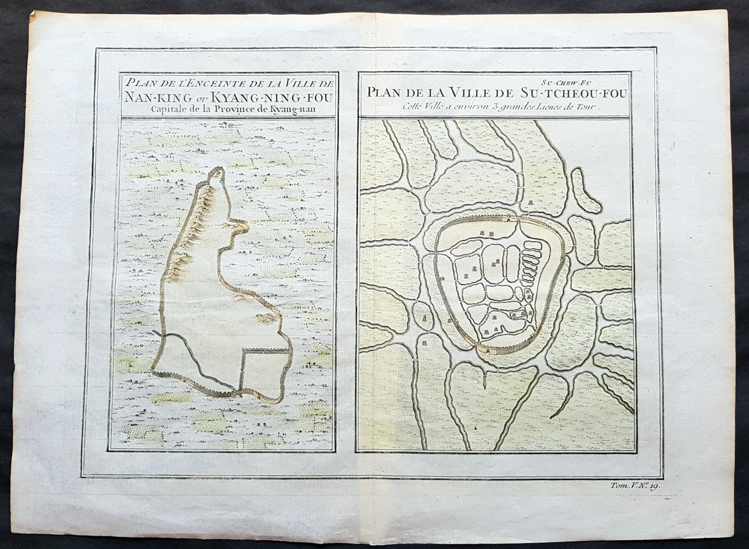
Description:This fine, original copper-plate engraved antique map a birds-eye view of the walled cities of Nanjing & Zhenzhou, in the Jiangsu Province of China by Jakob van Schley in 1755 was published in Antoine François Prevosts 15 volumes of Histoire Generale des Voyageswritten by Prevost & other authors between 1746-1790.Nanjing formerly romanized as Nanking and Nankin, is the capital of Jiangsu province of the People\'s Republic of China and the second largest city in the East China region, with an administrative area of 6,600 km2 (2,500 sq mi) and a total population of 8,270,500.Situated in the Yangtze River Delta region, Nanjing has a prominent place in Chinese history and culture, having served as the capital of various Chinese dynasties, kingdoms and republican governments dating from the 3rd century to 1949, and has thus long been a major center of culture, education, research, politics, economy, transport networks and tourism, being the home to one of the world\'s largest inland ports.Nanjing, one of the nation\'s most important cities for over a thousand years, is recognized as one of the Four Great Ancient Capitals of China. It has been one of the world\'s largest cities, enjoying peace and prosperity despite wars and disasters. Nanjing served as the capital of Eastern Wu, one of the three major states in the Three Kingdoms period (211–280); the Eastern Jin and each of the Southern Dynasties (Liu Song, Southern Qi, Liang and Chen), which successively ruled southern China from 317–589; the Southern Tang, one of the Ten Kingdoms (937–76); the Ming dynasty when, for the first time, all of China was ruled from the city (1368–1421);[15] and the Republic of China (1927–37, 1945–49) prior to its flight to Taiwan during the Chinese Civil War. The city also served as the seat of the rebel Taiping Heavenly Kingdom (1851–64) and the Japanese puppet regime of Wang Jingwei (1940–45) during the Second Sino-Japanese War. It suffered appalling atrocities in both conflicts, including the Nanjing Massacre.
General Definitions:Paper thickness and quality: - Heavy and stablePaper color : - off whiteAge of map color: - EarlyColors used: - Yellow, green, orangeGeneral color appearance: - AuthenticPaper size: - 13 1/2in x 10in (345mm x 255mm)Plate size: - 11 1/2in x 9in (295mm x 230mm)Margins: - Min 1/2in (12mm)
Imperfections:Margins: - NonePlate area: - NoneVerso: - None
Background: One of Antoine Francois Prevosts monumental undertakings was his history of exploration & discovery in 15 volumes titledHistoire Générale des Voyages written between 1746-1759 and was extended to 20 volumes after his death by various authors.The 20 volumes cover the early explorations & discoveries on 3 continents: Africa (v. 1-5), Asia (v. 5-11), and America (v. 12-15) with material on the finding of the French, English, Dutch, and Portugese.A number of notable cartographers and engravers contributed to the copper plate maps and views to the 20 volumes including Nicolas Bellin, Jan Schley, Chedel, Franc Aveline, Fessard, and many others.The African volumes cover primarily coastal countries of West, Southern, and Eastern Africa, plus the Congo, Madagascar, Arabia and the Persian Gulf areas.The Asian volumes cover China, Korea, Tibet, Japan, Philippines, and countries bordering the Indian Ocean.Volume 11 includes Australia and Antarctica.Volumes 12-15 cover voyages and discoveries in America, including the East Indies, South, Central and North America.Volumes 16-20 include supplement volumes & tables along with continuation of voyages and discoveries in Russia, Northern Europe, America, Asia & Australia.Jakob van der Schley aka Jakob van Schley (1715 - 1779) was a Dutch draughtsman and engraver. He studied under Bernard Picart (1673-1733) whose style he subsequently copied. His main interests were engraving portraits and producing illustrations for \\\"La Vie de Marianne\\\" by Pierre Carlet de Chamblain de Marivaux (1688-1763) published in The Hague between 1735 and 1747.He also engraved the frontispieces for a 15-volume edition of the complete works of Pierre de Brantôme (1540-1614), Oeuvres du seigneur de Brantôme, published in The Hague in 1740.He is also responsible for most of the plates in the Hague edition of Prévosts Histoire générale des voyages. (Ref: Tooley; M&B)