Welcome to Classical Images!
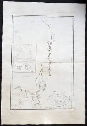
Description:This fine original copper-plate engraved antique nautical chart & coastal view of the Island of Nendo (then called Lord Egmonts Island or New Guernsey) along with inset maps of Swallow Bay & Byrons Harbour on Nendo and a view of the nearby volcanic island of Nupani was drawn by Captain Phillip Carteret in July-August 1767 aboard his ship Swallow, was published in George Andersons 1784 edition of A Collection of voyages round the world : performed by royal authority : containing a complete historical account of Captain Cooks first, second, third and last voyages, undertaken for making new discoveries, &c. ... published by Alexander Hogg, London 1784.
General Definitions:Paper thickness and quality: - Heavy and stablePaper color : - off whiteAge of map color: -Colors used: -General color appearance: -Paper size: - 13 1/2in x 9 1/2in (345mm x 240mm)Plate size: - 13 1/2in x 9 1/2in (345mm x 240mm)Margins: - Min 1/2in (12mm)
Imperfections:Margins: - NonePlate area: - NoneVerso: - None
Background: Capt. Philip Carteret (1733-1796)was a British naval officer and explorer who participated in two of the Royal Navy\\\'s circumnavigation expeditions in 1764-66 and 1766-69.Carteret entered the Navy in 1747, serving aboard the Salisbury, and then under Captain John Byron from 1751 to 1755. Between 1757 and 1758 he was in the Guernsey on the Mediterranean Station. As a lieutenant in the Dolphin he accompanied Byron during his voyage of circumnavigation, from June 1764 to May 1766.In 1766 he was made a commander and given the command of the Swallow to circumnavigate the world, as consort to the Dolphin under the command of Samuel Wallis. The two ships were parted shortly after sailing through the Strait of Magellan, Carteret discovering Pitcairn Island and the Carteret Islands, which were subsequently named after him. In 1767, he also discovered a new archipelago inside Saint George\\\'s Channel between New Ireland and New Britain Islands (Papua New Guinea) and named it Duke of York Islands, as well as rediscovered the Solomon Islands first sighted by the Mendana in 1568, and the Juan Fernandez Islands first discovered by Juan Fernandez in 1574. He arrived back in England, at Spithead, on 20 March 1769.He was promoted to post captain in 1771.Nendo is the largest of the Santa Cruz Islands, located in the Temotu province of the Solomon Islands. The island is also known as Santa Cruz, Ndeni, Nitendi or Ndende. The name Santa Cruz was given to the island in 1595 by the Spanish navigator Alvaro de Mendaña, who unsuccessfully started a colony there.The Nupani Atoll is located about 65 km to the West of the main group of the Reef Islands.