Welcome to Classical Images!
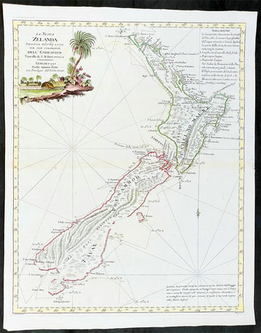
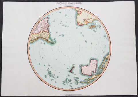
Description:A fine original antique, and incredibly important map of Patagonia & the Magellan Straits but more importantly one of the first maps to depict a distinctive outline of Australia - depicted here as part of Terra Australis the Great Southern Land - and was published by Cornelis van Wytfliet in the 1597 edition of Descriptionis Ptolemaicae Augmentum.Wytfliets famous map of the southern continent from the first atlas of the Americas, Descriptionis Ptolemaicae Augmentum, sive Occidentis Notitia in 1597.In the top part of the map, Patagonia is separated by a strait from a large southern continent named Australis Terrae Pars. The naming of C. Della Victoria and the illustration of Magellans ship, Victoria, indicates, although not names on the map, as the Strait of Magellan. The lower portion of the map is a polar projection, showing Terra Australis as the large landmass made up of four peninsulas, one reaching towards New Guinea which is shown as an island. This and the other peninsula to the west is one of the earliest and clearest indications of cartographical knowledge of Northern Australia, specifically Northern Queensland, the Gulf of Carpentaria & parts of the Northern Territory.Gunter Schilder discusses this map at length and points to its significance to Major Collingridge and others as proof that Australia had already been discovered in the sixteenth century....Wytfliet notes The Australis Terra is the most southern of all lands; it is separated from New Guinea by a narrow strait; its shores are hitherto but little known, since, after one voyage and another, that route has been deserted, and seldom is the country visited unless when sailors are driven there by storms. The Australis Terra begins at two or three degrees from the equator, and is maintained by some to be of so great an extent that if it were thoroughly explored it would be regarded as a fifth part of the world.Wyfliets depiction of a narrow strait separating Australis Terra from New Guinea, predates that of Torress discovery in 1606. Torress passage was not known to the world until the end of the 18th century, when Dalrymple discovered Torress journal of the voyage amongst archives in Manila.
General Definitions:Paper thickness and quality: - Heavy and stablePaper color : - off whiteAge of map color: -Colors used: -General color appearance: -Paper size: - 15in x 12in (380mm x 305mm)Plate size: - 11 1/4in x 9 1/4in (285mm x 235mm)Margins: - Min 1in (25mm)
Imperfections:Margins: - NonePlate area: - NoneVerso: - None
Background:
In 1597 Cornelis van Wytfliet published his Augmentum to Ptolemys Geography. Dedicated to Philip III of Spain it is a history of the New World to date, recording its discovery, natural history etc. For the book Wytfliet had engraved nineteen maps, by whom we do not know, one of the world and eighteen regional maps of the Americas. As such this book can be truly called the first atlas of the New World, America.
Wytfliet, Cornelis van d. 1597Cornelius Wytfliet or Cornelis van Wytfliet was a geographer from Leuven in the Habsburg Netherlands, best known for producing the first atlas of the Americas.Cornelius was the son of Catherine Huybrechts and her husband, Gregorius Wytfliet, who was advocate fiscal of Leuven University from 1557 to 1594. After graduating Licentiate in Laws from the University of Leuven, Wytfliet moved to Brussels and became secretary to the Council of Brabant. He died in or shortly after 1597, when his Descriptionis Ptolemaicae Augmentum (a work adding new discoveries to Ptolemy\\\'s description of the world) was published